groundwater information for management of the …
TRANSCRIPT

GROUNDWATER INFORMATION FOR MANAGEMENTOF THE ELLEN BROOK, BROCKMAN RIVER AND
UPPER CANNING SOUTHERN WUNGONGCATCHMENTS

Salinity and Land Use Impacts Series Groundwater in 3 catchments of the Swan-Canning rivers SLUI 12
i
GROUNDWATER INFORMATIONFOR MANAGEMENT OF
THE ELLEN BROOK, BROCKMANRIVER AND UPPER CANNING
SOUTHERN WUNGONGCATCHMENTS
byR. A. Smith, R. Shams, M. G. Smith, and A. M. Waterhouse
Resource Science DivisionWater and Rivers Commission
WATER AND RIVERS COMMISSION
SALINITY AND LAND USE IMPACTS SERIES
REPORT NO. SLUI 12
SEPTEMBER 2002

Groundwater in 3 catchments of the Swan-Canning rivers SLUI 12 Salinity and Land Use Impacts Series
ii
Acknowledgments
The authors acknowledge help and advice from;The Advisory Committee (below) to the Swan Hydrogeological Resource Base and Catchment Interpretation Project
Department Representative
Agriculture Western AustraliaConservation and Land ManagementCommunityCSIROEdith Cowan UniversityEnvironmental Protection AuthorityLocal Government AuthorityMinistry for PlanningSwan Catchment CentreSwan River Trust
Gerry ParlevlietRob TowersPeter Murray (Chair)Dr John AdeneyDr Ray FroendWes Horwood, Jane TaylorMick McCarthy, Veronica OmaDavid Nunn, Marie Ward, Alan Carman-BrownPeter NashDr Tom Rose, Declan Morgan, Adrian Tomlinson
Mr Ken Angel (Agriculture Western Australia),Mr Robert Panasiewicz (formerly Water and Rivers Commission), andMr Syl Kubicki (formerly Water and Rivers Commission).
Recommended Reference
The recommended reference for this report is:SMITH, R. A., SHAMS, R., SMITH M. G., and WATERHOUSE, A. M., 2002, Groundwater information formanagement of the Ellen Brook, Brockman River and Upper Canning Southern Wungong catchments: WesternAustralia, Water and Rivers Commission, Salinity and Land Use Impacts Series Report No. SLUI 12, 21 p.
We welcome your feedbackA publication feedback form can be found at the back of this publication,or online at www.wrc.wa.gov.au/public/feedback/
ISBN 1-920687-81-5ISSN 1447-7394
September, 2002
Cover photograph:
Ellen Brook by
Rezina Shams

Salinity and Land Use Impacts Series Groundwater in 3 catchments of the Swan-Canning rivers SLUI 12
iii
Foreword
The Swan Hydrogeological Resource Base and Catchment Interpretation project was a Natural Heritage Trust (NHT)and Water and Rivers Commission (WRC) funded project (NHT 973705). The study areas were three prioritycatchments of the Swan-Canning rivers—the Ellen Brook, Brockman River and the combined Upper Canning SouthernWungong catchments.
The following were the main objectives of the study:
� To liaise with the Swan Working Group and catchment groups to determine issues, needs and appropriateproducts.
� To provide baseline groundwater information essential for the catchment groups to implement management plans.
� To compile maps of hydrogeological information at a scale appropriate to the decision-making processes ofcatchment managers.
� To transfer expertise into the priority sub-catchments by training, publications and advice in interpretation.
This report comprises a brief overview of the areas and management guidelines from the perspective of the groundwaterissues. More detailed information can be found in the following project reports, posters and CD-ROM.
ReportsGroundwater information and management options for the Brockman River Catchment SLUI 2Hydrogeological information for management planning in the Ellen Brook Catchment SLUI 11Groundwater information for management in the Upper Canning Southern Wungong Catchment SLUI 14
PostersManaging Nutrient Movement into Ellen BrookGeology of Ellen BrookHydrogeology of Ellen BrookSalt affected land? Yes! It’s a groundwater problem! Brockman River Catchment
CD-ROM*Groundwater information and Management Zones for the Ellen Brook, Brockman River and combined Upper Canningand Southern Rivers and Wungong Brook catchments.
*The data package on the CD-ROM contains the following themes in GIS format: surface water catchmentsand their subcatchments; hydrogeological zones; water monitoring sites for groundwater and surface water;management boundaries; regional soil surveys; topographic contours; roads; Local Government boundaries;and general climatic data.
Groundwater in 3 catchments of the Swan-Canning rivers SLUI 12 Salinity and Land Use Impacts Series
iv
Contents
Summary ................................................................................................................... 1
1 Ellen Brook catchment........................................................................................... 21.1 Management guidelines........................................................................................................ 3
2 Brockman River catchment.................................................................................... 92.1 Management guidelines...................................................................................................... 10
3 Upper Canning Southern Wungong catchment................................................... 143.1 Management guidelines...................................................................................................... 15
Figures1. Catchment locations ............................................................................................................ 12. Location (Ellen Brook)........................................................................................................... 53. Geomorphology and topography (Ellen Brook) ..................................................................... 64. Hydrogeology (Ellen Brook) .................................................................................................. 75. Environmental Management Units (Ellen Brook)................................................................... 86. Groundwater zones (Brockman River) ................................................................................ 127. Management zones (Brockman River) ................................................................................ 138. Upper Canning Southern Wungong catchment location...................................................... 189. Simplified geology (Upper Canning Southern Wungong) .................................................... 1910. Slope of land derived from Digital Elevation Model (Upper Canning Southern Wungong) ... 20
Tables1a. Management options to reduce nutrient export (Ellen Brook)................................................ 31b. Management options to reduce inundation (Ellen Brook) ...................................................... 31c. Management options to counter dry land salinisation (Ellen Brook) ...................................... 41d. Management options to control water erosion (Ellen Brook) ................................................. 42a. Summary of management options for limited groundwater resource (Brockman River) ........ 62b. Summary of management options for dryland salinisation (Brockman River) ........................ 73a. Management options to control erosion by water (Upper Canning Southern Wungong)........ 93b. Management options to control inundation and waterlogging (Upper Canning Southern
Wungong) ............................................................................................................................ 93c. Management options to reduce nutrient export (Upper Canning Southen Wungong) .......... 103d. Management options to counter dryland salinisation (Upper Canning Southern Wungong) 113e. Management options to limit point source contamination of groundwater (Upper Canning
Southern Wungong)............................................................................................................ 11

Salinity and Land Use Impacts Series Groundwater in 3 catchments of the Swan-Canning rivers SLUI 12
1
Summary
In summarizing the reports listed in the Foreword, this report provides the recommendedgroundwater-related management actions for the three priority subcatchments of theSwan-Canning rivers.
The Ellen Brook, Brockman River and Upper Canning Southern Wungong catchments (Fig. 1) are three near urbansubcatchments of the Swan and Canning rivers experiencing significant land and water degradation as a consequence ofextensive land use changes and development.
Erosion, nutrient export and inundation are the significant land and water degradation issues for both the Ellen Brookand Upper Canning Southern Wungong catchments with dryland salinisation a growing problem in all three catchments.Contamination of groundwater by salt or other contaminants is a problem for all three catchments.
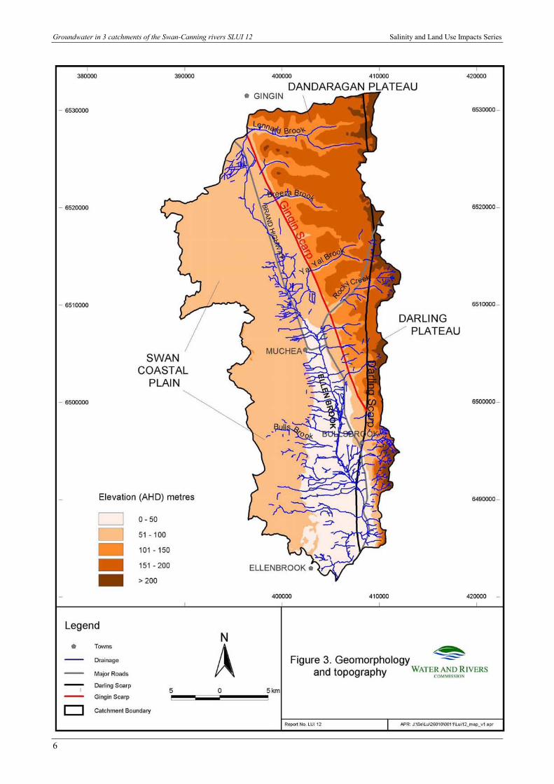
The Darling Scarp divides these catchments between the Swan Coastal Plain and the Darling Plateau. Understandingthese features and the associated drainage and geology explains much about the groundwater-related issues addressed inthis report.
Keywords: Yilgarn Southwest Province, Perth Basin, hydrogeology, catchment water quality, land use planning,Armadale, Bindoon, Bullsbrook, Kelmscott, Muchea, SH5014, SI5002

Groundwater in 3 catchments of the Swan-Canning rivers SLUI 12 Salinity and Land Use Impacts Series
2
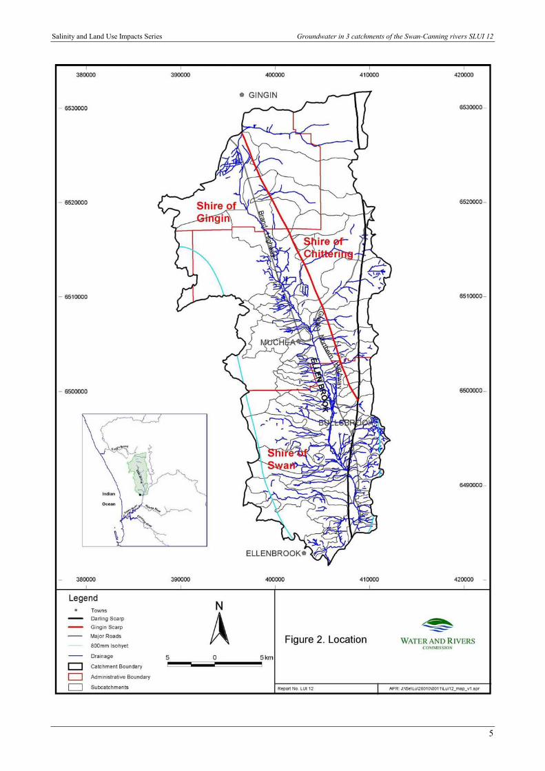
1 Ellen Brook catchmentThe Ellen Brook catchment (Fig. 2) on the outskirts of Perth is in transition from rural to intensehorticultural, light industrial and residential land use. Nutrient entry to surface water, inundation of valleyflats, salinisation on the plateaus, and erosion of banks and slopes are important groundwater-relatedissues for management. This study particularly addresses the role of groundwater in nutrient transport tothe Ellen Brook and thence to the Swan-Canning estuary.
The clearing and land use history, together with the differing groundwater behaviour in the three distinctgeomorphic zones (Swan Coastal Plain, Dandaragan Plateau and Darling Plateau, Fig. 3), have beeninstrumental in the emergence of the current issues for management and planning. An appreciation of thevaried hydrogeological conditions (Fig. 4) is important to achieving good management practice andaddressing the environmental issues in the Ellen Brook catchment.
The Environmental Protection Policy (EPP) for the Swan and Canning Rivers recognises that thereceiving waters of the Swan and Canning estuarine system provide important economic, aesthetic,recreational, commercial and environmental resources for the State. The Ellen Brook catchment isrecognised also for economic and heritage (Aboriginal) significance and environmental values. Four landand water degradation issues, whose management options require groundwater information, are describedbelow and shown in Table 1(a to d).
The Ellen Brook catchment is one of the highest contributors of the nutrients, nitrogen and phosphorus,to the Swan-Canning estuarine system. Very high levels of phosphorus and moderate levels of nitrogenare consistently found in the Ellen Brook. Fertilisers, animal wastes and soil-bound nutrients from currentland use activities and the impacts of past management within the catchment are the major source ofnutrients into the Ellen Brook via surface and groundwater.
The flat plains of the catchment, concentrated on the north-south drainage line, are prone to inundationin the winter either through a seasonally high watertable or waterlogging on surfaces with lowpermeability. These areas suffer loss of production, mobilisation of nutrients and seasonal salinity.
Salinisation is an emerging issue on the Dandaragan and Darling Plateaus. This groundwater issue iswidespread throughout the state, especially in the Southwest Land Division.
Erosion is the result of many geologic, geomorphic, hydrogeologic, ecologic, social and other factors incombination. It is a major problem along the scarp face, steep slopes of the plateau and the banks ofwaterways, but firebreaks, roads and tracks are also of concern. Stream bank erosion and sedimentationare major problems where fringing vegetation is absent or damaged through unrestricted stock access.Stream bank erosion and associated sedimentation is becoming a problem in some of the streams flowingfrom the Darling Scarp.
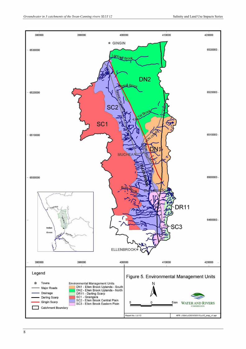
Report SLUI 11 applies what we know about the hydrogeology of the Ellen Brook catchment to what itmeans for management and planning. Table 1(a to d) on the next page duplicates the management actionsdescribed in that report. The priority areas for recommended management actions are the environmentalmanagement units (EMUs, Fig. 5) defined in a management plan for the Ellen Brook catchment.
Salinity and Land Use Impacts Series Groundwater in 3 catchments of the Swan-Canning rivers SLUI 12
3
1.1 Management guidelines
Table 1a. Management options to reduce nutrient export
Groundwatermanagementobjective
Priority areas(EMUs*)
Recommendedactions
Examples/actions
Reducegroundwaterrecharge
SC2Managegroundwaterrecharge
Commercial farm forestry - Maritime pine, Eucalyptus,Oil mallees, Acacias, and other tree species
Management of native vegetation and revegetationPerennial pasture
Minimisenutrientsleaching intogroundwater
SC1, SC2 and DN1 Bestmanagementpractice
Fertiliser & irrigation managementImprove land practiceApplication of soil amendment to low phosphorus-
retaining soilsReduceoverland runoff
SC2 and SC3 Surface watercontrol
Stream lining to trap and uptake nutrientsPlanting, graded bank to reduce overland flow
Minimisesedimententry todrainage
SC3, DN1, DN2 andDR11
Control erosion Planting to filter sedimentsPlanting, fencing, stock control to reduce erosionPerennial pastures
*EMUs are Environmental Management Units.
Table 1b. Management options to reduce inundation
Groundwatermanagementobjective
Priority areas(EMUs)
Recommendedactions
Examples/actions
Lowergroundwaterlevel
SC2Managegroundwaterrecharge
Commercial farm forestry, Maritime pine, Eucalyptus, Oilmallees, Acacias, and other tree species
Management of native vegetation and revegetationEngineering practices: surface water management via
shallow interceptor banks or grade banksSC3, DN1 and DN2 Reduce
waterloggingPlanting species tolerant to water

Groundwater in 3 catchments of the Swan-Canning rivers SLUI 12 Salinity and Land Use Impacts Series
4
Table 1c. Management options to counter dryland salinisation
Groundwatermanagementobjective
Priority areas(EMUs)
Recommendedactions
Examples/actions
Reducegroundwaterrecharge
Managegroundwaterrecharge
Commercial farm forestry, Maritime pine, Eucalyptus,Oil mallees, Acacias, and other tree species
Management of native vegetation and revegetationEngineering practices: surface water management via
shallow interceptor banks or grade banksLowergroundwaterlevel
Manage thegroundwaterrecharge andengineeringoptions
Reducing groundwater recharge as aboveEngineering options: deep drains (> 1.5m deep), not
effective in deep clays; groundwater pumping; reliefwells or siphons where depth to groundwater is < 4 mand land surface has slope greater than ~3%
Evaluateremedialactions
Monitoring Monitoring program either site specific or at catchmentlevel
Publicsupport ofmanagementactions
Subcatchmentsdraining the DarlingPlateau and southernsection of theDandaragan Plateau(DR11, SC3 andDN1).
Localised drylandsalinisation isevident on the SwanCoastal Plain whereshallow water tableis coincides withclay-dominatedsediments.
Increasedpubliceducation andawareness
Public information on catchment targets and why theywere selected
Education on the causes and management of salinisationReinforce the key message that the whole community
benefits from reducing salinityEncourage active subcatchment groups and community
participationEncourage tours of remedial sites, both positive and
negative
Table 1d. Management options to control water erosion
Groundwatermanagementobjective
Priority areas(EMUs)
Recommendedactions
Examples/actions
Stabilise slopeDN1, DN2 andDR11
Prevent erosion Planting high water using treesUtilising appropriate land/farming practiceEngineering practices: surface water management via
shallow interceptor banks or grade banksStabilisebanks
All (exceptSC1which has none)
Prevent erosion Riparian vegetationFencing of stream linesReduce stock access to stream line
Salinity and Land Use Impacts Series Groundwater in 3 catchments of the Swan-Canning rivers SLUI 12
5
Groundwater in 3 catchments of the Swan-Canning rivers SLUI 12 Salinity and Land Use Impacts Series
6

Salinity and Land Use Impacts Series Groundwater in 3 catchments of the Swan-Canning rivers SLUI 12
7
Groundwater in 3 catchments of the Swan-Canning rivers SLUI 12 Salinity and Land Use Impacts Series
8

Salinity and Land Use Impacts Series Groundwater in 3 catchments of the Swan-Canning rivers SLUI 12
9
2 Brockman River catchmentThe limited good quality groundwater and the development of dryland salinisation are the maingroundwater-related issues in the Brockman River catchment. Options for groundwater managementinclude efficient use and protection of existing groundwater supplies through industry awareness, bestpractice and public awareness and education. Developing dryland salinisation requires groundwatermanagement to reduce recharge or lower the groundwater levels.
There is widespread landholder concern in the Brockman River catchment over emerging drylandsalinisation from rising groundwater levels, both of which are reducing agricultural productivity andlowering economic returns. Businesses (such as tourism) that rely on attractions or the physicalinfrastructure (roads or buildings) are also likely to be adversely affected by these issues. Risinggroundwater levels need to be tackled at a catchment level and will require significant communitycooperation.
Four groundwater zones are identified (Fig. 6). The regional aquifer in the Dandaragan Plateau ismanaged as part of the Gingin Groundwater Management Area. The surficial aquifers and the westernfractured-rock aquifer zone are both important for private groundwater abstraction in the BrockmanValley. While additional localised groundwater resources are probably available in these two zones, it isunlikely that they will yield large supplies of good quality groundwater. Rising groundwater however hasthe potential to contaminate these already limited low salinity resources. Groundwater from the easternfractured-rock aquifer zone is generally suitable for limited irrigation and livestock.
60% of salt discharged by the Brockman River into the Avon River originates in the catchment upstreamof Tanamerah monitoring station (S616006, Fig. 6). This north-to-south variation is due to the differencein land use history, geology and rainfall.
Groundwater resources are limited and localised. Developmental and economic demands of the catchmentwill in places conflict with optimal groundwater management. Managers need to balance theenvironmental needs and development demands within the catchment.
The framework for groundwater management options used in report SLUI 2 and here comes from theEnvironmental Planning Precincts of Evangelisti & Associates. Figure 7 shows these EnvironmentalPlanning Precincts and Table 2(a and b) provides a range of management actions.

Groundwater in 3 catchments of the Swan-Canning rivers SLUI 12 Salinity and Land Use Impacts Series
10
2.1 Management guidelines
Table 2a. Summary of management options for limited groundwater resource
Groundwatermanagement objective
Priority areas Recommendedactions
Examples/actions
Use groundwaterefficiently.
A) Environmental PlanningPrecincts DR2, DR3,DR4, DR5, DR6 andDR9 which arepredominantly withinthe surficial aquifer zoneand fractured-rockaquifer zone A.
B) The regional aquifersystem located on theDandaragan Plateau.
Efficient use ofgroundwater
Ensure that appropriate land use activities arecarried out within the Brockman Rivercatchment.
Encourage the use of appropriate quality waterfor industrial and agricultural activities;i.e.do not use low salinity/freshgroundwater if brackish groundwater issuitable.
Industryawareness ofbestmanagementpractices
Identify groundwater issues related to specificindustries, such as nutrient dischargeassociated with piggeries; fuel leakagefrom fuel storage tanks (commercial andprivate); and contamination from wastedisposal sites.
Ensure that industry is employing bestmanagement practices and monitor issuesrelated to groundwater if deemednecessary.
Facilitate industry education; i.e. workshopsand field days.
Ensure correct disposal of solid and liquidwaste, and waste water from existing lightindustry, agricultural and horticulturalactivities.
Protect existinggroundwater sources
As above
Publicawareness andeducation
Education regarding the storage, usage anddisposal of chemicals, fertilisers, pesticidesand herbicides at both the household andbusiness levels.
Encourage the use of native plants in thegardens to reduce the use of chemicals likefertilisers, pesticides and herbicides.Native plants also require minimalwatering in summer, thus preservingexisting groundwater supplies.
Education on the interdependence of riversand groundwater, to illustrate the relevanceof groundwater quality to a healthy riversystem.
Salinity and Land Use Impacts Series Groundwater in 3 catchments of the Swan-Canning rivers SLUI 12
11
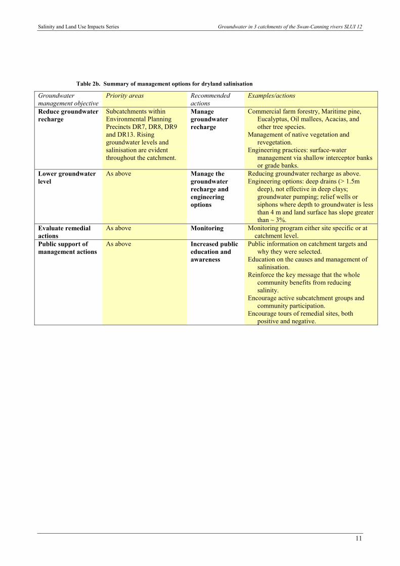
Table 2b. Summary of management options for dryland salinisation
Groundwatermanagement objective
Priority areas Recommendedactions
Examples/actions
Reduce groundwaterrecharge
Subcatchments withinEnvironmental PlanningPrecincts DR7, DR8, DR9and DR13. Risinggroundwater levels andsalinisation are evidentthroughout the catchment.
Managegroundwaterrecharge
Commercial farm forestry, Maritime pine,Eucalyptus, Oil mallees, Acacias, andother tree species.
Management of native vegetation andrevegetation.
Engineering practices: surface-watermanagement via shallow interceptor banksor grade banks.
Lower groundwaterlevel
As above Manage thegroundwaterrecharge andengineeringoptions
Reducing groundwater recharge as above.Engineering options: deep drains (> 1.5m
deep), not effective in deep clays;groundwater pumping; relief wells orsiphons where depth to groundwater is lessthan 4 m and land surface has slope greaterthan ~ 3%.
Evaluate remedialactions
As above Monitoring Monitoring program either site specific or at catchment level.
Public support ofmanagement actions
As above Increased publiceducation andawareness
Public information on catchment targets andwhy they were selected.
Education on the causes and management ofsalinisation.
Reinforce the key message that the wholecommunity benefits from reducingsalinity.
Encourage active subcatchment groups andcommunity participation.
Encourage tours of remedial sites, bothpositive and negative.

Groundwater in 3 catchments of the Swan-Canning rivers SLUI 12 Salinity and Land Use Impacts Series
12
#S#S
#S
#S
#S
#S
#S
Shire of Swan
Shire of Victoria Plains
Shire of Chittering
Shire of Toodyay
Shire of Gingin
2035-1-SE-0007
2035-1-SE-0005
2035-1-SE-0006
2135-4-SW-0001
2135-3-NW-0109
2135-3-SW-00852135-3-SW-0088
Gingin Groundwater Management Area
390000
390000
400000
400000
410000
410000
420000
420000
430000
430000
440000
440000
6490
000 6490000
6500
000 6500000
6510
000 6510000
6520
000 6520000
6530
000 6530000
6540
000 6540000
6550
000 6550000
6560
000 6560000
River
#S AQWAbase boreSubcatchment boundary
Local Government boundaryDarling Fault
Kilometres
10010
Groundwater zonesDandaragan PlateauFractured - rock aquifer zone AFractured - rock aquifer zone BSurficial aquifer zoneWater
N SCIENCE AND EVALUATION DIVISION
Figure 6Groundwater zones
FILENAME: br_report_figures.apr DATE: 23/07/01
mE
mN
Groundwater Management Area
Tanamerah S616006

Salinity and Land Use Impacts Series Groundwater in 3 catchments of the Swan-Canning rivers SLUI 12
13

Groundwater in 3 catchments of the Swan-Canning rivers SLUI 12 Salinity and Land Use Impacts Series
14
3 Upper Canning Southern Wungongcatchment
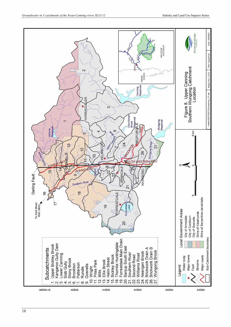
The Upper Canning Southern Wungong catchment is a near-urban composite catchment (Fig. 8)undergoing major land use changes and development. The major changes since European settlement havealready resulted in erosion, waterlogging, water quality degradation, dryland salinisation andcontamination of groundwater resources.
The catchment has a diverse geology and this has a major influence on the occurrence and vulnerability ofwater to land use practices. Consequently, the occurrence and quality of groundwater is most highlyvariable from east to west across the main geologic changes (Fig. 9). Furthermore, fresh groundwater islocalised and limited in the eastern half of the catchment, while large groundwater resources are presentin the western third of the area.
Erosion is significant mainly where the surface is clayey and the landscape steep, particularly the valleysand scarps of the Darling Plateau (Fig. 10). There is major erosion in cleared areas, especially alongstreamlines where there is stock access and land development.
Shallow watertables in the clayey areas in the east of the Swan Coastal Plain and in the Darling Plateaucan contribute to waterlogging and inundation of low-lying poorly drained land.
Groundwater in sandy surficial sediments varies in quality, may contain isolated very high nutrient levelsat the watertable or at depth, and transports nutrients in solution from the western part of the catchmentinto the Southern River.
Nutrients enter the Upper Canning and Southern rivers bound to eroding soil particles especially whereridges, slopes and drainage lines are poorly vegetated and used by stock and humans.
Land clearing on the Darling Plateau is the cause of localised mobilisation of salt stored in the soil profile,leading to the discharge of saline groundwater and land salinisation.
Investigations of groundwater contamination from land use, particularly landfill and liquid wastedisposal, are well documented.
Report SLUI 14 describes the current status and processes occurring in the catchment, gives guidelinesfor management of future development, and discusses the impact on land and water quality, in particulargroundwater. The suggested range of management actions is given in Table 3(a to e).

Salinity and Land Use Impacts Series Groundwater in 3 catchments of the Swan-Canning rivers SLUI 12
15
3.1 Management guidelines
Table 3a. Management options to control erosion by water
(The numbers refer to subcatchments named on Figure 8)
Groundwatermanagementobjective
Priority areas bysubcatchments
Recommendedactions
Examples/actions
Limit shallowwatertables
Areas with steepslopes in parts of 3,4, 5, 6, 10, 11, 12,13, 14, 15, 24, 25,26, 27.
Adequatedrainage
Restrict grazingPlant high water using treesUse appropriate land/farming practiceEngineering practices: surface water management via
shallow interceptor banks or grade banksLimitgroundwaterdischarge onsteep slopes
Areas with steepslopes in parts of 3,4, 5, 6, 10, 11, 12,13, 14, 15, 24, 25,26, 27.
Stabilise slopes Restrict grazingPlant high water using treesUse appropriate land/farming practiceEngineering practices: surface water management via
shallow interceptor banks or grade banksLimitgroundwaterdischarge ontounprotectedstream banks
Stream banks, scarpsand major rivers 6, 9,13, 14, 15, 16, 17,18, 21, 22, 24, 25,26, 27,
Stabilise banks Increase or improve riparian vegetationFence stream linesReduce stock access to stream line
Table 3b. Management options to control inundation and waterlogging
Groundwatermanagementobjective
Priority areas bysubcatchments
Recommendedactions
Examples/actions
Limit risingshallowwatertable
Limitwaterlogging
Flat poorly drainedclayey ground,especially along andeast of SouthernRiver, in 6, 8, 9, 14,15, 16, 17, 18, 19,20, 21, 22, 23, 24, 25
Controlwatertable riseto keepwatertablebelow surface
Plant high water-use treesAdequate urban drainageCommercial farm forestry, Maritime pine, Eucalyptus,
Oil mallees, Acacias, and other tree speciesManagement of native vegetation and revegetationEngineering practices: surface water management via
shallow interceptor banks or grade banksLimit shallow“perched”watertable
Areas of lateriteweathering profiles,in parts of 1, 2, 3, 4,5, 6, 7, 10, 11, 12,13, 14, 15, 24, 25,26, 27
Use or drainshallow“perched”groundwater
Maintain or restore healthy high water use vegetation, egforestry preferable to pasture
Planting species tolerant to waterlogging
Groundwater in 3 catchments of the Swan-Canning rivers SLUI 12 Salinity and Land Use Impacts Series
16
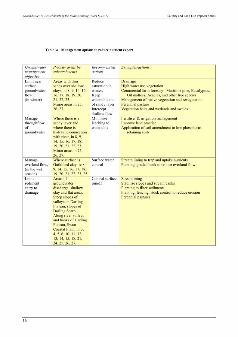
Table 3c. Management options to reduce nutrient export
Groundwatermanagementobjective
Priority areas bysubcatchments
Recommendedactions
Examples/actions
Limit nearsurfacegroundwaterflow(in winter)
Areas with thinsands over shallowclays, in 8, 9, 14, 15,16, 17, 18, 19, 20,21, 22, 23.Minor areas in 25,26, 27.
Reducesaturation inwinter.Keepwatertable outof sandy layerInterceptshallow flow
DrainageHigh water use vegetationCommercial farm forestry - Maritime pine, Eucalyptus,
Oil mallees, Acacias, and other tree speciesManagement of native vegetation and revegetationPerennial pastureVegetation belts and wetlands and swales
Managethroughflowofgroundwater
Where there is asandy layer andwhere there ishydraulic connectionwith river, in 8, 9,14, 15, 16, 17, 18,19, 20, 21, 22, 23.Minor areas in 25,26, 27.
Minimiseleaching towatertable
Fertiliser & irrigation managementImprove land practiceApplication of soil amendment to low phosphorus-
retaining soils
Manageoverland flow,(in the wetseason)
Where surface isGuildford clay, ie 8,9, 14, 15, 16, 17, 18,19, 20, 21, 22, 23, 25
Surface watercontrol
Stream lining to trap and uptake nutrientsPlanting, graded bank to reduce overland flow
Limitsedimententry todrainage
Areas ofgroundwaterdischarge, shallowclay and flat areas.Steep slopes ofvalleys on DarlingPlateau, slopes ofDarling Scarp.Along river valleysand banks of DarlingPlateau, SwanCoastal Plain, in 3,4, 5, 6, 10, 11, 12,13, 14, 15, 18, 21,24, 25, 26, 27.
Control surfacerunoff
StreamliningStabilise slopes and stream banksPlanting to filter sedimentsPlanting, fencing, stock control to reduce erosionPerennial pastures

Salinity and Land Use Impacts Series Groundwater in 3 catchments of the Swan-Canning rivers SLUI 12
17
Table 3d. Management options to counter dryland salinisation
Groundwatermanagementobjective
Priority areas bysubcatchments
Recommendedactions
Examples/actions
Limitmobilisationof stored salt
Where deep rootedtrees have beencleared and there isdeep salinegroundwater,especially poorlydrained clays, forexample on theDarling Plateau, in1, 2, 3, 4, 5, 6.Minor areas in 7,10, 11, 12, 13, 14,15, 24, 26, 27.
Managegroundwaterrecharge
Control clearingPlant deep rooted salt-tolerant vegetationCommercial farm forestry, Maritime pine, Eucalyptus,
Oil mallees, Acacias, and other tree speciesManagement of native vegetation and revegetationEngineering practices: surface water management via
shallow interceptor banks or grade banks
Slowdrainage andevaporativeconcentration
Near surface clay, in6, 8, 9, 14, 15, 21,22, 23, 25. Minorareas in 18, 19, 20.
Maintain orlowerwatertable, e.g.below 2m
Control clearingPlant deep rooted high water use trees
Table 3e. Management options to limit point source contamination of groundwater
Groundwatermanagementobjective
Priority areas bysubcatchments
Recommendedactions
Examples/actions
Limit pointsourcecontaminationof groundwater
Industrial sitesWaste disposalsitesLandfill sitesespecially onBassendean Sandmainly 9, 18, 19,20, 21.
Protectgroundwater
License land useMonitoringEducate on industrial Best Management PracticeReview the appropriateness of land use
Groundwater in 3 catchments of the Swan-Canning rivers SLUI 12 Salinity and Land Use Impacts Series
18

Salinity and Land Use Impacts Series Groundwater in 3 catchments of the Swan-Canning rivers SLUI 12
19

Groundwater in 3 catchments of the Swan-Canning rivers SLUI 12 Salinity and Land Use Impacts Series
20

Salinity and Land Use Impacts Series Groundwater in 3 catchments of the Swan-Canning rivers SLUI 12
21
Publication feedback form
The Water and Rivers Commission welcomes feedback to help us to improvethe quality and effectiveness of our publications. Your assistance incompleting this form would be greatly appreciated.
Please consider each question carefully and rate them on a 1 to 5 scale,where 1 is poor and 5 is excellent (please circle the appropriate number).
How did you rate the quality of information?1 2 3 4 5
How did you rate the design and presentation of this publication?
1 2 3 4 5How can it be improved?
1 2 3 4 5.....................................................................................................................How effective did you find the tables and figures in communicating the data?
1 2 3 4 5How can they be improved?
.....................................................................................................................
.....................................................................................................................
.....................................................................................................................How did you rate this publication overall?
1 2 3 4 5If you would like to see this publication in other formats, please specify. (Eg. CD)
.....................................................................................................................Please cut along the dotted line on the left and return your completed response to:
Publications CoordinatorWater and Rivers CommissionLevel 2, Hyatt Centre3 Plain StreetEast Perth WA 6004Fax: (08) 9278 0639


WATER AND RIVERS COMMISSION
Hyatt Centre3 Plain Street
East PerthWestern Australia 6004
Telephone (08) 9278 0300Facsimile (08) 9278 0301
Website: www.wrc.wa.gov.au