guidance handbook #13: planning for land use · guided by karen scott, assistant chief and kevin...
TRANSCRIPT

THE RHODE ISLAND COMPREHENSIVE PLANNING STANDARDS
GUIDANCE HANDBOOK SERIES
GUIDANCE HANDBOOK #13:
PLANNING FOR LAND USE
Revised June 2018

Comprehensive planning and its implementation are needed to promote the appropriate use of land. The lack of comprehensive planning and its implementation could lead to the misuse, underuse, and overuse of our land and natural resources.
The Rhode Island Comprehensive Planning and Land Use Regulation Act, RIGL subsection 45-22.2-3(a)(4)

ACKNOWLEDGEMENTS
The Rhode Island Comprehensive Planning Guidance Handbook Series is the result of over twenty-four months of cooperation and coordination among state agencies, local planners, and other professionals interested in helping cities and towns craft better comprehensive plans. The guidance development process was overseen by the Comprehensive Planning Advisory Committee, a dedicated group of planning, land use, legal, and community professionals who worked diligently to develop content on the comprehensive planning process and to review topical content as it was developed. Without this group the manual would not have become reality.
Additionally, the topical content for the guidance handbook series was developed in conversation with numerous experts. These knowledgeable individuals are the reason that the manual is helpful, user-friendly, and thorough.
The guidance handbook series was prepared by Chelsea Siefert, Principal Planner. Ms. Siefert was guided by Karen Scott, Assistant Chief and Kevin Nelson, Supervising Planner, and assisted by Caitlin Greeley, Principal Planner.
COMPREHENSIVE PLANNING ADVISORY COMMITTEE
Sheila Brush, former Director of Programs, Grow Smart RI
Bill DePasquale, Director of Planning, City of Warwick
Ann-Marie Ignasher, former Town Planner, Town of Foster
Nancy Letendre, Principal Planner, Mason & Associates, Inc.
Sue Mara, Assistant Director of Planning and Redevelopment, City of Pawtucket
Martha Matchnik, former Director of Healthy Aging, YMCA of Greater Providence
Krista Moravec, Environmental Planner, Horsley Witten Group, Inc.
Bonnie Nickerson, Director of Planning and Development, City of Providence
Fred Presley, City Manager, City of West Warwick
Pam Sherrill, former Town Planner, Town of Johnston
TOPIC EXPERTS
Angela Ankoma, RI Department of Health
Ken Ayars, RI Department of Environmental Management
Jim Boyd, RI Coastal Resource Management Council
Meredith Brady, RI Department of Transportation
Paige Bronk, Town of North Kingstown
Michelle Burnett, RI Emergency Management Agency
Kathleen Crawley, RI Water Resources Board
Teresa Crean, URI Coastal Resources Center/RI Sea Grant
Steve Devine, RI Department of Transportation
Joe Dias, RI Department of Environmental Management
Lauren Faria, RI State Council on the Arts
John Flaherty, Coalition for Transportation Choices
Elizabeth Francis, RI Council for the Humanities
Rupert Friday, RI Land Trust Council

Grover Fugate, RI Coastal Resources Management Council
Scott Gibbs, Economic Development Foundation of RI
Julia Gold, RI Department of Health
Rick Greenwood, formerly of RI Historical Preservation and Heritage Commission
June House, RI Office of Housing and Community Development
Paul Jordan, RI Department of Environmental Management
Lorraine Joubert, URI Nonpoint Education for Municipal Officials
Nate Kelly, Horsley Witten Group
Meg Kerr, Watershed Counts
Sarah Kite, RI Resource Recovery Corporation
Tom Kravitz, Town of Burrillville
Eliza Lawson, RI Department of Health
Mike McGonagle, RI Resource Recovery Corporation
Danny Musher, RI Office of Energy Resources
Bill Patenaude, RI Department of Environmental Management
Ken Payne, RI Agricultural Partnership
Amy Pettine, RI Public Transit Authority
Nicole Pollock, formerly of RI Department of Environmental Management
Leo Pollock, formerly of Southside Community Land Trust
Dan Porter, RI Airport Corporation
Lisa Primiano, RI Department of Environmental Management
Amy Rainone, Rhode Island Housing
Randy Rosenbaum, RI State Council on the Arts
Pam Rubinoff, URI Coastal Resources Center/RI Sea Grant
Rachel Sholly, RI Office of Energy Resources
Malcolm Spaulding, University of Rhode Island
Jan Reitsma, formerly of Governor Chaffee’s Office
Jonathan Stevens, former State Historic Preservation Officer
Jessica Stimson, RI Emergency Management Agency
Elizabeth Stone, RI Department of Environmental Management
Valerie Talmage, Preserve Rhode Island
Michael Tondra, RI Office of Housing and Community Development
David Tremblay, RI Department of Labor and Training
David Vallee, National Oceanic and Atmospheric Administration
Marcel Valois, Commerce RI
Bob Vanderslice, formerly of RI Department of Health
Mike Walker, Commerce RI
Scott Wolf, Grow Smart RI
Art Zeman, RI Department of Environmental Management

TABLE OF CONTENTS
INTRODUCTION . . . . . . . . . . . . . . . . . . . . . . . . . . . . . . . . . . . . . . . . . . . . . . . . . . . . . . . . . . . ii
SECTION 1. GENERAL INFORMATION ON PLANNING FOR LAND USE. . . . . . . . . . . . . 1
WHAT IS LAND USE? . . . . . . . . . . . . . . . . . . . . . . . . . . . . . . . . . . . . . . . . . . . . . . . . . . . . . . . . . . . . . . . . . . . . 3
WHY INCLUDE LAND USE? . . . . . . . . . . . . . . . . . . . . . . . . . . . . . . . . . . . . . . . . . . . . . . . . . . . . . . . . . . . . . . . 3
RELEVANT STATE GOALS AND POLICIES . . . . . . . . . . . . . . . . . . . . . . . . . . . . . . . . . . . . . . . . . . . . . . . . . . . . 3
OTHER RELEVANT DOCUMENTS . . . . . . . . . . . . . . . . . . . . . . . . . . . . . . . . . . . . . . . . . . . . . . . . . . . . . . . . . . 5
STAKEHOLDERS TO INCLUDE . . . . . . . . . . . . . . . . . . . . . . . . . . . . . . . . . . . . . . . . . . . . . . . . . . . . . . . . . 5
MAKING CONNECTIONS THROUGHOUT THE PLAN. . . . . . . . . . . . . . . . . . . . . . . . . . . . . . . . . . . . . . . 5
A NOTE ON THE URBAN SERVICES BOUNDARY AND LOCAL GROWTH CENTERS. . . . . . . . . . . . . . . 8
SECTION 2. FULFILLING THE STANDARDS . . . . . . . . . . . . . . . . . . . . . . . . . . . . . . . . . . . . . 9
STANDARD 13.1 . . . . . . . . . . . . . . . . . . . . . . . . . . . . . . . . . . . . . . . . . . . . . . . . . . . . . . . . . . . . . . . . . . . . . . . 11
STANDARD 13.2 . . . . . . . . . . . . . . . . . . . . . . . . . . . . . . . . . . . . . . . . . . . . . . . . . . . . . . . . . . . . . . . . . . . . . . . 13
STANDARD 13.3 . . . . . . . . . . . . . . . . . . . . . . . . . . . . . . . . . . . . . . . . . . . . . . . . . . . . . . . . . . . . . . . . . . . . . . . 14
STANDARD 13.4 . . . . . . . . . . . . . . . . . . . . . . . . . . . . . . . . . . . . . . . . . . . . . . . . . . . . . . . . . . . . . . . . . . . . . . . 15
STANDARD 13.5 . . . . . . . . . . . . . . . . . . . . . . . . . . . . . . . . . . . . . . . . . . . . . . . . . . . . . . . . . . . . . . . . . . . . . . . 17
STANDARD 13.6 . . . . . . . . . . . . . . . . . . . . . . . . . . . . . . . . . . . . . . . . . . . . . . . . . . . . . . . . . . . . . . . . . . . . . . . 25
STANDARD 13.7 . . . . . . . . . . . . . . . . . . . . . . . . . . . . . . . . . . . . . . . . . . . . . . . . . . . . . . . . . . . . . . . . . . . . . . . 26
STANDARD 13.8 . . . . . . . . . . . . . . . . . . . . . . . . . . . . . . . . . . . . . . . . . . . . . . . . . . . . . . . . . . . . . . . . . . . . . . . 27
STANDARD 13.9 . . . . . . . . . . . . . . . . . . . . . . . . . . . . . . . . . . . . . . . . . . . . . . . . . . . . . . . . . . . . . . . . . . . . . . . 28
STANDARD 13.10 . . . . . . . . . . . . . . . . . . . . . . . . . . . . . . . . . . . . . . . . . . . . . . . . . . . . . . . . . . . . . . . . . . . . . . 29
STANDARD 13.11. . . . . . . . . . . . . . . . . . . . . . . . . . . . . . . . . . . . . . . . . . . . . . . . . . . . . . . . . . . . . . . . . . . . .31
SECTION 3. CRAFT A BETTER PLAN . . . . . . . . . . . . . . . . . . . . . . . . . . . . . . . . . . . . . . . . . 35
RECOMMENDATION 13A . . . . . . . . . . . . . . . . . . . . . . . . . . . . . . . . . . . . . . . . . . . . . . . . . . . . . . . . . . . . . . .37
RECOMMENDATION 13B . . . . . . . . . . . . . . . . . . . . . . . . . . . . . . . . . . . . . . . . . . . . . . . . . . . . . . . . . . . . . . .42
RECOMMENDATION 13.12 . . . . . . . . . . . . . . . . . . . . . . . . . . . . . . . . . . . . . . . . . . . . . . . . . . . . . . . . . . . . . .43
SECTION 4. ADDITIONAL RESOURCES . . . . . . . . . . . . . . . . . . . . . . . . . . . . . . . . . . . . . . . 44
SAMPLE BUILD-OUT METHODOLOGY 1: MATHEMATICAL ASSESSMENT . . . . . . . . . . . . . . . . . . . .48
SAMPLE BUILD-OUT METHODOLOGY 2: SPATIAL ASSESSMENT. . . . . . . . . . . . . . . . . . . . . . . . . . . . . .52
ADDITIONAL BUILD-OUT METHODOLOGY RESOURCES. . . . . . . . . . . . . . . . . . . . . . . . . . . . . . . . . . . . .57
Comprehensive Planning Guidance Handbook #13 | Planning for Land Use Revised June 2018 i

This symbol is used to identify references to the Rhode Island General Laws (RIGL). Blue text within this note provides a link to the actual RIGL citation.
This symbol alerts the reader to something that is required for State approval.
This symbol alerts the reader to potential data sources.
The text following this symbol provides additional suggestions to enhance comprehensive plans.
This symbol alerts the reader to sample goals, policies and actions that would fulfill the requirements.
This symbol indicates general information that is secondary to the main point of the text, but could be helpful to the
This symbol alerts the reader to a cross-reference within the guidebook series. If a concept is mentioned in the text area and more information on the concept is available elsewhere in the guidebook series, this note will point the reader to where to find it.
INTRODUCTION
This handbook is meant to be an accompaniment to the Rhode Island Comprehensive Planning Standards Manual (“the Standards Manual”), providing additional information on the land use-related standards contained within the manual, as well as general guidance on planning for land use. The Rhode Island Comprehensive Planning Standards Manual and the other guidance handbooks in the series can be found online at www.planning.ri.gov/statewideplanning/compplanning/.
This manual is split into four sections. Section 1 - General Information on Planning for Land Use provides general information, including the purpose of doing so, relevant documents to review and ways to connect land use and the other topical areas. Section 2 - Fulfilling the Standards provides information on satisfying the specific requirements presented in the Rhode Island Comprehensive Planning Standards Manual. Section 3 - Craft a Better Plan provides additional recommendations for addressing land use within a comprehensive plan that are not required for State approval but would strengthen the plan’s overall efficacy, including the requirements for designating a growth center. Section 4 - Additional Resources provides more information about conducting a build-out assessment.
NOTES
In some cases, this guidebook presents “notes” that are relative to the content being discussed. Each note that occurs within the text will be tagged with a symbol to alert the reader to the note’s purpose, as shown below.
This handbook includes standards for complying with the requirements of the Comprehensive Planning Act. A standard may: 1) reiterate a requirement found in the Act; 2) provide specifics to clarify a requirement of the Act; 3) describe processes that if followed will help ensure State approval; or 4) identify information that while not specifically required by the Act, has been identified as vital to supporting the intents of the Act. Those standards that describe processes or information not required by the Act are listed as recommendations.
Comprehensive Planning Guidance Handbook #13 | Planning for Land Use Revised June 2018 ii

SECTION 1. GENERAL INFORMATION ON PLANNING FOR LAND USE
1

WHAT IS LAND USE?
The term land use signifies the physical ways in which we use, or develop, land. There are a wide variety of land uses, including residential, commercial, industrial, conservation, recreation, and agricultural. Land use can require the physical alteration of land, the preservation of land in its natural state, or a combination of both. For comprehensive plans, planning for land use implies creating a balance of land uses that is appropriate for achieving the community’s goals and is reflective of the natural characteristics of the land, its suitability for use, and the availability of existing and proposed public and/or private services and facilities. Land use planning must also be consistent with available resources and the need to protect public health, safety, and welfare.
WHY INCLUDE LAND USE?
The land use section provides important information and guidance for decision makers, developers, residents and business owners about the community’s vision for itself. As the Rhode Island Comprehensive Planning and Land Use Regulation Act states, land, water, and air are finite natural resources. Comprehensive planning, and specifically planning for appropriate land uses, is necessary to provide for the protection, development, use and management of our land and natural resources. Including a section on land use within the comprehensive plan allows the entire community to see the “big picture” of what is desired for the future of the municipality and the land use discussion provides direction for a community, outlining how it can get from where it is to where it wants to be.
RELEVANT STATE GOALS AND POLICIES
Every comprehensive plan must be consistent with and embody the State’s goals and policies for land use as found in the State Guide Plan and the laws of the State. The goals and policies listed below represent the main themes of the State’s goals and policies for land use and are intended to provide focus as to which aspects of the State’s goals and policies are most important for local comprehensive planning.
FROM THE STATE GUIDE PLAN
A sustainable Rhode Island that is beautiful, diverse, connected and compact with a distinct quality of place in our urban and rural centers, and abundance of natural resources, and a vibrant sustainable economy.
Land Use 2025: Rhode Island’s State Land Use Policies and Plan, LUG 1, page 2-6
A statewide network of greenspaces and greenways that protects and preserves the environment, wildlife habitats, natural resources, scenic landscapes, provides recreation, and shapes urban growth.
Land Use 2025: Rhode Island’s State Land Use Policies and Plan, LUG 2, page 2-6
Comprehensive Planning Guidance Handbook #13 | Planning for Land Use Revised June 2018 2
The required content for related to land use stems from the Rhode Island Comprehensive Planning and Land Use Regulation Act, RIGL subsections 45-22.2-6(b)(2), 45-22.2-6(b)(11) and 45-22.2-6(b)(12)
See the Rhode Island Comprehensive Planning and Land Use Regulation Act, RIGL subsections 45-22.2-6(b)(1) and 45-22.2-9(d)(3).

Excellence in community design: communities that are of high quality, energy efficient, safe and healthful, distinct, diverse and aesthetically pleasing; communities that are rich in natural, historical, cultural, and recreational resources; communities that provide abundant economic opportunities.
Land Use 2025: Rhode Island’s State Land Use Policies and Plan, LUG 3, page 2-7
First class supporting infrastructure that protects the public’s health, safety and welfare, fosters economic well-being, preserves and enhances environmental quality, and reinforces the distinction between urban and rural areas.
Land Use 2025: Rhode Island’s State Land Use Policies and Plan, LUG 4, page 2-7
Implement and maintain the vision. Continue to support public stewardship for land use through strategic public investments in growth centers, land conservation, development, and enhanced planning capacity at the local and regional levels.
Land Use 2025: Rhode Island’s State Land Use Policies and Plan, LUG 5, page 2-8
Focus growth within the urban services boundary and in centers of different sizes and types; support traditional centers instead of new development.
Land Use 2025: Rhode Island’s State Land Use Policies and Plan, LUO 1A, page 2-6
Continue to integrate land use and transportation planning using a travel corridor framework and promote responsible development practices in the public and private sectors.
Transportation 2035, Goal LU, page 5-31
Create great places by coordinating economic, housing and transportation investments.
Rhode Island Rising: A Plan for People, Places, and Prosperity, Goal 4, page 81
Locate housing units in reasonable proximity to employment opportunities, commercial enterprises, leisure time activities and public transportation.
State Housing Plan, Goal 1-1-4A, page 1.1
Manage and plan for water systems that support sustainable, compact land use and concentrate development within the urban service boundary and or growth centers.
Rhode Island Water 2030, Goal IMP-3, page 3-81
FROM THE RHODE ISLAND GENERAL LAWS
To promote orderly growth and development that recognizes the natural characteristics of the land, its suitability for use, the availability of existing and proposed public and/or private services and facilities, and is consistent with available resources and the need to protect public health, including drinking water supply, drinking water safety, and environmental quality.
RI Comprehensive Planning and Land Use Regulation Act, RIGL subsection 45-22.2-3(c)(1)
To ensure that municipal land use regulations and decisions are consistent with the comprehensive plan of the municipality, and to ensure state land use regulations and decisions are consistent with state guide plans.
RI Comprehensive Planning and Land Use Regulation Act, RIGL subsection 45-22.2-3(c)(9)
Establish and maintain a procedure for coordinating planning at state and municipal levels including addressing potentially conflicting land uses as well as shared resources in contiguous municipalities and encouraging cooperative planning efforts by municipalities.
RI Comprehensive Planning and Land Use Regulation Act, RIGL subsection 45-22.2-3(b)(5)
Comprehensive Planning Guidance Handbook #13 | Planning for Land Use Revised June 2018 3

OTHER RELEVANT DOCUMENTS
Before setting about developing the Future Land Use Map, assessing future build-out and identifying inconsistencies with other plans, communities should review the following additional documents that are relevant to land use planning:
• “Land Use 2025”, available at http://www.planning.ri.gov/documents/guide_plan/landuse2025.pdf;
• The applicable “Special Area Management Plans” of the RI Coastal Resources Management Council, available at http://www.crmc.ri.gov/samps.html;
• The municipal zoning ordinance;
• The Land Use sections of contiguous municipalities comprehensive plans; and
• Any local neighborhood or corridor plans that may be available.
STAKEHOLDERS TO INCLUDE
More so than with any other topic, discussions of land use should include broad representation from as many people, businesses and other stakeholders as possible. The Future Land Use Map (FLUM) sets the direction for future development and can have a large impact on each property owner’s ability to use their land. Additionally, these discussions may benefit from inclusion of representatives from contiguous municipalities, so that every effort can be made to bring consistency between adjoining land uses.
MAKING CONNECTIONS THROUGHOUT THE PLAN
Planning for land use, and specifically the creation of the Future Land Use Map (as described under Standard 13.5), should be the culmination of the assessments, discussions and goals related to the other topical areas of the plan. All of the goals, policies, and implementation actions within the comprehensive plan should align with the goals and policies for land use and the Future Land Use Map.
RELATIONSHIP TO NATURAL RESOURCES
Natural resources include water, soil, plants, animals, and other organisms. They not only sustain us, they provide for our recreation, contribute to our economy, and enhance our quality of life. The permanent protection of natural resources requires that existing conservation areas remain conserved into perpetuity. Comprehensive plans are required to map and assess the major natural resource assets in the community. With this analysis and mapping in mind, the Land Use section of the plan will identify the areas of the community that must be reserved for the permanent protection of natural resource and the areas that may be developed. As the Future Land Use Map sets the policy direction for the future use of land within the municipality, it is imperative that existing and proposed conservation areas are shown on the FLUM as not appropriate for development. Where development will be permissible, the land use section of the plan, and specifically the Future Land Use Map, must also identify the types and intensities of the development that would be most appropriate given the context of the surrounding natural resources. The Land Use section may also consider constraints to development imposed by the natural environment including soil and hydrologic limitations.
Comprehensive Planning Guidance Handbook #13 | Planning for Land Use Revised June 2018 4

RELATIONSHIP TO RECREATION
The enjoyment of recreation, whether it be outdoor recreation, such as in sports fields, playgrounds, parks, or undeveloped areas set aside for hiking, fishing, or other similar activities, or indoor recreation, is an important part of the quality of life for a community. The Land Use section of the comprehensive plan must consider both the amount of land that the community already has or desires to set aside for recreation and the most appropriate locations for these areas. In many instances, recreation areas may be combined with the protection of natural resources. The location of these areas should also take into account convenience to residents, especially disadvantaged areas where transportation may be an issue. RELATIONSHIP TO HISTORIC AND CULTURAL RESOURCES
A community’s historic and cultural resources directly shape the character of a community. The context in which these resources are set impacts how well they are able to contribute to the built environment. In areas that directly abut historic districts, archaeological sites, scenic view corridors, etc., it is especially important to be sensitive to the context and to site new or infill development appropriately so as not to interfere with the character that these resources confer on a particular area. In particular, infill development should respect the existing character of the area in both design and scale. RELATIONSHIP TO HOUSING
The single most common use for land is for residences. The locations and densities of these residences will influence the population level of the community and its character. Furthermore, the location, diversity and density of housing can affect the level and types of services needed to serve its residents. Where and how a community chooses to locate its housing will have direct impacts on public safety, transportation, energy use, service delivery, and economic development. It is this interrelationship of where people live, and at what densities, with the other topics covered in a comprehensive plan that culminate in the allocation of land on the Future Land Use Map (FLUM).
A key point to remember is that a municipality’s zoning ordinance must be brought into conformance with the Land Use section of the comprehensive plan and especially the FLUM. The Land Use section will set the course for future zoning amendments and the locations and densities of housing as displayed on the FLUM will determine what specific residential zoning districts will be allowed in the future. RELATIONSHIP TO ECONOMIC DEVELOPMENT
Economic development serves two key purposes for any community. It is both the source of individual wealth and prosperity and a source of revenue for municipal needs. Types of economic activity, ranging from agricultural to heavy industry, and the locations for these activities, go a long way in determining the character of the community. The Land Use section of a comprehensive plan will determine in broad terms whether the economic activity of that community will be characterized by growth centers, Main Streets, industrial parks, highway retail strips, farms, and all other forms of business. As noted above for housing, the FLUM will set the course for future zoning amendments, providing direction as to what types of business development will be allowed in the future.
Comprehensive Planning Guidance Handbook #13 | Planning for Land Use Revised June 2018 5

RELATIONSHIP TO AGRICULTURE
Agriculture, more than other land uses, has a special connection to the land and is dependent on site specific conditions. Therefore, in considering the relationship of agriculture to land use, the most important factor is the suitability of the land for agricultural uses. Foremost in determining agricultural suitability is the soil. As discussed in Guidance Handbook #2 and Guidance Handbook #7, part of a comprehensive plan’s assessment of natural resources and agricultural operations is the identification of important agricultural soils; this assessment must be part of the community’s decision-making in incorporating agriculture into its pattern of future land uses.
In addition to the suitability of the land for agriculture, the Land Use section should also consider the most suitable types of land use for areas adjoining or near agricultural activities. While farms add to the character and economy of a community, they are business operations that can have aspects that could be objectionable to nearby residences. Accordingly, the proximity and density of housing in relation to agricultural activities should be taken into account. RELATIONSHIP TO SERVICES AND FACILITIES
The designation of land for future use on the Future Land Use Map (FLUM) should reflect the quantity, quality, and location of a community’s existing and proposed services, facilities and infrastructure. To this end, when crafting the FLUM, the community should be mindful of which areas of the municipality currently have access to services and facilities and which areas do not. When siting future land uses, it is particularly important to recognize that consistency with Land Use 2025 (as described under Standard 13.5.f) means that infrastructure extensions should not occur outside of the Urban Services Boundary unless necessary to address a documented public health problem. RELATIONSHIP TO ENERGY
Future land uses should consider the availability of energy infrastructure. Development outside of existing electric or gas service areas will require an extension of infrastructure (e.g. electricity poles and wires or gas mains), the cost of which is passed on to the rate payers. Municipalities should capitalize on the efficiency that comes with compact development in areas that are already served by energy infrastructure.
The mix of uses on the FLUM also has implications for energy usage. Having a range of uses in close proximity to each other may reduce the vehicle miles traveled by residents, employees, and visitors, thereby reducing overall energy usage for transportation. Also, the future siting of renewable energy facilities should be considered when determining appropriate future land uses. If considered as part of the land use discussion, the municipality has the opportunity to ensure the compatibility of such facilities with surrounding land uses. RELATIONSHIP TO WATER SUPPLY
Municipalities make decisions about where to grow and develop or redevelop in the comprehensive plan. Water availability must be considered when planning for future land uses, as water availability varies throughout the state. Municipalities should manage and encourage land uses with low potential for impacting the quantity and quality of their potable water supply, and make decisions about future land use based on the availability and capacity of water infrastructure.
Comprehensive Planning Guidance Handbook #13 | Planning for Land Use Revised June 2018 6

RELATIONSHIP TO TRANSPORTATION
It is important to remember, in both the transportation section and the land use chapter of the comprehensive plan, that transportation and land use have a reciprocal relationship. Communities must realize the interconnected nature of the transportation network and the existing and future land uses in order to achieve the goals of both areas. The transportation network must be able to accommodate the future land uses that are desired within the community. Also, the designated future land uses must reflect the assortment of transportation modes that are desired within the community, including alternative modes.
If a community has a strong desire for additional public transportation options, such as new bus routes or a commuter rail station, or if such options already exist, the comprehensive plan should allocate new growth at appropriate densities in the areas where such service is desired or exists. When planning for new or expanded residential, commercial, or industrial areas, transportation options and the classifications of surrounding roadways should be a consideration. If more biking and walking options are desired, communities should implement design guidelines and building siting requirements that encourage pedestrian and bicycle activity. RELATIONSHIP TO NATURAL HAZARDS AND CLIMATE CHANGE
One of the primary reasons for including this topic in a local comprehensive plan is to provide an opportunity for the community to make decisions about future land uses, infrastructure and the provision of services and facilities in light of the projected impacts of natural hazards and climate change. Communities should recognize and discuss the implications of allocating additional density and/or development, or intending that development continue in vulnerable areas.
A NOTE ON THE URBAN SERVICES BOUNDARY AND LOCAL GROWTH CENTERS Land Use 2025 provides a framework for the future development of Rhode Island. Land Use 2025 calls for an “urban-rural” approach, which preserves the distinctly different development patterns of our urban and rural areas by focusing growth within the state’s urban areas, through the use of an Urban Services Boundary, as well as within locally-designated growth centers, which can be located in both urban and rural areas. Focusing growth in this way, allows better capitalization on existing and future investments and, when coupled with other land conservation measures such as transfer or purchase of development rights, preservation of the state’s valuable undeveloped lands.
Given this framework, it is important for comprehensive plans to identify the location of the Urban Services Boundary relative to the designation of future land uses (see Standard 13.4). It is also important for municipalities to consider where growth should be focused, which could translate into the designation of a local growth center, explained in more detail under Recommendations 13A.1, 13A.2, and 13A.3. The formal process for locally designating a growth center, and then having that growth center approved by the State, is to include it within the local comprehensive plan.
Comprehensive Planning Guidance Handbook #13 | Planning for Land Use Revised June 2018 7
See Land Use 2025 for more information about the State’s Urban Services Boundary and the importance of designating local growth centers.

SECTION 2. FULFILLING THE STANDARDS
8

STANDARD 13.1 IDENTIFY EXISTING LAND USES ON A MAP.
The comprehensive plan must include a map that identifies the existing land uses within the municipality. The easiest way to present the existing land uses within the municipality is to use the land use dataset available on the Rhode Island Geographic Information System (RIGIS) website, linked below. When mapping existing land uses, it may be helpful to keep the categorizations as simple as possible. To assist in this, the Division of Statewide Planning recommends starting with the following land use categories as a base and defining the appropriate mix of categories for the community:
• High Density Residential
• Medium High Density Residential
• Medium Density Residential
• Medium Low Density Residential
• Low Density Residential
• Commercial
• Industrial/Manufacturing
• Transportation & Utilities
• Mixed Use Commercial / Industrial
• Mixed Use Commercial / Residential
• Developed Recreation
• Institutional
• Agricultural
• Conservation / Open Space
• Undeveloped (unprotected)
• Wetland
• Water
If using the recommended data set, listed below, the residential units per acre and the characteristics of the other categories will match the standard data collected for the state as a whole. If the municipality chooses to use another data set, it would be helpful to provide an explanation of the category characteristics.
DATA SOURCES
The following RIGIS data sets are recommended for this standard:
Comprehensive Planning Guidance Handbook #13 | Planning for Land Use Revised June 2018 9
DATA SET NAME
Land Use - 2011
DOWNLOAD LINK
Conservation Lands: Municipal and NGO*
Conservation Lands: State of Rhode Island*
STANDARD 13.2 DESCRIBE, AND IDENTIFY ON A MAP, EXISTING ZONING DISTRICTS.
Comprehensive plans must include a map of the zoning districts that currently exist within the municipality. All of the municipality’s zoning districts and designated overlay zones must be shown on the map. Additionally, the narrative of the land use section must include a description of each zoning district that includes identification of the allowed uses. Providing descriptions of each zoning district is essential to determining whether there are any inconsistencies between the Future Land Use Map and existing zoning, as described under Standard 13.7.
DATA SOURCES
• Existing zoning data, available locally.
Comprehensive Planning Guidance Handbook #13 | Planning for Land Use Revised June 2018 10

STANDARD 13.3 INCLUDE A LAND USE SECTION THAT CONTAINS ALL OF THE INFORMATION NECESSARY TO SATISFY STANDARDS 13.4 THROUGH 13.9. The Rhode Island Comprehensive Planning and Land Use Regulation Act, RIGL subsection 45-22.2-6(b), requires that comprehensive plans include a separate section (or chapter) dedicated to discussing land use. The maps required to satisfy Standards 13.1 and 13.2 and the goals and policies required by Standard 13.10 are encouraged to be located in the Land Use section, but may be located elsewhere else within the plan, such as a section that includes all of the plan’s maps or all of the plan’s goals and policies. The implementation actions related to land use, which are required to satisfy Standard 13.11 must be in the Implementation Program, at a minimum, but may also be located in the Land Use section if desired.
Comprehensive Planning Guidance Handbook #13 | Planning for Land Use Revised June 2018 11

STANDARD 13.4 (Recommendation) ASSESS FUTURE DEVELOPMENT CAPACITY, BASED ON THE REGULATIONS OF THE EXISTING ZONING DISTRICTS, BY INCLUDING ESTIMATES OF:
a. Total future population at anticipated build-out; and
b. The year by which residential build-out is anticipated, based on historic trends.
One of the major components of the Land Use section of the comprehensive plan is the assessment of future development capacity. This assessment is also known as a future build-out analysis. A build-out analysis is simply a projection of how much development would occur in a community if it were to build on every available acre of land allowed by certain constraints, including zoning regulations and environmental factors. The build-out analysis allows a community to see how much development it can expect based on its current regulations and context. While much of the Land Use section is based on the assessments and findings related to the other topical areas, the build-out analysis is used both to inform some of the required topical assessments, such as the assessment of future water needs and the assessment of housing needs, and to determine whether any changes need to be made in terms of future land use.
A build-out analysis can be a complicated task to undertake. Given this, many communities will choose to hire a consultant to perform their analysis. Understanding that not all municipalities will have the funds available to hire a consultant, Section 4. Additional Resources provides two basic methodologies to assist in this process, as well as a listing of additional build-out methodology resources.
CRAFT A BETTER PLAN In addition to a build-out analysis based on current zoning, some communities may wish to also conduct a build-out analysis based on the Future Land Use Map (FLUM). This would allow a comparison of how the community could develop under the status quo versus how it could develop under if the zoning ordinance were amended to implement the FLUM. See Recommendation 13.12 for more information on how to conduct this assessment.
DATA SOURCES
• Existing zoning data, including data related to minimum lot sizes, maximum number of units allowed per lot, and allowed floor area ratios (FAR), available locally.
• Data from the local Tax Assessor, including current number of dwelling units and amount of non- residential square footage within the municipality and/or each zoning district.
• Data from the U.S. Census Bureau regarding current number of persons per household.
• Data from the local Building Official, including average number of dwelling units constructed per year for the previous 20 or more years.
To help determine the amount of land that is not available for development, either due to pre-existing development, conservation protections, or environmental constraints, the following RIGIS data sets may be used:
Comprehensive Planning Guidance Handbook #13 | Planning for Land Use Revised June 2018 12
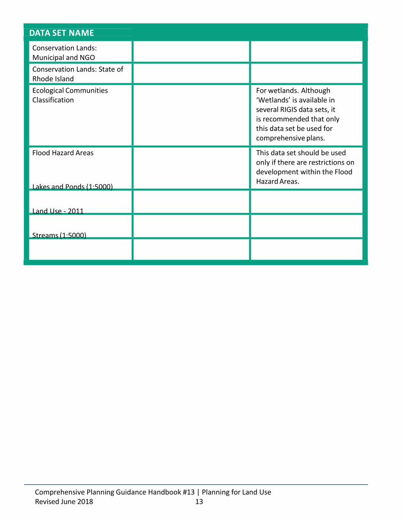
DATA SET NAME
Conservation Lands: Municipal and NGO
Conservation Lands: State of Rhode Island
Ecological Communities Classification
For wetlands. Although ‘Wetlands’ is available in several RIGIS data sets, it is recommended that only this data set be used for comprehensive plans.
Flood Hazard Areas
Lakes and Ponds (1:5000)
Land Use - 2011
Streams (1:5000)
This data set should be used only if there are restrictions on development within the Flood Hazard Areas.
Comprehensive Planning Guidance Handbook #13 | Planning for Land Use Revised June 2018 13
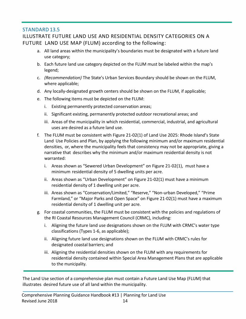
STANDARD 13.5 ILLUSTRATE FUTURE LAND USE AND RESIDENTIAL DENSITY CATEGORIES ON A FUTURE LAND USE MAP (FLUM) according to the following:
a. All land areas within the municipality’s boundaries must be designated with a future land use category;
b. Each future land use category depicted on the FLUM must be labeled within the map’s legend;
c. (Recommendation) The State’s Urban Services Boundary should be shown on the FLUM, where applicable;
d. Any locally-designated growth centers should be shown on the FLUM, if applicable;
e. The following items must be depicted on the FLUM:
i. Existing permanently protected conservation areas;
ii. Significant existing, permanently protected outdoor recreational areas; and
iii. Areas of the municipality in which residential, commercial, industrial, and agricultural uses are desired as a future land use.
f. The FLUM must be consistent with Figure 21-02(1) of Land Use 2025: Rhode Island’s State Land Use Policies and Plan, by applying the following minimum and/or maximum residential densities, or, where the municipality feels that consistency may not be appropriate, giving a narrative that describes why the minimum and/or maximum residential density is not warranted:
i. Areas shown as “Sewered Urban Development” on Figure 21-02(1), must have a minimum residential density of 5 dwelling units per acre.
ii. Areas shown as “Urban Development” on Figure 21-02(1) must have a minimum residential density of 1 dwelling unit per acre.
iii. Areas shown as “Conservation/Limited,” “Reserve,” “Non-urban Developed,” “Prime Farmland,” or “Major Parks and Open Space” on Figure 21-02(1) must have a maximum residential density of 1 dwelling unit per acre.
g. For coastal communities, the FLUM must be consistent with the policies and regulations of the RI Coastal Resources Management Council (CRMC), including:
i. Aligning the future land use designations shown on the FLUM with CRMC’s water type classifications (Types 1-6, as applicable);
ii. Aligning future land use designations shown on the FLUM with CRMC’s rules for designated coastal barriers; and
iii. Aligning the residential densities shown on the FLUM with any requirements for residential density contained within Special Area Management Plans that are applicable to the municipality.
The Land Use section of a comprehensive plan must contain a Future Land Use Map (FLUM) that illustrates desired future use of all land within the municipality.
Comprehensive Planning Guidance Handbook #13 | Planning for Land Use Revised June 2018 14

The FLUM is a policy statement in and of itself, directing municipal decision-makers as to what types of uses are desired in each area and setting a vision for the municipality’s future growth over the next 20-years. The FLUM is the visual depiction of the community’s desires for types, patterns, and intensities of development and for identifying those areas of the community that are to be dedicated to conservation. It is the underpinning for the regulations found within the zoning ordinance that legally regulate development in the community. A well-constructed FLUM should give the viewer instant recognition of the land uses to be allowed in the community, where they are to be allowed, and what areas of the community will be protected from development.
DATA SOURCES All of the maps, inventories and assessments presented in the other topical chapters should help to inform the Future Land Use Map.
To map the Urban Services Boundary, communities should use the following RIGIS data set:
SHOWING EXISTING CONSERVATION AREAS ON THE FLUM (Standard 13.5e.i.)
Existing permanently protected conservation areas must be shown on the Future Land Use Map (FLUM) as not appropriate for development. The Future Land Use Map sets the policy direction for the future use of land within the municipality; therefore, in order to avoid confusion and potential conflicts, existing permanently protected conservation areas must be shown on the FLUM as intended for conservation. The municipality can determine the best way to categorize conservation areas (e.g. protected open space, conservation lands, etc.), but the categories must reflect the intention of permanent conservation.
CRAFT A BETTER PLAN Municipalities may wish to show anticipated or proposed conservation areas on the FLUM as well. The areas that are proposed for future conservation on the FLUM will depend heavily on the community context, including the existing level of development, the significant natural resources present and the municipal priorities for conservation. Based on the identification of significant natural resources and resource areas, and the assessment of the issues facing these areas, communities should determine where it is appropriate to propose future conservation on the FLUM.
Comprehensive Planning Guidance Handbook #13 | Planning for Land Use Revised June 2018 15
DATA SET NAME
Urban Services Boundary
DOWNLOAD LINK
The plan’s Implementation Program must identify any inconsistencies that exist between the plan and the existingzoning ordinance and map. Any areas that are shown as “conservation” on the FLUM must also be designated as a conservation-based zoning district. For more information on the Implementation Program, see. Guidance Handbook #14 - The Implementation Program.
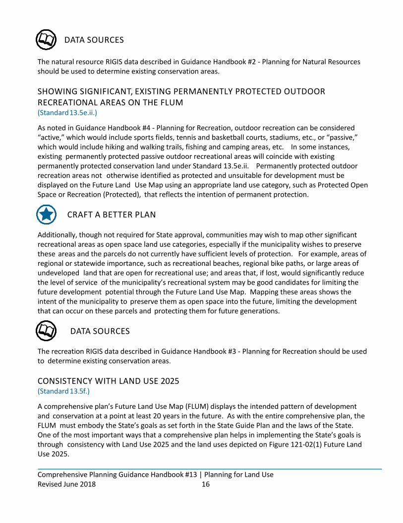
DATA SOURCES The natural resource RIGIS data described in Guidance Handbook #2 - Planning for Natural Resources should be used to determine existing conservation areas.
SHOWING SIGNIFICANT, EXISTING PERMANENTLY PROTECTED OUTDOOR RECREATIONAL AREAS ON THE FLUM (Standard 13.5e.ii.)
As noted in Guidance Handbook #4 - Planning for Recreation, outdoor recreation can be considered “active,” which would include sports fields, tennis and basketball courts, stadiums, etc., or “passive,” which would include hiking and walking trails, fishing and camping areas, etc. In some instances, existing permanently protected passive outdoor recreational areas will coincide with existing permanently protected conservation land under Standard 13.5e.ii. Permanently protected outdoor recreation areas not otherwise identified as protected and unsuitable for development must be displayed on the Future Land Use Map using an appropriate land use category, such as Protected Open Space or Recreation (Protected), that reflects the intention of permanent protection.
CRAFT A BETTER PLAN Additionally, though not required for State approval, communities may wish to map other significant recreational areas as open space land use categories, especially if the municipality wishes to preserve these areas and the parcels do not currently have sufficient levels of protection. For example, areas of regional or statewide importance, such as recreational beaches, regional bike paths, or large areas of undeveloped land that are open for recreational use; and areas that, if lost, would significantly reduce the level of service of the municipality’s recreational system may be good candidates for limiting the future development potential through the Future Land Use Map. Mapping these areas shows the intent of the municipality to preserve them as open space into the future, limiting the development that can occur on these parcels and protecting them for future generations.
DATA SOURCES The recreation RIGIS data described in Guidance Handbook #3 - Planning for Recreation should be used to determine existing conservation areas.
CONSISTENCY WITH LAND USE 2025 (Standard 13.5f.)
A comprehensive plan’s Future Land Use Map (FLUM) displays the intended pattern of development and conservation at a point at least 20 years in the future. As with the entire comprehensive plan, the FLUM must embody the State’s goals as set forth in the State Guide Plan and the laws of the State. One of the most important ways that a comprehensive plan helps in implementing the State’s goals is through consistency with Land Use 2025 and the land uses depicted on Figure 121-02(1) Future Land Use 2025.
Comprehensive Planning Guidance Handbook #13 | Planning for Land Use Revised June 2018 16

TABLE 13-1. LAND USE 2025 RESIDENTIAL DENSITY REQUIREMENTS
Land Use 2025 contains a map of future land use, Figure 121-02(1), “Future Land Use 2025” on page 2-15, that shows broad-scale patterns for committed and future uses of land. Consistency with Land Use 2025, is achieved when the comprehensive plan’s FLUM aligns with the residential densities allocated in Figure 121-02(1) and described in Section 2-4, “Future Land Use Patterns, Categories, and Intended Uses.” Generally, for areas inside the Urban Services Boundary, a higher residential density is expected due to the presence of existing services, facilities, and infrastructure. Outside of the Urban Services Boundary, however, the guidance of Land Use 2025 is a bit less clear. In areas outside of the Urban Services Boundary, communities must balance development and conservation, consider special resource concerns (such as wellhead and groundwater protection), and determine where growth is best suited, such as in a locally-designated growth center.
To move the state towards its goal of concentrated density within the Urban Services Boundary, local Future Land Use Maps must be consistent with the minimum and/or maximum residential densities outlined in Table 13-1. Land Use 2025 Residential Density Requirements. However, if there are instances where the municipality feels that consistency may not be appropriate, narrative must be given describing why the minimum and/or maximum residential density is not warranted. (For example, it may not be appropriate for areas depicted as “Urban Development” on Figure 121-02(1) but that have significant natural resource value to have a future residential density of greater than one (1) dwelling unit per acre. Similarly, areas shown as “Non-urban Developed” on Figure 121-02(1) where the existing residential density is greater than one (1) dwelling unit per acre may be best suited for existing residential densities.)
CRAFT A BETTER PLAN To truly embody the State’s goals for land use, communities are encouraged to align the comprehensive plan’s FLUM with Land Use 2025 in a more thoughtful and comprehensive way.
Comprehensive Planning Guidance Handbook #13 | Planning for Land Use Revised June 2018 17
LAND USE 2025 FUTURE LAND USE CATEGORY
Sewered Urban Development
Urban Development
Conservation/Limited
Reserve
Non-urban Developed
Prime Farmland
MINIMUM/MAXIMUM RESIDENTIAL DENSITY
Minimum of 5 dwelling units per acre
Minimum of 1 dwelling unit per acre
Maximum of 1 dwelling unit per acre
See Land Use 2025, pages 2-13 through 2-20 for additional information on the State’s Future Land Use Map and the intentions for each land use category.

The following guidance is provided for those municipalities who wish to align the FLUM with the full breadth of Land Use 2025’s future land use map.
Generally, Land Use 2025’s Figure 121-02(1) splits the state into “Growth Areas,” “Conservancy Areas,” and “Committed Use Areas.” According to Land Use 2025,
“Growth Areas are intended to accommodate the State’s anticipated growth needs through 2025.
They include both (currently) developed areas that are suited for maintenance, infill, and reuse, as well as (currently) undeveloped areas that are suited for new development.”
Land Use 2025’s Figure 121-02(1) directs growth to two types of land: 1) areas within the Urban Services Boundary (USB); and 2) areas within locally-designated growth centers, which can be both within and outside of the USB. In addition to the locally-designated growth centers, two categories of growth have been allocated within the USB: “Urban Development” and “Sewered Urban Development.”
As indicated by the name, the “Sewered Urban Development” category shows the areas within the USB where public sewer service is available. Land Use 2025 calls for these areas to be developed or redeveloped at higher intensities and densities so as to optimize the significant public infrastructure investment, unless there are significant constraints on the land. For both the “Urban Development” and “Sewered Urban Development” categories, the priority for developed lands is to maintain and enhance productive uses and to re-use underutilized areas to accommodate growth at intensities that efficiently utilize available services.
For undeveloped lands within these categories that have few resource constraints or are likely to be provided with urban-level services, the priority is development with intensities and residential densities that mirror existing urban developed lands and enable efficient provision and utilization of public services, including transit. Undeveloped areas within these categories that have some resource constraints but are likely to be provided with some urban-level services, are generally targeted for medium-level urban development, including residential uses at average densities of 1 to 5 dwelling units per acre. Other undeveloped areas that are targeted for growth, which have site and/or resource constraints and limited services, are targeted for lower residential densities, with some areas reserved for open space and farmland.
Land Use 2025’s FLUM also shows areas where Future Rail Stations may be established and directs municipalities that new rail stations should provide an impetus for new growth centers or other transit-oriented development.
All land outside of the USB that is not within a designated growth center has been categorized as “Committed Use Areas” – including “Non-urban Development” – or “Conservancy Areas” and are intended to remain as either conservancy or the existing committed use.
Land Use 2025 describes locally-designated growth centers as “compact, developed areas containing a defined central core that accommodate community and regional needs for residential and economic functions.” Land Use 2025 also states that, “Centers are intended to provide optimum utilization of land and services, and offer a higher density diverse housing stock, commercial, industrial, office, cultural, and governmental uses.” While some growth centers have been depicted on Land Use 2025’s FLUM, the locations are intended to be illustrative only. Municipalities are expected to determine the appropriate locations of any new growth centers within their boundaries.
Comprehensive Planning Guidance Handbook #13 | Planning for Land Use Revised June 2018 18
DATA SOURCES Land Use 2025: Rhode Island Land Use Policies and Plan, available at www.planning.ri.gov/documents/guide_plan/landuse2025.pdf. Urban Services Boundary data set, available at
CONSISTENCY WITH THE POLICIES AND REGULATIONS OF THE COASTAL RESOURCES MANAGEMENT COUNCIL (CRMC) WATER TYPE CLASSIFICATIONS (Standard 13.5g.i.)
The CRMC has assigned the state’s tidal waters, coastal ponds and adjacent upland areas to one of six use categories, commonly referred to as “water type classifications.” Each of these six categories have findings, goals, and policies pertaining to the category, which can be found in Section 200 of CRMC’s regulations. The six categories are:
• Type 1 - Conservation Areas
• Type 2 - Low-Intensity Uses
• Type 3 - High Intensity Boating
• Type 4 - Multipurpose Waters
• Type 5 - Commercial and Recreation Harbors
• Type 6 - Industrial Waterfronts and Commercial Navigation Channels
The CRMC’s water type classifications are the State’s designated priority use for all coastal waters and adjacent upland areas within the Council’s jurisdiction. The land uses designated on the FLUM for lands abutting coastal waters must allow, and not detract from or interfere with, the priority uses. For example, if a coastal area has the water type classification of “Type 6 - Industrial Waterfronts and Commercial Navigation Channels,” the comprehensive plan must allow industrial uses within the land use categories that are adjacent to these waters. Additionally, in this example, the comprehensive plan must not identify the local priority for the area as anything other than industrial.
If a municipality wishes to designate a future land use that is not compatible with the designated water type classification, it may request the CRMC to amend the water type classification for the subject area to allow for the preferred adjacent land use. While comprehensive plans may contain a discussion of, and implementation actions to pursue, a change in a water type classification, the FLUM must reflect the water type classification currently in effect.
Comprehensive Planning Guidance Handbook #13 | Planning for Land Use Revised June 2018 19
The CRMC’s Rules can be found at http://www.crmc.ri.gov/regulations/RICRMP.pdf. The CRMC’s maps depicting water use classifications for each coastal municipality can be viewed at http://www.crmc.ri.gov/maps/maps_
RULES FOR DESIGNATED COASTAL BARRIERS (Standard 13.5g ii.)
According to CRMC Rules Section 210.2, barriers “are islands or spits comprised of sand and/or gravel, extending parallel to the coast and separated from the mainland by a coastal pond, tidal water body, or coastal wetland.” There are three primary types of barriers designated by CRMC:
• Undeveloped Barriers: essentially free of commercial/industrial buildings, (excluding public utility lines) houses, surfaced roads, and structural shoreline protection facilities;
• Moderately Developed Barriers: essentially free of houses, commercial/ industrial buildings and/ or facilities (excluding utility lines) that contain surfaced roads, recreational structures, and/or structural shoreline protection facilities; and
• Developed Barriers: contain houses and/or commercial/industrial structures; they may also contain surfaced roads and structural shoreline protection facilities.
The FLUMs of coastal communities must demonstrate consistency with the policies and prohibitions for the designated barriers as outlined in CRMC’s Section 210.2. Some of the policies and prohibitions found in CRMC’s Section 210.2 that are of particular importance to comprehensive plans include:
• The prohibition of new development on moderately developed barriers, except where the primary purpose of the project is restoration, protection or improvement of the feature as a natural habitat for plants and wildlife; and
• The prohibition of new construction of infrastructure or utilities or expansion of existing infrastructure or utilities on all barriers, except for infrastructure that is intended to serve the needs of the State.
(Standard 13.5g.iii.)
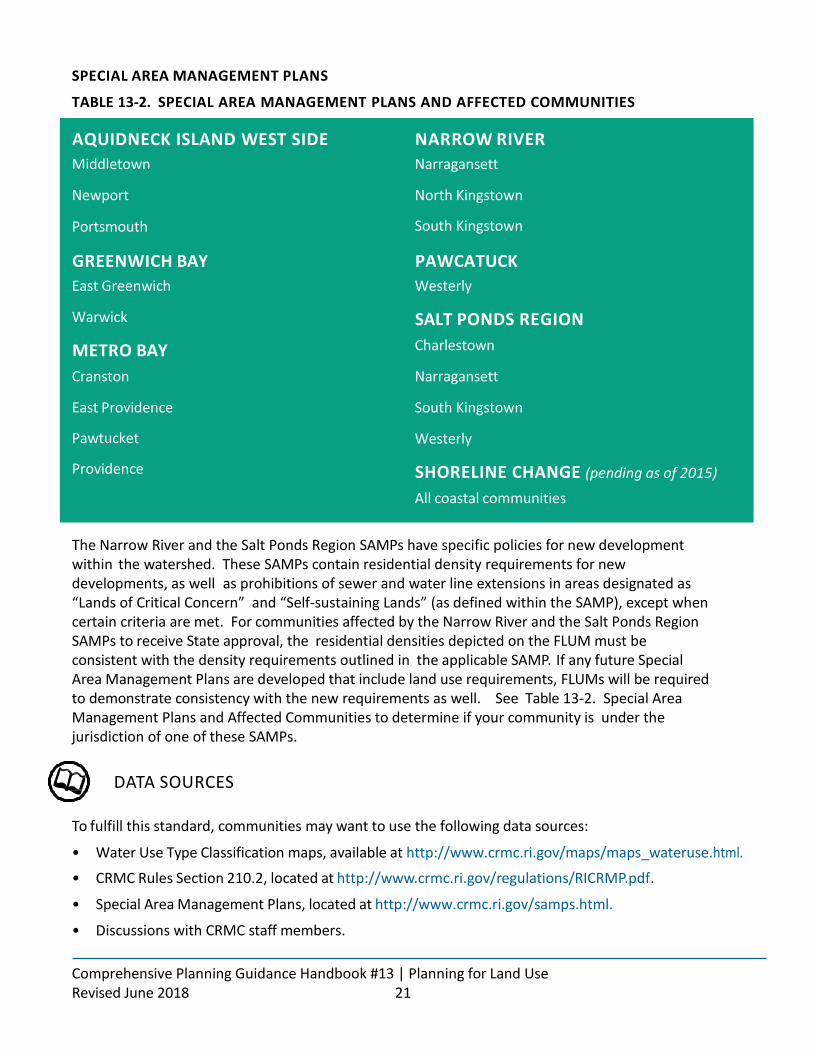
The CRMC has created six Special Area Management Plans (SAMPs) that affect coastal lands within the State and is in the process of developing a seventh. These plans address specific regional issues and present ecosystem-based management strategies that are consistent with the council’s legislative mandate to preserve and restore ecological systems. See Table 13-2 for a complete list of the SAMPs and the municipalities that intersect with each SAMPs jurisdiction.
The goals, policies and implementation actions of comprehensive plans of communities within the jurisdiction of a SAMP must not be in conflict with the policies of the applicable SAMP. Two SAMPS, the Narrow River and Salt Ponds Region SAMPS described below, include specific residential density policies for new development within the watershed, which must be adhered to by the FLUM. If any future SAMPs are developed that include land use requirements, municipalities will need to review their comprehensive plans, and especially their FLUMs, to ensure consistency with the new requirements.
Comprehensive Planning Guidance Handbook #13 | Planning for Land Use Revised June 2018 20
The CRMC’s Rules can be found at: http://www.crmc.ri.gov/regulations/RICRMP.pdf.
SPECIAL AREA MANAGEMENT PLANS
TABLE 13-2. SPECIAL AREA MANAGEMENT PLANS AND AFFECTED COMMUNITIES
The Narrow River and the Salt Ponds Region SAMPs have specific policies for new development within the watershed. These SAMPs contain residential density requirements for new developments, as well as prohibitions of sewer and water line extensions in areas designated as “Lands of Critical Concern” and “Self-sustaining Lands” (as defined within the SAMP), except when certain criteria are met. For communities affected by the Narrow River and the Salt Ponds Region SAMPs to receive State approval, the residential densities depicted on the FLUM must be consistent with the density requirements outlined in the applicable SAMP. If any future Special Area Management Plans are developed that include land use requirements, FLUMs will be required to demonstrate consistency with the new requirements as well. See Table 13-2. Special Area Management Plans and Affected Communities to determine if your community is under the jurisdiction of one of these SAMPs.
DATA SOURCES
To fulfill this standard, communities may want to use the following data sources:
• Water Use Type Classification maps, available at http://www.crmc.ri.gov/maps/maps_wateruse.html.
• CRMC Rules Section 210.2, located at http://www.crmc.ri.gov/regulations/RICRMP.pdf .
• Special Area Management Plans, located at http://www.crmc.ri.gov/samps.html.
• Discussions with CRMC staff members.
Comprehensive Planning Guidance Handbook #13 | Planning for Land Use Revised June 2018 21
AQUIDNECK ISLAND WEST SIDE
Middletown
Newport
Portsmouth
NARROW RIVER
Narragansett
North Kingstown
South Kingstown
GREENWICH BAY
East Greenwich
Warwick
METRO BAY
Cranston
East Providence
Pawtucket
Providence
PAWCATUCK
Westerly
SALT PONDS REGION
Charlestown
Narragansett
South Kingstown
Westerly
SHORELINE CHANGE (pending as of 2015)
All coastal communities

Additionally, communities may wish to use the following RIGIS data sets for this standard:
Comprehensive Planning Guidance Handbook #13 | Planning for Land Use Revised June 2018 22
DATA SET NAME
Barrier Beach Classification Zones
Barrier Islands and Spits
Water Use Categories
DOWNLOAD LINK

STANDARD 13.6 INCLUDE DESCRIPTIONS OF EACH OF THE FUTURE LAND USES AND DENSITIES SHOWN ON THE FUTURE LAND USE MAP THAT DISCUSS, AT A MINIMUM:
a. The general uses that are desired within the future land use category (residential, commercial, industrial, agricultural, civic, institutional, open space, recreation, etc.); and
b. The average residential density or the range of residential densities that are desired within the future land use category, if residential uses are to be permitted.
Each future land use category depicted on the FLUM must be described within the narrative of the comprehensive plan’s Land Use section. See Tips for Crafting a Future Land Use Map for more information on the options available for Future Land Use Maps.
CRAFT A BETTER PLAN
Though not required, it is beneficial for the Land Use section of a comprehensive plan to also describe the general character desired for the depicted areas. For example, it is helpful to local decision makers to know if an area depicted as “commercial” is intended to be neighborhood commercial, with a village- like, pedestrian scale, or if it is intended to be highway commercial, with larger footprint buildings and auto-oriented signage. The more descriptive the category descriptions are, the easier it will be to adopt standards within the zoning ordinance to achieve the desired land use patterns.
Comprehensive Planning Guidance Handbook #13 | Planning for Land Use Revised June 2018 23

STANDARD 13.7 IDENTIFY ANY AREAS OF THE MUNICIPALITY IN WHICH INCONSISTENCIES EXIST BETWEEN THE EXISTING ZONING DISTRICTS AND THE DESIRED FUTURE LAND USES ILLUSTRATED ON THE FUTURE LAND USE MAP, BY:
a. Clearly delineating, on a map, the areas that have been determined to be inconsistent;
b. Identifying the existing zoning in the areas that have been determined to be inconsistent; and
c. Identifying the future land use designations of areas that have been determined to be inconsistent.
In order to achieve the vision set forth by the Future Land Use Map (FLUM), it is imperative that communities understand how that vision differs from the existing regulations of the zoning ordinance and map. To this end, the Comprehensive Planning and Land Use Regulation Act requires that comprehensive plans include a map showing any areas in which inconsistencies exist between the FLUM and the zoning ordinance and map.
To determine areas where inconsistencies exist, the future land use designations and their descriptions must be compared to the existing zoning districts, both in terms of allowable uses and residential densities. Any instances where the uses and/or residential densities do not align are to be considered inconsistent. Inconsistencies can take a number of forms, including instances where:
• The FLUM calls for a singular use of the land (e.g. residential future land use designation) and the existing zoning allows multiple uses (e.g. residential with limited commercial zoning);
• The FLUM calls for multiple uses for the land (e.g. mixed-use residential and commercial future land use designation) and the existing zoning allows only a single use (e.g. commercial-only zoning);
• The FLUM calls for limited development in an area (e.g. open space future land use designation) and the existing zoning allows development (e.g. residential zoning that allows open space);
• The FLUM calls for increased residential density or intensity in an area (e.g. high density residential) and the existing zoning only allows low density or intensity development (e.g. low density residential); or
• The FLUM calls for lower density or intensity development and the existing zoning calls for higher density or intensity development.
It is not necessary for all of the required information to appear on the map itself; it may be more appropriate to number areas that have been deemed inconsistent and to provide a summary table of the future land use categories and the existing zoning districts.
Comprehensive Planning Guidance Handbook #13 | Planning for Land Use Revised June 2018 24
For areas designated as “open space” or a similar development-limiting category on the Future Land Use Map, consistency is only achieved when an “open space” or similar zoning district is applied to the area Any areas that do not have similarly limiting zoning for open space designated parcels must be highlighted as inconsistent.

STANDARD 13 .8 FOR ANY INCONSISTENCIES THAT EXIST BETWEEN THE EXISTING ZONING DISTRICTS AND THE FUTURE LAND USE MAP AND CATEGORIES, PROPOSE RESOLUTIONS BY SELECTING AND DISCUSSING ONE OF THE FOLLOWING OPTIONS:
a. Propose to change the zoning of a particular area to an existing zoning district that is consistent with the future land use designation, giving a brief description of the zoning district that includes the allowed uses; or
b. Propose the creation of a new zoning district that would achieve consistency with the future land use designation, and the application of the new district to the inconsistent area, giving a brief description of the intended zoning district that includes the expected allowed uses.
For each area in which an inconsistency between the current zoning and future land use designation is present, the comprehensive plan must propose a resolution for the inconsistency.
For those areas determined to be inconsistent, comprehensive plans may also propose a one-time moratorium on all development within the specified area for the twelve (12) months subsequent to the adoption of the comprehensive plan in order to limit development while the inconsistency is being resolved. If a development moratorium is desired, implementation actions must be included in the Implementation Program that would 1) enact the moratorium as an ordinance; and 2) amend the zoning ordinance and map within twelve (12) months of plan adoption.
The Implementation Program must also provide the schedule by which the zoning ordinance and map will be amended to bring consistency with the FLUM (see Guidance Handbook #14 - The Implementation Program).
If the community feels that changing the zoning for a particular area or parcel is not feasible, the Future Land Use Map should be adjusted to reflect the zoning requirements during the drafting process.
The comprehensive plan must assess and propose resolutions for inconsistencies between the zoning ordinance and map and the FLUM, which is not necessarily the same as assessing inconsistencies with the existing development pattern. (e.g. non-conforming lots of record).
For more information on the development moratorium, see the RI Comprehensive Planning and Land Use Regulation Act, RIGL subsection 45-22.2-13(e) .
CRAFT A BETTER PLAN
Though not required for State approval, it may benefit the community to include substantial information about any new zoning districts being proposed so that when the time comes to amend the zoning ordinance and map, the desires of the community can be fully addressed. The comprehensive plan could also discuss whether any of the amendments will be the subject of specialized study, planning and/or public engagement efforts. For example, if an area is likely to be the subject of a neighborhood planning effort, it could be noted in this section.
Comprehensive Planning Guidance Handbook #13 | Planning for Land Use Revised June 2018 25

To receive State approval, it is not necessary that all future land use conflicts be resolved, simply that the conflicts are acknowledged and discussed and that actions are taken to minimize conflicts as discussed under Standard 13.11b.
STANDARD 13.9 (RECOMMENDATION) DISCUSS ANY INCONSISTENCIES THAT EXIST BETWEEN THE DESIRED FUTURE LAND USES ILLUSTRATED ON THE FUTURE LAND USE MAP AND THE COPMREHENSIVE PLANS OF CONTIGUOUS MUNICIPALITIES BY INCLUDING, FOR EACH AREA IN WHICH A CONFLICT IS IDENTIFIED:
a. Identification of the conflicting future land use designations;
b. Discussion of the conflict that seems to exist; and
c. A brief synopsis of why the future land use was selected for the area.
To ensure coordinated land use planning throughout the state, it is important that communities consider the ways in which the future land use designations illustrated on the Future Land Use Map (FLUM) correspond to the uses identified within the plans of contiguous municipalities. When assessing consistency with the comprehensive plans of contiguous municipalities, communities should focus on comparing the Future Land Use Maps and future land use designation descriptions found within the plans. In areas where municipal borders meet, future land use designations must be compared to determine if there are any areas of conflict.
Determining whether a future land use conflict exists will require an understanding of the intent or priorities of the future land use designations. It is important to remember that different, bordering land uses do not necessarily create a conflict and that a general mix of land uses within a given area can be beneficial. For example, a medium-density residential area bordering a neighborhood commercial or mixed-use area may actually be an appropriate mix of uses. Communities should consider whether the future land use designations support or detract from the creation of a vibrant community.
CRAFT A BETTER PLAN Communities may also wish to consider the use of resources that cross municipal boundaries, such as water and transportation corridors, and how their policies and actions may affect the other municipalities who share the resource. Also, communities could consider the ways in which their development patterns are affecting contiguous municipalities in terms of resiliency to natural hazards and climate change. For example, the creation of impervious surfaces at the head of a river may have large consequences along the remainder of the river.
Comprehensive Planning Guidance Handbook #13 | Planning for Land Use Revised June 2018 26

STANDARD 13.10 INCLUDE GOALS THAT EMBODY THE STATE’S GOALS FOR LAND USE AND POLICIES TO SUPPORT EACH GOAL.
Comprehensive plans must include one or more goals that support the State’s goals for land use and policies to support each goal. The goals of the State call for sustainable land use patterns that create distinct, high quality places, orderly growth and development that respects and reflects the context in which it is happening, and a focus on developing within the Urban Services Boundary and locally-designated centers rather than in undeveloped areas. When determining the goals and policies that may be appropriate for the municipality, the following guiding questions should be considered:
• What is the relationship between the municipality and the Urban Services Boundary?
• What level of public services is currently provided to the municipality? Is the level of service expected to change?
• Are there currently high-quality places within the municipality? If not, would the community like to improve the quality of its places? If so, is the community seeking to enhance these places or create more of them?
• Does the current growth pattern respect and reflect the natural resource context of the municipality?
• Does the community wish to target growth to certain areas of the municipality? Does the community wish to create one or more growth centers?
SAMPLE GOALS
• Achieve a balanced and harmonious development pattern that promotes economic growth and reinvestment while preserving neighborhood integrity, environmental and aesthetic quality, and overall livability.
• Sustain our municipality’s high quality of life and preserve its unique attributes.
• Create walkable neighborhoods and a connected transportation network for all modes and people of all ages.
• Preserve and maintain our agricultural landscape and heritage.
SAMPLE POLICIES
• Manage and direct growth in a way that minimizes damage to the environment, reduces sprawl, and builds livable towns and cities.
Comprehensive Planning Guidance Handbook #13 | Planning for Land Use Revised June 2018 27
For more information on the difference between goals, policies and implementation actions, see Guidance Handbook #1 - The Comprehensive Plan 101.
• Participate in regional planning efforts with appropriate partners and neighboring communities.
• Discourage additional commercial sprawl/large-scale strip retail development.
• Encourage the redevelopment of vacant and underutilized commercial properties.
• Allow flexibility in regulations to support the needs of agricultural businesses.
• Protect and enhance the natural scenic beauty and heritage our coastal community.
• Ensure the continued strength and stability of our neighborhoods by directing growth to appropriate areas and respecting valued development patterns and attributes.
• Preserve significant buildings and view corridors.
• Encourage growth in areas best suited to provide access to jobs, housing and transit.
• Promote a balance of uses to support sustainable patterns of development providing healthy, walkable neighborhoods, thriving business districts, and a high quality of life.
• Promote the development of a wide range of residential land uses to ensure a diversity of housing choices for all residents.
• Permit institutional growth and expansion in designated areas while limiting their encroachment and negative impacts on the neighborhoods in which they are located.
• Promote design excellence and historic preservation through appropriate land controls.
• Consider scenic resources when reviewing the type, location, and intensity of land uses.
Comprehensive Planning Guidance Handbook #13 | Planning for Land Use Revised June 2018 28

STANDARD 13.11
Include implementation actions within the Implementation Program that addresses:
a. Promoting orderly growth and development.
b. (Recommended) Minimizing potentially conflicting land uses in contiguous municipalities and appropriately using shared resources.
c. Ensuring that municipal land use regulations are consistent with the goals and policies set forth within the comprehensive plan.
d. Amending the zoning ordinance and map to provide consistency with the comprehensive plan, if applicable
a. Promoting orderly growth and development.
The intent of this standard is to include implementation actions within the Implementation Program that align the many goals of the comprehensive plan so that they provide a clear picture of how the community intends to develop. Specifically, this standard calls for all growth and development within the municipality to recognize:
• The natural characteristics of the land;
• The suitability of land for the intended use;
• The availability of necessary resources; and
• The need to coordinate growth and the intensity of development with the provision of services and facilities.
Among other things, these considerations can take the form of actions that call for revisions to the zoning ordinance and/or subdivision and land development regulations, if necessary, to better coordinate project reviews, the alignment of new development proposals with the provision of services and facilities, the creation of or an increased level of service for specific community services and facilities that are impacted by new development, or the development of a growth center. Municipalities should consider where the current processes, regulations, and land use decisions are ineffective at promoting orderly growth and development and attempt to bring more coordination with these important aspects of planning.
SAMPLE IMPLEMENTATION ACTIONS • Review and update the zoning ordinance, and subdivision regulations to ensure smart growth
principles are encouraged.
• Amend the zoning ordinance and/or land development regulations to include incentives to attract desirable development and redevelopment to areas of town with existing infrastructure.
• Purchase development rights with land trusts and private/public land preservation organizations to agricultural parcels.
• Create incentives for property owners/developers to build mixed use properties.
Comprehensive Planning Guidance Handbook #13 | Planning for Land Use Revised June 2018 29

• Establish a Conservation Commission.
• Adopt a Conservation Design ordinance.
• Establish criteria for prioritizing the acquisition of conservation areas.
b. (Recommended) Minimizing potentially conflicting land uses in contiguous municipalities and
appropriately using shared resources.
There are two areas in which the planning of contiguous municipalities overlap significantly: the use of land in contiguous areas and the use of shared resources. The assessment of inconsistencies with the comprehensive plans of contiguous municipalities, described under Standard 13 .9, should highlight any areas where land use conflicts may exist. Communities should also think about how the use of shared resources, such as water bodies, major employers, and transportation corridors, affects other municipalities. Also, communities should think about the ways in which their development patterns are affecting contiguous municipalities in terms of resiliency to natural hazards and climate change. For example, the creation of impervious surfaces at the head of a river may have large consequences for communities along the remainder of the river.
To satisfy this standard, municipalities should consider what actions could be implemented to minimize land use conflicts and/or better share resources. Actions could include holding discussions with decision-makers from neighboring communities, working with neighboring communities to determine the best course of action for sharing resources, or amending the zoning ordinance and/or subdivision and land development regulations to better align with neighboring land uses.
SAMPLE IMPLEMENTATION ACTIONS
• Initiate quarterly meetings with the chief executives and/or municipal planners from contiguous municipalities to discuss issues and opportunities.
• Produce a recommendation report of potential mitigation measures for areas of the municipality in which inconsistencies of land use with contiguous communities have been identified.
• Notify contiguous municipalities of any new development projects that are proposed for lands that abut the shared borders.
c. Ensuring that municipal land use regulations are consistent with the goals and policies set forth
within the comprehensive plan. In addition to those implementation actions that specifically bring consistency between the zoning ordinance and map and the FLUM, there may be other parts of the comprehensive plan that require amendments to other municipal regulations, such as the subdivision and land development regulations, historic district regulations, design guidelines, etc. When crafting the comprehensive plan, communities should take note of all of the ways in which current regulations would need to change in order to fully align with the goals of the plan, and include those items as actions within the Implementation Program.
Comprehensive Planning Guidance Handbook #13 | Planning for Land Use Revised June 2018 30

SAMPLE IMPLEMENTATION ACTIONS
• Adopt mixed-use zoning ordinance which allows for mixed use in all commercial areas.
• Identify site specific properties where mixed-use zoning should be encouraged.
• Research how form-based zoning could complement Commercial Design Standards.
• Require that significant future retail development be contained within areas or on parcels already devoted to this type of use.
d. Amending the zoning ordinance and map to provide consistency with the
comprehensive plan, if applicable
As discussed under Standard 13.7, the Implementation Program must include policies and implementation actions that would achieve consistency between the comprehensive plan and the zoning ordinance and map. As this is a major component of the standards for the Implementation Program, the standards for addressing this standard are included in Guidance Handbook #14 - The Implementation Program.
Comprehensive Planning Guidance Handbook #13 | Planning for Land Use Revised June 2018 31

SECTION 3. CRAFT A BETTER PLAN
32

RECOMMENDATION 13A
Communities have the option of using their comprehensive plans to designate and receive state approval of a local growth center. If a community wishes to designate a local growth center, the following requirements must be met.
13A.1 Include a map of the growth center, illustrating:
a. The exact boundary of the land to be included within the growth center; and
b. The future land use designations within the growth center.
13A.2 Include a narrative that discusses:
a. The economic purpose or reason for the establishment of the growth center, including the desired outcomes of designation, and the types of businesses, residents and visitors that the growth center is likely to serve;
b. The public investment priorities that will be targeted for the growth center once adopted;
c. The ways in which the growth center compliments what is going on in the rest of the municipality, neighboring municipalities and the rest of the state, in terms of services and housing choices provided to residents and visitors, and the economic purpose;
d. The impact that designating the growth center is expected to have on development and investment patterns in areas of the municipality outside of the growth center;
e. The ways in which the municipality will incentivize growth within the center and/or limit growth outside of the center;
f. The potential impacts of natural hazards and climate change on the growth center, if any, and the ways in which the municipality intends to mitigate these impacts; and
g. The ways in which the growth center meets each of the following criteria:
i. Encourages growth in an area with existing infrastructure and services;
ii. New infrastructure is planned to support compact growth;
iii. Includes mixed land uses;
iv. Creates a range of housing opportunities and choices;
v. Protects and enhances critical environmental resources;
vi. Provides a variety of transportation choices;
vii. Promotes community design that contributes to a sense of place; and
viii. The center is appropriately scaled.
13A.3 Include implementation actions within the Implementation Program that would help to implement the designated growth center.
There are many important reasons for designating and implementing local growth centers. Perhaps the most important from a municipal perspective is that by targeting growth to specific areas of the municipality, existing resources can be shared and existing services and facilities can be fully utilized.
Comprehensive Planning Guidance Handbook #13 | Planning for Land Use Revised June 2018 33

From a statewide perspective, allowing higher densities and intensities within targeted growth areas helps to preserve undeveloped land throughout the state when combined with proper incentives and requirements, such as a transfer of development rights program. Given these reasons, designating a local growth center is one of the major ways in which municipalities can help to implement the goals of Land Use 2025 and create a future for Rhode Island that is sustainable.
The vehicle for designating a local growth center is to include it within a locally-adopted comprehensive plan, following the requirements outlined below. Once the comprehensive plan has received State approval, the growth center(s) identified in the plan will also be State-approved.
FROM CONCEPT TO DESIGNATION Designating a growth center, like any planning initiative, starts with an idea. It takes a good amount of time, effort and ingenuity to develop the idea of a growth center into something that is ready for official designation. Above all, developing a local growth center requires a lot of discussion - with stakeholders, community members, and elected officials - to ensure that the growth center is achieving all of the community’s goals.
If the community is not yet at the point of determining an exact boundary or can’t answer all of the questions required for the narrative (both discussed below), the growth center can still be generally mapped and discussed within the comprehensive plan, but the discussion will not qualify as official designation unless all of the requirements can be fulfilled. Like the rest of the plan, anything relayed in the adopted plan about the growth center will still serve the purpose of guiding local action.
GROWTH CENTER MAP (Recommendation 13A.1)
To receive State approval, the growth center map must illustrate:
• The exact boundary of the land to be included within the growth center; and
• The future land use designations within the growth center.
It is important that an exact boundary of the growth center be identified. If the community is unable to identify an exact boundary at the time of the comprehensive plan update, it is likely that the growth center is still in the conceptual stage and is not quite ready for designation. If that is the case, the municipality is free to map a rough outline of the growth center, with a star, circle or other indicator, but this will not qualify as designating the growth center.
All growth centers must include a mix of uses. The specific mix of uses desired for the growth center will depend on the purpose of the growth center, as described in the next section, but could include housing, employment opportunities, schools, commercial and industrial uses, and/or public spaces and buildings. If the community wishes to determine the exact mix of uses as the growth center develops, the center can be given the Future Land Use designation of “mixed-use,” or “growth center.” It is important, however, that whatever designation is given, it is the same as the designation given on the Future Land Use Map, and it is described as required under Standard 13.6.
Comprehensive Planning Guidance Handbook #13 | Planning for Land Use Revised June 2018 34
However, the growth center will be most effective if there can be some targeting of uses within the land area designated as the growth center. For example, it may be appropriate to have a residential/ commercial mixed-use core, with mixed- or single-use buildings, and to surround that core with higher density residential uses so that the commercial uses in the center can be supported. Some thought should be given to the best and highest use of the land within the growth center, in order to determine the appropriate mix of uses and the way in which the targeted uses should relate to each other.
GROWTH CENTER NARRATIVE (Recommendation 13A.2)
In addition to the map, in order to receive State approval of the designated growth center, the Land Use section must include a discussion of all of the items listed in 13A.2.a through 13A.2.g. This narrative can include as much detail as the community feels is appropriate. If there is a lot of support and momentum behind the growth center’s designation, it may be appropriate to do some in-depth analysis on the discussion points. However, if there are limited resources, time, and/or support, it is acceptable for the discussion to be a high-level overview. To receive state approval, and therefore designation, the plan must simply demonstrate that the community has thought through the important issues.
To complete these discussion points, it may be helpful for municipalities to consider what “type” of growth center is desired. The type of growth center being targeted will depend on the context of the place (urban, suburban, or rural), the desired form or character of the center, the targeted economic function, the type of transit access available and the market area that the growth center is intended to service.
In assessing how the growth center meets the criteria listed under 13A.2g, it would be helpful to consider the following.
i. ENCOURAGES GROWTH IN AN AREA WITH EXISTING INFRASTRUCTURE AND SERVICES
While not appropriate for all growth centers, the preferred locations are those with existing infrastructure and public services (e.g. public water, sewers, transportation, wastewater management districts, etc.) The reuse of brownfields, conversion of underutilized structures, and infill projects should have priority over greenfield sites.
ii. NEW INFRASTRUCTURE IS PLANNED TO SUPPORT COMPACT GROWTH
In instances where existing infrastructure is not adequate to support the proposed growth center, the comprehensive plan should document and explain what new infrastructure will be needed, how it will be phased to coincide with the development of the new center, and how it will be designed to support compact growth over a sprawl development pattern.
iii. INCLUDES MIXED LAND USES
Centers must include a mix of housing, land uses that allow for significant employment opportunities (e.g. commercial, industrial, etc.), and civic/public buildings and spaces. Single-use developments, such as business or industrial parks, are appropriate within a growth center as long as they are only one component of the wider mix of land uses within the center.
Comprehensive Planning Guidance Handbook #13 | Planning for Land Use Revised June 2018 35

iv. CREATES A RANGE OF HOUSING OPPORTUNITIES AND CHOICES
For this criterion, the community should consider the assessments that were conducted for the housing component of the comprehensive plan. Housing opportunities and choices should consider the appropriate mix of single-family, multi-family, rental units, and price ranges to address as wide a spectrum of housing needs and income levels as possible.
v. PROTECTS AND ENHANCES CRITICAL ENVIRONMENTAL RESOURCES
Growth centers should be chosen so as to:
• Avoid converting prime farmland into development;
• Avoid fragmenting existing greenspace, especially forests and natural habitat areas;
• Avoid negative impacts to critical resource areas such as public water supplies, wellhead protection areas, groundwater aquifers, important habitant areas, unfragmented forests, or high value recreational waters;
• Avoid negative impacts to important cultural resource areas such as scenic vistas, scenic roads, or historic/archeological sites;
• Enhance community greenspaces such as parks, sports fields, walking/biking paths, etc. and,
• Enhance the connections of greenspace and greenways across municipal borders. vi. PROVIDES A VARIETY OF TRANSPORTATION CHOICES
The preferred locations for growth centers are those with convenient access to mass transit (existing or planned) and centers are encouraged to include public transit hubs/stations to connect local routes. The density, layout, and design of centers should encourage public transportation, walking, and biking over automobile use for local trips. Automobile traffic should be accommodated by inter-connected streets providing multiple route options to minimize congestion. vii. PROMOTES COMMUNITY DESIGN THAT CONTRIBUTES TO A SENSE OF PLACE
Community design within a center should encourage interactions among people, facilitate vibrant and safe street life, and maximize the sense of harmony with natural settings. Centers should seek to exhibit several or all of the characteristics of walkable communities: physical indicators of where the neighborhood begins and ends, relatively narrow streets with sidewalks, residential buildings in close proximity to commercial destinations, non-residential buildings with many windows and doors set close to the street, building entrances accessible to sidewalks, on-street parking, trees and/or architectural elements that protect pedestrians from weather, use of traffic calming devices including right-angled street corners, grid street patterns with connectivity to adjoining neighborhoods, and streetscapes that include amenities such as benches, good lighting, informative signage, and plantings.
The preservation of older and historic buildings also contributes to a community’s sense of place.
Comprehensive Planning Guidance Handbook #13 | Planning for Land Use Revised June 2018 36

viii. THE CENTER IS APPROPRIATELY SCALED
While the configuration of an identified growth center will vary from community to community, in accordance with community character and type of center desired by the municipality, growth centers should be small enough to be comfortably walked. Except in the state’s five historic urban core communities, municipally-identified growth centers should be no larger than an area with an approximately ¼ to ½ mile radius from its center to its edge in all directions (approximately ½ square mile to maximum of 1 square mile area).
GROWTH CENTER IMPLEMENTATION ACTIONS (Recommendation 13A.3)
In order to create the growth center, comprehensive plans must include implementation actions related to catalyzing the growth center. If designating a growth center, the implementation actions related to the growth center must be included in the plan’s Implementation Program.
The implementation actions selected for the specific growth center will depend heavily on the context of the municipality, the economic purpose of the growth center and the ability of the municipality to invest in and/or incentivize the growth center. Municipalities should consider the following guiding questions to determine what implementation actions to undertake:
• What are the best qualities of the existing neighborhoods and/or villages in the municipality? Are there any barriers in the zoning code or other regulations that prevent enhancing these existing places or developing places with similar qualities?
• What is the economic reason for the new growth center? What purpose will it serve in the community? Will it be a place of employment? If so, who will work there and how will they get there?
• Does the intended area of the growth center have the environmental capacity to absorb new growth? Does it have access to water, or can water be accessed at a reasonable price?
• Can the growth center accommodate housing types that might be missing in the community or housing types that may be attractive to seniors, working families, young adults, etc.?
• What civic functions might the growth center play? Will it be a gathering spot for residents? A center for municipal services?
Comprehensive Planning Guidance Handbook #13 | Planning for Land Use Revised June 2018 37
RECOMMENDATION 13B
Communities that have already designated a growth center in a State-approved comprehensive plan can choose to maintain the growth center’s approval status by completing the following requirements. If the following requirements are not met, State-approval of the growth center will lapse.
13B.1 Include a map of the growth center, illustrating:
a. The exact boundary of the land to be included within the growth center; and
b. The future land use designations within the growth center.
13B.2 Include a narrative that discusses:
a. The economic purpose or reason for the establishment of the growth center, including the desired outcomes of designation, and the types of businesses, residents, and visitors that the growth center is likely to serve; and
b. The public investment priorities that will be targeted for the growth center.
13B.3 Implementation actions within the Implementation Program that would help to implement the designated growth center .
GROWTH CENTER MAP (Recommendation 13B.1)
To receive State approval, the growth center map must illustrate:
• The exact boundary of the land to be included within the growth center; and
• The future land uses that are to be targeted for the various areas within the growth center.
The growth center map may be carried over from the previously approved comprehensive plan or the community may choose to amend the boundaries of the growth center. In either instance, it is important to remember that all growth centers must include a mix of uses. To be effective, there should be some targeting of uses within the land area designated as the growth center.
GROWTH CENTER NARRATIVE (Recommendation 13B.2)
If the community intends the growth center’s economic purpose to remain the same, the relevant portions of the growth center narrative from the previously approved comprehensive plan may be reiterated. If changes to the growth center’s purpose are necessary, those changes, and the reasons for them, should be noted in the narrative. Any public investments that have already occurred within the growth center should be discussed, as well as any investments that are intended for the future.
GROWTH CENTER POLICIES AND IMPLEMENTATION ACTIONS (Recommendation 13B.3)
In order to maintain the growth center, comprehensive plans must include implementation actions related to the further development of the growth center. Such implementation actions must be included in the plan’s Implementation Program.
Comprehensive Planning Guidance Handbook #13 | Planning for Land Use Revised June 2018 38

RECOMMENDATION 13.12 ASSESS FUTURE DEVELOPMENT CAPACITY BASED ON THE LAND USES SHOWN ON THE FUTURE LAND USE MAP
One of the best ways to test whether the FLUM will direct future growth in the way intended by the community is to complete a future development capacity analysis (or build-out analysis) based on the future land use designations (rather than on the existing zoning categories, as is required under Standard #4). Though not required for State approval, using the future land use designations to determine what the municipality will look like at build-out can help the community determine if the right allocations were made.
To conduct a build-out analysis based on the Future Land Use designations, a similar methodology can be used as that presented in Section 4. Additional Resources, except that where densities and FAR are input, the densities and FAR of the Future Land Use designations should be used rather than those of the existing zoning districts. The analysis of inconsistencies between the zoning ordinance and map and the FLUM can assist in determining which densities and FARs to use, since, in many cases, existing zoning districts will be identified for the inconsistent areas. In areas where new zoning districts are proposed, thought should be given to what the areas are intended to look like and how the buildings will relate to the street, parking areas, other infrastructure and amenities, to determine appropriate densities and FARs.
Comprehensive Planning Guidance Handbook #13 | Planning for Land Use Revised June 2018 39

SECTION 4. ADDITIONAL RESOURCES
44

TIPS FOR CRAFTING A FUTURE LAND USE MAP
There are many different things that must be considered in the development of a Future Land Use Map (FLUM), including:
• The contents of the State’s land use plan, Land Use 2025;
• The policies and regulations of the RI Coastal Resources Management Council;
• The comprehensive plans and FLUMs of contiguous municipalities;
• Whether growth will be targeted to a specific location, or growth center;
• The existing land uses and residential densities;
• The results of the future development capacity analysis;
• The availability of facilities and services;
• The impacts of future land use designations on the transportation system;
• The characteristics of the transportation network, including where there is access to transit and/or where freight lines may exist;
• The potential exposure of the land to natural hazards and climate change trends; and
• The locations and sensitivities of the community’s natural resources.
All of these items must be considered and brought together to craft a FLUM, balancing the community’s priorities for growth with the State’s goals, the availability and capacity of existing infrastructure, projected vulnerabilities to natural hazards and climate change, and resource, and conservation goals.
As with all aspects of a comprehensive plan, municipalities have considerable discretion in the presentation of a future land use map. When depicting future land uses on the FLUM, communities should:
• Use the standard base map that is used for other maps found in the plan.
• Determine the level of detail to be displayed. Some municipalities may wish to use parcel data in which the borders between adjacent land uses can be displayed in fine detail while other communities may wish to use a general approach where the border between adjacent land uses is less specifically defined.
• Determine the future land use categories to be displayed. In choosing the future land use categories, consider whether it is appropriate to use the land use categories displayed on the plan’s Existing Land Use Map, as there are positives and negatives to both approaches. Maintaining consistency between the categories on these two maps facilitates an easy comparison of where the community is today versus where it intends to be in the future. However, existing land use categories may not depict all of the intended changes that the municipality would like to see happen regarding the land use pattern.
• Display existing undeveloped areas as either their intended future use (e.g. residential, business, etc.) or as conserved, open space areas.
Comprehensive Planning Guidance Handbook #13 | Planning for Land Use Revised June 2018 40

A NOTE ABOUT USING ZONING DISTRICTS FOR FUTURE LAND USE CATEGORIES Some municipalities may wish to use their zoning districts as the basis for future land use categories. While this is permissible, there is a distinct disadvantage in doing so. The Act requires that a municipality’s zoning be consistent with the comprehensive plan. In instances where a change in zoning would result in creating a conflict with the future land use map, the FLUM must be amended prior to the zone change. By using zoning districts as the basis for future land use categories, a municipality would face the prospect of having to amend their comprehensive plan for all zoning changes, no matter how minor.
Comprehensive Planning Guidance Handbook #13 | Planning for Land Use Revised June 2018 41

SAMPLE BUILD-OUT METHODOLOGY 1: MATHEMATICAL ASSESSMENT
While this assessment is the simplest way to determine future development capacity, it is not necessarily the most accurate as it assumes that every parcel within the municipality, unless already developed to its fullest capacity, will redevelop to its highest capacity. This methodology also does not account for any constraints on the land that may be present, such as wetlands and topography, or for regulatory constraints that may be present, such as those related to the Coastal Resources Management Council’s jurisdiction and flood hazard areas. If the municipality has the capacity to perform an assessment using GIS, it may result in a more accurate picture of the future conditions.
STEP 1: DETERMINE THE TOTAL LAND AREA IN EACH ZONING DISTRICT
The first step in determining the total number of dwelling units at build-out is to estimate the total land area within each zoning district in acres. The areas of each zoning district can be determined using GIS software or by using a traditional approach, such as a planimeter or grid overlay.
STEP 2: ESTIMATE THE TOTAL NUMBER OF DWELLING UNITS AT BUILD-OUT
The next step is to calculate the total number of dwelling units at build-out, given the regulatory constraints of the residential zoning districts. For land zoned residential, some of the land area should be subtracted from the total available land to account for new roads and infrastructure. Most of the build-out methodology resources suggest using a ratio for roads and infrastructure between 10% and 30%, where 10-30% of the available land is dedicated to roads and infrastructure and the remaining land (70-90%) is assumed to hold all of the development. Alternatively, the community could look at examples of developments that have occurred within the municipality, which were subject to the municipal subdivision and land development regulations, to determine how much land, on average, was dedicated to roads and infrastructure, and then apply the more customized ratio to the available land. While undertaking this assessment, the municipality could also attempt to determine how much of the land area was undevelopable due to environmental constraints (such as wetlands). Multiplying the area of the zoning district by the developable land ratio (likely somewhere between 70 and 90%) will produce the total net developable area within each residential district. See Figure 13-1. Example Estimate of the Total Number of Dwelling Units at Build-out for an example calculation.
Next, for each residential zoning district, multiply the net developable area within each zoning district by the maximum density allowed within the zoning district. This calculation will produce the total number of dwelling units at build-out for each residential zoning district. See Figure 13-1. Example Estimate of the Total Number of Dwelling Units at Build-out for an example calculation. Then, simply add the number of dwelling units at build-out for each zoning district together to get the total for the municipality.
STEP 3: ESTIMATE THE TOTAL POPULATION AT BUILD-OUT
Population at build-out is estimated by multiplying the current number of persons per dwelling unit (available from the U.S. Census Bureau) by the total number of dwelling units. See Figure 13-2.
Example Estimate of the Total Population at Build-out for an example calculation.
Comprehensive Planning Guidance Handbook #13 | Planning for Land Use Revised June 2018 42

FIGURE 13-1. EXAMPLE ESTIMATE OF THE TOTAL NUMBER OF DWELLING UNITS AT BUILD-OUT (MATHEMATICAL ASSESSMENT STEP 2)
Total Land Area within Zoning
District
Developable Land X Ratio
Total Net Developable Area
= within Zoning
District
500 acres X 70% = 350 acres
Total Net Developable Area
within Zoning District
Maximum Allowed
X Density =
Total # of Dwelling Units at Build-Out
within Zoning District
350 acres X 4 .4 units per acre = 3,080 dwelling units
Total # of Dwelling Units at Build-Out
within Zoning District 1
3,080
Total # of Dwelling Units at Build-Out
+ within Zoning
District 2
+ 4,600
Total # of Dwelling Units at Build-Out
+ within Zoning
District 3
+ 6,820
Total # of Dwelling
= Units at Build-Out within Municipality
= 14,500 dwelling units
FIGURE 13-2. EXAMPLE ESTIMATE OF THE TOTAL POPULATI(OTON FAITGBUURIEL1D3-O-3U) T (MATHEMATICAL ASSESSMENT STEP 3)
Total # of Dwelling Units at Build-Out X
within Municipality
Current # of Persons per Dwelling Unit
Total Population at =
Build-Out
14,500 dwelling
units X
2 .3 persons
= 33,350 persons
RE
QU
IRE
D
DA
TA
PO
INT

Comprehensive Planning Guidance Handbook #13 | Planning for Land Use Revised June 2018 43

STEP 4: ESTIMATE THE TOTAL NUMBER OF NEW DWELLING UNITS AT BUILD-OUT To determine the number of new dwelling units that will be produced between now and build-out, simply subtract the current number of dwelling units from the total number of units determined in step 2. If the community wants to see how many new units will be constructed in each district, the calculation could be done by district, but that would require knowing how many dwelling units are currently within each zoning district. See Figure 13-3. Example Estimate of the Number of New
Dwelling Units at Build-out for an example calculation.
FIGURE 13-3. EXAMPLE ESTIMATE OF THE NUMBER OF NEW DWELLING UNITS AT BUILD-OUT (MATHEMATICAL ASSESSMENT STEP 4)
Total # of Dwelling Units at Build-Out - within Municipality
Total # of Current Dwelling Units
Total # of New
= Dwelling Units at Build-out
(FROM
FIGURE 13-1)
14,500 dwelling
units -
12,250 units
= 2,250 units
STEP 5: ESTIMATE THE YEAR BY WHICH RESIDENTIAL BUILD-OUT IS LIKELY TO OCCUR To estimate the year by which residential build-out is likely to occur, municipalities can look at historic development figures to determine the average number of new dwelling units built per year. It is recommended that municipalities look back 20-years (or more) to get an accurate picture of development trends. Once determined, the total number of new dwelling units from step 4 is then divided by the average number of dwelling units built per year to determine how many years it will take to build all of the new units. Then, the necessary number of years is added to the current year to determine the year b y which residential build-out is likely to occur. See Figure 13-4. Example Estimate
of the Year by Which Residential Build-out is Likely to Occur for an example calculation.
(TO FIGURE 13-4)
Comprehensive Planning Guidance Handbook #13 | Planning for Land Use Revised June 2018 44
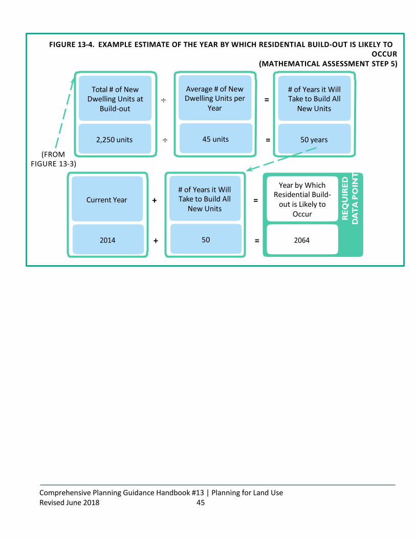
FIGURE 13-4. EXAMPLE ESTIMATE OF THE YEAR BY WHICH RESIDENTIAL BUILD-OUT IS LIKELY TO OCCUR
(MATHEMATICAL ASSESSMENT STEP 5)
Total # of New Dwelling Units at
Build-out
Average # of New Dwelling Units per
Year =
# of Years it Will Take to Build All
New Units
2,250 units 45 units = 50 years
(FROM FIGURE 13-3)
Current Year + # of Years it Will Take to Build All
New Units =
Year by Which Residential Build-
out is Likely to Occur
+ 50 =
Comprehensive Planning Guidance Handbook #13 | Planning for Land Use Revised June 2018 45
RE
QU
IRE
D
DA
TA
PO
INT

SAMPLE BUILD-OUT METHODOLOGY 2: SPATIAL ASSESSMENT
This methodology presents a more comprehensive approach to conducting a build-out analysis, but it requires the ability to access and map some important data. Much of the data that is needed for this assessment is already required for the comprehensive plan, as described below. This assessment can be done using printed maps and overlay sheets, but may be easier performed using GIS .
STEP 1: CONSTRUCT A BASE MAP
The very first step in conducting a build-out analysis is to construct a base map of the community. Base maps are typically developed using GIS, however, if a printed map is available it can be used in place of a GIS map. In order to be useful for the assessment, the base map should show:
• The perimeter or boundary of the community;
• The scale of the map;
• Existing roads; and
• Surface water (lakes, rivers, streams, etc.)
If available, it would be helpful for the base map to also show parcel boundaries.
STEP 2: DETERMINE AVAILABLE BUILDABLE LANDS
Next, several different types of data, or data layers, are laid on top of the base map to determine areas in which there is likely to be development. If using a printed map, clear overlay sheets should be laid over the base map, one for each data set, so that the data can be drawn in by hand. If using GIS, the data layers can be applied electronically.
The first data layer to be applied should delineate all of the land area within the municipality that is known to be undevelopable due to public ownership, conservation easements, deed restrictions, utility easements, etc. The required maps of conservation land (see Guidance Handbook #2 - Planning for Natural Resources) and major public infrastructure (see Guidance Handbook #8 - Planning for Services and Facilities), should assist in determining the constrained land areas.
The second data layer should depict all of the land area within the municipality that cannot be developed due to natural constraints, such as surface water, wetlands, flood plains, etc. The required maps of natural resources (see Guidance Handbook #2 - Planning for Natural Resources) and flood areas (see Guidance Handbook #12 - Planning for Natural Hazards and Climate Change), should assist in determining these areas.
Next, within the land areas that remain (those that are not constrained by ownership, deed, or environmental factors), the undeveloped and/or underdeveloped lands must be identified. The simplest version of this assessment is to look only at those lands that are obviously undeveloped or underdeveloped, including those that are simply vacant, as well as those with agricultural uses that are zoned for residential and natural areas that have not been protected with a conservation easement or deed restriction. The required existing land use map (see Standard 13.1) can assist in determining the areas that could be developed in the future. If a community wishes, it could also assume that portions of the municipality are likely to be redeveloped to the highest development
Comprehensive Planning Guidance Handbook #13 | Planning for Land Use Revised June 2018 46

capacity. If this type of assessment is desired, communities must delineate those areas in which redevelopment is expected and determine how many residential units currently exist within the areas.
The end result of this step will be a map depicting areas in which there is development capacity, due to being undeveloped or underdeveloped, or the expectation of redevelopment.
STEP 3: CALCULATE DEVELOPABLE AREAS WITHIN EACH ZONING DISTRICT
Once the areas that are likely to be developed (and redeveloped, if appropriate) are determined, the zoning district boundaries are overlaid on the areas and the amount of available land within each zoning district is calculated. If using a paper map, a planimeter may be necessary; if using GIS, the software is able to perform these calculations.
STEP 4: ESTIMATE NEW DWELLING UNITS EXPECTED WITHIN RESIDENTIAL ZONES
For land zoned residential, some of the developable land should be subtracted from the total land area available to account for new roads and infrastructure. Most of the build-out methodology resources listed beginning on page 57 suggest using a ratio for roads and infrastructure between 10% and 30%, where 10-30% of the available land is dedicated to roads and infrastructure and the remaining land (70- 90%) is assumed to hold all of the development. Alternatively, the community could look at examples of developments that have occurred within the municipality, which were subject to the municipal subdivision and land development regulations, to determine how much land, on average, was dedicated to roads and infrastructure, and then apply the more customized ratio to the available land. Multiplying the area of the zoning district by the developable land ratio (likely somewhere between 70 and 90%) will produce the total net developable area within each residential district. See Figure 13-5. Example Estimate of the Total Number of Dwelling Units at Build-out , without Redevelopment Areas for an example calculation.
For each residential zoning district, multiply the net developable, unconstrained acreage within each zoning district by the maximum allowable density. This calculation will produce the total number of new dwelling units within each residential zoning district. See Figure 13-5. Example Estimate of the Total Number of Dwelling Units at Build-out, without Redevelopment Areas for an example calculation.
If the assessment includes redevelopment parcels, the number of residential units that currently exist within the redevelopment areas must be subtracted from the total dwelling unit number that is calculated based on land area. Redevelopment assumes that there is already some development on the parcel, but that the level of development will increase at build-out. Therefore, in order to not double-count the existing units, they must be subtracted from the calculation. See Figure 13-6. Example Estimate of the Total Number of Dwelling Units at Build-out, with Redevelopment Areas for an example calculation.
STEP 5: ESTIMATE THE TOTAL DWELLING UNITS AND POPULATION AT BUILD-OUT
To determine the total dwelling units expected at build-out, simply add the number of new dwelling units calculated in step 4 to the existing number of dwelling units. To determine future population, multiple the total dwelling units by the existing household size (available from the U.S. Census Bureau). See Figure 13-7. Example Estimate of the Total Dwelling Units and Population at Build-Out for an example calculation.
Comprehensive Planning Guidance Handbook #13 | Planning for Land Use Revised June 2018 47

FIGURE 13-5. EXAMPLE ESTIMATE OF THE TOTAL NUMBER OF DWELLING UNITS AT BUILD-OUT, WITHOUT REDEVELOPMENT AREAS
(SPATIAL ASSESSMENT STEP 4)
Undeveloped, Unconstrained
Land Area in Zoning X
District
Developable Land
Ratio
Net Undeveloped,
= Unconstrained Area in Zoning District
80 acres X 70% = 56 acres
Net Undeveloped, Unconstrained Area X in Zoning District
Maximum Allowed
Density =
Total # of Dwelling Units at Build-Out
within Zoning District
56 acres X 4 .4 units per acre = 245 dwelling units
Total # of New Dwelling Units at Build-Out within
+ Zoning District 1
245 +
Total # of New Dwelling Units at Build-Out within Zoning District 2
250
Total # of New Dwelling Units at
+ Build-Out within Zoning District 3
+ 355
Total # of New Dwelling Units at
= Build-Out within Municipality
= 850 new dwelling units
STEP 6: ESTIMATE THE YEAR BY WHICH RESIDENTIAL BUILD-OUT IS LIKELY TO OCCUR To estimate the year by which residential build-out is likely to occur, municipalities must look at historic development figures to determine the average number of new dwelling units built per year. It is recommended that municipalities look back 20 years (or more) to get an accurate picture of development trends. Once determined, the total number of new dwelling units from step 4 is then divided by the average number of dwelling units built per year to determine how many years it will take to build all of the new units. Then, the necessary number of years is added to the current year to determine the year by which residential build-out is likely to occur. See Figure 13-8. Example Estimate of the Year by Which Residential Build-out is Likely to Occur for an example calculation.
(TO FIGURE 13-7 AND 13-8)

Comprehensive Planning Guidance Handbook #13 | Planning for Land Use Revised June 2018 48

FIGURE 13-6. EXAMPLE ESTIMATE OF THE TOTAL NUMBER OF DWELLING UNITS AT BUILD-OUT, WITH REDEVELOPMENT AREAS
(SPATIAL ASSESSMENT STEP 4)
Unconstrained Land in
Redevelopment Area
Amount of Land
X Typically Dedicated to Infrastructure
Net Unconstrained Land in
= Redevelopment
Area
125 acres X 70% = 87 .5 acres
Net Unconstrained Land in
Redevelopment X
Area
Maximum Allowed
Density
Total # of Units within
= Redevelopment Area at Build-out
87 .5 acres X 20 units per acre = 1,750 units
Total # of Units within
Redevelopment X
Area at Build-out
Current # of Units within
Redevelopment Area
Total # of New Units within
= Redevelopment Area at Build-out
1,750 units X 500 = 1,250 units
Total # of New Units at Build-Out
in Redevelopment +
Area
1,250 +
Total # of New Dwelling Units at Build-Out within Zoning District 1
493
Total # of New Dwelling Units at
+ Build-Out within Zoning District 2
+ 250
Total # of New Dwelling Units at
= Build-Out within Municipality
= 2,093 new dwelling units

(TO FIGURE 13-7 AND 13-8)
Comprehensive Planning Guidance Handbook #13 | Planning for Land Use Revised June 2018 49

FIGURE 13-7. EXAMPLE ESTIMATE OF THE TOTAL DWELLING UNITS AND POPULATION AT BUILD-OUT (SPATIAL ASSESSMENT STEP 5)
(FROM FIGURE 13-5 OR
13-6)
Total # of New Dwelling Units at
Build-out -
Current # of Dwelling Units
within Municipality =
Total # of Units at Build-out within
Municipality
1,100 units - 12,250 units = 13,350 units
Total # of Units at Build-out within
Municipality X
Current # of Persons per
Dwelling Unit =
Total Population at Build-Out
13,350 units 2 .3 persons = 30,705 persons
FIGURE 13-8. EXAMPLE ESTIMATE OF THE YEAR BY WHICH RESIDENTIAL BUILD-OUT IS LIKELY TO OCCUR
(SPATIAL ASSESSMENT STEP 6)
(FROM FIGURE 13-5 OR
13-6)
Total # of New Dwelling Units at
Build-out -
Average # of New Dwelling Units per
Year =
# of Years it Will Take to Build All
New Units
1,100 units - 45 units = 24 years
Current Year + # of Years it Will Take to Build All
New Units =
Year by Which Residential Build-
out is Likely to Occur
+ 24 =
Comprehensive Planning Guidance Handbook #13 | Planning for Land Use Revised June 2018 50
RE
QU
IRE
D
DA
TA
PO
INT
RE
QU
IRE
D
DA
TA
PO
INT

ADDITIONAL BUILD-OUT METHODOLOGY RESOURCES
The following list of additional build-out methodology resources was provided by the American Planning Association’s Planners Advisory Service.
ARTICLES DISCUSSING BUILD-OUT ANALYSIS Godschalk, David R. 2006. “Buildout Analysis: A Valuable Planning and Hazard Mitigation Tool.” Zoning Practice, March. Available at https://www.planning.org/zoningpractice/2006/pdf/mar.pdf .
Kilpatrick, Erin and Mark A. Wyckoff. 2002. “Overzoning & Buildout Analysis.” Planning & Zoning News, April. Available at http://pzcenter.msu.edu/documents/Overzoningandbuildoutanalysis04.02.pdf .
Knaap, Gerrit J. and Elisabeth Holler. 2008. “Monitoring Local Land Markets.” Zoning Practice, January. Available at https://www.planning.org/zoningpractice/2008/pdf/jan.pdf .
BUILDOUT ANALYSIS GUIDEBOOKS AND METHODOLOGIES Maryland Department of Planning. 2005. Estimating Residential Development Capacity: A Guidebook for Analysis and Implementation in Maryland. Available at http://dnr.maryland.gov/watersheds/pubs/planninguserguide/tools/Tool10DevelopmentCapacityAnalysis.pdf.
Meenar, Md Mahbubur Rabb, ASM Abdul Bari, and Jesse Sherry. 2004. “Growth Management Plan for Milford Township, PA: Suitability Analysis and Buildout Scenarios.” Available at http://proceedings.esri.com/library/userconf/proc04/docs/pap1124.pdf.
New Hampshire Office of Energy and Planning. 2004. “How to Conduct a Buildout Analysis.” In Preparing a Master Plan for Your Community. Available at https://www.nh.gov/oep/resource-library/planning/ documents/preparing-master-plan-buildout.pdf.
Pennsylvania Land Trust Association. 2013. “Build-Out Analysis.” Available at http://conservationtools.org/guides/show/42-Build-Out-Analysis.
Rozum, John, Chester Arnold, and Emily Wilson. 2010 . About Buildouts: A Brief Guide to Buildout Analysis, and Why and How to Do Them. CT NEMO Technical Report. Available at http://nemo.uconn.edu/publications/about_buildouts.pdf.
U.S. Environmental Protection Agency. 2013. “How to Do a Build-Out Analysis.” Available at http://www.epa.gov/greenkit/build_out.htm.
Comprehensive Planning Guidance Handbook #13 | Planning for Land Use Revised June 2018 51

EXAMPLES OF BUILDOUT ANALYSES Augusta (Virginia), County of. 2007. “M. Buildout Analysis.” In Augusta County Comprehensive Plan. Available at http://www.co.augusta.va.us/Modules/ShowDocument.aspx?documentid=419.
Bay (Michigan), County of. 2000. 2000 Build Out Analysis Report. Available at http://www.baycounty-mi.gov/EACD/ResourceBuildoutAnalysis.aspx.
Central Connecticut Regional Planning Agency. 2006. Regional Build-Out Analysis for the Central Connecticut Region. Available at http://www.ccrpa.org/projects/buildout_region/Final%20Full%20Report%20with%20Analysis.pdf.
Chittenden County Regional Planning Commission (Vermont). 2003. Chittenden County Regional Build- out Analysis: Project Report: Regional Build-out Results. Available at http://www.ccrpcvt.org/land_use/ buildout/.
King (Washington), County of. 2007. Buildable Lands Report: Recent Growth & Land Capacity in King County & its Cities. Available at http://your.kingcounty.gov/budget/buildland/bldlnd07.htm .
Minneapolis (Minnesota), City of. 2010. Land Capacity Analysis. Available at www.minneapolismn.gov/www/groups/public/@cped/documents/webcontent/convert_261135.pdf.
Nashua Regional Planning Commission. 2003. Town of Brookline, New Hampshire, Buildout Analysis. Available at http://www.nashuarpc.org/files/2713/9413/9654/brookline_buildout_dec03.pdf.
Portland (Oregon), City of. 2011. “Buildable Lands Inventory Archive.” Available at http://www.portlandonline.com/portlandplan/index.cfm?c=52133.
Comprehensive Planning Guidance Handbook #13 | Planning for Land Use Revised June 2018 52