high-resolution summer rainfall prediction in the jhwc
TRANSCRIPT
Asia-Pacific J. Atmos. Sci., 46(3), 341-353, 2010
DOI:10.1007/s13143-010-1003-2
High-Resolution Summer Rainfall Prediction in the JHWC Real-Time WRF System
Dong-Kyou Lee, Dae-Yong Eom, Joo-Wan Kim and Jae-Bok Lee
Atmospheric Sciences Program, School of Earth and Environmental Sciences, Seoul National University, Seoul, Korea
(Manuscript received 8 Jan 2010; revised 22 March 2010, accepted 28 April 2010)© The Korean Meteorological Society and Springer 2010
Abstract: The WRF-based real-time forecast system (http://jhwc.
snu.ac.kr/weather) of the Joint Center for High-impact Weather and
Climate Research (JHWC) has been in operation since November
2006; this system has three nested model domains using GFS
(Global Forecast System) data for its initial and boundary conditions.
In this study, we evaluate the improvement in daily and hourly
weather prediction, particularly the prediction of summer rainfall
over the Korean Peninsula, in the JHWC WRF (Weather Research
and Forecasting) model system by 3DVAR (three-Dimensional
Variational) data assimilation using the data obtained from KEOP
(Korea Enhanced Observation Program). KEOP was conducted
during the period June 15 to July 15, 2007, and the data obtained
included GTS (Global Telecommunication System) upper-air sounding,
AWS (Automatic Weather System), wind profiler, and radar observa-
tion data. Rainfall prediction and its characteristics should be verified
by using the precipitation observation and the difference field of each
experiment. High-resolution (3 km in domain 3) summer rainfall
prediction over the Korean peninsula is substantially influenced by
improved synoptic-scale prediction in domains 1 (27 km) and 2
(9 km), in particular by data assimilation using the sounding and
wind profiler data. The rainfall prediction in domain 3 was further
improved by radar and AWS data assimilation in domain 3. The
equitable threat score and bias score of the rainfall predicted in
domain 3 indicated improvement for the threshold values of 0.1, 1,
and 2.5 mm with data assimilation. For cases of occurrence of heavy
rainfall (7 days), the equitable threat score and bias score improved
considerably at all threshold values as compared to the entire period
of KEOP. Radar and AWS data assimilation improved the temporal
and spatial distributions of diurnal rainfall over southern Korea, and
AWS data assimilation increased the predicted rainfall amount by
approximately 0.3 mm 3hr-1.
Key words: WRF-3DVAR, WRF model real-time operation, KEOP,
summer rainfall prediction, diurnal variation of rainfall
1. Introduction
Mesoscale numerical weather prediction by using mesoscale
models (the Fifth-Generation Mesoscale Model (MM5), Grell
et al., 1994; Weather Research and Forecasting (WRF) model,
Skamarock et al., 2005) has played an important role in opera-
tional as well as severe weather forecasting by high-performance
computing. High-resolution mesoscale models can contribute to
localized weather forecasting, particularly in areas where the
topography and land-use heterogeneity modulate synoptic-scale
weather. Furthermore, the validational studies of these mesoscale
models, which is essential in terms of model predictability, has
been gaining interest in the recent years.
The Joint Center for High-impact Weather and Climate
Research real-time Numerical Weather Prediction (NWP) system
is based on the WRF model and has been in daily operation over
the East Asia domain using GFS data from November 2006.
The system is run on a Linux cluster machine at the National
Supercomputer Center of the Korea Institute of Science and
Technology Information (KISTI), and the model output data have
been archived. The WRF model has been carefully evaluated on
a test-bed facility to obtain its performance and error statistics
over the Korean Peninsula as well as East Asia in order to
understand high-impact weather and improve its predictability
(Lee et al., 2008a).
Nonconventional observation such as meteorological satellites
and radars provide additional and sufficient information for
mesoscale data assimilation. Variational assimilation (e.g., 3DVAR,
4DVAR) has become a predominant method for providing
initial model data. However, variational assimilation techniques
are yet to be successfully applied for severe weather forecasting,
especially the amount of heavy rainfall, in Korea and East Asia.
Therefore, it is imperative to conduct mesoscale model tests
and verify the results to provide a direction for the improvement
of model forecasts. Quantitative precipitation forecasting (QPF)
using mesoscale models for severe weather has been one of the
most challenging problems in operational numerical weather
prediction.
A number of studies have verified the predictability of
mesoscale model using either routine meteorological observa-
tions or data obtained from intensive field experiments. Many
of these studies such as those by Chen et al. (2002), and Colle
et al. (2003a, b) have focused on QPF and evaluated various
statistical techniques because high resolution mesoscale models
offer great potential for improved QPF. Summer rainfall, in-
cluding heavy rainfall, in Korea frequently occurs over the
monsoon front (Changma in Korea), which is influenced by
mid-latitude disturbances and directly and indirectly associated
with typhoons (Lee et al., 1991, 1998, 2008b). The intensive
severe weather responsible for heavy rainfall often develops
along the Changma front in Korea (Kim and Lee, 2006). In
particular, heavy rainfall is usually the result of individual
Corresponding Author: Prof. Dong-Kyou Lee, Atmospheric SciencesProgram, School of Earth and Environmental Sciences, Seoul Na-tional University, 599 Gwanak-ro, Gwanak-gu, Seoul 151-747, Korea. E-mail: [email protected]
342 ASIA-PACIFIC JOURNAL OF ATMOSPHERIC SCIENCES
mesoscale storms or mesoscale convective systems (MCSs)
embedded in synoptic-scale disturbances.
In order to understand and improve the predictability of com-
plex weather phenomena such as heavy rainfall, it is necessary
to obtain observation data with high temporal and spatial resolu-
tions (Langland et al., 1999). Observation experiments that were
carried out to understand the importance of intensive observa-
tion include TAMEX (Taiwan Area Mesoscale Experiment; Kuo
and Chen, 1990), FASTEX (Front and Atlantic Storm-Track
Experiment; Joly et al., 1999), IHOP (International H2O project;
Tammy et al., 2004), and SoWMEX/TiMREX (Southwest Mon-
soon Experiment/Terrain influenced Monsoon Rainfall Experi-
ment; Lee and Jou, 2008). The scientific objectives of these
field experiments were to investigate the physical processes
associated with heavy-rain-producing MCSs and estimate the
QPE/QPF capabilities of the numerical models. The ultimate
goal of these programs is to improve the ability to forecast
heavy-rain-producing convective systems, and the associated
QPE/QPF. The KEOP (Korea Enhanced Observing Program;
Kim and Park, 2008) was launched in 2001 to improve the
analysis/forecast of high-impact weather systems, and has pri-
marily been used during the Changma season. In addition, KOEP
provides an integrated observational data set to evaluate the
forecast impacts of data assimilation systems and the perfor-
mance of mesoscale models.
In this paper, the ongoing work at the JHWC for the verifi-
cation and evaluation of the WRF-ARW and the WRF data
assimilation system (WRF-3DVAR) using the KEOP-2007 data
is documented. In Section 2, the characteristics of the 2007
Changma season are described. In Section 3, data assimilation
using the KEOP data is explained. In Section 4, the results of
WRF-3DVAR and WRF-ARW are presented. In section 5, a
summary and discussion of the results is provided.
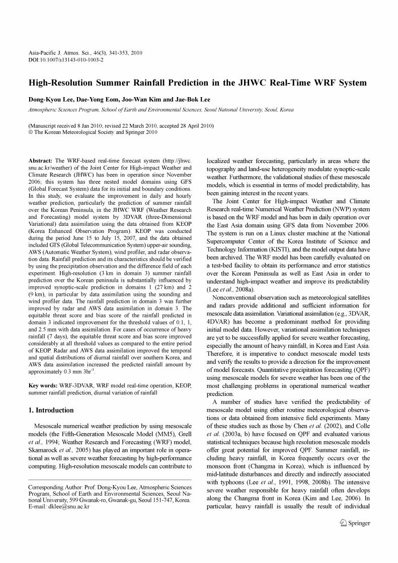
2. Observational Results of the KEOP-2007
The KEOP-2007 project was conducted from June 15 to July
15, 2007, in order to analyze and understand the Changma front
and high-impact weather systems. Figure 1 shows a time-
longitude diagram of the averaged sea-level-pressure and 850
hPa relative vorticity in the 32-35o
N latitudinal band, where the
monsoon rain band was located, along with the 3 h accumu-
lated rainfall time series of station-averaged and area-averaged
(34-39o
N, 120-125o
E) TRMM (Tropical Rainfall Measuring
Mission) data over Korea during the one-month period. During
this period, the rainfall events over the southern Korean Penin-
sula are directly associated with synoptic-scale disturbances.
Before approximately June 21, the subtropical high dominated
over the southern Korean Peninsula due to which rainfall did not
occur. From June 21 to July 16, low-pressure systems frequently
propagate eastward along the monsoon rain band over the
Korean Peninsula. Although relative vorticity develops at 850
hPa over the southern Korean Peninsula, it apparently does not
cause heavy rainfall. In this study, a heavy rainfall case is defined
Fig. 1. Time-longitude (Hovmueller) diagram of averaged sea-level-pressure and 850 hPa relative vorticity on the 32-35oN latitudinal band wherethe monsoon rain band was located (left), and the 3 h accumulated rainfall time series of station-averaged and area-averaged (34-39oN, 120-125oE)TRMM over Korea (right) during the one-month period.
31 August 2010 Dong-Kyou Lee et al. 343
by a daily amount of rain greater than 80 mm. We consider two
rainfall periods: the entire period of KEOP and the averaged
period of five heavy rainfall cases.
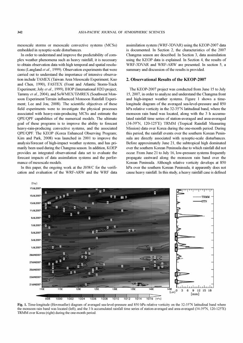
The time-averaged synoptic-scale patterns analyzed using the
FNL (Final) analysis and GPCP (Global Precipitation Climat-
ology Project) data are shown in Fig. 2. The heavy rainfall case
is characterized by an intensified and further westward extended
subtropical high, intensified low-level southerly and westerly
jet, active northerly flows east of northern Japan, and intensified
upper-level westerly jet; these conditions are favorable for heavy
rainfall. The rainfall occurs mainly over southern Japan for the
entire period while heavy rainfall occurs mainly over central
China, southern Yellow Sea, and southern Korea. According to
previous studies (Sun and Lee, 2002; Lee et al., 2008b), favorable
conditions for heavy rainfall in Korea are characterized by
warm advection with a southwesterly low-level jet (LLJ), cold-
air advection associated with upper-level disturbances, a warm
moisture tongue originating from southern or central China, an
intensified upper-level jet (ULJ) with strong baroclinicity, and
potential instability due to sufficient moisture.
3. Data Assimilation and Model Experiments
Figure 3 shows the model domains. The ARW model (version
2.2)/WRF is run for 72 h forecast in domain 1, 48 h forecast in
domain 2, and 24 h forecast in domain 3 with one-way nested
grids. The NCEP GFS (Global Forecast System) 0.5o
resolution
data are used for the boundary and initial conditions. The hori-
zontal resolutions are 27 km in domain 1, 9 km in domain 2,
and 3 km in domain 3, which mainly cover East Asia, the
Korean Peninsula and the ocean near the peninsula, and South
Korea, respectively. The vertical layer in each domain consists
of 35 vertical layers, with the model top corresponding to 50
hPa. Table 1 shows the simulation setup for this study.
WRF-3DVAR has been fully developed for the Advanced
Research WRF (ARW) model (Barker et al., 2003, 2004). The
WRF 3DVAR background error covariance is estimated using
the National Meteorological Center (NMC) method (Parrish and
Derber, 1992). The incremental cost function is minimized by
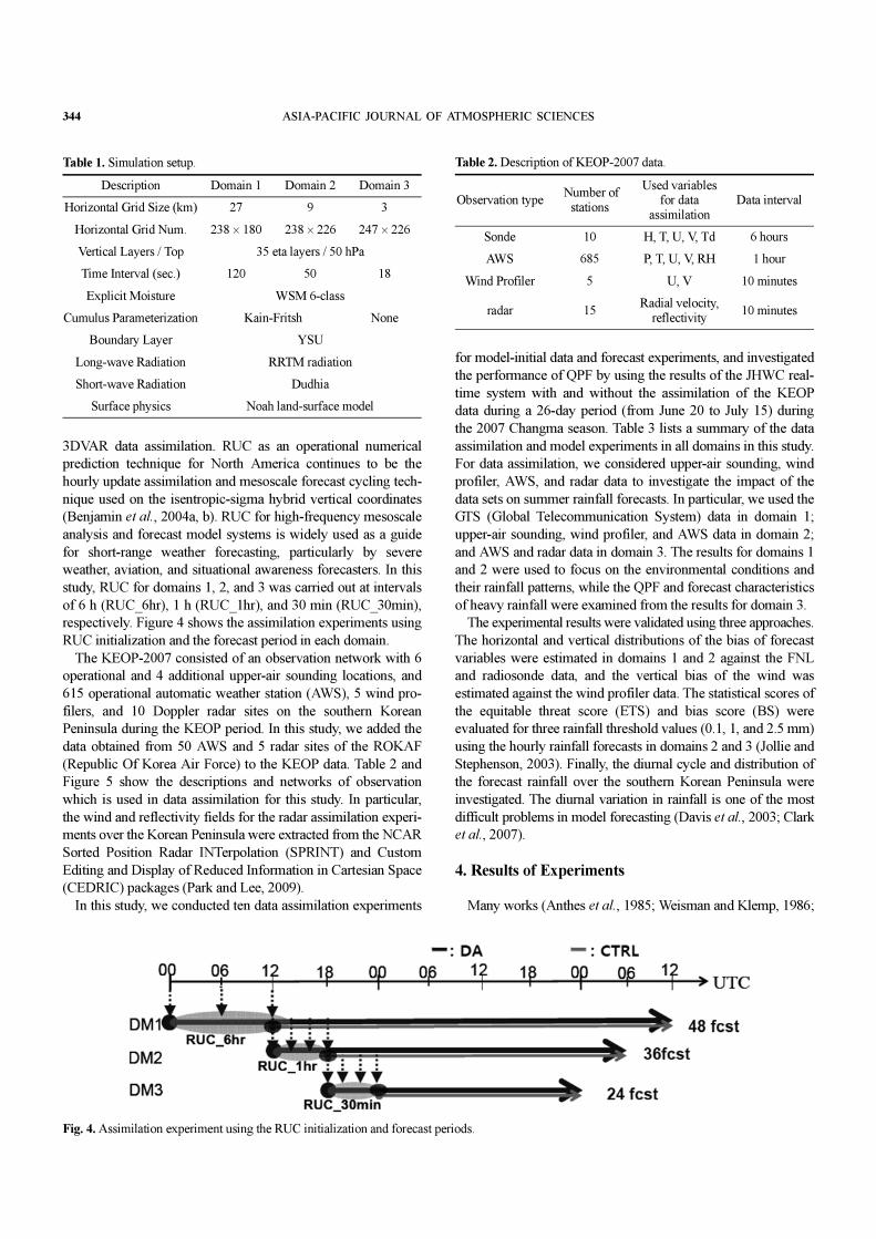
the conjugate gradient method. The Rapid Update Cycle (RUC)
technique is an analysis/forecast cycling technique used in
Fig. 2. Time-averaged synoptic patterns during (a) the entire and (b) theheavy rainfall cases: upper-level wind (dashed), 500 hPa geopotentialheight (solid), low level wind vector (arrow) using FNL, and GPCPrainfall distribution (shaded). Fig. 3. Model domains: 27 km, 9 km, and 3 km with terrain heights.
344 ASIA-PACIFIC JOURNAL OF ATMOSPHERIC SCIENCES
3DVAR data assimilation. RUC as an operational numerical
prediction technique for North America continues to be the
hourly update assimilation and mesoscale forecast cycling tech-
nique used on the isentropic-sigma hybrid vertical coordinates
(Benjamin et al., 2004a, b). RUC for high-frequency mesoscale
analysis and forecast model systems is widely used as a guide
for short-range weather forecasting, particularly by severe
weather, aviation, and situational awareness forecasters. In this
study, RUC for domains 1, 2, and 3 was carried out at intervals
of 6 h (RUC_6hr), 1 h (RUC_1hr), and 30 min (RUC_30min),
respectively. Figure 4 shows the assimilation experiments using
RUC initialization and the forecast period in each domain.
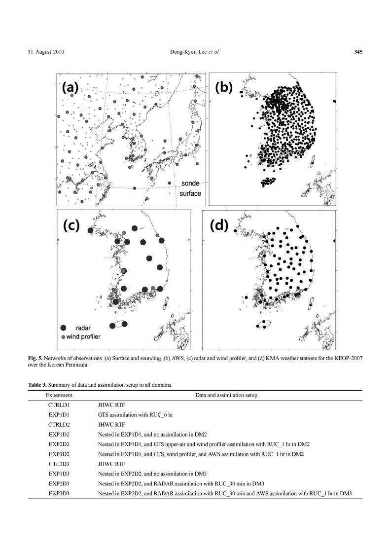
The KEOP-2007 consisted of an observation network with 6
operational and 4 additional upper-air sounding locations, and
615 operational automatic weather station (AWS), 5 wind pro-
filers, and 10 Doppler radar sites on the southern Korean
Peninsula during the KEOP period. In this study, we added the
data obtained from 50 AWS and 5 radar sites of the ROKAF
(Republic Of Korea Air Force) to the KEOP data. Table 2 and
Figure 5 show the descriptions and networks of observation
which is used in data assimilation for this study. In particular,
the wind and reflectivity fields for the radar assimilation experi-
ments over the Korean Peninsula were extracted from the NCAR
Sorted Position Radar INTerpolation (SPRINT) and Custom
Editing and Display of Reduced Information in Cartesian Space
(CEDRIC) packages (Park and Lee, 2009).
In this study, we conducted ten data assimilation experiments
for model-initial data and forecast experiments, and investigated
the performance of QPF by using the results of the JHWC real-
time system with and without the assimilation of the KEOP
data during a 26-day period (from June 20 to July 15) during
the 2007 Changma season. Table 3 lists a summary of the data
assimilation and model experiments in all domains in this study.
For data assimilation, we considered upper-air sounding, wind
profiler, AWS, and radar data to investigate the impact of the
data sets on summer rainfall forecasts. In particular, we used the
GTS (Global Telecommunication System) data in domain 1;
upper-air sounding, wind profiler, and AWS data in domain 2;
and AWS and radar data in domain 3. The results for domains 1
and 2 were used to focus on the environmental conditions and
their rainfall patterns, while the QPF and forecast characteristics
of heavy rainfall were examined from the results for domain 3.
The experimental results were validated using three approaches.
The horizontal and vertical distributions of the bias of forecast
variables were estimated in domains 1 and 2 against the FNL
and radiosonde data, and the vertical bias of the wind was
estimated against the wind profiler data. The statistical scores of
the equitable threat score (ETS) and bias score (BS) were
evaluated for three rainfall threshold values (0.1, 1, and 2.5 mm)
using the hourly rainfall forecasts in domains 2 and 3 (Jollie and
Stephenson, 2003). Finally, the diurnal cycle and distribution of
the forecast rainfall over the southern Korean Peninsula were
investigated. The diurnal variation in rainfall is one of the most
difficult problems in model forecasting (Davis et al., 2003; Clark
et al., 2007).
4. Results of Experiments
Many works (Anthes et al., 1985; Weisman and Klemp, 1986;
Fig. 4. Assimilation experiment using the RUC initialization and forecast periods.
Table 1. Simulation setup.
Description Domain 1 Domain 2 Domain 3
Horizontal Grid Size (km) 27 9 3
Horizontal Grid Num. 238 × 180 238 × 226 247 × 226
Vertical Layers / Top 35 eta layers / 50 hPa
Time Interval (sec.) 120 50 18
Explicit Moisture WSM 6-class
Cumulus Parameterization Kain-Fritsh None
Boundary Layer YSU
Long-wave Radiation RRTM radiation
Short-wave Radiation Dudhia
Surface physics Noah land-surface model
Table 2. Description of KEOP-2007 data.
Observation type Number of
stations
Used variables for data
assimilationData interval
Sonde 10 H, T, U, V, Td 6 hours
AWS 685 P, T, U, V, RH 1 hour
Wind Profiler 5 U, V 10 minutes
radar 15Radial velocity,
reflectivity10 minutes
31 August 2010 Dong-Kyou Lee et al. 345
Fig. 5. Networks of observations: (a) Surface and sounding, (b) AWS, (c) radar and wind profiler, and (d) KMA weather stations for the KEOP-2007over the Korean Peninsula.
Table 3. Summary of data and assimilation setup in all domains.
Experiment Data and assimilation setup
CTRLD1 JHWC RTF
EXP1D1 GTS assimilation with RUC_6 hr
CTRLD2 JHWC RTF
EXP1D2 Nested in EXP1D1, and no assimilation in DM2
EXP2D2 Nested in EXP1D1, and GTS upper-air and wind profiler assimilation with RUC_1 hr in DM2
EXP3D2 Nested in EXP1D1, and GTS, wind profiler, and AWS assimilation with RUC_1 hr in DM2
CTL3D3 JHWC RTF
EXP1D3 Nested in EXP2D2, and no assimilation in DM3
EXP2D3 Nested in EXP2D2, and RADAR assimilation with RUC_30 min in DM3
EXP3D3 Nested in EXP2D2, and RADAR assimilation with RUC_30 min and AWS assimilation with RUC_1 hr in DM3
346 ASIA-PACIFIC JOURNAL OF ATMOSPHERIC SCIENCES
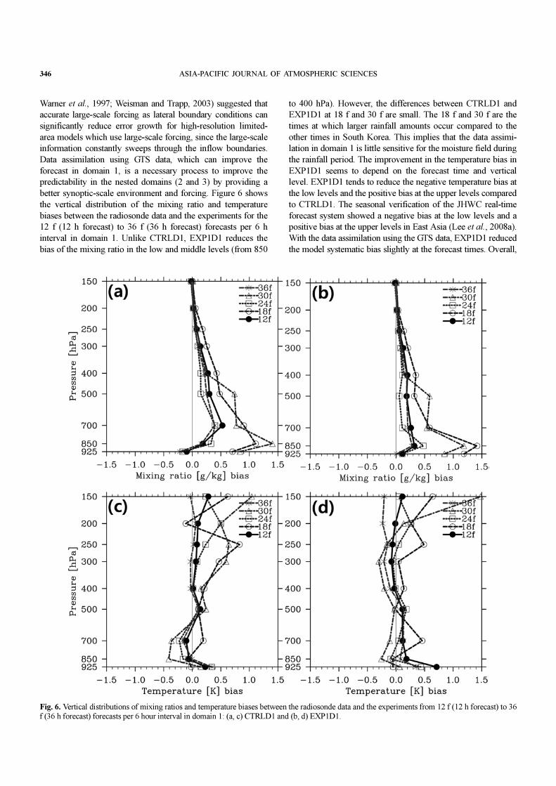
Warner et al., 1997; Weisman and Trapp, 2003) suggested that
accurate large-scale forcing as lateral boundary conditions can
significantly reduce error growth for high-resolution limited-
area models which use large-scale forcing, since the large-scale
information constantly sweeps through the inflow boundaries.
Data assimilation using GTS data, which can improve the
forecast in domain 1, is a necessary process to improve the
predictability in the nested domains (2 and 3) by providing a
better synoptic-scale environment and forcing. Figure 6 shows
the vertical distribution of the mixing ratio and temperature
biases between the radiosonde data and the experiments for the
12 f (12 h forecast) to 36 f (36 h forecast) forecasts per 6 h
interval in domain 1. Unlike CTRLD1, EXP1D1 reduces the
bias of the mixing ratio in the low and middle levels (from 850
to 400 hPa). However, the differences between CTRLD1 and
EXP1D1 at 18 f and 30 f are small. The 18 f and 30 f are the
times at which larger rainfall amounts occur compared to the
other times in South Korea. This implies that the data assimi-
lation in domain 1 is little sensitive for the moisture field during
the rainfall period. The improvement in the temperature bias in
EXP1D1 seems to depend on the forecast time and vertical
level. EXP1D1 tends to reduce the negative temperature bias at
the low levels and the positive bias at the upper levels compared
to CTRLD1. The seasonal verification of the JHWC real-time
forecast system showed a negative bias at the low levels and a
positive bias at the upper levels in East Asia (Lee et al., 2008a).
With the data assimilation using the GTS data, EXP1D1 reduced
the model systematic bias slightly at the forecast times. Overall,
Fig. 6. Vertical distributions of mixing ratios and temperature biases between the radiosonde data and the experiments from 12 f (12 h forecast) to 36f (36 h forecast) forecasts per 6 hour interval in domain 1: (a, c) CTRLD1 and (b, d) EXP1D1.
31 August 2010 Dong-Kyou Lee et al. 347
there is no noticeable difference in the temperature bias between
the two experiments, although the differences are obvious in
relation to the levels and forecast times.
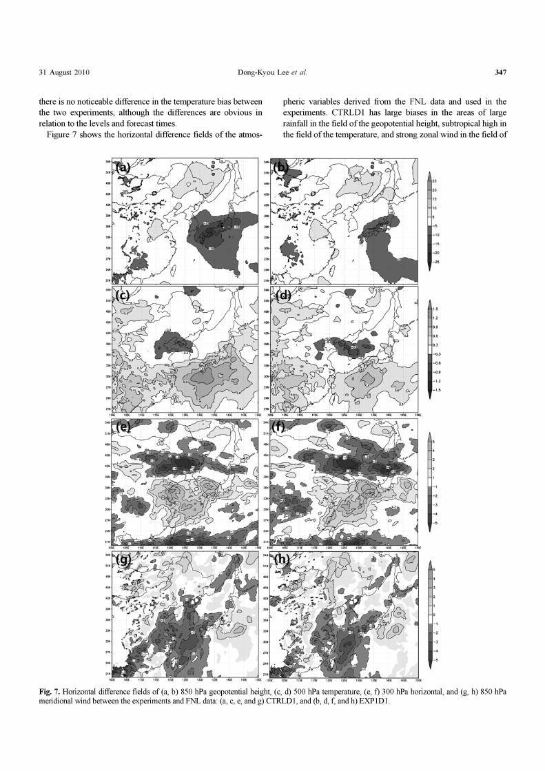
Figure 7 shows the horizontal difference fields of the atmos-
pheric variables derived from the FNL data and used in the
experiments. CTRLD1 has large biases in the areas of large
rainfall in the field of the geopotential height, subtropical high in
the field of the temperature, and strong zonal wind in the field of
Fig. 7. Horizontal difference fields of (a, b) 850 hPa geopotential height, (c, d) 500 hPa temperature, (e, f) 300 hPa horizontal, and (g, h) 850 hPameridional wind between the experiments and FNL data: (a, c, e, and g) CTRLD1, and (b, d, f, and h) EXP1D1.
348 ASIA-PACIFIC JOURNAL OF ATMOSPHERIC SCIENCES
the upper-level wind. EXP1D1 considerably reduces the biases
in CTRLD1, except for the upper-level wind. In particular, the
biases in CTRLD1 are also reduced by assimilating the GTS
data in the area of the Korean Peninsula and nearby ocean.
The vertical distributions of the mixing ratio (a, b, c, and d)
and temperature bias (e, f, g, and h) in domain 2 are shown in
Fig. 8. EXP1D2 shows the improvements in the mixing ratio
and temperature bias in CTRLD1, which are essentially similar
to the improvements in domain 1. This implies that the improve-
ment of the larger-scale features in domain 1 is important for
forecast in the high-resolution nested model in which the GTS
upper-air, wind profiler, and surface data are assimilated in the
model domain. Surface data assimilation affects forecasts up to
the 500 hPa level (EXP3D2). Weisman and Trapp (2003) showed
that a storm environment with a significant low-level vertical
wind shear probably influences the formation of a mesovortex.
The horizontal distributions of 24 h accumulated rainfall during
KEOP-2007 in domain 2, along with the TRMM data are shown
in Fig. 9. According to the TRMM rainfall data (Fig. 9a), the
areas to the east of China and to the south of Japan receive the
largest amount of rainfall. In the Korean peninsula, weak rain-
fall is observed over the central and southwestern regions.
CTRLD2 and EXP1D2 show that the rainfall amount in the
rain band along the Changma front from East China to Japan is
overestimated and that the rainfall amount in central Korea is
underestimated compared to the observations. The rainfall pre-
dicted by EXP2D2 is comparable to the observed rainfall over
central China, Japan, and the Korean peninsula; in particular,
the predicted and observed values of the maximum rainfall in
southern Japan and the second peak rainfall in the central region
of the Korean Peninsula are comparable. EXP3D2 shows that
less rainfall occurs over East China and Japan, and the rainfall
region in the Korean Peninsula is widely extended, and the peak
region is overestimated.
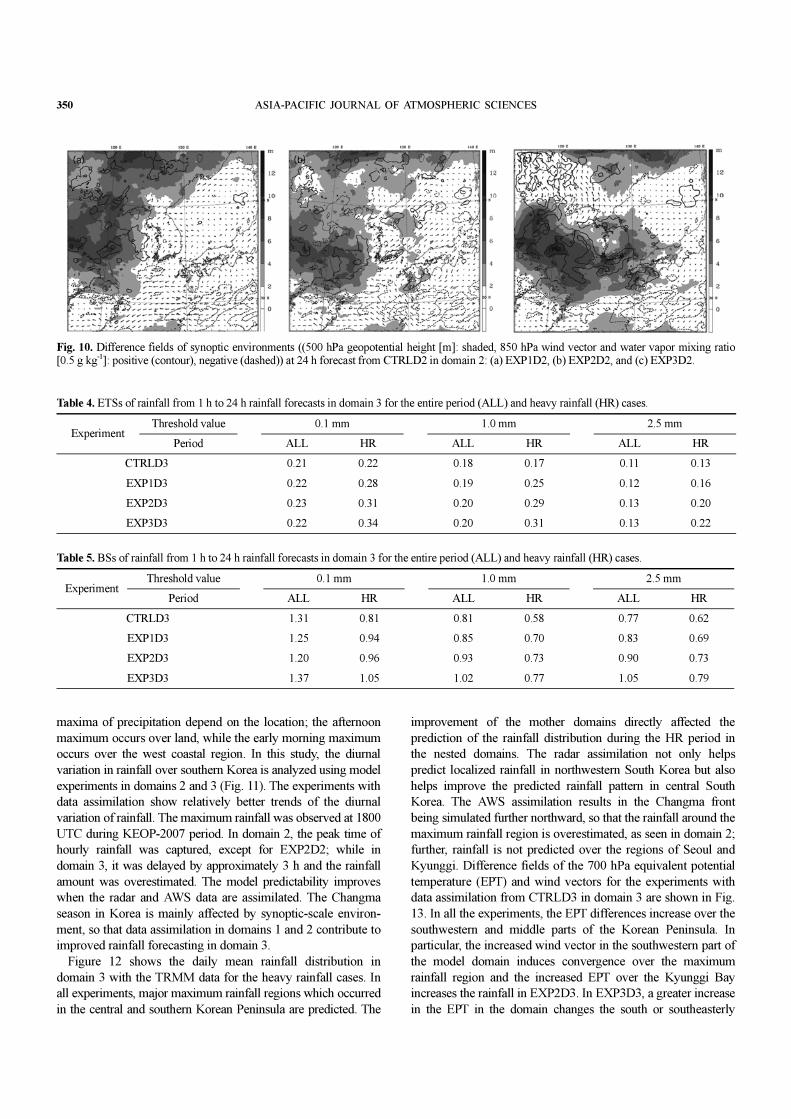
Figure 10 shows the difference fields for the 500 hPa
geopotential height, 850 hPa wind vector, and 850 hPa water
vapor mixing ratio for all CTRLD2 experiments in domain 2. In
all experiments involving data assimilation, negative differences
are observed in the mixing ratio over the seas to the south of
Korea and Japan and in central China; in EXP2D2 and EXP3D2,
positive differences are observed in the mixing ratio and
geopotential height over the Yellow Sea. Positive differences in
the southwesterly wind, which is part of an LLJ, are dominant
over the western and southwestern parts of the Yellow Sea. In all
the experiments involving data assimilation, negative differences
in the westerly wind component contributed to less rainfall
amount than that observed in CTRLD2. The geopotential height
of EXP2D2 represents the positive difference in the north-
eastern part of Korea, implying that the inclusion of the upper-
air data affected resulted in a strong Okhotsk high. In EXP3D3,
the moisture and geopotential height increased only over South
Korea. In particular, the data assimilation, including the upper-
air data (EXP2D2), has a positive impact on the lower tropo-
spheric fields such as moisture and wind at the 850 hPa level.
Tables 4 and 5 list the ETSs and BSs from the 1 h to 24 h
rainfall forecasts in domain 3 for the rainfall for the entire
period (ALL) and the heavy rainfall cases (HR). Seven heavy
rainfall events were documented during the KEOP-2007 period.
The ETS values for all of the threshold values are almost similar
for all of the entire period rainfall experiments; the exception is
the ETS values that tend to increase with data assimilation.
However, the ETS values with data assimilation increase con-
Fig. 8. Vertical distributions of mixing ratios (a, b, c, and d) and temperature biases (e, f, g, and h) in domain 2: (a, e) CTRLD2, (b, f) EXP1D2, (c, g)EXP2D2, and (d, h) EXP3D2.

31 August 2010 Dong-Kyou Lee et al. 349
siderably compared to those without data assimilation for the
heavy rainfall cases; the increase is more pronounced for the
combined assimilation of radar and AWS data. The BSs of the
large threshold values (1.0 and 2.5 mm) reduce with radar and
AWS data assimilation. The combined radar and AWS data as-
similation contributed to improved rainfall forecasts obtained in
this study.
In their research on the diurnal variation of rainfall over South
Korea using data from the KMA surface station, Lim and Kwon
(1998) analyzed the horizontal structure of the diurnal variation
of precipitation over the South Korean peninsula for 17 years
(1980-96). They found that the early morning or morning peak
in precipitation in South Korea might be a global phenomenon
with a minor variation in the time of occurrence. Misumi (1999)
showed that the morning precipitation maximum over East Asia
and the diurnal variation of the warm season precipitation are
characterized by an afternoon maximum dominant for localized
precipitation in Japan. Jung and Suh (2005) showed that the two
Fig. 9. Horizontal distributions of daily mean rainfall during KEOP-2007 in domain 2: (a) TRMM, (b) CTRLD2, (c) EXP1D2, (d) EXP2D2, and (e)EXP3D2.
350 ASIA-PACIFIC JOURNAL OF ATMOSPHERIC SCIENCES
maxima of precipitation depend on the location; the afternoon
maximum occurs over land, while the early morning maximum
occurs over the west coastal region. In this study, the diurnal
variation in rainfall over southern Korea is analyzed using model
experiments in domains 2 and 3 (Fig. 11). The experiments with
data assimilation show relatively better trends of the diurnal
variation of rainfall. The maximum rainfall was observed at 1800
UTC during KEOP-2007 period. In domain 2, the peak time of
hourly rainfall was captured, except for EXP2D2; while in
domain 3, it was delayed by approximately 3 h and the rainfall
amount was overestimated. The model predictability improves
when the radar and AWS data are assimilated. The Changma
season in Korea is mainly affected by synoptic-scale environ-
ment, so that data assimilation in domains 1 and 2 contribute to
improved rainfall forecasting in domain 3.
Figure 12 shows the daily mean rainfall distribution in
domain 3 with the TRMM data for the heavy rainfall cases. In
all experiments, major maximum rainfall regions which occurred
in the central and southern Korean Peninsula are predicted. The
improvement of the mother domains directly affected the
prediction of the rainfall distribution during the HR period in
the nested domains. The radar assimilation not only helps
predict localized rainfall in northwestern South Korea but also
helps improve the predicted rainfall pattern in central South
Korea. The AWS assimilation results in the Changma front
being simulated further northward, so that the rainfall around the
maximum rainfall region is overestimated, as seen in domain 2;
further, rainfall is not predicted over the regions of Seoul and
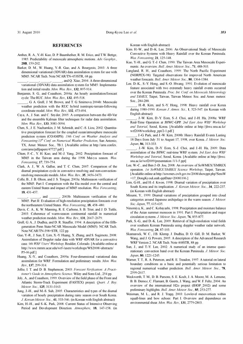
Kyunggi. Difference fields of the 700 hPa equivalent potential
temperature (EPT) and wind vectors for the experiments with
data assimilation from CTRLD3 in domain 3 are shown in Fig.
13. In all the experiments, the EPT differences increase over the
southwestern and middle parts of the Korean Peninsula. In
particular, the increased wind vector in the southwestern part of
the model domain induces convergence over the maximum
rainfall region and the increased EPT over the Kyunggi Bay
increases the rainfall in EXP2D3. In EXP3D3, a greater increase
in the EPT in the domain changes the south or southeasterly
Table 4. ETSs of rainfall from 1 h to 24 h rainfall forecasts in domain 3 for the entire period (ALL) and heavy rainfall (HR) cases.
ExperimentThreshold value 0.1 mm 1.0 mm 2.5 mm
Period ALL HR ALL HR ALL HR
CTRLD3 0.21 0.22 0.18 0.17 0.11 0.13
EXP1D3 0.22 0.28 0.19 0.25 0.12 0.16
EXP2D3 0.23 0.31 0.20 0.29 0.13 0.20
EXP3D3 0.22 0.34 0.20 0.31 0.13 0.22
Table 5. BSs of rainfall from 1 h to 24 h rainfall forecasts in domain 3 for the entire period (ALL) and heavy rainfall (HR) cases.
ExperimentThreshold value 0.1 mm 1.0 mm 2.5 mm
Period ALL HR ALL HR ALL HR
CTRLD3 1.31 0.81 0.81 0.58 0.77 0.62
EXP1D3 1.25 0.94 0.85 0.70 0.83 0.69
EXP2D3 1.20 0.96 0.93 0.73 0.90 0.73
EXP3D3 1.37 1.05 1.02 0.77 1.05 0.79
Fig. 10. Difference fields of synoptic environments ((500 hPa geopotential height [m]: shaded, 850 hPa wind vector and water vapor mixing ratio[0.5 g kg-1]: positive (contour), negative (dashed)) at 24 h forecast from CTRLD2 in domain 2: (a) EXP1D2, (b) EXP2D2, and (c) EXP3D2.

31 August 2010 Dong-Kyou Lee et al. 351
Fig. 11. Diurnal variation of rainfall over southern Korea analyzed using the model experiments in (a) domain 2, and (b) domain 3.
Fig. 12. Horizontal distribution of daily mean rainfall during the heavy rainfall cases in domain 3: (a) TRMM, (b) EXP1D3, (c) EXP2D3, and (d)EXP3D3.
352 ASIA-PACIFIC JOURNAL OF ATMOSPHERIC SCIENCES
wind at low levels, which affects the rain band and causes the
maximum rainfall regions to move further northward.
5. Discussion and Conclusion
This study documents the rainfall validation of the real-time
WRF forecasts over East Asia and the Korean Peninsula during
the Changma season using the KEOP-2007 data. The data as-
similation of RUC using the KEOP data is performed on the
WRF-ARW model with three nested grids (horizontal resolutions:
27, 9, and 3 km). The forecast periods for the domains were 48,
36, and 24 h. The forecast rainfall amounts are verified against
high-density rain gauge observations, GPCP, and TRMM. QPF
using the forecast rainfall in domain 3 is estimated by calcula-
ting the ETS and BS scores.
During the Changma season, the monsoon rain band is
observed to extend from south China to the south of Japan due
to the strong development of the Okhotsk high. Heavy rainfall
occurred when the NW Pacific subtropical high intensified and
extended to the western Pacific warm pool, thereby affecting
the variability of the summer monsoon rainfall patterns over
South Korea. The GTS data assimilation in domain 1 results in
better forecasts of the variables, which can be used as the
improved forcing for the nested domains; hence, the Changma
front is observed northward, and the moisture biases of the low
and middle levels in domain 1 is reduced. Consequently, the
synoptic environment affects the rainfall forecast in the Korean
Peninsula in domains 2 and 3. The data assimilation in the
mother domains is demonstrated to be necessary to provide an
improved large-scale environment for the nested domains.
During KEOP period, the rainfall predictability of the model
improved with data assimilation of GTS upper-air, wind profiler,
AWS, and radar data in domains 2 and 3. Radar and AWS data
assimilation improved the forecast rainfall in domain 3. The model
predicts the observed diurnal variation in summer precipitation;
peak time of rainfall is predicted to be at 3 and 4 LST over
southern Korea. However, the rainfall is underestimated at 9-km
horizontal resolution, and overestimated at 3-km resolution; at
3-km resolution, delayed peak of rainfall is simulated observed.
The results of this study demonstrated that data assimilation
with WRF 3DVAR by utilizing various observations for KEOP-
2007 improves the prediction of rainfall, especially for heavy
rainfall, during the Changma season. However, further applica-
tions should be studied by using data from other observations,
e.g., satellite observations. The experiment of horizontal and
vertical retrieval-wind data assimilation using the radiance ob-
tained from radar data (Park and Lee, 2009) is necessary
because the wind values obtained from the WRF-3DVAR re-
trieval system depend on the background error of model wind.
In addition to high horizontal resolution, observational and back-
ground error tuning in the model will be necessary because
rainfall forecasts with assimilation of radar and AWS data is
overestimated in this study. Huang et al. (2009) discussed that
the 4DVAR algorithm can assimilate more observations than
3DVAR from high frequency fixed observing platforms, such
as AWS networks, and Guo et al. (2008) shows that 4DVAR
using radial velocity can be operated as a tool in the convective-
scale weather research. Moreover, the comparison between
4DVAR and the Ensemble Kalman Filter (EnKF) will be in the
context of the assimilation of real observations. The error in the
forecast model and uncertainty in the specification of observa-
tional errors should be considered (Caya and Snyder, 2005).
The KEOP data should be further studied with the 4DVAR and
EnKF methods as well as sensitivity experiments of rainfall to
the model physics implemented in the WRF model.
Acknowledgements. We thank the Mesoscale and Microscale
Meteorology (MMM) division at the National Center for
Atmospheric Research (NCAR) for collaborating with the WRF
model. This study was supported by the Global Partnership
Program of the Korea Foundation of International Cooperation
for Science and Technology (KICOS). This study was also
supported by the principal project “Development and application
of technology for weather forecast (NIMR-2009-B-1)” of the
National Institute of Meteorological Research of the Korea
Meteorological Administration. Computing resources were sup-
ported by the Korea Institute of Science and Technology
Information under “The Strategic Supercomputing Support
Program.”
Fig. 13. Difference fields of 700 hPa equivalent potential temperature (solid lines are positive and dashed lines negative) and wind vector for theexperiments with data assimilation from CTRLD3 in domain 3: (a) EXP1D3, (b) EXP2D3, and (c) EXP3D3.
31 August 2010 Dong-Kyou Lee et al. 353
REFERENCES
Anthes, R. A., Y.-H. Kuo, D. P. Baumhefner, R. M. Erico, and T.W. Bettge,
1985: Predictability of mesoscale atmospheric motions. Adv. Geophys.,
28B, 159-202.
Barker, D. M., W. Huang, Y.-R. Guo, and A. Bourgeois, 2003: A three
dimensional variational (3DVAR) data assimilation system for use with
MM5. NCAR Tech. Note NCAR/TN-453STR, 68 pp.
______, ______, ______, ______, and Q. Xiao, 2004: A three-dimensional
variational (3DVAR) data assimilation system for MM5: Implementa-
tion and initial results. Mon. Wea. Rev., 132, 897-914.
Benjamin, S. G., and Coauthors, 2004a: An hourly assimilation/forecast
cycle: The RUC. Mon. Wea. Rev., 132, 495-518.
______, G. A. Grell, J. M. Brown, and T. G. Smirnova 2004b: Mesoscale
weather prediction with the RUC hybrid isentropic-terrain-following
coordinate model. Mon. Wea. Rev., 132, 473-494.
Caya, A., J. Sun. and C. Snyder, 2005: A comparison between the 4D-Var
and the ensemble Kalman filter techniques for radar data assimilation.
Mon. Wea. Rev., 133, 3081-3094.
Chen, S., J. E. Nachamkin, J. M. Schmidt, and C.-S. Liou, 2002: Quantita-
tive precipitation forecast for the coupled ocean/atmosphere mesoscale
prediction system (COAMPS). 19th Conf. on Weather Analysis and
Forecasting/15th Conf. on Numerical Weather Prediction, San Antonio,
TX, Amer. Meteor. Soc., 7B.1. [Available online at http://ams.confex.
com/ams/pdfpapers/47727.pdf.]
Chien, F.-C., Y. H. Kuo, and M.-J. Yang, 2002: Precipitation forecast of
MM5 in the Taiwan area during the 1998 Mei-yu season. Wea.
Forecasting, 17, 739-754.
Clark, A. J., W. A. Gallus, and T. C. Chen, 2007: Comparison of the
diurnal precipitation cycle in convective resolving and non-convection-
resolving mesoscale models. Mon. Wea. Rev., 35, 3456-3473.
Colle, B., J. B. Olson, and J. S. Tongue, 2003a: Multiseason verification of
the MM5. Part I: Comparison with the Eta model over the central and
eastern United States and impact of MM5 resolution. Wea. Forecasting,
18, 431-457.
______, ______, and ______, 2003b: Multiseason verification of the
MM5. Part II: Evaluation of high-resolution precipitation forecasts over
the northeastern United States. Wea. Forecasting, 18, 458–480.
Davis, C. A., K. W. Manning, R. E. Carbone, S. B. Trier, and J. D. Tuttle,
2003: Coherence of warm-season continental rainfall in numerical
weather prediction models. Mon. Wea. Rev., 131, 2667–2679.
Grell, G. A., J. Dudhia, and D. R. Stauffer, 1994: A description of the fifth-
generation Penn State-NCAR Mesoscale Model (MM5). NCAR Tech.
Note NCAR/TN-398+STR, 122 pp.
Guo, Y.-R., J. Sun, E. Lim, X.-Y. Huang, X. Zhang, and S. Sugimoto, 2008:
Assimilation of Doppler radar data with WRF 4DVAR for a convective
case. 9th WRF Users' Workshop, Boulder, Colorado. [Available online at
http://www.mmm.ucar.edu/wrf-/users/workshops/WS2008/-abstracts/
P5-06.pdf.]
Huang, X.-Y., and Coauthors, 2009a: Four-dimensional variational data
assimilation for WRF: Formulation and preliminary results. Mon. Wea.
Rev., 137, 299-314.
Jollie, I. T. and D. B. Stephenson, 2003: Forecast Verification: A Practi-
tioner's Guide in Atmospheric Science. Wiley and Sons Ltd., 254 pp.
Joly, A., and Coauthors, 1999: Overview of the field phase of the Front and
Atlantic Storm-Track Experiment (FASTEX) project. Quart. J. Roy.
Meteor. Soc., 125, 3131-3163.
Jung, J.-H., and M.-S. Suh, 2005: Characteristics and types of the diurnal
variation of hourly precipitation during rainy season over South Korea.
J. Korean Meteor. Soc., 41, 533-546. (in Korean with English abstract)
Kim, H.-H., and S.-K. Park, 2008: Current Status of Intensive Observing
Period and Development Direction. Atmosphere, 18, 147-158. (in
Korean with English abstract)
Kim. H.-W., and D.-K. Lee, 2006: An Observational Study of Mesoscale
Convective Systems with Heavy Rainfall over the Korean Peninsula.
Wea. Forecasting, 21, 125-148.
Kuo, Y.-H., and G. T.-J. Chen, 1990: The Taiwan Area Mesoscale Experi-
ments: An overview. Bull. Amer. Meteor. Soc., 71, 488-503.
Langland, R. H., and Coauthors, 1999: The North Pacific Experiment
(NORPEX-98): Targeted observations for improved North American
weather forecasts. Bull. Amer. Meteor. Soc., 80, 1364-1384.
Lee, D.-K., S.-Y. Hong, and S.-O. Hwang. 1991: Evolution of mesoscale
feature associated with two extremely heavy rainfall events occurred
over the Korean Peninsula. Proc. Int. Conf. on Mesoscale Meteorology
and TAMEX, Taipei, Taiwan, Taiwan Meteor. Soc. and Amer. meteor.
Soc., 284-288.
______, H.-R. Kim, and S.-Y. Hong, 1998: Heavy rainfall over Korea
during 1980-1990. Korean J. Atmos. Sci., 1, 523-547. (in Korean with
English abstract)
______, J.-W. Kim, D.-Y. Eom, S.-J. Choi, and J.-H. Ha, 2008a: WRF
Real-Time Operation at JHWC-GPP. 2nd East Asia WRF Workshop
and Tutorial, Seoul, Korea. [Available online at http://jhwc.snu.ac.kr/
wrf2008/workshop_ppt/2-1.pdf.]
______, J.-G. Park, and J.-W. Kim, 2008b: Heavy Rainfall Events Lasting
18 Days from July 31 to August 17, 1998, over Korea. J. Meteor. Soc.
Japan, 86, 313-333.
______, J.-W. Kim, D.-Y. Eom, S.-J. Choi, and J.-H. Ha, 2009: Data
assimilation of the JHWC real-time WRF system. 3rd East Asia WRF
Workshop and Tutorial, Seoul, Korea. [Available online at http://jhwc.
snu.ac.kr/wrf2009/presentation /1/1-5.ppt]
Lee, W.-C., and Ben J.-D. Jou, 2008: An overview of SoWMEX/TiMREX
operation. 1st SoWMEX/TiMREX Science Workshop, Taipei, Taiwan.
[Available online at http://sowmex.cwb.gov.tw/2008/showppt.php?SessW
=17_DongKyouLee&-pptDate=20081106.]
Lim, G.-H., and H.-J. Kwon, 1998: Diurnal variation of precipitation over
South Korea and its implication. J. Korean Meteor. Soc., 34, 222-237.
(in Korean with English abstract)
Misumi, Y., 1999: Diurnal variations of precipitation grouped into cloud
categories around Japanese archipelago in the warm season. J. Meteor.
Soc. Japan, 77, 615-635.
Ninomiya, K., and C. Kobayashi, 1998: Precipitation and moisture balance
of the Asian summer monsoon in 1991. Part I: Precipitation and major
circulation systems. J. Meteor. Soc. Japan, 76, 855-877.
Park, S.-G., and D.-K. Lee, 2009: Retrieval of high-resolution wind fields
over southern Korean Peninsula using doppler weather radar network.
Wea. Forecasting, 24, 87-103.
Skamarock, W. C., J.B. Klemp, J. Dudhia, D. O. Gill, D. M. Barker, W.
Wang, and J. G. Powers, 2005: A description of the Advanced Research
WRF Version 2. NCAR Tech. Note 468STR, 88 pp.
Sun, J., and T.-Y. Lee, 2002: A numerical study of an intense quasi-
stationary convection band over the Korean Peninsula. J. Meteor. Soc.
Japan, 80, 1221-1245.
Warner, T. T., R. A. Peterson, and R. E. Treadon, 1997: A tutorial on lateral
boundary conditions as a basic and potentially serious limitation to
regional numerical weather prediction. Bull. Amer. Meteor. Soc., 78,
2599-2617.
Weckwerth, T. M., D. B. Parsons, S. E. Koch, J. A. Moore, M. A. Lemone,
B. B. Demoz, C. Flamant, B. Geerts, J. Wang, and W. F. Feltz, 2004: An
overview of the international H2o project (IHOP_2002) and some
preliminary highlights. Bull. Amer. Meteor. Soc., 85, 253-277.
Weisman, M. L., and R. J. Trapp, 2003: Lowlevel mesovortices within
squall-lines and bow echoes: Part I. Overview and dependence on
environmental shear. Mon. Wea. Rev., 131, 2779-2803.