prediction of spatially explicit rainfall intensity
TRANSCRIPT

Prediction of spatially explicit rainfall intensity-duration thresholds for post-fire debris-flow generation in the western United States
Dennis M. Staley1, Jacquelyn Negri1, Jason W. Kean1, Jayme Laber2, Ann Tillery3, Anne Youberg41U.S. Geological Survey, Landslide Hazards Program, Golden CO USA
2National Weather Service, Los Angeles-Oxnard Weather Forecasting Office, Oxnard CA USA3U.S. Geological Survey, New Mexico Water Science Center, Albuquerque NM USA
4Arizona Geological Survey, Tucson AZ USA
2007 California WildfiresCourtesy of NASA: 22 October 2007
Debris flow emanating from the 2012 Waldo Canyon burn area01 July 2013
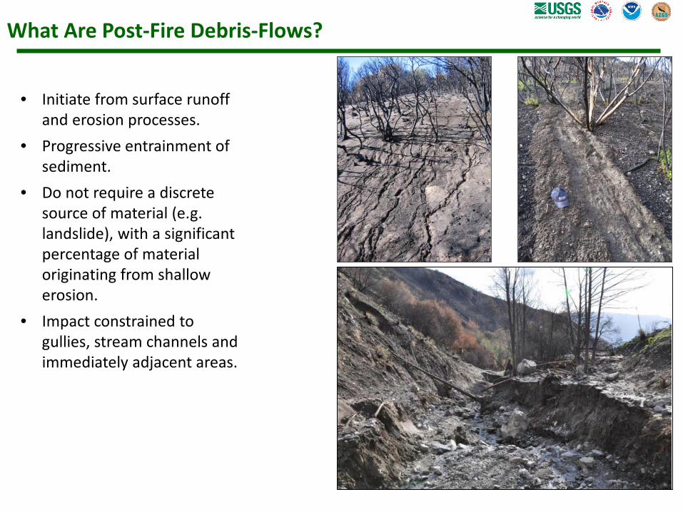
What Are Post-Fire Debris-Flows?
• Initiate from surface runoff and erosion processes.
• Progressive entrainment of sediment.
• Do not require a discrete source of material (e.g. landslide), with a significant percentage of material originating from shallow erosion.
• Impact constrained to gullies, stream channels and immediately adjacent areas.
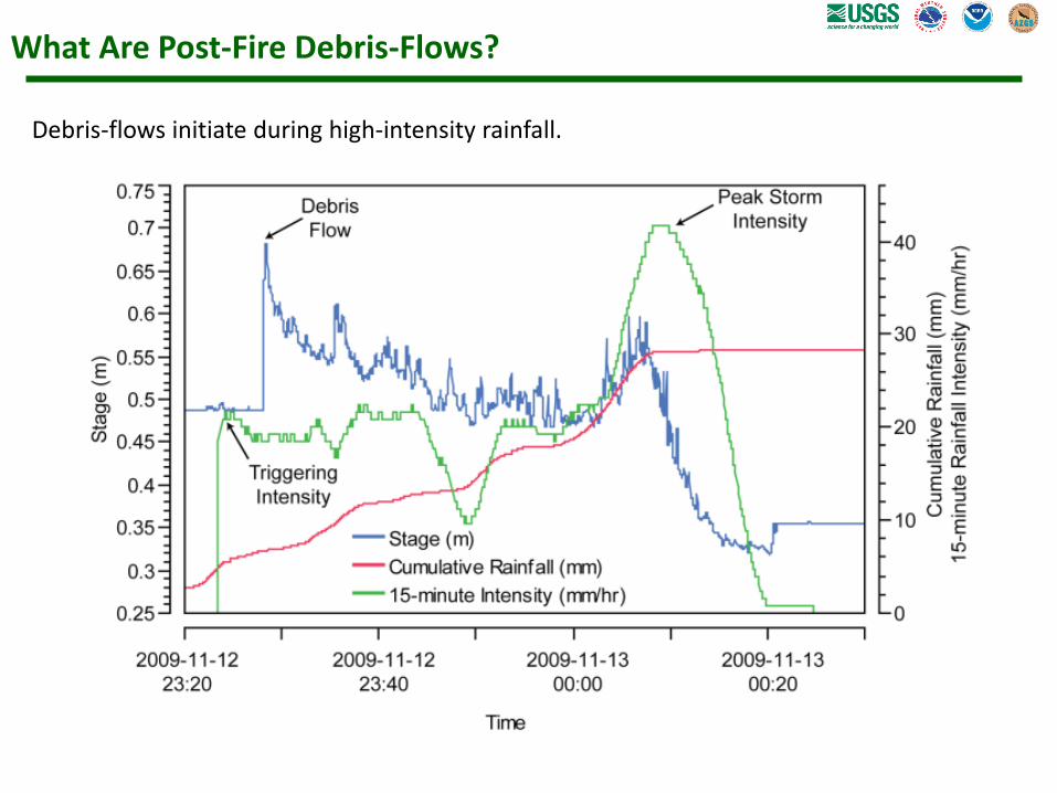
What Are Post-Fire Debris-Flows?
Debris-flows initiate during high-intensity rainfall.

How Do We Predict Post-Fire Debris-Flows?
Post-fire debris-flows are well-characterized by rainfall intensity-duration thresholds.

Debris-Flow Early Warning
• Short lead times requires forecast-based outlooks, watches, and real-time warning.
• USGS provides LOX and SGX threshold guidance for early warning.
• Threshold guidance forced into NWS flash-flood monitoring system(s).
• Interest at USGS and NWS in expansion of early-warning capabilities.
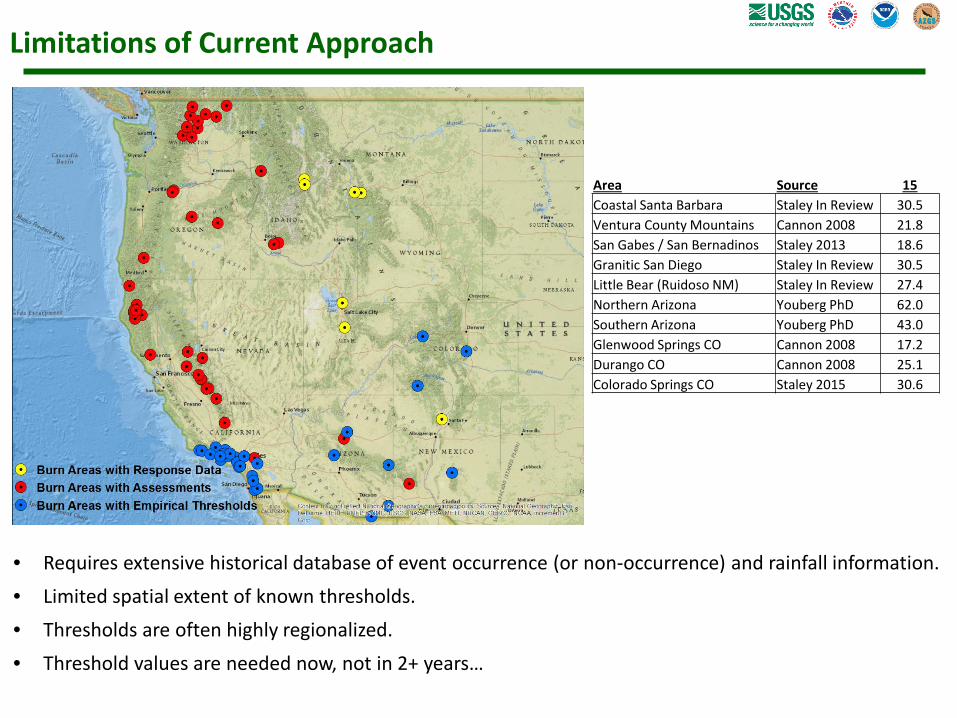
Limitations of Current Approach
• Requires extensive historical database of event occurrence (or non-occurrence) and rainfall information.• Limited spatial extent of known thresholds.• Thresholds are often highly regionalized.• Threshold values are needed now, not in 2+ years…
Area Source 15Coastal Santa Barbara Staley In Review 30.5Ventura County Mountains Cannon 2008 21.8San Gabes / San Bernadinos Staley 2013 18.6Granitic San Diego Staley In Review 30.5Little Bear (Ruidoso NM) Staley In Review 27.4Northern Arizona Youberg PhD 62.0Southern Arizona Youberg PhD 43.0Glenwood Springs CO Cannon 2008 17.2Durango CO Cannon 2008 25.1Colorado Springs CO Staley 2015 30.6

New Approach• Develop empirical model that
integrates susceptibility mapping with threshold prediction using nationwide data sources.
• Develop model equations from 939 records of debris-flow response, rainfall characteristics, terrain steepness (T), fire severity (F), and soil properties (S) in southern California (Training Dataset).
• Test model predictions against 611 records from other burn areas in the western United States (Test Dataset).
• Compare model predictions to 6 existing regional thresholds for the test dataset.

New Approach
Logistic Framework:
𝑝𝑝 =𝑒𝑒𝑥𝑥
1 + 𝑒𝑒𝑥𝑥𝑥𝑥 = 𝑏𝑏 + 𝑐𝑐1𝑐𝑐𝑋𝑋1 + 𝑐𝑐2𝑐𝑐𝑋𝑋2 + ⋯+ +𝑐𝑐𝑛𝑛𝑐𝑐𝑋𝑋𝑛𝑛
𝑥𝑥 = −3.63 + 0.41 𝑇𝑇 ∗ 𝑅𝑅 + 0.67 𝐹𝐹 ∗ 𝑅𝑅 + 0.70(𝑆𝑆 ∗ 𝑅𝑅)
Updated Link Function:
Terrain Steepness (T) Fire Severity(F)
Soil Properties(S)
Rainfall(R)
Proportion of upslope area with moderate to high
burn severity and gradients ≥ 23°
Average dNBR of upslope pixels / 1000
Average KF-Factor of
upslope area
Peak rainfall accumulation, in mm (15 minute durations)
Staley, D.M., Negri, J.A., Kean, J.W., Tillery, A.C., and Youberg, A.M., 2016, Updated Logistic Regression Equations for the Calculation of Post-Fire Debris-Flow Likelihood in the Western United States, U.S. Geological Survey Open-File Report 2016-1106, 20 p.
Available online at: https://pubs.er.usgs.gov/publication/ofr20161106

New Approach
Solving for the rainfall rate at any P value:
Terrain Steepness (T) Fire Severity(F)
Soil Properties(S)
Rainfall(R)
Proportion of upslope area with moderate to high
burn severity and gradients ≥ 23°
Average dNBR of upslope pixels / 1000
Average KF-Factor of
upslope area
Peak rainfall accumulation, in mm (15 minute durations)
𝑅𝑅(𝑝𝑝) =ln( 𝑝𝑝
1 − 𝑝𝑝) − 𝑏𝑏
𝑐𝑐1𝑇𝑇 + 𝑐𝑐2𝐹𝐹 + 𝑐𝑐3𝑆𝑆
Staley, D.M., Negri, J.A., Kean, J.W., Tillery, A.C., and Youberg, A.M., In Press, Prediction of spatially explicit rainfall intensity-duration thresholds for post-fire debris-flow generation in the western United States. Geomorphology.
Available online at: http://dx.doi.org/10.1016/j.geomorph.2016.10.019
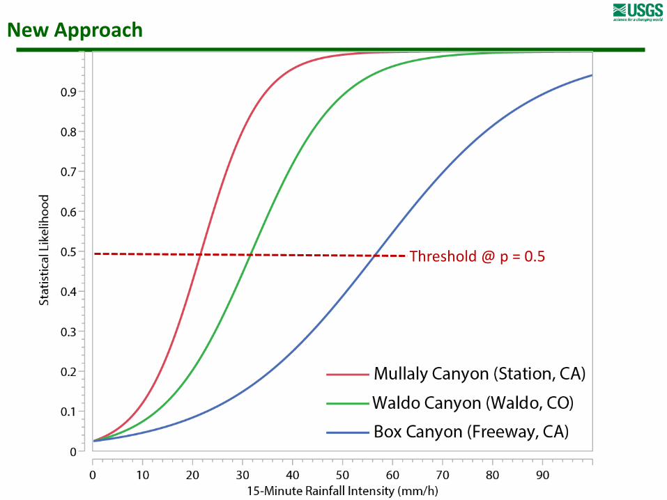
New Approach
Threshold @ p = 0.5

Spatially Explicit Application

Model Evaluation
• For model predictions, establish threshold at rainfall accumulation that results in p= 0.5. Convert to intensity for consistency with previous work.
• Evaluate using threat score metric based upon receiver operating characteristics analysis.

Model Evaluation
Training Dataset Test Dataset
Threshold RegionThreshold Region

Mullally Canyon Example
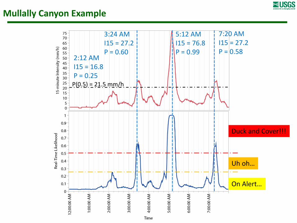
Mullally Canyon Example
On Alert…
Uh oh…
Duck and Cover!!!
3:24 AMI15 = 27.2P = 0.60
5:12 AMI15 = 76.8P = 0.99
7:20 AMI15 = 27.2P = 0.58
2:12 AMI15 = 16.8P = 0.25P(0.5) = 21.5 mm/h

Summary
New empirical model of debris-flow likelihood and spatially explicit threshold intensity prediction:
1) Model predictions compare well to what we “know” from intensive monitoring efforts.
2) Model does not require historic debris-flow occurrence information, therefore can be implemented in new areas.
3) Model allows flexibility in determining threshold values for emergency planning and early-warning.
4) Model form permits potential use in forecast-based warning and real-time monitoring.

Citations:
Staley, D.M., Negri, J.A., Kean, J.W., Tillery, A.C., and Youberg, A.M., 2016, Updated Logistic Regression Equations for the Calculation of Post-Fire Debris-Flow Likelihood in the Western United States, U.S. Geological Survey Open-File Report 2016-1106, 20 p. Available online at: https://pubs.er.usgs.gov/publication/ofr20161106
Staley, D.M., Negri, J.A., Kean, J.W., Tillery, A.C., and Youberg, A.M., In Press, Prediction of spatially explicit rainfall intensity-duration thresholds for post-fire debris-flow generation in the western United States. Geomorphology. Available online at: http://dx.doi.org/10.1016/j.geomorph.2016.10.019
Contact Info:Email: [email protected] Email: [email protected]: 303-273-8568 Phone: 303-273-8608Website: http://profiles.usgs.gov/dstaley Website: http://profiles.usgs.gov/jwkean
More Information: Questions and Discussion
Questions?