historic and architectural resources of pender county · historic and architecrural resources of...
TRANSCRIPT
Historic and Architectural Resourcesof
Pender County
Ed Turberg1997
HISTORIC AND ARCHITECrURAL RESOURCES OF PENDER COUNTY, NORTH CAROLINA
'Ld <'(VLb (~V J Introduction
Pender County was originally a part of New Hanover County and contained many large plantations, situated along the various rivers and creeks, which produced naval stores, lumber, rice, and other important comnodities. This condition prevailed until the post-Civil War era when small farms began to supplant plantations. Small crossroad, river, and church communities grew after 1840 when the railroad pushed through the region, which had a direct influence on economy and population growth. In 1875, divisions in political and racial matters brought about the separation of New Hanover County north and south of the Cape Fear rivers. Improved highways, agricultural advances, industrial development, suburban expansion, tourism, and retirement destinations have had an impact on Pender and have marked it in the latetwentieth century as the fastest growing county in the state.
Statement of Historic Contexts
A. TOPOGRAPHY ANO OVERVIEW OF THE COUNTY
B. HISTORIC CONTEXTS
1. EARLY DEVELOPMENT, 1725-1839
Settlement and Ethnicity Slavery Agriculture and Industry Transportation Religion and Education Architecture
2. THE RAILROAD ERA, 1840-1874
Growth of Settlements and Towns Agriculture and Industry From Slavery to Freedom Transportation Religion and Education Architecture
3. PENDER COUNTY, 1875-1945
Establishment of Pender County and the Growth of Towns Agriculture and Industry Transportation Religion and Education The War Years Architecture
4. PENDER COUNl'Y SNCE 1945
5. Endnotes
6. Bibliography
HISTORIC AND ARCHITECTURAL RESOURCES OF PENDER COUNTY, NORTH CAROLINA
Preface
Pender County is characterized by a changing landscape that is made up of
a variety of open farm lands, deep pine woods, dense swamps, and a sandy
coastline. Small towns, rural communities, and farmsteads are located close
to the many waterways, at rural crossroads, and adjacent to the railroad.
From the earliest period of European occupation in the 1720s to the Civil War,
the.region was populated by three distinct types of farming operations:
affluent plantation owners and their slaves who worked large tracts of land,
and subsistence farmers who tilled small acreage. Although many of the large
planters divided their time between the operation of their plantations upriver
and mercantile activities in the port of Wilmington, the smaller farmers
remained detached to pursue their labor-intensive livelihood on the farm. The
strength of the plantation lay in its slave workers; the strength of the farm
lay in its large families of varying ages who worked together at their
assigned chores. The semi-isolation that was characteristic of the county
caused the citizenry to draw together and form cohesive groups that were
strengthened by family ties, the cOIlll1uni ty, and the church.
The economics of the county, like those in many other parts of the state,
depended on the ability to transport goods at a reasonable rate from the farms
to the markets. In 1840, great strides in this field were made with the
completion of the Wilmington and Weldon Railroad through the center of the
region to the North Carolina-Virginia state line, and later with the opening
of the cape Fear and Yadkin Railroad to points in the western quadrant of the
county. Trains effectively tied rural farms, market towns, and coastal ports
together. By the end of the nineteenth century, they had become the principal
means for getting a variety of local produce to intrastate and interstate
consumers.
During its history, Pender County experienced a wide range of successful
production years as well as devastating seasons caused by natural calamities
like droughts, rains, fires, and storms. In addition, the Civil War and the
subsequent demise of the old plantation system had a serious impact on the
agronomy. Nevertheless, the determination of farm families, both white and
black, during the last quarter of the nineteenth century brought the region
out of depression and into the new century with renewed spirits. The 1900s
introduced automobiles, tractors, and trucks to the scene together with a need
to improve the myriad roads. Continuing through the remainder of the century,
the road-building era culminated in the building of an interstate highway
closely paralleling the Northeast cape Fear River, the historic Duplin Road,
and the railroad. Increased traffic along this artery has generated the
construction of new service-oriented businesses, larger farm and industrial
sites, and residential districts to accommodate the increasing population.
This progress is making a deep impression on the rural landscape and the
people because a slow but steady process is underway to desert the timeless
home places for new, contemporary ranch houses and manufactured homes, and to
displace the old, traditional farm buildings with modern, functional
structures.
A. IDPOGRAPHY AND OVERVIEW OF THE COUNTY
Pender County, located in the southeastern portion of coastal North
carolina, is the fifth largest county in the state after Bladen, Columbus,
Robeson, and Sampson. It contains a total area of 880.3 square miles
consisting of 870.8 square miles of arable land and forests, and 9.5 square
miles of water. The counties bordering Pender are New Hanover on the south;
Brunswick, Columbus, and Sarrpson on the west; Duplin on the north; and Onslow
on the east. Originally forming the northern two-thirds of New Hanover
County, which was established in 1729 and named for King George II of the
House of Hanover, Pender became a separate entity in 1875 with the political
division of the region into the Republican north and the Democratic south of
the Cape Fear rivers. The new county was named in honor of William Dorsey
Pender (1834-1865), one of seven major generals from North Carolina, who
served in the Army of the Confederacy, and who died at the battle of
Gettysburg. Burgaw, the county seat, supposedly takes its name from the Burgaw
Indians who lived in the area. Ten townships make up the administrative
divisions of the county and include Burgaw, Canetuck, Caswell, Columbia,
Grady, Holly, Long Creek, Rocky point, Surf City, TOpsail Beach, Watha, and
Willard.
From a high point of sixty-three feet above sea level at Atkinson in the
western section of the county, fifty-one feet at Willard in the northern
section, and forty-nine feet at Burgaw near the center of the county, the
terrain descends gradually southeast through clay, silt, and sandy soils to
the coast. Topsail Sound and the Atlantic Ocean lie along the eastern edge of
the county and extend across sixteen statute miles of shore. Three navigable
rivers--the Cape Fear, the Northeast Cape Fear, and the Black--form the
southern and a portion of the western boundaries of the county. Numerous
creeks, among them Colvins, Harrisons, Holly, Long, Moores, Rileys, Shaken,
Shelter, and Turkey, meander through the sandy ridges and swamps to drain
their silty and tannic waters into the ocean-bound rivers. Unusual and
important natural features in the county are the 48,470-acre Holly Shelter and
lO,OOO-acre Angola bays in the eastern region, and the Big Savannah north of
Burgaw. The bays, or pocosins, may be the result of ancient meteors which
sprayed across the southeastern area of the state and formed deep depressions
in the terrain. OVer time the bays became dense swamps that fostered a
variety of feral species of flora and fauna. Now state owned, the wetlands
enclose timber and wildlife preserves that provide ideal conditions for the
rare pitcher plant, trumpet flower, and Venus fly trap to flourish. The Big
Savannah, described as "the only true savannah left on the North American
continent," is a broad plain containing 1,000 acres of native wildflowers.
Forming the earth's crust here are a range of twenty-three soils that
constitute the Coastal Plain. The two most significant soils, called Norfolk
and Portsmouth from their places of origin in Virginia, contain a mixture of
loam (clay and silt), and sand. A third soil, Parkwood, contains limestone
and marl, and covers a smaller range around Rocky Point and the Northeast Cape
Fear River east and north of that community. Quarried, pulverized, and used
as a natural fertilizer, the marl greatly enriches the sandy soil and enhances
farm productivity. These soils have proven to be well-adapted for raising
corn, wheat, soy beans, vegetables, tobacco, and fruits. In recent years the
county won the distinction of being the largest grower of blueberries and
strawberries in the southeast.
Stands of timber are a conspicuous part of Pender County's landscape and
have supported the regional economy since the earliest years of European
settlement. The forests and swamps abound with ash, birch, cypress, dogwood,
black and sweet gum, hickory nut, short and long leaf pine, loblolly pine,
sycamore, and walnut trees. But the clearing of tracts for expanding
agricultural, residential, and commercial needs; removing acres of timber
devastated by fires and storms; and operating large tree farms have all
reformed the face of the region dramatically.
Pender County boasts a number of native plants, roots, and herbs that
proliferate in the region. The gaillardias brighten the beaches, the rare
insectiverous Venus fly traps and pitcher plants survive in the seclusion of
swamps and bogs, the narrow-leafed sunflowers bloom in roadside ditches, the
chaptalias cover the savannahs, the zenobias scatter through the bays, and the
prickly pears spread through the fallow, sandy fields. Among the native roots
and herbs are sassafras, sarsaparilla, China root, Indian pink, golden rod,
2/
horoun, snake root, and dog tongue, each a traditional cure for common
ailments.
The ensuing examination of the history of Pender County, extending from
its formation as a part of New Hanover Precinct in the early eighteenth
century, to its status as one of the fastest growing areas in North Carolina
in the late twentieth century, is divided into three separate periods that
mark the gradual development of the region over more than two centuries. The
first period covers the exploration, settlement, and growth of the area from
the establishment of river plantations and small farms beginning in the 1720s
to the emergence of the railroad in the 1830s. The second period continues
from the completion of the railroad in 1840 to post-Civil War reconstruction
in the 1870s. The third period runs from the creation of Pender County in
1875 through the end of World War II in the 1940s. In each period,
communication and transportation had significant roles in directing the
architectural, economic, and social changes that evolved over time and
continue to mold the character of the county today.
B. HIS'lIJRIC CONTEXTS
1. Early Development, 1725-1839: Settlement and Ethnicity
The early inhabitants of the southeast coastal plain of North Carolina
were the Cape Fear Indians, a body of migratory native Americans who spoke the
language of the Eastern sioux. About 500 B.C. they had settled into kindred
communities near the waterways, harvested corn and other crops on common
lands, and lived in harmony with man and nature. By the seventeenth century
their numbers had grown to about 1,000 inhabitants. (1)
The first attempt at colonizing the Lower Cape Fear region by Europeans
came in 1662 when a small group of English Puritans sailed from New England
under the leadership of Captain William Hilton. After surveying the twin
rivers north and west for several leagues, and acquiring land parcels from the
Indians, Hilton returned to New England. He convinced several of his townsmen
to sail south the following year and settle the new region which he had named
Cape Fear--a possible reference to the dangerous Frying Pan shoals that guard
the mouth of the river. (2) For undisclosed reasons, the colonists failed in
the prospect and returned home. It took another two years before a new wave
of English settlers, heading northwest from Barbados, sailed up the river,
claimed an area which they called Clarendon County, and founded a town which
they named Charlestown. Again, however, the venture failed because no support
came from the British homeland deeply involved in a European war, the
newcomers treated the natives with hostility, and New England offered no
encouragement. In 1667, the settlement was abandoned and the group headed
south to the Ashley-Cooper river basin to establish a second Charleston, in
what became South Carolina, in 1670. (3)
For almost sixty years the Cape Fear coastal region remained unexplored.
Then, in 1725, pioneers from the Albemarle region of northern Carolina and
others from the Goose Creek parish in southern Carolina converged at the Cape
Fear and staked their claims along the rivers and creeks. This time, the
attempt was a success and the settlement began to grow. (4) A dispute as to
whether North or South Carolina held judicial authority over the colony
resulted in an act by the former to establish the district as New Hanover
Precinct. The act, passed on November 27, 1729, set down the borders "bounded
to the Northward by the Haulover [Albemarle Sound], and Little Inlet [Onslow
Beach], and to the Southward by the Southernmost bounds of the Province." The
east-west limits were undefined. The name chosen for the precinct, or after
1739 the county, honored the German-English King George II, of the royal house
of Hanover. (5)
During the next thirty-five years more people arrived and spread out into
the surrounding countryside. The population growth over a short period
brought a strain on legal activities; citizens had to travel greater distances
by river and road to reach the county seat of Wilmington; and it was soon
manifest that new jurisdictional regions had to be created. In 1734, the
western sector of New Hanover became Bladen County and the northeastern
section was made into Onslow County. In 1750, another split created Duplin
County across the northern limits of the region, and in 1764 Brunswick County
was formed from a part of New Hanover. (6) From then until the post-Civil War
era, the county retained its form except for minor adjustments in boundary
lines. Pender County was the final division, breaking away north of the
branches of the Cape Fear rivers, in 1875.(7)
While the ethnic makeup of the settlers was predominantly British, there
were some different elements among the mercantile and the agricultural
populations. Jewish and German merchants from Charleston and abroad carried
on successful trades in Wilmington's port city, while the rural forests and
farmlands were husbanded by English, welsh, and Scottish settlers. In about
1730, just a year after the creation of New Hanover precinct, a group of
immigrants from Wales moved from Pennsylvania to North Carolina. They were
attracted by land opened for settlement by the Lords Proprietors--eight
Englishmen who, for their support in restoring King Charles II to the throne,
were granted territories in Virginia and Carolina to control, develop, and
govern. The "Welsh Tract" was not an outright grant to these particular
colonists, but was property offered on an individual basis to all qualified
freemen regardless of their ethnicity.(8) Following earlier precedent, the
venture did not reach fruition, although the Welsh laid out a village in 1740
which they called South Washington. The little trading post on the west side
of the Northeast Cape Fear River remained until 1840 when the town was moved a
mile-and-a-half south to the railroad and renamed Watha. (9) Today, the Welsh
Tract is recalled only by a state highway historical marker north of Burgaw.
A second early town, Exeter, also dating to 1740, lay on the east side of the
Northeast Cape Fear River near Holly Shelter and prospered until 1790 when it
was supplanted by South Washington. (10)
From 1736 to the period of the American Revolution, two different waves
of Scottish immigration swept into the Cape Fear region. The first flow,
reaching a thousand people by the year 1749, consisted of disfranchised
highlanders fleeing social and religious repressions at home. Sailing
directly from Scotland to southeastern North Carolina, some remained in
Wilmington to establish businesses in the port, but the great majority
followed the river north and west to its headwaters in wnat was later to
become Cumberland County. Others moved north along the rivers and creeks
above Wilmington wnere they cleared the forests, reclaimed the swampy areas,
and worked their farms in a productive manner that exemplified their strong,
industrious character. The second migration came as a result of forfeits
of land tenancy and increases in population due to English occupation of the
highlands, as well as unemployment brought about by Ireland's successful
capture of the linen trade. In the twelve years between 1763 and 1775, it is
estimated that 20,000 Scots moved to the Cape Fear region. In 1768, fifty
families arrived; the next year the number doubled; in 1770, six ships bearing
1,200 settlers entered the port; and in the next four years, 1,050 more
colonists disembarked at Wilmington. (11)
The American Revolution was a period of moral strife among Scottish
families. The early settlers had pledged never to rise against the crown if
they were granted freedom to emigrate to the colonies. Their children, on the
other hand, grew up into an era in which hostilities between Britain and
America came to a head and they felt no loyalty to those sworn oaths. The
subsequent conflict flowed into the very center of the Cape Fear region on
February 27, 1776, when a Tory band marching from Cross Creek to Wilmington
was intercepted by Whig forces near the Widow Moore's farm. The Battle of
Moore's Creek Bridge was a decisive victory for the colonial militia. Eighty
years later, in 1856, the first official commemoration of the combat was held
at the site and a memorial obelisk, the Grady Monument, was unveiled to honor
the event. In 1899, Raleigh legislators approved the creation of a ten-acre
State Park surrounding the creek, and the Moore's Creek Battleground
Association was established. On June 2, 1926, the united States Congress
designated thirty acres of ground a National Military Park, and in 1933 the
property came under the management of the National Park Service. A replica of
the bridge was built across the creek in 1931, and again in 1993. Among the
memorials that have been added to the battlefield are the 1909 Loyalist
monument; the 1929 Slocumb stones; and the 1958 Bridge, Stage, and Moore
markers. The latter were part of park improvements that were carried out
through the 1960s and included a new Visitors' Center, picnic shelter, and the
expansion of the site to 86 acres in 1986.
Slavery
An ethnic group that had a deep-seated impact on the South as a whole,
comprised the African and West Indian slaves. North Carolina had a much
smaller percentage of slaves than other states, but in New Hanover, in 1756,
eighteen per cent of the county's population was black. Among the white
population in 1780, 62.7 % of the landowners owned slaves, with a majority
holding one to seven bondsmen. (12) The slaves tiled in the turpentine
forests, cared for the farm crops, and raised rice along the marshy river
banks. Some visitors to the region saw the servile system through rose-tinted
lenses, as did an anonymous writer in 1773 who called himself Scotius
Americanus:
I cannot help mentioning here, the happiness in which blacks live in this and most of the provinces in America, compared to the wretchedness of their condition in the sugar islands. Good usage is what alone can make the negroes well attached to their masters interest. The inhabitants of Carolina, sensible of this, treat these valuable servants in an indulgent manner, and something like rational beings. They have small houses or huts, like peasants, thatched, to which they have little gardens, and live in families separate from each other. Their work is performed by a daily task ... which they have generally done by one or two o'clock in the afternoon, and have the rest of the day for themselves, which they spend in working in their own private fields. (13)
The reality of life in the slave-holding regions, however, was one of
guarded fear of uprisings and insurrections. The sugar islands of Haiti
and Santo Domingo had gone through fierce slave insurrections in the 1780s,
and planters in eastern North Carolina were wary of West Indian blacks coming
into the port of Wilmington. In 1791, the state General Assembly issued a
proscription regarding the entry of "any black above the age of fifteen from
the French, Dutch, Spanish, or English West Indies."(14) In 1798, Governor
Samuel Ashe of New Hanover County outlawed bringing in "slaves or free persons
of color as it might disturb the peace and safety of the state."(15) And in
1806, a state congressman warned that "one hundred West Indian negroes were
more to be feared than 10,000 from Africa. "(16)
A constant worry of the slave owners was that their bondsmen would
escape and band together to seek revenge on their owners. Countless
advertisements were printed in the Wilmington newspaper in the ante-bellum era
warning neighbors of the flight of slaves, describing their appearance and
dress, enumerating their skills, and suggesting the direction they might be
headed. In the eastern counties, the swamps were invariably searched since
they afforded almost total concealment for the runaways and a meeting place
for recalcitrants. (17)
In 1830, following Nat Turner's Rebellion in Virginia, citizens in the
cape Fear region requested that the North carolina General Assembly not only
supply military support when owners or their patrols were searching for
runaways, but also to grant them the right to fire on escapees. No uprising
or insurrection ever darkened the cape Fear region, but the constant
anticipation of such an incident was an ever present shadow. (18)
Agriculture and Industry
Small settlements comprising towns, crossroads communities, and farms
occupied by close-knit families form the character of rural Pender County.
Large expanses of swamps and woodlands surround fields of corn, soybeans,
potatoes, strawoerries, blueberries, and tobacco which give the region a
visual appeal in addition to an economic attraction. Development in the
early-eighteenth century combined small farm husbandry and large plantation
holdings along rivers and creeks which directed the production of naval
stores: tar, pitch, and turpentine; lumber for regional and export markets;
and a variety of subsistence crops. (19) The plantations, growing in number
between 1725 and 1760, contained from 640 acres (one square mile) to upwards
of 10,000 acres of farm and forest lands, that generated a strong prosperity
for up-river settlements as well as for the port city of Wilmington and the
entire coastal region of the state. (20)
The economic prosperity of the region generated a distinct social
environment that was centered around the colonial gentry, men of position in
military, political, and professional spheres. The Ashes, Burringtons,
Lillingtons, Moores, Moseleys, and Swanns built their elegant homes in the
prevailing styles wnere they entertained friends and relations in lavish
surroundings. Of the multifold plantations once located in what is now Pender
County--Point Pleasant, The oak, Lillington Hall, The Vats, Stag Park, and
others--hardly a trace remains except through letters, reports, and
documentary sketches attesting to their presence. A single exception is the
Sloop Point plantation of John Baptista Ashe, an early settler, whose home,
built in 1726, the year after permanent settlement of the area, expresses in
form and function the architectural influence of the Caribbean, and especially
of Barbados. (21) One early-nineteenth century writer, praising the lifestyle
of the southern gentry he met, reported:
The people in North carolina live in ease and plenty, and the more wealthy class in a considerable degree of luxury and refinement. poverty is here almost an entire stranger; and the planters are the most hospitable people that are to be met with. (22)
Janet Schaw, a Scottish gentlewoman who traveled to the cape Fear to
visit her brother in 1773, wrote to her friends at home glowing descriptions
of the fine homes in the area, the prosperity of the numerous plantations, the
refinement of the planters, and the industry of the settlers. Of the former
home of the late Colonel James Innes, which was occupied at the tLme by a
friend, Mrs. Corbin, she said:
The house is very handsome and quite on a British plan. The place is a peninsula that runs into the river and is justly called Point Pleasant. It stands on a fine lawn, with the noblest scattered trees in the world thro' it.(23)
Other insights into the type and character of the plantations appear in
'r
several newspaper advertisements listing property for sale or lease:
To be sold by the Subscribers, the pleasant Plantation called providence, situate on the N-E about ten miles from Wilmington two Houses with five rooms, a double Store, a new House clos'd in and shingled, a Dairy-House, Kitchen, Poultry-house, Chaise house, Stable, Mill-house and sundry good Negroe houses, Smoak-house &c, a good Garden, an Orchard with 200 bearing Apple-Trees, Peach Trees, &c. A very fine Mineral Spring and other good Springs contains nearly 1,300 acres .•. William Mouat. [1765] (24)
To be Sold at Public Venue at the Plantation of the late Mr. John Swan Porter, deceased, on Rocky point, on the 3rd day of January next ... household furniture, plantation tools, Corn, black ey'd and clay Pease, Horses, Hogs, cattle, and Sheep. [12/6/1773] (25)
To be sold - in South Washington on the 31st of this inst. by the Executors of the Last Will and Testament of John James, dec. that valuable Dwelling House with the lots of ground, in said town. [10/2/1800] (26)
For Sale - That valuable plantation on Rocky point, known by the name of Strawberry, whereon the late Mrs. George Moore lived; containing about 500 acres. [12/4/1800] (27)
For Sale - Hyrneham, 13 miles above Wilmington, 3,000 acres. A large, handsome, well finished two-story Brick Dwelling House and every necessary out building, a stock of Horses, cattle, Hogs, Sheep, &c. Thomas Hill. [6/23/1807] (28)
Not all of the settlers, however, were of the gentry class. The small
farmer was also a person of account, especially before the Revolution. A 1939
study of land holdings in New Hanover County prior to 1780 indicates that, of
a total of 253 farmers, 13.0 % owned less than 100 acres, 16.2 % had up to 200
acres, 19.4 % had between 201 and 400 acres, 51.4 % had more than 400 acres,
and only 28.9 % of the total held in excess of 1,000 acres. The closest
comparison was Bladen County along the westward course of the cape Fear River,
where holdings of 100, 200, and 400 acres were fairly uniform at between
20.0 % and 23.0 %, and owners of more than 400 acres reached 34.6 %.(29)
Throughout the cape Fear region and extending inland to the Piedmont the
principal early farm activities were naval stores and lumber. Tar, pitch,
rosin, and turpentine were products of the timberlands wherein pine oleoresin
was collected, prepared in a distillery or burned in a "tark '1," loaded into
barrels, and sent by boat or wagon to Wilmington for transshipment to North
American and European ports. Each of the products had specific uses from the
waterproofing and caulking of ships to the manufacture of paints and
varnishes, and even as medicinal salves and tonics. (30) until the depletion
of the pine forests began to be manifest in the 1850s, the naval stores
industry was the most economically rewarding activity in North Carolina, South
Carolina, Georgia, and Alabama with the former state leading the world in the
quality and amount of production. As late as 1880, there were four turpentine
operators in Pender County. (31)
Second to the turpentine trade in the colony was lumbering. The sylvan
tracts of pine, oak, and cedar surrounding the plantations were felled, bound
together as log rafts, and floated down river to wilmington saw mills, or
processed in saw mills on the plantations. The importance of the lumber
business kept the Cape Fear's Wilmington and the Black River's Point Caswell
in the forefront of shipbuilding until the twentieth century, and the highly
desirable building materials were exported to Caribbean settlements to supply
construction needs. (32)
The clearing of forests and the lack of silvicUlture to replenish the
woodlands led to the opening of larger areas for agriculture and animal
husbandry. The warm climate afforded extended growing seasons, .and the good
loamy soil made the popular field crops of corn, beans, peas, and potatoes
profitable with little need for fertilizers. The upland rather than river
variety of rice did well in the rich, black marsh soil. (33)
The age of invention in the late-eighteenth and early-nineteenth
centuries led to improvements in horticulture and offered farmers time-saving
devices. In 1807, Thomas J. Robeson, a Bladen County plantation owner and
inventor, offered for sale a corn shelling machine with the patent right for
Bladen, Brunswick, Cumberland, Duplin, New Hanover, Robeson, and Sampson
counties. "This machine," he claimed, "with two men or boys, will shell one
hundred bushels of corn per day. It may be constructed to turn by water or
horse machines. "(34)
A variety of grasses which extended across the county provided grazing
grounds for horses, cattle, and sheep. The woods were a source of food for
hogs which were allowed to run freely with the result that hog production
became an economical resource which engendered a steady development of
processing and marketing that eventually gave the region a prominent position
second only in significance to tidewater Virginia. (35)
Transportation
Transportation was a constant consideration of the rural farmers and
those who lived at any distance from the waterways or principal roads found
difficulty in transporting their marketables to the centers of population,
particularly in wet weather. The primary route was by water and Wilmington's
position along the only river in the state directly accessible to the ocean
made it the hub of coastal and foreign shipping. As early as 1735, one could
travel by sea from the Cape Fear to Charleston in two days; after the
Revolution, the time was reduced to twelve or fourteen hours. (36)
Roads, though sometimes in poor condition, reached more farmers than the
waterways and often provided a more direct link to communities and towns than
the meandering rivers and creeks. In addition, it was early realized that
road improvements and maintenance were of vital concern in dealing with the
expanding commerce of the region. An act of 1745 empowered road commissioners
in particular areas of the state to clear roadways to river landings so that
farmers who were otherwise isolated from the wharves could ship their goods to
the ports. The power to establish public landings was transferred to the
county courts in 1790.(37} By 1775, the improved road systems throughout New
Hanover and adjacent counties made them the preferred mode of travel since
horses could move more swiftly along straight land routes than the boats could
navigate the twisting and sometimes entangled water courses. (38)
In the fall of 1836, the most significant move forward in the history of
transportation in the state occurred with the commencement of the construction
of a railway from Wilmington into upper New Hanover, Duplin, Wayne, Wilson,
Edgecombe, and Halifax counties--a distance of 161.5 miles--to connect at
Weldon with the railroad to Richmond. By May of 1838, the tracks had advanced
considerably, slowed only briefly by a difficulty in bridging Burgaw Creek
between Rocky Point and South Washington. (39) The May 4th issue of the
Wilmington Advertiser reported that "Next week passengers will be brought into
town to lodge instead of stopping a night at South Washington so that they
will be landed here in Forty-Eight hours from Washington City [D.C.] or
Seventy-Two from New York." The trip through North Carolina took thirty-four
hours, and the price for a ticket was $14.00.(40}
Religion and Education
Scotius Americanus, the pamphleteer writing in 1773, said of North
Carolina:
All modes of Christian worship, not detrimental to society, are here tolerated, as in the other royal governments in North America. The Church of England is the established religion, but the Presbyterians are most numerous; and divines of that order might here find decent livings, lawyers and physicians are here respected; professors of the sciences are as yet few; teachers of youth are much caressed and wanted. ( 4l)
Presbyterians of Scottish background had traversed the area as early as
1736, and, indeed, organized the first church of their denomination in Duplin
County. By 1735, six presbyterian churches stood in the Pender section of New
Hanover County. (42) Other religious groups that reared themselves in the
rural districts were the Baptists and the Methodists. A Baptist minister
traveled through the area in the early eighteenth century, but it would not be
until the early years of the forthcoming century that church bodies were
formed. Both Mt. Holly and Riley's Creek Baptist churches were established in
1814. (43) Rocky Point and Macedonia Methodist churches date to the late
1800s, although circuit preachers had frequented the territory since the
previous century. (44)
The official or state religion in the colonies, however, was the Church
of England, the very institution that had driven many settlers to the cape
Fear from their homelands. But the Anglican church was not strongly supported
by congregations like those in the protestant faiths, and the priests often
met with difficulties and disinterest. In 1728, the Reverend John Lapierre
was installed as the rector of the cape Fear district. After struggling for a
brief time, and faced with the fact that his congregation would not keep up
their subscriptions, he asserted that he was "forced to work in the field"
for his livelihood. (45)
But times were changing and the new settlements attracted new religious
fervor. A surge that began in the 1740s and crested in 1804 was felt from the
northeast to the deep south changed the ways of many of the humble and proud
through a movement known as the Great Awakening. In New England, Separate
Baptist evangelists held open revivals teaching the "born again" principle of
the Christian faith. As it developed in the following decades, the revival
movement was spurred by "The Freat Awakening in New England, the
evangelization of the Separate Baptists, the Methodists, and the New Light
presbyterians, to the social conditions following the American Revolution, and
to t..he apostasies of the French Revolution. "(46) Although the movement did
not reach the cape Fear as quickly as other areas of the country, it touched
the rural farmers and general populace deeply. Even some of the upper class
were receptive and, at first, attended the camp meetings. The common message
was an emphasis on the welfare of mankind and the need to improve it through
the "establishment of schools, missions, poor relief, and other humanitarian
reforms. "(47)
Religion had an especially strong influence on the lives of the working
classes, but education had a weaker effect because the workers needed to
devote as much time as possible to clearing forests, tilling fields, and small
merchandising. In the wealthier classes, the young had better opportunities.
In 1697, Alexander Lillington, whose plantation occupied the alluvial area
adjacent to Holly Shelter, directed that after his death "All my Children be
brought up in learning, as conveniently as can bee." John Baptista Ashe,
proprietor of Sloop Point, planned for the schooling of one of his sons as an
attorney, a second as a merchant, and a daughter in the social graces as well
as "the management of household affairs." (48) In 1759, James Innes provided
in his will that his plantation, Point Pleasant, be sold for the establishment
of a free school in Wilmington. The resulting Innes Academy formerly stood on
the site now occupied by Thalian Hall. (49)
In 1813, a tutor in the upper section of New Hanover County announced his
intention in the Wilmington press to open a school in South Washington:
A School under the direction of Mr. Malcom Bethune will be opened in South Washington on the first day of June next. Mr. Bethune has exhibited ample testimonials of his capacity as an Instructor to the English branches of Education, as well as in the Greek and Latin classics. (50)
Several attempts were made during the eighteenth century to establish
public schools in the state but failed for a variety of reasons, and it was
not until 1839 that the North Carolina Legislature enacted a successful public
school law, with its strongest support from the eastern counties, and the
first schools were opened in 1840.(51)
Architecture
The architecture that survives in Pender County from the earliest period
to 1839 is extremely rare, since virtually all of the homes, churches,
schools, and outbuildings gradually disappeared as a result of fires, wars,
division of lands, and general neglect. Early travelers to the Cape Fear
during the eighteenth century have left indelible images in sketches and
writings of a substantial number of prominent plantation houses, many of
brick, with spacious rooms, halls, fireplaces, supporting outbuildings,
gardens, and broad vistas. But the smaller farm houses were often looked upon
with disdain. (52) For the most part, however, the subsistence farmers built
plain but suitable dwellings by their own hands, cutting the trees from their
farms and constructing log cabins or frame houses that they adapted to the
climate as well as to their own skills. While the large plantation manors
reflected the genteel architectural tastes of their owners and the craftsman
ship of their builders, the humbler abodes retained basic, traditional traits,
with little or no decorative enhancements, that evoked the simple, sturdy
character of their occupants. (53) But in the early nineteenth century, an
increase in the population and an improvement in the economy generated a
widespread interest in incorporating stylistic treatments of the Georgian,
Federal, and Greek Revival styles. (54)
With the exception of the stately homes of the wealthy planters who drew
their inspiration from Georgian manor houses, the early architecture of Pender
County reflects the traditional attitude of the settlers in modeling their
dwellings on familiar types in the West Indies as well as in the British
colonies of New England and Virginia. The three-room and hall-and-parlor
plans were combined with engaged porches and multiple exterior doors to assist
in shading the house and ventilating the interior spaces in a climate that was
similar to the tropics. The large exterior and interior chimneys, which were
typical of British and New England models, were modified for the milder
southern winters. The kitchen and dining room were in separate buildings
behind the main dwelling and connected to it by a porch or breezeway.
Of the six houses in the county that represent the period from the early
eighteenth century through the early nineteenth century, the outstanding
example is Sloop Point (NR), the oldest documented house in the state. It was
built in 1726 as the plantation house of John Baptista Ashe, one of the first
settlers in the region and father of a governor of North carolina. From
dendrochronology and nail research, the house appears to have been built in
two phases. The first phase produced a three-room plan in 1726; the second
stage resulted in the extension of the porch and a higher roof to accommodate
upstairs rooms in the 1760s. The design has distinct characteristics
reminiscent of west Indian architecture: a raised cottage with a deep, engaged
porch acrpss the east elevation facing the water, and trap doors in the porch
ceiling to ventilate the attic bedrooms. The most striking feature of the
house is a massive, double-shouldered chimney rising along the south gable
end. The chimney is bisected in the center by a ground-floor entrance to a
brick-paved cellar, and a first-story entrance--accessible by double stairs-
opening into ornnnunicating rooms with corner fireplaces. A similar chimney
without the built-in entrances, stands at the north side of the house. A
feature of the plan, which later became a characteristic of Pender County
houses built up to the early twentieth century, is that each room is
accessible from the exterior. The detached kitchen and outbuildings no longer
exist, and the original 1,000-acre tract has been subdivided into smaller
. parcels by later generations, but the ambience of the site holds fast from the
first arrival onto the property by a narrow lane to the final appearance of
the house overlooking the tree-lined intracoastal waterway.
At the opposite side of the county, bordering the headwaters of Moore's
Creek in northwestern Pender, is the story-and-a-half, late-eighteenth
century, Bartholomew Burns house (PD-92) which exhibits architectural forms of
both the west Indies and coastal Carolina, especially with the inclusion of an
engaged porch, hall-and-parlor plan, and a staircase rising from the rear of
the house to the attic. Each of the rooms opens directly onto the porch. A
detached kitchen with an engaged corner porch and small pantry, and tongue
and-groove interior woodwork, stands to the south of the main block.
The nucleus of the c. 1780 Powell house (PD-169), near watha (formerly
South Washington), is a single-story log dwelling which was framed in and
enlarged to a two-story form by 1840. The attached front porch, balanced on
the rear by shed rooms, is supported by broad posts similar to those at Sloop
Point. Greek Revival style moldings cap the posts and matching corner boards.
Separate front entrances open into the hall and the parlor, and tall, double
shouldered chimneys rise at the gable ends. A single-story kitchen stands
near the rear corner of the house.
Just north of Hampstead are the former land holdings of Nicholas Nixon
(1800-1868. His home, Belvidere (NR), dating to c. 1820, has a gambrel roof,
a feature that traces its form to New England and Virginia models. A shed
roofed porch extends across the front elevation and shed rooms occupy the rear
side of the dwelling. The hall-and-parlor plan features tall exterior end
chimneys with smooth shoulders and handsome, Federal style mantels. The house
was moved in the 1980s from its former site to a lot overlooking Virginia
Creek and the intracoastal waterway to make way for the development of a
residential subdivision and golf course which retains the name Belvedere
Plantation. Nixon raised peanuts on his lands and employed 136 slaves to
cultivation them. He brought the plants up to a level of economic importance
by his adoption of scientific advances. The Wilmington Peanut, which was also
called the African Runner, became a flourishing crop during the nineteenth
~-!
century and was included in the wholesale market price lists in the newspapers
as early as 1833.(55)
To the southeast of Watha, in the old community of six Forks near the
Northeast Cape Fear River, is the two-story Best house (PD-86), probably built
before 1830. Combining both Federal and Greek Revival details, the central
chimney, flush end gables, and hall-and-parlor plan are early architectural
features, while the door and window surrounds reflect the later style.
2. THE RAILROAD ERA, 1840-1874
Growth of Settlements and Towns
North carolina was labeled the "Rip Van Winkle" state during the first
thirty years of the nineteenth century. There was little increase in the
population between 1820 and 1830, and it gained only 2.1% from 1830 to
1840.(56) A major reason for the slowdown in population was that migration
into the state was supplanted by an emigration to nearby available western
farmlands. In addition, the regional industry was overshadowed by the
development of New England's large, water-powered spinning and weaving
factories which manufactured American-made cotton and wool fabrics. This move
effectively eliminated southern states from direct participation in the
industrial movement, except as suppliers of raw materials, for nearly seventy
five years. The result was that North carolina continued on its course of
rural, agrarian subsistence with little hope of demographic or economic
advancement. (57)
Another reason for the lack of progress in North carolina during the
early nineteenth century was the laissez-faire attitude of the state
government. In 1835, the one-party system was turned around by the formation
of the progressive Whig party, an organization directed at long-awaited
improvements in all sections of the state. That same year, a convention was
called in Raleigh from which several important amendments to the 1776 state
Constitution were made. All white taxpayers were given the right to vote in
gubernatorial elections, the governor was enabled to represent the people
regarding state issues, and the voters were given the opportunity to
participate in formulating state policy. (58) The cape Fear region profited
especially from these reforms because the Whig candidate for governor was
Etlward B. Dudley, a Wilmington who was a strong voice in "internal
improvements, public education, and railroad construction." (59) Two years
before his 1836 election, a group of businessmen met at Dudley's home in the
port city and drew up a charter for the establishment of the Wilmington and
Raleigh Railroad to connect the port with the state capital through northern
New Hanover, Duplin, and adjacent counties. The hope of a resurgence of
energy in the sleepy southeast was vested in the success of the railroad.
And the result was more than anticipated:
The railroads cut in half the old wagon freight rates [which] encouraged the production of surplus crops for market, increased the farmer's profit on what he sold, and reduced the price of goods which he purchased. Land values and farm productivity increased. There was a marked growth of towns, trade, factories, wealth, and state revenue. There was more travel, more frequent mail service, and a higher standard of living for many people. (60)
The Wilmington and Weldon Railroad, its course altered in favor of a
more direct connection with the Richmond and Petersburg trains, and its name
changed in 1854, was the catalyst that brought about the revitalization of the
state and especially the Cape Fear. Settlements that previously associated
themselves with the old plantations that lined the Cape Fear and Black rivers
and skirted the Duplin Road, now identified themselves with the railroad.
Rocky point, named by early explorers in 1662, was well-situated as a stop at
the south end of the line. The town of South Washington shifted slightly
southwest in 1840 to skirt the tracks and became Watha. (61) Eventually every
community with a road crossing the railway became a part of the rails-to-
market movement. By the end of the 1860s, post offices had been set up to
serve communities at Black River Chapel, Burgaw Depot, Caintuck, camera,
Colvin's Creek, Harrell's store, Lillington, and Rocky Point Depot. (62)
Agriculture and Industry
In the second period of the county's history, the upland areas continued
on a course of producing naval stores, lumber, and agricultural produce for
personal, regional, and widespread markets. staple crops such as corn, beans,
peas, potatoes, and wheat were the livelihood of the rural farmer, while rice
was raised in the wetlands of the lower districts. Between 1850 and 1860 the
average size farm contained 119 acres with fewer than 10 slaves in the
fields. (63) Naval stores remained the most important regional industry from
the earliest settlement of the area and expanded at a steady pace. By 1860,
the eastern counties of the state were producing two-thirds of the world's
supply of turpentine and New Hanover County was second only to Bladen in the
number of operating distilleries: 336 in the former and 492 in the latter. (64)
Notwithstanding a national depression in 1837, the strides made by the
Whig party in North Carolina to improve transportation had a dynamic effect on
the rural economy. within a decade, the statewide profit from farm crops rose
by sixty-eight per cent and the value of land increased twofold. (65) Several
journals devoted articles that disseminated agricultural information to
growers during the 1840s and 1850s, and these culminated in a successful move
to establish the State Agricultural Society, in 1852, in Raleigh. (66) A
valuable crop that received attention from the society was one especially well
adapted to the coastal plain: the peanut. OVer generations, North Carolina
peanut farmers, such as the Foys at their 1850 poplar Grove Plantation (NR),
in Scotts Hill, produced first quality peanuts. Lacking in-state peanut
processing facilities, they sent their harvests in bulk to Virginia factors
for cleaning, bagging, and marketing. The Tidewater merchants claimed that
the peanuts were Virginia grown, but a writer for Harpers Magazine noted that
the difference between the two areas was obvious and stated, "The eastern
North Carolina nuts are unexcelled by any others that are grown in the
world."(67)
Another source of income in the region close to Scotts Hill was fishing.
Frederick Law Olmsted, traveling through the coastal region of North caroLina
in the 1850s, observed that "The shad and herring fisheries upon the sounds
and inlets ••• are an important branch of industry, and a source of
considerable wealth. The men are mostly negroes, slave and free."(68)
On the heels of slow economic movement came the devastating effect of the
Civil War on the Cape Fear region. It took farmers from the fields, and made
those at home labor long hours to supply food for themselves and the army.
Much of the field work fell to the hands of the women who devoted their days
to the crops and spent their evenings sewing uniforms, as well as aiding the
wounded and needy. (69) The most crushing blow, however, was that an
agricultural tax was levied on the farmers which effectively forced them to
give 10% above the exempted amount of their yearly yield, depending on the
crop, to the Confederacy. (70)
Wnen the war finally ended, many returning soldiers found their farms
ruined and their families destitute. The abolition of slavery collapsed the
plantations and they were subsequently reduced to smaller holdings, some
lands acquired by the freed slaves. But, despite the losses, a wave of
optimism spread through the post-war south and urged, among other things,
diversification in farm production. The next decade saw progress in the
fields of agriculture, industry, and transportation. (71)
From Slavery to Freedom
Between 1840 and 1860, the number of slaves within the entire Coastal
Plain region rose from 42 %. to 44.2 %. of the total population. In the
census of 1860, upriver New Hanover County accounted for 10,407 bondsmen
disbursed among 934 masters. The Topsail Sound district showed 781 slaves
working on large plantations and small farms. Nicholas Nixon had 136 slaves
working on his large peanut plantation, while in Scotts Hill, J.M. Foy raised
the crop by the labor of 59 field hands. In the naval stores and lumber
regions of the county, Holly Shelter recorded 315 slaves, Rocky Point 651, and
South Washington 397.(72)
At the same time, the number of free blacks living in North Carolina was
30,468.(73) Many of these were artisans who had trained in the building
trades and peopled the larger population centers. Some were manumitted by
their masters before or after the latters' death; others had been born to free
mothers and thus were free. But with the coming of abolition of slavery a
great uneasiness sprang up among whites that the free blacks would wield an
influence on the former slaves which would be dangerous both socially and
politically. In 1865, the Thirteenth Amendment officially freed the slaves.
Three years later, the Fourteenth Amendment set in motion the problems of
equality for blacks in southern society. For over a century the blacks had
been servants to their white masters. They were clothed, fed, sheltered, and
educated in manual and domestic skills as well as receiving some instruction
in religion. The new legislation put the two races in a position of political
equality. (74) Three years later, in 1870, the United States Constitution was
amended to guarantee equal suffrage for all men. At the same time, the white
majority conservatives won control of the North Carolina State Legislature and
allied themselves with the national Democratic party. Despite the fact that
whites in North Carolina held a two-thirds majority, in the eastern counties
of the state the majority of voters were now black. This would have a
dramatic effect on New Hanover County and lead to the division of urban and
rural populations by the creation of Pender County in 1875.(75)
Transportation
The completion of the Wilmington and weldon Railroad in 1840 forged a
future through the heartland of Pender County that brought the widely
scattered settlements out of isolation and sired new towns along its tracks.
The railroad changed the livelihood of the self-sufficient farmer by offering
expanding markets for his produce. until its arrival, naval stores and non
perishable conmodities were sent along sometimes arduous water or land routes
to the only accessible market in Wilmington where they were disseminated by
merchants. Now, new markets appeared along the rail line and changed the
rural way of life from subsistence to truck farming. But the change was not
immediate since the new mode of transport was a departure from established
ways, trains were susceptible to delays or derailments, and the noise could be
intimidating. Nevertheless, through persistence and fortitude the railroad
began a steady rise in the economic prosperity of the county and in the self
esteem of the communities and farms. (76)
The Wilmington and Weldon put a definite crimp in river traffic, but it
was a timely occurrence. Added to this was the determination of farmers, who
were still not able to enlist the services of the trains because of distance,
to generate a highway program that would be beneficial to their needs. About
the year 1850, the Wilmington and Topsail Sound plank Road Company was
organized, and by 1852 it ran from its first toll gate at Seventeenth and
Market streets in the port city northeast along the old post route twenty-five
miles to Holly Ridge. According to one description, "the road was constructed
by laying three or four sleepers, or stringers, parallel, close to the ground,
and then covering them with boards three or four inches thick." (77) Dubbed
the "farmers' railroad," it provided a means to carry bulk items to market at
the convenience of the farmer, and was also a reliable link to the railway.
The cost of building plank roads was one-tenth of the expenditure of railroad
construction, but the planks deteriorated rapidly under heavy weights and in
the damp environment. In addition, the uneven surface of the road sometimes
caused wagons and carriages to jolt off the path and be destroyed, to say
nothing of the danage done to the horses pounding along the route. When
repairs were required, the roads often were abandoned. The Wilmington and
Topsail Sound Plank Road, however, because of its importance as a coastal
artery, remained in operation through 1867. A rail line was built through the
district in 1893.(78)
The Wilmington and Weldon Railroad proved its worth on a grand scale
during the Civil War by transporting Confederate troops and vital supplies to
the Virginia front. It was called by General Robert E. Lee "the lifeline of
the Confederacy." The rail men tirelessly loaded provisions dockside from the
ships breaking through the blockade into Wilmington and ran them up through
the core of the eastern counties. Towards the end of the struggle, it was
estimated that "half the food for Lee's army came through the blockade to
Wilmington and over the Wilmington and weldon Railroad to the battlefields of
Virginia. "(79) Unfortunately, the demand for troop transport by the line
resulted in clashes between the railroad and the military because the
Confederate officers demanded that men and materiel be moved according to
military and not civilian schedules. The growing devastation of war thus
dealt a double blow to the farmers who could no longer rely on timely
deliveries to the markets, and the situation worsened when the physical damage
to trains and tracks slowed the efforts to a near standstill. It was not
until the end of August 1865 that the railroad returned to a timetable, but
the loss of locomotives and freight cars, and the elimination of passenger
services took years to replace. (80)
Religion and Education
The three most popular religious sects in the rural districts of New
Hanover County during the nineteenth century were the Baptist, Methodist, and
presbyterian denominations. TWo groups in the Baptist church, the Calvinist
Regulars or Primitive Baptists, and the popular Evangelical Separates or
Missionary Baptists, finally divided into individual entities in 1830. By
1860, the Missionary Baptist Church had grown to be the largest church body
among the small rural farmers.
A second popular sect was the Methodist church. From the post
Revolutionary period into the mid-nineteenth century it grew rapidly in public
'. ,'I
appeal because of its emotional camp meetings, its humanitarianism towards
whites and blacks, and its stress on education.
The third and oldest sect was the presbyterian church which was brought
in by the early Scottish colonists and appealed to families of wealth and
lineage. Unlike the Baptists and Methodists, the sect believed strongly in an
educated ministry and an austerity that precluded evangelical services.(81)
Religion was an important part of the lives of North Carolinians and
during the 1800s about fifty percent of white adults maintained membership in
churches, with four out of five communicants supporting the Baptist and the
Methodist sects. During the 1840s, the question of slavery was a constant
issue that led to a break between between the northern and southern branches,
first among the Methodists in 1844, and in the following year, the
Baptists. (82) Although both religions felt strongly about and spoke to the
issue of humanitarian treatment of slaves, the Presbyterians were the most
active in facing the problem by holding services and establishing Sunday
schools for blacks. So effective were their efforts that, by 1849, the
Wilmington Presbytery counted 131 black members in the church. In 1856, the
Session reported that "Large numbers of Blacks are joining the Presbytery." (83)
The early meeting houses, according to historic reports, were almost
exclusively of logs. Later, when members were able to afford better and
larger accommodations, the old structures were replaced by more substantial
frame edifices. Later still, these churches made way for spacious, twentieth
century sanctuaries, often in Colonial Revival style, and sometimes in a
modern interpretation of church architecture.
Three remaining nineteenth century Baptist churches are Mt. Holly
Missionary, founded in 1814 and rebuilt in 1860 (PD-230); Bethlehem
Missionary, founded in 1835 and rebuilt in 1880 (PD-126); and Maple Hill Free
Will (PD-191), founded in 1870 as White Oak Church and built in 1880.
The Methodists were a significant part of Pender County's religious life,
but their focus was on outdoor camp meetings and smaller groups often met in
private homes. The historical record indicates that circuit riders began
preaching in Rocky Point in 1854, but the church (PD-215) was not built until
1879.
The presbyterians have preserved more historic church buildings than any
other sect in the county. The Hopewell congregation, which was organized in
1800, built the current church in 1870 (PD-91). From Hopewell grew Keith
(1817), Mt. Williams (1833), Pike (1856), and Burgaw (1879) (PD-69). caswell
(1858), in Atkinson, was the successor of another early foundation, Moore's
Creek Church, which was founded in 1788. The Wilmington Presbytery also
supplied ministers to several isolated communities such as Sloop Point in
1869, and Topsail in 1873.(84)
The year 1840 was a banner year for education in North Carolina because
it saw the opening of the first public schools following a state passage of a
bill to improve scholarship throughout North Carolina. (85) In 1846, a school
was established at Rocky point; another was opened in Topsail in 1851; and
Union School, at Harrell's Store, was in operation by 1854. In 1867, the
Rocky Point school was succeeded by a new facility. (86)
The single most important impetus to education in North carolina was the
appointment of calvin H. Wiley to the post of Superintendent of Public
Schools, a position he served from 1853 until 1865. In the next century,
James Y. Joiner, State Superintendent of public Instruction from 1902 to 1919,
and a strong advocate of education and agriculture, honored wiley by unveiling
a monument which reads: "Under his shaping hand, the system grew and
improved, and the schools prospered until it could be truthfully said at the
-.- f
beginning of the War between the States that North Carolina had the best
system of corrmon schools in the South. n (87)
ArchitectUre
From the 1840s through the 1870s, a corrrnitment to the land and its almost
limitless productive possibilities, together with a sense of accomplishment,
focused the aspirations of the rural farmer to expanding his livlihood and
improving his surroundings. The coming of the railroad at the beginning of
the period brought agricultural markets closer together, and at the same tLme
conveyed architectural ideas and materials to the farmer's doorstep. The most
important and pervasive style in the early part of the period was the Greek
Revival, a style that emerged from a renewed western interest in an ancient
culture that embraced architecture and democratic ideals. The architecture
was especially well-adapted to the design of large houses, churches, and
schools because the measured proportions regulated a broad scale. The
governing policy of the united States was an outgrowth of the political roots
of the ancient city-states. Thus, the two disciplines formed a symbolic unity
that tied ideas and ideals into a three-dimensional form.
Within the boundaries of current-day Pender County, the Greek Revival
style survives in several forms. In residential architecture, the style was
often used to rebuild the old Georgian style plantation houses that had burned
or were replaced by successive generations of owners. In religious designs,
the style was omnipresent. But of more importance is a regional tendency to
stamp the houses with unusual details and features.
A highly important example of Greek Revival architecture appears in
the 1840s Kinchen Powers house (PD-147), called Fair Oaks, located near the
northern border of the county just south of Rockfish Creek. The principal
structure on the site is a one-story dwelling with a pedimented end bay and
central chimney serving twin chambers. The exterior edges of the house
terminate in broad corner boards that suggest pilasters. The windows contain
nine-over-six sash, the interior doors feature double panels, and the mantels
incorporate splayed pilasters supporting wide lintels and mantel shelves. A
slightly later addition on the north side of the main block replicates the
Greek Revival details, and an exterior chimney rises along the gabled bay.
Doors are centered in the east and west elevations to give the house cross
ventilation, an innovation that became a distinctive feature of houses
throughout this part of the cape Fear region. During the later nineteenth
century, a two-story wing was added to the east end of the house and a
wraparound porch was extended across the new addition and the original one
story block. The wing appears from the outside to be an I-house form, but the
plan copies the original design in that there is a central fireplace between
the rooms, and the staircase is located in a recess where the three units
meet. The most impressive part of the site, however, is not the house but the
outbuildings that are lined up in a neat row across the service drive behind
the residence. The complex consists of a gable-front smokehouse, a gable-end
servants quarters with two rooms, and a hip-roofed privy featuring square
vents in the end bays. All the buildings are accentuated by Greek Revival
style details.
In Currie, at the opposite side of the county, is the 1845 Murphy-Moore
house (PD-139l. Situated back from NC-210 on a knoll overlooking one of
several streams that flow into Moore's Creek, the two-story, Greek Revival
style residence has a center hall plan and opens on the west side to a brick
patio encompased by a hip-roofed detached kitchen, a brick smokehouse, and a
grape arbor. Down the hill to the southeast on the bank of the creek is a
rare, log tobacco barn with saddle-notched joints. To the northeast between
the house and the highway is a stone-enclosed family cemetery.
The 1845 Herring house (PD-95), just south of Shiloh Church, is a two
story hall-and-parlor dwelling that occupies a small bluff on the west side of
US-421. Although a later kitchen and dining room were built on the rear of
the main block in the 1930s, the tall form and restrained details of the
original Greek Revival design are still evident.
The 1850 Rooks house (PD-182), southeast of watha, is a handsomely
proportioned, two-story, Greek Revival style dwelling \qhich features unusual,
octagonal porch columns across the front elevation. The kitchen and dining
room are in a rear wing, an arrangement that became common in many subsequent
Pender County houses.
The 1865 Dr. Solomon Satchwell house (PD-211), west of Rocky Point on
NC-210, combines Greek Revival simplicity with a flair for the picturesque.
The engaged front porch has four square posts crowned by stepped caps from
which branch angled brackets terminating in volutes. TWin entrance doors and
flanking, floor-length front windows feature applied ornamentation in their
upper sections which form bracketed arches surmounted by rectangular panels
containing stylized foliation. Unusual decoration is, likewise, found on a
c. 1865 dwelling (PD-175) in Watha which has verge boards forming zig-zag
patterns below the roof lines.
The Paddison house (PD-125), at Point Caswell, constitutes two distinct
stylistic periods. The 1866 rear section incorporates a recessed central
porch supported by robust, square posts with stepped caps, flanking piazza
rooms with six-over-six sash windows, and a gable-end roof. The front
section, added in 1896, has a transverse-gable roof, an attached porch with
turned posts and balustrades, foliated brackets, and two-over-two sash
windows. The two construction dates underline Paddison's career. In 1868, he
expanded his mercantile activities by establishing a steamboat service to ship
naval stores from Point Caswell to Wilmington. with the decline of the naval
stores industry in the l880s, he removed to Florida and remained there until
1896 when he returned to Point caswell and enlarged the home place.
The most widespread use of the Greek Revival style in the county was in
the design of churches, both in towns and in rural communities. The increased
prosperity of the region and the religious commitments of the people found
their expression in architecture. Two in\oortant examples from the period
point to the popularity of the style among diverse religious groups.
Mt. Holly Missionary Baptist Church (PD-230), just north of Burgaw on the
old Duplin Road (US-117), represents the earliest establishment of the sect in
Pender County and is one of the best preserved religious structures in the
county. Organized in 1814, in 1861 the congregation replaced an earlier log
church with a sturdy frame edifice in which the Greek Revival style gives a
feeling of strength and dignity. The pedimented edifice contains two widely
spaced front doors, so arranged because the pulpit originally stood at the
front of the sanctuary between the portals. When the highway was relocated,
in 1900, from behind the building to its present position on the east side,
the pulpit and pews were rearranged. The north and south elevations contain
well-proportioned, six-over-six sash windows.
Hopewell Presbyterian Church (NR), less than three-quarters of a mile
soutl) of Mt. Holly, is situated at the end of a long, straight driveway that
extends from the east side of the state highway. Built for a congregation
founded before 1800, the structure was erected in 1870. The restrained Greek
Revival lines are evident in the simple architectural details. An engaged,
gable-front porch is supported by three, square posts which frame the twin,
transomed entrances. Bordering the church on the south and extending along
the avenue is an extensive burying ground containing stones dating from the
first quarter of the nineteenth century to the present. Among those interred
here are Hinton James (1776-1847), the first student to enroll at the
University of North carolina. He became an engineer and was put in charge of
Cape Fear River improvements as well as being elected mayor of Wilmington.
At the opposite end of the architectural scale are two rare examples of
log dwellings, built prior to the formation of Pender County, which stand in
testimony of the deep-rooted traditions of some of the rural farmers in the
northern tier of the Cape Fear region. The Bryant wooten Log cabin (PD-199)
in Maple Hill is an extremely rare example in the county of an intact log
dwelling built just after the Civil War. The house originally rested on
juniper stumps and the walls of the cabin have diamond-shaped log ends
covered with weathered, scalloped shingles. A portion of a beam end
supporting the overshot roof survives at the northwest corner of the cabin.
The masonry work in the stepped-shoulder brick chimney is noteworthy. The c.
1870 Murray cabin (PD-183) east of Watha is sheathed with weathered shingles
that add greatly to its rustic character. An engaged front porch, supported
by three chamfered posts, shelters the entrance and weatherboarded front wall.
',1. - /
3. PENDER COUNrY, 1875 TO 1945
Establishment of Pender County and the Growth of Towns
The year 1875 was significant for the Cape Fear region because New
Hanover County, torn by political factionalism between the merchants of
Wilmington and its environs on the one side, and the rural farmers in the
northern part of the county on the opposing side, witnessed the creation of
Pender County above the forks of the Cape Fear rivers. Earlier, in 1859,
citizens of the upper region had petitioned for separation and were granted
approval under the stipulation that a two-thirds majority from the Rocky Point
precinct voted in favor of the measure. The vote failed, however, and the
county remained united for the next sixteen years. (88) Finally, upon a
reinstigation of the proposal, Pender County became a reality. The county
seat was located first at Watha and then at Burgaw. The name selected
celebrated William Dorsey Pender of Edgecombe County, a West Point graduate,
Major General in the civil War, and casualty at the battle of Gettysburg at
twenty-nine years of age. (89)
In 1870, the county had a widely dispersed population that was centered
around small communities and post offices in Black River Chapel, Burgaw Depot,
Caintuck, Cameron, Colvin's Creek, Harrell's Store, Lillington, and Rocky
Point Depot. (90) By 1875, the total population stood at 8,000. Townships,
indicating a Republican sentiment in the area, were named Caswell, Columbia,
Grant, Holden, Holly, Lincoln, and Rocky Point. Post offices stood in the
communities of Angola, Ashton, Burgaw, Caintuck, Moore's Creek, Point Caswell,
Rocky Point, South Washington, and Scotts Hill. (91) A steady migration of
small farmers onto the former plantation lands in the next decade caused an
D1crease in the population to 12,468 by 1880, which was composed of 5,509
whites and 6,959 blacks. New post offices opened in 1883 at Bannerman's,
Cedar Dale, Harrison Creek, Long Creek, Maple Hill, Sloop point, Topsail
Sound, and Viola. (92) In 1890, the total population reached 12,514 with
whites numbering 5,967 and bnlacks 6,547. Additional post offices were set up
at Dew Drop, Keith, Page, Rhyne, and Willard; and the Cedar Dale post office
was closed. (93)
During this time farmers were growing disconcerted about a slowdown of
agricultural progress at the hands of an ineffectual Democratic leadership.
As a result, many planters turned their allegiance to the Republican or
populist parties. In 1896, the white population had increased with a decrease
in black numbers. Post offices were added in Atkinson, Birta, Currie,
Daughton, Grit, and Montague, while the Rhine and Dew Drop post offices had
ceased operations. (94)
In 1910, three town populations were cited in the record. Burgaw had 640
whites and 500 blacks; Atkinson counted 600 residents, black and white; and
Rocky Point reported 450 people of both races. The total county population
stood at 15,471.(95) The decade from 1910 to 1920 was a reversal of the slow
but steady rate of increase in the county polls, showing a 4.4% decline in the
population, possibly the result of war enlistments and the influenza epidemic
that swept across the Cape Fear in 1918 and 1919. Subsequently, the
population returned to its former pattern of conservative growth. (96)
Agriculture and Industry
The post-Civil War era saw farmers and merchants in the Cape Fear region
returning to their former occupations of growing and marketing agricultural
crops, naval stores, and lumber and re-establishing trade with Europe and the
West Indies. (97) Saw and grist mills were back in operation in Ashe's Creek,
Lillington, Point Caswell, Rocky Point, South Washington, and Topsail
Sound. (98) But the era was also a time of real concern for the farmers in the
Cape Fear because they realized that state support was vital for agricultural
reforms and futures. When North Carolina was readmitted to the Union in 1868,
the State was won by the reform Republicans. Two years later, the situation
was reversed and the old-line Conservatives held the majority of legislative
seats. Wilmington and the southern precincts of New Hanover County, however,
continued to be controlled by black and white Republicans. The Republican
party supported a reformed agrarian system wherein the old plantation system
would give way to "yeoman farmers" of both races. For nearly a decade, an
undercurrent of political and racial tension obtained across the county
leading to the split across party lines. (99)
From a production standpoint, the statistics were hopeful. In 1877,
there were turpentine distilleries at camera and Point caswell, two cotton
gins at ROCky Point, two flour and corn mills at Point caswell, a saw mill at
Rocky point, and saw and grist mills at South Washington and Lillington. The
staple crops, reflecting pre-war yields, were cotton, corn, ground peas,
vegetables, and naval stores. (100) The 1880 census reported an additional
turpentine distillery at Point caswell and a new one at Bannerman's. There
were now nine grist mills and eight saw mills in the county, as well as a bee
keeper in Bonham and a nurseryman at Point caswell. Among agricultural
products, that census also listed cotton: 1,463 acres yielding 835 bales;
Indian corn: 16,550 acres producing 159,064 bushels; oats: 183 acres with
2,209 bushels; rice: 392 acres totaling 248,622 pounds; rye: fourteen acres
and forty-six bushels; tobacco: three acres for 690 pounds; and wheat: seven
acres making twenty-eight bushels. Two-thirds of the land area was given over
to woodlands. (l01)
The decade ending in 1890 returned a listing of thirteen corn and flour
mills distributed through the county.(102) But an 1896 report showed only a
turpentine mill in Atkinson, a grist mill in Rocky point, and a saw mill in
Hampstead. (103) Nonetheless, in 1910, the census reported cotton gins in
Burgaw, watha, Currie, and Maple Hill showing the dispersal of this valued
crop; and flower, cotton, and seed mills in Atkinson and Burgaw. (104)
A man of pre-eminence in the twentieth century development of Pender
County was Hugh MacRae (1865-1951). An 1885 graduate of the Massachusetts
Institute of Technology, MacRae become involved in numerous projects including
operating a cotton mill, improving electric power, extending railroads, and
farming. His genius in the field of scientific farming found its outlet in
1905 with the organization of the carolina Trucking Development Company in
Wilmington. Working on a theory that the neglected land once forming the vast
plantations of the Cape Fear could be returned to productivity by new blood,
he devised a program of sending agents to EurOpe to bring back farmers of good
character and ability to settle in ethnic colonies which he planned to
establish in New Hanover, Pender, Bladen, and Columbus counties. (105)
The first of the colonies, St. Helena, founded in 1908, was situated
along the railroad line between Rocky Point and Burgaw. It was intended to be
settled by northern Italians and was named in honor of st. Helena, mother of
Constantine. Sixteen blocks were laid out with a total of 205 one-eighth acre
lots arranged north-south along Front and Second streets. Dividing cross
streets were called Verona, Sebastian, Garibaldi, Main, Rovigo, villanova, and
Milan. A railroad depot was constructed on a spur of track where Front and
Main streets met. (106) That spring, seven families arrived in the colony and
were settled into little board-and-batten cottages arranged along the main
street (one of these cottages still survives). By 1909, forty immigrant
families, numbering 150 people, had moved to the colony and began the
propagation of not only subsistence and truck crops but also, since they were
from the wine region of Italy, the improvement of the species of Muscadine
grape found in the Cape Fear region. In 1914, a frame Catholic church and a
concrete block school, made from materials fabricated at the site, were
completed. But, due to a variety of circumstances, the Italians moved on to
, .~
be replaced by twelve Belgian families. Not being farmers, however, only one
Belgian family rerrained. In 1918, eight Hungarian, six Serbian, and twelve
Slovak families established homesteads at St. Helena, but except for one
Slovak family, they were attracted away to other farms and urban areas.
Finally, in 1924, eighteen Ukranian and Russian families arrived in the
colony, and in 1932 built the first Russian Orthodox Church in the South
(PD-91), at the corner of Front and Main streets across from the depot. (107)
MacRae's second attempt at establishing an immigrant colony was Van
Eeden, now spelled Van Elden, midway between Burgaw and watha. Again situated
along the railroad so that produce could be shipped by train to the port of
Wilmington, the 1909 colony derived its name from Frederick Van Eeden, a Dutch
physician and poet who joined with MacRae in developing the farmlands.
Scouting through Europe himself, Van Eeden was able to entice twelve Dutch
families to resettle in the development. Because of poor drainage of the
farms, the colonists turned to another of their skilled enterprises: dairy
farming. (108)
The change in use of the Van Eeden land by the Dutch from truck crops to
dairy cows lit the light of inapiration in MacRae's mind. A problem with
successful animal husbandry in the past was the low quality of grass that grew
in the loamy soil of the county. Sensing that this situation could be changed
through the application of scientific methods, MacRae purchased additional
acreage just east of Rocky Point above the banks of the Northeast Cape Fear
River, and named it Invershiel after the ancestral village of the MacRaes in
Scotland. It was an experimental farm that was centered on the development
and production of a variety of grasses that would mature at different times
during the year, thus providing a continuous source of food for grazing farm
animals. Through constant testing and consultation with other experts, eighty
varieties of grass were reduced to five types that were well adapted to the
climate and soil conditions of the area. Lespedeza, an Oriental variety, grow
from early June to early November; giant white Dutch clover are in season from
early November to mid-November; manganese bur follow from mid November to
early May; crimson clover blooms from early December through early June; and
Johnson grass--once the anathema of farmers--extends from mid-May to early
November. Thus, following MacRae's plan, a pasture remains continuously
productive for grazing throughout every season of the year, all the varieties
flourish together, fields are rotated for the best development of the plants,
and the region is able to produce high quality livestock. (109)
In general, the early-twentieth century was the best era for Pender
County farmers, and although following generations of native and immigrant
farmers saw fluctuations in both population and production due to two world
wars, a national economic depression, and the attraction of other rural and
urban areas, the farm reports continued to be promising. The 1930 census
indicated good returns in Pender County. There was a rural population of
15,686 people on 1,984 farms containing an average of 81.01 acres. Among the
annual yields were $100,000 in cotton, $2,000,000 in tobacco, $237,947 in
peanuts, $750,000 in truck crops including beans, corn, cucumbers, peppers,
and strawberries. The annual shipment of produce to the interstate markets
totaled 400 box cars: 152 cars of strawberries, 100 cars of cucumbers, 63 cars
of string beans, and 85 cars of assorted vegetables. In addition, $640,000
worth of hogs and $100,000 in poultry were raised on the farms. (110)
The Coastal Experiment Station at Willard, opened in 1917, played an
inestimable role in raising the level of husbandry and economy in Pender
County. Through its direction, the Scuppernong and Muscadine grape varieties
regained their former position in fruit culture during the 1930s. During the
1950s and 1960s, the station helped tobacco became the county's major cash
crop which accounted for half the income of the 1,742 rural farmers. (111)
L/ ?_
In 1932, another innovative developer, Harold Huntington, a New Jersey
fanner, introduced blueberries to Pender County. He found that the quality
and acidity of the soil replicated that of his home state and proved that
blueberries would thrive in the country. By the 1960s Pender became known as
"the blueberry center of the State." (112)
The New Deal of President Franklin Delano Roosevelt had a particular
impact on northern Pender County with the establishment, in 1934, of the
Penderlea Homestead. Envisioning a model farm community in the post
depression years, the Federal Subsistence Homesteads Corporation purchased
10,000 acres for the purpose of resettling isolated fanners from North and
South Carolina in an environment that would bolster the social and economic
needs of the residents. The plan called for settlement of 200 families in the
first year, with a total population of from 300 to 500 families at the
completion of the project. (113) Hugh MacRae was chosen to be the president
and manager of the community because of his long and successful experience in
colonization. An elaborate town plan had already been drawn up in 1922 for
Hugh MacRae by John Nolan, a city planner in Cambridge, Massachusetts, which
would link Van Eden and Pender lea along a narrow corrider of ten-acre
farmsteads. The arrangement of Penderlea (as yet unnamed) included a village
green surrounded by community buildings, a school and playground, shops along
a mall, twenty- and forty-acre farms on radiating roads leading from the core
of the town, woodlands buffers between farm groups, and recreational
facilities bordering a small pond. By 1935, the Federal Resettlement
Administration had teken over the project and modified the plan by the
reduction of each farmstead to about ten acres, removal of the shopping mall,
and the excavation of drainage ditches through the community. In 1938, a
school facility of innovative design was built in the center of the community.
The plan included a series of detached schoolrooms linked by covered wlkways,
a gynmasium, an auditorium, and a teacherage. In the following year, the Farm
Security Administration assumed the project. One hundred and ninety-two
farmsteads had been built, each incorporating "a one-story frame house, a
barn, a pigpen, a poultry house, and a corn crib" on an average of twenty
acres of land. (114) Although the program did not develop as quickly or as
extensively as the federal agencies planned, the project was successful in
establishing subsistence farms owned by families who otherwise would not have
had the opportunity to remain in agriculture.
Transeortation
The era that transpired from the creation of Pender County as a separate
administrative entity in 1875 to the mid-twentieth century was one in which
great progress was made in transportation by water, road, and rail. A plank
road existed along the eastern coastal section of the region as early as 1852,
but shipbuilding remained an important industry both in Wilmington on the Cape
Fear River and at Point Caswell on the Black River. In fact, the majority of
steam river boats constructed between the Civil War and 1901 were from Point
Caswell and were used to ship turpentine, timber, cotton, food su.oplies, and
passengers to and from the port city. The Black River landings, beginning at
Wilmington, were called Mouth at fourteen miles, Malpass Point at twenty
miles, Heading Bluff at twenty-seven miles, Still Bluff at thirty-three miles,
point Caswell at thirty-six miles, Colvin's at thirty-eight miles, Long View
or Sparkleburg at thirty-nine miles, Haw Bluff at forty-one miles, Mill Creek
at forty-two miles, and Sandy Landing at forty-four miles. (115)
The demise of the riverboat was due to the rise of road traffic in the
1920s. The first automobile in Wilmington swung down the city streets in
1901. By the next decade, Model-T Fords were jolting along the county roads
in greater numbers. The cars were light and quick to maneuver in comparison
to horses and wagons, but in mud times the vehicles were not powerful enough
to slog through the mire. The result was that the state was pressed to
improve roads so that motor traffic could pass with fewer slowdowns. In 1921,
at the urging of Harriet Berry (1877-1940) of the North Carolina Good Roads
Association, the State Legislature passed a highway act providing for the
improvement and maintenance of 5,500 miles of principal routes that would link
all the counties in the state. A highly significant benefit of the act was
that the improved roads made it possible to consolidate the white schools in
rural areas and to provide bus service for the students.(116) In 1928, the
U.S. Highway program was in effect and primary roads were numbered. Three of
Pender County's old routes were improved, straightened, and given new
designations: the Holly Shelter plank road became US-17 along the coast,
Duplin Road became US-117, and the Clinton Road became US-42l. Three
important cross roads were given state highway numbers: NC-ll along the
northern part of the county from Duplin to Bladen counties, NC-53 crossed the
center of the region from Onslow to Bladen counties, and NC-2l0 followed a
southern route along the Sampson-Bladen county line east to the Atlantic
Ocean.
The most significant aspect of the highway system was the victory of the
cape Fear region in linking itself with the Interstate system that binds the
nation tog<;lther. The route, as originally planned in the 1970s, was to run
from the Pacific to the Atlantic with the eastern terminus at Morehead City,
but politicians and businessmen in the southeast argued for the terminus to be
at the port of Wilmington. The revised plan was approved, and in 1989 the
final link was opened, passing southeast through the heartland of Pender
County, parallel and adjacent to its ancient water, land, and rail
routes. (117)
Religion and Education.
The religious affiliations of the county continued through the period to
embrace three basic sects: the Baptist, Methodist, and presbyterian. The
Maple Hill Missionary Baptist Church, established in in 1883, built their new
sanctuary in 1898-99 (PD-188). Point caswell Missionary Baptist Church,
organized in 1884, erected the current edifice in 1889 (PD-124). ROCky Point
!~thodist Church rose in the center of the crossroads community in 1879.
The 1880 Macedonia A.M.E. Church (PD-77) in Burgaw, built by a black
congregation shortly after the town became the county seat, remains a vital
part of the corrmunity. Hampstead Methodist Church, anchoring what l1\3.y be
considered the geographical center of town, was dedicated in 1907 and now
serves another sect. And the 1932 Russian Orthodox Church of Ss. Peter and
Paul (PD-91) in St. Helena has the distinction of being the first of its kind
in the South.
Historically, North carolina schools were founded and l1\3.intained by
private groups or philanthropists and were generally church affiliated. With
the establis~ment of Pender County in 1875, however, plans were enacted to
build facilities that would reach a wider audience of students in the county.
In the following years four schools were placed in service in Burgaw. Burgaw
Academy, completed in 1880, offered private classes for white students. In
1896, a Negro High School was opened for training ministers. The first of a
series of public school for whites was erected near the depot in 1908. And in
1917 a Negro training center was begun in Rocky Point (PD-205). This was
accredited as a high school, in 1928.
Meanwhile, in 1900, the National Alliance of unitarian Women came to the
Shelter Neck area in the northeastern corner of Pender County to establish a
school which they named the carolina Industrial School (PD-186). Consisting
of a chapel, schoolhouse, and boys' and girls' dormitories, the com.olex covers
a knoll in a pastoral setting skirted by a sharp bend of the Northeast cape
Fear River. (118)
A genuine secular impetus for building rural schools came from the
Rosenwald Foundation, established as a private enterprise by Julius Rosenwald
of Chicago, president of Sears Roebuck and Company. Beginning in 1919 and
ending in 1929, a total of fifteen schools were built for rural black students
across the county in facilities arranged for one to nine teachers. (119) Two
basic designs were used consisting of one or more classrooms. The one-room
type featured a high gable-front roof and tall windows in the side elevations.
The interior incorporated a stage across the rear wall, and the space could be
subdivided by sliding a panel across the room. The multi-room school was
modeled on a general plan which could be expanded according to the number of
students in attendance. The front elevation was punctuated by a gabled porch
sheltering a recessed entrance. Inside, a small foyer extended into narrow
passageways or opened directly into the classrooms. Banks of windows opened
along the walls, and the was covered by a hipped or gable-end roof.
In the 1950s, the small rural schoolhouses were abandoned and were
purchased by nearby residents for other uses. Those at Atkinson and Hampstead
were adapted for commercial uses, the Sloop Point School is now a Masonic
Lodge, while Union Chapel (PD-100) and the Lee or Laurel School in Maple Hill
(PD- ) are used for storage. The large building at Canetuck (PD-128) has
been restored through local efforts to serve as a community center.
In addition to the efforts of the Rosenwald Foundation, the state began a
program in the 1920s to consolidate schools and to abandon the small, frame
schoolhouses by constructing new facilities primarily for white students. The
Boney architectural firm of Wilmington which specialized in designing modern,
one- and two-story brick facilities began with New Hanover High School in
1919, and extended their practice into almost every school district in North
Carolina. Their Pender County designs are immediately recognizable for the
use of clustered, multi-pane windows and diamond-patterned stone accents in
the pediments and window aprons. Four of their schools, built in 1924 and
1925, are in Atkinson (PD-118), Long Creek (PD-2l4), Rocky Point (PD-205), and
TOpsail (PD-23l). In the 1960s, with integration, additional schools were
built; and in the 1990s the firm continued in the field by expanding existing
buildings, and sometimes replacing their earlier work.
An unusual and in\oortant part of Pender County's educational heritage is
the Penderlea School (PD-156) northwest of Burgaw. Built in 1938 to serve the
Penderlea Homestead community, the facility consists of a series of unique,
free-standing brick structures that extend out from a central library wing and
are clustered around interior courtyards. Large windows overlook the
courtyards, and the entrances in the opposite walls open to covered walkways.
The design is reminiscent of Austrian architect Richard Neutra's work in
California during the 1920s and early 1930s.
The War Years
Pender County residents have participated in the military history of
North Carolina since the Battle of Moore's Creek in 1776. With memories of
their ancestors who witnessed the depredations of General Cornwallis's troops
in 1781, and the marauding Union troops after the fall of Fort Fisher in 1865,
the men of the region participated full-heartedly in the two world wars. New
Hanover International Airport, opened in 1947, honors the memory of a Cape
Fear hero, Arthur Bluethenthal, who joined the Lafayette Flying Squad in 1918
and was fatally shot down over Frrulce.
The region's activity in World War II was more direct. with an anti
aircraft training base on TOpsail Island, an Army post and flight training
school at Camp Davis (in Holly Ridge, Onslow County), and a shipyard in
Wilmington, the fever of war swept all along the coast. At the conclusion of
the war, the base on Topsail was transferred to the U.S. Naval Ordnance
Testing Facility (NR) for use as a laboratory in the development of a ramjet
missile program. An Assembly Building, a Control Tower, a launching pad, and
nine reinforced tracking towers were constructed within a short span of time.
But the peacetime return of coastwise shipping hampered the firing of the
missiles, and the facility was eventually moved to other sites in California,
New Mexico, and Florida. The property was turned over to a municipality and
developed as resort property. Some of the towers were adapted as residences,
the Assembly Building became a community center and museum, and the launch pad
was transformed into the seaside patio of a motel. But these surviving
structures symbolize the strides that brought the nation into the space age.
Architecture
The years that elapsed between the establishment of Pender County in 1875
and the post-war years of the twentieth century introduced a surge of building
that was unequaled in the history of the region. Residents of the new county
saw the final demise of large plantation holdings and the substitution of
smaller subsistence and truck farms in their stead. The progress of the
railway and improvements in the road systems had a direct impact on the
increase in population, development of towns and farm communities, and
accessibility of local and factory-produced building materials. Although many
farmers still cut their own timber from their property and constructed their
own dwellings, more and more people began to rely on trained carpenters to
help them develop designs, purchase lumber, and select decorative details for
their homes. By the early 1900s, the Garysburg Manufacturing Company in
Burgaw was building complete residences for their workers from the c~oany's
own stock. And, in the early 1920s, the Aladdin Company, producer of ready
built homes, had opened a factory in Wilmington to transport Bungalow
1/ .-f
craftsman houses and other prefabricated styles to locations accessible by
raii.
The railroad boosted building efforts because rail cars were able to
accommodate sizable amounts of construction material and convey them from
factory to field dependably and efficiently. Local distributors set up shops
near the depots and stocked a variety of items from lumber and nails to the
fittings for entire houses. Pre-cut materials for framing and finishing
became commonplace, while a variety of decorative items such as turnings,
brackets, and patterned shingles gave distinctive touches to the designs.
Illustrated product catalogues were available to customers, and contractors
and carpenters were at hand to assist with or execute the entire construction.
The domestic architecture of Pender County was influenced by the Greek
Revival style throughout the nineteenth century. Few other styles became as
popular and generally followed some years after they appeared in towns and
commercial centers. The Italianate, Wilmington's favorite fashion from the
1850s through the 1870s, did not advance into Pender County until the early
1900s and then in only two examples. The Penny-Henry house (PD-213) between
Rocky Point and Currie is an exceptionally fine example of regional Italianate
craftsmanship accentuated by Tuscan style porch columns and uniquely carved
scroll brackets supporting the main eaves. The Everett house (PD- ) east of
Burgaw has floor-length windows in the front elevation and a frieze containing
vents and brackets.
The sole Neoclassical Revival style house in the county is the 1896
Hawes home (PD-116) in Atkinson. An in\oosing, two-and-a-half story residence,
it presents a clear picture of the social and business prominence of its
owner, a local banker and storekeeper. The central entrance portico and
flanking wraparound porches are reminiscent of Wilmington's grand style
mansions that once graced South Third and Market streets in the port city.
Three Atkinson homes feature the Queen Anne style at its best. The
(Former) presbyterian Church Manse (PD-113) is two stories high with a hipped
roof pierced by a pediment centered on the front elevation. A one-story hip-
roofed porch extends across the front and side elevations. supported by
turned and bracketed posts arranged in pairs, the porch roof has central and
angled corner gables. The C.C. Eakins House (PD-1l9) duplicates the plan and
details of the Manse. The 1902 Johnson House (PD-IIO) is typical of the
asyrmtetrical fonn that was depicted in national rragazines during the late
Victorian period. The design incorporates a series of projecting bays, a
wraparound porch, and a high hipped roof that is punctuated by triangular
dormers. The interior of the residence features dark-stained woodwork,
paneled doors, and decorative rrantels.
East of Burgaw on Stag Park Road is the Sanderson place (PD-226), built
in 1903. The large home has the scale and bearing of a rranor house. The
first story is sheathed with Gennan siding while the second story and attic
dormer are shingled. Adding to the expansiveness of the plan is a one-story,
Tuscan-columned porch that encircles the house. Windows in the first and
second stories are oversized, and the dormer features a tripartite window with
snall panes encircling single lights.
The 1917 Burton-Noel House (PD-76) in Burgaw is another example of a
distinctive design. The two-story, L-shaped brick building is sheltered by a
double-story porch wnich wraps across the front elevation and is supported by
brick piers. At the second level, the porch has short, tapered posts resting
on the upper tenninations of the piers. The interior contains a handsome
staircase with turned newel and balustrades, and Elnpire style mantels in both
parlors.
Unlike the exuberant Queen Anne designs that reached a high point in
; . ;
popularity in large towns by the late nineteenth century, the residential
architecture of the rural areas settled back into a vernacular mode reflecting
the simpler tastes of the farmers. Nevertheless, during the early twentieth
century, the traditional rectangular plan with rear shed rooms evolved first
into an L-shaped form with a symmetrical main block and rear wing, then into
the asymmetrical Queen Anne type with projecting bays, gables, and porches
accentuated by applied ornament purchased from local suppliers. Most of the
homes were one-story in height and the rooms opened onto the front or rear
porch. Several of the more prosperous farmers favored two-story versions with
double-story rear porches.
The floor plans were almost universally consistent in most dwellings and
incorporated a single pile main block with a center hall and exterior
chimneys, and an attached rear wing containing the dining room and kitchen.
Examples of this type are the Jesse Batson farmstead (PD-224) east of St.
Helena, the English house (PD-223) near Rocky point, and five Jordan family
dwellings (PD-223) along Stag Park Road near Jordan's Chapel, all constructed
in the early 1900s. Individual variations occur in the window sash glazing,
the configuration of the porch posts and balustrades, and other decorative
touches favored by the owners. Dr. Williams' house (PD-207) in ROCky Point
has an encircling porch with turned posts, balustrades, and scroll brackets,
and a gabled front dormer containing a tripartite vent. East of the house
stands his former medical office, a diminutive copy of the main dwelling.
A development of the single-pile plan has two rooms on each side of the
center hall, but only the front rooms are heated by fireplaces. The homes
of James Dew (PD- ) and Moore (PD- ) near Canetuck are illustrative of
this type.
Among two-story examples of the L-shaped form are the pridgen (PD- ),
Noble (PD-120), Simpson (PD- ), and Littleton (PD- ) farmsteads.
Several one-story examples of the asymmetrical Queen Anne style include
two similar designs at opposite sides of the county: the Ella Henry house (PO-
144), in the northwest corner of Pender County, and the Pinkham (Pink) Rowe
house (PD-90), east of Burgaw. The former features five gables, a wraparound
porch with turned posts and balustrades, and door and window surrounds
composed of slim pilasters and sinuous moldings. Each room in the house opens
directly onto a porch, a ubiquitous county characteristic. The latter place
has three gabled ends containing diamond-shaped attic vents, and a wraparound
porch supported by turned posts and scroll brackets. In 1909, Alexander
Martin chose the Queen Anne style for his new home near the site of the
family's destroyed plantation house in Rocky Point. The one-story dwelling
(PD-204) is accentuated by a corner bay window surmounted by opposing gables
containing ornamental shingles. The shingles in the north gable form fish
scales, while those in the east gable are of a double-diamond pattern.
In the decades following the emotional devastation of World War I, social
attitudes broke free from the restraints of the past and opened the way to
more progressive ideals. The field of architecture signaled the departure
away from pre-war lifestyles by focusing on new designs developed in the
midwest and california. The Bungalow Craftsman style combined elements of the
open plan of the Prairie school and the broad eaves and deep porches favored
on the west coast. Both innovations were suitable to houses in the southern
states because they increased ventillation through the interior spaces and
shaded the occupants from the sun and rain. The Woodcock house (PD-llO) in
Atkinson and the Carr house (PD- ) in Rocky Point are models of the new
design which incorporate clustered windows, large sun porches, and bracketed
roof overhangs. Built during the period when automobiles were emerging as
an important addition to rural and town life, the broad front porches extend
out over carports. Three brick examples of the style are the Corbett house
(PD-115) in Atkinson with cross dormers in each slope of the hipped roof, the
Kelly house (PD- ) south of town with a corner porch, and the Malpass house
(PD- ) along US-421 which is capped by a clipped gable roof.
In addition to standardized plans and stylistic features, some owners
selected highly individual designs for their homes. The W.C. Keith House (PD-
111), built for an Atkinson merchant, recalls early coastal dwellings by its
raised main story ru1d deep porches. The wells farmhouse (PD-84) south of
Watha, intended to be two-stories high but never completed, is dominated by a
gable-over-hip roof that is flru1ked by exterior chimneys. Two front gables,
one surmounting the porch and the other in the lower slope of the main roof,
are accentuated by Queen Anne style patterned shingles. The Cameron Highsmith
(PD-105) house near Rhyne's Crossroads. is a story-and-a-half dwelling with
an engaged front porch and steeply-pitched cross-gables that give it a
classically geometric appearance.
Another distinction of many Pender County houses is that, instead of
razing the old structures and building anew, the owners often modernized their
dwellings by additions containing prevailing stylistic treatments. The one
story Walker place (PD-137) in Currie was enlarged three years later by adding
a two-story side wing. The M.M. Moore home (PD-72) in Burgaw was originally
an I-house with exterior end chimneys and an attached front porch. In the
early twentieth century the chimneys were dismantled, rear rooms were added,
and a wraparound porch replaced the former veranda.
Houses that were built between the two World Wars demonstrate the fact
that national styles and mass-produced details were as popular in Pender
County as elsewhere in the country, and were adapted to meet the individual
taste and thrift of the clients, as well as the talent of the local builders.
In 1919, James Dew built his one-story farmhouse (PD-132) southwest of Currie
using the Neoclassical Revival style with pedimented gable ends, a central
entrance highlighted by a wide transom and sidelights containing patterned
glass, and flanking windows with similar glass in the upper sash. In the same
year, Benjamin Franklin Keith, a merchant, politician and Custom House
official, erected a two-and-a-half-story county seat nearby at a bend in the
Black River (PD-133). The dignified Neoclassical Revival style is accentuated
by a pedimented porch featuring four Composite columns, a tripartite window
above the entrance, and pedimented attic dormers. A double-gallery rear porch
supported by Tuscan columns overlooks Alderman's Cove.
The prosperity and growth of the Cape Fear region after the completion of
the railroad became apparent when new towns developed along the rail lines.
In Duplin County this was especially evident, but in the area which became
Pender, only the county seat of Burgaw developed an important commercial
district which was centered around Courthouse Square. Most of the buildings
were erected in the early twentieth century, but the several blocks contain
an impressive array of structures that give the town a distinct architectural
flavor. The 1910 Bank of Pender (PD-57) anchors the southwest corner of
Wright and Fremont streets and adds a classical touch to the block by its
arched bays. Harrell's Department store (1920) to the east of the bank, is
enriched by the use of orange face brick and red brick trim. Further east,
Dee's Drug Store (1925) occupies adjacent structures at the corner of
Courthouse Avenue, a narrow street that rWlS from the Courthouse to the Depot.
The north side of Courthouse Avenue (PD-64) has several stores dating to the
1910s which indicate a high level of craftsmanship in their segmentally-arched
second-story windows, bands of dog-tooth brick below the parapet, and intact
storefronts. On West Fremont Street a triple store (PD-61) dominates the
block and features tripartite upper-story windows, attic vents and a stepped
parapet. Three one-story stores further west in the block retain their period
55
shopfronts, with chamfered posts flanking the entrances, and translucent glass
transoms.
The town of currie, settled in 1888 and named for an engineer who
directed the completion of the Cape Fear and Yadkin Railroad through the
community, had a block-long commercial street skirting the north side of the
railway until the trains stopped running in the 1970s. The area reverted to
residential use, but the semblance of the railroad town is preserved in the
neat row of structures that still stand (PD-155). At the eastern end of the
street is Walker's Store, gable-fronted, with an attached porch whose deep
recess once accommodated chairs and benches for patrons and passers-by waiting
for the wilmington train. At the corner of the porch, a gas pump registers a
charge of 27.9¢ per gallon as a reminder of the passage of time. Across the
street, the unpainted weatherboards of Bell's Railroad Store have a golden
shimmer of age. To the west are the old Post Office and the earliest building
on the block, the 1901 Lewis house, which formerly contained a barber's shop
in the front a residence in the L-shaped rear wing. Like many other rural
dwellings in the county, each room in the house opens directly onto the
porch.
At the western termination of the street and partly hidden in the woods
is one of currie's best remembered--if not revered--buildings. The large,
rambling barn was operated for many years as "The Hen House" movie theater
wnere countless children and adults flocked to watch the latest films brought
by train from Wilmington.
Another small railroad town is Willard near the Duplin County line.
First called Leesburg in 1890 and renamed Willard for a local family of lumber
dealers, the town is the best preserved crossroads community in Pender County
(PD-158, 159, 160). Encompassing only six squares of land bordering the
former Wilmington and Weldon Railroad tracks, the extant structures include a
general store, depot, old and new post offices, five residences, and two
churches. Of the canmercial buildings, the 1920 D.Q. Smith, Inc. general
merchandise store anchors the southwest corner of the intersection and
continues its uninterrupted service to the community. Across the street on
the opposite side of the Depot is Johnson's Farm Supply (1844), the oldest
commercial structure in the vicinity, which formerly housed a general store
and the town's first post office. On an adjacent street is the picturesque,
late Gothic Revival style, Pentecostal Free Will Baptist Church (PD-159).
Built about 1890, the church is a dignified and sturdy design with a tall,
crenellated entrance tower standing out boldly as a landmark across the
surrounding fields.
Among the nineteenth century rural churches in the county, most display
the long-established preference for the Greek Revival style in a variety of
ways. The 1880 Bethlehem Baptist Church (PD-126) southwest of Currie has a
tall, gable-front porch sheltering the double entrances. An unusual feature
of the design is the projecting side bays with false fronts. The 1889 point
caswell Missionary Baptist Church (PD-124), standing solemnly within a grove
of pine trees near the bend of the road where it skirts the Black River, is a
rare example of an intact rural meeting house which retains its unpainted
weatherboarding, large sash windows, twin front entrances, diamond-shaped
attic vents, and steep gable-front roof. The 1879 Rocky Point united
Methodist Church (PD-215), tucked into the angled intersection of US-117 and
NCO=-2l0, rises through a steep gable-front to a belfry containing arched
windows. The sanctuary contains multi-light sash surmounted by unusual
single-pane transoms.
The Gothic Revival style was a late fashion in the region and was applied
to new foundations or supplanted earlier structures. Burgaw's 1883 Macedonia
AME Church (PD-77), one of the oldest black congregations in the county and an
important part of the surrounding black neighborhood, was organized on January
27, 1883 and the church edifice was built shortly thereafter. Alterations
were made in 1915, and the exterior was later brick veneered. The Greek-cross
plan contains pointed-arch windows highlighted by stained glass panes. The
1890 former St. Thomas Episcopal Chapel (PD-116) on the grounds of the Hawes
house in Atkinson features a steep pediment bisected by a square tower. The
wood-sheathed interior, truss roof, and intact furnishings produce an aura of
timeless serenity that is tinctured by a lofty stained glass sanctuary window
reputed to have been given by St. Thomas Church in New York City. Also in
Atkinson is the c. 1900 caswell Presbyterian Church (PD-109), forming a Latin
cross in plan, with a pyramidal-roofed corner tower, a gabled entrance
pavilion, and pointed-arch windows, arranged singly and in pairs. Mills
Memorial Advent Christian Church (PD-146), west of penderlea, is a highly
picturesque, carpenter Gothic board-and-batten edifice that is virtually
identical to St. Christopher's Episcopal Church (c. 1890) in Elizabethtown,
Bladen County. The front facade features a three-stage central tower and
pointed-top windows. The c. 1900 waters Chapel A.M.E. Church (PD-123), near
Currie, stands in a grassy clearing surrounded by piney woods. Flanking the
central entrance and occupying the side elevations are windows surmounted by
pointed-arch transoms. Patches in the weatherboarding beside the transoms
suggest that the windows originally were trabeated and later pointed. The roof
line is accentuated by unique, sawtooth-pattern fascias and verge boards
probably fabricated by a member of the congregation. The c. 1907 Watha
Missionary Baptist Church (PD-17 4) has pointed-arch windows containing two
over-two sash and a diamond-shaped light in the apex of each upper sash. A
two-tier square tower rises at the southwest corner of the church and is
capped by a low pyramidal roof.
The Colonial Revival style was another type of design used in religious
architecture and is represented by a few churches which replaced older
sanctuaries during the twentieth century. The earliest is the 1907-1908
watha Methodist Church (PD-181) featuring a gable-front roof crowned by
a square cupola and pyramidal roof. The central front entrance contains
double doors and a fanlight transom. Fanlights also occur in the upper sash
of the flanking windows. In Burgaw, the style is echoed in two brick
edifices: the 1928 Burgaw Methodist Church (PD-69) with a T-shaped plan
highlighted by a portico and crowned by an octagonal cupola; and the 1940
Burgaw Baptist Church (PD-69) with a cruciform plan, Corinthian portico, and
multi-stage steeple. In St. Helena, Sts. Peter and Paul Russian Orthodox
Church (PD-91) stands within the 1908 farming colony established by Wilmington
real estate developer, Hugh MacRae, whose goal was resettling European farmers
to the region. Erected in 1932, the one-story brick church combines Colonial
Revival details--arched entrance and windows, and an octagonal cupola--and
Byzantine features--a wheel window above the entrance and a faceted, gilded
dome crowned by the Orthodox cross.
The design of Pender County schools fall into three categories: the small,
frame structures built during the first quarter of the twentieth century for
black children and funded by the Rosenwald Foundation; similar facilities for
whites constructed during the same era; and large, single-and multi-story
brick buildings dating to the 1920s, the period of school consolidation.
The first type consisted of standardized structures with weatherboarding on
the exterior walls; smooth, tongue-and-grove walls inside; and tall, clustered
windows to brighten the compact interiors. The larger schools were of more
architectural interest with entrance porches highlighted by chevron-pattern
panels above the chamfered posts, molded doors and windows, beaded board walls
and ceilings, and decorative cornices and wainscoting. The brick schools were
designed in a vaguely Tudor or Colonial style by prominent architects such as
the Boneys of Wilmington. The buildings spread their broad wings out across
the park-like grounds and are enlivened by handsome masonry work, decorative
details, and wide banks of windows. A unique design by a Washington, D.C.
firm, is the 1938 educational complex built on Penderlea Homestead (PD-156).
The single-story structures contain individual classrooms which enclose small
courtyards. These grassy enclosures reduce the ambient noise surrounding the
school while admitting light into the classrooms.
Two significant government buildings in the county are the Pender County
Courthouse (PD-56), centered in the four-acre Courthouse Square in Burgaw, and
the former Pender County Jail on the north side of the square. The former
building, a 1936 Colonial Revival style design, is one of the most attractive
and picturesque public buildings in the state. Built to replace a smaller
but, nonetheless, handsome 1883 courthouse at the same location, the new
building was designed by Raleigh architect William Henley Dietrick during a
period of government public works projects and Williamsburg architectural
influences. The H-shaped edifice is three stories high with a seven-bay
central section accentuated by tall, multi-light, arched windows. The gable
end roof is surmounted by an octagonal cupola, and the end walls terminate in
Flemish gables. The 1924 Pender County Jail (PD-58) is a two-story, stuccoed,
Spanish Colonial style structure, five bays wide and two bays deep. The
entrance porch is covered with Mission tiles. When built, the first level was
occupied by offices and the jailer's living quarters. Upstairs, a maze of
prisoners' cells, stout bars, steel doors, and impenetrable locks attest to
the dark despair of in\orisonment.
4. PENDER COUNTY SINCE 1945
The most important and continuing commercial enterprise in Pender County
is in the field of agriculture; an activity that has retained a strong bond
among generations of farmers in the region. The development of new technology
and the expansion of trade have led to continuous growth in the production of
corn, potatoes, soy beans, melons, strawberries, blueberries, tobacco, and
other staples. Despite the steady increase in the exportation of fruits and
vegetables from california and other western states to eastern markets, local
growers still compete on a regional and interstate scale. The size of Pender
County farms remains fairly small--between one hundred and four hundred acres,
and related families continue to cultivate adjacent tracts. The large
agribusiness operations, in which local yields are sold directly to regional
packing companies, has not effected Pender County as it has nearby counties,
but increased production has necessitated the hiring of seasonal field
laborers here as elsewhere.
The impact of the railroad's demise as a part in the commerce of the
county has diminished in recent years by the improvement and expansion of the
highways and state roads that extend across the district. But of greatest
import was the completion of Interstate 40 through the heart of the region, a
route that unites the southeast with the rest of the nation in a way the
railroad could never do. The achievement has opened new trade markets, has
attracted new residents to the area for work or retirement, and has expanding
both regional productivity and population.
The domestic architecture in Pender County following World War II is
marked by the number of simple frame dwellings, brick ranch houses, and
manufactured homes that proliferated in rural communities and farmlands.
More recently, subdivisions have developed along highway corridors, many of
them bordering rivers and streams, while convenience stores, small shopping
I , D
centers, and restaurants mitigate the isolation of suburban life.
Public buildings, too, have been constructed to serve the needs of all
residents. In Burgaw, a county library was opened in 1966 and expanded in
1990, the Rescue Squad building was put into service in 1971, a new county
administration building was finished in 1977, and the combined jail and
Sheriff's department was completed in 1978. Branch banks have appeared in
several towns as well as modern post office structures. But perhaps the most
noticeable additions to the landscape are the new middle and high schools that
have grown out of the surrounding fields in the 1980s and 1990s. The
extensive buildings--many by Boney Architects--are veritable villages which
encompass broad vistas and express the most contemporary architectural vogue
on a national scale.
HISTORIC AND ARCHITECTURAL RESOURCES OF PENDER COUNTY, NORTH CAROLINA
Endnotes
1. Janice Cross, "The Original Inhabitants of the Cape Fear Region," Wilmington Coast, September, 1994, 23-25.
2. Lawrence Lee, New Hanover COW1ty: A Brief History, 2nd printing (Raleigh, N.C.: Division of Archives and History, Department of Cultural Resources, 1977), 4; James SPrW1t, Chronicles of the Cape Fear River, 1660-1916, 2nd ed. (Raleigh, NC: Edwards & Broughton printing Co., 1916), 5-6; William S. Powell, The North Carolina Gazetteer, A Dictionary of Tar Heel Places (Chapel Hill, NC: University of North Carolina Press, 1968), 87.
3. Lee, 5.
4. ibid., 7; Alfred Moore Waddell, A History of New Hanover COW1ty and the Lower Cape Fear Region, 1723-1800, vol. I, facsimile reprint (Bowie, MD: Heritage Books, Inc., 1989), 7-8.
5. Lee, 7-9; Waddell, 7.
6. Lawrence Lee, The Lower Cape Fear in Colonial Days (Chapel Hill, NC: University of North Carolina Press, 1965), 116.
7. David Leroy Corbett, Formation of the North Carolina COW1ties, 1663-1943 (Raleigh, NC: Department of Archives and History, 1950), 162.
8. William S. Powell, The North Carolina Gazetteer, A Dictionary of Tar Heel Places (Chapel Hill, NC: University of North Carolina Press, 1968), 524.
9. ibid., 467.
10. ibid., 166.
11. "Informations Concerning the Province of North Carolina," in William K. Boyd, "Some North Carolina Tracts of the Eighteenth Century," North Carolina Historical Review 3 (October 1926): 591-592.
12. Francis Grave Morris and Phyllis Mary Morris, "Economic Conditions in Morth Carolina about 1780," Part 2, North Carolina Historical Review 16 (July 1939): 313.
13. "Informations," 615-616.
14. R.H. Taylor, "Slave Conspiracy in North Carolina," North Carolina Historical Review 5 (January 1928): 24-26.
15. ibid.
16. ibid., 26.
17. ibid., 24.
17. ibid.
18. Wilmington newspapers, various dates.
19. Winslow C. Watson, ed., Men and Times of the Revolution; or Memoirs of Elkanah Watson, including His Journals of Travels in Europe and America, 1777-1842, 2d ed. (NY, NY: Dana and Company, 1857), 47.
20. Waddell, 38 (map); Powell, 471; Lee, New Hanover County, 14.
21. Conversations with Dr. Tom Loftfield, University of North Carolina at Wilmington, 1995.
22. William Guthrie, "A New Geographical History and Common Grammar," (Philadelphia, PA, 1815), 47.
23. Janet Schaw, Journal of a Lady of Quaklity, ed. Evangeline W. Andrews and Charles M. Andrews (New Haven, CT: Yale University Press, 1921), 184-185.
24. North Carolina Gazette, 1765.
25. Cape Fear Mercury, December 6, 1773.
26. Wilmington Gazette, October 2, 1800.
27. Wilmington Gazette, December 4, 1800.
28. Wilmington Gazette, June 23, 1807.
29. Francis Grave Morris and Phyllis Mary Morris, "Economic Conditions in North Carolina About 1780," North Carolina Historical Review 16 (April 1939): 130-131.
30. Handbook of North Carolina, (Raleigh, NC: P.M. Hale Co., 1886), 16.
31. "Pender County," Branson's North Carolina Business Directory (Raleigh, NC: Levi Branson, 1880).
32. Nola Nadeau, "Ghost Town On the River," The State 53, No. 12 (May 1986): 110; Pender Chronicle, May 29, 1996, l-B.
33. A Sketch of North Carolina (Charleston, SC: Lucas-Richardson Co., 1896), 83.
34. Wilmington Gazette, April 28, 1807.
35. Hugh Talmage Lefler and Albert Ray Newsome, The History of a Southern State: North Carolina, rev. ed. (Chapel Hill, NC: University of North Carolina Press, 1963), 612-613.
36. Charles Christopher Crittenden, "Ships and Shipping in North Carolina, 1763-1789," North Carolina Historical Review 8 (January 1931): 12.
37. Charles Christopher Crittenden, "Inland Navigation in North Carolina, 1763-1789," North Carolina Historical Review 8 (April 1931): 145.
38. ibid., 146-147.
39. Lewis Philip Hall, Land of the Golden River, 2 vols. (Wilmington, NC: Wilmington Printing Co., 1980), 2:36.
40. ibid., 36-37.
41. "Infonuations," 621.
42. Bill Sharpe, A New Geography of North Carolina, 4vols. (Raleigh, NC: Sharpe Publishing Co., 1961), 3:1523.
43. Maloy A. Huggins, A History of North Carolina Baptists, 1727-1932 (Raleigh, NC: General Board of the Baptist Convention of North Carolina, 1967), 409, 412.
44. Guion Griffis Johnson, "Revival Movements in Ante-Bellum North Carolina," North Carolina Historical Review 10 (January 1933): 34.
45. William L. Saunders, ed., The Colonial Records of North Carolina, reprint. ed. (Wilmington, NC: Broadfoot Publishing Co., 1993), 3:529-530.
46. Johnson, 27.
47. ibid., 43.
48. Sprunt, 655.
49. ibid., 248.
50. Wilmington Gazette, February 2, 1813.
51. Lefler, 351.
52. James W. Patton, "Glimpses of North Carolina in the Writings of Northern and Foreign Travelers, 1783-1860," North Carolina Historical Review 3 (Summer 1968): 301, 303.
53. Julia Cherry Spruill, "Virginia and Carolina Homes Before the Revolution," North Carolina Historical Review 12 (October 1935): 338-339.
54. &!ward F. Turberg, "Architecture in the Lower Cape Fear," Time, Talent, Tradition: Five Essays on The Cultural History of the Lower Cape Fear Region, North Carolina, Janet K. Seapker, ed. (Wilmington, NC: Cape Fear Museum, 1995), 18-22.
55. F. Roy Johnson, The Peanut Story (Murfreesboro, NC: Johnson Publishing Co., 1964), 39-40.
56. Guion Griffis Johnson, "Social Characteristics of Ante-Bellum North Carolina," North Carolina Historical Review 6 (April 1929): 144.
56. Ben Franklin Lemert, "Geographical Information on the History of North Carolina," North Carolina Historical Review 12 (October 1935): 309.
55. Lefler, 349.
56. Hall, 37.
57. Lefler, 349.
58. Powell, 467, 520.
59. Branson's North Carolina Business Directory, 1866-67 (Raleigh, NC: Branson & Farrar Co., 1866).
60. ibid.
61. Lefler, 369.
62. ibid., 371.
63. Joseph Carlyle Sitterson, "Economic Conditions in Ante-Bellum North Carolina," North Carolina Historical Review 16 (April 1939):136-137.
64. Lefler, 375.
65. ibid., 369.
66. ibid., 371.
67. "Charleston and the Carolinas," 1890s article reprinted in The South: A Collection from Harper's Magazine (NY, NY: Gallery Books, 1990), 457.
68. Frederick Law Olmsted, A Journey in the Seaboard Slave States, reprint ed. (NY, NY: Knickerbocker Press, 1904), 351.
69. Lefler, 435.
70. ibid., 444.
71. ibid., 474.
72 • Eighth Census of the united States, 1860: New Hanover County, North Carolina, Population Schedule, National Archives, Washington, D.C. (microfilm, State Archives, Division of Archives and History, Raleigh).
73. Lefler, 444.
74. ibid., 458-459.
75. William Alexander Mabry, "Negro Sufferage and Fusion Rule in North Carolina," North Carolina Historical Review 12 (April 1935), 80.
76. Lefler, 349.
77. Hall, 65.
78. ibid.
79. Lefler, 436.
80. Howard Douglas Dozier, A History of the Atlantic Coast Line Railroad (Boston, MA: Houghton Mifflin Co., 1920), 110-117.
81. Lefler, 392-393.
82. ibid., 395.
I , . . .
83. John Roscoe Dail, A History of Wilmington Presbytery and Its Predecessors (Burgaw, NC: John Roscoe Dail, 1984), 52, 57.
84. ibid., 72, 73.
85. Lee, New Hanover County, 46.
86. Sprunt, 659.
87. ibid.
88. Conversation with Mike Taylor, Reference Librarian Pender County Public Library, Burgaw.
89. Powell, 377.
90. Ninth Census of the United States, 1870: New Hanover County, North Carolina, Population Schedule, National Archives, Washington, D.C. (microfilm, State Archives, Division of Archives and History, Raleigh).
91. Branson's North Carolina Business Directory, 1877-78 (Raleigh, NC: L. Branson Co., l878).
92. Tenth Census of the United States, 1880: pender County, North Carolina, Population Schedule, National Archives, Washington, D.C. (microfilm, State Archives, Division of Archives and History, Raleigh); Chataigne's North Carolina State Directory and Gazetteer (Raleigh, NC: Alfred williams Co., l883), 509.
93. Eleventh Census of the united States, 1890: Pender County, North Carolina, Population Schedule, National Archives, Washington, D.C. (microfilm, State Archives, Division of Archives and History, Raleigh); Branson's North Carolina Business Directory, 1890 (Raleigh, NC: Levi Branson Co., l889).
94. ibid.
95. Branson's North Carolina Business Directory, 1896 (Raleigh, NC: Levi Branson Co., l896).
96. Thirteenth Census of the united States, 1910: Pender County, North Carolina, population Schedule, National Archives, Washington, D.C. (microfilm, State Archives, Division of Archives and History, Raleigh).
97. Pender County censuses, 1910 and 1920; North Carolina Business Directory (Raleigh, NC: The Raleigh News and Observer, 19l6).
98. Lefler, 474-475.
99. Branson's North Carolina Business Directory, 1867-68 (Raleigh, NC: L. Branson Co., l868).
100. Lee, New Hanover county, 77.
101. Branson's North Carolina Business Directory, 1877-78 (Raleigh, NC: L. Branson Co., l878).
102. Pender County Census, 1880.
103. Pender County Census, 1890.
104. Branson's North carolina Business Directory, 1896 (Raleigh, NC: Levi Branson Co., 1896).
105. Pender County Census, 1910.
106. Susan Taylor Block, "Van Beden," Lower cape Fear Historical Society, Inc. Bulletin 40, No.1 (October 1995) 6-7.
107. Map of St. Helena, Pender Chronicle, February 28, 1996, 10.
108. ibid.
109. Block, 10.
110. Bill Sharpe, Southern Agriculturist, 1945.
111. Fifteenth Census of the United States, 1930: Pender County, North carolina, population Schedule, National Archives, Washington, D.C. (microfilm, State Archives, Division of Archives and History, Raleigh).
112. Sharpe, A New Geography, 1518.
113. ibid., 1519, 1524.
114. Majel Ivey Seay, "Penderlea," The State (August 11, 1934): 2; Wallace Enterprise, Sept. 24, 1987; Federal Writers' Project, North Carolina: A Guide to the Old North State (Chapel Hill, NC: University of North carolina Press, 1939), 332.
115. Wilson Angley, "An Historic Overview of the Black River in Southeastern North Carolina" (report, Research Branch, Division of Archives and History, Raleigh, May 17, 1984), 19.
116. Lefler, 554, 566.
117. Conversation with Harry Warren, Assistant Director, cape Fear Museum, Wilmington, NC, September 1997.
118. Eunice Milton Benton, "Shelter Neck's Unitarian School," (masters thesis, University of Mississippi, Deca~r 1994).
119. Frances D. Sawyer, "Transition of Public Schools in Pender County fran Late 1800's to 1984," unpublished manuscript, 1984; Thomas W. Hanchett, "Rosenwald Schools and Black Education in North carolina," North Carolina Historical Review, Vol. 64, No.4, Oct. 1988, 387-444; various newspaper articles by J. Fred Newber, 1993-1996.
HISTORIC AND ARCHITECTURAL RESOURCES OF PENDER COUNI'Y, NORTYH CAROLINA
Bibliography
Angely, Wilson. "An Historic Overview of the Black River in Southeastern North Carolina," (report, Research Branch, Division of Archives and History, Raleigh, May 17, 1984).
Benton, Eunice Milton. "Shelter Neck's unitarian School," (masters thesis, University of Mississippi, December 1994).
Block, Susan Taylor. "Van Eeden," Lower Cape Fear Historical Society, Inc. Bulletin 40 (October 1995), 6-7, 10.
Boyd, William K. "Some North Carolina Tracts of the Eighteenth Century," quoting from "Informations Concerning the Province of North Carolina," North Carolina Historical Review, 3 (October 1926), 591-592, 615-616, 621.
Branson, Levi. Branson's North Carolina Business Directory, 1866-67 Raleigh, NC: Branson & Farrar Co., 1866.
Branson, Levi. Branson's North Carolina Business Directory, 1867-68 Raleigh, NC: L. Branson Co., 1868.
Branson, Levi. Branson's North Carolina Business Directory, 1877-78 Raleigh, NC: L. Branson Co., 1878.
Branson, Levi, Branson's North Carolina Business Directory Raleigh, NC: Levi Branson, 1880.
Branson, Levi. Branson's North Carolina Business Directory, 1890 Raleigh, NC: Levi Branson Co., 1889.
Branson, Levi. Branson's North Carolina Business Directory, 1896 Raleigh, NC: Levi Branson Co., 1896.
Cape Fear Mercury, December 6, 1773.
"Charleston and the Carolinas, " 1890s article reprinted in The South: A Collection from Harper's Magazine NY, NY: Gallery Books, 1990.
Chataigne' s North Carolina State Directory and Gazetteer, Raleigh, NC: Alfred Williams Co., 1883.
Corbett, David Leroy. Formation of the North Carolina Counties, 1663-1943 Raleigh, NC: Department of Archives and History, 1950.
Crittenden, Charles Christopher. "Inland Navigation in North Carolina, 1763-1789, " North Carolina Historical Review, 8 (April 1931), 145.
Crittenden, Charles Christopher. "Ships and Shipping in North Carolina, 1763-1789," North Carolina Historical Review, 8 (January 1931), 12.
Dail, John Roscoe. A History of Wilmington Presbytery and Its Predecessors, Burgaw, NC: John Roscoe Dail, 1984.
Dozier, Howard Douglas. A History of the Atlantic Coast Line Railroad Boston, MA: Houghton Mifflin Co., 1920.
Eighth Census of the United States, 1860: New Hanover County, North carolina, Population Schedule, National Archives, Washington, D.C. (microfilm, State Archives, Division of Archives and History, Raleigh).
Eleventh Census of the United States, 1890: Pender County, North carolina, Population Schedule, National Archives, Washington, D.C. (microfilm, State Archives, Division of Archives and History, Raleigh).
Federal Writers' Project. North Carolina: A Guide to the Old North State Chapel Hill, NC: University of North carolina Press, 1939.
Fifteenth Census of the United States, 1930: Pender County, North carolina, Population Schedule, National Archives, Washington, D.C. (microfilm, State Archives, Division of Archives and History, Raleigh).
Wilmington Gazette, Oct. 12 and Dec. 4, 1800; Apr. 28, and June 23, 1807; Feb. 2, 1813.
Guthrie, William. "A New Geographical History and Comnon Gram:nar." Philadelphia, PA, 1815.
Hall, Lewis Philip. Land of the Golden River. vol 2. Wilmington, NC: Wilmington printing Co., 1980.
Hanchett, Thomas W. "Rosenwald Schools and Black Education in North carolina," North Carolina Historical Review. 4 (October 1988), 387-444.
Handbook of North carolina. Raleigh, NC: P.M. Hale Co., 1886.
Huggins, Maloy A. A History of North Carolina Baptists, 1727-1932. Raleigh, NC: General Board of the Baptist Convention of North Carolina, 1967.
Johnson, Guion Griffis. "Revival Movements in Ante-Bellum North carolina." North Carolina Historical Review 10 (January 1933), 27, 34, 43.
Johnson, Guion Griffis. "Social Characteristics of Ante-Bellum North carolina." North Carolina Historical Review. 6 (April 1929), 144.
Lee, Lawrence. The Lower Cape Fear in Colonial Days. Chapel Hill, NC: University of North carolina Press, 1965.
Lee, Lawrence Lee New Nanover County: A Brief History. 2nd printing. Raleigh, N.C.: Division of Archives and History, Department of Cultural Resources, 1977.
Lefler, Hugh Talmage and Albert Ray Newsome. The History of a Southern State: North carolina. rev. ed. Chapel Hill, NC: University of North Carolina Press, 1963.
Lemert, Ben Franklin. "Geographical Information on the History of North carolina," North Carolina Historical Review. 12 (October 1935), 309.
Moore, William Alexander M3.bry. "Negro Sufferage and Fusion Rule in North carolina," North carolina Historical Review. 12 (April 1935), 80.
Morris, Francis Grave Morris and Phyllis Mary Morris. "Economic Conditions in North carolina About 1780." Part 1 North carolina Historical Review 16 (April 1939), 130-131; Part 2 North carolina Historical Review (July, 1939), 313.
Nadeau, Nola. "Ghost Town On the Rover." The State. 53 (May 1986), l-B.
Ninth Census of the united States, 1870: New Hanover County, North carolina, Population Schedule, National Archives, Washington, D.C. (microfilm, State Archives, Division of Archives and History, Raleigh).
North carolina Business Directory. Raleigh, NC: The Raleigh News and Observer, 1916.
North carolina Gazette. 1765.
Olmstead, Federick Law. A Journey in the Seaboard Slave States. reprint of 1856 ed. NY, NY: Knickerbocker Press, 1904.
Patton, James W. "Glimpses of North carolina in the Writings of Northern and Foreign Travelers, 1783-1860, " North carolina Historical Review, 5 (Summer 1968), 301, 303.
Pender Chronicle., Feb. 28, 1996; May 29, 1996, 10.
powell, William S. The North carolina Gazetteer, A Dictionary of Tar Heel Places, Chapel Hill, NC: University of North carolina Press, 1968.
Sawyer, Frances D. "Transition of Public Schools in Pender County from Late 1800' s to 1984," (unpublished manuscript, 1984), Copy in Pender County Historical Society Collection, Burgaw, North carolina.
Schaw, Janet. Journal of a Lady of Quaklity, Evangeline W. Andrews and Charles M. Andrews, ed., New Haven, CT: Yale University Press, 1921.
Seay, M3.jel Ivey. "Penderlea," The State, (August 11, 1934), 2.
Sharpe, Bill. The Counties of North carolina, Vol. 3, Raleigh, NC: Sharpe Publishing Co., 1961.
Sharpe, Bill. Southern Agriculturist, 1945.
Sketch of North carolina, A, Charleston, SC: Lucas-Richardson Co., 1896.
Spruill, Julia Cherry. "Virginia and carolina Homes Before the Revolution," North carolina Historical Review, 12 (October 1935), 338-339.
Sprunt, James. Chronicles of the cape Fear River, 1660-1916, 2d ed., Raleigh, NC: Edwards & Broughton printing Co., 1916.
Taylor, R.H. "Slave Conspiracy in North carolina," North Carolina Historical Review, 5 (January 1928), 24-26.
Thirteenth Census of the united States, 1910: Pender County, North Carolina, Population Schedule, National Archives, Washington, D.C. (microfilm, State Archives, Division of Archives and History, Raleigh).
Turberg, Ed.ward F. "Architecture in the Lower cape Fear," Time, Talent, Tradition: Five Essays on The Cultural History of the Lower cape Fear Region, North carolina, Janet K. Seapker, ed., Wilmington, NC: cape Fear Museum, 1995.
Waddell, Alfred Moore. A History of New Hanover County and the Lower cape Fear Region, 1723-1800, Vol.I, facsimile reprint, Bowie, MD: Heritage Books, Inc., 1989.
Wallace Enterprise, Sept. 24, 1987.
Watson, Elkanah watson. Men and Times of the Revolution; or Memoirs of Elkanah Watson, including His Journals of Travels in Europe and America, 1777-1842, Winslow C. Watson, ed., 2d ed., NY, NY: Dana and Company, 1857.
Associated Property Types.
Property Type 1: FARM COMPLEXES
A. Farm Complexes Prior to the Railroad Era, 1839.
B. Farm Complexes from 1840 to 1874.
C. Farm Complexes from 1875 to 1945.
Property Type 2: RESIDENTIAL RESOURCES
A. Houses Built Prior to the Railroad Era, 1839.
B. Houses Built from 1840 to 1874.
C. Houses Built from 1875 to 1945.
Property Type 3: TRANSPORTATION, INDUSTRIAL, AND CQ'.1MERCIAL STRUCTURES
A. The Railroad Era from 1840 to 1945.
B. Industrial Structures and Sites.
C. Commercial Structures.
1. Atkinson Commercial District 2. Burgaw Commercial District 3. Currie Commercial District 4. Willard Commercial District
Property Type 4: INSTITUTIONAL BUILDINGS
A. Churches B. Schools C. Government Buildings
Bibliography.
Associated Property Types
PROPERTY TYPE 1: FARM CCMPLEXES.
Introduction.
Farm complexes in Pender County were once a familiar part of the
landscape throughout the region, originally the core of vast plantations that
supported the life and economy of the entire Cape Fear region of southeastern
North carolina. From pioneering efforts during the mid-eighteenth century
through the dawn of the civil War in the mid-nineteenth century, plantations
and their associated farm complexes rose up along rivers and creeks. In
areas that now appear isolated and forlorn, these estates became agricultural,
industrial, political, and social centers. Along the west side of the
Northeast Cape Fear River, arranged as a string of beads, were stag Park, east
of current-day Burgaw, named by the 1662 explorers; The Neck, south of Stag
Park, owned by Governor Samuel Ashe; Green Hill, near Rocky point, occupied by
General John Ashe; Moseley Hall, home of a prominent early family; Clayton
Hall, at Clayton Creek, which was considered in the early nineteenth century
to be the best plantation in the county; The Vats, at the sharp bend of the
river near Rocky Point, residence of Major Maurice Moore; and Spring Field and
Strawberry, built by the Lanes. On the east side of the river across from The
Vats was Lillington Hall, bordering the expansive Holly Shelter pocosin.
Further west, skirting the road from Wilmington to Duplin county, was Moore
Fields. On Long Creek were Mt. Gallant, Hyrneham, pleasant Hall, Spring
Garden, and Bloom Hill. Swann's Point and The Oak stood on the north side of
the Northeast Cape Fear River on each side of Turkey Creek. In his book,
Chronicles of the Cape Fear River, James Sprunt wrote that Frederick Jones,
owner of Spring Garden was "noted in his day as being the most industrious and
successful farmer in all the country round." Naval stores and lumber were the
lifeblood of the plantations; subsistence crops raised on the farms included
corn, rice, beans, and potatoes.
Over time, the ravages of fire, war, and neglect reduced these noble
seats to near-oblivion. Homes and support buildings were swept away, and
the lands were subdivided into smaller farmsteads following Reconstruction and
the creation of Pender County from northern New Hanover County. Today, only
the place names survive in rural communities and crossroads to attest to the
former presence of these plantations.
The scattered farm complexes that developed throughout the county during
the late-nineteenth and early-twentieth centuries were at the core of smaller
farm operations that comprised an area generally covering from one to three
hundred acres. Land division during successive generations reduced
individual holdings to less. than a hundred acres. Though many of the farm
lands remain in the possession of families of long standing in the area, the
distribution of land to later generations has increased the number of new
ranch and manufactured homes on the farms with the subsequent loss of
traditional houses and outbuildings. In many cases, the historic farm complex
preserves only the house--often used for storage, a smokehouse, and a barn.
Description.
A farm complex is an aggregation of structures that have specific uses in
the domestic and agricultural activities on the site. The centerpiece is the
house, usually situated near the road, and often oriented in an east-west
direction towards the river or highway. Built on a slightly elevated site,
the house commands views of the surrounding fields and woods. Close to the
rear or side of the house are dependencies that serve domestic needs: kitchen,
dairy, smokehouse, wash house, and privy. In very rare instances a slave
house survives. Further afield are outbuildings related to agriculture:
barns, storage sheds, corn cribs, pack houses, tobacco barns, stables, and hog
pens. The majority of farm complexes are of frame construction with plain
edge weatherboarding or German siding covering the house and kitchen. Some
dependencies are sheathed with vertical siding or are built of planks or logs.
Of the latter, the saddle-notch with round or diamond-cut ends is the most
common. More recent additions to the complex are prefabricated garages, metal
silos, and frame or brick pump houses. Within a short distance of the
farmstead, in a field or in the neighboring woods, is the family cemetery.
Because of the distance between farm and church graveyard or town burying
ground, the general trend in the region was to make the cemetery a part of
the homesite, shared by several neighboring families. In a survey of Pender
County cemeteries in the early 1970s, 315 family plots, thirty-three church
yards, and eight community sites were recorded.
A. Farm Complexes Prior to the Railroad Era, 1839.
Farm complexes in·the formative years of settlement in the section of New
Hanover County, which became Pender County in the third quarter of the
nineteenth century, are extremely rare, and the single surviving example
preserves only its domestic outbuildings. Fair Oaks (PD-147), in the
northernmost part of the county near Rockfish Creek, was built for Kinchin
Powers (1785-1868) about 1830 in the Greek Revival style, an architectural
fashion that was just becoming popular in the state. The one-story house is
set back from the curve of the road and is surrounded by corn fields and pine
woods. Behind the house is a neat row of domestic outbuildings consisting of
a smokehouse, a servants' quarters, and a privy, all featuring Greek Revival
massing and details. OVer the years the division of lands and the development
of modern farming and distribution methods, assisted by the transportation
advantages of the railroad, have resulted in the disappearance of many, if not
all of the agricultural outbuildings: livestock barns, silos, equipment and
produce storage sheds, and tobacco barns. In the case of Fair Oaks, being
remote from the railway, it was the reapportionment of acreage and the
varieties of crops raised on the farms that eliminated the need for the
traditional outbuildings.
B. Farm Complexes from 1840 to 1874.
In the second period of development, covering the years from the
completion of the railroad between Wilmington and Weldon, North Carolina, up
to the eve of the creation of Pender County, settlers continued to move into
the area to establish large plantations as well as to cultivate smaller farms.
Except for the coastal predilection for peanut production, farming operations
followed two general directions, the raising of vegetable and fruit crops for
regional consumption, and the production of naval stores and lumber for export
markets. During this period the prevailing architectural style was the Greek
Revival, but its use was usually restricted to residential design while the
outbuildings were built of logs, timber frame, and in some instances, brick.
The Murphy-Moore House (PD-139), the sole surviving complex of the time, was
constructed in 1845 near Currie, a historic area of the county that was
settled by the Moores about 1735, and where the Battle of Moore's Creek Bridge
was fought in 1776. The Greek Revival style farmstead consists of the two
story dwelling, detached and attached kitchens, a brick dairy, and a log
tobacco barn. Between the house and the creek is the family cemetery enclosed
by a low stone wall. The fields are still under cultivation with yields
consisting of corn, soy beans, potatoes, and tobacco.
C. Farm Complexes from 1875 to 1945.
The creation of Pender County was motivated by political and agronomical
reasons, triggered in the first instance by dissension between town and
country factions, and in the second by the dissolution of the plantations
after the war and Reconstruction. It was a progressive period which saw the
expansion of the rural farming population throughout the region, due in part
to immigration from other counties and from Europe, as well as to successive
family generations who chose to farm their portion of their forefathers' land.
The increased population brought with it demands for housing. Where families
retained close ties, the new homes were built near the old farmstead. Where
new land was cleared, the domiciles tended to be drawn together in hamlets or
communities.
North of Atkinson, in the lush terrain above the crooks of White oak and
Moore's creeks, are the adjacent farms of four generations of the Moores. The
nucleus of the settlement is the Timothy Moore House (PD-94l, built c. 1870 in
a traditional style with a center hall main block and radiating wings. Across
the road, rather than behind the house, are a barn with hay loft, twin tobacco
barns joined by a shed, and a large storage building.
The 1880 Walker House (PD-137l in CUrrie is a one-story farm house with a
rear kitchen wing and a two-story gable-front addition, built in 1883, on the
south end of the main block. In close proximity to the dwelling are a chicken
house, a story-and-a-half barn, a wash house, and a smokehouse.
West of Burgaw on Page Road is the l880s Page House (PD-102l with a
curious salt-box roof extending across the south two-thirds of the rear
elevation, a kitchen ell, and a later Bungalow/Craftsman style front porch.
Tall, exterior end chimneys rise along the end gables of the I-house. Lining
the side driveway are a large saddle-notched log corn crib covered by an
overhanging gable, two frame barns, and a modern metal silo.
The Costin House (PD-95l, situated beside US-421 east of Atkinson, was
built c. 1890 and reflects a traditional coastal cottage form with an engaged
front porch and symmetrical end chimneys. The rear dining room and kitchen
wing are typical of regional architecture. To the southeast of the house are
a barn with a hay loft, a story-and-a-half storage building, a garage, and a
small gable-front store at the front edge of the lot. Across the highway are
a small cluster of three very rare tobacco barns arranged along a semicircular
drive.
The Robert Allen Moore House (PD-127), near the Pender-Bladen County
line, is an early twentieth century I-house with an extended rear wing and
numerous support buildings bordering the adjacent fields. Two log barns, a
log corn crib, a log smoke and woodshed, two frame garages, a tobacco barn,
and two modern silos make up the most impressive collection of outbuildings in
the county.
The c. 1900 Rich House (PD-162) near Willard is a one-story, board-and
batten dwelling with an unusual, cross-shaped plan consisting of two offset
wings intersecting the lTI3.in mass. Typical of many turn-of-the-century farm
houses in the county, wraparound porches extend across the front elevations.
The front porch is supported by chamfered posts and four, five-panel doors
open onto the porches providing direct access from each of the wings. The
rear yard contains a rare and impressively complete array of original
outbuildings that are arranged in an open square. These include a dairy
supported by wooden blocks and covered with an overshot roof, a garage, a
shed-roofed storage structure, a privy, a tripartite smokehouse with flanking
store rooms, a wagon shed, a gable-front corn crib with openings between the
plank siding, a pump house, and a gable-front barn with open-bay side pens.
The c. 1900 J.W. Jones House (PD-165) in Willard, is a one-story
traditional style dwelling with an extended dining room and kitchen wing, and
a bed room ell forming a U-shaped plan. A gabled dairy sheathed with vertical
siding, a smokehouse of similar construction with open side sheds and a
bracketed gable, and a shed-roofed privy stand behind the house.
Straddling the road in Maple Hil, and encompassing a rare collection of
original buildings, the c. 1900 Perry Raynor (PD-197) farm complex consists of
the main house, a tenant house, a barn, two sheds and a corn crib. The house,
typical in plan to rural dwellings throughout the county, is one-story high
with a gable-end roof, attached front porch, and transverse-gable rear wing
with entrances in both side elevations.
The c. 1900 Mclendon House (PD-222), near Rocky Point, is an in\oortant
farm complex with several fine outbuildings. A gable-end detached kitchen--an
extremely rare occurrence in the county--is now joined to the northwest corner
of the hip-roofed main block by a screened breezeway. Further afield are a
multi-bay gabled barn, a four-unit shed-roofed garage, a shingled smokehouse
and dairy building connected by a small hyphen, a tobacco barn, and a hog
house.
The 1900 Jesse Batson House (PD-224), east of Ashton crossroads near st.
Helena, is a triple-A dwelling with the traditional dining room and kitchen
wing at the rear which preserves its original open side porch. The building
is highlighted by metal shingle roofs which were installed by the current
owner, Arthur Batson, in 1926. An abundance of outbuildings are distributed
around the grounds, some original to the site and some moved here from
adjacent family farms. Opposite the kitchen porch are a pump house,
smokehouse and dairy. On the opposite side of the driveway behind the house
are a two-story barn with one-story wraparound sheds, two former tenant
houses, and a stable containing three stalls and unusual open-slat board
walls.
The 1905 James Noble House (PD-120), just south of Atkinson, is a farm
complex consisting of a two-story I-house with interior chimneys, an attached
porch across the front and side elevations, and a rear dining room and kitchen
wing. To the east of the house is a gabled barn with a shed-roofed side bay,
two storage sheds, and a log corn crib.
One of the most attractive and intact dwellings in Maple Hil, the c. 1910
Benjamin "Bodge" Lanier House (PD-198), sits at a right angle to the roadway
with a straight, unpaved driveway extending from the street past the front
porch to the rear yard. The story-and-a-half residence has a T-shaped plan
and a wraparound porch weaves across the north and west elevations. The main
block has a central entrance facing the driveway; the side wing contains doors
in the first and third bays facing the road, and recessed doors on the rear
side. A one-story, gable-front shed with an open-sided storage bay stands in
the yard to the east of the house. To the southeast is a shed-roofed
outbuilding and nearby is a circular, brick-walled well with its original
wooden boom still in place. Across a field to the south are a rambling
storage building covered with wooden shingles, and a tripartite barn with
shed-roofed side pens.
The c. 1910 Nelson House (PD-202) in the Rocky Point vicinity is a one
story, L-shaped dwelling, with a center hall main block and a rear wing
containing the dining room and kitchen. An attached front porch, supported by
square posts with scroll brackets, extends across the front elevation. Two
exterior chimneys, set between the return cornices of the gable ends, have
stepped shoulders above offset lower stacks with stepped faces. To the
northeast of the house are a tripartite outbuilding incorporating two sheds
and a smokehouse, and a gable-front barn enlivened by board-and-batten siding
and doors painted red.
The 1912 Stokes House (PD-187) between Burgaw and Maple Hill is a two-
story, L-shaped dwelling with intersecting roofs that contain diamond-shaped
attic vents in the three gables. A one-story wraparound porch turns along
three sides of the front facade, sheltering entrances in each wing. The
corners of the house are embellished by flat corner boards with molded caps,
short corner fascias, and flared verge boards. The fascia is continuous
across the front elevation above the second floor windows. Behind the house
are an assortment of original outbuildings including several vertical-sided
and metal sheds, and a smokehouse with diagonal board siding and a board-and-
batten door.
The 1919 James Dew House (PD-132), southwest of Currie, is a one-story,
Neoclassical Revival style house featuring pedimented gable ends, an attached
front porch, and a transverse-gable rear wing. The central entrance features
a wide transom and sidelights containing patterned glass, which is repeated in
the upper sash of the flanking windows. A smooth-shouldered chimney with
stepped cap is offset along the east side elevation. Arranged in a row along
the east side of the house are a low-gabled barn of unpainted weatherboards, a
second barn with vertical siding, and a shingled outbuilding with overshot
front gable.
The most ambitious attempt at creating farm complexes came in the mid-
1930s with the establishment of the Penderlea Homestead, built by the Federal
Subsistence Homesteads Corporation to resettle farmers who had lost their land
during the Depression, and to offer a younger generation opportunities in
agriculture. The project, a favorite with First Lady, Eleanor Roosevelt, was
planned to incorporate 350 farmsteads radiating from a central mall containing
community buildings and a school. Each farmstead consisted of a ten-acre
tract, a hay barn, a combined wash house and smokehouse, a hog house, a corn
crib, and a chicken coop. Ninety-nine homes remain in the area in their
original or slightly altered condition; five properties retain a complete
assemblage of outbuildings. Although several homestead projects were begun
in rural farm areas across the nation prior to World War II, this settlement
was the most successful and retains much of its character and productivity.
i'4
PROPERTY TYPE 2: RESIDENTIAL RESOURCES
A. Houses Built Prior to the Railroad Era, 1839.
Houses dating to the period prior to the completion of the railroad
through the county, like early farm complexes, are not numerous and are widely
dispersed. Besides the labor intensive tasks of clearing forests, tilling
fields, and marketing crops, the farmers often took on the responsibility of
building their own dwellings and outbuildings. Since the majority of farms
included woodlands, the process of selecting, cutting, and =ing the lumber
was a localized process, and the traditional "barn-raising" became a family
and cOl1illUIlity socialized work activity. In addition, the form and appearance
of the early buildings often indicated the origins of the builders.
with the exception of the prosperous planters' homes, most of the
earliest dwellings of the small farmer were log structures built after
traditional European types. In time the log cabins were replaced with more
fashionable houses that incorporated =rent stylistic details. In other
cases, the cabins were transformed by new additions, siding, fenestration, and
porches to conform with the advanced tastes. This latter aspect of building,
often dictated by economy and conservatism, oc=red across the region where
older houses of wood or brick, were enlarged and modernized rather than
replaced, giving each habitation a historic context of its own.
The william Powell House (PD-169), southeast of Willard, is an important,
two-story residence which contains in its core a log structure dating to c.
1780. Around 1840, the house was greatly altered by the addition of Greek
Revival features including square, robust porch posts with molded caps,
similar corner posts, two front entrances in alternating bays suggest that the
original plan contained a hall and parlor. Windows contain nine-over~nine
sash at the first level and six-over-six sash in the second story. Tall,
double-shoulder chimney stacks centered on the north and south gables may be

from the original construction period. A detached, transverse-gable kitchen
stands at the southeast corner of the house.
The c. 1800 Bartholomew Burns House (PD-92), close to the west side of
US-421, in the northwest section of the county, is a one-story, gable-end
dwelling with an engaged front porch that echoes traditions of West Indian
architecture. The house contains a hall and parlor at the first level, with a
back-to-front staircase along the north wall of the larger room rising to two
bed rooms in the attic. A detached kitchen beside the house incorporates an
engaged corner porch and piazza room. The interior, sheathed with wide boards
rather than plaster, was a common feature in many regional farmhouses where
timber was in abundance.
The c. 1800 Best House (PD-86), in the Six Forks community between Burgaw
and the Northeast cape Fear River, is a two-story version of a hall-and-parlor
dwelling with design elements that combine Federal and Greek Revival details.
Doors in the right front bay and in the two end bays on the north side have
horizontal upper panels and two tiers of paired lower panels similar to
Federal period work in Wilmington. Windows have nine-over-six sash at the
lower level and six-over-six sash upstairs, all contained within Greek Revival
type frames. A stout interior chimney stack rises through the roof ridge
between the second and third front bays suggesting that the owner was
influenced by building traditions in cooler climates.
B. Houses Built from 1840 to 1874.
Construction that was undertaken during the period that evolved from the
completion of the railroad until the post-Civil War era, Reconstruction, and
the eve of the emergence of Pender County as a separate entity is typified by
both simple, vernacular types of dwellings and those which demonstrate a flair
for the growing popularity of the Greek Revival style. It was the railroad
that helped spread interest in architectural styles throughout the region
while making available to the rural farmers a selection of ready-made building
materials, decorative elements, and furnishings. As was the case in the
previous generation, houses continued to be built according to traditional
patterns and, later, modified according to prevailing fashions.
The Herring House (PD-95), on the west side of US-421 just south of
Shiloh crossroads. was erected in 1845 for James Herring (1803-1852) and his
wife, Jane (1800-1886). One of the earliest I-house forms in the county, the
building was constructed from local materials, including the chimneys whose
clay came from a nearby site. The current front porch, rear, and side
additions, as well as the window sash, are alterations that were made in 1937.
But the house, standing tall and dignified on a knoll overlooking the the
road, preserves the vernacular of its original Greek Revival lines.
The 1845 Murphy-Moore House (PD-139), just north of CUrrie, is the area's
most picturesquely sited farmstead. Situated on rising ground above a branch
of Moore's Creek, the two-story home displays Greek Revival stylistic details
in the cornerboards, window and door moldings, and interior fireplaces. A
one-story wraparound porch shelters the luulti-panel entrance and nine-over-six
window sash. The fenestration in the second story has six-over-six sash, and
flanks tall exterior end chimneys rise in both side elevations. In close
proximity to the modern kitchen wing is a brick patio bordered by grape vines,
the original detached kitchen, and a brick smokehouse. The rear of the main
block was later enlarged to accommodate additional living spaces and a side
bay window has a panoramic view of the tree-dotted lawn and a stone-walled
family cemetery located between the house and the road.
The 1850 Rooks House (PD-182), southeast of Watha, is a handsomely
proportioned dwelling that exhibits the mature Greek Revival style in its
gable-end roof, cornice returns, paneled corner boards, and exterior end
chimneys. The shed-roofed front porch features octagonal columns with molded
caps, a feature that occurs often in Bladen and Cumberland counties but is
unique rare in Pender County. The central entrance is enframed by paneled
sidelights. Windows throughout the house contain six-over-six sash and wide
moldings. A shed-roofed rear addition connects with a transverse-gable dining
room and kitchen wing.
The 1865 Dr. Solomon Satchwell House (PD-211), west of Rocky Point on NC-
210, is unique in form and detail suggesting the individuality of its owner.
The one-story, hip-roofed residence has a square plan containing four rooms
arranged around a central chimney stack which serves the elaborately carved
fireplaces. A profusion of delicate architectural ornament animates the front
elevation: the engaged front porch is supported by four square posts crowned
by stepped caps from which branch angled brackets terminating in volutes;
twin, four-panel entrance doors and flanking, floor-length front windows
feature applied ornamentation in their upper sections which form bracketed
arches surmounted by rectangular panels containing stylized foliation.
Windows in each elevation have nine-over-nine sash. According to the current
owner, this is the only remaining portion of a larger, twelve room house.
Another unusual design is the c. 1865 house (PD-175) just east and behind
the Watha Baptist Church. A one-story, gable-end dwelling with aU-shaped
plan, the plain-edge siding terminates in paneled corner boards with Greek
Revival style caps. Doors in the first and third front bays are framed by
paneled sidelights, and the oversize, six-over-six sash windows are contained
within broad frames. A highlight of the exterior is the decorative
vergeboards at the gable ends which form a zig-zag pattern below the roof.
The Paddison House (PD-125), at Point Caswell, built for a riverboat
captain dates to two distinct stylistic periods. The rear section, dating to
1866, incorporates a recessed central porch supported by robust, Greek
Revival style square posts with stepped caps, flanking piazza rooms with six-
over-six sash windows, and a gable-end roof. The front section, added in
1896, has a Queen Anne style attached porch enlivened by turned posts and
balustrades, and foliated brackets.
At the opposite extreme of design are two rare examples of mid-nineteenth
century log houses in the northern section of the county. The Murray cabin
(PD-183), east of Watha, is a story-and-a-half, gable-end roof dwelling is
sheathed with weathered shingles that add greatly to its rustic character. An
engaged front porch, supported by three chamfered posts, shelters the entrance
and weatherboarded front wall. A four-over-four sash window and board-and-
batten door are centered in the rear elevation. An exterior end chimney rises
along the west gable. The Bryant Wooten Log cabin (PD-199) in Maple Hill is
an extremely rare example in the county of an intact log dwelling. The
diminutive, story-and-a-half structure is three bays wide and one bay deep·
with a gable-end roof and an exterior end chimney. The house rests on
concrete block piers as well as two original juniper stumps. Corners of the
cabin have diamond-shaped log ends and the walls are covered with weathered,
scalloped shingles. The front porch has been removed and a new shed-roofed
carport occupies the rear elevation. Doors on the east, south, and west sides
have flush vertical boards attached to interior cross battens clinched by
square-headed nails. Windows contain small, six-over-six sash. A portion of
a beam end to support the original overshot roof over the stepped-shoulder
brick chimney survives at the northwest corner of the cabin. The masonry work
is noteworthy.
C. Houses Built from 1875 to the End of World War II.
The last quarter of the nineteenth century marked the end of the
plantation era, but it was a n~~ beginning for residents of Pender County
because it made more land available to subsistence farmers and attracted
additional settlers to the area. With the increase in small farms a demand
arose for new housing which was served by the railroad, improved roads, and
the establishment of saw mills and supply stores in several regional towns.
The building activity renewed interest in a variety of architectural modes
that were added to the Greek Revival, including Gothic Revival, Italianate,
Queen Anne, Neoclassical Revival, and Bungalow/Craftsman styles. The
widespread distribution of similar types of buildings across the county
underline the common communication that prevailed among owners, suppliers, and
builders; and individual variations add interest to the architectural scene.
Between the two world wars, prefabricated buildings, including homes, garages,
barns, and sundry outbuildings, became available through mail-order companies
such as sears-Roebuck and Aladdin. The Aladdin Company established its second
plant in Wilmington in 1920 and transported their Ready-Cut houses wherever
trains ran--as far afield as Florida. OWners of older properties continued to
tailor their houses stylistically by replacing porches, roofs, and trim.
The 1885 M.M. Moore House (PD-72) in Burgaw is one of the town's oldest
structures and it's most interesting. Originally a gable-end I-house with
exterior chimneys and an attached porch across the south front, in 1903 the
entire structure was transformed it a two-story, hip-roofed residence with
wraparound porch and interior chimneys. Both Greek Revival and Queen Anne
styles were combined on the exterior and interior to create a highly
individual composition. Of particular interest is that the weatherboarding
terminates at each corner in flat, narrow cornerboards with backband moldings
attached to their inner edges, giving the visual effect of a folded corner
panel--a treatment that is peculiar to Pender County architecture.
The 1896 Hawes House (PD-116), built for Edmund A. Hawes (1849-1926), a
local banker and storekeeper, exhibits his taste and prosperity in the
in\oosing Neoclassical Revival style that is enhanced by a high, pedimented
10
portico across the entrance and flanking wraparound porches. The central
door is enframed by patterned-glass sidelights and a multi-pane transom while
the flanking windows have similar patterned glass in their upper sashes.
A bracketed balcony extends across the second level within the portico.
The c. 1900 Ella Henry House (PD-144), in the northwest corner of Pender
County adjacent to the Duplin and Sampson county borders, is a rambling, one-
story, Queen Anne style structure, with five gables containing return cornices
and hexagonal attic vents. A wraparound porch extends across the front of the
L-shaped main block, supported by turned posts and enclosed by turned
balustrades. The original door and window surrounds are noteworthy for their
use of slim pilasters and sinuous moldings recalling the Federal style. The
interior of the house features beaded, tongue-and-groove ceilings; four-panel
doors; and Greek Revival and Queen Anne style mantels. A similar rambling
design is seen in the contemporary Pinkham (Pink) Rowe House (PD-90), on the
south side of NC-53, northeast of Burgaw, and commanding a dramatic view over
the Northeast cape Fear River. The S-shaped plan is surrounded by a bracketed
porch that wraps around all but two sides of the structure and provides
exterior entrances to each of the five rooms. Windows contain two-over-two
sash and the doors feature four vertical panels and a horizontal mid-panel of
a design popular throughout the county. A third, similar design is the
Timothy Moore House (PD-94) north of Atkinson which has an S-plan, wraparound
porch, and a bay window in the front projecting bay.
The c. 1900 cameron Highsmith House (PD-105), west of Burgaw and just
north of Rhyne's Crossroads, is a unique example in the county of a story-and-
a-half dwelling with a cross-gable roof. The engaged front porch is supported
by Queen Anne style turned posts and the entrance and windows have Greek
Revival type moldings. Copying traditional forms, the dining room and kitchen
occupy an ell attached to the rear of the main block.
The c. 1900 Penny-Henry House (PD-213), between Rocky Point and CUrrie,
is an unusually fine example of regional Italianate craftsmanship. The two
story, hip-roofed residence has a one-story front porch supported by four
TUscan style columns. The central entrance is flanked by floor-length
windows, a one-story bay window is centered on the west elevation, and a
large kitchen wing is attached to the rear of the house. The overhanging
eaves of the hipped roof are enlivened by uniquely carved scroll brackets.
The c. 1900 (Former) Presbyterian Church Manse (PD-113) in Atkinson
is one of two notable two-story, hip-roofed, Queen Anne residences in the
viCinity. A one-story porch extends across the front and part of the two side
elevations and is supported by turned and bracketed posts arranged in pairs.
The porch roof is interrupted at the entrance and angled southeast corner by
small gables. The c. 1900 C.C. Eakins House (PD-119), just north of Atkinson,
is a virtual copy of the Manse with its high hipped roof, pedimented front
gable, one-story wraparound porch containing turned posts, balusters and
scroll brackets, and a pediment in its angled corner bay.
The c. 1900 Dr. Williams House (PD-207) in Rocky Point is a charming
one-story residence with a triple-A roof, wraparound porch, and large rear
lqing. The encircling porch contains turned posts and balustrades, and scroll
brackets. The gabled front dormer features return cornices and a stepped,
tripartite vent. To the east of the residence is Dr. williams' medical
office, a diminutive, gable-front structure with a wraparound porch that
replicates the one on the main house.
The 1902 Johnson House (PD-llO) in Atkinson is an attractive, two-story,
Queen Anne style residence with an asymmetrical plan, projecting bays, and a
high hipped roof that contains three attic pediments. The one-story
wraparound porch is supported by TUscan style columns. An indication of the
availability of large glass panes is shown by the two-over-two window sash
used throughout the house.
The 1903 Sanderson House (PD-226), east of Burgaw is a handsomely
restored example of a large home with a scale and architectural detail that
give it the bearing of a manor house on a large estate. The exterior walls
are sheathed with both German siding and shingles. Adding to the
expansiveness of the plan is a one-story, Tuscan-columned porch that
encompasses three sides of the house and the west elevation of the rear
kitchen wing. The oversize windows in the first and second stories contain
two-over-two sash while the hip-roofed dormer features a tripartite window
with small panes encircling single lights.
The 1909 Alexander Martin House (PD-204) in ROCky Point replaced an
earlier plantation house that stood to the west of the current site. Settled
comfortably on a knoll above and well back from the road, the one-story, Queen
Anne style house commands an uninterrupted view of the highway and adjacent
corn fields. The hip-roofed main block and south elevation of the rear
kitchen wing are encircled by an attached porch supported by Tuscan columns.
A highlight of the exterior is a bay window at the northeast corner of the
house, surmounted by opposing gables containing ornamental shingles. The
interior is a model of Queen Anne fashion with stained rather than painted
woodwork and mirrored overmantels.
The c. 1910 w.e. Keith House (PD-lll) in Atkinson, is of a unique design
consisting of a story-and-a-half dwelling raised on high brick piers with
steps rising at the east and south elevations to a wraparound porch. Each
street elevation contains a bay window and entrance in the first story, and a
shingled wall dormer in the high hipped roof.
The c. 1910 Wells House (PD-84), southwest of Watha, is a highly original
design dominated by a gable-over-hip roof with exterior end chimneys rising
from interior, back-to-back fireplaces. The one-story, Queen Anne style
dwelling was originally intended to be two stories in height, but the upper
floor was never built, resulting in the unique form. The front porch features
turned posts and balustrades, scroll brackets, and is crowned by a triangular
gable containing patterned shingles above the central entrance. A larger
gable, duplicating that on the porch, is centered in the lower slope of the
main roof, creating a delightful architectural composition.
The 1917 Burton-Noel House (PD-76) in Burgaw is a two-story, L-shaped
structure with a double-story porch across the front. Built by a fonner mayor
of the town, this was the first brick building erected in the area and is
accentuated by a double-story, wraparound front porch with brick piers at the
lower level and short, tapered posts in the upper story.
The 1919 James Dew House (PD-132), southwest of CUrrie, is a one-story
version of the Neoclassical Revival style featuring pedimented gable ends, an
attached front porch supported by square posts, and a transverse-gable rear
wing. The central entrance features a wide transom and sidelights containing
patterned glass, which is repeated in the upper sash of the flanking windows.
The exterior chimney is set forward in the side elevation, a treatment that is
common in cape Fear region houses where only the front rooms of the double
pile house are heated. The c. 1900 R.E. Moore House (PD-129), in the
southwest corner of the county, has a similar fireplace placement and the
gable-end chimneys have stepped shoulders and free-standing stacks, a
recurrence of an early building tradition. A kitchen and dining room wing is
attached to the northeast corner of the main block and the rooms open directly
onto an engaged porch which extends along the south elevation from the rear of
the main block to a small pantry.
The 1919 B. F. Keith House (PD-133), at Still Bluff just north of the Dew
House, was built for a former collector of the Port of Wilmington, a farmer,
and a popular politician. It is one of the grandest houses in the county, and
occupies an incomparable site at a bend of the Black River below Point
Caswell. The two-and-a-half story, Neoclassical Revival style house has a
pedimented front porch supported by four Composite columns, and tripartite
window above the entrance bay. A three-bay, double~gallery rear porch with
Tuscan columns, overlooks Aldermans Cove. Two interior chimneys,
as~umetrically arranged serve the two north parlors and the dining room. The
wide eaves of the pedimented roof are accentuated by exposed rafters.
Pedimented dormers are centered on the front and rear facades.
The 1920 Corbett House (PD-115) in Atkinson, the home of the founder of a
large crate manufacturing and packing company, is a unique combination of
the Bungalow/Craftsman and Prairie styles which shed formality for relaxed
comfort, space, and light. The story-and-a-half brick residence has a deep
front porch and attached carport--signifying the growing popUlarity of the
automobile--which are supported by square brick posts. The central entrance
features a patterned glass door and matching sidelights. Windows throughout
the house contain single, paired and tripled sash. A low-pitched gabled sun
porch is attached to the southeast corner of the main block. Four hipped
dormers with paired windows occupy each slope of the high hipped roof.
The 1920 Woodcock House (PD-IlO), also in Atkinson, is a noteworthy
example of a California bungalow, a design that became nationally popular
through magazine articles and ready-built housing companies. The story-and-a
half residence has broad, bracketed, gable-end roofs extending over the main
block, attached front porch, carport, and shed-roofed dormers. The single,
paired and tripled windows contain multiple-pane upper sash. Nine-light
tripartite casements are in the dormers.
The 1920 Bowden House (PD-225), near Ashton Crossroads, is a square, two
story, frame dwelling with a high hip roof accentuated by exposed rafter ends
suggesting the Bungalow/Craftsman style. Attached porches extend across the
east front and south elevations and are supported by Tuscan style columns.
Single and paired windows contain two-over-two sash. A long, rear wing,
rebuilt in 1974, duplicates the details found in the main block of the house.
The 1940 Kelly House (PD-122) south of Atkinson is a one-story,
Bungalow/Craftsman style brick residence featuring a gable-front roof
surmounting a transverse-gable porch and gabled front bay. The porch features
tapered posts on brick piers and turned-picket balustrades. The roofs
incorporate exposed rafter ends and triangular brackets. The house appears to
be an original or copy of the Aladdin Company's "plaza" model ready-made
design and was built by King David Bowers who also built several homes in
Wilmington's Sunset Park subdivision in the 1920s and 1930s, and the Atkinson
Baptist Church in 1948.
A unique example of the cooperation of several family members in building
homes is found along Stag Park Road northeast of Burgaw. Here, about 1900,
five members of the Jordan family: Charlie, George, Isabella, Jesse, and John,
built look-alike dwellings on adjacent farms in a row along the west side of
the street. Some of the homes were later altered, but the basic, traditional
L-plans, attached porches, and diamond-shaped attic vents are evident. Across
from the Jesse Jones, now Walters, House (PD-227), is the 1895 Hodges House-
the Hodges and the Jordans were related--which is one of the most unusual
small houses in the county. The plan is like its neighbors, but the interior
finishes are remarkable. The left front room is square and contains vertical
board wainscoting, a three-tier mantel frieze, and a beaded wood ceiling with
criss-cross ribs that meet at a center circle from which the light fixture
suspends. The center hall is sheathed with diagonal-board wainscoting.
Houses with standardized designs became more popular during the 1900s
because of the mass-production and ready availability of building materials.
The ultimate effect of this development was the prefabricated house.
catalogue-order companies such as Aladdin, a Bay City, Michigan firm which
built its second manufacturing plant in Wilmington; Sears Roebuck; Victory
Homes, another Wilmington firm; and others offered a variety of traditional
and period models for their customers in rural and urban places. In towns
like Atkinson and Burgaw, the ready-built houses were very popular because the
crates carrying the "kits" could be delivered to the site by train. with the
creation of the Pender lea Homestead in the 1930s, government sponsored mass
produced housing were built with five different floor plans and a range of
architectural styles being available. In the post-World War II generation,
the ready-built companies were supplanted by tract-housing contractors and,
later, by mobile home dealers. In the late twentieth century, the number of
brick ranches and manufactured homes has increased greatly, displacing many of
the old farmsteads and making those that do survive much more significant
historically and architecturally.
17
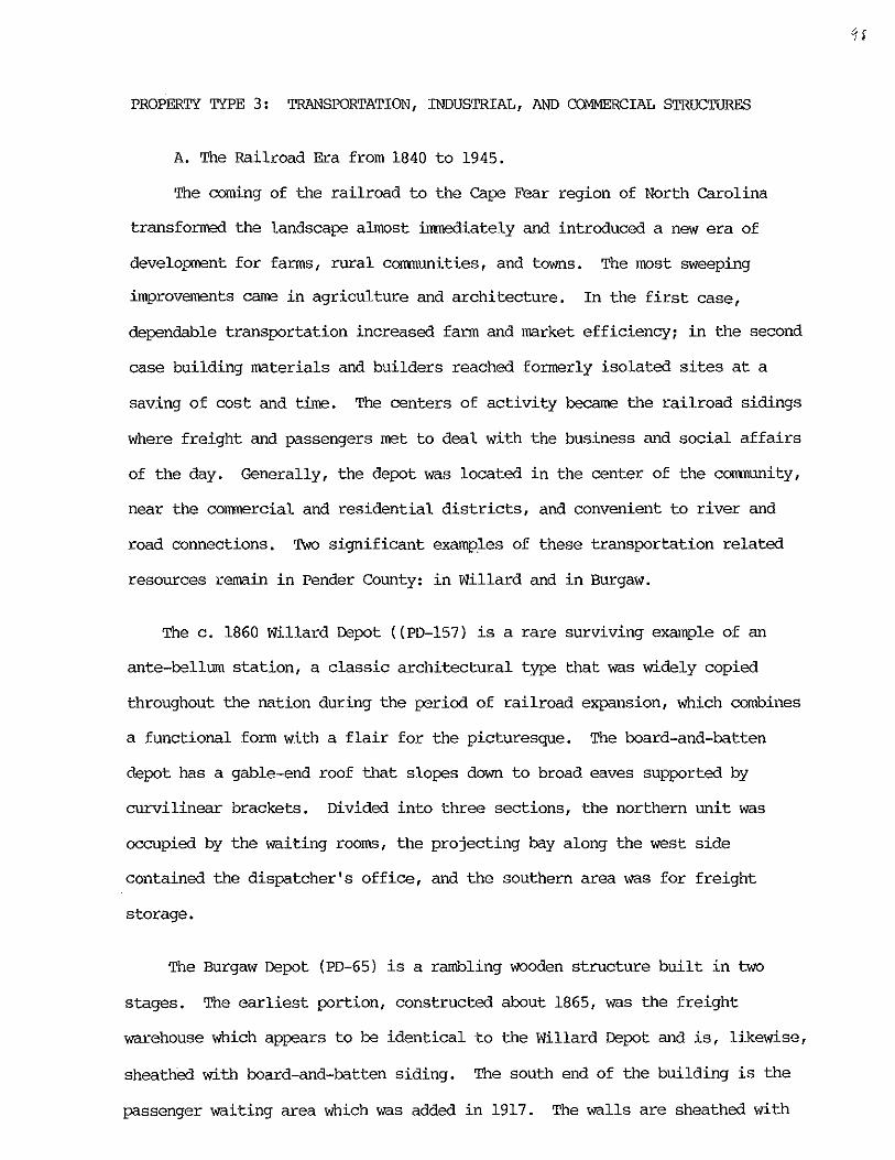
PROPERTY TYPE 3: TRANSPORTATION, INDUSTRIAL, AND O)I1MERCIAL STRUCTURES
A. The Railroad Era from 1840 to 1945.
The coming of the railroad to the Cape Fear region of North Carolina
transformed the landscape almost immediately and introduced a new era of
development for farms, rural comnuni ties, and towns. The most sweeping
improvements came in agriculture and architecture. In the first case,
dependable transportation increased farm and market efficiency; in the second
case building materials and builders reached formerly isolated sites at a
saving of cost and time. The centers of activity became the railroad sidings
where freight and passengers met to deal with the business and social affairs
of the day. Generally, the depot was located in the center of the comuunity,
near the commercial and residential districts, and convenient to river and
road connections. TWo significant examples of these transportation related
resources remain in Pender County: in Willard and in Burgaw.
The c. 1860 Willard Depot «PD-157) is a rare surviving example of an
ante-bellum station, a classic architectural type that was widely copied
throughout the nation during the period of railroad expansion, \~ich combines
a functional form with a flair for the picturesque. The board-and-batten
depot has a gable-end roof that slopes down to broad eaves supported by
curvilinear brackets. Divided into three sections, the northern unit was
occupied by the waiting rooms, the projecting bay along the west side
contained the dispatcher's office, and the southern area was for freight
storage.
The Burgaw Depot (PD-65) is a rambling wooden structure built in two
stages. The earliest portion, constructed about 1865, was the freight
warehouse which appears to be identical to the Willard Depot and is, likewise,
sheathed with board-and-batten siding. The south end of the building is the
passenger waiting area which was added in 1917. The walls are sheathed with
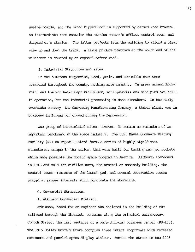
weatherboards, and the broad hipped roof is supported by carved knee braces.
An intermediate room contains the station master's office, control room, and
dispatcher's station. The latter projects from the building to afford a clear
view up and down the track. A large produce platform at the north end of the
warehouse is covered by an exposed-rafter roof.
B. Industrial structures and sites.
Of the numerous turpentine, seed, grain, and saw mills that were
scattered throughout the county, nothing more remains. In areas around Rocky
Point and the Northeast Cape Fear River, marl quarries and sand pits are still
in operation, but the industrial processing is done elsewhere. In the early
twentieth century, the Garysburg Manufacturing Company, a timber plant, was in
business in Burgaw but closed during the Depression.
One group of interrelated sites, however, do remain as reminders of an
important benchmark in the space industry. The u. S. Naval Ordnance Testing
Facility (NR) on Topsail Island forms a series of highly significant
structures, unique in the nation, that were built for testing ram jet rockets
which made possible the modern space program in America. Although abandoned
in 1948 and sold for civilian uses, the arsenal or assembly building, the
control tower, remnants of the launch pad, and several observation towers
placed at proper intervals still punctuate the shoreline.
C. Commercial Structures.
1. Atkinson Commercial District.
Atkinson, named for an engineer who assisted in the building of the
railroad through the district, contains along its principal entranceway,
Church Street, the last vestiges of a once-thriving business center (PD-108).
The 1915 Holley Grocery Store occupies three intact shopfronts with recessed
entrances and paneled-apron display windows. Across the street is the 1923
Atkinson Drug Store, its chamfered corner bay wraps around the intersection,
and the upper story is crowned by a brick-paneled parapet. Further east in
the block is an attractive array of one-story brick stores with basketweave
patterns in the aprons beneath the windows and in the upper facades.
2. Burgaw Commercial District.
The west side of Wright Street (PD-57) across from Courthouse Square was
developed between 1910 and 1950 and contains a row of distinctive commercial
buildings including the c. 1910 Bank of Pender anchoring the south corner, the
1920 Harrell's Department Store in mid-block, and the 1925 Dee's Drug Store at
the intersection of Wright Street and Courthouse Avenue. Each building
incorporates handsome brickwork and decorative details that are characteristic
of its time. The north side of Courthouse Avenue (PD-64) has several stores
dating to the 1910s with an especially attractive building, No. 104,
highlighted by segmentally-arched windows in the second story and bands of
dog-tooth brick between the arches and the parapet. On West Fremont Street
(PD-61), three store fronts surmounted by tripartite upper-story windows,
attic vents and stepped parapet once contained a newspaper office and a cafe.
3. Currie Commercial District.
The town of Currie, settled in 1888, like other communities in Pender
County, developed along the railway right-of-way, in this instance the Cape
Fear and Yadkin Railroad, and was named for a director of the line, John H.
Currie. The tracks were abandoned in the 1960s, but the short row of stores
(PD-155) along the north side of Brinson Road survive as testimony of the
once-thriving business district, ·with two general stores, a post office, a
barber shop, and a movie house still standing, but used for other purposes.
Walker's Store at the east end of the block is a model of an early twentieth
century commercial building with its high gable, deep porch, and wide entrance
doors. Bell's Store and the old post office have narrow street facades, and
luo
the former barber shop extends back into an L-shaped residence with the
ubiquitous wraparound porch and separate entrances into the rooms.
4. Willard Commercial District.
First called Leesburg in 1890 and renamed Willard for a local family
of lumber dealers, the town is the best preserved and most typical crossroads
community in Pender County (PD-158, 159, 160). Encompassing only six squares
of land surrounding the c. 1865 Depot, the extant structures, dating from the
1840s to the 1940s, include a general store, depot, old and new post offices,
five residences, two churches, a supply house, and a modern Resque Squad. The
architecture is simple and straightforward, but the overall arrangement of
differing building types and structural elements is artistically appealing.
( (> (
PROPERTY TYPE 4: INSTITUTIONAL BUILDINGS
A. Churches.
Religion has always been a dominant part of the urban and rural
populations throughout the region and embraced three major branches of
Christianity: Baptist, Methodist, and Presbyterian. Their foundations
date back to the eighteenth and early nineteenth centuries and reflect
the origins of the communicants. The oldest of the group are the
presbyterians who moved into the northern part of New Hanover, now Duplin,
County in the 1730s and established a congregation near present day
Kenansville. The Baptists were the next religious group to form an assembly
and organized a church near South Washington (Watha) in the early 1800s.
Methodist preachers had visited the area during the latter part of the 1700s,
but it was not until the post-Civil War era that they came together formally
and built their houses of worship. A fourth, but much smaller sect was the
Episcopal church which emanated from the Church of England after the American
Revolution and was mostly composed of the wealthy rural and urban classes. A
unique group in the county was the Unitarians who, in 1900, established their
first church in North carolina at Shelter Neck, built a chapel, schoolhouse,
and dormitories, and operated a boarding school there until the 1920s.
In the twentieth century, many families have become associated with
larger and more centrally located churches, and the old meeting houses have
witnessed a depletion of their congregations. In many instances, however, the
buildings are maintained by friends and families who gather annually at
reunions to preserve the historic continuity of their faith.
The first churches were often simple log structures that were suitable
for small congregations. But, in time, these were replaced by larger, more
spacious and airy meeting houses which were designed in the prevailing Greek
Revival style. Later, the pointed-arched Gothic Revival and the semicircular-
J tl7-
arched Colonial Revival became popular, but the basic form and character of
the churches retained their Greek Revival antecedents of a white painted frame
edifice, simple rectilinear lines, and robust detailing.
Mt. Holly Baptist Church (PD-230) represents the earliest establishment
of the sect in Pender County. Organized in 1814, the first church was of log
construction, but was replaced in 1861 by the current Greek Revival style
structure, the oldest and most intact religious edifice in the Cape Fear
region. The white frame edifice features widely spaced double doors in the
gable-front facade, and robust corner posts supporting a pediment. A cemetery
is located along the north side of the church.
Hopewell Presbyterian Church, (PD-91), situated at the eastern end of a
long drive that extends in a straight line from the state highway, is a
simple, Greek Revival style frame church with an engaged front porch supported
by three square posts, and two front entrances. On the south side of the
church is an extensive burying ground containing, among other communicants,
the remains of Hinton James (1776-1847), who, in 1795, was the first student
to enroll at the University of North Carolina.
The 1879 Rocky Point united Methodist Church (PD-215), at the
intersection of the old Duplin and Rocky Point roads, has an unusual window
design consisting of six-over-six sash surmounted by single-pane transoms.
The central entrance is contained within a porch supported by Tuscan columns.
The steep gable-front roof is crowned by a belfry with arched windows and a
slender spire.
The 1880 Bethlehem Baptist Church (PD-126), southwest of Currie, is a
Greek Revival style, gable-front structure, with an attached front porch
supported by two square posts. Separate doors open into the sanctuary and the
side walls are lighted by six rectangular, stained-glass windows.
Burgaw's 1883 Macedonia AME Church (PD-77), one of the oldest black
congregations in the county, has a Greek-cross plan which contains pointed
arch, stained glass windows in the north, south and west elevations. A square
tower surmounted by a front gable is attached to the southeast corner of the
edifice. The brick facings were added in 1915.
The 1889 Point Caswell Missionary Baptist Church (PD-124), standing
solemnly within a grove of pine trees near the bend of the road that skirts
the Black River, is a rare example of an intact rural meeting house which
retains its unpainted weatherboarding, large sash windows, twin front
entrances, and diamond-shaped attic vents beneath a steep gable-front roof.
The c. 1890 Pentecostal Free will Baptist Church in Willard (PD-159)
exhibits Gothic Revival details including a crenellated entrance tower
containing double doors, a blind window with paired, peaked tops, and diamond
shaped side vents. Windows in the nave contain nine-over-nine sash and
triangular transoms.
To the northwest of the Hawes House in Atkinson (PD-116) is the 1890
Gothic Revival style frame chapel, formerly St. Thomas, a unique example in
the county of an Episcopal mission, currently used as an interdenominational
church. The gabled front is bisected by a square tower which incorporates a
double-door entrance surmounted by a pointed-arch transom; a multi-light,
pointed-arch window; and a circular vent.
Atkinson's c. 1900 Caswell presbyterian Church (PD-I09) is a late Gothic
Revival style frame edifice with a Latin cross plan, a pyramidal-roofed tower,
and a gabled entrance pavilion at the southeast corner of the building. The
pointed-arch windows, arranged singly and in pairs, contain stained glass
panels.
10~
The c. 1900 Maple Hill Missionary Baptist Church (PD-188) anchors the
northeast corner of NC-50 and SR-1526 and is bordered by woods and a stream
along the northern side of the grounds. The edifice is one bay wide and
three bays deep with a projecting tower at the gable-front entrance. The
tower is crowned by a small gable in each flank and an octagonal steeple
containing its original scalloped shingles.
The c. 1900 waters Chapel AME Church (PD-123), near CUrrie, is a
gable-front frame building with a central entrance and windows surmounted by
pointed-arch transoms. Patches in the weatherboarding around the transoms
suggest that the windows originally were trabeated and later changed to
suggest Gothic Revival work. Sawtooth-pattern fascias and verge boards
animate the roof which is crowned by a square cupola and a pyramidal roof
topped by a spike.
The c. 1907 Watha Missionary Baptist Church (PD-174) is is a one-story
edifice in the Victorian Gothic style. The main block has pointed windows
containing two-over-two sash and diamond-shaped lights in the apex of the
upper sash. A two-tier, pyramidal-roofed entrance tower rises at the
southwest corner of the church.
Mills Memorial Advent Christian Church (PD-146), west of Penderlea, is a
rare example of the carpenter Gothic style with board-and-batten walls, multi
stage central entrance tower, and pointed-arch windows containing stained
glass panels. The church duplicates the design of the Episcopal church in
Elizabethtown, which was moved from Faison in the 1980s.
The 1907-1908 Watha Methodist Church (PD-181) is a Colonial Revival style
edifice, three bays wide and four bays deep, with a gable-front roof crowned
by a square cupola and pyramidal roof. The central front entrance contains
double doors and a fanlight transom. Flanking arched windows have six-over-
nine sash with the upper sash terminating in fanlights. Fenestration in the
side elevations consist of trabeated windows containing six-over-six sash.
In Burgaw, the Colonial Revival style is echoed in two religious edifices:
the 1928 Burgaw Methodist Church (PD-69), a T-shaped brick structure
highlighted by a portico and crowned by an octagonal cupola; and the 1940
Burgaw Baptist Church (PD-69), with a cruciform plan, Corinthian portico, and
multi-stage steeple.
In St. Helena, Ss. Peter and Paul Russian Orthodox Church (PD-91) was
built in 1932 and owes much to the Colonial Revival style with arched windows,
basket-weave decoration framing the central entrance, and an octagonal belfry.
Distinctive Orthodox stylistic details include a wheel window over the
entrance and a faceted, gilded dome crowned by a Russian cross.
Island Creek Missionary Baptist Church (PD-235), west of Hampstead,
is one of a small number of brick churches in the county. The noteworthy
design is arranged around large, Italianate-influenced arched windows in the
front and side elevations of the nave.
B. Schools.
No school structures predating the early twentieth century survive in
Pender County, and schools built in the late 1910s and 1920s are of two types:
frame and brick. The first type is best represented by a number of structures
sponsored by the Rosenwald Foundation, an organization of Sears-Roebuck and
Company of Chicago, which funded the construction of school houses for black
children in the South. Of these, eight survive in Pender County at Currie
(PD-141), Caintuck (PD-128), Maple Hill (PD-201), two in ROCky Point (PD-205
and PD-209), Sloop Point (PD
(PD-IOO).
), Still Bluff (PD- ), and Union Chapel
In the 1920s, school consolidation was put into effect and a number of
IUb
brick schools were built for white students. The first of these was the 1924
Atkinson School (PD-118), one of a vast number of educational buildings
designed by Wilmington architect Leslie N. Boney, and perhaps his best work,
with a suggestion of Tudor and Neoclassical influences including a formal
central entrance, clustered windows, and applied ornament in the stepped
parapets. The 1924 Long Creek-Grady School (PD-214), east of Currie, is
another Boney design, but with an exposed-rafter hipped roof rather than the
undulating parapets of his other designs. In 1925, similar schools were
designed and erected at Topsail (now the Middle School) and Rocky Point (a
one-story version later named Pender Academy). In addition to the main
building, many of the schools had separate, frame gymnasiums, cafeterias, and
manual training classrooms added to the facilities between the 1930s and
1950s.
The one-story, brick, Colonial Revival style Maple Hill School (PD-90)
was a Federal Works Progress Administration project, which was built in 1939
to replace a wooden schoolhouse, and is now used as a community center.
The Pender lea School (PD-156) was also a Federal project that was
completed in 1938. The modern, advanced design forms a complex of free
standing, one-story, brick buildings arranged in a symmetrical pattern around
interior courtyards. Covered walkways run between the units and connect with
the gymnasium and auditorium across the green.
C. Government Buildings.
The first Pender County Courthouse was located in Watha, in 1875, but the
seat of government was moved to Burgaw shortly thereafter and a new building
was erected there in 1883. The current courthouse (PD-56), replacing the
earlier structure in 1936, was designed by Raleigh architect William Henley
Dietrick. The Colonial Revival style was favored during the WPA era and the
result is one of the most attractive public buildings in North Carolina.
The 1924 Pender County Jail (PD-58) across Courthouse Square is a two
story, Spanish Colonial style structure with an entrance porch covered with
Mission tiles. The building rises to a flat roof enclosed by a low parapet.
The first level originally contained offices and the jailer's living quarters;
the prison cells occupy the second floor.
)0'