historic south main revitalization - springfield, mo
TRANSCRIPT

Historic South MainRevitalization
Springfield, MO
Fall 2006Center for Community Studies
Hammons School of ArchitectureDrury University

Preface • Site Analysis • Executive Summary • Research • Workshops • Proposals • AppendixHistoric South MainARCH 417 - Fall 2006Pg. 2
AcknowledgementsCommunity Studio Visioning Team:Laura BergmanCraig CulbertsonMichael HamptonBrian HarbisonTyler HellwigErika KoenigBryon Oster
Project Administrator:Jay Garrott
City of Springfield:Brendan K. Griesemer, AICP, Neighborhood Conservation Office Andrea Hall, Economic DevelopmentJason Haynes, P.E., Traffic Engineering David Hutchison, P.E., Traffic EngineeringHannah Rippe, Neighborhood Conservation Office Ralph Rognstad Jr., AICP, Planning and Development DirectorRandall Whitman, Neighborhood Conservation Office
Historical Preservation:Deb Sheals, Architectural Historian
Springfield History Museum:John Sellars, Director
Missouri Department of Natural ResourcesJo Ann Radetic, CLG Coordinator of State Historic
Preservation Office
Community Advisory Committee:Tom and Nancy Dornan, owners and developersCarl Herd, ownerBob Horton, Executive Director of Urban Neighborhoods AllianceJake Jackson, ownerGary and Linda Lawrence, ownersJack and Mary Ellen Pugh, ownersAndy Wang, ownerRusty Worley, Director of Urban Districts Alliance
Workshop Participants:Chris DietzKimberly and Thomas DuboisKevin GriceDebbie GulleyChris HoughtonSoonok MayhewAnthony and Marcha MullinsAlan and Pat NeffRonald WhiteheadAl and Mary Williams

Preface • Site Analysis • Executive Summary • Research • Workshops • Proposals • AppendixHistoric South Main
ARCH 417 - Fall 2006Pg. �
Preface Problem Statement 4 Historical Information 5 Introduction to Site 6Site Analysis Aerial of Site 8 Current Zoning 10 Massing Diagram 12 Renter vs. Owner 1� Existing Housing Stock 14 Site Observations 16Executive Summary Comprehensive Master Plan 18 Location 20 Perception 22 Mixed-Use vs. Residential 24 Future Development 26 Park/Community Spaces �2 Demographics �4 Crime �6 History �8 Unification 40 Streetscape 42 Parking 46 Traffic Flow/Speeding 50 Zoning 52 Funding 54
Research Precedent Studies 56 Literature Research 59Workshops 1st Community Workshop 64 Advisory Committee Meeting 72 2nd Community Workshop 80Proposals Comprehensive Master Plan 88 Residential Component 90 Mixed-Use/Commercial Component 100 Entry Nodes 106Appendix Citations 114
Table of Contents

Preface • Site Analysis • Executive Summary • Research • Workshops • Proposals • AppendixHistoric South MainARCH 417 - Fall 2006Pg. 4
The City of Springfield approached us to help them in a visioning effort for the blocks of South Main bounded by Walnut, Market, Mount Vernon and Grant. Located just southwest of the central business district and square downtown, this area is part of the West Central Neighborhood. The homes in this area represent the closest single family residences to downtown urban living. Currently, many of the homes are being used as multi-family rental properties and only a few are owner occupied or vacant. The Department of Planning and Development seeks to explore visions of how the area could be revitalized and developed as a mixed-use commercial and/or residential area. The city hopes to retain the existing housing stock but possibly allow different uses. They want to emphasize refurbishment, not demolition. Community input is essential because the project needs backing and support. It is also important to recognize that this is an educational process. It is our goal to educate the community and the City about what is possible in the area. This is a visioning process where ideas must be tested and explored to find the best final solution.
Problem StatementHistorical InformationIntroduction to Site
Problem StatementPreface
Location of site 4A

Preface • Site Analysis • Executive Summary • Research • Workshops • Proposals • AppendixHistoric South Main
ARCH 417 - Fall 2006Pg. 5
Problem StatementHistorical Information
Introduction to Site
PrefaceHistorical Information South Main Street is rich with history and has seen many changes throughout the years. At the turn of the Twentieth century, Main Street, just north of Walnut, was a major industrial area. Businesses such as Springfield Gas and Electric Company, Missouri Pacific Railroad depot, Rogers and Baldwin Hardware, and Springfield Gas Plant Manufacturer were located on Main St.. These companies were important to the economic growth of Springfield, and have helped build Springfield to become what it is today. During the Civil War General Lyons had his head-quarters on North Main. Hence, nearby points to the North and South of our site on Main Street were sites for the Battle of Springfield. Soon after the Civil War, Main Street turned into a industrial area which included a trolley that ran North and South from 1887 to 19�7. Years ago the famous Route 66 ran just one block north of the site. Today the businesses that grew after the Civil War no longer exist on Main Street. However, new buisnesess such as the Main Post Office and Butler Rosenbury and Partners architecture offfice currently call Main Street home. The site did not have major development until after 1896 and for the past century the lot boundaries have remained mostly unchanged along Main street.
Springfield Gas and Electric 5A
Route 66 5B
View of old train station looking toward downtown 5C Trolley car on Main Street 5D

Preface • Site Analysis • Executive Summary • Research • Workshops • Proposals • AppendixHistoric South MainARCH 417 - Fall 2006Pg. 6
Problem StatementHistorical InformationIntroduction to Site
Introduction to SiteSite Analysis
For the purposes of this book, we want to define some terminology to differentiate parts of our study.
I. South Main Site The site being studied bounded by
the streets Walnut Street (north), Market Avenue (east), Mt. Vernon Street (south) and Grant Avenue (west)
II. South Main Avenue The section of South Main Avenue
between Walnut Street and Mount Vernon.
South Main Site and South Main Avenue 6A

Preface • Site Analysis • Executive Summary • Research • Workshops • Proposals • AppendixHistoric South Main
ARCH 417 - Fall 2006Pg. 7
Problem StatementHistorical Information
Introduction to Site
Site AnalysisIntroduction to SiteIII. South Main Corridor South Main in its entirety.
IV. Main Avenue Main Avenue in its entirety, north
and south.
South Main Corridor and South Main Avenue 7A

Preface • Site Analysis • Executive Summary • Research • Workshops • Proposals • AppendixHistoric South MainARCH 417 - Fall 2006Pg. 8
This photo shows an aerial view of Springfield as a whole. The red area shows where our site is located in relationship to the city as a whole.
Aerial of SiteCurrent ZoningMassing DiagramRenter vs. OwnerExisting Housing StockSite Observations
Aerial of SiteSite Analysis
N
Aerial view of Springfield, MO 8A
Preface • Site Analysis • Executive Summary • Research • Workshops • Proposals • AppendixHistoric South Main
ARCH 417 - Fall 2006Pg. 9
Aerial of SiteCurrent Zoning
Massing DiagramRenter vs. Owner
Existing Housing StockSite Observations
Site AnalysisAerial of Site
N
Aerial view of South Main site 9A
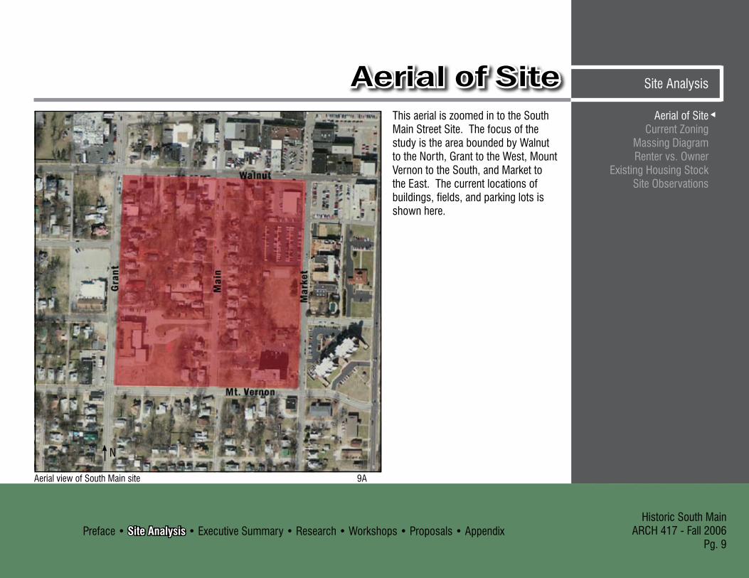
This aerial is zoomed in to the South Main Street Site. The focus of the study is the area bounded by Walnut to the North, Grant to the West, Mount Vernon to the South, and Market to the East. The current locations of buildings, fields, and parking lots is shown here.

Preface • Site Analysis • Executive Summary • Research • Workshops • Proposals • AppendixHistoric South MainARCH 417 - Fall 2006Pg. 10
Zones: R-TH: Townhouse Residential
District. CC: Center City District GR: General Retail District R-SF: Single-Family
Residential District R-MD : Medium-Density
Multi-Family Residential District
The city wrote in their 1998 West Central Neighborhood Strategic Plan that the current R-TH zoning in impractical because it is “surrounded.”
416
502
455
467
428
440
807801
619617
824437
626
438
425
514
447451
632
308301
601
465
527
531
218
640724
727
444
604
816
535
737
810
412
715
811
823
320
816 710
411
615
620
621
823
800
405623
453
301327
500
506
500
807
826
608
504
810
401
807
618716
829
421
807331
732736
614
440430
811
629801
723
525
312
801829
736
607520
800
415
623
733
436
414
838
611
816
800434
510
424
721
701
601
445
534
812
507
817529
454
826
318
716
431
530
520
617
817
445
400
639
459
633
616
410
420
621
724818
609
540
730
433
614
414
600
601
308
731
724734
446436
612
404
618
611
320
515
422421
614
311
324
448
608
513
714
461
817
801
208
731460460
302
505
620
464
737
316
424802
817
615620
530
729
452
710
420
318
832
737
825
427
824
715
524
319
730
702
325
605
440 444
727
448451
427
822
825
416
828
609
521
606310
417
512
727
509
812
413
831
313
330
616
519
806
326
428
613
323
306
613
603
408
453
430
632
507
220
307
314
503
620
811
528
813
8TH
MA
IN
WALNUT
GR
AN
T MA
RK
ET
MOUNT VERNON CA
MPB
ELL
DO
UG
LAS
PATT
ON
MCDANIEL
7TH
ELM
PERSHING
ELM
7TH
DO
UG
LAS
ELM
PERSHING PERSHING
SOUTH MAIN VILLAGE
DISCLAIMER: All information included on this map or digital f ileis provided "as-is" for general information purposes only. The Cityof Springfield, and all other contributing data suppliers, make nowarranties, expressed or implied, concerning the accuracy, completeness,reliability, or suitability of the data for any particular use. Furthermore,the City of Springfield, and all other contributing data suppliers, assume noliability whatsoever associated with the use or misuse of the data.
Aerial of SiteCurrent ZoningMassing DiagramRenter vs. OwnerExisting Housing StockSite Observations
Current ZoningSite Analysis
N
Zoning Map of South Main Site 10A

Preface • Site Analysis • Executive Summary • Research • Workshops • Proposals • AppendixHistoric South Main
ARCH 417 - Fall 2006Pg. 11
Zoning OrdinanceSpringfield City Code - Chapter �6, Article ICity of Springfield, MissouriMarch 7, 1995Last Amended July 7, 2005
Townhouse Residential District (R-TH): A district designed for single-family-detached, single-family-semi-detached, duplex and townhouse residences at a maximum density of eleven (11) dwelling units per acre.
Center City District (CC):A zone designed to accommodate the existing mix of uses in the Springfield Central Business District and Commercial Street Area.
General Retail District (GR):A zone designed for uses that provide community-wide personal and business services, shopping centers and specialty shops.
Single-Family Residential District (R-SF):A zone designed to accommodate single-family residential development at a maximum density of seven (7) dwelling units per acre.
Medium-Density Multi-Family Residential Distict (R-MD):A zone designed for multi-family dwelling units (apartments) with a maximum density of twenty-nine (29) dwelling units per acre.
Aerial of SiteCurrent Zoning
Massing DiagramRenter vs. Owner
Existing Housing StockSite Observations
Site AnalysisCurrent Zoning

Preface • Site Analysis • Executive Summary • Research • Workshops • Proposals • AppendixHistoric South MainARCH 417 - Fall 2006Pg. 12
Aerial of SiteCurrent ZoningMassing DiagramRenter vs. OwnerExisting Housing StockSite Observations
Massing DiagramSite Analysis
The massing of buildings of the South Main Site is fairly consistent with single family dwellings bordering both sides of the street. Walnut, Grand, and Mount Vernon are also lined with buildings on both sides but the sizes vary with a mix of residential, commercial and institutional facilities. Market street has a few major buildings to the east but the west side is fairly open with parking and fields.
Mount Vernon
Gran
d
Mar
ket
N
Lakeland Hospital
Campbell Elementary Schoool
Housing Authority of Springfield
Church
Walnut
Current Uses:
= Commercial
= Residential
= InstitutionalMassing Diagram of South Main Site 12A

Preface • Site Analysis • Executive Summary • Research • Workshops • Proposals • AppendixHistoric South Main
ARCH 417 - Fall 2006Pg. 1�
Aerial of SiteCurrent Zoning
Massing DiagramRenter vs. Owner
Existing Housing StockSite Observations
Site AnalysisRenter vs. OwnerThe properties within the South Main Site are primarily renter occupied (green) with only a few owner occupied (blue). This map also shows the property lines of the area which have stayed relatively unchanged since around 1900 when the area began to develop.
According to recent housing data, this is the breakdown of the area: Owner Occupied Housing Units: Renter Occupied Housing Units: Vacant Housing Units:
18.60%79.10%
2.�0%
Renter vs. Owner Map 1�A

Preface • Site Analysis • Executive Summary • Research • Workshops • Proposals • AppendixHistoric South MainARCH 417 - Fall 2006Pg. 14
Aerial of SiteCurrent ZoningMassing DiagramRenter vs. OwnerExisting Housing StockSite Observations
Existing Housing StockSite Analysis
East Side of South Main Street
West Side of South Main Street
Mt.
Vern
onW
alnu
t
The South Main Site is a peninsula of multi-family residential housing surrounded by commercial and institutional properties. Some businesses have begun to intrude at the intersection of South Main Avenue and Walnut Street. Most of the houses on South Main Avenue were built in the 1890s and they have a distinct historic quality. The predominant types of houses include the Gabled-Ell,
American Foursquare, Bungalow, and Catalouge homes. Many of the houses are in need of rennovation to restore them to their original historic character. The vegetation in the area is very mature with large trees on most properties. The houses are set back from the street with front porches and garages behind.

Preface • Site Analysis • Executive Summary • Research • Workshops • Proposals • AppendixHistoric South Main
ARCH 417 - Fall 2006Pg. 15
Aerial of SiteCurrent Zoning
Massing DiagramRenter vs. Owner
Existing Housing StockSite Observations
Site AnalysisExisting Housing Stock
East Side of South Main Street
West Side of South Main Street
Wal
nut
Mt.
Vern
on
A large portion of South Main Avenue is lined with an old stone wall. The wall is falling apart and needs fixing up but it is still a positiive aesthetic element for the neighborhood. There is a vacant lot on the northeast side of South Main Avenue and across from Lakeland Hospital on Market Avenue.
Currently, most parking for the South Main Site occurs along the street. Local businesses also use South Main Avenue for parking. The current street lighting is inadequate. Residents and owners have requested that lighting be improved to add to the safety of the neighborhood.

Preface • Site Analysis • Executive Summary • Research • Workshops • Proposals • AppendixHistoric South MainARCH 417 - Fall 2006Pg. 16
Observed Trends:
Location I:- Highest foot and car traffic overall, which
was between 10am-4pm- Traffic associated with Campbell Elementary
School
Location II:- More pedestrians- Pedestrian traffic associated with proximity
to downtown activities, especially Springfield Brewing Company
Location III:- More pedestrians- Pretty quiet in general- Busier on weekdays vs. weekends- Traffic associated with Housing Authority of
Springfield property
Aerial of SiteCurrent ZoningMassing DiagramRenter vs. OwnerExisting Housing StockSite Observations
Site ObservationsSite Analysis
I
II
III
Observation locations 16A

Preface • Site Analysis • Executive Summary • Research • Workshops • Proposals • AppendixHistoric South Main
ARCH 417 - Fall 2006Pg. 17
Aerial of SiteCurrent Zoning
Massing DiagramRenter vs. Owner
Existing Housing StockSite Observations
Site AnalysisSite Observations
Weekday
Weekend
Location I Location II Location III

Preface • Site Analysis • Executive Summary • Research • Workshops • Proposals • AppendixHistoric South MainARCH 417 - Fall 2006Pg. 18
Comprehensive Master Plan LocationPerceptionMixed-Use vs. ResidentialFuture DevelopmentPark/Community SpacesDemographicsCrimeHistoryUnificationStreetscapeParkingTraffic Flow/SpeedingZoningFunding
Comprehensive Master PlanExecutive Summary
= Residential
= Mixed-Use
= Existing Commercial
= Institutional
= Future Development
= Brick Sidewalk
= Entry Nodes
= Greenspace
= Parking
= StreetsMaster Plan
Preface • Site Analysis • Executive Summary • Research • Workshops • Proposals • AppendixHistoric South Main
ARCH 417 - Fall 2006Pg. 19
Comprehensive Master Plan Location
PerceptionMixed-Use vs. Residential
Future DevelopmentPark/Community Spaces
DemographicsCrime
HistoryUnification
StreetscapeParking
Traffic Flow/SpeedingZoning
Funding
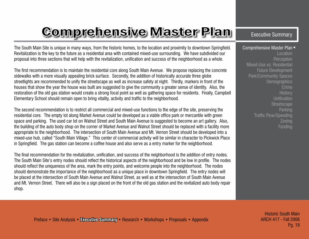
Executive SummaryComprehensive Master PlanThe South Main Site is unique in many ways, from the historic homes, to the location and proximity to downtown Springfield. Revitalization is the key to the future as a residential area with contained mixed-use surrounding. We have subdivided our proposal into three sections that will help with the revitalization, unification and success of the neighborhood as a whole.
The first recommendation is to maintain the residential core along South Main Avenue. We propose replacing the concrete sidewalks with a more visually appealing brick surface. Secondly, the addition of historically accurate three globe streetlights are recommended to unify the streetscape as well as increase safety at night. Thirdly, markers in front of the houses that show the year the house was built are suggested to give the community a greater sense of identity. Also, the restoration of the old gas station would create a strong focal point as well as gathering space for residents. Finally, Campbell Elementary School should remain open to bring vitality, activity and traffic to the neighborhood.
The second recommendation is to restrict all commercial and mixed-use functions to the edge of the site, preserving the residential core. The empty lot along Market Avenue could be developed as a viable office park or mercantile with green space and parking. The used car lot on Walnut Street and South Main Avenue is suggested to become an art gallery. Also, the building of the auto body shop on the corner of Market Avenue and Walnut Street should be replaced with a facility more appropriate to the neighborhood. The intersection of South Main Avenue and Mt. Vernon Street should be developed into a mixed-use hub, called “South Main Village.” This center of commercial activity will be similar in character to Pickwick Place in Springfield. The gas station can become a coffee house and also serve as a entry marker for the neighborhood.
The final recommendation for the revitalization, unification, and success of the neighborhood is the addition of entry nodes. The South Main Site’s entry nodes should reflect the historical aspects of the neighborhood and be low in profile. The nodes should reflect the uniqueness of the area, mark the entry points, and welcome people into the neighborhood. The nodes should demonstrate the importance of the neighborhood as a unique place in downtown Springfield. The entry nodes will be placed at the intersection of South Main Avenue and Walnut Street, as well as at the intersection of South Main Avenue and Mt. Vernon Street. There will also be a sign placed on the front of the old gas station and the revitalized auto body repair shop.

Preface • Site Analysis • Executive Summary • Research • Workshops • Proposals • AppendixHistoric South MainARCH 417 - Fall 2006Pg. 20
Comprehensive Master Plan LocationPerceptionMixed-Use vs. ResidentialFuture DevelopmentPark/Community SpacesDemographicsCrimeHistoryUnificationStreetscapeParkingTraffic Flow/SpeedingZoningFunding
LocationExecutive Summary
ISSUE: LocationThe location of the site is unique and important because it is the closest single family residences to downtown. The unique location of residences is one of the defining characteristics of the neighborhood.
CONCERN: Proximity to downtownOne of the more interesting qualities of the site is its proximity to the downtown area. It is the closest place to downtown you can live and still have the benefits that come with neighborhood life (intimacy, back yard, etc). This brings a great opportunity to create an area where the residents can enjoy the culture and energy of downtown while still retaining a peaceful, serene place to live.
CONCERN: “Peninsula” of Residential ZoningBecause of it’s proximity to downtown, over the years the South Main Site has become a “peninsula” of residential activity that stems northward from Mt. Vernon St. along South Main Avenue. It has become surrounded by commercial activity and zoning, with a day care, two auto garages, a used car lot, the local bricklayers labor organization, and an audio store all located around the northern and western perimeters of the site. We want to allow these different activities to happen simultaneously without one interfering with the other.
CONCERN: Public Exposure/ VisibilityThe fact that this area is so close to downtown means that there is a considerable amount of traffic flow around it, both vehicular and pedestrian. This creates an opportunity to enhance the character of the area in a way that engages the public’s interest and turns the neighborhood and surrounding businesses from just a space into a recognizable place.
View looking west on Park Central East

Preface • Site Analysis • Executive Summary • Research • Workshops • Proposals • AppendixHistoric South Main
ARCH 417 - Fall 2006Pg. 21
Comprehensive Master PlanLocation
PerceptionMixed-Use vs. Residential
Future DevelopmentPark/Community Spaces
DemographicsCrime
HistoryUnification
StreetscapeParking
Traffic Flow/SpeedingZoning
Funding
Executive SummaryLocationCONCERN: Residential Interaction with Urban ActivitiesThe peninsula of residential zoning and the heavy commercial activity around the site creates a sensitive residential interface. It is important to keep these activities separate while creating a comfortable, flowing transition between the two zones.
RECOMMENDATIONS:The existing residential core of the site should be preserved by restricting mixed use activities to the more urbanized edges. Buffered commercial parking created on each business’s lot would discourage employees and customers from parking along South Main Avenue, developing a visual and physical separation of residential and commercial activities. The character of the area should be unified through the use of elements such as materials, lighting, signage, and vegetation, thus assisting in turning the area into a distinct community. The use of vegetation and/or privacy fencing would keep the commercial and residential activities separated while elements such as signage and lighting retain the continuity of the area.
Residential-Urban Interaction 21A
Preface • Site Analysis • Executive Summary • Research • Workshops • Proposals • AppendixHistoric South MainARCH 417 - Fall 2006Pg. 22
Comprehensive Master Plan LocationPerceptionMixed-Use vs. ResidentialFuture DevelopmentPark/Community SpacesDemographicsCrimeHistoryUnificationStreetscapeParkingTraffic Flow/SpeedingZoningFunding
PerceptionExecutive Summary
ISSUE: PerceptionThe look of the neighborhood:The South Main Site is the closest residential area to Downtown Springfield. This attribute makes the perception of the South Main Site as a clean, safe and a unique place to be, very important to the future success of the South Main Site. Elements such as crime, speeding, unkept landscaping, and renovations that need to be made, all effect how people perceive the area.
CONCERN: Crime RatesThe crime rates are high and must be reduced to entice people to become residents. Speeding on South Main Avenue is a problem with the addition of school children crossing the street twice daily. Crime rates will lower with upper scale living and neighborhood unity. Speeding can be reduced by the lowering of the speed limit and the introduction of pedestrian cross walks.
CONCERN: LandscapingMaintaining plant growth is very important to the aesthetics of the neighborhood. Keeping trees pruned, the grass cut, and bushes along houses trimmed is an important task that must be taken on by the resident. Keeping up with lawn maintenance can be costly, but is very important to keep a good perception of the neighborhood. Having a lawn
maintenance crew take care of the lawn care on a regular basis can be a good solution to poor landscape conditions.
CONCERN: Structure RenovationsHouses that are in need of renovation detract from the other houses and the South Main Site as a whole. Retaining
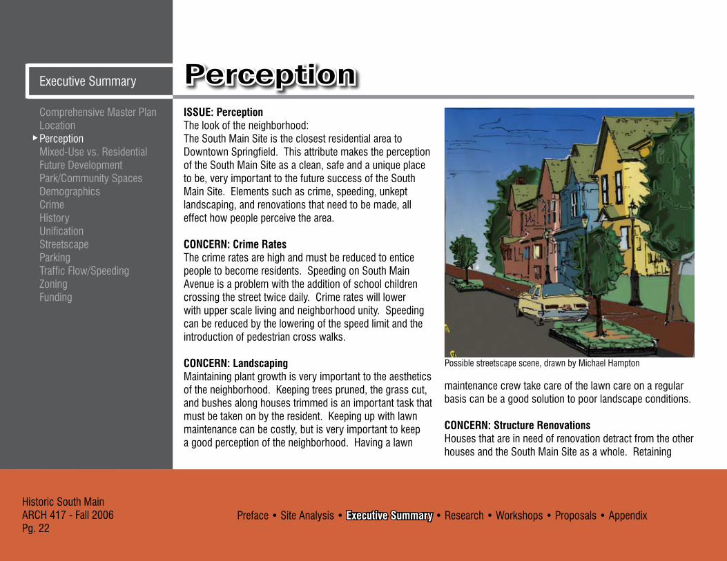
Possible streetscape scene, drawn by Michael Hampton

Preface • Site Analysis • Executive Summary • Research • Workshops • Proposals • AppendixHistoric South Main
ARCH 417 - Fall 2006Pg. 2�
Comprehensive Master Plan Location
PerceptionMixed-Use vs. Residential
Future DevelopmentPark/Community Spaces
DemographicsCrime
HistoryUnification
StreetscapeParking
Traffic Flow/SpeedingZoning
Funding
Executive SummaryPerception
wall and entry walk-way improvements could help the image and aesthetics of the neighborhood. Renovations must fit with the historic character of the neighborhood. Renovations to the retaining wall and entry walk-way should be done similar in all residential cases to maintain unity within the South Main Site.
RECOMMENDATIONS:Controlling speeding could be accomplished in a number of ways: a crosswalk on either end of South Main Street, ‘smart parking,’ a type of curb outcropping to designate parking areas along a street, gives traffic less room in their lane which statistically lowers traffic speed and also having police regularly monitor traffic. Maintaining the landscaping is the responsibility of the owner; however, the development of neighborhood landscaping guidelines would assure conformity. Renovations that are made in the South Street Site should be restricted based on an Urban Conservation District (UCD) and the historic nature of the neighborhood. These renovations could be funded by a Neighborhood Improvement District (NID) that is created to help residents with renovations to their homes, yard and retaining wall.
Possible streetscape scene, drawn by Michael Hampton

Preface • Site Analysis • Executive Summary • Research • Workshops • Proposals • AppendixHistoric South MainARCH 417 - Fall 2006Pg. 24
Comprehensive Master Plan LocationPerceptionMixed-Use vs. ResidentialFuture DevelopmentPark/Community SpacesDemographicsCrimeHistoryUnificationStreetscapeParkingTraffic Flow/SpeedingZoningFunding
Mixed-Use vs. ResidentialExecutive Summary
ISSUE: Mixed-Use vs. ResidentialThe residential section of the South Main Site is the closest single-family housing to downtown. This makes it a prime location for people who want to be part of an urban lifestyle and still have a house with a yard. The proximity to downtown makes the land unique and valuable.
CONCERN: Owner vs. Renter Occupied Residences The neighborhood is primarily renter occupied and not owner occupied. To increase the overall care in the neighborhood, it would be advantageous to try to stimulate a shift back to more owner occupied housing. However, because renting is a source of income, many owners in the area may be hesitant to give up their properties unless there was a better prospect for income.
CONCERN: Mixed-Use:If mixed-use and businesses were introduced into the area, the feel of the neighborhood would change. The residential character would be broken up and the unique character of being the closest single family housing to downtown would be lost. Although businesses could bring new investment and interest to the area, help revive the spirit of the neighborhood, and bring in new investors, the increased mixed-use activities could seriously disrupt the residential character of the neighborhood.
David and Judy Ostrander restored home, Waverly, IA 24A

Preface • Site Analysis • Executive Summary • Research • Workshops • Proposals • AppendixHistoric South Main
ARCH 417 - Fall 2006Pg. 25
Comprehensive Master Plan Location
PerceptionMixed-Use vs. Residential
Future DevelopmentPark/Community Spaces
DemographicsCrime
HistoryUnification
StreetscapeParking
Traffic Flow/SpeedingZoning
Funding
Executive SummaryMixed-Use vs. ResidentialCONCERN: Location of Mixed-Use:Restricting mixed-use activities to the existing surrounding areas by enhancing and expanding these activities would help to maintain and strengthen the residential core along South Main Avenue between Walnut and Mt. Vernon. If mixed-use activities are expanded into the residential area of the South Main Site it should be restricted to the entry points at Walnut and South Main Avenue and Mt. Vernon and South Main Avenue, where vehicular traffic is highest.
RECOMMENDATIONS: Mixed-use activities should be restricted to the areas along Market, Walnut, and Grant with limited additions at Walnut and South Main Avenue and Mt. Vernon and South Main Avenue intersections. The single-family residential area along South Main Avenue between Walnut and Mt. Vernon should be retained and strengthened because of its unique character in the City Center. The surrounding businesses should be restricted to professional offices, restaurants, bed and breakfasts, art galleries, boutiques, day care and neighborhood oriented shops.
O Gallery, Paducah, KY 25A
York Street House Bed and Breakfast, Lambertville, NJ 25B
Preface • Site Analysis • Executive Summary • Research • Workshops • Proposals • AppendixHistoric South MainARCH 417 - Fall 2006Pg. 26
Comprehensive Master Plan LocationPerceptionMixed-Use vs. ResidentialFuture DevelopmentPark/Community SpacesDemographicsCrimeHistoryUnificationStreetscapeParkingTraffic Flow/SpeedingZoningFunding
Future DevelopmentExecutive Summary
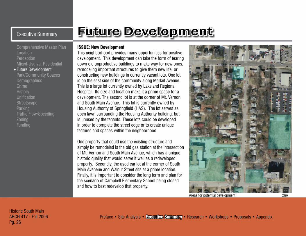
ISSUE: New DevelopmentThis neighborhood provides many opportunities for positive development. This development can take the form of tearing down old unproductive buildings to make way for new ones, remodeling important structures to give them new life, or constructing new buildings in currently vacant lots. One lot is on the east side of the community along Market Avenue. This is a large lot currently owned by Lakeland Regional Hospital. Its size and location make it a prime space for a development. The second lot is at the corner of Mt. Vernon and South Main Avenue. This lot is currently owned by Housing Authority of Springfield (HAS). The lot serves as open lawn surrounding the Housing Authority building, but is unused by the tenants. These lots could be developed in order to complete the street edge or to create unique features and spaces within the neighborhood.
One property that could use the existing structure and simply be remodeled is the old gas station at the intersection of Mt. Vernon and South Main Avenue, which has a unique historic quality that would serve it well as a redeveloped property. Secondly, the used car lot at the corner of South Main Aveneue and Walnut Street sits at a prime location. Finally, it is important to consider the long term and plan for the scenario of Campbell Elementary School being closed and how to best redevelop that property.
Areas for potential development 26A

Preface • Site Analysis • Executive Summary • Research • Workshops • Proposals • AppendixHistoric South Main
ARCH 417 - Fall 2006Pg. 27
Comprehensive Master Plan Location
PerceptionMixed-Use vs. Residential
Future DevelopmentPark/Community Spaces
DemographicsCrime
HistoryUnification
StreetscapeParking
Traffic Flow/SpeedingZoning
Funding
Executive SummaryFuture Development
CONCERN: DensityOne of the first concerns is maintaining a proper density on these sites. We must consider what level of density is appropriate for this neighborhood by taking into consideration the current density, scale of surrounding buildings, and the setbacks and lot lines of current properties.
CONCERN: CharacterThis community has a very unique character, one that is rooted in the history of the neighborhood. It is a quiet neighborhood even with its proximity to downtown. The
wide sidewalks set back from the street making it a pleasant area to stroll. All of these concerns must be taken into account in order to preserve the unique character of the neighborhood.
CONCERN: HistoryThis neighborhood dates back to the late 1800s. This fact gives the individual house and the neighborhood a very distinct style. Many of the homes have distinct features such as, pitched roofs, large front porches, symmetrical design, columns, railings, pedestrian scale, proportionally wider than tall which add to the neighborhood charm. The lot lines have not moved much since the neighborhood first developed, so this should continue to be preserved.
CONCERN: Residential vs. CommercialThere are currently a number of commercial buildings that operate on the perimeter of the South Main Site. When creating infill it is important to be concerned with the balance of residential and commercial. The placement of commercial and residential structures is also important in order to maintain continuity throughout the neighborhood.
Potential Market Ave. office park, drawn by Craig Culbertson

Preface • Site Analysis • Executive Summary • Research • Workshops • Proposals • AppendixHistoric South MainARCH 417 - Fall 2006Pg. 28
Comprehensive Master Plan LocationPerceptionMixed-Use vs. ResidentialFuture DevelopmentPark/Community SpacesDemographicsCrimeHistoryUnificationStreetscapeParkingTraffic Flow/SpeedingZoningFunding
Future Development Executive Summary
CONCERN: ConnectionIt is important that any new structures fit the existing character of the neighborhood both physically and visually. New properties need to be easily accessible from the rest of the site through the creation of appropriate connections.
CONCERN: Types of UsesThe type of use for a new structure must be carefully considered. The use needs to be appropriate to the community. The proposed use must be appropriate for the community with regard to traffic, resident’s desires, scale, clientele, culture and character of the neighborhood, and market interest. This is important to maintain the feeling of a unified community.
CONCERN: Raze or Remodel It is important to consider the inherent value of exiting structures to the community, whether it is historical, monetary, or distinction.
RECOMMENDATIONS: 1. The empty lot owned by Lakeland Regional Hospital along Market Avenue should be reclaimed and developed as professional offices. This would help to complete the street edge along that block as well as continue the neighborhood commercial perimeter around the neighborhood. The lot is large enough to accommodate
several small two story office buildings while still leaving space in the center to be used as open green space, which makes the development more visually appealing and gives it a density that is similar to the surrounding neighborhood. This central green space would also serve as a buffer between the commercial buildings and the backyards of the homes along South Main Avenue. In addition to infilling the area with professional offices small cafes and other small business that might support the offices could be included.
Market Avenue office park, drawn by Craig Culbertson

Preface • Site Analysis • Executive Summary • Research • Workshops • Proposals • AppendixHistoric South Main
ARCH 417 - Fall 2006Pg. 29
Comprehensive Master Plan Location
PerceptionMixed-Use vs. Residential
Future DevelopmentPark/Community Spaces
DemographicsCrime
HistoryUnification
StreetscapeParking
Traffic Flow/SpeedingZoning
Funding
Executive SummaryFutureDevelopmentThese business types would not disturb the surrounding neighborhood, nor would they bring in a large influx of traffic that the neighborhood could not support. Also, by properly arranging the buildings the development could encourage pedestrian circulation through the site and surrounding neighborhood preserving that character of the neighborhood and providing valuable connection to the existing neighborhood. In the designing of the individual structures it will be important to consider the historic nature of the neighborhood. The new buildings should not be replicas of historic buildings, but rather should incorporate key characteristics of historic buildings and buildings in the neighborhood while still maintaining their own modernity. The key characteristics should be scale and proportion, fenestration shape and type, materiality, and detail work.
2. The green space on the HAS lot at the corner of South Main Avenue and Mt. Vernon is another opportunity for appropriate and positive infill. There is nothing there that draws people into the space. It has the potential to be a very nice community gathering space. By inserting proper pathways into the space it could begin to provide vital linkage across Mt. Vernon, between the old gas station, the proposed office park, and the rest of the neighborhood. By serving as a community gathering space the lot could also
View of infill site at corner of South Main and Mt. Vernon 29A
foster block parties, barbecues, and day-to-day interaction between neighbors enhancing the Americana character that the neighborhood is beginning to capture. The lot needs to also contain a central sitting area and focal point to anchor the activities there. The focal point would also serve to draw people from the neighborhood south of Mt. Vernon to this area.
This type of infill would encourage pedestrian circulation, be sensitive to density levels, not offset an appropriate balance between commercial and residential, and be sensitive to the history of the site.

Preface • Site Analysis • Executive Summary • Research • Workshops • Proposals • AppendixHistoric South MainARCH 417 - Fall 2006Pg. �0
Comprehensive Master Plan LocationPerceptionMixed-Use vs. ResidentialFuture DevelopmentPark/Community SpacesDemographicsCrimeHistoryUnificationStreetscapeParkingTraffic Flow/SpeedingZoningFunding
Future DevelopmentExecutive Summary
3. The old gas station on the corner of Mt. Vernon and South Main Avenue is historically and architecturally a unique property ready for development. It has the potential to be a landmark feature for the neighborhood, the type of establishment that brings identity to the community. For this reason it is important to remodel the existing structure rather than building a new one. Its location at the end of South Main Avenue also grants it the opportunity to serve as a focal point for South Main Avenue, North of Mt. Vernon. This could bring visual interest to the community and help draw people down the street. A small outdoor café/bar that could support a live musician or other small forms of entertainment should be considered at this location. This could serve as a small neighborhood establishment that helped to unite neighbors as well as bring in business from outside the South Main Site.mixed use businesses along Mt. Vernon, whichever would seem to benefit the neighborhood at that point in time. The remainder of the lot could be used for parking and a neighborhood square that could be linked to other green spaces on Mt. Vernon and Market through a series of paths. This would greater facilitate community interaction by providing attractive gathering space.
Potential gas station redevelopment, drawn by Craig Culbertson
Old gas station with streetscape improvements and signage, drawn by Michael Hampton

Preface • Site Analysis • Executive Summary • Research • Workshops • Proposals • AppendixHistoric South Main
ARCH 417 - Fall 2006Pg. �1
Comprehensive Master Plan Location
PerceptionMixed-Use vs. Residential
Future DevelopmentPark/Community Spaces
DemographicsCrime
HistoryUnification
StreetscapeParking
Traffic Flow/SpeedingZoning
Funding
Executive SummaryFuture Development
Existing Campbell Elementary School
4. The used car lot at the corner of South Main Avenue and Walnut Street is located at a prime entry point to the neighborhood because of its location and visibility. This site should be redevelopment to create a more appropriate entry into the neighborhood and draw people from the city center to the new businesses that will develop as part of this renewal initiative. Currently a new art gallery is being developed North of the neighborhood. We suggest that the car lot be a replaced by a two story art gallery, restaurant, and reception hall to help shift the center city focus towards our site by expanding the art walk and hosting special events. Any new development must be sensitive to the history and character of the site without trying to replicate a historical building.
5. Campbell Elementary School, although still in use, is an important structure whose future redevelopment needs to be considered in the event that the school is closed. The building’s size and layout make it an excellent building for divided uses such as loft housing, or a small business incubator. Both of these uses could bring an influx of interest and commerce to the area. The building’s location on Grant Avenue places it at the commercial edge, so the business incubator would be more appropriate. The existing school yard could be filled in with houses or mixed use businesses along Mt. Vernon, whichever would
seem to benefit the neighborhood at that point in time. The remainder of the lot could be used for parking and neighborhood square that could be linked to other green spaces on Mt. Vernon and Market through a series of paths. This would greatly facilitate community interaction by providing attractive gathering space.

Preface • Site Analysis • Executive Summary • Research • Workshops • Proposals • AppendixHistoric South MainARCH 417 - Fall 2006Pg. �2
Comprehensive Master Plan LocationPerceptionMixed-Use vs. ResidentialFuture DevelopmentPark/Community SpacesDemographicsCrimeHistoryUnificationStreetscapeParkingTraffic Flow/SpeedingZoningFunding
Park/Community SpacesExecutive Summary
ISSUE: Parks and Other Community Spaces:South Main Avenue has the advantage of a nearby local park; however, Hawthorn park is not generally used by the local community. It has the potential of being a welcoming community space with a few improvements.
CONCERN: Current ParksThe condition of Hawthorn Park is currently unkempt and gives a negative image to the area. The park has the potential of being a welcoming space that can serve the community. When we surveyed the local community, no one stated that they used Hawthorn Park.
CONCERN: Crime/DrugsThe majority of current residents do not use the local parks and claim the local park is used more for drug trafficking and other mischievous activities.
Current state of Hawthorn Park

Preface • Site Analysis • Executive Summary • Research • Workshops • Proposals • AppendixHistoric South Main
ARCH 417 - Fall 2006Pg. ��
Comprehensive Master Plan Location
PerceptionMixed-Use vs. Residential
Future DevelopmentPark/Community Spaces
DemographicsCrime
HistoryUnification
StreetscapeParking
Traffic Flow/SpeedingZoning
Funding
Executive SummaryPark/Community SpacesRECOMMENDATIONS: We recommend upgrading Hawthorn park by improving the landscaping, sitting areas, lighting, walking paths, and surveillance. There is not one solution to solve the crime issue at the park, however with the many improvements, especially lighting, and increased police presence, the park will be less attractive to crime. The goal is to make the park appealing and an enjoyable space for the surrounding community.
A desirable image of a park ��A

Preface • Site Analysis • Executive Summary • Research • Workshops • Proposals • AppendixHistoric South MainARCH 417 - Fall 2006Pg. �4
Comprehensive Master Plan LocationPerceptionMixed-Use vs. ResidentialFuture DevelopmentPark/Community SpacesDemographicsCrimeHistoryUnificationStreetscapeParkingTraffic Flow/SpeedingZoningFunding
DemographicsExecutive Summary
ISSUE: DemographicsDemographic statistics are about assessing the people that live in a particular area. They are important because they statistically pinpoint certain trends and characteristics. Understanding the current problems at hand helps begin the analysis process.
CONCERN: Renter vs. OwnerThe houses that are part of the South Main Site are currently 79.1% renter occupied, 18.6% owner occupied and 2.�% vacant. It is unusual for a neighborhood to be so highly dominated by renters. This can in turn result in properties that owners feel less invested in improving and caring for because they are not living there themselves.
CONCERN: Crime StatisticsAround the South Main Site there have been a few occurrences of assault, vandalism-property damage, burglaries, robberies, and domestic disturbances. Owners complain about speeding in the area, drug problems and less than desirable renters.
CONCERN: Income LevelAccording to the 2000 Census, the median household income in 1999 (dollars) for the 65806 zip
Owner Occupied Distribution Map for Springfield, MO �4A

Preface • Site Analysis • Executive Summary • Research • Workshops • Proposals • AppendixHistoric South Main
ARCH 417 - Fall 2006Pg. �5
Comprehensive Master Plan Location
PerceptionMixed-Use vs. Residential
Future DevelopmentPark/Community Spaces
DemographicsCrime
HistoryUnification
StreetscapeParking
Traffic Flow/SpeedingZoning
Funding
Executive SummaryDemographicscode was $15,484. In the same area, 22.9% of the families were below poverty level. This means that as a whole, this neighborhood is not economically prosperous.
CONCERN: AgeThe majority of people in the area around the South Main Site fall in the 20-�0 year old age category. According to the 2000 Census, the median age in the 65806 zip code is 25.5. This means that as a whole, the residents of the neighborhood are relatively young.
RECOMMENDATIONS: It is recommended that the South Main Site become primarily owner occupied rather than renter occupied. This would encourage owners to feel more invested in the character and quality of their properties and the neighborhood as a whole. The neighborhood median income would be likely to increase if more business were introduced to the area through mixed-use development. Also, when considering the character of the neighborhood and what businesses might be appropriate, it is important to focus on a younger age group since many people in the area are in their mid 20s.
Income Distribution Map for Springfield, MO �5A

Preface • Site Analysis • Executive Summary • Research • Workshops • Proposals • AppendixHistoric South MainARCH 417 - Fall 2006Pg. �6
Comprehensive Master Plan LocationPerceptionMixed-Use vs. ResidentialFuture DevelopmentPark/Community SpacesDemographicsCrimeHistoryUnificationStreetscapeParkingTraffic Flow/SpeedingZoningFunding
CrimeExecutive Summary
ISSUE: CRIMEResidents and owners of the South Main Site have numerous complaints regarding crime in the area. Many of them have concerns about excessive speeding, drug use/sale, and sex offenders in the area.
CONCERN: SpeedingThe residents and property owners have expressed a concern for the excessive speeding that occurs down South Main Avenue. This makes for an unsafe neighborhood, and is increasingly unacceptable because Campbell Elementary School and its playground are located at the corner of Mt. Vernon and Grant.
CONCERN: Drug Use/ SaleThere has been a considerable amount of drug use and sale reported in the area. This is undesirable for any neighborhood, and the residents are predictably dissatisfied. Again, the magnitude of this concern is increased with the adjacent location of Campbell Elementary School.
CONCERN: Sex OffendersThere are currently two registered Greene County sex offenders who live within the South Main Site, and another seven who live within a one-block radius. This brings a
Officer setting up a mobile speed monitor �6A

Preface • Site Analysis • Executive Summary • Research • Workshops • Proposals • AppendixHistoric South Main
ARCH 417 - Fall 2006Pg. �7
Comprehensive Master Plan Location
PerceptionMixed-Use vs. Residential
Future DevelopmentPark/Community Spaces
DemographicsCrime
HistoryUnification
StreetscapeParking
Traffic Flow/SpeedingZoning
Funding
Executive SummaryCrimelevel of discomfort to the residents, and is increasingly disturbing due to the fact that the registered sex offender who lives on the South Main Site is a child molester, and is living so close to an elementary school.
CONCERN: Police PresenceThe residents have expressed dissatisfaction with the local police force, saying that they don’t have enough of a presence in the area to scare off the crime that occurs. They believe that part of the reason for the drugs, robberies, and assaults is the fact that the police simply aren’t around often enough.
RECOMMENDATIONS: Extending the curb into the street at the intersections of South Main Avenue and Walnut Street and South Main Avenue and Mt. Vernon Street would preserve the existing residential parking while visually narrowing the street and discouraging speeding. The local economic boost associated with mixed-use development coupled with the streetscape and property renovations would raise the value of local homes and encourage more single family housing. Adding mixed-use activities will heighten the overall surveillance of the area and encourage a stronger police presence.
Officer using a radar gun to catch speeders �7A

Preface • Site Analysis • Executive Summary • Research • Workshops • Proposals • AppendixHistoric South MainARCH 417 - Fall 2006Pg. �8
Comprehensive Master Plan LocationPerceptionMixed-Use vs. ResidentialFuture DevelopmentPark/Community SpacesDemographicsCrimeHistoryUnificationStreetscapeParkingTraffic Flow/SpeedingZoningFunding
HistoryExecutive Summary
ISSUE: HistoryThe history of the South Main Site is rich and varied; it has a strong influence on the history of Springfield itself. South Main Avenue’s proximity to the downtown square was just as important at the turn of the 20th century as it is today. When the majority of houses on South Main Avenue were built it was almost a suburb of town which attracted many prominent business men to build beautifully detailed homes in this area. Before this area became a prominent neighborhood it was one of the sites of the Battle of Springfield. This area is covered with historical significance that should be highlighted and honored.
CONCERN: Historical RestorationThis neighbourhood has two major selling points, its historical nature and its proximity to downtown. Good housing stock within many older neighborhoods is being lost because they are not protected by a “historic designation”. In neighborhoods that are attracting interest like the South Main Site, some stake holders are not organized enough to protect the architectural integrity of their community or to keep up with rising property values. The integrity of the area is often compromised by the demolition of existing, and often structurally sound houses, inappropriate renovation of existing houses, and introduction of new construction which is incompatible with
Springfield Gas and Electric Company, historic light post �8A
the existing architectural character of the area. To prevent such mistakes the neighborhood group needs to set up restrictions for restoration with in the neighborhood.
CONCERN: Historical RecognitionTo give this neighborhood a since of character the historical aspects of the area that derive its uniqueness must be highlighted. There are different ways of understanding old buildings. They can be seen as examples of specific building types, examples of the use of specific materials, or they can also be considered as examples of a historical period. Although many of theses buildings are of historic, rather than architectural significance, it is their tangible
Preface • Site Analysis • Executive Summary • Research • Workshops • Proposals • AppendixHistoric South Main
ARCH 417 - Fall 2006Pg. �9
Comprehensive Master Plan Location
PerceptionMixed-Use vs. Residential
Future DevelopmentPark/Community Spaces
DemographicsCrime
HistoryUnification
StreetscapeParking
Traffic Flow/SpeedingZoning
Funding
Executive SummaryHistory
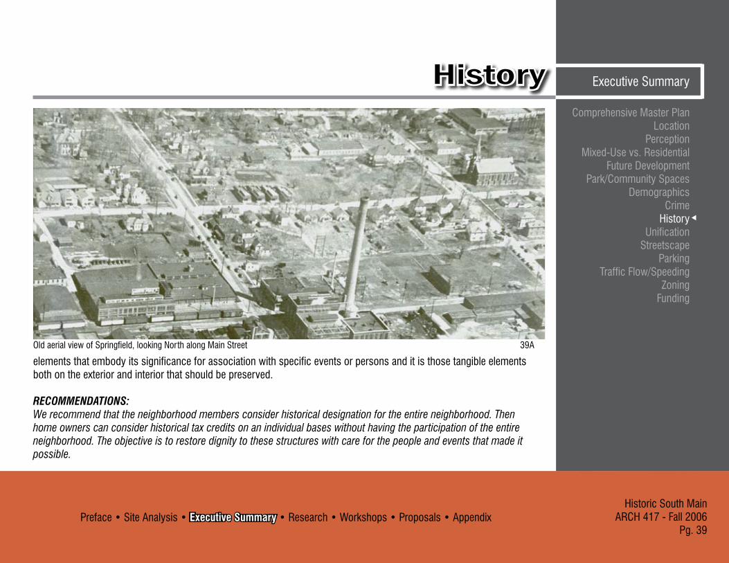
Old aerial view of Springfield, looking North along Main Street �9A
elements that embody its significance for association with specific events or persons and it is those tangible elements both on the exterior and interior that should be preserved.
RECOMMENDATIONS:We recommend that the neighborhood members consider historical designation for the entire neighborhood. Then home owners can consider historical tax credits on an individual bases without having the participation of the entire neighborhood. The objective is to restore dignity to these structures with care for the people and events that made it possible.
Preface • Site Analysis • Executive Summary • Research • Workshops • Proposals • AppendixHistoric South MainARCH 417 - Fall 2006Pg. 40
Comprehensive Master Plan LocationPerceptionMixed-Use vs. ResidentialFuture DevelopmentPark/Community SpacesDemographicsCrimeHistoryUnificationStreetscapeParkingTraffic Flow/SpeedingZoningFunding
UnificationExecutive Summary
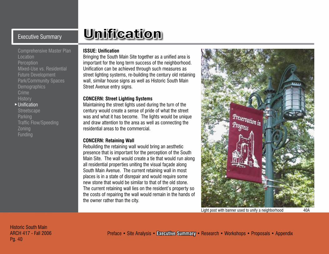
ISSUE: UnificationBringing the South Main Site together as a unified area is important for the long term success of the neighborhood. Unification can be achieved through such measures as street lighting systems, re-building the century old retaining wall, similar house signs as well as Historic South Main Street Avenue entry signs.
CONCERN: Street Lighting SystemsMaintaining the street lights used during the turn of the century would create a sense of pride of what the street was and what it has become. The lights would be unique and draw attention to the area as well as connecting the residential areas to the commercial.
CONCERN: Retaining WallRebuilding the retaining wall would bring an aesthetic presence that is important for the perception of the South Main Site. The wall would create a tie that would run along all residential properties uniting the visual façade along South Main Avenue. The current retaining wall in most places is in a state of disrepair and would require some new stone that would be similar to that of the old stone. The current retaining wall lies on the resident’s property so the costs of repairing the wall would remain in the hands of the owner rather than the city.
Light post with banner used to unify a neighborhood 40A

Preface • Site Analysis • Executive Summary • Research • Workshops • Proposals • AppendixHistoric South Main
ARCH 417 - Fall 2006Pg. 41
Comprehensive Master Plan Location
PerceptionMixed-Use vs. Residential
Future DevelopmentPark/Community Spaces
DemographicsCrime
HistoryUnification
StreetscapeParking
Traffic Flow/SpeedingZoning
Funding
Executive SummaryUnification
CONCERN: House Signs/Entry Signs:House markers such as custom made address signs would be reminiscent of earlier address markers on turn of the century houses. These would further add aesthetic value as well as create unity within the neighborhood. Entry signs could create an entry and exit markers for the South Main Site.
RECOMMENDATIONS: Street light selection is very important; a street light that is similar to the three light fixture of the turn of the century street light would be a contextual fit to the South Main Site. Rebuilding the retaining wall is also important to the unification of the neighborhood. The wall would visually unite the resident’s property along South Main Avenue. House markers and entry signs would be a way to unite the houses and strengthen the image of the South Main Site. These signs would be similar in nature and detailed in the UCD. The funding for the signs as well as the lighting, and retaining wall could be covered under a NID.
Possible unified streetscape scene, drawn by Michael Hampton

Preface • Site Analysis • Executive Summary • Research • Workshops • Proposals • AppendixHistoric South MainARCH 417 - Fall 2006Pg. 42
Comprehensive Master Plan LocationPerceptionMixed-Use vs. ResidentialFuture DevelopmentPark/Community SpacesDemographicsCrimeHistoryUnificationStreetscapeParkingTraffic Flow/SpeedingZoningFunding
StreetscapeExecutive Summary
ISSUE: Streetscape - PrivateThe streetscape of the south main area is very unique because no two homes are exactly alike. Many of the homes were built at the turn of the Twentieth Century and they all have their own unique characteristics. Most of the residents in the area would like to see the streetscape return to its original beauty and show that they live in a historically distinct area.
CONCERN: Home Improvements A few homes in the area have maintenance and upkeep concerns. Without any financial assistance or incentives, many owners in the neighborhood would be hard pressed to renovate their property.
CONCERN: Historical AccuracyIf owners decide to renovate or add on to their property, it is important for them to consider doing so while remaining historically accurate.
CONCERN: Overgrown FoliageSome homes require landscaping upkeep. Trees and bushes have matured and become overgrown which blocks the view of the residence and creates a barrier from the street. This disconnects the property and alienates it from the rest of the neighborhood.
A desirable streetscape scene 42B
A desirable streetscape scene 42A

Preface • Site Analysis • Executive Summary • Research • Workshops • Proposals • AppendixHistoric South Main
ARCH 417 - Fall 2006Pg. 4�
Comprehensive Master Plan Location
PerceptionMixed-Use vs. Residential
Future DevelopmentPark/Community Spaces
DemographicsCrime
HistoryUnification
StreetscapeParking
Traffic Flow/SpeedingZoning
Funding
Executive SummaryStreetscape
CONCERN: Crumbling Retaining WallsSome areas of the stone retaining walls, which line the front of some homes, are in need of repair. These walls separate the public sidewalk from the private yard instead of using fencing which can seem uninviting. The walls are also an aesthetic element that helps unify the streetscape.
Current streetscape of South Main Avenue, looking north
RECOMMENDATIONS: These improvements should be developed in phases. The first phase could be simple improvements such as cutting back overgrown foliage, cleaning up landscaping and simple home improvements such as paint. These small improvements would go a long way in brightening and improving the neighborhood. These improvements would encourage others to improve their own homes and would probably snowball into others phases of improvements.

Preface • Site Analysis • Executive Summary • Research • Workshops • Proposals • AppendixHistoric South MainARCH 417 - Fall 2006Pg. 44
Comprehensive Master Plan LocationPerceptionMixed-Use vs. ResidentialFuture DevelopmentPark/Community SpacesDemographicsCrimeHistoryUnificationStreetscapeParkingTraffic Flow/SpeedingZoningFunding
StreetscapeExecutive Summary
ISSUE: Streetscape - PublicThe south main area’s streetscape not only has unique architecture but it is also unique in its public streetscape. South Main Street is wide enough for parking on both sides and still has room for two way traffic down its center. This is unique to the area because most downtown streets are narrow. Another unique quality to the area is that there is almost as much pedestrian traffic in the area as vehicular traffic.
CONCERN: SidewalksOverall the sidewalks are in good condition. Areas that needed repair were recently fixed by the city. Some property owners in the area would still like to see brick sidewalks installed to make the area seem more unique and important. Because of expense and since the city has recently made improvements to the current sidewalks this modification may be difficult to achieve.
CONCERN: LightingThe street is extremely dark at night, which permits crime activity and makes the area seem dangerous. Lighting for the area is a necessity but it can be very expensive.
CONCERN: SignageSome signage would add importance to the area and make
it seem like more of a destination. Improvements in the area need to occur before signs should be added.
CONCERN: CrosswalksThere is high traffic flow during some portions of the day and pedestrians have no crosswalks to safely cross the street. Crosswalks could also slow traffic speed in the area.
Current South Main Avenue streetscape, looking north 44A

Preface • Site Analysis • Executive Summary • Research • Workshops • Proposals • AppendixHistoric South Main
ARCH 417 - Fall 2006Pg. 45
Comprehensive Master Plan Location
PerceptionMixed-Use vs. Residential
Future DevelopmentPark/Community Spaces
DemographicsCrime
HistoryUnification
StreetscapeParking
Traffic Flow/SpeedingZoning
Funding
Executive SummaryStreetscape
Current Mt. Vernon streetscape, looking west 45A
CONCERN: How to Pay for ImprovementsThese improvements cost money up front and would increase property taxes
RECOMMENDATIONS: A NID (explained on pg. 54) would be beneficial to help make these improvements. Property taxes would increase in the area but the residents could see the direct benefit of their tax dollars at work in their own neighborhood. The improvements to the neighborhood would also increase property values which offsets the increase in taxes.

Preface • Site Analysis • Executive Summary • Research • Workshops • Proposals • AppendixHistoric South MainARCH 417 - Fall 2006Pg. 46
Comprehensive Master Plan LocationPerceptionMixed-Use vs. ResidentialFuture DevelopmentPark/Community SpacesDemographicsCrimeHistoryUnificationStreetscapeParkingTraffic Flow/SpeedingZoningFunding
ParkingExecutive Summary
ISSUE: Parking for South Main Site:The parking along South Main Avenue will have to adjust to accommodate changes regardless of how the area grows. The current residents like the wide street with parking on both sides. Only a few houses take advantage of private drives.
CONCERN: Current ParkingThe current parking along South Main Avenue is inadequate. Business are using the neighborhood street for their use which at times causes problems.
CONCERN: Increased Traffic FlowIf mixed-use is introduced into the neighborhood the need for parking will increase. This is a problem because the parking along South Main Avenue is currently inadequate.
CONCERN: Location of Additional ParkingWith increased development in the area, there will be an increased need to create additional off street parking area.
RECOMMENDATIONS: By installing some designated spaces, commercial vehicles will not be able to overflowing into the neighborhood. If the neighborhood evolves into more single family homes then the demand for street parking will decrease, but off street drives might
Weekend parking along South Main Avenue, looking South
Weekday parking along South Main Avenue, looking South

Preface • Site Analysis • Executive Summary • Research • Workshops • Proposals • AppendixHistoric South Main
ARCH 417 - Fall 2006Pg. 47
Comprehensive Master Plan Location
PerceptionMixed-Use vs. Residential
Future DevelopmentPark/Community Spaces
DemographicsCrime
HistoryUnification
StreetscapeParking
Traffic Flow/SpeedingZoning
Funding
Executive SummaryParkingbe added to give the neighborhood a better community feel. Currently with the number of multi-family facilities street parking is in higher demand. At times the street parking can be limited, but overall, is adequate. However as more lots become occupied more spaces will be needed.
All new mixed-use activities shall accommodate at least 50% of their parking needs on site. It is likely that any mixed use facility will have some sort of a back lot for vehicle parking. Another option would be designated time limited parking in certain areas along the street or locations designated as public parking lots.
Potential Lots for Parking 47A

Preface • Site Analysis • Executive Summary • Research • Workshops • Proposals • AppendixHistoric South MainARCH 417 - Fall 2006Pg. 48
Comprehensive Master Plan LocationPerceptionMixed-Use vs. ResidentialFuture DevelopmentPark/Community SpacesDemographicsCrimeHistoryUnificationStreetscapeParkingTraffic Flow/SpeedingZoningFunding
ParkingExecutive Summary
RECOMMENDATIONS: The parking condition will continually change along the South Main Avenue to accommodate for the change in parking demand. Currently the parking condition has a high demand for on street parking close to the multi-family houses. This condition will change if more homes are converted back to single family homes and again change
if mixed-use homes are introduced. An issue that we see that is currently exists and will continue to exist is speeding down South Main Avenue. The reason for this is the extreme width of the street that provides on street parking for both sides of the street. The current residences like the fact of on street parking on both sides of the street. We do not want to take away the parking, but we do want to
Proposed crosswalk at intersection of South Main and Mount VernonCurrent Main Street condition

Preface • Site Analysis • Executive Summary • Research • Workshops • Proposals • AppendixHistoric South Main
ARCH 417 - Fall 2006Pg. 49
Comprehensive Master Plan Location
PerceptionMixed-Use vs. Residential
Future DevelopmentPark/Community Spaces
DemographicsCrime
HistoryUnification
StreetscapeParking
Traffic Flow/SpeedingZoning
Funding
Executive SummaryParking
“narrow” the appearance of the street. In order to narrow the street we add curb extensions to the existing street. By doing this, we will accomplish our goal of slowing down drivers while still maintaining the current street parking. Curb extensions simply extend the curb out into the street creating peninsulas which narrows the street. The great thing about curb extensions is they can be added in
location where current street parking is not allowed, for instance near intersections. They also provide a little more green area for the neighborhood and, more importantly, safety..
Mixed-use facility that demands extra parking 49A Potential space for additional parking 49B

Preface • Site Analysis • Executive Summary • Research • Workshops • Proposals • AppendixHistoric South MainARCH 417 - Fall 2006Pg. 50
Comprehensive Master Plan LocationPerceptionMixed-Use vs. ResidentialFuture DevelopmentPark/Community SpacesDemographicsCrimeHistoryUnificationStreetscapeParkingTraffic Flow/SpeedingZoningFunding
Traffic Flow/SpeedingExecutive Summary
ISSUE: Traffic Flow/SpeedingSouth Main Avenue is wide enough to allow parking along both sides of the street and still allow two-way traffic to travel through unrestricted. The residents in the area like the width of the road and do not want to constrict the traffic flow in any way.
CONCERN: SpeedingThe width and openness of the street encourages speeding. Efforts to reduce speeding should not restrict the flow of traffic and parking along the street.
CONCERN: CrosswalksMany pedestrians walk and bike in the area. Designating crosswalks could improve the safety for walkers and bikers.
CONCERN: Safety Of The NeighborhoodSome residents complain of crime such as drug dealing in the area.
RECOMMENDATIONS: “Smart parking” curb extensions should be installed at the north and south entrances of South Main Avenue to make the street seem narrower and discourage speeding. This solution would not effect current parking conditions on the street. A crosswalk should also be painted at the north and south end of the street to allow safe pedestrian crossing. Street lighting and increased police patrols would help discourage crime in the neighborhood and make it safer.
These recommendations could be paid for through a Neighborhood Improvement District (NID) which is further explained on page 54.
Weekday parking on South Main Avenue

Preface • Site Analysis • Executive Summary • Research • Workshops • Proposals • AppendixHistoric South Main
ARCH 417 - Fall 2006Pg. 51
Comprehensive Master Plan Location
PerceptionMixed-Use vs. Residential
Future DevelopmentPark/Community Spaces
DemographicsCrime
HistoryUnification
StreetscapeParking
Traffic Flow/SpeedingZoning
Funding
Executive SummaryTraffic Flow/Speeding
Example of curb extension 51A
Example of brick crosswalk 51B
Weekend parking on South Main Avenue

Preface • Site Analysis • Executive Summary • Research • Workshops • Proposals • AppendixHistoric South MainARCH 417 - Fall 2006Pg. 52
Comprehensive Master Plan LocationPerceptionMixed-Use vs. ResidentialFuture DevelopmentPark/Community SpacesDemographicsCrimeHistoryUnificationStreetscapeParkingTraffic Flow/SpeedingZoningFunding
ZoningExecutive Summary
ISSUE: ZONINGThe zoning of the South Main Site is a mix of commercial and residential. This historic residential area is beginning to merge with the expanding downtown business core. This encroaching business center needs to be organized and controlled if the residential is expected to survive and retain its character.
CONCERN: Clarifying the Current ZoningThe current zoning of the South Main Site is a mix of older residential and commercial. Commercial structures currently surround the residential homes in a peninsula style lining Mt Vernon, Walnut, and Grant with the interior of South Main Avenue remaining entirely residential.
CONCERN: Zoning RestrictionsThe current R-TH zoning does not allow any commercial uses. It is restricted to residential uses only. For any alternate uses to be allowed, an overlay district or zoning change must be introduced.
RECOMMENDATION: For the organization of the area and to prevent unwanted development we recommend that the neighborhood organize an Urban Conservation District (UCD) and petition the city for an overlay district in order to reorganize the current zoning according to the preferences
of the community members. An Urban Conservation District or UCD promotes the safety, economic, cultural and general welfare of the public by encouraging the conservation and enhancement of the urban environment as those district members see fit. A UCD requires the signatures of 50% of property owners, an adoption of city council resolution and a preparation and adoption of an urban conservation plan. This plan allows the citizens to regulate changes within the district. This requires that the neighborhood members be willing to create a set of restriction for the area in regards to restoration and development of area structures as well as general aesthetic issues.

Preface • Site Analysis • Executive Summary • Research • Workshops • Proposals • AppendixHistoric South Main
ARCH 417 - Fall 2006Pg. 5�
Comprehensive Master Plan Location
PerceptionMixed-Use vs. Residential
Future DevelopmentPark/Community Spaces
DemographicsCrime
HistoryUnification
StreetscapeParking
Traffic Flow/SpeedingZoning
Funding
Executive SummaryZoning
416
502
455
467
428
440
807801
619617
824437
626
438
425
514
447451
632
308301
601
465
527
531
218
640724
727
444
604
816
535
737
810
412
715
811
823
320
816 710
411
615
620
621
823
800
405623
453
301327
500
506
500
807
826
608
504
810
401
807
618716
829
421
807331
732736
614
440430
811
629801
723
525
312
801829
736
607520
800
415
623
733
436
414
838
611
816
800434
510
424
721
701
601
445
534
812
507
817529
454
826
318
716
431
530
520
617
817
445
400
639
459
633
616
410
420
621
724818
609
540
730
433
614
414
600
601
308
731
724734
446436
612
404
618
611
320
515
422421
614
311
324
448
608
513
714
461
817
801
208
731460460
302
505
620
464
737
316
424802
817
615620
530
729
452
710
420
318
832
737
825
427
824
715
524
319
730
702
325
605
440 444
727
448451
427
822
825
416
828
609
521
606310
417
512
727
509
812
413
831
313
330
616
519
806
326
428
613
323
306
613
603
408
453
430
632
507
220
307
314
503
620
811
528
813
8TH
MA
IN
WALNUTG
RA
NT M
AR
KET
MOUNT VERNON CA
MPB
ELL
DO
UG
LAS
PATT
ON
MCDANIEL
7TH
ELM
PERSHING
ELM
7TH
DO
UG
LAS
ELM
PERSHING PERSHING
SOUTH MAIN VILLAGE
DISCLAIMER: All information included on this map or digital f ileis provided "as-is" for general information purposes only. The Cityof Springfield, and all other contributing data suppliers, make nowarranties, expressed or implied, concerning the accuracy, completeness,reliability, or suitability of the data for any particular use. Furthermore,the City of Springfield, and all other contributing data suppliers, assume noliability whatsoever associated with the use or misuse of the data.
Zones: R-TH: Townhouse Residential District. CC: Center City District GR: General Retail District
R-SF: Single-Family Residential District R-MD : Medium-Density Multi-Family
Residential District
5�A
Preface • Site Analysis • Executive Summary • Research • Workshops • Proposals • AppendixHistoric South MainARCH 417 - Fall 2006Pg. 54
Comprehensive Master Plan LocationPerceptionMixed-Use vs. ResidentialFuture DevelopmentPark/Community SpacesDemographicsCrimeHistoryUnificationStreetscapeParkingTraffic Flow/SpeedingZoningFunding
FundingExecutive Summary
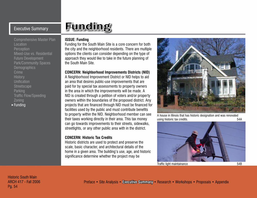
ISSUE: FundingFunding for the South Main Site is a core concern for both the city and the neighborhood residents. There are multiple options the clients can consider depending on the type of approach they would like to take in the future planning of the South Main Site.
CONCERN: Neighborhood Improvements Districts (NID)A Neighborhood Improvement District or NID helps to aid an area that desires public-use improvements that are paid for by special tax assessments to property owners in the area in which the improvements will be made. A NID is created through a petition of voters and/or property owners within the boundaries of the proposed district. Any projects that are financed through NID must be financed for facilities used by the public and must contribute benefits to property within the NID. Neighborhood member can see their taxes working directly in their area. This tax money can go towards improvements to their streets, sidewalks, streetlights, or any other public area with in the district.
CONCERN: Historic Tax Credits Historic districts are used to protect and preserve the scale, basic character, and architectural details of the home in a given area. The building’s use, age, and historic significance determine whether the project may be
A house in Illinois that has historic designation and was renovated using historic tax credits. 54A
Traffic light maintainance 54B

Preface • Site Analysis • Executive Summary • Research • Workshops • Proposals • AppendixHistoric South Main
ARCH 417 - Fall 2006Pg. 55
Comprehensive Master Plan Location
PerceptionMixed-Use vs. Residential
Future DevelopmentPark/Community Spaces
DemographicsCrime
HistoryUnification
StreetscapeParking
Traffic Flow/SpeedingZoning
Funding
Executive SummaryFundingconsidered for a 10%, 20% or even 45% rehabilitation tax credit. Historically designated residential districts enjoy on average 10-25% higher property values versus homes without historical designation. (The National Trust)
RECOMMENDATIONS: We recommend to the city and neighborhood residents that they set up a NID to support and pay for future public development in the area. The neighborhood members will need to decide which improvements would be most desired and complete a petition with the signatures of two-thirds of the home owners with in the area. A Neighborhood Improvement District can then be set up with the city allowing the increased taxes to be directed back to improvement in the neighborhood.
Placing of a new neighborhood sign 55A
Street light installation 55B

Historic South MainARCH 417 - Fall 2006Pg. 56
Preface • Site Analysis • Executive Summary • Research • Workshops • Proposals • Appendix
LowerTown Arts District, Paducah, KY
Problem: grand old houses divided into apartments, 70% were rentals, slumlords reigned and drug dealing was common
Assets: Ni ce housing stock, close to downtown, booming with local history, many sections named to the National Historic Register
- Artist Relocation Program encouraged artists from across the country to move to Paducah
- Paducah Bank supported the program and took a risk to help make it more affordable for artists to buy and fix up property by providing unusually flexible loans and similar financial incentives
- Trade off: artists would rehabilitate the decaying properties, transforming them into galleries, shops, restaurants and residences
- For every $1 the city has put into the program, it has received $14 back
- Now has more than 70 artists - “When you bring in artists, they colonize a neighborhood.
They’re good citizens. They are very likely to become community activists.” – Roy Close, resource development director for ArtSpace
Precedent StudiesLiterature Research
Precedent StudiesResearch
Aphrodite Gallery, Paducah, KY 56A
Mentor House Gallery, Paducah, KY 56B

Preface • Site Analysis • Executive Summary • Research • Workshops • Proposals • AppendixHistoric South Main
ARCH 417 - Fall 2006Pg. 57
Southside, Greensboro, NC
Problem: Slid into poorly maintained rentals with rampant prostitution and drug dealing
Assets: Hi storic architecture, narrow streets and alleys, proximity to downtown shops, and a magnificent view of the downtown skyline
- �0 single family homes. 10 two-family homes, 50 townhouses, 10 restored historic homes, and 20 live/work units where business owners live upstairs
- Greensboro contributed by installing new sidewalks, historic streetlights, decorative brickwork, and landscaping
- Neighborhood generates significantly more tax revenue for the city
- “Southside was the type of neighborhood we had been searching for—it provides us with the sense of community we crave within walking distance of all the services and amenities downtown has to offer.” – new resident of Southside
Precedent StudiesLiterature Research
ResearchPrecedent Studies
Restored House, Greensboro, NC 57B
View of Southside Downtown, Greensboro, NC 57A
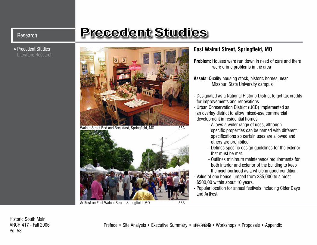
Historic South MainARCH 417 - Fall 2006Pg. 58
Preface • Site Analysis • Executive Summary • Research • Workshops • Proposals • Appendix
Precedent StudiesLiterature Research
Precedent StudiesResearch
East Walnut Street, Springfield, MO
Problem: Houses were run down in need of care and there were crime problems in the area
Assets: Q uality housing stock, historic homes, near Missouri State University campus
- Designated as a National Historic District to get tax credits for improvements and renovations.
- Urban Conservation District (UCD) implemented as an overlay district to allow mixed-use commercial development in residential homes.
- Allows a wider range of uses, although specific properties can be named with different specifications so certain uses are allowed and others are prohibited.
- Defines specific design guidelines for the exterior that must be met.
- Outlines minimum maintenance requirements for both interior and exterior of the building to keep the neighborhood as a whole in good condition.
- Value of one house jumped from $85,000 to almost $500,00 within about 10 years.
- Popular location for annual festivals including Cider Days and ArtFest.
Walnut Street Bed and Breakfast, Springfield, MO 58A
ArtFest on East Walnut Street, Springfield, MO 58B

Preface • Site Analysis • Executive Summary • Research • Workshops • Proposals • AppendixHistoric South Main
ARCH 417 - Fall 2006Pg. 59
Summery of Mid-Town Inventory Report Community Development Department of SpringfieldNovember 1988For the Mid-Town Inventory Report, the City’s Department of Community Development compiled statistics and demographic information about the Mid-Town Neighborhood. The Mid-Town Neighborhood Plan includes a history of the area, rezoning requests, housing types, circulation, parking, and potential development. This report was compiled in November of 1988 because the Missouri Heritage Trust identified the study area as a viable neighborhood for preservation and possible National registration in 198�. This district includes business, residential, and educational properties in the area of ‘North Springfield’ between Blaine Street (north border), Chestnut Expressway (south border), Boonville to the west and the Burlington Northern Railroad tracks to the east. This area is known as Mid-Town.
“A Public Surface: Finding Space in the Margins”Norman Miller et. al. 2003 Center for Community Research and Design Hollywood, CAThis study looked at the possibilities for creating adaptable space for pedestrians in a very dense urban environment. The exact proposals brought forth in this study were not directly transferable to our project, however, many of the
Precedent StudiesLiterature Research
ResearchLiterature Researchideas discussed expanded our thought processes as we designed. This study was very sensitive to density and multiple uses for single spaces that allowed more activity in the neighborhood while requiring less space. Ideas like this influenced our treatment of space and density. This study also employed a unique mapping system used to identify zones of use and material use. This technique again was not directly transferable to our project, but some of the graphic techniques that the study used did influence some of the site plans that our team developed.
West Central Neighborhood Strategic PlanThe West Central Neighborhood Strategic Plan was written in 1998 with the goal of stopping the decline of the quality of the neighborhood as well as increasing the desirability and livability of the neighborhood. This document expresses a lot of the same issues that we have seen in the South Main Site, such as an image of crime, run down and unkempt houses, high ratio of renters to owners, and high percentage living below the poverty line. The major issue that was identified was the multi-family zoning laws. The old housing stock was zoned in a fashion where multi-family living was allowed and many single family homes were converted. Because of this, single-family homes were holding multiple families and as a result fell into disrepair.

Historic South MainARCH 417 - Fall 2006Pg. 60
Preface • Site Analysis • Executive Summary • Research • Workshops • Proposals • Appendix
Precendent StudiesLiterature Research
Literature ResearchResearch
Springfield Neighborhoods: Guidelines and Pattern BookThe area labeled, The West Central Neighborhood, is the neighborhood bounded by Walnut, Campbell, Grand, and Kansas. Each house in this area was investigated and the plans or patterns where grouped by style. These plans and patterns documented the unique housing styles and character of the neighborhood’s streetscape. These documentations became the design guidelines for future renovations for the neighborhood. The neighborhood character was broken down into four housing styles: Queen Ann/Freestyle, Foursquare, Bungalow and Gabled Ell. Other design proposals such as loan programs and energy saving designs are part of the overall guidelines.These residential patterns and design guidelines can be a tool for current residents as well and future developers for the success of the West Central Neighborhood.
Springfield-Greene County Comprehensive PlanHistoric Preservation Element“There are within Springfield and Greene County a number of areas, places, buildings, structures, works of art, and other objects having significant historical, archeological or cultural interest and value that reflect the heritage of the city and county.” (p. 10)
The city of Springfield has set out guidelines for the manner in which historic structures and areas should
be rehabilitated and protected. The objectives they have developed address issues such as maintenance standards, design guidelines, assistance programs, and the relationship of infill to existing historic elements.As rehabilitation occurs, it is important to preserve the structure’s existing architectural character. On a broader scale, as infill occurs it should be sensitive to its architectural context without necessarily being a duplication of it. The city offers many financial incentives to encourage this, and provides resources to educate property owners and developers about the historical appropriateness of their rehabilitations and developments.
The essence of the plan is to preserve the historic character of our local buildings and communities. These places provide a tangible link to the past and should be treated carefully when renovations and maintenance are considered. Although the site is not currently a designated historic district, these same considerations should be implemented.
Ten Principles for Rebuilding Neighborhood Retail“The convenient availability of goods and services is a key factor that people consider when choosing a place to live, and neighborhoods without suitable retailing are dramatically weakened. Residents who can afford it, leave, and potential new residents choose to live somewhere

Preface • Site Analysis • Executive Summary • Research • Workshops • Proposals • AppendixHistoric South Main
ARCH 417 - Fall 2006Pg. 61
Precendent StudiesLiterature Research
ResearchLiterature Researchelse.”Positive implications for the rebirth of neighborhood retailing:- States are increasingly concerned about the effects of
sprawl and are instituting smart growth policies. By redirecting growth back into existing communities we can avoid urban sprawl.
- Pedestrian-oriented, street front retail environments are gaining favor with today’s consumers.
- Inner-city crime has declined dramatically in the past ten years.
- Local governments are using increasingly sophisticated planning, regulatory and financial incentives to encourage market-based real estate investments in distressed urban neighborhoods.
Ten strategic principles to guide in rebuilding neighborhood retail streets:
I. Great Streets Need Great Champions Someone needs to initiate the process, fight to ensure
it is done right and follow through to completion. The champion will be a person (or group of people) who is a committed, responsible stakeholder who recognizes the problem, has dreams of something better and has the passion to overcome obstacles to achieve results.
II. It Takes a Vision The successful rebuilding of a neighborhood shopping
street will be incremental, so it must be based on a shared vision that provides a strategic framework for imagining, analyzing, judging and implementing each step along the way. Reaching a shared vision requires facing the tough questions up front, making sure everyone understands the realities of the situation, and setting short-, medium- and long-range goals that are realistically attainable.
III. Think Residential Successful retail depends on successful residential
neighborhoods. Retailing cannot survive in an environment of deteriorating neighborhood housing, declining population and homeownership rates, disinvestment, crime and neglect. Most important, successful retail needs a growing number of high-quality residents because this is what retailers look for.
IV. Honor the Pedestrian When pedestrians are not honored with a pleasant and
enjoyable shopping experience, they usually choose competing locations that do a better job of creating such an environment. The first goal for a neighborhood shopping street should be to satisfy the aspirations and enhance the lifestyles of a neighborhood’s residents.

Historic South MainARCH 417 - Fall 2006Pg. 62
Preface • Site Analysis • Executive Summary • Research • Workshops • Proposals • Appendix
Precendent StudiesLiterature Research
Literature ResearchResearch
V. Parking Is Power Easy accessibility, high visibility, a sense of personal
security, and adequate, convenient parking are all preconditions for successful retailing, and without them retail will likely fail, regardless of the sophistication of the shopping environment or the quality of the tenants. Parking is arguably the most important of these requirements because today’s consumers, conditioned by their suburban shopping center experiences, expect nothing less than a guaranteed space close to their shopping destination every time they shop.
VI. Merchandise and Lease Pro actively A neighborhood commercial street must be managed
and operated like a shopping center-but recognize that having multiple landowners and operating in the public realm enormously complicates these tasks. To achieve higher sales, rents and land values, landlords along the street need to band together and work pro actively with the public sector to merchandise and lease their street in a coordinated and mutually supportive way.
VII. Make It Happen Communities should be willing to convince landowners,
developers and retailers that the revitalization efforts are in their interests. Willingness to exercise regulatory
powers to achieve the stakeholder’s vision and protect it from negative influences projects a sense of momentum to the stakeholders and potential tenants and enhances the street’s appeal as a place to do business.
VIII. Be Clean, Safe and Friendly If a neighborhood shopping street is clean, safe and
friendly, customers will be drawn to their favorite shops even though the street as a whole may still be in transition from failure to success. If even one of these characteristics is absent, some neighborhood residents will continue to shop elsewhere, and few commuters are likely to stop as they drive through. Achieving an acceptable comfort level for neighborhood shoppers, however, won’t happen without a coordinated, holistic approach to addressing the street’s underlying problems and deficiencies.
IX. Extend Day into Night Long hours equal stronger sales, and strong sales
define a successful shopping street. As revitalization accelerates and rents rise, retailers will be unable to survive unless business hours can be extended to capture more business. The evening is the hardest time to keep businesses open even though that’s when
Preface • Site Analysis • Executive Summary • Research • Workshops • Proposals • AppendixHistoric South Main
ARCH 417 - Fall 2006Pg. 6�
Precendent StudiesLiterature Research
ResearchLiterature Researchpeople have time to shop, and it will take a healthy dose of imagination and hard work to achieve the mix of stores, coordinated hours and sense of security to create an environment where people are comfortable going out after dark.
X. Manage For Change Plan for long term, but manage for constant change in
the short term. Rebuilding a neighborhood retail street is a long reinvestment process, and market realities will undoubtedly continue to change throughout the ongoing life of the street.

Preface • Site Analysis • Executive Summary • Research • Workshops • Proposals • AppendixHistoric South MainARCH 417 - Fall 2006Pg. 64
1st Community WorkshopAdvisory Committee Meeting2nd Community Workshop
1st Community WorkshopWorkshops
Summary of Information PresentedWe wanted to emphasize respect for the ideas of community members. Our role is to be facilitators and guide you in discussion. We are not here to tell you what or how things are happening.
The goals of the day are to inform the community about the background of the project, discuss the qualities of the neighborhood, and brainstorm options for the area and get feedback. The City of Springfield proposed that we retain existing housing stock, but allow different uses, educate the community about what is possible in the area and emphasize refurbishment not demolition.
The overall neighborhood is a mixture of single and multi family housing surrounded by commercial zoning. The neighborhood is the closest residential community to the downtown square.
Rehabilitation is the process of returning a building or buildings to a state of utility, through repair or alteration, which makes possible an efficient use while preserving those portions and features of the building and its site and environment which are significant to its historic, architectural, and cultural values.
Historic rehabilitation is important because historic buildings are tangible links with the past. They help give a community a sense of identity, stability and orientation. The Federal government encourages the preservation of historic buildings through various means. One of these is the program of Federal tax incentives to support the rehabilitation of historic and older buildings.
Site Rehab- To meet the Standards for Rehabilitation, new site
elements should: - Preserve significant landscape features on the
site.

Preface • Site Analysis • Executive Summary • Research • Workshops • Proposals • AppendixHistoric South Main
ARCH 417 - Fall 2006Pg. 65
1st Community WorkshopAdvisory Committee Meeting
2nd Community Workshop
Workshops1st Community Workshop - Be compatible with the historic character of the
property. - Basic guidance for new site features that will meet
the Standards is: - New site features should be compatible
with the buildings and the significant landscape features on the site. Additionally, new site features should be consistent with the historic use of the property.
- New site features should be as unobtrusive as possible in both location and design.
- New site features should preserve the historic relationship
between the buildings and the significant landscape features.
For interior rehabilitation, the historic floor plan is frequently a defining characteristic of a building’s interior. The sequence of spaces from the entry of the building, such as moving from the vestibule to the stair hall to the parlor in a residence, or from the lobby to the stair and into the auditorium of a theater, expresses the building’s particular character. The repetitive floor plan of an apartment building or office building, or the arrangement of rooms in a simple shotgun house or Georgian mansion, helps makes these buildings distinctive and should therefore be treated with sensitivity.
Possible solutions include:- Purely Residential: Midtown, Rountree- Light Mixed-Use: Walnut Street- Dense Mixed-Use: The majority of the buildings have
business spaces on main level with living spaces above- Themed Development: Paseo, OK or Paducah, KY

Preface • Site Analysis • Executive Summary • Research • Workshops • Proposals • AppendixHistoric South MainARCH 417 - Fall 2006Pg. 66
1st Community WorkshopAdvisory Committee Meeting2nd Community Workshop
1st Community WorkshopWorkshops

Preface • Site Analysis • Executive Summary • Research • Workshops • Proposals • AppendixHistoric South Main
ARCH 417 - Fall 2006Pg. 67
1st Community WorkshopAdvisory Committee Meeting
2nd Community Workshop
Workshops1st Community Workshop

Preface • Site Analysis • Executive Summary • Research • Workshops • Proposals • AppendixHistoric South MainARCH 417 - Fall 2006Pg. 68
1st Community WorkshopAdvisory Committee Meeting2nd Community Workshop
1st Community WorkshopWorkshops
Historic South Main Street Laura BergmanCraig CulbertsonMichael HamptonBrian Harbison
Tyler HellwegErika KoenigBryon Oster
Themed Neighborhood
Case Study: LowerTown Arts District, Paducah, KY
Problem: �grand old houses divided into apartments, 70% were rentals, slumlords reigned and drugdealing was common
Assets: Ni�ce housing stock, close to downtown, booming with local history, many sections named to theNational Historic Register
• �Artist Relocation Program encouraged artists from across the country to move to Paducah• �Paducah Bank supported the program and took a risk to help make it more affordable for artists to buy
and fix up property by providing unusually flexible loans and similar financial incentives• �Trade off: artists would rehabilitate the decaying properties, transforming them into galleries, shops,
restaurants and residences• �For every $1 the city has put into the program, it has received $14 back• �Now has more than 70 artists• �“When you bring in artists, they colonize a neighborhood. They’re good citizens. They are very likely
to become community activists.” – Roy Close, resource development director for ArtSpace
Mixed Use with a Theme:
• �Each house can be converted to mixed-use with residential above and acommercial, cultural, or other functions would be housed on the first floor
• �The mixed-use spaces along a street would follow a theme and be home tothings such as:
� � - restaurants� � - artist galleries� � - bed and breakfasts� � - �professional offices (for lawyers, architects, etc.)

Preface • Site Analysis • Executive Summary • Research • Workshops • Proposals • AppendixHistoric South Main
ARCH 417 - Fall 2006Pg. 69
1st Community WorkshopAdvisory Committee Meeting
2nd Community Workshop
Workshops1st Community WorkshopSummary Of Workshop Feedback:The community wants residential owner-occupied single family homes that everyone cares for individually. They want higher class renters to try and eliminate the drug use in the area. Owners who rent their properties pointed out that it is difficult to convert a big house to single family home because of limited renter income. Limited mixed-use might be appropriate with an office on the first floor. It would be nice to be able to own a home while still having a yard and a business. Utilizing specificity of Urban Conservation District (UCD) to designate
appropriate and inappropriate uses could be beneficial.The community fears that mixed-uses could turns into bars with brothels. They do no want restaurants or other business with heavy traffic. They also do not want to start a series of zoning changes that just keep changing over and over again. Owners need to put money in as an investment to see any improvement. Some oweners fear that parks draw social problems and drug users
The benefits of a Historic District are that after the fact restrictive covenants are possible to prevent oweners from having less desirable things like RVs and carports. There are also financial incentives that are available for historic districts.
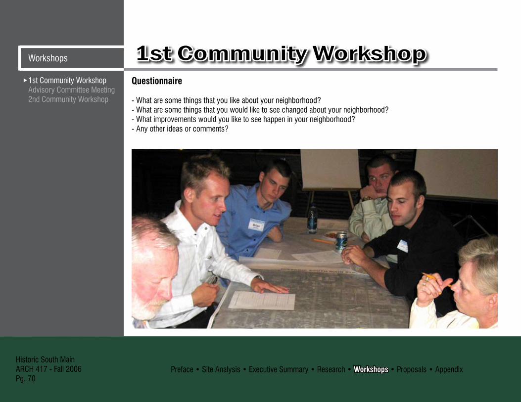
Preface • Site Analysis • Executive Summary • Research • Workshops • Proposals • AppendixHistoric South MainARCH 417 - Fall 2006Pg. 70
1st Community WorkshopAdvisory Committee Meeting2nd Community Workshop
1st Community WorkshopWorkshops
Questionnaire
- What are some things that you like about your neighborhood?- What are some things that you would like to see changed about your neighborhood?- What improvements would you like to see happen in your neighborhood?- Any other ideas or comments?

Preface • Site Analysis • Executive Summary • Research • Workshops • Proposals • AppendixHistoric South Main
ARCH 417 - Fall 2006Pg. 71
1st Community WorkshopAdvisory Committee Meeting
2nd Community Workshop
Workshops1st Community Workshop
Wants:Clean up of houses 5Only single-family 5Better wider sidewalks 4Historic District designation 4Would like a little mixed-use �To remain mixed single-family & renters 1Better quality renters 1More street lights 1
Historic street lights 1More of an Entry way 1Campbell to become 2-way 1Historic house signs (like midtown) 1More landscaping 1West meadows of Jordan Valley Park to be completed 1 Better performance at Campbell Elementary 1 More families with young children 1
Community Members’ Open Responses (based on 20 people)# of Responses # of Responses

Preface • Site Analysis • Executive Summary • Research • Workshops • Proposals • AppendixHistoric South MainARCH 417 - Fall 2006Pg. 72
1st Community WorkshopAdvisory Committee Meeting2nd Community Workshop
Advisory Committee MeetingWorkshops
7 Scheme Continuum Approach:For the Advisory Committee Meeting we wanted to test a full range of concepts, ranging from the current residential to full heavy commercial throughout. The goal was to test a variety of ideas because we were still at an early stage in the design process.
Response Summary:Properties on Grant Avenue are already concerned with parking and access problems without additional mixed-use. Street lighting could be unique to differentiate the neighborhood from other areas downtown rather than copying. Currently, Center City has a heavy demand for residential. It is possible to restore historic structures and construct an addition on the back that is sympathetic with the design. Some people in the area have fixed incomes and it is difficult for them to make significant financial improvements. Residential use on the South Main Site should be maintained and the commercial along Grant or Walnut should be enhanced. Alleys and trails can draw trouble in addition to benefits.
South Main House Before
South Main House After, photo editing by Bryon Oster

Preface • Site Analysis • Executive Summary • Research • Workshops • Proposals • AppendixHistoric South Main
ARCH 417 - Fall 2006Pg. 7�
1st Community WorkshopAdvisory Committee Meeting
2nd Community Workshop
WorkshopsAdvisory Committee MeetingScheme #1: 80% Renter/20% Owner Occupied (Current Condition)When improving properties it is important to maintain the historic character of the neighborhood. Some improvements to the streetscape would also return the neighborhood to its original character (see pg. 42 to 45 for a detailed description of these improvements). More law enforcement would also improve the area. Police patrolling the area would keep away crime such as drug dealing and make the neighborhood a safer place to live.
South Main House Before
South Main House After, photo editing by Bryon Oster

Preface • Site Analysis • Executive Summary • Research • Workshops • Proposals • AppendixHistoric South MainARCH 417 - Fall 2006Pg. 74
1st Community WorkshopAdvisory Committee Meeting2nd Community Workshop
Advisory Committee MeetingWorkshops
Scheme #2: All Single-Family Residential (owner occupied)This scheme proposes that all homes on the block of South Main between Walnut and Mt. Vernon, be restored to their original use as a neighborhood of single family homes. This plan offers minimal changes to the neighborhood’s current layout. Changes to the homes will only be made to improve and restore them to their original use and appearance. This approach allows for the possibility of creating a neighborhood historical district as well as the option of applying historical tax credits. Historical tax credits wouldn’t be possible for most multi-use options. If current zoning was enforced the majority of the multi-family housing that currently exists on South Main Avenue would not be allowed. The trees along the sidewalk on South Main Avenue need to be trimmed as well as a general cleanup of the street.
South Main House Before
South Main House After, photo editing by Erika Koenig

Preface • Site Analysis • Executive Summary • Research • Workshops • Proposals • AppendixHistoric South Main
ARCH 417 - Fall 2006Pg. 75
1st Community WorkshopAdvisory Committee Meeting
2nd Community Workshop
WorkshopsAdvisory Committee MeetingScheme #3: Residential With Very Light Mixed-UseThere will be entrances marking the South Main Site. The first marker will be at the south west corner of Walnut and South Main Avenue. The second marker will be located at the gas station at Mt. Vernon and South Main Avenue. The mixed use area will be located on the east side of South Main Avenue. The parking will be located on Market Avenue in the empty lot to be purchased from Lakeland Hospital.
There will be access from the parking lot to the back of the mixed use properties. The streetscape will see many changes including: New rock retaining wall, ‘Smart Street’ Parking, brick sidewalks, landscaped retaining divider between the sidewalk and street on the east side of South Main Avenue. There will be low traffic types of mixed-use: Bed and breakfast, art gallery, café and coffee shop. Very light mixed use that keeps the commercial areas on the bottom floor of the house and residential areas above.
Streetscape of South Main Avenue, drawn by Michael Hampton Streetscape of South Main Avenue, drawn by Michael Hampton

Preface • Site Analysis • Executive Summary • Research • Workshops • Proposals • AppendixHistoric South MainARCH 417 - Fall 2006Pg. 76
1st Community WorkshopAdvisory Committee Meeting2nd Community Workshop
Advisory Committee MeetingWorkshops
Scheme #4: 25% Mixed-Use/75% Single-Family ResidentialInvestigating 25% mixed use, looked at the different ways in which the commercial structures could be laid out. This evolved into three schemes: one with 25% of each individual building becoming commercial on the ground floor with residential above it, one with 25% of the buildings on the South Main Site designated as mixed-use, and one with 25% of the buildings along the more urban edges of the site being mixed-use.
All three of these schemes had the advantage of increasing the community’s image as well as boosting the local economy. There were various deficiencies with these schemes, the most obvious being the difficulty in converting each unit into a store or office. Another problem is that placing the commercial use in the heart of the neighborhood destroys the residential integrity of the area and offers the businesses less public visibility. Keeping these problems in mind, the most appropriate option was to restrict mixed use activities to the edges of the site, which is beneficial for both the residents and the businesses.
These schemes also began to explore ways of accommodating the parking for the increased vehicular traffic associated with mixed use communities, and looked at different options for the infill of the vacant Lakeland Hospital lot as well as options for Campbell Elementary School if it were to become available.
Site Plan
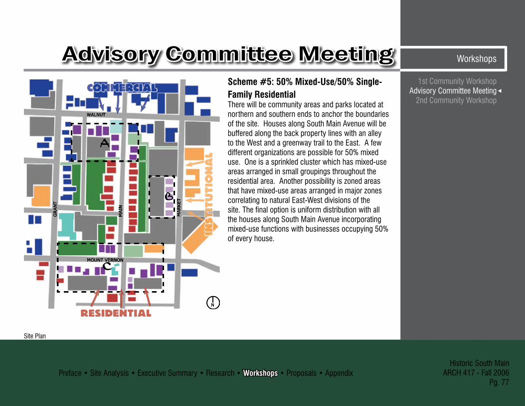
Preface • Site Analysis • Executive Summary • Research • Workshops • Proposals • AppendixHistoric South Main
ARCH 417 - Fall 2006Pg. 77
1st Community WorkshopAdvisory Committee Meeting
2nd Community Workshop
WorkshopsAdvisory Committee Meeting
WALNUT
MOUNT VERNON
GRAN
T
MAIN
MARKET
N
Scheme #5: 50% Mixed-Use/50% Single-Family ResidentialThere will be community areas and parks located at northern and southern ends to anchor the boundaries of the site. Houses along South Main Avenue will be buffered along the back property lines with an alley to the West and a greenway trail to the East. A few different organizations are possible for 50% mixed use. One is a sprinkled cluster which has mixed-use areas arranged in small groupings throughout the residential area. Another possibility is zoned areas that have mixed-use areas arranged in major zones correlating to natural East-West divisions of the site. The final option is uniform distribution with all the houses along South Main Avenue incorporating mixed-use functions with businesses occupying 50% of every house.
Site PlanSite Plan

Preface • Site Analysis • Executive Summary • Research • Workshops • Proposals • AppendixHistoric South MainARCH 417 - Fall 2006Pg. 78
Scheme #6: 80% Mixed-Use/20% ResidentialThe 80% commercial scheme was initially looking at the implications of a large number of commercial inhabitants on the South Main Site. Due to the large amount of businesses, the requirements for parking was on the verge of impractical but possible with additional parking lots. It was possible to maintain the feel of a residential neighborhood while giving it a professional feel. The advisory committee did like a few of the features, mainly the curb extensions, but over all still preferred the mostly residential schemes. They felt that East Walnut Street was like this scheme and the South Main Site did not want to resemble East Walnut Street.
1st Community WorkshopAdvisory Committee Meeting2nd Community Workshop
Advisory Committee MeetingWorkshops
Proposed Renovations, photo editing by Brian Harbison Possible islands added to slow traffic, photo editing by Brian Harbison
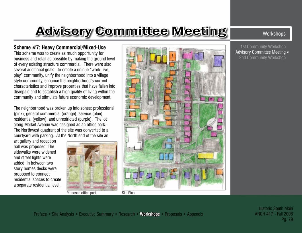
Preface • Site Analysis • Executive Summary • Research • Workshops • Proposals • AppendixHistoric South Main
ARCH 417 - Fall 2006Pg. 79
1st Community WorkshopAdvisory Committee Meeting
2nd Community Workshop
WorkshopsAdvisory Committee MeetingScheme #7: Heavy Commercial/Mixed-UseThis scheme was to create as much opportunity for business and retail as possible by making the ground level of every existing structure commercial. There were also several additional goals: to create a unique “work, live, play” community, unify the neighborhood into a village style community, enhance the neighborhood’s current characteristics and improve properties that have fallen into disrepair, and to establish a high quality of living within the community and stimulate future economic development.
The neighborhood was broken up into zones: professional (pink), general commercial (orange), service (blue), residential (yellow), and unrestricted (purple). The lot along Market Avenue was designed as an office park. The Northwest quadrant of the site was converted to a courtyard with parking. At the North end of the site an art gallery and reception hall was proposed. The sidewalks were widened and street lights were added. In between two story homes decks were proposed to connect residential spaces to create a separate residential level.
Site PlanProposed office park

Preface • Site Analysis • Executive Summary • Research • Workshops • Proposals • AppendixHistoric South MainARCH 417 - Fall 2006Pg. 80
1st Community WorkshopAdvisory Committee Meeting2nd Community Workshop
2nd Community WorkshopWorkshops
3 Scheme Approach:Based on feedback received at the previous meetings, as a group we decided to narrow our investigation to three schemes. The categories we chose were based on what we thought was most appropriate for the neighborhood.
Response Summary:Big Group Comments:- Contained mixed-use makes sense because it is sort of
what already exists- Use of Housing Authority for path or other development
is probably wishful thinking because of problems with federal law related to acceptable uses
- Maintain the residential peninsula- South Main Avenue to Grant Avenue along Walnut Street
already has safety problems- Midtown is a National Historic District which is more
flexible than a local district (must go to the Landmark’s Board for any exterior change)
- Steer away from local historic districts- How tough will the city be as to commercial building
codes (like fire doors, sprinkler systems, etc.)?- Don’t like flashy signage, columns or arches marking the
entry points but signage could be ok if done tastefully like at Rountree
- Curb extensions with trees start to look too commercial- Is a brick sidewalk really a good idea? Maybe bricks just
lining the edges?- Neighborhood needs to have a unique character before
signs and flashy markings go up- If tucked in neighborhood, will small businesses get
enough traffic to survive?- Businesses that are a destination in themselves may be
more viable- Adding trees along the sidewalk may add character but it
takes away parking- Rountree feeds off Missouri State University, Midtown
feeds off Drury University, and South Main can feed off downtown and the future College Station
- This is still the closest single family homes where you can be part of the urban lifestyle
Scattered Mixed-Use presentation

Preface • Site Analysis • Executive Summary • Research • Workshops • Proposals • AppendixHistoric South Main
ARCH 417 - Fall 2006Pg. 81
1st Community WorkshopAdvisory Committee Meeting
2nd Community Workshop
Workshops2nd Community Workshop
STRICTLY RESIDENTIALPOSSIBLE IMPROVEMENTS
CATALOGUE HOME
GABLED ELL
AMERICAN FOURSQUARE
HISTORIC DISTRICT PURPOSE: TO PROTECT AND PRESERVE THE SCALE, BASIC CHARACTER AND ARCHITECTURAL DETAILS OF HOMES DETAILS: THE BUILDING’S HISTORIC SIGNIFICANCE IS THE KEY TO WHETHER THE PROJECT MAY BE CONSIDERED FOR 10% OR 20% REHABILITATION TAX CREDIT BENEFITS: HISTORICALLY DESIGNATED RESIDENTIAL DISTRICTS ENJOY 10-25% HIGHER PROPERTY VALUES VERSUS HOMES WITHOUT HISTORICAL DESIGNATION (THE NATIONAL TRUST)
URBAN CONSEURBAN CONSERVATION DISTRICT PURPOSE: TO PROMOTE THE HEALTH, SAFETY, ECONOMIC, CULTURAL AND GENERAL WELFARE OF THE PUBLIC BY ENCOURAGING THE CONSERVATION AND ENHANCEMENT OF THE URBAN ENVIRONMENT AS THOSE DISCTRICT MEMBERS SEE FIT DETAILS: REQUIRES IGNATURES OF 50% OF PROPERTY OWNERS, AN ADAPTION OF CITY COUNCIL RESOLUTION AND A PREPARATION AND ADOPTION OF AN URBAN CONSERVATION PLAN BENEFITS: ALLOWS THE CITIZENS TO REGULATE CHANGES WITHIN THE DISTRICT
NEIGHBORHOOD IMPROVEMENT DISTRICTNEIGHBORHOOD IMPROVEMENT DISTRICT PURPOSE: TO AID AN AREA THAT DESIRES PUBLIC-USE IMPROVEMENTS THAT ARE PAID FOR BY SPECIAL TAX ASSESSMENTS TO PROPERTY OWNERS IN THE AREA IN WHICH THE IMPROVEMENTS ARE MADE DETAILS: CREATED THROUGH PETITION OF VOTERS AND/OR PROPERTY OWNERS WITHIN THE BOUNDARIES OF THE PROPOSED DISTRICT. ANY PROJECTS THAT ARE FINANCED THROUGH NID MUST BE FINANCED FOR FACILITIES USED BY THE PUBLIC, AND MUST CONTRIBUTE BENEFITS TO PROPERTY WITHIN THE NID BENEFITS: NEIGHBORHOOD MEMBERS CAN SEE THEIR BENEFITS: NEIGHBORHOOD MEMBERS CAN SEE THEIR TAXES WORKING DIRECTLY IN THEIR AREA. THIS TAX MONEY CAN GO TOWARDS IMPROVENTS TO THEIR STREETS, SIDEWALKS, STREETLIGHTS, OR ANY OTHER PUBLIC AREA WITHIN THE DISTRICT
Board by Erika Koenig and Bryon OsterBoard by Erika Koenig and Bryon Oster

Preface • Site Analysis • Executive Summary • Research • Workshops • Proposals • AppendixHistoric South MainARCH 417 - Fall 2006Pg. 82
1st Community WorkshopAdvisory Committee Meeting2nd Community Workshop
2nd Community WorkshopWorkshops
Board by Laura Bergman and Michael Hampton Board by Laura Bergman and Michael Hampton
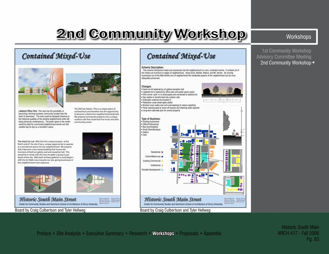
Preface • Site Analysis • Executive Summary • Research • Workshops • Proposals • AppendixHistoric South Main
ARCH 417 - Fall 2006Pg. 8�
1st Community WorkshopAdvisory Committee Meeting
2nd Community Workshop
Workshops2nd Community Workshop
Board by Craig Culbertson and Tyler HellwegBoard by Craig Culbertson and Tyler Hellweg

Preface • Site Analysis • Executive Summary • Research • Workshops • Proposals • AppendixHistoric South MainARCH 417 - Fall 2006Pg. 84
1st Community WorkshopAdvisory Committee Meeting2nd Community Workshop
2nd Community WorkshopWorkshops
Questionnaire (filled out by 10 people):1. On a scale from 0-5 rate the amount of improvement S
Main St. needs. (5 being the highest.) 0 = 0 1 = 0 2 = 0 � = 5 4 = 1 5 = � Comments that needs to be improved: -Home renovations/improvements 5 -Better drug enforcement 2 -Lighting 2 -Stone walls 2 -Streets 2 -More owner occupied houses 1 -Safety 1 -Family friendly 1 -More marketing 1 -Relationship of homes to street 1 -Addition of a Gateway 1 -Everything 12. Rate the appropriateness of each mixed use business
for the neighborhood. (0 no importance & 5 very important.)
Bed and Breakfast 0 = 1 1 = 2 2 = 2 � = 0 4 = 1 5 = � Small Professional Office 0 = 1 1 = 1 2 = 0 � = 2 4 = 1 5 = 5 Artist Studio/Gallery 0 = 1 1 = 1 2 = 0 � = � 4 = 2 5 = �
Cafe 0 = 1 1 = 2 2 = � � = 2 4 = 0 5 = 2 Boutique 0 = 1 1 = 2 2 = 2 � = 2 4 = 2 5 = 1 Restaurant 0 = 2 1 = 4 2 = 2 � = 1 4 = 0 5 = 1 Sports Bar 0 = 6 1 = 2 2 = 1 � = 0 4 = 0 5 = 1�. The closed gas station at the corner of Mt. Vernon and S.
Main St. has been suggested to be turned into a coffee house or some other small business; do you think this would be appropriate?
Yes = 7 No = 24. Do you ever use Hawthorn Park for recreation? Yes = 1 No = 75. Do you think Hawthorn Park is used more for
mischievous behavior? Yes = 6 No = 06. When College Station, the Heers Center and the many
other parts of downtown have completed renovation, do you feel S. Main St. will become a more popular place to live?
Yes = 10 No = 07. If the neighborhood was upgraded do you think the crime
in the area would go down or would remain the same? 0 = 0 1 = 1 2 = 0 � = � 4 = 1 5 = 5

Preface • Site Analysis • Executive Summary • Research • Workshops • Proposals • AppendixHistoric South Main
ARCH 417 - Fall 2006Pg. 85
1st Community WorkshopAdvisory Committee Meeting
2nd Community Workshop
Workshops2nd Community Workshop8. There are not many owner occupied homes on S. Main
St. If the neighborhood was improved would you like to see more owner occupied homes or is the current situation of 79% renter occupied okay?
Yes = 9 No = 1 Comments: - Owner occupied is always better, they care more
about their neighborhood. - Yes, proximity to downtown would increase
interest. - More single family ownership is a worthy goal.9. A few people expressed concern with trying to comply
with Historic Districts for tax credit. If you were to renovate your property, would you be interested in applying for tax credits?
Yes = 2 No = 510. S. Main St. has been identified as a residential
peninsula surrounded by commercial close to downtown. Some people feel that there is great potential of increased property value in the area allowing for higher rent and a significant raise in resale value. (West Central has seen a raise in one year of $50 sq. ft. to $80 sq. ft. after renovation. $90,000 increase in value for a �,000 sq. ft. home). If there were low interest loans available would you take advantage of them for home improvement?
Yes = 5 No = 411. Improvements concerning the streetscape, including
the street lights and side walks, can be funded by N.I.D. (neighborhood improvement district) which works by slightly increasing the property tax of all effected properties over 15 to �0 years. Assuming the improvements justify themselves by increasing your resale value, would you consider this an option for neighborhood improvement?
Yes = 6 No = 212. Have you ever considered turning one of your
properties into a mixed-use house? Why or why not? Yes = 4 No = 2 Comments: - No, don’t want new problems that mixed-use
would bring. - Yes, a neighborhood home repair business. - Yes, it is currently. - Not personally, but I think it could be a valuable
option. Final Opinions:Strictly residential, No mixed use �Contained mixed-use 2Scattered mixed-use 1National historic district �Historic lighting 1

Preface • Site Analysis • Executive Summary • Research • Workshops • Proposals • AppendixHistoric South MainARCH 417 - Fall 2006Pg. 86
1st Community WorkshopAdvisory Committee Meeting2nd Community Workshop
2nd Community WorkshopWorkshops
90 % 10 %
Visual Preference SurveyCircle the corresponding number to the image that provokes the most positive feeling.
70 % �0 %
40 % 60 %
90 % 10 %
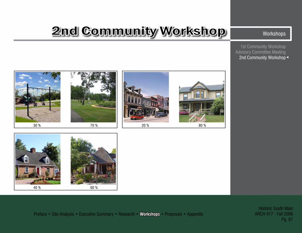
Preface • Site Analysis • Executive Summary • Research • Workshops • Proposals • AppendixHistoric South Main
ARCH 417 - Fall 2006Pg. 87
1st Community WorkshopAdvisory Committee Meeting
2nd Community Workshop
Workshops2nd Community Workshop
�0 % 70 %
40 % 60 %
20 % 80 %

Preface • Site Analysis • Executive Summary • Research • Workshops • Proposals • AppendixHistoric South MainARCH 417 - Fall 2006Pg. 88
= Residential
= Mixed-Use
= Existing Commercial
= Institutional
= Future Development
= Brick Sidewalk
= Entry Nodes
= Greenspace
= Parking
= StreetsMaster Plan
Comprehensive Master PlanResidential ComponentMixed-Use/CommercialEntry Nodes
Comprehensive Master PlanProposals

Preface • Site Analysis • Executive Summary • Research • Workshops • Proposals • AppendixHistoric South Main
ARCH 417 - Fall 2006Pg. 89
Comprehensive Master PlanResidential ComponentMixed-Use/Commercial
Entry Nodes
ProposalsComprehensive Master PlanFormat of Proposals:For our final proposal we broke up our master plan into three components: residential, mixed-use and entry nodes. This way each issue could be fully developed and investigated. Although, each section can stand alone as individual studies, each part supports and compliments the others. Therefore, each component should be examined as part of the greater master plan that incorporates all aspects.
Suggestions for Community Members to Begin the Revitalization Process:- Form a neighborhood Community Action Group- Establish a UCD overlay district to specify alternate uses for the site- Establish a NID to finance street lights, entry markers, and signs in front of houses- prune overly mature vegetation to give houses greater exposure from the street- Hold community events: garage sales, block parties

Preface • Site Analysis • Executive Summary • Research • Workshops • Proposals • AppendixHistoric South MainARCH 417 - Fall 2006Pg. 90
The residential core contain many of the old historic homes in the area. The area contains 27 homes of which only eight are owner occupied. In general, the houses date from the early 1890s and have large and mature foliage.
Goals:-Enhance inherent historic qualities-Foster interaction between residents-Capture ‘Americana’ quality- Create a more positive public image of community
-Maintain pedestrian qualities-Manage vehicle access -Unification of the neighborhood
Comprehensive Master PlanResidential ComponentMixed-Use/CommercialEntry Nodes
Residential ComponentProposals
Residential component highlighted

Preface • Site Analysis • Executive Summary • Research • Workshops • Proposals • AppendixHistoric South Main
ARCH 417 - Fall 2006Pg. 91
Neighborhood CharacterThis community has a rich and unique character, one that is rooted in the history of the neighborhood. This is a quiet neighborhood even with its proximity to downtown. It has wide sidewalks that are set back from the street making it a great area to stroll. It also evokes a romantic idealized image of the ‘All-American Neighborhood”. This is an idea that brings up thoughts of barbecues, block parties, children playing, and neighbors interacting. It is important that as
this neighborhood progresses it retains this vital romantic character.
In order to maximize the neighborhood’s potential to capture the Americana feel it is important that the neighborhood be unified into a cohesive unit and that opportunities for interaction be exploited within the neighborhood. The residential lots also need to be opened up more to the street.
Currently many of the lots have become overtaken by mature vegetation. Some simple landscaping pruning would go along way to make the lots feel more open and inviting. By allowing the houses to be more visible along the length of the street they will visually become unified parts as opposed to being sectioned off individual lots.
By, capturing this American ideal the public perception of the neighborhood will become much more positive.
Comprehensive Master PlanResidential ComponentMixed-Use/Commercial
Entry Nodes
ProposalsResidential Component
Sketch showing re-landscaped house with flag added, drawn by Craig Culbertson
Existing Americana: white picket fence, large front porch with swing
Example of overgrown vegetation on South Main

Preface • Site Analysis • Executive Summary • Research • Workshops • Proposals • AppendixHistoric South MainARCH 417 - Fall 2006Pg. 92
The South Main Site has an extensive history that is unannounced to the community. Home owners requested some way to designate older homes. One simple way to showcase some of the historic homes along South Main Avenue are markers. Midtown currently has such markers; some signs designate the neighborhood while others designate individual homes. The signs serve two fold; first they set the neighborhood apart from the rest of the city and second they unify the neighborhood. Other options include, but, not limited to, unique street signs, stylized house numbers, mailboxes, and even historic street lights. The idea behind any unifying historic markers is not to make the neighborhood look gaudy but to bring a since of uniqueness to the neighborhood as well as the homes.
Residential ComponentProposals
House marker in Mid-Town, Springfield, MO
Neighborhood marker in Mid-Town, Springfield, MO
Comprehensive Master PlanResidential ComponentMixed-Use/CommercialEntry Nodes

Preface • Site Analysis • Executive Summary • Research • Workshops • Proposals • AppendixHistoric South Main
ARCH 417 - Fall 2006Pg. 9�
ProposalsResidential ComponentFocal PointsFocal points are necessary to create a sense of place. They draw the eye visually, which can help to also draw users through a space physically. Focal points can also serve as anchors to a series of elements that unify a space. Within the neighborhood it would be beneficial to have focal points at the end of South Main Avenue in order to draw people from Walnut and the Center City down into the South Main Site. It could also be used to anchor some of the repetitive elements that will be used such as street lighting, signage and landscaping.
The old gas station is the obvious choice to utilize as a focal point; its location puts it in to direct view at the end of South Main Avenue. Also, its unique qualities give it a strong visual interest. If some accenting elements were added the station’s visual appeal could be strengthened. Appropriate lighting could enhance the structures appearance at night. It would appear inviting and lively. The addition of elements such as signage for the neighborhood and a flag or bank of flags could also be beneficial if done appropriately. This would give identity to the neighborhood, increase the public perception of neighborhood, add to the unification of the community, and continue to develop the Americana image.
View of old gas station down South Main Avenue
Vision of old gas station, drawn by Michael Hampton
Comprehensive Master PlanResidential ComponentMixed-Use/Commercial
Entry Nodes

Preface • Site Analysis • Executive Summary • Research • Workshops • Proposals • AppendixHistoric South MainARCH 417 - Fall 2006Pg. 94
LightingThe most important attribute of street lighting is safety. The current lighting at night is inadequate, creating a neighborhood that is unattractive and dreary. Because the neighborhood has a lot of history and character, we feel the historic street lights would be a great way to add uniqueness to the area. Because of this, the South Main Site has an opportunity to separate itself from the rest of the surrounding community. Unique street lights also give the South Main Site a more refined feel.
Residential ComponentProposals
Suggested street lights for South Main Site
Night view of South Main Avenue with new street lights, photo editing by Brian Harbison
Comprehensive Master PlanResidential ComponentMixed-Use/CommercialEntry Nodes

Preface • Site Analysis • Executive Summary • Research • Workshops • Proposals • AppendixHistoric South Main
ARCH 417 - Fall 2006Pg. 95
There are many options for street lights. The exact design needs to be determined by the neighborhood in conjunction with the city. Lights with only one bulb are typically similar and provide a more community feel. This option would be best suited for a residential area or a low traffic commercial area.
Another option would be a two bulb light. This type of light is more often seen in professional areas.
Another option is the three plus bulb light. Typically this is seen in very commercialized and tourist areas. Although attractive this option may not be appropriate for this area. The style of the street lights has a great affect on the image the light creates.
ProposalsResidential Component
Sample streetlight 95B
Sample streetlight 95A
Sample streetlight 95C
Comprehensive Master PlanResidential ComponentMixed-Use/Commercial
Entry Nodes

Preface • Site Analysis • Executive Summary • Research • Workshops • Proposals • AppendixHistoric South MainARCH 417 - Fall 2006Pg. 96
ParkingThere are many issues to be dealt with in terms of parking. The reason for this is the potential change in demand for different condition. Currently the parking condition has a high demand for on street parking close to the multi-family houses. This condition could easily change if more homes are turned to single family homes and again change if mixed-use homes are introduced. Each condition brings a separate set of issues. (See park section) The one issue that we see that is currently occurring and will continue to exist is speeding down South Main Avenue. The reason for this
Residential ComponentProposals
Site Plan 96A
Potential Parking along South Main Avenue 96B
Comprehensive Master PlanResidential ComponentMixed-Use/CommercialEntry Nodes

Preface • Site Analysis • Executive Summary • Research • Workshops • Proposals • AppendixHistoric South Main
ARCH 417 - Fall 2006Pg. 97
ProposalsResidential Componentis the extreme width of the street with street parking along both sides of the street. We do want to “narrow” the appearance of the street. By doing this, drivers naturally slow down and are more careful. Curb extensions simply extend the curb out into the street creating peninsulas which narrow the street. The great thing about curb extensions is they can be added in location where current street parking is not allowed, for instance near intersections. They provide a little more green area for the neighborhood and more importantly safety.
Potential Parking on South Main Site 97A
Comprehensive Master PlanResidential ComponentMixed-Use/Commercial
Entry Nodes

Preface • Site Analysis • Executive Summary • Research • Workshops • Proposals • AppendixHistoric South MainARCH 417 - Fall 2006Pg. 98
Residential ComponentProposals
SidewalksThe sidewalks that were original to the neighborhood were brick. These old sidewalks were removed in the 1980s and replaced with the current concrete sidewalks. In order to bring out the historic qualities of the community and to help signal the entrance to the South Main Site the sidewalks should return to brick. Brick sidewalks have a lot of character, and if properly maintained they can add to the visual appeal to the neighborhood. The brick sidewalks would run all around the neighborhood and incorporate new crosswalks. These new crosswalks will increase pedestrian safety.
Improved brick sidewalk locations 98A
Comprehensive Master PlanResidential ComponentMixed-Use/CommercialEntry Nodes

Preface • Site Analysis • Executive Summary • Research • Workshops • Proposals • AppendixHistoric South Main
ARCH 417 - Fall 2006Pg. 99
ProposalsResidential Component
The sidewalks will remain in their current positions. Currently they are set 2-� feet back from the street. This makes the sidewalks safe for pedestrians and also provides opportunities to add plantings between the sidewalk and the street to further divide pedestrian and vehicular traffic. Also, the addition of plantings and street lights begin to work with existing trees that over hang the sidewalk to make an intimate pedestrian space within the public setting. In the Northern half of the site this creation of a pedestrian zone is heightened by the retaining walls that line the sidewalk. Some of these retaining walls have, however, fallen into disrepair. They have begun to settle and sag in the middle. Some need to be reset and some need to be completely replaced.
Relationship of pedestrian to street
South Main Avenue sidewalk view Potential sidewalk view 99A
Comprehensive Master PlanResidential ComponentMixed-Use/Commercial
Entry Nodes

Preface • Site Analysis • Executive Summary • Research • Workshops • Proposals • AppendixHistoric South MainARCH 417 - Fall 2006Pg. 100
Mixed-use/commercial component highlighted
Mixed-Use/CommercialProposals
Restricting Commercial to Perimeter The incorporation of a mixed-use plan into this peninsula of historic residential homes was for the most part discouraged by its residents. In response to the encroachment of commercial structures into this residential neighborhood we propose a comprehensive plan to limit commercial uses to the perimeter of the site leaving the interior structures located on the South Main Site to remain residential. This will also help businesses get more exposure on the busy exterior street than they would on the quiet residential South Main Avenue. This plan proposes that the residents take an active interest in what type of business will be allowed in this outside perimeter area.
Comprehensive Master PlanResidential ComponentMixed-Use/CommercialEntry Nodes

Preface • Site Analysis • Executive Summary • Research • Workshops • Proposals • AppendixHistoric South Main
ARCH 417 - Fall 2006Pg. 101
ProposalsMixed-Use/CommercialProposed Commercial InfillCurrently, there are a number of vacant lots that dot the neighborhood and break-up the continuity of the commercial district, which discourages pedestrians from the downtown area from exploring this space. To complete the commercial area we propose that these lots be purchased and developed into structures more befitting the vernacular of the downtown streetscape. - Lakeland Hospital Lot: The large fenced-in lot on the west side of Mt. Vernon
directly across from Lakeland Regional Hospital is a prime space for both commercial development and added parking space. We propose that this lot be purchased by a developer and developed into a historically sensitive structure or grouping of structures that maintains the street edge and also allows for public parking with access that is visible from the street.
- Used Car Lot The used car lot on the southwest corner of South Main
and Walnut is considered an eyesore and a poor entrance to the neighborhood. We propose that this lot also be purchased and developed into a commercial structure more befitting to the downtown vernacular. Some possible ideas are an extension to the already packed Casper’s restaurant or an art gallery that will help to extend the flow of pedestrian down Walnut.
Proposed use for the used car lot site at South Main Avenue and Walnut 101B
Comprehensive Master PlanResidential ComponentMixed-Use/Commercial
Entry Nodes
Proposed use for Lakeland Regional Hospital Lot 101A
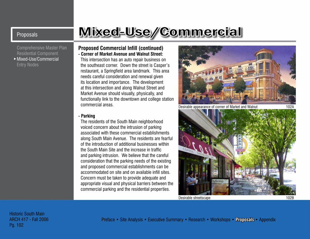
Preface • Site Analysis • Executive Summary • Research • Workshops • Proposals • AppendixHistoric South MainARCH 417 - Fall 2006Pg. 102
Mixed-Use/CommercialProposals
Proposed Commercial Infill (continued)- Corner of Market Avenue and Walnut Street: This intersection has an auto repair business on
the southeast corner. Down the street is Casper’s restaurant, a Springfield area landmark. This area needs careful consideration and renewal given its location and importance. The development at this intersection and along Walnut Street and Market Avenue should visually, physically, and functionally link to the downtown and college station commercial areas.
- Parking The residents of the South Main neighborhood
voiced concern about the intrusion of parking associated with these commercial establishments along South Main Avenue. The residents are fearful of the introduction of additional businesses within the South Main Site and the increase in traffic and parking intrusion. We believe that the careful consideration that the parking needs of the existing and proposed commercial establishments can be accommodated on site and on available infill sites. Concern must be taken to provide adequate and appropriate visual and physical barriers between the commercial parking and the residential properties.
Desirable streetscape 102B
Desirable appearance of corner of Market and Walnut 102A
Comprehensive Master PlanResidential ComponentMixed-Use/CommercialEntry Nodes

Preface • Site Analysis • Executive Summary • Research • Workshops • Proposals • AppendixHistoric South Main
ARCH 417 - Fall 2006Pg. 10�
ProposalsMixed-Use/CommercialCampbell Elementary Future Uses:Campbell Elementary School is a positive life force of the neighborhood. The school offers not only education to the neighborhood children but also a building for community events. If the school were to close, we propose that the facility become a community center, multi-family residential, an artist co-op, or a business incubator. Retaining this facility and its community service function is important to the life and vitality of the neighborhood.
Buffering:As the commercial activities within and surrounding the South Main Site continue to develop it will become increasingly important to provide adequate and appropriate visual and physical buffering between the commercial and residential areas.- Visual and Physical: For the residential properties that will adjacent to
commercial properties we propose the addition of new vegetation and low privacy fences to separate the areas.
Example of buffering with vegetation 10�A
Alternative plan for Campbell Elementary School site
Comprehensive Master PlanResidential ComponentMixed-Use/Commercial
Entry Nodes
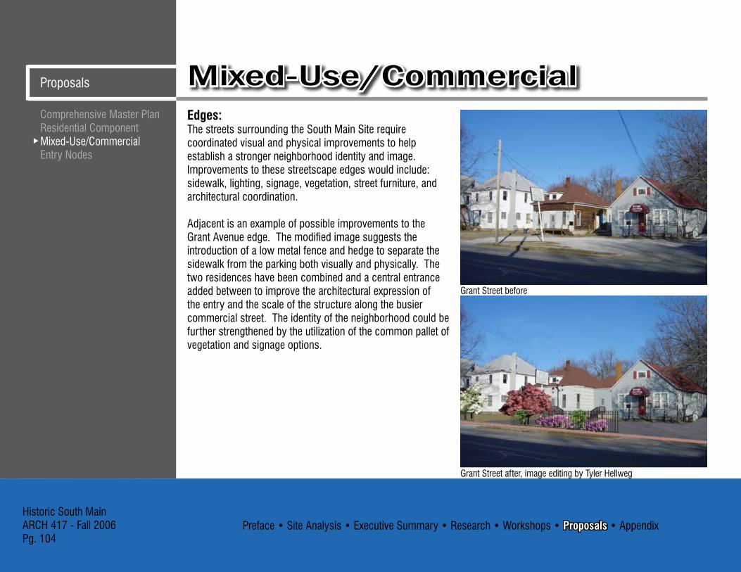
Preface • Site Analysis • Executive Summary • Research • Workshops • Proposals • AppendixHistoric South MainARCH 417 - Fall 2006Pg. 104
Mixed-Use/CommercialProposals
Edges:The streets surrounding the South Main Site require coordinated visual and physical improvements to help establish a stronger neighborhood identity and image. Improvements to these streetscape edges would include: sidewalk, lighting, signage, vegetation, street furniture, and architectural coordination.
Adjacent is an example of possible improvements to the Grant Avenue edge. The modified image suggests the introduction of a low metal fence and hedge to separate the sidewalk from the parking both visually and physically. The two residences have been combined and a central entrance added between to improve the architectural expression of the entry and the scale of the structure along the busier commercial street. The identity of the neighborhood could be further strengthened by the utilization of the common pallet of vegetation and signage options.
Grant Street before
Grant Street after, image editing by Tyler Hellweg
Comprehensive Master PlanResidential ComponentMixed-Use/CommercialEntry Nodes

Preface • Site Analysis • Executive Summary • Research • Workshops • Proposals • AppendixHistoric South Main
ARCH 417 - Fall 2006Pg. 105
ProposalsMixed-Use/Commercial
Market Street before
Market Street after, image editing by Tyler Hellweg
Walnut Street before
Walnut Street after, image editing by Tyler Hellweg
Comprehensive Master PlanResidential ComponentMixed-Use/Commercial
Entry Nodes
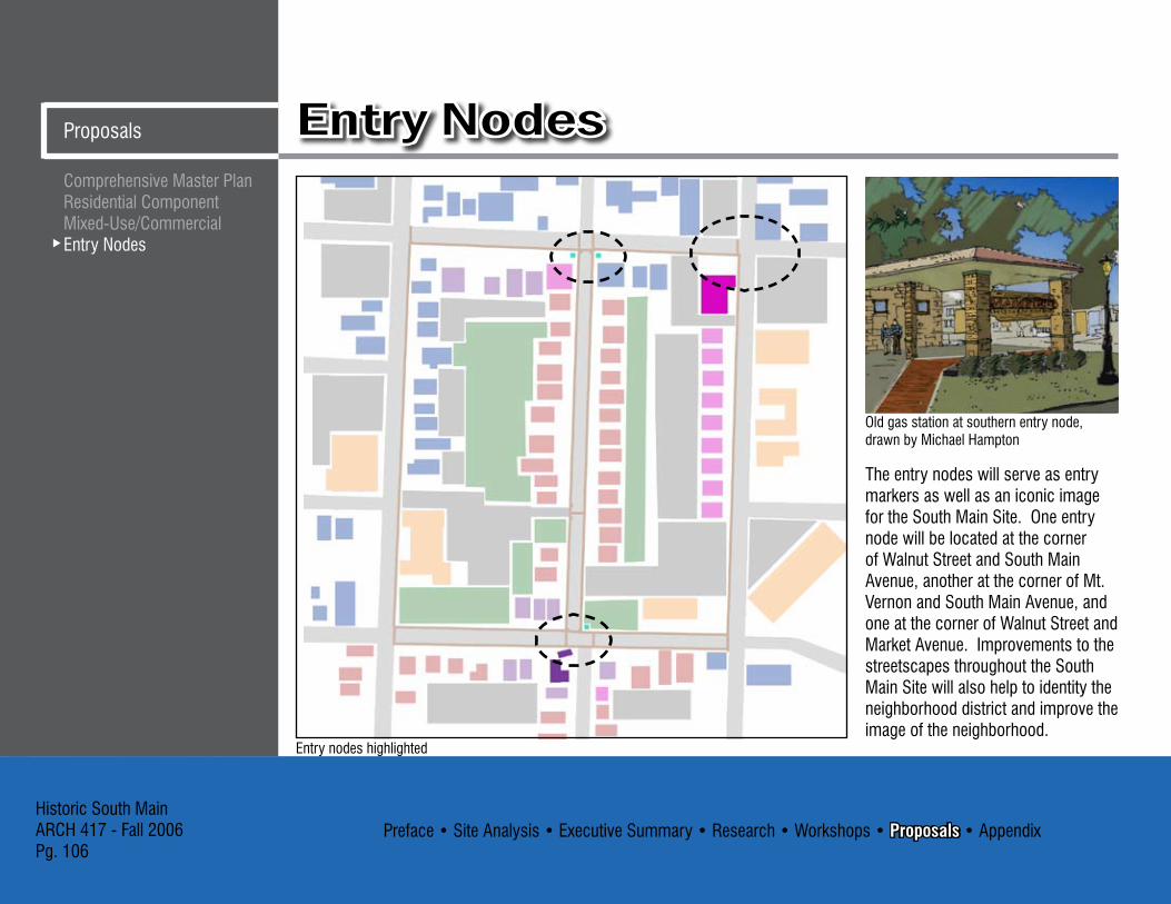
Preface • Site Analysis • Executive Summary • Research • Workshops • Proposals • AppendixHistoric South MainARCH 417 - Fall 2006Pg. 106
Entry NodesProposals
The entry nodes will serve as entry markers as well as an iconic image for the South Main Site. One entry node will be located at the corner of Walnut Street and South Main Avenue, another at the corner of Mt. Vernon and South Main Avenue, and one at the corner of Walnut Street and Market Avenue. Improvements to the streetscapes throughout the South Main Site will also help to identity the neighborhood district and improve the image of the neighborhood.
Old gas station at southern entry node, drawn by Michael Hampton
Entry nodes highlighted
Comprehensive Master PlanResidential ComponentMixed-Use/CommercialEntry Nodes

Preface • Site Analysis • Executive Summary • Research • Workshops • Proposals • AppendixHistoric South Main
ARCH 417 - Fall 2006Pg. 107
ProposalsEntry NodesFunding:The entry markers could be funded by a Neighborhood Improvement District (NID). A NID creates a small increase in area taxes which can fund the entry markers and other improvements to the neighborhood.
Materials:Brick would be a sturdy and maintenance free material. Historically accurate brick would help the markers fit into the context of the neighborhood.
Safety:Crosswalks and bump outs can slow down traffic and help keep pedestrians safe while improved street lighting deters crime in the area.
Northern entry node A, image editing by Bryon Oster
Northern entry node B, image editing by Bryon Oster
Southern entry node A, image editing by Bryon Oster
Southern entry node B, image editing by Bryon Oster
Comprehensive Master PlanResidential ComponentMixed-Use/Commercial
Entry Nodes

Preface • Site Analysis • Executive Summary • Research • Workshops • Proposals • AppendixHistoric South MainARCH 417 - Fall 2006Pg. 108
Proposed Entry Node at South Main Avenue and Mt. Vernon:The old gas station at the corner of South Main Avenue and Mt. Vernon should be developed as a neighborhood entry node or marker because of its location and its architectural significance. Although the old gas station should be considered a key element in the development at the South Main Avenue and Mt. Vernon entry node, it should only be a part of the entry node development at this intersection. The development of a small neighborhood commercial area at this intersection that integrates the old gas station and uses its architectural character for inspiration would add significance and contextual correctness to this entry node. This small neighborhood commercial area could become identified and/or called the “South Main Village.”
Entry NodesProposals
Possible entry markers, Computer model and drawings by Michael Hampton
Site plan of old gas station -- “South Main Village” area
Comprehensive Master PlanResidential ComponentMixed-Use/CommercialEntry Nodes

Preface • Site Analysis • Executive Summary • Research • Workshops • Proposals • AppendixHistoric South Main
ARCH 417 - Fall 2006Pg. 109
ProposalsEntry Nodes
Advantages:- The development of the “South Main Village” entry node
takes advantage of the important neighborhood landmark.- The old gas station’s position on axis with South Main
Avenue provides excellent visibility.- The development of such a “South Main Village”
commercial area would strengthen the economic, social
and visual context of the neighborhood.- The development of the “South Main Village” compatible
with the style and period of the old gas station would help to reinforce the image of the neighborhood and support the Historic South Main concept.
109A 109B 109C 109D
Comprehensive Master PlanResidential ComponentMixed-Use/Commercial
Entry Nodes
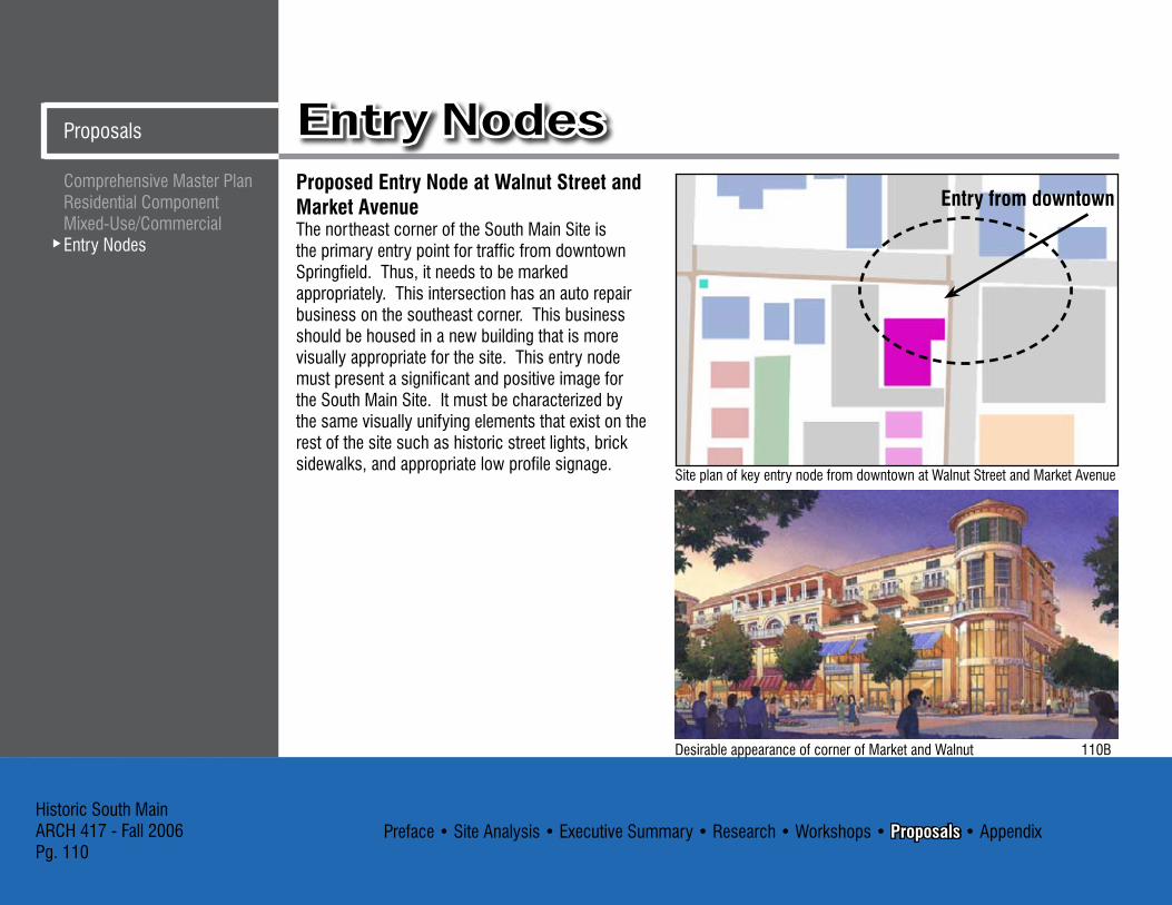
Preface • Site Analysis • Executive Summary • Research • Workshops • Proposals • AppendixHistoric South MainARCH 417 - Fall 2006Pg. 110
Entry NodesProposals
Comprehensive Master PlanResidential ComponentMixed-Use/CommercialEntry Nodes
Proposed Entry Node at Walnut Street and Market Avenue The northeast corner of the South Main Site is the primary entry point for traffic from downtown Springfield. Thus, it needs to be marked appropriately. This intersection has an auto repair business on the southeast corner. This business should be housed in a new building that is more visually appropriate for the site. This entry node must present a significant and positive image for the South Main Site. It must be characterized by the same visually unifying elements that exist on the rest of the site such as historic street lights, brick sidewalks, and appropriate low profile signage.
Desirable appearance of corner of Market and Walnut 110B
Site plan of key entry node from downtown at Walnut Street and Market Avenue
Entry from downtown

Preface • Site Analysis • Executive Summary • Research • Workshops • Proposals • AppendixHistoric South Main
ARCH 417 - Fall 2006Pg. 111
ProposalsEntry NodesComprehensive Master Plan
Residential ComponentMixed-Use/Commercial
Entry Nodes
Proposed infill gallery for southwest corner of South Main Avenue and Walnut Street, drawn by Craig Culbertson
Proposed Entry Node at South Main Avenue and Walnut StreetThis entry node marks the northern end of South Main Avenue. Casper’s, a neighborhood favorite restaurant, is located on the northwest corner of the intersection. The southeast corner has a communications specialty equipment business that is a lively source of traffic in the neighborhood. We propose that the used car lot on the southwest corner be replaced with an art gallery to compliment the recently added Art Factory, just north of the South Main Site. This corner should also include visually appropriate historic street lights, brick sidewalks, and appropriate low profile signage.
Site plan of entry node at Walnut Street and South Main Avenue

Preface • Site Analysis • Executive Summary • Research • Workshops • Proposals • AppendixHistoric South MainARCH 417 - Fall 2006Pg. 112
Entry NodesProposals
South Main Avenue and Walnut Street:The intersection at South Main Avenue and Walnut Street creates an unflattering image and entry into the neighborhood due to the condition and types of commercial activities in the area. This entry into the South Main Site needs significant visual improvement and the establishment of a strong iconic element making the entry node to the neighborhood. The streetscape along Walnut Street needs to be upgraded and unifying elements added to further mark and distinguish the South Main Site.
Advantages:The development of an iconic entry and improved streetscape features would help to beautify the area and mark the neighborhood.
The iconic entry node could help to mark the residential zone visually, physically, and psychologically.
Disadvantages: The nodes will be an expense to the South Main Avenue residents. The nodes would have to fit the requirements of the UCD; this also would be of expense to the residents.
�0’ 5’ 7’ 25’ 5’ �’ 27’
Comprehensive Master PlanResidential ComponentMixed-Use/CommercialEntry Nodes

Preface • Site Analysis • Executive Summary • Research • Workshops • Proposals • AppendixHistoric South Main
ARCH 417 - Fall 2006Pg. 11�
ProposalsEntry NodesIssues:- The South Main Site needs to improve its
image and establish entry nodes.- Before entry nodes become the marker
for the South Main Site, the neighborhood itself would need many improvements before their ‘image’ was established.
- What would the entry node look like so to be contextual as well as fit into the physical requirements of the neighborhood?
Concerns:- Identification of funding sources for these
public/private improvements.- Improvement of South Main Site’s image:
physically and socially.- Development of entry nodes and other
neighborhood features that are compatible with the physical and social context.
Recommendations: The city and South Main Site businesses and residents should work collaboratively to improve the physical and social image of the area. Of particular importance is the establishment of South Main entry nodes or characteristic physical features that can be identified with the area. Entry nodes should be developed at South Main Avenue and Walnut Street and South Main Avenue and Mt. Vernon. Characteristic South Main Avenue streetscape features, that can also be considered neighborhood visual markers, should be developed along Walnut Street, Grant Avenue, Mt. Vernon Street and Market Avenue.
Comprehensive Master PlanResidential ComponentMixed-Use/Commercial
Entry Nodes
Preface • Site Analysis • Executive Summary • Research • Workshops • Proposals • AppendixHistoric South MainARCH 417 - Fall 2006Pg. 114
CitationsAppendix
4A - http://www.mapquest.com5A - Springfield History Museum5B - Springfield History Museum5C - Springfield History Museum5D - Springfield History Museum6A - Mr. SID7A - http://www.mapquest.com8A - Mr. SID9A - Mr. SID10A - City of Springfield Planning and Development1�A - City of Springfield Planning and Development16A - City of Springfield Planning and Development21A - http://en.wikipedia.org22A - Congress for New Urbanism: Charter Awards 200124A - http://city.waverlyia.com/historical_preservation.asp25A - http://www.paducaharts.com25B - http://www.yorkstreethouse.com/26A - Mr. SID��A - http://www.russellmb.com�4A - http://factfinder.census.gov�4A - http://factfinder.census.gov�6A - http://www.hoffmanestates.com/�7A - http://www.wpd.org/�8A - Springfield History Museum�9A - Springfield History Museum40A - http://dnr.mo.gov/shpo
42A - http://www.flickr.com42B - http://www.flickr.com47A - Mr. SID49A - http://www.seelyhouse.com49B - Mr. SID51A - http://www.trafficcalming.org51B - http://www.gallagher.com5�A - City of Springfield Planning and Development54A - http://www.nationaltrust.org54B - http://www.hhs.csus.edu55A - http://www.nottinghamcity.gov.uk55B - http://www.opkansas.org56A - http://www.paducaharts.com56B - http://www.paducaharts.com57A - http://www.southsideneighborhood.com57B - http://www.southsideneighborhood.com58A - http://www.walnutstreetinn.com58B - http://artshowphoto.com88A - MR. SID9�A - http://www.picturejockey.com9�B - http://www.istockphoto.com9�C - http://en.wikipedia.org/94A - Mr. SID95B - Mr. SID95A - Mr. SID96A - Mr. SID
Citations

Preface • Site Analysis • Executive Summary • Research • Workshops • Proposals • AppendixHistoric South Main
ARCH 417 - Fall 2006Pg. 115
Citations Appendix
95A - http:www.prairienet.org99A - Congress for New Urbanism: Charter Awards 200499B - Congress for New Urbanism: Charter Awards 2001100A - Smart Growth Shareware Version 2100B - Smart Growth Shareware Version 2101A - Smart Growth Shareware Version 2102A - Smart Growth Shareware Version 2102B - Smart Growth Shareware Version 2107A - http://www.flickr.com107B - http://dnr.mo.gov/shpo107C - http://geo.msu.edu107D - http://www.flickr.com110A - Smart Growth Shareware Version 2
All photos that are not cited were taken by members of the group.
Citations