hydrologic & hydraulic analysis for the takoma park public
TRANSCRIPT

Hydrologic & Hydraulic Analysis for the
Takoma park Public Library
TAKOMA PARK , MD
PRELIMINARY REPORTAugust 2018
Prepared for:The City of Takoma ParkMontgomery County, MD
And
ADTEK Engineers
AndDepartment of Permitting Services
Montgomery County, MD
ByDelon Hampton and Associates
8403 COLESVILLE ROAD,SUITE 600
SILVER SPRING MD, 20910

Takoma Park Library Hydrologic and Hydraulic Report
i
TABLE OF CONTENTS
REPORT PageSection 1. INTRODUCTION ..................................................................................................... 1Section 2. SCOPE OF SERVICES ........................................................................................... 2Section 3. SOURCES OF INFORMATION .............................................................................. 2Section 4. METHODOLOGY .................................................................................................... 2Section 5. FEDERAL EMERGENCY MANAGEMENT AGENCY (FEMA) FLOODZONE ........ 5Section 6. HYDROLOGIC ANALYSIS ...................................................................................... 5Section 7. HYDRAULIC ANALYSIS ......................................................................................... 7Section 8. CONCLUSIONS AND RECOMMENDATIONS ....................................................... 8
TABLESTable 1– Rainfall Depths ............................................................................................................... 4Table 2 - Summary of TR-55 Inputs for Existing and Ultimate Conditions .................................... 4Table 3 - Summary of Results of Peak Discharges for Existing and Ultimate Conditions ............ 6Table 4 - Summary of TR-55 Inputs for Existing and Ultimate Conditions .................................... 6Table 5 - Summary of Results of Peak Discharges for Existing and Ultimate Conditions .... Error!
Bookmark not defined.Table 6– 100 Year Water Surface Elevations ............................................................................... 7
FIGURESFigure 1 – Location Map (Not to Scale) ........................................................................................ 1
APPENDICES APPENDIX A – DRAINAGE AREA AND SOIL MAPS APPENDIX B – HYDROLOGIC COMPUTATIONS APPENDIX C – HEC-RAS ANALYSIS APPENDIX D – FLOODPLAIN MAP
Takoma Park Library Hydrologic and Hydraulic Report
1
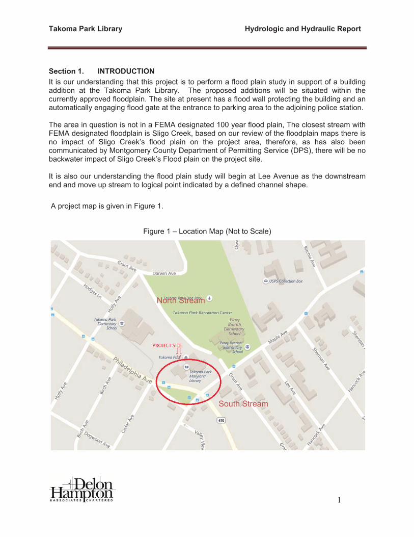
Section 1. INTRODUCTION It is our understanding that this project is to perform a flood plain study in support of a building addition at the Takoma Park Library. The proposed additions will be situated within the currently approved floodplain. The site at present has a flood wall protecting the building and an automatically engaging flood gate at the entrance to parking area to the adjoining police station.
The area in question is not in a FEMA designated 100 year flood plain, The closest stream with FEMA designated floodplain is Sligo Creek, based on our review of the floodplain maps there is no impact of Sligo Creek’s flood plain on the project area, therefore, as has also been communicated by Montgomery County Department of Permitting Service (DPS), there will be no backwater impact of Sligo Creek’s Flood plain on the project site.
It is also our understanding the flood plain study will begin at Lee Avenue as the downstream end and move up stream to logical point indicated by a defined channel shape.
A project map is given in Figure 1.
Figure 1 – Location Map (Not to Scale)
South Stream
North Stream

Takoma Park Library Hydrologic and Hydraulic Report
2
Section 2. SCOPE OF SERVICES
1. Perform an Aerial Survey of the project site supplemented by field run survey to include cross sections at locations identified to be critical to the study including at change in slope width or at structural crossing at buildings and structures.
2. Obtain and review existing storm drain records from Montgomery County and/or the City of Takoma Park.
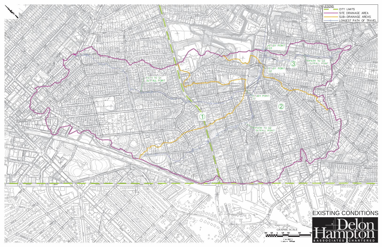
3. Delineate drainage area to the study point (Lee Avenue) and sub drainage areas contributing to major storm sewer systems and points of interest and tributary points.
4. Perform storm sewer capacity calculations based on the receiving drainage areas, to determine if there is storage capacity within the system during a 100 year storm event.
5. Perform hydrologic analysis using TR-55 for ultimate development condition>
6. Develop a HEC-RAS model based on the cross section data, roughness coefficient and the hydrologic and Hydraulic analysis date. The model will be run on an urban channel beginning on the downstream end at Lee Avenue and upstream to Birch Avenue.
Section 3. SOURCES OF INFORMATION In order to carry out the present study, the following data were provided:
1. Montgomery County GIS topography (2-foot contour intervals). 2. Aerial topographic plan prepared by Potomac Aerial Survey and supplemented by field
run cross sections by Aultec. Inc. 3. Storm drain information obtained from the City of Takoma Park in GIS format. In addition, reference was made to the following manuals in the report: 1. U.S. Army Corps of Engineers, Hydrologic Engineering Center, River Analysis System
(HEC-RAS) Manual, Version 5.0, February 2016. 2. United States Department of Agriculture, Natural Resources Conservation Service
(NRCS) Technical Release 55 (TR-55) Urban Hydrology for Small Watersheds, April 2002.
Section 4. METHODOLOGY 4.1 Drainage Area Maps
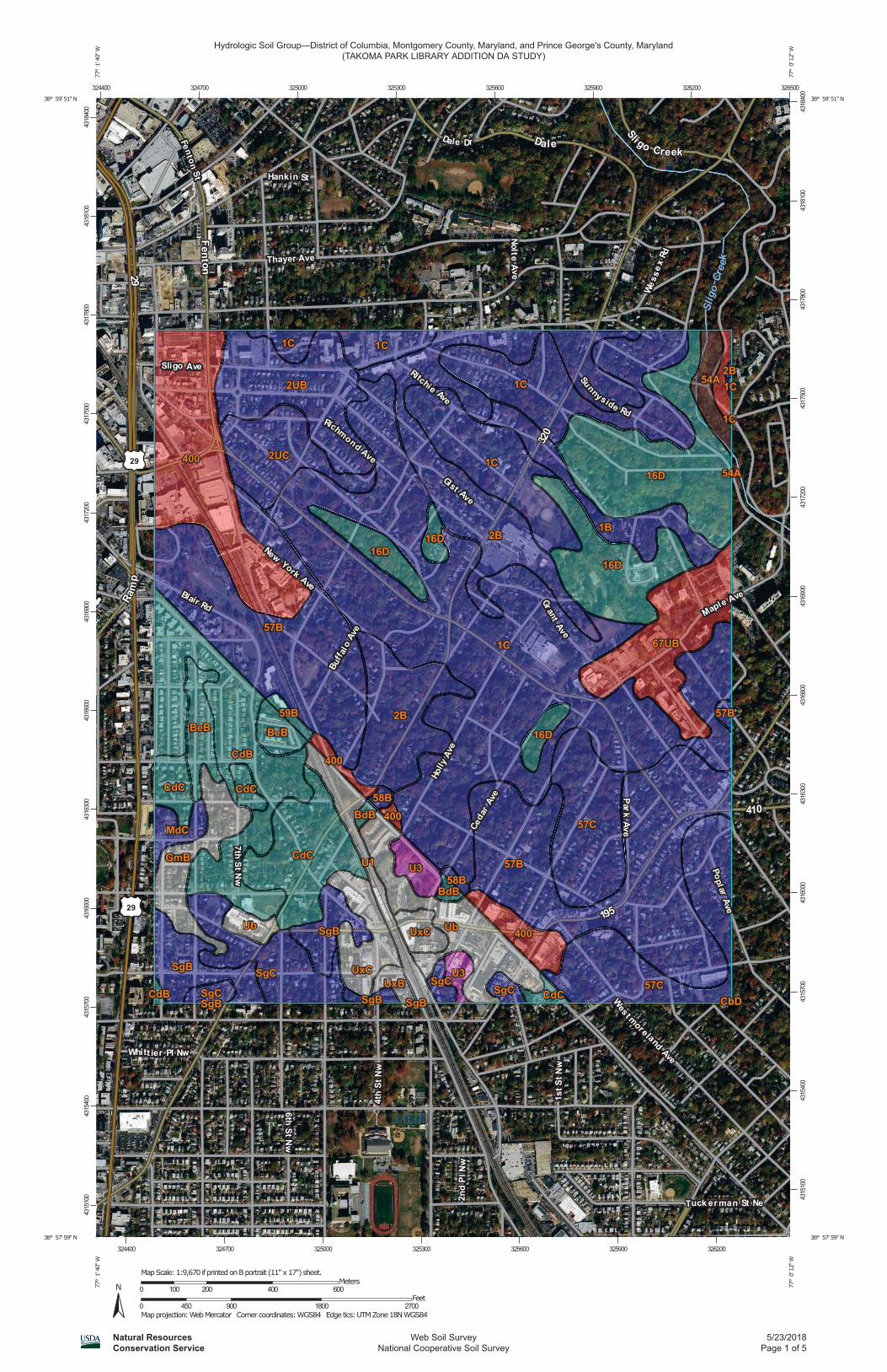
Drainage area maps for the project were developed using 2-foot contour intervals extracted from the Montgomery County GIS topography. The Drainage area map is included in Appendix A.

Takoma Park Library Hydrologic and Hydraulic Report
3
4.2 Hydrology
4.2.1 Soils Information
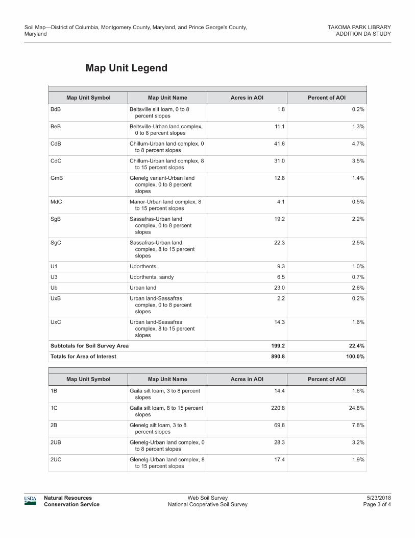
The hydrologic soil information for the project was obtained from USDA Natural Resources Conservation Service, National Cooperative Soil Survey for Montgomery County, MD, (Refer to Appendix A).
4.2.2 Land Use
Land uses were obtained from Montgomery County GIS (MC Atlas) for the ultimate zoning condition
4.2.3 Runoff Curve Numbers
Runoff curve numbers were developed using TR-55 Urban Hydrology for Small Watersheds by the USDA Natural Resources Conservation Service (NRCS). HydroCADD software was used to perform the calculations. Drainage areas, soil types and land uses were used to generate the existing and ultimate runoff curve numbers for the various drainage areas.
4.2.4 Time of Concentration Flow Paths
Time of concentration flow paths were determined using the 2-foot contour intervals GIS plans as well as the storm drain information obtained from the City of Takoma Park. Sheet flow, shallow concentrated flow, open channel flow and pipe flow were the flow types used to calculate the time of concentration for each drainage area. For computing times of concentration, stream velocities for channel flow and pipe flow were based on average channel slopes. Drainage Area maps showing drainage boundaries, flow paths, land use and hydrologic soil groups for both existing and ultimate conditions are given in Appendix B.
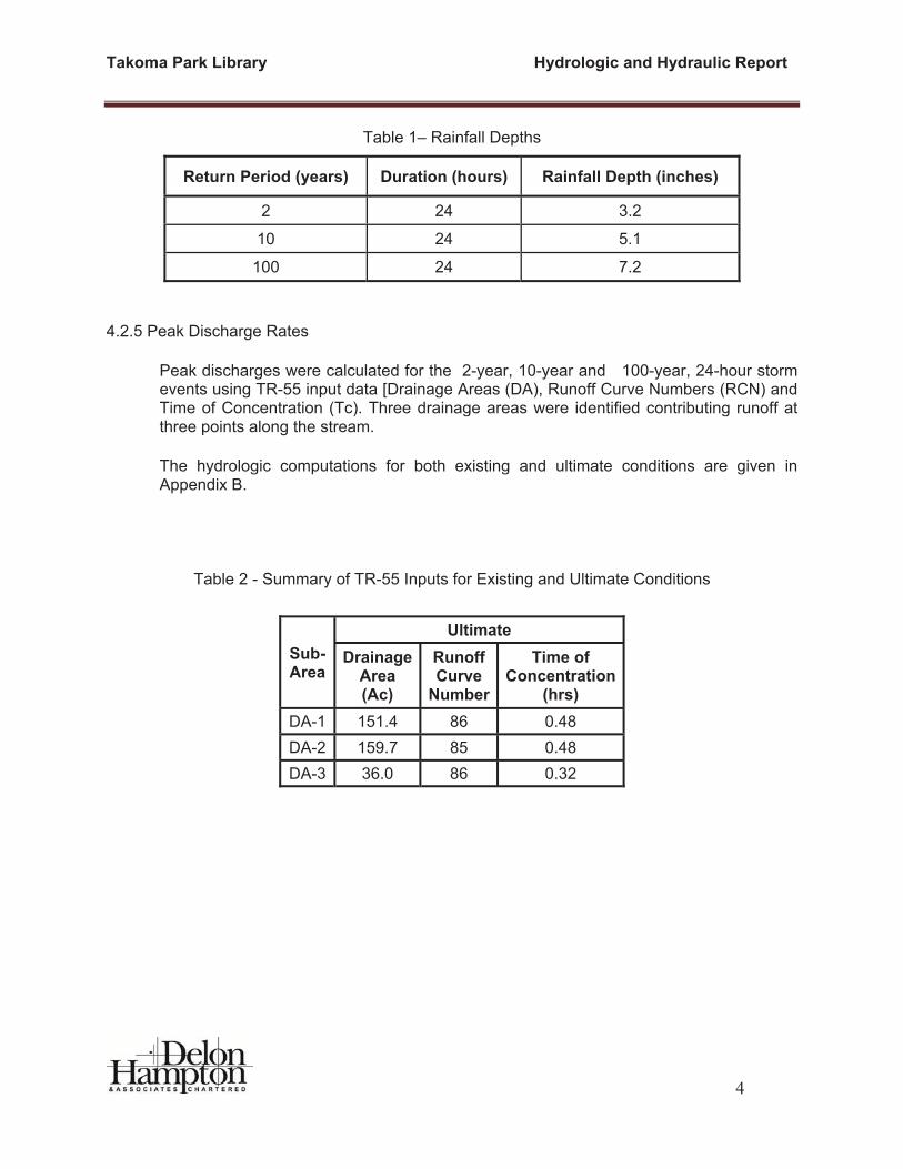
4.2.5 Rainfall Depths
The rainfall depths were obtained from the Maryland Department of Transportation State Highway Administration, Highway Drainage Manual, Chapter 2, and Charts SHA-61.1-403.4 to SHA-61.1-403.9. The rainfall depths for the 24 hour duration storms model are listed below in Table 1. A Type II rainfall distribution was applied to the 24-hour duration storms.
Takoma Park Library Hydrologic and Hydraulic Report
4
Table 1– Rainfall Depths
Return Period (years) Duration (hours) Rainfall Depth (inches)
2 24 3.2
10 24 5.1
100 24 7.2
4.2.5 Peak Discharge Rates
Peak discharges were calculated for the 2-year, 10-year and 100-year, 24-hour storm events using TR-55 input data [Drainage Areas (DA), Runoff Curve Numbers (RCN) and Time of Concentration (Tc). Three drainage areas were identified contributing runoff at three points along the stream.
The hydrologic computations for both existing and ultimate conditions are given in Appendix B.
Table 2 - Summary of TR-55 Inputs for Existing and Ultimate Conditions
Sub-Area
UltimateDrainage
Area(Ac)
RunoffCurve
Number
Time of Concentration
(hrs)DA-1 151.4 86 0.48 DA-2 159.7 85 0.48 DA-3 36.0 86 0.32

Takoma Park Library Hydrologic and Hydraulic Report
5
The hydrologic computations for both existing and ultimate conditions are given in Appendix B.
4.3 Hydraulics
The site is an urban site without a defined stream channel. The reach modeled is the gutter line of Philadelphia Avenue and Maple Avenue. The reach was modeled utilizing the HEC-RAS River Analysis System software (V 5.05.1.0, January 2016). Elevation data was collected and cross sections were developed based on the 1-foot contour survey data provided by AULtec, as well as an aerial topographic survey performed by Potomac Aerial Survey. In addition drainage area maps were developed using the 2-foot contours extracted from the Montgomery County GIS topography. Steady flow data was entered for the 100-year, 24-hour storm events based on computations performed as described in section 4.2.5 above. The Manning’s n was approximated based on field verification and the existing culvert information was based on the survey.
The reach is an urban street with a network of storm sewer system designed to convey the 10 year storm out to the receiving water body, which is Sligo Creek. Therefore the assumption is any storm over the 10 year storm is conveyed overland via the streets and overland swales and channels, therefore the peak discharge used to model the 100 year flood plain in HEC-RAS is the difference between the 10 year and 100 year peak discharge. The peak discharges that are conveyed overland are therefore as shown on
Stream cross sections and results of the HEC-RAS analysis are given in Appendix D.
Section 5. FEDERAL EMERGENCY MANAGEMENT AGENCY (FEMA) FLOODZONE
The flood zones for Montgomery County, Maryland and incorporated areas are outlined in the Federal Emergency Management Agency (FEMA) Flood Insurance Rate Maps (FIRM), dated September, 2006. The project will take place in Community Panel 24031C04600D. See FIRMette included in Appendix C. According to the map, the project site is not located in any special flood hazard areas.
Section 6. HYDROLOGIC ANALYSIS The total drainage area draining to the point of analysis, which is at the intersection of Lee Avenue and Maple Avenue is 0.54 square miles (347.1 Acres). This area is divided into three based on where it enters the reach. The entire drainage area is assumed to be at an ultimate condition development. Per Montgomery County Atlas the predominant zoning within the drainage area is R-60 which is approximately and eighth of an acre single family residential development, within the area there are some areas that are less dense and some more. Per SCS TR-55 manual the average percent impervious is 65%. The distribution of Hydrologic Soil Group (HSG) includes HSG A, B, C and D. The soil types were considered in developing the composite Run off Curve Number (RCN).

Takoma Park Library Hydrologic and Hydraulic Report
6
The data for each of the drainage areas was entered into the TR-55 model and the appropriate Runoff Curve Numbers (RCN) were calculated for each area. In addition, methods outlined in the TR-55 were used to calculate the Time of Concentration (Tc) for each basin. Existing topographic / contour mapping as well as inlet / pipe / culvert / ditch data from Montgomery County was used to determine flow paths and hydraulic characteristics of the flow paths. The TR-55 analyses were carried out to determine the RCN and Tc for each basin for both existing and ultimate land uses. Tables 3 show the TR-55 inputs for the existing conditions for the north and south streams. Table 4 summarize the peak discharges for the north and south streams.
Table 3 - Summary of TR-55 Inputs for Existing and Ultimate Conditions
Sub-Area
Existing Ultimate Drainage
Area(Ac)
RunoffCurve
Number
Time of Concentration
(hrs)
DrainageArea(Ac)
RunoffCurve
Number
Time of Concentration
(hrs)DA-1 123.07 78 0.362 123.09 74 0.362 DA-2 49.78 77 0.248 49.77 79 0.248
Table 4 - Summary of Results of Peak Discharges for Existing and Ultimate Conditions
Peak Discharges (CFS)
DA-1 (Sta-10+54)
DA-2 (Sta-6+89)
DA-3 (Sta-0+00)
2-YR 186 187 53.95
10-YR 346 351 99
100-YR 673 697 193
The hydrologic computations for both existing and ultimate conditions are given in Appendix B.
Takoma Park Library Hydrologic and Hydraulic Report
7
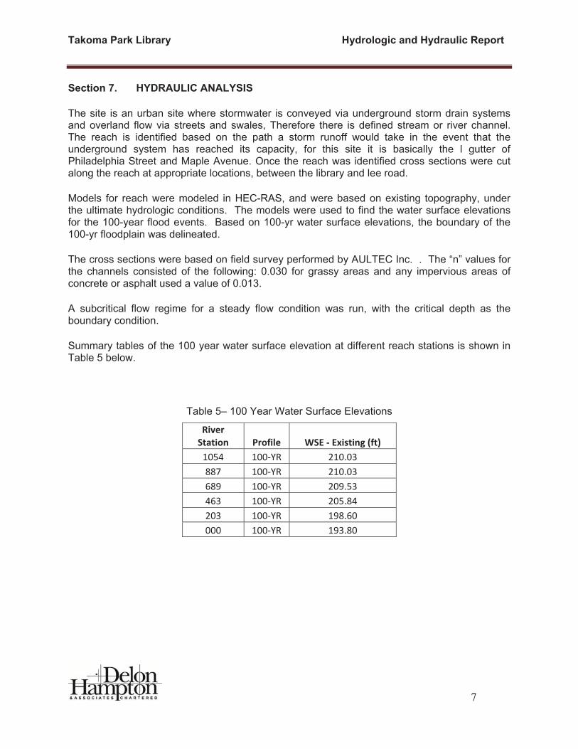
Section 7. HYDRAULIC ANALYSIS
The site is an urban site where stormwater is conveyed via underground storm drain systems and overland flow via streets and swales, Therefore there is defined stream or river channel. The reach is identified based on the path a storm runoff would take in the event that the underground system has reached its capacity, for this site it is basically the l gutter of Philadelphia Street and Maple Avenue. Once the reach was identified cross sections were cut along the reach at appropriate locations, between the library and lee road.
Models for reach were modeled in HEC-RAS, and were based on existing topography, under the ultimate hydrologic conditions. The models were used to find the water surface elevations for the 100-year flood events. Based on 100-yr water surface elevations, the boundary of the 100-yr floodplain was delineated.
The cross sections were based on field survey performed by AULTEC Inc. . The “n” values for the channels consisted of the following: 0.030 for grassy areas and any impervious areas of concrete or asphalt used a value of 0.013.
A subcritical flow regime for a steady flow condition was run, with the critical depth as the boundary condition.
Summary tables of the 100 year water surface elevation at different reach stations is shown in Table 5 below.
Table 5– 100 Year Water Surface Elevations
RiverStation Profile WSE Existing (ft)1054 100 YR 210.03887 100 YR 210.03689 100 YR 209.53463 100 YR 205.84203 100 YR 198.60000 100 YR 193.80

Takoma Park Library Hydrologic and Hydraulic Report
8
Section 8. CONCLUSIONS AND RECOMMENDATIONS
The analysis determines that there will be significant flooding between maple Avenue and cedar Avenue for the 100 year storm. The terrain of this triangular area to the south of the city hall is basically a low area without and overland flow relief. The water does not have a way out until the water surface reaches elevation of 209.2. It is then conveyed via Maple Avenue downstream towards the receiving water body. It appears that the natural flow regime has been altered in this area due to the construction of the street and buildings creating a sump situation.
This study is to set the result of the flood plain delineation as the existing condition 100 year flood plain elevation and the design of the future library addition will performed to avoid any impact to these elevations,
APPENDIX A – DRAINAGE AREA AND SOIL MAP


EXISTING CONDITIONS
GRAPHIC SCALE