impermanent architecture in a less - lost … · 1 3 impermanent architecture in a less permanent...
TRANSCRIPT

Impermanent Architecture in a Less Permanent Town: The Mid-Seventeenth-CenturyArchitecture of Providence, MarylandAuthor(s): Jason D. Moser, Al Luckenbach, Sherri M. Marsh, Donna WareSource: Perspectives in Vernacular Architecture, Vol. 9, Constructing Image, Identity, andPlace (2003), pp. 197-214Published by: Vernacular Architecture ForumStable URL: http://www.jstor.org/stable/3514434Accessed: 04/11/2010 13:06
Your use of the JSTOR archive indicates your acceptance of JSTOR's Terms and Conditions of Use, available athttp://www.jstor.org/page/info/about/policies/terms.jsp. JSTOR's Terms and Conditions of Use provides, in part, that unlessyou have obtained prior permission, you may not download an entire issue of a journal or multiple copies of articles, and youmay use content in the JSTOR archive only for your personal, non-commercial use.
Please contact the publisher regarding any further use of this work. Publisher contact information may be obtained athttp://www.jstor.org/action/showPublisher?publisherCode=vaf.
Each copy of any part of a JSTOR transmission must contain the same copyright notice that appears on the screen or printedpage of such transmission.
JSTOR is a not-for-profit service that helps scholars, researchers, and students discover, use, and build upon a wide range ofcontent in a trusted digital archive. We use information technology and tools to increase productivity and facilitate new formsof scholarship. For more information about JSTOR, please contact [email protected].
Vernacular Architecture Forum is collaborating with JSTOR to digitize, preserve and extend access toPerspectives in Vernacular Architecture.
http://www.jstor.org

1 3
IMPERMANENT ARCHITECTURE IN A LESS
PERMANENT TOWN
THE MID-SEVENTEENTH-CENTURY ARCHITECTURE OF PROVIDENCE, MARYLAND
JASON D. MOSER, AL LUCKENBACH, SHERRI M. MARSH, AND DONNA WARE
Introduction
During the seventeenth and eighteenth centuries, a number of town sites developed in the Chesapeake Tidewater of Maryland and Virginia only to ultimate-
ly disappear from the landscape. They are "lost towns," not in the sense that people have forgotten where they were, but because little if any of the archi- tecture that defined them survives above ground. Much of what might have been learned about build-
ing traditions, town planning, and town life disap- peared with their physical structures.
On the Western Shore of the Chesapeake Bay, a
long list of once-familiar names, like Calverton, Her-
rington, Providence, and London Town, have not
only now been forgotten but also have left little trace in the documentary records. Those Maryland town sites for which plat maps survive are few and lie
principally along the Eastern Shore.1 Virtually noth-
ing survived of the early housing stock that once defined these port towns.
Over the last decade, Anne Arundel County's Lost Towns Project, an archaeological and historical re- search program in Anne Arundel County, Maryland, has uncovered the remains of impermanent, or earth- fast, buildings in the "lost town" of Providence (1649- c. 1680s) (map 13.1). Neither "impermanent" nor "earthfast" hints at the variability exhibited by this once-common technology. This chapter presents a number of architectural findings from Providence, ex-
amining the archaeological evidence within the con- texts of current understandings of earthfast buildings and the town of which they were a part. Analysis of historic documents, archaeological floor plans and ar- chitectural artifacts suggest urban ambitions, as well

Eastern United ; States .-
Anne Arundel County, Maryland
0 250 500 Miles , I
Miles
Map 13.1. Providence, Anne Arundel County, Maryland, USA. Courtesy of Anne Arundel
County, Maryland, the Lost Towns Project.
,PROVIDENCE

Mordecai-Hammond
....:: i Homewoods Lot
3 :m i 5 [ * ~
. x, ;? , / ,??:' ^ :urles Town a? ^> , i: * Broadneck <A /,
@ A '
\ @(> J
?y9S , <|^>\ << Annapolis \
Town Neck
Map 13.2. General archaeological site locations for portions of Providence. Courtesy of Anne Arundel County, Mary- land, the Lost Towns Project.
0 4000 8000 Feet : :. . i :
N ,:A

MOSER, LUCKENBACH, MARSH, AND WARE
as local solutions to the technical and aesthetic con- siderations of housing in towns, real or envisioned.
Excavations conducted at four sites within the town of Providence provide the data for this analysis. Additional, supporting data will be drawn from a fifth house site located within the original bounds of Prov- idence but postdating the primary occupation of the town by nearly forty years (map 13.2). This site not
only provides additional information but also demon- strates the possible persistence of local seventeenth-
century vernacular building traditions into the first decades of the eighteenth century.
Methods in Earthfast Construction Earthfast construction refers to a variety of related
building techniques in which the lower framing mem- bers lie directly on the ground or are supported by earth-set wooden posts.2 In the seventeenth century these construction techniques arrived on the shores of the southern colonies, most likely adapted from a much earlier English building tradition.3 Used throughout the colonial period, the popularity, or desirability, of earth- fast construction started to wane in the eighteenth century. Chesapeake carpenters continued building earthfast structures until the end of the Civil War, but later examples are limited almost exclusively to barns and outbuildings.4
Architectural study of colonial buildings in the
Chesapeake has shown that more expensive tradition- al frame and brick buildings were not erected in
significant numbers until the second quarter of the eighteenth century,5 although at least two late-
seventeenth-century traditionally framed buildings, the Sands House and Holly Hill, still survive in Anne Arundel County, Maryland.6 Historians explain this late appearance of conventional framed buildings in the Chesapeake as a result of labor-intensive tobacco
farming combined with the short life expectancy of
early Chesapeake immigrants.7 Agricultural diversi- fication by planters in the 1720s and 1730s and shifts in the composition of the Chesapeake population re- sulted in the formation of a demographically stable
society. With increased social stability also came a
higher standard of living, and with this, more durable construction methods and materials.8
Many earthfast buildings employed a false-plate roofing system structurally independent of the wall frame. This separation of roof and wall systems ac- commodated differential settling and wracking com- mon in earthfast structures.9 Other research has shown that riven clapboards covered the exteriors, and in- terior walls often bore plastered lathing. Fenestra- tion included leaded casement windows, although other types of windows undoubtedly were used. Brick
chimneys were a rarity: wattle-and-daub exterior end
chimneys with brick hearths generally served the pur- pose. Floors were earth, wood, or-in a few instances -tile, with partial earthen cellars typically construct- ed beneath the wooden floors.
Compared with traditional English box framing and masonry, earthfast construction used a light, sim-
plified structural system, requiring less-skilled labor and coarser materials. Consequently, earthfast con- struction was more economical than other construc- tion techniques. The resulting product, however, was
considerably inferior and less permanent than other construction methods used at the time. Generally, the average life-span of an earthfast building was about twenty-five years, barring extraordinary main- tenance.10 "Earthfast" applies to a variety of coexistent
building methods more related in purpose (ease and
economy of construction) than in structural similari-
ty. Post-in-the-ground, or framed hole-set, buildings dominated this building tradition and consisted of three subtypes defined by how and in what order the
posts were erected. Most earthfast structures uncovered by archaeolo-
gists are framed hole-set, where posts were set two to four feet into the ground. Builders raised hole-set
buildings as preconstructed sidewall units, as paired posts, or bents, and as individual posts. Each of these methods leaves a distinctive archaeological footprint. Sidewall construction employed parallel lines of two or more postholes, the long axes of the holes perpen- dicular to the long axis of the building and the molds from the timber posts set against the inside edges of the holes. In profile, the postholes ordinarily are
stepped, the deepest part of the hole located closest to the building. The long axes of postholes for bent- raised structures parallel the building's long axis, and the deepest parts of the stepped holes tend to be lo-
I I 200

ARCHITECTURE OF PROVIDENCE, MARYLAND
cated at the same end of each hole, suggesting bent-
raising from one direction. In "Impermanent Archi- tecture in the Southern Colonies," Carson et al. have
suggested that independent post construction was the least sound and least common building technique. Such structures are readily identified by irregular, nonstepped postholes that may vary in shape and ori- entation within a single building. Postmold placement within the posthole varies as well.
Sill-on-ground construction constitutes another form of impermanent architecture. Builders rested continuous sills directly on the ground or embedded them in shallow trenches, tenoning the principal members and intermediate studs into the sills." Al-
though vulnerable to decay, sill-on-ground structures
repaired easily, particularly by using the third earthfast
technique: frame-on-block. This method elevated a continuous-sill structure on hole-set blocks. Frame- on-block structures share many similarities with sill-
on-ground type buildings, and some frame-on-block
buildings may have been attempts to salvage sill-on-
ground structures.'2 Architectural historians have documented only
three extant colonial earthfast houses in the Chesa-
peake region: Cedar Park and Sotterley, both post-in- ground buildings, in southern Maryland, and the Matthew Jones House in Virginia. Each of these struc- tures survived as a result of extensive alteration. Each
represents multiple phases of construction and repair that show the adaptability and ironically, the some- times permanence of impermanent architecture. These three buildings represent only a small fraction of the earthfast buildings that once dominated the
Chesapeake region. Most of the colonial Chesapeake's housing stock survives only as patterned stains in the subsoil and scatters of architectural artifacts. Archae-
ologists commonly encounter these structures on rural sites and, increasingly, on town sites such as Providence, Maryland.'3
The "Lost Town" of Providence A small group of Puritans from Virginia founded Providence, or Severn, in 1649, invited to Maryland by Governor William Stone. They settled along the Sev- ern River, near present-day Annapolis. In a context of
religious and political strife in the English world, and unsure of their future under the rule of the Catholic
proprietor, the Puritans occupied relatively small tracts in close proximity to one another for defense.
They initially envisioned Providence as a center for the fur trade and signed treaties to that end with the
Susquehannock tribe in 1652.14 Fur trading proved unsuccessful, however, and the Puritans soon turned to the economic mainstay of the Chesapeake, tobacco
production. Never a town in the modern colloquial sense of
the word, Providence nevertheless provided at least some of the social, political, and economic functions of a town.'5 That the Puritans regarded Providence as a town, or at least as a town in the making, is clearly evidenced by their designation of a "Town Path" and "Town Creek" and references to certain properties as "Town Lands."'6 In reality, Providence was little more than what anthropologists would call a "hamlet." A
grouping of homes, in this case, arranged around a
public center or structure. This form of dispersed settlement is not unique and sounds similar to Lord Baltimore's 1668 description of St. Mary's City, which also used a "town land" system. Writing over three de- cades after its initial settlement in 1634, Lord Baltimore described St. Mary's City: "The principal place or towne is called St. Maries where the General Assem- blies and Provincial court are kept... but it can hard-
ly be called a towne, it being in length by the water about five miles and in breadth upward toward the land not above six miles, in all which space, excepting my own house and buildings where in the said courts and public offices are kept, there are not above 30 houses and those at considerable distances from each other...." Providence probably had a somewhat simi- lar, dispersed appearance. A small hamlet comprised of a meetinghouse and several dozen widely dispersed houselots on small plantations, averaging from five to
fifty acres. Relations between the Protestant Providence set-
tlers and the Catholic proprietor soured quickly, and
open hostilities culminated in the Battle of the Severn on March 25, 1655. The resulting battle was an over-
whelming victory by the Providence forces, wrest-
ing power from Lord Baltimore's Maryland gov- ernment. The Puritans maintained control of the
I 201

MOSER, LUCKENBACH, MARSH, AND WARE
government until 1657, when power was returned to Lord Baltimore. The perceived threat from Lord Baltimore abated; the Puritans rapidly expanded their
holdings in Anne Arundel County or moved to new lands in Baltimore County and on the Eastern Shore of the Chesapeake. Providence, town or hamlet, ceased to exist, or, more accurately, a portion of its extent de-
veloped into a new locus called "Arundelton" (eventu- ally Anne Arundel Town, and finally Annapolis) on the western bank of the Severn River. By the 1680s the settlement's core on the Broadneck Peninsula began consolidating into large rural tobacco plantations.
Archaeology of Providence
Significant architectural data assembled from test ex- cavations is available for four Providence sites: Broad- neck (18AN818), Burle's Town Land (18AN826), Town Neck (18AN944), and Homewood's Lot
(18AN871).17 This chapter discusses these sites, as well as Mordecai Hammond's Addition (18AN943), an
early-eighteenth-century site, within Providence prop- er but postdating the primary occupation (map 13.2).
Broadneck Excavations in 1991, prior to the construction of a res- idential subdivision, led to the discovery of the Broad- neck site (18AN818), the earliest definitive evidence of
European occupation within Anne Arundel County. Located in an abandoned agricultural field, the site
occupied a slope at the head of a small cove on White- hall Bay, an embayment of the Chesapeake. Tempo- rally diagnostic artifacts indicate that the site was
occupied for a limited time, beginning around 1650, demonstrably among the earliest Providence sites set- tled. Few documents from this period of early settle- ment in the county survive, and intensive archival research has yet to identify the occupant.18
Archaeological excavations at the site revealed a cellar, a pit feature, several postholes, puncheon-set posts, and the possible evidence of sills.19 The most
prominent remains, the cellar and the pit feature, were located thirty feet apart, and measured ten by six feet and six by three feet, respectively (fig. 13.1). A group of small puncheon set posts farther up-slope may
demarcate the location of a small outbuilding.20 Two small, shallow features, devoid of artifacts, were dis- covered in a line running perpendicular to the main cellar and exactly five feet away from the side of the main cellar. These features were interpreted as evi- dence for a sill-on-ground constructed building. The location of the pit features within the footprint of the
building implies the presence of a wooden floor. Ash and burned daub from the cellar deposits suggests a
single wattle-and-daub chimney on the west gable- end of the building. Additionally, large quantities of daub recovered from across the site suggest that the
principal building at the Broadneck site may have pos- sessed wattle-and-daub walls or may have been a log structure sealed with clay chinking.
Excavations at the Broadneck site reveal evidence of a number of architectural features used in one of the earliest buildings in the county. However, more il-
luminating is the lack of certain architectural details. Neither window leads nor window quarrel fragments were recovered, suggesting shuttered windows.2' In ad- dition, the low numbers of hand-wrought nails recov- ered supports the theory that the building was of a wattle-and-daub wall construction, possibly with a thatched roof. Evidence of thatched roofs in the Chesa-
peake is sparse, but examples have been documented.22
Pegged shingle roofs are also known. The Broad- neck site appears to have been a two- or three-room
/ /-, ' ^. Conjectured Waul
-/ c--
0 15
roadeck 8AN18 Broadneck 18AN818
Fig. 13.1. Plan view of features at Broadneck site (18AN818). Courtesy of Anne Arundel County, Mary- land, the Lost Towns Project.
I I I 202

ARCHITECTURE OF PROVIDENCE, MARYLAND
0
1
2
3
4
5
6
7
8
Fig. 13.2. Profile of cellar at Town Neck site (18AN944). Courtesy of Anne Arundel County, Maryland, the Lost Towns Project.
building approximately thirty-six to forty feet in length and sixteen feet in width. Given the evidence of a
single gable-end chimney, only one room was heated. The artifact assemblage from Broadneck indicates
that the site was occupied for only a short duration. This structure may relate to the first generation of
building activity at Providence. A 1684 pamphlet pro- moting colonization of Pennsylvania describes a house "30 feet long and 18 feet wide, with one parti- tion near the middle and another to divide one end into two smaller rooms," and one which usually lasted ten years without repair.23 Referencing to the same
pamphlet, Carson et al. (1981) noted that "it is per- haps more likely that the pamphleteer was remember-
ing houses in which the studs, too, were buried in holes or trenches or were fastened to unframed
lengths of sill beam laid in slots in the ground." The
description approximates the interpretation of the
principal structure at Broadneck.24 The short length of
occupation and the relatively crude construction sug- gest that the Broadneck site buildings date to the ini-
tial phase of settlement at Providence. Structures un- covered at other Providence sites contrast markedly with the architecture at Broadneck.
Town Neck The Town Neck site (18AN944) was located during sediment trap excavations associated with construction of athletic facilities at the Naval Radio Transmitter Fa-
cility on Greenbury Point. Further investigation re- vealed that the Navy construction crew had cut through a seventeenth-century cellar (fig. 13.2). The site is lo- cated on peninsula near the mouth of Carr Creek, a tidal tributary of the Severn River. Salvage excavations were conducted by the Anne Arundel County archaeol-
ogy program and by KCI Technologies, a private firm under contract to the Department of the Navy.
Richard Bennett and eight other individuals set- tled portions of this peninsula "for their Mutual Secu-
rity" between 1649 and 1658.25 In 1658, Bennett, by this time the sole owner the entire tract deeded the
property to Nathaniel Utie, secretary to Governor
-- --- - - --- - - - -- --- - - I --- - - -- 203

MOSER, LUCKENBACH, MARSH, AND WARE
Fig. 13.3. Dodekop staining from yellow brick header recovered at Town Neck site (18AN944). Courtesy of Anne Arundel County, Maryland, the Lost Towns Project.
Stone, who patented it as Towne Neck. In November 1661, Utie sold the property to William Pennington, who sold it a month later to Ralph Williams, a Bristol merchant and a magistrate of Anne Arundel County. Williams held the 250-acre Town Neck tract until his death in 1673, after which the property was conveyed to his heirs, then to Edwin Perrin in 1685, and finally transferred to Nicholas Greenbury, who named the
property Greenberry's Point. Temporally diagnostic artifacts recovered from the site indicate the property was occupied from at least about 1660 until the 1680s, when the structure was destroyed by fire.
Excavations were limited in scope but provided a
great deal of architectural evidence. The most notable feature was a timber-lined cellar or half-cellar (Feature 1), probably twelve by fifteen feet in plan and eight feet in depth (fig. 13.2). In addition to the cellar, several other architectural features were documented, includ-
ing three postholes and a large refuse pit, interpreted by the excavators as a trash-filled borrow pit.26 Because of the limited scope of these excavations, the floor plan of the Town Neck structure remains unknown; how- ever, significant information can be derived about the
finishing and appurtenances of this building. Excavators observed more brick at Town Neck than
at any other Providence site. Recovered samples includ- ed an English-standard sized red brick and three vari- eties of yellow brick. Quantities of quartzite foundation
stones were also noted. Typical seventeenth-century yellow bricks are hard klinker varieties imported from the Netherlands. Because of their resistance to high temperature, these bricks typically were used for fire- boxes. The three varieties of yellow brick recovered from the Town Neck site also included softer Dutch
moppen construction brick, and a third, larger type of unknown derivation. A number of examples exhibited evidence of dodekop staining, an iron oxide stain ap- plied for decorative effect (fig. 13.3). Joseph Sopko identified similar staining at the Fort Orange site Al-
bany, New York.27 Sopko suggests that dodekop stained brick was used to create decorative brickwork patterns typical of Dutch brickwork or, alternatively, as an at-
tempt to blend yellow bricks with red.28 At Town Neck, the combination of red and yellow
brick with the building stones probably represents the remains of a substantial and notably decorative brick
chimney stack seated on a stone base. The quantity of brick observed during excavations may even have been sufficient to represent the remains of decorative brick gable ends.29
Other artifacts recovered from the excavations at Town Neck indicate the use of leaded casemate win- dows. Two window lead fragments bear the name of the English glazier Frances Good and are dated 1661.30 Also recovered were a number of yellow and green lead-glazed estrikken floor tiles, discussed in more de-
204

ARCHITECTURE OF PROVIDENCE, MARYLAND
tail below (fig. 13.4). These architectural artifacts sug- gest that the building displayed a high degree of finished and decorative detail not typically found on most mid-seventeenth-century Chesapeake sites. The builders imported the windows, yellow bricks, and floor tiles from Europe. Based on form and materials, the bricks and the floor tiles are Dutch. As will be dis- cussed, excavations of Robert Burle's residence (c. 1649), another nearby Providence site, Homewood's Lot, and Mordecai Hammond's Addition also reveal the existence of Chesapeake earthfast framing utilizing Dutch imported finishing materials, a housing stan- dard atypical of the Chesapeake building tradition.
Burle's Town Land Robert Burle, county surveyor, patented one hundred acres called Burle's Town Land in 1663. Although patented late, artifacts recovered from the site support an earlier construction date possibly as early as 1650. He lived there until his death in 1676, leaving the
plantation to his youngest daughter, Rebecca. Rebecca
Fig. 13.4. Estrikken tiles recovered at the Town Neck site (18AN944). Courtesy of Anne Arundel County, Mary- land, the Lost Towns Project.
Burle married Humphrey Boone in 1680, and the
couple seems to have moved their household to Boone's land in the northern part of Anne Arundel
County, effectively abandoning the Burle homelot. The nature of the archaeological excavations at the
Burle site was quite different than that seen at Broad- neck and Town Neck. The latter were both limited
salvage investigations designed to collect as much in- formation as possible within a narrow time frame. Ex- cavations at the Burle's Town Land site, however, were extensive and systematic, consisting of over 225 five-
by-five-foot excavation units conducted over a period of years (fig. 13.5). This sample size provides a context that neither the materials from Broadneck nor Town Neck are capable of providing.
Situated at the head of a small drainage on a ter- race overlooking Mill Creek, Burle's Town Land lies
partly within a plowed field and partly within an eigh- teenth- to nineteenth-century family cemetery. Grave- shafts have disturbed seventeenth-century deposits, damaging some portions of the principal dwelling.
Fig. 13.5. Plan view of excavations at the Burle's Town Land site (18AN826). Courtesy of Anne Arundel County, Maryland, the Lost Towns Project.
205

MOSER, LUCKENBACH, MARSH, AND WARE
However, because the core of the site lies within this
cemetery, large areas have escaped plowing. A second
building or enclosure, found in the plowed field, es-
caped damage from grave digging but remains only partially delineated by excavation.
The principal dwelling measured roughly sixty by twenty feet and had three rooms, or possibly six, de-
pending on the interpretation. The structure appears to have consisted of two sections, each an inverted mirror image of the other (fig. 13.5). Both were con- structed simultaneously during period one. Each sec- tion had an interior wattle-and-daub chimney located
along the west and east walls. Gable-end wattle- and-daub chimneys would have been more typical of
seventeenth-century-Chesapeake architecture. Dutch
yellow klinker bricks were used to complete the fire- box. The vertical support posts were likely raised in
pairs using bent construction, and tied into an inter-
rupted sill. The exterior most likely was riven clap- board, while burned daub impressions and lath nails indicate interior split lathing. Other areas of the build-
ing incorporate more unconventional materials.
Large quantities of red clay "pantiles," or roofing tiles, apparently of Dutch origin, were found across the site. Computer simulation mapping of the tile
fragment distributions demonstrate that at least the northern half of this "duplex" was roofed with pan- tiles. However, lower amounts recovered in the south- ern portion may only be the result of plowing in this area. Pantiles have been found at few seventeenth-
century Chesapeake sites, and these were predomi- nately brick public buildings.31
Like at the Town Neck site, fragments of estrikken tiles-red bodied earthenware floor tiles with white
slip under green or yellow glaze-were also recovered at Burle.32 Equal numbers of green and yellow tile
fragments were excavated, suggesting alternating col- ors of either a "checkerboard "or a "striped" pattern arrangement. Paintings by Vermeer and De Hooch, and other seventeenth-century Dutch genre painters, illustrate the use of such tiles in scenes of Dutch domestic life. Several paintings in particular show checkerboard patterns (fig. 13.6). The exact placement of the tiles is open to speculation, but they seem to be located directly in front of the hearths.
Fig. 13.6. Nicolaes Maes, Interior with a Sleeping Maid and Her Mistress (The Idle Servant) illustrating the green and yellow estrikken floor tiles, c. 1655. Courtesy of the National Gallery, London, England.
Robert Burle's house also utilized blue and white Dutch tin-glaze earthenware, or "delft" tiles, as either
fireplace surrounds or, less likely, baseboards or chair rails. The one identifiable fragment found at the Burle site depicts a portion of a soldier, modeled after the engravings from De Gheyns's Exercise of Armes (1609), an important and influential early-seventeenth- century military manual (fig. 13.7).33 Similar Dutch tiles have been recovered from a number of other
seventeenth-century sites. Examples include St. John's, van Sweringen's "Council Chamber," the Country House, and Smith's Town Land at St. Mary's City, Maryland, Jamestown, Virginia, Dutch Manhattan, and Fort Orange, New York.34
Two marked window cames were recovered from the Burle site, as well as a nearly intact quarrel with
206

ARCHITECTURE OF PROVIDENCE, MARYLAND
Fig. 13.7. Portion of tin-glazed earthenware tile recovered at the Burle site. Courtesy of Anne Arun- del County, Maryland, the Lost Towns Project.
glazing, indicating the presence of leaded casement windows. One marked window lead bears the letters RICHAR-. Hanna, Knight, and Egan (1992), suggest that these letters are possibly the mark of Richard Holland, an English glazier.35 The second mark con- tains the fragmentary inscription "-SON of BRIS-."
This is the mark of John Mason of Bristol, England, for which the only known associated date is 1647.36 This approximates the circa 1650 assumed construc- tion date for the Burle's Town Land site.
The extensive use of Dutch materials (including a
variety of lead-glazed earthenware floor tiles, tin-
glazed earthen decorative tiles, pantiles, and yellow bricks) and glazed casement windows suggest a well-
appointed dwelling unrivaled in Providence, and per- haps on a par with anything else in Maryland. The
relatively small quantities of these materials actually recovered from the Burle site, and the paucity of ar- chitectural hardware, probably indicate an extensive
salvage of building materials following the abandon- ment of the building.
Homewood's Lot Homewood's Lot (18AN871), also called Belfield Farms, is the location of the fourth Providence ar-
chaeological site for which substantial clues about the
original architecture currently exists. Evidence from the seventeenth-century component of the site further refines the chronology of settlement, occupation, and vernacular architectural forms relating to the town of Providence.
This complex site located overlooking Whitehall Creek was occupied almost continuously from the mid-seventeenth century through the present. In 1650, the first property owner James Homewood had the property surveyed into a 210-acre tract called Homewood's Lot. The property remained within the
family for the next eighty-one years until it was resur-
veyed in 1731, incorporating additional tracts totaling 1,392 acres.
Excavation of forty-one five-by-five-foot test units revealed a diversity of architectural features from as
many as six distinct buildings, many of which can be associated with seventeenth- and eighteenth-century occupations. These overlapping chronological and
spatial sequences generated significant difficulties in site interpretation. As a result of these difficulties, dis- cussion of the site within the context of this chapter is
largely limited to the structure incorporating Feature 30, one of the earliest site components.
Feature 30 is a ten-by-six-foot cellar/pit approxi- mately two and a half feet in depth. Paralleling the cel- lar was the remains of a linear feature containing ironstone debris (a naturally occurring ferrous rock). Although clearly linear in plan, the surviving portion of the trench was irregular and in some cases indis- tinct from surrounding subsoil. At one end of the cel- lar was a dark U-shaped stain (Feature 33) enclosing the burn area of the hearth. A cross-section of one
portion the hearth feature revealed a clear half-round
profile that extended approximately .3 feet into the subsoil. Though ambiguous, this trench is interpreted as the remains of the bottom half of a sill-on-ground earthfast chimney base.
The dimensions of the structure itself would have been approximately eight by twelve feet, with a
single gable chimney projecting from the north end.
207

MOSER, LUCKENBACH, MARSH, AND WARE
Diagnostic artifacts from the cellar include ceramics and tobacco pipe fragments that indicate that it was filled beginning in the 1660s and probably abandoned well before 1670. The cellar was filled relatively rapid- ly with large quantities of active fireplace ash deposits, and a remarkable quantity of faunal material, espe- cially fish bone. A single leaded window came dated 1661 was recovered at the base of the cellar/pit and
provides a terminus post quem for the filling of the cel- lar but not for its construction.
The dated window came is interpreted as con- struction debris from a nearby, unexcavated building. Other materials recovered from the Feature 30 cellar
supporting the existence of a clearly more elaborate
building include moppen yellow brick, a single frag-
ment of green estrikken floor tile, a large unglazed floor tile, and large quantities of hand wrought nails. The plowzone also produced large quantities of Dutch
pantile fragments that may relate to another unexca- vated building.
The building encompassing Feature 30 is consid- ered one of the earliest structures yet found in Provi- dence. Interestingly, it most closely resembles the Broadneck site in that it possessed a sill that was either
ground laid or supported by a crude ironstone base. The presence of another mid-seventeenth-century
structure at Homewood's is clearly indicated by the construction debris encountered. It clearly contained the same Dutch trait bundle seen with the finishings at Burle's Town Land.
Mordecai Hammond's Addition
18AN943 0 10
Feet
Conjectured Wall
/
Fig. 13.8. Plan View of Mordecai Hammond's Addition site (18AN943). Courtesy of Anne Arundel County, Maryland, the Lost Towns Project.
I I I 208

ARCHITECTURE OF PROVIDENCE, MARYLAND
Mordecai Hammond's Addition In the spring of 1993, construction activity led to the
discovery and salvage of the Mordecai Hammond's Addition site (18AN943). Unlike the sites discussed above, Hammond's Addition is not considered a part of the initial settlement at Providence, although it was located in the Providence locale. Hammond's Addi- tion probably was constructed about 1719, almost
forty years after the disappearance of the town. Tem-
porally diagnostic artifacts indicate that the structure was occupied between about 1720 and the 1780s. After its abandonment, the chimney toppled, falling
into the interior of the building. Plowing destroyed only the uppermost exterior face of the chimney, while much of the articulated lower exterior of the
chimney survived. Interestingly, the firebox and chim-
ney stack combined red and yellow bricks in a manner not only functional but also decorative, with alternat-
ing bands of yellow and red. The structure itself measured sixteen by twenty-
four feet, with sills laid on native ironstone founda- tions (fig. 13.8). The firebox and chimney were the most interesting architectural elements at Hammond's Addition (fig. 13.9). The firebox was constructed with
/ / Detail of Stack / /
/ / / /
/ /
//
/ / 0 5 / /
Feet / / / /
Fig. 13.9. Detail of the chimney stack at Mordecai Hammond's Addition site (18AN943). Courtesy of Anne Arundel County, Maryland, the Lost Towns Project.
I 209
MOSER, LUCKENBACH, MARSH, AND WARE
courses of large red brick stretchers alternating with courses of Dutch yellow klinker bricks laid on edge in rowlock fashion.37 The remaining length of yellow rowlock bricks projected into the interior of the firebox. Yellow bricks were then mortared into the in- terior rowlock bricks on their stretcher edges, forming an interior entirely faced with yellow brick, and an ex- terior of horizontal red and yellow stripes.
Twenty-six courses of articulated brick from the
chimney stack were also excavated. In this case, two red brick stretchers and a half-yellow brick on edge, as a "queen closer," formed each course. Bricks in the ad-
jacent courses were laid in the reverse pattern, form-
ing a square stack approximately twenty-four by twenty-four inches. There is no indication that the
building materials used at Hammond's Addition were
salvaged from another site. This uncommon use of brick fulfilled both func-
tional and aesthetic considerations. The only other ex-
amples of horizontal red and yellow striped masonry
Fig. 13.10. Pieter de Hooch, The Courtyard of a House in Delft, illustrating decorative archway, 1658. Courtesy of the National Gallery, London, England.
of which the authors are aware occur in Christiana, Norway. One building built in 1714, and located at
building number 213, in Dronningenst 15, is the old- est example of its use within the town.38 Builders in the city attempted to emulate this style, even painting timber buildings to achieve the same effect. Many of the builders of Christiana were reputed to be workers
imported from Denmark or Germany. Whether this includes Dutch workers is unknown.
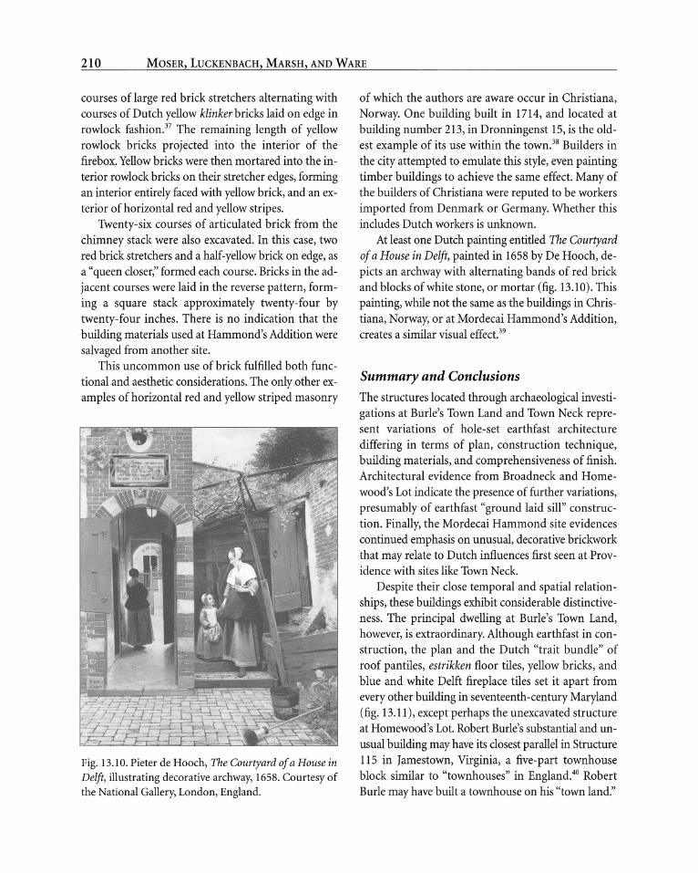
At least one Dutch painting entitled The Courtyard of a House in Delft, painted in 1658 by De Hooch, de-
picts an archway with alternating bands of red brick and blocks of white stone, or mortar (fig. 13.10). This
painting, while not the same as the buildings in Chris- tiana, Norway, or at Mordecai Hammond's Addition, creates a similar visual effect.39
Summary and Conclusions The structures located through archaeological investi-
gations at Burle's Town Land and Town Neck repre- sent variations of hole-set earthfast architecture
differing in terms of plan, construction technique, building materials, and comprehensiveness of finish. Architectural evidence from Broadneck and Home- wood's Lot indicate the presence of further variations, presumably of earthfast "ground laid sill" construc- tion. Finally, the Mordecai Hammond site evidences continued emphasis on unusual, decorative brickwork that may relate to Dutch influences first seen at Prov- idence with sites like Town Neck.
Despite their close temporal and spatial relation-
ships, these buildings exhibit considerable distinctive- ness. The principal dwelling at Burle's Town Land, however, is extraordinary. Although earthfast in con- struction, the plan and the Dutch "trait bundle" of roof pantiles, estrikken floor tiles, yellow bricks, and blue and white Delft fireplace tiles set it apart from
every other building in seventeenth-century Maryland (fig. 13.11), except perhaps the unexcavated structure at Homewood's Lot. Robert Burle's substantial and un- usual building may have its closest parallel in Structure 115 in Jamestown, Virginia, a five-part townhouse block similar to "townhouses" in England.40 Robert Burle may have built a townhouse on his "town land."
210

ARCHITECTURE OF PROVIDENCE, MARYLAND
Fig. 13.11. Artist's reconstruction of Robert Burle house based on archaeological evidence. Courtesy of animators Tracy Corder and Carl Gehrman.
The architectural materials recovered from Town Neck also suggest sophisticated finishing detail. While Town Neck did not possess a tiled roof, it had a po- tentially elaborate brick chimney, or possibly a brick
gable end, and a substantial wood-lined cellar. Such finds from the excavations at Providence are
clear evidence that Chesapeake, and presumably Eng- lish, architectural traditions were hybridized with ex- tensive Dutch finishings. This is perhaps attributable to Puritan/Protestant connections with the Nether- lands during this period.41 The artifacts recovered from Providence indicate extensive Dutch trade con- nections. This is supported by documentary evidence from the Dutch Notarial Acts, which indicate Chesa-
peake planters engaged in a substantial trade with Amsterdam and Rotterdam, between 1620 and 1653.42 In 1648, over 35 percent of the vessels trading to the
Chesapeake were from the Netherlands.43 In addition
to Dutch building materials, excavations at Providence have recovered numerous examples of Dutch utilitar- ian goods such as tobacco pipes and ceramics. The
presence of refined Dutch building materials and a
Chesapeake earthfast framing tradition suggest a
unique blend of architectural styles forming a distinct vernacular tradition at Providence.
Portions of this "Providence" building tradition
may have persisted locally into the early eighteenth cen-
tury. Evidence supporting this is inconclusive; however, excavations at Mordecai Hammond's Addition docu- ment an unusual type of decorative brickwork that may have origins in earlier Dutch masonry styles. This brickwork may also relate to similar examples found in Christiana, Norway, the earliest of which dates to about 1714, predating the construction of Hammond's Addi- tion by approximately six years. Red brick and several varieties of yellow brick recovered from Town Neck
211

MOSER, LUCKENBACH, MARSH, AND WARE
(including some with dodekop staining) suggest some form of masonry patterning on chimneys in the same
region nearly seventy years before. Not surprisingly, the architectural survey of stand-
ing structures in the Providence area has failed to lo- cate any extant examples of buildings dating to the seventeenth or even to the first half of the eighteenth centuries. Intensive archival research, although suc- cessful in reconstructing the general layout of Prov- idence, has been able to yield few details about domestic, commercial, or industrial architecture. Ar-
chaeological excavation and analyses have proven to be the only means of studying early Providence archi- tecture which, to date, has all been earthfast. The re- sults, however, do not fully conform to the paradigms concerning this construction type that have developed over the past twenty years.
Given the known conventions of earthfast con- struction, Providence households appear to express far more variability than might be expected. Such
finishing materials as roofing and floor tiles, and even decorative fireplace surround tiles, seem to belie the
interpretation of earthfast buildings as impermanent structures intended to last no more than a generation in a swidden-based agricultural system. Archaeologi- cal investigations of the dwelling houses of Robert Burle, and Ralph Williams beg the question: why were their dwellings so elegantly finished while those
Notes
1. Dennis J. Pogue, "Calverton, Calvert County, Mary- land: 1668-1725," Maryland Historical Magazine 80 (1985): 271-76; John W. Reps, Tidewater Towns: City Planning in
Colonial Virginia and Maryland (Williamsburg, Va.: Colo-
nial Williamsburg Foundation, 1972); Joseph B. Thomas,
Settlement, Community, and Economy: The Development of Towns on Maryland's Lower Eastern Shore, 1660-1775, Vol-
umes in Historical Archaeology 38, ed. Stanley South, South
Carolina Institute of Archaeology and Anthropology (Co- lumbia: University of South Carolina, 1997).
2. Carl R. Lounsbury, ed., A Glossary of Early Southern Architecture and Landscape (New York: Oxford Univ. Press,
1993), 126.
of most other Chesapeake inhabitants, including members of the planter elite, were not? Perhaps Robert Burle and Ralph Williams envisioned a town reminiscent of those in Great Britain. The very names of their lands convey an optimism for urbanity. Burle's household on Burle's Town Land and Ralph Williams's Town Neck both imply if not the presence of town, then at least aspirations for a formal town.
Perhaps they thought their "town lands" would even-
tually stand in the middle of a densely populated urban center.
The architectural variability of Providence sug- gests its inhabitants achieved some of their urban ambitions, though perhaps not the cosmopolitan prospects they initially imagined. Providence, at least the portion of Providence north of the Severn River, never developed into more than a dispersed hamlet. After the 1680s, as the population of town core de- clined, the focus of urban settlement shifted to the south side of the Severn River. The general assembly designated as an official port of entry in 1669, that
part of Providence south of the Severn River. Named Arundelton, and later Anne Arundel Town, this area was the direct predecessor of the town of Annapolis. It was here the spatial organization, specialization, com- mercial prominence, craft-specialization, and admin- istrative importance first envisioned by the original Providence settlers were achieved.
3. Cary Carson, Norman F. Barka, William M. Kelso,
Garry Wheeler Stone, and Dell Upton, "Impermanent Ar-
chitecture in Southern American Colonies," Winterthur
Portfolio 16 (Summer/Autumn 1981): 138.
4. Lounsbury, Glossary, 126; Carson et al., "Imperma- nent Architecture," 174-75.
5. H. J. Heikkenen and Mark R. Edwards, "The Key- Year Dendrochronology Technique and Its Application in
Dating Historic Structures in Maryland," Bulletin of the As- sociation for Preservation Technology 25(3): 3-25.
6. Donna M. Ware, Anne Arundel's Legacy: The Historic
Properties of Anne Arundel County (Annapolis, Md.: Anne
Arundel County Office of Planning and Zoning, 1990).
I I I 212

ARCHITECTURE OF PROVIDENCE, MARYLAND
7. Lorena Walsh, "'Till Death Us Do Part': Marriage and
Family in Seventeenth-Century Maryland," in The Chesa-
peake in the Seventeenth Century: Essays on Anglo-American Society (New York: Norton, 1979), 128.
8. Carson et al., "Impermanent Architecture," 171. 9. Dell Upton, "Early Vernacular Architecture in South-
eastern Virginia" (Ph.D. diss., Brown Univ.), 1981. 10. Carson et al., "Impermanent Architecture," 141. 11. Upton, "Early Vernacular Architecture." 12. Carson et al., "Impermanent Architecture," 153. 13. Carson et al., "Impermanent Architecture"; Henry
M. Miller, Discovering Maryland's First City: A Summary Report on the 1981-1984 Archaeological Excavations at St. Mary's City, St. Mary's City Archaeology Series No. 2
(St. Mary's City, Md.: St. Mary's City Commission, 1986); Fraser D. Neiman, "An Evolutionary Approach to Archaeo-
logical Inference: Aspects of Architectural Variation in the
17th-Century Chesapeake" (Ph.D. diss., Yale Univ., 1990). 14. Al Luckenbach, Providence 1649: The History and Ar-
chaeology ofAnne Arundel County Maryland's First European Settlement (Annapolis: Maryland State Archives and the
Maryland Historical Trust, 1995). 15. See Pogue, "Calverton, Calvert County, Maryland,"
on defining towns in terms of function, rather than popula- tion density.
16. See Luckenbach, Providence 1649. 17. Registered archaeological sites are number based on
the U.S. National Museum system. In the trinomial desig- nation system, 18 is for Maryland, AN stands for Anne Arundel County, and 826 refers to the specific site number.
18. Most surviving documents postdate the restoration of power to Lord Baltimore.
19. The postholes are interpreted as associated with a
nearby mid-eighteenth-century site. 20. Puncheon set posts, or a series of closely placed posts
driven directly into the ground, are uncommon in the
Chesapeake region. For further description of puncheon set
posts, see Carson et al., "Impermanent Architecture," 148. 21. This may also partially be the result of the deflated
nature of the archaeological deposits. 22. Orlando Ridout V, personal communication with au-
thor, Mar. 11,1999. The use of thatched roofs in the Chesa-
peake is documented as early as the journals of Capt. John Smith and could be found on Virginia's eastern shore in
1640, Kent County in 1656, and Somerset County in 1682.
Some examples of thatched roofs have been documented as late as the twentieth century.
23. Carson et al., "Impermanent Architecture," 141.
24. Ibid. 25. Alan D. Beauregard, Al Luckenbach, Anthony
Lindauer, and James Kodlick, Phase IIArchaeological Evalu-
ation: The Ralph Williams Site (18AN944), Athletic Facilities Construction Project Naval Radio Transmitter Facility An-
napolis, Anne Arundel County, Maryland, Report to the United States Naval Academy, Annapolis, Md. (Mechanics-
burg, Pa.: KCI Technologies, 1994), 32. 26. Beauregard et al., Phase II Archaeological Evalua-
tion, 55. 27. M. J. Becker, "'Swedish' Colonial Yellow Bricks: Notes
on Their Uses and Possible Origins in 17th Century Amer-
ica," Historical Archaeology 11 (1977): 114; and Joseph S.
Sopko, An Analysis of Dutch Bricks from a 17th Century Structure within the Site of Fort Orange at Albany, New York
(Waterford: New York State Parks, Recreation and Historic Preservation Bureau of Historic Sites, 1982), 37.
28. Sopko, Analysis of Dutch Bricks, 37. 29. The presence of large quantities of brick probably in-
dicate that building materials were not salvaged from the
site following its destruction. 30. Beauregard et al., Phase II Archaeological Evalua-
tion, 69.
31. Silas D. Hurry, Masonry Roof Tile from the St. John's Site (18ST1-23) in St. Mary's City, Maryland, unpublished manuscript, St. Mary's City Commission (1980), 5-10.
Fragments of pantile roofs have been recovered from exca- vations at Jamestown, Virginia, and St. Mary's City, Mary- land, including the State House, St. Johns site, and the
Mattapony-Sewell site. All were occupied by prominent in-
dividuals, including the Calvert family. 32. Paul R. Huey, Archaeological Testing at Philipse Manor
Hall, Yonkers, N.Y. (Waterford: New York State Office of Parks, Recreation and Historic Preservation Research Unit, Bureau of Historic Sites, 1996), 9. Two Friesland archives documents dated 1614 and 1662 describe floors paved with yellow and
green glazed tiles called estrikken. These tiles were more com- mon in Friesland and less common in North Holland.
33. J. B. Kist, Jacob De Gheyn: The Exercise ofArmes (New York: McGraw-Hill, 1971).
34. Gary Wheeler Stone, Seventeenth-Century Wall Tile
from the St. Mary's City Excavations, 1971-1985, St. Mary's
I 213

MOSER, LUCKENBACH, MARSH, AND WARE
City Research Series No. 3 (St. Mary's City: Historic St.
Mary's City, St. Mary's County, Maryland, 1987), 1-2.
35. Susan Hanna, Barry Knight, and Geoff Egan, "Marked
Window Leads from North America and Europe," unpub- lished manuscript, Historic St. Mary's City, Maryland, 1992.
36. Al Luckenbach and James G. Gibb, "Dated Window
Leads from Colonial Sites in Anne Arundel County, Mary- land," Maryland Archeology 30, no. 2 (Sept. 1994): 23-28.
37. Al Luckenbach, "The Excavation of an 18th-Century Dutch Yellow Brick Firebox and Chimney Stack in Anne
Arundel County, Maryland," Maryland Archeology 30, no. 2
(Sept. 1994): 9-22.
38. Letter and photographs from Patricia Reynolds, July 11, 1995.
39. Donna R. Barnes and the Hofstra Museum, The Butch-
er, the Baker, the Candlestick Maker: Jan Luyken's Mirrors of
17th-Century Dutch Daily Life (Hempstead, N.Y.: Hofstra
Museum, Hofstra University, 1995), catalog for an exhibition of drawings and prints at the Emily Lowe Gallery, 17 Sep- tember-31 October 1995, curated by Donna R. Barnes, Ed.E.,
reports on p. 37 that Bentheim sandstone from Germany and
Italian marble were also used for facade ornamentation.
40. John L. Cotter, Archeological Excavations at James-
town, Virginia, rev. ed. (Richmond, Va.: Archaeological
Society of Virginia, 1994), 121-29; and Edward Chappell, Colonial Williamsburg Foundation, personal communica-
tion with author, 1998. 41. James G. Gibb and Al Luckenbach, Ceramic and To-
bacco Pipe Seriations of Five 17th Century Domestic Sites in
Anne Arundel County, Maryland. Anne Arundel County's Lost Towns Project, Annapolis, Maryland. Submitted to the
Maryland State Highway Administration, Baltimore, Mary- land, 1997, 19.
42. Jan Kupp, "Dutch Notarial Acts Relating to the To-
bacco Trade of Virginia, 1608-1653," William and Mary
Quarterly 30(4): 653-55. 43. Sopko, Analysis of Dutch Bricks; Jan Kupp, "Dutch
Notarial Acts Relating to the Tobacco Trade of Virginia; Karina Paape, "From Nansemond to Providence: The
Quest for Piety and Profit in the Seventeenth-Century
Chesapeake" (master's thesis, Univ. of Maryland-Baltimore
County, 1997), 8-9; Sopko reports that most Dutch sailing vessels used "Dutch" yellow brick as ballast, which could
be sold with the cargo. He suggests that the frequent Dutch trade vessels arriving in the settlement may have
supplied a sufficient quantity of yellow brick for use in
construction during the early years (Analysis of Dutch
Bricks, 46-48).
I I I 214