information depicted on this map is for planning purposes
TRANSCRIPT
ConnecticutRhode Island
Blackstone River Bikeway
Mass Central Rail Trail
Mid-State Trail
Wachusett Reservoir
Quabbin Reservoir
Webster Lake
Sudbury Reservoir
Quaboag Pond
Pottapaug Pond
Whitehall Reservoir
Lake Quinsigamond
Bare Hill Pond
Manchaug Pond
Singletary Pond
Stiles Reservoir
Whitin Reservoir
Wickaboag Pond
Pine Hill Reservoir
Lake Lashaway
Gore Pond
Indian Lake
Flint Pond
Assabet River Reservoir
Chauncy Lake
Quinapoxet Reservoir
Hamilton Reservoir
Quaboag River
Mare Meadow Reservoir
Granite Reservoir
Quacumquasit Pond
Fort Meadow Reservoir
Wachusett Reservoir
East Waushacum Pond
Framingham Reservoir #1
North Pond: Lake Maspeno
Alum Pond: Big Alum Pond
Brooks Pond: Sapphire Pond
Dark Brook Reservoir [U.B.]
Wyman Pond: Grassy Pond
§̈¦90
§̈¦395
§̈¦190
§̈¦290
§̈¦84
§̈¦495
§̈¦190
§̈¦90
§̈¦495
§̈¦395
§̈¦84
§̈¦90
§̈¦90
§̈¦290
§̈¦495
§̈¦495
SNETT
Alt 1Trail
Dresser Hill Trail
Blackstone River Bikeway
Mass Central Rail Trail
Mid-State Trail
Grand Trunk Trail
Ware River Rail Trail
County Roads Walk
Alt 4 Trail
Aqueduct Trail
Alt #5
Grafton & Upton Rail Trail
Sturbridge Trails Vision
Mt. Pisgah Trail
Alt #4
Alt #3
Shrewsbury Bikeways
Upton Loop
Hopedale Rail Trail
Northbridge Bike Route
Alt #2
Alt 3 Snow Trail
Leicester Trails
Wachusett Reservoir Loop
Ridge Road Walk
French River Greenway
Muddy Brook Trail
Trout Brook Trail
Quinnebaug River Rail Trail
Cold Harbor Dam Trail
Blackstone Trails - Alt1
Central Street Bikeway
Holden Street
Lake Manchaug Greenway
Shining Rock Trail
Mine Brook Bikeway
Alt #6
Alt 2 Trail
Blackstone Trails - Alt2
Worcester Bikeway & Trails
Millbury Rail Trail
Heritage Trail
Wells State Park Trail
DCR Horse Trail
Western Rail Line
Breakneck Brook Bikeway
Buffumville Dam Trail
New Braintree Trail
Sutton State Forest Trail
Charlton Walking Trail
Ware River Watershed Trail
Nimrod League Gun Club Trail
McKinstry Brook Trail
Blackstone Trails - Alt4
Swank Farm Trail
Old Stagecoach Trail
Davidson Sanctuary
Shrewsbury Street BIkeway
Wells State Park Trail Loop
Alt #1
Tetasset Hill Trail
Westborough Trail
D.O.D. Riverwalk
Gates Pond Reservoir Loop
Shaw ES Trail
Wolf Swamp WMA Trails
Troiano Brookside Trail
Swift River Trail
Hodges Village Dam Trail
Upton State Forest Trail
Juniper Hill Golf Course Trail
Old County Road
Richardson WMA Trails
Stowe-Day Sanctuary
Bicentennial Trail
Malden Street Loop
Holden Street Bikeway
Mendon Rail Trail
Blackstone Trails - Alt3
Palmer WMA Trail
Lake Avenue North Bikeway
Echo Lake Road
King Tut's Highway
Parker/Macomber Land Trail
Blackstone Valley Trails
Douglas State Forest Trails
Ardlock Acres Trail
Jack Frost Trail
Old Trolley Trail
Hobbs Brook Trail
Sprague Trail
River Street Trails
Forest Road Trail
Logan Field Trail
Tyler Conservation Area Trail
Semuhenna Trail
Treasure Valley Camp Trail
Southbridge Rail Trail
Mill/Quinapoxet Street Trails
Gummere Wood/Marsters Preserve
Stage Coach Trail
Clearview Country Club Trail
Brigham Hill Trail
Manor Ridge Trail
Mountain House Trail
Little Wachusett Trail
Spencer State Forest Trail
Lady Slipper Trail
Southern NE Rail Trail
Chandler Hill Park Trails
Moore State Park
Coffee House Loop
Capen Hill Trail
Rock House Trail
Leominster State Park Trail
Patch Reservoir Trail
Grafton Conservation Area Trail
Lincoln Street Bikeway
Airport Drive Trail
Old Mason Road Trail
Millbury Grafton Trail Network
Gilbert/Stockwell Property Trail
Green Hill Park Trails
Opacum Woods Trail System
Oak Trail
Douglas Conservation Area Trail
Holdredge Trail
Old Trolley Line
Algonquin HS Trail
Forty Caves/Sudbury Valley Trail
E Brimfield Lake Trail
Elm Park Trails
Quinsig Bridge Bikeway
Bridge
Cedar Swamp Trail
Cedar Hill Trail
Ed Calcut Trail Bridge
Herbert's Candies Trailhead
Shining Rock Trail
Mass Central Rail Trail
Wolf Swamp WMA Trails
Mid-State Trail
Blackstone Trails - Alt3
Mid-State Trail
Alt 2 Trail
Alt #5
Blackstone Trails - Alt1
Mid-State Trail
Westborough Trail
Bridge
Westborough Trail
Mid-State Trail
Grand Trunk Trail
Mass Central Rail Trail
Bridge
Mass Central Rail Trail
Mid-State Trail
Bridge
Alt 2 Trail
Ware River Watershed Trail
Blackstone River Bikeway
Alt 3 Snow Trail
Westborough Trail
Mid-State Trail
SNETT
Mass Central Rail Trail
French River Greenway
Ware River Watershed Trail
Blackstone River Bikeway
Alt 3 Snow Trail
Aqueduct Trail
Alt 1Trail
Alt 1Trail
Alt #6
Westborough Trail
Blackstone Trails - Alt4
Bridge
Westborough Trail
DCR Horse Trail
Western Rail Line
Westborough Trail
Bridge
Upton State Forest Trail
Alt #4
Mid-State Trail
Blackstone Valley Trails
Mid-State Trail
Mass Central Rail Trail
Millbury Grafton Trail Network
Mid-State Trail
Alt #4
Mass Central Rail Trail
Blackstone River Bikeway
Westborough Trail
Grand Trunk Trail
Alt #3
Westborough Trail
Blackstone River Bikeway
Mass Central Rail Trail
Mid-State Trail
Blackstone Trails - Alt1
£¤20
")2
")31
")67
")146
")198
")19
")16
")101
")49
")98
")131
")32
")32A
")68
")62
")148
")122
")85
")9
")140
")135
")110
")70
")56
")117
")111
")12
")169
")27
")96
")109
")30
")126
")2A
")193
")27")12
")62
")62
")85
")148
")148
")117
")67
")2A
")126
")19
")56
")126
")140
")27
")32
")67
")117 ")62
")140
")146
")31
")122A
")146A
")122A
")122A
")122A
PETERSHAM
WARE
STERLING
BRIMFIELD
STOW
ACTON
FRANKLIN
SUDBURY
HUBBARDSTON
BOLTON
WALES
HOPKINTON
LANCASTER
HARVARD
FRAMINGHAM
HOLLISTON
MILFORD
CONCORD
PALMER
BELLINGHAM
MARLBOROUGH
HOLLAND
ASHLAND
HUDSON
MEDWAY
LEOMINSTER
SHERBORN
MILLIS
MONSON
WAYLAND
SOUTHBOROUGH
NATICK
CLINTON
WRENTHAM
BOXBOROUGH
NEW SALEM
MAYNARD
WESTMINSTERLITTLETON
PHILLIPSTONCARLISLE
NORFOLK
TEMPLETON
PLAINVILLE
LINCOLN
ATHOL
SUDBURYSUDBURY
UnionThompsonWoodstock
Stafford
BURRILLVILLECUMBERLAND
WOONSOCKETNORTH SMITHFIELD
BARRE
HOLDEN
SUTTONCHARLTON
DOUGLAS
SPENCER
RUTLAND
HARDWICK
OXFORD
WORCESTER
PRINCETON
STURBRIDGE
WARREN
UPTON
UXBRIDGEDUDLEY
LEICESTER
GRAFTON
OAKHAM
PAXTON
BOYLSTON
MENDON
AUBURN
BERLIN
MILLBURY
SHREWSBURY
WEBSTERSOUTHBRIDGE
WESTBOROUGH
BROOKFIELD
NEW BRAINTREE
NORTHBRIDGE
WEST BROOKFIELD
NORTH BROOKFIELD
NORTHBOROUGH
BLACKSTONE
WEST BOYLSTON
EAST BROOKFIELD
MILLVILLE
HOPEDALE
Information depicted on this map is for planning purposes only.This information is not adequate for legal boundary definition,regulatory interpretation, or parcel-level analysis. Use cautionintrepreting positional accuracy.Produced by the Central MassachusettsRegional Planning Commission (CMRPC)2 Washington Square, Union StationWorcester, MA 01604http://www.cmrpc.org/gis
Source: Data provided by the CentralMassachsuetts Regional Planning Commission (CMRPC),Mass DOT and theExecutive Office of Environmental Affairs/MassGIS (EOEA/MassGIS).
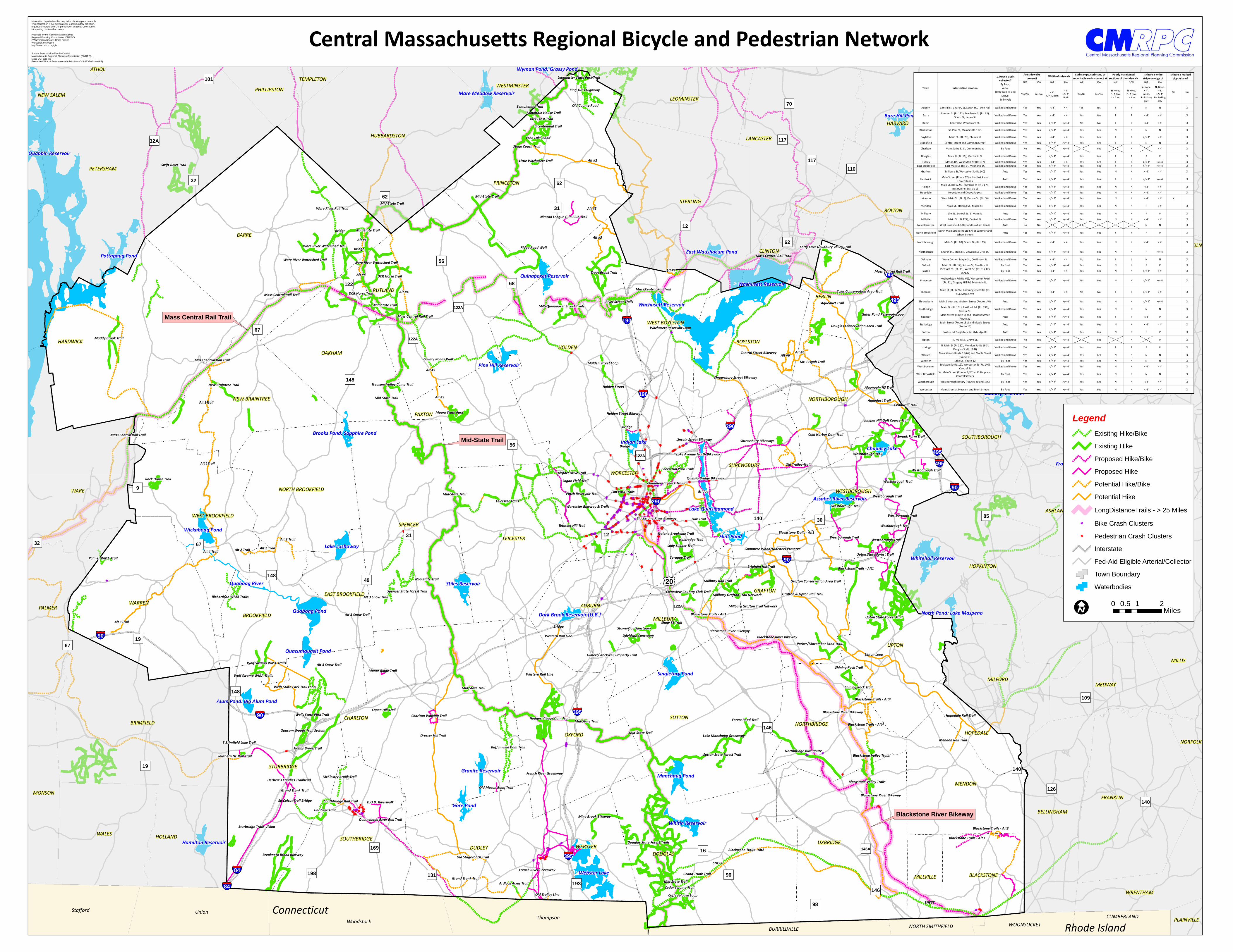
Central Massachusetts Regional Bicycle and Pedestrian Network
LegendExisitng Hike/Bike
Existing HikeProposed Hike/Bike
Proposed HikePotential Hike/Bike
Potential HikeLongDistanceTrails - > 25 Miles
k Bike Crash Clustersk Pedestrian Crash Clusters
InterstateFed-Aid Eligible Arterial/CollectorTown Boundary
Waterbodies
I 0 1 20.5 Miles
N/E S/W N/E S/W N/E S/W N/E S/W N/E S/W
Yes/No Yes/No < 4', >/= 4', Both
< 4', >/= 4', Both
Yes/No Yes/NoN-None,F - A few, L - A lot
N-None,F - A few, L - A lot
N- None, < 4',
>/= 4', P - Parking
only
N- None, < 4',
>/= 4', P - Parking
only
Auburn Central St, Church, St, South St., Town Hall Walked and Drove Yes Yes < 4' < 4' Yes Yes F F N N X
Barre Summer St (Rt 122), Mechanic St (Rt. 62), South St, James St Walked and Drove Yes Yes < 4' < 4' Yes Yes F F < 4' < 4' X
Berlin Central St, Woodward St. Walked and Drove Yes Yes >/= 4' >/= 4' No No F F < 4' < 4' XBlackstone St. Paul St, Main St (Rt. 122) Walked and Drove Yes Yes >/= 4' >/= 4' Yes Yes N N N N XBoylston Main St. (Rt. 70), Church St Walked and Drove Yes Yes < 4' < 4' Yes Yes F F >/= 4' < 4' X
Brookfield Central Street and Common Street Walked and Drove Yes Yes >/= 4' >/= 4' Yes Yes F F N N XCharlton Main St (Rt 31 S), Common Road By Foot No Yes >/= 4' Yes N < 4' X
Douglas Main St (Rt. 16), Mechanic St Walked and Drove Yes Yes >/= 4' >/= 4' Yes Yes F F P P XDudley Mason Rd, West Main St (Rt.197) Walked and Drove Yes Yes < 4' < 4' Yes Yes F F >/= 4' >/= 4' X
East Brookfield East Main St. (Rt. 9), Mechanic St. Walked and Drove Yes Yes >/= 4' >/= 4' Yes Yes F F >/= 4' >/= 4' XGrafton Millbury St, Worcester St (Rt.140) Auto Yes Yes >/= 4' >/= 4' Yes Yes N N < 4' < 4' X
Hardwick Main Street (Route 32) at Hardwick and Lower Roads Auto Yes Yes >/= 4' >/= 4' Yes Yes F N >/= 4' >/= 4' X
Holden Main St. (Rt 122A), Highland St (Rt 31 N), Reservoir St (Rt. 31 S) Walked and Drove Yes Yes >/= 4' >/= 4' Yes Yes N N < 4' < 4' X
Hopedale Hopedale and Depot Streets Walked and Drove Yes Yes >/= 4' >/= 4' Yes Yes N N < 4' < 4' XLeicester West Main St. (Rt. 9), Paxton St. (Rt. 56) Walked and Drove Yes Yes >/= 4' >/= 4' Yes Yes N N < 4' < 4' X
Mendon Main St., Hasting St., Maple St. Walked and Drove Yes Yes >/= 4' >/= 4' Yes Yes N N P < 4' X
Millbury Elm St., School St., S. Main St. Auto Yes Yes >/= 4' >/= 4' Yes Yes N N P P XMillville Main St. (Rt 122), Central St. Walked and Drove Yes Yes >/= 4' >/= 4' Yes Yes N N < 4' < 4' X
New Braintree West Brookfield, Utley and Oakham Roads Auto No No N N X
North Brookfield North Main Street (Route 67) at Summer and School Streets Auto Yes Yes >/= 4' >/= 4' Yes Yes F F P P X
Northborough Main St (Rt. 20), South St. (Rt. 135) Walked and Drove Yes Yes < 4' < 4' Yes Yes N N < 4' < 4' X
Northbridge Church St., Main St., Linwood St. , Hill St. Walked and Drove Yes Yes >/= 4' >/= 4' Yes Yes N N P >/= 4' X
Oakham Ware Corner, Maple St., Coldbrook St. Walked and Drove Yes Yes < 4' < 4' No No L L N N XOxford Main St. (Rt. 12), Sutton St, Charlton St By Foot Yes Yes >/= 4' >/= 4' Yes Yes N N P P XPaxton Pleasant St. (Rt. 31), West St. (Rt. 31), Rts
56/122 By Foot Yes Yes < 4' < 4' Yes Yes N N >/= 4' < 4' X
Princeton Hubbardston Rd (Rt. 62), Worcester Road (Rt. 31), Gregory Hill Rd, Mountain Rd Walked and Drove Yes Yes >/= 4' >/= 4' Yes Yes N N >/= 4' >/= 4' X
Rutland Main St (Rt. 122A), Pommogussett Rd. (Rt. 56), Maple Ave Walked and Drove Yes Yes < 4' < 4' No No F F >/= 4' < 4' X
Shrewsbury Main Street and Grafton Street (Route 140) Auto Yes Yes >/= 4' >/= 4' Yes Yes N N >/= 4' >/= 4' X
Southbridge Main St. (Rt. 131), Eastford Rd. (Rt. 198), Central St. Walked and Drove Yes Yes >/= 4' >/= 4' Yes Yes N N N N X
Spencer Main Street (Route 9) and Pleasant Street (Route 31) Auto Yes Yes >/= 4' >/= 4' Yes Yes F F < 4' P X
Sturbridge Main Street (Route 131) and Maple Street (Route 15) Auto Yes Yes >/= 4' >/= 4' Yes Yes N N < 4' < 4' X
Sutton Boston Rd, Singletary Rd, Uxbridge Rd Auto Yes Yes >/= 4' >/= 4' Yes Yes N N P P X
Upton N. Main St., Grove St. Walked and Drove No Yes >/= 4' Yes N P X
Uxbridge N. Main St (Rt 122), Mendon St (Rt 16 S), Douglas St (Rt 16 N) Walked and Drove Yes Yes >/= 4' >/= 4' Yes Yes F F P P X
Warren Main Street (Route 19/67) and Maple Street (Route 19) Walked and Drove Yes Yes >/= 4' >/= 4' Yes Yes N N N N X
Webster Lake St., Route 12 By Foot Yes Yes >/= 4' >/= 4' Yes Yes N N N N XWest Boylston Boylston St (Rt. 12), Worcester St (Rt. 140),
Central St Walked and Drove Yes Yes >/= 4' >/= 4' Yes Yes N N < 4' < 4' X
West Brookfield W. Main Street (Routes 9/67) at Cottage and Central Streets By Foot Yes Yes >/= 4' >/= 4' Yes Yes N N N N X
Westborough Westborough Rotary (Routes 30 and 135) By Foot Yes Yes >/= 4' >/= 4' Yes Yes N N < 4' < 4' X
Worcester Main Street at Pleasant and Front Streets By Foot Yes Yes >/= 4' >/= 4' Yes Yes N N < 4' < 4' X
Town Intersection location
1. How is audit collected?By Foot,
Auto, Both Walked and
Drove, By bicycle
Are sidewalks present?
Is there a white stripe on edge of Width of sidewalk Curb ramps, curb cuts, or
mountable curbs connect at Poorly mainitaned
sections of the sidewalk
Yes No
Is there a marked bicycle lane?