institute of transportation engineers · 1999-06-22 · the institute of transportation engineers...
TRANSCRIPT

INSTITUTE OF TRANSPORTATION ENGINEERS
A TOOLBOX FOR ALLEVIATINGTRAFFIC CONGESTION AND
ENCHANCING MOBILITY
DOT/FHWA150240

A TOOLBOX FOR ALLEVIATING
TRAFFIC CONGESTION AND
ENHANCING MOBILITY
Institute of Transportation Engineers
Prepared byMichael D. Meyer, Ph.D., P.E.Georgia Institute of Technology

The Institute of Transportation Engineers published the first edition of&e Toolbox in 1989. Thii edition wasone of the first efforts to develop a comprehensive summary of all the tools available to “solve” the urban con-gestion problem. We have learned much since 1989, and much has happened in the way of how we look atthe urban transportation system and the types of strategies that can now be considered in a toolbox. Perhapsmost dramatically, we are now seeing the initial application of advanced electronic technologies to bettermanage the transportation system. Known as intelligent transportation system (ITS) technologies, these toolsare laying the foundation for the management of system operations that will be the basic component of manyurban areas’ transportation strategy in the not-too-distant future.
In addition to ITS, there are several other tools discussed in this edition that are not found in the earlier ver-sion. These include: nonmotorized transportation, transit-oriented development and urban design, trafficcalming, freight movement, congestion pricing, intermodal terminals, and multimodal corridor investment.The remaining sections from the 1989 edition have been greatly expanded and updated. In many cases, theoriginal chapters have been kept largely intact with new material added. The authors of the original chapterswere: Chapter 1, Dr. Michael Meyer; Chapter 2, Thomas E Humphrey; Chapter 3, Dr. Michael Walton;Chapter 4, Katherine Hooper and Robert Stanley; Chapter 5 and 6, C. Kenneth Orski; and Chapter 7, PeterA. Peyser Jr. This edition was prepared solely by Dr. Michael Meyer.
A final acknowledgement must be given to Stephen C. Lockwood, whose ideas expressed in a 1988 presenta-tion at the Annual Meeting of the Transportation Research Board entitled, “Kaleidoscope or Map: SuburbanCongestion and Institutional Barriers” served as the basis of the “toolbox” analogy developed in this docu-ment.
NoticeThis document is disseminated under the sponsorship of the Department of Transportation in the interest of infor-mation exchange The United States Government assumes no liability for its contents or use thereof.
The contents of this document reflect the views of the Institute of Transportation Engineers (ITE) and the FederalHighway Administration (FHWA), which are responsible for the facts and accuracy of the information. The con-tents do not necessarily reflect the official views or policy of the Department of Transportation. This documentdoes not constitute a standard, specification, or regulation
FHWA-SA-98436
Library of Congress Cataloging-in-Publication DataA toolbox for alleviating traffic congestion and enhancing mobility.
p. cm.Includes bibliographical references.ISBN o-935403-12-41. Traffic congestion. 2. Traffic flow. 3. Traffic engineering.
I. Institute of Transportation Engineers.HE336.C64T662 1996388.3'14--dc21 98-4639
CIPPrinted in the United States of America
iteUS, Deaprtment of TransportationFederal Highway Administration
Institute of Transportation Engineers525 School St., S.W., Washington, D.C. 20024-2797 USATelephone: +1 (202) 554-8050, Fax: +1 (202) 863-5486ITE on the Web: http://www.ite.org
c 1997 Institute of Transportation Engineers. All rights reserved.Publication No. IR-054B1.7M/BP/298

TABLE OF CONTENTS
P r e f a c e . . . . . . . . . . . . . . . . . . . . . . . . . . . . . . . . . . . . . . . . . . . . . . . . . . . . . . . . . . .
CHAPTER ONE - Traffic Congestion: An Overview. . . . . . . . . . . . . . . . . . . . . . . . .Why Worry? . . . . . . . . . . . . . . . . . . . . . . . . . . . . . . . . . . . . . . . . . . . . . . . . . . . . . . . . .
Transportation Today and Tomorrow. . . . . . . . . . . . . . . . . . . . . . . . . . . . . . . . . . . . . . .
Mobility and Accessibility: The Bigger Picture. . . . . . . . . . . . . . . . . . . . .
Can Anything Be Done?. . . . . . . . . . . . . . . . . . . . . . . . . . . . . . . . . . . . . .
Mobility and Congestion as an Areawide Multimodal Phenomenon:Development of a Coordinated Program. . . . . . . . . . . . . . . . . . . . . . . . . . . . . . . . . . .
A Mobility/Congestion Reduction Toolbox. . . . . . . . . . . . . . . . . . . . . . . . . . . . . . . . . .
Intelligent Transportation Systems. . . . . . . . . . . . . . . . . . . . . . . . . . . . . . . . . .
Benefits and Costs . . . . . . . . . . . . . . . . . . . . . . . . . . . . . . . . . . . . . . . . . . . . . . . . . . . .
Commitment, Process and Public Involvement. . . . . . . . . . . . . . . . . . . . . . . .
1
2489
. 10
151617
19
.
CHAPTER TWO - Highways: Getting the Most Out of the Existing System . . . . . . . .23Urban Freeways. . . . . . . . . . . . . . . . . . . . . . . . . . . . . . . . . . . . . . . . . . . . . . . . . . . . . 23
l Freeway Incident Detection and Management Systems . . . . . . . . . . . . . . . . . . . . . 23l Ramp Metering . . . . . . . . . . . . . . . . . . . . . . . . . . . . . . . . . . . . . . . . . . . . . . . . . 33
l Highway Information Systems . . . . . . . . . . . . . . . . . . . . . . . . . . . . . . . . . . . . . . . 36l Freeway Corridor Traffic Management
(Including Arterial Surveillance and Control). . . . . . . . . . . . . . . . . . . . . . . . . . . . 39l Providing Additional Lanes without Wrdening the Freeway . . . . . . . . . . . . . . . . . . . 43
l High Occupancy Vehicle (HOV) Facilities . . . . . . . . . . . . . . . . . . . . . . . . . . . . . . . 46l Park-and-Ride Facilities. . . . . . . . . . . . . . . . . . . . . . . . . . . . . . . . . . . . . . . . . . . . . . 55l Highway Pricing Strategies. . . . . . . . . . . . . . . . . . . . . . . . . . . . . . . . . . . . . . . . . . . . 58
Arterials and Local Streets: Design. . . . . . . . . . . . . . . . . . . . . . . . . . . . . . . . . . . . . . . . . 58l Super Street Arterials. . . . . . . . . . . . . . . . . . . . . . . . . . . . . . . . . . . . . . . . . . . . . 58l Intersection Improvements. . . . . . . . . . . . . . . . . . . . . . . . . . . . . . . . . . . . . . . . . . . 60
l One-Way Streets . . . . . . . . . . . . . . . . . . . . . . . . . . . . . . . . . . . . . . . . . . . . . . . . . . . 61
l Reversible Traffic Lanes. . . . . . . . . . . . . . . . . . . . . . . . . . . . . . . . . . . . . . . . . . . . . . . 63
l Arterial Access Management . . . . . . . . . . . . . . . . . . . . . . . . . . . . . . . . . . . . . . 65l Traffic Calming and Street Space Management. . . . . . . . . . . . . . . . . . . . . . . . . . . 70
Arterials and Local Streets: Operations. . . . . . . . . . . . . . . . . . . . . . . . . . . . . . . . . . .
. Traffic Signal Improvements . . . . . . . . . . . . . . . . . . . . . . . . . . . . . . . . . . . . . . . .
l Computerized/interconnected Signal Systems. . . . . . . . . . . . . . . . . . . . . . . . . . .
747476
808285
l Arterial Surveillance and Management. . . . . . . . . . . . . . . . . . . . . . . . . . . . . .. .
l Turn Prohibitions. . . . . . . . . . . . . . . . . . . . . . . . . . . . . . . . . . . . . . . . . . . . . . . . . .
l Improved Traffic Control Devices . . . . . . . . . . . . . . . . . . . . . . . . . . . . . . . . . . . . . .

Artenals and Local Streets System Management. . . . . . . . . . . .. . . . . . . . . . . . . . .
l High Occupancy Vehicle (HOV) Facilities on Arterials . . . . . . . . . . . . . . . . . . . . . .
l Parking Management . . . . . . . . . . . . . . . . . . . . . . . . . . . . . . . . . . .
l Freight Movement Management . . . . . . . .. . . . . . . . . . . . . . . . . . . . . . . . . . .
l Bicycle and Pedestrian Networks . . . . . . . . . . .. . . . . . . . . . . .. . . . . . . ..Enforcement . . . . . . . . . . . . . . . . . . . . . . . . . .. . . . . . . . . . . .. . . . . . .
CHAPTER THREE - Building New Road Capacity . . .. . . . . . . . . . . .. . . . . . . . . . . .
l Multimodal Transportation Corridor Investment . . .. . . . . . . . . . . .. . . . . . . . . . . .
l New Highways . . . . . . . . . . . . . . . . . . . . . . . .. . . . . . . . . . . .. . . . . . . . . . . .
l Access Control and Management. . . . . . . . . . . . . . . . . . . . . . .. . . . . . . . . . . .
l Geometnc Design . . . . . . . . . . . . . . . . . . . . . . . . . . . . . . . .. . . . . . . . . . . .
l Reconstruction and Traff it Management. . . . . . . .
l Grade Separation . . . . . . . . . . . . . . . . . . . . . . . . . . . . . . . . . . . . .. . . . . . . . . . . .
. . . . . . . . . . . .. . . . . . .
87879299
104109
115
117121124125
127130
CHAPTER FOUR Providing Public Transportation Services. . . . . . . . . . . . . . . . . . 133System/Service Expansion . . . . . . . . . . . . . . . . . . . . . . . . . . . . . . . . . . . . . . 136
. Rail/Fixed Guideway Transit Facilitiess . . . . . . . . . . . . . . . . . . . . . . . . . . . . 136System/Service Operational Improvements. . . . . . . . . . . . . . . . . . . . . . . . . . . . . . . . . . . 148
l Fixed Route and Express Bus Services (New and Operational Changes). . . . . 148l Paratransit Services (Indluding Contract and Shuttle) . . . . . . .. . . . . . . . . . . . 154
Supporting Actions/Policies. . . . . . . . . . . . . . . . . . . . . . . . . . . . . . . . . . . . . . 157l Fare Structures. . . . . . . . . . . . . . . . . . . . . . . . . . . . . . . . . . . . . 157l Multimodal Access to Transit Services/Facilitiess . . . . . . . . . . . . . . . . . . . . . . . . . . 162. Multimodal/Intermodal Transit Stops and Terminals. . . . . . . . . . . . . . . . . . . . 165l Transit-Oriented Development/Livable Communities . . . . . . . . . . . .. . . . . . . . . 171l Joint Development. . . . . . . . . . . . . . . . . . . . . . . . . . . . . . . . . . . . . . . . 180l Transit-Oriented Parking Policies . . . . . . . . . . . . . . . . . . . . . . . . . . . . . . . . . . . 184. Transit Technology Applications . . . . . . . . . . . . . . . . . . . . . . . . . . . . . . 184
CHAPTER FIVE - Managing Transportation Demand . . . . . . . . . . . . . . . . 187Important Considerations . . . . . . . . . . . . . . . . . . . . . . . . . . . . . . . . . . . . . . . 187
Site-Specific TDM Strategies . . . . . . . . . . . . . . . . . . . . . . . . . . . . . . . . . . . . . . 189Alternative Modes of Transportation . . . . . . . . . . . . . . . . . . . . . . . . . . . 190
. Ridesharing . . . . . . . . . . . . . . . .. . . . . . . . . . . . . . . . . . . . . . . . . . . . . . . . 190l Nonmotonzed Transportation (Bicycling/Walking) . . . . . . . . . . . . . . . . . . . . . . . 197
Alternative Hours of Travel . . . . . . . . . . . . . . . . . . . . . . . . . . . . 203
Alternative Locations . . . . . . . . . . . . . . . . . . . . . . . . . . . . . . . . . 205l Telecommunications . . . . . . . . . . . . . . . . . . . . . . . . . . . . . . . . . . . . . . . . 205
l Complementary Support Measures. . . . . . . . . . . . . . . . . . . . . . . . . . . . 213
Areawide Strategies . . . . . . . . . . . . . . . . . . . . . . . . . . . . . 219
l Growth Management . . . . . . . . . . . . . . . . . . . . . . . . . . . . . 219
. . Urban Design. . . . . . . . . . . . . . . . . . . . . . . . . . . . . . . . . . . . . . . . .. 224
. Congestion Pricing.. . . . . . . . . . . . . . . . . . . . . . . . . . . . . . . . . . . 229
l Auto Restricted Zones . . . . . . . . . . . . . . .. . . . . . . . . . . .. . . . . . . . . . . . 238

l Parking Management . . . . . . . . . . . . . . . . . . . . . . . . . . . . . . . . . . . . . . .
l Trip Reduction Ordinances . . . . . . . . . . . . . . . . . . . . . . . . . . . . . . . . . . . . l Negotiated Demand Management Agreements . . . . . . . . . . . . . . . . . . . . . . . . l Regional Multimodal Traveler Information Systems... . . . . . . . . . . . . . . . . . . . . . . l Transportation Management Associations. . . . . . . . . . . . . . . . . . . . . . . . . . .
241 247 251 254 254
CHAPTER SIX - integrating Intelligent Transportation Systems Into RegionalTransportation. . . . . . . . . . . . . . . . . . . . . . . . . . . . . . . . . . . . . . . . . .Toward a Focus on System Operations and Management. . . . . . . . . . . . . . . . .
Intelligent Transportation Systems Defined. . . . . . . . . . . . . . . . . . . . . . . . . . . . . . .
l Regional Multimodal Traveler Information Systems (RMTIS) . . . . . . . . . . . . . . . . . . . . l Traffic Signal Control Systems (TSCS) . . . . . . . . . . . . . . . . . . . . . . . . . . . . . . . . . . . l Freeway Management Systems (FMS). . . . . . . . . . . . . . . . . . . . . . . . . . . . . . l Transit Management Systems (TMS) . . . . . . . . . . . . . . . . . . . . . . . . . . . . . . . . . . . . l incident Management Systems (IMS) . . . . . . . .. . . . . . . . . . . . . . . . . . . . . . . . . . . . . . l Electronic Toll Collection (ETC) Systems. . . . . . . . . . . . . . . . . . . . . . . . . . . .
l Electronic Fare Payment System (EFPS) . . . . . . . . . . . . . . . . . . . . . . . . . . . . . . . .
l Railroad Grade Crossing Warning System . . . . . . . . . . . . . . . . . . . . . . . . . . . . . .
l Emergency Management (EM) Systems . . . . . . . . . . . . . . . . . . . . . . . . . . . . . . . .
. . 257. . . . 257. . . . 258. . . . 263. . . 268
. . 270. . . 277
.281. . . . 282. . . . 286. . . . 289
. . . . 290
. . 292
. . . 293
. . . . 298
Implementation of a Regional ITS Program . . . . . . . . . . . . . . . . . . . . . . . . . . . . .
The Linkage Between ITS and Transportation Planning. . . . . . . . . . . . . . . . . . . . . . . . . . . .
Institutional Challenges in Implementing ITS . . . . . . . . . . . . . . . . . . . . . . .
CHAPTER SEVEN - Implementation, Funding and Institutional Measures .Traditional Funding Sources . . . . . . . . . . . . . . . . . . . . . . . . . . . . . . . .
l Fuel Taxes . . . . . . . . . . . . . . . . . . . . . . . . . . . . . . . . . . . . . .
l General Revenues . . . . . . . . . . . . . . . . . . . . . . . . . . . . . . . . . . . .
. . . . 305
. . . . 305
. . . . 306. . 309
. . 310
. . 311
. . . . 313
. . . . 313
. . . . 316
. . . . 323.327
. . . . 330
. . 332. . . . 333. . . . 333
. . . . 337
. . . . 341
. . . . . 343. . . . 348
. Bonding . . . . . . . . . . . . . . . . . . . . . .. . . . . . . . . . . . . . . . . . . l Other Revenue Sources (Targeted Taxes and Transit Revenues) . . . . . . . . . . . . . . .
Innovative Funding Sources. . . . . . . . . . . . . . . . . . . . . . . . . . . . . . . . . . . . . . .
l Vehicle Use-Based Taxes. . . . . . . . . . . . . . . . . . . . . . . . . . . . . . . . . . . . . .
l Public/Private Partnerships . . . . . . . . . . . . . . . . . . . . . . . . . . . . . . .
l Development Fees, Exactions and Value-Added Taxation . . . . . . . . . . . . . . . . . . . . . .
l Toll Roads . . . . . . . . . . . . . . . . . . . . . . . . . . . . . . . . . . . . . . . . . . . . . . . . . . . . . . . .
l Privatization. . . . . . . . . . . . . . . . . . . . . . . . . . . . . . . . . . . . . . . . . . . . . . .
Putting It All Together. . . . . . . . . . . . . . . . . . . . . . . . . . . . . . . . . . . . . . . . . . . . . . . . . . .
Institutional Issues . . . . . . . . . . . . . . . . . . . . . . . . . . . . . . . . . . . . . . . . . . . . .
l Organizational Capability: Government Agencies . . . . . . . . . . . . . . . . . . . . . . .
l Transportation Management Associations. . . . . . . . . . . . . . . . . . . . . . . . . . . .
l Human Resource Development . . . . . . . . . . . . . . . . . . . . . . . . . . . . . . . . . . .
l Public Involvement and Marketing . . . . . . . . . . . . . . . . . . . . . . . . . . . . . . . . .
Putting It All Together in a Regional Program. . . . . . . . . . . . . . . . . . . . . . . . . . .
.
.

IN THIS CHAPTER . . .
Why Worry?
Transportation Today and Tomorrow
Mobility and Accessibility:The Bigger Picture
Can Anything Be Done?
Mobility and Congestion as anAreawide Multimodal Phenomenon: Development of a Coordinated Program
A Mobility/Congestion Reduction Toolbox
Intelligent Transportation Systems
Benefits and Costs
Commitment, Process and Public Involvement
A TOOLBOX FOR ALLEVIATING TRAFFIC CONGESTION AND ENHANCING MOBILITY

TRAFFIC CONGESTION: AN OVERVIEW
Over 40 years ago, the United States embarked upon the largest public works
project in its history--the construction of the Interstate highway system.. . . . , . . . . . . . . . . . . . . . . . . . . . . . . . . . . . . . . . . . . . . . . . . . . . . . . . . . . .
The urban portions of this systemalong with the highways and publictransportation services developed bystate, county, and local governments,as well as public transportation ser-vices offered by other organizations,have provided urban Americans withunprecedented levels of mobility.However, in many communitiesincreasing levels of traffic congestionhave turned once easy trips intonightmares. In addition, the lack ofaccurate and timely public transporta-tion information and services hasdiscouraged drivers from consideringoptions other than driving alone.People are turning to communityofficials for solutions.
The purpose of A Toolbox forAlleviating Traffic Congestion andEnhancing Mobility (Toolbox) is to pro-vide local elected officials, businessleaders, and community leaders withinformation on the congestion phe-nomenon and on the multimodaltransportation strategies that can beused to provide improved mobilityand accessibility. There are ways ofdealing with traffic congestion prob-lems. Some actions can be used indi-vidually, while others require mutuallysupportive actions implemented cooperatively by several public and privatesector groups. Some actions focusexclusively on changes to the trans-portation system, while others deal
TRAFFIC CONGESTION AN OVERVIEW
with changes to land developmentprocedures. Some actions provideadded capacity to highway and transitsystems so that passenger demand canbe accommodated, while othersattempt to change the characteristicsof the demand itself (e.g., by encour-aging ridesharing). However, no mat-ter what type of action is considered,those who are dealing with trans-portation problems need to haveinformation on the likely effective-ness of different actions that can beused to deal with these problems.This Toolbox is designed to providethis type of information.
The remainder of this chapterdiscusses the characteristics of trans-portation in urban areas, its history,future trends, and the impacts andcosts to the community when thetransportation system does not pro-vide the level of performance desired.In addition, this chapter presents anoverall framework for developing acoordinated program to provide goodmultimodal transportation service to acommunity. Chapter 2 discussesactions that can be implemented toenhance the person-carrying capabili-ty of the highway system, withoutadding significantly to the width ofthe highway. Chapter 3 discussesactions that result in substantialadded capacity to the highway system,either through the widening of exist-
The purpose of this Toolbox is
to provide local elected officials,
business leaders, and community
leaders with information on the
congestion phenomenon and
on the multimodal transportation
strategies that can be used to
provide Improved mobility and
accessibility.

ing roads or by constructing newhighways. Chapter 4 discusses publictransportation actions that can beused to move people more effectively.Chapter 5 discusses actions for reduc-ing transportation demand eitherthrough land use management, region-al demand management programs, or .site-specific policies like carp001 pro-grams. Chapter 6 presents an overviewof new applications for advanced tech-nologies in providing transportationservices. Chapter 7 discusses fundingand institutional actions that can be .used by themselves or in combinationwith other actions.
To some, congestion IS considered to be one result of economic prosperity Others
argue that the consequences of congest/on are much more serious to a community
Chapters 2 through 7 are struc-tured to provide the reader with easi-ly accessed and understood informa-tion about specific actions. Sectionswithin each chapter present:
1) a brief description of the actionwith special attention given to thecriteria for success,
2) the costs and benefits/impacts ofthe action that have been deter-mined from previous experience,
3) steps needed to implement theaction successfully, and
4) sources of further information onthe action.
WHY WORRY
Put simply, traffic congestion meansthere are more people trying to usea given transportation facility duringa specific period of time than thefacility can handle with what areconsidered to be acceptable levels ofdelay or inconvenience. In a broader
sense, a congested facility is just oneelement of a transportation system’sability to provide mobility and acces-sibility. Delays at particular locationsin a transportation network arecertainly aggravating to those usingthe system, but these delays are partof a much larger picture of how atransportation system allows peopleand goods to move around a metro-politan area.
To some, congestion is not aproblem. It is considered to be oneresult of economic prosperity andone that we will have to learn to livewith. Proponents of this viewpointargue that our expectations aboutconvenient travel will simply have tochange. Others argue, however, thatthe consequences of congestion aremuch more serious to a community.Those holding this viewpoint haveoften relied on one or more of thefollowing arguments:
Local Traffic Impacts: When facedwith congested conditions, manydrivers quickly look for ways tobypass the bottleneck. These ofteninclude making their way throughresidential neighborhoods on streets
not designed to handle through traffic. Such bypass traffic often
becomes the focus of neighborhoodcomplaints. Similar complaints are
often heard when overflow parkingfinds its way into neighborhoods.
Economic Growth: Efficient trans- portation access to employment and shopping sites is an important consid-
eration to businesses and developerswhen considering expansion opportu-
nities. A good transportation systemis an important selling point tocommunities that desire to attract
A TOOLBOX FOR ALLEVIATING TRAFFIC CONGESTION AND ENHANCING MOBILITY

development. In addition, goodtransportation is very important tothe movement of goods and servicesand thus has a direct impact onsound economic growth and produc-tivity (Transportation Research Board1995).
Community Access: Good accesswithin a community and to otherparts of the metropolitan area bydrivers and by those using publictransportation is an important issueto community residents. Not only isgood access important to thoselooking for places to live, but it canbecome an important communitypublic safety (e.g., police, fire andemergency medical) issue.
Quality-of-Life: To some people,congested highways are a symptomof deteriorating quality-of-life in acommunity. In many cases, and inparticular in suburban communities,residents moved to their communityto escape urban problems like trafficjams. Now, facing this congestion hasonce again become part of their dailyroutine. Another aspect of this quali-ty-of-life characteristic is the roletransportation plays as a key elementof getting and keeping a job. This isparticularly important today with thegreater emphasis being given to“welfare-to-work,’ programs.
Highway Safety: Whether charac-terized by stop-and-go traffic alonga major road or by traffic trying toget through intersections, congestedhighways often can result in acci-dents. Reducing this congestioncould reduce the number of accidentsand generally produce safer travelconditions.
Environmental Quality: Congestedroad conditions can have a detrimen-tal effect on the environment, in par-ticular, air quality. Making improve-ments to the transportation system ortrying to change travel behavior hasbeen an important objective of thosewanting to improve environmentalquality.
These arguments can be importantreasons for being concerned aboutthe performance of the transportationsystem. However, of even more inter-est to community leaders, addressingthe mobility needs of a communityhas become in several cases a litmustest for effective leadership. Becausethe public sector is viewed as havingthe major responsibility for solvingtransportation problems, communityofficials are often the focal point forcitizen unrest concerning traffic con-gestion and mobility needs.
Transportation as a Regional Issue:In addition to the local concernsidentified above, there are metropoli-tan-level planning requirements andfederal (and often state) environmen-tal laws that require a comprehensiveexamination of congestion reductionand mobility strategies. For example,the Intermodal Surface Transporta-tion Efficiency Act (ISTEA) passedand amended by Congress requiresthat all states and metropolitan areashave a transportation planningprocess that considers these types ofstrategies. For metropolitan areas over200,000 population, and especiallythose not in attainment of air qualitystandards, a congestion managementsystem is required that identifiesstrategies for improving the perfor-mance of the transportation system
TRAFFIC CONGESTION AN OVERVIEW
Addressing the mobility needs
of a community has become In
several cases a litmus test for
effective leadership

with special consideration given tohe pollution-reducing impact ofthese strategies. The transportationplanning and project programmingprocess in non-attainment areas isvery much influenced by this assess-a-rent. Therefore, understanding whatstrategies are available in the Toolboxand their likely impacts on travelbehavior and air quality becomes acritical input into the planningprocess in many of our majormetropolitan areas. This is especiallyimportant if one looks at the expect-ed levels of congestion on urbantransportation systems in the nearfuture.
TRANSPORTATION TODAY
Increasing levels of congestion arecommon in urban areas throughoutthe United States. Recent transporta-tion plans for a sample of urban areasand states indicate some of the char-acteristics associated with futuremobility challenges:
Florida: Daily vehicle miles traveledhas continued to grow, from 300 mil-lion miles1483 million kms in 1990 to334 million miles/538 million kms in1994, an increase of about 11 percent(Florida DOT 1995).
Dallas-Ft.Worth: The growth invehicle miles of travel and vehiclemiles of travel per person in theregion represents a significant chal-lenge in addressing mobility needs ofthe region. By the year 2010, dailyvehicle miles traveled is projected toexceed 124 million/200 million kmsrepresenting a 33 percent increase intravel (North Central Texas Councilof Governments 1995).
Milwaukee: In 1991, the numberof vehicle miles of travel on anaverage weekday totaled nearly 33million/53 million kms. Under ano-build alternative, the growth invehicle miles traveled would beapproximately 35 percent to 44.5million vehicle miles/72 million kmsof travel in the year 2010 (SoutheastWisconsin Regional PlanningCommission 1995).
Boston: Vehicle miles traveled in2020 are forecast to increase byapproximately 25 percent...Vehiclehours of travel are forecast to grow by35 percent in the base case, evidenceof growing systemwide congestion(Central Transportation Planning
AND TOMORROW staff 1993).
Albany: Congestion-related delaywill increase significantly for theregion as a whole by 2015. This con-gestion will be experienced dispropor-tionately-suburban areas will experi-ence a growing percentage of theregion’s congestion (Capital DistrictTransportation Commission 1995).
Atlanta: . ..despite substantialimprovements to the highway system,over 53 percent of the vehicle milestraveled in 2010 will be on facilitiesthat are subject to levels of service F(Atlanta Regional Commission1990).
Texas: Increased congestion onTexas’ highways will worsen signifi-cantly over the lifetime of thePlan---twice as many miles of majorurban facilities will be congested in2012 than were in 1992, causingdelays on more than half of urban
. Interstate, freeway, and expresswaymiles (Texas DOT 1994).
A TOOLBOX FOR ALLEVIATING TRAFFIC CONGESTION AND ENHANCING MOBILITY


The number ofworkers in the labor force almostdoubled between 1950 and 1990,with women joining the labor forcebeing a major reason for this signifi-cant increase. Importantly, theincrease in workers by geographicarea illustrates the suburbanizationthat has occurred in every U.S. met-ropolitan area. From 1980 to 1990,65 percent of the growth in the laborpopulation occurred in the suburbs,18 percent in the central city, and 17percent in non-metropolitan areas.The suburbs in 1990 had 42 percentof the nation’s jobs (up from 37 per-cent in 1980), and suburban areassaw 49 percent of the growth in jobsfrom 1980 to 1990, whereas centralcities represented only 23 percent ofthe growth.
Households and Persons/Household:Between 1969 and 1990, the numberof households grew 49 percent withthe largest share of the growth in sin-gle-person and single-parent house-holds. The average household sizealso declined from 3.16 persons in1969 to 2.56 persons in 1990. Thisphenomenon has had profoundimplications on transportation in thateach household has a baselineamount of trips and travel associatedwith it (Federal Highway Admini-stration 1993).
Trips/Capita: Between 1983 and1990, trips per capita increased byalmost 7 percent to 3.04 trips permale and 3.13 trips per female.
Person Trip Length: The averagemiles for commuting each day in1983 was approximately 7.9 miles/12.7 kms; in 1990 this number hadrisen to 9.55 miles/15.4 kms (Federal
Highway Administration 1993).This increase can be associated withthe tremendous population andemployment growth in the suburbanareas of our metropolitan regions(86 percent of total U.S. populationgrowth since 1970 had occurred inthe suburbs), and in the rising per-centage of the adult population whohad drivers licenses.
Households by Vehicles Available:
Although population and number ofhouseholds between 1980 and 1990increased by less than 10 percent and14 percent, respectively, the totalvehicles available to households grewby over 17 percent. Every worker hason average 1.3 vehicles available forthe work trip. Over the past decades,the number of households with multi-ple vehicles grew rapidly.
Licenses: Between 1969 and 1990,the number of licensed drivers in theUnited States increased by almost 60percent. For those aged 30 through49, over 96 percent of the men androughly 93 percent of the women arelicensed. In addition to licensed dri-vers, the number of automobilesavailable for trip making increasedsignificantly. Between 1969 and1990, the average number of vehiclesper household rose from 1.1 to 1.77,with only 9.2 percent of U.S. house-holds not having a car available for atrip (one in five households had threeor more cars).
Mode Use: Transit’s share of allnational travel has declined to about2 percent, although in many urbanmarkets transit retains a strong pres-ence. This decline is associated withincreased auto availability to thosepopulation groups most likely to use
A TOOLBOX FOR ALLEVIATING TRAFFIC CONGESTION AND ENHANCING MOBILITY

transit and the continued suburban-ization of metropolitan regions result-ing in land uses difficult to serve withtraditional transit services.
Auto Occupancy: Average vehicleoccupancy (measured as person milesper vehicle mile) has declined from1.9 in 1977 to 1.6 in 1990. In manyurban highway corridors, the averageautomobile occupancy for work tripsis below 1.1 persons per vehicle.
All of these factors have con-tributed to a fundamental characteris-tic of the urban travel phenomenon-the number of person miles trav-eled and the number of trips madehave increased proportionately muchfaster than the individual factors thatinfluence trip-making.
What does the future hold? Arecent report from the Urban LandInstitute which examined some of theunderlying causes of congestion iden-tified the following trends and obser-vations that could affect future urbantravel: (Dunphy 1997)
. Growth in the United States popu-lation is slowing, but millions ofadded travelers will still need to beaccommodated.
. Virtually all Americans old enoughto drive are already licensed.
l In the U.S. there already is morethan one car, van, or light truckfor every person age 16 and older.
l Looking ahead to 2010, the num-ber of young adults will return toits 1980 level, from a recentdecline.
. Baby boomers will make up asmaller share of the population by2010.
TRAFFIC CONGESTION AN OVERVIEW
l The elderly population will begrowing more rapidly than the pop-ulation in prime driving age groups.However, the differences in traveldemand between younger peopleand seniors will be narrowing.
l The image of seniors traveling bybus or on foot to take care of theirdaily needs is no longer accurate.More seniors will be driving wellinto their retirement years.
. More people living beyond age 75will result in more trips taken byyounger family members to help intheir care.
. There will be a continued diver-gence in travel behavior betweenmen and women.. Married men with children,regardless of the age of theiryoungest child, make the samenumber of trips as married menwithout children.
l The use of transit and carpooling isdeclining more so for women thanfor men.
l Race and ethnicity further differ-entiate travel patterns.
. Wealthier households make moretrips, use cars more, and travellonger distances.
l Low density development meansmore automobile trips.
l Nonwork travel will increase as ashare of total trips.
. Dispersed development meansmore shopping trips, whileincreased catalog and electronicshopping will mitigate against thistrend.
The number of person miles
traveled and the number of
trips made have increased
proportionately much faster
than the individual factors that
influence trip-making

l Cities are capturing a decreasingshare of new jobs, resulting inlonger work trips and lower publictransit ridership.
. During the 1990s cities will not beas successful as they were in the1980s in slowing the rate of exodusof jobs to the suburbs. The shift ofjobs to edge cities means quickercommutes for suburbanites, moretravel for lower-income city resi-dents, and lower transit demand.
l The dispersal of employmentcenters means more commutingbetween suburbs and across countylines.. Growth in the labor force is slow-ing. More people are holding twoor more jobs.. More companies are offeringflexible work hours as an employeeperk and to reduce peak hourtraffic. Telecommuting andworking at home are increasinglypopular options.
MOBILITY AND ACCESSIBLITHE BIGGER PICTURE
The original Toolbox published in1989 focused on strategies andactions that were aimed at relievingcongestion on the transportation sys-tem with primary focus on the high-way system. Most often, this conges-tion occurred at specific locationsand were, in many ways, just one ele-ment of the total trip for people andgoods in a metropolitan region. Sincepassage of the Intermodal SurfaceTransportation Efficiency Act in1991, many transportation officialshave broadened their perspective onthe types of strategies that can be
considered in dealing with congestionand mobility. Multimodal transporta-tion system performance more thanever now includes an integrated mul-timodal perspective for overall mobil-ity and accessibility. The three termsthat will be used in this version of theToolbox are defined as: (Meyer, 1996)
Mobility: The ability and knowledgeto travel from one location to anoth-er using a multimodal approach.
Accessibility: The means by whichan individual can accomplish someeconomic or social activity.
Congestion: The travel demand fora facility or service exceeds thecapacity of that facility/service tohandle the demand at performancelevels considered acceptable to facili-ty/service users.
Note that this definition includesnot only highway facilities, but alsotransit services. Also, in these defini-tions, “mobility” implies movement,but accessibility does not. For exam-ple, modern telecommunicationsallows one to order goods and/or con-duct work without ever leavinghome. The activity is accomplished,but the individual does not have touse the transportation system toachieve the objective. In fact, one ofthe more recent strategies for reduc-ing congestion is to encouragetelecommuting so that accessibility tothe workplace still occurs, but vehic-ular travel is reduced. This broaderperspective on improving the perfor-mance of the transportation by devel-oping a coordinated mobility programfor your community system is furtherillustrated later in this chapter.
A TOOLBOX FOR ALLEVIATING TRAFFIC CONGESTION AND ENHANCING MOBILITY

CAN ANYTHING BE DONE?
The simple answer to this question is,“yes”! There are proven techniquesthat can be used to deal with specificcongestion problems, as well as trans-portation and land use strategies thatcan be implemented to enhancemobility and accessibility. The moredifficult answer to this question is,“Yes, but . ...” Many of these tech-niques and strategies require changesin individual travel behavior, persua-sive use of land use managementtechniques, changes in institutionalstructure, garnering of political will,and/or increased funding. This is par-titularly true for those strategies .aimed at a longer term vision ofimproved mobility and accessibility.Given this perspective, what can bedone?
l Recognize that traffic congestion isa more difficult problem than sim-ply too many cars at a particularlocation. There are institutionaland land use dimensions to theproblem that make it complex. Inaddition, congestion is simply asymptom of much larger issuesassociated with mobility and acces-sibility in a community.
l Recognize the direct and funda- .mental relationship between landuse and travel patterns. Approvingland developments withoutproviding adequate transportationoptions will result in congested,unsafe, and environmentallydamaging conditions.
l Recognize that transportationimprovements can be consideredfrom the perspective of enhancedtransportation services (i.e., the
“supply” of transportation), fromthe perspective of those who usethese services (i.e., better manag-ing the “demand” for the trans-portation system), from the per-spective of influencing where thisdemand occurs (i.e., the land usedimension), or any combination ofthe above.
l Consider carefully how individualactions relate to one another andhow, when combined into an over-all program, they relate to regionaland community objectives.
l Implement those actions thatthrough sound engineering andplanning analysis are shown toimprove congestion problems in acost effective, multimodal manner.Be realistic in the assessment ofwhat is likely to be accomplished.
l Recognize early on that the imple-mentation of actions that are like-ly to be controversial will requirestrong commitments and efforts atdeveloping a constituency for theaction from interested organiza-tions that have not traditionallybeen part of the transportationplanning process.
l Incorporate private sector interests(developers, employers, businessassociations, etc.) into the plan-ning and decision-making process.It is often in their best interest toparticipate, and they can providestrong support in gaining projector program adoption.
l Cooperate with neighboring gov-ernmental jurisdictions, regionaltransportation agencies, and orga-nizations that provide transporta-
TRAFFIC CONGESTION: AN OVERVIEW
Many of these techniques and
strategies [that address congestion
problems] require changes in
individual travel behavior; persua-
sive use of land use management
techniques, changes in institutional
structure, garnering of political
will, and/or increased funding.


Second, a mobility/congestion reduc-tion program should examine betterways of managing transportationdemand, especially if the opportunityfor substantial gains in system mance through expansion or opera- .tional improvements is limited.Third, a mobility/congestion reduc-tion program should explicitly con-sider long-range strategies that willprovide the foundation for avoidingsimilar problems in the future. Thisimplies an important role for consid-ering future land use/developmentpatterns and their impact on travel.Finally, the program needs to dealwith institutional arrangements andfunding requirements for implement-ing the program. This is especiallyimportant where the transportationservices are housed in separate units.In most cases, substantial levels offunding will be necessary to provide the desired levels of mobility and/orcongestion relief. However, there area number of cost-effective improve-ments that can be implemented atlow cost, including improvementsusing intelligent transportation sys-tern (ITS) technologies.
Even though these program com-ponents are listed separately, they arereally complementary to one another.For example, a ridesharing program(an effort to influence demand) canbecome more effective if some form of preferential treatment is provided en route (e.g., a high occupancy vehi-cle lane) or at the destination (e.g.,preferential parking), both changes to
.the transportation system. The effec-tiveness of the ridesharing programcould be even greater if employers were required to incorporate
enhanced ridesharing activities intothe design and use of the site (a landuse/development decision). Similarly,linkages exist between different toolsthat often work at cross purposes. Forexample, land development regula-tions that require high minimum lev-els of parking as a condition of devel-opment work against employerdemand management programs. Amobility and congestion reductionprogram must therefore consider howeach action relates to one another.
The important components of amobility/congestion reduction pro-gram are shown in Figure 1-2. Notethat a key word that is used todescribe each component is “manage-ment.” Because much of our trans-portation system is in place, the deci-sions of what additional capacity toprovide, what types of operationalimprovements to make, how to influ-ence demand for the purpose of
Figure 1.2: Elements of a Mobility/Congestion Reduction Program
Intelligent Transportation Systems A Planning & Zoning
Transit Facilities and Services
Intermodal Facilities
Traffic Engineering
Highway Capacity
Bike/Walkways
Phasing/Adequacy
Density
DEMAND MANAGEMENTAlternative Work Alternative Alternative Work Employer SupportSchedules Modes Locations
Financial Incentives and Disincentives
Source: Meyer
TRAFFIC CONGESTION AN OVERVIEW

reducing the impact of traffic, how todevelop compatible land use, andhow to provide the institutional andfunding structure that supports theprogram are all in essence systemmanagement decisions.
Figure l-2 is an important point ofdeparture for developing effectivemobility/congestion reduction pro-grams. Significantly, this figure sug-gests that to be effective, such a pro-gram should consist of actions ortools that come from three differentcategories-managing the supply ofthe transportation system, managingthe demand or travel behavior ofthose who use transportation, andmanaging the land use and/or devel-opment patterns that influence whenand where travel demand occurs.Every community’s mobility/conges-tion reduction program falls some-where inside the shown triangle. Insome cases, a community might relymore on transportation demand andland use actions to provide improvedmobility, whereas others might placegreater emphasis on expanding thecapacity of the transportation system.Each community must decidethrough its planning and decision-making process where inside the tri-angle it wants to be.
Managing Transportation SystemSupply-Managing the transportationsystem by adding new facilities or bymaking operational changes toimprove system performance has beenthe most common response to trans-portation problems for many years.Actions such as the construction ofnew highways and transit facilities;the provision of improved traffic sig-nalization schemes; the use of traffic
engineering improvements such asturn lanes, one-way streets, reversiblelanes, and turn prohibitions; the addi-tion of new transit services or improv-ing existing service by adding vehi-cles, increasing vehicle size, orincreasing frequency of service; theprovision of preferential treatment tothose who use multi-occupant vehi-cles; and ramp metering are Illustra-tive of the types of actions that can beused to deal with congestion problemsthat occur every day. Increasingly,transportation professionals are alsobecoming interested in those actionssuch as incident detection programs,motorist information systems, andtowing/enforcement efforts that canbe used to minimize the effects ofaccidents and other non-recurringincidents on traffic flow. Advancedtransportation technologies, known asintelligent transportation systems(ITS), are also being considered seri-ously as tools to reduce congestionand enhance mobility.
Because planners and engineershave had many years of experiencewith the supply side of the trans-portation system, there is more evi-dence in the literature on the impactof these types of actions. In theextreme, that is, where new capacitycan be continually added to accom-modate the demand, these actionscan significantly reduce congestionlevels. In the long term, however, thisadditional capacity, if assigned tohighway improvements only (e.g.,additional lanes), will continue aheavy reliance on the automobilewhich could have serious implica-tions to some on the urban mobilityoptions available in the region. Onthe other hand, additional capacity
A TOOLBOX FOR ALLEVIATING TRAFFIC CONGESTION AND ENHANCING MOBILITY

TRAFFIC CONGESTION AN OVERVIEW
improvements to transit could helpalleviate the congestion problem. Inheavily urbanized areas, the construc-tion of these actions (especially majorhighway improvements) can be cost-ly, their implementation met withstrong opposition, and even if feasi-ble, they might take a long time tocomplete. It is for these reasons thatother actions need to be considered.
Managing TransportationDemand-In its broadest sense,demand management is any action orset of actions intended to influencethe intensity, timing, and spatialdistribution of transportation demandfor the purpose of reducing theimpact of traffic or enhancing mobili-ty options. Such actions can includeoffering commuters one or morealternative transportation modesand/or services, providing incentivesto travel on these modes or at non-congested hours, providing opportu-nities to better link or “chain” tripstogether, and/or incorporating growthmanagement or traffic impact policiesinto local development decisions.
Available evidence suggests thatwell-conceived and aggressively pro-moted demand reduction programscan indeed decrease peak period traf-fic at many sites by as much as 10 to15 percent. In fact, as will bedescribed in chapter 5, significantlyhigher demand reduction levels havebeen achieved at several employmentsites. But one should be careful tounderstand the limitations of thistechnique. Demand reduction efforts,unless undertaken on a truly massivescale, can have only a local impact.They can relieve spot congestion-for example, at entrances and exits to
large employment centers--but theycannot appreciably reduce traffic onfreeways and major arterials. Theonly exception to this seems to beareawide road pricing schemes whichat least from a modeling perspectiveindicate significant influence on trav-el demand. One should therefore becareful not to raise unrealistic publicexpectations as to their impact onareawide levels of traffic congestion.
Managing Land Use-One of thefundamental relationships in under-standing how and why the trans-portation system operates is thelinkage between land use and trans-portation. Put simply, trip-makingpatterns, volumes, and modal distrib-utions are largely a function of thespatial distribution and use of land.Thus, at individual developmentsites, exercising control over the tripgenerating characteristics of the landuse (e.g., development density) canbe used to make the resulting demandconsistent with the existing trans-portation infrastructure and the levelof service desired.
Over the long run, the spatial dis-tribution of land use can greatly influ-ence regional travel patterns, and inturn this land use distribution can beinfluenced by the level of accessibilityprovided by the transportationsystem. Changing the economicequation for travel by equalizingsubsidies for all modes could alsoaffect location decisions. Avoidingfuture congestion therefore requirescareful attention to zoning and landuse plans, in coordination with thestrategic provision and pricing oftransportation services to influencewhere development occurs.
Available evidence suggests that
well-conceived and aggressively
promoted demand reduction
programs can indeed decrease
peak period traffic at many sites
by as much as 10 to 15 percent.

Given that not much can happen without funding, managing the process of
obtaining the required resources and then effectively managing the operating
and capital budgets that result, is the most critical aspect of a comprehensive
mobility congestion reduction program
Managing the Institutional andFunding Framework-Implemen-tation of individual actions orcombinations of actions is often con-strained by institutional problemsassociated with the coordination ofmany groups in both the public andprivate sectors. The authority fortransportation decision making isdispersed among several levels of gov-ernment and often between severalagencies within each governmentallevel. The areawide nature of travelrequires a regional or subregionalframework of decision making.In some metropolitan areas, thechallenge created by today’s trans-portation problems has resulted in
transportation agencies re-examiningtheir mission and function. For exam-ple, many transit agencies areresponding to the new, non-tradition-al suburban markets with new typesof services. Transit agencies areviewing themselves as “managers ofmobility” rather than just operatorsof traditional bus or rail services. Inother metropolitan areas, subregionalplanning groups have been formed todeal with transportation problems.
The increased role of the privatesector in dealing with transportationissues has often introduced addedcomplexity into the institutionalstructure for decision making. Diverse budgets that result, is the most criti-
cal aspect of a comprehensive mobili-ty/ congestion reduction program.
A TOOLBOX FOR ALLEVIATING TRAFFIC CONGESTION AND ENHANCING MOBILITY
perspectives’on responsibility, fund-ing, and decision-making authority,combined with differing expectationsof project timing and outcomes, canlead to frustration in dealingsbetween the two sectors. However,effective mobility/congestion reduc-tion programs require the active par-ticipation and support of private sec-tor groups. Therefore, successful pro-gram implementation will be in largepart due to the success that projectproponents have in managing theinstitutional characteristics of deci-sion-making and project implementa-tion in the public sector and amongpublic and private sector participants.
Adequate funding is an importantaspect of any congestion reductionaction or mobility program. In thosecases where actions are more local
and site-specific, acquiring the neces-sary funding will be a matter of pro-gramming the project in the capital
budget of the responsible agency or ofgetting commitments from othersources (e.g., developers or businessassociations). In addition, many mar-ket-based strategies can generate rev-
. enues for use in improving the trans-portation system. At the regionallevel, adequate funding could requirespecial assessments or taxes that
would be allocated for this purpose.Such funding will most likely requireserious political deliberation andvoter approval. Given that not muchcan happen without funding, manag-ing the process of obtaining therequired resources and then effective-ly managing the operating and capital

All of the mobility/congestion reduc-tion actions that are presented in therest of this Toolbox should be consid-ered as “tools” that can be used bylocal officials to develop a compre-hensive program for dealing with thetransportation problems they face.Similar in concept to the tools thatare used to make repairs around thehouse, these tools, both individuallyand in different combinations, can beused to “fix” transportation problems.For purposes of presentation, assumethat these tools are available in atoolbox. As shown in Figure l-3, thistoolbox has four different compart-ments. In come cases, the nature ofthe congestion/mobility problemwould require tools that deal withchanges to transportation supply andwhich require a short (one to three
Figure 1.3: A Toolbox for Reducing Congestion and Enhancing Mobility
INSTITUAND FUENVIRO
INSTITUTIONALAND FUNDINGENVIRONMENT
tool depends on the institutional and funding environment specific to that
tool. The challenge to the user of a toolbox of course is to know which tool or combination of tools to use in a particular situation. Effectively HAN-
dling a mobility problem may simply require some combination of high-
years) timeframe to implement. way, transit improvements, and landuse/development policies (e.g., higher
Once a drawer is opened, theOther drawers in the toolbox contain
.tools that also deal with transporta- density levels for new sites) in a spe- effectiveness of that particular
tion supply but which require alonger timeframe to implement. Inaddition, the toolbox contains toolsthat try to influence transportationdemand over both the short- andlong-term.
cific corridor. In fact, as noted previ- congestion reduction toolously, the areawide nature of travel
will usually require some combination depends on the institutional
of tools and thus different sections of and fundrng environment
this document. What is needed then is a better understanding of the BENE-
specific to that tool.
fits and costs of each tool available tocommunity officials and the effect
that these tools have when combinedinto packages.
The remaining chapters of thisbook provide the contents of thesedrawers. Figure l-3 is also an exampleof how this toolbox (and the remain-der of this book) can be used. Notethat each drawer contains informa-tion on that particular mobility/con-gestion reduction action, its benefitsand costs, and the requirements forsuccessful implementation. Once adrawer is opened, the effectiveness ofthat particular congestion reduction
TRAFFIC CONGESTION AN OVERVIEW

Nine key ITS infrastructurecomponents have been identifiedas being essential to traffic man-agement and traveler informationservices within a metropolitanarea.
1. Regional Multimodal
Traveler Information Systems
2. Traffic Signal Control Systems
3. Freeway ManagementSystems
4. Transit Management Systems
5. Incident Management
Programs
6. Electronic Toll Collection
Systems
7. Electronic Fare Payment
Systems
8. Railroad Grade Crossing
Warning Systems
9. Emergency Management
Systems
INTELLIGENT TRANSORTATIONSYSTEMS
One of the new “tools” in the Toolboxis the application of intelligent trans-portation technologies to theimproved management of the trans-portation system. Intelligent trans-portation systems (ITS) are definedas “the application of advanced sen-sor, computer, electronics, and com-munications technologies and man-agement strategies-in an integratedmanner-to increase the safety andefficiency of the surface transporta-tion system.” The basic premise ofITS is that by integrating differentsystem components and technologiesin a consistent fashion, great benefitscan occur. ITS applications can occurfor both highway and transit opera-tions, such as freeway and arterialmanagement, interconnected trafficsignals, areawide traveler informationservices, electronic toll collection,and transit automatic vehicle loca-tion. The key vision for ITS is thatsuch technologies will provide a corecommunications network, transporta-tion system monitoring, andadvanced information processingcapabilities that can act as a founda-tion for the coordinated operation ofthe transportation system.
The appropriate role for ITS in thecontext of transportation planningincludes:. ITS can represent both direct
operational initiatives (e.g. freewayand network traffic control systemsand incident management sys-tems) as well as actions that sup-
port other strategies (e.g. user ser-vices that support ridesharing andtransit operations).
. ITS strategies interact with othertransportation strategies in impact-ing traffic congestion and mobility(e.g. an HOV ramp meter bypasssystem needs to interact and coor-dinate with the provision of transitservice and ridesharing efforts).
l ITS may sometimes need to beconsidered as a competing alterna-tive with other transportationstrategies.. In a planning environment withconstrained resources, ITS needsto be considered for its investmentmerits along with other strategies.. There are elements of ITS that areunique and that need to be consid-ered at a regional level indepen-dent of other transportation strate-gies in establishing cost-effectivesystems. For example, a communi-cations system or traveler informa-tion system should be thoughtthrough at a regional level to pro-vide for economies of scale, consis-tency among geographic areas, andcoordination among agencies.
Given the operational focus ofmany ITS actions, the considerationof ITS in transportation planningmight very well provide an importantoperations orientation to the trans-portation plans and programs thatresult from the planning process.
A TOOLBOX FOR ALLEVIATING TRAFFIC CONGESTION AND ENHANCING MOBILITY


Some methods only take into
consideration those benefits and
costs that are linked to those
directly affected by a project
Others argue that a fair accounting
of benefits and costs should
consider all direct and indirect
impacts and take into considera-
tion the total costs to society of
inplementing a particular project
estimated at $1 .l billion. The studyconcluded:
l The Seattle region spends a“staggering” amount of money ontransportation, about 25 percent ofthe region’s personal income.
l Public expenditures on roads,transit, and ferries represent only8 percent of all transportationexpenditures
l Even without considering gastaxes, licensing, and excise taxes,auto-related expenditures byindividuals and businesses repre-sent 62 percent of all expenditures.
l Less than 3 percent of the region’sdirect public and private trans-portation expenditures go towardtransit, ferries, and non-motorizedtransportation.
These distinctions on how oneestimates benefits and costs areimportant in that many debates onthe cost effectiveness of individualprojects depend on what type ofbenefit or cost is being considered.Some methods only take into consid-eration those benefits and costs thatare linked to those directly affectedby a project. Others argue that a fairaccounting of benefits and costs
ly, a great deal of professional atten- tion has been paid to the economic benefits of improvements in trans- portation services. These benefits can
be associated with additional businessor industry attracted to a location,increased tourism, and expansion ofexisting businesses due to decreasedtransportation costs (Weisbrod andBeckwith 1992; Wilbur Smith andAssocs. 1993). For transit services,benefits have been. defined alongmany different dimensions-those
improvements to transit riders in theform of reductions in time, cost and
inconvenience; changes in well-being and security, changes in lifestyle, and
improvements to the natural environ-ment (Beimbom and Horowitz 1993).
The estimation of costs is often more complex than simply adding the amount of dollars needed to construct. a project. Importantly, monetary costs
should be considered over the entire life cycle of a project to obtain a bet-
ter picture of how much a project will
should consider all direct and indirectimpacts and take into considerationthe total costs to society of imple-menting a particular project.
cost when considering not only actu-al construction, but also operations,maintenance, and rehabilitation.Total societal costs of a project mightinclude costs associated with conges-tion, air pollution, noise and waterpollution, loss of biological diversity,
accidents, and energy consumption. In this document, the costs reported for typical application of the tools are
primarily construction or purchasecosts. Users of the Toolbox, however,when considering the implementa-tion of different actions should care-fully weigh a full cost accounting of aproject’s impacts.
The traditional benefits relating tosuch improvements usually reflect thecost savings to users and to society ofreductions in travel time, vehicleoperating costs, fleet managementcosts, ease and convenience of use,and accidents. However, more recent-
A TOOLBOX FOR ALLEVIATING TRAFFIC CONGESTION AND ENHANCING MOBILITY

COMMITMENT, PROCESSAND PUBLIC INVOLVEMEN
Tools are not very helpful if one doesnot know how or is unwilling to usethem. Many of the tools in thisToolbox, especially those that attemptto influence demand, require time fortheir full effect to occur. For example,a major purpose of preferential lanesfor high occupancy vehicles on majorfreeways is to encourage the increaseduse of transit and ridesharing. For thisto happen in any significant waymight have to await land use andtravel behavior changes that couldtake years. In the meantime, incon-venience to existing users of the free-way could result in political pressureto remove the lane. Officials musthave a strong commitment to theimplementation of these types oftechniques if they are ever to beeffective.
One of the ways of gaining supportfor these actions is to involve thepublic in the discussion and debatethat precedes adoption. Some of themost successful efforts at adoptingtransportation programs have exhibit-ed the following characteristics:
l Waging an aggressive campaign toinform the public of what is likelyto occur if something is not done.
. Clearly stating what the averagecitizen will gain from theseactions.
l Providing opportunities for citizensand interest groups to participatein the planning and decision-mak-ing process.. Actively pursuing business supportfor the proposed actions.
. Seeking media support in editorialsand news reporting.
l Developing a cost effective pro-gram that appeals to as broad apolitical base as possible.
There are many examples fromaround the country where good ideasand projects have languished foryears. In some sense then the processof implementing mobility/congestionreduction actions is as important asthe actions themselves. It is for thisreason that a focus on implementa-tion is provided for each tooldescribed in this Toolbox.
TRAFFIC CONGESTION AN OVERVIEW
Officials must have a strong
commitment to the implementa-
tion of these types of techniques
if they are ever to be effective.

References
Apogee Research, Inc. 1Prepared for the Federal
994 “Cost Benefit Analysis of Hi&way Improvement Projects,”Highway Administration, Washington D.C., October.
Atlanta Regional Commission. 1990. Atlanta Regional Transportation Plan: 2010,Atlanta, GA, March.Beimborn, Ed and Alan Horowitz.1993. ‘Measurement of Transit Benefits,” Report DOT-T-93-33, Urban Mass Transportation Administration, Washington, D.C., June.
Capital District Transportation Committee. 1995. Community Quality of l i fe :Measurements, Trends, and Transportation Strategies, Albany, NY, August.
Central Transportation Planning Staff. 1993. The Transportation Plan jii the BostonRegion, Boston, MA, November.
Dunphy, Robert. 1997. Moving Beyond Gridlock, Traffic and Development, Urban LandInstitute, Washington D.C.
Federal Highway Administration. 1993. Travel Behavior Issues in the 90’s, Report FHWA-PL-93-012, Washington D.C.
Florida Department of Transportation. 1995. Implementing the 2020 Transportation Plan,1996-2005, Tallahassee, FL, April.
Gomez-Ibanez, Jose. 1995. "Pitfalls in Estimating Whether Transport Users Pay Their Way,”Paper presented at a Conference on Measuring Full Social Costs and Benefits ofTransportation, Bureau of Transportation Statistics, U.S. Department of Transportation,Washington D.C., July.
Meyer, Michael. 1996. alternative Performance Measures Fur Transportation Planning:Evolution Toward Multimodal Planning, Federal Transit Administration, Report FTA-GA-26-7000, Washington D.C., December
North Central Council of Governments. 1995. Mobility 2010 Plan Update, TechnicalFindings, Arlington, TX, September.
Pisarski, Alan. 1996. Commuting in America II, Report prepared for the EnoTransportation Foundation, Inc., Washington D.C.Puget Sound Regional Council. 1996. The Costs of Transportation, Expenditiures onSurface Transportation in the Central Puget Sound Region for 1995, Seattle, WA.
Southeast Wisconsin Regional Planning Commission. 1995. I994 Annual Report,Milwaukee, WI, August.Texas Department of Transportation. 1994. The Texas Transportation Plan, Modal Profiles,Austin, TX.
Transportation Research Board. 1995. Congestion Impacts on Business and Strategies t oMitigate Them, Research Results Digest No. 202, Washington D.C., September.
Weisbrod, Glen and James Beckwith. 1992. “Measuring Economic Development Benefitsfor Highway Decision-Making: The Wisconsin Case,” Transportation Quarterly, January.
Wilbur Smith Associates. 1993. “Guide to the Economic Evaluation of Highway Projects”,Prepared for the Iowa Department of Transportation.
U.S. Department of Transportation. 1996.1995 Status of the Nation’s SurfaceTransportation System: Condition & Performance, Report to Congress, Report FHWA-PL-96-007, Washington D.C.
A TOOLBOX FOR ALLEVIATING TRAFFIC CONGESTION AND ENHANCING MOBILITY

IN THIS CHAPTER . . .
Urban Freeways
• Freeway Incident Detection and Management Systems• Ramp Metering• Highway Information Systems• Freeway Corridor Traffic Management (including Arterial Surveillance and control)• Providing Additional Lanes without Widening the Freeway• High Occupancy Vehicle (HOV) Facilities• Park-and-Ride Facilities• Highway Pricing Strategies
Arterials and Local Streets: Design
• Super Street Arterials• Intersection Improvements• One-Way Streets• Reversible Traffic Lanes• Arterial Access Management• Traffic Calming and Street Space Management
Arterials and Local Streets: Operations
• Traffic Signal Improvements• Computerized/Interconnected Signal Systems• Arterials Surveillance and Management• Turn Prohibitions• Improved Traffic Control Devices
Arterials and Local Streets: System Management
• High Occupancy Vehicle (HOV) Facilities on Arterials• Parking Management• Freight Movement Management• Bicycle and Pedestrian Networks
Enforcement
A TOOLBOX FOR ALLEVIATING TRAFFIC CONGESTION AND ENHANCING MOBILITY

HIGHWAYS: GETTING THE MOST OUT OF THEEXISTING SYSTEM
This chapter is organized in five major sections. The first focuses on those actrons
that are primarily oriented to better managing urban freeways or expressways..
The second, third and fourth sections describe actions that relate to the design,
operations, and system management of arterial and local streets. The last section in
the chapter discusses the important role of enforcement.
As indicated in Chapter 1, highwaycongestion will grow substantiallyworse in the years ahead unless thetotal transportation system isimproved to handle mobilitydemands. In some cities, theseimprovements will include the con-struction of new highways. However,in these and other cities, local officialswill be greatly interested in whatimprovements to the existing highwaysystem can be made before more cost-ly and potentially more disruptivehighway construction might occur.This chapter thus focuses on thehighway element of transportationsystems management. This chapterpresents cost effective improvementsthat can be made to existing freewaysand arterials in a relatively shorttimeframe, and in many cases, at arelatively low cost.
( URBAN FREEWAYS )
Although urban freeways make up lessthan 2.4 percent of the total urbanhighway mileage, they carry approxi-mately 20 percent of the trafficnationwide. Congestion on this road-way system can occur under recurringconditions (i.e., due to capacity oroperational problems) or can becaused by accidents or breakdowns,
known as non-recurring congestion.By some estimates, as much as 60percent of all freeway congestion isconsidered to be non-recurring. Thus,a key strategy for reducing congestionin major urban areas is to handleaccidents’ and incidents as quickly aspossible to keep traffic flowing.The approaches discussed in thefollowing sections will describe thepotential of reducing one or bothtypes of congestion.
Highway congestion will grow substantially worse in the years ahead unless the
total transportation system is improved to handle mobility demands.
Freeway Incident Detectionand Management Systems
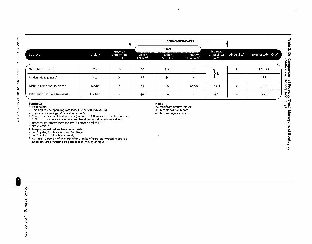
Description: Accidents (and otherincidents) are a common occurrenceon urban freeways. As shown inFigure 2-1, between 80 to 85 percentof recorded incidents are vehicle dis-ablements, 5 to 10 percent are acci-dents, and the remaining percentageincludes emergency maintenancework, debris on the road, etc.(Cambridge Systematics and TheATA Foundation 1996). There arethree major stages to an incidentmanagement program: 1) detection/verification, 2) response/clearance,and 3) recovery/information.
HIGHWAYS GETTING THE MOST OUT OF THE EXISTING SYSTEM


A study of a freeway service patrolin the San Francisco Bay area con-cluded that the proportion of towtruck assisted incidents increased from9 percent “before” to 24 percent afterimplementation with 80 percent ofthese assists provided by the patrol(Skabardonis et al 1995). About 30percent of these incidents requiredthe vehicle to be removed from thehighway. The response times of theservice patrol assists were reduced by57 percent, and the response times ofall assisted incidents were cut by 35percent. This service had an estimat-ed benefit/cost ratio of 3.4:1 and anestimated annual reduction of 77 tonsof carbon monoxide, 19 tons of oxidesof nitrogen, and 7.6 tons of hydrocar-bons. A survey of motorists assistedby this service not surprisingly showedoverwhelming approval with 93 per-cent rating the service “excellent.”
A 1986 Federal HighwayAdministration study revealed thatincident management systems couldreduce congestion on approximately30 percent of the major urban areafreeway mileage, returning abenefit/cost ratio of approximately4: 1, where benefits are measured asthe aggregate value of time saved bythe motorists (Federal HighwayAdministration 1986). Other studieshave produced the following benefit/cost ratios for specific types of actions:
HIGHWAYS GETTING THE MOST OUT OF THE EXISTING SYSTEM
Developing a comprehensivefreeway incident management strate-gy is one of the most cost effectivestrategies that can be implementedas part of a transportation systemmanagement program. As shown inFigure 2-3, the different types ofactions that can be undertaken toprovide better incident managementcapabilities can vary in potentialbenefits and costs.
Implementation: The documentedimpacts of freeway incident manage-ment improvements have beenimpressive. As freeways become morecongested, incident detection andmanagement systems will becomeeven more important. The processfrom conceptual planning to com-pleted system in an urban area cantake five years. Marketing efforts, inparticular, are needed early in theprocess to assure that the public andelected officials will understand theimpacts of these traffic managementefforts. Table 2.2 shows the differentconstituencies for incident manage-ment and key “selling points” foreach. Some metropolitan areas haveestablished “Congestion ManagementTeams,” with specific responsibilitiesfor planning, implementing, monitor-ing and identifying these activities.Of particular interest is the use ofadvanced technologies in the devel-opment of incident detection and
CharlotteChicago
Denver
Houston
HoustonHouston
Motorist Assistance Patrol
Emergency Traffic Control
Mile-High Courtesy Patrol
Motorist Assistance PatrolMotorist Assistance Patrol
Freeway Courtesy Patrol
7 6:l 1993
171 1990135.1 to 184.1 1993
19 1 1993
71to361 1991
2.1 1973
Source Cambridge Systematics and The ATA Foundation 1996


Figure 2.3: ContinuedOptions to Improve Response Time
Personnel ResourceList
Equipment andMaterials ResourceList
Peak Period MotorCycle Patrols
+++
+++
++++
$ Can save time in locating speciallytrained personnel
$ Can save time in locating specialequipment or personnel if list isfrequently updated
$$ to $$$ Roving motorcycle patrols can provideadded surveillance on high iincidentsegments
Dedicated Freewayor Service Patrols
Personnel TrainingProgram
+ + to ++++
+++
$$ to $$$$
$$
Roving patrols can reduce responsetime required by response vehicles
An emphasis on training through knowledge and repetition can reduce responsetimes
Tow Truck/ RemovalCrane Contracts
++ $ Provides faster access to equipment, butmay be problematic with competingfirms
Improved Inter-agency RadioCommunications
OrdinancesGoverning Travelon Shoulders
+++
+
$ to $$ Adequate communication can helpto insure closest response vehicle IS
dispatched
$ Can provide additional travel lane forresponse vehicles
Emergency vehicleAccess
Alternative RoutePlanning
Equipment StorageSites
AdministrativeTraffic ManagementTeams
Public EducationProgram
++
++
++
+
+++
$$ Requires iidentification of those freewaylinks which suffer from poor access
$ If properly planned, can allow quickeraccess
$ to $$ Provides faster access to equipment ormaterials
$ Provides forum to discuss and providefunding for area incident managementprograms
$ Can educate drivers regardrng disabledvehicle removal and help resolve incl-dents without need for actual response
Central Information +++ $$$ Provides a single location for monitoringProcessing and incidents and allows coordination ofControl response from many different agencies
Closely Spaced ++ $ Fast, accurate, easy location of incidentsMilepost Markers Improves response speed
+ = Minor Benefits $ = Minor Costs++ = Moderate Benefits $$ = Moderate Costs+++ = Substantial Benefits $$$ = Substantial Costs++++ = Very Substantial Benefits $$$$ = Very Substantial Costs
HIGHWAYS GETTING THE MOST OUT OF THE EXISTING SYSTEM


Options for improving Motorist Information, Continued
Route GuidanceProvides the most comprehensive infor-matron concerning traffi c situations, butIS stil l in development stage
A central location can collect data frommultiple sources and provide a more accu-rate picture of existing traffi c conditions
Options for Reducing Clearance Time
Policy Requiring Fastvehicle Removal
Governing Shoulder
ion of those freeway
Alternative Rout e If implemente d wit h informationsystems, can serve to reduce congestronand Improv e mobilit y by reroutinguninvolve d vehicles
Identi f ication of FireHydrant Locations
++ $ Can greatly speed clearance efforts byallowin g quick locating of utrlrtres inincidents with fire
Incident ResponseTeams
Incident ResponseManual
++ to ++++
+++
$ to $$$
$
Coordinated response teams should betrained in a variety of equipment use
Once developed, should be Included inregular training procedures for clear-ance efforts
Hazardous MaterialsManual
+++ $ Once developed, should be included inregular trainin g procedures for clear-ance efforts
Administrative TrafficManagement Teams
Public EducatronProgram
Total Station Survey-ing Equipment
+
+++
++++
$ Provides a forum to discuss and providefunding for area incident management
$ Can educate drivers regarding disabledvehicle removal policies
$ Can reduce time required for accidentinvestigation by nearly half
HIGHWAYS GETTING THE MOST OUT OF THE EXISTING SYSTEM
+ = Minor Benefits++ = Moderate Benefits+++ = Substantial Benefits++++ = Very Substantial Benefits
$ = Minor Costs$$ = Moderate Costs$$$ = Substantial Costs$$$$ = Very Substantial Costs

References
Cambridge Systematics and The ATA Foundation. 1996. Incident Management, Reportprepared for National Incident Management Coalition, Washington D.C., July.
Collura, John et al. 1995. A Review and Assessment of the Massachusetts *SF Program,Final Report, University of Massachusetts, Department of Civil and EnvironmentalEngineering, Amherst, MA, December.
Connecticut Department of Transportation. 1990. Connecticut Freeway TrafficManagement System, Final Report, Hartford, CT, August.
Federal Highway Administration. 1986. Quantification of Urbun Freeway Congestion andAnalysis of Remedial Measures, Report FHWA/RD-87/052, Washington, D.C.: FHWA,October.
Institute of Transportation Engineers.1992. Traffic Engineering Handbook, WashingtonD.C.:ITE.
J.Koehne, F. Mannering, and M. Hallenbeck. 199 1. Framework for Developing IncidentManagement Systems, Washington Department of Transportation, Olympia, WA.
Minnesota Department of Transportation. 1996. Traffic Management Program Overview,Twin Cities Metro Area, Metro Division, Freeway Operations Section, Report No. TMC07043-0196, St. Paul, MN, February.Schrank, D. and T. Lomax. 1996. “Estimating the Effect of Operational Improvementsin the Houston Area,” Transportation Research Record 1564, Transportation ResearchBoard, Washington D.C.
Skabardonis, A. et al. 1995. Freeway Service Patrol Evaluation, Institute of TransportationStudies Report UCB-ITS-PRR-95-5, University of California, Berkeley.
Urban Land Institute. 199 1. 12 Tools for Improving Mobility and Managing Congestion,Washington D.C.
A TOOLBOX FOR ALLEVIATING TRAFFIC CONGESTION AND ENHANCING MOBILITY

Ramp Metering
Description: Ramp metering is acost-effective technique for improv-ing traffic flow on freeways. Using amodified traffic signal placed at theend of a ramp, ramp metering allowstraffic to enter the highway trafficeither at pre-timed intervals or attimes determined by traffic volumeon the ramp or on the main highway.Although delays are often incurred byramp traffic, mainline capacities areprotected and the overall operationalefficiency, usually measured in termsof travel time or speed, is improved.HOV bypass lanes on metered rampshave been used to provide time sav-ings for carpools, van pools, andbuses. Minneapolis/St. Paul has 380ramp meters on the region’s freeways,350 of which are centrally controlledby a traffic management center. In anew twist to the concept of rampmetering, the Minnesota DOT ismetering 70 freeway-to-freeway rampsthat have been severely congested .over the past 10 years (MinnesotaDOT 1995). Figure 2-4 shows thebasic concept of how ramp meterswork.
Benefits/Costs: Ramp metering isprimarily a tool for increasing trafficthroughput on a freeway. However,ramp metering also can be used todiscourage drivers from using thefreeway for very short trips and toprovide incentives for bus riders andcarpools by bypassing ramp conges-tion (often a one to four minute timesavings). A survey made for the
’Federal Highway Administration ofseven ramp metering systems in theUnited States and Canada revealedthat average highway speeds
increased by 29 percent after rampmetering was installed. When delayson ramps are included, average speedsstill increased 20 percent and traveltimes decreased 16.5 percent. Ananalysis of the FLOW system inSeattle (ramp metering and HOVlanes) revealed that in addition tosimilar improvements in speed andtravel time, highway volumesincreased by about 60 percent as aresult of ramp metering. An addi-tional benefit from ramp metering isa decrease in the accident rate.Reductions from 5 to 50 percent havebeen achieved through improvedmerging operations (Piotrowicz andRobinson 1995). The following is asummary of ramp metering impactsfrom five locations in the UnitedStates: (Connecticut DOT 1990)
Ramp metering IS a cost-effective
technique for improving traffic
flow on freeways.
Change in:
Portland, OR 16mph 41 mph -61% -43% NA
Mi nneapolis 34 mph 46 mph NA -27% +32%
Seattle NA NA -48% -39% +62%
Denver 43 mph 50 mph -37% -5% +19%
Long Island, NY 29 mph 35 mph -20% NA 0
Various levels of entrance rampcontrol have been implementedacross the country. Some are usedsimply to improve the conditions atspecific problem merge areas. Tworamp metered locations in Detroitresulted in increases on the freewaymainline of traffic volume and speed(27 mph to 60 mph) at one locationand increases of traffic volume andspeed (35 mph to 58 mph) at anoth-er. A few states have focused atten-tion on longer sections of routes inurban areas and are now attemptingsystem-wide applications, notably inCalifornia and Texas. Average speed
HIGHWAYS GETTING THE MOST OUT OF THE EXISTING SYSTEM


The common increase in freewayspeed and flow rate that results fromramp metering must be consideredfrom the perspective of latentdemand. Over time, significantincreases in freeway capacity will leadto large growth in traffic volume, pos-sibly encouraging travelers to switchto auto use from transit services.Therefore, ramp metering should beimplemented in conjunction withcorridor transportation demand man-agement strategies that will encour-age high-occupancy vehicle use.
Implementation: A substantialamount of time is needed to plan andimplement a ramp metering system.The engineering aspects of rampmetering are fairly wellknown.However, ramp meters can oftencreate significant controversy regard-ing the perceived inconvenience tomotorists, and importantly the equityissue of providing improved freewaytraffic flow for those using the free-way (e.g., suburban commuters) tothe inconvenience of those trying toaccess it (e.g., center city residents).The implementation of a rampmetering system must thereforeinclude a process where a variety ofgovernment and public groups areactively involved in the conceptualplanning and implementation.
The following implementationstrategy was recommended for incor-porating ramp meters into theHartford, CT freeway system(Connecticut DOT 1990).. Involve all affected agencies and
institutions in the process from thevery beginning.
. Institute a proactive publicrelations program.
l Discuss with local governmentshow the metering will be operated,e.g., diversion strategies and howto minimize impacts on localstreets.
. Perform ramp control experimentsto demonstrate the effectiveness ofmetering.
. Install ramp meters in conjunctionwith freeway rehabilitation andresurfacing.. Provide updates on meteroperations at frequent intervals.
Although ramp metering canprovide some important improve-ments to the flow of freeway traffic, it
is not always an appropriate solution for a number of reasons. Ramps selected for this technique must be at locations where arterials feeding the ramps will not become severely
congested as a consequence of suchaction. Improvements to freewayflows could be made at the expense of
transferring a more severe congestionproblem to local streets. Possiblemitigation measures for such anoccurrence include:
. Increasing ramp storage, e.g., widen-ing/increasing number of lanes.
l Creating an areawide systemcontrol of metering such thatbackups are distributed amongmany different ramps.
l Installing a queue detector at thetop of the ramp that will increasethe metering rate to clear out thevehicles in the queue.
HIGHWAYS GETTING THE MOST OUT OF THE EXISTING SYSTEM
The implementation of a ramp
metering system must include a
process where a variety of govern-
ment and public groups are active-
ly involved in the conceptual plan-
ning and Implementation.

Highway Information Systems
can consist of the following:
changeable message signs,
highway advisory radio, and/or
in-vehicle navigation and
information systems.
References
Connecticut Department of Transportation. 1990. Connecticut Freeway TrafficManagement System Final Report, Hartford, CT, August.
Minnesota Department of Transportation. 1995. Overview of the MnDOT Ramp MeteringProgram, Report No. 07043-0795, Metro Division, St. Paul, MN, December.
Piotrowicz, G. and J. Robinson. 1995. Ramp Metering Status in North America, 1995Update, Report DOT-T-95-17, Federal Highway Administration, Washington D.C.
Highway Information Systems(See also Regional Multimodal Traveler .Information Systems, Chapter 6)
Description: Highway informationsystems represent an important ele-ment of a freeway management sys-tem in that they provide the meansof communicating to those travelingon the road system. Such informa-tion systems can consist of one ormore of the following: changeablemessage signs, highway advisoryradio, and/or in-vehicle navigation .and information systems. The intentof these information systems is toprovide dynamic information regard-ing existing traffic conditions so thattravelers can make intelligent route :choices if already on the road net-work, or even mode choice if the triphas not yet started. Information thatcould be conveyed includes:(Connecticut DOT 1990)
l Delays due to recurring congestion
l Delays from non-recurringcongestion
l Speed limits
l Weather conditions
l Construction activities
l Evacuation information
l Implementation of new devices(e.g., ramp meters)
More recently, the Internet hasbeen used to provide real-time free-way condition information in a num-ber of cities in the United States.Local cable TV channels could alsoprovide real-time video of traffic con-ditions to the public as is being donein Montgomery County, Maryland.The state-of-the-art of this technolo-gy was demonstrated in the AtlantaTraveler Information Showcase thatwas put in place for the 1996Olympics (see Chapter 6 for a moredetailed description of this program).
Benefits/Costs: The benefits ofimproved traveler information sys-tems include:
Early warning reduces the speedsof vehicles approaching a queue,resulting in fewer secondary acci-dents and associated delays.Decelerations have been found tobe less severe in congested loca-tions when advanced warn.ing was
Invehicle Navigation System given.
A T O O L B O X F O R A L LE V I A T I NG T R A F F I C CONGESTION A N D E N H A N C I N G M O B I L I T Y

. Vehicles can divert to alternateroutes when informed of an inci-dent that is blocking the roadahead.
l Information on lane blockagesinduces lane changing away fromthat lane.
Motorist diversions will generally .contribute to overall savings in traveltime over the delays likely to beexperienced on the mainline. Thisassumes, of course, that there arealternative routes available to divertto and that these routes themselvesare not greatly congested. However,every effort should be made to keepdiverting motorists from using resi-dential streets.
Highway information systems can .also be used at locations where heavycongestion occurs. Highway advisoryradio, for example, is often used atapproaches to airport parking facili-ties, near construction sites on free-ways, and in mobile units by incidentmanagement teams. The transmittershave a range of approximately 2miles/3.2 kms in each direction. Themessages are changed remotely toreflect actual conditions. Otherinformation dissemination tools can .also be used including in-vehicledisplays (Federal Highway Admini-stration 1995).
One of the more recent demon-strations of in-vehicle traveler infor-mation was the TravTek program inOrlando, Florida (Federal HighwayAdministration 1996). This demon- stration consisted of 100 vehiclesequipped with in-vehicle informationdisplays, a traffic management centerand a TravTek information and
services center. The majority of thevehicles were rented to Orlandovisitors. Figure 2-5 shows the resultsof improved information to drivers.Note in this figure that the reductionin the different parameters were theresult of tests with local drivers aswell as out-of-town visitors.
Figure 2.5: Summary of TravTek In-Vehicle Information Demonstration
A c c i d e n t s
E m i s s i o n s
FUel
W r o n g r u m s
Distance
Travel Time
10 20 25 30 35Percent Reduction
Source: FHWA 1996
Implementation: A substantialamount of time is needed to plan andimplement a highway traveler infor-mation system. Implementationrequires the design and constructionof the system, using the steps requiredfor a typical highway constructionproject. However, the nature of thissystem is such that experts in theareas of electronics and informationsystems must be involved in additionto highway and traffic engineers.Local communication media shouldbe included in the planning and pos-sibly in the implementation stage.Ideally, the system should be designedas an integral part of an areawidefreeway management program, asdescribed previously. An example of acoordinated freeway corridor manage-ment system that relies on travelerinformation systems is shown inFigure 2-6. This approach has been
HIGHWAYS GETTING THE MOST OUT OF THE EXISTING SYSTEM


References
Connecticut Department of Transportation (ConnDOT). 1990. Connecticut FreewayTraffic Management System, Final Report, Hartford, CT, August.
Connecticut Department of Transportation (ConnD0T). 1995. ITS Needs Assessmentand Service Assessment, Planning Report No. 1, Hartford, CT, November.
Federal Highway Administration (FHWA). 1995. Responsive Multimodal TransportationManagement Strategies and IVHS Report FHWA-RD-94-086, Washington D.C.Federal Highway Administration (FHWA). 1996. TravTek Evaluation Modeling Study,Report FHWA-RD-95-090, Washington D.C., March.
Freeway Corridor TrafficManagement (Including ArterialSurveillance and Control)
Description: Freeway corridor trafficmanagement consists of a coordinat-ed application of the strategies dis-cussed earlier on both a freeway andon the adjacent arterials. The impor-tant element of a corridor trafficmanagement strategy is that addition-al mobility enhancements can occurby combining the control and surveil-lance of nearby arterial roads withadjoining freeway control and surveil-lance activities. Motorists seeking toavoid the congested freeway coulduse parallel arterial routes or otherfreeways, which in turn increasescongestion on these facilities. Trafficwaiting to enter the congested free-way may spill onto adjacent surfacestreets, further aggravating conges-tion. An integrated freeway and arte-rial network surveillance system con-
HIGHWAYS GETTING THE MOST OUT OF THE EXISTING SYSTEM
sists of incident surveillance andmanagement, entrance ramp control,exit ramp control, freeway mainlinecontrol [which includes driver infor-mation systems, variable-speed con-trol, mainline metering, lane control,and reversible lane control], and cor-ridor control [which includes coordi-nation of traffic signals on frontageroads and on parallel arterials, coordi-nation of ramp control and frontage
road operations to provide alternateroutes during emergencies, coordina-tion of turning traffic signal phases,and coordination of traffic signals atfreeway interchanges with arterialcross streets] (Institute ofTransportation Engineers 1992).
Benefits/Costs: A good example ofan operationally integrated freewayand arterial road project is in NewYork State. The Information forMotorists (INFORM) project wasconceived to optimize traffic flowthrough a 35 mile/56 km long and 5mile/8 km wide corridor of freewaysand arterials in Long Island by inte-grating ramp metering, coordinatedtraffic signal control, and variablemessage signing into one comprehen-sive system sharing the same softwareand database. INFORM consists ofthe following elements: (Domjan andHan 1994). 2069 roadway embedded vehicle
sensors
. 101 variable message signs
l 75 ramp meters
l 34 closed circuit TVs
. 22 Citizen Band radio receivers
l central control center. 133 centrally controlled signalizedintersections
The Important element of a
corridor traffic management
strategy i s that additional mobility
enhancements can occur by
combining the control and
surveillance of nearby arterial
roads with adjoining freeway
control and surveillance activities

The most important benefits associated with these types of projects is the reduction
in delay that occurs with improved traffic flow in the corridor.
Both California and Texas haveembarked on similar ventures. Anintegrated corridor concept is foundon the Santa Monica freeway corri-dor in Los Angeles, 12 miles/l9 kmslong and 5 miles/8 kms wide with fivearterial alternative routes. A com-mon database has been developed forroadway management and motoristinformation. Personal computer andtelephone information access and in-vehicle navigation information arepart of the state-of-the-art activities.One of the few studies that have esti-mated the benefits of freeway man-agement focused on the existing andprojected (in the year 2000) freewaytraffic management (FTM) systems inHouston. This study estimated thatthe 48-mile/77-kilometer FTM sys-tem in 1995 reduced daily recurrentdelay by 6,300 vehicle-hours which isthe equivalent of an additional 56freeway lane-miles. For the projected110 mile/l 77-km FTM system in2000, the reduction in daily recurrentdelay would be 21,100 vehicle-hourswhich is the equivalent of an addi-tional 153 freeway lane-miles(Schrank and Lomax 1996).
The most important benefits asso-ciated with these types of projects isthe reduction in delay that occurswith improved traffic flow in thecorridor. A sophisticated surveillanceand control program in a corridorcould increase average vehiclethroughput by 12 to 20 percent andproduce benefit/cost ratios of between10 and 12 to 1 (Henk,) Poe, and
Lomas 1991). A recent case studyof TRANSCOM a regional institu-tional structure for coordinating alarge number of transportation andenforcement agencies in the NewYork City area, illustrates the benefitsof such an approach (Wilson 1996).A consortium of 15 transportationand traffic enforcement agencies cre-ated TRAN’SCOM, an incidentmanagement and communicationsclearinghouse. TRANSCOMreceives updated information onroadway emergency situations, specialevents, and any other incidents thatrequire immediate attention.TRANSCOM staff evaluate thisinformation and transmit it to allmember agencies via encoded pagers,giving them real-time information onevents affecting traffic conditions.This ensures quick response. One ofthe important activities of this effortis the transmission of digitized pic-tures of incident scenes by cellulartelephone to a personal computer atthe TRANSCOM center. To mini-mize disruptions and improve the effi-ciency of the highway system,TRANSCOM has developed aregional database of all scheduledconstruction and maintenance pro-jections, and has prepared pre-arranged diversionary plans for themajor highways in the region(Federal Highway Administration1987). Some benefits associated withTRANSCOM include daily coordi-nation among the operating agenciesin a major metropolitan area, longerterm coordination of constructionscheduling on the regional highwaynetwork, and sharing of new trans-
A TOOLBOX FOR ALLEVIATING TRAFFIC CONGESTION AND ENHANCING MOBILITY

portation management technologies.For example, TRANSMIT, theTRANSCOM System for ManagingIncidents and Traffic, uses vehiclesequipped with transponders for elec-tronic toll collection as probes tomonitor traffic. Although the origi-nal purpose of this project was tomonitor for incidents, implementingagencies have found great use withthe collected data for determiningtravel times between key pointswhich has been used for schedulingstaffing levels at toll plazas.
Of some importance to regionaltransportation, the TRANSCOMprogram was one of the majorfoundations for a much larger effortcalled the I-95 Coalition which hasexpanded TRANSCOM’s impactfrom Maine to Virginia (see Chapter6 for a more detailed description ofthe I-95 Coalition).
Implementation: Integrated corridorsolutions are in the early stages ofimplementation in several cities. ITStechnologies are being used as thefoundation of many of these efforts.The barrier to further efforts (large orsmall, simple or sophisticated) islargely institutional and financial.Only by working side by side, as partof the whole solution, can regionalimprovements result. TheTRANSCOM example above illus-trates this point quite well. As notedin (Wilson 1996), there are severalgeneral principles that are inherentin regional cooperative efforts:
. Lack of authority should not detera coalition from pursuing its mis-sion with confidence.
HIGHWAYS GETTING THE MOST OUT OF THE EXISTING SYSTEM
. Even if the coalition has a uniformset of goals and objectives, themotivations among the memberagencies for participating or notparticipating in the coalition canbe highly variable.
. Even if the executive managementof a constituent agency supports aregional coalition, this may notnecessarily translate into supportfor regionalism at all levels and allsectors of the agency.
. While uniform procedures amongthe member agencies may be desir-able in making a coalition effec-tive, that is an unlikely situationfor a coalition that has no authori-ty over its members.
l There should be no inconsistencybetween the self-interest of eachagency and the collective, regionalinterest of the coalition.
. Coalitions should focus on thingsthat truly are better done collec-tively.
l To develop from an abstract idealinto a going concern, a coalitionhas to provide a valuable service-it has to help its constituent agen-cies do their business and servetheir customers more effectively.
Another example of integratedfreeway/arterial systems is the con-cept of Traffic Management Teams inTexas. There are currently 12 teamsoperating in the state, covering theseven largest metropolitan areas andthe nine largest cities as well as othersmaller areas. Each team bringstogether professionals from varioustraffic-related agencies in the area,and works cooperatively to solve the
The barrier to further efforts in
integrated corridor solutions is
largely institutional and financial.
Only by working side by side, as
part of the whole solution, can
regional improvements result.

traffic problems. The rapidspread of the team concept and theirwide acceptance among the largercities in Texas is evidence that effec-tive interagency communications canoften lead to cooperation. The TexasDepartment of Transportation hasalso sponsored an aggressive educa-tion program for both highway/trafficprofessionals and the general public.The viability of coordinated trafficmanagement schemes is demonstrat-ed through workshops, seminars, andtraining courses.
Integrated freeway and arterialnetwork surveillance/control pro-grams are important tools for bettermanaging the existing road system.These programs should be integratedwith multimodal traveler informationsystems so that corridor transporta-tion improvements benefit not onlyauto users, but all travelers. As notedin Chapter 1, the management oftransportation supply should be inte-grated with transportation demandmanagement and land use policies.
.
References
Domjan, R. and B. Han. 1994. “INFORM-An Updated Performance Evaluation From1990 to 1994,” ITE Compendium of Technical Papers, Washington, D.C.
Federal Highway Administration. 1987. Urban Traffic Congestion - A Perspective to theYear 2020, San Francisco, CA, Region 9 Office of FHWA, September.
Henk, R., C. Poe, and T. Lomax. 1991. An Assessment of Strategies for Alleviating UrbanCongestion, Texas Transportation Institute, Report 1252-lF, Texas A&M University,College Station, TX, November.
Institute of Transportation Engineers. 1992. Traffic Engineering Handbook, WashingtonD.C.
Schrank D. and T. Lomax. 1996. “Estimating the Effect of Operational Improvementsin the Houston Area,” Transportation Research Record 1564, Transportation ResearchBoard, Washington D.C.Wilson, F. 1996. “The TRANSCOM Coalition: Multi-Jurisdictional Issues in ITS,” ITSQuarterly, Spring.
A TOOLBOX FOR ALLEVIATING TRAFFIC CONGESTION AND ENHANCING MOBILITY

Providing Additional Lanes WithoutWidening the Freeway
Description: Using freeway shoul-ders as travel lanes has occurred insome cities since the late 1960s, withmany of these lanes being devoted toHOV use. These modificationsinclude, 1) using one or more shoul-ders as travel lanes (this is often doneonly during peak hours and in thepeak direction), and 2) reducing lanewidths to provide additional laneswithin the existing pavement.
Benefits/Costs: Significant increasesin capacity (up to as much as 30 per-cent and more) are possible. Thesecapacity increases, however, haveoften been achieved with someincrease in accident rates. Thus, thedesign of such lanes must clearly takeinto consideration the safety aspectsof the particular freeway section.Even though such treatments shouldbe considered temporary, an FHWAstaff study found that in cities withpopulations over one million, almost32 percent of the urban freewaymileage could experience reducedcongestion through such low-costmeasures (Federal Highway Admini-stration 1987).
A recent study of freeway shoulderlanes found: (Curren 1995)
l Freeway capacity in excess of 2,200passenger car per hour per lanewere observed at these sites.
. Modified sites have a greater tend-ency to fall into more congestedconditions at high volumes thanunmodified sites.
. The range of observed speedsalong an unmodified freeway sec-tion will be somewhat greater than
HIGHWAYS GETTING THE MOST OUT OF THE EXISTING SYSTEM
along a comparable modifiedsection.
. Accident rates at modified freewaysections are somewhat higher thanrates for unmodified sections.
. Truck accident rates are almostalways higher on modified sections.
Another study examined thenorthern Virginia I-95 use of shoulderlanes for the entire day (Chen 1995).This 8-mile/1 2.9~km section ofInterstate has a left lane designatedfor 3+ HOV vehicles, two generalpurpose lanes, and a right shoulderlane which is used as a conventionaltravel lane. This study concluded:
. The use of shoulder lanesincreased freeway capacity signifi-cantly. Analysis indicated thatremoving the shoulder lanes fromgeneral purpose use would increasequeue lengths by 140 percent andsystem delays by 929 percent. TheHOV and shoulder lanes carried47 percent of total vehicles and 63percent of total travelers on thefreeway.. No adverse impacts on generaltraffic accident frequency wasfound. Fatality rates were lowerthan the “before” situation.
Importantly, in keeping with theconcern mentioned earlier about safe-ty, several modifications were madein the corridor to maintain opera-tional and enforcement activities.In particular, emergency pulloutswere built and signed to allow for safestorage of disabled vehicles.
Costs will normally vary depend-ing on the individual circumstancesand the condition of the existing
Modifications to provide additional
lanes without widening the
freeway include:
I) using one or more shoulders astravel lanes;
2) reducing lane widths to provideadditional lanes within the existingpavement.

When shoulder use is being
considered for traffic flow careful
planning and design should occur
to avoid any potential safety
problems.
freeway, but in general, costs per mile there are no other less-than-standardwill be $1.5 million for construction features; however combined withand engineering, and $12,000 per shoulder width reductions, substan-year for maintenance. Overall, low- dard sight distance, and other fea-cost improvements have the potentialof returning a benefit/cost ratio of upto 7:1
tures, (these) lanes may not providethe same operation.”
This means that when shoulderThe primary advantages and disad- use is being considered for traffic flow,
antages in implementing this tool are: careful planning and design should
Use of Left Shoulder Left shoulder not used as much foremergency stop or emergencyenforcement
Least expensive if width IS available
Trucks often restricted from leftlane
Use of Right Shoulder Often the easiest to Implement
Use of Both Shoulders Not recommended
Use ONLY in extreme cases
Usually requires restriping
sight distance problem with somemedian treatments
Right shoulder IS preferred area foremergency stops and enforcement
Sight distance changes at mergeand diverge areas of ramps
Requires restriping
Safety concerns
Enforcement difficult
Incident response longer
Manintenance more difficult andexpensive
ource current 1995
mplementation: Whenever occur to avoid any potential safetymprovements are made to a highway problems. In addition, structuralhe level of safety should be capacity of a highway varies acrossmproved. As noted in (AASHTO the cross section. The shoulder is not997): . often constructed to accommodate
“The need to accommodate more traffic loads. Pavement failure and
traffic within existing or limited addi- subsequent repair under traffic condi-
tional right-of-way on high volume tions will have an effect on both
urban freeways has led some agencies capacity and safety. Changes in traffic
to increase capacity by exchanging and operational patterns often have
full-lane or shoulder widths for addi- an impact that goes beyond the
tional travel lanes with reduced immediate facility that is being affect-
widths. Any proposed use of less- ed. Thus, additional capacity provid-
than-full-atandard cross-sections must ed in one corridor could very well
be analyzed carefully on a case-by- influence demand on adjacent arteri-
case basis. Experience indicates thatals or on nearby freeways. Such
12ft/3.3m lanes can operate safely if issues must be considered in the
A TOOLBOX FOR ALLEVIATING TRAFFIC CONGESTION AND ENHANCING MOBILITY

analysis that precedes a decision touse shoulder lanes.
The state transportation agencywould most likely plan and designthese improvements as a typical high-way project, and enter into a con-struction or lane striping contract inthe usual manner. Cooperation andcoordination between the state high-way agency and the traffic enforce-ment officials responsible for enforce-ment (e.g., the state police) is essen-tial. Because the use of breakdownlanes is not consistent with federaldesign criteria, federal approval willbe required if the highway facility ison the federal-aid system.
When this action is being consid-ered, it typically generates oppositionfrom traffic enforcement agencies andmotorists who are mainly concernedabout safety (i.e., the emergency laneis used for traffic flow rather than byemergency vehicles or breakdowns).Also, there is concern that the flowfrom entrance ramps will be adverselyaffected. These are all legitimateconcerns which should be addressed.The response to these concernsinclude the following (AASHTO1997):
l Where shoulders are converted totravel lanes, removing the left-sideshoulder is preferable.. Where a highway with a narrowmedian and median barrier isbeing considered for using themedian shoulder for a travel lane,curves should be checked for ade-quate stopping sight distance.
l Comprehensive incident detectionand response systems should beconsidered for sections with sub-standard lane and shoulder widths.
. If both shoulders are removed,mitigating measures shouldinclude: adequate advisory and
regulatory signing, constructingfrequent emergency pullouts,active overhead and side-mountedchangeable message signs and sig-nals, continuous lighting, trucklane-use restrictions, dedicated ser-vice patrols, and continuousenforcement.
l For sections greater than 1.5 kmswhere inadequate shoulders are pro-vided, emergency pullouts shouldbe considered where feasible.
The state transportation agency would most likely plan and design the improvements
as a typical highway project, and enter into a construction or lane striping contract
in the usual manner: Cooperation and coordination between the state highway
agency and the traffic enforcement officials responsible for enforcement is essential.
Given that the major reason forimplementing this action is toincrease the vehicle-carrying capacityof a freeway, the planning for thisaction should consider the likelyimpact of induced traffic demand thatwill now be generated on air quality,environmental issues, and eventuallyon the long-term operation of thefreeway.
A complete guide for the imple-mentation of this tool is found in(Current 1995).
HIGHWAYS GETTING THE MOST OUT OF THE EXISTING SYSTEM

HOV lanes bypass serious conges-
tion points thus decreasing travel
times and in creasing travel time
reliability for HOV lane users which
can be a strong Inducement to use
transit or ridesharing
References
American Association of State Highway and Transportation Officials (AASHTO),1997. Highwuy Safety Design and Operations Guide, Washington D.C.Chen, C. 1995. “Evaluation of HOV and Shoulder Lane Travel Strategy for I-95”, ITEJournal Institute of Transportation Engineers, Washington D.C., September.CurrenJ.E. 1995. Use of shoulders and N a r r o w Lanes to Increase Freeway Capacity,NCHRP Report 369, Transportation Research Board, Washington, DC.Federal Highway Administration (FHWA). 1987. Urban and Suburban HighwayCongestion, Working Paper No. 10, Washington, D.C., December.
High Occupancy Vehicle (HOV)Facilities
Description: An increasingly popularmethod for increasing the person-car-rying capacity of a freeway is to desig-nate some portion of the roadway foruse solely by those using high occu-pancy vehicles (HOVs). HOVs areusually defined as including buses,vanpools, and carpools. HOV lanesbypass serious congestion points thusdecreasing travel times and increasing
Figure 2.8: Freeway HOV Lane Applications
Reversible-Flow
Two-Way (Concurrent Flow)
Borrowed for HOVs
Queue Bypass
Source. Texas Transportation Institute 1992
travel time reliability for HOV laneusers which can be a strong induce-ment to use transit or ridesharing. Inaddition, HOV facilities allow transitoperators to provide a more reliabletransit service given that buses arenot now subject to the unpredictableconditions of freeway operation.Several types of HOV facilities arefound in the United States, includ-ing: (see Figure 2-8)
Exclusive HOV Facility, SeparateRight-Of-Way. A roadway or lane(s)developed in a separate right-of-wayand designated for the exclusive useof high occupancy vehicles (usuallydefined as vehicles carrying at leasttwo or three persons per vehicle).
Exclusive HOV Facility, FreewayRight-Of-Way. Roadways or lanesbuilt withii the freeway right-of-waythat are physically separated fromother freeway lanes and are designedfor the exclusive use of high occupancyvehicles for some portion of the day.
Concurrent Flow Lane. A freewaylane in the peak direction of travel(commonly the inside lane), notphysically separated from the othergeneral traffic lanes, and designatedfor the exclusive use by high occu-pancy vehicles during some portion
of the day.
A TOOLBOX FOR ALLEVIATING TRAFFIC CONGESTION AND ENHANCING MOBILITY

Contraflow Lane. A freeway lane(commonly the inside lane) locatedin the off-peak direction of traveldesignated for exclusive use by highoccupancy vehicles (usually busesonly or buses and Vanpools) travelingin the peak direction during someportion of the day. The lane istypically separated from the off-peakdirection travel lanes by plastic posts,pylons, or movable concrete barriers.
Benefits/Costs: The primary purposeof HOV facilities is to increase thepeople-moving (versus vehicle-mov-ing) capacity of a freeway. As shownin Figure 2-9, the results can be quitedramatic. The peak direction, personvolumes per lane are substantiallyhigher than comparable non-HOVfreeway lanes. The same can be saidfor average auto occupancy, the num-ber of 2+ Carpools, and the number ofbus passengers (Henk, Morris andChristensen 1994). The I-64 HOVlane in Hampton Roads, Virginia istypical of what one sees with theimplementation of an HOV lane.The freeway showed an increase ofalmost 3,000 persons carried with acorresponding decrease of 7 11 vehi-cles after the lane was opened in1992.
The major reason for using anHOV lane often cited in surveys ofHOV lane users is improved traveltime. Figure 2-10 shows the amountof time saved for different HOV facil-ities in the United States. Thesetravel time savings have been animportant factor in attracting driversto ridesharing and transit. For exam-ple, the following percentage of HOVlane users previously drove alone:
( W h o P r e v i o u s l y D r o v e A l o n e )
l-l 0, Katy Freeway, Houstonl-394, Twin Ci t iesl-395, Northern Vlrgmial-45, HoustonI-10, San Bernadmo Freeway,
Los Angeles
3 6 %4 3 %2 3 %3 9 %4 6 %
3 6 %
To the extent that HOV lanes canreduce the number of single occupantvehicles on the road, air quality bene-fits will occur. Some estimates of airquality benefits include a 21 percentreduction in pollutant emissions inthe I-395 corridor in WashingtonD.C.; and a 10 to 20 percent reduc-tion in emissions during the peakhour on the San Bernadino Freewayin Los Angeles.
Improvements in transit operationshave also been shown to be signifi-cant. In Houston, the peak hour busoperating speeds on the four majorfreeways with HOV lanes havealmost doubled from 26 mph to 54mph, reducing the revenue bus-hoursneeded to provide service by 31,000hours and saving the transit authorityapproximately $4.8 million annually(Henk, Morris, Christensen 1994).In Pittsburgh, the East Busway hasreduced bus travel times by 40 to 50percent. In Ottawa, Ontario, where a
Contraflow Lanes for High Occupancy Vehicles
HIGHWAYS GETTING THE MOST OUT OF THE EXISTING SYSTEM
The major reason for using an
HOV lane often cited in surveys
of HOV lane users is improved
travel time.


One of the important decisions
that must be made early i n the
HOV lane planning process IS the
minimum occupancy requirements
for those vehicles allowed in the
lane. The selection must allow
for growth as more commuters
choose to switch to ridesharing
arrangements to take advantage
of the time savings afforded by
the lane.
. Two HOV facilities in Hartford,Connecticut have provided a five-minute time savings to express bususers. When a minimum vehicleoccupancy requirement waschanged from 3+ to 2+ in 1993,lane use increased from 3 15 to 9 13vehicles.
HOV facilities have been planned,designed and constructed in a threeto eight-year time frame. The con-struction involves well-known high-way technology. HOV lanes can beopened as each section is completedthus providing immediate benefits asthe entire facility is being finished.The costs of an HOV facility willvary depending upon the type offacility. HOV facilities constructedon separate rights-of-way can costfrom $7 to $8 million per lane-mile;barrier-separated facilities constructedin freeway rights-of-way cost from $4to $6 million per lane-mile; concur-rent flow facilities cost from $1 to $2million per lane-mile; and contraflowlanes cost $0.5 to $1 million per lane-mile (Henk, Poe, and Lomax 1991).The annual operations and enforce-ment cost will also vary depending onthe level of enforcement provided. Astudy of the Houston HOV lanes, forexample, indicated that the annualoperating/enforcement cost per HOVlane was between $250,000 and$300,000.
Evaluation of HOV priority laneshas shown that the benefit/cost ratiosfor such projects are frequently inexcess of 6 to 1. Thus, HOV lanesshould be considered a very costeffective tool in a region’s mobilityenhancement program.
Implementation: A recent survey oftransportation professionals identifiedthe following concerns in implement-ing HOV facilities (Tumbull andCapelle 1996).. Enforcement problems/lack of
enforcement
l Converting general purpose lanesto HOV lanes
. 2+ vs. 3+ occupancy require-ments/managing demand
l Concern over low utilization levels
l Funding
l Opposition to HOV facilities/lackof political and public acceptance
l Safety issues
l MarketingAs indicated, one of the important
decisions that must be made early inthe HOV lane planning process is theminimum occupancy requirementsfor those vehicles allowed in the lane.The selection must allow for growthbe more commuters choose to switchto ridesharing arrangements to takeadvantage of the time savings afford-ed by the lane. In recent years, aminimum of two persons per vehiclehas been the most common occupan-cy requirement, although a 3+requirement has also been used.Allowing too small of a minimumoccupancy can create excess demandfor the facility, thereby negating anytime savings and incentives. Figure2-11 shows the results of lowering theoccupancy rate from 3+ to 2+ on theKaty Freeway in Houston and theconsequences on the number of vehi-
using the lane. In addition tothe increase in number of vehicles
A TOOLBOX FOR ALLEVIATING TRAFFIC CONGESTION AND ENHANCING MOBILITY


Most state transportation agencies having responsibilty for freeways In metropolitan
areas have design guides which strongly influence the process and ultimate design
of an HOV lane.
A major innovation in the physi-cal operation of HOV lanes hasoccurred over the last 10 years withthe development of movable barriers.These barriers (which are attachedtogether) are stored at the side of thefreeway during off-peak periods andthen put in place with a large tractor-type machine that lifts the barriersand places them in predeterminedlocations while the machine travelsdown the freeway. This approach isused primarily to create (on a dailybasis) a contra flow HOV lane that isphysically separated from on-comingtraffic. Such systems are found inBoston on I-93 and in WashingtonD.C. on I-66. They have also beenused at locations where limitedcapacity causes bottlenecks such asbridges.
There are a number of HOV pref-erential treatments that may be effec-tive in promoting HOV use whenimplemented as elements of a region-al HOV strategy. The following feaetures are very important in planningfor a successful HOV facility:
. park and ride lots. metered ramp by-pass. preferential parking and pricingl signal priorityl exclusive access rampsl turning restrictionsl preferential tollsl toll preferential lanesl transit passes
One of the most comprehensiveHOV strategies at the metropolitanlevel is found in Minneapolis/St.Paul. HOV lanes are currently onI-394 and I-35W, with some 55 HOVramp meter bypasses in operationthroughout the metropolitan area.Three parking garages in downtownMinneapolis with direct access toI-394 have been constructed withpreference given to HOV users.Remote park-and-ride lots have beenconstructed and timed transit transferstations to encourage transit rider-ship. The metropolitan area has alsocreated a “Team Transit” whichidentifies low cost enhancements toHOV users (Minnesota DOT 1996).This is the type of comprehensiveHOV program that is necessary toproduce significant results.
The ITE Traffic EngineeringHandbook provides guidelines for thefeasibility of different HOV applica-tions on freeways (Institute ofTransportation Engineers 1992).
For Separate HOV Facilities: Thepotential for HOV lanes on con-trolled access facilities is limited tohigh-volume urban corridors.Because of the severe right-of-wayand construction cost constraintsassociated with such corridors,consideration of sole-traveled-wayHOVs should take place in theplanning stage.
l Projected corridor demand duringpeak periods should indicatepotentially serious capacityproblems. A heavy peak perioddirectional split of 65-35 percentor 70-30 percent would be typicalof such a corridor.
A TOOLBOX FOR ALLEVIATING TRAFFIC CONGESTION AND ENHANCING MOBILITY
l The corridor should be of suffi-cient length and should carry ahigh enough volume of traffic toprovide the potential for large timesavings to users of the HOV facili-ty. A minimum of 10 minutestime savings is considered signifi-cant, with a 15 to 20 minutepotential time savings considereddesirable.
. Transit bus demand should exist inthe corridor.
l HOV lanes on sole-traveled waysshould normally be designed witha minimum of two lanes.
l Lane use vehicle occupancyrequirements should be carefullyconsidered if an acceptable levelof service is to be provided for allusers.
. Access to the separate HOV lanesshould preferably be restricted tospecial access ramps from grade-separated roadways.
. In planning and design, maximumoperation flexibility should be pre-served that will allow changes tothe operation of the HOV facilityshould it become unworkable inpractice.
For Concurrent or Contra-Flow HOVLanes:
. The lane should be physically separated from the remaining freewaylanes.
l Physical modifications to the free-way that reduce lane widths mustbe approached with extreme cau-tion. Minimum shoulder widthsshould be maintained.
. Contra-flow priority lanes shouldbe considered only when a consid-erable flow imbalance prevailsduring peak traffic periods and ifthe remaining off-peak directiontraffic can flow at an acceptablelevel of service.
. For safety reasons, contra-flowoperations must be at all timesclearly and unmistakably identifiedby opposing traffic.
. Concurrent-flow HOV lanesshould be physically separatedfrom the normal lanes by a bufferzone that will safely ensure thedesired separation.
l Exclusive connections or bypassramps should be considered wheretime savings to the HOV users aregreater than the costs when theramp and through-lane capacitiesare not adversely affected.
One of the key issues associatedwith contra-flow or concurrent flowlanes is taking existing highwaycapacity from general purpose useversus widening the road or restripingthe highway lanes to provide addi-tional HOV capacity. Beginning inthe mid-1970s with a controversial“take-a-lane” project on the SantaMonica Freeway in Los Angeles,HOV lanes that substantially reducethe vehicle-carrying capacity of thefreeway have faced strong oppositionfrom those who argue that such useand impact is unwarranted. For thoseprojects where a “take-a-lane” designis the only feasible alternative orwhere public policy is designed to
HIGHWAYS: GETTING THE MOST OUT OF THE EXISTING SYSTEM
The ITE Traffic Engineering
Handbook provides guidelines for
the feasibility of different HOV
applications on freeways.

restrict automobile use, project imple-mentation should include a compre-hensive marketing campaign to influ-ence public attitudes toward the
the lane for a price, the so-called highoccupancy toll lane or “HOT” lane.Some ITS demonstration projects aredoing just this (see Chapter 6).
HOV lane. In addition, such anHOV lane might best be implement-ed during a freeway reconstructionproject, or serious consideration begiven to allowing non-HOV use of
A comprehensive discussion onthe design of HOV lanes is found in(AASHTO 1992).
References
American Association of State Highway and Transportation Officials (AASHTO).1992 Guide for the Design of High Occupancy Vehicle Facilities, Washington D.C.California Department of Transportation. 1991. High Occupancy Vehicle Guidelines forPlanning, Design and Operations, Sacramento, CA, July.Henk, R., D. Morris, and D. Christensen. 1994. An Evaluation of High-Occupancy VehicleLanes in Texas, 1993, Research Report 1353-1, Texas Transportation Institute, TexasA&M University, College Station, TX, October.Henk, R., C.Poe, and T. Lomax. 1991. An Assessment of Strategies for Alleviating UrbanCongestion, Research Report 1252.lF, Texas Transportation Institute, Texas A&MUniversity, College Station, TX, November.Institute of Transportation Engineers. 1992. Traffic Engineering Handbook, ITE.Minnesota Department of Transportation. 1996. Traffic Management Program Overview,Twin Cities Metro Area, Report TMC 07043-0196, St. Paul, MN.Texas Transportation Institute. 1992. High Occupancy Vehicle Project Case Studies:Historical Trends and Project expericences Technical Report 925-4, Texas A&MUniversity, College Station, TX, August.Transportation Research Board. 1995. HOV Systems in a New Light, Proceedings of aNational Conference on High-Occupancy Vehicle Systems, June 5-8, 1994, LosAngeles, CA, Transportation Research Circular 442, July.Tumbull,K. and D.Capelle. 1996. D e v e l o p m e n t of an HOV Systems Manual, InterimReport, National Cooperative Highway Research Program, March.Vuchic, V., et al. 1994. The Bus Transit System: Its Potential Implementation and Obstacles,Report # DOT-T-94-20, Federal Transit Administration, Washington D.C.
A TOOLBOX FOR ALLEVIATING TRAFFIC CONGESTION AND ENHANCING MOBILITY

Park-and-Ride Facilities
Description: The primary purpose ofpark-and-ride facilities is to provide acommon location for individuals totransfer from a low- to high-occupan-cy travel mode. In the context offreeway corridor management, suchfacilities become an important com-ponent of efforts to encourage HOVuse. There are three major types ofpark-and-ride facilities: (AASHTO1992)
Remote Park-and-Ride: Facilitiesthat provide a change-of-mode ser-vice from a suburban or satellite com-munity to another suburb, a majoremployment site, central business dis-trict (CBD), or major activity centervia an established parking facilitywith express transit service to thedestination.
Local Service Park-and-Ride:Facilities located along a local busroute that is served by nonexpress,local transit operations. Demand forthese facilities is much smaller thanthat for remote lots.
Peripheral Park-and-Ride: Locatedat the edge of the CBD, thesefacilities are intended to interceptautomobiles before they entercongested city streets or downtownareas. The feasibility of these lotsdepends greatly on the pricing andlimited availability of parking in thedowntown area.
Users of park-and-ride facilities arevery sensitive to the time costs ofmaking a transfer, and thus facilitydesign must be convenient, easilyused and safe. Park-and-ride facilitiescan be built exclusively for such use,or they can be part of some other
activity, so-called “shared-use” facili-ties. Portions of shopping center,church, or school parking lots can bedevoted to park-and-ride users bynegotiating agreements with the own-ers of these lots. In addition, park-and-ride facilities should facilitateaccess to HOV use for non-motorizedmodes of transportation (e.g., bicycleand walking) where such accessmodes are likely to be used.
Benefits/Costs: The benefits of park-and-ride facilities relate to user costand travel time savings, more effec-tive congestion management, lowerdemand for parking spaces in con-gested areas, reduced energy con-sumption and vehicular emissions,enhanced mobility, and improvedefficiency of the transit system(Tumbulll995). In almost all cases,the benefits of park-and-ride facilitiesare tied to those related to transit use(described in Chapter 4). A 1986study of 305 park-and-ride lots foundthat the previous mode of work travelfor those now using park-and-ride lotsin conjunction with some form ofHOV use ranged from 11 to 65 per-cent who drove alone (with an aver-age across all lots of 49 percent); from5 to 28 percent (with an average of23 percent) who carpooled; from 5to 49 percent (with an average of 10percent) who used transit; and from 0to 29 percent (with an average of 15percent) who did not previouslymake the trip (Bowler et al 1986).Encouraging the use of nonmotorizedmodes for accessing the park-and-ridelot would further augment the con-gestion relief and mobility enhance-ment benefits of these facilities(Replogle and Parcells 1992).
HIGHWAYS GETTING THE MOST OUT OF THE EXISTING SYSTEM
The primary purpose of park-and
ride facilities IS to provide a
common location for individuals
to transfer from a low- to high-
occupancy travel mode.

Users of park-and-ride fa cilities are very sensitive to the time costs of making a trans-
fer, and thus facility design must be convenient, easily used and safe.
Perhaps the only benefit of formalpark-and-ride facilities that is notrelated directly to the use of alterna-tive modes is the experience in manyurban areas of ad hoc parking occur-ring on highway shoulders or at othernearby locations. Such “informal”parking can create a hazardous trafficsituation. Developing park-and-ridefacilities can thus provide safety ben-efits at these locations.
The costs of providing park-and-ride facilities will vary significantly bythe type of facility. Shared ride facili-ties where no additional major capitalinvestment is necessary could be putin place simply through highwaysigning and pavement marking, witha fee or liability insurance paid by thelot operator. Larger scale lots often
built in conjunction with the con-struction of new interchanges or tran-sit lines could cost significantly more,with the most expensive lots beingthose that provide parking structuresadjacent to major transit lines. Costscan range from $400,000 to $4.$5million depending on the circum-stances.
Implementation: The most impor-tant considerations in locating park-and-ride facilities include: (Tumbull1995)
l Locate park-and-ride facilities incongested travel corridors wheremodal transfer clearly will be per-ceived by users as having substan-tial time savings.
l Locate park-and-ride facilities inadvance of areas experiencingmajor traffic congestion whichwould provide a more convenientand comfortable modal transfer.
. Locate park-and-ride facilities inareas with high levels of traveldemand to a major activity centeror centers served by the facility.
l Include preferential transit ser-vices, either rail or HOV lanes, toenhance park-and-ride facilityusage.
l Locate park-and-ride facilities sothat commuters do not have tobacktrack to reach the lot.
. Orient park-and-ride facilities toensure good accessibility and visi-bility to increase awareness of thelots.
l Locate park-and-ride facilities atappropriate distances from oneanother so that the market serviceareas do not overlap.
l Consider partnerships to includeprivate services at or near park-and-ride lots.
. Encourage cooperation amongagencies in developing, operating,serving, and enforcing park-and-ride facilities.
This latter point is critical.Although there are many successfulpark-and-ride lots in the UnitedStates that only provide the ability totransfer from an automobile to car-pools or vanpools, the most successfullots provide some form of directaccess to high-speed transit services.In addition, a police presence isimportant in promoting a safe and
A TOOLBOX FOR ALLEVIATING TRAFFIC CONGESTION AND ENHANCING MOBILITY

secure environment for leaving a car.Planning park-and-ride facilities musttherefore include the participation ofa large number of agencies andgroups; at a minimum, state and localtransportation agencies, transitproviders, enforcement agencies,local governments, citizens, and themedia.
In those cases where existing park-ing lots are going to be leased forpark-and-ride use, agreements mustbe developed that cover such thingsas: what types of improvements willbe made and by whom? who will per-form maintenance? what types of lia-bility insurance are necessary andwho will provide it? who will beallowed to use the site?, and otherlegal issues relating to public use ofprivate property- In addition, leasearrangements often deal with howthe spaces will be delineated, how to
HIGHWAYS GETTING THE MOST OUT OF THE EXISTING SYSTEM
keep shoppers out of transit spaces,how to handle excess transit parkerswho overflow into shopping centerparking spaces, and the reduction inparking requirements for the shop-ping center if spaces are leased fortransit purposes.
Intelligent transportation systems(ITS) technologies can play animportant role in the operation ofpark-and-ride facilities. ITS technolo-gies could provide pre-trip andenroute real-time information tocommuters on the conditions beingfaced in the travel corridor and atpark-and-ride facilities. In-vehiclenavigational aids could guide travel-ers to parking lots. In addition, travelkiosks at these facilities could provideinformation on available traveloptions or on the schedule/likelyarrival of the next bus/train.
. . . . . . . . . . .
References
American Association of State Highway and Transportation officials (AASHTO).1992. Guide for the Design of Park-and-Ride Facilities, Washington DC.Bowler, C., et al. 1986. Park-and-Ride Facilities, Guidelines for Planning, Design andOperation, Federal Highway Administration, Washington D.C., January.Replogle, M. and H. Parcells. 1992. Case Study No. 9, Linking Bicycle/Pedestrian Facilitieswith Transit, FHWA Report FHWA-PD-93-012, Washington D.C., October.Trunbull, K. 1995. Effective Use of Park-and-Ride Facilities, NCHRP Synthesis 213,Transportation Research Board, Washington D.C.

A pricing strategy for a region’s
road system would Include charg-
ing a premium to motorist who
wish to drive during peak travel
periods by using tolls, fees for
congested areas, or surcharges to
parking prices
Pricing Strategies
Description: A pricing strategy for aregion’s road system would includecharging a premium to motorists whowish to drive during peak travel peri-ods by using tolls, fees for congestedareas, or surcharges to parking prices.The travel impact of such pricingschemes could vary widely. Travelerscould change routes to untolledroads, change time-of-day of travel to
ARTERIALS AND LOCALavoid tolls, switch transportationmodes, change destinations for thosetrip purposes where such is possible,combine more errands on one trip(so-called trip chaining), telecom-mute, and in the long run evenreduce the number of autos owned.One of the major advances in roadpricing is the advent of electronic tollcollection (ETC) systems. Tags orsmart cards located in a vehicle are“read” electronically as it passes asensor at a tollgate. A computerdeducts the amount of toll from thedriver’s prepaid tag or is billedmonthly. Studies have indicated thatETC can increase conventional tollplaza lane capacity by 50 to 150 per-cent while permitting free-flowspeeds of up to 55 miles per hour.Some issues associated with ETCimplementation include using pre-payment versus post-payment pur-chasing schemes, privacy issues asso-ciated with the use of ETC collecteddata, costs and legislative require-ments for some types of enforcement(e.g., photos of license plates), andthe overall enforcement strategy ofETC-equipped lanes.
Benefits/Costs: Pricing strategies arediscussed in great detail inChapter 5-Managing Transportation
Demand.
Implementation: The reader isreferred to chapter five for furtherdescription.
All of the tools described so farhave been discussed in light of theirapplication to freeways (except in thesection on freeway corridor trafficmanagement). The following sectionsfocus on those tools that are primarilyapplied to urban arterials
STREETS: DESIGN
In 1993, approximately 41 percent ofall annual vehicle miles of travel inthe United States were on urbanarterials (non-freeway) and localstreets. Improving travel flow onthese roads could thus be an effectivemeans of improving urban mobility.For example, there are approximately240,000 traffic signals in the UnitedStates of which about 54 percent(130,000) are interconnected in traf-fic signal systems (Henk, Poe, andLomax 1991). These signalized inter-sections, together with otherimprovements on the arterial streetsystem, provide significant opportuni-ties for increasing capacity and mak-ing better use of existing arterialswithout major new construction.
The following sections brieflydescribe the available procedures thatshould be considered from the per-spective of roadway design.
Super Street Arterials
Description: Super street arterials arewide, multi-laned arterials with limit-ed access provided from intersectingstreets. To the degree possible, majorintersecting streets are grade-separat-ed in order to minimize the need for
A TOOLBOX FOR ALLEVIATING TRAFFIC CONGESTION AND ENHANCING MOBILITY

traffic signals. Super streets take fulladvantage of as many traffic opera-tions improvements as possible,including:
l traffic channeliiationl grade separations. street widening. reversible traffic lanes. intersection widening. railroadgrade separations. leftlright turn lanes. improved traffic control devicesl two-way turn lanesl removal of parkingl turn prohibitionsl lighting improvementsl one-way streets. bus turnout bays
These measures generally providespot or localized reductions in con-gestion.
Benefits/Costs: Implementation ofsuper arterial streets is similar in con-cept to the reconstruction and expan-sion of freeways to increase capacityand to improve traffic flow. However,super arterial streets provide evengreater increases in capacity. Thisapproach is beneficial for those subur-ban highway systems that are basedupon arterial networks that will notaccommodate freeway facilities.Converting a typical suburban arteri-al with signalized intersections to asuper street could increase capacityby as much as 50 to 70 percent, while
REFERENCE
the same time significantly reduc-ing delays when at-grade intersec-tions are replaced with grade separa-tions. In addition, accidents havebeen reduced by up to 20 percent.The cost per mile is estimated to bebetween $3 and $4 million, resultingin benefit/cost ratios between 2:l and4:l (Urbanik et al 1990).
Implementation: The design, con-struction, and operation of a superstreet arterial will be undertaken bythe agency having the administrativejurisdiction for the arterial in ques-tion. The design and construction ofsuch a facility will likely be expensiveand time-consuming, as it is treatedin the same way as any large highwayconstruction project. It is thus not aquick solution to recurring conges-tion. There are several importantconstraints that must be addressed inconsidering this type of improve-ment, including land acquisition,opposition from abutting land own-ers, access to existing and future landparcels, and environmental problems(such as wetlands). Importantly, forthose areas not in compliance withair quality standards, addition ofsuper arterial capacity will be subjectto conformity review to show thatadditional road capacity will not fur-ther deteriorate the quality of theregion’s air.
Henk, R., C. Poe, and T Lomax. 1991. An Assessment of Strategies for alleviating UrbanCongestion, Report 1252-lF, Texas Transportation Institute, Texas A&M University,College Station, TX, November.Urbanik, T., et al. 1990. Considerations in Developing a Strategic Arterial Street System,Research Report 1107s5F, Texas Transportation Institute, Texas A&h4 University,College Station, TX, November.
HIGHWAYS GETTING THE MOST OUT OF THE EXISTING SYSTEM
implementation of super arterial
streets is beneficial for those
suburban highway systems that
are based upon arterial networks
that will not accommodate
freeway facilities.

Intersections often can be
designed or redesigned to improve
the flow of vehicles and to assure
the safe passage of pedestrians
and bicycles. The use of traffic
control devices such as stop and
yield signs can provide significant
Improvements in capacity and
safety
Intersection Improvements
Description: Intersections often canbe designed or redesigned to improvethe flow of vehicles and to assure thesafe passage of pedestrians and bicy-cles. Not only will such a design pro-vide better geometries, but the use oftraffic control devices such as stopand yield signs can provide signifi-cant improvements in capacity andsafety. As noted in the section onbicycle and pedestrian networks onpage 104, however, not all intersec-tion improvements might be made tofacilitate the movement of vehicles.Traffic calming techniques thatinclude intersection modifications aredesigned to lower the speed of motorvehicles and facilitate the movementof pedestrians and bicycles.Therefore, intersection improvementsmust be considered from a broad per-spective on what a community wantsto achieve in enhancing mobility andaccessibility.
Benefits/Costs: The costs associatedwith planning and implementing thistechnique are modest, and varydepending upon the complexity andthe extent of the improvement. Thebenefits, however, are possibly sub-stantial due to the reduction in trafficconflicts between different vehicleflows and between pedestrians/bicy-cles and vehicles. There are no readi-ly available data to define the specificcosts and benefits of intersectionimprovements, because there is sucha wide range of circumstances thatare appropriate for this action.
Implementation: In designing andimproving arterial intersections thatare at-grade, 11 principles have beenestablished by the Institute of
Transportation Engineers (ITE) thatshould be incorporated whereverpossible (Institute of TransportationEngineers 1992; Neuman 1985) Theyare:
1. Reduce the number of conflictpoints among vehicular move-ments.
2. Control the relative speed ofvehicles both entering/leaving anintersection.
3. Coordinate the type of trafficcontrol devices used (such as stopsigns or traffic signals) with thevolume of traffic using anintersection.
4. Select the proper type of intersec-tion to serve the volume of trafficbeing served. Low volumes can beserved with no controls, whereashigh levels of traffic may requiremore expensive and sophisticatedtreatments such as turning lanes oreven at grade separation structures.
5. When traffic volumes are high,separate right turn and/or left turnlanes may be required.
6. Avoid multiple and compoundmerging and diverging maneuvers.Multiple merging or divergingrequires complex driver decisionsand creates additional conflicts.
7. Separate conflict points.Intersection hazards and delays areincreased when intersectionmaneuver areas are too closetogether or when they overlap.These conflicts may be separatedto provide drivers with sufficienttime (and distance) betweensuccessive maneuvers.
A TOOLBOX FOR ALLEVIATING TRAFFIC CONGESTION AND ENHANCING MOBILITY
8. Favor the heaviest and fastestflows. The heaviest anapplicabled fastestflows should be given preferencein intersection design to minimizehazard and delay.
9. Reduce area of conflict. Largeintersections cause driver confu-sion and inefficient operations.When intersections have excessiveareas of conflict, us e channeliza-tion.
l0. Segregate nonhomogeneous flows.Separate lanes should be provided
.
REFERENCES
where there are volumes of traffic trav-
eling at different speeds. For exam-ple, separate turning lanes shouldbe provided for turning vehicles.
. Design for access by pedestriansand bicyclists. For example, whenthere are pedestrians crossing widestreets, refuge islands should beprovided so that a large number oftravel lanes have to be crossed at atime (see section on pedestrianand bicycle networks).
Institute of Transportation Engineers. 1992 . Traffi c Engineering Handbook, FourthEdition, Washington D.C.Neuman, T. 1985. Intersection Channelization: Design Guide, NCHRP Report 279,Transportation Research Board, Washington D.C., November.
One-Way Streets
Description: Although most streetsand highways are designed for use bytwo-way traffic, high volumes of traf-fic and vehicle conflicts often lead toconsideration of one-way traffic regu-lations. In major activity centers,such as the central business districtsof cities with large traffic volumesand closely spaced intersections, one-way traffic regulations are frequentlyused because of traffic signal timingconsiderations and of limited avail-ability of other options to improvestreet capacity. In the development ofnew activity centers such as shoppingcenters, sports arenas, industrialparks, and so on, one-way regulationsare frequently incorporated into origi-nal street and traffic plans.
One-way streets are generally oper-ated in one of three ways:. A street on which traffic moves in
one direction at all times.
l A street that is normally one-way,but at certain times may be operat-ed in the reverse direction toprovide additional capacity in thepredominant direction of flow.
l A street that normally carries two-way traffic, but which during peaktraffic hours may be operated as aone-way street usually in the heav-ier direction of flow. Such a streetmay be operated in one directionduring the morning peak hour andin the opposite direction duringthe evening peak hour, with two-way traffic during all other hours.
HIGHWAYS GETTING THE MOST OUT OF THE EXISTING SYSTEM
In major activity center, such as
the central business districts of
cities with large traffic volumes
and closely spaced intersections,
one-way traffic regulations are
frequently used

One-Way Street
One-way streets could result /n improved safety as they reduce vehicle-pedestnan
and vehicle-vehicle conflrcts at intersections. However, they may also lead to safety
problems as they may increase average traffic speeds and lead to wider pedestrian
roadway crossings.
Benefits/Costs: One-way streets can
provid e increase d capacit y or facili-tate e multimodal l improvements , asthey : (Institut e of TransportationEngineer s 1992)
l Reduce intersection n delay s causedby vehicle e turning-movementt con-flicts s and pedestrian-vehicle e con-flicts.
) Allow w lane-width h adjustments s thatincrease e the e capacity y of existinglanes, , or provide e an additionallane e forr motor traffic , bicycles,buses s or parking.
l Permit t improvements s in publictransit t operations , such h as routingswithout t turnback k loops (out t onone street t and return n on the e para-llel l streets).
l Permit t turns s from more than n onelane e and doing g so at more intersec-tions s than n would d be possible e withtwo-way y operation.
l Redistribute e traffic c to relieve e con-gestiono n on adjacent t streets.. Simplify y traffic c signal l timing g by:
l Permitting g improved d progressivemovement t of traffic.
l Reducing g multiphase e signalrequirements s by making g minorstreet s one-way y away fromcomplex x areass or intersections.
The benefits s of one-way y streets s aremixed . They y could d result t in improvedsafety y as they y reduce e vehicle-pedestri-an and vehicle-vehicle e conflicts s atintersection, , prevent t pedestrianentrapment t between n opposingg trafficstreams, , and improve e a driver's ’s fieldof vision n at intersection n approaches.However, , they y may also o lead d to safetyproblems s as they y may increase e aver-age traffic c speeds s and lead d to widerpedestrian n roadway crossings . One-way streetss could d also o result t inn morecost-effective e operation , as they y pro-vide additional l capacity y to satisfytraffic c requirements s forr a substantialperiod d of time e without t large e capitalexpenditures. . And they y could d alsomeet t other r community y objectivess asthey y save e sidewalks, , trees s and othervaluable e frontage e assets s that t couldotherwise e be lost t because e of thewidening g of existing g two-way y streets.However , there e is s a possible e adverseimpactt on some businesses s and com-mercee in general l when n one-waystreets s are initiated.
Implementation: The amountt ofdata a to be collected d and analyzed d inplanning g forr one y traffic c regula-tion s will l depend d largely y on the e sizeand complexity y of the e one-way y sys-temm under r donsideration. . As a gener-al rule , two-way y streets s should d bemade one-way y only y when:. It t can be shown n that t a specific
traffic c problem will l be alleviated d orthe e overall l efficiency y of the e trans-portation n system m will l be improved.
l One-way y operation n is s moredesdirable e and cost-effective e thanalternative e solutions.
A TOOLBOX FOR ALLEVIATING TRAFFIC CONGESTION AND ENHANCING MOBILITY

. Parallel streets of suitable capacity, . Proper transit service can be main-preferably not more than a block tained.apart, are available or can be con- . The effect on businesses and accessstructed. to community centers is known. Such streets provide adequate and mitigation provided for.traffic service to the area traversedand carry traffic through and
. The impact on nonmotorized
beyond the congested area.transportation is minimal.
l Safe transition to two-way opera-One-way streets are sometimes
tion can be provided at the endintroduced as part of a major detour
points of the one-way sections.scheme that is made permanent afterthe project is constructed.
References
Institute of Transportation Engineers. 1992. Traffic Engineering Handbook FourthEdition, Washington D.C.
Reversible e Traffic c Lanes
Description : Arterial routes that arenormally operated as two-way streets,particularly those in urban areas, canexperience much greater peak-hourtraffic volumes in one direction thanin the other. With the reversible lanesystem, one or more lanes are designated for movement one-way duringpart of the day and in the oppositedirection during another part of theday. On a three-lane road, for exam-ple, the center lane might normallyoperate as a two-way left-turn lane,but during the peak hour operate inthe direction of greater flow. One ofthe outstanding examples of multiplereversible lanes is the eight-laneCuter Drive in Chicago, which oper-ates a 6-2 lane split during peak traf-fic periods. The purpose of thereversible lane system is to provide anextra lane or lanes for use by thedominant direction of flow. Twoincreasingly used methods are toreverse the flow of an entire streetduring peak-hour periods or to make
a two-way street operate one-wayduring that period.
Benefits/Costs : A reversible-lanesystem is one of the most efficientmethods of increasing rush-periodcapacity of existing streets (Instituteof Transportation Engineers 1992).With minimal capital costs, it takesadvantage of unused capacity in thedirection of lighter traffic flow bymaking one or more of those lanesavailable to the heavier traffic flow.The result is that all lanes are betterused. The system is particularlyeffective on bridges and in tunnels,where the cost to provide additionalcapacity would be high and perhapsimpossible. Some disadvantages are:. Capacity is reduced for minor
flows during peak periods.. Reversible lanes frequently createoperational problems at theirtermini.
HIGHWAYS GETTING THE MOST OUT OF THE EXISTING SYSTEM .
With the reversible lane system,
one or more lanes are designated
for movement one-way during
part of the day and In the opposite
direction during another part of
the day.
.

A reversible-lane system is one of
the most efficient methods of
increasing rush-period capacity of
existing streets.
Concentrated enforcement efforts
may be needed to prevent viola-tions of the lane-use regulations.
Implementation : Several factorsshould be considered in determiningwhether reversible lanes are justified:
Evidence of congestion. If the levelof service during certain periodsdecreases to a point that it is evidentthat traffic demand is in excess ofactual capacity, the possibility ofusing reversible lanes should be con-sidered.
Time of congestion. The periodsduring which congestion occursshould be periodic and predictable.Traffic lanes can usually only bereversed at a fixed time each day.
Ratio of directional traffic volumes.Lane reversal requires that the addi-tional capacity for the heavier direc-tion be taken from the traffic movingin the opposite direction. Trafficcounts by lane will determinewhether the number of lanes in onedirection can be reduced, how manylanes should be allocated to eachdirection, and when the reversalshould begin and end. On majorstreets, there should be at least twolanes for traffic flowing in the minordirection.
Capacity at access points. Theremust be adequate capacity at endpoints of the reversible-lane system,with an easy transition of vehicles
Reference
between the normal and reversed-lane conditions. Installation of areversible-lane system with sufficientend-point capacity may simplyaggravate or relocate the congestionproblem.
Once a reversible system is deemednecessary and feasible, the method ofdesignating lanes to be reversed andthe direction of flow must be select-ed. Three general methods are used:1) special traffic signals suspendedover each lane, 2) permanent signsadvising motorist of the changes intraffic regulations and the hours theyare in effect, and 3) physical barriers,such as traffic cones, signs onportable pedestals, and movable barri-ers (see discussion in HOV section).
Although reversible-lane operationis principally used on existing streetsand roadways, it can also be designedinto new streets, freeways/express-ways, bridges, and tunnels.Applications to older limited-accessfacilities is difficult because most suchroadways have fixed medians separat-ing the two directions of traffic. Byconstructing special median crossinglocations and by properly using trafficcontrol devices, however, even thesefacilities can be used in a reversiblemanner. Obviously, extreme caremust be exercised to maintain safeoperation. Another possible applica-tion is the use of movable barriers(see HOV discussion).
.
Institute of Transportation Engineers. 1992. Traffic Engineetirrg Handbook, FourthEdition, Washington D.C.
A TOOLBOX FOR ALLEVIATING TRAFFIC CONGESTION AND ENHANCING MOBILITY

Arterial Access Management
Description: In a general sense,access management is the control ofthe spacing, location, and design ofdriveways, medians/median openings,intersections, traffic signals, and free-way interchanges. Access manage-ment elements often include one ormore of the following:
l physically restricting left turns. restricting curb cuts and directaccess driveways. separating obvious conflict areas
l eliminating parking
l locating intersections at no lessthan minimum intervals. constructing frontage roads to col-lect local business traffic and fim-neling it to nearby intersections
The importance of access manage-ment is seen in the following statis-tics. Fifty-two percent of all accidentsin Colorado were access-related; 32percent of all fatalities. In Oklahoma,57 percent of the accidents areaccess-related; in Michigan 55 per-cent. Better managing arterial accesscould thus provide significant safetybenefits to a community.
A good example of the role thatcorridor access management can haveis found in a corridor plan for a majorthoroughfare in suburban Detroit.The access management plan for thiscorridor was intended to meet thefollowing goals: (Michigan DOT1995)
l Discourage commercial development along the corridor where lotdepth is inadequate to provideturning truck movements
l Discourage additional commercialsprawl and strip development
l Assess the traffic impacts of allproposed developments
. Minimize conflicts between localand through traffic by regulatingland uses, building setbacks, drive-way openings, and front or rearservice drives
l Provide efficient accessibility toretail uses to minimize traffic con-flicts
l Establish driveway location andspacing standards such as distancefrom intersections, joint use ofdriveways, spacing of driveways toavoid conflicts, etc.
l Incorporate access managementconcepts into zoning and subdivi-sion regulations
Another example of access management that includes a variety ofrecommended actions is found inPenfield, a suburb of Rochester, NewYork (New York State DOT 1996).The different types of actions foundin this program are:
Access Management Changesl Driveway consolidation and
sharingl Driveway spacing and designl Comer clearance spacingl Parking consolidation and accessl Alternative parking
requirements
Land Use Modificationsl Conditional land usesl Front setback reductionsl Density and intensity incentivesl Buffers and lot coverage
HIGHWAYS: GETTING THE MOST OUT OF THE EXISTING SYSTEM
Access management is the control
of the spacing, location, and
design of driveways, medians/
median openings, intersections,
traffic signals, and freeway
interchanges.

The major benefit of access man-
agement occurs with the resulting
reduction in accidents.
Transportation Improvements
reFi
l Dimensional requirementsl Landscapingl Use limitations for corner
properties
l Raised mediansl Access roadsl Right turn lanesl Signal location and timingl Directional signage modifications
Capital improvementsl Project bettermentsl Developer agreements/
mitigationl Mitigation fees within zone
closed. Without an access manage-ment program along arterial high-ways, capital investment for roadwayimprovements and/or relocation isoften required. This cycle relates tosatisfying traffic demands that areoften a result of increased businessactivity, which is influenced byimproved traffic conditions, whichleads to further traffic demands. Thenumber of conflict points amongvehicles rises as a result of an increas-ing number of driveways, causing thecapacity at a specific level of serviceto diminish. Vehicle delay increases,and safety and comfort are reduced.
Benefits/Costs : The major benefit of One of the potential consequencesaccess management occurs with the of closing medians or not allowing
sulting reduction in accidents. multiple driveways is the negativegure 2-12 shows the relationship impact on businesses that are adja-
between accident rates and the num- cent to the arterial. Several studiesber of curb cuts per mile as deter- have shown that, depending on howmined in two studies (La11 et al 1995; access management is implemented,Gluck et al 1996). Figure 2-13 shows these losses can vary. In one Floridathe results when median openings are DOT district, for example, 63 percent
Figure 2.12: Accident Rates and Number of Curb Cuts Per Mile
- Access per M i le
<---------------- CltY --->Llmlts
<-------- Parkway ----->
ource. La// et al 1995
A TOOLBOX FOR ALLEVIATING TRAFFIC CONGESTION AND ENHANCING MOBILITY


Traffic calming is a concept that
seeks a more harmonious relation-
ship between vehicular traffic and
people.
References
Federal Highway Administration. 1993. Proceedings of the First National AccessManagement Conference, Vail, CO, Report HEP-22/11-93( 350)) Washington D.C.Florida Department of Transportation (DOT). 1994. Model Land Development &Subdivision Regulations That Support Access Management, Tallahassee, FL, Jan.Florida Department of Transportation (DOT), Crush Comparisons, Median Treatments,Tallahassee, FL, undated.Gluck, J. et al. 1996. Impacts of Access Management Techniques, Interim Report, NCHRP,Transportation Research Board, Washington D.C., January.Koepke, EJ. and H.Levinson. 1992. Access Management Guidelines for Activity Centers,NCHRP Report 348, Transportation Research Board, Washington D.C.Lall, B.K., et al. 1995. Analysis of Traffic Accidents within the Functional Area ofIntersections and driveways Technical Report TRANS l-95, Portland State University,Portland, ORMichigan Department of Transportation. 1995. M59 Corridor Plan, Lansing, MI, May.New York State Department of Transportation (NYSDOT).1996. Best Practices InArterial Management, Corridor Management Group, Albany, NY, August.Williams, K. and J.R. Foster. 1996. Land Development Regulations that Promote AccessManagement, NCHRP Synthesis 233, Transportation Research Board, Washington D.C.
Traffic Calming and Street SpaceManagement
Description: Traffic calming is a con-cept that seeks a more harmoniousrelationship between vehicular trafficand people. The definition of trafficcalming according to the Institute ofTransportation Engineers is as fol-lows: Traffic calming is the combinationof mainly physical measures that reducethe negative effects of motor vehicle use,alter driver behavior and impose condi-tions for non-motorized street users(Lockwood 1997). Comprehensivetraffic calming strategies consist of avariety of techniques designed to re-allocate trips, either by mode orroute, occurring within an urban orsuburban street network. Within theUnited States, traffic calming mea-sures are more focused towards lower-ing vehicle speeds and reducing traf-fic volumes, most often with physicalor operational changes to the streetsthemselves (Institute ofTransportation Engineers 1993).
With lower speeds and vehicular vol-umes, the area’s living environmentbecomes more hospitable to residents,pedestrians, and bicyclists. For exam-ple, the traffic calming steps that arebeing considered in Albany, NewYork include: (Capital DistrictTransportation Commission 1995)
l high visibility crosswalksl allowing on-street parkingl providing bike lanesl reducing curb radii at intersectionsl lower speed limitsl limiting/prohibiting right turns
on redl sidewalk extensions (both
maintaining and reducingnumber of lanes)
l pavement narrowing (bothmaintaining and reducingnumber of lanes). speed bumps/tables
l stop signs/all-way stops. diagonal diverters at intersections(eliminates through movements)
l street closures
A TOOLBOX FOR ALLEVIATING TRAFFIC CONGESTION AND ENHANCING MOBILITY

In West Palm Beach, Florida,traffic calming actions have beenclassified into four major groups:(City of West Palm Beach 1996)
Actions Most EffectiveFor Reducing Speeding
l Narrowing the street (chokepoints)
l Angled slow points (chicanes)l Bulbouts at intersectionsl Roundabouts (or traffic circles)l Yield points, midblock and
intersectionl Speed humps (or speed tables)
Actions Most Effective In ReducingCut-Through Traffic
l Diagonal road closure(intersection diverters)
l Forced turn barriersl Partial road closuresl One-way streetsl Rebuild street with reduced
pavement widthl Gateways (perimeter treatments)l Roundabouts (or traffic circles)
Actions Providing the BestLandscape Opportunities
l Roundabouts (or traffic circles)l Gateways (perimeter treatments)l Narrowing the street (choke
points)l Angled slow points (chicanes)l Bulbouts at intersectionsl Mid-block single lane points
Low-Cost, Immediate Actions. STOP signsl On-street parkingl Turning movement restrictionsl Speed humps
Traffic Circle or Roundabout with Curb Extem-tons
The basic concepts inherent intraffic calming and street space man-agement have been discussed formany years by planners and urbandesigners [see, for example, (Moudon1987; Appleyard 1981; Buchanan1963)]. Recently, traffic calming hasreceived renewed attention in thecontext of environmental quality andthe quality of life in a community(Johnson 1993; Carlson 1995). Inaddition, traffic calming techniquesin the context of neo-traditionalneighborhood design have begun toreceive serious attention by trafficengineers (Lemer-Lam et al 1992).Issues that must be addressed in theengineering of traffic calming includedesign speed, use of alleys, intersec-tion geometry, street trees and land-scaping, street lighting, sidewalkwidth and location, building setbacks,superelevation, construction center-line of roads, and trip generation.
Benefits/Costs: The benefits of traf-fic calming can vary by the level andscope of the types of techniques thatare employed. At a broader level, theimpact of such an action on trans-portation behavior is similar to thatfound for improved urban design (dis-cussed in Chapter 5)) auto restrictedzones (discussed in Chapter 5), and
HIGHWAYS: GETTING THE MOST OUT OF THE EXISTING SYSTEM
Issues that must be addressed in
the engineering of traffic calming
include design speed, use of alleys,
intersection geometry street trees
and landscaping, street lighting,
sidewalk width and location, build-
ing setbacks, superelevation, con-
struction centerline of roads, and
trip generation.

A study of traffic calming
techniques in Germany showed a
significant Increase In community
interactions when automobile use
was limited and when a more
friendly pedestrian environment
was provided
transit supportive development (dis-cussed in Chapter 4). Generally, tran-sit ridership from such areas will behigher and auto trips will be lowerthan comparable neighborhoods.Pedestrian/bicycle conflicts withvehicles will also be reduced thuslikely decreasing the number of acci-dents that occur in the area. At thesite level, the application of thesetypes of techniques can have animportant impact on the communityfabric and the interaction amongneighbors. A study of traffic calmingtechniques in Germany showed a sig-nificant increase in community inter-actions when automobile use was lim-ited and when a more friendly pedes-trian environment was provided(Eubank-Ahrens 1987). Anotherstudy of German traffic calmingschemes showed a 20 percent reduc-tion in accidents, a 50 percentdecline in serious accidents, throughtraffic was discouraged, and a“notable decline in the noise leveland in the speed of motortraffic”(Hass-Klau 1990). A study ofthe impacts of traffic calming mea-sures on accident frequency was con-ducted in Vancouver, British
Figure 2.15: Accident Reductions for Traffic Calming Measures in BritishColumbia
/ \
speed Limits
Refuges
Muiltiple
stop signs
Speed Humps
Narrowlings
Chicanes
Traffic Circles
percent Reduction in Accidents
S o u r c e Z e i n et al 1997
Columbia and the results are shownin Figure 2-15 (Zein et al 1997)
Implementation: Traffic calmingand street management techniquescan provide important benefits tolocal neighborhoods and shoppingareas. However, constraining the useof the automobile and trucks willlikely be opposed by those worriedabout the impact of such constraintson mobility and accessibility to spe-cific activity centers. A study of suchtechniques in Europe found the fol-lowing lessons in successfully imple-mented projects: (Pressman 1987).
. A high degree of public participa-tion in planning is essential.
. Laws and regulations providingenhanced rights for pedestriansand bicyclists were an importantfoundation for the enforcement ofthe automobile constraints.
. Public acceptance of the conceptwill occur over time when thebenefits are clearly observable.
. Speed bumps and traffic controldevices are being used regularly asa means of controlling vehiclemovement.
. Design of the street space (throughbricks, paint, street furniture, andfencing) is critical in emphasizingquality and human scale.
. Sophisticated visual guidance sys-tems/kiosks can be used to provideinformation to visitors.
. Strong political commitment fromcommunity leaders is an essentialingredient of success.
72 A TOOLBOX FOR ALLEVIATING TRAFFIC CONGESTION AND ENHANCING MOBILITY

l A stable and continuing fund formaintenance is an important ele-ment of a financing strategy.
l Traffic calming is integrated withregional and local transit services.
l Zoning should be used to reinforcethe types of land uses that arecompatible with the pedestrianenvironment.
l The ability to accommodatechanges in use over time is centralto the vitality of the area.
The ingredients of a successfultraffic calming plan for U.S. applica-tion includes not only these items,but also a close relationship betweenland use plans, transportation plansand programs, and public involve-ment (Jarvis 1993).
References
Appleyard, D. 1981. Livable Streets, Berkeley: University of California Press.Buchanan, C. 1963. Traffic in Towns, London.Capital District Transportation Commission. 1995. Making the Capital District MoreBicycle- and Pedestrian-Friendly: A Toolbox and Game Plan, Albany, NY, October.Carlson, D. 1995. At Road’s End, Transportation and Land Use Choices for Communities,Surface Transportation Policy Project, Washington D.C..City of West Palm Beach. 1996. Traffic Calming for West Palm Beach: A Catalog ofOptions, West Palm Beach, FL, March.Eubank-Ahrens, B. 1987. “A Closer Look at the Users of Wonnerven,” in A. Moudon,Public Streets for Public Use, New York: Columbia University Press.Hass-Klau, C. 1990. The Pedestrian and City Traffic New York: Bellhaven Press.Institute of Transportation Engineers (ITE) 1993. Guidelines for the Design andApplication of Speed Bumps: A Proposed Recommended Practice, Washington D.C.Jarvis, F. 1993. Site Planning and Community Design for Great Neighborhoods, WashingtonD.C.: Home Builder Press.Johnson, E. 1993. Avoiding the Collision of Cities and Cars, Urban Transportation Policy forthe Twenty-first Century, American Academy of Arts and Sciences, Washington D.C.Lemer-Lam, E., et al, 1992.“Neo-‘Traditional Neighborhood Design and Its Implications forTraffic Engineering,” ITE Journal, January.Lockwood, I. 1997. ITE Traffic Calming Definition, ITE Journal, July.Moudon, A. 1987. Public Streets for Public Use, New York: Columbia University Press.Pressman, N. 1987. ‘The European Experience,” in A. Moudon, Public Streets for PublicUse, New York: Columbia University Press.Zein, S., et al. 1997,“Safety Benefits of Traffic Calming ,” Paper presented at the 76thAnnual Meeting, Transportation Research Board, Washington D.C.
HIGHWAYS GETTING THE MOST OUT OF THE EXISTING SYSTEM

Traffic signal improvements
generally provide the greatestpayoff for reducing congestion
on surface streets Traffic signalImprovements include:
l Equipment update
l Timing Plan Improvements
l Interconnected Signals
l Traffic Signal Removal
l Traffic Signal Maintenance
ARTERIALS AND LOCAL STREETS:OPERATIONS
Similar to the tools discussed underfreeway operations, many of the tech-niques and technologies mentionedin this section are components ofintelligent transportation systems(ITS) strategies. Trends in urban traf-fic management suggest that one ofthe most important tools in the con-gestion management toolbox will beimproving system operations.
Traffic Signal improvements
Description: Of the approximate240,000 urban signalized intersectionsin the United States, about 148,000need upgrading of physical equipmentand signal timing optimization, whileanother 30,000 are only in need ofsignal timing optimization (FederalHighway Administration 1987).Traffic signal improvements generallyprovide the greatest payoff for reduc-ing congestion on surface streets.There are a number of relatively basicimprovements that can and should bemade to improve traffic flow on arte-rials. They include:
Equipment update-In this case, aninventory of existing traffic controldevices should be made to determineif new, more modem equipment canreplace them. This would allow forthe planning of a more comprehen-sive set of strategies to improve trafficflow.Timing Plan Improvements--Thisaction would require a data collectioneffort in order to update the trafficsignal timing to correspond to currenttraffic flows. Appropriate pre-timingof signals has been very successful inimproving traffic flows.
Interconnected Signals-Specificimprovements could include one ormore of the following: interconnect-ed pre-timed signals, traffic actuatedsignals, interconnected activelymanaged timing plans, and mastercontrols.
Traffic Signal Removal-Many trafficsignals are no longer justified inurban areas due to changes in trafficpatterns. Many of these intersectionscan be better controlled by two-waystop control. For those situationswhere peak traffic flows necessitatecontinued signalized control, but off-peak traffic does not, conversion ofcontrol from full to flashing operationcan provide significant reductions indelay and congestion during the off-peak times. Removing traffic signalscan reduce vehicle delay and decreaseunwarranted stops. However, experi-ence has shown that removing anexisting traffic signal will likely beopposed by many groups, especiallynearby residents.
Traffic Signal Maintenance-Trafficsignals are often installed with littleattention given to the cost andprocedures required for maintenance.This is a problem that has becomeparticularly critical in recent yearsas more sophisticated trafhc controldevices are installed. Severalcategories of maintenance should beconsidered:. Preventive maintenance, to be
performed at regular intervals inorder to avoid unnecessary prob-lems;
A TOOLBOX FOR ALLEVIATING TRAFFIC CONGESTION AND ENHANCING MOBILITY

l Response maintenance, whichincludes quick response to emer-gency situations as well as troubleshooting; and
l Design modification, which dealswith the need to monitor newequipment as well as signals placedin new locations in order to ensuresafe and effective operation.
Benefits/Costs: Improvements totraffic signalization is one of the mostcost-effective tools in the Toolbox.Appropriately designed and function-ing traffic signals provide for orderlytraffic movement, interrupt heavytraffic at intervals to allow pedestri-ans and connecting-street traffic tocross, increase the traffic-handlingcapacity of an intersection, andreduce the frequency of accidents.Sometimes traffic signals can havethe opposite effect of that intended.Experience has shown that althoughsignals can decrease the number andseverity of right-angle collisions, theymight increase the number of rear-end collisions (Institute ofTransportation Engineers 1992).However, even given such a possibili-ty, the cost effectiveness of improvedsignal timing is significant primarilydue to the reduced delay at intersec-tions. Several studies have indicatedthe level of such benefits. Texasimplemented a statewide signal syn-chronization program and concludedthat after 26 projects, and $1.7 mil-lion in expenditure, there was a 19.4percent reduction in delay, an 8.8percent reduction in the number ofstops, and a 13.3 percent reduction infuel consumption (Fambro et al1995). The overall benefit/cost ratiowas 38:l. In Tucson, AZ a regional
program to improve traffic signalsresulted in reductions in averagedelay per signal cycle from between14 to 29 seconds (City of Tucson1991). A similar effort for northernVirginia resulted in benefit/cost ratiosin the 2O:l range for signal improve-ments. The annual user benefits (interms of travel time savings and fuelcosts) were estimated to be just over$7 million (Virginia DOT 1991). Anaggressive program of signal timingoptimization in California indicated abenefit-cost ratio of 58 to 1. Appliedto 3,172 signals in the state, the pro-gram resulted in over a 15 percentreduction in vehicular delays and a16 percent reduction in stops overthree years. Overall travel timesthrough these systems dropped by 7.2percent. The reduction in fuel expen-ditures (8.6 percent) alone producedsavings almost 18 times the total costof implementing the signal retimeprogram.
Typical costs associated with trafficsignalization improvements include:(Environmental Protection Agency1991)
Improvements to traffic signaliza-
tron is one of the most cost-
effective tools in the Toolbox.
I \
Equipment or software updating. . . . . . . . . . . . $2,000-$3,000 per signalTiming plan improvements . . . . . . . . . . . . . . . . . . . . . , . $300-$400 per signalSignal coordinationand inter-connection. . . . . . . . . . . . . . . . . . . . . . . . $5,000-$13,000 per signalSignal removal . _ . . . . . . . . . . . . . . . $300-$400 per signal
HIGHWAYS: GETTING THE MOST OUT OF THE EXISTING SYSTEM

Computerized traffic signal systemsusually involve:
1. Coordinating groups of signals
2. Optimizing the signal timingparameters of pre-timed signals
3. Incorporating advanced trafficcontrol functions.
Implementation: The first actionrequired to improve the traffic signalsystem in an urban area is to invento-ry existing signals, the traffic flowconditions being controlled, and thelevel of service being provided.Traffic and its relationship to theexisting traffic signal system must beanalyzed to determine if the system iscurrent and still appropriate. Then, acomprehensive policy should bedeveloped to implement the actionsdescribed above. Traffic signal loca-tions and timing should be developedin accordance with state and localwarrants established for that purpose(ITE 1992). [For more informationabout these warrants, contact your
References
local traffic engineering department.]
Although the methods available toupgrade traffic signals are relativelystraightforward, this action is oftenoverlooked by public officials as aneffective way to improve traffic flow.In fact, there are cases where publicofficials may react to public pressurefor installing new traffic signals fasterthan they will to improve existingsignals. Installing new signals could,in fact, further exacerbate the prob-lems of congestion in a particulararea. The strategy having the greatestpotential for improving system opera-tions is providing better connectionsor interconnectivity between signals.
City of Tucson. 1991. Tucson Transportation System Planning Study, Find Report,Transportation Planning Division, April.Environmental Protection Agency. 1991. Transportation Control Measure InformationDocuments, Washington DC.Fambro, D. et al. 1995. Benefits of the Texas Traffic Light Synchronization Grant Program,Texas Transportarion Institute, Report No. 0280-1F Texas A&M University.Federal Highway Administration. 1987. Urban and Suburban Highway Congestion,Working Paper No. 10, Washington, D.C., December.Institute of Transportation Engineers (ITE). 1992. Traffic Engineering Handbook,Washington D.C.Virginia Department of Transportation. 1991. VASTOP Final Project Report for theNorthern Region, August.
Computerized/InterconnectedSignal Systems
Description: Computerized trafficsignal systems usually involve threeelements: 1) coordinating groups ofsignals by using either inter-connec-tion or highly accurate timebasedcoordinators, 2) systematically opti-mizing the signal timing parametersof pretimed signals or the interval
settings of traffic actuated signals,and 3) incorporating advanced trafficcontrol functions by using mastercomputers. This latter includesincreased timing plan flexibility,dynamic traffic responsive controlfeatures, and on-line traffic petfor-mance monitoring and control systemcomponents operation.
A T O O L B OX FOR ALLEVIATING T R A F F I C C O N G E S T I O N A N D ENHANCING M O B I L I T Y

Benefits/Costs: Project experiencefrom around the United States indi-cates that:
l Interconnecting previously un-coordinated signals or pretimedsignals, and providing newly opti-mized timing plans and a centralmaster control system can result ina reduction in travel time rangingfrom 10 percent to 20 percent.
. Installing advanced computer con-trol has resulted in about a 20 per-cent reduction in travel time whencompared to interconnected pre-timed signals operating with oldtiming plans.. Installing advanced computer con-trol has resulted in a 10 to 16 per-cent reduction in travel time whencompared to non-interconnected,traffic actuated controls.
. Installing advanced computer con-trol, when compared to intercon-nected multi-dial pretimed controlwith relatively active signal timingmanagement, has resulted in an 8to 10 percent reduction in traveltime.
l Optimizing traffic signal timingplans, when compared to previous-ly interconnected signals with var-ious master control forms andvarying previous signal timingqualities, has resulted in a 10 to 15percent reduction in travel time.
Table 2.4 shows the results from acomprehensive signal interconnec-tion effort in Denver. As shown,travel time reduction on the Denverarterial corridors ranged from 7 to 22percent (Denver Council ofGovernments 1995). A similar pro-gram in Richmond, Virginia saw areduction in travel time ranging from9 percent on one corridor to 14percent on another; a 14 percent to30 percent reduction in total delay;and a 28 percent to 39 percentreduction in stops (Virginia DOT1994). A national effort to improvecoordinated traffic signalization
A national effort to improve coordinated signalization demonstrated that
signal retiming projeas can be extremely cost-effective.
demonstrated that signal retimingprojects can be extremely cost-effective, with benefit/cost ratiosconservatively estimated at 10: 1when considering fuel savings only.When the benefits of reduced delayand stops are added, these ratiosdouble to 20:l (Federal Highway
Administration 1987).
HIGHWAYS GETTING THE MOST OUT OF THE EXISTING SYSTEM


Additional l analysisis s of signa l improve-ment s inn Houston include[see e table
inn next t colum (Henk, & Poe andLomax 1991).
Implementation: The implementa-tion n of coordinated d traffic c signalsystems s should d be based d on soundanalysis s of the e appropriate e charater-istics s of such h a system. . Severalcomputer r programs are available e todevelop p optimal l sisgnal l timing g strate-gies. . One e of the e most-used d programsis s called d Transyt-7F F and providesuseful l guidance e on optimal l signalcoordination n strategies . Anotherpackage , TRAF-Netsim , can be usedto assess s the e benefits s of signal l coordi-nation . Increasingly , computerizedsignal l coordination n has become animportant t element t of regional l trafficmanagement t schemes. . In these
. . . . . . . .
References
Isolated/uncoordinated
Isolated/Uncoordinated
Isolated/uncoordinated
Local coordinated
Local coordmated
Monitored
Local coordinated
Monitored/coordinated
Central coordinated
Monitored/coordinated
Central coordmated
Central coordmated
instances, , close e interjurisdictionalcooperation n is s necessary y to assurethat t technologies s are being g applied d ina consistent t manner. . Even n inn theabsence e of ITSS programs, , such h coopreation n is s critical l forr success. . TheDenver r example e described d previouslyshows s the e important t rolee that t anagency y “ convener ” (in n this s case , themetropolitan n planning g organizationcan have e in getting g different t jurisdic-tions s to interconnect t signal l systems.
. . . . .
Denver Regional Council of Governments. 1995. Signal Systems Improvements, , RegionalReport, Denver, CO, August.Federal Highway Administration. 1987. Urban Trafficrafi c Congestion - A Perspective to theYear 2020, San Francisco, CA, FHWA Region 9, San Francisco, September.Henk,& R.H., C.M. Poe, and T. Lomax . 1991. An Assessment o f Strategies for AlleviatingUrban Congestion, Research Report 1252-1F , Texas Transportation Institute, CollegeStation, Texas.Schrank, , D. and T Lomax. . 1996. the e Effect t of Operational l Improvements s in theHouston Area," ” Transportation Research Record 1564, Transportation Research Board,Washington D.C. Virginia Department of Transportation. 1994. CBD Traffic c Signal System in the City ofRichmond, Richmond, VA, October.
10%
15%
2 5 %
5 %
15%
10%
HIGHWAYS: GETTING THE MOST OUT OF THE EXISTING SYSTEM

Arterial surveillance and manage-ment could include:
l Incident detection
l intersection surveillance andmonitoring
l Parking control and
management
l Integration of freeway and
arterial management programs
. Traffic surveillance andmetering
Arterial Surveillance andManagement
Description: Arterial surveillanceand management is very similar inconcept to the freeway and integratedfreeway/arterial management systemsdiscussed earlier in this chapter. Thisaction could include the followingkinds of efforts:. Incident detection and follow-up
action to remove incidents:l Service patrolsl Roving tow vehicles at key sitesl Motorist information system,
including radio announcements,citizen-band radios and cellularphones
l Incident teamsl Real time transit passenger
information systems at bus stops,kiosks, and via telephone
l Intersection surveillance andmonitoring, using:l Loop detectorsl Interconnected signal systemsl Video monitoring of key
intersections
. Parking control and managementon key arterials, with greaterenforcement of parking regulationson designated through arterials
l Integration of freeway and arterialmanagement programs (asdescribed earlier in this chapter)
Traffic surveillance and metering
The City of Anaheim, Californiahas implemented an integrated trafficmanagement system that is one of thebest examples of this action (JHK &Assocs. 1992). One of the most dis-tinctive features of this system is thevery extensive use of traffic surveil-
lance data for a variety of traffic man-agement functions. Traffic surveil-lance data is used in monitoring traf-fic conditions with computer graphicsdisplays, critical intersection control,traffic responsive control, development of ad hoc timing plans for non-recurring situations, transportationplanning, and system performanceevaluation. As a general policy, trafficsystem detectors are placed in eachmarked approach lane at intersec-tions of arterial streets. Closed circuittelevision is used to monitor trafficflow, and changeable message signsand highway advisory radios are usedto convey important traffic informa-tion to motorists. This system hasgiven transportation officials thecapability of responding more effec-tively to short- and long-termchanges in traffic demand, developing new signal timing plans, evaluat-ing current timing strategies, andidentifying equipment malfunctions.
Benefits/Costs: A major cost ofplanning and implementing an effec-tive arterial surveillance and manage-ment system is associated with inter-section control devices and the oper-ational costs of monitoring road per-formance [described earlier in thischapter]. The benefits to be derivedfrom such a program are significant.The following Boston case study illus-trates the possible magnitude of suchbenefits (Dimino, Bezkorovainy, andCampbell 1987). In August, 1986,Boston initiated Phase I of a TrafficRelief Program (TRP). The programwas an interagency effort of theBoston Transportation Departmentand the Boston Police Department toprovide increased enforcement of the
A TOOLBOX FOR ALLEVIATING TRAFFIC CONGESTION AND ENHANCING MOBILITY

city’s traffic and parking regulationson congested roadways in downtownBoston (see enforcement section atthe end of this Chapter). The TRPwas a reaffirmation of the city’s phi-losophy that major arterials primaryfunction is the movement of trafficduring periods of heavy traffic flow. A30.day trial period concentrated onthree corridors. The following actionswere taken in the corridors:
l No-stopping zones were estab-lished along most portions ofthe three arterials from 7 a.m. to7 p.m.
l Over 180 parking meters wereremoved.. Cab stands, tour bus stops, andhandicapped parking spaces wererelocated to alternate locations.
. Particular problem areas, such asqueuing at large garages, receivedremedial treatment.. Enforcement activities featured aclose working relationship betweenthe police department (12 motor-cycle officers) and the enforce-ment division of the Transpor-tation Department (20 metermaids). They were instructed tokeep traffic moving and not tohand out tickets, unless necessary.The effectiveness of the programwas evaluated by collecting traveltime data and traffic counts,recording parking violations, andanalyzing the collected data.
The most significant increase intravel speeds occurred in the after-noon showing approximately a 28percent increase. At 7 a.m., theseefforts resulted in only a 6 percent
increase in speeds. As could havebeen expected, because average speedsincreased, travel times decreased inthe range of 28 to 30 percent for threeof the routes surveyed, and an 18 per-cent decrease was noted on another.This resulted in a time savings tomotorists of over 1,200 hours per day.An air quality analysis for carbonmonoxide showed an overall improve-ment of 15 percent to 18 percent asmeasured by eight-hour concentrationstandards and a 13-33 percentimprovement in one-hour concentra-tions. The program was well receivedboth by the public and the press. Thenumber of parking violations wasreduced by nearly 60 percent.Although not sophisticated by City ofAnaheim standards, this effort inBoston illustrates what can beachieved when arterial operations areviewed from a systems perspective.
Implementation: The planning andimplementation of an arterial surveil-lance and management system can bea major undertaking. The develop-ment of such a system must be coor-dinated with a number of areawideprograms. They must be developed incooperation with all relevant localjurisdictions, property abutters whowill be affected, business interests,local elected officials, and citizengroups.
The following keys to successfulimplementation were associated withthe Anaheim project: (JHK & Assocs1992)
l Incremental implementationwhich allowed the city to moveforward at a reasonable pace
HIGHWAYS GETTING THE MOST OUT OF THE EXISTING SYSTEM
A major cost of planning and
implementing an effective arterial
surveillance and management
system is associated with
intersection control devices
and the operational costs of
monitoring road performance.

The most cited reasons for pro-hibiting turning movements are:
l reduction in accidents
l increased intersection efficiency
l reduced delay
l reduced conflicts
l improved traffic flow
. City officials and officials from allconcerned agencies participateddirectly in all aspects of projectimplementation
. Flexibility in adjusting to newtechnologies, funding availability,and actions of other agencies wascritical
. Successful interagency cooperationwas the most impressive andimportant lesson
References
. Risk was recognized as part of theeffort to move forward; somedegree of risk was needed inexchange for significant opportuni-ties to improve the system
l The lead agency must seek outfunding sources and pursue fundingdirectly, and importantly leveragethese funds against contributionsfrom other sources
JHK & Assocs.1992. City of Anaheim lntegrared Traffic Management System DemonstrationProject, FHWA Report DOT-T-93-13, Federal Highway Administration, April.Dimino, R., G. Bezkorovainy, and B. Campbell. 1987. “A Successful Traffic ReliefProgram,” ITE Journal, Institute of Transportation Engineers, Washington D.C., Aug.
Turn Prohibitions
Description: Conflicts between turn-ing vehicles and pedestrians andbetween turning vehicles from oppos-ing directions can cause congestiondelay and safety problems at intersec-tions and driveways. Prohibiting turnsis a means of eliminating such con-flicts and reducing congestion andaccidents. The treatment of turns atan intersection is undertaken withconsideration for many concerns,including the following that relatemost to turning movements: (Pline1996)
. Undesirable movements should bediscouraged or prohibited. Desirable vehicular paths shouldbe clearly defined, safe speedsencouraged, and points of conflictseparated
l High priority traffic movementsand desired traffic control schemesshould be facilitated; stopped or
slow vehicles should be removedfrom high-speed flows
. Safe refuge should be provided forpedestrians and other nonmotor-ized travelers.
It is not always necessary to pro-hibit turning movements at all timesin order to alleviate a congestion oraccident problem caused by turningvehicles. Turning movements shouldbe prohibited-only during those hourswhen data indicate that a congestionor accident problem exists and whena suitable alternative route is avail-able. When part-time restrictions areused, signs used to notify motorists ofthe restrictions must be designed andplaced so that the time of the restric-tion is clearly visible to approachingmotorists.
At intersections controlled by traf-fic signals, turns can be restricted tocertain phases of the signal operationby use of separate signal displays and
A TOOLBOX FOR ALLEVIATING TRAFFIC CONGESTION AND ENHANCING MOBILITY

appropriate signs. This type of turnrestriction is generally most effectivewhen a separate lane is provided forturning vehicles. The signal phasingtechniques can be used to eliminatethe conflict between turning vehiclesand pedestrians or between turningvehicles and opposing traffic.
Benefits/Costs: The most citedreasons for prohibiting turning move-ments are: reduction in accidents,increased intersection efficiency,reduced delay, reduced conflicts, andimproved traffic flow (Pline 1996).Because turn restrictions cause achange in travel path, reliable datarelative to the total impact of turnrestrictions on accidents are difficultto obtain. Data compiled in SanFrancisco indicated that accidents atfour intersections with turn restric-tions were reduced between 38 per-cent to 52 percent. All of the inter-sections were high-volume intersec-tions used by 30,000 to 50,000motorists on an average day (Instituteof Transportation Engineers, 1992).
The prohibition of turning move-ments at driveways between intersec-tions is frequently accomplished byconstruction of a median divider. Astudy in Wichita, Kansas, reportedthat prohibition of turns betweenintersections by use of a medianreduced accidents between intersec-tions by amounts ranging from 43percent to 69 percent during the firstthree years after the median wasinstalled. During the same period,accidents at intersections where turnswere not prohibited increased byamounts ranging from 12 percent to38 percent. However, because acci-dents between intersections originally
represented more than 60 percent ofthe total accidents on the street sec-tion affected by the construction, themedian construction resulted in a netaccident reduction ranging from 12percent to 38 percent (see section onArterial Access Management).
An alternative to turn restrictionsis the designation of a separate lanefor storage of vehicles waiting tomake left turns. This traffic controltechnique can take the form of “con-tinuous two-way left-turn lanes”which can be used by motorists ineither direction. Left-turn storagelanes can also be established withpavement markings for one direction
An alternative to turn restrictions is the designation of a separate lane for storage
of vehicles waiting to make left turns. This traffic control technique can take the form
of “continuous two-way left-turn lanes” which can be used by motorists in either
direction.
of traffic only on approaches to inter-sections where left-turning vehiclescreate accident or congestion prob-lems. Such designation, however,might require that parking be prohib-ited which could create a need for astudy of curb parking supply anddemand. The advantages of the turnlane must be compared to the impactof possible parking restrictions.
One of the critical issues associat-ed with restricting turns is the eco-nomic impact on businesses that arenow not as accessible as before. Thefollowing results came from a studywhich looked at the economicimpacts of restricting left turns:(Cambridge Systematics and JHK &Assocs 1995)
HIGHWAYS GETTING THE MOST OUT OF THE EXISTING SYSTEM

. Gas stations had statisticallysignificant loss of sales
studies should consider:
. Retailers of non-durable goods hadstatistically significant loss of sales
l The amount of congestion anddelay caused by turning move-ments.. Service businesses showed patterns l The number of collisions involving
of loss of sales although the result vehicles making the turning move-was not statistically significant ment.
. Durable goods retailers and hotels . The availability of suitable altema-showed weak evidence of loss of tive travel paths if turns aresales restricted.
. Grocery stores and restaurantsshowed statistically significantevidence of increased sales
The costs associated with differentoperational strategies are estimated asfollows: (Environmental ProtectionAgency 1991)
l The possible impact of trafficdiversion on congestion and acci-dents at intersections that wouldbe required to accommodate thetraffic diverted by the turningrestriction.
l Possible adverse environmentalimpacts caused by re-routed traffic.
Converting two-way streets to one-way . . . . . . $500-$2,000 per block
Two-way street left turn restrictions . . . . . . . . . . . . . $400 per intenection
Continuous median strip for left turns . . . . . . . . . . . . $2,000 per block
Channelized roadway and Intersections . . . . . . . . . . . $200-$500 per block
Roadway and intersection reconstruction . . . . . . . . . . . Varies widely
. The feasibility of alternative solu-tions, such as provision of separatestorage lanes for the turning move-ments and, at signalized intersec-tions, the use of special turn-move-ment phasing.
Implementation: A modest plan-ning effort is required to identify thelocations for possible application ofturning prohibitions. A routinedesign and construction process isthen implemented, using appropriatedesign standards. Turn prohibition
References
Cambridge Systematics and JHK &. Assocs. 1995. Economic Impacts of Restricting ListTurns, Final Report, NCHRP, Transportation Research Board, February.Environmental Protection Agency. 1991. Transportation Control Measure InformationDocuments, Washington D.CInstitute of Transportation Engineers. 1992. Traffic Engineering Handbook, Fourth Edition,Washington D.C.Pline, J. 1996. Left-Turn Treatments at Intersections, NCHRP Synthesis of HighwayPractice 225, Transportation Research Board, Washington D.C.
A TOOLBOX FOR ALLEVIATING TRAFFIC CONGESTION AND ENHANCING MOBILITY
. The exclusion of buses, taxis, andbicycles from the turn prohibition,depending on circumstances.

Improved Traffic Control Devices
Description: Traffic control deviceswhich include traffic signs and mark-ings are the primary means of regulat-ing, warning, or guiding traffic onstreets and highways. Traffic signs fallinto three broad functional classifica-tions:( Institute of TransportationEngineers 1992)
l Regulatory signs: used to imposelegal restrictions applicable toparticular locations and unenforce-able without such signs.
. Warning signs: used to callattention to hazardous conditions,actual or potential, that wouldotherwise not be readily apparent.. Guide or informational signs:used to provide directions tomotorists, including route designations, destinations, available ser-vices, points of interest, and othergeographic, recreational or culturalsites. Street signs with large, boldletters, both in advance of and atintersections, are extremely helpfulto motorists and can improvetraffic flow. People looking for aparticular street tend to slowdown. The provision of easily readcross street signs is relatively cheapand can have great benefit totraffic flow, as well as improvecustomer satisfaction.
Variable message signs can be usedto inform drivers of regulations orinstructions that are applicable onlyduring certain periods of the day orunder certain traffic conditions. Theneed for, and use of, variable messagesigns has increased considerably overthe past several years. These variablemessage signs, which can be changed
Street signs with large, bold letters can improvetraffic flow
manually, by remote control, or byautomatic controls that can “sense”the conditions that require specialmessages, have applications for alltypes of roads.
Improvements in any type of roadsigning, the intent of which is to pro-vide better information to the driver,will be beneficial in addressing conges-tion issues. Improved directional signs,route markers, large street signs, signson mast arms, etc., are all means ofreducing the level of uncertainty (andthus potential indecision) of drivers.
Traffic markings include all trafficlane markings (both longitudinal andtransverse), symbols, words, objectmarkers, delineators, cones or otherdevices except signs, that are appliedupon or attached to the pavement ormounted at the side of the road toguide traffic or warn of an obstruc-tion. Traffic markings have certaindefinite functions to perform in theproper control of vehicular andpedestrian traffic. They serve to regu-late, guide, and channel traffic into
improvements in any type of road
signing, the intent of which is to
provide better information to the
driver, will be beneficial in address-
ing congestion issues.
HIGHWAYS GETTING THE MOST OUT OF THE EXISTING SYSTEM

Five basic factors must be
employed in designing and main-
taining traffic control devices:
1. Design
2. Placement
3. Operation
4. Maintenance
5. Uniformity
the proper position on the street orhighway, and to supplement the regulations or warnings of other trafficcontrol devices. They also serve as apsychological barrier for opposingstreams of traffic, as a warning devicefor restricted sight and passing dis-tances, and provide information forturning movements. As an aid topedestrians, they channelize move-ment into locations of safest crossingand, in effect, provide for an exten-sion of the sidewalk across the road-way. Traffic markings aid the vehicledriver in many respects withoutdiverting attention from the roadway.
Transverse marking lines are usedfor crosswalks, stop lines, railroadcrossings, parking space markings,word and symbol markings and curbmarkings.
Miscellaneous traffic controldevices are used to guide traffic inand around work areas, to alert trafficto hazards that are ahead, and toprovide a means of identifying specif-ic locations on streets and highways.They include barricades, vertical pan-els, drums, barricade warning lights,rumble strips and milepost markers.
Benefits/Costs: The costs associatedwith planning and implementing thistechnique are modest, and varydepending upon complexity and thenumber installed. The benefits aresubstantial, because of the separation
References:
of traffic and the enhancement of thesafety of operation.
Implementation A modest planningeffort is required to identify locationsfor implementation. A routine designand construction process is imple-mented, using appropriate designstandards. There are five basic factorsthat must be employed in designingand maintaining traffic controldevices: (U.S. DOT 1988)
Design-the combination of physicalfeatures such as size, colors, and shapeneeded to command attention andconvey a message.
Placement-the installation ofdevices so that they are within thelines of vision of the users, and thusable to command attention and allowtime for response.
Operation-the application ofdevices so that they meet trafficrequirements in a uniform and consis-tent manner, fulfill a need, commandrespect, and allow time for response.
Maintenance-the upkeep of devicesto retain legibility and visibility, orthe removal of devices if not needed.
Uniformity-the uniform applicationof similar devices for similar situations.
In addition, the effectiveness oftraffic control devices is greatlyenhanced when visible and activeenforcement of the related lawoccurs.
Institute of Transportation Engineers. 1992., Traffic Engineering Handbook, FourthEdition, Washington D.C.U. S. Department of Transportation. 1988 Manual on Unifm Traffic Control Detices,Federal Highway Administration, Washington D.C.
A TOOLBOX FOR ALLEVIATING TRAFFIC CONGESTION AND ENHANCING MOBILITY

RIALS AND LOCAL STREETS:EM MANAGEMENT
High Occupancy Vehicle (HOV)Facilities on Arterials
Description: Similar to HOVpriority treatments on freeways, HOVpreferential treatment on arterialsprovides for more effective manage-ment of scarce highway space duringpeak periods by moving more peoplein fewer vehicles. High occupancyvehicles include buses, vanpools andCarpools. Although a variety of HOVfacilities have been used in theUnited States, there are usually oneor two types currently being used inurban areas on major arterials:(Levinson et al 1975)
Concurrent Flow-Concurrent flowHOV lanes on surface streets are themost widely applied HOV priorityproject, found in at least 30American cities. Most applicationshave occurred along curb lanes ofdowntown streets using a minimumof signing and marking. Most concur-rent flow HOV lanes in downtownareas are implemented either bytaking an existing lane, moving anon-street parking lane, or by narrow-ing existing lanes to achieve an extralane. Restricted right-of-way usuallyprohibits the construction of anadded lane.
Contraflow Lanes-Most contraflowapplications have occurred on one-way streets, although a few projectshave applied the contraflow conceptto two-way surface streets, either onthe opposite side of a median, or as areversible center lane. These latterapplications are most prevalent onarterial routes outside of the down-
town area. Because a contraflow laneis taken from the off-peak directionflow, there are usually no major phys-ical changes required of the roadway;however, good signing is a criticalfeature. To date, all contraflow lanesin downtown areas have been limitedto buses due to the typically high busvolumes and safety concerns arisingfrom the contraflow movements.
Other Downtown HOV Treatment-Apart from the concurrent flow andcontraflow lanes, several other supportive HOV treatments can befound in downtown areas, including:
l Exclusive transit streetsl Priority signalsl Priority parking spacesl Priority parking ratesl Priority ramp access
Benefits/Costs: If properly imple-mented, HOV facilities can accom-plish the following:
l Induce commuters to shift to high-er occupancy travel modes toreduce vehicular demand in peakperiods and consequently reducetraffic congestion in the shortterm, and over the long termreduce energy consumption and airpollution emissions.
l Increase the person-carryingcapacity of critically congestedhighway corridors to provideincreased accessibility to importantmajor activity centers, particularlyCBDs.. Reduce total person travel time forgiven levels of vehicular trafficdemand served, i.e., optimizetransportation for people.
HIGHWAYS: GETTING THE MOST OUT OF THE EXISTING SYSTEM
HOV facilities currently being usedin urban areas on major arterialsInclude.
l Concurrent Flow HOV Lanes
l Contraflow HOV lanes
l Other downtown HOVtreatments
- exclusive transit streets
- prionty signals
- priority parking spaces and rates
- priority ramp access

Reduce or defer the need to con-struct additional highway capacityfor general purpose traffic therebygaining the maximum productivityfrom financial resources.. Improve the efficiency andeconomy of public transit opera-tions and enhance transit serviceschedule reliability.
Several case studies illustrate thecosts and benefits that have beenexperienced in metropolitan areas.
New York City: In an effort toimprove user travel times and busreliability in Manhattan, a compre-hensive HOV program for buses onlywas developed by the New York CityDOT Ten concurrent flow bus lanesoperating under special regulationswere designated between June 1982and November 1982 for a total of 11miles. Two of the 10 bus lanes wereentirely new. Success has beenachieved through emphasis upon athree part approach of engineeringtreatments, enforcement strategies,and public education programs.“Before and after” results revealedthat the average bus saved two tofour minutes, representing a 15 to 25percent increase in speed. Non-bustraffic speeds also increased by 10 to20 percent due to the separation ofbuses and autos. Over 3,100 busesand 140,000 riders utilized the laneson 20 local and 68 express bus routes.These high volumes and time savingstranslated into large savings in totalperson-minutes for bus passengers.
Pittsburgh, Pennsylvania: A con-traflow right curb bus lane was imple-mented in June, 1981 along a 0.4mile length of a downtown arterial.The lane was installed in order tocarry buses diverted from a parallelstreet, which was being reconstruct-ed. The bus lane was implemented byremoving curb parking from the arte-rial, which initially had two west-bound lanes plus parking. After thebus lane was implemented, therewere still two remaining westboundlanes, one of which is used for short-term parking and loading during offpeak hours. The bus lane was so suc-cessful that it was made permanent.The bus lane carries approximately50 to 70 buses in the peak hour. Thelane is marked with overhead signs,double yellow line delineation, andthe diamond symbol.
Chicago, Illinois: Four contraflow buslanes were implemented during theearly 1980’s on streets crossing theState Street transit mall. These rightcurb lanes operate for seven blocks(0.7 mile). The bus lanes were imple-mented in response to severe con-flicts between buses and right turningvehicles which had occurred at virtu-ally every bus stop in the previousmixed mode operation. The con-traflow lanes resulted in a consolida-tion of bus routes along these fourstreets. As a result, the lanes areheavily used, each averaging 120buses per peak period (three hours),and 50 buses per peak hour. Thesebuses accommodate over 3,800 pas-sengers per peak period and 1,700 perpeak hour on each street. Buses savefrom one to four minutes ( 1.4-5.7min/mi) during peak periods with an
A TOOLBOX FOR ALLEVIATING TRAFFIC CONGESTION AND ENHANCING MOBILITY

increase bus speeds of 15 to 40 per-cent. A related benefit has beenimproved reliability of bus serviceand greater frequency of serviceacross the Loop due to the consolida-tion of bus routes. The reliabilityimprovements in the Loop alsoresulted in improved service alongthe bus routes outside of the down-town area. The combination ofdecreased travel time and improvedreliability allowed the transit operatorto eliminate five buses withoutdecreasing service, thereby yieldingan annual operating cost savings ofabout $400,000.
Houston, Texas: A concurrent rightcurb HOV lane operates on bothsides of Houston’s Main Street, a sixlane, two-way arterial. The HOVlanes are reserved for buses only onweekdays from 7a.m. to 6p.m. Theproject was the first HOV treatmentimplemented in 1971 as a part of aTransit Action Program in Houston.The key feature of the downtownHOV treatment is the prohibition ofall turns along the street for 11 blocks(0.7 mile). This restriction wasimposed at the same time that thebus lanes were implemented. As aresult, once a vehicle enters MainStreet within a restricted zone it can-not turn off until it reaches the endof the project. There are virtually noaccess points on Main Street to park-ing lots, alleys or hotels. In addition,most off-peak truck loading is per-formed on cross streets, thus eliminat-ing the obstruction of the bus lanesduring the day. Travel time savingswere evidenced for both buses andgeneral traffic. Buses saved from 0.4-2.0 minutes; general traffic travel
times also improved by 0.2-0.6 min-utes due to the elimination of turnsand an overall decrease in volume.The specific travel time impacts ofthe bus lane versus those of the turnrestrictions could not be isolated.
San Francisco, California - The expe-rience in San Francisco with HOVlanes on downtown arterials has beenmixed. In particular, transit times oncity streets after conversion to HOVlane have not significantly declined,especially on those streets wheretraffic volumes before the conversionwere not large. Only in those caseswhere traffic was continuously con-gested were there any clear benefits.The Department of Parking andTraffic for the City and County ofSan Francisco has demonstrated,however, that the distance betweenbus stops, the placement of bus stopsin relation to traffic signals and stopsigns, and improved parking and traf-fic enforcement can have directimpacts on transit speeds (City andCounty of San Francisco 1989). Arecent implementation of an HOVlane on Market Street in the down-town showed other types of benefitsto transit operations. Of particularconcern in this case was the delaycaused by traffic signals to transitvehicles waiting to enter boardingislands. By reducing the number ofnon-transit vehicles in the nearsidelane, it was hoped that all transitvehicles would be able to reach theislands without significant signaldelay. The travel time impact ofreserving this lane for transit vehicleswas limited, a 2 percent reduction intravel time (12 seconds). However,preferential treatment did have a very
HIGHWAYS. GETTING THE MOST OUT OF THE EXISTING SYSTEM

positive impact on transit vehicledelay. Before such treatment, typical-ly 12 of the 50 buses on MarketStreet were caught in the signalqueue. After the treatment, none ofthe buses had such delay (City andCounty of San Francisco 1997).
Implementation: Although everyHOV treatment is unique in itssetting, there are several guidelinesthat have been common to most ofthe projects implemented to date.
. HOV project planning mustinclude various agencies and inter-est groups such as:l Trafficl Business groupsl Enforcementl Transitl Political leadersl Ridesharingl Citizen groupsl Taxi operatorsl Motorist groupsl Employers and employer
associationsl Environmental groups. The project must be flexible tomeet changing conditions in thedowntown area, including differentpedestrian flows, constructionactivities, and transit operations.
. Enforcement is the key to an effec-tive HOV treatment. Adequateenforcement must be in placeimmediately to establish thecredibility of the project.
. Public education (i.e., marketing)must begin before the project isimplemented. The high auto, n-ansit, and pedestrian volumes in thedowntown can create volatile andpotentially confusing travel move-ments which must be understoodby the public.
l The HOV project must be clearlysigned and marked to promoteunderstanding of and compliancewith the restrictions. Thesefeatures should be explained aspart of the public education.
l Improved travel time reliabilityand efficient movement of personsshould be the primary goals in adowntown area. Many projectsdo not show a large actual traveltime savings due to the largenumber of buses, frequent busstops, and other traffic friction;however, improved reliability hasbeen linked to ridership increasesand operating cost savings.
l An HOV project should beplanned and implemented in thecontext of other HOV treatments.In a tightly defined downtownarea, a combination of HOV treat-ments (e.g., a network of bus lanes,bus lane plus signal priority) cangreatly enhance the effectivenessand visibility of the HOV concept.Coordination with transit andridesharing incentives should alsobe provided.
l The effects of an HOV project onnon-users as well as users must beanalyzed. The implementation ofHOV treatments on high volume
A TOOLBOX FOR ALLEVIATING TRAFFlC CONGESTION AND ENHANCING MOBILITY

downtown streets can result inadverse effects on non-HOV trafficif the project is not well-designed.As a general rule, the traffic flowfor non-users should not bedegraded more than one level-of-service category (e.g., level ofservice “C” to “W).
. Projects with unsolvable safetyand/or operational problemsshould be avoided.
. Most downtown HOV treatments(exclusive of transit malls) can beimplemented at a low to moderatecost relative to other highway ortransit changes. Concurrent flowand contraflow lanes can often beinitially implemented at a lowcost, with additional funds for finalsigns and markings expended later,once the project has been estab-lished. Thus, major initial capitalcosts can be avoided.
References:
. HOV treatment can significantlyalter the flow of traffic and pedes-trian movement on the arterial(and adjacent) streets. Therefore, astudy should be done thatevaluates the effect on businessesof such a treatment.
In addition to these points,advances in intelligent transportationsystem technology (ITS) haveprovided opportunities for improvingarterial bus operations. For example,providing preemption of trafficsignals for buses in the HOV lanescan be done by linking the oncomingbus to the traffic signal controller.Automated passenger informationsystems can provide riders with realtime information concerning busarrivals. These innovations can great-ly enhance the attractiveness of tran-sit service (Transportation ResearchBoard 1995).
City and County of San Fran&co. 1989. Transit Preferential Streets Program, May. Cityand County of San Francisco. 1997. “Before-and-After Study of Market Street TransitOnly Lane,” Department of Parkmg and Traffic, March 27.Levinson, H., et al. 1975. Bus Use of Highways, NCHRP Report 155, TransportationResearch Board, Washington D.C.Transportation Research Board. 1995. HOV Systems in a New Light, Proceedings of aNational Conference on High-Occupancy Vehicle Systems, June 5-8, 1994,Transportation Research Circular 442, Washington D.C., July.
HIGHWAYS GETTING THE MOST OUT OF THE EXISTING SYSTEM

Parking management is a
jurisdictional approach toward
the provision, control, regulation,
or restriction of parking space.
Parking Management
Description: Parking management isa jurisdictional approach toward theprovision, control, regulation, orrestriction of parking space. Parkingmanagement can consist of actionsthat fall into six major categories: on-street parking, off-street parking,fringe and corridor parking, pricing,enforcement and adjudication, andmarketing. The major types of actionin each category are shown in Table2.5. Although discussed here, parkingpricing receives a more detailed dis-cussion in Chapter 5.
Parking management can beundertaken for many reasons. Inmany cases, communities want tohave a comprehensive parking pro-gram that provides a sufficientamount of parking space to serve resi-dential, commercial, and retail activi-ties. In other situations, communitiesuse parking policies to achieve differ-ent objectives, such as to improveenvironmental quality, encourage ashift to different modes of transporta-tion, or to preserve sufficient accessfor local residents. Importantly, park-ing policies are one of the most effec-tive actions that can be taken toreduce single occupant vehicle use. Astudy on suburban parking, however,illustrates the challenges facing publicofficials who wish to use parking poli-cies to meet some of these objectives.This study concluded: (Willson 1992). Parking is substantially oversup
plied at suburban office worksites.
. Employers and/or commutersrarely receive appropriate pricesignals about the cost of providingparking.
l Cities often require developers toprovide too much parking.
l Parking standards are usually nottailored to the specific use charac-teristics of office buildings.
l Parking policy is rarely an issue ofpolitical importance in suburbancities.
l Transit operators face a dauntingtask serving low density, over-parked employment centers.
l Some suburban areas havematured to the point where theyresemble central business districts,and can use urban parking man-agement strategies.
l Suburban parking policy is unlike-ly to change unless most of thestakeholders involved in parkingsupply and management are con-vinced that change is desirable.
Benefits/Costs: The benefits andcosts of parking management actionsdepend upon the specific strategy orstrategies to be implemented, as wellas the objectives to be achieved [seeChapter 5 for site-specific parkingstrategies]. Table 2.6 shows the esti-mated impact of parking manage-ment strategies if applied to Portland,Oregon (Portland State University1995). Not surprisingly, parkingpricing strategies have the greatestimpact on single occupant vehicleuse and transit ridership. This Tablealso shows an implementationfeasibility analysis which indicatesthe short- and long-term conse-quences of these types of actions.
A TOOLBOX FOR ALLEVIATING TRAFFIC CONGESTION AND ENHANCING MOBILITY