introduction of geoinformatic researches at yunnan
TRANSCRIPT
Introduction of Geoinformatic researches at Yunnan University of Finance and Economics (China)
Chunxue LIUSchool of Urban and Environment, Yunnan University of Finance and Economics, China
Research Introduction
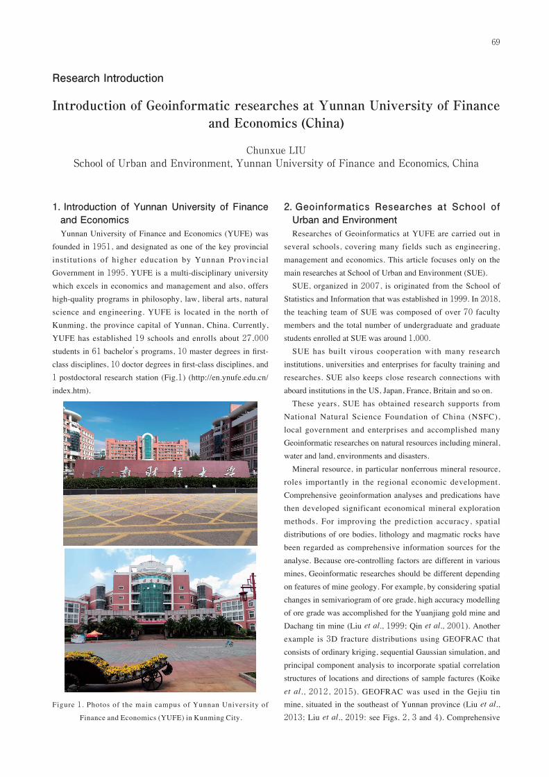
1. Introduction of Yunnan University of Finance and EconomicsYunnan University of Finance and Economics (YUFE) was
founded in 1951, and designated as one of the key provincial
institutions of higher education by Yunnan Provincial
Government in 1995. YUFE is a multi-disciplinary university
which excels in economics and management and also, offers
high-quality programs in philosophy, law, liberal arts, natural
science and engineering. YUFE is located in the north of
Kunming, the province capital of Yunnan, China. Currently,
YUFE has established 19 schools and enrolls about 27 ,000
students in 61 bachelor’s programs, 10 master degrees in first-
class disciplines, 10 doctor degrees in first-class disciplines, and
1 postdoctoral research station (Fig.1) (http://en.ynufe.edu.cn/
index.htm).
Figure 1 . Photos of the main campus of Yunnan University of
Finance and Economics (YUFE) in Kunming City.
2. Geoinformatics Researches at School of Urban and EnvironmentResearches of Geoinformatics at YUFE are carried out in
several schools, covering many fields such as engineering,
management and economics. This article focuses only on the
main researches at School of Urban and Environment (SUE).
SUE, organized in 2007, is originated from the School of
Statistics and Information that was established in 1999. In 2018,
the teaching team of SUE was composed of over 70 faculty
members and the total number of undergraduate and graduate
students enrolled at SUE was around 1,000.
SUE has built virous cooperation with many research
institutions, universities and enterprises for faculty training and
researches. SUE also keeps close research connections with
aboard institutions in the US, Japan, France, Britain and so on.
These years, SUE has obtained research supports from
National Natural Science Foundation of China (NSFC),
local government and enterprises and accomplished many
Geoinformatic researches on natural resources including mineral,
water and land, environments and disasters.
Mineral resource, in particular nonferrous mineral resource,
roles importantly in the regional economic development.
Comprehensive geoinformation analyses and predications have
then developed significant economical mineral exploration
methods. For improving the prediction accuracy, spatial
distributions of ore bodies, lithology and magmatic rocks have
been regarded as comprehensive information sources for the
analyse. Because ore-controlling factors are different in various
mines, Geoinformatic researches should be different depending
on features of mine geology. For example, by considering spatial
changes in semivariogram of ore grade, high accuracy modelling
of ore grade was accomplished for the Yuanjiang gold mine and
Dachang tin mine (Liu et al., 1999; Qin et al., 2001). Another
example is 3D fracture distributions using GEOFRAC that
consists of ordinary kriging, sequential Gaussian simulation, and
principal component analysis to incorporate spatial correlation
structures of locations and directions of sample factures (Koike
et al., 2012 , 2015). GEOFRAC was used in the Gejiu tin
mine, situated in the southeast of Yunnan province (Liu et al.,
2013; Liu et al., 2019: see Figs. 2, 3 and 4). Comprehensive
69

information analysis and prediction were mainly based on
information entropy theory to integrate orebody indicator
information and applied to the Gejiu tin mine (Liu et al., 2003).
Figure 2 . Bird view map (A) and stereogram (B) of simulated
fracture networks in the Gaosong field, Gejiu tin mine in
the southeast of Yunnan province, China (Liu et al., 2019).
Figure 3 . Relationship between the geometry of tin orebodies
and simulated continuous fractures that are composed of
160 facets or more (roughly longer than 2 km), coded as
SF1, SF2, SF3, SF4, SF5 and SF6. OX represents the tin
orebody. Dotted lines guide the control of steep fractures
on the vertical displacements of the orebody.
Figure 4 . Digital elevation model (left), large change portions of
slope gradient (middle) and interpreted fractures (right) in
the Gejiu tin mine.
Water resource is indispensable for economic and social
developments. Utilization, management and maintenance of
water resource affects sustainability of the developments. With
large change in water volume in time and space, water quality is
characterized by many factors. Then, Geoinformatic researches
on water resources have focused on space-time multivariate
ordinary cokriging (SPMOK). SPMOK consists of suitable
modeling of semivariograms and cross-semivariograms for
quantifying correlation structures among multivariate and an
extended standardized ordinary cokriging. In addition, a tensor
product cubic smoothing surface method was used for space-time
semivariogram modeling. SPMOK was applied to model the
water quality space-time distribution in Lake Dianchi, situated in
the southwest of Kunming City (Tan et al., 2012; Fig. 5).
Another research example is surface water storage modeling
Figure 5. Distribution map of water quality indicators (COD, TP
and TN) in Jan. 2010 with circles for sample location and
☆ for town.
Figure 6. Temporal change in distribution map of precipitation (mm/
year) in the Cangshan basin, Dali City.
Figure 7. Temporal change in normalized difference vegetation
index (NDVI) distribution in the Cangshan basin.
70

using SWAT (Soil and Water Assessment Tool) combined with
geostatistics and remote sensing. SWAT was applied with the
data of precipitation, vegetation interception and soil infiltration
in the Cangshan basin in Dali City, located in the west of
Yunnan province (Liu et al., 2014: Figs. 6 and 7).
LULCC (land-use/land-cover change) greatly affects regional
ecosystem and environment. Modeling and prediction of LULCC
can support land use policy and coordinate sustainable urban
development and ecosystem protection, especially in plateau
lake basins. Remote sensing and GIS techniques have been used
to monitor the dynamics of land use patterns through fractal
dimension from 1974 to 2008 in the Dianchi lake watershed
(Zhang et al., 2013 : Fig. 8). SLEUTH (Slope, Land use,
Excluded, Urban, Transportation, and Hillshade) method was
used to forecast the LULCC pattern changes under six policies
for the urban development based on the LULCC data derived
from remote sensing images in the Dianchi lake watershed
(Zhao et al., 2010). LULCC was also simulated using a GIS
technique from 1990 to 2010 in the Dongchuan district in the
north of Kunming City (Li et al., 2017: Fig. 9). IDRISI software
was used to evaluate land ecological security in the Dali lake
for 16 natural, environmental and landscape indicators (Zhang
et al., 2017). In addition, satellite images of ALOS, SPOT
and Quickbird were applied to evaluate China’s alternative
cultivation policies for replacing poppy to anti-drug, substitution
planting of opium poppy in the north of Laos (Liu et al., 2010).
Natural disasters have widely occurred and destroyed the
economic and society developments in China. Geoinformatic
researches at SUE have also focused on monitoring and
predicting the disaster occurrence and reducing the influences.
RA (Rock Analyst) based dynamics-kinematic analysis under
the ArcGIS platform was built and applied to detect dangerous
zones in the Wenchuan earthquake area, Sichuan Province (Liu
et al., 2012: Fig. 10). Mountain hazard extraction model has
been constructed based on remote sensing data to predict the
hazard areas and applied in Yunnan province (Xu and Liu, 2018)
F ig u re 10 . Ro ck fa l l s i mu la t ion r esu l t fo r t he D uj ia ng ya n-
Wenchuan highway, Sichuan province.
Figure 11. Landsat ETM+ original image (left), density slice of
digital number (DN, middle) and extracted debris f low
gullies (right) in Dongchuan district in the north part of
Kunming City.
Figure 8 . Land use classification and its temporal change in the
Dianchi basin in the southwest par t of Kunming City.
Targeted years are 1974, 1988 , 1998 and 2008 from left
to right showing extension of urban area coloured by red.
Figure 9. Temporal change of land use in Dongchuan distr ict in
the north part of Kunming City. Targeted years are 1990,
2000 and 2010 from left to right.
71

and the Wenchuan earthquake area (Su et al., 2008: Fig. 11).
Those introduced Geoinformatic researches are mainly
focused on modeling space-time distribution changes in natural
resources and influences from human activities. Since YUFE is
a university dominant at economics and management, all these
studies are aimed to enhance the space-time economics and
management researches and to support the natural resources
policy decisions and supervisions.
3. Concluding RemarksUnder the supports form cooperat ion ins t i tut ions ,
Geoinformatic researches at YUFE-SUE have concentrated to
simulate the space-time distribution changes in natural resources
and environments to support precisely the regional policy
decision and dynamic monitoring, especially in Yunnan province
in the southwest of China.
Towards more precise and comprehensive researches in
the future, Geoinformatic researches at YUFE-SUE will
concentrate furthermore on the process simulation and unified
modeling to support targeted and practical policy decision with
collaborations including faculty member exchanges. For this, to
build more strong connection with world research institutions
is an urgent issue. On the basis of long-term cooperation, more
advanced collaboration and joint researches of Geoinformatics
with Japanese universities are strongly expected.
ReferencesKoike, K., Liu, C. X., and Sanga, T. (2012) Incorporation of
fracture directions into 3D geostatistical methods for a rock
fracture system. Environmental Earth Sciences, vol.66, no.8,
pp.1403-1414.
Koike, K., Kubo, T., Liu, C. X., Masoud, A., Amano, K., and
Kurihara, A. (2015) 3D geostatistical modeling of fracture
system in a granitic massif to characterize hydraulic properties
and fracture distribution. Tectonophysics, vol.660, pp.1-16.
Li, J., Zhang, X. J., Liu, L. M., Dong, Y. X., Zhang, K. Q.,
and Huang, R. (2017) Land pattern and process analysis in
Dongchuan, Kunming from 1990 to 2010. Journal of Yunnan
Agricultural University, vol.32, no.2, pp.342-349.
Liu, C., Kubo, T., Lu, L. , Koike, K., and Zhu, W. (2019) Spatial
simulation and characterization of three-dimensional fractures
in Gejiu tin district, southwest China, using GEOFRAC.
Natural Resources Research, vol.28, no.1, pp.99-108.
Liu, C. X., Tan, L. , Ni, C. Z., and Yan, Y. F. (2013 )
Automatically extraction of lineaments from DEM. Applied
Mechanics and Materials, vol.391, pp.394-397.
Liu, C. X., Qin, D. X., and Hong, T. (1999) The application of
variant function in Dachang tin deposit. Journal of Kunming
University of Science and Technology (Natural Science
Edition), vol. 24, no.1, pp.171-176.
Liu, C. X., Qin, D. X., Dang, Y. T., and Tan, S. C. (2003)
Synthesis information based mineral resource prediction of
Gaosong field in Gejiu tin deposit. Advance in Earth Sciences,
vo.18, no. 6, pp.921-927.
Liu, C. X., Wei, Z. H., and Lv, X. J. (2014) Research on the
water resource utilization in Cangshan basin, Kunming.
Yunnan Science & Technology Press Co., Ltd.
Liu, H. J., Lan, H. X., Zhang, J., Liu, J., and Yang J. (2010)
Evaluation and analysis for the substitution planting for
opium poppy in the north of Laos based on remote sensing.
Resources Science, vol.32, no.7, pp.1425-1432.
Liu, H. J. and Lan, H. X. (2012) Rockfall disaster simulation
and risk assessment on the Dujiangyan-Wenchuan highway
after “5.12” earthquake. Resources Science, vol.34, no.2,
pp.345-352.
Qin, D. X., Liu, C. X., Yan, Y. F., and Li, M. D. (2001) The
deposit model and mining economics of Yuanjiang gold
deposit, Yunnan. Acta Mineralogica Sinica, vol.21, no.4,
pp.609-612.
Su, F. H., Liu, H. J., and Han, Y. S. (2008) The extraction
of mountain hazard induced by Wenchuan earthquake and
analysis of its distributing characteristic. Journal of Remote
Sensing, vol.12, no.6, pp.956-963.
Tan, L., Liu, C. X., Yang, S. P., and Li, F. R. (2012) Assessment
on the economic loss caused by water pollution of the Dianchi
lake. Resources and Environment in the Yangtza Basin,
vol.21, no.12, pp.1449-1452.
Xu, J. and Liu, H. J. (2018) Earthquake disasters characteristics
and its risk trends in Yunnan province. Yunnan Geographic
Environment Research, vol.30, no.5, pp.1-7.
Zhang, H., Wang, A. Q., and Song, B. Y. (2017) Evaluation of
land ecological security in Dali City based on OWA. Scientia
Geographica Sinica, vol.37, no.11, pp.1778-1784.
Zhang, K., Zhao, Y. L., Fu, Y. C., and Zhang, H. (2013)
Fractal dimension dynamics and land use in the lake Dianchi
watershed from 1974 to 2008. Resources Science, vol.35.
no.1, pp.232-239.
Zhao, Y. L., Zhang, K., Peng, Y. J., Fu, Y. C., and Zhang, H.
(2014) Scenario analysis of urban growth in Kunming based
on geosimulation system. Geographical Research, vol.33,
no.1, pp.119-131.
Reference Citeshttp://www.ynufe.edu.cn/index.htm
http://www.ynufe.edu.cn/pub/csyhjxy/
72