introduction prehistoric: oil and gas, … · james “jim” evins ... men such as dennis b....
TRANSCRIPT

1
Note: images are placeholders only, and do not represent final size or placement
Table of contents
Foreword by Dr. Robert Nelsen
Preface –The CHAPS Program PIs
INTRODUCTION
PREHISTORIC: OIL AND GAS, SOIL, AND PREHISTORIC PEOPLES
Oil and Gas
Soil
Prehistoric People
1749 – 1920: EARLY EUROPEANS IN THE LOWER RIO GRANDE VALLEY
Early Explorers and Colonizers in Nuevo Santander
Mexican and Texan Independence and International Boundaries
LOWER RIO GRANDE VALLEY, 1900-1920.
Edinburg
Economic Development

2
Mexican Revolution
1920s: ENTER THE ATWOOD FAMILY
AGRICULTURE IN THE RIO GRANDE VALLEY
Early Agriculture in the Rio Grande Valley
Weather and Natural Disasters
Braceros
1930s - 1960s: THE CHILDREN GROW UP
The Great Depression And Economics
The Atwoods and life during the Depression
School
1940s
Water and Electricity
Radio
Citrus Movie Theater
Telephone
Transportation
Fun and Parties
Medicine
1944
1950s
Hazel Atwood Baldridge
James “Jim” Evins
Irene Atwood-Evins and Jim Evins
Edinburg Junior College and Pan American College
Irene and UTPA
1960s and On
1960s and 1970s
1980s to present
CONCLUSION
Bibliography
Appendix A
Transcript of oral history interview with Irene Evins, Interview A. Border Studies Archive, The
University of Texas – Pan American Library. Interviewed by Jenarae Alaniz et al. September 18,
2013.
Appendix B
Transcript of oral history interview with Irene Evins, Interview B, Border Studies Archives, The
University of Texas – Pan American Library. Interviewed by Colin Newton et al.. October 25,
2013.
Appendix C

3
Transcript of oral history interview with Hazel Baldridge Interview C. Border Studies Archive,
The University of Texas – Pan American Library. Interviewed by Alexis Casiano et al.
September 20, 2013
Appendix D
Transcript of oral history interview with James Evins, Interview D. Border Studies Archive, The
University of Texas – Pan American Library. Interviewed by Norma Perez et al. September 23,
2013.
Appendix E
Real estate transactions and aerial photographs
Appendix F
Texas Railroad Commission gas and oil lease documents
Appendix G
Biology chart

4
FOREWORD
History matters. As we wind down The University of Texas-Pan American and as we
ramp up The University of Texas Rio Grande Valley, perhaps history matters even a bit
more. The students and faculty who comprise CHAPS (Community Historic Archeological
Project with Schools) are beautifully and wisely documenting the history of families in the
Rio Grande Valley. In this volume, they chronicle the lives of the Atwood family—from
their oil wells, to their citrus farms, to their connections to Edinburg College and its
eventual successor The University of Texas-Pan American.
The Rio Grande Valley is the “Magic Valley”—everyone knows that. But does
everyone know that it got that name because of (1) its “warm, tranquil climate,” (2) “fertile
soil,” (3) “irrigation water,” and (4) “cheap labor”? Atwood Acres tells a larger story than
just the amazing story of the Atwoods. It helps us understand how the Valley became the
Valley, how land sold for 25 cents an acre in 1903 to 50 dollars an acre in 1906 and up to
$300 dollars an acre in 1910, all because of the railroad. Plus we learn how Edinburg itself
moved from the banks of the Rio Grande River to where it is now also because of that same
railroad.
For me, the people in the Valley are what make the Valley magical—the people and
UT Pan American (soon to be, very appropriately, UT Rio Grande Valley). We have Bronc
Pride, and we are the Bronc family. To the students and faculty who took down these oral
histories and wrote Atwood Acres, thank you for teaching me that the green in our school

5
colors stood for citrus, that the white stood for cotton, and that the Bronc stood for our
connection to the ranches and ranchers. As we choose our new colors and mascot, I hope
that we will stay connected to the history of the Valley and all who live in this “Promised
Land.”
Robert S. Nelsen President (2010-2014) The University of Texas-Pan American

6
PREFACE
Ninety two years ago in 1922 U.S. Marine Corps and World War One veteran Dewey Atwood
and his wife of three years, Jewel found their “American Dream” in Edinburg, Texas. The
nascent community, though only founded some thirteen years earlier, was the county seat for
Hidalgo County and was located at the heart of a commercial agricultural “boom” focusing on
citrus, cotton, melons, vegetables, and sorghum. Here major irrigation projects, a salubrious
climate, good soil, and a railroad system had created the “Magic Valley” in the opening years of
the twentieth century and attracted migrants from the United States, Mexico, Canada, and
Europe.
Six children were born to the Atwoods and came to age on their farm west of Edinburg. One,
Irene Atwood Evins lives on the farm to this day with her husband Jim. Their stories and those
of her sister Hazel enliven this study and bring the past back to life. Significantly, Irene served
on a the committee who chose the Bronc as the mascot for Pan American College as homage to
the ranching past of the region and the colors green, for the citrus, and white, for cotton in the
age of commercial agriculture. Now as Pan American closes and these colors and mascot are put
aside we will know how they once were chosen.
Change is always a part of our world. We on the CHAPS Program team are honored to provide
primary information on local geology, archaeology, fauna, flora, and history while telling the
story of the Atwood Family and others. Thanks are extended to the Norquest Family, Dr. Lisa
Adam and the Museum of South Texas History, Ruby de la Garza and the USDA, and an
Anonymous Donor for their on-going support of the CHAPS Program. We hope you will enjoy
this “Porción of Edinburg,” and in it find a story which resonates across the disciplines and the
decades providing a snapshot of our changing world in south Texas.
Margaret Dorsey, Ph.D.
Juan L. González, Ph.D.
Sonia Hernandez, Ph.D.
Bobbie L. Lovett, MA
Kenneth R. Summy, Ph.D.
Russell K. Skowronek, Ph.D.
Director of the CHAPS Program www.utpa.edu/chaps

7
INTRODUCTION
Hours of reading, research, field experience, and oral interviews were conducted by the
fall 2013 CHAPS class at The University of Texas-Pan American. This CHAPS (Community
Historical Archaeology Project with Schools) Program-sponsored class is an interdisciplinary
course specializing in the archeological, biological, anthropological, geological and historical
uniqueness of south Texas. The CHAPS faculty specialize in the fields mentioned: Dr. Russell
Skowronek (archaeology), Dr. Margaret Dorsey (cultural anthropology), Dr. Sonia Hernandez
(history), Dr. Juan Gonzalez (geology), Dr. Kenneth Summy (biology), and Professor Bobbie
Lovett (archaeology). Class members come from different backgrounds and scholarly
disciplines. The students were brought together by the opportunity to learn more about the
evolution of the Lower Rio Grande Valley (the Valley), a region that developed from sparsely
populated lands to the thriving community it is today.
Thousands of years ago, the first people in this region would have walked through vast
open ranges once dominated by groups of mesquite trees. The mesquite trees grew around presas
(watering holes) formed by low spots after the oceans receded. The sounds of insects such as
chicharas, (cicadas) would permeate the night air. Birds like ala blancas (white wings), and
wild animals such as white tail deer, javelinas, and jackrabbits were abundant and provided
sustenance. Native plants included prickly pears, mesquite beans, wild roots, and countless
others.
Europeans began settling in this region when Captain José de Escandón left Querétaro
and moved north with 2,500 settlers and soldiers to colonize Nuevo Santander between the
Pánuco River in Mexico and the Guadalupe River in Texas. Many of the original settlements

8
were established along the Rio Grande, including Reynosa, which was founded in 1749. In
1767, the King of Spain, Charles III granted porciones (land grants) in Nuevo Santander.
Porciones were named after the settlements of Laredo, Mier, Camargo, Revilla, and Reynosa,
and were numbered from west to east. The porciones along the river had access to water
provided by the Rio Bravo as it is commonly known in Mexico, or the Rio Grande as it is called
in the United States.
In 1848 after the Mexican American War, the Treaty of Guadalupe Hidalgo set the
boundary between the United States and Mexico at the Rio Grande. Through a series of events
in the mid to late 1800s, many Mexican American landowners lost their lands to new Anglo
American migrants from the north. While there were Mexican American families who held
actual titles to their land, there were other families with property passed down by word of mouth
or a handshake with the result that land transactions were not recorded.
In the early 1900s, land speculators in south Texas advertised in northern papers
promoting the rich farmland, water availability through irrigation, and “cheap” labor to harvest
crops. The town of Edinburg was originally located along the Rio Grande. The town was
moved from near the river to its current location because of potential flooding, the development
of irrigation canals, and the building of the railroad. Men such as Dennis B. Chapin, John
Closner, William F. Sprague, William Briggs, and Plutarco de la Viña helped build and promote
the new town.
The Atwood family whose story is featured in this report moved to Edinburg from
Johnson County, Texas in the early 1920s. Lewis Webster Atwood, and his wife Rachel Colmer
Atwood, originally purchased 160 acres east of Edinburg in the Texas-Mexican Railway Section
249 Lots 3, 4, 5, and 6 in 1920. They later sold that land, and in 1925 purchased 60 acres west of

9
Edinburg in the Texas-Mexican Railway Section 238 all of Lot 13 and the west half of Lot 14,
the site of the family’s current homestead, and the focus of this report.
OR
Southern portion of map of Hidalgo County1 OR Edinburg portion of map of Hidalgo County
[insert 01-General Land Office, Hidalgo County, 1977]
Five generations of Atwoods have lived on the property over the 90 years since Lewis
and Rachel moved to south Texas. Lewis and Rachel had nine children, of whom eight survived
into adulthood: Harmon, Dewey Clifton, Rema Christina (married name Carter), Price (married
Elizabeth and moved north), Floyd (married Nina and also moved north), Kirby (married Clara
Lightfoot, and moved to LaPryor), Esther Ruth (married Ernest Hunter and moved to Fort
Worth), and Cone (never married). Their daughter Ramona, died in a fire as a child.
Three generations of the Atwood family
1 Preston R. Connally, compiler, and Joan B. Kilpatrick, draftsman, “Hidalgo County,” October
6, 1977, map 77311, Texas General Land Office.

10
[insert 02-Atwoods family tree-3 generations.
[JG Note: recommend printing 3 generations on page and putting 5 generations on fold-out with
appendices]
Dewey Clifton, their second oldest son, acquired the land from his parents. Dewey, and
his wife Jewel Thelma Jones Atwood, had six children: Lambard W. (b. 1920), Hazel Grace (b.
1924), Jean (b. 1927), James (b. 1931), Irene (b. 1933, birth certificate has ‘Rachel Irene’), and
Alan, nicknamed Bud (b. 1935).
Dewey Clifton Atwood, the second oldest son of Lewis and Rachel, was born in Texas in
1898 according to the family’s oral histories and genealogical research completed by CHAPS
students. His parent’s experiences must have been similar to that of the many Anglo immigrants
coming to Texas. Dewey’s father, Lewis Webster Atwood was born in Texas in 1864. His
parents were not native Texans: his father was born in Georgia and his mother in Kentucky.2 It
is not completely clear from the historical record when they met. Did they know each other
before moving to Texas or did they meet in the Lone Star State? Dewey’s mother, Rachel
Colmer Atwood, was born in Germany sometime in 1873. She immigrated to the United States
with her parents as a young child in 1879.3 Similar to the Atwoods, it is unclear where Rachel
Colmer and her family initially settled after reaching the United States, and when she came to
live in Texas. It is likely that Lewis and Rachel married in Texas sometime in the late 1800s.
Dewey married Jewel Thelma Jones on December 19, 1919.
2 United States Census, 1910. 3 Ibid.

11
Jewel and Dewey Atwood when they first arrived in the Valley in 1922 coming from Cleburne, Texas, photograph courtesy of Irene and Jim Evins
[insert 3-Jewel and Dewey Atwood 1922]
The family of Jewel Thelma Jones, wife of Dewey Atwood, had a similar experience of
migration. Jewel was born in 1898 in Johnson County, Texas and was able to live a long and
wonderful life until 1998 when she passed in Edinburg, Texas. Generations of Jewel’s ancestors
lived in the Eastern United States, until her grandparents moved to Johnson County, where both
of Jewel’s parents were born and raised. A partial look at Jewel’s family tree shows that her
paternal grandparents Mary Combs and Jessey B. Jones were married in Morgan, Mississippi on
June 16, 1863.4 Jewel’s paternal great grandparents James Combs and Zilpha Hunt lived in
Tennessee. It is clear from the historical record that the Jones family, like the Atwood family,
has deep roots in the United States. It is not known why or when the Jones and Atwood families
came to settle in Texas, however it can be assumed that they, like other immigrants to Texas,
were looking for new opportunities.
4 “Genealogy, Family Trees, and Family History Records,” Ancestry.com,
http://www.ancestry.com (accessed November 18, 2013).

12
Hazel, Irene, and the other siblings grew up on the 60 acres of land near Edinburg
purchased in 1925. Irene and her husband Jim Evins are currently living on the land, and
managing the property for the brothers and sisters. Irene, Jim, and Hazel have been very
gracious and welcoming in allowing CHAPS students and faculty to explore their land and
history. They experienced the life of being a country family, witnessing all the changes from the
installation of electricity and all that it allowed, to finally having the road paved all the way to
their home, which occurred not very long ago. All the Atwood children left the nest to live their
lives. Hazel married her husband, John Edward Baldridge, had a family, and moved to their
ranch in Mexico. Irene married her high school sweetheart, Jim Evins. They had their share of
moving around and having their own children, only later to come back to the Atwood homestead.
They have since lived and raised their children, and have experienced the joy of seeing their
grandchildren walking and playing on the same property they did, as the saying goes, ‘many
moons ago.’
In contrast to Irene and Hazel, Jim Evins was considered a city boy. James "Jim" Evins
was born October 8, 1932, the youngest of twelve children. Two of his siblings had died from
influenza from his mother's first marriage. While he was growing up, his mother, all four feet
and eleven inches, raised her boys and girls all on her own. According to Jim, she ruled with an
iron fist. Jim grew up tough, to stand up to his older brothers. He enjoyed sports, and has
worked since he was a very small child.
This report will trace the evolution of this particular piece of land, as well as the broader
Lower Rio Grande Valley region from prehistoric times through the present. The history of this
land and the Atwood-Evins family is just one example of the rich history of southern Texas.

13
PREHISTORIC: OIL AND GAS, SOIL, AND PREHISTORIC PEOPLES
In the early 1920s when the Atwood family came to the "Magic Valley," promoters
proclaimed this region for its farming possibilities. One of the chief attractions was the rich
alluvial soil that could support many different types of crops. In March 1944 Dewey and Jewel
signed their first oil, gas, and mineral lease. Eight months later Dewey Atwood passed away,
leaving his wife Jewel to raise and support their children. The royalties the oil companies paid to
the widowed Jewel to drill on her land, allowed her to more easily clothe and feed her family.
Both of those elements: soil and gas, were made possible because of conditions that had
developed millions of years earlier.
Oil and Gas
During the Cretaceous Period (approximately 144 million years ago), the sea level was
much higher than today, and the area that is occupied by the Lower Rio Grande Valley was
underwater. Primitive sharks and marine reptiles such as mosasaurs populated the shallow seas,
as dinosaurs wandered the land. The continents were drifting apart as the supercontinent Pangea
was breaking. These were times of intense volcanic activity particularly under water as the
Atlantic Ocean widened. In the southern continent of Gondwana glaciers advanced and retreated
many times, sea levels fluctuated such that at times the area would be underwater and other
times, the coastline would be far into the current Gulf of Mexico.

14
[Insert 04-geologic epochs.pptx
Oil and gas form when marine microorganisms die. Their remains settle to the bottom
and are then covered with sediments. Over millions of years, thick sediment layers of shale and
sandstone accumulate and consolidate. In some places, the oil trapped in the rocks migrated
upwards over time through sedimentary rock until it reached an impermeable surface that
prevented further movement, thus forming an oil deposit. Oil and natural gas are often found
together. Such deposits exist at great depths below the surface in the general area of the city of
Edinburg. According to the oil companies the gas and gas condensate found on the Atwood
property was labeled by as ‘Oligocene – Frio.’5 This refers to the Frio Formation of the
Oligocene Epoch (approximately 34 to 24 million years before present). The lithology of the
Frio Formation consists of alternating packages of sand and shale that dip steeply to the Gulf of
Mexico and thickens in the same direction, forming wedge shaped bodies. Glaciers were
extensive in Antarctica, sea levels were correspondingly low, and volcanoes were active in
Mexico and the southern United States, spewing ash which winds distributed for great distances.
Sediments built up over 8 million years leaving deposits along the Gulf Coast commonly termed
5 Arthur Troutman, The Oil and Gas Fields of the Rio Grande Valley in District 4 of South Texas
(Houston: 5 Star Oil Reports, Inc., 1956), 8.

15
as the “Frio-Vicksburg deposit.”6
Dewey and Jewel Atwood signed their first oil, gas, and mineral lease for all of lot 13,
and the west half of lot 14 of Section 238 of the Texas, Mexican Railway in March 1944,
encompassing the area studied in this report. In August 1944, another lease was signed for the
west half of lot 2 of Section 277, an area that is just southwest of the land studied in this report.
Subsequent leases for these lands were signed with Sun Oil Company until 1957, and then with
Mokeen Oil Company beginning in 1967, usually for five-year intervals. Mokeen Oil was
formed in 1961 by Corpus Christi oilman Jack Modesett, and “the Patriarch” Joseph P. Kennedy
(father of President John F. Kennedy, U.S. Senator Ted Kennedy and U.S. Senator and Attorney
General Robert Kennedy).7 In June 1966 Mokeen Oil Company filed paperwork with the Texas
Railroad Commission for new field designations for Edinburg West 7600' (well 1-UT, lease
34802) and Edinburg West 6700' (well 1-L, lease 31359) gas sands for the lands leased from
Jewel Atwood for gas wells located on Sections 238 and 277 as described above. In 1967
Mokeen Oil contracted with the Permian Corporation to transport 100% of the condensate. [see
Appendix G] JG note: reproduce only relevant pages Bib: 127-001-000698_61 / [Bib: 127-001-
000698_63.pdf] In 1968 the Texas Railroad Commission granted permission to Mokeen Oil to
exceed the standard state rate of 800 MCF (1,000 cubic feet) per day. The well’s normal rate of
production was listed as 1500 MCF, and the minimum daily rate was 1200. In 1974 another
report was filed by Mokeen Oil Company to report that the two wells had been drilled in 1963
and capped in 1974.
6 Darryl L. Felder, et al. Geology, vol. 3 of Gulf of Mexico Origin, Waters, and Biota (College
Station, TX: Texas A&M University Press, 2011), 44. 7 Fortune Editors, “Joseph P. Kennedy: A portrait of the founder (Fortune Classics, 1963),”
Fortune, (April 10, 2011), http://features.blogs.fortune.cnn.com/2011/04/10/joseph-p-kennedy-a-
portrait-of-the-founder (accessed November 29, 2013).

16
Portion of Oil Maps Information: Map 13 drawn by J. R. Beard8
[insert 05-Beard oil maps]
As part of the class, CHAPS students interviewed Irene, Hazel, and Jim at the
University’s Border Studies Archives concerning their recollections of daily life and events,
including the gas well. Other personal communications that were not recorded also provided
valuable information. In her first interview Irene recalls the gas well:
Yeah, that's been a long time ago because they drilled that well on the west side of
the house. Before Mother tore her…before we tore Mother’s old house down, and
we’ve lived out there since the year after Beulah, and it pumped for about 6 years
I think. And it wasn’t a huge well, I mean, it wasn’t a gusher…you wouldn’t call
it a gusher, but it was oil. And I remember they had a stand of tanks, that they
drained off a substance called ‘distillate’ and they had oil that went into a
pipeline, and they had that distillate that they gathered into those tanks and then
every so often a truck would come and siphon off what was in those tanks and I
don’t know how, or how they used that distillate but it was part of the income off
of that well. And then it dried up I guess and I guess it wasn’t productive enough
to warrant keeping it open, and so they plugged the hole and took their junk and
left. And that was the end of that.9
In her second interview, Irene recalls more about the well when asked how long the
drilling lasted:
8 Joseph Radford Beard, “Oil Maps Information: Map 13,” The University of Texas-Pan
American Library. 9 Irene Evins, Interview A. Border Studies Archive, The University of Texas – Pan American
Library. Interviewed by Jenarae Alaniz et al. September 18, 2013.

17
I don’t remember. Wasn’t too long, it was a shallow well, wasn’t deep. And, I
imagine it took them two to three months to drill it. And I remember when they
flared the well; I thought that was kind of exciting. They set fire to that, you
know, they flared the well, I don’t know why they do that but we watched that for
a while and then they capped it and then they did something, they put a pipeline in
and they also piped a byproduct called distillate to some tanks up close to the
road. The well was further back and then up close to the road they built a pad of
caliche and some tanks, a tank farm. And one of those pipes took the byproduct
called distillate and put it in those big tanks. And every so often a truck would
come and fill up with that, and I don’t know what they did with that. Somebody
said it was similar to kerosene, I don’t know, my brother was a petroleum
engineer and he could’ve told you but I don’t know.10
Flares are used for various reasons throughout the drilling process. When a new well is
drilled, a temporary flare is used to test the pressure, flow, and composition of the gas or oil.
The distillate byproduct, or condensate, was gas that was heated to rise through pipes, then
condensed again and stored in tanks at the top to form distillates.
Soil
As sea levels fell to their current levels, the Rio Grande formed as it rushed from the
mountains to find the new coast, creating a broad valley in the process. Eventually, the river
slowed and broadened, filling the valley and dropping sediment it had picked up on its way from
the mountains. Frequent flooding and the resultant river course changes deposited sediments in
old cut-off channels after each flood known as resacas (oxbow or horseshoe bends). Winds
blowing from the Gulf Coast helped distribute those sands and sediments more evenly over the
land. Approximately 7,000 years ago the sea level reached its present position and the Rio
Grande progressively decreased its flow. The sediments deposited by the river and spread by the
wind over the centuries created the perfect soil conditions for the Lower Rio Grande Valley, the
10 Irene Evins, Interview B. Border Studies Archives, The University of Texas – Pan American
Library. Interviewed by Colin Newton et al. October 25, 2013.

18
"garden spot" of Texas.
Prehistoric People
Little is known about the prehistoric peoples who once inhabited southern Texas and
northeastern Mexico. Modern scholars have grouped the indigenous people in this region under
the common term of Coahuiltecans after the Mexican state of Coahuila from where they are said
to originate. Beginning 14,000 years ago scrub grasslands began to replace the woodlands
marking a warming and drying trend. A few centuries later, there is evidence that Paleo-Indians
wandered into the area, possibly following large mammals such as mastodons and mammoth.
Archaeological sites around a flood pool to the mouth of the Rio Grande have yielded a few
mammoth bones and Clovis spear points. Clovis people were hunter-gatherers, and their spear
points are long, leaf-shaped, and generally 1.5 to 5 inches long. As the climate eventually shifted
to warmer and drier conditions with more seasonal rainfall, larger mammals such as the
mammoth and mastodon began to disappear and eventually became extinct. The Indians had to
hunt smaller game and gather more plants.
Projectile points found in the region indicate that there were widespread semi-nomadic
bands. It is estimated that there were approximately 200 bands in this area, with an average of
about 45 people in each band. The bands were autonomous without social, economic, or
political ties, yet loosely connected through a shared common language base. Life would have
been hard in this region during the prehistoric period. Occupied areas tended to be located near
the river, resacas, springs or where water gathered in eolian plain depressions (depressions
formed by wind erosion). These watering holes also would have attracted more wildlife. There
appears to be a high correlation between depressions in the land and channel scar levees and
19
prehistoric sites.11 The indigenous peoples typically moved with the seasonal change, their diet
reflecting the time of the year.12 Prickly pear was eaten in the summer while acorns and pecans
were eaten predominantly in the fall.13 They fished along the river, and hunted smaller game
such as antelope, deer, peccaries, rabbits, rodents, reptiles, and birds, as well as the occasional
large bison. Their houses and clothing were made from the skins of antelopes and rabbits.
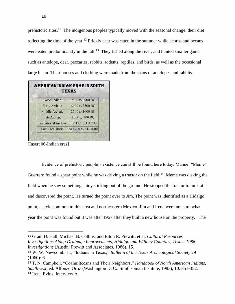
[Insert 06-Indian eras]
Evidence of prehistoric people’s existence can still be found here today. Manuel “Meme”
Guerrero found a spear point while he was driving a tractor on the field.14 Meme was disking the
field when he saw something shiny sticking out of the ground. He stopped the tractor to look at it
and discovered the point. He turned the point over to Jim. The point was identified as a Hidalgo
point, a style common to this area and northeastern Mexico. Jim and Irene were not sure what
year the point was found but it was after 1967 after they built a new house on the property. The
11 Grant D. Hall, Michael B. Collins, and Elton R. Prewitt, et al. Cultural Resources
Investigations Along Drainage Improvements, Hidalgo and Willacy Counties, Texas: 1986
Investigations (Austin: Prewitt and Associates, 1986), 15. 12 W. W. Newcomb, Jr., “Indians in Texas,” Bulletin of the Texas Archeological Society 29
(1960): 6. 13 T. N. Campbell, “Coahuiltecans and Their Neighbors,” Handbook of North American Indians,
Southwest, ed. Alfonzo Ortiz (Washington D. C.: Smithsonian Institute, 1983), 10: 351-352. 14 Irene Evins, Interview A.

20
Hidalgo point was about 8,000 years old, dating back to the Early Archaic. The Archaic Period
began around 6,000 BC and lasted through 300 BC. Through further analysis with a scanning
electron microscope at the University it was determined that the point was made out of El Sauz
chert, a stone that would have been found in a quarry in Starr County.
Early Archaic Hidalgo projectile point (obverse and reverse) found by Manuel “Meme” Guerrero on the Atwood-Evins farm
[Insert 07b-Hidalgo Point side a and b]
Hidalgo points were sturdy, had an expanding stem and usually a biconvex cross section.
Samples found are rarely less than 10 mm thick. Typically the shoulders (edge on bottom portion
above stem) and stem (bottom edge) were rounded and varied from a narrow lanceolate to
broadly ovate. The stone used to make the Hidalgo point would have needed to travel over a
great distance from the El Sauz outcrop in Starr County to end up in the Atwood-Evins property.
Movement of stone was no easy feat for the Native Americans who had to walk everywhere to
acquire goods or trade with other native groups for supplies.15
15 Ellen Sue Turner, Thomas R Hester and Richard L McReynolds. Stone Artifacts of Texas
Indians, rev. 3rd ed. (Lanham, MD: Taylor Trade Publishing, 2011). Juan L. González, James R.

21
Knowing that a point had already been discovered on the property, the CHAPS team used
it as a starting point for their fieldwork. Students dedicated a total of 8 hours to pedestrian
surveys across the majority of the Atwood-Evins property. At least 21 pairs of eyes combed
through the field, typically seven at a time. The archaeological surveys allowed the team to go
through the property in search of points, lithic debitage, and other historic and prehistoric
archaeological material. There were multiple items found which included various rocks that
could possibly be stone tools. Two chert stones in particular showed tremendous wear in the
middle. A grooved notch in the middle of the stone could have been used as an arrow shaft
sharpener. It may have been used to smooth out the shaft to keep it straight.
Two notched chert scrapers with wear in the middle, possibly arrow shaft sharpeners
[Insert 08a-arrow shaft sharpener]
Another piece of chert found showed signs of heat treatment. A stone may have been heated so
that it may be more malleable when being shaped into a point. It was extremely smooth on
almost all sides.
Hinthorne, Russell K. Skowronek, Thomas Eubanks, Don Kumpe 2014 Characteristics and genesis of El Sauz chert, an important prehistoric lithic resource in south Texas. Lithic Technology 39(3):1-10.

22
Heat treated stone
[Insert 08b-Heat treated JG note, separate 8a and 8b by text or put together?]
One stone in particular was quite fascinating because of its size. It was a large solid piece
of quartz that both the archaeology professors and the student who picked up the rock said that it
was plausible to call it a hammer stone. It is smooth on one end and appears to be pushed in from
repeated poundings.
Possible hammer stone
[Insert 09a-Hammer stone]
Not only was a possible hammer stone found, another rock may have been used as a
grinding stone. It was an igneous rock with a two-tone discoloration, which could be attributed to
its repeated use.

23
Possible grinding stone
[Insert 09b-Grinding stone JG note, separate 9a and 9b by text or put together?]
All of the potential stone tools must be accepted as speculation because they were found
alone in various parts of the field. If a larger number of stones or pieces had been found, the tools
may have been conclusively identified. One must also remember that although the lithic stones
have striations that seem to have been from repetitive use, it may also have come from the
Atwood-Evins tractor as it plowed the field over numerous growing seasons.
Larger stones with no wear were also recovered. These particular stones were kept
because they were deemed source stones, rocks that would have been used to make points.
Stones collected were limestone, two different colors of chert, and a small igneous rock
(volcanic). Other points made out of the same stones have been found in Texas by the CHAPS
professors. It must be noted that many of the rocks were found closer to the street at the edge of
the property, which means that it may have come from an outside source earlier than prehistoric
times. They may have been dragged in from cars passing through the area or they could have
been brought in when the roads were paved 15 years ago.

24
Limestone Color chert Igneous rock
[Insert 10a, 10b, and 10c]
The Hidalgo point found at the Atwood-Evins property reestablishes the fact that many
native people lived in this area thousands of years ago. The Norquests, a family researched by
CHAPS students in 2011, had accumulated various points found on their property over the years.
Some points were from the Gower and Zorra cultures, which also date back to the Early Archaic
Period.16
[Insert 11-CHAPS projectile point chart]
More recent man-made objects were also found on the property during the field surveys.
Four ceramic pottery shards were found on the Atwood-Evins property. They were discovered in
the middle of the field, which could insinuate that the shards were most likely thrown away in
16 Sandra Hernandez-Salinas, et al. The Norquest Family: A Porcion of Edinburg. A Report Prepared for the Norquest Family and for the University of Texas – Pan American, Community Historical Archaeological Project with Schools Program. (Edinburg, TX: The University of Texas – Pan American, 2012), 22.

25
the trash. It was determined that the flakes were the lip of a saucer, the edge of a coffee mug, and
other fragments of a plate. It was simple earthenware, which was very common in the twentieth
century, specifically 1930-1960. Two different colored fragments were found indicating there
were at least two different sets.
Ceramic chards found in middle of field
[Insert 12-ceramic shards]
1749 – 1920: EARLY EUROPEANS IN THE LOWER RIO GRANDE VALLEY
Early Explorers and Colonizers in Nuevo Santander
The first European to pass by this area was Alonso Álvarez de Pineda. In 1519, Álvarez
de Pineda was commissioned by the Governor-General of Jamaica to explore the area along the
Gulf of Mexico from peninsular Florida to Veracruz, an area which he named Amichel. Pineda
mapped much of the Gulf Coast prior to Spanish colonization. He landed and went ashore at a
large river identified by earlier historians as the Rio Grande, but which is now generally
recognized as the Rio Soto la Marina.
Álvar Núñez Cabeza de Vaca landed in Texas later in the sixteenth century. He had been
shipwrecked and then captured by Native Americans on the Gulf Coast. After seven years he
was able to escape with a small group of men, including a former slave named Esteban. It has
been speculated the only reason this small band was not recaptured was the fact that Cabeza de
Vaca became a well-known healer. Although no one today knows his exact route, it is estimated

26
he passed through south Texas during his search for Spanish civilization.17
Beginning in the mid eighteenth century people from the north and the south began
converging on this region. The small bands of original Native American inhabitants living in
this region were easily displaced by those larger migrating populations. Spanish settlers began
moving north to the Rio Grande, and Lipan Apache and Comanche Native Americans were
being driven south out of their own territory in the plains. Little effort was made by the new
settlers to record the lives of the native Indians.
In 1747 José de Escandón was sent by the King of Spain to begin establishing settlements
in La Colonia de Nuevo Santander to make the area safe for Spanish settlers. In order to
accomplish this, his goal was to pacify the natives and convert them to Christianity. Previously,
Escandón had encountered hostilities in the Veracruz Peninsula. In Nuevo Santander, Escandón
made an effort to keep the region peaceful and to work cooperatively and avoid hostilities with
those who were already living in the region. Escandón was successful in exploring and mapping
the area. There were three main rivers that flowed into the Lower Rio Grande: the Salado, the
San Juan, and the Alamo. Escandón established settlements along the rivers because he
anticipated they could be irrigated and were ideal for missions.18 Towards this end, he was
responsible for the establishment of settlements in this area including: La Villa de Santa Ana de
Camargo in 1749, led by Jose Maria de la Garza Falcon; Nuestra Señora de Guadalupe de
Reynosa in 1749, led by Carlos Cantu; and the Hacienda de Nuestra Señora de los Dolores in
17 Jerry Thompson, introduction to A Shared Experience: The History, Architecture, and Historic
Designations of the LRGV Heritage Corridor, 2nd ed. (Austin, TX: Los Caminos and The Texas
Historical Commission, 1994), 25. 18 Ibid., 16.

27
1750, the first permanent settlement in Nuevo Santander north of the Rio Grande.19 Land grants
north of the Rio Grande were distributed beginning in 1767 through a commission led by
Fernando de Palacios. The “General Visit of the Royal Commission to the Colonies of Nuevo
Santander” was considered one of the most important events in the history of the Rio Grande
Valley. It was through this commission that lands were measured and distributed into
porciones.20
Mexican and Texan Independence and International Boundaries
The Lower Rio Grande Valley is unique in that not only do two countries share a border,
but that because of the relative geographic isolation to the north and south of the region, that the
citizens of both countries identify closely with the other. It is a place where two cultures, two
ethnicities, and two histories are integrated into one. It is impossible to relate the story of south
Texas without discussing Mexican history. The region was once part of Spain, then the Republic
of Mexico, the Republic of Texas, and ultimately, part of the United States.
One of the most important events affecting this region was the war between the United
States and Mexico from 1846 to 1848. It was this war, and the resulting treaty, that officially set
the international boundary at the Rio Grande. The causes of the 1846 war date back to 1821
when Mexico gained its independence from Spain. In 1824 the Mexican Constitution, partially
patterned after the American Constitution and the 1812 Spanish Constitution, was written and
signed into law and Nuevo Santander became part of Tamaulipas. Large portions of northern
Mexico including lands in Tamaulipas (south of the Nueces River) and the Mexican state of
Coahuila y Tejas, were sparsely populated. Threats from indigenous people made settling these
19 Ibid., 29. 20 Ibid., 32.

28
regions difficult. Mexico began to offer generous colonization grants in the region, most notably
to Stephen F. Austin. The desire for cheap and fertile land attracted the Austin family and other
settlers to Texas. Stephen F. Austin and his father Moses were granted permission by the
Mexican government to bring new settlers to Texas to populate the region. The settlers that the
Austins brought to Texas were Anglo-Americans who agreed to abide by Mexico’s 1824
Constitution. Tamaulipas also developed colonization laws and incentives to bring settlers to
the region, such as offering ten years of tax exemptions. Tejanos (Spanish or Mexican origin
residents of Texas) welcomed the new Texans (Anglo or European origin residents of Texas).
The new Texans were required to learn Spanish, pay taxes, and adopt Catholicism.21 In response
to the overwhelming influx of Anglo-Americans who bypassed such requirements, the Mexican
government instituted the Law of April 6, 1830 to restrict new Anglo immigration and slavery.
Antonio López de Santa Anna was elected President in Mexico in 1833. Many Texans
and Tejanos objected to the 1830 laws and the strong centralist government, which they felt
ignored the needs of the outlying northern provinces. There were a series of battles at the
Alamo, Goliad and finally San Jacinto where Sam Houston won an overwhelming victory,
defeating President and General Antonio de López de Santa Anna. With the victory came the
birth of the Republic of Texas. On December 1836, the first congress of the new republic
declared the Rio Grande as the official southern boundary of the newly formed country. Mexico,
however, did not agree to either Texas independence, or the Rio Grande as the boundary,
insisting that if there were a boundary, that it should be the Nueces River. The dispute over the
southern boundary continued for the whole existence of the Republic of Texas. To try to enforce
their claim, Texans decided to cross the Nueces River and moved south along the Rio Grande.
21 Lino Garcia, Jr., “Early Tejanos and the Role of Seguin in Texas’ Development,” Brownsville
Herald, December 12, 2010.
29
There were a series of expeditions and raids including the disastrous expedition into Mier,
Mexico in December 1842, which resulted in the execution of 18 captured Texans. Almost ten
years after Texas declared its independence from Mexico, it was annexed by the United States in
December 1845.
Shortly after the United States annexed Texas, President James Polk went to war with
Mexico. The vision of Manifest Destiny was strong in the United States; many Americans felt it
was their right, or “destiny” to acquire more land. Many of the battles of the Mexican War
occurred along the lower Rio Grande including the battles of Palo Alto, and Resaca de la Palma
in Texas; and at Matamoros, Reynosa, and Camargo in Mexico. Battles continued farther south
into Mexico to Monterrey, Buena Vista, Saltillo, and Veracruz. General Winfield Scott
disembarked at the Veracruz port, then headed to the capital of Mexico. U.S. troops surrounded
and captured Mexico City in October 1847, effectively ending the war.
In February 1848, presidents Santa Anna and Polk signed the Treaty of Guadalupe
Hidalgo, which ended the war between the two nations, and set the Rio Grande as the boundary
line. The Treaty of Guadalupe Hidalgo under article VIII gave Mexican citizens residing in the
United States the right to return to Mexico or stay in the US and retain their full property rights.22
Much of the land in the Lower Rio Grande Valley was ranch land that had been held by families
for generations. Despite the rights listed under the treaty however, many land owners lost their
lands in the succeeding decades. A variety of reasons have been given, including language
difficulties, lack of legal knowledge, lost original titles, attorney fees, intermarriage, and outright
violence.23 Several ranching families hired attorneys to claim or prove they owned their lands,
22 Galen D. Greaser, New Guide to Spanish and Mexican Land Grants in South Texas (Austin,
TX: Texas General Land Office, 2009), 127. 23 Hernandez-Salinas, 27.

30
however, because they did not have the cash to pay the attorneys in money, they paid with acres
out of their porciones. After the annexation to the United States, an influx of European
American settlers migrated to the area. The new settlers came to politically and economically
dominate the region between the Rio Grande and the Nueces River. After 1848 there was an
increase in border commerce and trade. These new systems gradually replaced the existing
cattle- and sheep-based pastoral economy.
LOWER RIO GRANDE VALLEY, 1900-1920.
The first two decades of the twentieth century brought growth and change to the Lower
Rio Grande Valley. The early 1900s saw the decline of cattle ranching and the rise of the
irrigation and agriculture industries. The arrival of the railroad to the border contributed to the
development of many towns parallel with the Rio Grande. In addition, the opening decades of
the twentieth century evoke the interdependence and connectedness of the Lower Rio Grande
Valley and Mexico.
Edinburg
In 1908 there was talk of moving the county seat from its current location along the river
because of flooding concerns, and the fact that the railroad would not build a spur that close to
the river. John Closner and associates who had land-development projects north of present-day
McAllen and Pharr developed a townsite known as Chapin. It was named after one of the
developers, Dennis B. Chapin. In October 1908, there was an election to move the county seat to
Chapin. The growth and development of Edinburg parallels that of many towns in the Lower Rio
Grande with the coming of the early twentieth century’s economic developments. The town grew

31
slowly to some 800 inhabitants by 1915 and remained unincorporated until 1919. During its
early years it served as a ranching community, but the arrival of irrigation in 1915 initiated an
agricultural economy. Edinburg became a center for processing and shipping agricultural
products such as citrus, cotton, and grain.24
Economic Development
Ranching dominated the Lower Rio Grande Valley’s economy at the close of the
nineteenth century. The long tradition of ranching among Mexican settlers, the availability of
cheap pasture land, a mild, semi-arid climate, and the presence of immense cattle herds in the
outlying districts that could be obtained cheaply favored the development of stock raising in
south Texas.25 At the turn of the century, the Lower Rio Grande Valley experienced an increase
in land sales, and the rise of commercial agriculture and large-scale mechanized irrigation that
allowed thousands of acres to become productive. The region became an area where Anglo
settlements, financed by credit, took over earlier Spanish-American and Tejano settlements that
succeeded those of the native inhabitants.26
Much of this development came with the construction of the St. Louis, Brownsville, and
Mexico Railroad in 1904. For Edinburg, the first railroad service came in 1909, a spur line of
eight miles that extended from the one connecting Brownsville and San Juan. Seventeen years
24 Hubert J. Miller, “Edinburg, TX,” Handbook of Texas Online,
http://www.tshaonline.org/handbook/online/articles/hee02 (accessed November 10, 2013). 25 Armando Alonso, “Change and Continuity in Tejano ranches in the Trans-Nueces, 1848-
1900,” in Ranching in South Texas, ed. Joe S. Graham (Kingsville, Texas: Texas A & M
University-Kingsville, 1994), 58. 26 Hernandez-Salinas, 27.

32
later the city received direct rail connections with Corpus Christi and San Antonio.27 With the
completion of the railroad to the border the transfer of goods to the rest of the state and the
nation became more feasible.
In Hidalgo County in 1903, the year before the St. Louis, Brownsville and Mexico
Railway arrived, land had been selling for twenty-five cents an acre. After the arrival of the
railway, land was selling for fifty dollars an acre in 1906, and for up to $300 an acre by 1910.28
In 1913 the Texas legislature passed the first major irrigation act, which called for the
establishment of the Board of Water Engineers to regulate water appropriations.29 Early in the
twentieth century, several irrigation canals such as the one behind the Atwood-Evins property,
and pumping stations on the Rio Grande, such as the one that still stands at Hidalgo, helped to
transform the semi-arid landscape into what has been called the “Magic Valley.”30 Large
irrigation companies such as the American Rio Grande Land and Irrigation Company played an
important role in the development of irrigation, the coming of the railroad, and the sale of
farmland in the Lower Rio Grande Valley. By 1920 the system consisted of three large canals,
five pumping plants, reservoirs and settling basins, and extensive drainage works.31 In 1909
John Closner, John C. Conway, J.C. Kelly, H.N. Pharr, and A.W. Roth incorporated the
Louisiana-Rio Grande Canal Company with the desire of developing an elaborate irrigation
27 Miller. 28 David M. Vigness and Mark Odintz, “Rio Grande Valley” in Handbook of Texas Online,
http://www.tshaonline.org/handbook/online/articles/rgr01 (accessed November 8, 2013). 29 Morris E. Bloodworth and Paul T. Gillett, "Irrigation," in Handbook of Texas Online, http://www.tshaonline.org/handbook/online/articles/ahi01 (accessed November 08, 2013). 30 Thompson, 69. 31 Mrs. Goldsby Goza, "American Rio Grande Land and Irrigation Company," Handbook of
Texas Online, http://www.tshaonline.org/handbook/online/articles/gza01 (accessed November
10, 2013).

33
system that would divert water to what was then only a small community of farmsteads.32
Citrus fruits, sugar cane, corn, cotton, and several vegetable crops developed rapidly with
irrigation. In 1914 producers discovered that grafting grapefruit and oranges on the native orange
stock would produce a tree adapted to the Rio Grande soil and climate.33 The commercial crops
of fruits and vegetables that transformed the Lower Rio Grande Valley at the turn of the century
remained important after the Atwood family arrived in the region. Irene recalled some of the
crops planted by her father when she was a child "So tomatoes was a big crop, Daddy grew
corn, I remember a big crop of radishes one time, bell pepper, green bell pepper, squash,
cucumbers, just a variety of things, we don’t really grow a whole lot of vegetables here anymore,
but at that time, vegetables were a big crop and they sold them, and people would ship them
away from here."34
At the turn of the century commercial agriculture became the cornerstone for the region’s
economy. The Lower Rio Grande Valley grew as Midwestern farmers were enticed by the new
farming opportunities with access to a growing Mexican population as potential laborers. There
was a dramatic population growth in Valley counties: Cameron County grew from just over
16,000 in 1900 to 77,540 in 1930; that of Hidalgo County climbed from 6,534 in 1900 to 38,110
in 1920 and just over 77,000 in 1930. By 1930, the population of the four lower Rio Grande
Valley counties exceeded 176,000.35 As population continued to increase due to commercial
agriculture, economic disparity and ethnic discrimination increased as well. Events occurring
32 Hernandez-Salinas, 38-39. 33 Rupert N. Richardson et al, Texas: The Lone Star State (New Jersey: Pearson Prentice Hall,
2005), 283. 34 Irene Evins, Interview A. 35 Vigness.

34
south of the Rio Grande in the early decades of the twentieth century increased racial and ethnic
tensions.
Mexican Revolution
The second decade of the twentieth century witnessed a period of tumult and violence
along the banks of the Rio Grande. The year 1910 marked the end of the 34-year dictatorship of
Porfirio Díaz in Mexico and the beginning of a revolution that had repercussions on the southern
and northern banks of the Rio Grande. Some of the events in 1915 demonstrate how violence
from the revolution reached the region. On August 8, 1915, revolutionaries attacked Las Norias
Station on the railroad, some seventy miles north of Brownsville. In the weeks that followed,
railroad bridges were also burned throughout Cameron, Starr, Hidalgo, and Webb counties. On
October 18, 1915 raiders derailed a train of the St. Louis, Brownsville, and Mexico Railroad near
Olmito, Texas.36
Violence along the border during the early decades of the twentieth century brought
about the generalization that every Mexican was a “bandit.” Texas Rangers were sent to the Rio
Grande Valley to “quell border trouble”. In 1915 and 1916, the Rangers were said to have
executed from 100 to perhaps as many as 300 men they believed to be Mexican bandits or
sympathizers.37 The numbers vary depending on the source. In 1915 about 20,000 U.S. federal
troops were assigned to the border area to restore order and subdue the raids.38 The proliferation
of United States forces on the Mexican border to restrain the violence of the Mexican Revolution
36 Thompson, 64. 37 Ibid. 38 Richardson, 338.

35
helped prepare the armed forces for entry into the First World War.
The situation on the border was exacerbated as the United States’ participation in World
War I became imminent. With the sinking of the Lusitania in 1915, the United States was
moving towards suspending all diplomatic relations with Germany. A telegram from the
German Foreign Minister, Arthur Zimmermann, to the German Minister to Mexico, von
Eckhardt, was intercepted and deciphered on January 1917 by British cryptographers.39 The
telegram offered Mexico its former territory lost to the United States in 1848, including Texas, in
return for joining the German cause. The message in the Zimmermann telegram was enough for
President Wilson to ask the Congress to declare war against Germany on April 2, 1917. In Texas
there was little opposition in the state to the draft, for which 989,600 men registered.40 Dewey
C. Atwood was among the thousands of Texans who joined the cause. He enlisted on June 5,
1918.
The violence of the revolution that spread throughout Mexico displaced large numbers of
people north across the border. One estimate holds that more than one million Mexicans crossed
over into the Southwest between 1910 and 1920.41 Many of them ended up working for the
emerging agricultural industries. By the early twentieth century, states along the border benefited
from the routine migrations of seasonal Mexican farm workers seeking higher wages. This was
very beneficial for the agribusiness companies, which required the plentiful, low-cost labor
39 National Archives, “Teaching with Documents: The Zimmermann Telegram,”
http://www.archives.gov/education/lessons/zimmermann (accessed November 25, 2013). 40 Ralph W. Steen, "WWI," Handbook of Texas Online,
http://www.tshaonline.org/handbook/online/articles/qdw01 (accessed December 2, 2013). 41 Matt S. Meir and Feliciano Ribera, Mexican Americans, American Mexicans: From
Conquistadors to Chicanos (New York: Hill and Wang, 1993), 109.

36
supply.42
1920s: THE ATWOOD FAMILY’S EARLY YEARS IN EDINBURG
“The Rich and abundant growth of all plant life, a growth so rapid and profuse as
to seem “as if by magic”, has suggested the name of this fertile semi-tropical
section of the United States as “The Magic Valley of the Lower Rio Grande.”43
“Vision is the first requisite of accomplishment, the vital essence of all true
success. Attribute of every pioneer soul, it set him high above his fellows,
starbound.”44
Any savvy farmer living in North Texas and even as far as the Midwest in the late 1800s
and early 1900s knew that harsh winter weather did not lend itself for farming an array of
different crops. Moreover, farmers understood that each planting season was not a financial
guarantee, or that they would ever become rich from farming. Therefore, land developers and
promoters from south Texas such as John H. Shary, who became the leading developer of the
citrus industry in the Rio Grande Valley, along with railroad companies like the Gulf Coast
Lines, which was part of Missouri Pacific Lines, and Southern Pacific Lines found it very easy to
entice northern farmers to come and buy property in “The Magic Valley of the Lower Rio
Grande.” Advertising such as the quote found in a pamphlet from Southern Pacific Lines
highlighted the “Personality of the Magic Valley,” caught the attention of its audience:
Together with the climate which is healthy for man and beast, and productive for
all growing things, with its very fertile soils, offers an opportunity for happy,
successful lives that is seldom found anywhere else…Every person who is not
fully satisfied with where he is, whether it be from a health standpoint, climatic
standpoint, poor soil standpoint or whatever it may be, owes it to himself to fully
42 Hernandez-Salinas, 35. 43 The Magic Valley of the Lower Rio Grande: The Land of Golden Fruit (Houston: Southern
Pacific Lines, 1931), 1. 44 Julia Cameron Montgomery, A Little Journey through the Lower Valley of the Rio Grande: A
Story Written for the Southern Pacific Lines (Houston: Southern Pacific Lines, 1928), 3.

37
investigate the wonderful opportunities offered in the Magic Valley of the Lower
Rio Grande.45
With such great promises being publicized in pamphlets, brochures and other forms of
advertising by multiple promoters such as those mentioned above, many Midwestern farmers
came to the Rio Grande Valley in hopes of procuring their own piece of the “Promised Land.”
Special trains from the Midwest loaded up potential buyers and brought them to the Rio Grande
Valley to purchase recently cleared ranchland. Upon their arrival, buyers would be met at train
stations by promoters who would have a host of automobiles ready to carry their guests across
the well irrigated land. As a precaution, each potential buyer was carefully watched to prevent
agents from competing real estate companies from stealing their customers.46
Arrival of the Standard Land Co. party San Juan, Tex. Excursion party and drivers posing in front of automobiles and railroad cars at Sharyland, Texas, 1912
[insert 13-Sharyland drivers]47
Since most visitors stayed for a few days, clubhouses were constructed to lodge them, as
the Valley had few other means to accommodate the mass of overnight guests. In addition to
this, potential buyers would be entertained with visits to Mexico and special activities for the
45 J.I. McGregor, The Magic Valley of the Lower Rio Grande (Houston: Southern Pacific Lines,
1929), 23. 46 "Texas Department of Transportation FTP Server." n.d. http://ftp.dot.state.tx.us/pub/txdot-
info/env/ifg_3.pdf (accessed November 18, 2013), 26. 47 Novelty Studio, “Arrival of the Standard Land Co. party San Juan, Tex.,” February 9, 1912,
The Portal to Texas History, University of North Texas Libraries, crediting The University of
Texas-Pan American, Edinburg, Texas, http://texashistory.unt.edu/ark:/67531/metapth17261
(accessed November 18, 2013).

38
wives.48 Land companies were so committed to dazzling their customers that even William
Jennings Bryan, the Nebraska politician and three-time Democratic presidential nominee, was
used for his entertainment services.49
J. H. Shary excursion. Excursion party in front of Shary Lake and the frame of the Shary Clubhouse under
construction, 1917.50
[insert 14-Shary clubhouse]
The ‘Magic Valley,’ according to some, had four principal factors that made up its
success. Although these principles may seem a bit exaggerated now, they were successful
messages that appealed to those with a watchful eye on the Magic Valley. The first factor was a
warm tranquil climate that delivered an average temperature of 86 degrees in August, which was
considered the hottest month, to 50 degrees, which, was the average temperature for the month of
January, and considered the coldest month of the year. The second factor was the fertile soil,
which had been formed from sedimentary deposits of river silt that was deep, rich and easy to
manage. With this sort of soil, many land developers and promoters boasted that any farmer
could produce bountiful fruits and vegetables all year round. The third factor was irrigation
water from the Rio Grande that carried a high silt plant food content that was equal or better than
water from any other river, including the Nile River in Egypt. Allegedly, a chemical analysis of
the two waters had proven the Rio Grande’s quality. The fourth factor was the availability of
48 Texas Department of Transportation FTP Server 49 Ibid. 50 J. C. Murff, “J. H. Shary excursion,” February 24, 1917, The Portal to Texas History,
University of North Texas Libraries, crediting The University of Texas-Pan American, Edinburg,
Texas, http://texashistory.unt.edu/ark:/67531/metapth17266 (accessed November 18, 2013).

39
cheap labor with the influx of many Mexican immigrants. With such securities available in
South Texas many northerners poured into the region. As early as 1912, the Sharyland Company
photographed excursion parties panoramically.
Excursion party posing between the Rio Grande and the pump house near Hidalgo, Texas, November 4, 1913.51
[insert 15 Hidalgo Pump house).
In the case of the Atwood family living in Cleburne, Texas at the beginning of the 20th
century they looked toward the Magic Valley with hope of having their own farm where they
could earn a living and rear a family. According to Hazel, her grandparents, Lewis Webster
Atwood and Rachel C. Atwood, were drawn to the area in the 1920s by individuals such as John
H. Shary and the Bentsen Brothers who had formed land parties to develop the area.52 Hazel
went on to explain during her interview that her grandparents came on a land excursion (possibly
provided by John H. Shary), “just to look at stuff” and that most likely, “were interested in citrus
and cotton. Cotton was king at the time”53
51 “Excursion party posing between the Rio Grande and the pump house near Hidalgo, Texas,”
November 4, 1913, The Portal to Texas History, University of North Texas Libraries, crediting
The University of Texas-Pan American, Edinburg, Texas,
http://texashistory.unt.edu/ark:/67531/metapth17273/?q=pump%20house (accessed November
18, 2013. 52 Hazel Baldridge, Interview C. Border Studies Archive, The University of Texas – Pan American Library. Interviewed by Alexis Casiano et al. September 20, 2013. 53 Ibid.

40
Excursion party of the Southwestern Land Co. at Sharyland. Excursion party posing in front of the Shary clubhouse. Peter Bentsen labeled, January 9, 1924.54
[insert 16-Shary and Bentsen]
Dewey Clifton Atwood had enlisted in the United States Marine Corps on June 3, 1918.
He was sent to Marine Barracks Battalion “B” Paris Island. S. C. From there he joined the 16th
Regiment and was stationed aboard the U.S.S. Henderson. On April 20, 1920, Private Dewey
was honorably discharged and returned home to Cleburne in 1918. Because of his status as a
farmer and World War I veteran, he had access to the Federal Farm Loan Act (FFLA) that was
enacted on July 17, 1916. The FFLA was a United States federal law aimed at increasing credit
to small rural farmers. In January of 1917, Specialist in Rural Organization C.W. Thompson
created a report entitled, How the Federal Farm Loan Act Benefits the Farmer, in which he
stated:
The federal land banks, it is expected, will stand ready at all times to lend money
to farmers on farm-mortgage security. Loans will be made for periods ranging
from 5 to 40 years. Local loan associations will improve the credit of their
members and reduce the cost of loans through the performance of definite
services. The bonds issued will be secured not only by farm mortgages deposited
with the land bank registrar but also by the capital and surplus of the 12 federal
land banks. Both mortgages and bonds will be exempt from all forms of
taxation."55
54 Ziebel Studio. Excursion party of the Southwestern Land Co. at Sharyland, Photograph,
January 9, 1924; digital image, University of North Texas Libraries, The Portal to Texas History,
crediting The University of Texas-Pan American, Edinburg, Texas
(http://texashistory.unt.edu/ark:/67531/metapth14483 (accessed November 19, 2013). 55 C. W. Thompson, How the Federal Farm Loan Act Benefits the Farmer (Washington D.C.)
UNT Digital Library, http://digital.library.unt.edu/ark:/67531/metadc96441 (accessed November
19, 2013).

41
Dewey Clifton Atwood military registration card, June 3, 1918
[insert 17-Dewey registration card]
It can be speculated that Mr. Atwood used such a program before or after World War I to
purchase farmland. However, he also could have used Atwood family capital to further his land
acquisition in the state of Texas. Regardless, he procured property in Hidalgo and Nueces
counties in the 1920s and 1930s. As a result of being in the farming business in North Texas,
specifically the city of Cleburne, it can be assumed that the Atwood family caught the vision of
the “Magic Valley” presented to them by land developers and promoters, which led them to
move to the region in 1922 to become pioneer farmers of the city of Edinburg.
At the same time the Atwoods were settling into Valley, the City of Edinburg during the
1920s was growing and expanding. In 1920, Edinburg’s population was 1,406 and by 1930 it
had more than tripled to 4,821. This growth was especially apparent as new establishments were
built, including Ebony Hills Country Club (now known as the Municipal Golf Course), Grand
View Hospital, and many public schools such as Sam Houston and Stephen F. Austin
Elementary. The Edinburg Junior College campus expanded with the additions of an auditorium,
administration building, science building, engineering building, library, and housing for teachers

42
and students.56
Like many other European immigrant families of this time period, the Atwoods came to
the United States pursuing the “American Dream” of owning their own land and with a
wholesome yearning to create their own wealth. This generation of people who uprooted
themselves from their mother countries in Europe and made the trek across the Atlantic into a
foreign nation, such as the United States, demonstrated the mental and physical fortitude to see
past any adversity and secure for themselves a prosperous future. Those attributes were passed
down through the Atwood family. Dewey Clifton Atwood, and his wife Jewel Jones, blazed a
trail for themselves and their family right into the Rio Grande Valley.
Dewey and Jewel Atwood with their son Lambard, 1st year in the Valley 1922 or 1923, photograph courtesy of Irene and Jim Evins
[insert 18-Atwood 1st year]
AGRICULTURE IN THE RIO GRANDE VALLEY
Early Agriculture in the Rio Grande Valley
Successful commercial agriculture in the Rio Grande Valley was made possible because
of irrigation, transportation, and people to till the land. Irrigation was required in order to
combat the frequent droughts that plague the Valley. Rainfall is scarce in south Texas, and
56 Edinburg Chamber of Commerce, http://www.edinburg.com/history.html (accessed October
29, 2013).

43
without water, crops would not grow. Introduction of irrigation on a large scale began in 1898.
Another essential element was an adequate means of transporting the crops to a viable market.
The railroad made its appearance in 1904, allowing for quick transportation to markets before the
produce spoiled.57
Because of the efforts of people like John Closner, Lon C. Hill, and John Shary, investors
became interested in providing capital for the development of agricultural land, and farmers
began arriving from the Midwest. The farmers came in three waves: the first in the early 1900s,
the second in the late teens to mid-1920s, and the third around 1942 when the Valley became
fully developed as an agricultural area. One of the first big farmers in the Rio Grande Valley was
Lon C. Hill, an attorney from Beeville, Texas. He arrived in the Valley in 1900 and bought
acreage along the Rio Grande near Brownsville. In a 1902 interview with the San Antonio
Express, Hill is noted as being the first man to advocate for the use of mass irrigation. Hill first
planted rice, which yielded as much as 28 bags an acre. He then purchased an additional 300
acres and planted sugar cane. The variety of crops that Hill was able to plant on his land is
typical to the Valley.
Dewey Atwood and Harold Knops in carrot field around 1943, photograph courtesy of Irene and Jim Evins.
57 Ibid.

44
[insert 19-carrot field]
The rich alluvial soil supports many types of crops, such as those grown by the Atwoods,
including carrots, cotton, corn, tomatoes, radishes, bell peppers, green peppers, squash,
watermelon, cantaloupe, cucumbers, cabbage, and lettuce. Over the course of three weeks the
CHAPS class visited the Atwood-Evins property for a series of biological surveys,
archaeological surveys and geological excavations. Each week a group of students led by Dr.
Gonzalez would dig boreholes using a hand-operated auger with meter extensions.
Soil samples from hand-operated auger
[insert 20-soil samples]
The purpose of this exercise was to examine soil composition including: color, texture,
mineral content, and the depth at which the caliche layer was found. In order to create a
geological soil survey for the property, data was recorded at ten centimeter intervals. A soil
profile representing a total of five boreholes approximately two meters deep were made at
various locations on the Atwood-Evins property. The top layer consists of sandy loam, followed
by silty loam, calcerous concretions, and finally caliche one and one-half to two meters deep.

45
Soil profile from five boreholes approximately two meters deep
[insert 21-soil profile]
Map of five borehole locations
[insert 22-borehole map]
In 1902, the dream of a railroad to south Texas began to form. While the process
necessary to give birth to this effort was being organized, Benjamin Yoakum and Thomas Carter
began buying large tracts of land in Hidalgo County. In August 1903, the two formed the
American Rio Grande Land and Irrigation Company (ARGLIC). It would become one of the
largest and most successful irrigation companies in the Lower Rio Grande Valley. The Hidalgo
County Water Control and Improvement District Number 1 (HCWCID #1) was smaller than
ARGLIC, but was the irrigation company which supplied water to the Atwood farm. According
to a 1938 report the district “operates 170 miles of canals, 140 miles of which are of concrete.

46
The annual water rate is $1.50 and the service charge is $0.50.”58 According to the statistics
provided on a 1941 map, HCWCID #1 supplied water to 35,578 gross acres, of which 27,770
were cultivated.
Dewey Atwood and John drinking water from the canal in the early 1920', photograph courtesy of Irene and Jim Evins.
[insert 23-drinking from canal]
By the 1920s, the Lower Rio Grande Valley became well established as a “Garden of
Eden.” The Valley became famous in the agricultural world for its tomatoes, cabbages, carrots,
potatoes, beets, corn, green beans, onions, and other minor crops. Cotton and sorghum grain
were produced in volume, but the primary crop became citrus.59 By the 1940s, the Valley was a
combination of urban and rural areas. Agricultural development based on irrigation grew
together with processing plants, industries, and marketing systems. Farms varied from ranching
to citrus crops. Cotton and sorghum became leading crops, but citrus remained most important
and it survived several freezes in 1949, 1951, 1961, 1983, and in 1989. The freeze of 89 was the
end of an era.
Weather and Natural Disasters
On January 30, 1949, a super cold front hit the Rio Grande Valley bringing freezing
58 W. L. Lipscomb, “Interview June 27, 1938” in A History of Irrigation in the Rio Grande
Valley by William Kenneth Matthews. (master’s thesis, University of Texas, 1938), 68. 59 Vigness and Odintz.

47
temperatures and snow. Several cities west of Brownsville recorded temperatures below 20
degrees for several hours. This freeze damaged non-dormant plants, but the citrus industry
managed to recover within a couple of years. In December of 1950, a mild freeze hit the Valley.
This caused very little damage to some citrus plants. After this, the weather warmed and
continued warming until January 30, 1951. The citrus trees, which suffered mild injury during
the December mild freeze, began to regrow during the warm weather. Two years to the date
after the 1949 freeze, the cruelest cold front since 1899 hit the Valley. This front brought several
cold afternoons to below freezing temperatures. Most Valley cities recorded temperatures’
around the 20s. The damage to the citrus industry was immense; there was a fatal loss of 75
percent of the citrus trees.
Between the years 1951 and 1962, most of the fronts were mild, this gave the citrus
industry time to flourish and bring financial prosperity to the Valley economy. In January of
1962, another extended freeze over two days hit the Valley. With clear skies, freezing
temperatures were as low as 19 degrees in Brownsville and 10 degrees in Rio Grande City. Most
subtropical plants were killed, but strangely, the citrus trees managed to survive because they
were in a dormant stage at the time.60 The Valley’s citrus industry had a chance to rebound
during several sustained mild winters until Christmas Eve 1983 when temperatures dropped
below the 20s. Although the actual front was shorter than the last freeze, the sustained duration
of freezing temperatures was devastating. To many, this freeze was known as the freeze that
killed the palm trees. People who lived in the area remember the thousands of Washingtonia
Robusta palm trees lined along the Valley and how after the freeze all that remained was dead
stumps for miles on end. The citrus industry, again received a dreadful pounding, but residents
60 Richard Travis, History of Freezes in the Lower Rio Grande Valley, Part II 1895-1962,
http://www.raingardens.com/psst/articles/artic02.htm (accessed November 22, 2013).
48
dismissed it as a coincidence, a once in a century abnormality. Six years later in 1989, came the
“100 year freeze” This fast moving freeze came with powerful arctic air that stretched deep into
Mexico and across the United States into the Florida peninsula. There were two straight nights of
extremely low readings, again in the low 20s. Every time a freeze occurred some citrus trees
were cut down and replaced with other crops such as carrots, potatoes, celery, lettuce, sugar
beets, and sugar cane.
When asked about the freeze’s impact on the citrus industry, Jim said, “It didn’t affect me
personally, but it did my mother-in-law. She had a little five acre tangerine grove back on the
canal. And she would go down there every day in the morning and work in that grove, cutting
weeds and, checking the trees to make sure they didn’t have disease or insects or problems.
They loved those tangerines. But the ‘83 freeze wiped that little grove out. And she was too old
to put in another one…”61
There were two major hurricanes in the Lower Rio Grande Valley which Hazel and Irene
were able to recall. Hazel was just a young child, around nine years old, when the 1933 Labor
Day Hurricane hit the Valley. The hurricane made landfall just north of Brownsville as a
category 2 on September 4, 1933. It crossed the Rio Grande near Los Indios as a category 1.
The hurricane caused 44 deaths, 1,500 injuries, and $15,000,000 in damages. There was
extensive flooding after one foot of rain fell in 18 hours. Telephone and telegraph poles were
knocked to the ground by the wind, leaving the Valley with no telephone or electricity. US 83
flooded, so people couldn’t drive north, and bridges were down, so there was no travel south into
Mexico. The only road out was from Mission to Laredo. Feelings of isolation intensified. One
61 James Evins, Interview D. Border Studies Archive, The University of Texas – Pan American
Library. Interviewed by Norma Perez et al. September 23, 2013.

49
reporter for McAllen’s Monitor newspaper recalled in an article how he was finally able to
communicate outside of the Valley. All long-distance telephone lines were down, but he heard
that Mrs. Mollie Frisby, the chief operator for the Rio Grande Valley Telephone Company was
able to call Rio Grande City, so he and Mrs. Frisby talked to the Rio Grande City operator, who
then connected them with Roma, who connected them with Zapata, and then Laredo, to Mason,
to Fredericksburg, and finally to San Antonio, each operator staying on the line, sometimes
having to repeat what was said, until finally the Valley’s story could be told and shared through
the San Antonio newspaper.62 Something positive came out of this time of devastation. The
Valley shipped more citrus in 1933 than they had in the preceding year. Stories were told how
citrus carpeted the land as they were blown from trees and carried by floods. Volunteers from all
across the Valley helped each other as crews quickly organized to pick and save any fruit that
they could.
The 1933 hurricane came as a surprise to the Atwood family. This was in the days before
early warning systems, and the family had gone to sleep that night in their home, just as they had
every night before. It wasn’t until the winds knocked the windmill over onto the garage that
their father woke up. Their parents decided that their frame house didn’t feel safe enough, so
they gathered up the kids early in the morning, their father carried Irene, and they walked or as
Hazel recalled it, “the hurricane kind of blew us down the road”63 to the Hoehn’s house. The
Hoehn (pronounced Heyn) house was on the southwest corner of Schunior and Hoehn Drive
(named after the family) and is still standing today. The house was made of cement, and must
have seemed very safe, although Hazel, as a child, remembered the excitement more than the
62 Brad Smith, “Reporter Recalls 1933 Labor Day Hurricane,” Edinburg Daily Review, August
18, 1993. 63 Hazel Baldridge, Interview C.

50
fear that her parents must have felt. The Baylis family, including Hazel’s friend and schoolmate
Bobby, who also lived on Hoehn Drive joined the Atwood and Hoehn families in sitting out the
hurricane in the Hoehn home. Hazel couldn’t recall that the 1933 Labor Day Hurricane had a
strong negative effect on their family. Cotton season was over, and it was before they had
planted their tomatoes. They did not have citrus trees, nor were they affected by flooding, but
she does recall that they got to eat a lot of popcorn.
Hoehn house to which the Atwood and Baylis families fled during the 1933 Labor Day Hurricane
[insert 24-Hoehn house] *JG-Get better picture!
Hurricane Beulah made landfall as a category 5 near Brownsville on September 20, 1967.
Beulah, the third largest hurricane of the twentieth century, was the only category 5 to land in the
Rio Grande Valley. Hurricane Beulah swept across south Texas on September 20–21, 1967. The
storm, which had previously ravaged the Yucatán Peninsula in Mexico, moved inland from the
Gulf just south of Port Isabel early on the morning of the twentieth. It struck Brownsville with
winds estimated at 140 miles an hour, moved northwest across South Texas to the vicinity of
Alice, then turned southwest, crossed the Rio Grande between Zapata and Laredo, and finally
blew itself out in Mexico. Beulah spawned 115 separate tornadoes. Rains of up to thirty inches
accompanied the storm, and these in turn caused floods that inundated a large part of south Texas
for more than two weeks. Every single Rio Grande Valley community was directly impacted by
this hurricane. In Harlingen rampaging water from the Arroyo Colorado threatened the entire
city. Floodwaters on the Rio Grande put large portions of Camargo and Reynosa, Tamaulipas,

51
under water, and some 9,000 refugees crossed the border to Rio Grande City. On September 28,
President Lyndon B. Johnson declared twenty-four counties in South Texas disaster areas.
Official estimates in these counties set the number of dead at eighteen, although none of those
were reported from the Valley, the injured or sick at 9,000, and the number of homes destroyed
or heavily damaged at 3,000. Property damage was estimated at $100 million, and crop damage
at $50 million. Some 300,000 people were evacuated during the storm and subsequent
flooding.64
Large sections of the Valley were left without power, water, and telephone service
for days. The Valley residents had prepared for this hurricane, but could do little to lessen
the multi-million dollar damages to the citrus industry. The eye of the hurricane passed
directly over this area, Northeasterly winds slammed the Rio Grande Valley at about 140
MPH, and then two hours later got battered with winds from the Southwest. Texas
Agricultural commissioner John White said early indications of crop damage were at
50,000,000. And about 80 to 90 percent of the citrus crop had been blown off the trees,
and about 50 percent of trees had actually been de-stumped. The Valley environment
changed according to Irene:
You know, there was a weed that started growing in my yard that I had never seen
after Beulah.. I don’t know what that weed is, but it grew up tall, and I haven’t
seen any since like that weed. And it died, but you know that. Something that I
heard the other night that I haven’t heard in years, frogs croaking! Do you
remember when we were kids, and it would rain like this, the frogs would just
croak and croak and we’d gather those little tadpoles and put them in a jar and
watch them turn in to frogs, and, they weren’t frogs, they were toads, but we
called them frogs. I don’t see that anymore. They’re just not a lot of those.65
Jim had an account of horny toads that became scarce after Beulah. In his oral interview
64 Roy Sylvan Dunn, "Hurricanes," Handbook of Texas Online,
http://www.tshaonline.org/handbook/online/articles/ybh01 (accessed December 3, 2013). 65 Irene Evins, Interview A.

52
he said:
After Beulah, we didn’t have any horny toads. Before that there were a few
around. And as a child we played with them, I mean they were very common.
And we would go out and catch a horny toad and take them to an ant bed and see
if we could stuff them with ants [laughing]. Just whatever we wanted to do with
them. Tie a string around their head and lead them around the yard. But they were
great fun and we didn’t… we didn’t hurt them, because you know they couldn’t
fight back, so you take care of things like that.66
Braceros
During World War II, America was in dire need of cheap labor, and Mexicans were eager
to fill the need. In 1942, the Rio Grande Valley experienced firsthand the economic evolution
involving braceros. The Bracero Program was introduced in 1942 as a good faith effort with the
Mexican government as allies during the war. The braceros were supposed to fill the void as
American men went off to war. The Atwood farm participated in this program to the benefit of
the braceros and the Atwood family. Bracero is a Spanish word meaning “strong arm” and it
reflected the strong arm of labor.
For many braceros, being away from home for extended periods of time, and the
practices of some farmers made things difficult. According to Pete Villanueva Sr., a field
supervisor to a bracero outfit, “Life was hard for the bracero, life was not glorious, but rather
painful. The sentiment of overworked and underpaid men took its toll on the braceros. Many of
them took to drinking and dealt with depression as they were away from their loved ones. I
remember having to go get several of them out of cantinas, but as soon as I would return to camp
several more had just left headed into the cantina. I would get two out and three or four would go
back in.”67 At 15 to 25 cents per hour, many men were sending their earnings home and were
66 James Evins, Interview D. 67 Pete Villanueva, Bracero Program Field Supervisor, The Bracero Program and Undocumented
Workers, Digital History ID 599, President's Commission on Migratory Labor, 1951.

53
left with little to survive. The deposits, as they were called, represented another barrier faced by
the bracero; a catch 22 if you will. Some farmers would hold 10 to 15 dollars from their pay. In
order for the bracero to redeem this money he had to reenter the US illegally and reappear on the
farmer’s land within ten days. Once here, several strategies were used to retain the illegal
immigrant and coax him to stay. Anything from threatening deportation, and incarceration were
used to retain his presence on the farm. The deposits were kept in order to ensure the return of
these individuals.
The Atwood farm employed both local and bracero workers. Both Irene and Hazel
remembered Antonio Guerrero and his family fondly. Antonio had been hired by their father,
and stayed with the family for many years. Antonio and his wife, Macsimina, their son Meme,
and daughter Estefana all lived on the property. Initially the Guerrero family lived in a jacal on
the north end of the land; Irene recalled helping to build it when she was young, but as things got
better, both the Atwoods and the Guerreros built better homes. In several interviews with Irene,
she clearly remembers the cheap labor the bracero program afforded to them. When asked about
the decline of the farming industry, she immediately responded with, “No more cheap labor.”
When the family hired the braceros, Antonio acted as a medio jefe.68
Jim also talks about the farm workers:
Well, no, I wasn’t farming during the Bracero Program. I was in the insurance
business then and I sold insurance to the Bracero Program. At that time we called
them wetbacks, now they call them illegal aliens. No le hace [laughing]. It’s the
same thing. They came across that river so their back had to get wet. But during
the harvest season at that time border patrol was pretty lenient. They…you know,
they knew we had to have the people to harvest those crops. So they kind of turn
their heads and…wait till the season was over and if somebody wanted to stay
then, then they’d pick them up but primarily they left them alone during the
harvest season. But they were mostly…Mexicans that came across, worked the
season took their money and went home and took care of their families down
68 Irene Evins, Interview B.

54
there. Now the Atwoods had a year round, I mean the same people would come
every year and work on their farm from Mexico. As a matter of fact when they
bought that land out there, there was nobody here to harvest or work on the farms
and they had to go down to… Granjeno and they contracted with a family to
move on to the place out there and work with Mr. Atwood. But then eventually
we got more population and more people came over and became permanent
residents. So, finally we got to where we are today. 69
1930s - 1960s: THE CHILDREN GROW UP
Hazel, Irene, and Jim all had stories to tell as they were growing up, going to school,
doing chores, working, and having fun with family and friends. They were children of the Great
Depression; they all felt blessed to grow up in strong families, rich in love and affection, even if
they were not rich with money.
The Great Depression and Economics
In the United States, 1929 started as a promising year, until the month of October. The
stock market crashed, bringing on what we know today as "The Great Depression." People living
throughout much of the United States were in dire straits. Ration cards were distributed to the
general population to help ensure all families had resources necessary to survive. In addition,
political actions undertaken by re-elected Governor Dan Moody wiped out debts, and lowered
taxes in order to help the people of Texas get through this terrible time in U.S. history. In the
Lower Rio Grande Valley new farming techniques, and the abundance of various fruits and
vegetables lessened the effects of the depression. Moreover, the ever-growing irrigation system
spreading throughout the Valley made truck and citrus farming exceedingly lucrative.
69 James Evins, Interview D.

55
The Atwoods and life during the Depression
Hazel, the oldest, would have been five years old when the stock market crashed. Irene
and Jim weren’t yet born. From her earliest memories, Irene told this story:
I was the first one born after the depression actually deepened in 1933. So they
had 3 children already and I was born in 1933. I have a brother, Jim, who was
born in 1931 and then I have a baby brother who was born in 1936. So someone
asked my father and this is a story I don’t remember, but someone told me. They
asked him, “Dewey! Don’t you know that we’re having a depression? How in the
world can you afford to have so many children?” And he said, his answer was, as
I’ve been told, “Well, when it was just Jewel and me, it took everything that I
could to make a living. So then, Bardy came along and then Hazel Grace, and
Jean, and it took everything I could make to get along. And now I have Irene and
Jim and Bud, and it still takes everything I could make to get along.70
Large families were typical during the 1930s, including the Atwood family. Both Irene
and Hazel show a great appreciation for their parents. As Hazel put it: “Well you know we were
children of the depression, but kudos to my parents, we never felt poor. Because, we always had
all the necessities, we had a fine time and looking in retrospect we have a lot easier time growing
up than a lot of the children do now.”71 All the Atwood children, boys and girls alike, had
chores. Each child was assigned a task and they all helped their mother with as much as possible.
As children, they gathered eggs, fed the chickens, milked the cow (though Irene claims that she
was smart in not learning how to perform this task as it kept her from having to do it.72 Jim
described his childhood involved both the picking of cotton and playing on the bales.
In her remarks during her oral interview Hazel stated:
I hated to wash dishes. But I got to iron and I kinda liked ironing. So and but we
all helped keep house. But one time I remember my mother papered the rooms
and we helped her with that. You could spread the glue. [laughs] And she
would… she was a great paper hanger. And we did a lot of that. And we had to
help in the chores like we had chickens. We had to feed chickens and things you
70 Irene Evins, Interview A. 71 Hazel Baldridge, Interview C. 72 Irene Evins, Interview A.

56
know, in traditional things way back there kids did on a farm.73
All things considered, the Atwood children had great childhoods. Most of all they were
happy because they had shoes on their feet, food in their bellies and a place to call home during
the Great Depression.
Lambard Atwood two years old with mail order chicks, 1923, photograph courtesy of Irene and Jim Evins.
[insert 25-Lambard and chicks]
School
Since the family lived “out in the country” as it was considered at the time, the children
would have to go to school by bus. Since there were not many students in the district at the time
there were a limited number of buses, all the students of all grades shared the same bus routes to
and from school, and routes were pretty long. Irene was in the first grade when she began riding
on the same school bus as her brother Lambard who was twelve years older. Today, elementary
and high school students do not ride the same bus, and many people, when they think of school
buses, automatically think the color yellow. As Irene recalled, “the first school bus that I
remember--that I have a recollection of--was painted blue and it was like a truck bed made of
wood with wooden seats in there.”74
Getting to school during those times was also difficult since many roads and streets were
not paved. Some roads were made out of caliche, but many were just plain dirt roads. On rainy
73 Hazel Baldridge, Interview C. 74 Irene Evins, Interview A.

57
days the buses would not have an easy time getting from point A to point B in a timely manner.
Rainy days meant muddy roads, and the bus would often get stuck. If this happened, they would
have to call for the bus to be pulled out, while the students remained in the bus. This meant the
students would sometimes get to school a couple minutes late, or in some cases even hours late.75
When the children would get out of school and head home, they would run and play out
on the property. Hazel recalled playing “marbles, jacks, ‘Annie Come Over’, you know, you
throw a thing over the house, and Hide and Seek, all the normal things everybody plays. And
then we played inside games. I don’t remember what year but one year we got the first
Monopoly game. So we sat up all night playing that. We played a lot of Monopoly, we played
dominoes." An interesting game was mumbly peg. Hazel told how they would draw a circle in
the dirt. In order to play the game you needed to have a pocket knife. When you would open up
the blade you had to flip it. You got points depending on how it landed. But most of the time
they were horseback riding with their horses. "It was all dirt roads and things. And back in those
times our parents let us do things. We would ride our horses over to the big west canal and we go
swimming.”76
1940s
The 1940s, were hectic and exciting years for both the Atwood family and the United
States. The Great Depression was ending, and World War II had just begun in 1939. The United
States joined the war after Japanese forces attacked the Naval base of Pearl Harbor, Hawaii in
1941. At this time, the Atwood’s eldest son Lambard decided to enlist into the military to serve
his country. Dewey, Lambard’s father didn’t want Lambard to enlist, but instead to claim an
75 Hazel Baldridge, Interview C. 76 Ibid.

58
exemption under classification II-C as essential to farm labor. Despite his father’s wishes,
however, Lambard enlisted on July 2nd, 1942. He was stationed in Fort Sam Houston for basic
training, then stationed for the major part of time for his enlistment at Moore Field. Because of
his business training from Edinburg Junior College he worked in the command center there.
After the war, when he was discharged, he was the manager of the Edinburg co-op gin. After
World War II ended in 1945, the Cold War began. The national debt stood at $43 billion, the
average salary was $1,299.00, minimum wage was 40 cents per hour, 55% of US homes had
indoor plumbing, life expectancy was over 60, the US Supreme Court gave blacks the right to
vote, it became more acceptable for women to work outside the home, and the US developed the
Bracero program.
Water and Electricity
In the late 1930s, indoor plumbing and electricity were brought into the home. Before
waterlines reached the farm, the Atwoods relied on their windmill, or would have to retrieve
water from the canal or from town. Even though the Atwood farm had a windmill that would
pump water, it was mostly used for the animals. Dewey would transport drinking water from
town in "two big barrels." Before they had indoor plumbing, the family had an outhouse about 30
to 40 feet away from the back door of the house itself. Bathing was done in washtubs in the
kitchen. They would heat the water on the stove, and pour it into the tub, which would be placed
inside the kitchen. The process was such a hassle to do that they would not bathe every single
day. Eventually (around age 6 for Irene), a cistern and a filter were installed on the property
which allowed a proper stationary shower to be built in which the Atwood family could shower
daily without needing to heat up water on the stove. Laundry days were always an event at the

59
Atwood farm. Jewel preferred Tuesdays for laundry day, after the house had been cleaned over
the weekend.77 On wash days Dewey would bring the water from the canal in two big barrels.
Hazel explained in her oral interview how water was used:
We had, a well, a windmill. But that water had a lot of minerals in it and it was ok
for the cattle. We did not drink that water. But we could use it for bathing and
washing dishes. My father had a little sled with two big barrels that he went down
to the canal which was cemented to bring water for my mother to do the washing.
On wash day he always brought a bunch of barrels full of water that we did not
use to drink because you know sometimes children who drank well water had
stains on their teeth.78
Before they had electricity, the Atwoods would use kerosene lights and lamps, and, they
had an old wooden stove in the living room that was used to keep them warm in the winter. The
introduction of electricity to the family home caused a great commotion. Irene recalls the day it
happened:
I remember my dad came running home and he said ‘Guess what, Jewel? They’re
bringing the REA poles down the road.’ And so he said ‘I’m gonna go see Mr.
Olden,’ he was the only electrician in town, and so he came and wired our house
for electricity before we got the poles, but we knew the poles were coming. And I
remember sitting there on our front yard watching those people putting in those
poles and when they got to the pole that was across from our house and they put
that guy-wire down to hold that pole—oh we were so excited. We danced and just
were happy, happy, happy. And I remember when they brought the wire to the
house and they hooked up and we had a radio then, and lights…electric lights,
before that we used kerosene lights, lamps, you know.79
With the introduction of electricity, came other things. An electric washing machine
ended the all-day Tuesday washday, to the relief of all. When asked about air conditioning,
Hazel recalled her mother saying that she would go hungry before she would go hot. But
perhaps the two most memorable advantages of having poles and wires to the house, were the
fact that they could now get a radio and a telephone.
77 Irene Evins, Interview A. 78 Hazel Baldridge, Interview C. 79 Irene Evins, Interview A.

60
Radio
Hazel, Irene, and Jim all recalled listening to the radio when they were growing up. The
Atwood family purchased their first radio, a Philco floor standing model, after power was
hooked up at their home in the late 1930s. At Jim’s home they had an RCA table model. Some
of their favorite shows included Green Hornet, Fibber McGee and Molly, Jack Benny and
Rochester, Jack Armstrong, Superman, Mr. District Attorney, Jimmy Durante, The Shadow, the
Lone Ranger, Amos and Andy, Edgar Bergen (a ventriloquist on the radio) Clem
Kadiddlehopper, and comedian Red Skelton. The programs always had good triumph over evil
Irene said, “there were only white and black hats and no grey. The good side always won. Even
their grandmother would tune in to listen to her favorite radio soaps, including the one about a
poor country girl marrying a rich man and moving with him to the city.
Irene and Jim recalled how comedian Bob Hope was suspended from the radio for some
time for telling an adult joke on a live broadcast. “After Bob said that joke about how ‘a 12 year
old girl swallowed a pen and did not feel the prick until she was 18,’ stunned and shocked
listeners,” Irene said. “We were too little to understand that joke, but it made our parents very
upset at Bob Hope for going that far.” Just seconds after he said that crude joke, the radio station
airing the program cut off the broadcast. Irene added that, “back then comedians were for the
most part classier than the ones around today. Red Skelton for example, was hilarious and never
used crude or vulgar humor.
Edinburg's first radio station, KURV, was started in 1947 by Charles Rankin. By 1960
KURV served both a Spanish and English listening audience. In the 1970s and 1980s three more
stations were established. Although KURV has changed format several times, it still exists today.
The station, however, no longer belongs to the Rankins.

61
Jim also told of how the Edinburg police communicated with the police in their patrol
cars in the days before there were radios in each car. “The Edinburg Hotel was the biggest and
tallest building in town at that time. It had a spotlight on the top that was used as a call signal to
bring in the police and deputies to the station. From there they would find out what needed
tending to.”
Citrus Movie Theater
Hazel, Irene, and Jim have fond memories of trips to the Citrus Theater as children. This
was before most people, including the Atwood and Evins families, owned television sets. Irene
discussed how, “going to the theater was always a lot of fun. Mom would drop us kids off at the
movies so she could tend to her in-town errands. The manager of the theater was a very nice man
and he looked after us kids. Tickets were five cents and you could stay until the theater closed
for the day. They [the theater] had ‘running movies.’ So if you caught a film during the second
half you could stay and see the first half when the movie started up again.” This is much
different from today’s seven dollar ticket for one show and a call to the police if you just drop off
your children as you go to run errands around town.
Jim also added that there would be newsreels by 20th Century Fox, Pathway before the
showing of movies. Companies who had newsreels shown at movie theaters were pioneers to the
television news industries of today. For many people of that time period, the most common way
to get news was via newspapers and radio. Jim, a paperboy for the Edinburg Daily Review,
enjoyed watching the newsreels when he would go to the movies. Irene recalled how the
Edinburg Daily was the morning newspaper, and the McAllen Monitor was the afternoon
newspaper in those days.

62
Telephone
Hazel, Irene, and Jim also grew up as better communication developed. Jim, a city boy,
grew up with a phone in the house. The nickname for the phone was “Ma Bell” for the Bell
Telephone Company. “Ma Bell owned the phones at that time, most people did not own their
own phones in those days,” Jim said. The Atwood family, being in the country, did not have the
option to have a phone until after the phone lines reached their area in the early 1940s. Irene
explained that, “it took 40 years for phones to reach saturation in the Valley, and only 2 years for
the iPhone.”
Phone service at both the Evins home in town, and the Atwood home in the country was
provided by Southwestern Bell Company. “Back then there were these things called ‘party lines.’
We would share a phone line with seven other houses in our area and you could never be certain
if someone from another house was listening in on your conversation. So you had to be careful
what we talked about on the phone,” Jim said. If you wanted to make a telephone call, you would
pick up the receiver, if someone else were talking, you would wait for them to finish before
making your own call. A single line did not come in until between the years of 1952-53. Some
people however had no concern for what they discussed on the party line phone system. One
young couple, Sonny and Peggy, were on the same 8-party line that the Atwood family was
connected to. Irene discussed how Sonny and Peggy were always on the phone talking. “They
would argue and fight too! For hours they would do this. Their arguing would drive my brother
Lambard crazy. He would ask them nicely to argue some other time and that he needed to use the
phone.” Irene added that Sonny and Peggy eventually got married. Irene’s mother would have
never tolerated such uses of the phone. Her mother’s rule about talking on the phone was, ‘say

63
what you need to say and that’s it.’ Irene remembers when her family’s home phone finally got
a single line. It was around 1952 or 1953, the same time that she and Jim started going steady.
Irene and Jim said that the best part about having a single line was that they did not have to hear
Sonny and Peggy argue on the phone any more. Jokingly, Jim said, “they [Sonny and Peggy] got
married anyways so at least they did not have to argue on the phone. They could do that in
person. Wonder how that was?”80
Jim and Irene also talked about how Edinburg’s telephone’s area code has changed over
the years. Though the last four digits of their home phone number have stayed the same, the area
codes have changed from Dudley 3, to Du5, to 512, to 210, and to the current area code of 956.
“Its interesting how 512 and 210 were so popular they took them away from us,”81 Jim said.
Transportation
Developments and improvements in transportation and communication in the Rio Grande
Valley are crucial components to understanding how this region, and the city of Edinburg
developed over time. When Jim and Irene were asked about the roads in Edinburg growing up,
they smiled and replied in unison, “MUD!” They explained about how difficult it was to drive
even after a small rain. “You really had to know how to drive to get around in all the muddy
roads,” Irene explained. As a volunteer fireman in Edinburg, Jim recalled that “even if the roads
were deep with mud, we would have to drive [our fire truck] right on through….we had no
choice.”82
For many years the only paved segments of roads were located in the middle of town.
80 Personal communication with Irene and Jim Evins. 81 Ibid. 82 Ibid.

64
Jim recalled how downtown segments of Harriman (now University Avenue), Closner,
Kruttschnitt (now Cano Street), and 12th Street were the only paved sections in Edinburg for
many years. Road composition in these small paved sections consisted of caliche or gravel.
“Some roads in the city remained unpaved for years,” Irene stated. Main roads such as McColl
Road, Schunior Road, Chapin Road, Sugar Road, and Canton Road still had caliche or gravel
sections until the 1990s when they were finally paved. Jim and Irene both explained that even
though many of the roads were unpaved when they were growing up, both of their families
preferred driving as their main mode of traveling from city to city.
Road trips with the family were memorable occurrences for Irene as a child. She
remembers riding in the family’s Studebaker up to Cleburne to visit relatives. To put things into
perspective, driving the 300 miles from Edinburg to Cleburne today would take about five hours.
However, when Irene was growing up, the most direct highway route to Cleburne went through
San Antonio, and people typically didn’t drive as fast on the highways as they do today, so that
the trip took two days. Irene explained how, “half way up [to Cleburne] we would stop in San
Antonio for the night and stay at the ‘Tourist Court,” a hotel-like business that provided
affordable overnight lodging for travelers. She further explained that not all of the Atwood
family could fit into the Studebaker for these trips. “Some of us kids had to stay at home because
there was not enough room for all of us to fit in the Studebaker at once.” Irene jokingly explains,
“this was probably a good thing for my parents, we kids invented ‘are we there yet?’” Jim and
Irene further discussed how it would have been an even more interesting journey if all of the
Atwood children packed into the family Studebaker, with luggage on a 300 mile, four day round
trip.

65
Before the Atwood family bought their Studebaker, they owned a Ford Model-A truck,
and an Oliver tractor with lug wheels on it. “For the first few years after moving to Edinburg, the
family had mules to help with things around the farm and getting around. It was not long after
moving down to Edinburg that my father bought the family’s first tractor,” Irene said. When
Irene was asked how her family paid for their Ford Model-A and Oliver tractor she explained
that her father paid cash for these vehicles and did not take out a loan or line of credit. “It was
best to pay cash for things,” she said.
Trains were still popular in the Valley in the mid-twentieth century. Since the first
railroad to the Valley was built in 1904, the railroads provided a quick and affordable means of
transportation from city to city, and connections to the greater region and state. It was because of
the railroads that families like the Atwoods had an opportunity to move to the Valley and start a
new chapter of family history. The railroads brought new wealth, prosperity, and development to
the region. To this day, even though passenger service has been discontinued, the railroads
continue to play a crucial role in the economics of the Valley as they continue to transport goods
and materials.
Events involving trains in this region during the early to mid-1900s were community
events that attracted large crowds of people. Businesses would provide food, there was music
and festive goods such as games, and flags, and whistles for children. Jim and Irene recalled a
train that was chartered to provide transportation for fans to a high school football game between
the Edinburg Bobcats and Alice Coyotes. Irene talked about how “everyone was dressed to
nines at the event” and “it was the place to be.”83
Besides cars and trains, bicycles were also popular. Irene laughingly shared a story about
83 Personal communication with Irene and Jim Evins.

66
how Jean would loan out her personal bicycle to her siblings. “One way or another she [Jean]
saved up enough money to buy herself a bicycle. She would let us [siblings] ride it but we had to
pay her a fee to do so. If we did not pay the fee, she would not let us use her bike. She was the
straw boss and always had a way of keeping us in line,”84 Irene recalled with a smile.
Fun and Parties
Life on the Atwood property was not always just work. There were times of celebration,
even though the living was tough. When one of their uncles would stop by with his children they
would have watermelon parties with ice cream. The cousins would all play the typical children’s
games like hide and seek and red rover. Irene once held a taffy party. It was a messy type of
party, how her mother Jewel allowed it to go on is a mystery; though she was the one who made
taffy for about twenty kids. As soon as the kids got a hold of the taffy, they began to pull on it. A
taffy party can be very sticky and a huge mess but Irene remembers the fun part more. As the
children got older, they could look forward to dance parties held at various houses, or simply
going over to a friend's house to listen to records. Irene also recalls the ingenuity involved in
dating back in her teenage years. Double dates or even triple dates were a necessity due to the
lack of cars. Popular date locations included the movies, drive-ins, nightclubs in Reynosa, and a
club called "The Wagon" off Expressway 83. At that time there were no labels, a young lady
could go on a date with one young man Friday and another Saturday without being judged like
they are today. Church activities, such as Christmas parties, also served as a method of
strengthening the community. Dewey Atwood was chosen once to play Santa Claus. He wore a
84 Ibid.

67
beard of spun glass, although the beard caused his face to get burned.85
Medicine
In the early years of the twentieth century, new medicines and vaccines were being
developed to fight many illnesses. For instance the antibiotic effects of Sulfa (sulfanilamide)
were first discovered in 1932, shortly followed by Penicillin, the new wonder drugs of the
twentieth century. Moreover, the polio vaccine became available in the 1950s, effectively
eradicating the disease in the United States. When Irene was six years old she got pneumonia,
which was a cause for alarm at the Atwood home. This event occurred during the 1930s, when
pneumonia was considered a fatal illness since modern medicine had not yet reached its full
maturity. However, in Irene’s oral interview conducted by CHAPS students, she told a story of
how Sulfa helped save her life. Irene stated:
I had pneumonia and mother tells me, I don’t remember any of it, but I was a
pretty small kid and in the 30s and I was very sick and that was when doctors
made house calls and old Dr. C. J. Hamme came out and he walked in down the
hall and to the bedroom where I was, and I don’t remember any of this, but have
heard stories, and he said, ‘Oh Jewel, she has pneumonia,’ and mother said ‘oh
my god’ that was like saying she’s going to die and he said ‘but don’t worry, we
have a new drug that is really successful,’ and he called it Sulfa drug. So that was
when Sulfa was first invented86 Later, in a one-on-one talk, Irene discussed how her mother always liked to use Vick’s
salve and aspirin on all the children. She also spoke about home remedies that her mother in-law
would use. Irene said that her mother-in-law would use an onion that was cored and then pour
sulfur in the middle. She would then bake it until slimy and rub it on the chest of the sick child.
Liniment was also produced by her mother-in-law who sent it to her son who was a University of
Texas football player, who in turn shared it with his trainer, who used it on other football players
85 Irene Evins, Interview A. 86 Irene Evins, Interview B.

68
to treat their injuries. According to Irene the ingredients are still unclear to this day but she does
remember that it had horse liniment, aspirin, and carbolic acid. Irene also described in her oral
interview that:
Back in the day, medicine wasn’t as good as it is now and if we ever stepped on a
nail or something and we did, or we got a big mesquite thorn or we got a splinter,
my sister, I remember, oh she was running and stepped on a board and had a
terrible splinter and she got it in her foot and they had to take her to the doctor and
have it cut out and that was pretty serious. We always had to get tetanus shots
because they were afraid we would get tetanus from all that stuff. Yeah, we got
hurt. I didn’t ever break a bone though. I was never broken in any way
[knocking on wood]. For sure! My sister Hazel, she had a lot of bad things
happen to her. She was bitten by a snake; she had an appendix burst. Back then
that was very dangerous. That was like a death sentence and she also was in a
pretty severe wreck that broke this occipital bone here and she, I remembered, she
was in pretty bad shape.87
1944
In March of 1944 Dewey and Jewel signed their very first oil, gas and mineral lease for
all of lot 13 and the west half of lot 14 of Section 238 of the Texas-Mexican Railway. A couple
months later in August of the same year, there was another lease that was signed for the west half
of lot 2 of Section 277. Leases for the lands were signed with Sun Oil Company until 1957,
leases were then signed with Mokeen Oil Company in 1967. Mokeen Oil discovered gas in
1967, and the well was active until 1974 (see Prehistoric section for more information.)
Though the family was making improvements and bettering their lifestyle, on November
17th of 1944 the Atwood family lost their beloved father, Dewey Clifton Atwood. He was only
46 year old at the time; leaving Jewel Thelma Atwood a widow at 45. Due to his sudden passing,
Jewel had to run the farm on her own. She had much help from Antonio and other working hands
that were already there. Jewel’s father, James Berkely Jones (b. 1869) retired from his job with
87 Ibid.
69
the railroad in Johnson County so that he and his wife, Cordelia Irene Rogers (b. 1876), could
come down to help Jewel on the farm. They both stayed until they too passed; Cordelia in 1954
and James in 1959.
1950s
The decade of the 1950s was another decade of many changes. The Cold War was in full
force, and people began challenging stereotypes and racial segregation. In June of 1950 the
United States Supreme Court in the Sweatt v. Painter case ordered that The University of Texas
School of Law could not deny admission based on race. Four years later the ruling of one of the
most historic cases in American history, Brown vs. Board of Education occurred. In May of
1954, the Supreme Court unanimously ruled that racial segregation in public schools was
unconstitutional.
Hazel Atwood and John Baldridge
Hazel married her childhood sweetheart, John Baldridge in 1950. They did not have a big
ceremony like many people do nowadays. Instead, they married in her Aunt Rema Carter’s
garden in Edinburg. Rema lived on Monte Cristo Road in Edinburg. Hazel first met John in Mr.
Molack’s 7th grade class, “he was very cute and he came into class the new boy in town.”88
John, who was known to everyone as ‘Bus’, short for Buster, was originally from the small town
of Lyford. Bus and his family “moved from Lyford because they got flooded out … and they
moved to Edinburg.”89 After their marriage, Hazel and John lived in the city of Mission for
88 Hazel Baldridge, Interview C. 89 Ibid.

70
about two years.90
Hazel Atwood at 8 years old around 1934, photograph courtesy of Irene and Jim Evins.
[insert 26-Hazel]
The year 1952 was an eventful year for Hazel and John. Their oldest son John Dair was
born in Edinburg on July 29th. The year of John’s birth was also the year that the Baldridge
family first went down to the ranch they owned in Mexico. They mostly bred cattle, but later on
they also grew cotton. Although Hazel currently lives in Texas, her “business was mostly in
Mexico, and still is.”91 Between 1952 and 1954 they were constantly going back and forth
between their property in Mexico and their property in the United States. During this time in
1953, Hazel and John had a second son, Dewey, who was born in Saltillo. In 1954, the
Baldridge family focused most of their time on the property in Mexico, “we spent a lot of time
there and then we still had a place here so we did come back and forth. But we were mostly
there.”92 Eventually in 1955, Hazel and John had a third child, a daughter named Dallas born on
January 21st in Mission. On March 6, 1957, their youngest child Kevin Joaquin was born in
Edinburg.93
90 Ibid. 91 Ibid. 92 Ibid. 93 Ibid.

71
Although Hazel and John moved back and forth between the United States and Mexico,
they lived in Mission for their first two years of marriage. The constant moving did have an
impact on their children; the Baldridge children attended many different schools. “The kids went
to Sharyland in the first grade, the older children did.”94 When they moved to Mexico, the
youngest child Joaquin went to kindergarten in Tampico, Mexico in the American school there.
As the children grew older, the sons went to a Jesuit school in the 8th grade. When their children
grew up, “they graduated, and came to college in the states”95
Irene Atwood and Jim Evins
Jim and Irene Atwood-Evins built a life and family together. As juniors in high school,
Jim and Irene began dating in 1950. They married four years later in 1954. Two of their three
children, Rachel and Gina were born in 1957 and 1958. Jim and Irene's youngest child James II,
was born on July 28, 1962. Although they lived in other parts of Texas and briefly in the state of
Florida, the city of Edinburg was always considered home to them.
Like the Atwoods, Jim swam in the canals for fun and ran out in the yard. Yet, Jim was
considered a city boy while Irene was a country girl. Because Jim was the youngest in his
family, he had to be the strong one in order to show his older brothers he wasn’t weak. In 1949,
Jim began boxing at his high school. Although it was for only a year, he won twenty-four out of
twenty-eight matches, and won the title of Valley Lightweight Champ in 1949. He also got to
letter in football for three years.
94 Ibid. 95 Ibid.

72
Valley Morning Star newspaper clipping of James Evins and Freddie Montalvo in 1949 announcing their victory in their High School Boxing 16AA Division, clipping courtesy of Irene and Jim Evins.
[Insert 27-Jim boxing]
Edinburg High School football players at the old football field left to right are Ray Paul, Bobby Gaston, Roland Johnson, Sid Harris and James Evins, clipping courtesy of Irene and Jim Evins.
[Insert 28-Jim football]
Jim has worked hard all of his life. Even as a small child at the age of about four or five
years old he worked as a shoe shiner downtown. Jim recalled the time when he was working as a
shoe shiner when he witnessed someone getting shot outside a club down the block from where
he was shining shoes. In 1947, Jim began working as a caddy at the Ebony Hills Country Club
in Edinburg. He would later run the pro shop at the club. In 1949 he began doing a paper route
for the Monitor in Edinburg. That would also be around the time when got his driver’s license at
the age of fourteen, and a 1936 Ford truck which he named Edna. In 1951, his last year in high
school he worked lidding lettuce crates at Hugh Rouw’s packing shed and served as a volunteer

73
fireman.96
Volunteer fireman James Evins putting out fire at Crump Truck Stop on South Closner, Edinburg in 1951, photograph courtesy of Irene and Jim Evins.
[Insert 29-Fireman]
The 1951 freeze impacted Jim’s after-school job with Hugh Rouw. When other teenagers
were busy attending parties, Jim was missing out on the fun due to his after-school job at the
packing shed. When football season was over, and school let out at three o’clock in the
afternoon, Jim raced across the street where the packing shed was located and lidded lettuce
crates until midnight. When he got off work he would go home to sleep a few hours before he
had to wake up the next morning ready for school. As Jim states it, he was probably the only one
in Edinburg who was happy about the 1951 freeze which impacted the lettuce industry, as he was
finally able to attend parties with his friends.97
H.Rouw yellow pages advertisement in the Rio Grande Valley Telephone Directory, 1951.
[Insert 30-Hugh Rouw telephone ad]
96 Personal communication with Irene and Jim Evins. 97 James Evins, Interview D.

74
Jim enlisted in the Naval Reserve in 1949 even though the war had ended in 1945. He
was sent to San Diego, California a year later for training. In 1953 he was called to active duty.
His boot camp was near Chicago, Illinois. He was attending a hospital school for training, and
when he would finish, he expected to be shipped overseas. Before that happened however,
Eisenhower, in an attempt to lessen the Cold War, signed a truce, which brought an armed peace
along the South Korean border. Jim did his duty at a Naval Hospital for six months. In 1955, he
left the Navy but did not finish his reserve until two years later.
While Jim was in the Navy, Irene enrolled in Edinburg Junior College in 1952, a two-
year college at the time, which later evolved to become The University of Texas-Pan American.
All of Irene’s siblings attended the two-year Edinburg college, “It was just sort of an unwritten
rule in our household, after high school it was grade 13.”98 After Irene finished her education at
Edinburg Junior College where she received her Associate of Arts degree,99 she enrolled as a
junior year at The University of Texas in Austin.100
The year 1954 was an important year in the lives of Jim and Irene. After dating for
several years, they finally said their “I do’s.” However, before they married, Irene needed her
mother Jewel’s blessing. “We could’ve run off but it would never have been alright for me in my
own mind to run off to get married.”101 Before Jewel gave her blessing to Irene, she made her
daughter promise she would finish her college education. Jim and Irene’s wedding was also not
like most elaborate weddings that occur today. Both Jim and Irene were living busy lives at the
time. Jim was currently enlisted in the United States Navy, while Irene was completing her
98 Irene Evins, Interview A. 99 Ibid. 100 Irene Evins, Interview B. 101 Irene Evins, Interview A.

75
education at The University of Texas in Austin. Jim was able to obtain a weekend pass from the
Navy, and he and Irene married and spent the weekend together. Irene Atwood and Jim Evins
married on January 2nd, 1954 at the First Baptist Church located on Champion Street in
Edinburg.102
[Insert all 3 Wedding Photos]
Irene Atwood on her Wedding Day January 2, 1954 at the 1st Baptist Church in Edinburg on Champion Street, photograph courtesy of Irene and Jim Evins.
[insert 31a-Irene wedding]
James Evins and Irene Atwood on their wedding day, photograph courtesy of Irene and Jim Evins.
[insert 31b-Irene and Jim wedding]
102 Ibid.

76
James Evins and Irene Atwood with their mothers Mary Jane Evins and Jewel Atwood on their wedding day, photograph courtesy of Irene and Jim Evins.
[insert 31c-Atwoods and Evins wedding]
Soon after their marriage, it was time for the two to face reality once again. Jim went
back to Corpus Christi, where he was stationed during his time in the Navy, and Irene went back
to Austin to The University of Texas. Jim and Irene primarily communicated via letters to one
another after Jim entered into the Navy. They explained that writing letters and paying postage
was the most cost-effective way to communicate. The original post office in Edinburg was
pointed out by Jim as being, “right across from the courthouse on the southwest side, where the
drainage district building is now.”103 The mailing route for the Atwood-Evins property changed
from route 2 to route 4. Jim and Irene would call each other long distance every now and then,
but not too often. “Making long distance calls in those days cost $1.41 per minute when it just
took three cents to send a letter first class across the country,” Jim recalled. Irene and Jim
jokingly said that their long distance calls were really short, almost to the point of just saying
‘Hello, love you. It’s your turn to call next time. Bye!’ and hang up before getting charged too
much. Irene also mentioned that if someone had an urgent message, that Western Union
telegrams were a good affordable alternative to long distance phone calls.104
103 Personal communication with Irene and Jim Evins. 104 Ibid.

77
Edinburg Junior College and Pan American College
All of the Atwood children began their higher education in Edinburg. During the times
they attended, the college expanded from the two-year Edinburg Junior College (EJC, 1933-
1948), to incorporate a larger regional focus as Edinburg Regional College (ERC, 1948-1952),
and then expanded to an international focus by becoming the four-year Pan American College
(PAC, 1952-1971). Before Lambard, the oldest, went into the army he attended EJC and
majored in Business. Because of this training he was placed in the Quartermaster Corp and
served his time doing office work. Hazel, the second oldest, obtained her Associate’s Degree
from EJC, then finished her four years at Texas State College for Women (now Texas Women’s
University) in Denton, Texas. Her sister Jean attended EJC for two years, then got married and
had children. After EJC changed to Pan American College, Jean went back and obtained her
teaching degree. She became a teacher, and later a principal in Harlingen. Jim Atwood also
attended EJC for two years where he received basic chemistry with Dr. J. Lell Elliot and went
later to Texas Tech where he completed his chemical engineering degree. After Bud attended
college in Edinburg, he went on to become a petroleum engineer, a state representative, a farmer,
and a teacher.105 Jim Evins also attended Pan American College (PAC) after the war when he
was released from the Navy. He joined many other ex-soldiers at PAC as he took advantage of
the G.I. Bill in order to pay for his education.106 Unfortunately, Jim did not get to complete his
college education, but continued in the business world.107
While Jim was still in the Navy, Irene was able to finish her education at The University
of Texas in Austin in January 1955. She moved back home and obtained her first teaching job as
105 Irene Evins, Interview B. 106 Irene Evins, Interview A. 107 James Evins, Interview D.

78
a physical education teacher the following September at Lincoln School, a brand new school,
with a new idea. Lincoln school was established by Al Ramirez, who later became the mayor of
Edinburg. The school was designed for junior-high age children who were not proficient in their
education. Children were not passed from grade to grade unless they could show they could do
the work for that level, but soon the problem of students "stacking up" began to arise. Al
Ramirez saw this problem and said, "these kids need a school where they can do junior-high
activities, be junior-high school kids and have their peers all be the same you know, junior-high
age." Ramirez proposed a school where
if you are a certain age and you haven’t attained a certain grade, then you will be
provided for at Lincoln School, and they had self-paced work. So any kid could
gain as much as two years in one year if they had the drive and the desire and the
teachers were focused on that very thing. Getting them proficient enough to get
into high school and be competent to do their grades and it was such a good idea
and then somebody thought it was racist and they said no more and I was
saddened by that.... We had that self-paced IPI is what they called it, Individual
Prescribed Instruction and it was wonderful because the kids who had the drive
and desire moved on so fast and it filled a real need, but we don’t have that
anymore. We just pass them along and then they graduate from high school and
they can’t be proficient and then they have remedial classes in college and then
they drop out and then what do they have?108
As the physical education teacher, Irene chose activities of interest to junior high school
kids, not “baby games like they do in elementary level” 109 but team sports, dances, and things
kids that age liked.
After two years of teaching Irene took a break in 1957 due to the birth of her first child,
Rachel Christina, born on February the 4th. When Rachel was old enough, Irene went back to
teaching at Lamar Elementary where she taught at the third grade level. In 1958, Irene took
another break from teaching due to the birth of her second child, Gina Claire born on August the
108 Irene Evins, Interview B. 109 Ibid.

79
21st.110 When her second child was older, Irene returned to the school, this time teaching fourth
grade. The family moved to Florida where they lived for a time due to Jim’s work involving
post-harvest decay control in the citrus industry.111 When they returned to Edinburg, Irene
worked at Sam Houston Elementary where they desperately needed a P.E. teacher. Irene
continued to teach there until the Evins family began construction on their home. Once
construction was completed, Irene went back to teaching. However, this time around she taught
as a sixth grade English teacher at South Junior High School. It was this position as an English
teacher where she completed her teaching career.
Irene and UTPA
The college in Edinburg had a profound effect on the Atwood family and children.
Conversely, Irene provided an influential role in the growth and development of the college. As
a student, she played a leadership role in clubs and organizations, such as Student Senate,
Journalism Club, the Host and Hostess Club, and a member of the Bronkettes. Even after she
graduated, she continued her leadership role as the college changed to its ‘Pan American’ focus.
The University of Texas-Pan American is a vital part of the Rio Grande Valley. In 1927,
Edinburg College became Hidalgo County’s first higher education institution, just one year after
another junior college was established in Brownsville. There have been six name changes to the
college since it was first established, and in 2015 there will be a seventh name change as the
University joins with The University of Texas at Brownsville and a new medical school to
become The University of Texas-Rio Grande Valley.
Edinburg College, established in 1927, was governed by the Edinburg School District. It
110 Ibid. 111 Irene Evins, Interview A.

80
was initially housed on the same campus as the high school (currently the Edinburg CISD
administrative buildings), and many of the college faculty also taught high school. In 1933, still
a two-year institution, it was renamed Edinburg Junior College to better reflect the scope of the
institution. Irene became involved with the college during perhaps one of the most exciting
times of the history of the university. The college was undergoing rapid expansion in the Lower
Rio Grande Valley community as an educational and cultural institution. As the college grew,
leaders and faculty such as R. P. Ward, Chase and Ella Fay Hodges and Dr. Elliot, and Ruth
Owens helped bring renowned artists and the cultural arts to this outpost of the Valley.112 This
drove the need for expansion, but expansion required a wider tax base. “Rather than just
Edinburg Junior College, we needed to maybe make it a regional college and we did.”113 In
1948 when Irene was a freshman in high school, the college was renamed Edinburg Regional
College, separated from the Edinburg school district, and became eligible for partial state
support. During her time in college, Irene participated with the Bronkettes, the school’s
cheerleaders. Although the football team had long been disbanded, the “vestiges of the
Bronkettes were still alive.”114 As a Bronkette, she cheered on the school’s sports teams during
the two years she was attending Edinburg Junior College.
The need for higher education continued to grow, and the college continued to expand.
The years in which Irene and Jim attended college during the 1952 and 1953 school years were
the post-war years. Young men, such as Jim, were coming back from war and taking advantage
of the G.I. Bill to attend college. Kids from other towns such as Harlingen and McAllen traveled
to the college by bus. There were also many students from Mexico who attended ERC. Some
112 Irene Evins, Interview B. 113 Ibid. 114 Ibid.

81
students had not completed high school, and required pre-college classes before they could
continue with their degrees. Irene recalls that aspect of the college as very extensive as it helped
prepare them for college and this educational opportunity allowed them a chance for a higher
education. Many of the students in the region could not travel outside of the Valley to continue
their education past the two years offered by ERC. As a result the push began to make the
college a four year college that would allow local students the opportunity to achieve more than
an associate degree.
[insert 32-PAC logo]
Irene was part of the vanguard to push for the college to become a four-year institution
with an international “Pan American” outlook. “We stuffed envelopes, we did mailers, we went
everywhere, and we put fliers everywhere.”115 In 1951, everyone’s hard work paid off. Hidalgo
County was allowed to hold a referendum for a four-year university. In January 1952, the Board
of Regents was appointed and the school’s name officially became Pan American College. Irene
and her classmates had triumphed in their efforts, but their work was not yet done. Along with
its new status came the need for many decisions regarding the details of Pan American College.
Irene served on the committee to choose the new school name, colors and mascot. Irene did not
realize at the time what a critical role she was playing in the schools tradition and history. Pan
American College was chosen based on the schools proximity to the border. The student body
115 Ibid.

82
that was mainly composed of Anglos and Hispanics, felt the international dynamic of the college
should be represented in the name. The committee chose green and white as the school colors.
Green was chosen to represent citrus, which was a large part of the economy and daily life in the
region. White was chosen to represent cotton, another vital part of the region. The Bronc was
chosen as the school's mascot to serve as a reflection of the strong ranching community in the
area. “It was definitely very agricultural and we chose the Bronc because there were people who
ranched and had ranches and so that was important.”116 Unfortunately, Irene was not able to
benefit from the new institution because they could only add one year at a time. Irene continued
her education, entering The University of Texas in Austin as a junior.
In 1965 Pan American College became Pan American University. Pan American
University became The University of Texas-Pan American when it joined The University of
Texas System in 1989. Irene is very happy with the growth of the school and proud that it has
maintained the traditions she helped to create. Through the changes, the Pan American name has
remained, along with the Bronc and green and white school colors. The addition of orange to the
school colors was welcomed, as it did not eliminate the existing colors. However, the unification
between The University of Texas–Pan American and The University of Texas at Brownsville is
about to change the tradition Irene helped to create. She believes the merger is a good thing. Yet
the prospect of a new name, new mascot, and new school colors bring sadness to Irene. “We're
the larger university, why don’t we suck them in” she joked in her interview.117 That joke
embodies the spirit and positive attitude of a wonderful woman who has helped shape the
traditions and history of The University of Texas-Pan American.
116 Ibid. 117 Ibid.

83
1960s and On
1960s and 1970s
The 1960s saw a generational shift in politics at all levels of government. It was also the
decade when the Atwood and Evins children were all grown up, married, and on their own. In
the presidential election of 1960, Vice President Richard M. Nixon was defeated by Senator John
F. Kennedy D-Mass. Kennedy was the first president elected who was born in the twentieth
century. He was also the first Roman Catholic president. Kennedy's inaugural address on
January 20, 1960 set the stage for the new generation assuming the mantle of leadership - the
most remembered phrase of the address.
The world is very different now. For man holds in his mortal hands the power to abolish
all forms of human poverty and all forms of human life. And yet the same revolutionary beliefs
for which our forebears fought are still at issue around the globe—the belief that the rights of
man come not from the generosity of the state, but from the hand of God. We dare not forget today that we are the heirs of that first revolution. Let the word go
forth from this time and place, to friend and foe alike, that the torch has been passed to a new
generation of Americans—born in this century, tempered by war, disciplined by a hard and bitter
peace, proud of our ancient heritage—and unwilling to witness or permit the slow undoing of
those human rights to which this Nation has always been committed, and to which we are
committed today at home and around the world.118
For thirteen days in October 1962 the world waited—seemingly on the brink of nuclear
war—and hoped for a peaceful resolution to the Cuban Missile Crisis. The United States came
close to nuclear war and total destruction when the U.S.S.R., at Fidel Castro's request, installed
nuclear missiles on the island of Cuba to prevent another invasion by the United States after the
118Kenney, John F. Inaugural Address of President John F. Kennedy, Washington, D.C.,
January 20, 1961, http://www.jfklibrary.org/Research/Research-Aids/Ready-Reference/JFK-
Quotations/Inaugural-Address.aspx (accessed November 22, 2013).

84
failed Bay of Pigs invasion in 1961. South Texas, including Edinburg, was in the sphere of a
missile strike from Cuba. The Valley panicked and conducted simulated nuclear bomb attacks.
School students were asked to take a blanket to school for protection. Students were drilled
constantly on how to get under their desk and cover with blankets. Grocery store shelves went
empty, banks deposits were withdrawn, fuel was short, and there was constant conversation of
the pending nuclear war that was thought to be inevitable. An agreement was finally reached
between the U.S.S.R. and the United States that eased the tension that the valley, nation, and
world had experienced.
Race and politics were also two major topics in the Valley during this time. Eligio
“Kika” de la Garza, a democrat, was elected as a young Hispanic member of the Texas State
House of Representatives in 1952. He served as a State Representative until 1963. In 1965 Kika
de la Garza became U.S. Representative for the 15th District in Texas where he stayed until he
retired in 1997. Other Hispanics gained political positions, including Edinburg’s first Hispanic
mayor, Al Ramirez, in 1963; and in 1970 local television anchor, Ed Gomez became the first
Hispanic Hidalgo County Judge.
The Atwood family continued doing influential work in Hidalgo County when A.C.
"Bud" Atwood, Hazel and Irene’s youngest brother, won Kika de la Garza’s retired seat in the
38th District, Position 3 (Hidalgo County) in 1965 after Kika moved to the U.S. Congress. Bud
represented Hidalgo County in the Texas House of Representatives for eight years from the 59th
to the 62nd sessions.

85
A. C. “Bud” Atwood re-election card, courtesy of Irene and Jim Evins.
[insert 33-Bud Atwood]
The Chicano movement led to two major events in the Lower Rio Grande Valley: the
Edcouch-Elsa Walkout and the Pharr Riot. At the Edcouch-Elsa High School, a group of
students demanding to be able to speak Spanish in school led the walkout. The students posted
fifteen demands they felt the Edcouch-Elsa school district needed to address. The demands were
not met, and 150 students staged a walkout. The school board suspended the students for the rest
of the year. The issue was later resolved with a three day suspension and the eventual election of
Mexican-Americans as school board members. Similarly, the Pharr Riot took place in 1971 led
by a group called “MAYO” Mexican American Youth Organization. The group was protesting
police brutality against Mexican Americans. The riot turned deadly when one deputy sheriff
caused the death of Alfonso “Poncho” Flores, a young man who was killed four blocks from the
riot. Ironically, the protest in Edcouch-Elsa and the riot in Pharr divided the Mexican-American
community and set back the evolution of local Mexican Americans as political leaders. The
Chicano movement became a Valley-wide cause. High Schools assembled student bodies and
lectured students on the consequences of civil disobedience.
When asked about race relations and segregation, Irene remarked that it might have been
something that happened in bigger towns like Brownsville and McAllen, but that she never was
aware of it in Edinburg. She thought some of the segregation was language-based, but that she
and her brothers and sisters had grown up speaking Spanish and playing with their Hispanic
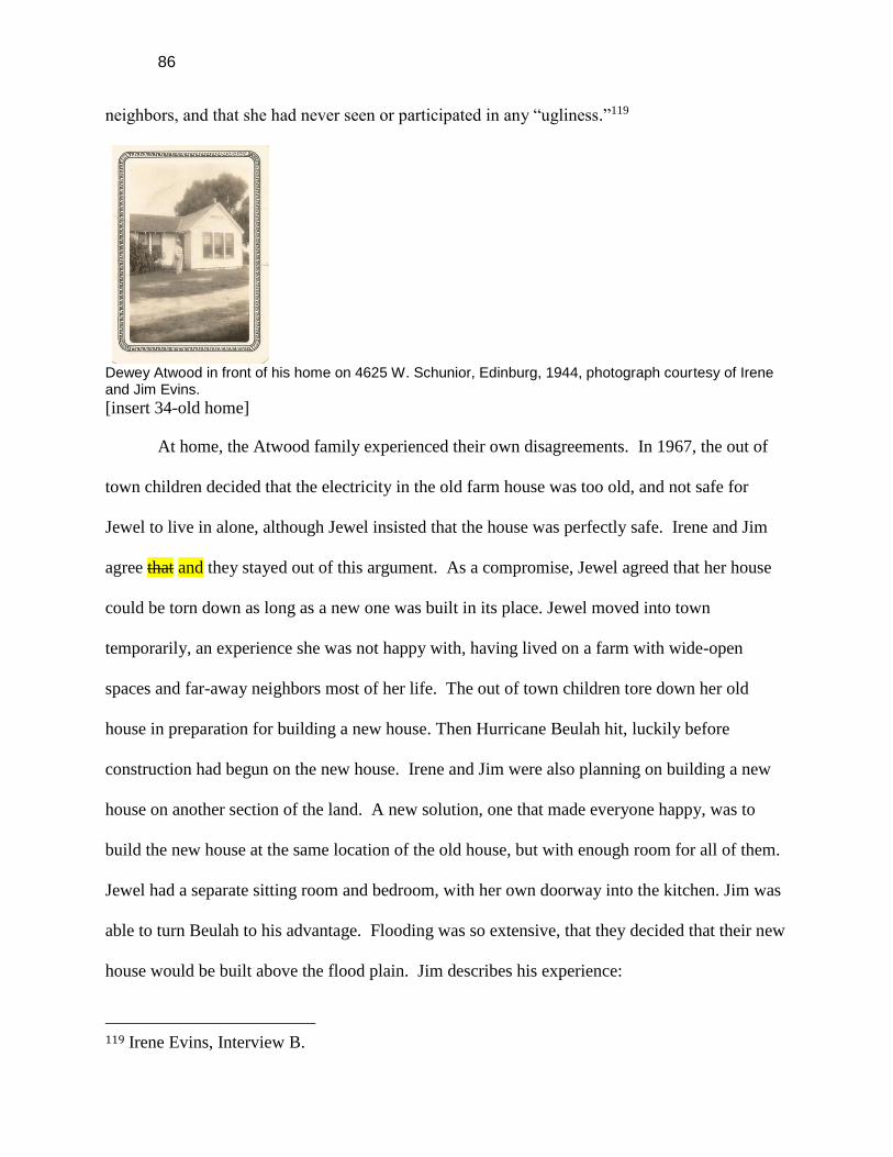
86
neighbors, and that she had never seen or participated in any “ugliness.”119
Dewey Atwood in front of his home on 4625 W. Schunior, Edinburg, 1944, photograph courtesy of Irene and Jim Evins.
[insert 34-old home]
At home, the Atwood family experienced their own disagreements. In 1967, the out of
town children decided that the electricity in the old farm house was too old, and not safe for
Jewel to live in alone, although Jewel insisted that the house was perfectly safe. Irene and Jim
agree that and they stayed out of this argument. As a compromise, Jewel agreed that her house
could be torn down as long as a new one was built in its place. Jewel moved into town
temporarily, an experience she was not happy with, having lived on a farm with wide-open
spaces and far-away neighbors most of her life. The out of town children tore down her old
house in preparation for building a new house. Then Hurricane Beulah hit, luckily before
construction had begun on the new house. Irene and Jim were also planning on building a new
house on another section of the land. A new solution, one that made everyone happy, was to
build the new house at the same location of the old house, but with enough room for all of them.
Jewel had a separate sitting room and bedroom, with her own doorway into the kitchen. Jim was
able to turn Beulah to his advantage. Flooding was so extensive, that they decided that their new
house would be built above the flood plain. Jim describes his experience:
119 Irene Evins, Interview B.

87
I came down Mon Mack Road off of 107 and the water from there out to the
house was waist deep, or where the house was going to be. It was waist deep, and
I waded all the way down there, and when I got there, I took nails and nailed them
in trees at the water level so we would know when we built how high to raise the
ground because we felt that if the water got deeper than it did at Beulah, we
needed to drown. So, when the water went down, we brought dirt in and raised it
up to that level and we haven’t had any problems since. We came through Allen
and every other little hurricane we’ve had without any trouble.120
1980s to present
For a scary moment at three a.m. in the early 1990s, it looked like the new house might
not last. A lightning strike hitting a transformer caused a fire to erupt in the wiring of the kitchen
dishwasher. Irene was up late because she couldn't sleep. She was up reading, smelled the
smoke and woke up Jim. Jewel, who was in the house at the time, refused to leave the house
unless she was properly dressed. Jim and his son tried to remove the dishwasher although the
flames had already spread to the wall. Luckily, the fire department was able to arrive in roughly
12 minutes despite being primarily composed of volunteers. The report for the fire stated that if
the fire truck had arrived just a few minutes later than it did, the entire house might have been
lost to the flames121.
Much like the Atwood home, Edinburg has had its fair share of change. Around the time
that the Atwood-Evins' built the new home, Edinburg had a population of 17,163 people
according to the 1970 U.S. Census. Now home to 77,100 people according to the 2010 census,
many of those residents will not remember what it was like to have a pound for stray farm
animals. The old 1910 county courthouse, built in the Spanish style, was razed and replaced by
the new 1954 block-style courthouse. The Citrus Theater, which once provided a place for the
Atwood children and other youth of Edinburg to hang out and have fun was closed several years
120 James Evins, Interview D. 121 Personal communication with Irene and Jim Evins.

88
ago, and is now used as a storage building. Around 5:00 in the evening, Edinburg turns back
into a small town. The University was, and still is, a ‘commuter’ school. Students drive into
town in the mornings to attend class, and return to their home or work afterwards. As the County
Seat, Edinburg also attracts county workers, and those who have business with the county during
the day, but go home after 5:00 p.m.
NAFTA (the North American Free Trade Agreement) was signed into law in 1993.
There were concerns that NAFTA would negatively affect the agricultural sector. Nationwide,
agriculture represented a declining share of the national economy. Within the Lower Rio Grande
Valley, agriculture and earnings fluctuated before and after NAFTA was introduced between
1970 and 1997. From 1970 to 1980, earnings declined, then increased in the next decade, and
declined again from 1990 to 1997. Employment in the sector showed similar, but less dramatic,
fluctuations: an increase from 1970 to 1980; a decline between 1980 and 1990; and an increase,
again from 1990 to 1997. This fluctuation represents normal patterns in agriculture, although it
is possible that NAFTA slightly accelerated the trend.122
The experience that Dewey and Jewel and their children had on the Atwood farm in the
1920s varies considerably from what their grandchildren and great-grandchildren will see. The
Atwood farm is no longer remote or on the outskirts of town. Shallow brass shotgun shells were
found on the property. Jim informed the CHAPS students that he used to allow people on his
property to hunt white wing doves. Glass shards found near the shotgun shells, however,
indicate that the hunters may have also practiced shooting at glass bottles. A housing
122 J. Daniel Morales and Judith I. Stallmann, NAFTA and the Lower Rio Grande Valley of
Texas: Measuring Impacts (Faculty Paper 00-11, Texas A&M University, July, 2000), 10,
http://agecon.tamu.edu/wp-content/uploads/2013/07/fp00-11.pdf (accessed November 20, 2013).

89
development has been erected in front of the property, a stone wall around the private
community blocks the view from the front window of the Atwood home. From just about any
point on the property, the signs of an encroaching city can be seen.
Shotgun shells found in field
[insert 35a and 35b-shotgun shells]
This account brings us to the acacia tree in the front yard whose roots and branches
mirror those of the Atwood family. Farm workers, neighbors and the various family members
have traversed the grounds countless times. This time, the twenty or so people crossing the fertile
soil upon which Dewey Atwood built his farm and his family have a different purpose.
CONCLUSION
At about 2:30 in the afternoon a group of twenty students sat huffing and puffing
underneath the spotty shade of an acacia tree. Water bottles were passed around as bodies
shifted, looking for a comfortable resting position. Chairs were pulled out by some of the
students, brightly colored against the clearing where they chose to congregate in a haphazard
circle around the Atwood-Evins', their dogs, and the home that they have built for themselves.
The students ask about weddings, buildings, family members, and snakes. Some of them jot
down notes to remember, others wait their turn to ask their own question about a seemingly

90
mundane topic. Not too long before this, those very same students walked all around the
property, asking for the names of plants, taking pictures of spiders hiding away in the garden,
taking turns with an auger and asking for help when they could not raise it back up themselves.
They walked around the property, poking at the ground in hopes of finding a small piece of
history underneath their shoe. To anyone who drove by, it surely must have been a strange sight,
seeing twenty bodies making circles and huddling together, stuffing rocks in their pockets for
later inspection.
This is the third year that The University of Texas-Pan American has offered the CHAPS
class which introduces students to archeology, anthropology, biology, geology, and history of the
Lower Rio Grande Valley region. Each year a new group of students has the opportunity to
study a little piece of Valley history in-depth. For three weeks, the students in the Fall 2013
course completed fieldwork studying the archaeology, biology, and geology of the 60 acres
owned by the Atwood-Evins family.
This story begins with a family who loved the land so much that they stood by it through
the brightest and the darkest times in their lives. A family who is as deeply rooted in the Rio
Grande Valley, and the lives of the people who live here, as the crops that continue to grow.
There are not many farmers left in the area. Housing developments go up around the Atwood
farm year after year.
A drive around the block of the Atwood-Evins home helps tell the story of the Valley.
Street names surrounding the Atwood-Evins property are named after prominent men and
families of Edinburg, including Schunior, Hoehn, and Chapin. A field of brush and cactus lies to
the north, reminiscent of what this area must have looked like before the land was cleared,

91
plowed, and planted. An irrigation canal, crops, and citrus fields may be found all along the
block, indicative of how the area changed as irrigation was developed, and new farm families,
such as the Atwoods, moved to the region. Finally, on the east side of the block is a new
subdivision, planted over what used to be a citrus orchard, as the enormous population growth of
this region spurred in part by demands of international trade requires more room for people and
houses.
Why is a project like this necessary? Why make a group of students devote so much time
to the property of a single family like the Atwoods? These questions were asked of us more than
once by family members and instructors alike. The Rio Grande Valley is growing at an
accelerated pace. What used to be an area dominated by citrus farms as far as the eye can see is
now being dominated by sorghum and other crops that are more resistant to drought following a
string of bad drought years. Farming and farming families are finding the literal and figurative
climate on which their existence relies increasingly harsh. Younger generations are losing
interest in farming and so they abandon the ways of their ancestors. They move away and the
land is left without tenant or anyone to continue the work, so the land is sold off by extended
family, uninterested in remaining in the Rio Grande Valley. Just across the Atwood farm there is
a housing development where once there were only fields as far as the eye could see. Some
families are unable to remain farmers despite lingering attachment to the lands. Jim told us that
the three conditions necessary for successful farming were cheap land, cheap water, and cheap
labor.
Families like the Atwoods are not as common as they used to be in the Rio Grande
Valley. It is our duty as anthropologists, historians, citizens of the Valley, and students of The

92
University of Texas-Pan American to write down the story of these families before they are lost
forever. Who knows more about this land than the people who have had to work on it every day
for years? This project was a combined effort of many disciplines in capturing an accurate
picture of what life was like for these early farming families. By studying the Atwood property
through time and as viewed through the different lens of geology, archaeology, biology, history,
and anthropology, we were able to create an understanding of just how much the region has
changed and affected the land and the people who work it.
Through our investigations of the “Atwood Acres” evidence of pre-historic life as seen
with the spear point, petrified wood, and presence of gas, we were able to glimpse what the land
was like before the Atwoods arrived on the property. We know of this history through talking
with the family, and because everyone dedicated to this project walked the property and scoured
over dust and rocks tirelessly searching for it. The homes and the crops on the Atwood land are
tangible proof of the love and sacrifice this family has made for the land.
It is our hope that projects such as the one we have explained in detail in this book will
continue. There are more families in the Rio Grande Valley with stories that need to be told
before they are forgotten and lost to time. In these pages we hope to have done justice to the
story of the Atwoods, and hope that all who read this may have a glimpse of what life was like
for those who helped make our region become what it is today.
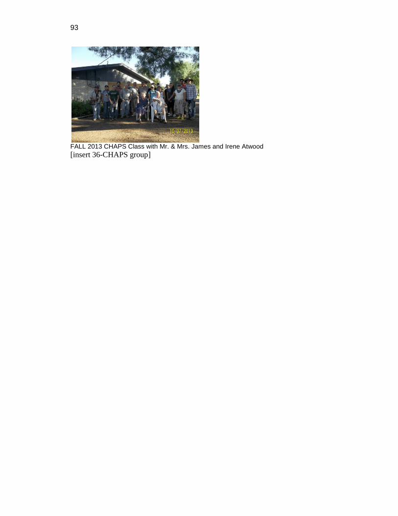
93
FALL 2013 CHAPS Class with Mr. & Mrs. James and Irene Atwood
[insert 36-CHAPS group]

94
BIBLIOGRAPHY
INTERVIEWS
Baldridge, Hazel, Interview C. Border Studies Archive, The University of Texas – Pan
American Library. Interviewed by Alexis Casiano et al. September 20, 2013.
Evins, Irene, Interview A. Border Studies Archive, The University of Texas – Pan
American Library. Interviewed by Jenarae Alaniz et al. September 18, 2013.
Evins, Irene, Interview B, Border Studies Archives, The University of Texas – Pan
American Library. Interviewed by Colin Newton et al. October 25, 2013.
Evins, James, Interview D. Border Studies Archive, The University of Texas – Pan
American Library. Interviewed by Norma Perez et al. September 23, 2013.
PUBLICATIONS
Alonso, Armando. “Change and Continuity in Tejano Ranches in the Trans-Nueces, 1848
– 1900.” In Ranching in South Texas, compiled by Joe S. Graham. Kingsville,
Texas: Texas A & M University-Kingsville, 1994.
Barker, Eugene C. “The Life of Stephen F. Austin, Founder of Texas, 1793 – 1836.” A
Chapter in the Westward Movement of Anglo-American People. Austin: The
Texas State Historical Association, 1949.
Campbell, T. N. “Coahuiltecans and Their Neighbors.” Vol 10 of Handbook of North
American Indians, Southwest, edited by Alfonzo Ortiz. Washington D. C.:
Smithsonian Institute, 1983.
Fagen, Brian M. Ancient North America: The Archaeology of a Continent. 4th ed. New
York: Thames & Hudson. 2005.
Felder, Darryl L. Geology. Vol. 3 of Gulf of Mexico Origin, Waters, and Biota. College
Station, TX: Texas A&M University Press, 2011.
Fortune Editors. “Joseph P. Kennedy: A portrait of the founder (Fortune Classics, 1963),”
Fortune (April 10, 2011).

95
http://features.blogs.fortune.cnn.com/2011/04/10/joseph-p-kennedy-a-portrait-of-
the-founder (accessed November 29, 2013).
“Genealogy, Family Trees, and Family History Records.” Ancestry.com.
http://www.ancestry.com (accessed November 18, 2013).
González, Juan L., James R. Hinthorne, Russell K. Skowronek, Thomas Eubanks, Don Kumpe 2014 Characteristics and genesis of El Sauz chert, an important prehistoric lithic resource in south Texas. Lithic Technology 39(3):1-10.
Greaser, Galen D. New Guide to Spanish and Mexican Land Grants in South Texas.
Austin, TX: Texas General Land Office, 2009.
Hall, Grant D., Michael B. Collins, and Elton R. Prewitt. Cultural Resources
Investigations Along Drainage Improvements, Hidalgo and Willacy Counties,
Texas. Austin: Prewitt and Associates, 1986.
Hernandez-Salinas, Sandra, et al. The Norquest Family: A Porcion of Edinburg. A Report
Prepared for the Norquest Family and for the University of Texas – Pan
American, Community Historical Archaeological Project with Schools Program.
Edinburg, TX: The University of Texas – Pan American, 2012.
Lipscomb, W. L. “Interview June 27, 1938” In A History of Irrigation in the Rio Grande
Valley by William Kenneth Matthews. Master’s thesis, University of Texas, 1938.
Meir, Matt S. and Feliciano Ribera. Mexican Americans, American Mexicans: From
Conquistadors to Chicanos. New York: Hill and Wang, 1993.
Morales, J. Daniel and Judith J. Stallmann. NAFTA and the Lower Rio Grande Valley of
Texas. Faculty Paper 00-11, Texas A&M University, July, 2000.
http://agecon3.tamu.edu/pdf_files/publications/facultyPapers/2000/fp00-11.pdf
(accessed November 1, 2013).
Newcomb, W. W. Jr. “Indians in Texas.” Bulletin of the Texas Archeological Society 29
(1960): 1-34.
Richardson, Rupert N. Texas: The Lone Star State. New Jersey: Pearson Prentice Hall,
2005.
Texas Railway Commission. http://rrcsearch.neubus.com (accessed November 22, 2013).
Travis, Richard. History of Freezes in the Lower Rio Grande Valley, Part II 1895-1962.
http://www.raingardens.com/psst/articles/artic02.htm (accessed November 22,
2013).
Thompson, Jerry. Introduction to A Shared Experience: The History, Architecture, and
Historic Designations of the LRGV Heritage Corridor. 2nd ed. Austin, TX: Los
Caminos and The Texas Historical Commission, 1994.
Troutman, Arthur. The Oil and Gas Fields of the Rio Grande Valley in District 4 of South
Texas. Houston: 5 Star Oil Reports, Inc., 1956.
96
Turner, Ellen Sue, Thomas R Hester and Richard L McReynolds. Stone Artifacts of Texas
Indians. Completely rev. 3rd ed. Lanham, MD: Taylor Trade Publishing, 2011.
Delete from bibliography – don’t include maps, photos, census and encyclopedia articles
Bloodsworth, Morris E. and Paul T. Gillet. “Irrigation.” Handbook of Texas Online.
Accessed November 8, 2013.
http://www.tshaonline.org/handbook/online/articles/ani01.
Garcia, Lino Jr. “Early Tejanos and the Role of Seguin in Texas’ Development”.
Brownsville Herald (Brownsville, TX), December 12, 2010.
Garcia, Lino Jr. “Lorenzo de Zavala y Saenz: Designer of the Texas Flag”. Brownsville
Herald (Brownsville, TX), November 1, 2010.
Garcia, Lino Jr. “Tejano Patriots at the Battle of the Alamo”, Rio Grande Guardian
(McAllen, TX), May 26, 2013. Accessed December 1, 2013.
http://www.riograndeguardian.com/columns3_story.asp?story_no=5.
Goza, Mrs. Goldsby. “American Rio Grande Land and Irrigation Company.” Handbook
of Texas Online. Accessed November 10, 2013.
http://www.tshaonline.org/handbook/online/articles/gza01.
Henson, Margrett Swett. “Anglo-American Colonization,” Handbook of Texas Online.
Accessed November 9 2013.
http://www.tshaonline.org/handbook/online/articles/uma01.
Miller, Hubert J. “Edinburg, TX.” Handbook of Texas Online. Accessed November 10,
2013. http://www.tshaonline.org/handbook/online/articles/hee02.
Smith, Brad. “Reporter Recalls 1933 Labor Day Hurricane,”, Edinburg Daily Review
(Edinburg, TX), August 18, 1993.
Tamm, Office of Alfred, Civil Engineer. Map and General Information of Lower Rio
Grande Valley of Texas, 1941.
United States Census, 1910.

97
Vigness, David M. and Mark Odintz. “Rio Grande Valley.” Handbook of Texas Online.
Accessed November 8, 2013.
http://www.tshaonline.org/handbook/online/articles/rgr01.