ipsos mrbi/operations/jnlr misc 1 jnlr – joint national listenership research - population matrix...
TRANSCRIPT
Ipsos MRBI/Operations/JNLR Misc
1
JNLR – Joint National Listenership Research - Population Matrix x Franchise AreaCensus 2012

Ipsos MRBI/Operations/JNLR Misc
Co. Dublin Population – Region X Community Size
This stratification forms the basis of the control of the Dublin area sample.
2
Region Co. BoroTowns10,000+
Towns5,000-10,000
Towns1,500-5,000
Rural<1,500
Total1,273,069100%
1,273,069100%
Dublin City NthDublin City SthDunlaoghaire/RathdownFingalSouth Dublin
307,495220,117206,261
273,991265,205
Base: Census 2011 – Total population

Ipsos MRBI/Operations/JNLR Misc
Co. Kildare (KFM) Population – Region X Community Size 3
This stratification forms the basis of the control of the Kildare local area sample.
Region Co. BoroTowns10,000+
Towns5,000-10,000
Towns1,500-5,000
Rural<1,500
Total
210,312 89,773 35,586 16,441 68,512
100% 42.7% 16.9% 7.8% 32.6%NaasNewbridgeCelbridgeLeixlip Maynooth
20,71321,56119,53715,45212,510
AthyKildareClane KilcockSallins
9,9268,1426,7025,5335,283
MonasterevanKilcullenKillProsperousRathanganDerrinturn
3,710
3,4733,0952,2482,3741,541
Athy No. 1 RACelbridge No. 1 RAEdenderry No. 2 RANaas No. 1 RA
17,481 9,565 7,84133,625
Base: Census 2011 – Total population
Ipsos MRBI/Operations/JNLR Misc
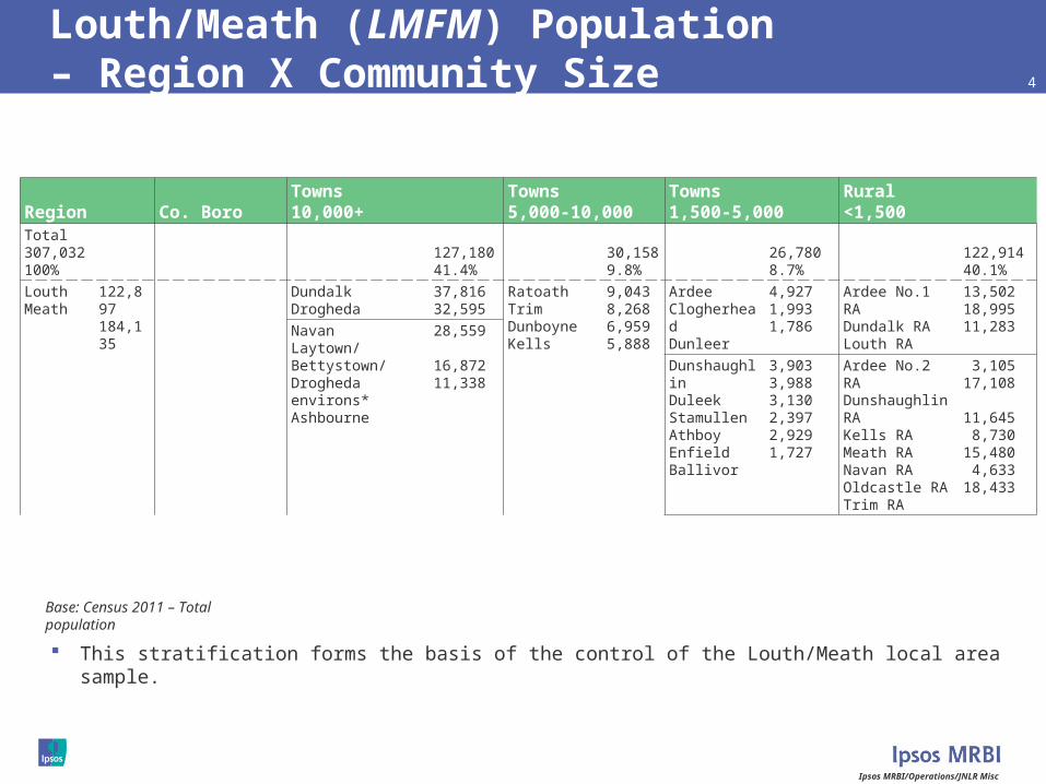
Louth/Meath (LMFM) Population – Region X Community Size 4
This stratification forms the basis of the control of the Louth/Meath local area sample.
Region Co. BoroTowns10,000+
Towns5,000-10,000
Towns1,500-5,000
Rural<1,500
Total307,032100%
127,18041.4%
30,1589.8%
26,7808.7%
122,91440.1%
LouthMeath
122,897184,135
DundalkDrogheda
37,81632,595
RatoathTrimDunboyneKells
9,0438,2686,9595,888
ArdeeClogherheadDunleer
4,9271,9931,786
Ardee No.1 RADundalk RALouth RA
13,50218,99511,283Navan
Laytown/Bettystown/Drogheda environs*Ashbourne
28,559
16,87211,338
DunshaughlinDuleekStamullenAthboyEnfieldBallivor
3,9033,9883,1302,3972,9291,727
Ardee No.2 RADunshaughlin RAKells RAMeath RANavan RAOldcastle RATrim RA
3,10517,108
11,645 8,73015,480 4,63318,433
Base: Census 2011 – Total population

Ipsos MRBI/Operations/JNLR Misc
Kilkenny/Carlow (KCLR) Population - Region X Community Size 5
This stratification forms the basis of the control of the Kilkenny/Carlow local area sample.
Region Co. BoroTowns10,000+
Towns5,000-10,000
Towns1,500-5,000
Rural<1,500
Total150,031100%
43,48729.0%
16,31210.9%
90,23260.1%
CarlowKilkenny
54,61295,419
CarlowKilkenny
19,06424,423
TullowMuinebeag
3,9722,950
Baltinglass No. 2 RACarlow RAIdrone RA
4,37222,0192,235Waterford suburb*
ThomastownCallan
*Kilcalliheen *Aglish
4,7872,2732,330
Callan RACarrick-on-Suir No.3 RACastlecomer RAIda RAKilkenny RAThomastown RAUrlingford RAWaterford No. 2 RA
5,4264,5678,4782,95313,40911,7534,65810,362
Base: Census 2011 – Total population
Ipsos MRBI/Operations/JNLR Misc
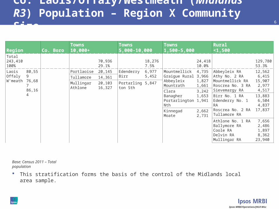
Co. Laois/Offaly/Westmeath (Midlands R3) Population – Region X Community Size 6
This stratification forms the basis of the control of the Midlands local area sample.
Region Co. BoroTowns10,000+
Towns5,000-10,000
Towns1,500-5,000
Rural<1,500
Total243,410100%
70,93629.1%
18,2767.5%
24,41810.0%
129,78053.3%
LaoisOffalyW’meath
80,55976,68786,164
Portlaoise 20,145 EdenderryBirr
6,9775,452
MountmellickGraigue RuralAbbeyleixMountrath
4,7353,9661,8271,661
Abbeyleix RAAthy No. 2 RAMountmellick RARoscrea No. 3 RASievemargy RA
12,562 6,41515,907 2,977 4,517
Tullamore 14,361Mullingar Athlone
20,10316,327
Portarlington Sth 5,847
ClaraBanagherPortarlington Nth
3,2421,6531,941
Birr No. 1 RAEdenderry No. 1 RARoscrea No. 2 RATullamore RA
13,883 6,504 4,83717,837
KinnegadMoate
2,6622,731
Athlone No. 1 RABallymore RACoole RADelvin RAMullingar RA
7,656 2,486 1,897 8,36223,940
Base: Census 2011 – Total population
Ipsos MRBI/Operations/JNLR Misc
7
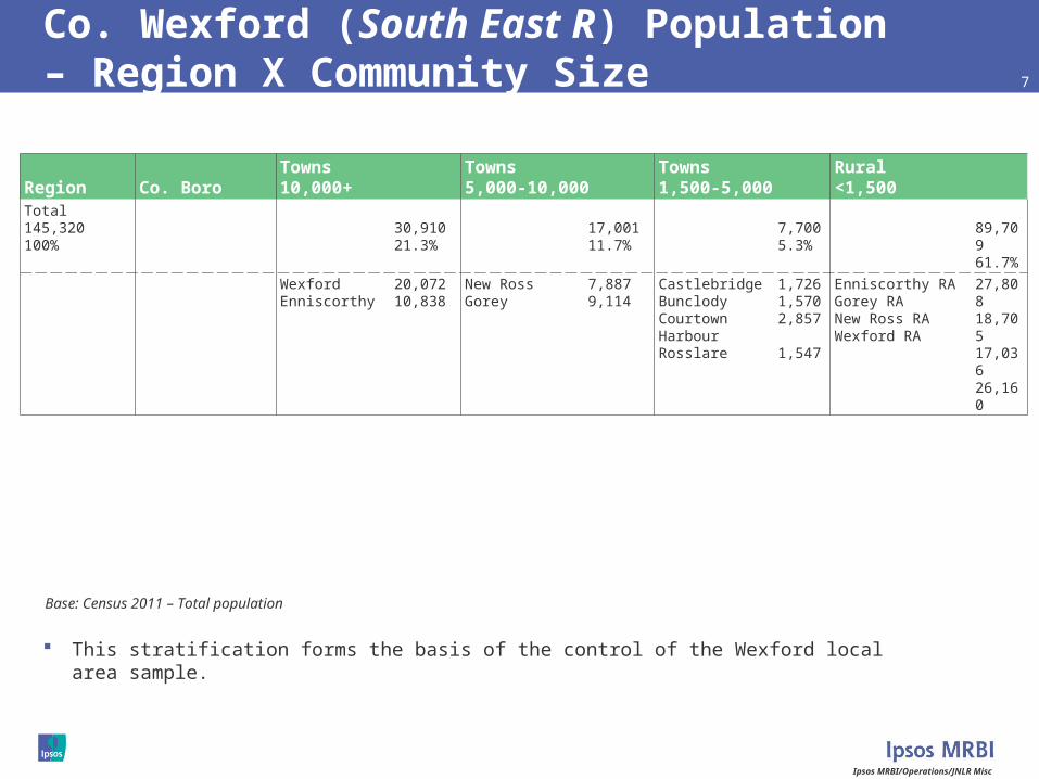
Co. Wexford (South East R) Population– Region X Community Size
This stratification forms the basis of the control of the Wexford local area sample.
Region Co. BoroTowns10,000+
Towns5,000-10,000
Towns1,500-5,000
Rural<1,500
Total145,320100%
30,91021.3%
17,00111.7%
7,7005.3%
89,70961.7%
WexfordEnniscorthy
20,07210,838
New RossGorey
7,8879,114
CastlebridgeBunclody Courtown HarbourRosslare
1,7261,5702,857
1,547
Enniscorthy RAGorey RANew Ross RAWexford RA
27,80818,70517,03626,160
Base: Census 2011 – Total population

Ipsos MRBI/Operations/JNLR Misc
8
Co. Wicklow (East Coast R) Population – Region X Community Size
This stratification forms the basis of the control of the Wicklow local area sample.
Region Co. BoroTowns10,000+
Towns5,000-10,000
Towns1,500-5,000
Rural<1,500
Total136,640100%
69,42550.8%
19,52014.3%
47,69534.9%
BrayGreystones/DelganyArklowWicklow
28,59217,468
13,00910,356
BlessingtonKilcooleNewtown-Mt- KennedyEnniskerryRathnewBaltinglassRathdrum
4,6394,0492,410
1,8112,9642,0611,586
Baltinglass No.1 RARathdown No.2 RARathdrum RAShillelagh RA
11,265 4,28124,229 7,920
Base: Census 2011 – Total population

Ipsos MRBI/Operations/JNLR Misc
Co. Cork Population – Region X Community Size 9
This stratification forms the basis of the control of the Cork local area sample.
Region Co. BoroTowns10,000+
Towns5,000-10,000
Towns1,500-5,000
Rural<1,500
Total519,032100%
198,58238.3%
50,7289.8%
26,7135.1%
47,7399.2%
195,27037.6%
Co. BoroSuburbs
119,23079,352
CarrigalineCobhMallow Midleton
14,77512,34711,60512,001
YoughalFermoyBandonPassage West
7,7946,4896,6405,790
ClonakiltyKinsaleMacroomMitchelstownBantryTowerRathluircCarrigtohillBlarneySkibbereenKanturkCrosshavenDunmanwayMillstreetCloyneRathcormac
4,7214,8933,8793,6773,3483,3063,6464,5512,4372,6702,2632,0931,5851,5741,5621,534
Bandon RABantry RACastletown RAClonakilty RACork RADunmanway RAFermoy RAKanturk RAKinsale RAMacroom RAMallow RAMidleton RAMillstreet RAMitchelstown No.1 RASkibbereen RASkull RAYoughal RA
16,1306,3254,29711,25525,1316,77415,65415,05713,27115,31118,09217,9815,3614,579
11,4414,1144,497
Base: Census 2011 – Total population

Ipsos MRBI/Operations/JNLR Misc
Co. Limerick (Live 95) Population – Region X Community Size 10
This stratification forms the basis of the control of the Limerick local area sample.
Region Co. BoroTowns10,000+
Towns5,000-10,000
Towns1,500-5,000
Rural<1,500
Total191,809100%
87,08145.4%
6,3273.3%
9,9655.2%
88,43646.1%
Co. BoroSuburbs
57,10629,975
Newcastle West 6,327 AbbeyfealeAnnacotty * *Ballyvarra/ BallysimonRathkealeKilmallockCastleconnell
2,0072,856
1,5501,6351,917
Croom RAGlin RAKilmallock RALimerick No.1 RAMitchelstown No.2 RANewcastle RARathkeale RATipperary No.2 RA
12,6712,28715,22520,7373,247
15,62013,8394,810
Base: Census 2011 – Total population

Ipsos MRBI/Operations/JNLR Misc
Co. Tipperary (Tipp FM) Population – Region X Community Size 11
This stratification forms the basis of the control of the Tipperary local area sample.
Region Co. BoroTowns10,000+
Towns5,000-10,000
Towns1,500-5,000
Rural<1,500
Total158,754100%
17,04810.7%
32,97120.8%
15,4899.8%
93,24658.7%
Clonmel 17,048 NenaghThurlesCarrick-on-SuirTipperaryRoscrea
8,4397,9335,886
5,3105,403
CahirCashelTemplemoreBallinaNewportFethard
3,5784,0512,0712,4421,8061,541
Borrisokane RANenagh RARoscrea No.1 RAThurles RACarrick-on-Suir RACashel RAClogheen RAClonmel No.1 RASlieveardagh RATipperary No.1 RA
7,79516,9183,41014,1051,89914,2269,6206,0166,05613,201
Base: Census 2011 – Total population

Ipsos MRBI/Operations/JNLR Misc
Co. Waterford (WLR) Population – Region X Community Size 12
This stratification forms the basis of the control of the Waterford local area sample.
Region Co. BoroTowns10,000+
Towns5,000-10,000
Towns1,500-5,000
Rural<1,500
Total113,795100%
46,73241.1%
10,328 9.1%
9,4278.3%
3,2552.9%
44,05338.7%
Co. Boro 46,732 Tramore 10,328 Dungarvan 9,427 Dunmore- EastPortlaw
1,559
1,696
Carrick on Suir No. 2 RAClonmel No. 2 RADungarvan RAKilmacthomas RALismore RAWaterford No. 1 RAYoughal No. 2 RA
3,329
2,7959,1007,4438,2489,7153,423
Base: Census 2011 – Total population
Ipsos MRBI/Operations/JNLR Misc
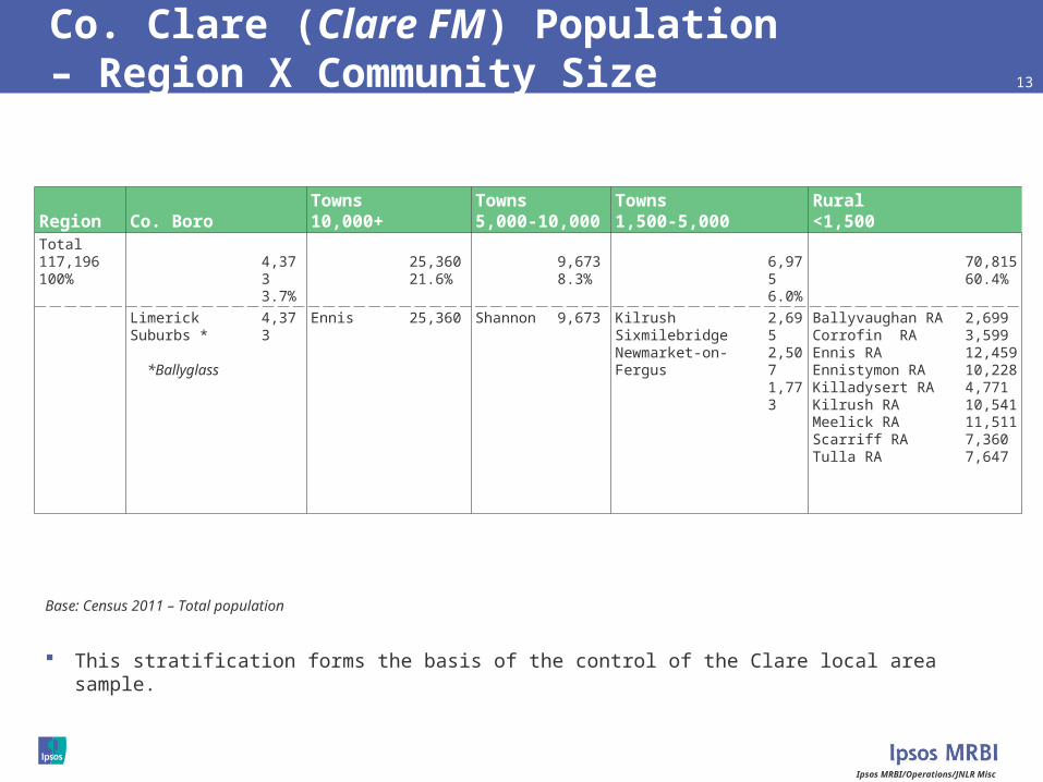
Co. Clare (Clare FM) Population – Region X Community Size 13
This stratification forms the basis of the control of the Clare local area sample.
Region Co. BoroTowns10,000+
Towns5,000-10,000
Towns1,500-5,000
Rural<1,500
Total117,196100%
4,3733.7%
25,36021.6%
9,6738.3%
6,9756.0%
70,81560.4%
Limerick Suburbs *
*Ballyglass
4,373 Ennis 25,360 Shannon 9,673 KilrushSixmilebridgeNewmarket-on-Fergus
2,6952,5071,773
Ballyvaughan RACorrofin RAEnnis RAEnnistymon RAKilladysert RAKilrush RAMeelick RAScarriff RATulla RA
2,6993,59912,45910,2284,77110,54111,5117,3607,647
Base: Census 2011 – Total population

Ipsos MRBI/Operations/JNLR Misc
Co. Kerry (Radio Kerry) Population – Region X Community Size 14
This stratification forms the basis of the control of the Kerry local area sample.
Region Co. BoroTowns10,000+
Towns5,000-10,000
Towns1,500-5,000
Rural<1,500
Total145,502100%
37,90626.1%
13,5679.3%
94,02964.6%
TraleeKillarney
23,68714,219
ListowelCastleislandDingleKenmareKillorglin
4,8322,5131,9652,1752,082
Caherciveen RADingle RAKenmare RAKillarney RAListowel RATralee RA
8,8027,6845,27427,55119,90124,817
Base: Census 2011 – Total population
Ipsos MRBI/Operations/JNLR Misc
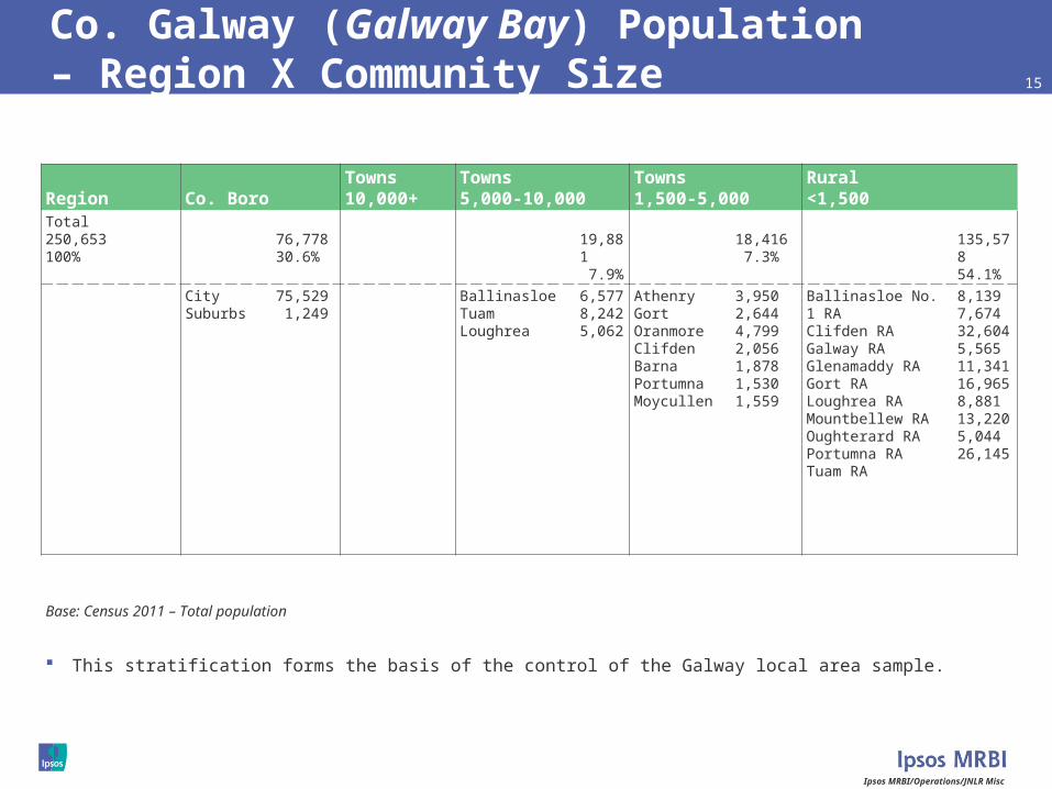
Co. Galway (Galway Bay) Population– Region X Community Size 15
This stratification forms the basis of the control of the Galway local area sample.
Region Co. BoroTowns10,000+
Towns5,000-10,000
Towns1,500-5,000
Rural<1,500
Total250,653100%
76,77830.6%
19,881 7.9%
18,416 7.3%
135,57854.1%
City Suburbs
75,529 1,249
BallinasloeTuamLoughrea
6,5778,2425,062
Athenry Gort Oranmore ClifdenBarnaPortumnaMoycullen
3,9502,6444,7992,0561,8781,5301,559
Ballinasloe No. 1 RAClifden RAGalway RAGlenamaddy RAGort RALoughrea RAMountbellew RAOughterard RAPortumna RATuam RA
8,1397,67432,6045,56511,34116,9658,88113,2205,04426,145
Base: Census 2011 – Total population

Ipsos MRBI/Operations/JNLR Misc
Co. Mayo (MWR) Population – Region X Community Size 16
This stratification forms the basis of the control of the Mayo local area sample.
Region Co. BoroTowns10,000+
Towns5,000-10,000
Towns1,500-5,000
Rural<1,500
Total130,638100%
23,40417.9%
6,0634.6%
8,4286.5%
92,74371.0%
CastlebarBallina
12,31811,086
Westport 6,063 ClaremorrisBallinrobeBallyhaunis
3,4122,7042,312
Ballina RABallinrobe RABelmullet RACastlebar RAClaremorris RASwinford RAWestport RA
15,69111,209 8,00513,746 9,85216,37917,861
Base: Census 2011 – Total population

Ipsos MRBI/Operations/JNLR Misc
Roscommon/Longford/Sth Leitrim (Shannonside) Population – Region X Community Size 17
This stratification forms the basis of the control of the Shannonside local area sample.
Region Co. BoroTowns10,000+
Towns5,000-10,000
Towns1,500-5,000
Rural<1,500
Total123,947100%
15,29412.3%
16,84213.6%
91,81174.1%
RoscommonLongfordSth Leitrim
64,06539,00020,882
Longford 9,601 BoyleAthlong EnvCastlereaBallaghaderreenBallymahonEdgeworthstown
2,5883,8261,9851,8221,5631,744
Ballymahon RAGranard No.1 RALongford RA
5,6107,27413,208
Roscommon 5,693
Athlone No.2 RABoyle No.1 RACastlereagh RARoscommon RA
12,1697,70811,72716,547Carrick-on-Shannon 3,314
Ballinamore RACarrick-on-Sh No.1Mohill RA
3,3706,1018,097
Base: Census 2011 – Total population

Ipsos MRBI/Operations/JNLR Misc
Cavan/Monaghan (Northern Sound) Population – Region X Community Size 18
This stratification forms the basis of the control of the Cavan/Monaghan local area sample.
Region Co. BoroTowns10,000+
Towns5,000-10,000
Towns1,500-5,000
Rural<1,500
Total133,666100%
10,205 7.6%
7,4525.6%
22,14916.6%
93,86070.2%
CavanMonaghan
73,18360,483
Cavan 10,205 Monaghan 7,452 BailieboroughCootehillKingscourtVirginiaBallyjamesduff
2,5302,1232,3262,2822,568
Bailieborough RABawnboy RACastlerahan RACavan RAEnniskillen No.2 RAMullaghoran RA
9,9694,4045,77527,4791,2932,229Carrickmacross
CastleblayneyClones
4,9253,6341,761
Carrickmacross RACastleblayney RAClones No.1 RAMonaghan RA
9,6299,1985,79418,090
Base: Census 2011 – Total population

Ipsos MRBI/Operations/JNLR Misc
Sligo/Sth Donegal/Nth Leitrim (Ocean FM) Population – Region X Community Size 19
This stratification forms the basis of the control of the Ocean FM local area sample.
Region Co. BoroTowns10,000+
Towns5,000-10,000
Towns1,500-5,000
Rural<1,500
Total102,572100%
19,45219.0%
12,13211.8%
70,98869.2%
SligoSth DonegalNth Leitrim
65,39326,26310,916
Sligo 19,452 TobercurryStrandhillBallymote
1,7471,5961,539
Boyle No.2 RADromore West RASligo RATobercurry RA
4,6947,31121,7797,275Ballyshannon
DonegalBundoran
2,5032,6072,140
Ballyshannon RA Donegal RA (part)Glenties RA (part)
3,4989,8285,687
Manorhamilton RAKinlough RA
8,0302,886
Base: Census 2011 – Total population
Ipsos MRBI/Operations/JNLR Misc
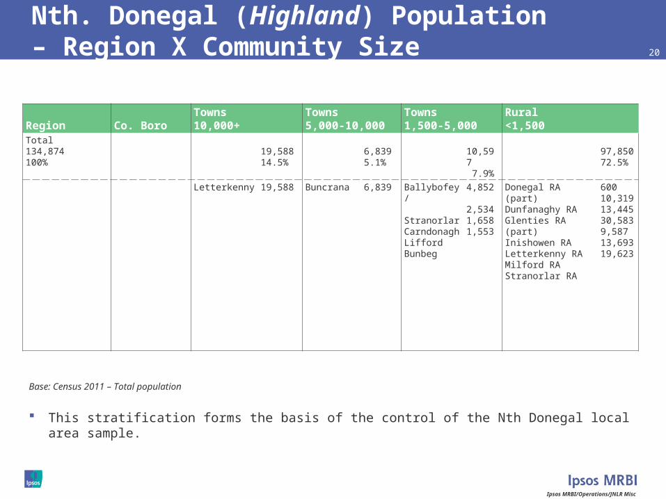
Nth. Donegal (Highland) Population – Region X Community Size 20
This stratification forms the basis of the control of the Nth Donegal local area sample.
Region Co. BoroTowns10,000+
Towns5,000-10,000
Towns1,500-5,000
Rural<1,500
Total134,874100%
19,58814.5%
6,8395.1%
10,597 7.9%
97,85072.5%
Letterkenny 19,588 Buncrana 6,839 Ballybofey/ StranorlarCarndonaghLiffordBunbeg
4,852
2,5341,6581,553
Donegal RA (part)Dunfanaghy RAGlenties RA (part)Inishowen RALetterkenny RAMilford RAStranorlar RA
60010,31913,44530,5839,58713,69319,623
Base: Census 2011 – Total population

Ipsos MRBI/Operations/JNLR Misc
21
JNLR – Joint National Listenership Research - Population Matrix x Franchise AreaCensus 2012