iron road presentation to tumby bay & districts community consultative group
TRANSCRIPT

Central Eyre Iron Project
Central Eyre Iron Project Presentation to Tumby Bay & Districts Community
Consultative Group
19 September 2013

Notices
Forward-Looking Statements
This presentation contains forward looking statements concerning the projects owned by Iron Road Limited. Statements concerning mining reserves and resources may also be deemed to be forward looking statements in that they involve estimates based on specific assumptions. Forward-looking statements are not statements of historical fact and actual events and results may differ materially from those described in the forward looking statements as a result of a variety of risks, uncertainties and other factors. Forward looking statements are based on management’s beliefs, opinions and estimates as of the dates the forward looking statements are made and no obligation is assumed to update forward looking statements if these beliefs, opinions and estimates should change or to reflect other future developments. Data and amounts shown in this presentation relating to capital costs, operating costs and project timelines are internally generated best estimates only. All such information and data is currently under review as part of Iron Road Limited’s ongoing development and project studies. Accordingly, Iron Road Limited cannot guarantee the accuracy and/or completeness of the figures or data included in the presentation until the project studies are completed.
Competent Person’s Statements
The information in this report that relates to Exploration Results is based on and accurately reflects information compiled by Mr Larry Ingle, who is a fulltime employee of Iron Road Limited and a Member of the Australasian Institute of Mining and Metallurgy. Mr Ingle has sufficient experience relevant to the style of mineralisation and the type of deposits under consideration and to the activity which he is undertaking to qualify as a Competent Person as defined in the 2004 Edition of the “Australasian Code for Reporting of Exploration Results, Mineral Resources and Ore Reserves. Mr Ingle consents to the inclusion in the report of the matters based on his information in the form and context in which it appears.
The information in this report that relates to Mineral Resources is based on and accurately reflects information compiled by Mr Iain Macfarlane and Mr Alex Virisheff, both of Coffey Mining Ltd, who are consultants and advisors to Iron Road Limited and Members of the Australasian Institute of Mining and Metallurgy. Mr Macfarlane and Mr Virisheff have sufficient experience relevant to the style of mineralisation and the type of deposits under consideration and to the activity which they are undertaking to qualify as Competent Persons as defined in the 2004 Edition of the “Australasian Code for Reporting of Exploration Results, Mineral Resources and Ore Reserves”. Mr Macfarlane and Mr Virisheff consent to the inclusion in the report of the matters based on their information in the form and context in which it appears.
Exploration Targets
It is common practice for a company to comment on and discuss its exploration in terms of target size and type. The information in this presentation relating to exploration targets should not be misunderstood or misconstrued as an estimate of Mineral Resources or Ore Reserves. Hence the terms Resource(s) or Reserve(s) have not been used in this context. Any potential quantity and grade is conceptual in nature, since there has been insufficient work completed to define them beyond exploration targets and that it is uncertain if further exploration will result in the determination of a Mineral Resource.
2

Introductions
• Larry Ingle, General Manager
• Tim Scholz, Principal Advisor- Stakeholder
Engagement
• Tilly Smart, Community Engagement Advisor
• Laura Johnston, Regulation and Approvals Manager
• Aaron Deans, Project Manager (Construction)
• Steve Green, Environmental Manager
• Alan Millett, Infrastructure Manager
• Brad Hunter, Principal Civil/Rail Engineer
3
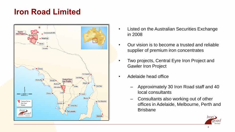
Iron Road Limited
• Listed on the Australian Securities Exchange
in 2008
• Our vision is to become a trusted and reliable
supplier of premium iron concentrates
• Two projects, Central Eyre Iron Project and
Gawler Iron Project
• Adelaide head office
– Approximately 30 Iron Road staff and 40
local consultants
– Consultants also working out of other
offices in Adelaide, Melbourne, Perth and
Brisbane
4

A Brief History of the Project
Deposit studied by the SA Department of Mines in
the 1960’s
• Iron Road acquired exploration licence in 2008
• Commenced drilling shortly thereafter
• The deposit has been the subject of two
prefeasibility studies:
– 1960’s SA Department of Mines; and
– 2011 Iron Road Limited
• Infrastructure component recently declared a
Major Development by the South Australian
government
5

Central Eyre Iron Project
Large scale iron ore project near Warramboo
• Second largest resources project in SA
history (after Olympic Dam)
• Open pit mine
• Processing plant
• Waste rock and tailing storage
• Power upgrade to the Eyre Peninsula
and project
• Water treatment facilities
• Offices and accommodation
• Infrastructure corridor to link the mine
and port
• Standard gauge railway line
• Deep water port at Cape Hardy
6
Head Office
Local Office

Study Main Points of Difference
7
Prefeasibility Study Definitive Feasibility
Production rate 12.4Mtpa 20Mtpa
Concentrate transport Slurry pipeline Standard gauge railway
Water Potable water used in process, desalination on the coast
Potable water only used for final concentrate wash, desalination on site
Port Third party facility Cape Hardy

Mining Large scale, conventional open pit mining – drill, blast, load and haul.
Cat 797F
360t payload
54 units
8

Processing Plant
Common process, established
technology
• On-site crushing, grinding
and magnetic separation
• Ore treatment throughput
+100Mtpa
• Concentrate production of
20Mtpa @ 67% iron and
low impurities
Aerial view of the Karara Iron Project, Western Australia
9

Mine Footprint
10
Correct at August 2013

11 Mine Fly Through

Rail and Utilities
• Standard gauge rail, approximately 145
kilometres from mine to port
• Infrastructure corridor for rail, water and
power
• Potential to link rail into the wider
national network
• Twin rotary car dumper – 660,000t
stockpile at port
• Seawater pipeline from port, with
desalination unit on mine site
• High voltage power upgrade
– to service entire district
12

Infrastructure and Utilities Corridor
• Rationale for the Corridor
– Minimise impact, one corridor only
• Comprises rail, pipeline, power line,
service road, pump station
• Best route possible avoiding remnant
native vegetation, towns and dwellings
• Corridor quarantined during construction
• Automated crossings, culverts for stock,
service road
• Rail schedule- six return trips per day
• Power line to site, reinforcement of EP
transmission network
• Corridor fenced
13

Why can’t you upgrade the existing rail corridor?
14
• Design is significantly different to the
Genesee & Wyoming line, so much so,
they are incompatible.
• Construction period of 2 – 3 years will
shutdown the current rail operation.
• Current rail system highly impacts
residents and towns.
• Significant remnant vegetation in the
Genesee & Wyoming easement.

Why doesn’t the company run the corridor through
Hambidge conservation park & avoid productive farm
land?
15
• Prohibited under the Wilderness
Protection Act 1992 (SA)
• Mallee Parks of Central Eyre
Peninsula Management Plan
captures Hambidge and Hincks
as Wilderness Protection Areas
• Prohibits the construction of
private infrastructure
• DEWNR strongly opposes the
construction of public
infrastructure

Corridor Construction
16

Port Facility
• Best suited locality on EP
• Deep water
• Required capacity
• No other bulk commodity
port has committed to
development
• Necessary for each
proposal to seek approvals
• No dredging
17
Correct at Sept 2013

Port Facility
• East coast of the Eyre Peninsula offers
sheltered, deep water locations
• 1.6km modular jetty and wharf structure
• 30Mtpa capacity at commissioning, 20Mtpa
required for CEIP
• Handymax, Panamax and Capesize capable
• Ship loader capacity of 7,300tph
• Easy and cost effective expandability of wharf
• First and only Capesize port in South Australia
• Land parcel sufficient to cater for third party
access and facilities
Cape Hardy visualisation
18

Port Fly Through

Employment Opportunities
• 1000+ during construction
• 550 during operation Mine
• 600 during construction
• 100 during operation Port & Rail
• 1600+ during construction
• 650 during operation Total Direct
• Industry employment multiple of 4 Indirect
20

• Environment ↔ natural, social, cultural and economic
• Comprehensive baseline
• Listen to community, government and technical experts
• Undertake impact and benefit assessments
• Modify design for optimal outcome
• Positive legacy
Environment

Environment
Topics raised to date include:
• Natural – noise, dust, visual, waste, flora, fauna, water
• Social / Economic – employment, lifestyle, traffic, land values, human services, tourism
• Cultural – Aboriginal sites of significance, shipwrecks, cemeteries
22

Approval Processes & Timelines
Mining Act Development Act Environment Protection and
Biodiversity Conservation Act
The major development assessment process
Stage 1 – Referral to the Development Assessment Commission
Once a proposal has been declared a major development by the Minister, and a formal
development application received, it is referred to the Development Assessment Commission
(DAC) .
The DAC will determine what level of assessment is required and issue formal guidelines.
There are three possible levels of assessment:
1. an environmental impact statement
2. a public environmental report
3. a development report.
Stage 2 – Detailed assessment documents released
Once the necessary assessment document is completed by the proponent, the document is
released for public or agency comment for three to six weeks. The document is made
available at the relevant local council and on the listing of major developments proposals.
Stage 3 – Responding to public comment
After the public comment period, the proponent is required to respond to any public or
agency comments. This completed response document is released for public information and
is made available at the relevant local council and on the listing of major developments
proposals.
Stage 4 – Assessing the proposal
The Minister will consider the proposal and detail in an assessment report. The completed
report is made available at the relevant local council and the listing of major developments
proposals.
Stage 5 – Decision
The Governor will make a decision on the final proposal having regard to the assessment
report and other documentation. This will be notified:
in the Government Gazette
by listing on this site under current major developments proposals
to the local media.
It is involved…
23

Simplified Timeline
Company Study Submit studies
Respond If approved,
decide to proceed
Construct Operate Close Relinquish
Estimated dates
2010 - 2013
Mid 2014 End 2014 2015 2015-2018 2018-??? ~5 years Criteria
Compliance
24

Seek community response
Simplified Process
Company Study Submit studies Respond
If approved, decide to proceed
Construct Operate Close Relinquish
Assessment Government decision on
Project Government
Decide assessment path (DA)
Publish guidelines -
infrastructure
Ongoing / Annual Regulation
Mine - assess achievement of closure criteria
Community
Stakeholder meetings
including CCC
Ongoing stakeholder engagement – performance, final land uses, opportunities
Review Govt published Guidelines
Review Study Findings
Comment to Government
25

Bulk Materials
Course tailings – gravel Fine tailings – silt like Product – magnetite concentrate
26

Bulk Materials
Course tailings – gravel, sand Fine tailings – silt like Product – magnetite concentrate
27

Dust limits

Mine
• Model established
• Finalising key data inputs
• Awaiting mine plan – November
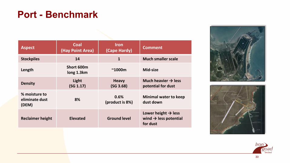
Port - Benchmark
• Coal example
• Twice as light as iron concentrate (SG 1.2 v 3.7)
• Ten times moisture content required to eliminate
dust (DEM 8% v 0.6%)
• 14 stockpiles
Aspect Coal
(Hay Point Area) Iron
(Cape Hardy) Comment
Stockpiles 14 1 Much smaller scale
Length Short 600m long 1.3km
~1000m Mid-size
Density Light
(SG 1.17) Heavy
(SG 3.68) Much heavier → less potential for dust
% moisture to eliminate dust (DEM)
8% 0.6%
(product is 8%) Minimal water to keep dust down
Reclaimer height Elevated Ground level Lower height → less wind → less potential for dust
30

Bucket wheel reclaimers

Benchmark

Benchmark

Mitigation options
34
Mine
• Waste rock locations
• Road quality and maintenance
• Mist sprays
• Enclosed wagon loading and transfer points
• Stockpile veneering
• Predictive weather modelling
Corridor – train wagons
• Veneering
Port
• Veneering
• Enclosed wagon unloading and transfer
points
• Mist sprays
• Water cannons
• Wind barriers – earth, vegetation, fencing
• Predictive weather modelling

Flora and Fauna Overview
• Vegetation largely cleared for agriculture
• Remnant vegetation in conservation areas, dune crests
and road / rail corridors
• Full flora and fauna survey at mine and port completed
• Desktop fauna and 90% field vegetation assessment at
Infrastructure Corridor
• Numerous agricultural weeds and feral fauna
• No EPBC listed vegetation communities
• One EPBC listed vegetation species
• Considering migratory birds and marine mammals for
Port
Impact Mitigation
• SEB offsets, revegetation of buffers/linkage
• Construction EMP
• Management of weeds, particularly WoNs and declared
• Management of feral fauna
*Remnant vegetation on dune crest

Vegetation Offsets
Overall Aim
• Leave the region in a measurably improved
ecological state in terms of an increase in
biodiversity values and ecological connectivity.
SEB Priorities
• Protect and improve existing remnant vegetation
(e.g. Heritage Agreements)
• Implement ongoing monitoring programs
• Revegetate strategically to improve habitat quality
and connectivity
• Integrate with existing regional and local
conservation initiatives
Ongoing Active
Management
Rehabilitation and
revegetation programs across
project area to improve
connectivity
Re-vegetation
programs at
mine site
Protect, rehabilitate
and expand patches of
existing native
vegetation in region
36

Investigations to date-
• Nine investigation wells drilled
• Groundwater salinity ranges from 20,000
ppm to 150,000 ppm – 2/3 to 5 times as
salty as seawater
• Water table is at 2-3m depth in low-lying
areas and 10 to 30m below ground surface
on the higher ground
• Bore yields are low, <0.5l/s.
Groundwater
37

Distance to Fresh Groundwater
38

Impacts from mining operations-
• Mine dewatering: will reduce the level of the local saline water table. Drawdown will be greatest close to
the mine and diminish quickly with distance. Preliminary estimates are a maximum radius of about 6km.
• Potable groundwater. The nearest source of fresh groundwater is the Polda Lens in the Musgrave
Prescribed Wells Area. This lens is 25 kilometres from the mine, not connected and too far away to be
impacted by mining.
• Soil Moisture: Groundwater is saline. Areas where soil moisture is supported by groundwater are low
lying salinized areas where the water table is close to the surface. Soils suitable for cropping are not
supported by saline groundwater. Dewatering will not impact on the moisture content of these soils used
for cropping.
Groundwater
39

Further Work
• Drilling, construction and pumping tests of 10
investigation bores in and around the mine site.
• Objective is to obtain more information regarding,
groundwater salinity, groundwater yield and aquifer
properties.
• Data will be used to support detailed groundwater
modelling of the mine site.
Groundwater
40

Community Engagement Update
Port
• Public Information Sessions at Port Neill and
Tumby Bay March 2013
• Port Neill Reference Group
• Tumby Bay and Districts Community Consultative
Group
Utilities & Infrastructure Corridor
• We have met with most impacted landowners
• Cleve Drop in Session – Friday 20th Sept
• Ongoing Landowner discussions
Mine
• Community Project Updates – Warramboo and
Wudinna
• Community Consultative Committee (CCC)
41

Keeping the Community Informed
• Community Information Sessions
• Dedicated community team
• Involved in local events
• Presentations to community groups, councils and
government agencies
• Regular updates in the Granite
• Work with the CCC to further
improve project communications
42

Community Involvement
• Tumby Bay & Districts Community Consultative Group
• Proposed Mine at Warramboo- Community Consultative
Committee
• Port Neill Community Reference Group
Iron Road working with community representative groups
• Voice of the community
• Conduit for information
• Improve decision making
• Keep informed on Community
expectations
• Achieve the best outcomes possible
43

Next Steps
Complete supporting
studies
Community Consultative Committee’s/ Reference
Groups
Government submissions
and applications
We will continue to
keep communities
informed and involved
44

Thank you for your time Questions
Feel free to ask questions now or later in the
evening.
You may also contact Iron Road or the Tumby
Bay & Districts Community Consultative Group
Email: [email protected]
1800 176 008 (toll free)
Alerts- www.ironroadlimited.com.au
45