jopuno expedition 2010 - mountaineering.scot · jopuno expedition 2010 expedition members geoff...
TRANSCRIPT

JOPUNO EXPEDITION 2010
Expedition Members
Geoff Cohen Bob Hamilton Richard Isherwood Steve Kennedy David Ritchie Paul Swienton
Supported by
Barap Namgyal Bhutia Sanjeev Tamang Karma Sherpa Bhai-Chung And the staff of Sikkim Holidays We acknowledge the generous financial support of the Mount Everest Foundation and the Mountaineering Council of Scotland. The expedition is greatly indebted to Barap Namgyal for unstinting support and to Roger Payne for much helpful advice. The compilers of this report and the members of the expedition agree that all or part of it may be copied for the purposes of private research.

Introduction
The mountains of Sikkim were ventured into quite early in the history of Himalayan mountaineering. In
1883 W.W.Graham led an expedition to west Sikkim which apparently climbed both Kabru and Jopuno,
and at the end of the nineteenth century Douglas Freshfield made an important exploratory tour of
Kanchenjunga which greatly clarified the topography and brought back wonderful photographs by the
inimitable Vittorio Sella. In the early years of the twentieth century Dr Alexander Kellas climbed many
high and remote Sikkimese peaks, and then in the 1930’s there were several expeditions to
Kangchendzonga and successful ascents of important peaks around the Zemu glacier by German and
Swiss climbers. After the second world war while Nepal was opened up access to Sikkim became
harder for western mountaineers. However within the last six years much has been done to facilitate
access by trekkers and mountaineers. In particular, Roger Payne has worked tirelessly with the
Sikkimese to broaden access and has written important survey articles in the British and Ameriacan
Alpine Journals (see bibliography).
It was on the inspiration of Roger’s accounts that Geoff Cohen decided to try and organise an
expedition to Sikkim. After initially recruiting old friends Dick Isherwood and Steve Kennedy the group
expanded to include two more ‘Highlanders’, Bob Hamilton and Dave Ritchie, and Paul Swienton,
whom Geoff had met while climbing in the USA. Throughout the long process of selecting an objective
and organising the trip the team received invaluable help and advice from Roger, and from Roger’s
recommended agent in Sikkim, Barap Bhutia Namgyal.
There are only five peaks on the permitted list in Sikkim, of which two are in north Sikkim and three in
west Sikkim. We chose the latter area as it appeared that the walk-in to base camp would be more
interesting and the opportunities for climbing and exploration more varied. This walk-in starts from the
village of Yoksam about six hours drive from Gangtok, and takes the popular trek to Gocha La that first
climbs up to a famous viewpoint at Dzongri (4000m) and then follows the Prek Chu valley. On the east
of this valley is a formidable ridge running south from the sacred peak of Pandim (6691m) to
Tinchenkang (6010m), Jopuno (5936m) and Lama Lamani (about 5650m). Both Tinchenkang and
Jopuno had been climbed starting from this valley, however nothing is known about the east side of this
mountain range.
Initially we speculated that it might be possible to approach the east side of the range by going up the
Talung Valley (from near Mangang) and then the Rungiang Chu. However a reading of Tilman’s
account of descending the Talung through extremely difficult vegetation discouraged us from this idea.
It might require a great deal of persuasion of the Sikkimese authorities to allow such an approach, it
would probably take a great deal of time and effort and there would be a possibility of never reaching
the mountains at all. We opted instead for the standard approach to the Prek Chu, with the hope that
we might find a crossable col permitting some exploration of the east side of Jopuno.
Expedition diary in brief
April 29 GC, RH, SK, DR depart Glasgow; PS departs Washington DC; RI departs Seattle
April 30 GC,RH, SK, DR arrive Kolkata in morning, PS arrives in evening
May 1 GC, RH, SK, DR and PS fly Kolkata- Bagdogra and meet RI who has flown in via Delhi.
All drive to Gangtok
May 2 Visit to Rumtek monastery; checking equipment and food supplies and meeting Sikkim
Holidays staff
May 3 Drive Gangtok - Yoksam
May 4 Walk Yoksam - Bakkim
May 5 Walk Bakkim – Dzongri
May 6 Acclimatisation day at Dzongri (4000m)
May 7 Walk Dzongri – Tangshing, establish base camp (3960m); first attempt to locate
suitable higher camp
May 8 Second attempt to locate suitable high camp; rain; loads taken to 4750m
May 9 High camp established at 4900m. DR stays at Tangshing owing to oedema in face.
May 10 Exploration of route from high camp to glacier and foot of W face of Lama Lamani
May 11 New route on W face of Lama Lamani up to N top (5600m), descent by NW face (SK,
RH, GC and PS)
May 12 Rest day at high camp. DR comes up to high camp.
May 13 DR and RH climb peak (5500m) between Jopuno and Lama Lamani; SK and PS
explore approach to W ridge of Jopuno; GC and RI explore glacier between Lama
Lamani and Peak 5480 and reach col at 5257m. SK and PS descend to Tangshing
May 14 GC and RH explore ground to N of high camp and observe potential route on NW face
of Jopuno
May 15 DR worried about oedema in face. DR and RI descend to Tangshing; SK and PS return
to high camp
May 16 SK, RH, PS and GC, assisted by Karma Sherpa and Bhai-Chung, carry loads to camp
at 5100m below W ridge and NW face of Jopuno
May 17 Poor weather and snowfall overnight; planned ascent postponed
May 18 SK, RH, PS and GC climb to 5600m on W ridge of Jopuno and return to top camp
May 19 Assisted by Karma Sherpa, SK, RH, PS and GC pack up top camp and return to high
camp at 4900m. DR ascends from Tangshing to high camp; SK, PS and GC descend
to Tangshing; RH stays with DR at high camp
May 20 Uncertain weather prevents DR and RH from climbing
May 21 SK, RI, PS, GC and Sanjeev walk to viewpoint for Gocha La (4500m). Mixed weather
again; DR and RH descend from high camp to Tangshing with Karma and Bhai-chung
May 22 RH visits Lam Pokri
May 23 RH and DR visit Gocha La viewpoint; SK visits Lam Pokri; base camp packed up.
Descend via contouring path to Choka. Heavy rain in evening
May 24 Descend to Yoksam in very heavy rain
May 25 Visits to royal palace and Dabde monastery at Yoksam
May 26 Drive to Pelling via Kechoiperi Lake and visit to Rabdentse palace at Pelling
May 27 Visit Sangacholing and Pemayangtse monasteries at Pelling; drive to Darjiling
May 28 Train rides and shopping in Darjiling
May 29 GC, RH, SK, DR and PS drive Darjiling – Bagdogra and fly to Kolkata
May 30 Election day in Kolkata, everything closed!
May 31 RI leaves Darjiling; all depart Kolkata for home

To Base Camp
The four Scottish members flew by Emirates via Dubai, arriving in Kolkata in the morning of 30th April.
Paul Swienton from Maryland USA flew in that evening, minus his baggage which had been held up in
New York. Next morning the five of us took a pre-booked flight on Spicejet airways from Kolkata to
Bagdogra, with Paul having been assured that Air India would get his baggage to Bagdogra the next
day. Dick Isherwood, who had travelled from Seattle via Frankfurt and a long tiring wait in Delhi met us
in Bagdogra, as did Barap Bhutia, our agent and Sanjeev Tamang, the guide that Barap had assigned
to us. We then took the 5 hour drive to Gangtok, arriving late in the evening.
The next day was spent in Gangtok, partly surveying equipment and food arrangements with Barap. He
had agreed to supply us with some mountain tents and stoves and most of our mountain food, as well
as full base camp support. We inspected the equipment together with a ‘Sherpa’, Karma and ‘liaison
officer’ Bhai-Chung, whom Barap had assigned to our trip. In addition Barap had very hospitably
arranged for us to visit the Rumtek monastery near Gangtok, and to dine at his home – where he
presented each of us with a very fine recent book detailing the history of Kangchendzonga1.
We drove on Sunday 3rd
May to Yoksam, the first capital of Sikkim, a journey of about 6 hours. Yoksam
is a very pleasant village at about 1750m that has developed a small tourist industry as the starting
point for the most popular trek in Sikkim, up to the Gocha La. We were put up in an excellent hotel, the
Tashigang. All baggage was arranged on yaks and horses and next day we started our walk-in, though
Steve was very unwell with gut problems. The path first climbs gently, through very thick forest, along
the side of the Rathong Chu valley, with numerous ups and downs. After crossing the Prek Chu we
climbed steeply up through the forest for about 500m to reach Bakkim (2750m), where we stayed the
night in the Forest Rest House. From Bakkim it is less than an hour’s climb to Choka (3005m), a small
village with a number of rest houses and even a small cafe/bar. Then the path continues up the steep
wooded ridge crowded with splendid rhodendrons on a path greatly improved by a succession of logs in
places where it must previously have been extremely muddy. We emerged in rain and mist at about
3950m onto a horizontal section which leads with a slight descent to a cluster of huts at Dzongri
(4030m) - where shelter and chang can be obtained. We camped a little higher on a flat grassy plain.
We stayed here for two nights in order to allow time for acclimatisation.
Dzongri has been known to westerners since the mid-19th century as a fabulous viewpoint for the
mountains of the Kangchendzonga range and those of west Sikkim. It also is a stop on the way to the
peaks Ratong and Koktang which lie south of Kabru, and to the Kang La pass to Nepal. Unfortunately
our day at Dzongri was marred by continuous low cloud, but the following morning we were able to join
crowds of trekkers at a famous belvedere about half an hour from the campsite (about 4100m). At dawn
we had gorgeous views southward over the forests of our approach and our first clear view of the whole
range from Narsing around to Pandim and, directly north, the magnificent panorama of
Kangchendzonga and the ridge running south over Kabru to Ratong and Koktang..
The same day we made a very pleasant trek from Dzongri to the base camp at Tangshing (3950m).
The route contours for a few miles, drops about 300m through forest to the Prek Chu and then climbs
gently up the valley to the grassy plain of Tangshing. Here there are a few stone huts and a chowkidar
(caretaker) in residence during the trekking season. There is a pretty steady flow of horses, yaks,
porters and trekkers going to and returning from the Gocha La, as this trek terminates at the La and it is
necessary to return by the same route. The same day we climbed a few hundred metres above the
valley to the site of a ruined former trekking lodge where some expeditions have placed their base
camp. However at this time of year there was no water anywhere close to the site.
On May 8th we made another attempt with laden porters to establish a high camp, but the weather was
cold, wet and cloudy, and the loads were left at about 4750m without having located the site. Finally,on
the following day Karma managed to locate the campsite previously used by Roger Payne and other
expeditions, and the porters made a double carry from the previous dump to establish us there. The

camp is located at about 4900m among the moraines below the Jopuno glacier. We made room for four
tents close to a convenient overhanging boulder which provided shelter for the equipment. At this time
there was water about five minutes walk away, and after snow-melt and a storm a few days later there
was a stream running by the camp. But later in the expedition the site had no water at all close by, and
buckets had to be carried from a lochan a good 20-30 minutes walk away, involving a scramble up
rocks for about 150m.
Lama Lamani North Top
Route on W Face of Lama Lamani. Apparent summit is N top, the higher S top is hidden. Descent was on the NW face below and left of the summit
From our camp the easiest approach to the glacier between Jopuno and Lama Lamani was to follow a
line of cairns through the moraines in a south-easterly direction. The first morning we found perfect
neve covering some of these moraines, and soon emerged onto easy snow slopes below the W face of
Lama Lamani. We identified an obvious line going up to a col to the south of the final elegant snow
arête of Lama Lamani’s north top. This arête had been taken on the first ascent in 2005 by Roger
Payne’s party, but they had started from a camp higher up the glacier and had climbed the NW face to
gain the arête. We explored the glacier close under the base of the W face, climbing around to the left
up to about 5200m and found no serious obstacles. With the intention of returning next day we left
some gear in the boulders below the W face.

Approaching the West face of Lama Lamani
On May 11th Steve, Bob, Paul and Geoff set off about 4 am to climb Lama Lamani. (At this time Dave
was still feeling unacclimatised and had not come up to the moraine camp.) We retrieved our gear from
the boulders under the face and started climbing about 6 am. The weather was excellent, snow
conditions good and dawn views west to Kabru and Kangchendzonga exhilarating. Apart from one
pitch, Steve and Bob soloed, while Geoff and Paul moved together placing runners. The face up to the
col was largely mixed climbing at about Scottish grade II. The route started below and to the right of
left-trending ramps leading into a snow couloir that runs up to the col. Steve and Bob followed the
highest, narrow ramp tucked up against a steep rock wall, while Geoff and Paul took an easier ramp
below. We all then followed a blocky ridge on the right of the couloir. In the upper part we moved into
the couloir, and climbed out on the left to reach the col. At the col an impressive rock tower to the south
lent a dramatic air to our perch. We could look across to the main (South) top of Lama Lamani, which is
connected to the North top by a pinnacled rock ridge. We climbed up an interesting mixed ridge at
about Scottish grade III above the col. After about 80m Geoff and Paul decided it would be easier to
traverse left and join the lower part of the final snow arête but Steve and Bob continued on the rocks,
climbing a through route at one point and a steep wall on the south side. When the rock ridge gave out
at a level section they joined the snow arête and made steps up the final section of about 100m to the
North summit (5655m).

Geoff and Paul on the upper snow arete of Lama Lamani Another view of the upper aretes (looking S from Jopuno)
As remarked by Roger Payne, this summit is remarkably sheltered. At the top of the snow arête (which
on this day was in perfect condition) we dropped onto a small level area of snow right on the summit,
with a kind of snow parapet protecting us from exposure to the west where we had come from and a
few rocks forming a similar kind of parapet preventing exposure on the other side. Unfortunately by the
time we reached the summit, around noon, the afternoon cloud had already started to come in. We did
not get a very clear view to the east, but we could see the impressive face of P.5833 (sometimes
mistaken for Narsing), and we got a tiny glimpse of the top of the E face of Jopuno, which seemed
extremely steep. Although the S ridge of Jopuno looks feasible, it seemed likely to have some quite
technical and time-consuming sections. The top section where the rock is black (and reportedly much
less sound) appears to have some rather tricky pinnacles.
Paul Swienton on the North summit of Lama Lamani (5600m). South-west face of Jopuno behind, with S ridge on the right, W ridge on the left.
Looking the other way we could see why Roger Payne had not continued along the connecting ridge to
the higher North top of Lama Lamani. Although the distance was not great, there were several
pinnacles that might be difficult, though it was hard to tell for sure. In any event, this being our first peak
and with a cold wind and cloud coming in we felt it more prudent not to attempt it.
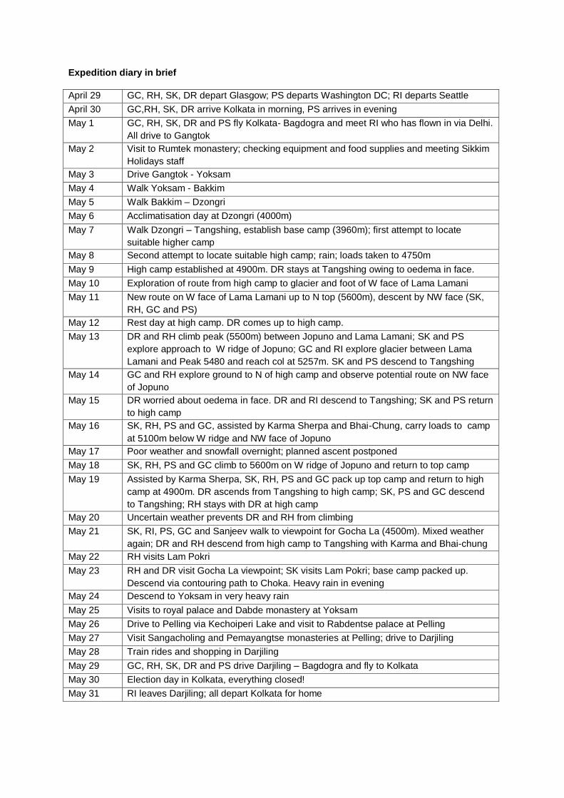
We descended the ridge towards Jopuno a short way, then began abseiling down the NW face. After a
couple of long abseils (we had 60m ropes) we down climbed on snow for about 100m then moved a
little to the left (north-east) and abseiled again. Finally more down climbing on reasonable snow (getting
some afternoon softness) got us above a last steeper section which we abseiled to get onto the glacier.
Looking down an abseil on the descent of the NW face of Lama Lamani

Lama Lamani South Side
After a rest day, on May 13th Geoff and Dick went to explore the glacier and peaks south of Lama
Lamani. The SFR 1:150,000 map is not on a large enough scale to depict very precisely the topography
of this area. There is a spot height of 5480m which presumably represents the double headed rocky
peak south of Lama Lamani. It appeared from a conversation with Karma that Lamani (meaning female
lama) may be the name of this peak, while Lama Lamani may refer to the whole group of peaks from
the N top we had just climbed right through to P.5480m. But it would be very confusing to adopt this
nomenclature. As previous reports have referred to Lama Lamani, we have retained this name in
relation to the peak whose North top both Roger Payne and we climbed.
To the south of the glacier approach to our W face route on Lama Lamani, some very steep cliffs could
be seen in profile from our camp. We found that it was not difficult to traverse a boulder field
immediately under these cliffs, losing very little height from the Jopuno glacier, and gaining the next
glacier south in about two hours. This glacier was gently angled and apparently crevasse free. It gives
access to the SW face of Lama Lamani, and its S ridge. This line had been previously mentioned by
Roger Payne as offering an attractive but challenging route to the highest (South) top of Lama Lamani.
We would concur with this judgement. In a very cold wind we reached a col at 5257m at the head of this
glacier, between Lama Lamani and P.5480. To the east a descent appeared possible to a long glacier
draining east and then south. However there appeared to be no possibility of getting around to the north
to access the east side of Jopuno. All we could see on the north bounding side of the glacier was steep
ground rising to a pinnacle ridge running east, and in the distance further east a group of pointed peaks
that we took to include Narsing (5825m). North-east of the pinnacle ridge the flat top of peak 5833m
was visible, but accessing its steep W face from this col would be extremely time consuming. To the
south of the 5257m col it appeared possible to climb in about 200m to the summit of P.5480m by a
mixed route that would possibly not exceed grade III in difficulty. But a more aesthetic line was the snow
couloir rising between the two tops of P.5480m which could be climbed from the snow bowl below the
col. We did not attempt this route although it looked eminently feasible in the conditions.
On the far left the lower part of the S ridge of Jopuno. The N and S tops of Lama Lamani are in the centre. Right of this is col 5257m with the flat-topped P.5833m behind. At the right is the double headed P.5480m.View taken by telephoto from Dzongri belvedere.

P.5480m as seen from N top of Lama Lamani. The col 5257m is just hidden at bottom left.
The S ridge of Lama Lamani runs directly towards the camera on the right of this photo, taken from col 5257m

Peak 5500m between Jopuno and Lama Lamani
Also on 13th May Bob and Dave left camp at about 4am with Steve and Paul. We all climbed together up to a point below the glacier well right of the start of the west ridge of Jopuno. Steve and Paul then went left to explore the approach to the west ridge, while Bob and Dave climbed onto the glacier at a point directly below the line of the Payne Clyma route on the SW face of Jopuno (October 2009). Bob and Dave then traversed across the straightforward glacier under the face of Jopuno before climbing steeper ground and reaching the lowest bealach between Lama Lamani and Jopuno. From here we traversed right on steep snow and ice for a couple of rope lengths to gain a snow arete. We followed this for a rope length to gain the summit rocks of P.5500m. Two further short pitches up mixed grooves led to a few exposed moves to gain the summit block.
In descent we down climbed a short way then did one abseil to gain the snow arete which we down climbed to another bealach. From here we down climbed a further two rope lengths of steep ground before regaining the glacier. Neither of us carried an altimeter but we thought the top was no more than 100 metres lower than the north summit of Lama Lamani.
Summit of P.5500m. Ridge behind runs approximately South-east
On bealach north of P.5500m. S ridge of Jopuno on left, with a ridge running NE behind
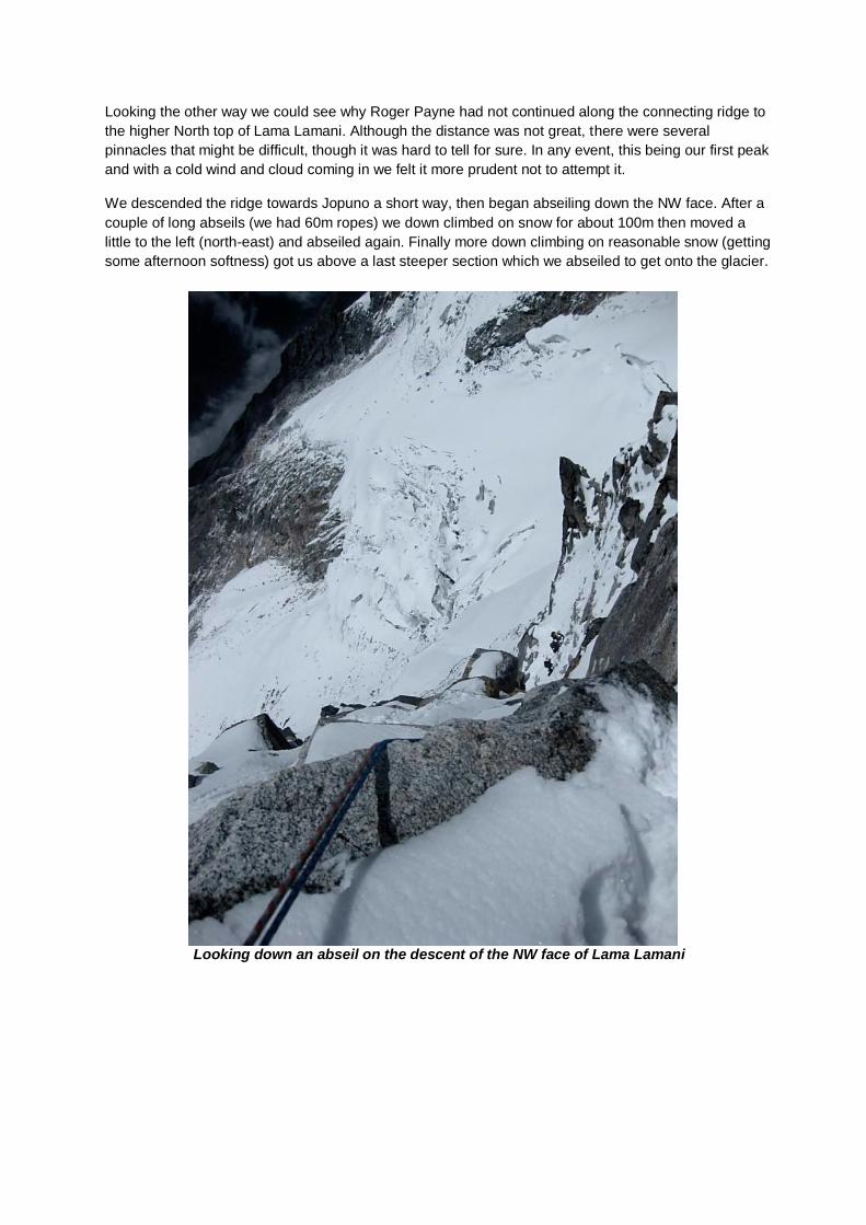
Jopuno NW Face
The following day Bob and Geoff explored in a northerly direction from the high camp. Our aim was to
investigate the possibility of accessing the col between Tinchenkang and Jopuno, and the potential for
routes on the NW face of Jopuno or the SW face of Tinchenkang. We stayed at a relatively low level,
below 5200m, and contoured around two spurs separated by intervening corries until we were below
the gully that falls from the col between Tinchenkang and Jopuno. The slopes on the face left of this
gully looked feasible, but were not particularly attractive, especially as it would necessitate a long climb
up a possibly gendarmed ridge to reach either summit from near this col. Below the SW face of
Tinchenkang there is a small flat area of glacier above a horrendous icefall that looked out of the
question, so any attempt on the face would require a diagonal approach from near the base of the
dividing gully between Tinchenkang and Jopuno. On the right of this gully things looked more
promising. The eye of faith could make out a line up the NW face of Jopuno that would be mainly on
snow and might, in the right conditions, be shorter and quicker than the W ridge (see photo).
In order to investigate access to the base of this face and of the W ridge we scrambled up broken rocks
for about 200m and established that there were ledges offering potential campsites.
NW Face of Jopuno. The line contemplated (but not attempted) went between the two ice cliffs and then up left and possibly behind the banded rock buttress.

Jopuno W Ridge
Steve and Paul had explored direct approaches from our high camp to the West ridge of Jopuno, but
had not found any particularly good way. They had then descended to the Tangshing base camp.
Meanwhile Dave continued to suffer from oedema–like swelling in his face even after his ascent of
P.5500m with Bob. On May 15th Dave decided that the safest thing was to descend to base camp, and
Dick accompanied him, while on the same day Steve and Paul returned to high camp after two nights
recuperation in the Tangshing fleshpots. We reviewed our options and decided that our best hope of a
new route was the possible line on the NW face of Jopuno that Bob and Geoff had identified.
Accordingly, on the following day, with the sterling assistance of Karma and Bhai-Chung, Steve, Bob,
Paul and Geoff carried a camp up to the ledges below the face ( 5100m). Excavation of snow ledges
and arrangement of a boulder-protected cooking area consumed a good deal of energy and time.
The weather in the morning, following some night snowfall, was somewhat doubtful, so it was decided
to stay put for a day. With Bob not feeling very well, Steve, Paul and Geoff reconnoitred the first 150m
of snow leading to the W ridge. All things considered we felt that we were more likely to reach the
summit if we attempted the W ridge.
At 2.45am on May 18th the four of us left camp to climb the W ridge. Bob was still not well, but decided
to accompany us. Above the point reached the previous morning was a short icy section where a belay
on ice screws was taken. We then climbed unroped up snow for several hours to a height of perhaps
5450m. Here the ridge became quite icy and it was necessary to rope up again and belay on screws.
After two quite time-consuming pitches, with a traverse right under the next rocks, we got established
on the firm brown rock mentioned by the previous American party that first climbed this ridge in 2008.
The rocks had a fair bit of snow on them and though broken up gave climbing of about Scottish grade III
standard. Steve and Bob reached the foot of the looser black rock that forms the summit of the
mountain at about 11am, with Geoff and Paul a pitch behind. The black rock section is easier angled
than the brown section that we had climbed, but it is longer (maybe 300m) and likely to take quite a lot
of time. The party was climbing quite slowly and it appeared unlikely that we could reach the summit
and descend safely before evening. So it was decided to turn around. A succession of 60m abseils,
including two from abalakov threads, got us down the rocks and the icy section. We could see at this
time that the NW face was very icy and would undoubtedly have been too time-consuming for our party.
We continued slowly reversing our route and regained the tents at about 5.30pm. In view of our slow
speed it seemed that we had made the right decision. Although disappointed not to have reached the
summit we all agreed that we had had a very good 15 hour day of Alpine climbing in a splendid
mountain setting.
Bob on icy section below mixed ground Bob climbing the mixed golden rock section

Two views of W ridge of Jopuno. High point was at top of brown rocks, below first black tower.
Final days in the mountains
Karma appeared next morning and was hugely helpful in packing up our top camp. We descended to
the 4900m camp to meet Dave who had come up from Tangshing that morning. Bob elected to stay up
at this camp with Dave in the hope of getting another route done in our last couple of days, while Steve,
Paul and Geoff continued down to Tangshing. In the event uncertain weather prevented Dave and Bob
from attempting another climb, although they did some rock climbing with Bhai-Chung and taught him
some belaying techniques. Down at Tangshing the chowkidar’s hut was the scene of much drinking and
singing, with Dick impressing everyone by his capacity for ‘tumba’ (bamboo vessel for imbibing chang
through a straw), and the locals evidencing a very proper appreciation of our Scotch whisky. On the 21st
Steve, Paul, Dick and Geoff walked about 4 hours up to a viewpoint at about 4600m near the Gocha
La. We got excellent views of the huge west face of Pandim, but unfortunately cloud partly obscured
views to the north and west preventing the best view of Kangchendzonga. A couple of days later in the
morning before leaving Tangshing Bob and Dave repeated the walk and got better views. Visits were
also made by Bob and Steve to Lam Pokri, a pretty loch on the west flanks of the mountains south of
Lama Lamani, which lies on a fairly recently opened trekking route from Tangshing to Tashiding.
Dick and Sanjeev looking towards Gocha La West ridge of Pandim

Sikkim tourism
Our guide Sanjeev had arranged for the yaks and horses to come back up to Tangshing on May 22nd
so
that we could start our walk down on the 23rd
. In principle we could have had a couple more days in the
mountains had we been sure from the beginning that we would need them. However Barap and
Sanjeev had determined a somewhat complex timetable for our last week in Sikkim, so we just went
along with this. On our first descent day we avoided the re-ascent to Dzongri by taking a long
contouring path from the Prek Chu that rejoins the ascent route about 250m above Choka. Although of
potentially great interest to botanists thanks to the profusion of rhododendrons, this path has quite a lot
of small ups and downs, and is not in our view any better as a descent route than going via Dzongri.
We spent a night in Choka, which has a couple of good rest houses (and a bar provided with beer!),
and next day descended to Yoksam in torrential rain which made us think the monsoon had arrived.
A further day was spent in Yoksam visiting the site of the first palace in Sikkim and the ancient Dabde
monastery on the hill above the village. Barap came to join us at Yoksam that evening and for reasons
that we could not quite fathom he had arranged that instead of returning to Gangtok we should travel by
way of Pelling and Darjiling. Pelling, situated on a ridge opposite Yoksam (but separated from it by a
deep valley) was the second capital of Sikkim. We were treated to a very worthwhile visit to the ruined
palace of Rabdentse and the ancient monasteries of Sangacholing and Pemayangtse. As it was the
birthday of the Buddha we were able to witness the celebrations. None of this had been expected by us,
it was just laid on by Barap as part of his package. Next day we descended to the Rangit river and then
climbed up a very steep interesting road to Darjiling, with a fascinating visit to a tea factory en route.
After a day in Darjiling, including a ride on its famous train and the even more famous dawn view of
Kangchendzonga, we were taken to Bagdogra and flew back to Kolkata. Our final day there coincided
with the West Bengal elections, thus precluding any more tourism.
Cricket at base camp Trainee monks at Yoksam

Appendix 1 – Travel
The Scottish four flew on Emirates from Glasgow to Kolkata via Dubai. This avoided the hassles of
Heathrow. We were unable to get more than the standard 30 kg allowance for checked baggage,though
this was interpreted quite liberally on both outward and return journeys.
From Kolkata to Bagdogra we flew with Spicejet. There appear to be several competing Indian flights
for this leg, and Spicejet were the cheapest. We obtained a discount for buying five return tickets, with a
total price of about 17,500 rupees. There was no problem with booking this online, and Spicejet
appeared to run efficiently. Weight restrictions are more severe on this flight : 20 kg checked baggage
plus 10 kg carry-on baggage. Excess baggage was charged at 100 rupees per kilo. We were helped by
the fact that Paul’s baggage was delayed between USA and Kolkata so that on the outward flight to
Bagdogra we only had four persons’ baggage between five. However we ended up paying a total of
£192 in excess baggage for the two flights outward and return.
After Bagdogra our travel was entirely managed by Barap’s team from Sikkim Holidays. We were driven
everywhere in comfortable vehicles by impressively careful drivers.
Appendix 2 – Logistics
We were recommended by Roger Payne to use Sikkim Holidays (www.sikkimholidays.com), run by
Barap Namgyal Bhutia, as our agent. Barap was extremely helpful both in email correspondence over
the year of preparation and for the duration of the expedition. He obtained all necessary permissions, so
we did not need to have any dealings with the Sikkim government or the Indian Mountaineering
Federation. He gave us a per person price quoted in euros, with a discount for the sixth person. We
paid 40 percent of the total a few months in advance and the balance when we left Yoksam.
For the walk-in and base camp Barap supplied base camp tents and all the usual paraphernalia of
dining tent, cooking tent, toilet tents etc. We had a very good cook, Suresh, and several cook’s
assistants. Transport of food and equipment by yaks and horses from Yoksam to Tangshing was
arranged by our guide Sanjeev through local pony men used regularly by Sikkim Holidays. We had no
need to concern ourselves with these arrangements (beyond providing expected tips at the end).
Barap also supplied us with some tents for high camp and butane gas stoves and cylinders for use on
the mountain. He purchased a reasonable supply of local food for our use above base camp and we
supplemented this with a small stock of instant potato, cheese, salami and other high energy foods
brought from UK and US.
In retrospect we would have been wise to pay more attention to the food provided for above base camp.
It had not been made clear to us that this was meant to feed Karma and Bhai-Chung as well as
ourselves. Indeed we had not understood that these two would be living with us above base camp. It
seemed as though they had a very different model of mountaineering in mind, whereby Karma would fix
ropes and haul us up the mountain. When we explained that we wished to climb independently there
was no problem, and they were of great help with carrying loads, siting camps, fetching water etc, but
they did require to be fed!!
Overall the support provided was on a reasonably lavish scale, as seems to be normal these days for
commercial trips, though it was in excess of what we really needed and far greater than what some of
us had been used to in the past.
Appendix 3 – Equipment
We took a good range of rock and ice gear plus snow stakes and lots of spare tat for abseiling. In the
event we used very little gear. On the two mountain climbs each pair used one lightweight 60m rope,

allowing us to combine for 60m abseils in descent. By using Abalokov threads we avoided having to
leave behind expensive ice screws. On Lama Lamani we were able to find rock spikes for abseiling.
Appendix 4 – Medical
We took a very comprehensive medical kit thanks to the good offices of the Glencoe Mountain Rescue
Team, of which Steve and Bob are members. The most serious medical event was Dave’s mountain
sickness. Dave knew from previous Himalayan experience that he was slow to acclimatise.
Unfortunately on this trip he suffered from quite severe oedema in his face and hands. When we initially
established high camp he decided to stay down at Tangshing as his cheeks had become puffed up after
our push to about 4750m the previous day. However he came up to high camp (4900m) a few days
later and succeeded in reaching P.5500m with Bob. But the swelling returned and although he took
diamox he felt it best to descend to Tangshing. He returned to 4900m after 3 more nights below at
3960m and probably would have been fit to climb higher had we had the weather and time to do so.
Appendix 5 – Visas and Sikkim Government Permits
Visas are easily obtainable by post or in person, but you need to allow enough time. The procedure has
been improved and, at least in Scotland, seemed to work quite smoothly. At the time of obtaining an
Indian visa it is possible to apply for a permit to enter Sikkim. However it is much simpler to do this at
the border. We expended quite a bit of effort completing Sikkim Government entry forms which Barap
had sent to us, and emailing them back to him with photographs etc. But there was still a delay of about
an hour when we crossed the border into Sikkim. It is likely that it would have been no slower if we had
not sent any forms beforehand but simply completed all formalities at this time. Of course plenty of
spare passport photographs are required.
Appendix 6 – Maps and Names of Features
The most detailed map available seems to be that produced by the Swiss Foundation for Alpine
Research (SFR). Sikkim Himalaya, scale 1:150,000, contour intervals 100m. It is shaded in two colours
but not particularly easy to read, as the typeface is quite faint. It covers the whole of Sikkim, so the
detail around Jopuno and Lama Lamani is limited. It is obtainable from Stanfords, 12/14 Long Acre,
London WC2E 9LP (www.stanfords.co.uk) price £23.95 (in 2009). A rather poor copy of the area we
visited is attached to the end of this report.
Those with expertise in using Google Maps can easily follow the route we took from Bagdogra to
Gangtok and thence to Yoksam, and the return journey via Darjiling. However as an introduction to
Sikkim a simple tourist map showing a few main places is appended.
There seems to be no accepted spelling of most of the geographical features mentioned in this report.
For consistency we have adopted the spelling on the SFR map wherever possible. However we saw
almost every conceivable variation of the spelling of Jopuno on our travels (Juponu, Joponu, . . .).The
book by Wangchuk and has an interesting discussion of the history spelling of Kangchendzonga.
Appendix 7 – Bibliography
Roger Payne has a review article, Sublime Sikkim, in the Alpine Journal, 2009 (Vol 114), pp 147-160. This article has a selection of historical references. Roger also has a review article, Emerging from the Mists, in the American Alpine Journal 2008. A pdf is available at www.rogerpayne.info/AAJ%202008%20final%20draft.pdf. Roger’s website www.rogerpayne.info is a useful source for reaching the reports of Roger’s numerous Sikkim expeditions. The Alpine Journal 2009 also has a historical article by Blaser and Hughes about the first ascent of Kabru (AJ 2009, pp 219-228) with specific historical references A fascinating survey of the culture of Sikkim and the history of mountaineering around Kanngchendzonga is given in : Wangchuk, P and Zulca, M (2007), Kangchendzonga, Sacred Summit, Little Kingdom, Gangtok. An account of the Americam ascent of the West ridge is in the American Alpine Journal. Some pictures can be found online at http://www.themountaininstitute.com/reports/india/jopuno.html. A fuller set of photos from this expedition is at http://picasaweb.google.com/halladay/IndiaExpedition2008
Two books by Trevor Braham : Himalayan Odyssey (1974) and Himalayan Playground (2008) recount a number of interesting trips to northern Sikkim.
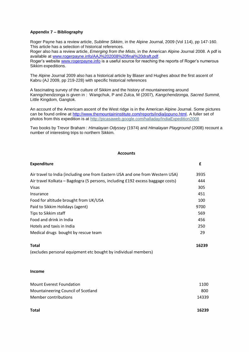
Accounts
Expenditure £
Air travel to India (including one from Eastern USA and one from Western USA) 3935
Air travel Kolkata – Bagdogra (5 persons, including £192 excess baggage costs) 444
Visas 305
Insurance 451
Food for altitude brought from UK/USA 100
Paid to Sikkim Holidays (agent) 9700
Tips to Sikkim staff 569
Food and drink in India 456
Hotels and taxis in India 250
Medical drugs bought by rescue team 29
Total 16239
(excludes personal equipment etc bought by individual members)
Income
Mount Everest Foundation 1100
Mountaineering Council of Scotland 800
Member contributions 14339
Total 16239

Section of SFR 1:150,000 map of Sikkim