kansas city green infrastructure case study - terrain.org · case study series kansas city green...
TRANSCRIPT

Green Infrastructure — Linking Lands for Nature and People
The Conservation Fund © 2009 1
Case Study Series
Kansas City Green
Infrastructure Case Study
OverviewMetroGreen is a proposed 1,144-mile interconnected system of public and private open spaces, greenways, and trails designed to link seven counties in the Kansas City metropolitan area. The MetroGreen system plan covers Leavenworth, Johnson, and Wyandotte counties in Kansas and Cass, Clay, Jackson, and Platte counties in Missouri. MetroGreen builds on the area’s tradition of valuing green space by extending the “parkways and boulevards” concept of the 1894 Kessler Plan for Kansas City, Missouri. MetroGreen identifies 85 separate corridors that form a regional network of greenways connecting many of the area’s most valuable natural assets. By the end of 2008 MetroGreen had succeeded in creating 252 miles of greenway trails and protecting about 91,000 acres of stream corridors.
Highlights• The MetroGreen Plan of 2001 linked a regional vision
for recreational greenways (the MetroGreen Vision of 1991) with a regional Natural Resources Inventory
(2004) and recommends implementing planning and engineering regulations in jurisdictions across the Kansas City metropolitan area.
• The Mid-America Regional Council (MARC), the metropolitan planning organization for the 125 city and nine county governments in the bi-state Kansas City region, has brought together parks, natural resource, and public works agencies in a unique commitment to couple green infrastructure with more traditional grey infrastructure needs such as stormwater management, water quality protection, and planning for roads, sewers and such. [Note: The MetroGreen Plan was originally developed for seven of the nine counties that MARC serves, but MARC anticipates its future expansion.]
• MARC and key regional partners are developing a strategy to make the Greater Kansas City metropolitan region a “green region.” Green infrastructure is one of the core indicators of success of this strategy.
“To effectively address green infrastructure issues, local communities must view themselves as part of a larger regional or watershed context. Water and air flow in and
out of communities, as do traffic, people, and wildlife. Urban and nearby residents need to learn how their land-use decisions affect one another and how they might work
together to achieve common goals.”
—Kansas City Region. “Green Infrastructure: Designing with Nature”
© MARC

Green Infrastructure — Linking Lands for Nature and People
The Conservation Fund © 2009 2 The Conservation Fund © 2009
Background and ContextThe confluence of the Kansas and Missouri Rivers has long served as a crossroads. Traditionally home to the Kaw Nation, the area played host to the westward expansion of the United States. The Lewis and Clark expedition camped near present-day Kansas City along their journey up the Missouri River and toward the Pacific Ocean. Fur trappers throughout the Midwest and the upper Rockies used the Missouri River as the gateway to shipping across the world. And Kansas City was the starting point for thousands of settlers migrating westward along the Santa Fe and California Trails.
The rivers and historic trails provided a framework for Kansas City’s first green space plan. In the early 1890s, George Kessler and August Meyer proposed an integrated network of protected greenways, parks, boulevards, and open space. The 1894 Kessler plan used the ridgelines and land along the waterways for boulevards to create a chain of natural parks along some of the most rugged terrain and bluffs near the river. Other parks featured more formal features, such as fountains, elegant bridges, sunken gardens, and walkways. The Plan actually guided the city’s growth by reorienting Kansas City away from the riverfront and the original downtown, creating beautiful new residential districts, and fostering redevelopment of older areas.
Kansas City has built on this green space tradition through the MetroGreen initiative. During their 1991 annual conference, members of the American Society of Landscape Architects (ASLA) sponsored a local service project. The ASLA Community Assistance Team, inspired by the Kessler Plan, established a Vision for MetroGreen that identified a regional greenway system for the Kansas City area. The proposed system consisted of a 90-mile urban loop surrounded by a 140-mile outer loop through suburban areas. The two loops were connected with multiple spokes that followed stream valleys and existing park lands and that linked to agricultural landscapes and such rural greenspaces as upland prairie, wooded slopes, and streams.
The 1991 Vision also called for the development of a MetroGreen Master Plan. The 2001 MetroGreen Regional Initiative provided that plan.
Expanding on that effort, the Mid-America Regional Council (MARC), the area’s metropolitan planning organization, and a consultant team of Greenways, Inc., Patti Banks Associates, ETC/Leisure Vision, and The Trust for Public Land, defined a 100-year implementation strategy: the MetroGreen Action Plan (December 2007). This Plan called for development of a 1,144-mile integrated network of greenways and open space throughout the metro region.
Figure 1: MetroGreen Counties
The Conservation Fund © 2009 The Conservation Fund © 2009
Case Study Series
3
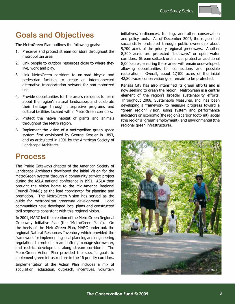
Goals and ObjectivesThe MetroGreen Plan outlines the following goals:
1. Preserve and protect stream corridors throughout the metropolitan area
2. Link people to outdoor resources close to where they live, work and play.
3. Link MetroGreen corridors to on-road bicycle and pedestrian facilities to create an interconnected alternative transportation network for non-motorized use.
4. Provide opportunities for the area’s residents to learn about the region’s natural landscapes and celebrate their heritage through interpretive programs and cultural facilities located within MetroGreen corridors.
5. Protect the native habitat of plants and animals throughout the Metro region.
6. Implement the vision of a metropolitan green space system first envisioned by George Kessler in 1893, and as articulated in 1991 by the American Society of Landscape Architects.
Process The Prairie Gateways chapter of the American Society of Landscape Architects developed the initial Vision for the MetroGreen system through a community service project during the ASLA national conference in 1991. ASLA then brought the Vision home to the Mid-America Regional Council (MARC) as the lead coordinator for planning and promotion. The MetroGreen Vision has served as the guide for metropolitan greenway development. Local communities have developed local plans and constructed trail segments consistent with this regional vision.
In 2001, MARC led the creation of the MetroGreen Regional Greenway Initiative Plan (the “MetroGreen Plan”). On the heels of the MetroGreen Plan, MARC undertook the regional Natural Resources Inventory which provided the framework for implementing local planning and engineering regulations to protect stream buffers, manage stormwater, and restrict development along stream corridors. The MetroGreen Action Plan provided the specific goals to implement green infrastructure in the 16 priority corridors.
Implementation of the Action Plan includes a mix of acquisition, education, outreach, incentives, voluntary
initiatives, ordinances, funding, and other conservation and policy tools. As of December 2007, the region had successfully protected through public ownership about 9,700 acres of the priority regional greenways. Another 8,300 acres are protected “blueways” or open water corridors. Stream setback ordinances protect an additional 8,000 acres, ensuring these areas will remain undeveloped, allowing opportunities for connections and possible restoration. Overall, about 17,100 acres of the initial 42,800-acre conservation goal remain to be protected.
Kansas City has also intensified its green efforts and is now seeking to green the region. MetroGreen is a central element of the region’s broader sustainability efforts. Throughout 2008, Sustainable Measures, Inc. has been developing a framework to measure progress toward a “green region” vision, using system and performance indicators on economic (the region’s carbon footprint), social (the region’s “green” employment), and environmental (the regional green infrastructure).
© MARC
Green Infrastructure — Linking Lands for Nature and People
The Conservation Fund © 2009 4 The Conservation Fund © 2009
Network DesignThe MetroGreen Action Plan designated priority corridors as the roadmap to catalyze the next generation of plan implementation. With 200 miles of the entire MetroGreen system’s 1,100 corridor miles protected, MetroGreen needed to establish priorities for focusing energy and attention. The 16 priority corridors comprise about half the overall system. A broad coalition of the region’s stakeholders—including local and regional staff, elected officials, and civic
leaders—participated in identifying the regional greenway priorities. The priority greenway planning integrated GIS (geographic information system) analysis of existing natural resource information and development trends; extensive stakeholder consensus building; and targeted outreach efforts including regional prioritization workshops and review by conservation ecologists.
The data assessment led to preliminary identification of the most valuable and threatened conservation lands. Stakeholders then reviewed the preliminary conservation
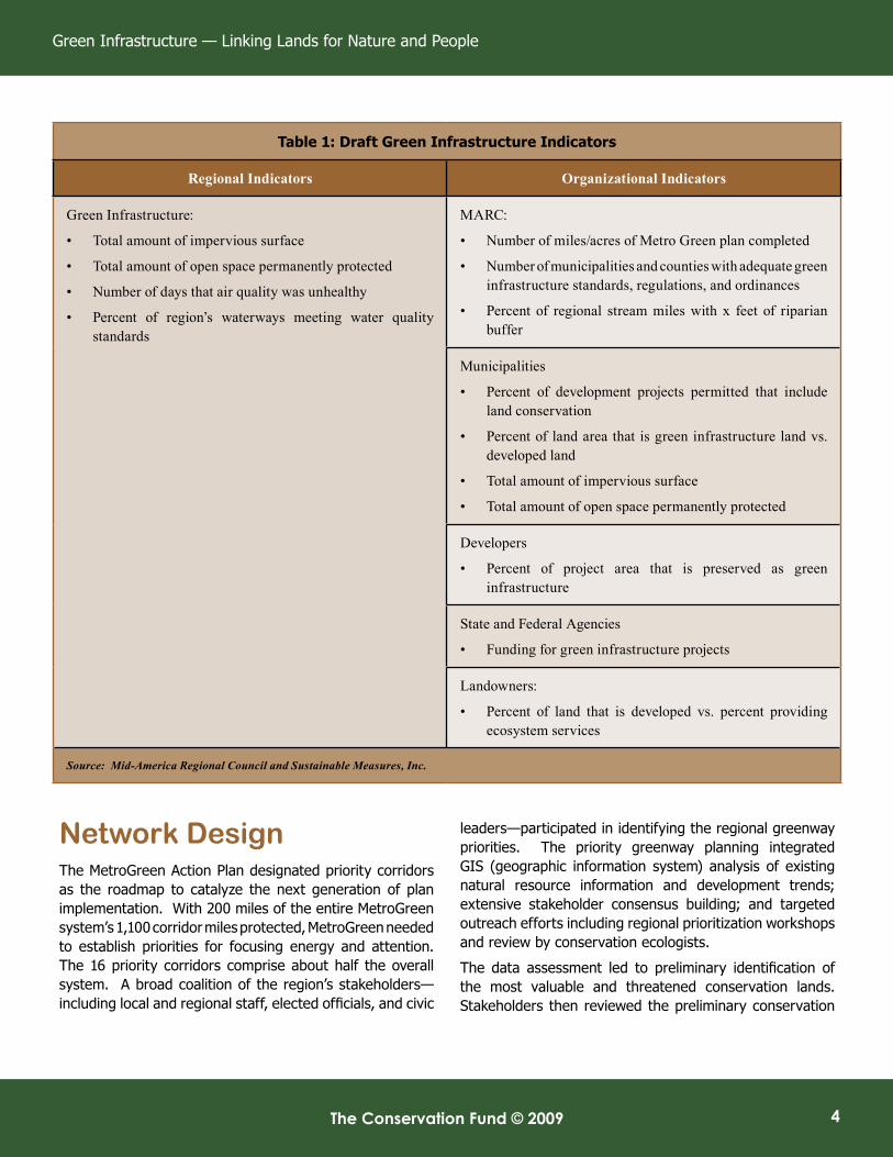
Table 1: Draft Green Infrastructure Indicators
Regional Indicators Organizational Indicators
Green Infrastructure:
• Total amount of impervious surface
• Total amount of open space permanently protected
• Number of days that air quality was unhealthy
• Percent of region’s waterways meeting water quality standards
MARC:
• Number of miles/acres of Metro Green plan completed
• Number of municipalities and counties with adequate green infrastructure standards, regulations, and ordinances
• Percent of regional stream miles with x feet of riparian buffer
Municipalities
• Percent of development projects permitted that include land conservation
• Percent of land area that is green infrastructure land vs. developed land
• Total amount of impervious surface
• Total amount of open space permanently protected
Developers
• Percent of project area that is preserved as green infrastructure
State and Federal Agencies
• Funding for green infrastructure projects
Landowners:
• Percent of land that is developed vs. percent providing ecosystem services
Source: Mid-America Regional Council and Sustainable Measures, Inc.

The Conservation Fund © 2009 The Conservation Fund © 2009
Case Study Series
5
Figure 2: Map of MetroGreen
Green Infrastructure — Linking Lands for Nature and People
The Conservation Fund © 2009 6 The Conservation Fund © 2009
Priority Corridors TheMetroGreenActionPlanidentifies16priorityregionalcorridors tofocuseffortsonthemost importantregionalasset.Thirteen of these corridors are along waterways while two provide important overland connections.
The corridors are:
opportunities at a special workshop. A preliminary field review augmented the initial analysis and stakeholder input. The Regional Conservation Priorities Map was drawn up and compared with the regional natural resources inventory mapping and stream asset mapping from Kansas City Stormwater Mapping Plan and Johnson County. Finally, the Regional Conservation Priorities Map was reviewed at a second regional workshop.
In 2004, MARC advanced the network design further through the preparation of a regional Natural Resources Inventory (NRI). This inventory is a geographic information system (GIS)-based effort to help the area plan for future development while considering natural systems. Financial support from foundations, U.S. Environmental Protection Agency, and the natural resource agencies of Missouri and Kansas enabled MARC’s leadership on the NRI. Under contract to MARC, Applied Ecological Services reconciled land cover data from two states, secured gap analysis data from the U.S. Fish and Wildlife Service, and spent countless hours of field survey work to identify and map the most valuable natural resource assets and ecological features in the Kansas City region.
The resulting NRI provides a critical tool for conservation planning among the region’s communities and spurred a growing acceptance of habitat protection and restoration. MARC used the NRI to help 14 jurisdictions adopt stream buffer ordinances as well as over a dozen jurisdictions adopt ecologically-informed stormwater planning and engineering guidelines for site development. Coupling the MetroGreen Regional Initiative and the NRI demonstrated the links between greenways and natural resources and built support for green infrastructure in the region.
ImplementationThe MetroGreen Action Plan of December 2007 outlined specific implementation goals to conserve, connect, and restore 16 priority regional corridors over 10 to 20 years. According to the Plan, potential strategies include regulatory tools such as stream setback ordinances and parkland dedication; funding strategies like sales and property taxes; and other tools like conservation easements. The plan also targets state and federal funding opportunities and technical assistance programs and highlights the importance of nonprofit and private sector partners.
The MetroGreen Action Plan includes action plans specific to each county, as well as for Kansas City, Missouri and the Missouri River Corridor. Each county action plan incorporates technical analysis plus input from local staff and elected officials on local profiles, strategies, and funding opportunities. MARC coordinated a series of public meetings with each county which helped to build “corridor by corridor” support throughout the planning process.
In 2008, the Kansas City region began crafting performance and system indicators to measure progress for a “green region”. The indicators process included green infrastructure as one of the core measures of success. MARC is integrating the indicators into its strategic planning process, further institutionalizing green infrastructure in the region (see Table 1: Sample Indicators). MARC continues to promote the network and foster collaborative leadership within each corridor by, in the words of MARC’s environmental program director, “knitting together a patchwork of community leaders and institutions.”
• Missouri River
• Kansas River
• Katy Trail Connection
• Blue River
• Fishing River
• Grand River
• Little Blue River
• Platte River
• Cedar Creek
• Line Creek
• Second Creek
• Shoal Creek
• Stranger Creek
• North Brush Creek (Platte County)
• Wyandotte/Leavenworth County Line Connection
• I-435 Corridor
The Conservation Fund © 2009 The Conservation Fund © 2009
Case Study Series
7
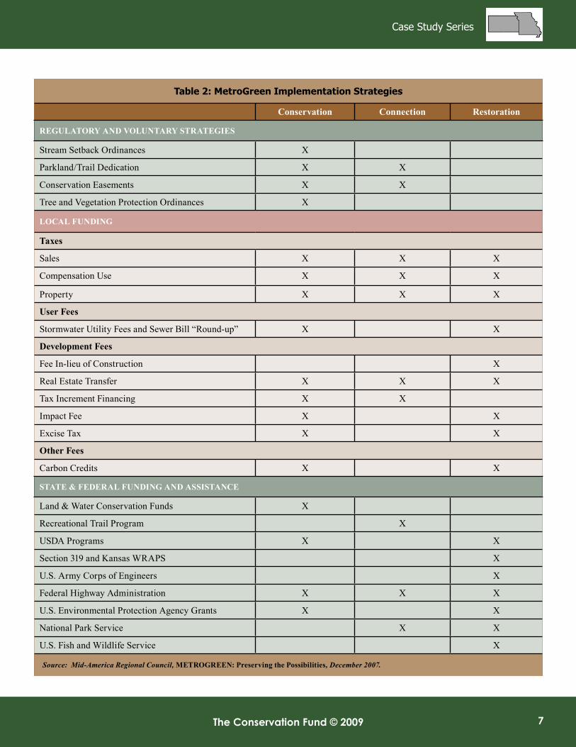
Table 2: MetroGreen Implementation Strategies
Conservation Connection Restoration
RegulatORy and VOluntaRy StRategIeS
Stream Setback Ordinances X
Parkland/Trail Dedication X X
Conservation Easements X X
Tree and Vegetation Protection Ordinances X
lOCal FundIng
taxes
Sales X X X
Compensation Use X X X
Property X X X
user Fees
Stormwater Utility Fees and Sewer Bill “Round-up” X X
development Fees
Fee In-lieu of Construction X
Real Estate Transfer X X X
Tax Increment Financing X X
Impact Fee X X
Excise Tax X X
Other Fees
Carbon Credits X X
State & FedeRal FundIng and aSSIStanCe
Land & Water Conservation Funds X
Recreational Trail Program X
USDA Programs X X
Section319andKansasWRAPS X
U.S. Army Corps of Engineers X
Federal Highway Administration X X X
U.S. Environmental Protection Agency Grants X X
National Park Service X X
U.S. Fish and Wildlife Service X
Source: Mid-America Regional Council, MetROgReen: Preserving the Possibilities, December 2007.

Green Infrastructure — Linking Lands for Nature and People
The Conservation Fund © 2009 8 The Conservation Fund © 2009
Leadership GroupMARC looked at Chicago Wilderness as a model but adapted the Chicago framework to the Kansas City region. Since Kansas City had fewer organizations on the ground than Chicago, MARC helped local groups build their capacity for implementation and management.
By design, MARC provides regional leadership and coordination of the MetroGreen implementation but nurtures the support and energy of numerous local groups (see Stewardship/Management). MARC’s support formed the basis for the MetroGreen Alliance, designed to strengthen the area’s resolve for an integrated regional network, instead of a “bits and pieces” approach carried out by area cities and counties.
In 2007, the MetroGreen Alliance used the past tools and planning processes to update the vision for the next few hundred miles of the overall network. The effort, called “Preserving the Possibilities” by MARC, focused on promoting the vision to create collaborative “corridor by corridor” support that knit together the patchwork of people, organizations, links, and hubs into a rich quilt of green infrastructure, with natural resource protection as its foundation.
Currently MARC is preparing a communications plan, building the Alliance’s constituency, and conducting public outreach and education. Much of its work is shifting to 16 priority corridors in an effort to preserve the most significant resources first.
FinancingSince its inception the MetroGreen effort has relied on numerous funding sources. The original MetroGreen Vision was completed under the auspices of the Prairie Gateway chapter of the American Society of Landscape Architects and the Community Assistance Team associated with their 1991 national conference. At its completion, the Vision came under the auspices of MARC, which has served as its champion, maintaining an active role in fundraising and building capacity among local jurisdictions while forging partnerships with the public and private sectors.
For the 2001 MetroGreen planning process MARC secured substantial philanthropic support from the Hall Family Foundation and William T. Kemper Foundation. The U.S. Environmental Protection Agency provided $150,000 in support to MARC, working in collaboration with the University of Missouri’s Center for Agroforestry and the U.S. Department of Agriculture’s National Agroforestry Center, to develop the regional natural resource inventory. Additional support for the MetroGreen Action Plan came from the Grace Harris Philanthropic Fund of the Greater Kansas City Community Foundation. More recently, the 2008 FHWA Eco-Logical grant of $90,000 provided a boost to the programmatic planning; MARC also received $70,000 from a 2007 EPA Wetlands Grant and $135,000 in water quality protection planning funds from the Missouri Department of Natural Resources.
MARC provides the base funding for the regional coordination but depends on local support for implementation of the green infrastructure network. The initiative, however, lacks dedicated funding for regional implementation, relying instead on local commitments of support.
The region’s 125 municipalities and nine counties support the MetroGreen Vision, but, while several counties and municipalities have local funding sources, local financial commitments vary widely. Local property, parks, and stormwater taxes; bonds; and Congestion Mitigation and Air Quality (CMAQ) and Transportation Enhancement resources resulted in the first 200 miles of greenway creation. The initial focus was largely on the area’s recreational needs but throughout the process, environmental professionals and activists have promoted the need to link recreational and natural assets.
One example of this link is in the community of Lenexa, Kansas. Lenexa passed a 3/8 cent sales tax in 2000 that funded trail creation as part of a broader watershed protection effort. The city’s local plan, From Rain to
© FRAn MATTOx

The Conservation Fund © 2009 The Conservation Fund © 2009
Case Study Series
9
Table 3: Metrogreen
Region
al Priority C
orridor Sum
mary
Category
Cass
Clay
a,bJackson
a,bJohnson
KC
MO
bl
eavenworth
bPlatte
a,bW
yandotteb
Missouri R
ivertotal
Total Priority C
orridor (acres)2,490
3,3802,450
5,4507,900
6,3703,060
3,5708,150
42,820
Protected by R
egulation (acres)2,000
390430
1,3801,690
01,080
01,045
8,015
Public Land or Open
Water (acres)
70990
1,500780
3,820620
1,0602,320
6,57017,730
Rem
aing Protection N
eeds (acres)420
2,000520
3,3002,390
5,750920
1,250535
17,075
Trail Corridor Length
(miles)
5148
3357
69100
3630
208632
Constructed Trails
(miles)
016
140
7100
00
1553
Rem
aining Trail C
onstruction (miles)
5132
1957
62100
3630
193579
Crop and Pasture
Land for Restoration
(acres)975
730275
1,380780
1,840675
80265
7,000
Source: Mid-A
merica R
egional Council, M
etR
Og
Re
en
: Preserving the Possibilities, Decem
ber 2007
estim
ated Cost (10-year Im
plementation Period):
Protectiongoal:$122to$206million
Connectiongoal:$125M
illionMaintenanceandrestorationgoal:$46to$53m
illionTotal:$300to$380m
illion
existing or planned funding sources: $80to$100m
illiona
dditional funding needed:$220to$280million
Future land acquisition: 1,700to2,000acresFuture trail construction: 100m
iles
notes:
a. Excludes Incorporated Kansas C
ityb. Excludes M
issouri River corridor
Green Infrastructure — Linking Lands for Nature and People
The Conservation Fund © 2009 10 The Conservation Fund © 2009
Recreation, aims to reduce flooding, protect water quality and natural habitat, and provide educational and recreational opportunities for the citizens of Lenexa.
According to Jacobs, green infrastructure helps make a strong argument for line item support in local capital improvement plans (CIPs). In 2000, Lenexa included stream restoration as a line item in its CIP which has generated more than $10 million to support neighborhood stream restoration, flood control, sediment control, park improvements, and greenway creation. Lenexa also instituted a stream setback ordinance and undertook the area’s first natural resources inventory (prior to the MetroGreen NRI).
Other local commitments include actions by Johnson County, Kansas and Platte County, Missouri. Johnson County has had, since 1991, a 1/10-cent sales tax and property tax increase dedicated for a 20-year, $192 million park expansion program. Johnson County is also trying to address flooding problems. The county directed proceeds from the sales tax to pay for stormwater projects in the county and its cities. In 2001, these proceeds provided $7 million for about 20 new projects. Since 2000, Platte County has had a ½-cent sales tax to fund parks, trails, and stormwater projects and, in 2001, completed a Northland Master Trail Plan with Clay County.
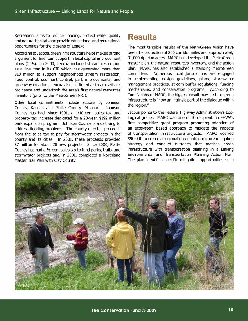
Results The most tangible results of the MetroGreen Vision have been the protection of 200 corridor miles and approximately 91,000 riparian acres. MARC has developed the MetroGreen master plan, the natural resources inventory, and the action plan. MARC has also established a standing MetroGreen committee. Numerous local jurisdictions are engaged in implementing design guidelines, plans, stormwater management practices, stream buffer regulations, funding mechanisms, and conservation programs. According to Tom Jacobs of MARC, the biggest result may be that green infrastructure is “now an intrinsic part of the dialogue within the region.”
Jacobs points to the Federal Highway Administration’s Eco-Logical grants. MARC was one of 10 recipients in FHWA’s first competitive grant program promoting adoption of an ecosystem based approach to mitigate the impacts of transportation infrastructure projects. MARC received $90,000 to create a regional green infrastructure mitigation strategy and conduct outreach that meshes green infrastructure with transportation planning in a Linking Environmental and Transportation Planning Action Plan. The plan identifies specific mitigation opportunities such
© MARC

The Conservation Fund © 2009 The Conservation Fund © 2009
Case Study Series
11
as land acquisition, stream buffers, restoration, and right-of-way best management practices. Jacobs notes that MARC would have been unprepared to pursue this grant opportunity a few years ago but now MARC is leading the way as one of the select recipients.
The 1,144-mile system is huge, but Jacobs notes that the “incremental progress adds up.” In his words, MARC has helped instigate “pockets of energy, leadership, and capability” that support the local implementation, management, and stewardship of this network.
Management/StewardshipThe MetroGreen Action Plan outlined regional goals and implementation strategies at the local and regional levels. The plan recommended institutionalizing a MetroGreen Alliance for regional implementation followed by local implementation and action plans for each county, the Missouri River corridor, and Kansas City, Missouri. A regional land conservancy could help further knit together a regional commitment to management of the network.
For now, however, MARC provides the regional leadership and coordination for the MetroGreen Vision and Plan. MARC supports local efforts by, for example, facilitating meetings on alignment and other issues in the first-ring suburbs along the Turkey Creek corridor. Creation and ongoing protection of the network, however, lies with the web of municipal, county, and state governments, independent agencies, and nonprofit interest groups and organizations. By design, MARC’s approach cultivates locally based support and energy to drive projects. One example is the community foundation that established a fund to support trail development along the Little Blue River. Network management and stewardship relies on local commitment to implement and monitor conserved land as well as establish design guidelines, stormwater manuals, local plans, and other tools.
BenefitsMetroGreen is designed to provide multiple community, health, environmental, and economic benefits to the Kansas City region. Benefits range from cost-effective improvement of air and water quality; stream stabilization; reduction of flood risk; wildlife habitat protection; opportunities for biking, hiking, and walking; and the structure for more sustainable urban development patterns.
Application of GI Principles1. Protect green infrastructure before
development.
The Kansas City region, like so many areas, has witnessed land development rates at a faster pace than population increases. Since 1982, the metro area population has jumped by 17 percent while developed land area increased by approximately 27 percent. Residents are increasingly concerned with the loss of green space and the impact on ecological function.
Kansas City has a long tradition of valuing green space and MetroGreen seeks to extend the “parkways and boulevards” concept of the 1894 Kessler Plan. MetroGreen works to ensure upfront protection where possible but also restore high-value natural areas where needed. The region recognizes that to create an interconnected 1,144-mile network, it needs to work together. The Mid-America Regional Council has been working with numerous partners to identify and prioritize opportunities.
2. Engage a diverse group of stakeholders.
MARC serves as regional coordinator of the green infrastructure initiative, in partnership with numerous other federal, state, and local agencies and organizations. MARC works closely with the local entities responsible for implementing the network, helping build their capacity and conducting outreach to strengthen local commitment and understanding the connection to the broader landscape and watershed. MARC also engages citizens through direct outreach and participation in the planning and implementation as well as through festivals, planning charrettes, school events, and the media.
3. Linkage is key.
Connection is at the heart of the MetroGreen vision and action. The three goals outlined in the
“Green infrastructure is now an intrinsic part of the dialogue
within the region.”
—Tom Jacobs, Mid-America Regional Council

Green Infrastructure — Linking Lands for Nature and People
The Conservation Fund © 2009 12 The Conservation Fund © 2009
action plan are, in sum: protect, restore, and connect. The MetroGreen network aims to protect and restore natural resource linkages as well as connect people to the natural, cultural, and historic heritage and to each other. The MetroGreen Action Plan identified 16 corridors for protection and set specific connection goals to extend existing trails, construct trails that connect regional natural areas, and restore natural resource linkages in the priority corridors.
4. Work at different scales and across boundaries.
The MetroGreen initiative covers the broader Kansas City region, touching 1.8 million people, 125 cities, nine counties, and two states. By design MetroGreen seeks regional coordination and local implementation, working at a variety of scales to achieve green infrastructure protection.
5. Use sound science.
The Natural Resources Inventory of 2004 provided the essential technical analysis of the region’s natural resources, layering water resources (lakes, rivers, streams, wetlands, 100-year floodplain, and lowland vegetation) with upland resources (including forests, woodlands, grasslands, and steep slopes), important natural resource sites, and the parks and existing and planned MetroGreen trails.
The result fleshed out the regional conservation plan and demonstrated the worth of the green infrastructure protection efforts. The NRI also called for linking the natural resources data with recreational possibilities to set regional policy, support municipal and county conservation planning, and connect related plans for recreation, economic development, stormwater management, and community quality of life.
6. Fund up-front as a public investment.
MARC has located a variety of funding streams supporting research, planning, protection, restoration, and implementation. However, most funding depends on the local commitment to dedicate resources and attention to the green infrastructure. This commitment varies greatly across the region, with a few outstanding jurisdictions providing tremendous support while others provide little or no support.
7. Green infrastructure benefits all.
MetroGreen is designed to connect Kansas City-area residents to nature—and to protect and restore natural resources for the benefit of people and the ecological systems. MetroGreen is inspired by the need to connect children to nature and create a higher quality of life. But MetroGreen is also meant to reduce flood risks, stabilize streams, protect wildlife habitat, improve air and water quality, provide opportunities for hiking, biking, and walking, and offer a framework for more sustainable urban development patterns.
8. Make green infrastructure the framework for conservation and development.
The implementation of the green infrastructure network is intended to help direct development and provide a higher quality of life in the Kansas City metropolitan area. The NRI served as the framework for conservation planning and restoration by indicating locations for commercial, residential, and industrial development, examining transportation corridors, and assessing how conservation interests can enhance the community’s development potential. MetroGreen recognizes that natural resource protection is essential to the region’s quality of life. The region’s existing woodlands, grasslands, and vegetation provide the most cost-effective stormwater management, leading to cleaner water and healthier stream corridors. MetroGreen seeks to protect these resources.© MARC

The Conservation Fund © 2009 The Conservation Fund © 2009
Case Study Series
13
EvaluationUnique or outstanding elements
• The MetroGreen plan has attracted support across the metro area, resulting in a regional vision and broader public understanding of the need for natural resource protection. MetroGreen has succeeded in creating more than 250 miles of greenways and protecting over 90,000 acres of stream corridors. The green infrastructure is now an “intrinsic part of the dialogue in the region” according to Tom Jacobs of MARC.
This commitment has led to the region’s successful award of one of the first Federal Highway Administration Eco-Logical grants to revise its long-term transportation plan to include a host of mitigation strategies. A few years ago, such a proposal would never have occurred.
• MARC provides strong regional leadership and works with local governments for implementation and stewardship of the network.
• MARC and the key regional partners are at the forefront of connecting green infrastructure to a broader “green region” vision and the system and performance indicators for measuring success.
Challenges• The network protection, management, and stewardship
are carried out at the local level. Also, funding for the network’s implementation is a local responsibility; political support varies greatly across the area.
MARC works to build local commitment but ultimately, the creation of strong design guidelines, stormwater regulations, and plans require steadfast and ongoing support from communities and elected officials. Pockets of energy, leadership, and capability mean incremental, but not insignificant, progress toward realizing the overarching green infrastructure goal.
• MARC provides staff for MetroGreen and base funding for regional coordination but program staff is sometimes shared with other priority projects.
Implementation of a green infrastructure network requires coordination between multiple stakeholders. Yet, variable, and occasionally competing, interests among community and professional stakeholder groups at times interfere with the implementation of a fully collaborative regional agenda.
References and SourcesFederal Highway Administration’s Eco-Logical Grant Program, accessed November 13, 2008, http://www.environment.fhwa.dot.gov/ecological/eco_entry.asp#chart
Interview of Tom Jacobs, Mid-America Regional Council, August 11, 2008.
Interview of Maureen Hart, Sustainable Measures, Inc., November 21, 2008.
Kansas City MetroGreen Plan, “Preserving the Possibilities,” Patti Banks Associates, et al, December 2007.
Kansas City Metro Green Action Plan, online at www.marc.org/metrogreen, undated, accessed November 2008.
Lenaxa, Kansas “Turning Rain to Recreation” Web site, accessed November 10, 2008, http://www.raintorecreation.org/
Mid-America Regional Council. MetroGreen Web site, http://www.marc.org/metrogreen/
Mid-America Regional Council. Natural Resources Inventory Web site, http://www.marc.org/Environment/Smart_Growth/NRI/index.htm
Mid-America Regional Council. On the Map: Conservation Planning for the Kansas City Region, February 2005, http://www.marc.org/Environment/Smart_Growth/pdf/nribook.pdf
Review by Jennifer Blattman, Metro Green Planner, Mid-America Regional Council, January 2009.
Green Infrastructure — Linking Lands for Nature and People
The Conservation Fund © 2009 14
About the AuthorKendra J. Briechle is the Senior Training Associate with The Conservation Fund’s Conservation Leadership network. Since 2003, Ms. Briechle has coordinated, facilitated, and presented at numerous workshops, conferences, and meetings to advance strategic conservation, sustainable economic development and smart growth. She also authored the first nationwide study on Conservation Based Affordable Housing: Improving the Nature of Affordable Housing to Protect Place and People (June 2006).
About Green Infrastructure
Green infrastructure is a strategic approach to land and water conservation that links lands for the benefit of nature and people, helps identify conservation priorities, and provides a planning framework for conservation and development. Green infrastructure is different from conventional approaches to conservation because it looks at conservation values and actions in concert with land development and growth management. Green infrastructure projects bring public and private partners together to work collaboratively toward a common land conservation goal. They help move beyond jurisdictional and political boundaries by providing a process for identifying, protecting, and restoring interconnected green space networks that conserve natural ecosystem functions and provide associated benefits to human populations. The green infrastructure approach appeals to people concerned about biodiversity, habitat, and land conservation as well as people interested in open space and land use planning at the community, region, or statewide scale. It also appeals to smart growth advocates because of its potential to lessen impacts and reduce the costs of built infrastructure.
Green Infrastructure Case Study SeriesThis series of case studies highlights successful and innovative green infrastructure projects from around the country. The series was undertaken so that readers can learn from and improve upon approaches tried by others. We hope that thorough, well-documented examples will allow readers to see the many possibilities and to adapt successful practices to their unique situations and challenges. Each case study addresses the same basic pieces of the story: overview, highlights, background and context, process, public education and participation, results and products, management and stewardship,
financing, application of green infrastructure principles, and evaluation. Eight principles of green infrastructure, which are elements of most successful efforts, form the core of the case studies. The series illustrates concrete, real-life examples of how to assess and protect green infrastructure, including details about how each step was implemented.
About The Conservation FundThe Conservation Fund is a national, nonprofit land conservation organization that forges partnerships to protect America’s legacy of land and water resources. Through land acquisition, community planning, and leadership training, the Fund and its partners demonstrate sustainable conservation solutions emphasizing the integration of economic and environmental goals. Since 1985, the Fund has protected more than 6 million acres of open space, working farms and forests, wildlife habitat, and historic sites across America.
The Conservation Fund’s Green Infrastructure Program was created in 1999 to build the capacity of land conservation professionals and their partners to undertake strategic conservation activities that are proactive, systematic, well integrated, and applied at multiple scales. The program is a cooperative effort of the Fund and multiple public and private partners. Program products include a national course, workshops and conference sessions, publications, case studies, demonstration projects, a website, and related educational materials.
The Conservation Fund would like to thank the Surdna Foundation and the USDA Forest Service for providing support for this and other Green Infrastructure Program products.
Contact Us1655NorthFortMyerDrive
Suite1300Arlington,VA22209Phone:703.525.6300Fax:703.525.4610
www.conservationfund.org