keeills research project - bacas in 1079 ad between viking invaders under godred crovan and the manx...
TRANSCRIPT

GEOPHYSICAL SURVEYS IN THE VICINITY
OF KEEILL BOW, SKY HILL,
RAMSEY, ISLE OF MAN
Summary Report
A programme of research carried out by the
Keeills Research Project
In conjunction with
© Copyright Keeills Research Project & BACAS, 2017
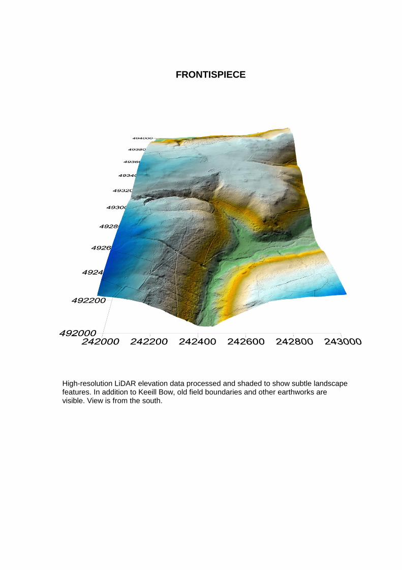
FRONTISPIECE
High-resolution LiDAR elevation data processed and shaded to show subtle landscape features. In addition to Keeill Bow, old field boundaries and other earthworks are visible. View is from the south.

1 INTRODUCTION 1.1 This report describes the results of geophysical surveys within Fields 132872 (the ‘Keeill
Field’) and 134903 (the ‘Middle Field’) aimed at detecting and characterising subsoil features associated with Keeill Bow, an Early Christian Chapel. This monument can be seen as the small earthwork in the NE quarter of the LiDAR frontispiece image.
1.2 The site lies on a near-plateau just to the South of Sky Hill which is the eastern end of a
ridge which dominates the western prospect from Ramsey; this ridge is part of the northern flank of the main uplands of the Isle of Man. As illustrated in the frontispiece, the now-known site of the Keeill towards the Southern edge of this plateau dominates the upper reaches of the Glen Auldyn valley.
Known prehistoric burials in the area to the west of the main plateau, including cinerary urns, indicate the hand of man on and around this plateau dating back at least as far as the Bronze Age. Later, the slopes of Sky Hill are said to have been the site of a decisive battle in 1079 AD between Viking invaders under Godred Crovan and the Manx inhabitants.
1
Until perhaps the 17
th century, a significant part of the northern plain of the Island
between this ridge and foothills and the Bride Hills several miles to the North remained boggy or ‘curraghy’ from the remains of the post last quaternary glaciation Lake Andreas
2,
so routes west from Ramsey ran along the foot, or along the spine, of this ridge.
1.3 The land of this plateau has long been cultivated, pastures being enclosed and improved; and by the time of the First Edition of the Ordnance Survey in 1868 the main plateau was in three large fields (of 15-20 acres each), each having at least one mapped monument site. Recorded in the northern Field (field 2207: modern field 134441) was a site ‘Chapel (Ruins of)’ just to the SW of the rock outcrop known as ‘Creg Bouyr’ (mound of the dead); the ‘Middle’ Field (2241: 134903) shows a ‘Burial Ground’; and another ‘Burial Ground’ and a possible burial mound are shown in the southern field (2872: 132872) - now known as the ‘Keeill Field’ but whose Manx name is ‘Magher ny Hoarn (Hoaieghyn)’ (field of the graves).
1.4 In 1912 the Manx Archaeological Survey (MAS) investigated the Sky Hill Keeill site(s). 3
The marked site of the former chapel in the northern field (2207) was investigated and excavated; and whilst evidence of burial (including calcined bones and cinerary urns), and possible later re-use, were found, there was no indication it had been a Keeill. The eminence in the Middle Field (2241) marked as a ’Burial Ground’ was summarily investigated by the MAS, but, possibly because the interesting and complex site of the Keeill had been found in the Southern field, the curious mound in the Middle Field was dismissed. In the southern field (2872), the MAS found the ‘Burial Ground’ as evidenced by a lintel grave in the middle of an enclosed area, with a number of paved paths which were found to lead to a vestigial building which, when excavated, proved to be a small Keeill.
1 Chronica Regum Manniae et Insularum - folio 33-r
2 The Isle of Man – Celebrating a Sense of Place, Vaughan Robinson & Danny McCarroll, Liverpool University
Press, fig 4.4 post glacial landforms 3 Manx Archaeological Survey – Fourth Report, 1915 – pp 3-5

1.5 Figure 1 shows the site viewed from the air and Figure 2 as mapped by the First Edition of the Ordnance Survey 1:2500 County Series, 1868. On this map the Keeill location is marked as ‘Burial Ground’ in Field 2872, with another ‘Burial Ground’ sketched about 85m NNW in Field 2241; for convenience here referred to as the ‘Middle Field’. The latter feature comprises a rocky prominence, part-covered in gorse scrub, with a distinct kerb that extends around the northern and eastern perimeter. At the present time there is some uncertainty as to whether this second edifice actually represents the site of a second Keeill or a burial ground, since there is no confirmation of this interpretation in the National Monuments Record. Hence, one aim of the present study was to use geophysical methods to test for the presence of subsoil features that might highlight the archaeological character and significance of this enigmatic feature.
1.6 This plateau and environs contain a high number of potential ‘targets’ – attention was
focussed on the areas around the now-known Keeill and the mound-quarry to its South-East, and the curious ‘Burial mound’ in the middle field described above. At this time, surveys were not extended to the original (discounted) alleged Keeill site in the northern field, or to any of the other mounds or tumuli in the area.
1.7 The geophysical survey of Keeill Bow forms part of an Island-wide project that is using a
range of scientific methods and documentary research to gain a deeper understanding of keeill monuments; in particular their origins and placement in the historic landscape, their structure, purpose and evolution. Results are being shared with Manx National Heritage and will be more widely disseminated via publication and electronic media.
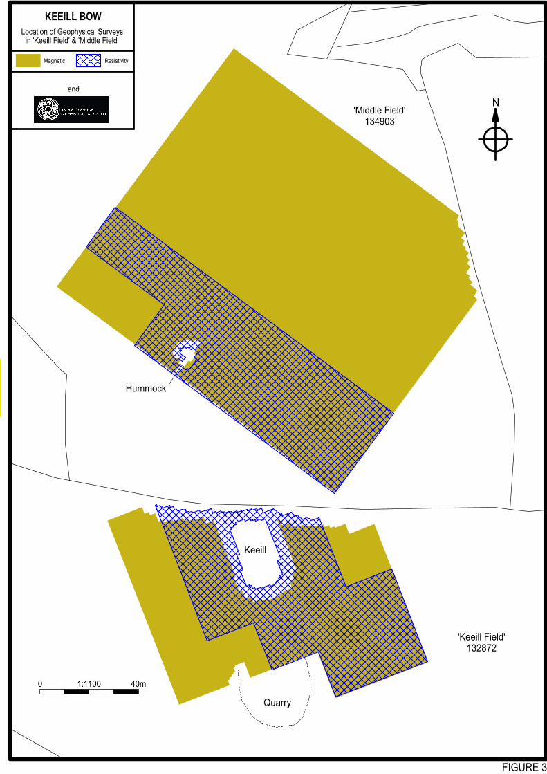
2 THE GEOPHYSICAL SURVEYS 2.1 Geophysical survey was carried out during July 2017 by teams from The Keeills Research
Project and the Bath and Camerton Archaeological Society, while both fields were in pasture. Baselines and grid patterns were established as a foundation for the surveys using fibron tapes and optical squares. This network was subsequently connected relative to the Ordnance Survey using kinematic GPS, which thus provided a precision basemap for the drawings presented in this report. Fluxgate gradiometers and soil resistance meters were then used to conduct detailed surveys over those areas shown in Figure 3.
2.2 Measurements of the vertical gradient in the Earth’s magnetic field were recorded using
Geoscan FM36 and FM256 fluxgate gradiometers with 0.05nT/m resolution. A zig-zag traverse scheme was employed and data were logged in grid units of 20x20m at 1.0x0.5m intervals, thus providing 800 measurements per grid. Data were downloaded on-site into a portable graphics computer and later transferred to a laboratory PC for final processing, interpretation and archiving.
2.3 Measurements of soil electrical resistivity were made using Geoscan RM15 instruments
with 0.5m spacing of the search electrodes. A zig-zag traverse scheme was again used, with data recorded with a similar regime to that utilised for the magnetic field survey.
2.4 GeoQuest InSite® software was used to process the magnetometer data into continuous-
tone grey-scale images representing subtle variations in the Earth’s magnetic field (Figure 4). In this drawing positive magnetic anomalies appear dark grey and negative magnetic anomalies light grey. Generally, most positive magnetic anomalies will correspond to soil-filled ditches or ploughed-out earthen banks, while negative anomalies usually reflect features such as wall footings and paths composed of sedimentary rock. The magnetometer often reveals ferrous litter or burnt ground as strong ‘dipolar magnetic anomalies’, seen as close black-white pairings in the greyscale image. Results from the soil resistance surveys are shown in Figure 5, with high resistance anomalies portrayed

dark grey, grading to low resistance anomalies shown as light grey. In general, high resistance anomalies in archaeological contexts usually correspond to volumes of drier, more stony ground, such as wall or tracks, while low resistance anomalies often reflect more moist materials, such as soil-filled pits, ditches or palaeochannels.
2.5 A preliminary archaeological interpretation of this surveys is presented in Figure 6. A key
defines the colours and fill styles used in this drawing, while feature codes have been added for ease of reference in the text.
3 DISCUSSION
The following features of archaeological interest have been identified by the surveys:
Middle Field
3.1 f1, f2, f3 & f4: The Middle Field has been found to contain several areas with strong textures of parallel lineations which represent the ploughed-out remains of former lazy beds. These appear to have several different orientations suggesting that the site was previously divided by a number of field boundaries that are neither recorded on the 1
st
Edition Ordnance Survey, nor have been detected by the geophysical surveys. This indicates that these boundaries comprised light fences or hedges with no significant ground intrusion and resulting subsoil traces.
3.2 f5: A strong positive magnetic anomaly, up to 6m wide, has been detected close to the northern limit of the magnetic survey. This anomaly extends follows a path of maximum gradient, trending beyond the area investigated, and probably reflects a bedrock scarp or silted palaeochannel that meanders beyond the area of investigation.
3.3 f6: The geomagnetic survey has mapped a distinct negative magnetic lineation oriented WSW-ENE in the northern quarter of the study area. This anomaly may correspond to a wall footing or a plastic land drain or pipe that continues towards the boundary with the adjacent plantation.
3.4 f7: A striking feature of the magnetic survey image is a band of positive and negative
lineations, about 7m wide, that trends parallel to feature f6 through the centre of the study area. It is possible that these anomalies derive from a former trackway, since there are currently no field entrances at either end of its projection.
3.5 f8 & f9: A pair of strong positive magnetic lineations have been detected that appear to converge on the NW limit of the survey area. These are consistent with shallow soil-filled ditches or alternatively tile land drains or cable ducts.
3.6 f10, f11 & f12: Unfortunately, it was not possible to survey the summit of the mound described as a ‘Burial Ground’ on the 1
st Edition OS owing to dense gorse scrub.
However the resistivity and magnetic data sets have revealed a complex pattern of anomalies that do suggest that features of archaeological significance are present in the subsoil. Of particular interest are a ring of high resistance material encircling the mound
(f12), plus an external arcuate high resistance anomaly to the east (f11). Although the former may correlate with shallow bedrock topography, the outer arc strongly suggests the existence of a perimeter kerb of which footings survive in the subsoil.
3.7 f13 & f14: The southern quarter of the ‘Middle Field’ contains a pair of weak and diffuse magnetic lineations which provide tentative evidence for additional minor silted ditches in this location.
Keeill Field
3.8 f15: Rather surprisingly, the majority of features revealed by the geophysical investigations of this area are seen in the geomagnetic, rather than resistivity data. A very weak and diffuse pair of N-S oriented lineations in the western half of the block may represent bedrock topography or artefacts of soil sorting due to former cultivation.
3.9 f16: Immediately east of the keeill the magnetic image contains a very weak, diffuse and intriguing set of concentric arcuate anomalies. These are negative, implying deposits (or outcrops) of more stony material. However, it seems very unlikely that such a pattern would be geological in origin, instead suggesting that this feature reflects traces of a former circular monument, such as a barrow with stone kerb(s), now ploughed-out and robbed, possibly to construct the adjacent field walls.
3.10 f17: A small and indistinct positive magnetic anomaly on the northern flank of the quarry hollow is too small to provide conclusive evidence as to whether this feature was once a barrow (now robbed) or some other structure of archaeological interest.
4 CONCLUSIONS
Detailed geophysical surveys has been undertaken of two fields in the vicinity of Keeill Bow in an effort to provide further information regarding the survival of subsoil features associated with this monument and other traces of archaeological interest. Complex patterns of former lazy beds have been detected in the ‘Middle Field’, although clear boundaries between these regions are not distinguishable, suggesting that they comprised light fences or hedges. Several silted ditches and a palaeochannel (or bedrock scarp) have also been mapped, plus a field wall (or land drain). A gorse-covered rocky knoll in the ‘Middle Field’ denoted as a ‘Burial Ground’ on the 1
st
Edition Ordnance Survey appears to be partly encircled by arcuate deposits of stony material lending support to the conjecture that this is indeed the site of an Early Christian monument of some type, such as a cemetery or keeill. Of particular interest is the presence of a pattern of sub-circular geophysical anomalies immediately east of the keeill in Field132872. These provide intriguing evidence for a barrow or similar prehistoric feature with which the keeill may once have been associated. Further investigation, for example by trial trenching and more detailed geophysical surveys, may be required in order to verify these conjectures.
5 ACKNOWLEDGEMENTS
We are very grateful to the landowner Julian Edwards and to the tenant Brian Brumby for kindly granting permission to undertake the geophysical surveys. The Isle of Man Government Department of Infrastructure provided the OS digital mapping and LiDAR data used, under licence ACA-1040, as the basis of drawings presented in this report.

Culture Vannin kindly supported the visit to the Isle of Man by BACAS to assist with these surveys.
6 CREDITS
Geophysical survey: Owen Dicker, Dulcie Foster, Dave Joughin, Judy Kee, Tim Lunt, David Martin, Mark Noel, John Oswin, Janet Pryke, John Richards, John Shakespeare, Henry Uniacke, Gillian Vickery, Frank Wooley.
Report M.J. Noel & D. Martin Date: 10
th October 2017
Keeills Research Project

FIGURE 1
NKEEILL BOW
Not to scale
Air photograph of survey areas
keeills research projectand
Keeill Field
Middle Field

FIGURE 2
KEEILL BOWExtract from 1:2500 County
Series (1868)
Not to scale
keeills research project
and
N
'Middle Field'
'Keeill Field'
'Middle Field'134903
'Keeill Field'132872
Quarry
Keeill
Hummock
FIGURE 3
N
KEEILL BOW
Location of Geophysical Surveysin 'Keeill Field' & 'Middle Field'
keeills research projectand
ResistivityMagnetic
1:1100 40m0

'Middle Field'134903
'Keeill Field'132872
Quarry
Keeill
Hummock
FIGURE 4
N
KEEILL BOW
Results of Geomagnetic Surveys
keeills research projectand
ANOMALIES, nT/m
1:1100 40m0

Keeill
'Middle Field'134903
'Keeill Field'132872
Quarry
Hummock
FIGURE 5
N
KEEILL BOW
Results of Resistivity Surveys
keeills research projectand
ANOMALIES, Ohms
1:1100 40m0

'Middle Field'134903
'Keeill Field'132872
Quarry
Keeill
Hummock
FIGURE 6
N
KEEILL BOW
Archaeological Interpretation
keeills research projectand
Silted palaeo-channel
Earthen bank orsilted ditch
Furrow oflazy bed
Course of possible trackways
Wall or stoneydeposit
f1
f2
f3
f4
f5f6
f7
f8
f9
f10
f11
f12
f13
f14
f15
f16
f17
1:1100 40m0