kinzua photo maps - fountains land › client_media › properties › kinzua... · 2017-06-15 ·...
TRANSCRIPT

Kinzua Timberlands Photo Maps Prepared June 9, 2017 by F&W Forestry
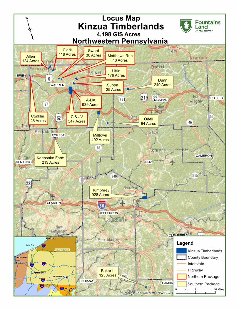
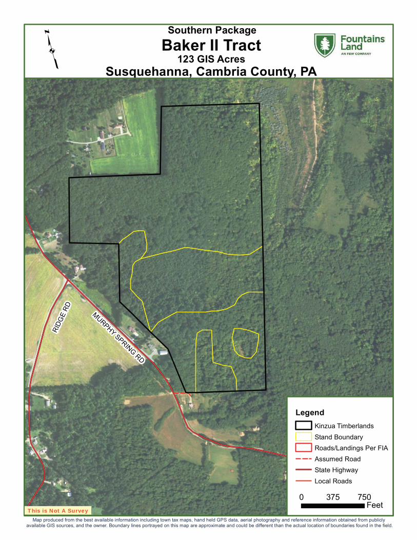
Baker II123 Acres
Humphrey928 Acres
Keepsake Farm213 Acres
Dunn249 Acres
Odell64 Acres
Milltown492 Acres
Little176 Acres
Suppa125 Acres
C & JV547 Acres
A-DA939 Acres
Conklin 26 Acres
Allen124 Acres
Clark118 Acres Sword
30 Acres Matthews Run43 Acres
ELK
MCKEAN
WARREN
CLEARFIELD
CLARION
JEFFERSON
FOREST
INDIANA
ARMSTRONG
CAMERONVENANGO
POTTER
CAMBRIA
CENTRE
BLAIR
ERIE
BUTLER
ALLEGHENY Sources: Esri, DeLorme, NAVTEQ, USGS, NRCAN, METI, iPC, TomTom
4,198 GIS AcresNorthwestern Pennsylvania
Kinzua Timberlands
PITTSBURGH!
HARRISBURG!
BUFFALO!
§̈¦80
§̈¦70
§̈¦79
§̈¦90
!
!
AKRON
CLEVELAND
Kinzua Timberlands
§̈¦68
!
BALTIMORE
§̈¦70
Lake Erie
!
Locus Map
q
LegendKinzua TimberlandsCounty BoundaryInterstateHighway
0 8 164 MilesSouthern PackageNorthern Package

KINZUA TIMBERLANDS
Package Configuration
Property County State
TotalGIS
Acres MBF
MBFPer
AcrePW
Tons
PWTonsPer
AcreClark Warren PA 118.19 761.1 6.44 1,595.0 13.5 Sword Warren PA 30.41 292.9 9.63 373.6 12.3 Matthews Run Warren PA 43.01 339.0 7.88 906.6 21.1 Little Warren PA 176.42 1,504.0 8.53 4,204.1 23.8 Suppa Warren PA 125.03 1,181.1 9.45 2,278.6 18.2 C& JV Warren PA 547.10 3,090.8 5.65 6,218.7 11.4 A-DA Warren PA 939.05 4,068.6 4.33 10,323.9 11.0 Conklin Warren PA 25.85 249.1 9.63 241.4 9.3Allen Warren PA 123.83 520.5 4.20 1,123.9 9.1Milltown Warren PA 492.08 3,678.0 7.47 11,567.6 23.5 Odell Warren PA 63.71 413.0 6.48 469.7 7.4Dunn McKean PA 248.97 858.0 3.45 1,582.2 6.4Keepsake Farm Forest PA 213.01 993.4 4.66 2,374.0 11.1 Humphrey Jefferson PA 928.23 5,733.1 6.18 9,607.7 10.4 Baker II Cambria PA 122.85 956.9 7.79 1,698.4 13.8 South Package 2,069 12,632.5 6.11 27,299.6 13.2 North Package 2,129 12,007.0 5.64 27,266.0 12.8 Totals 4,198 24,639.5 5.87 54,565.5 13.0

Kinzua Timberlands Photo Maps for Northern Package

£¤6
IRV
INE R
UN
RD
HU
LL HILL R
D
ROUSE AV
Copyright:© 2013 National Geographic Society, i-cubed
939 GIS AcresBrokenstraw, Warren County, PA
A-DA TractqLegend
Kinzua TimberlandsStand Boundary
Roads/Landings Per FIA Revised Roads By BrokerLocal Roads
Northern Package
0 1,000500Feet
This is Not A SurveyMap produced from the best available information including town tax maps, hand held GPS data, aerial photography and reference information obtained from publicly
available GIS sources, and the owner. Boundary lines portrayed on this map are approximate and could be different than the actual location of boundaries found in the field.

LOTT
SVIL
LE-N
IOBE
RD
NORTH RD
STILLWATER RD
124 GIS AcresFreehold, Warren County, PA
Allen Tractq
LegendKinzua TimberlandsStand BoundaryRoads/Landings Per FIA Revised Roads By BrokerState HighwayLocal Roads
Northern Package
0 750375Feet
This is Not A SurveyMap produced from the best available information including town tax maps, hand held GPS data, aerial photography and reference information obtained from publicly
available GIS sources, and the owner. Boundary lines portrayed on this map are approximate and could be different than the actual location of boundaries found in the field.

DUNN
S ED
DY R
D
ALLEGHENY SPRINGS RD
ROUSE AV
ERIE AV
SR 3022 SH
EAST MAIN ST
547 GIS AcresBrokenstraw, Warren County, PA
C & JV Tractq
LegendKinzua TimberlandsStand BoundaryRoads/Landings Per FIA Revised Roads By BrokerState HighwayLocal Roads
Northern Package
0 1,000500Feet
This is Not A SurveyMap produced from the best available information including town tax maps, hand held GPS data, aerial photography and reference information obtained from publicly
available GIS sources, and the owner. Boundary lines portrayed on this map are approximate and could be different than the actual location of boundaries found in the field.

HU
NTL
EY R
D
£¤957
Copyright:© 2013 National Geographic Society, i-cubed
118 GIS AcresFreehold, Warren County, PA
Clark Tractq
LegendKinzua TimberlandsStand BoundaryRoads/Landings Per FIA Revised Roads By BrokerState HighwayLocal Roads
Northern Package
0 500 1,000250FeetThis is Not A Survey
Map produced from the best available information including town tax maps, hand held GPS data, aerial photography and reference information obtained from publicly available GIS sources, and the owner. Boundary lines portrayed on this map are approximate and could be different than the actual location of boundaries found in the field.

SPENCER RD
MAIN ST
SHAD
Y AV
GAM
MA RD
£¤6
26 GIS AcresColumbus, Warren County, PA
Conklin TractqLegend
Kinzua TimberlandsRoads/Landings Per FIA Revised Roads By BrokerStand BoundaryState HighwayLocal Roads
Northern Package
0 1,000500Feet
This is Not A SurveyMap produced from the best available information including town tax maps, hand held GPS data, aerial photography and reference information obtained from publicly
available GIS sources, and the owner. Boundary lines portrayed on this map are approximate and could be different than the actual location of boundaries found in the field.

LANNING HILL RD
SCRAN
TON
HO
LLOW
RD
JACKSON RUN RD
176 GIS AcresFarmington, Warren County, PA
Little Tractq
LegendKinzua TimberlandsStand BoundaryRoads/Landings Per FIA Revised Roads By BrokerState HighwayLocal Roads
Northern Package
0 500250Feet
This is Not A SurveyMap produced from the best available information including town tax maps, hand held GPS data, aerial photography and reference information obtained from publicly
available GIS sources, and the owner. Boundary lines portrayed on this map are approximate and could be different than the actual location of boundaries found in the field.

PATC
HEN
HIL
L R
D
HAZELTINE VALLEY RD
43 GIS AcresSugar Grove, Warren County, PA
Matthews Run Tractq
LegendKinzua TimberlandsStand BoundaryRoads/Landings Per FIA Revised Roads By BrokerState HighwayLocal Roads
Northern Package
0 500250Feet
This is Not A SurveyMap produced from the best available information including town tax maps, hand held GPS data, aerial photography and reference information obtained from publicly
available GIS sources, and the owner. Boundary lines portrayed on this map are approximate and could be different than the actual location of boundaries found in the field.

SEIF
ERT
RD
YANKEE BUSH RD
125 GIS AcresConewango, Warren County, PA
Suppa Tractq
LegendKinzua TimberlandsStand BoundaryRoads/Landings Per FIA Revised Roads By BrokerState HighwayLocal Roads
Northern Package
0 500250Feet
This is Not A SurveyMap produced from the best available information including town tax maps, hand held GPS data, aerial photography and reference information obtained from publicly
available GIS sources, and the owner. Boundary lines portrayed on this map are approximate and could be different than the actual location of boundaries found in the field.

STIL
LSO
N H
ILL
RD
SWEENEY RD
SHELDON RD
30 GIS AcresSugar Grove, Warren County, PA
Sword Tractq
LegendKinzua TimberlandsStand BoundaryRoads/Landings Per FIA Revised Roads By BrokerState HighwayLocal Roads
Northern Package
0 500250Feet
This is Not A SurveyMap produced from the best available information including town tax maps, hand held GPS data, aerial photography and reference information obtained from publicly
available GIS sources, and the owner. Boundary lines portrayed on this map are approximate and could be different than the actual location of boundaries found in the field.

Kinzua Timberlands Photo Maps for Southern Package
MURPHY SPRINGRD
RIDG
ERD
123 GIS AcresSusquehanna, Cambria County, PA
Baker II Tractq
LegendKinzua TimberlandsStand BoundaryRoads/Landings Per FIA Assumed RoadState HighwayLocal Roads
Southern Package
0 750375Feet
This is Not A SurveyMap produced from the best available information including town tax maps, hand held GPS data, aerial photography and reference information obtained from publicly
available GIS sources, and the owner. Boundary lines portrayed on this map are approximate and could be different than the actual location of boundaries found in the field.

£¤321
Source: Esri, DigitalGlobe, GeoEye, Earthstar Geographics, CNES/AirbusDS, USDA, USGS, AeroGRID, IGN, and the GIS User Community
249 GIS AcresCorydon, McKean County, PA
Dunn Tractq
LegendKinzua TimberlandsStand BoundaryRoads/Landings Per FIA Revised Roads By BrokerState HighwayLocal Roads
Southern Package
0 750375Feet
This is Not A SurveyMap produced from the best available information including town tax maps, hand held GPS data, aerial photography and reference information obtained from publicly
available GIS sources, and the owner. Boundary lines portrayed on this map are approximate and could be different than the actual location of boundaries found in the field.

RATTLESNAKE RD
Jefferson County
Clearfield County Clearfield CountyElk County
SIPLE RD
BUN
DY SE
TTLEMEN
T RDANDERSON RD
RING BLOOM RD
928 GIS AcresSnyder, Jefferson County, PA
Humphrey Tractq
LegendKinzua TimberlandsStand BoundaryRoads/Landings Per FIA Revised Roads By BrokerState HighwayLocal Roads
Southern Package
0 750 1,500Feet
This is Not A SurveyMap produced from the best available information including town tax maps, hand held GPS data, aerial photography and reference information obtained from publicly
available GIS sources, and the owner. Boundary lines portrayed on this map are approximate and could be different than the actual location of boundaries found in the field.

MCARTHUR RUN RD
PREA
CH
ER H
ILL
RD
TANK HILL RD
CRES
TMON
T RD
SCENIC DR
FERR
Y LN
CEMETERY R
D
ANN
ST
RESERVOIR R
D
HOLLOW RD
£¤0
£¤127
£¤62
213 GIS AcresHarmony, Forest County, PA
Keepsake Farm Tractq
LegendKinzua TimberlandsStand BoundaryRoads/Landings Per FIA Revised Roads By BrokerState HighwayLocal Roads
Southern Package
0 750 1,500375Feet
This is Not A SurveyMap produced from the best available information including town tax maps, hand held GPS data, aerial photography and reference information obtained from publicly
available GIS sources, and the owner. Boundary lines portrayed on this map are approximate and could be different than the actual location of boundaries found in the field.

COUNTRY LN
SAWMILL RD
BLO
SS
HIL
L R
D
FIR
ST
MIL
L ST
£¤6
£¤0
492 GIS AcresSheffield, Warren County, PA
Milltown Tractq
LegendKinzua TimberlandsStand BoundaryRoads/Landings Per FIA Revised Roads By BrokerState HighwayLocal Roads
Southern Package
0 750 1,500375Feet
This is Not A SurveyMap produced from the best available information including town tax maps, hand held GPS data, aerial photography and reference information obtained from publicly
available GIS sources, and the owner. Boundary lines portrayed on this map are approximate and could be different than the actual location of boundaries found in the field.

CH
ER
RY
RU
NR
D
£¤948
64 GIS AcresSheffield, Warren County, PA
Odell Tractq
LegendKinzua TimberlandsStand BoundaryRoads/Landings Per FIA Revised Roads By BrokerState HighwayLocal Roads
Southern Package
0 750375Feet
This is Not A SurveyMap produced from the best available information including town tax maps, hand held GPS data, aerial photography and reference information obtained from publicly
available GIS sources, and the owner. Boundary lines portrayed on this map are approximate and could be different than the actual location of boundaries found in the field.