kipt road freight options assessment · kipt road freight options assessment. page | 7 4.0 road...
TRANSCRIPT

KIPT Road Freight OptionsAssessment
September 2017

Contents1.0 Overview ...................................................................................1
2.0 Heavy Vehicle Volumes ...........................................................4
3.0 Forestry Freight Road Hierarchy & Specifications ................6
4.0 Road Assessments ....................................................................7
4.1 Option 2........................................................................... 11
4.1.1 Playford Highway A ................................................... 11
4.1.2 Stokes Bay Road......................................................... 15
4.1.3 Bark Hut Road.............................................................. 19
4.1.4 McBrides Road ........................................................... 22
4.1.5 North Coast Road...................................................... 25
4.2 Option 5........................................................................... 29
4.2.1 Playford Highway....................................................... 29
4.2.2 Ropers Road ............................................................... 34
4.2.3 Gap Road ................................................................... 38
4.2.4 North Coast Road ...................................................... 41
4.3 Option 6........................................................................... 44
4.3.1 Springs Road............................................................... 44
4.3.2 Rose Cottage Road................................................... 47
5.0 Summary of Assessments....................................................... 50
5.1 Evaluation Framework results ..................................... 50
5.2 Upgrade and Maintenance estimates...................... 51
5.3 Assessment Outcomes ................................................. 52
5.0 Funding Options ..................................................................... 53
Appendix A Evaluation Framework
B Assessment Criteria Results
C Upgrade & Maintenance Preliminary Estimates

KIPT Road Freight Options Assessment
Page | 1
1.0 Overview
Osman Solutions has been engaged by Kangaroo Island Plantation TimbersLtd (KIPT) to undertake evaluations of the shortlisted road access routes forthe mobilisation of timber freight on Kangaroo Island.
The routes assessed are based on the freight port being approved for SmithBay.
Walbridge & Gilbert (W&G) undertook a Route Assessment in October 2016with the purpose of that assessment being to examine the condition of theexisting road network and its suitability to accommodate heavy vehiclemovements. The assessment by W&G was based on timber transportationbeing by 19m semi-articulated vehicles which are general access vehicleswhich do not require permits to access public roads.
In June 2017 a Discussion Paper, prepared by Osman Solutions, was preparedbased on B-Double vehicles which are Restricted Access vehicles to:-
Engage in formal discussions with Kangaroo Island Council (KIC) toestablish timber freight access routes.
Provide an overview of the evaluation of all options identified in theW&G Route Assessment (October 2016) and subsequently identified onfurther discussions and assessment.
Provide a short list of access route options for Smith Bay along withroads required to access plantations for the first five years of harvestoperations.
Establish a framework to evaluate short listed options. Establish freight road specifications for two way freight movement
based on a road access hierarchy for timber freight.
Department of Planning, Transport and Infrastructure (DPTI’s) Heavy VehicleAccess Framework (HVAF) is the basis for the evaluation of freight routes. TheHVAF provides policy and direction for meeting the main objectives in SA’sStrategic Plan for heavy vehicle operations including development of roadfreight networks and corridors for heavy vehicles which take into accountenvironmental and social issues.
Heavy Vehicle Operations are divided into three (3) categories
General Access (ie Semi articulated vehicles) Restricted Access by Gazette Notice Restricted Access by Permit

KIPT Road Freight Options Assessment
Page | 2
Based on the W&G assessment and subsequent discussions the followingoptions were reviewed:-
Option 1 – Stokes Bay Road / North Coast Road Option 2 – Stokes Bay Road / Bark Hut Road / McBrides Road / North
Coast Road Option 3 – Stokes Bay Road / right of way access / McBrides Road /
North Coast Road Option 4 – Bark Hut Road / McBrides Road / North Coast Road Option 5 – Ropers Road / Gap Road / North Coast Road Option 6 – Stokes Bay Road / Bark Hut Road / McBrides / Springs Road /
Rose Cottage Road / North Coast Road Option 7 – Stokes Bay Road / Pioneer Bend Road / McBrides Road /
North Coast Road Option 8 – Boxer Road / North Coast Road Option 9 – Unmade Road Reserves
Based on those assessments and as agreed with Kangaroo Island Council(KIC) the route options shortlisted for assessment are:-
Option 2 – Playford Highway / Stokes Bay Road / Bark Hut Road /McBrides Road / North Coast Road
Option 5 – Playford Highway / Ropers Road / Gap Road / North CoastRoad
Option 6 – Playford Highway / Stokes Bay Road / Bark Hut Road /McBrides Road / North Coast Road / Springs Road / Rose CottageRoad / North Coast Road.
The Evaluation Framework used in undertaking assessments of the shortlistedoptions is contained in Appendix A.
The assessments are based on existing conditions, acknowledging that therewill be investment into upgrading the roads to ensure the freight task is donesafely and efficiently.

KIPT Road Freight Options Assessment
Page | 3

KIPT Road Freight Options Assessment
Page | 4
2.0 Heavy Vehicle Volumes
Forestry yield and generated volumes of heavy vehicles was supplied in W&Gsassessment based on semi articulated vehicles with a maximum load of 30 tonnesgross which are general access vehicles. This report is based on B Double vehicleswith a maximum load of 42.5 tonnes gross which are restricted access vehicles. Forthe purpose of looking at heavy vehicle volumes, calculations have also been donefor A Double vehicles with a maximum load of 60 tonnes.
It is considered with the projected volumes of timber to be harvested and mobilisedto the proposed freight port facility that the use of B-Double or possibly largerRestricted Access Vehicles on a Gazetted Restricted Access route as opposed tosemi-trailer movements which are General Access Vehicles (no approvals required)would be preferred due to:-
Reduced number of truck vehicle movements resulting in less impact on theroad network, amenity and environment.
Improved safety for all road users by way of upgrading the roads andintersections where required.
Improved efficiencies for the freight task.
As per the W&G assessment, KIPT provided the following information regardingvehicle movements
Harvesting will occur year-round. There will be some variation from year to year in total harvest tonnage. The daily frequency of haulage movements will be influenced by shipping
schedules and storage capacity at the Smith Bay wharf. It is acknowledged that haulage may be affected by flooding and fire risks.
Harvesting and haulage will be scheduled according to local conditions, withareas prone to flooding being harvested during summer months and drierareas harvested in winter months.
Timber transportation will occur Monday – Friday.
KIPT has highlighted that schedules for the harvesting and shipping of timber will bedependent on demand and other external factors. For the purposes of thisassessment, the projections summarised in the table below have been assumed.

KIPT Road Freight Options Assessment
Page | 5
Based on the table above, during an average 12 hour freight movement day therewould be a Semi Trailer making the journey to Smith Bay every 14 minutes iftransporting 400,000 to Smith Bay per annum. If B-Doubles make that journey thefrequency is reduced to every 19 minutes and reduced further again if A Doublesare used.
The estimates are based on General Mass Limits (GML) however Higher Mass Limits(HML) for vehicles fitted with Road Friendly Suspensions could be applied for whichcould further increase the allowable load and therefore reduce vehicle movementsfurther.
Daily Heavy Vehicle Volumes
TonneAnnual
TripsDailyTrips
AnnualTrips
DailyTrips
AnnualTrips
DailyTrips
400,000 26,667 107 18,824 75 13,333 53500,000 33,333 133 23,529 94 16,667 67600,000 40,000 160 28,235 113 20,000 80700,000 46,667 187 32,941 132 23,333 93
A typica l year for freight movement i s 250 working days , which excluded weekends and publ ic hol idays
Trip represents a two-way vehicluar movement and includes an empty return journey
Semi Trips (30 t GML) B Double (42.5 t GML) A Double (60 t GML)

KIPT Road Freight Options Assessment
Page | 6
3.0 Forestry Freight Road Hierarchy & Specifications
Due to the nature of forestry practices, being that year round access will be requiredto the proposed Smith Bay Wharf and seasonal access during harvest operations tothe various plantations it is recommended that there be a Forestry Freight RoadHierarchy with fit for purpose specifications.
Smith Bay Wharf Access(Core Roads) Year round, ongoing access done under
Restricted Access by Gazette Notice
Seasonal Plantation Access(Local Access Roads) During harvest operations under Restricted
Access by Permit
The primary purpose of a road hierarchy is to ensure that appropriate management,engineering design, construction standards and maintenance practices are appliedto a road based on its function. It also enables more efficient use of limitedresources by allocating funding to those roads that are in greater need and onwhich expenditure is better justified and higher returns obtained. Special purposeroads ie quarry, logging or tourist roads should be made to fit existing classificationsrather than establish a separate classification1.
In accordance with Council’s Transport Infrastructure Asset Management Plan, thehighest classification for unsealed rural roads is C1 (Bark Hut Road, Springs Road,North Coast Road) and for sealed rural roads are A (Arterial) and B (Collector).
It is recommended that the Smith Bay Wharf Access route be constructed andmaintained to a Class B unsealed standard (previously not required by Council forunsealed rural roads) with Seasonal Plantation Access roads be maintained to theirexisting standard where it is safe for two heavy vehicles, such as B-Doubles, to passsafely.
Smith Bay Wharf Access 8m wide carriageway(Core Roads) 0.75m shoulders (each side)
80km speed limit for heavy vehicle operations
Seasonal Plantation Access 6m wide carriageway(Local Access Roads) 0.75m shoulders (each side
60kkm speed limit for heavy vehicle operations
1 ARRB Unsealed Road Manual, Guidelines to Good Practice P 4.2

KIPT Road Freight Options Assessment
Page | 7
4.0 Road Assessments
DPTI’s Heavy Vehicle Access Framework (HVAF) is the basis for the evaluationof freight routes. The framework is designed to demonstrate the ability of theproposed Restricted Access Vehicle to be physically and safelyaccommodated along the proposed route. The effect on amenity, theenvironment and impact on local communities will be considered.
The framework also reflects KIPT’s route selection criteria being:-
Safety Efficiency of the freight task (cost per tonne) Minimise impact on other road users and property owners Timelines to enable an approved route to be operational Cost implications
The evaluation framework was presented to Kangaroo Island Council forreview and approval as part of the options shortlisting process. The scoringapplied is based on a 1 – 5 approach, whereby:-
1 Excellent – satisfies prescribed criteria for the length of the assessed roadsection
2 Good – meets prescribed criteria with either some constraints or minoritysection that is only ‘fair’ to ‘poor’
3 Fair – not at prescribed criteria that can be addressed4 Poor – multiple issues that could impact safety, environment or
community which can be addressed5 Very poor – significant issues that will impact either safety, environment
or community
The Evaluation Framework used in undertaking assessments of the shortlistedoptions is contained in Appendix A.
Below is an overview of the areas being assessed and the relevant criteria.
Existing Road Conditions
The existing road conditions including width, shoulders, clearances, condition(surface & pavement) and geometry were assessed to enable upgraderequirements to be determined.
The upgrade standard will provide for an 8m wide carriageway with 0.75mshoulders which will enable a 9.5m clearance for two heavy vehicles to passat 80km/hr. The sealed roads assessed (Stokes Bay Road and PlayfordHighway) both have sealed carriageways of 6m with 1m shoulders (unsealed)which will require the shoulders to be sealed to enable two heavy vehicles topass safely. There are some sections along both sealed roads assessed that

KIPT Road Freight Options Assessment
Page | 8
will only provide for a 7m total width without extensive and expensiveupgrades, predominantly over rivers and waterways.
Geometry is an important consideration, particularly as the nature of theterrain through to Smith Bay has multiple rolling valleys and rises. Thesechanges in grade lead to speed variations, breaking and gear changes. Inthe case of haulage roads, a flatter grade will enable a more constantspeed, demand less of both vehicle and driver and generally lower vehicleoperating costs. Also grades create speed disparities between vehicle types.This can lead to queuing and overtaking requirements2.
Drainage & Bridges
Drainage is an important consideration to ensure year round operation. Thedrainage assessment considered provision of table/side drains, mitre drains,cross drains, floodways and any roadside dams. All of the lower class (DClass) unsealed roads being McBrides, Ropers, Gums and Rose CottageRoads require drainage upgrades including building the road up wherecurrently the road ‘dips’ into waterways that can become inundated duringheavy rain events. Hydrology studies would be required to determine thecatchment and therefore capacity requirements for upgrade to the crossdrains to mitigate the risk of water inundation on the haulage route.
To access Smith Bay from central Kangaroo Island, the Cygnet River needs tobe crossed (via a bridge) regardless of what option is selected. Of the threeoptions being assessed, the crossing point is either on Stokes Bay Road over abridge that is 8m wide at the bottom of a steep approach and subsequentrise or Ropers Road that is a single lane bridge that is 3.2m wide that wouldrequire replacement. Further the same section on Ropers Road that abutsthe Cygnet River would need to be built up some 2m and widened withbatter slops for some 600m, with significant vegetation and amenity impact.
Roadside Native Vegetation
Roadside Native Vegetation assessments have also included any WaterAffecting Activities (linked with Drainage & Bridges) and any known habitats.Roadside vegetation was assessed for any clearance requirements to provide2m back behind white marker posts and 4m overhead clearance along withline of sight for corners and intersections.
Preliminary discussions have been held with Department of Environment,Water and Natural Resources (DEWNR) and Natural Resource Management(NRM) staff including a field trip driving the proposed routes.
Preliminary roadside vegetation clearance requirements were provided torelevant staff prior to site visits. A formal, independent roadside vegetation
2 ARRB Unsealed Roads Manual, Guidelines to Good Practice P 4.7.

KIPT Road Freight Options Assessment
Page | 9
assessment will be commissioned when the preferred route is selected as partof the approval process. This will identify any protected and endangeredplants along with SEB off set requirements.
There is a Glossy Black habitat at the intersection of Rose Cottage Road andNorth Coast Road that could impact any road works at that intersection. Asidentified in the previous section, Ropers Road has a section that abuts theCygnet River that is both low and narrow with a single lane bridge. There isalso another know Glossy Black habitat to the east of that same section onRopers Road. Any road works in that area would require removal of multiplelarge trees to enable the road to be built up to provide all weather access.
Right of Way and Intersections
Right of way for the proposed freight routes were assessed as part safety to allroad users and efficiency of the freight task. The majority of the routesassessed were only non-right of way when turning right onto a connectingroad, with the exception of Ropers and Gap which both have ‘give way’points along their length (Gum Creek and Springs Roads).
Intersections were assessed based on line of sight, swept path provisions(turning movement for long heavy vehicles) and vertical alignment. Allintersections will require some form of upgrade, particularly vegetationremoval and widening.
Site distances were based on Austroads Guide to Road Design, Part 4A:Unsignalised and Signalised Intersections. For the give way roads (minor)along the assessed routes Approach Sight Distance (ASD) was used and SafeIntersection Sight Distance (SISD) used for the intersections navigated alongthe assessed routes. As per ARRB Unsealed Road Manual (page 4.9) ‘nolongitudinal friction values for trucks on unsealed roads are known at thisstage. As a rough guide stopping sight distances for trucks should be at least30m greater than for cars’3.
The following site distances were used in the assessment4
ASD SISD5
80km/hr 185 220100km/hr 230 307
3 ARRB Unsealed Roads Manual, Guidelines to Good Practice P 4.9.4 ARRB Unsealed Roads Manual, Guidelines to Good Practice P 4.255 Department of Transport Infrastructure and Planning ‘Route Assessment Guidelines for Restricted AccessVehicles; Appendix A.

KIPT Road Freight Options Assessment
Page | 10
Land Uses & Residential Impacts
It is acknowledged that the impacts of a freight route of the proposedvolumes will impact road users and particularly residents along the route.Although the roads will be upgraded and maintained to a high standardwhich residents will enjoy the benefits of, the frequency of heavy vehiclemovement will impact residents to some degree, particularly for those whoreside close to the road.
Identifying the number and proximity of residences along the assessed routeshas been included. Roads like McBrides, although currently in poor condition,have no residences along its length unlike Playford Highway or North CoastRoad.
Traffic & Safety
This part of the assessment included traffic counts, school bus routes, trafficcomposition, crash history, speed environment and overtaking provisions.
Roads with a low traffic count (<10 vehicles per day) have been scoredhigher than those with high traffic counts (>150 vpd) as the risk of accident isreduced on road with low traffic counts. It is also acknowledged thatgenerally when a road is upgraded, traffic counts increase.
Kangaroo Island has relatively low traffic counts which increase significantlyduring the peak summer tourist season. The impact of approximately 90heavy vehicle return trip movements per day will have an impact on otherroad users in the short to mid-term. Safety and impact on other road users isintegral in the route assessments including overtaking provisions. As forestrytrucks will be travelling at 80km or slower where required, it is important thatsafe overtaking opportunities are provided for where appropriate.
Traffic composition including current school bus routes, Regionally SignificantTourist, Community Access and Freight Roads6 and locally significant freightroutes have been included. Any conflict in traffic composition has beenscored accordingly.
Crash history has also been reviewed (available on DPTI website). None ofthe crashes on the assessed roads resulted in personal injury, only propertydamage. With 2 exceptions of hitting wildlife, the other crashes wereattributed to driver inattention. It must be noted that many crashes onKangaroo Island are never reported, nor are the near misses. Incidentsinvolving wildlife are numerous according to locals, with the majority havingbeing involved at some time.
6 Southern & Hills Local Government Association 2020 Transport Plan

KIPT Road Freight Options Assessment
Page | 11
4.1 Option 2 – Playford Highway A, Stokes Bay Road, Bark Hut Road, McBridesRoad, North Coast Road
4.1.1 Playford Highway A (30km assessed)
Playford Highway A for the purpose of this options assessment is fromWest Highway through to Stokes Bay Road. This assessed section ofPlayford Highway is under the care and control of Kangaroo IslandCouncil.
Existing RoadConditions
Sealed road 7mwide from WestHighwayintersectionthrough toAhwans Roadand 6.0m – 6.5mwide through toStokes Bay Roadand is in goodcondition.There are somesections of theseal west of MtTaylor road where stripping and delamination of the seal is evident.Based on the assessment, seal has been scored at 3 with pavement at4. Playford Highway from Ahwans Road to Rowland Hill Highway is
Playford Highway A 1 – typical clearances

KIPT Road Freight Options Assessment
Page | 12
scheduled for re-seal in 2021/22 in Kangaroo Island Council’s TransportInfrastructure Asset Management Plan7.
The shoulders are unsealed and range from 1.0 – 2.0m along theassessed length with clearance back at least 2m which has resulted in
a score of 5 inthe assessmentcriteria.
Geometry of theassessed lengthhas good crossfall at anaverage of 3 –4% and ispredominantlyat grade withsome gradualrises and falls.Geometry hasbeen scored 5overall in theassessment withpredominantlyflat and straight
sections of road with good cross fall and batter slopes.
Drainage& Bridges
The cross drains along the assessed length of Playford Highway are ingood condition, 2m clear of the carriage way and suitable capacity tocapture and distribute water run of. Drainage has been scored 5overall in the assessment.
Roadside Native Vegetation
The Roadside vegetation is currently 2 – 3 m back from thecarriageway along the majority of the assessed length of road. Pruningmaintenance is required along sections of the assessed length to getthe vegetation back 2m behind the white marker posts. Heightclearance is good (3 – 4 m clearance) with vegetation being scored at5 overall in the assessment criteria.
7 www.kangarooislandcouncil.sa.gov.au
Playford Highway A 1 - typical condition and clearances
KIPT Road Freight Options Assessment
Page | 13
Right of Way & Intersections
Along the assessed length, there is one (1) non right of way intersectionbeing
Playford Highway A and Stokes Bay Road which is a right handturn from Stokes Bay Road onto Playford Highway when headingaway from Smith Bay.
The other intersections along the assessed length that are right of wayto Playford Highway are
Gosse Ritchie Road & North Coast Road (110km speed zone)which provides adequate Safe Intersection Site Distance (SIDS).
Mt Taylor Road (110km speed zone) which provides adequateSIDS.
Coopers Road (110km speed zone) which provides adequateSIDS.
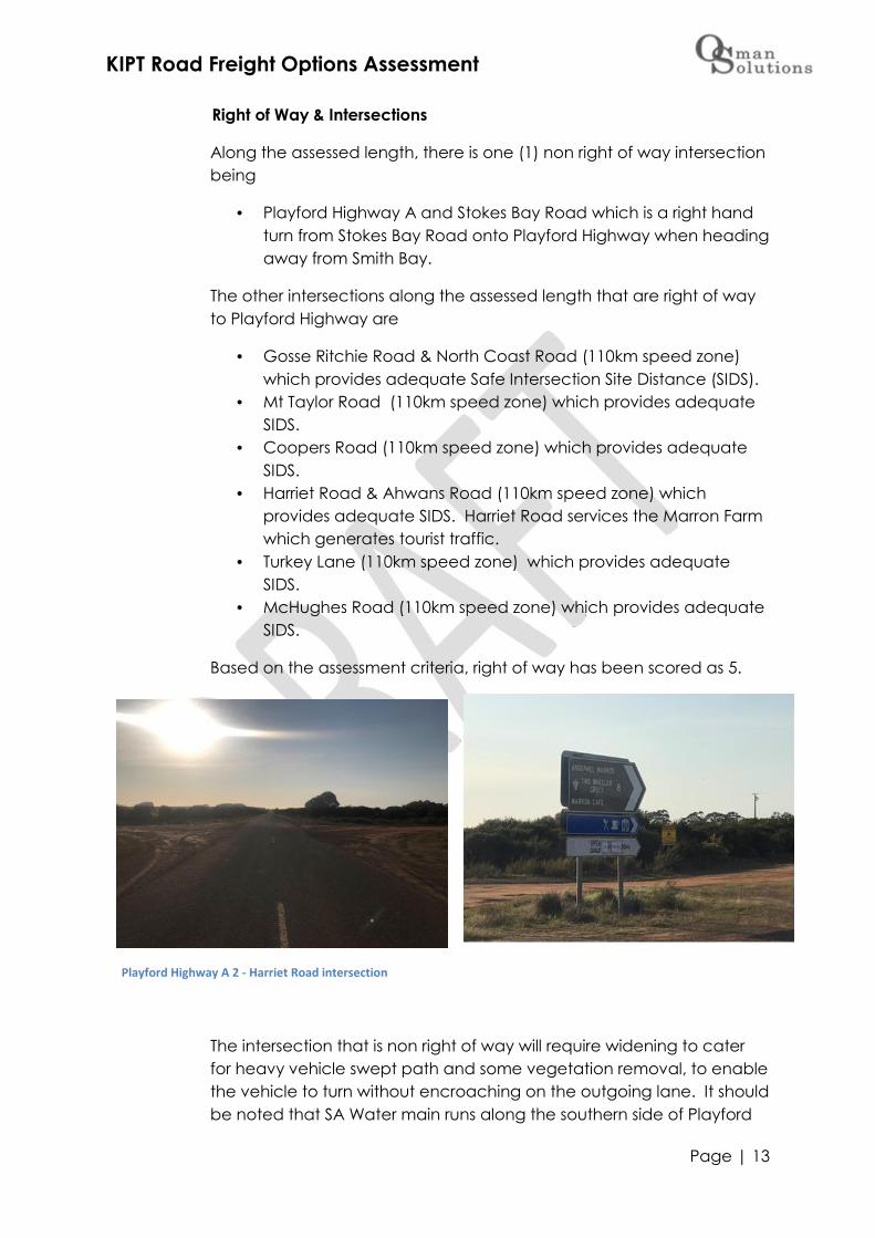
Harriet Road & Ahwans Road (110km speed zone) whichprovides adequate SIDS. Harriet Road services the Marron Farmwhich generates tourist traffic.
Turkey Lane (110km speed zone) which provides adequateSIDS.
McHughes Road (110km speed zone) which provides adequateSIDS.
Based on the assessment criteria, right of way has been scored as 5.
The intersection that is non right of way will require widening to caterfor heavy vehicle swept path and some vegetation removal, to enablethe vehicle to turn without encroaching on the outgoing lane. It shouldbe noted that SA Water main runs along the southern side of Playford
Playford Highway A 2 - Harriet Road intersection

KIPT Road Freight Options Assessment
Page | 14
Highway (east of Turkey Lane) which will need to be considered whendesigning the intersection upgrade.
Based on the assessment criteria, intersections have been scored as 4.
Land Uses & Residential Access
Predominantly agricultural land with paddock accesses along withsome residential driveways. There were no commercial drivewaysidentified, however as previously stated the Marron Farm is on HarrietRoad (intersects with Playford Highway) which generates tourist trafficand has been scored as 4 in the assessment criteria. Also noted is theWestern Districts Sports Club that is west of Goss Ritchie Road thatgenerates vehicle movements, predominantly on weekends and onWednesdays (practice). Health Clinics and other community servicesare provided from the Sports Club.
Traffic & Safety
Playford Highway has a traffic count of 140 vpd8 and RegionallySignificant Tourist and Access Routes in the S&HLGA 2020 TransportPlan. There are no reported crashes along the assessed length ofPlayford Highway. The speed environment is 110km for the assessedlength of Playford Highwaywith overtaking provisionsalong the assessed length.
The assessed length ofPlayford Highway is aschool bus route. Based onthe assessment criteria, anaverage of 3.6 has beenscored.
8 Kangaroo Island Council Traffic Counts, Summer 2017
Playford Highway A 3 - Mt Taylor Road intersection (lookingwest)

KIPT Road Freight Options Assessment
Page | 15
4.1.2 Stokes Bay Road (11.5km assessed)
Existing Road Conditions
Sealed road 6m wide between edge lines that is in very goodcondition. The carriageway width is just under 6m in some sectionsgoing down to 5.8, as such has been scored a 3.5 overall in theassessment criteria.
The shoulders are unsealed and range from 0.5 – 1.0 along theassessed length with clearance back at least 2m.There are severalsections along the assessed length that have w-beam crash barriersinstalled that provides for a total width of 8m including unsealedshoulders which has resulted in a score of 4 overall in the assessmentcriteria.
The seal and pavementcondition have both beenscored at 5 overall in theassessment criteria.
Geometry of the assessedlength has good cross fall atan average of 3 – 4%however there are sectionsof steep vertical grade,particularly over the bridgespanning the Cygnet Riverwhich also has a sharptransition from descent toincline. Geometry has beenscored 2 overall in the
assessment, predominantly due to the steep section associated withthe bridge over the Cygnet River.
Drainage& Bridges
The cross drains along the assessed length of Stokes Bay Road are ingood condition, 2m clear of the carriage way and suitable capacity tocapture and distribute water run of. The exception to this is the 300 diacross drain at the intersection with Playford Highway which will need tobe upgraded along with the intersection should this route be adopted.
Stokes Bay Road 1 - typical condition
Stokes Bay Road – typical condition

KIPT Road Freight Options Assessment
Page | 16
The bridge crossing theCygnet River (at chainage5.5 off Playford Highway)has a carriageway width of5.9m (edge line to edgeline) with unsealed shouldersof 1m and w-beam crashbarriers installed toAustralian Standards. Thebridge has been scored at 4in the assessment criteriahowever it must be notedthat structural testing of thisbridge is required should thisroute be adopted.
Roadside Native Vegetation
The Roadside vegetation iscurrently 2 – 3 m back from thecarriageway along the majorityof the assessed length of road.Pruning maintenance isrequired along the majority ofthe assessed length(approximately 9.5km) to getthe vegetation back 2m behindthe white marker posts. Heightclearance is good (3 – 4 mclearance) with vegetationbeing scored at 4 overall in theassessment criteria.
Right of Way & Intersections
Along the assessed length, there are two (2) non right of wayintersections being
Stokes Bay Road & Bark Hut Road which is a right hand turn fromStokes Bay Road onto Bark Hut Road when heading towardsSmith Bay.
Stokes Bay Road 2 - bridge over Cygnet River
Stokes Bay Road 3- roadside vegetation

KIPT Road Freight Options Assessment
Page | 17
Stokes Bay Road & Playford Highway which is a right hand turnfrom Stokes Bay Road onto Playford Highway when headingaway from Smith Bay.
The other intersections along the assessed length that are right of wayto Stokes Bay Road are
Weatheralls &Morgans Roads(staggered intersection)which provides adequateSafe Intersection SiteDistance (SIDS). Pioneer Bend Roadwhich provides adequateSIDS.
Based on the assessmentcriteria, right of way hasbeen scored as 5.
Both of the intersectionsthat are non right of waywill require widening to
cater for heavy vehicle swept path and some vegetation removal,particularly at the intersection of Playford Highway and Stokes BayRoad where a deceleration lane on Playford Highway to enable thevehicle to turn without encroaching on the outgoing lane. Note thatthere is a power pole on the western side of the intersection of PlayfordHighway which needs to be considered when designing an upgrade.
Stokes Bay Road 5 - intersection with Playford Highway intersection with Bark Hut Road
Based on the assessment criteria, intersections have been scored as 4.
Stokes Bay Road 4 - intersection with Weatheralls & Morgans Roads

KIPT Road Freight Options Assessment
Page | 18
Land Uses & Residential Access
Predominantly agricultural land with paddock accesses along withsome residential driveways. No commercial driveways were identifiedduring the assessments however it is noted that the Stokes Bay Hall is onthe intersection of Stokes Bay Road and Bark Hut Road and has beenscored as 3.5 in the assessment criteria.
Traffic & Safety
Stokes Bay Road has a traffic count of 150 vpd9, particularly in thesummer peak tourist season and is a Regionally Significant Tourist Routein the Southern & Hills LGA 2020 Transport Plan. There is some crashhistory along the assessed length with a motorbike rider leaving theroad (rider inattention) which resulted in two (2) injuries10.
The speed environment is 100km/hr and there are overtaking provisionsalong the assessed length. However it should be noted that thedescent and rise over the bridge at Cygnet River will require ladenheavy vehicles to use low gear with no opportunity for overtaking forvehicles behind.
Currently Stokes Bay Road is a School Bus route and as previously notedis a tourist route. Based on the assessment criteria, an average of 2.2has been scored.
9 Kangaroo Island Council Traffic Count Summer 201710 www.data.sa.gov.au/data/dataset/road-crash-data

KIPT Road Freight Options Assessment
Page | 19
4.1.3 Bark Hut Road (5.8km assessed)
Existing Road Conditions
Unsealed road 7mthat is in verygood condition.The shoulders aregenerally 0.5malong theassessed lengthwith clearanceback at least 2mup to 3m. There isone section alongthe assessedlength that has w-
beam crashbarriers installedon a bridge that provides for a total width of 8m including shoulderswhich has resulted in a score of 4 overall in the assessment criteria.
The surface and pavement condition have both been scored at 5overall in the assessment criteria.
Geometry of the assessed length has good cross fall at 6% with gradualvertical grades however there are some sections where the batterslopes are steeper than 1 in 3 which has resulted in an overall score of 4in the assessment criteria.
Drainage& Bridges
The cross drains along theassessed length of Bark HutRoad are in good condition,1m clear of the carriage wayand suitable capacity tocapture and distribute waterrun of. During assessmentsafter periods of heavy rainfall,it was noted that there are acouple of sections that areholding water which could becorrected by clearing the
Bark Hut Road 1 - typical condition
Bark Hut Road 2 - bridge crossing

KIPT Road Freight Options Assessment
Page | 20
table drains of built up material.
Bark Hut Road has four (4) bridges with one (1) positioned on theassessed length. This bridge has an 8m width and new b-beam crashbarriers. The bridge is relatively low lying (descent and rise) with a bendlimiting line of sight on the eastern side of the road. The bridge hasbeen scored 4 in the assessment criteria due to the low lying nature ofthe bridge which will require structural testing and hydrologicalcapacity assessment should this route be adopted.
Roadside Native Vegetation
The Roadside vegetation is currently 2 – 3 m back from thecarriageway along the majority of the assessed length of road. Someoverhead clearance is required along with some tree removal near thebridge at the bend in the road on the rise leaving the bridge toimprove line of sight. Vegetation has been scored at 3.5 overall in theassessment criteria.
Right of Way &Intersections
Along the assessedlength, there are two(2) non right of wayintersections being
Stokes BayRoad & BarkHut Roadwhich is a righthand turn fromStokes BayRoad ontoBark Hut Roadwhen headingtowards Smith Bay.
Bark Hut Road & McBrides Road which is a right hand turn whenheading away from Smith Bay.
The other intersections along the assessed length that are right of wayto Bark Hut Road are
Pioneer Bend Road which provides adequate Safe IntersectionSite Distance (SIDS).
Based on the assessment criteria, right of way has been scored as 5.
Bark Hut Road 3 - intersection with McBrides
KIPT Road Freight Options Assessment
Page | 21
Both of the intersections that are non right of way will require wideningto cater for heavy vehicle swept path and some vegetation removal,particularly at the intersection of Bark Hut Road and McBrides Road.
Based on the assessment criteria, intersections have been scored as 4.
Land Uses & Residential Access
Predominantly agricultural land with paddock accesses along withtimber plantations along portion of the southern side of the assessedroute. No commercial driveways were identified during theassessments and has been scored as 4 in the assessment criteria.
Traffic & Safety
Bark Hut Road has a traffic count of 55 vpd in 201311. As the road hasrecently been upgraded it is assumed that vehicle counts will increase.This road is also a local freight route that trucks use to access thenorth/western area of the island. There is some crash history along theassessed length however these did not result in injury and wereattributed to driver inattention. One driver hit a fixed object afternavigating a curve in the road with no injuries and another rolled thevehicle on a straight section of the road with no injuries. Bothhappened during daylight hours in dry weather12.
The speed environment is 100km/hr with some overtaking provisionsalong the assessed length.
Currently that end of Bark Hut Road is not a School Bus route howeveras previously noted is a local freight route. Based on the assessmentcriteria, an average of 3 has been scored
11 Kangaroo Island Council Traffic Counts, Winter 2013 (count was 59 vpd in Autumn 2012)12 12 www.data.sa.gov.au/data/dataset/road-crash-data

KIPT Road Freight Options Assessment
Page | 22
4.1.4 McBrides Road (7.17km assessed)
Existing Road Conditions
An unsealed, low classification road in poor condition. It is known thatMcBrides Road is often closed to non local traffic during winter due tohazardous conditions as it is not an all weather road. The carriagewaywidth varies from 5.5m down to 3.6m and as such has been scored a
1.5 overall in theassessment criteria.
The shoulders arepredominantly nonexistent along theassessed length withclearance only 0.5 – 2mresulting in a score of 1overall in the assessmentcriteria.
The surface andpavement conditionhave both been scoredat 1.5 overall in theassessment criteria.
Geometry of the assessed length has poor cross fall at an average of 1– 2 with sections of steep vertical grade. Geometry has been scored 2overall in the assessment, predominantly due to some steep sections.
Drainage& Bridges
The cross drainsalong theassessed lengthof McBridesRoad are undercapacity and inpoor condition.There aremultiplecreek/waterway crossingsthat wouldrequire the roadto beraised/built up
McBrides Road 1 - typical condition (poor)
McBrides Road 2 - insufficient drainage
KIPT Road Freight Options Assessment
Page | 23
and cross drain capacity increased. There are no bridges on McBridesRoad.
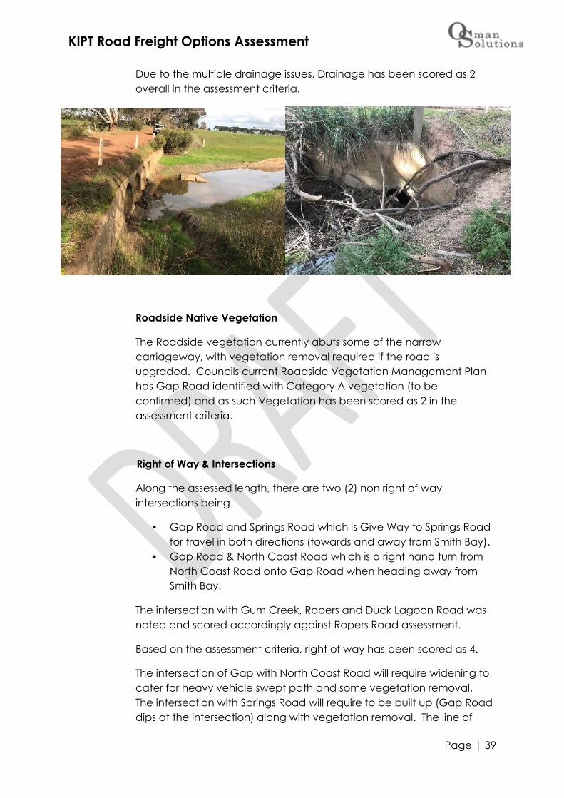
Due to the multiple drainage issues, Drainage has been scored as 2overall in the assessment criteria.
Roadside Native Vegetation
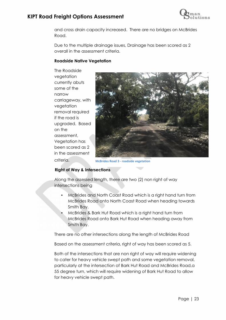
The Roadsidevegetationcurrently abutssome of thenarrowcarriageway, withvegetationremoval requiredif the road isupgraded. Basedon theassessment,Vegetation hasbeen scored as 2in the assessmentcriteria.
Right of Way & Intersections
Along the assessed length, there are two (2) non right of wayintersections being
McBrides and North Coast Road which is a right hand turn fromMcBrides Road onto North Coast Road when heading towardsSmith Bay.
McBrides & Bark Hut Road which is a right hand turn fromMcBrides Road onto Bark Hut Road when heading away fromSmith Bay.
There are no other intersections along the length of McBrides Road
Based on the assessment criteria, right of way has been scored as 5.
Both of the intersections that are non right of way will require wideningto cater for heavy vehicle swept path and some vegetation removal,particularly at the intersection of Bark Hut Road and McBrides Road,a55 degree turn, which will require widening of Bark Hut Road to allowfor heavy vehicle swept path.
McBrides Road 3 - roadside vegetation

KIPT Road Freight Options Assessment
Page | 24
Based on the assessment criteria, intersections have been scored as3.5.
Land Uses & Residential Access
All agricultural land withpaddock accesses only, noresidential driveways. Thereis also a timber plantationapproximately 1.6km fromBark Hut Road with a scoreof 5 in in the assessmentcriteria.
Traffic & Safety
McBrides road has a trafficcount of less than 10 vpdwith no crash historyreported. The speedenvironment is 100km/hr
however it is noted that due to the current condition of the road thatspeed at which vehicles actually travel is around 80km/hr. Due to thenarrow carriageway and encroaching roadside vegetation, currently itis considered that there are no safe overtaking provisions.
McBrides Road is not a School Bus route and as previously noted hasonly paddock/farmland access (no residences). Based on theassessment criteria, an average of 4 has been scored
McBrides Road 4 - timber plantation
KIPT Road Freight Options Assessment
Page | 25
4.1.5 North Coast Road (15.9km assessed)
Existing Road Conditions
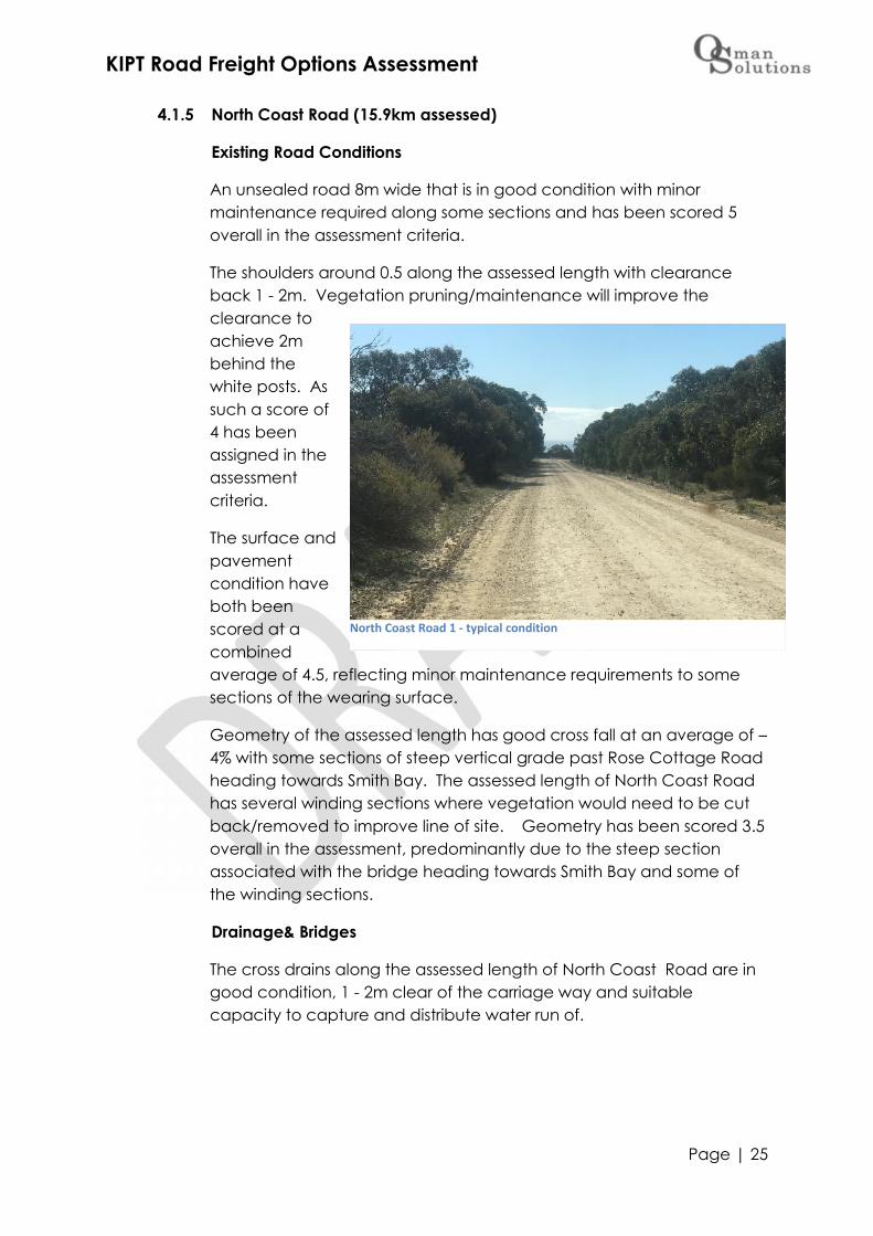
An unsealed road 8m wide that is in good condition with minormaintenance required along some sections and has been scored 5overall in the assessment criteria.
The shoulders around 0.5 along the assessed length with clearanceback 1 - 2m. Vegetation pruning/maintenance will improve theclearance toachieve 2mbehind thewhite posts. Assuch a score of4 has beenassigned in theassessmentcriteria.
The surface andpavementcondition haveboth beenscored at acombinedaverage of 4.5, reflecting minor maintenance requirements to somesections of the wearing surface.
Geometry of the assessed length has good cross fall at an average of –4% with some sections of steep vertical grade past Rose Cottage Roadheading towards Smith Bay. The assessed length of North Coast Roadhas several winding sections where vegetation would need to be cutback/removed to improve line of site. Geometry has been scored 3.5overall in the assessment, predominantly due to the steep sectionassociated with the bridge heading towards Smith Bay and some ofthe winding sections.
Drainage& Bridges
The cross drains along the assessed length of North Coast Road are ingood condition, 1 - 2m clear of the carriage way and suitablecapacity to capture and distribute water run of.
North Coast Road 1 - typical condition

KIPT Road Freight Options Assessment
Page | 26
There is a bridgecrossing (at chainage14.8 off McBridesRoad, east of theintersection withRose Cottage Road)has a carriagewaywidth of 7.1m which isconsidered narrowand w-beam crashbarriers installed toAustralian Standards.Due to the narrowcarriageway, thebridge has beenscored at 3 in theassessment criteriaand it must be noted
that structural testing of this bridge is required should this route beadopted. Options for widening to allow for heavy vehicle to safelypass each other on the bridge should also be investigated.
Roadside Native Vegetation
The Roadside vegetation is currently 1 – 2 m back from thecarriageway along the majority of the assessed length of road. Pruningmaintenance is required along approximately 65% of the assessedlength to get the vegetation back 2m behind the white marker posts.Height clearance is good (3 – 4 m clearance) with vegetation beingscored at 3.5 overall in the assessment criteria due to the potentialrequirement for cutting back/removal around corners and removal atthe intersection with Smith Bay access road to facilitate upgrade ofthat intersection.
Right of Way & Intersections
Along the assessed length, there are two (2) non right of wayintersections being
McBrides Road and North Coast Road which is a right hand turnfrom McBrides Road onto North Coast Road when headingtowards Smith Bay.
Smith Bay access road & North Coast Road which is a right handturn when heading away from Smith Bay.
The other intersections along the assessed length that are right of wayto North Coast Road are
North Coast Road 2 – approaching bridge

KIPT Road Freight Options Assessment
Page | 27
Springs Road which is just under adequate Safe Intersection SiteDistance (SIDS) due to the rise in the road heading towardsSmith Bay. Advance warning signage is installed.
Hummoky Road which provides adequate SIDS. Cassini Road which provides adequate SIDS. Rose Cottage Road which provides adequate SIDS.
Based on the assessment criteria, right of way has been scored as 4.5.
Both of theintersectionsthat are nonright of waywill requirewidening tocater forheavyvehicleswept pathand somevegetationremoval,particularlyat the
intersectionof NorthCoast Roadand Smith Bay access road where a deceleration lane on North CoastRoad to enable the vehicle to turn without encroaching on theoutgoing lane will be required. .
Based on the assessment criteria, intersections have been scored as3.5.
Land Uses & Residential Access
Predominantly agricultural land with paddock accesses along withmultiple residential driveways along the length of the assessed length.No commercial driveways were identified during the assessments andhas been scored as 3 in the assessment criteria.
North Coast Road 3 - approach to Smith Bay access (vegetation removal required forintersection upgrade)
KIPT Road Freight Options Assessment
Page | 28
Traffic & Safety
North Coast Road has a traffic count of 160 vpd13, particularly in thesummer peak tourist season and is a Regionally Significant Tourist Routein the Southern & Hills LGA 2020 Transport Plan. There is some crashhistory along the assessed length however these did not result in injuryand were attributed to wildlife and driver inattention.
The speed environment is 100km/hr and there are some overtakingprovisions along the assessed length. However it should be noted thatdue to the winding nature of some sections of the assessed roadlength, that overtaking cannot be undertaken safely along thesesections.
Currently the assessed section of North Coast Road is not a School Busroute however as previously noted is a tourist route. Based on theassessment criteria, an average of 3.3 has been scored.
13 Kangaroo Island Council Traffic Counts, Summer 2017

KIPT Road Freight Options Assessment
Page | 29
4.2 Option 5 – Playford Highway, Ropers Road, Gap Road and NorthCoast Road
4.2.1 Playford Highway (25.2km assessed)
Playford Highway is under Department of Planning, Transport &Infrastructure (DPTI) from the intersection with Birchmore Road throughto Parndana and under Kangaroo Island Council’s care and controlwest of Parndana.
Existing Road Conditions
Sealed road 6m wide fromStokes Bay Roadintersection through toParndana and 6.5m widefrom Parndana through toRopers Road and is ingood condition. Thecarriageway does havesome variation from thedescent towards Bark HutRoad (travelling east)through to Ropers Road,going down to 6m east ofthe intersection with BarkHut Road and as such hasbeen scored a 4 overall inthe assessment criteria.
Playford Highway 2 – Council controlled section (west of Parndana)

KIPT Road Freight Options Assessment
Page | 30
The shoulders are unsealed and range from 1.0 – 2.0m along theassessed length with clearance back at least 2m. East of Parndanathe shoulders are sealed 0.5 for the first 10km east of Parndana whichthen reducesto no edgelines withedge breaksevident alongsections ofthe assessedlength whichhas resultedin a score of 4in theassessmentcriteria.
The seal andpavementconditionhave both been scored at 4 overall in the assessment criteria. There issome evidence of sections of the pavement beginning to fail wheredeveloping wheel ruts on the sealed road are holding water,delamination and edgebreaks.
Geometry of theassessed length hasgood cross fall at anaverage of 3 – 4%however there is asteep descent(Kohinoor Hill) with abend in the road thatintersects with Bark HutRoad. Geometry hasbeen scored 3 overallin the assessment,predominantly due tothe steep section
known as KohinoorHill.
Playford Highway 3 – DPTI controlled section (east of Parndana)
Playford Highway 4 - evidence of seal delaminating
KIPT Road Freight Options Assessment
Page | 31
Drainage& Bridges
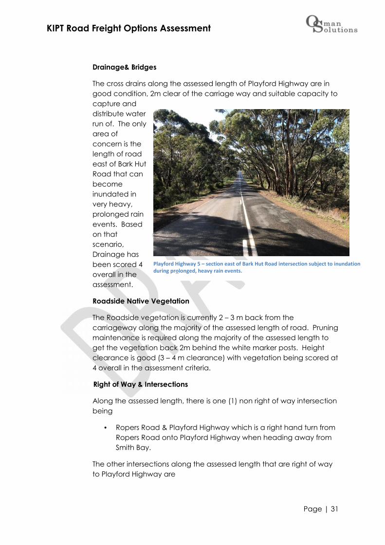
The cross drains along the assessed length of Playford Highway are ingood condition, 2m clear of the carriage way and suitable capacity tocapture anddistribute waterrun of. The onlyarea ofconcern is thelength of roadeast of Bark HutRoad that canbecomeinundated invery heavy,prolonged rainevents. Basedon thatscenario,Drainage hasbeen scored 4overall in theassessment.
Roadside Native Vegetation
The Roadside vegetation is currently 2 – 3 m back from thecarriageway along the majority of the assessed length of road. Pruningmaintenance is required along the majority of the assessed length toget the vegetation back 2m behind the white marker posts. Heightclearance is good (3 – 4 m clearance) with vegetation being scored at4 overall in the assessment criteria.
Right of Way & Intersections
Along the assessed length, there is one (1) non right of way intersectionbeing
Ropers Road & Playford Highway which is a right hand turn fromRopers Road onto Playford Highway when heading away fromSmith Bay.
The other intersections along the assessed length that are right of wayto Playford Highway are
Playford Highway 5 – section east of Bark Hut Road intersection subject to inundationduring prolonged, heavy rain events.

KIPT Road Freight Options Assessment
Page | 32
Rowland Hill Highway (110km speed zone) which providesadequate Safe Intersection Site Distance (SIDS).
Smith & Jones Streets, Parndana (80km speed zone) whichprovides adequate SIDS.
Wedgewood Road (80km speed zone) which providesadequate SIDS.
Timber Creek Road provides adequate SIDS. Bark Hut Road does not provide adequate SIDS when travelling
east due to steep descent and intersection being of the edge ofa bend in the road. Advance warning signs have been installedas an additional measure.
Branch Creek Road does not provide adequate SIDS whentravelling east due to the vegetation and intersection alignment(65 degree turn off Playford when travelling east). Advancewarning signs have been installed as an additional measure.
Margaries Road provides adequate SIDS.
Based on the assessment criteria, right of way has been scored as 4.
The intersection that is non right of way will require widening to caterfor heavy vehicle swept path and some vegetation removal, to enablethe vehicle to turn without encroaching on the outgoing lane. It shouldbe noted that SA Water main runs along the southern side of PlayfordHighway which will need to be considered when designing theintersection upgrade.
Based on the assessment criteria, intersections have been scored as 4.
Playford Highway 6 - typical condition

KIPT Road Freight Options Assessment
Page | 33
Land Uses & Residential Access
Predominantly agricultural land with paddock accesses along withsome residential driveways. There was one commercial drivewayidentified and has been scored as 3.5 in the assessment criteria.
The length of road assessed abuts the township of Parndana (speedlimit reduced to 80km for that section). There are SA Ambulance andCFS despatches from that location servicing the central and westernend of Kangaroo Island.
The commercial driveway identified services the Parndana Wildlife Parkwhich is a popular attraction generating tourist and local traffic.
The balance of the assessed length contains a mix of agricultural landwith paddock access and residential driveways. Due to the Highwayabutting the township of Parndana, the commercial driveway andnumber of residential driveways (20 counted with rural road numbersalong assessed length) Land Uses and Residential Access has beenscored 2 overall.
Traffic & Safety
Playford Highway has a traffic count of over 200 vpd and is a GazettedB-Double Route (23m) from east of Parndana (DPTI Major FreightRoad), Regionally Significant Tourist and Access Routes in the S&HLGA2020 Transport Plan . There is some crash history along the assessedlength with one reported crash resulting in a casualty and serious injury.That accident occurred near Ropers Road intersection where a vehiclefailed to keep left resulting in a head on crash. Another crashoccurred at the Parndana township where a vehicle leaving SmithStreet failed to give way (no injuries). Another occurred at a T-Junction(Mellvelle Track) where two vehicles were following too closely whenone hit an animal which resulted in five (5) casualties14.
The speed environment is 100km down to 80km through Parndana thenup to 110km west of Parndana with overtaking provisions along theassessed length.
Currently Playford Highway has two (2) School Bus routes and aspreviously noted is DPTI Major Freight Road and Regionally SignificantTourist and Access Routes. Based on the assessment criteria, anaverage of 2.3 has been scored.
14 14 www.data.sa.gov.au/data/dataset/road-crash-data

KIPT Road Freight Options Assessment
Page | 34
4.2.2 Ropers Road (4.47km assessed)
Existing Road Conditions
An unsealed roadin fair to poorcondition. Thecarriagewaywidth varies from5.5m down to3.3m and as suchhas been scoreda 2 overall in theassessmentcriteria.
The shoulders are0.5 along themajority of theroad with theexception of the600m through the Cygnet River floodway up to the single lane bridgethat is narrow, low lying (floods) with no shoulders resulting in a score of2.5 overall in the assessment criteria.
The surface and pavement condition have both been scored at 2.5overall in the assessment criteria.
Geometry of the assessed length has cross fall at an average of 2 – 3with sections of moderate vertical grade. Geometry has been scored3 overall in the assessment, predominantly due to the section through
the Cygnet Riverfloodway.
Drainage& Bridges
The cross drains along theassessed length of RopersRoad are under capacityand in fair to poorcondition. The major issueidentified is the length ofroad abutting the CygnetRiver that is prone toannual flooding alongthat would need to bebuilt up some 1.5 – 2m,
Ropers Road 1 – typical standard (200m off Playford Highway)
Ropers Road 2 - approaching floodway section that would require to be built upwith substantial tree removal

KIPT Road Freight Options Assessment
Page | 35
batters would be 2 – 3 m for a 9m wide carriageway resulting in a 15m+ working envelope vegetation clearance. This is deemed a significantWater Affecting Activity that will require NRM Board approval. Thereare other sections crossing minor creek/water ways that would requirethe road to be raised/built up and cross drain capacity increased.There are also several roadside dams identified that cause potentialflooding issues.
There is a single lane bridge (3.2mwide) with the original crashbarriers that are not to currentAustralian Standards. There areold timber bridge pylons situatedto the east of the current bridge.The existing bridge would eitherhave to be widened, or a newdouble lane bridge constructed.
Due to the multiple drainageissues and single lane bridgeconstraint, Drainage & Bridgeshas been scored as 1 overall inthe assessment criteria.
Roadside Native Vegetation
The Roadside vegetation currently abuts some of the narrowcarriageway, with vegetation removal (large gum trees) required if theroad isupgraded.Based on theassessment,Vegetationhas beenscored as 1.5in theassessmentcriteria.
Ropers Road 3 - single lane bridge spanning Cygnet River
Ropers Road 4 - narrow section that would require significant tree removal
KIPT Road Freight Options Assessment
Page | 36
Right of Way & Intersections
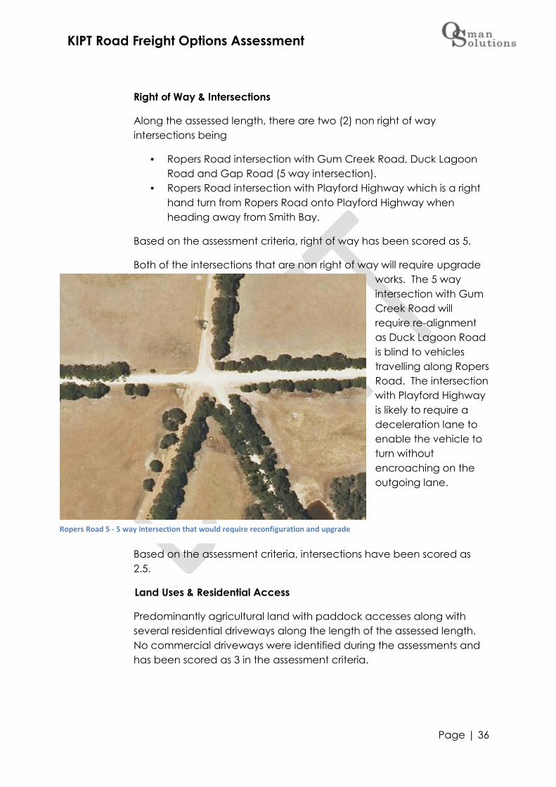
Along the assessed length, there are two (2) non right of wayintersections being
Ropers Road intersection with Gum Creek Road, Duck LagoonRoad and Gap Road (5 way intersection).
Ropers Road intersection with Playford Highway which is a righthand turn from Ropers Road onto Playford Highway whenheading away from Smith Bay.
Based on the assessment criteria, right of way has been scored as 5.
Both of the intersections that are non right of way will require upgradeworks. The 5 wayintersection with GumCreek Road willrequire re-alignmentas Duck Lagoon Roadis blind to vehiclestravelling along RopersRoad. The intersectionwith Playford Highwayis likely to require adeceleration lane toenable the vehicle toturn withoutencroaching on theoutgoing lane.
Based on the assessment criteria, intersections have been scored as2.5.
Land Uses & Residential Access
Predominantly agricultural land with paddock accesses along withseveral residential driveways along the length of the assessed length.No commercial driveways were identified during the assessments andhas been scored as 3 in the assessment criteria.
Ropers Road 5 - 5 way intersection that would require reconfiguration and upgrade
KIPT Road Freight Options Assessment
Page | 37
Traffic & Safety
Ropers Road has a traffic count of 33 vpd15 with no crash historyreported. The speed environment is 100km/hr however it is noted thatthrough the narrow section of the road vehicles actually travel ataround 80km/hr. Through the narrow section there are no safeovertaking provisions, however there along the strait, flat sections ateither end.
Ropers Road is not a School Bus route and there are no reportedcrashes. Based on the assessment criteria, an average of 4 has beenscored.
15 Kangaroo Island Council Traffic Count, Spring 2012

KIPT Road Freight Options Assessment
Page | 38
4.2.3 Gap Road (6.9km assessed)
Existing Road Conditions
An unsealed, low class road in fair condition. The carriageway widthvaries from 6.5m down to 4.8m and as such has been scored a 3overall in the assessment criteria.
The shoulders are 0.0 – 0.5 along the assessed length with clearanceonly 1 – 2m resulting in a score of 3.5 overall in the assessment criteria.
The surface and pavement condition have both been scored at 2 and2.5 respectively in the assessment criteria. It is noted that Council haverecent patched sections between Gum Creek and Springs Roads andthat re-sheeting of that same section is programmed for 2017/18Financial Year.
Geometry ofthe assessedlength haspoor cross fallat anaverage of 1– 2 % withseveralsections thatdip wherewaterways/creeks cross(see Drainagefor further
details).Generally therises and falls of the grades are gradual resulting in an overall score of3.
Drainage& Bridges
The cross drains along the assessed length of Gap Road are generallyunder capacity and require maintenance, including extension. Thereare several creek/water way crossings that would require the road tobe raised/built up and cross drain capacity increased. These drainsrange from 1200mm with several 600mm demonstrating thecatchments and drainage requirements in the area. There is a 4 x600dia creek crossing that is just under the classification of a bridge (7mor greater span) that would require upgrade subject to hydrologicalassessment.
Gap Road 1 - typical condition
KIPT Road Freight Options Assessment
Page | 39
Due to the multiple drainage issues, Drainage has been scored as 2overall in the assessment criteria.
Roadside Native Vegetation
The Roadside vegetation currently abuts some of the narrowcarriageway, with vegetation removal required if the road isupgraded. Councils current Roadside Vegetation Management Planhas Gap Road identified with Category A vegetation (to beconfirmed) and as such Vegetation has been scored as 2 in theassessment criteria.
Right of Way & Intersections
Along the assessed length, there are two (2) non right of wayintersections being
Gap Road and Springs Road which is Give Way to Springs Roadfor travel in both directions (towards and away from Smith Bay).
Gap Road & North Coast Road which is a right hand turn fromNorth Coast Road onto Gap Road when heading away fromSmith Bay.
The intersection with Gum Creek, Ropers and Duck Lagoon Road wasnoted and scored accordingly against Ropers Road assessment.
Based on the assessment criteria, right of way has been scored as 4.
The intersection of Gap with North Coast Road will require widening tocater for heavy vehicle swept path and some vegetation removal.The intersection with Springs Road will require to be built up (Gap Roaddips at the intersection) along with vegetation removal. The line of

KIPT Road Freight Options Assessment
Page | 40
sight on Gap Road looking east on Springs Road heading towardsSmith Bay is obscured by a bend in the road and vertical grade withvegetation requiring removal.
Based on the assessment criteria, intersections have been scored as 3.
Land Uses & Residential Access
Predominantly agricultural land with paddock accesses along withseveral,residentialdrivewaysalong thelength of theassessedlength. Nocommercialdriveways wereidentifiedduring theassessmentsand has beenscored as 3 inthe assessmentcriteria.
Traffic & Safety
Ropers Road has a traffic count of 46 vpd16 with no crash historyreported. The speed environment is 100km/hr however it is noted thatthrough the narrow section of the road vehicles actually travel ataround 80km/hr. Through the narrow section there are no safeovertaking provisions, however there along the strait, flat sections ateither end.
Ropers Road is not a School Bus route however there is a reportedcrash (no injuries, driver inattention). Based on the assessment criteria,an average of 3.6 has been scored
16 Kangaroo Island Council Traffic Count Spring 2015
Gap Road 2 - typical standard between Springs Road and North Coast Road

KIPT Road Freight Options Assessment
Page | 41
4.2.4 North Coast Road (6.8km assessed)
Existing Road Conditions
An unsealed road 7m wide that is in good condition and has beenscored 5 overall in the assessment criteria.
The shoulders around 0.5 along the assessed length with clearanceback 2 - 3m. Vegetation pruning/maintenance will improve the line ofsight for curves and bends in the road. As such a score of 5 has beenassigned in the assessment criteria.
The surface and pavementcondition have both beenscored at a combinedaverage of 4.5, reflectingminor maintenancerequirements to somesections of the wearingsurface.
Geometry of the assessedlength has good cross fall atan average of 5% withgradual vertical. Theassessed length of NorthCoast Road has severalwinding sections wherevegetation would need tobe cut back/removed to
improve line of site. Geometry has been scored 4 overall in theassessment, predominantly due to the winding sections.
Drainage& Bridges
The cross drains along the assessed length of North Coast Road are ingood condition, 1 - 2m clear of the carriage way and suitablecapacity to capture and distribute water run of.
There are no bridges along this section of North Coast Road, FORDS orroadside dams and as such Drainage & Bridges has been scored 5.
Roadside Native Vegetation
The Roadside vegetation is currently 1 – 2 m back from thecarriageway along the majority of the assessed length of road. Pruningmaintenance is required for corners and bends to improve line of sight.
North Coast Road 4 - typical condition

KIPT Road Freight Options Assessment
Page | 42
Height clearance is good (3 – 4 m clearance) with vegetation beingscored at 4 overall in the assessment criteria.
Right of Way & Intersections
Along the assessed length, there are two (2) non right of wayintersections being
North Coast Road and Smith Bay access road which is a righthand turn from North Coast Road onto the Smith Bay accessroad when heading towards Smith Bay.
North Coast Road & Gap Road which is a right hand turn whenheading away from Smith Bay.
The no otherintersectionsalong theassessedlength of NorthCoast Road.Based on theassessmentcriteria,intersectionshave beenscored as 4.
Land Uses & Residential Access
Predominantly agricultural land with paddock accesses along withmultiple residential driveways along the length of the assessed length.Two (2) commercial driveways were identified during the assessments(Willsons Quarry and Abalone Farm) and has been scored as 3 in theassessment criteria.
Traffic & Safety
North Coast Road has a traffic count of 160 vpd17, particularly in thesummer peak tourist season and is a Regionally Significant Tourist Routein the Southern & Hills LGA 2020 Transport Plan. There is some crash
17 Kangaroo Island Council Traffic Count Summer 2017
North Coast Road 5 - intersection with Gap Road

KIPT Road Freight Options Assessment
Page | 43
history along the assessed length however these did not result in injuryand were attributed to driver inattention.
The speed environment is 100km/hr and there are some overtakingprovisions along the assessed length. However it should be noted thatdue to the winding nature of some sections of the assessed roadlength, that overtaking cannot be undertaken safely along thesesections.
Part of the assessed section of North Coast Road is a School Bus routeand as previously noted is a Regionally Significant Tourist route. Basedon the assessment criteria, an average of 2 has been scored.
KIPT Road Freight Options Assessment
Page | 44
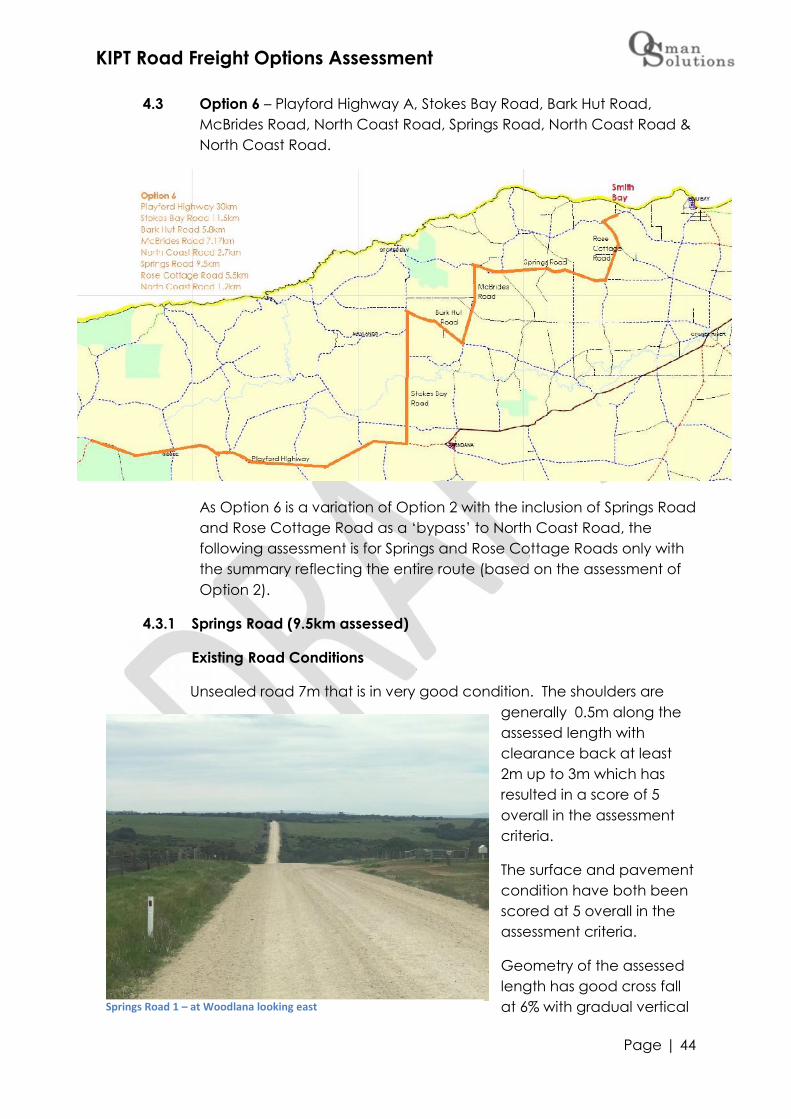
4.3 Option 6 – Playford Highway A, Stokes Bay Road, Bark Hut Road,McBrides Road, North Coast Road, Springs Road, North Coast Road &North Coast Road.
As Option 6 is a variation of Option 2 with the inclusion of Springs Roadand Rose Cottage Road as a ‘bypass’ to North Coast Road, thefollowing assessment is for Springs and Rose Cottage Roads only withthe summary reflecting the entire route (based on the assessment ofOption 2).
4.3.1 Springs Road (9.5km assessed)
Existing Road Conditions
Unsealed road 7m that is in very good condition. The shoulders aregenerally 0.5m along theassessed length withclearance back at least2m up to 3m which hasresulted in a score of 5overall in the assessmentcriteria.
The surface and pavementcondition have both beenscored at 5 overall in theassessment criteria.
Geometry of the assessedlength has good cross fallat 6% with gradual verticalSprings Road 1 – at Woodlana looking east

KIPT Road Freight Options Assessment
Page | 45
grades however there is one section near the Millers Road intersectionwhich is steep and winding which has resulted in an overall score of 3.5in the assessment criteria.
Drainage& Bridges
The cross drains along the assessed length of Springs Road are in goodcondition, 1m clear of the carriage way and suitable capacity tocapture and distribute water run-off. There are no bridges alongSprings Road which has resulted in a score of 5 in the assessmentcriteria.
Roadside Native Vegetation
The Roadsidevegetation iscurrently 2 – 3 mback from thecarriageway alongthe majority of theassessed length ofroad. Someoverhead clearanceis required along withsome tree removalaround some cornersto improve line ofsight. Vegetation hasbeen scored at 3.5overall in the assessment criteria.
Right of Way & Intersections
Along the assessed length, there are two (2) non right of wayintersections being:-
North Coast Road and Springs Road which is a right hand turnfrom North Coast Road onto Springs Road when headingtowards Smith Bay.
Rose Cottage Road and Springs Road which is a right hand turnwhen heading away from Smith Bay.
The other intersections along the assessed length that are right of wayto Springs Road are:-
Springs Road 2 – vegetation that needs to be cut back

KIPT Road Freight Options Assessment
Page | 46
Millers Road which is marginally short of adequate SafeIntersection Site Distance (SIDS). When heading towards SmithBay, the approach to the Millers Road intersection is a relativelysteep descent that has a couple of curves, limiting line of sight
and the ability to pull up a heavyvehicle impacted.
Based on the assessment criteria,right of way has been scored as4.
Both of the intersections that arenon right of way will requirewidening to cater for heavyvehicle swept path and somevegetation removal, particularlyat the intersection of Springs andRose Cottage Road.
Based on the assessment criteria,intersections have been scoredas 4.
Land Uses & Residential Access
Predominantly agricultural land with paddock accesses along withmultiple residential accesses. No commercial driveways wereidentified during the assessments however it should be noted thatSprings Road dissects Woodlana Station where livestock is often movedalong and across the road. Land Uses has been scored as 3 in theassessment criteria.
Traffic & Safety
Springs Road has a traffic count of 12918 vpd. As the road has recentlybeen upgraded it is assumed that vehicle counts have increased.There is no crash history along the assessed length however is a SchoolBus route.
The speed environment is 100km/hr with some overtaking provisionsalong the assessed length. Based on the assessment criteria, anaverage of 3.6 has been scored
18 Kangaroo Island Council Traffic Count Spring 2016
Springs Road 3 – Springs Road and North Coast Road intersection
Springs Road 4 – intersection with Rose Cottage Road
KIPT Road Freight Options Assessment
Page | 47
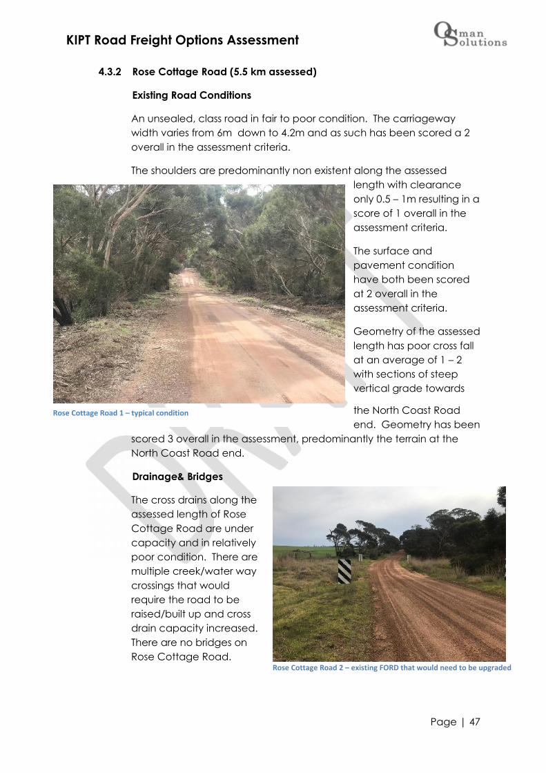
4.3.2 Rose Cottage Road (5.5 km assessed)
Existing Road Conditions
An unsealed, class road in fair to poor condition. The carriagewaywidth varies from 6m down to 4.2m and as such has been scored a 2overall in the assessment criteria.
The shoulders are predominantly non existent along the assessedlength with clearanceonly 0.5 – 1m resulting in ascore of 1 overall in theassessment criteria.
The surface andpavement conditionhave both been scoredat 2 overall in theassessment criteria.
Geometry of the assessedlength has poor cross fallat an average of 1 – 2with sections of steepvertical grade towards
the North Coast Roadend. Geometry has been
scored 3 overall in the assessment, predominantly the terrain at theNorth Coast Road end.
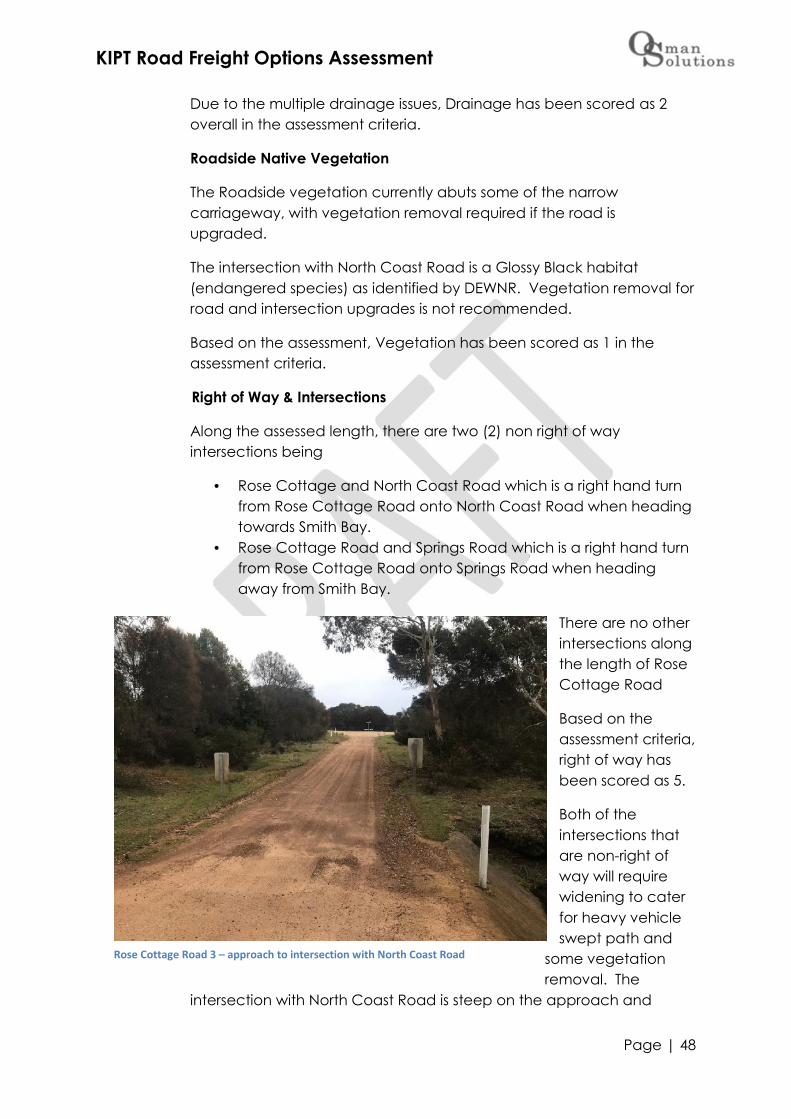
Drainage& Bridges
The cross drains along theassessed length of RoseCottage Road are undercapacity and in relativelypoor condition. There aremultiple creek/water waycrossings that wouldrequire the road to beraised/built up and crossdrain capacity increased.There are no bridges onRose Cottage Road.
Rose Cottage Road 1 – typical condition
Rose Cottage Road 2 – existing FORD that would need to be upgraded
KIPT Road Freight Options Assessment
Page | 48
Due to the multiple drainage issues, Drainage has been scored as 2overall in the assessment criteria.
Roadside Native Vegetation
The Roadside vegetation currently abuts some of the narrowcarriageway, with vegetation removal required if the road isupgraded.
The intersection with North Coast Road is a Glossy Black habitat(endangered species) as identified by DEWNR. Vegetation removal forroad and intersection upgrades is not recommended.
Based on the assessment, Vegetation has been scored as 1 in theassessment criteria.
Right of Way & Intersections
Along the assessed length, there are two (2) non right of wayintersections being
Rose Cottage and North Coast Road which is a right hand turnfrom Rose Cottage Road onto North Coast Road when headingtowards Smith Bay.
Rose Cottage Road and Springs Road which is a right hand turnfrom Rose Cottage Road onto Springs Road when headingaway from Smith Bay.
There are no otherintersections alongthe length of RoseCottage Road
Based on theassessment criteria,right of way hasbeen scored as 5.
Both of theintersections thatare non-right ofway will requirewidening to caterfor heavy vehicleswept path and
some vegetationremoval. The
intersection with North Coast Road is steep on the approach and
Rose Cottage Road 3 – approach to intersection with North Coast Road

KIPT Road Freight Options Assessment
Page | 49
meets with North Coast Road on a dip of a bend with insufficient line ofsight. The intersection would need to be raised considerably butwould still have limited line of sight onto North Coast Road. There is acreek crossing (FORD) 80 back from the intersection that would have tobe raised and upgraded to enable laden heavy vehicles to pull upand stop safely at the intersection. The extent of works required for anintersection upgrade would impact on Glossy Black habitat and is notrecommended.
Based on the assessment criteria, intersections have been scored as 1.
Land Uses & Residential Access
All agricultural land with paddock access with several residentialdriveways. No commercial activity was identified during theassessment and as such has a score of 4 in in the assessment criteria.
Traffic & Safety
Rose Cottage Road has a traffic count of less than 10 vpd with nocrash history reported. The speed environment is 100km/hr however it isnoted that due to the current condition of the road that speed atwhich vehicles actually travel is around 80km/hr. Due to the narrowcarriageway and encroaching roadside vegetation, currently it isconsidered that there are no safe overtaking provisions.
Rose Cottage Road is not a School Bus route and as previously notedhas several FORD crossings that reduce the speed vehicles generallytravel. Based on the assessment criteria, an average of 3.6 has beenscored
KIPT Road Freight Options Assessment
Page | 50
5.0 Summary of Assessments
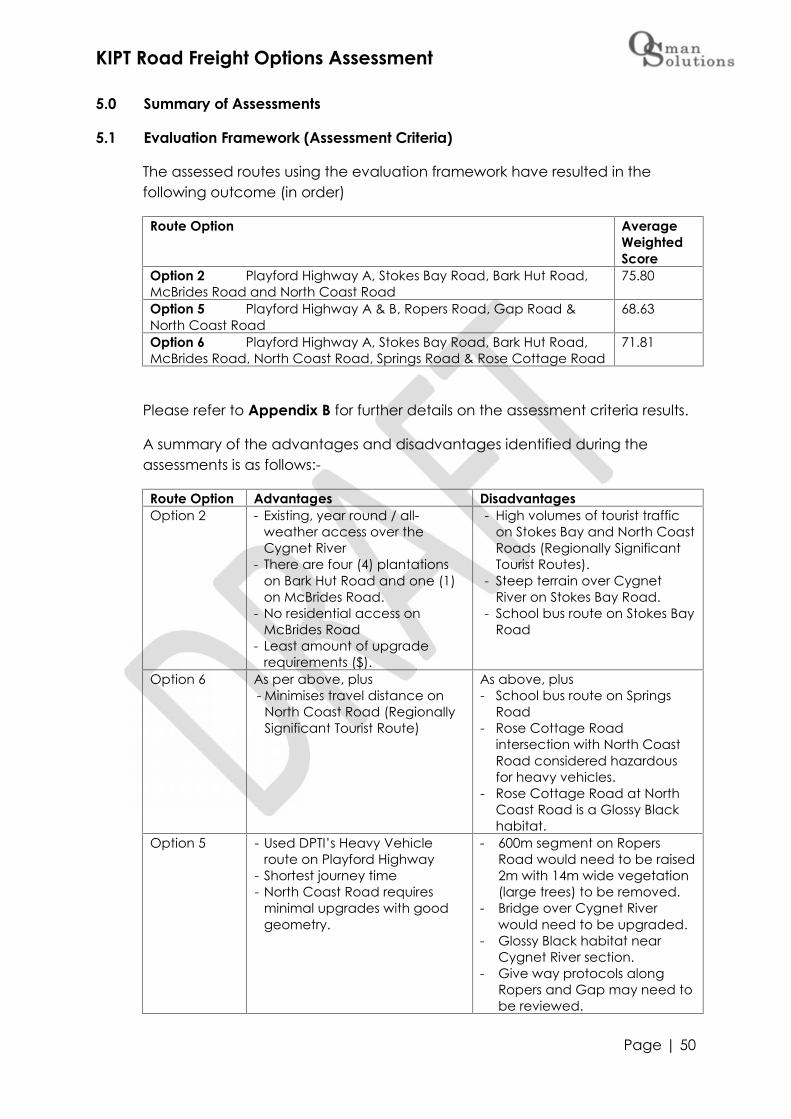
5.1 Evaluation Framework (Assessment Criteria)
The assessed routes using the evaluation framework have resulted in thefollowing outcome (in order)
Route Option AverageWeightedScore
Option 2 Playford Highway A, Stokes Bay Road, Bark Hut Road,McBrides Road and North Coast Road
75.80
Option 5 Playford Highway A & B, Ropers Road, Gap Road &North Coast Road
68.63
Option 6 Playford Highway A, Stokes Bay Road, Bark Hut Road,McBrides Road, North Coast Road, Springs Road & Rose Cottage Road
71.81
Please refer to Appendix B for further details on the assessment criteria results.
A summary of the advantages and disadvantages identified during theassessments is as follows:-
Route Option Advantages DisadvantagesOption 2 - Existing, year round / all-
weather access over theCygnet River
- There are four (4) plantationson Bark Hut Road and one (1)on McBrides Road.
- No residential access onMcBrides Road
- Least amount of upgraderequirements ($).
- High volumes of tourist trafficon Stokes Bay and North CoastRoads (Regionally SignificantTourist Routes).
- Steep terrain over CygnetRiver on Stokes Bay Road.
- School bus route on Stokes BayRoad
Option 6 As per above, plus- Minimises travel distance on
North Coast Road (RegionallySignificant Tourist Route)
As above, plus- School bus route on Springs
Road- Rose Cottage Road
intersection with North CoastRoad considered hazardousfor heavy vehicles.
- Rose Cottage Road at NorthCoast Road is a Glossy Blackhabitat.
Option 5 - Used DPTI’s Heavy Vehicleroute on Playford Highway
- Shortest journey time- North Coast Road requires
minimal upgrades with goodgeometry.
- 600m segment on RopersRoad would need to be raised2m with 14m wide vegetation(large trees) to be removed.
- Bridge over Cygnet Riverwould need to be upgraded.
- Glossy Black habitat nearCygnet River section.
- Give way protocols alongRopers and Gap may need tobe reviewed.

KIPT Road Freight Options Assessment
Page | 51
5.2 Upgrade and Annual Maintenance Preliminary Estimates
What also needs to be considered when selecting a preferred option isdistance, journey time, upgrade and maintenance costs.
The cost estimates below are preliminary estimates based on square meterrates (Rawlinsons and local knowledge). Note that these preliminaryestimates are indicative only and have been compiled to aid the optionsassessment.
Upgrade costs include vegetation clearance, excavation, drainage, bridgeupgrades, pavement construction, resheeting and shoulder sealing.Intersection upgrades have also been included which accounts for adeceleration lane on North Coast Road at the intersection with Smith Bayaccess road, Playford Highway and Stokes Bay Road and Playford Highwayand Ropers Road.
Maintenance costs include grading, patching, drain maintenance, cracksealing, potholes, line marking and roadside vegetation. Maintenance costsexclude operating expenses such as administration, depreciation andfinance costs.
Please refer to Appendix C for further details on the estimated unit rates usedin determining preliminary estimates.
RouteOption
Distance(km)
JourneyTime
Upgradeindicativepreliminaryestimate
Maintenanceindicativepreliminaryestimate pa
Upgrade/km
Option 2 70.37 103 mins $2,985,000 $ 233,000 $42,000Option 5 73.37 107 mins $5,135,000 $ 216,000 $70,000Option 6 73.37 109 mins $4,625,000 $ 246,000 $63,000
The distance for both Option 6 and 5 is the same, however the journey timefor Option 6 is marginally more than Option 5 due to the additionalintersections navigated. It is noted that once the roads are upgraded alongthe preferred route, journey time will be reduced as heavy vehicles will beable to maintain 80km/hr along the majority of the distance.
Upgrade estimates reflect the length of road requiring upgrade where Option2 is predominantly for McBrides Road (7.17km) and shoulder sealing onPlayford Highway (30km) and Stokes Bay Road (11.5km) as compared toOption 6 which requires McBrides (7.17km) and Rose Cottage (5.5km) alongwith shoulder sealing on Playford Highway and Stokes Bay Road or Option 5which requires Ropers (4.47km) and Gap Road (6.9km) along with shouldersealing along Playford Highway (52.5km). The number of intersections along

KIPT Road Freight Options Assessment
Page | 52
the route has also impacted the upgrade estimates where Option 2 andOption 5 both have five (5) intersections that require upgrade unlike Option 6which has eight (8) intersections that require upgrade.
Maintenance estimates exclude administration, depreciation and financecosts. Option 5 has the longest length of sealed road (Playford Highway)which has a lower annual maintenance preliminary estimate as compared tounsealed maintenance.
5.3 Assessment Outcomes
To compare the three options against the assessment criteria outcomes,distance, journey time, upgrade estimates and annual maintenanceestimates the table below reflects the combined comparisons by denotingthe preferred option against each of the assessment areas:-
RouteOption
EvaluationFrameworkOutcomes
Distance JourneyTime
UpgradeEstimates
MaintenanceEstimates
Option 2
Option 5
Option 6
Based on the assessment outcomes, it is recommended that Option 2 beconsidered for Road Safety Audit, engineering upgrade requirements andNative Vegetation assessments.

KIPT Road Freight Options Assessment
Page | 53
6.0 Funding Options
As per Council’s Road Network Extension Policy19 “Council will not developand construct new road nor upgrade an existing road unless the associatedconstruction or upgrade costs are fully borne by the Applicant/s – or – theconstruction or upgrade is undertaken with the assistance of a significantfinancial co-contribution provided by the Applicant/s, they having proven theconstruction or upgrade is warranted within the Kangaroo Island StrategicManagement Plan and subsequently, having any related costs included inthe current budget.”
The policy also states “Council’s funding for applications (external andinternal) to extend or upgrade the road network is dependant upon;
2.2.1 additional funds are gained via the Roads to Recovery scheme,whether they be from State and/or Federal funding streams,
2.2.2 evidentiary need being established. That being that a case for prioritydevelopment be made based upon community socio-economic need.
The Kangaroo Island Strategic Management Plan 2014 – 2018 have thefollowing ‘actions’ that align with the proposed road upgrades based on theSmith Bay proposal by KIPT being:-
Action 7.1 Advocate for affordable access to Island by both sea and air,for freight and people.
Action 11.2 Optimise opportunities for Private Works.
Action 12.1 Review underutilised reserve/non-useable assets and explorepotential to lease, sell or co-develop for commercial orcommunity return.
Action 13.1 E tags for non-residential road users
Action 14.2 Package infrastructure service opportunities with otherCommunity investment propositions to increase attractivenessfor Public Private Partnership (PPP) potential.
Action 17.1 Encourage investment opportunities.
The Southern & Hills Local Government Association 2020 Transport Plan is thestrategic transport plant document for the Southern & Hills Region that isaligned to South Australia’s Strategic Plan.
19 Kangaroo Island Council Road Network Extension Policy March 2014

KIPT Road Freight Options Assessment
Page | 54
It is proposed that based on the preferred freight route option be supportedby Council and included in the 2020 Transport plan with a view to secureSpecial Local Roads Programme (SLRP) funding through the Roads WorkingParty.
An overview of the process is depicted below:-
Following is an overview of SLRP funding and how it is allocated along withother potential funding programmes that could be accessed.
Special Local Roads Program (SLRP)
SLRP is funded with 15% of the Local Roads Grants allocated to the State aspart of the Financial Assistance Grants (FAGs) and 15% of the State allocationof Roads to Recovery.
In 2016/17 the Local Road Funding for SA was $38.7m of which $5.8m went toSLRP along with $9.8m from Road to Recovery. Southern & Hills LGA(Kangaroo Island is a member) allocation was $1.7m in 2016/17 with thesuccessful projects being funded 1/3 Council and the balance (2/3) SLRP. Itwould be unlikely for the Region’s full allocation to go to just one (1) Council.

KIPT Road Freight Options Assessment
Page | 55
Local Government Transport Advisory Panel (LGTAP) make recommendationsto the LGA Board based on the submissions from the various regional andmetropolitan local government associations. LGTAP give preference to thoseprojects that have been developed through Regional Transport Plans (ieSouthern & Hills LGA 2020 Transport Plan) and transparent planning processes.
The nominations for 2017/18 have been submitted. The next round ofnominations will be put forward by the S&HLGA Road Working Party generallyaround February based on the defects assessments of the revised RegionalFreight, Tourist and Community Access routes which will be done October –November 2017.
National Heavy Vehicle Safety and Productivity Program (NHVSPP)
The Australian Government has extended the Heavy Vehicle Safety andProductivity Programme and will provide $40 million per year from 2021-22onwards, building on the current $328 million investment from 2013-14 to 2020-21. The HVSPP is an Australian Government initiative to fund infrastructureprojects that improve productivity and safety outcomes of heavy vehicleoperations across Australia.
Applications are assessed through a competitive, merit basis process withapplicants funding ½ of the project. Round 5 successful projects wereannounced in September 2016. Applications for Round 6 are currently closedwith no advice on when it will open.
Black Spot Funding
For individual sites such as intersections, mid-block or short road sections, thereshould be a history of at least three casualty crashes over a five-year period.For lengths of road, there should be an average of 0.2 casualty crashes perkilometer per annum over the length in question over five years.
The requirement of a history of crashes ensures that those sites that have arecurrent problem are targeted first for treatment.
The Black Spot Programme also recognises that there are road locationswhich could be considered as 'accidents waiting to happen'. Therefore, someprogramme funds may be used to treat sites where road traffic engineershave completed a Road Safety Audit and found that remedial work isnecessary. This allows an opportunity for proactive safety works to beundertaken before casualties occur.
In line with national road safety objectives, approximately 50% of each State’sallowance is allocated to rural areas, acknowledging the high rate and
KIPT Road Freight Options Assessment
Page | 56
consequences of crashes in rural areas (60% of fatalities are in rural areas anda significant proportion of serious injuries outside the metropolitan area).
Federal Black Spot Funding is 100% funded by the Department ofInfrastructure and Regional Development. State Black Spot Funding is 50/50funded by DPTI and Council.
Bridges Renewal Program
The Australian Government will provide $360 million from 2015-16 to 2019-20,with an on-going commitment of $60 million each year following to upgradeand repair bridges to enhance access for local communities and facilitatehigher productivity vehicle access.
Round 3 closed in May 2017 with a co-funding requirement of 50%.
Regional Growth Fund
The Australian Government will provide $472.2 million over four years from2017-18 to establish a Regional Growth Fund.
The Regional Growth Fund includes $272.2 million to provide grants of $10.0million or more for major transformational projects which support long-termeconomic growth and create jobs in regions undergoing structuraladjustment.
Also in the Regional Growth Fund is a further $200 million for the Building BetterRegions Fund (BBRF) for four years from 2017-18. This builds on thecommitment to the BBRF at the 2016 election, bringing the BBRF to nearly $500million.
Please monitor this website for any announcements regarding funding underthe Regional Growth Fund.
Building Better Regions Fund
The Building Better Regions Fund (BBRF) will create jobs, drive economicgrowth and support strong regional communities across Australia by fundinginfrastructure and community investment projects.
The BBRF invests in eligible projects in regional and remote Australia, outsidethe major capital cities of Sydney, Melbourne, Brisbane, Perth, Adelaide, andCanberra.
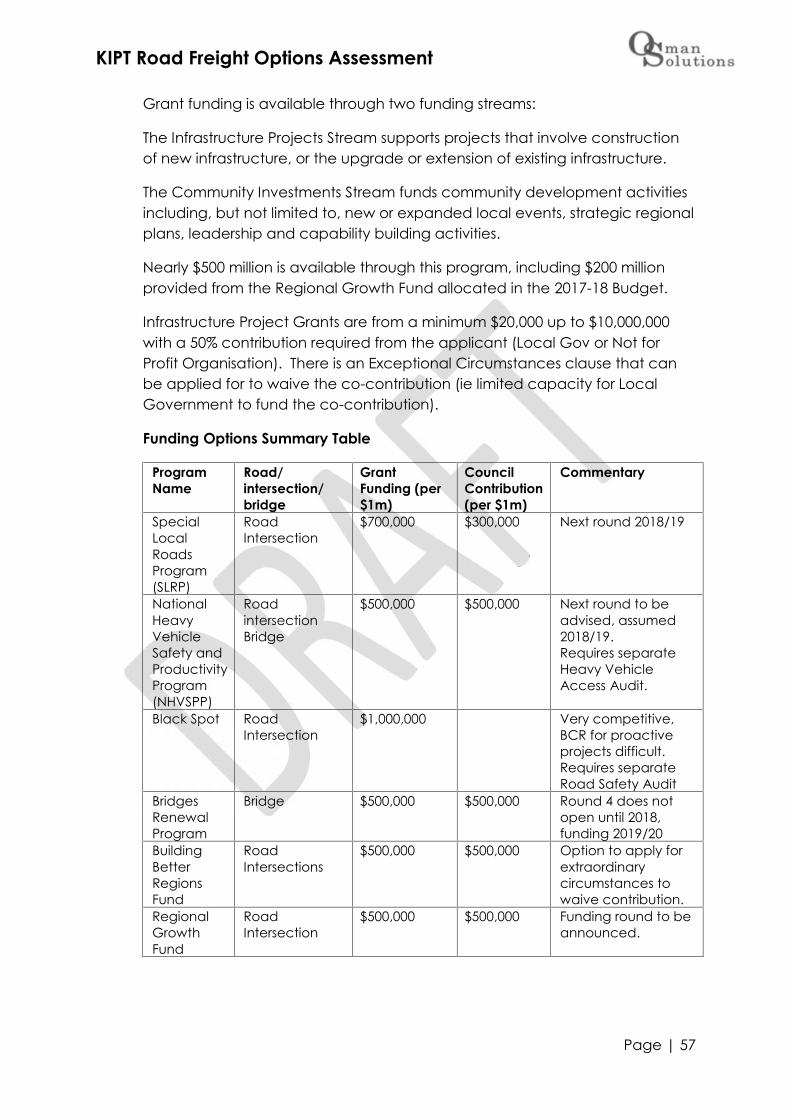
KIPT Road Freight Options Assessment
Page | 57
Grant funding is available through two funding streams:
The Infrastructure Projects Stream supports projects that involve constructionof new infrastructure, or the upgrade or extension of existing infrastructure.
The Community Investments Stream funds community development activitiesincluding, but not limited to, new or expanded local events, strategic regionalplans, leadership and capability building activities.
Nearly $500 million is available through this program, including $200 millionprovided from the Regional Growth Fund allocated in the 2017-18 Budget.
Infrastructure Project Grants are from a minimum $20,000 up to $10,000,000with a 50% contribution required from the applicant (Local Gov or Not forProfit Organisation). There is an Exceptional Circumstances clause that canbe applied for to waive the co-contribution (ie limited capacity for LocalGovernment to fund the co-contribution).
Funding Options Summary Table
ProgramName
Road/intersection/bridge
GrantFunding (per$1m)
CouncilContribution(per $1m)
Commentary
SpecialLocalRoadsProgram(SLRP)
RoadIntersection
$700,000 $300,000 Next round 2018/19
NationalHeavyVehicleSafety andProductivityProgram(NHVSPP)
RoadintersectionBridge
$500,000 $500,000 Next round to beadvised, assumed2018/19.Requires separateHeavy VehicleAccess Audit.
Black Spot RoadIntersection
$1,000,000 Very competitive,BCR for proactiveprojects difficult.Requires separateRoad Safety Audit
BridgesRenewalProgram
Bridge $500,000 $500,000 Round 4 does notopen until 2018,funding 2019/20
BuildingBetterRegionsFund
RoadIntersections
$500,000 $500,000 Option to apply forextraordinarycircumstances towaive contribution.
RegionalGrowthFund
RoadIntersection
$500,000 $500,000 Funding round to beannounced.

KIPT Road Freight Options Assessment
Page | 58
Council Contribution Funding Options
Please note that the following options are to enable discussion betweenCouncil and KIPT and are only the opinion of the author of this routeassessment report. The following commentary is not intended to reflectCouncil’s position on funding options and is provided to inform of possibleoptions. The information provided is publically available.
DPTI $2m Funding
An option to be considered would be to direct some of the Department ofTransport and Planning (DPTI) $2m Unsealed Roads Upgrade funding towardsthe agreed projects.
However it must be noted that this funding is not a grant and as such notrecorded as income in the financial statements. Rather DPTI take over ‘careand control’ of the nominated road under the Highways Act for a 12 monthperiod while the contracted upgrade works are undertaken. The asset is thenre-assigned back to Council and received as an asset free of charge.Council act as Project Managers on DPTI’s behalf which is claimed by Councilas operational income which is then capitalised against the project inaccordance with Australian Accounting Standards.
It is likely that model of funding would not suit the co-contributionrequirements of the funding programmes identified earlier in this report. Ifclearly disclaimed during the nomination and application process for SLRPthat the whole length of road is being nominated for funding however the 1/3contribution from Council will be done separately by the DPTI contractor maybe accepted, but may not be supported by the other Council’s in the region(they do not get that option) or LGTAP.
Council could discuss the funding arrangement with DPTI with a view toreceive a portion of the funding as income (cash) equivalent to the level ofgrant funding co-contribution levels. However as this grant funding is essentialto Council’s asset sustainability position, any changes to the fundingarrangement may not be supported.
Borrowing additional funds
Based on the Economic Impact Study being undertaken by EconSearch,there may be an option for Council to borrow additional funds. This would beadditional to the current level of capital expenditure which is $1.5m (net) asper the adopted Long Term Financial Plan.
Repayment of the borrowings could be funded by way of operationalincome received under a Freight Road Toll or Road Management Agreementbetween KIPT and Council. The toll would need to include a proportion ofinterest and principle payments along with increased depreciation.

KIPT Road Freight Options Assessment
Page | 59
Any agreement would also need to address costs and responsibility forincreased maintenance requirements for timber freight roads includinggrading, patching and likely pavement stabilisation needs (dust, stormwaterand corrugation mitigation).
Primary beneficiary of the upgrades and the portion of costs based on benefitwould need to be considered in detail, including the impacts of othercommodity being shipped off island via the Smith Bay Wharf in the future (ie KIPure Grain) who would gain benefit from using the upgraded freight network.
Upfront Capital Contribution
KIPT may consider an upfront capital contribution to Council. As this will havean impact on Financial Statements and therefore FAGs grant allocation, maynot be supported by Council. However a payment to part fund co-contribution requirements for grant funding options supplemented by a RoadManagement Agreement would warrant further assessment and discussion.
As per the Road Maintenance Agreement, should other commodities enjoythe benefit of the upgraded freight roads and/or new port facility thecontribution and ongoing costs would need to be reapportioned. It isconsidered that the current level of general freight that will enjoy the benefitof the upgraded roads is accounted for by way of the grant contribution andthey should not be required to contribute unless freight movements for anyone commodity increase to Regional levels (ie 20 Semi movements perday/10 B-Double movements per day/50,000 tonne of freight per annum).

KIPT Road Freight Options Assessment
Page | 60
Summary of Council Funding Options
Benefits/Positives Constraints/NegativesDPTI $2m roads funding Funding already
provided Not received as
Income, rather AssetReceived Free ofCharge.
Road ManagementAgreement (off setadditional Councilborrowing)
Additional incomestream to reducemaintenance costs forCouncil (Strategic Plan& Road NetworkExtension Policy)
Enables Levels ofService to benegotiated andagreed to (KIPT hassome control over roadcondition = managingfleet operational costs)
Apportioning costsbetween Council andKIPT allowing for anyfuture beneficiaries
Upfront CapitalContribution(off set additional Councilborrowing)
Additional incomestream to reducemaintenance costs forCouncil (Strategic Plan& Road NetworkExtension Policy)
Reduces Council’sneed for additionalborrowing with minimalimpacts on FAGs
Impacts on financialstatements and FAGsallocation
Ongoingmaintenancecontrolled by Councilwhich could increaseKIPT fleet operationalcosts (roads notmaintained toappropriate standard).
Road ManagementAgreement & CapitalContribution combination
Reduces Council’slevel of additionalborrowing with minimalimpacts on FAGs
Additional incomestream to reducemaintenance costs forCouncil (Strategic Plan& Road NetworkExtension Policy)
Enables Levels ofService to benegotiated andagreed to (KIPT hassome control over roadcondition = managingfleet operational costs)
Apportioning costsbetween Council andKIPT allowing for anyfuture beneficiaries

Appendix AEvaluation Framework

Excellent Good Fair Poor Very poor Weighting5 4 3 2 1
Road Surface MaterialRoad Surface width (carriageway) >7m 6 - 7m 5 - 6m 4 - 5m <4mShoulders/carriageway clearances >2 1 - 2m 1 - 0.5m 0.5 - 0.25m <0.25mRoad Surface ConditionRoad Pavement Condition
Geometry
Good cross fa l lgood vertica lgrades(predominantlyflat)
Gradual vertica lgrades
Multiple cornerswith poorelevation
Steep vertica lgrades
Cross fa l l <6%Steep batters lopes (<1in5)
Bridges
No bridges >7m widecrash barriers asper AustStandards
1 low-lyingbridge (floodprone)cash barriers notto Aust Standards
<2 low lyingbridges (floodprone)bridge(s )<7mwide
Single lanebridge
Drainage
Good crossdra inage (0.5m+clear from roadedge)No roads ide damsNo FORDS orFloodways
Cross dra ins tobe extendedno roads idedams
Cross dra ins tobeextended/widened1 - 2 roads idedams
MultipleFORDS/floodways(Water AffectingActivi ty)l i ttle to no crossdra ins
Abuts majorwaterway(Signi ficantWater AffectingActivi ty)
Roadside Native Vegetation
Right of Way1 - 2 non right ofway intersections
3 - 4 non right ofwayintersections
5 - 6 non right ofway intersections
6 - 7 non right ofway intersections
7 - 8 non rightof wayintersections
Intersections
Land Uses/residential access
No rura lres identia l accessno non complyingland use
<2 rura lres identia laccess within2km length
Commercia l(<10vpd)bus iness access2 - 4 rura lres identia laccess within2km length
<2 Commercia lbus iness accesswithin 2kmlength5 - 7 rura lres identia laccess within2km length
<8 rura lres identia laccess within2km length
15%
Other- traffic count >10 vpd 20 - 50 vpd 50 - 100 vpd 100 - 200 vpd <200 vpd
- school bus route No Yes
- traffic composition (2020Transport Plan & MetroCount trafficdata)
Gazetted DPTIFreight Road
Local lys igni ficantTouris t orCommunityAccess Route
Regional lySigni ficantTouris t orAccess Route
- crash history No Yes
- overtaking Good provis ion/opportunity
Someprovis ion/opportunity
no Provis ion/opportunity
- speed environment <100km/hr 80km/hr
30%
20%
As per Councils IAMPAs per Councils IAMP
15%
Adequate sweptpathExcel lent l ine ofs ightGood vertica la l ignment
Intersectionturn greaterthan 45degPoor vertica la l ignmentBl ind corner
Intersection tobe widenedVeg pruning forl ine of s ight
Intersection tobe ra isedVeg/tree removalrequired for l ineof s ight
Intersection tobe re-a l igned
Vegetation clear2m behind whiteroads ide markers
Vegetation clear1m behind whiteroads ide
Overheadvegetation
Single ChainRoadlarge trees
Category AVegetation
10%
10%
Appendix BAssessment Criteria Results

Weighting
Road Surface MaterialRoad Surface width (carriageway) 4 3.5 5 1.5 5 4 4 2 3 5 5 1.5 5Shoulders/carriageway clearances 5 4 3 1 4 5 4 2.5 3.5 5 4 1 5Road Surface Condition 3 5 5 2 4.5 3 4 2.5 2 4.5 5 2 4.5Road Pavement Condition 4 5 5 1 5 4 4 2.5 2.5 5 5 2 5Geometry 5 4 4 2 3.5 5 3 3 3 4 3.5 2.5 2Bridges 5 4 4 5 3 5 5 1 2.5 5 5 3 3Drainage 5 5 4.5 2 4 5 4 1 2 5 3 2 5Roadside Native Vegetation 5 4 3.5 2 3.5 5 4 1.5 1 4 3 1 3.5Right of Way 5 5 5 5 4.5 5 5 4 4 5 4 5 4.5Intersections 4 4 4 3.5 3.5 4 4 2.5 3 4 4 1 3.5Land Uses/residential access 15% 4 4.60 3.5 4.03 4 4.60 5 5.75 3 3.45 4 4.60 2 2.30 3 3.45 3 3.45 3 3.45 3 3.45 4 4.6 4 4.60Other 0
- traffic count 2 4 3 5 1 2 1 4 4 1 3 5 1- school bus route 1 1 5 5 5 1 1 5 5 1 1 5 5- traffic composition (2020Transport Plan & MetroCount trafficdata)
41 2 5 1
43 4 4 1 4 4 1
- crash history 5 2 4 5 2 5 1 5 2 2 2 5 2- overtaking 5 3 5 1 5 5 5 3 3 3 3 1 3- speed environment 5 5 5 4 5 5 3 3 4 5 5 1 2
71 83 63 74.88 71 83.73 55 63.05 62.5 74.18 70.50 83.15 57 67.70 49.5 57.38 51.5 60.10 62.5 74.80 62.5 74.35 46 53.15 59 70.38TotalWeighted
Option 6
24.70 27.95
Sealed
NorthCoast Road
B
Gap RoadRopersRoad
PlayfordHighway B
Sealed Ironstone Ironstone Limestone
6.6
SpringsRoad
Limestone
RoseCottage
RoadIronstone
NorthCoastRoad
Limestone
10.80 2.40 5.40 12.00 9.60 6.00 9.60
16.25 18.20 30.55 29.25 11.7
8.80
4.60
30%
20%
15%
10% 8.80
3.45
10%
28.60 9.75 28.60
10.20 8.40 8.40
27.95
10.80
9.90
17.60
4.60 4.03 2.30 4.03
26.40
9.90 9.35 8.80
1.15 4.03
15.40
61.0071.811
27.50 20.90 15.40 26.40 24.20 14.30 19.80 23.1
64.4075.80 68.63
58.20
1.73 1.15 4.60
9.90 7.15 7.70 9.90
PlayfordHighway A
Option 2Playford
Highway A
Sealed
27.30
11.40
5.75
9.90
24.20
27.30
11.40
5.75
9.90
24.20
Sealed
Option 5North
Coast RoadA
Limestone
McBridesRoad
Ironstone
Bark HutRoad
Limestone
StokesBay Road

Appendix CUpgrade & Maintenance
Preliminary Estimates

Forestry Freight Roads - Preliminary Maintenance and Operations Estimates
Road Name SurfaceType
Length
Grading Patching Cross Dra insCrack sea l ing+ edge breaks
White MarkerPosts & Signs
VegetationManagement Tota l Per KM
Option 2Playford Highway A Sealed 30 18,750$ 32,250$ 6,000$ 15,000$ 72,000$ 2,400$Stokes Bay Road Sealed 11.5 7,188$ 12,363$ 2,300$ 5,750$ 27,600$ 2,400$Bark Hutt Road Unsealed 5.8 9,744$ 9,280$ 3,625$ 1,160$ 2,900$ 26,709$ 4,605$McBrides Road Unsealed 7.17 12,046$ 11,472$ 4,481$ 1,434$ 3,585$ 33,018$ 4,605$North Coast Road Unsealed 15.9 26,712$ 25,440$ 9,938$ 3,180$ 7,950$ 73,220$ 4,605$
70.37 48,502$ 46,192$ 43,981$ 44,613$ 14,074$ 35,185$ 232,546$ 232,546$ 607,500 0.38$Total Average
annualtonne
per tonne
Option 5Playford Highway A Sealed 30 18,750$ 32,250$ 6,000$ 15,000$ 72,000$ 2,400$Playford Highway B Sealed 25.2 15,750$ 27,090$ 5,040$ 12,600$ 60,480$ 2,400$Ropers Road Unsealed 4.47 7,510$ 7,152$ 2,794$ 894$ 2,235$ 20,584$ 4,605$Gap Road Unsealed 6.9 11,592$ 11,040$ 4,313$ 1,380$ 3,450$ 31,775$ 4,605$North Coast Road Unsealed 6.8 11,424$ 10,880$ 4,250$ 1,360$ 3,400$ 31,314$ 4,605$
73.37 30,526$ 29,072$ 45,856$ 59,340$ 14,674$ 36,685$ 216,153$ 216,153$ 607,500 0.36$Total Average
annualtonne
per tonne
Option 6Playford Highway A Sealed 30 18,750$ 32,250$ 6,000$ 15,000$ 72,000$ 2,400$Stokes Bay Road Sealed 11.5 7,188$ 12,363$ 2,300$ 5,750$ 27,600$ 2,400$Bark Hutt Road Unsealed 5.8 9,744$ 9,280$ 3,625$ 1,160$ 2,900$ 26,709$ 4,605$McBrides Road Unsealed 7.17 12,046$ 11,472$ 4,481$ 1,434$ 3,585$ 33,018$ 4,605$North Coast Road Unsealed 2.7 4,536$ 4,320$ 1,688$ 540$ 1,350$ 12,434$ 4,605$Springs Road Unsealed 9.5 15,960$ 15,200$ 5,938$ 1,900$ 4,750$ 43,748$ 4,605$Rose Cottage Road Unsealed 5.5 9,240$ 8,800$ 3,438$ 1,100$ 2,750$ 25,328$ 4,605$North Coast Road Unsealed 1.2 2,016$ 1,920$ 750$ 240$ 600$ 5,526$ 4,605$
73.37 53,542$ 50,992$ 45,856$ 44,613$ 14,674$ 36,685$ 246,361$ 246,361$ 607,500 0.41$Total Average
annualtonne
per tonne
Grading Assumed at 6 grades pa, 2 hours per km @ $140/hr (plant + operator)Patching Assumed that 500m per 10km will require patching (particularly intersections and rises) @ $16,000/500m
Cross Drains Assumed at 1 per 400m @ $250 each to flush and excavate inlets/outletsCrask Sealing + edge breaks Assumed at $1,075/km
White marker posts Assumed at $200/kmVeg Management Assumed at annual grooming (tracktor and groomer) + overhead lopping (chainsaw & mulcher) $500/km (both sides)
NOTE: the maintenance costs exclude administration, depreciation and any finance costs
Maintenance Activity
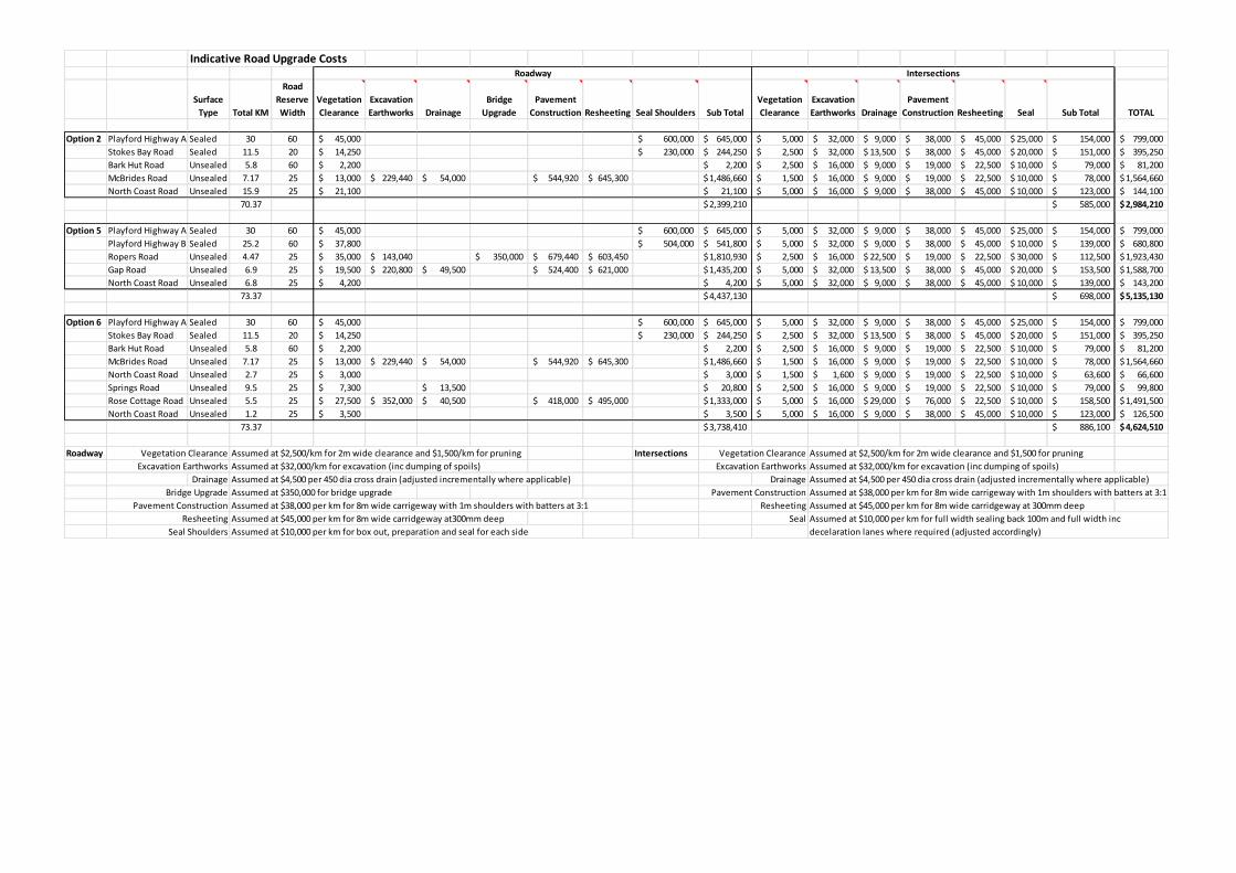
Indicative Road Upgrade Costs
SurfaceType Total KM
RoadReserveWidth
VegetationClearance
ExcavationEarthworks Drainage
BridgeUpgrade
PavementConstruction Resheeting Seal Shoulders Sub Total
VegetationClearance
ExcavationEarthworks Drainage
PavementConstruction Resheeting Seal Sub Total TOTAL
Option 2 Playford Highway A Sealed 30 60 45,000$ 600,000$ 645,000$ 5,000$ 32,000$ 9,000$ 38,000$ 45,000$ 25,000$ 154,000$ 799,000$Stokes Bay Road Sealed 11.5 20 14,250$ 230,000$ 244,250$ 2,500$ 32,000$ 13,500$ 38,000$ 45,000$ 20,000$ 151,000$ 395,250$Bark Hut Road Unsealed 5.8 60 2,200$ 2,200$ 2,500$ 16,000$ 9,000$ 19,000$ 22,500$ 10,000$ 79,000$ 81,200$McBrides Road Unsealed 7.17 25 13,000$ 229,440$ 54,000$ 544,920$ 645,300$ 1,486,660$ 1,500$ 16,000$ 9,000$ 19,000$ 22,500$ 10,000$ 78,000$ 1,564,660$North Coast Road Unsealed 15.9 25 21,100$ 21,100$ 5,000$ 16,000$ 9,000$ 38,000$ 45,000$ 10,000$ 123,000$ 144,100$
70.37 2,399,210$ 585,000$ 2,984,210$
Option 5 Playford Highway A Sealed 30 60 45,000$ 600,000$ 645,000$ 5,000$ 32,000$ 9,000$ 38,000$ 45,000$ 25,000$ 154,000$ 799,000$Playford Highway B Sealed 25.2 60 37,800$ 504,000$ 541,800$ 5,000$ 32,000$ 9,000$ 38,000$ 45,000$ 10,000$ 139,000$ 680,800$Ropers Road Unsealed 4.47 25 35,000$ 143,040$ 350,000$ 679,440$ 603,450$ 1,810,930$ 2,500$ 16,000$ 22,500$ 19,000$ 22,500$ 30,000$ 112,500$ 1,923,430$Gap Road Unsealed 6.9 25 19,500$ 220,800$ 49,500$ 524,400$ 621,000$ 1,435,200$ 5,000$ 32,000$ 13,500$ 38,000$ 45,000$ 20,000$ 153,500$ 1,588,700$North Coast Road Unsealed 6.8 25 4,200$ 4,200$ 5,000$ 32,000$ 9,000$ 38,000$ 45,000$ 10,000$ 139,000$ 143,200$
73.37 4,437,130$ 698,000$ 5,135,130$
Option 6 Playford Highway A Sealed 30 60 45,000$ 600,000$ 645,000$ 5,000$ 32,000$ 9,000$ 38,000$ 45,000$ 25,000$ 154,000$ 799,000$Stokes Bay Road Sealed 11.5 20 14,250$ 230,000$ 244,250$ 2,500$ 32,000$ 13,500$ 38,000$ 45,000$ 20,000$ 151,000$ 395,250$Bark Hut Road Unsealed 5.8 60 2,200$ 2,200$ 2,500$ 16,000$ 9,000$ 19,000$ 22,500$ 10,000$ 79,000$ 81,200$McBrides Road Unsealed 7.17 25 13,000$ 229,440$ 54,000$ 544,920$ 645,300$ 1,486,660$ 1,500$ 16,000$ 9,000$ 19,000$ 22,500$ 10,000$ 78,000$ 1,564,660$North Coast Road Unsealed 2.7 25 3,000$ 3,000$ 1,500$ 1,600$ 9,000$ 19,000$ 22,500$ 10,000$ 63,600$ 66,600$Springs Road Unsealed 9.5 25 7,300$ 13,500$ 20,800$ 2,500$ 16,000$ 9,000$ 19,000$ 22,500$ 10,000$ 79,000$ 99,800$Rose Cottage Road Unsealed 5.5 25 27,500$ 352,000$ 40,500$ 418,000$ 495,000$ 1,333,000$ 5,000$ 16,000$ 29,000$ 76,000$ 22,500$ 10,000$ 158,500$ 1,491,500$North Coast Road Unsealed 1.2 25 3,500$ 3,500$ 5,000$ 16,000$ 9,000$ 38,000$ 45,000$ 10,000$ 123,000$ 126,500$
73.37 3,738,410$ 886,100$ 4,624,510$
Roadway Vegetation Clearance Assumed at $2,500/km for 2m wide clearance and $1,500/km for pruning Intersections Vegetation Clearance Assumed at $2,500/km for 2m wide clearance and $1,500 for pruningExcavation Earthworks Assumed at $32,000/km for excavation (inc dumping of spoils) Excavation Earthworks Assumed at $32,000/km for excavation (inc dumping of spoils)
Drainage Assumed at $4,500 per 450 dia cross drain (adjusted incrementally where applicable) Drainage Assumed at $4,500 per 450 dia cross drain (adjusted incrementally where applicable)Bridge Upgrade Assumed at $350,000 for bridge upgrade Pavement Construction Assumed at $38,000 per km for 8m wide carrigeway with 1m shoulders with batters at 3:1
Pavement Construction Assumed at $38,000 per km for 8m wide carrigeway with 1m shoulders with batters at 3:1 Resheeting Assumed at $45,000 per km for 8m wide carridgeway at 300mm deepResheeting Assumed at $45,000 per km for 8m wide carridgeway at300mm deep Seal
Seal Shoulders Assumed at $10,000 per km for box out, preparation and seal for each side
Roadway Intersections
Assumed at $10,000 per km for full width sealing back 100m and full width incdecelaration lanes where required (adjusted accordingly)