knox/blount regional greenway 2010 master plan …...knox/blount regional greenway master plan –...
TRANSCRIPT

2010
Knox/Blount Regional Greenway Master Plan for Maryville, Alcoa, and
Blount County, Phase One
March 2010

Knox / Blount Regional Greenway Master Plan For Maryville, Alcoa, and Blount County – Phase One
Knox/Blount Regional Greenway Master Plan – Phase One
Table of Contents
Introduction ..................................................................................................... 1 Benefits and Opportunities of Greenways ....................................................... 1 Master Planning Process………………………………………………………….. 3
Inventory and Analysis of Existing Natural and Cultural Features ............ 3 • Opportunities ........................................................................... 4 • Constraints............................................................................... 5
Determination of Potential Greenway Corridors ........................................ 7
Public Input (Public Meeting and Internet Survey) .................................... 7
Final Conceptual Route ............................................................................. 8
Other Stakeholders ................................................................................. 10
Rough Order of Magnitude Cost Estimate .............................................. 10
Phasing ................................................................................................... 13 Greenway Design Standards ........................................................................ 13 Conclusion .................................................................................................... 18 Appendix A Powerpoint Presentation made during October 8, 2009 Public Meeting Appendix B
Blount County Greenways Internet Survey Results
Knox/Blount Regional Greenway Master Plan – Phase One Page 1
Knox / Blount Regional Greenway Master Plan For Maryville, Alcoa, and Blount County – Phase One
Introduction Blount County and the Cities of Alcoa and Maryville have been leaders in greenway and trail development, not only in Tennessee, but in the United States. Before the term “greenway” was ever coined, leaders in Blount County dreamed of a continuous trail for pedestrians and bicyclists along the floodplains of Pistol Creek which would physically and symbolically link the cities of Alcoa and Maryville. Today, Alcoa and Maryville have extensive greenway networks in place that connect and greatly enhance the character of their communities. In July of 2009, Barge Waggoner, Sumner and Cannon, Inc. (BWSC) was retained to prepare a Greenway Master Plan for a specific area of Blount County and the Cities of Alcoa and Maryville to further expand this existing greenway system. The purpose of this report is to document the process that was used to provide a proposed greenway network that will connect the Knox County greenway to the extensive greenway networks in Alcoa and Maryville, as well as the Heritage High School area. The Knox County greenway system is not complete, however the southern terminus of the greenway has been constructed across the Knox / Blount County line, along and underneath the bridge crossing the Little River, thus providing a point of connection. This proposed greenway system is a major component of the ultimate plan to provide a pedestrian connection from Knoxville to Alcoa\Maryville to Townsend and eventually to the Great Smoky Mountains National Park. This study is limited to a specific area of Blount County, and is not considered to be comprehensive from a County or regional perspective. For the purpose of this plan, greenways are defined as linear corridors of land along waterways, ridgelines and railroad, road or utility corridors used for or converted to recreation and active transportation purposes. These greenways usually contain hard surfaced (paved) trails that serve multiple users: walkers; runners; bicyclists; skaters, hikers; and horse riders, depending on the use regulations of the managing agency. Benefits and Opportunities of Greenways There are many benefits of greenways; this section provides a brief summary of some of them.
Knox/Blount Regional Greenway Master Plan – Phase One Page 2
Connections Greenway systems are typically designed to provide linear connections to important nodes. Neighborhood to neighborhood, neighborhood to park, park to park, park to school, etc. These connections allow for increased interaction among community residents and provide safe ways for children and adults to access community assets. Improved health of our citizens The federal Centers for Disease Control has reported that the majority of Tennesseeans are overweight and almost 1/3 engage in no physical activity. Simply walking on a greenway can begin to alter these statistics. The availability of close to home greenway connections will encourage more Blount Countians to get outdoors and get engaged in physical activity. Economic growth National studies have shown that communities with extensive greenway and trail networks provide a more attractive place for existing businesses to make new investments. Quality of life is one of the major site selection decision criteria for new businesses to locate in a community. Greenways provide an enhancement of quality of life that makes a community more attractive to business and industry. Enhanced property values Study after study across the United States has shown that residential properties in particular realize positive gains in property values when they are along or are in close proximity to a greenway. Newly developed residential communities which have access to greenways tend to sell more quickly and at higher prices than those which are not. Environmental conservation Greenways preserve linear corridors of space, many times along streams. These corridors filter runoff, preserve vegetation and provide for wildlife habitat and corridors for their movement. Safe recreation Crime statistics across the country evidence the fact that the incidence of crime on greenways is most often less than that in surrounding neighborhoods. As greenway use increases, the safety of the trail increases.
Knox/Blount Regional Greenway Master Plan – Phase One Page 3
Alternative forms of transportation Greenways provide opportunities for alternative modes of transportation from home to school, work and public facilities. This reduces traffic congestion and pollution. Master Planning Process The planning process consisted of four basic components:
1. An inventory and analysis of the existing natural and cultural features of the area 2. Preparation of alternative concept plans 3. Public meetings to obtain community input 4. Preparation of a final greenway master plan, to include:
a. Documentation of the master planning process b. A description of the master plan c. A rough order of magnitude cost estimate d. A set of standard greenway construction details and standards in order to
meet grant funding agency requirements. Inventory and Analysis of Existing Natural and Cultural Features The physical boundaries of the study area consist of S.R. 115/US 129 (Alcoa Highway) to the west, the Little River to the east, and Lamar Alexander Parkway to the South. The northern boundary is the terminus of the Knox County greenway, which is located at the Knox / Blount County boundary. The trail extends across the Little River, and then eastward under the S.R. 115/US 129 (Alcoa Highway) bridge. The first step in the inventory phase was to obtain maps and aerial photos of the project area as well as previous planning studies conducted by local agencies. A field survey was then conducted. The field survey entailed reviewing the potential routes of the trail in the field by vehicle and/or where possible on foot to determine the conceptual feasibility of a potential trail route. Due to private property ownership issues, a complete field review of each entire route was not possible; however adequate information was obtained to perform the inventory. After field information was obtained, a top level analysis of natural and cultural features, transportation resources, and existing and future connection points was performed. This analysis determined which areas of features could provide opportunities or constraints to development of a greenway system and amenities. Identification of these opportunities and constraints guides the design of the greenway master plan by acknowledging those

Knox/Blount Regional Greenway Master Plan – Phase One Page 4
elements that could influence, either positively or negatively, the routing and design of the system in its preliminary stages.
• Opportunities 1. Available public land
Properties that are owned by governments, public utilities, etc., are often desirable, especially if their location is in close proximity to a greenway system. Schools, parks and existing greenways provide highly desirable destinations for future greenways, and, along with other public areas such as utility rights of way and other government facilities, normally do not require acquisition negotiation or access easements. Examples of public lands providing opportunities for greenway development include:
a. TVA properties b. Maryville’s Wastewater Treatment Plant c. UT agriculture research facility d. Clayton Greenway e. Pellissippi Place f. Alcoa Elementary School g. Springbrook Park h. Greenbelt Park i. Rockford Elementary School j. New Eagleton Elementary School k. Heritage High School
2. Pellissippi Parkway, Lamar Alexander Parkway and Proposed S.R.
115/US 129 Bypass (Alcoa Highway Relocation) Although vehicular corridors are not the first choice for pedestrian or bicycle use, those with adequate right of way width can provide opportunities for pedestrian and bike circulation when other physical constraints prohibit consideration of other, possibly more desirable locations from a user experience perspective. Though technically not a greenway, if adequate road shoulder width is present, a pedestrian path can be located inside the right of way of these parkways in a safe and aesthetic manner that can provide an important link in the greenway system. Also considered a constraint, Proposed S.R. 115/US129 Bypass (Alcoa Highway Relocation) can become an opportunity to greenway development if future TDOT planning for this road provides for parallel bike \ pedestrian facilities inside the right of way. The same can be said for the future extension of Pellissippi Parkway. Also, S.R. 115/US 129 (Alcoa Highway), while currently considered a constraint, can become suitable for greenway development as this corridor is redeveloped with limited curb cuts and expanded bike \ pedestrian facilities. This could provide key connections to existing and future adjacent recreational trails.
Knox/Blount Regional Greenway Master Plan – Phase One Page 5
3. Little River Corridor
The Little River serves as the eastern boundary of the study area and provides an excellent opportunity for greenway development. This slow flowing river has many banks that are gentle enough to allow for the greenway to be located along the river. Tree cover is present along most of the river providing shade and visual buffers. A greenway along the Little River would provide excellent opportunities for environmental education, for conservation of the environment and would provide an excellent user experience. With little public land available along most of the river, the acquisition of easements from private landowners would be necessary.
• Constraints
1. S.R. 115/US 129 (Alcoa Highway), CSX Railroad, and Proposed S.R. 115/US 129 Bypass (Alcoa Highway Relocation) These man‐made constraints may prohibit the development of a trail system due to their strict access requirements for pedestrians as well as vehicles. Further, crossing them can be dangerous, and very cost prohibitive, often times requiring overpasses or underpasses.
2. Steep topography and rock outcroppings Steep grades can sometimes constrain design and construction of trails to the point where rerouting is more prudent than expending funds on large volumes of earthwork and/or construction of expensive retaining walls. For the same reason, rock outcroppings should be avoided, however they can be a visual amenity to a greenway when located in close proximity.
3. Floodplain and wetlands Although developing a greenway along a water body such as a river or creek is most often highly desirable, the design approach can be significantly constrained by accompanying floodplain issues. Designers must take into account the hydraulics of the water body, and what impact the greenway may have on stream flow and upstream flooding. Also crossing water bodies can be expensive and also contribute to flow \ flooding problems. Wetlands should be avoided altogether, if possible. However, they can also be considered a visual amenity, as well as an educational opportunity with proper trail location and informative signage.

Knox/Blount Regional Greenway Master Plan – Phase One Page 6
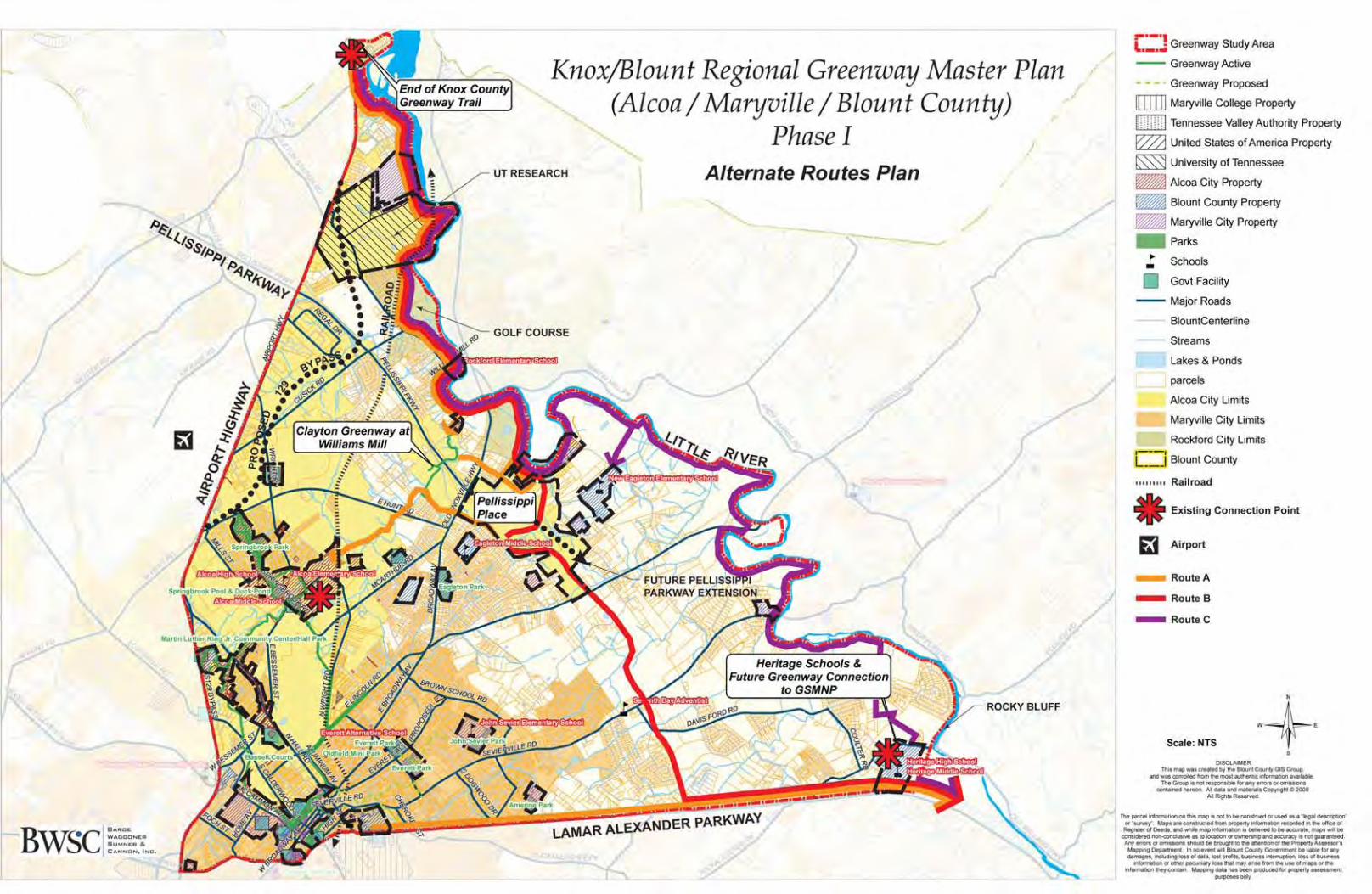
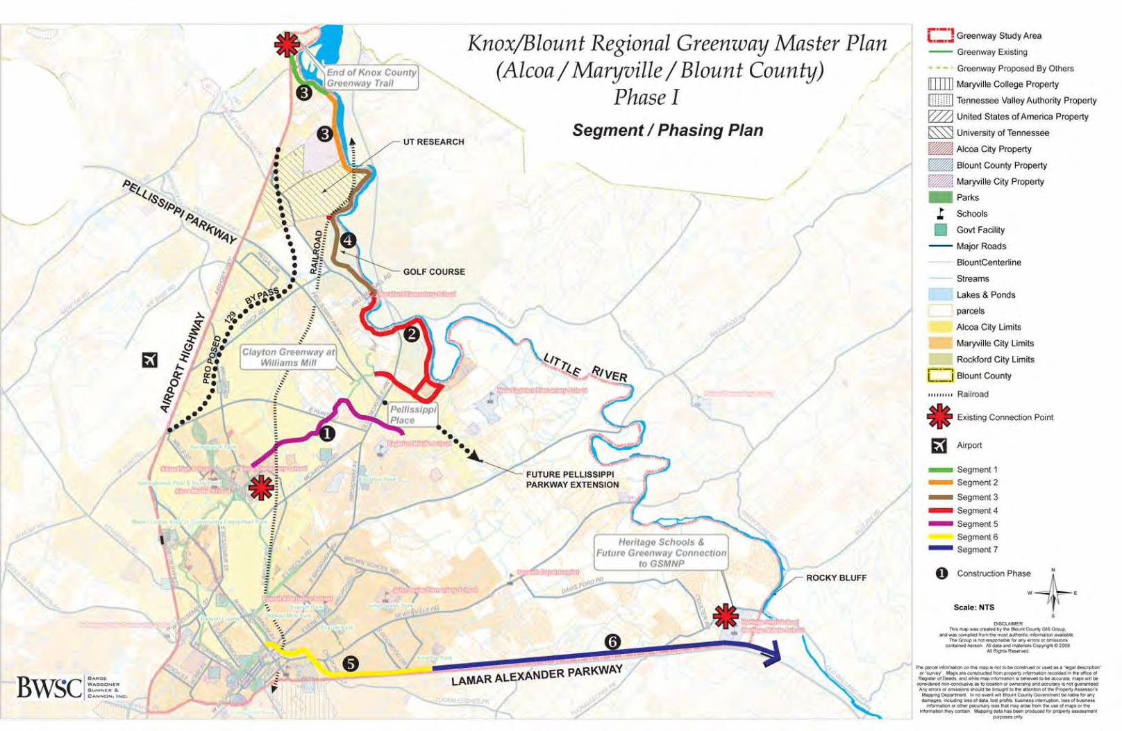
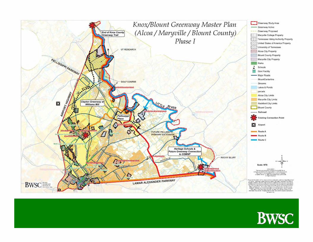
Determination of Potential Greenway Corridors Upon completion of the area inventory and analysis, the following three potential corridors were determined suitable to be studied in greater detail (see figure 1.0). All three routes begin at the southern terminus of the Knox County Greenway, proceed briefly inside the right of way of S.R. 115/US 129 (Alcoa Highway), then along the western bank of the Little River to a point near the Clayton Greenway at Williams Mill. At this location, the three Alternate routes proceed in different directions before they arrive at the Heritage High School.
• Route A connects to Clayton Greenway and to Pellissippi Place. It then extends over to Alcoa Elementary School and Springbrook Park, which is a part of the Alcoa greenway network. It then travels Maryville’s “Greenbelt Park” via the Alcoa and Maryville connection. Then from “Greenbelt Park’, the trail makes its way along Lamar Alexander Parkway to the Heritage High School.
• Route B extends through Pellissippi Place, and proceeds along the future extension of Pellissippi Parkway to Lamar Alexander Parkway, where it would turn and proceed eastward to Heritage High School.
• Route C continues generally along the western bank of the Little River to a point
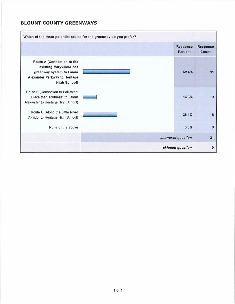
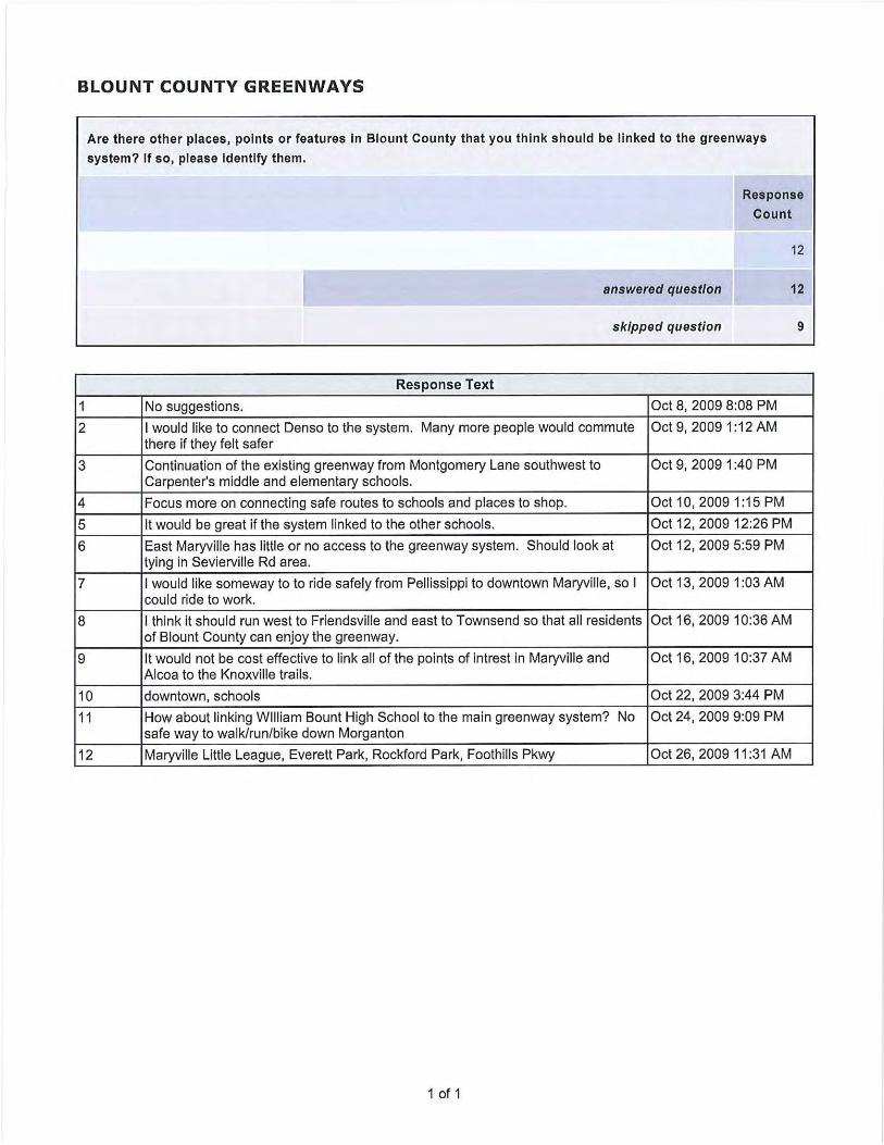
where it leaves the river and extends southward to Heritage High School. Public Input (Public Meeting and Internet Survey) The preparation of the Master Plan utilized an open planning process to gain public input and consensus on the results. A public participation meeting was held on October 8, 2009 to present the master planning process, benefits and opportunities of greenways, the site inventory and analysis, and to obtain input from the public on the three potential greenway routes. A copy of the Powerpoint presentation made at the meeting can be found in Appendix A. The meeting was very well attended by approximately 35 persons. The audience was very engaged and enthusiastic in providing their input concerning the expansion of the greenways system. In general, the following feedback was provided during the meeting:
• Route A was preferred by most responders because it would create an immediate, direct connection between Alcoa\Maryville and Knoxville. It would also be the best option for the area economically, and would cost less to construct because much of the network is already in place.
Knox/Blount Regional Greenway Master Plan – Phase One Page 8
• Route C, although the most expensive and ambitious from an easement acquisition standpoint, has the potential to bring national prominence to the area.
• Route B was generally the least desirable route, due to its location along a four
lane parkway with high traffic volumes.
• Pellissippi Place was considered an asset to the area, and could serve as a hub for future pedestrian circulation in the area.
• Many participants were concerned about the possibility of crime on greenways,
although studies suggest that this in fact should not be a concern.
• Preservation of farmland, and the rural character of the area was emphasized.
• Some participants expressed concerns about land acquisition\condemnation procedures for trail segments that cross private land.
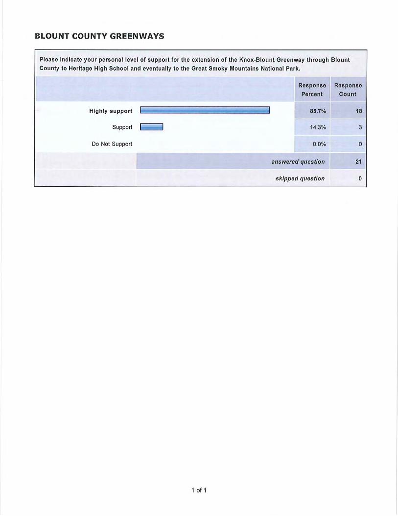
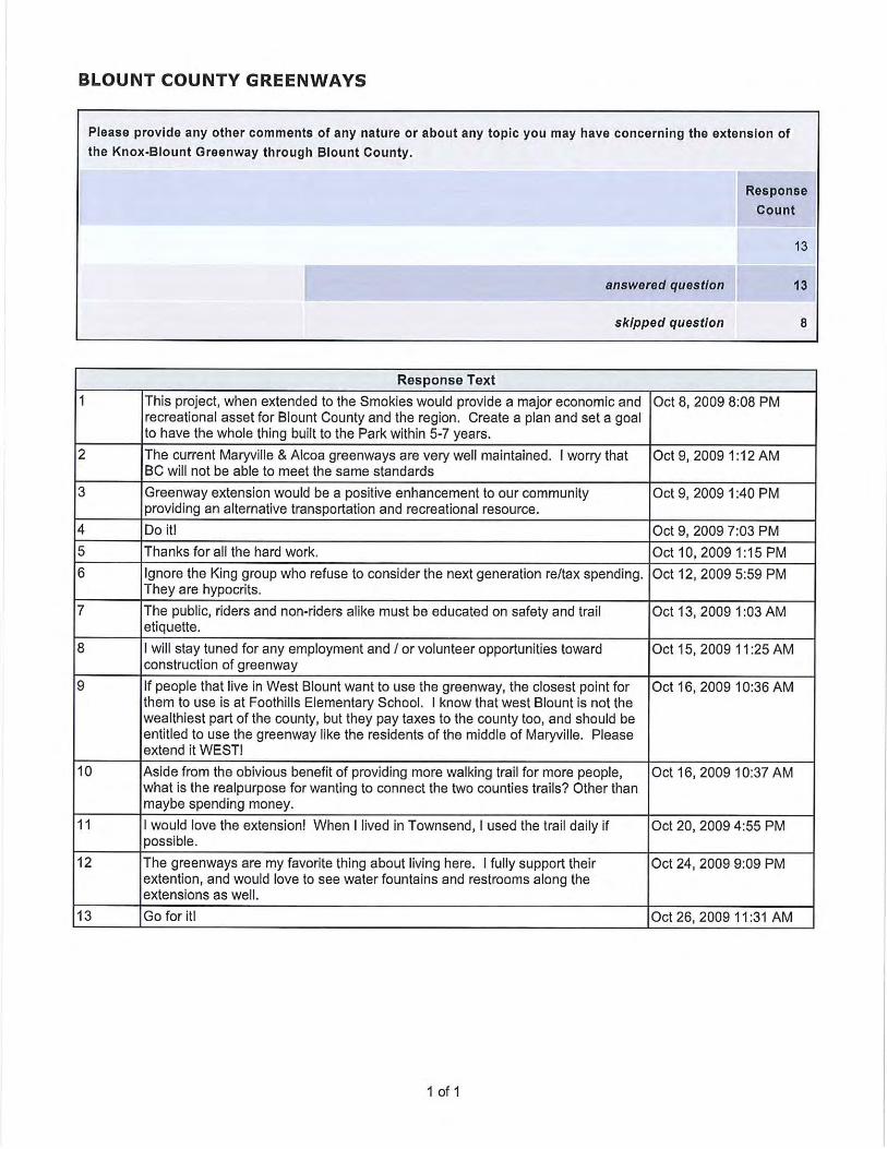
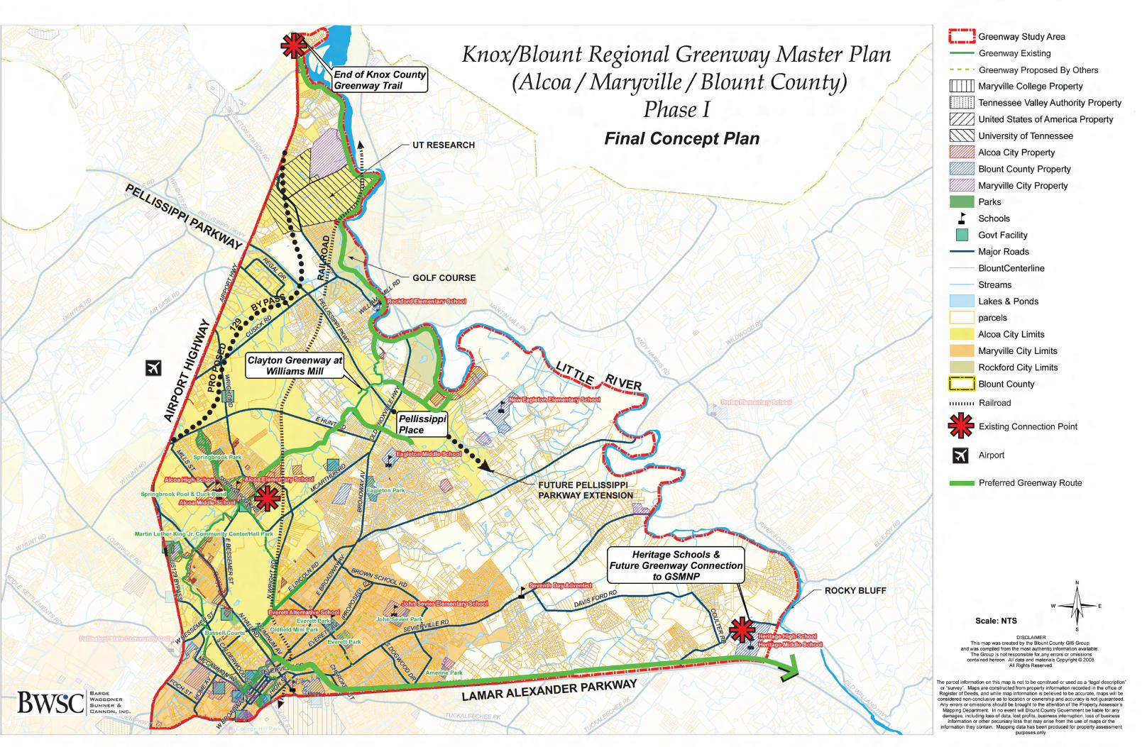
In general, the majority of participants in the public meeting were very supportive of the idea of a greenway system for Blount County that would provide a link in the network that could ultimately connect Knoxville, Alcoa, and Maryville with the GSMNP, and further expand the existing systems of Alcoa and Maryville. A survey link was posted on Blount County’s website seeking additional comments from meeting participants and from citizens who could not attend. The results, which confirmed the general consensus of the meeting participants, are provided in Appendix B. Final Conceptual Route Based on the site analysis and input from the public meeting, a modified version of Route A was selected as the preferred route (see figure 2.0). The modification entailed extending the route further down the Little River to take advantage of accessible public lands with river frontage. Another option that that was strongly supported at the public meeting and by the internet survey respondents was Route C. This route certainly warrants further consideration for long term planning efforts in the area as it would differ from Route A in terms of its function and user demographic. Route A would provide the most direct option for providing a trail connection from Knox County to Alcoa, Maryville, and Heritage High School, and would be considered more of an urban route. Route C, on the other hand, would be considered much more of a scenic route, and an actual destination in its own right. It would provide a true natural corridor along the Little River to Heritage High School and
Knox/Blount Regional Greenway Master Plan – Phase One Page 10
eventually to the GSMNP at build‐out. Route C would begin where Route A turns south from the River towards Pellissippi Place. It would proceed, for the most part along the southern bank of the Little River for a distance of approximately nine additional miles. One main constraint to development of this corridor is the considerable number of private properties located along the river that will require easement acquisitions. Other Stakeholders An important aspect of the master planning process is encouraging other area communities to participate and become components of the future network. The Town of Rockford is strategically located along the Little River and within the limits of the study area, and should be included as future planning moves forward. Also, a future connection to the Town of Louisville should be provided as the greenway system extends outside of the current study area. Rough Order of Magnitude Cost Estimate A component of this Master Plan is a preliminary cost estimate for greenway construction. Due to the conceptual level of detail this plan provides, these cost estimates should be used for budgeting and long term planning purposes only. The costs are based on the average of recent greenway construction costs from local projects. This estimate assumes a 10’ wide asphalt trail, and does not include costs for items such as lighting, retaining walls, site furnishings, signage, landscaping, or survey\design fees. It is assumed there will be places along the proposed trail where a concrete surface will be preferred over asphalt, due to aesthetics or functional needs. However, for the purposes of this master plan, the estimate will include costs for an asphalt surface only. Recommendations for areas requiring a concrete surface should be made on a more site specific basis.
For planning purposes, the preferred trail route will require approximately 16.6 miles of new construction to connect the Knox County Greenway with the existing greenway network, and Heritage High School. Following is a rough order magnitude cost estimate of the preferred trail layout, broken down by trail segments (see figure 3). All quantities shown are approximate and are for planning purposes only. Lights are excluded from this estimate, and bridge costs assume a 10’ x 60’ prefabricated steel bridge with a lightweight concrete deck, installed on concrete abutments. Additional costs for the Route C extension are included as well.
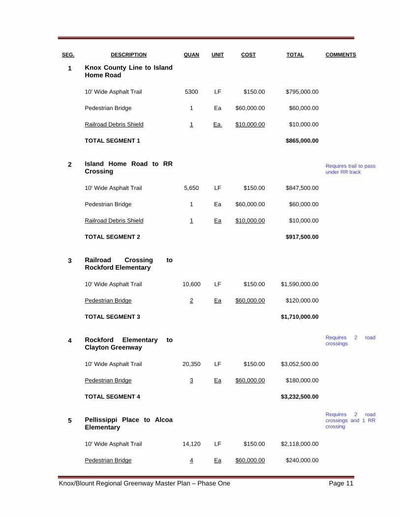
Knox/Blount Regional Greenway Master Plan – Phase One Page 11
SEG. DESCRIPTION QUAN UNIT COST TOTAL COMMENTS
1 Knox County Line to Island Home Road
10' Wide Asphalt Trail 5300 LF $150.00 $795,000.00
Pedestrian Bridge 1 Ea $60,000.00 $60,000.00
Railroad Debris Shield 1 Ea. $10,000.00 $10,000.00
TOTAL SEGMENT 1 $865,000.00
2 Island Home Road to RR Crossing
Requires trail to pass under RR track
10' Wide Asphalt Trail 5,650 LF $150.00 $847,500.00
Pedestrian Bridge 1 Ea $60,000.00 $60,000.00
Railroad Debris Shield 1 Ea $10,000.00 $10,000.00
TOTAL SEGMENT 2 $917,500.00
3 Railroad Crossing to Rockford Elementary
10' Wide Asphalt Trail 10,600 LF $150.00 $1,590,000.00
Pedestrian Bridge 2 Ea $60,000.00 $120,000.00
TOTAL SEGMENT 3 $1,710,000.00
4 Rockford Elementary to Clayton Greenway
Requires 2 road crossings
10' Wide Asphalt Trail 20,350 LF $150.00 $3,052,500.00
Pedestrian Bridge 3 Ea $60,000.00 $180,000.00
TOTAL SEGMENT 4 $3,232,500.00
5 Pellissippi Place to Alcoa Elementary
Requires 2 road crossings and 1 RR crossing
10' Wide Asphalt Trail 14,120 LF $150.00 $2,118,000.00
Pedestrian Bridge 4 Ea $60,000.00 $240,000.00

Knox/Blount Regional Greenway Master Plan – Phase One Page 12
TOTAL SEGMENT 5 $2,358,000.00
6 Sevierville Rd to Amerine Park
Requires 3 road crossings and 1 RR crossing
10' Wide Asphalt Trail 12,400 LF $150.00 $1,860,000.00
TOTAL SEGMENT 6 $1,860,000.00
7 Amerine Park to Heritage High School
10' Wide Asphalt Trail 19,400 LF $150.00 $2,910,000.00
TOTAL SEGMENT 7 $2,910,000.00
SUBTOTAL ALL SEGMENTS 87,820 LF $13,853,000.00
10% Contingency $1,385,300.00
TOTAL ROUTE A $15,238,300.00
ROUTE C ADDITION 10' Wide Asphalt Trail 48,000 LF $150.00 $7,200,000.00
Pedestrian Bridge 6 Ea $60,000.00 $360,000.00
TOTAL ROUTE C $7,560,000.00
TOTAL ROUTES A AND C 135,820 LF $22,798,300.00 Lighting If lighting is desired along the trail, they can be installed by the Alcoa Electric Department at an approximate cost of $23.00 per linear foot of trail. Costs for trail lighting vary and are influenced by hardware and installation choices. This cost assumes the lighting hardware and installation matches the existing trail lights in the area, and that lights are located approximately 70’ on center.

Knox/Blount Regional Greenway Master Plan – Phase One Page 13
Phasing Determining how to implement a phasing plan is an important step in obtaining the desired goals of the Master Plan. The phased development should occur in logical steps with long term results in mind (see figure 3). Issues such as available funding, construction costs, special community needs, and other future development plans in the area should be considered. Following is an attempt at a phasing schedule considering the seven segments in the above cost estimate :
Phase One
Segment 5: This first phase will connect Springbrook Elementary School to Pellissippi Place, extending Alcoa’s greenway network into the center of the study area.
Phase Two Segment 4: This link will further extend the greenway network by connecting Pellissippi Place with the Little River corridor.
Phase Three Segments 1 and 2: This phase will begin the extension of the Knox County Greenway into Blount County and will provide a connection to the UT research facility along the Little River.
Phase Four Segment 3: This phase will be a key link in the Master Plan as it will connect the UT research facility with Segment 4, at Rockford Elementary School. When this phase is complete, pedestrians will have an unobstructed path between Knox County and downtown Alcoa and Maryville.
Phases Five and Six Segments 6 and 7: This phase extends out Lamar Alexander Parkway from Maryville to Heritage High School, and will complete the Master Plan. It will also provide the foundation for the next greenway link to the Great Smoky Mountains National Park.
Greenway Design Standards Following are general standards and recommendations for construction of greenways. It should be noted these standards are, in many cases, desirable but not mandatory.
• Trail Width According to AASHTO (American Association of State Highway and Transportation Officials) standards, under most conditions, the recommended paved width for a two direction shared use path is 10 feet. Under certain conditions, a width of 8’ is acceptable. In addition to the trail itself, a 2 foot wide shoulder with a maximum 1:6 slope should be maintained adjacent to both sides
Knox/Blount Regional Greenway Master Plan – Phase One Page 15
of the trail. Where the trail is adjacent to water bodies, ditches or side slopes steeper than 3:1, a wider separation should be considered. In this case, a 5 foot shoulder is desirable, and a physical barrier such as a rail or fence may be necessary, depending on the height of the adjacent embankment.
• Vertical Clearance The vertical clearance to obstructions should be a minimum of 8 feet. However, this may need to be increased to permit passage of maintenance and emergency vehicles. In underpasses and tunnels, 10 feet of clearance should be maintained.
• Grades When possible, the grades, or slopes, of trails should maintain a maximum longitudinal slope of 5%. When steeper slopes are necessary, they should be kept to a minimum and perhaps should contain landings at certain intervals (see ADA Accessibility below). The maximum cross slope is 2%. Trails should not be crowned, but pitched in one direction to ensure positive drainage.
• Surface Materials Asphalt is the most common paving material for hard surface trails, although trails can also be constructed of concrete or crushed material. When using asphalt, a 2 inch thickness of asphalt over a 6 inch crushed stone base is required. In all cases, a well compacted subgrade is necessary. Concrete should be used in locations where the trail is frequently inundated with water, as in a floodplain. Reinforced concrete should be used in areas where the subgrade is unstable and prone to subsidence. Packed crushed stone, gravel fines compacted with a roller, packed soil and other natural materials bonded with synthetic materials can provide the degree of material stability and firmness that is required for ADA accessibility.
• ADA Accessibility All pedestrian trail projects are required to be planned and designed to comply with the “American Standard Specifications for making Buildings and Facilities Accessible to, and Usable by, the Physically Handicapped.” In October of 2009, the United States Access Board published “Draft Final Accessibility Guidelines For Outdoor Developed Areas”. These regulations cover campgrounds, trails,
Knox/Blount Regional Greenway Master Plan – Phase One Page 16
etc. located on federal outdoor sites, but will likely eventually regulate local and state government facilities as well. To summarize, these regulations state that no more than 30% of the total length of a trail shall have a running slope steeper than 1:12 (8%). The running slope of any segment of a trail shall not be steeper than 1:8 (12%). Where the running slope of a trail is steeper than 1:20 (5%), the maximum length of the segment shall be:
200 feet for slopes between 1:20 and 1:12; 30 feet for slopes between 1:12 and 1:10; 10 feet for slopes between 1:10 and 1:8
At the end of each segment, a resting interval shall be placed, that is a minimum of 5’ long, with a maximum slope of 1:40 if concrete, asphalt, or boards, and 1:20 if another surface.
For more information on these draft requirements, and to submit comments, go to the internet website at www.access‐board.gov/outdoor/.
• Bridges There are several factors to be considered when determining the best option when a bridge crossing is required. Functional, aesthetic, and cost considerations are among these factors. Bridges can either be built of wood, or can be pre‐fabricated structures made of steel or concrete. The aesthetic quality of bridges should be considered during the design process. Pedestrian and bicycle‐traffic bridges can become a focal point to the user. The style choices include covered bridges, rustic, or any number of variations of contemporary styles.
1. The bridge should be located in a straight section instead of a bend or curve, preferably at a narrow point, to reduce cost.
2. Locate the bridge above the 100 year floodplain. 3. The interior clear span width of the bridge should be at least as wide as
the approaching trail. 4. The minimum handrail height is 4.5 feet, in accordance with AASHTO
standards. The top rails should be designed to discourage sitting, and a rub rail height of 3.5 feet is recommended.
Knox/Blount Regional Greenway Master Plan – Phase One Page 17
• Railroad Crossings Railroad crossings should be planned at existing street crossings. Railroad permits for new crossings are difficult and costly to obtain. Following are basic guidelines for rail crossings.
1. Use existing crossings where practical. 2. Always cross at right angles to the tracks, and mark the crossing with
highly visible paint or thermoplastic material. 3. Allow a clear zone of 15 feet or more on each side of the track. Install an
advance warning on the trail 250 feet prior to the crossing. 4. Use tactile warning surfaces for the visually impaired.
Railroad companies may have specific construction detail requirements. Check with the appropriate company early in the planning process.
• Road Crossings Road crossings must be carefully planned and designed, as they present the most potentially hazardous part of the trail system. There are specific requirements for signage, sight distance, pavement markings, special surface treatments, and access control that could differ for each individual crossing, depending upon the type of road to be crossed.
• Graphics and Signage A comprehensive signage system that utilizes universal symbols is a necessity for a greenway system. A symbol or logo should be incorporated into the signage and should convey the atmosphere of the community. The logo can be used to help expand the user population and to gain public support and community identity.
• Regulatory and Warning Signs The Manual on Uniform Traffic Control Devices (MUTCD), latest edition, covers most of the applications in which regulatory signs are required for greenways. In most instances, regulatory signs are used to inform the trail user of laws and regulations and to indicate the applicability of legal requirements not otherwise apparent. Additionally, regulatory signs indicate where something is mandated or where a prohibition begins or applies. Warning signs are used to alert trail users of potentially hazardous conditions within or adjacent to the corridor. All regulatory and warning signs should
Knox/Blount Regional Greenway Master Plan – Phase One Page 18
meet the specifications of MUTCD. MUTDC does, however provide for smaller than standard highway signs when used on trails.
• Guidance and Directional Signage Information for trail users regarding location, orientation, location, and distance should be provided along trails. MUTCD provides guidelines for these types of signs, although customized signs can add character and continuity to the trail. Information signs can address specific route identification, overall trail network, and directional changes in the trail. These sign can also be used for environmental education opportunities. Mile marker designations are also helpful to the user. These types of signs can also provide recognition of local jurisdiction participation and/or corporate/private sponsorships. For more information on the MUTCD, and how signage applies to greenway networks, log on to their website at http://mutcd.fhwa.dot.gov.
• Landscape Design When selecting plant materials for use along the greenway corridor, care should be taken to select trees and shrubs that are not heavily root invasive. Plant materials should be native or naturalized, require little maintenance, and be drought tolerant. Plant selection should be dependant upon the miroclimate of the area in which it is planted. Plants that are within low‐lying areas or drainage areas should be suited to wet conditions. An arborist or landscape architect should be consulted prior to selecting new plant material for the proposed trail corridor. Plant material, when properly selected and located, can have a variety of functional and aesthetic uses, as described below:
1. Plants can block undesirable views or can be used as a sound barrier. 2. Plants can create physical barriers. 3. Plants blend with the natural environment.
• Tree Roots
Existing tree roots can cause damage to trail surfaces. The root zones of significant trees should be protected during construction. In some cases, the trail may need to be field adjusted when conflict with trees occur, or a specimen tree may need to be moved or replaced. In situations where new trees are desired, they should be planted no closer than 4 feet from the trail edge.
Knox/Blount Regional Greenway Master Plan – Phase One Page 19
Conclusion This report has documented the process that was used to provide a proposed greenway network that will connect the terminus of the Knox County greenway to the greenway networks in Alcoa and Maryville, as well as Heritage High School. This plan represents the first phase of a proposed greenway system which is intended to provide a pedestrian connection from Knoxville to Alcoa\Maryville to Townsend and eventually to the Great Smoky Mountains National Park. The mission of this plan, and the process leading up to it, is to provide long term guidance to Blount County, and the cities of Alcoa and Maryville for greenway construction as funding becomes available to these communities. As noted earlier, this study covered only a specific area of the County. Other important greenway links requiring study within the County are Heritage High School to Townsend, and the existing greenway network to the McGee Tyson Airport and Louisville. In order for this Master Plan to be effective in the future, it must be considered by TDOT during their roadway planning and construction operations. Formal approvals from the appropriate governing bodies such as planning commissions or parks and recreation boards should occur. Which bodies formally approve the plan should be coordinated by Blount County and the Cities of Maryville and Alcoa.

Knox/Blount Regional Greenway Master Plan – Phase One Page 20
APPENDIX A
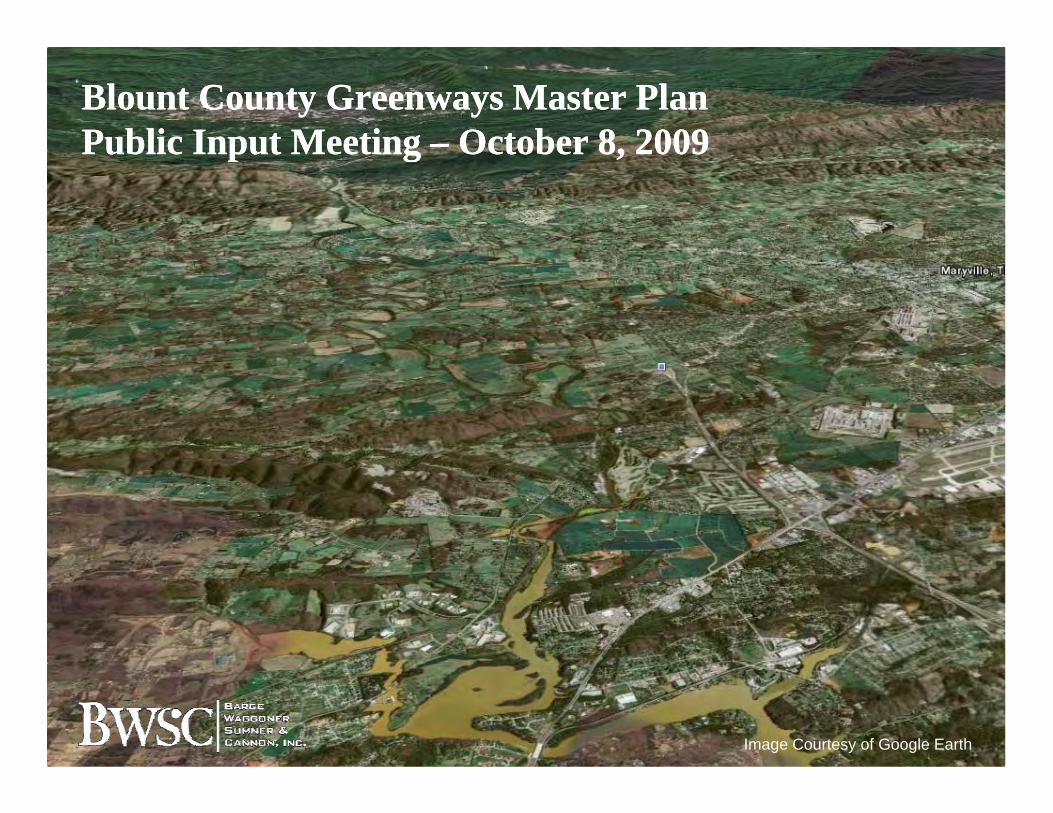
Blount County Greenways Master PlanBlount County Greenways Master PlanPublic Input MeetingPublic Input Meeting –– October 8, 2009October 8, 2009Public Input Meeting Public Input Meeting October 8, 2009October 8, 2009
Image Courtesy of Google Earth

Presentation OutlinePresentation Outline
IntroductionsMaster Planning ProcessgBenefits and Opportunities of GreenwaysBackgroundBackgroundSite Inventory and AnalysisDiscussion of Potential RoutesDiscussion of Potential RoutesPublic Input on Potential Routes
Master Planning ProcessMaster Planning Processgg
Inventory and AnalysisPublic InputpAlternative Concept PlansFinal Master PlanFinal Master Plan
Public Input ProcessPublic Input Processpp
Inventory and Analysis/Public Input: Tonight
Final Master Plan Presentation: December 2009ece be 009
GreenwaysGreenwaysyy
Greenways, for the purpose of this plan, are linear corridors of land along gwaterways, ridgelines and railroad, road or utility corridors used for or converted to recreation purposes. These greenways usually contain hard surfaced (paved) trails h l i l lkthat serve multiple users: walkers;
runners; bicyclists; skaters; and hikers.
Benefits and OpportunitiesBenefits and Opportunitiesof Greenwaysof Greenways
Improved Health of our CitizensEconomic GrowthConservationHistoric PreservationHistoric PreservationSafe RecreationConnectionsConnectionsAlternative Transportation
Examples of Economic Examples of Economic BenefitsBenefits
Salem, OR: Land adjacent to a greenbelt was found to be worth about $1,200 an acre more than land only 1 000 feet awayland only 1,000 feet awayOakland, CA: A three-mile greenbelt around Lake Merritt near the city center was found toLake Merritt, near the city center, was found to add $41 million to surrounding property valuesFront Royal, VA: A developer who donated aFront Royal, VA: A developer who donated a 50-foot-wide, seven-mile-long easement along a popular trail sold all 50 parcels bordering the trail i l f hin only four months

Examples of Economic Examples of Economic BenefitsBenefits
Seattle, WA: Homes bordering the 12-mile Burke Gilman trail sold for 6 percent more than other houses of comparable sizehouses of comparable sizeDenver, CO: Between 1980 and 1990, the percentage of Denver residents who said they p g ywould pay more to live near a greenbelt or park rose from 16 percent to 48 percentDenver, CO: Property values along a greenway increased enough to generate $500,000 in additional property taxes, paying for the greenwayadditional property taxes, paying for the greenway in 3 years
ChattanoogaChattanoogagg
“We certainly have had a revival, and the city takes pridein the fact that we have received a lot of attention for this turnaround There is a feeling not that we’ve arrived butturnaround. There is a feeling not that we ve arrived, but that we are on the right path — and ‘path’ is a good word for it since our progress is closely linked to paths. People may point to some rightly celebrated projects, like the aquarium or the IMAX theater, but making the city more pedestrian-friendly is really what’s bringing it back to life.”p f y y g g f
-- David Crockett, Former Chattanooga City Council Chair
BackgroundBackgroundgg
Before the term “greenway” was ever coined, leaders in Blount County dreamed of a continuous trail for pedestrians and bicyclists along thetrail for pedestrians and bicyclists along the floodplains of Pistol Creek which would physically and symbolically link the cities of Alcoa and y yMaryvilleTownsend trail was built in the 1970s, the first municipal bike trail in the StateThe Maryville greenways system began in 1985,
ll b f il l h Swell before trails were popular across the State
BackgroundBackgroundgg
Maryville’s and Alcoa’s linked greenway system was recognized in the November 2002 publication of the N ti l T t tipublication of the National Transportation Enhancements Clearinghouse, A Guide to Transportation Enhancements, Enhancing p gAmerica’s Communities
Thus, Blount County has been a leader in , ygreenway and trail development, not only in Tennessee, but in the U.S.

BackgroundBackgroundgg
Great Smoky Mountains Regional Greenways Council (GSMRG) organization established in 1994O i i l i l f th GSMRG tOriginal primary goal of the GSMRG: connect Knoxville to the Great Smoky Mountains National ParkGSMRG initiated a grant application for this study and contributed $2,000 towards the local match
ill Al d l C ib dMaryville, Alcoa, and Blount County contributed $1,000 each towards the matchA Recreation Trails Program grant from TDEC wasA Recreation Trails Program grant from TDEC was awarded to fund this study
BackgroundBackgroundgg
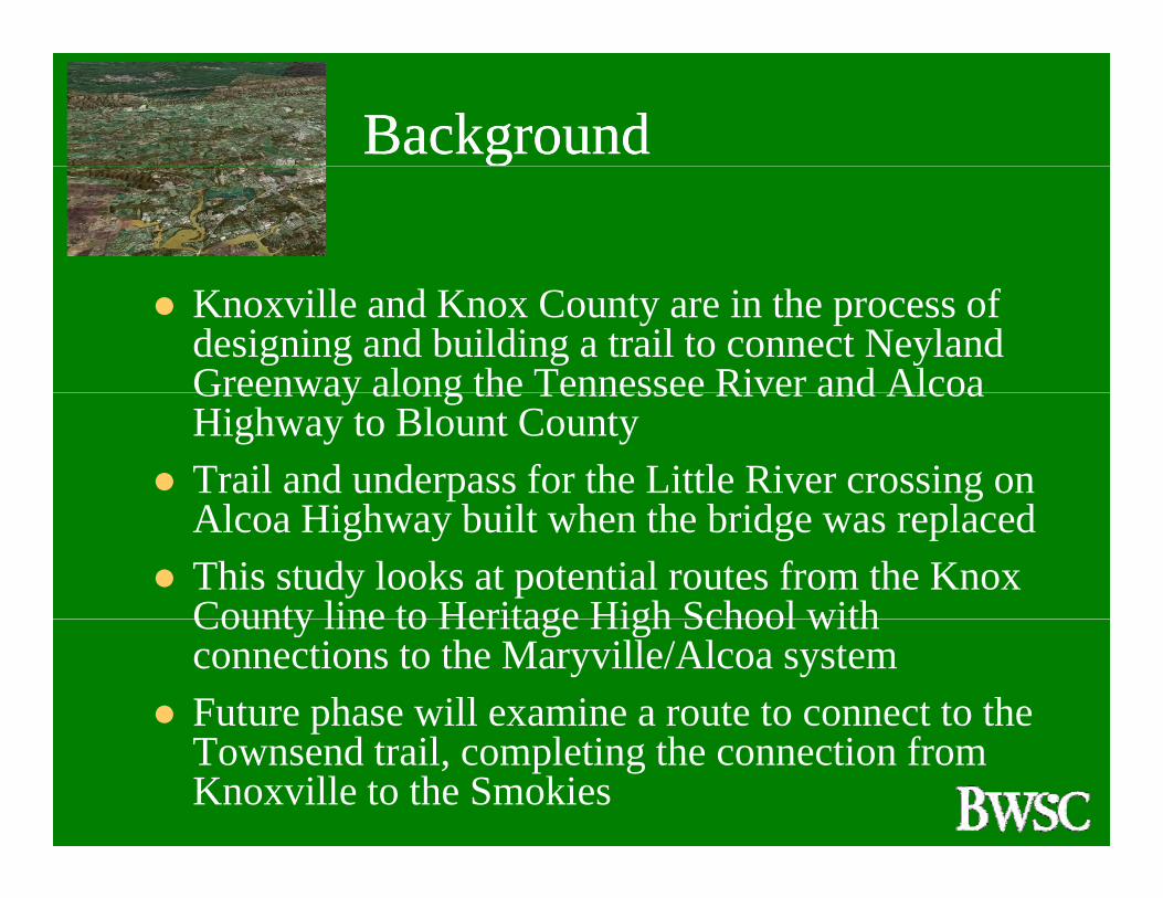
Knoxville and Knox County are in the process of designing and building a trail to connect Neyland Greenway along the Tennessee River and AlcoaGreenway along the Tennessee River and Alcoa Highway to Blount CountyTrail and underpass for the Little River crossing on Al Hi h b il h h b id l dAlcoa Highway built when the bridge was replacedThis study looks at potential routes from the Knox County line to Heritage High School withCounty line to Heritage High School with connections to the Maryville/Alcoa systemFuture phase will examine a route to connect to the pTownsend trail, completing the connection from Knoxville to the Smokies

Inventory and AnalysisInventory and Analysisy yy y
Opportunities• Public Land (City/County, TVA, UT Property) • Pellissippi Parkway, Lamar Alexander Parkway• Little River Corridor
Constraints• Railroad and Proposed Hwy. 129 Bypass• Steep Topography/Rock Outcroppings• Floodplain/Wetlands

Potential CorridorsPotential Corridors
Route A: Knox County to existing City greenway network to Lamar Alexander Parkway to Heritage HSto Heritage HS
Route B: Knox County to Pellissippi Place, l P lli i i P k t i t Lalong Pellissippi Parkway extension, to Lamar
Alexander Parkway to Heritage HS
R t C K C t l th Littl RiRoute C: Knox County along the Little River Corridor to Heritage HS
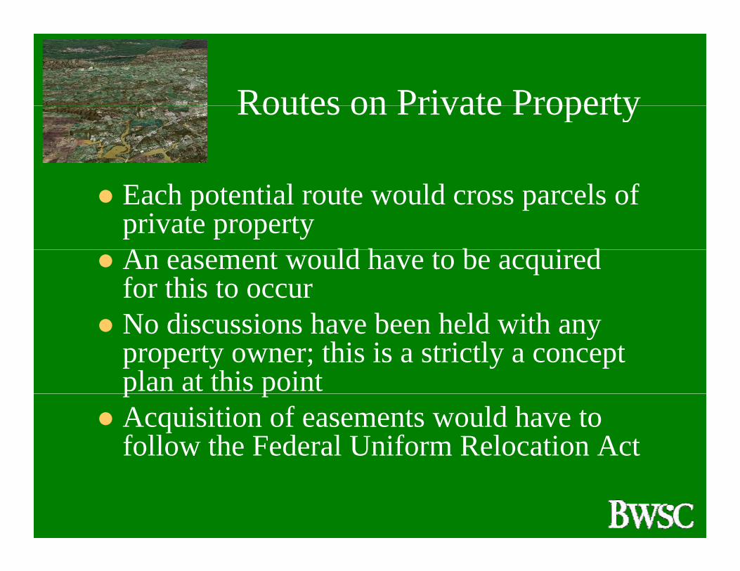
Routes on Private PropertyRoutes on Private Property
Each potential route would cross parcels of private propertyA ld h b i dAn easement would have to be acquired for this to occurNo discussions have been held with anyNo discussions have been held with any property owner; this is a strictly a concept plan at this pointp pAcquisition of easements would have to follow the Federal Uniform Relocation Act
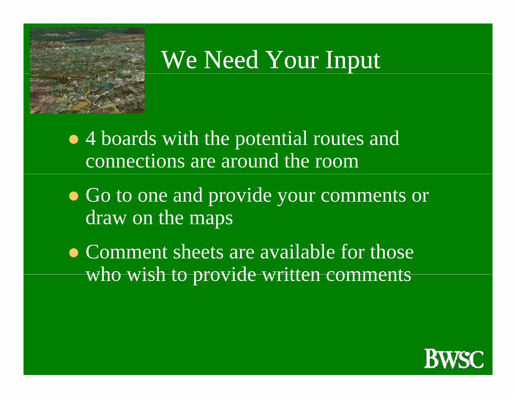
We Need Your InputWe Need Your Inputpp
4 boards with the potential routes and connections are around the room
Go to one and provide your comments or draw on the mapsd aw o t e aps
Comment sheets are available for those who wish to provide written commentswho wish to provide written comments
We Need Your InputWe Need Your Inputpp
You may review this presentation, fill out a survey and provide additional comments at:
www.blounttn.org/planning/
or Google: Blount County TN Planning Department
Please tell your friends!

Knox/Blount Regional Greenway Master Plan – Phase One Page 21
APPENDIX B