land development regulations - reedy creek … · land development regulations . amended . february...
TRANSCRIPT

LAND DEVELOPMENT
REGULATIONS Amended
February 23, 2011
December 20, 2011
REEDY CREEK
IMPROVEMENT DISTRICT
City of Bay Lake
City of Lake Buena Vista

Amended February 23, 2011 i Table of Contents - By Chapter Amended December 20, 2011
RCID LAND DEVELOPMENT REGULATIONS
TABLE OF CONTENTS - BY CHAPTER
Chapter Page ARTICLE 1: GENERAL PROVISIONS
1-10 GENERAL PROVISIONS: INTENT ...................................................... 1-1 1-20 GENERAL .............................................................................................. 1-2 1-30 DEFINITIONS ........................................................................................ 1-4 1-40 INTERPRETATION OF BOUNDARIES .............................................. 1-14
ARTICLE 2: LAND USES
2-10 LAND USES: INTENT .......................................................................... 2-1 2-20 ALLOWED USES .................................................................................. 2-2 2-30 USE CLASSIFICATION SYSTEM ........................................................ 2-6 2-40 SPECIAL RESIDENTIAL USES.......................................................... 2-10 2-50 CAMPING FACILITIES ....................................................................... 2-11
ARTICLE 3: GROWTH AND INFRASTRUCTURE PHASING
3-10 GROWTH AND INFRASTRUCTURE PHASING: INTENT ................. 3-1 3-20 GROWTH STANDARDS ....................................................................... 3-2 3-30 INFRASTRUCTURE STANDARDS ...................................................... 3-5
ARTICLE 4: DEVELOPMENT AND DESIGN REGULATIONS
4-10 DEVELOPMENT AND DESIGN REGULATIONS: INTENT ................ 4-1 4-20 SITE IMPROVEMENTS ......................................................................... 4-2 4-30 STREETS AND RIGHTS-OF-WAY ....................................................... 4-3 4-40 PARKING, LOADING, AND CIRCULATION ........................................ 4-6 4-50 LANDSCAPING ................................................................................... 4-12 4-60 OPEN SPACE...................................................................................... 4-16 4-70 SIGNS .................................................................................................. 4-17 4-80 NON-CONFORMITIES ........................................................................ 4-18

Chapter Page
Table of Contents – By Chapter ii Amended February 23, 2011 Amended December 20, 2011
ARTICLE 5: ENVIRONMENTAL PROTECTION
5-10 ENVIRONMENTAL PROTECTION: INTENT ....................................... 5-1 5-20 WETLANDS ........................................................................................... 5-2 5-30 STORMWATER MANAGEMENT ......................................................... 5-6 5-40 GROUNDWATER PROTECTION ....................................................... 5-17 5-50 EROSION CONTROL .......................................................................... 5-19 5-60 SANITARY SEWER ............................................................................ 5-24 5-70 SOLID WASTE .................................................................................... 5-26 5-80 SOILS AND MINERALS ...................................................................... 5-27 5-90 FLORA AND FAUNA ......................................................................... 5-28 5-100 ARCHAEOLOGICAL AND HISTORIC RESOURCES ....................... 5-29
ARTICLE 6: PROCEDURES
6-10 PROCEDURES: INTENT ...................................................................... 6-1 6-20 CONSISTENCY REVIEW ...................................................................... 6-2 6-30 DEVELOPMENT REVIEW ................................................................... 6-7 6-40 SUBDIVISION REVIEW ...................................................................... 6-14 6-50 SPECIFICATIONS FOR SUBDIVISION PLANS AND PLATS........... 6-20 6-60 VARIANCES ........................................................................................ 6-25 6-70 REVIEW AND APPEALS .................................................................... 6-28 6-80 ENFORCEMENT ................................................................................. 6-30 6-90 AMENDMENT OF LAND DEVELOPMENT REGULATIONS ............ 6-32 6-100 AMENDMENT OF COMPREHENSIVE PLAN .................................... 6-35 6-120 FEES .................................................................................................... 6-40
ARTICLE 7: OFFICERS AND BOARDS
7-10 OFFICERS AND BOARDS: INTENT ................................................... 7-1 7-20 BOARD OF SUPERVISORS ................................................................. 7-2 7-30 PLANNING BOARD ............................................................................. 7-4 7-50 PLANNING AND ENGINEERING DEPARTMENT ............................... 7-6

Amended February 23, 2011 iii Table of Contents - By Section Amended December 20, 2011
RCID LAND DEVELOPMENT REGULATIONS
TABLE OF CONTENTS - BY SECTION
Section Page
ARTICLE 1: GENERAL PROVISIONS
CH. 1-10 GENERAL PROVISIONS: INTENT 1-10.1 Title and Purpose ................................................................................... 1-1 1-10.2 Organization ........................................................................................... 1-1 CH. 1-20 GENERAL 1-20.1 Purpose .................................................................................................. 1-2 1-20.2 Title ........................................................................................................ 1-2 1-20.3 Purpose of Land Development Regulations .......................................... 1-2 1-20.4 Applicability ............................................................................................ 1-2 1-20.5 Relationship to Comprehensive Plan ..................................................... 1-2 1-20.6 Regulatory Map ...................................................................................... 1-3 1-20.7 Interpretations ........................................................................................ 1-3 1-20.8 Moving Buildings .................................................................................... 1-3 1-20.9 Visitor Access ........................................................................................ 1-3 1-20.10 Severability ............................................................................................. 1-3 CH. 1-30 DEFINITIONS 1-30.1 Purpose .................................................................................................. 1-4 1-30.2 Applicability ............................................................................................ 1-4 1-30.3 Rules of Construction ............................................................................. 1-4 1-30.4 Use Classifications ................................................................................. 1-5 1-30.5 Definition of Terms ................................................................................. 1-5 CH. 1-40 INTERPRETATION OF BOUNDARIES 1-40.1 Purpose ................................................................................................ 1-14 1-40.2 Rules of Interpretation .......................................................................... 1-14 1-40.3 Final Determination .............................................................................. 1-14
ARTICLE 2: LAND USES
CH. 2-10 LAND USES: INTENT 2-10.1 Title and Purpose ................................................................................... 2-1 2-10.2 Organization ........................................................................................... 2-1 CH. 2-20 ALLOWED USES 2-20.1 Purpose .................................................................................................. 2-2 2-20.2 Principal Uses ........................................................................................ 2-2 2-20.3 Classification of Principal Uses .............................................................. 2-2 2-20.4 Accessory Uses ..................................................................................... 2-3 2-20.5 Essential Services .................................................................................. 2-3
Section Page
Table of Contents – By Section iv Amended February 23, 2011 Amended December 20, 2011
2-20.6 Theme Parks .......................................................................................... 2-3 2-20.7 Lodging Services ................................................................................... 2-3 2-20.8 Potential Deannexation Areas ............................................................... 2-3 CH. 2-30 USE CLASSIFICATION SYSTEM 2-30.1 Purpose .................................................................................................. 2-6 2-30.2 Administrative and Business Offices ..................................................... 2-6 2-30.3 Agriculture .............................................................................................. 2-7 2-30.4 Animal Services ..................................................................................... 2-7 2-30.5 Automotive ............................................................................................. 2-7 2-30.6 Business and Professional Support ....................................................... 2-7 2-30.7 Civic and Cultural Centers ..................................................................... 2-7 2-30.8 Custom Manufacturing ........................................................................... 2-7 2-30.9 Day Care ................................................................................................ 2-7 2-30.10 Eating and Drinking Establishments ...................................................... 2-7 2-30.11 Equipment Services ............................................................................... 2-7 2-30.12 Financial and Professional Services ...................................................... 2-8 2-30.13 Laundry Services ................................................................................... 2-8 2-30.14 Lodging Services ................................................................................... 2-8 2-30.15 Maintenance Services ............................................................................ 2-8 2-30.16 Material Excavation ................................................................................ 2-8 2-30.17 Medical Services .................................................................................... 2-8 2-30.18 Natural Resources ................................................................................. 2-8 2-30.19 Recreation .............................................................................................. 2-8 2-30.20 Residential ............................................................................................. 2-9 2-30.21 Safety Services ...................................................................................... 2-9 2-30.22 Sales and Services ................................................................................ 2-9 2-30.23 Transportation Services ......................................................................... 2-9 2-30.24 Utility Services........................................................................................ 2-9 2-30.25 Warehousing Services ........................................................................... 2-9 2-30.26 Water-Related Services ......................................................................... 2-9 CH. 2-40 SPECIAL RESIDENTIAL USES 2-40.1 Purpose ................................................................................................ 2-10 2-40.2 Small Community Residential Homes ................................................. 2-10 2-40.3 Other Special Residential Uses ........................................................... 2-10 CH. 2-50 CAMPING FACILITIES 2-50.1 Purpose ................................................................................................ 2-11 2-50.2 Where Allowed ..................................................................................... 2-11 2-50.3 Standards ............................................................................................. 2-11
Section Page
Amended February 23, 2011 v Table of Contents - By Section Amended December 20, 2011
ARTICLE 3: GROWTH AND INFRASTRUCTURE PHASING
CH. 3-10 GROWTH AND INFRASTRUCTURE PHASING: INTENT 3-10.1 Title and Purpose ................................................................................... 3-1 3-10.2 Organization ........................................................................................... 3-1 CH. 3-20 GROWTH STANDARDS 3-20.1 Purpose .................................................................................................. 3-2 3-20.2 Development Maximums ....................................................................... 3-2 3-20.3 Land Consumption Maximums .............................................................. 3-4 3-20.4 Development Thresholds ....................................................................... 3-4 CH. 3-30 INFRASTRUCTURE STANDARDS 3-30.1 Purpose .................................................................................................. 3-5 3-30.2 Maintenance of Standards ..................................................................... 3-5 3-30.3 Roadway System ................................................................................... 3-5 3-30.4 Potable Water ........................................................................................ 3-6 3-30.5 Sanitary Sewage .................................................................................... 3-7 3-30.6 Solid Waste ............................................................................................ 3-7 3-30.7 Drainage ................................................................................................. 3-7 3-30.8 Parks and Recreation ............................................................................ 3-8
ARTICLE 4: DEVELOPMENT AND DESIGN REGULATIONS
CH. 4-10 DEVELOPMENT AND DESIGN REGULATIONS: INTENT 4-10.1 Title and Purpose ................................................................................... 4-1 4-10.2 Organization ........................................................................................... 4-1 CH. 4-20 SITE IMPROVEMENTS 4-20.1 Purpose .................................................................................................. 4-2 4-20.2 Potable Water Distribution Systems ...................................................... 4-2 4-20.3 Wastewater Collection Systems ............................................................ 4-2 4-20.4 Surface Drainage Systems .................................................................... 4-2 4-20.5 Solid Waste Systems ............................................................................. 4-2 4-20.6 Traffic Circulation Systems .................................................................... 4-2 CH. 4-30 STREETS AND RIGHTS-OF-WAY 4-30.1 Purpose .................................................................................................. 4-3 4-30.2 Classification of Roads .......................................................................... 4-3 4-30.3 Roadway Design Standards .................................................................. 4-3 4-30.4 Access Standards .................................................................................. 4-3 4-30.5 Pedestrian Safety Requirements ........................................................... 4-4 4-30.6 Public Rights-of-Way Requirements ...................................................... 4-5

Section Page
Table of Contents – By Section vi Amended February 23, 2011 Amended December 20, 2011
CH. 4-40 PARKING, LOADING, AND CIRCULATION 4-40.1 Purpose .................................................................................................. 4-6 4-40.2 General Parking Regulations ................................................................. 4-6 4-40.3 Location of Parking ................................................................................ 4-7 4-40.4 Joint Use of Parking ............................................................................... 4-7 4-40.5 Loading and Unloading Requirements .................................................. 4-8 4-40.6 Permanent Reservation ......................................................................... 4-8 4-40.7 Parking for Disabled Persons ................................................................ 4-8 4-40.8 Pedestrian Access from Public Sidewalks ............................................. 4-8 CH. 4-50 LANDSCAPING 4-50.1 Purpose ................................................................................................ 4-12 4-50.2 Applicability .......................................................................................... 4-12 4-50.3 Required Plans .................................................................................... 4-12 4-50.4 Water Conservation and Water Quality ............................................... 4-12 4-50.5 Public Safety ........................................................................................ 4-14 4-50.6 Native Vegetation ................................................................................. 4-14 4-50.7 Non-residential Properties Adjacent to Residential Properties ............ 4-15 CH. 4-60 OPEN SPACE 4-60.1 Purpose ................................................................................................ 4-16 4-60.2 Open Space Requirements ................................................................. 4-16 CH. 4-70 SIGNS 4-70.1 Purpose ................................................................................................ 4-17 4-70.2 Applicability .......................................................................................... 4-17 4-70.3 Rights-of-Way and Easements ............................................................ 4-17 4-70.4 Signage Criteria ................................................................................... 4-17 CH. 4-80 NON-CONFORMITIES 4-80.1 Purpose ................................................................................................ 4-18 4-80.2 Regulations .......................................................................................... 4-18
ARTICLE 5: ENVIRONMENTAL PROTECTION
CH. 5-10 ENVIRONMENTAL PROTECTION: INTENT 5-10.1 Title and Purpose ................................................................................... 5-1 5-10.2 Organization ........................................................................................... 5-1 CH. 5-20 WETLANDS 5-20.1 Purpose .................................................................................................. 5-2 5-20.2 Applicability ............................................................................................ 5-2 5-20.3 Exemptions ............................................................................................ 5-2 5-20.4 Wetland Classifications .......................................................................... 5-2 5-20.5 General Provisions ................................................................................. 5-3 5-20.6 Uses Allowed in Class II Wetland Areas................................................ 5-3 5-20.7 Maintenance and Repairs ...................................................................... 5-4 5-20.8 Requirements for Wetland Buffers ......................................................... 5-4 5-20.9 Environmental Review ........................................................................... 5-5 5-20.10 Evaluation and Approvals ...................................................................... 5-5
Section Page
Amended February 23, 2011 vii Table of Contents - By Section Amended December 20, 2011
CH. 5-30 STORMWATER MANAGEMENT 5-30.1 Purpose .................................................................................................. 5-6 5-30.2 Approval Process ................................................................................... 5-6 5-30.3 Drainage Improvements ......................................................................... 5-7 5-30.4 Master Drainage Plans .......................................................................... 5-7 5-30.5 Construction Plans and Supplemental Information ............................... 5-8 5-30.6 Impervious Surfaces .............................................................................. 5-9 5-30.7 Pollution Abatement ............................................................................... 5-9 5-30.8 Protection from Flooding ...................................................................... 5-10 5-30.9 Development Within Floodplain Areas ................................................. 5-10 5-30.10 Disposition of Stormwater Runoff ........................................................ 5-10 5-30.11 Design Storm ....................................................................................... 5-11 5-30.12 Computation Methods .......................................................................... 5-11 5-30.13 Dry Ponds ............................................................................................ 5-12 5-30.14 Wet Ponds ............................................................................................ 5-13 5-30.15 Discharge Structures ........................................................................... 5-13 5-30.16 Open Drainage Ways ........................................................................... 5-14 5-30.17 Control Devices .................................................................................... 5-14 5-30.18 Maintenance of Water Table ................................................................ 5-14 5-30.19 Roadways: Swales .............................................................................. 5-14 5-30.20 Roadways: Curbs, Gutters, and Inlets ................................................ 5-14 5-30.21 Secondary Drainage: Design Discharges ........................................... 5-15 5-30.22 Secondary Drainage: Pipe Requirements .......................................... 5-15 5-30.23 Secondary Drainage: Tailwater and Hydraulic Grade Computations ............................................................ 5-15 CH. 5-40 GROUNDWATER PROTECTION 5-40.1 Purpose ................................................................................................ 5-17 5-40.2 Protection of Recharge Areas .............................................................. 5-17 5-40.3 Wellhead Protection ............................................................................. 5-17 5-40.4 Sludge Disposal ................................................................................... 5-18 5-40.5 Hazardous Waste Holding ................................................................... 5-18 CH. 5-50 EROSION CONTROL 5-50.1 Purpose ................................................................................................ 5-19 5-50.2 Compliance .......................................................................................... 5-19 5-50.3 Discharges ........................................................................................... 5-19 5-50.4 Adverse Impacts .................................................................................. 5-19 5-50.5 Responsibilities .................................................................................... 5-19 5-50.6 Erosion Control Plan ............................................................................ 5-19 5-50.7 RCID Approvals ................................................................................... 5-20 5-50.8 Requirements ....................................................................................... 5-20 5-50.9 General Provisions ............................................................................... 5-21 5-50.10 Best Practices ...................................................................................... 5-23 5-50.11 Dewatering ........................................................................................... 5-23 5-50.12 Certificate of Occupancy ...................................................................... 5-23

Section Page
Table of Contents – By Section viii Amended February 23, 2011 Amended December 20, 2011
CH. 5-60 SANITARY SEWER 5-60.1 Purpose ................................................................................................ 5-24 5-60.2 General Requirements ......................................................................... 5-24 5-60.3 Wastewater Collection Systems .......................................................... 5-24 5-60.4 Independent Package Plants and Septic Tanks .................................. 5-25 CH. 5-70 SOLID WASTE 5-70.1 Purpose ................................................................................................ 5-26 5-70.2 General Requirements ......................................................................... 5-26 5-70.3 Hazardous Materials ............................................................................ 5-26 CH. 5-80 SOILS AND MINERALS 5-80.1 Purpose ................................................................................................ 5-27 5-80.2 Geotechnical Studies ........................................................................... 5-27 5-80.3 Waterways ........................................................................................... 5-27 5-80.4 Construction Sites ................................................................................ 5-27 5-80.5 Mineral Extraction ................................................................................ 5-27 CH. 5-90 FLORA AND FAUNA 5-90.1 Purpose ................................................................................................ 5-28 5-90.2 General Requirements ......................................................................... 5-28 5-90.3 Gopher Tortoise Management Program .............................................. 5-28 5-90.4 Scrub Jay Habitat Protection Program ................................................ 5-28 CH. 5-100 ARCHAEOLOGICAL AND HISTORIC RESOURCES 5-100.1 Purpose ................................................................................................ 5-29 5-100.2 Survey .................................................................................................. 5-29 5-100.3 Mitigation .............................................................................................. 5-29 5-100.4 State Archaeological Sites ................................................................... 5-29
ARTICLE 6: PROCEDURES
CH. 6-10 PROCEDURES: INTENT 6-10.1 Title and Purpose ................................................................................... 6-1 6-10.2 Organization ........................................................................................... 6-1 CH. 6-20 CONSISTENCY REVIEW 6-20.1 Purpose .................................................................................................. 6-2 6-20.2 Applicability ............................................................................................ 6-2 6-20.3 Pre-Application Conference ................................................................... 6-3 6-20.4 Concept Plan ......................................................................................... 6-3 6-20.5 Consistency Determination .................................................................... 6-4 6-20.6 Record Keeping ..................................................................................... 6-4 6-20.7 Determination if Concurrency Review Required .................................... 6-4 6-20.8 Determination if Site Plan Review Required .......................................... 6-5 6-20.9 Determination if Environmental Review Required ................................. 6-5 6-20.10 Appeals .................................................................................................. 6-6 6-20.11 Changes in Concept Plan ...................................................................... 6-6
Section Page
Amended February 23, 2011 ix Table of Contents - By Section Amended December 20, 2011
CH. 6-30 DEVELOPMENT REVIEW 6-30.1 Purpose .................................................................................................. 6-7 6-30.2 Site Plan Information .............................................................................. 6-7 6-30.3 Site Plan Review .................................................................................... 6-8 6-30.4 Concurrency Information........................................................................ 6-9 6-30.5 Timing of Concurrency Review .............................................................. 6-9 6-30.6 Process for Concurrency Determination ................................................ 6-9 6-30.7 Determination of Concurrency ............................................................. 6-10 6-30.8 Availability of Potable Water, Wastewater, Solid Waste, and Drainage Facilities ........................................................................ 6-10 6-30.9 Availability of Parks and Recreation Facilities ..................................... 6-10 6-30.10 Availability of Roads ............................................................................. 6-11 6-30.11 Period of Validity .................................................................................. 6-12 6-30.12 Changes in Project ............................................................................... 6-12 6-30.13 Transferability ...................................................................................... 6-12 6-30.14 Semi-Annual Reports ........................................................................... 6-13 6-30.15 Fees ..................................................................................................... 6-13 6-30.16 Appeals ................................................................................................ 6-13 CH. 6-40 SUBDIVISION REVIEW 6-40.1 Purpose ................................................................................................ 6-14 6-40.2 Application Requirements .................................................................... 6-14 6-40.3 Notice ................................................................................................... 6-15 6-40.4 Review Procedures: Preliminary Subdivision Plan ............................. 6-15 6-40.5 Planning Board Action: Preliminary Subdivision Plan ........................ 6-15 6-40.6 Appeal of Denial ................................................................................... 6-16 6-40.7 Board Action: Preliminary Subdivision Plan ........................................ 6-16 6-40.8 Review Procedures: Final Subdivision Plan ....................................... 6-17 6-40.9 Board Action: Final Subdivision Plan .................................................. 6-17 6-40.10 Plat Approval and Recording ............................................................... 6-17 6-40.11 Start of Construction ............................................................................ 6-17 6-40.12 Variances, Modifications, and Waivers ................................................ 6-17 6-40.13 Vacating of Plats .................................................................................. 6-18
CH. 6-50 SPECIFICATIONS FOR SUBDIVISION PLANS AND PLATS 6-50.1 Purpose ................................................................................................ 6-20 6-50.2 Land Use Category .............................................................................. 6-20 6-50.3 Preliminary Plans: Preparation ........................................................... 6-20 6-50.4 Preliminary Plans: Contents................................................................ 6-20 6-50.5 Final Subdivision Plans ........................................................................ 6-22 6-50.6 Platting Requirements .......................................................................... 6-23 CH. 6-60 VARIANCES 6-60.1 Purpose ................................................................................................ 6-25 6-60.2 Requirements for Application ............................................................... 6-25 6-60.3 Review Procedures .............................................................................. 6-25 6-60.4 Notice ................................................................................................... 6-26 6-60.5 Planning Board Action ......................................................................... 6-26 6-60.6 Appeals ................................................................................................ 6-27 6-60.7 Wait on Denials .................................................................................... 6-27 6-60.8 Modification .......................................................................................... 6-27 6-60.9 Expiration ............................................................................................. 6-27
Section Page
Table of Contents – By Section x Amended February 23, 2011 Amended December 20, 2011
6-60.10 Revocation ........................................................................................... 6-27 CH. 6-70 REVIEW AND APPEALS 6-70.1 Purpose ................................................................................................ 6-28 6-70.2 Administrative Review .......................................................................... 6-28 6-70.3 Formal Appeal ...................................................................................... 6-28 6-70.4 Submittal .............................................................................................. 6-28 6-70.5 Notices ................................................................................................. 6-28 6-70.6 Public Hearing ...................................................................................... 6-29 CH. 6-80 ENFORCEMENT 6-80.1 Purpose ................................................................................................ 6-30 6-80.2 Responsibility for Enforcement ............................................................ 6-30 6-80.3 Applicability .......................................................................................... 6-30 6-80.4 Enforcement Procedures ..................................................................... 6-30 6-80.5 Immediate Threat ................................................................................. 6-31 6-80.6 Penalties .............................................................................................. 6-31 6-80.7 Remedies ............................................................................................. 6-31 CH. 6-90 AMENDMENT OF LAND DEVELOPMENT REGULATIONS 6-90.1 Purpose ................................................................................................ 6-32 6-90.2 Requirements for Application ............................................................... 6-32 6-90.3 Review Procedures .............................................................................. 6-32 6-90.4 Notice ................................................................................................... 6-33 6-90.5 Planning Board Action ......................................................................... 6-33 6-90.6 Appeal of Denial ................................................................................... 6-33 6-90.7 Action by Board .................................................................................... 6-33 6-90.8 Effective Date ....................................................................................... 6-34 6-90.9 Wait on Denials .................................................................................... 6-34 6-90.10 Modification .......................................................................................... 6-34 CH. 6-100 AMENDMENT OF COMPREHENSIVE PLAN 6-100.1 Purpose ................................................................................................ 6-35 6-100.2 Frequency of Amendments .................................................................. 6-35 6-100.3 Requirements for Application ............................................................... 6-35 6-100.4 Review Procedures .............................................................................. 6-36 6-100.5 Notice ................................................................................................... 6-36 6-100.6 Planning Board Action ......................................................................... 6-36 6-100.7 Appeal of Denial ................................................................................... 6-37 6-100.8 Action by Board .................................................................................... 6-37 6-100.9 Transmittal of Proposed Amendment .................................................. 6-38 6-100.10 Adoption of Amendment ...................................................................... 6-38 6-100.11 Effective Date ....................................................................................... 6-38 6-100.12 Submittal of Adopted Amendment ....................................................... 6-38 6-100.13 Amendment Not in Compliance ........................................................... 6-38 6-100.14 Amendment Not Adopted ..................................................................... 6-38 6-100.15 Amendments Not Subject to Compliance Review ............................... 6-38 6-100.16 Small-Scale Development .................................................................... 6-38 6-100.17 Wait on Denials .................................................................................... 6-39 6-100.18 Modification .......................................................................................... 6-39 6-100.19 Amendments to Land Development Regulations ................................ 6-39 6-100.20 Changes in Jurisdictional Boundaries ................................................. 6-39
Section Page
Amended February 23, 2011 xi Table of Contents - By Section Amended December 20, 2011
CH. 6-110 RESERVED CH. 6-120 FEES 6-120.1 Purpose ................................................................................................ 6-40 6-120.2 Fee Schedule ....................................................................................... 6-40 6-120.3 Exempt Entities .................................................................................... 6-40 6-120.4 Simultaneous Applications ................................................................... 6-40 6-120.5 Expired Approval .................................................................................. 6-40 6-120.6 Amendment to Approval ...................................................................... 6-40 6-120.7 Reinitiation of Withdrawn Applications ................................................. 6-40 6-120.8 Specialists ............................................................................................ 6-41
ARTICLE 7: OFFICERS AND BOARDS
CH. 7-10 OFFICERS AND BOARDS: INTENT 7-10.1 Title and Purpose ................................................................................... 7-1 7-10.2 Organization ........................................................................................... 7-1 CH. 7-20 BOARD OF SUPERVISORS 7-20.1 Purpose .................................................................................................. 7-2 7-20.2 Comprehensive Plan .............................................................................. 7-2 7-20.3 Land Development Regulations ............................................................. 7-2 7-20.4 Environmental Regulations .................................................................... 7-3 7-20.5 Safety and Sanitary Codes .................................................................... 7-3 7-20.6 Other Standards ..................................................................................... 7-3 7-20.7 Implementation of Regulations .............................................................. 7-3 7-20.8 Procedures ............................................................................................. 7-3 7-20.9 Planning Board ...................................................................................... 7-3 7-20.10 Intergovernmental Coordination ............................................................ 7-3 7-20.11 Appeals .................................................................................................. 7-3 7-20.12 Fees ....................................................................................................... 7-3 CH. 7-30 PLANNING BOARD 7-30.1 Purpose .................................................................................................. 7-4 7-30.2 Local Planning Agency .......................................................................... 7-4 7-30.3 Powers of the Planning Board ............................................................... 7-4 7-30.4 Evaluation and Appraisal of the Comprehensive Plan .......................... 7-4 7-30.5 Appointment of Members ....................................................................... 7-5 7-30.6 Terms of Membership ............................................................................ 7-5 CH. 7-40 RESERVED CH. 7-50 PLANNING AND ENGINEERING DEPARTMENT 7-50.1 Purpose .................................................................................................. 7-6 7-50.2 Responsibilities ...................................................................................... 7-6 7-50.3 Manager of Planning and Engineering .................................................. 7-6 7-50.4 Authority of Manager .............................................................................. 7-6 7-50.5 Hearing Officer ....................................................................................... 7-6

Amended February 23, 2011 1-1 General Provisions: Intent • Chapter 1-10
ARTICLE 1 - GENERAL PROVISIONS
CHAPTER 1-10
GENERAL PROVISIONS: INTENT Sections: 1-10.1 Title and Purpose 1-10.2 Organization Section 1-10.1 Title and Purpose. Article 1 of the Land Development Regulations is entitled General Provisions. The purpose of this article is to specify the title, purpose, basic structure, and applicability of the Land Development Regulations, and require conformity thereto. Section 1-10.2 Organization. Article 1 consists of the following chapters: (a) 1-10 General Provisions: Intent (b) 1-20 General (c) 1-30 Definitions (d) 1-40 Interpretation of Boundaries
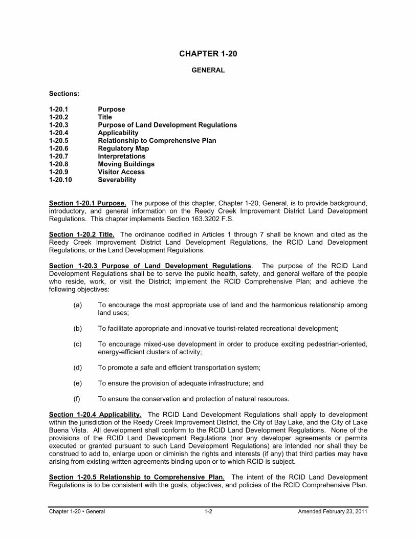
Chapter 1-20 • General 1-2 Amended February 23, 2011
CHAPTER 1-20
GENERAL Sections: 1-20.1 Purpose 1-20.2 Title 1-20.3 Purpose of Land Development Regulations 1-20.4 Applicability 1-20.5 Relationship to Comprehensive Plan 1-20.6 Regulatory Map 1-20.7 Interpretations 1-20.8 Moving Buildings 1-20.9 Visitor Access 1-20.10 Severability Section 1-20.1 Purpose. The purpose of this chapter, Chapter 1-20, General, is to provide background, introductory, and general information on the Reedy Creek Improvement District Land Development Regulations. This chapter implements Section 163.3202 F.S. Section 1-20.2 Title. The ordinance codified in Articles 1 through 7 shall be known and cited as the Reedy Creek Improvement District Land Development Regulations, the RCID Land Development Regulations, or the Land Development Regulations. Section 1-20.3 Purpose of Land Development Regulations. The purpose of the RCID Land Development Regulations shall be to serve the public health, safety, and general welfare of the people who reside, work, or visit the District; implement the RCID Comprehensive Plan; and achieve the following objectives: (a) To encourage the most appropriate use of land and the harmonious relationship among
land uses; (b) To facilitate appropriate and innovative tourist-related recreational development; (c) To encourage mixed-use development in order to produce exciting pedestrian-oriented,
energy-efficient clusters of activity; (d) To promote a safe and efficient transportation system; (e) To ensure the provision of adequate infrastructure; and (f) To ensure the conservation and protection of natural resources. Section 1-20.4 Applicability. The RCID Land Development Regulations shall apply to development within the jurisdiction of the Reedy Creek Improvement District, the City of Bay Lake, and the City of Lake Buena Vista. All development shall conform to the RCID Land Development Regulations. None of the provisions of the RCID Land Development Regulations (nor any developer agreements or permits executed or granted pursuant to such Land Development Regulations) are intended nor shall they be construed to add to, enlarge upon or diminish the rights and interests (if any) that third parties may have arising from existing written agreements binding upon or to which RCID is subject. Section 1-20.5 Relationship to Comprehensive Plan. The intent of the RCID Land Development Regulations is to be consistent with the goals, objectives, and policies of the RCID Comprehensive Plan.
Amended February 23, 2011 1-3 General • Chapter 1-20
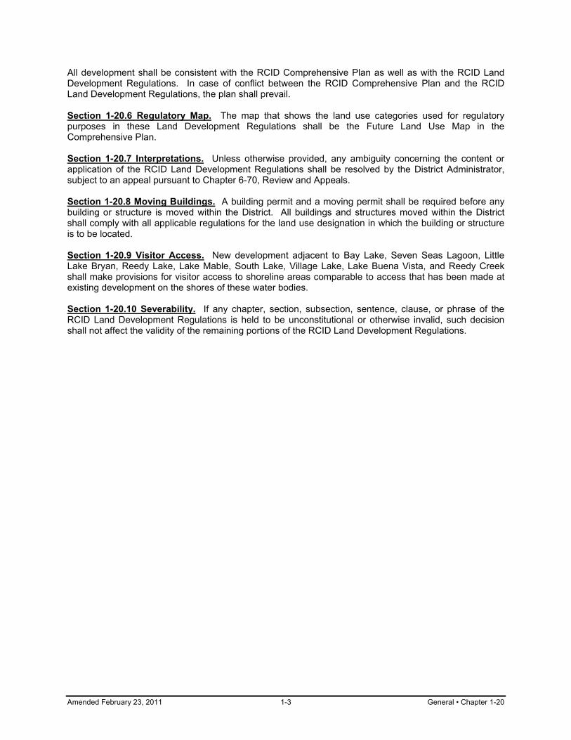
All development shall be consistent with the RCID Comprehensive Plan as well as with the RCID Land Development Regulations. In case of conflict between the RCID Comprehensive Plan and the RCID Land Development Regulations, the plan shall prevail. Section 1-20.6 Regulatory Map. The map that shows the land use categories used for regulatory purposes in these Land Development Regulations shall be the Future Land Use Map in the Comprehensive Plan. Section 1-20.7 Interpretations. Unless otherwise provided, any ambiguity concerning the content or application of the RCID Land Development Regulations shall be resolved by the District Administrator, subject to an appeal pursuant to Chapter 6-70, Review and Appeals. Section 1-20.8 Moving Buildings. A building permit and a moving permit shall be required before any building or structure is moved within the District. All buildings and structures moved within the District shall comply with all applicable regulations for the land use designation in which the building or structure is to be located. Section 1-20.9 Visitor Access. New development adjacent to Bay Lake, Seven Seas Lagoon, Little Lake Bryan, Reedy Lake, Lake Mable, South Lake, Village Lake, Lake Buena Vista, and Reedy Creek shall make provisions for visitor access to shoreline areas comparable to access that has been made at existing development on the shores of these water bodies. Section 1-20.10 Severability. If any chapter, section, subsection, sentence, clause, or phrase of the RCID Land Development Regulations is held to be unconstitutional or otherwise invalid, such decision shall not affect the validity of the remaining portions of the RCID Land Development Regulations.
Chapter 1-30 • Definitions 1-4 Amended February 23, 2011
CHAPTER 1-30
DEFINITIONS Sections: 1-30.1 Purpose 1-30.2 Applicability 1-30.3 Rules of Construction 1-30.4 Use Classifications 1-30.5 Definition of Terms Section 1-30.1 Purpose. The purpose of this chapter, Chapter 1-30, Definitions, is to promote consistency and precision in the interpretation of the RCID Land Development Regulations. This chapter implements Section 163.3202 F.S. Section 1-30.2 Applicability. The meaning and construction of words and phrases as set forth herein shall apply throughout the Land Development Regulations except where the context of such words and phrases clearly indicates a different meaning or construction. Definitions contained in the EPCOT Building Code shall be applicable except when in conflict with definitions contained in the Land Development Regulations, in which case the Land Development Regulations shall control. Additional definitions which apply only within one article or chapter may be contained within that article or chapter. Section 1-30.3 Rules of Construction. The following general rules of construction shall apply to the textual provisions of the Land Development Regulations: (a) Chapter and Section References. "Chapter" means a chapter of the ordinance codified in
these Land Development Regulations unless some other ordinance is specially mentioned. "Section" means a section of the ordinance codified in these regulations unless some other ordinance is specifically mentioned. "Subsection" means a subsection of the section in which the term occurs unless some section is specifically mentioned.
(b) Headings. Section and subsection headings contained herein shall not be deemed to
govern, limit, modify, or in any manner affect the scope, meaning, or intent of any provision of these regulations.
(c) Illustrations. In case of any differences of meaning or implication between the text of any
section or chapter and any illustration, the text shall control. (d) Gender. The masculine gender includes the feminine and neuter. (e) Number. The singular number includes the plural, and the plural the singular. (f) Tense. The present tense includes the past and future tenses, and the future tense
includes the present tense. (g) Shall and May. "Shall" is mandatory, and "may" is permissive. (h) Statutory References. Whenever references are made to any portion of the ordinance
codified in these regulations, any other ordinance of the RCID, or any law of this state or federal government, the reference applies to all applicable amendments and additions now or hereafter made.
Amended February 23, 2011 1-5 Definitions • Chapter 1-30
Section 1-30.4 Use Classifications. Uses are described in the Use Classification System in Chapter 2-30. Section 1-30.5 Definition of Terms. Unless otherwise specified, the following definitions shall be applicable throughout the Land Development Regulations: (a) AASHTO. AASHTO means the American Association of State Highway and
Transportation Officials. (b) Accessory Building. See Epcot Building Code for definition. (c) Accessory Use. An accessory use is a use of land customarily incidental and
subordinated to the principal use of the land on the same project site. (d) Acute Toxicity. Acute toxicity means the presence of one or more substances or
characteristics or components of substances in amounts which:
(1) are greater than one-third ( ) of the amount lethal to fifty (50) percent of the test organisms in 96 hours (96 hr LC50) where the 96 hr LC50 is the lowest value which has been determined for a species significant to the indigenous aquatic community; or
(2) may reasonably be expected, based upon evaluation by generally accepted
scientific methods, to produce effects equal to those of the concentration of the substance specified in (1) above.
(e) Adjusted Gross Income. Adjusted gross income means all wages, assets, regular cash,
or noncash contributions from persons outside the household, and such other resources and benefits as may be determined to be income by the United States Department of Housing and Urban Development, adjusted for family size, less deductions allowable under Section 62 of the Internal Revenue Code.
(f) Adult Congregate Living Facility. See "Group Home." (g) Adverse Impact. Adverse impact means any direct or indirect action likely to cause or
actually causing a measurable decline in the stability, function, or diversity of a natural resource system.
(h) Affordable Housing. Affordable housing is housing which costs the household thirty (30)
percent or less of the Metropolitan Orlando Area median income. Housing costs for owner-occupied housing include principal and interest, utilities, property taxes, house insurance, and mandatory association dues. Housing costs for rental housing include rent and utilities.
(i) Aquifer. An aquifer means an underground, water-bearing layer of earth, porous rock,
sand, or gravel through which water can seep or be held in natural storage. Aquifers generally hold water in quantities sufficient to be used as a water supply.
(j) Area of Disturbance. Area of disturbance means the area within which soil or vegetation
is disturbed or material deposited on land, in conjunction with a development. Area of disturbance is often also known as the "construction area" or "limits of construction."
(k) Board of Supervisors. Board of Supervisors means the RCID Board of Supervisors.
References to procedural actions to be taken by the Board of Supervisors also include actions by the City Council of Bay Lake and/or City Council of Lake Buena Vista, as appropriate.

Chapter 1-30 • Definitions 1-6 Amended February 23, 2011
(l) Berm. A berm is a mound or embankment of earth. (m) Borrow Pit. A borrow pit is an excavated area where material has been dug for use as fill
at another location. (n) Buffer. A buffer is a specially designed protective boundary between a land use,
development, or activity and another land use, development, or activity, where the boundary, according to appropriate data and analysis, is of sufficient size and composition to provide the stated level of protection to the protected use, development, or activity.
(o) Building. See EPCOT Building Code for definition. (p) Building, Accessory. See "Accessory Building." (q) Building, Main. See "Main Building." (r) Community Park. A community park is a park located near major roadways, and
designed to serve the needs of more than one neighborhood. (s) Community Residential Home. A community residential home is a dwelling unit licensed
to serve clients of the Department of Health and Rehabilitation Services, which provides a living environment for unrelated residents who operate as the functional equivalent of a family, and includes such supervision and care by supportive staff as may be necessary to meet the physical, emotional, and social needs of the residents.
(t) Compensation Point for Photosynthetic Activity. Compensation point for photosynthetic
activity means the depth at which one (1) percent of the light intensity at the surface remains unabsorbed. The light intensities at the surface and subsurface shall be measured simultaneously by irradiance meters such as the Kahlsico Underwater Irradiameter, Model No. 268 WA 310 or other devices having a comparable spectral response.
(u) Comprehensive Plan. Comprehensive Plan is the Reedy Creek Improvement District
Comprehensive Plan developed pursuant to the Local Government Comprehensive Planning and Development Regulation Act, as amended, unless otherwise clearly indicated.
(v) Concurrency Management System. Concurrency management system means the
procedures that the RCID will use to assure that development orders and permits are not issued unless the necessary facilities and services are available concurrent with the impacts of development.
(w) Cone of Influence. Cone of influence is the area surrounding a well pumping water for
human consumption that encompasses all area or features that supply groundwater recharge to the well.
(x) DCA. DCA means the Florida Department of Community Affairs. (y) Day. A day is a calendar day, unless a working day is indicated. (aa) Detention. Detention is a delay of stormwater flow for a limited period of time to reduce
flooding, improve water quality, and to prevent erosion.
Amended February 23, 2011 1-7 Definitions • Chapter 1-30
(ab) Development. Development is the carrying out of any building activity or mining operation or the making of any material change in the use of land. Development includes a change in the intensity of use of land, such as an increase in the number of dwelling units in a structure or on land or a material increase in the number or size of businesses, manufacturing establishments, offices, or dwelling units in a structure or on land; alteration of a shore or bank of a seacoast, river, stream, lake, pond, or canal; commencement of drilling (except to obtain soil samples), mining, or excavation; clearing of land as an adjunct of construction; and deposit of refuse, solid or liquid waste, or fill on land.
(ac) Development Parcel. A development parcel is an identified portion of the District that has
been or will be developed as an integrated unit. (ad) District. District is the Reedy Creek Improvement District, unless otherwise clearly
indicated. (ae) District Administrator. District Administrator is the RCID Administrator or his or her
designee, unless otherwise indicated. (af) Drought Tolerant Species. Drought tolerant species are those plant species which do not
require consistent water treatment greater than the average. (ag) EPA. EPA means the U.S. Environmental Protection Agency. (ah) Encroachment. Encroachment means the protrusion of a vehicle into a vehicular access
way, pedestrian way, or landscaped area. Encroachment may also mean the protrusion of development into a protected area.
(ai) Erosion. Erosion is the wearing away and transportation of earth material as a result of
the movement of wind, water, or ice. (aj) FDEP. FDEP means the Florida Department of Environmental Protection. (ak) FDOT. FDOT means the Florida Department of Transportation. (al) F.A.C. F.A.C. means the Florida Administrative Code. (am) F.S. F.S. means the Florida Statues. (an) Fence. A fence is a wall or barrier constructed of boards, masonry, wire, or any other
material for the purpose of enclosing space or separating units of land. The term "fence" does not include retaining walls, but does not include fence gates and gateposts.
(ao) Floodplain. A floodplain is an area inundated during a 100-year 3-day storm event as
defined by the RCID Master Drainage Plan. (ap) Foster Care Facility. A foster care facility is a facility which houses foster residents and
provides a family living environment for the residents, including such supervision and care as may be necessary to meet the physical, emotional, and social needs of the residents, and serves either children or adult foster residents.
(aq) Functional Residents. Functional residents are permanent residents of, day visitors to,
and overnight guests within the Reedy Creek Improvement District. (ar) Functions. Functions are the beneficial roles wetlands serve, including storage,
conveyance, and attenuation of floodwaters and stormwaters; groundwater recharge and
Chapter 1-30 • Definitions 1-8 Amended February 23, 2011
discharge; protection of water quality and reduction of sediment and erosion; production of waterfowl, game, and non-game birds, mammals, and other living resources; protection of habitat for rare, threatened, and endangered species; food chain support for a broad range of wildlife and fisheries; educational, historical, and archaeological value protection; and scenic, aesthetic, and recreational amenities.
(as) Group Home. Group home is a facility which provides a living environment for unrelated
residents who operate as a functional equivalent of a family, including such supervision and care as may be necessary to meet the physical, emotional, and social needs of the residents. Adult congregate living facilities comparable in size to group homes are included in this definition. Group homes shall not include rooming or boarding homes, clubs, fraternities, sororities, monasteries or convents, hotels, residential treatment facilities, nursing homes, or emergency shelters.
(at) Guest. Guests are tourist residents who stay overnight within the District at least one day
but less than six months and day visitors who visit but do not stay overnight within the District.
(au) Hazardous Waste. Hazardous Waste means solid waste, or a combination of solid
wastes, which, because of its quantity, concentration, or physical, chemical, or infectious characteristics, may cause, or significantly contribute to, an increase in mortality or an increase in serious irreversible or incapacitating reversible illness or may pose a substantial present or potential hazard to human health or the environment when improperly transported, disposed of, stored, treated, or otherwise managed. The term does not include human remains that are disposed of by persons licensed under Chapter 470 F.S.
(av) Hedge. A hedge is a dense row of plant material, such as shrubs, which are arranged to
form a boundary or screen. (aw) Impervious Surface. Impervious surface is a surface through which water cannot
penetrate, such as a roof, road, sidewalk, paved parking lot, or plaza. (ax) Infill Projects. Infill projects means projects which are an integral part of a larger
development project and whose traffic, water, sanitary sewer, solid waste, drainage, and parks and recreation impacts were adequately addressed in the approved plans for the larger development project.
(ay) In-kind. In-kind means the restoration or creation of a wetland with vegetation and other
characteristics closely approximating those of a specified wetland. (az) LOS. See "Level of Service." (ba) Landscaped Buffer. A landscaped buffer is an area of landscaping separating two
distinct land uses or public rights-of-way that acts to soften or mitigate the effects of one land use on the other.
(bb) Landscaping. Landscaping means an area devoted to or developed and maintained
predominantly with native or exotic plant materials including lawn, groundcover, shrubs, flowers, vines, and trees. In addition, landscaping may include, but is not limited to, other complementary decorative features such as rocks, fountains, sculpture, decorative walls, and tree wells.
(bc) Level of Service. Level of service means an indicator of the extent or degree of service
provided by, or proposed to be provided by, a facility based on and related to the operational characteristics of the facility.

Amended February 23, 2011 1-9 Definitions • Chapter 1-30
(bd) Level of Service Standard. Level of service standards means the adopted minimum level
of service that is allowable for the various infrastructure facilities. (be) MUTCD. MUTCD means the Manual of Uniform Traffic Control Devices. (bf) Man-induced Conditions which Cannot be Controlled or Abated. Man-induced conditions
which cannot be controlled or abated means pollution conditions that have been influenced by human activities, and:
(1) would remain after removal of all point sources; (2) would remain after imposition of best management practices for non-point
sources; and (3) cannot be restored or abated by physical alteration of the water body, or there is
no reasonable relationship between the economic, social, and environmental costs and the benefits of restoration or physical alteration.
(bg) Main Building. A main building is the building or one of the buildings housing a principal
use on the same project site. (bh) Maintenance Program. A maintenance program is a program for regular upkeep in order
to assure that the goals of an approved plan or design will be met. (bi) Manufactured Home. A manufactured home is a structure, transportable in one or more
sections, which, in the traveling mode, is eight (8) body feet or more in width; which is built on a metal frame and designed to be used as a dwelling with or without a permanent foundation when connected to the required utilities, and includes the plumbing, heating, air conditioning, and electrical systems contained therein; and which was fabricated after June 15, 1976.
(bj) Mixing Zone. See "Zone of Mixing." (bk) Mobile Home. A mobile home is a structure, transportable in one or more sections,
which, in the traveling mode, is eight (8) body feet or more in width, and which is built on a metal frame and designed to be used as a dwelling with or without a permanent foundation when connected to the required utilities, and includes the plumbing, heating, air conditioning, and electrical systems contained therein. If fabricated after June 15, 1976, each section bears a U.S. Department of Housing and Urban Development label certifying that it is built in compliance with the federal Manufactured Home Construction and Safety Standards. Structures fabricated after June 15, 1976, shall be deemed to be and are referred to as "manufactured homes."
(bl) NPDES Permit. A NPDES permit is a National Pollutant Discharge Elimination System
Permit as defined by the Federal Clean Water Act. (bm) N/A. N/A means not applicable. (bn) Native Plants. Native plants are plants that grow naturally in Florida and have adapted to
the climate, soil, location, and rainfall patterns of their area. (bo) Natural Background. Natural background means the condition of waters in the absence
of man-induced alterations based on the best scientific information available to the District. The establishment of natural background for an altered water body may be based upon a similar unaltered water body or on historical pre-alteration data.

Chapter 1-30 • Definitions 1-10 Amended February 23, 2011
(bp) Natural Drainage Features. Natural drainage features are the naturally occurring
features of an area which accommodate the flow of stormwater such as streams, rivers, lakes, wetlands, sloughs, and floodplains.
(bq) Natural Drainage Flow. Natural drainage flow means the pattern of surface and
stormwater drainage through or from a particular site before the construction or installation of improvements or prior to regrading.
(br) Natural Groundwater Aquifer Recharge Areas. Natural groundwater aquifer recharge
areas are areas receiving significant volumes of water which add to the storage of an aquifer through vertical flow.
(bs) Natural Resources. Natural resources are the physical, biological, and chemical
components of our environment supplied by nature. (bt) Neighborhood Park. A neighborhood park is a park which serves the population of a
neighborhood and is generally accessible by bicycle or pedestrian ways. (bu) Nonconforming Use. A nonconforming use is a use existing on November 15, 1991, that
was allowed under the previous plan and regulations but is not allowed by the Future Land Use map of the current Comprehensive Plan.
(bv) Nonpoint Source Pollution. Nonpoint source pollution is any pollution that is not point
source pollution. (bw) Open Space. Open space means (1) all areas that are designated for “Resource
Management/Recreation” (RM/R) uses on the Future Land Use Map of the Comprehensive Plan; (2) lakes and waterways; (3) golf course fairways; (4) all areas designated as such on Figure 7-1 of the Comprehensive Plan; and (5) all areas outside the Wildlife Management Conservation Area (WMCA) that are designated for Conservation uses on the Future Land Use Map. Open space does not include large landscaped areas – rapid infiltration basins, sports fields, turf areas, buffers – within development parcels used for hotels and attractions.
(bx) Off-site. Off-site means a location on a project site other than that where a specific action
is proposed. (by) On-site. On-site means a location on the same project site where a specific action is
proposed. (bz) Organic Mulch. Organic mulch means a material applied to landscaped areas to help
minimize evaporation from the soil, reduce weeds, moderate soil temperatures, and slow erosion. Organic mulches typically include shredded or chipped melaleuca, eucalyptus, pine straw, various hardwoods, and oak leaves.
(ca) Out-of-kind. Out-of-kind means the restoration or creation of a wetland with vegetation or
other characteristics not resembling a specified wetland. (cb) Parking Area. Parking area means an open area, excluding a street or other public right-
of-way, used for parking of vehicles available to the public, whether for free or for compensation.
(cc) Plan. Plan means the RCID Comprehensive Plan, unless otherwise clearly indicated.

Amended February 23, 2011 1-11 Definitions • Chapter 1-30
(cd) Point Source Pollution. Point source pollution means any pollution resulting from a pollutant discharged from any source that constitutes a discernible, confined, and discrete conveyance, including but not limited to any pipe, ditch, channel, tunnel, conduit, well, discrete fissure, container, rolling stock, concentrated animal feeding operation, or vessel or other floating craft. This term does not include return flows from irrigated agriculture.
(ce) Pollution. Pollution means the presence in the outdoor atmosphere or waters of the
District of any substances, contaminants, noise, or man-made or man-induced alteration of the chemical, physical, biological, or radiological integrity of air or water in quantities or levels which are or may be potentially harmful or injurious to human health or welfare, animal or plant life, or property, including outdoor recreation.
(cf) Potable Water Facilities. Potable water facilities are a system of structures designed to
collect, treat, or distribute potable water, and includes water wells, treatment plants, reservoirs, and distribution mains.
(cg) Prime Aquifer Recharge Areas. Prime aquifer recharge areas are those areas
designated by the SFWMD as having high aquifer recharge potential. (ch) Principal Use. A principal use is the primary or predominant use of any project site,
building, or structure. (ci) Project. See "Development." (cj) Project Site. Project site is that area within which anything is disturbed in preparation for
or during construction of a development, except those areas which are disturbed only for the purpose of connecting the development to an underground utility line.
(ck) Propagation. Propagation means reproduction sufficient to maintain a species' role in its
respective ecological community. (cl) Public Access. Public access is a means by which a guest may physically reach, enter,
or use recreation sites including beaches and shores. (cm) Public Road. Public Road is a road that is connected on both ends to a publicly owned
facility or to another public road, and is defined by a right-of-way dedicated to public use. (cn) RCES. RCES means Reedy Creek Energy Services, Inc. (co) RCID. RCID means the Reedy Creek Improvement District. (cp) Restoration. Restoration means a human activity that returns a wetland or former
wetland from a disturbed or altered condition to a previous condition with greater wetland acreage or functions.
(cq) Retention. Retention means the prevention of storm runoff from direct discharge into
receiving waters. Examples are systems which discharge through percolation, exfiltration, and evaporation systems.
(cr) SFWMD. SFWMD means the South Florida Water Management District. (cs) Screening Device. A screening device is the combination or individual use of a fence,
wall, or dense landscaping to physically and visually separate one area from another area.

Chapter 1-30 • Definitions 1-12 Amended February 23, 2011
(ct) Shrubs. Shrubs are a self-supporting woody species of plants characterized by persistent stems and branches springing from the base.
(cu) Site Plan. A site plan is a plan for a project site, showing the existing and proposed
conditions of the site. (cv) Solid Waste. Solid waste is sludge from a waste treatment works, water supply treatment
plant, or air pollution control facility or garbage, rubbish, refuse, or other discarded material, including solid, liquid, or contained gaseous material resulting from domestic, industrial, commercial, mining, agricultural, or governmental operations.
(cw) Special Residential Use. A special residential use is a residential care facility such as a
nursing home, convalescent home, adult congregate living facility, group home, foster care facility, or community residential home.
(cx) State. State is the State of Florida. (cy) Structure. A structure is a combination of materials constructed or erected, the use of
which requires location on the ground or attachment to something having location on the ground.
(cz) Subdivision. A subdivision is the division of land into two (2) or more legal lots for the
purpose of sale of the lots. (da) Surface Runoff. Surface runoff is water that results from precipitation which is not
absorbed by the soil, evaporated into the atmosphere, or entrapped by ground surface depressions and vegetation, and which flows over the ground surface.
(db) Surface Water. Surface water means water upon the surface of the earth, whether
contained in bounds created naturally or artificially or diffused. Water from natural springs shall be classified as surface water when it exits from the spring onto the earth's surface.
(dc) Theme Park. See description of "Recreation: Theme Park" in Chapter 2-30. (dd) Topography. Topography means the configuration of a surface, including its relief and
the position of natural and man-made features. (de) Topsoil. Topsoil means the upper part of the soil profile that is relatively rich in humus,
known in agronomy as the "A-horizon." (df) Travel Trailer. Travel trailer means a vehicular portable unit that is mounted on wheels;
of such a size or weight as not to require special highway movement permits; primarily designed to provide temporary living quarters for recreational, camping, or travel use; and not more than eight and one-half (8 1/2) feet in width and forty (40) feet in length.
(dg) Use. Use is the purpose for which land or a building is arranged, designed, or intended,
or for which either land or a building is or may be occupied or maintained. (dh) Variance. A variance is an authorization to depart from the literal requirements of these
Land Development Regulations in situations where strict enforcement would cause undue hardship.
(di) WTRM. Water treatment management area.

Amended February 23, 2011 1-13 Definitions • Chapter 1-30
(dj) Waters. Waters are as defined in Section 403.03(3) Florida Statues. (dk) Wellfield Protection Area. Wellfield protection area is an area designated by local
government to protect the groundwater source for a well providing water intended for human consumption for a community water system and includes the surface and subsurface area surrounding a potable water wellfield where contaminants have historically degraded or are likely to degrade the quality of the water supply below groundwater standards established by the Florida Department of Environmental Regulation. The wellhead protection area may include all or part of the zone of contribution. Wellhead protection areas shall be delineated using such methods as reasonable or calculated fixed radius, simplified variable shapes, analytical methods, hydrogeological mapping, numerical flow or transport models or other professionally accepted methodologies.
(dl) Wetland. A wetland is that area periodically inundated or saturated by surface or
groundwater, that may be subject to the jurisdiction of the South Florida Water Management District.
(dm) Wetland Buffer. Wetland buffer means an upland area landward of a wetland in which
land clearing and water draw-down activities are limited in order to protect the water quality, water quantity, and wildlife habitat values of the wetland.
(dn) Year. Year is a calendar year, unless otherwise indicated. (do) Zone of Mixing. Zone of mixing means a volume of surface water containing the point or
area of discharge and within which an opportunity for the mixture of wastes with receiving surface waters has been afforded. For construction related activities, this zone will be contained wholly within the construction site.

Chapter 1-40 • Interpretation of Boundaries 1-14 Amended February 23, 2011
CHAPTER 1-40
INTERPRETATION OF BOUNDARIES Sections: 1-40.1 Purpose 1-40.2 Rules of Interpretation 1-40.3 Final Determination Section 1-40.1 Purpose. The purpose of this chapter, Chapter 1-40, Interpretation of Boundaries, is to provide guidance where the boundaries of the land use categories as shown in the Future Land Use Map of the Comprehensive Plan are not defined in sufficient detail. This chapter implements Section 163.3202 F.S. Section 1-40.2 Rules of Interpretation. When uncertainty exists on the exact location of a land use category boundary, the following rules shall apply in the order listed: (a) Boundaries shown as following or approximately following any street shall be construed
as following the right of way of the street or, if a right of way has not been established, the centerline of the street; and
(b) Boundaries shown as following or approximately following natural features shall be
construed as following such features. Section 1-40.3 Final Determination. When the application of the rules in Section 1-40.2, Rules of Interpretation, do not resolve boundary interpretation issues, the District Administrator shall make the final determination based on the features of the Future Land Use Map of the Comprehensive Plan.

Amended February 23, 2011 2-1 Land Uses: Intent • Chapter 2-10
ARTICLE 2 - LAND USES
CHAPTER 2-10
LAND USES: INTENT Sections: 2-10.1 Title and Purpose 2-10.2 Organization Section 2-10.1 Title and Purpose. Article 2 of the Land Development Regulations is entitled Land Uses. The purpose of this article is to provide more detailed descriptions of land uses than are provided in the land use categories of the Comprehensive Plan. Section 2-10.2 Organization. Article 2 consists of the following chapters: (a) 2-10 Land Uses: Intent (b) 2-20 Allowed Uses (c) 2-30 Use Classification System (d) 2-40 Special Residential Uses (e) 2-50 Camping Facilities

Chapter 2-20 • Allowed Uses 2-2 Amended February 23, 2011
CHAPTER 2-20
ALLOWED USES Sections: 2-20.1 Purpose 2-20.2 Principal Uses 2-20.3 Classification of Principal Uses 2-20.4 Accessory Uses 2-20.5 Essential Services 2-20.6 Theme Parks 2-20.7 Lodging Services 2-20.8 Potential Deannexation Areas Section 2-20.1 Purpose. The purpose of this chapter, Chapter 2-20, Allowed Uses, is to prescribe the allowed uses that apply to property within the Reedy Creek Improvement District. This chapter implements Section 163.3202(2)(b) F.S. Section 2-20.2 Principal Uses. Principal uses allowed within the RCID are set forth in Table 2-20 of these Land Development Regulations. Section 2-20.3 Classification of Principal Uses. Principal uses shall be classified according to the use types described in Chapter 2-30, Use Classification System. The classifications shall comply with the provisions of this section. (a) Classifying Uses. Uses shall be classified into use types based upon the description of
the use types and upon physical or operating characteristics similar to other uses already classified within the use type.
b) Classification Process. The District Administrator shall have the authority to classify uses
according to use types or to determine that a use does not fit under any type and, therefore, is not permitted. The following rules shall be used:
(1) For all land use categories except Resource Management/Recreation,
Conservation, and Water, the District Administrator may use broad discretion in classifying uses as long as the public health and safety is not adversely affected; and
(2) For the Resource Management/Recreation, Conservation, and Water land use
categories, the District Administrator shall allow new uses only if he or she finds that they clearly fit under an existing use type and are consistent with the Comprehensive Plan.
(c) List of Uses. The District Administrator shall develop and maintain an administrative list
of common uses and the types into which they are classified. (d) Classifying Several Uses on the Same Project Site. The principal uses conducted on a
single project site shall be classified separately. (e) Appeals. An applicant can appeal the District Administrator's decision pursuant to
Chapter 6-70, Review and Appeals.

Amended February 23, 2011 2-3 Allowed Uses • Chapter 2-20
Section 2-20.4 Accessory Uses. Accessory uses normally incidental to principal uses are allowed except as otherwise provided by this chapter. The District Administrator shall have the authority to determine if a proposed use is a principal or accessory use and if the use is incidental to the principal use. A decision of the District Administrator is subject to the right of appeal pursuant to Chapter 6-70, Review and Appeals. Section 2-20.5 Essential Services. Services, such as gas distribution pipelines, electrical distribution and transmission lines, utility poles, and pole transformers, that are necessary to support principal uses shall be considered allowed accessory uses. Section 2-20.6 Theme Parks. Accessory uses within Theme Parks shall be accorded a broad interpretation to allow those uses that may be desirable or essential in providing an innovative and exciting setting for visitors. Section 2-20.7 Lodging Services. Accessory uses to Lodging Services shall be construed to permit a wide variety of uses including, but not limited to, health clubs, restaurants, auto rental outlets, specialty stores, recreation facilities, meeting rooms, and convention centers. Section 2-20.8 Potential Deannexation Areas. Areas identified in the Comprehensive Plan as potential deannexation shall comply with all laws, ordinances, and regulations of the District, including the land use categories indicated, which shall remain in full force until the area is deannexed.

Chapter 2-20 • Allowed Uses 2-4 Amended February 23, 2011
Table 2-10: RCID USE/LAND USE CATEGORY MATRIX
USE TYPES
COMPREHENSIVE PLAN LAND USE CATEGORIES
Commer-cial Resort
Entertain-ment
Support Facilities
Public Facilities Mixed Use
Resource Mgt /
Recreation Conserva-
tion Water Administrative and Office
Private Sector X X X X X
Public Sector X X X X X X
Agricultural X X
Animal Services
Grooming X X X
Kennels X X X X
Stables X X X
Automotive
Services X X X
Parking X X X X X X
Bus/Professional Support X X X
Civic/Cultural X X X X X
Custom Manufacturing X X X
Day Care X X X X X X
Eating & Drinking X X X X X
Equipment Services X
Finance/Professional X X X
Laundry X X X X
Lodging X X X
Maintenance X X X X
Material Excavation X
Medical X X X X X
Natural Resources X X X X X X X X X

Amended February 23, 2011 2-5 Allowed Uses • Chapter 2-20
Table 2-10: RCID USE/LAND USE CATEGORY MATRIX
USE TYPES
COMPREHENSIVE PLAN LAND USE CATEGORIES
Commer-cial Resort
Entertain-ment
Support Facilities
Public Facilities Mixed Use
Resource Mgt /
Recreation Conserva-
tion Water Recreation
Indoor Entertainment X X X X
Indoor Sports X X X X
Low Impact X X X X X X X X X
Parks & Recreation X X X
Outdoor Entertainment X X X X X X
Outdoor Sports X X X X
Theme Park X X
Residential X
Safety X X X X X X
Sales/Service X X X X
Transportation X X X X X
Utility Services
General X X X X X X
Lines X X X X X X X X X
Warehousing X X
Water Related X X X X X
Notes: a. The column headings refer to the land use categories in the Comprehensive Plan. b. The row headings refer to use types as described in Chapter 2-30. c. An " X" indicates that the use is allowed, subject to the appropriate review.

Chapter 2-30 • Use Classification System 2-6 Amended February 23, 2011
CHAPTER 2-30
USE CLASSIFICATION SYSTEM Sections: 2-30.1 Purpose 2-30.2 Administrative and Business Offices 2-30.3 Agriculture 2-30.4 Animal Services 2-30.5 Automotive 2-30.6 Business and Professional Support 2-30.7 Civic and Cultural Centers 2-30.8 Custom Manufacturing 2-30.9 Day Care 2-30.10 Eating and Drinking Establishments 2-30.11 Equipment Services 2-30.12 Financial and Professional Services 2-30.13 Laundry Services 2-30.14 Lodging Services 2-30.15 Maintenance Services 2-30.16 Material Excavation 2-30.17 Medical Services 2-30.18 Natural Resources 2-30.19 Recreation 2-30.20 Residential 2-30.21 Safety Services 2-30.22 Sales and Services 2-30.23 Transportation Services 2-30.24 Utility Services 2-30.25 Warehousing Services 2-30.26 Water-Related Services Section 2-30.1 Purpose. The purpose of this chapter, Chapter 2-30, Use Classification System, is to classify uses according to a limited number of use types on the basis of common functional, product, or compatibility characteristics, thereby providing a performance basis for regulation of uses in accordance with criteria which are directly relevant to the public health, safety, and general welfare. These classifications shall apply throughout the Land Development Regulations. The following sections in this chapter contain the use types which constitute the use classification system. This chapter implements Section 163.3202(2)(b) F.S. Section 2-30.2 Administrative and Business Offices. The Administrative and Business Offices use type refers to offices which are primarily used for the provision of executive, management, or administrative services not primarily involving walk-in customers or clients. The following are Administrative and Business Offices use types: (a) Private Sector. Offices used by for-profit organizations and not-for profit organizations
other than government entities. Typical uses include headquarters buildings and computer processing offices.
(b) Public Sector. Offices used by governmental entities. Typical uses include government
headquarters buildings and departmental offices.
Amended February 23, 2011 2-7 Use Classification System • Chapter 2-30
Section 2-30.3 Agriculture. The Agriculture use type refers to raising animal or agricultural plant products. Typical uses include grazing, pastures, forests, plant nurseries, tree farms, and orchards. Section 2-30.4 Animal Services. The Animal Services use type refers to establishments primarily engaged in animal-related services. The following are Animal Services use types: (a) Grooming. Grooming of dogs, cats, and similar small animals. Typical uses included
dog bathing and clipping salons, and pet grooming shops. (b) Kennels. Kennel services provided within any project site, building, structure, enclosure,
or premises whereupon or wherein are kept seven or more dogs, cats, or similar small animals in any combination for more than ten days.
(c) Stables. The use of a building, and associated exercise and training areas, for sheltering
horses. Section 2-30.5 Automotive. The Automotive use type refers to establishments or places of business primarily engaged in automotive-related services. The following are Automotive Services use types: (a) Services. Minor automotive repairs; washing and polishing of automobiles; sales of
petroleum products with the incidental sale and installation of tires, batteries, and replacement items; and lubricating services. Typical uses include gasoline service stations.
(b) Parking. Parking of operable motor vehicles on a temporary basis within a privately
owned off-street parking area with or without a fee. Typical uses include parking lots and garages.
Section 2-30.6 Business and Professional Support. The Business and Professional Support use type refers to establishments or places of business primarily engaged in the sale or rental of equipment or the provisions of services to offices of other businesses and organizations, rather than individuals. Typical uses include office supply stores, copying centers, secretarial services, and travel agencies primarily serving business customers. Section 2-30.7 Civic and Cultural Centers. The Civic and Cultural Center use type refers to the performance of educational, cultural, governmental, and other uses which are strongly vested with public or social importance. This classification includes non-profit, museum-like preservation and exhibition of objects of permanent interest in one or more of the arts and sciences, gallery exhibition of works of art, community meeting rooms, and library collection of books and manuscripts. Section 2-30.8 Custom Manufacturing. The Custom Manufacturing use type refers to establishments primarily engaged in on-site production of goods and equipment used within the District. Typical uses include set production manufacturing and costume making. Section 2-30.9 Day Care. The Day Care use type refers to the care of pre-school age children, but does not include the overnight care of such children. Typical uses include day care centers and day care facilities within residential units. Section 2-30.10 Eating and Drinking Establishments. The Eating and Drinking Establishments use type refers to establishments or places of business engaged in the sale of prepared food and beverages. Section 2-30.11 Equipment Services. The Equipment Services use type refers to facilities for the repair and servicing of trucks, buses, heavy equipment, and special equipment. Typical uses include monorail repair facilities and boat repair facilities.

Chapter 2-30 • Use Classification System 2-8 Amended February 23, 2011
Section 2-30.12 Financial and Professional Services. The Financial and Professional Service use type refers to establishments primarily engaged in the provision of financial and banking services and professional services to individuals or business. Typical uses include banks, savings and loan institutions, check cashing services, law offices, insurance offices, and real estate firms. Section 2-30.13 Laundry Services. The Laundry Services use type refers to establishments primarily engaged in the provision of laundering, dry cleaning, or dyeing services other than those classified as Personal Sales and Services. Typical uses include laundry agencies and linen supply services. Section 2-30.14 Lodging Services. The Lodging Service use type refers to establishments primarily engaged in the provision of commercial sleeping room accommodations on a less than monthly basis to the general public. Lodging Services includes incidental food, drink, and other sales and services intended for the convenience of guests as well as meeting rooms and convention facilities. Typical uses include hotels, motels, villas, treehouses, and campgrounds. Section 2-30.15 Maintenance Services. The Maintenance Services use type refers to establishments primarily engaged in the provision of cleaning, custodial services, and material storage areas. Typical uses include janitorial, landscape maintenance, and window cleaning service. Section 2-30.16 Material Excavation. The Material Excavation use type refers to the unearthing of building materials or minerals from the land. Typical uses include borrow pits. Section 2-30.17 Medical Services. The Medical Services use type refers to establishments primarily engaged in the provision of personal health services ranging from prevention, diagnosis and treatment, or rehabilitation services provided by physicians, dentists, nurses, and other health personnel as well as the provision of medical testing and analysis services. Typical uses include medical offices, dental laboratories, health maintenance organizations, and immediate care facilities. Section 2-30.18 Natural Resources. The Natural Resources use type refers to those areas which are left in their natural, undeveloped state. Typical uses include wildlife habitats and natural open spaces. Section 2-30.19 Recreation. The Recreation use type refers to establishments or places of business primarily engaged in the provision of sports, entertainment, or recreation for participants and spectators. The following are Recreation use types: (a) Indoor Entertainment. Predominantly spectator uses conducted within an enclosed
building. Typical uses include motion picture theaters, performance galleries, discotheques, and nightclubs.
(b) Indoor Sports and Recreation. Predominantly participant sports and health activities
conducted within an enclosed building. Typical uses include indoor swimming pools, indoor racquetball courts, and health clubs.
(c) Low Impact. Recreation uses that have a very low impact on the natural environment.
Typical uses include hiking trails and wildlife observation platforms. (d) Park and Recreation. The use of parks, playgrounds, and recreational facilities primarily
by the permanent residents and employees within the District. Typical uses include neighborhood parks and community parks.
(e) Outdoor Entertainment. The use of open or primarily open areas to entertain people.
Typical uses include open music stages. (f) Outdoor Sports. Predominantly participant sports conducted in open or partially enclosed
or screened facilities. Typical uses include golf courses, swimming pools, equestrian centers, and tennis courts.

Amended February 23, 2011 2-9 Use Classification System • Chapter 2-30
(g) Theme Park. The multiple use of a planned area which may include amusement and
thrill rides, performance areas, shops and restaurants, educational and cultural displays, television and motion picture production, and necessary support and service facilities. Typical uses include the Magic Kingdom, Epcot, Disney’s Hollywood Studios, and Typhoon Lagoon.
Section 2-30.20 Residential. The Residential use type refers to the occupancy of living quarters by one or more families. Typical uses include single-family houses, multi-family housing, manufactured housing, mobile homes, and special housing. Section 2-30.21 Safety Services. The Safety Services use type refers to public safety and emergency services, including police, fire protection, emergency medical, and ambulance services. Section 2-30.22 Sales and Services. The Sales and Services use types refers to establishments or places of business primarily engaged in the provision of frequently or recurrently needed specialty items or services. These include various general retail sales and personal services of an appropriate size and scale to meet the above criteria. Typical uses include grocery stores, drug stores, souvenir shops, and clothing stores. Section 2-30.23 Transportation Services. The Transportation Service use type refers to privately owned establishments primarily engaged in the provision of transportation of persons and goods. Typical uses include monorail, bus, and shuttle services. Section 2-30.24 Utility Services. The Utility Services use type refers to major structures necessary to support development but which allow some flexibility in location in contrast to those utility uses which coexist with development and which are considered accessory uses. The following are Utility Service use types: (a) General. Services normally provided to developed areas. Typical uses include, but are
not limited to, energy production facilities, natural gas substations, electrical substations, wastewater treatment plants, solid-waste transfer stations, potable water pump stations, water supply wells, storage tanks, and rapid infiltration basins.
(b) Lines. Typical uses include natural gas, potable water, reclaimed water and wastewater,
transmission pipe lines and electrical transmission and distribution lines. Section 2-30.25 Warehousing Services. The Warehousing Services use type refers to establishments or places of business primarily engaged in the storage and distribution of material and equipment. Typical uses include food warehouses. Section 2-30.26 Water-Related Services. The Water-Related Services use type refers to uses that take place over water but have access from the shore. Typical uses include boat docking facilities and fishing piers. Restaurants are included if they are allowed in the land use category of the landward portion of the water body.

Chapter 2-40 • Special Residential Uses 2-10 Amended February 23, 2011
CHAPTER 2-40
SPECIAL RESIDENTIAL USES Sections: 2-40.1 Purpose 2-40.2 Small Community Residential Homes 2-40.3 Other Special Residential Uses Section 2-40.1 Purpose. The purpose of this chapter, Chapter 2-40, Special Residential Uses, is to set forth regulations for special residential uses that involve a higher level of care than is normally associated with homes for families or individuals. This chapter implements Sections 163.3202(2)(b) and 419.001(2)-(11) F.S. Section 2-40.2 Small Community Residential Homes. A community residential home housing six (6) or fewer residents shall be considered the functional equivalent of a single-family home and, therefore, is allowable wherever a single- or multi-family home is allowed, provided that the applicable Florida Department of Health and Rehabilitative Services standards are met and that a minimum separation of one thousand (1,000) linear feet from any such other small community residential home is maintained. These residential homes are not subject to the provisions of Section 2-40.3, Other Special Residential Uses. Section 2-40.3 Other Special Residential Uses. Special residential uses other than those subject to the provisions of Section 2-40.2, Small Community Residential Homes, shall comply with the provisions of this section. (a) Design Character. If the special residential use is located in a residential area, it shall be
designed and maintained to conform to the character of that neighborhood. (b) Signs. Signs denoting the name or the purpose of a special residential use shall not be
allowed in a residential area. (c) Siting. A special residential use may not be located within one thousand and two
hundred (1,200) feet of another special residential use or within five hundred (500) feet of an area devoted exclusively to single-family residential uses.
(d) Interior Facilities. A facility used for a special residential use and which has more than
six (6) clients shall provide one (1) bedroom and one (1) full bath for every two (2) clients. One (1) bedroom must be designated for the exclusive use of the facility operator and may not be included with the total number of bedrooms available for use by clients.
(e) Licensing. Special residential use uses may not operate unless they have received all
required licenses from applicable state agencies.

Amended May 3, 2000 2-11 Camping Facilities • Chapter 2-50
CHAPTER 2-50
CAMPING FACILITIES Sections: 2-50.1 Purpose 2-50.2 Where Allowed 2-50.3 Standards Section 2-50.1 Purpose. The purpose of this chapter, Chapter 2-50, Camping Facilities, is to set forth regulations for camping facilities to be used by visitors. This chapter implements Section 163.3202(2)(b) F.S. Section 2-50.2 Where Allowed. Camping facilities are classified under the Lodging Services use type and are allowed wherever that use type is allowed. Section 2-50.3 Standards. The following standards shall apply to camping facilities: (a) Recreation vehicles and tent camping for transient occupancy only may be permitted in
designated spaces and areas; (b) All accessory uses shall be conducted primarily for the convenience of the occupants of
the camping area; (c) Every camping facility shall provide an adequate water supply system and wastewater
collection systems; and (d) Where individual wastewater collection connections to vehicle spaces are not provided,
there shall be a central collection station for servicing vehicles with self-contained wastewater systems.
Amended February 23, 2011 3-1 Growth and Infrastructure Phasing: Intent • Chapter 3-10
ARTICLE 3 - GROWTH AND INFRASTRUCTURE PHASING
CHAPTER 3-10
GROWTH AND INFRASTRUCTURE PHASING: INTENT Sections: 3-10.1 Title and Purpose 3-10.2 Organization Section 3-10.1 Title and Purpose. Article 3 of the Land Development Regulations is entitled Growth and Infrastructure Phasing. The purpose of this article is to provide limits on the rate and extent of development in order that public facilities and services may be planned more efficiently, to provide level of service standards for selected public facilities and services, and to ensure that public facilities and services are available concurrent with the impacts of development. Section 3-10.2 Organization. Article 3 consists of the following chapters: (a) 3-10 Growth and Infrastructure Phasing: Intent (b) 3-20 Growth Standards (c) 3-30 Infrastructure Standards

Chapter 3-20 • Growth Standards 3-2 Amended February 23, 2011
CHAPTER 3-20
GROWTH STANDARDS Sections: 3-20.1 Purpose 3-20.2 Development Maximums 3-20.3 Land Consumption Maximums 3-20.4 Development Thresholds Section 3-20.1 Purpose. The purpose of this chapter, Chapter 3-20, Growth Standards, is to set forth the overall limitations on all development within the District. This chapter implements Section 163.3202(2)(b) F.S. Section 3-20.2 Development Maximums. Development of the following uses shall not exceed the maximum increments for growth as specified in Table 2-1 of the Comprehensive Plan, as summarized herein in Table 3-20.2. The figures in the last two columns indicate development in addition to base conditions. Table 3-20.2: Maximum Development
Use
Plan Designation Where Use Is
Permitted
2009 Base
Condition 2010 through 2015
Maximum Increment 2010 through 2020
Maximum IncrementHotel/Motel Hotel/Resort
Mixed Use 28,267 Keys 6,300 Keys 11,300 Keys
Hotel/Motel Mixed Use 180 Acres of
Western Beltway Property (Parcel Id
Numbers: 21-24-27-0000-00-
003, 005, 008)
1,757 Keys 1,757 Keys (Subset of 11,300 Hotel/Motel Keys)
Other Resort Unit Hotel/Resort Mixed Use
5,000 Keys 4,000 Keys 8,900 Keys
Other Resort Unit Mixed Use 180 Acres of
Western Beltway Property (Parcel Id
Numbers: 21-24-27-0000-00-
003, 005, 008)
1,259 Keys (Subset of 8,900 Hotel/Motel Keys)
Golf Courses Hotel/Resort Mixed Use
81 Holes 0 Holes 18 Holes
Office Commercial Mixed Use
882,000 S.F. 100,000 SF 150,000 SF
Retail/Restaurant Commercial Mixed Use
897,887 S.F. 560,000 SF 835,000 SF

Amended February 23, 2011 3-3 Growth Standards • Chapter 3-20
Use
Plan Designation Where Use Is
Permitted
2009 Base
Condition 2010 through 2015
Maximum Increment 2010 through 2020
Maximum IncrementOffice/Retail/ Restaurant
Mixed Use 180 Acres of
Western Beltway Property (Parcel Id
Numbers: 21-24-27-0000-00-
003, 005, 008
450,000 SF (Subset of 150,000 SF Office
and 835,000 SF Retail/Restaurant)
450,000 SF (Subset of 150,000 SF Office
and 835,000 SF Retail/Restaurant)
Major Theme Parks Entertainment Mixed Use
4 Parks 0 Park 1 Park
Minor Theme Parks Entertainment Mixed Use
3 Parks 1 Park 2 Parks
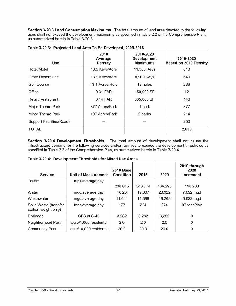
Chapter 3-20 • Growth Standards 3-4 Amended February 23, 2011
Section 3-20.3 Land Consumption Maximums. The total amount of land area devoted to the following uses shall not exceed the development maximums as specified in Table 2.2 of the Comprehensive Plan, as summarized herein in Table 3-20.3. Table 3-20.3: Projected Land Area To Be Developed, 2009-2018
Use
2010 Average Density
2010-2020 Development
Maximums 2010-2020
Based on 2010 DensityHotel/Motel 13.9 Keys/Acre 11,300 Keys 813
Other Resort Unit 13.9 Keys/Acre 8,900 Keys 640
Golf Course 13.1 Acres/Hole 18 holes 236
Office 0.31 FAR 150,000 SF 12
Retail/Restaurant 0.14 FAR 835,000 SF 146
Major Theme Park 377 Acres/Park 1 park 377
Minor Theme Park 107 Acres/Park 2 parks 214
Support Facilities/Roads -- -- 250
TOTAL 2,688
Section 3-20.4 Development Thresholds. The total amount of development shall not cause the infrastructure demand for the following services and/or facilities to exceed the development thresholds as specified in Table 2.3 of the Comprehensive Plan, as summarized herein in Table 3-20.4. Table 3-20.4: Development Thresholds for Mixed Use Areas
Service
Unit of Measurement
2010 Base Condition
2015
2020
2010 through 2020
Increment Traffic trips/average day
238,015
343,774
436,295
198,280 Water mgd/average day 16.23 19.607 23.922 7.692 mgd Wastewater mgd/average day 11.641 14.398 18.263 6.622 mgd Solid Waste (transfer station weight only)
tons/average day 177 224 274 97 tons/day
Drainage CFS at S-40 3,282 3,282 3,282 0 Neighborhood Park acre/1,000 residents 2.0 2.0 2.0 0 Community Park acre/10,000 residents 20.0 20.0 20.0 0

Amended February 23, 2011 3-5 Infrastructure Standards • Chapter 3-30
CHAPTER 3-30
INFRASTRUCTURE STANDARDS Sections: 3-30.1 Purpose 3-30.2 Maintenance of Standards 3-30.3 Roadway System 3-30.4 Potable Water 3-30.5 Sanitary Sewage 3-30.6 Solid Waste 3-30.7 Drainage 3-30.8 Parks and Recreation Section 3-30.1 Purpose. The purpose of this chapter, Chapter 3-30, Infrastructure Standards, is to set forth the level of service standards for roads, potable water, sanitary sewer, solid waste, drainage, and parks and recreation. This chapter implements Section 163.3202(2)(g) F.S. Section 3-30.2 Maintenance of Standards. The standards in this chapter shall be used in the concurrency management review pursuant to Chapter 6-30. Section 3-30.3 Roadway System. The level of service standards for public roads within the District are as provided in this section. (a) Peak Season. The level of service standards are based on the peak season, which is
defined as June through August. (b) Constrained Facilities. A fifteen (15) percent increase in service flow rates (capacities)
shall be allowed for those roads designated as constrained facilities in the Transportation Element policies of the Comprehensive Plan.
(c) Standards. The level of service standards for roads are as follows:
Functional Classification State
Facilities County
Facilities District
Facilities Principal Arterial (Limited Access) Principal Arterial (Major) Minor Arterial Collector Local
D D E
N/A N/A
N/A N/A E E
N/A
E E E E
N/A (d) Definitions. The definitions of the level of service standards for roads are as follows:
(1) LOS A: Denotes a relatively free flow of traffic, with little or no limitation on vehicle movement or speed.
(2) LOS B: Denotes a steady flow of traffic, with only slight delays in vehicle
movement and speed. All queues clear a single signal cycle.
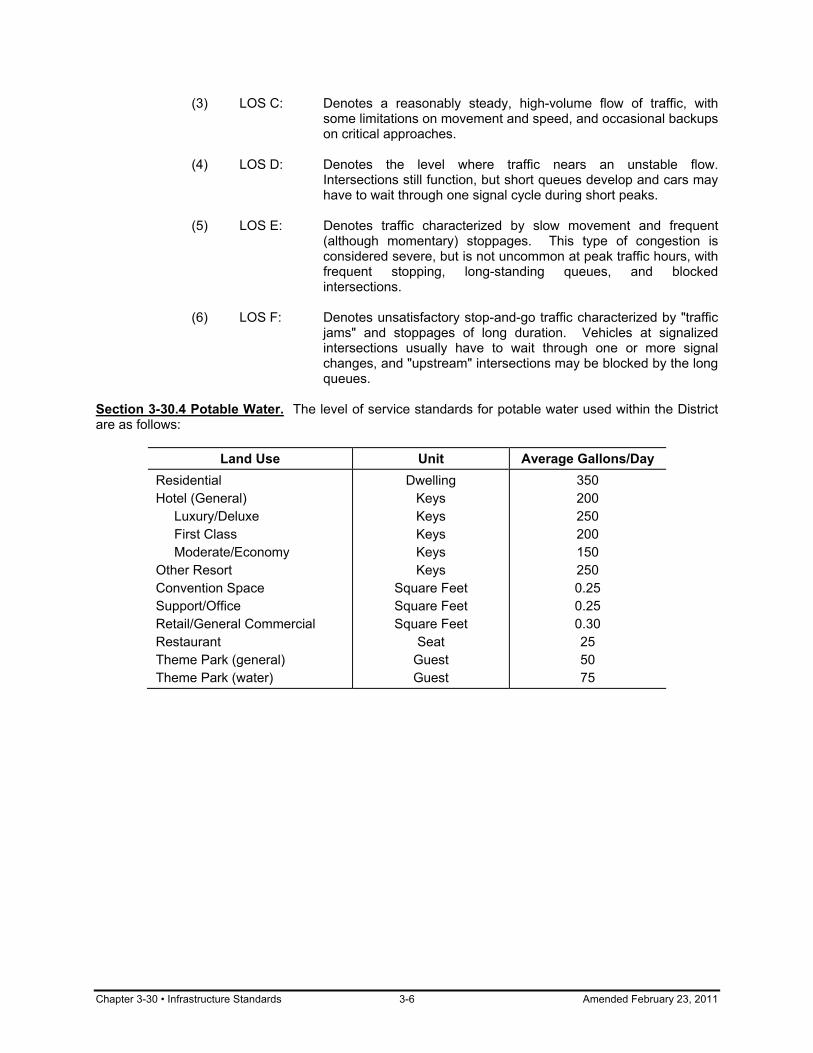
Chapter 3-30 • Infrastructure Standards 3-6 Amended February 23, 2011
(3) LOS C: Denotes a reasonably steady, high-volume flow of traffic, with some limitations on movement and speed, and occasional backups on critical approaches.
(4) LOS D: Denotes the level where traffic nears an unstable flow.
Intersections still function, but short queues develop and cars may have to wait through one signal cycle during short peaks.
(5) LOS E: Denotes traffic characterized by slow movement and frequent
(although momentary) stoppages. This type of congestion is considered severe, but is not uncommon at peak traffic hours, with frequent stopping, long-standing queues, and blocked intersections.
(6) LOS F: Denotes unsatisfactory stop-and-go traffic characterized by "traffic
jams" and stoppages of long duration. Vehicles at signalized intersections usually have to wait through one or more signal changes, and "upstream" intersections may be blocked by the long queues.
Section 3-30.4 Potable Water. The level of service standards for potable water used within the District are as follows:
Land Use Unit Average Gallons/Day Residential Hotel (General) Luxury/Deluxe First Class Moderate/Economy Other Resort Convention Space Support/Office Retail/General Commercial Restaurant Theme Park (general) Theme Park (water)
Dwelling Keys Keys Keys Keys Keys
Square Feet Square Feet Square Feet
Seat Guest Guest
350 200 250 200 150 250 0.25 0.25 0.30 25 50 75

Amended February 23, 2011 3-7 Infrastructure Standards • Chapter 3-30
Section 3-30.5 Sanitary Sewage. The level of service standards for sanitary sewage generated within the District are as follows:
Land Use Unit Average Gallons/Day Residential Hotel (General) Luxury/Deluxe First Class Moderate/Economy Other Resort Convention Space Support/Office Retail/General Commercial Restaurant Theme Park (general) Theme Park (water)
Dwelling Keys Keys Keys Keys Keys
Square Feet Square Feet Square Feet
Seat Guest Guest
300 180 230 180 130 230 0.20 0.20 0.25 20 30 50
Section 3-30.6 Solid Waste. The level of service standards for solid waste generated within the District are as follows:
Land Use Unit Average Pounds/Day Residential Hotel (General) Luxury/Deluxe First Class Moderate/Economy Value Other Resort Convention Space Support/Office Retail/General Commercial /Restaurant Theme Park (general) Theme Park (water)
Dwelling Keys Keys Keys Keys Keys Keys
Square Feet Square Feet Square Feet
Park Park
11.5 7.5 11.0 7.5 6.0 3.5 6.0
0.0325 0.002
0.0325
10 to 20 tons* 0.5 to 1.0 tons*
*depending on size and amenities Section 3-30.7 Drainage. The level of service standards for drainage within the District are as set forth in this section.
(a) Main Drainage System. The main District Drainage System shall convey the 50-year, 3-day storm event as determined by the RCID stormwater model.
(b) S-40 Structure. The discharge at S-40 shall be limited to 3,282 cubic feet per second
during a 10-year, 3-day storm event. (c) Arterial Roadways. Arterial roadways shall remain above the 50-year, 3-day storm event
elevation as determined by a stormwater model acceptable to the District.
Chapter 3-30 • Infrastructure Standards 3-8 Amended February 23, 2011
(d) Floor Levels. The first floor of all habitable structures and public facilities shall be a minimum of one (1) foot above the 100-year, 3-day storm event elevation, as determined by a stormwater model acceptable to the District.
(e) Detention and Retention. All development sites shall provide detention or retention
before discharge into the District system as set forth in one of the subsections below.
(1) Detention volume shall be provided equal to the first one (1) inch of runoff times the development site acreage, or two and one-half (2 1/2) inches times the development site acreage multiplied by the percentage of imperviousness, whichever is greater;
(2) Retention volume shall be provided equal to fifty (50) percent of the amount
computed in Subsection (e)(1) of this section. Section 3-30.8 Parks and Recreation. The level of service standards for parks and recreation facilities within the District are as set forth in this section. (a) Neighborhood Parks. Two (2) acres of neighborhood parkland shall be provided
per 1,000 permanent residents. (b) Community Parks. Twenty (20) acres of community parkland shall be provided
per 10,000 permanent residents.

Amended February 23, 2011 4-1 Development and Design Regulations: Intent • Chapter 4-10
ARTICLE 4 - DEVELOPMENT AND DESIGN REGULATIONS
CHAPTER 4-10
DEVELOPMENT AND DESIGN REGULATIONS: INTENT Sections: 4-10.1 Title and Purpose 4-10.2 Organization Section 4-10.1 Title and Purpose. Article 4 of the Land Development Regulations is entitled Development and Design Regulations. The purpose of this article and the chapters within it is to provide development standards, regulate the use of signs, and address nonconforming uses and structures. Section 4-10.2 Organization. Article 4 consist of the following chapters: (a) 4-10 Development and Design Regulations: Intent (b) 4-20 Site Improvements (c) 4-30 Streets and Rights-of-Way (d) 4-40 Parking, Loading, and Circulation (e) 4-50 Landscaping (f) 4-60 Open Space (g) 4-70 Signs (h) 4-80 Non-Conformities

Chapter 4-20 • Site Improvements 4-2 Amended February 23, 2011
CHAPTER 4-20
SITE IMPROVEMENTS Sections: 4-20.1 Purpose 4-20.2 Potable Water Distribution Systems 4-20.3 Wastewater Collection Systems 4-20.4 Surface Drainage Systems 4-20.5 Solid Waste Systems 4-20.6 Traffic Circulation Systems Section 4-20.1 Purpose. The purpose of this chapter, Chapter 4-20, Site Improvements, is to establish requirements for adequate site improvements. This chapter implements Section 163.3202(2) F.S. Section 4-20.2 Potable Water Distribution Systems. All development shall comply with the provisions of this section. (a) Connection to RCID System. All development within the potable water service area shall
be connected to the RCID water system, except as otherwise provided by the RCID Utility Division Rules.
(b) Size and Design. All development within the District shall provide a potable water
distribution system that shall be of sufficient size and design to supply water for potable use and fire protection to each of the buildings and structures to be erected in the development.
(c) Fire Hydrants. At least one fire hydrant shall be installed within one hundred fifty (150)
feet of each building or structure. Fire hydrants shall be designed and installed in accordance with the EPCOT Fire Prevention Code.
Section 4-20.3 Wastewater Collection Systems. All development shall include a wastewater collection system that complies with Chapter 5-60, Sanitary Sewer. Section 4-20.4 Surface Drainage Systems. All development shall include a surface drainage system that complies with Chapter 5-30, Stormwater Management and Section 3-30.7. Section 4-20.5 Solid Waste Systems. All development shall include a solid waste system that complies with Chapter 5-70, Solid Waste. Section 4-20.6 Traffic Circulation Systems. The traffic circulation system shall comply with the provisions of Chapter 4-30 and Chapter 4-40.
Amended February 23, 2011 4-3 Streets and Rights-of-Way • Chapter 4-30
CHAPTER 4-30
STREETS AND RIGHTS-OF-WAY Sections: 4-30.1 Purpose 4-30.2 Classification of Roads 4-30.3 Roadway Design Standards 4-30.4 Access Standards 4-30.5 Pedestrian Safety Requirements 4-30.6 Rights-of-Way Requirements Section 4-30.1 Purpose. The purpose of this chapter, Chapter 4-30, Streets and Rights-of-Way, is to establish minimum requirements for transportation improvements, including public and private streets, bikeways, pedestrian ways, and access control to and from public streets. This chapter implements Section 163.3202(2)(h) F.S. Section 4-30.2 Classification of Roads. Roads in the District are classified and mapped according to the function they serve, regulation of access, road and right-of-way widths, circulation patterns, design speed, and construction standards. All roads, except for local roads, within the RCID shall be classified as limited access roadways, major arterials, minor arterials, and collectors as set forth in the Transportation Element of the Comprehensive Plan; such classification is herein adopted by reference. Section 4-30.3 Roadway Design Standards. All required elements of the transportation system shall at a minimum be in compliance with the engineering design and construction standards contained in FDOT Manual of Uniform Minimum Standards for Design, Construction and Maintenance for Streets and Highways and Design Standards for Design, Construction, Maintenance and Utility Operations on the State Highway System, unless otherwise approved by the RCID. In instances where FDOT policies are absent, AASHTO engineering design and construction guidelines shall be used. All traffic control devices shall be designed and constructed in compliance with MUTCD standards and Chapter 4-70, Signs, unless otherwise approved by the RCID. Section 4-30.4 Access Standards. Access driveways shall be designed in conformance with the standards set forth in this section. (a) Access. Driveway design, including the number of lanes, shall be based on traffic
engineering standards for entering and exiting traffic demand which shall comply with Section 4-30.3, Roadway Design Standards.
(b) Future Driveways. No driveway shall be permitted within seventy (70) feet of an
intersection. This measurement shall be made from the centerline of the proposed driveway to the nearest right-of-way line of the intersecting street as measured along the adjacent right-of-way line.

Chapter 4-30 • Streets and Rights-of-Way 4-4 Amended February 23, 2011
(c) Spacing. The minimum spacing for interchanges, driveway connections, median openings, and signals shall be as follows:
Roadway Classification
Interchange Spacing
Minimum Driveway
Connection Spacing
Median Opening Spacing
Minimum Signal
Spacing
Major Arterial/ Limited Access 1 mile N/A N/A N/A
Minor Arterial N/A 245 feet 660 feet 1,320 feet
Collector N/A 125 feet 330 feet 1,320 feet
(e) Number of Driveways. The number of driveways to be provided for any individual use
shall be the minimum number required to adequately serve the needs of the use. Uses with frontage of one hundred (100) feet or less will be limited to one (1) driveway.
(f) Angle to Roadway. Driveways shall be as nearly at right angles to the roadway as
practical. (g) Obstruction of Right-of-Way. Site development shall be designed to provide adequate
on-site parking and maneuvering for all vehicles so that vehicles entering or exiting the site do not park on or obstruct the right-of-way.
(h) Backing onto Right-of-Way. No driveway shall be permitted which necessitates backing
of vehicles on the right-of-way. (i) Road Improvements. When driveway connections are proposed, improvements to the
public road shall be required of development when necessary to ensure safe and adequate ingress and egress to the site.
Section 4-30.5 Pedestrian Safety Requirements. (a) Sidewalk Adjacent to Collector, Minor Arterials, and Local Roads. Location of sidewalks
shall be consistent with planned roadway improvements. Pedestrian ways or crosswalks will be required between places of work and shopping/eating areas and between adjacent or adjoining places of work.
(b) Other Sidewalks or Footpaths. The FDOT Florida Pedestrian Planning and Design
Handbook shall be used as guidance in the design and construction of sidewalks and other footpaths within rights-of-way. In instances where FDOT manuals are absent, AASHTO engineering design and construction policies may be used.
Section 4-30.6 Public Rights-of-Way Requirements. The dedication and/or reservation for acquisition of rights-of-way for public transportation facility improvements shall be required of development within the District, as provided in this section. (a) General. The location and design of new roadway network facilities, transit corridors, and
pedestrian facilities shall be coordinated during the development review process. (b) Minimum Widths. Rights-of-way shall be reserved at the minimum width required to
accommodate construction of the number of lanes shown on the Future Transportation
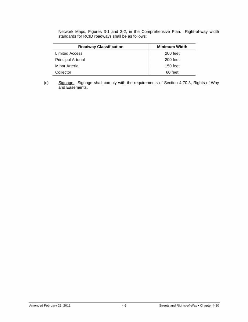
Amended February 23, 2011 4-5 Streets and Rights-of-Way • Chapter 4-30
Network Maps, Figures 3-1 and 3-2, in the Comprehensive Plan. Right-of-way width standards for RCID roadways shall be as follows:
Roadway Classification Minimum Width
Limited Access 200 feet Principal Arterial 200 feet Minor Arterial 150 feet Collector 60 feet
(c) Signage. Signage shall comply with the requirements of Section 4-70.3, Rights-of-Way
and Easements.
Chapter 4-40 • Parking, Loading, and Circulation 4-6 Amended February 23, 2011
CHAPTER 4-40
PARKING, LOADING, AND CIRCULATION Sections: 4-40.1 Purpose 4-40.2 General Parking Regulations 4-40.3 Location of Parking 4-40.4 Joint Use of Parking 4-40.5 Loading and Unloading Requirements 4-40.6 Permanent Reservation 4-40.7 Parking for Disabled Persons Section 4-40.1 Purpose. The purpose of this chapter, Chapter 4-40, Parking, Loading, and Circulation, is to provide safe and adequate parking and loading facilities. This chapter implements Section 163.3202(2)(h) F.S. Section 4-40.2 General Parking Regulations. Parking shall be required as set forth in this section. (a) General. Prior to issuance of a Certificate of Occupancy and permanent provision of
utilities, evidence shall be provided that the parking required by this chapter, including disabled-person spaces, is provided.
(b) Applicability. Parking for new uses, new buildings or structures, enlargement of existing
buildings or structures, or increase in capacity of existing buildings or structures shall be provided as set forth in this chapter.
(c) Number of Spaces. The number of spaces provided shall be based on Table 4-40-1
unless a detailed parking study is submitted which justifies the use of other standards. All references to employees mean the number of employees on the largest shift.
(d) Disabled Persons. Parking space requirements for disabled people are addressed in
Section 4-40.7, Parking for Disabled Persons. (e) General Design. All parking areas shall be properly drained and designed with regard to
pedestrian and vehicular safety. (f) Size of Parking Spaces. Parallel parking spaces shall have a minimum width of eight (8)
feet and a minimum length of twenty-two (22) feet and all other parking spaces shall have a minimum width of eight and one-half (8 1/2) feet and a minimum length of eighteen (18) feet.
(g) Turning and Maneuvering. Off-street turning and maneuvering shall be provided for each lot so that no vehicle will be required to back onto or from any public street or alley.
(h) Access and Circulation. The parking area shall be designed so that vehicles within the
parking area will not have to enter a public street to move from one location to any other location within the parking area. The size and location(s) of all public vehicular access and vehicular circulation shall be subject to review by the District Administrator.
(i) Surfacing. Pervious paving of parking spaces, driveways, and maneuvering areas is
encouraged where suitable soils are present. Suitable pervious materials include, but are not limited to, 57 stone, crushed granite, and pervious concrete. Asphaltic millings are not a suitable pervious material. In instances where pervious paving may not be used,
Amended February 23, 2011 4-7 Parking, Loading, and Circulation • Chapter 4-40
parking spaces, driveways, and maneuvering areas shall be paved and permanently maintained with asphalt, concrete, or other similar durable weather-resistant surface.
Section 4-40.3 Location of Parking. The required parking facilities shall be located on the development site they are intended to serve, except as provided herein. (a) Within 750 Feet. The District Administrator may allow the establishment of parking
facilities on another development site if the majority of such facilities are within seven hundred and fifty (750) feet of the site or use they are intended to serve, provided all of the following findings are made:
(1) Practical difficulties, such as environmental constraints or site congestion,
prevent the placing of the facilities on the same development site as the building or use they are designed to serve;
(2) A pedestrian walkway system is provided to connect the parking facilities to the
building or use they are designed to serve. When such a pedestrian walkway system traverses the public right-of-way, the pedestrian walkway system must be elevated above the right-of-way or depressed beneath the right-of-way; and
(3) The owner of the parking facility has entered into a written agreement with the
RCID, with enforcement running to the RCID, providing that the land comprising the parking facility shall be reserved as set forth in Section 4-40.6, Permanent Reservation.
(b) More Than 750 Feet. The District Administrator may allow the establishment of parking
facilities on another development site where such facilities are more than seven hundred and fifty (750) feet of the site or use they are intended to serve, provided all of the following findings are made:
(1) Practical difficulties, such as environmental constraints or site congestion,
prevent the placing of the facilities on the same development site as the building or use they are designed to serve;
(2) Valet, shuttle, and/or tram service is provided from the parking facilities to the site
or use, and the owner of the building or use has entered into a written agreement with the RCID that the valet, shuttle, and/or tram service will be maintained so long as the parking facilities are required; and
(3) The owner of the parking facility has entered into a written agreement with the
RCID, with enforcement running to the RCID, providing that the land comprising the parking facility shall be reserved as set forth in Section 4-40.6, Permanent Reservation.
(c) Voidable Agreement. The written agreements in Subsection (a)(3) or Subsection (b)(3)
of this section shall be voided by the RCID if parking facilities on the same development site are subsequently provided in accordance with this chapter.
Section 4-40.4 Joint Use of Parking. The sharing of spaces by more than one use shall comply with the provisions of this section. (a) Joint Use of Spaces. Parking spaces required for a building or use shall be included as
part of the on-site parking requirements for another building or use only upon approval of a parking study that demonstrates that parking demands of the different uses overlap in a complementary manner and/or occur at different times.
Chapter 4-40 • Parking, Loading, and Circulation 4-8 Amended February 23, 2011
(b) Combined Parking Areas. Nothing in this chapter shall be construed to prevent the joint use of on-site parking space by two (2) or more buildings or uses if the total of such spaces when used together shall not be less than the sum of the requirements for the various individual uses or buildings computed separately.
Section 4-40.5 Loading and Unloading Requirements. (a) Location. All loading and unloading shall take place in designated areas so as not to
interfere with the movement of traffic. (b) Markings. Loading and unloading areas shall be designated with appropriate markings
and signage. Section 4-40.6 Permanent Reservation. Except where equivalent parking or loading space is provided, the area reserved for parking or loading in accordance with the requirements of this chapter shall not be reduced in area or changed to any other use unless the permitted use that it serves is discontinued or modified. Section 4-40.7 Parking for Disabled Persons. All development offering parking for the general public shall provide specially designed and marked motor vehicle parking spaces and passenger drop-off and loading zones for the exclusive use of physically disabled persons in accordance with the EPCOT Building Code. Section 4.40.8 Pedestrian Access from Public Sidewalks. All developments with adjacent public sidewalks shall provide safe pedestrian access from the public sidewalk with a connecting walkway or sidewalk to the development site.

Amended February 23, 2011 4-9 Parking, Loading, and Circulation • Chapter 4-40
Table 4-40-1: Off-street Parking Space Requirements Use Types Spaces Required
Administrative and Business Offices
Private Sector 1 per 180 sq. ft. of building GFA on first floor + 1 per 250 sq. ft. of GFA above first floor, excluding floor area used for mechani-cal/utility equipment and public spaces
Public Sector Same as Private Sector Agriculture No Requirements Animal Services Grooming 2.5 per 1000 sq. ft. + 1 per employee Kennels 1 per 300 sq. ft. of enclosed floor area Stables 1 per employee + 0.5 per horse Automotive Services 1 per employee + 2 per 1000 sq. ft. of GFA + 2 per service bay Parking 1 per employee + guest spaces
Business and Professional Support
1 per 250 sq. ft. of GFA in buildings with less than 2,000 square feet in area, 1 per 200 sq. ft. of GFA in buildings with 2,000 to 20,000 square feet in area, and 1 per 150 sq. ft. of GFA in buildings with over 20,000 square feet in area
Civic and Cultural Centers Places of Assembly with Fixed Seats 1 per 3 fixed seats for patron use + 1 per employee
Places of Assembly without Fixed Seats
1 per 35 feet of building GFA used for assembly purposes + 1 per employee
Exhibition Space, Library, Meeting Rooms
1 per 300 sq. ft. GFA
Custom Manufacturing 1 per 500 sq. ft. of GFA, or 2 per employee, whichever results in the greater number of spaces
Day Care 1 per 1000 sq. ft. + 1 per employee + 0.20 per child Downtown Disney 9 per 1000 sq. ft. of GFA including outdoor dining areas
Eating and Drinking Establishments 1 per 5 fixed seats + 1 per 35 sq. ft. with no fixed seats + 1 per employee; minimum 10 spaces total
Fast Food Restaurants 0.58 per seat.
Equipment Services 1 per 500 sq. ft. of GFA, or 1 per employee, whichever results in the greater number of spaces
Financial and Professional Services
1 per 250 sq. ft. of GFA in buildings with less than 2,000 square feet in area, 1 per 200 sq. ft. of GFA in buildings with 2,000 to 20,000 square feet in area, and 1 per 150 sq. ft. of GFA in buildings with over 20,000 square feet in area
Laundry Services 1 per 500 sq. ft. of GFA, or 1 per employee, whichever results in the greater number of spaces

Chapter 4-40 • Parking, Loading, and Circulation 4-10 Amended February 23, 2011
Table 4-40-1: Off-street Parking Space Requirements (continued)
Use Types Spaces Required Lodging Services
Hotels (with monorail) 1.3 per guest room, plus, if applicable, 1 per 200 sq. ft. of floor area used for convention and meeting purposes (excluding lobbies, pre-function areas, and restrooms)
Hotels/Motels (without monorail) 1 per guest room, plus if applicable, 1 per 200 sq. ft. of floor area used for convention and meeting purposes (excluding lobbies, pre-function areas, and restrooms)
Value Resort 0.92 per guest room
Maintenance Services 1 per 500 sq. ft. of GFA, or 1 per employee, whichever results in the greater number of spaces
Material Excavation 1 per employee
Medical Services 1 per 150 sq. ft. of GFA, excluding floor area used for mechanical and utility equipment, or 5 per doctor's office, or 1 per hospital bed, whichever results in the greatest number of spaces
Natural Resources No Requirements Recreation Indoor Entertainment 1 per employee + 1 per 3 seats Indoor Sports and Recreation 5 per 1000 sq. ft. + 1 per employee Low Impact No Requirements Park and Recreation 9 per acre Outdoor Entertainment Parking Study required Outdoor Sports
Golf Courses 10 per hole plus parking requirements for related buildings and uses; if golf course is an integral part of a hotel development, 4 per hole plus parking requirements for hotel
Other Outdoor Sports Parking Study required Theme Park Parking Study required Residential Single- and Two- Family 2 per unit, both covered
Multi-Family 1 per studio unit; 1.5 per 1-bedroom unit; 2 per 2-bedroom unit; +0.25 per each unit for visitor parking
Mobile Home 2 per unit Special Parking Study required Safety Services 1 per employee Sales and Services 1 per 180 sq. ft. of GFA used for retail uses Transportation Services 1 per employee

Amended February 23, 2011 4-11 Parking, Loading, and Circulation • Chapter 4-40
Table 4-40-1: Off-street Parking Space Requirements (continued)
Use Types Spaces Required Utility Services General 1 per employee Lines No Requirements Warehousing Services 1 per 1000 sq. ft. of building GFA
Water-Dependent Services Use space requirements for other applicable use types listed in this table; if not listed, parking study required
Note: 1. "GFA" means gross floor area of building. 2. "Employee" refers to the number of employees on the largest shift.

Chapter 4-50 • Landscaping 4-12 Amended December 20, 2011
CHAPTER 4-50
LANDSCAPING Sections: 4-50.1 Purpose 4-50.2 Applicability 4-50.3 Required Plans 4-50.4 Water Conservation 4-50.5 Public Safety 4-50.6 Native Vegetation 4-50.7 Non-residential Properties Adjacent to Residential Properties Section 4-50.1 Purpose. The purpose of this chapter, Chapter 4-50, Landscaping, is to establish regulations for landscaping, including plants and irrigation. This chapter implements Section 163.3202(2) F.S. Section 4-50.2 Applicability. The provisions set forth in this chapter shall apply to all areas within the Reedy Creek Improvement District boundaries. Section 4-50.3 Required Plans. Landscaping plans shall be required for all development requiring a site plan review pursuant to Chapter 7-20. These plans shall be prepared by a licensed Landscape Architect or other person knowledgeable of Florida plant materials, plant communities, and landscape procedures. The landscaping plans shall provide sufficient detail to enable the District Administrator to determine that the plans comply with this chapter. These plans shall not be reviewed for aesthetic value or for other features not covered specifically by this chapter. Section 4-50.4 Water Conservation and Water Quality. (a) All new irrigation systems shall be required to connect to the RCID water reuse system
upon initial installation or when such system connections become available. Where reuse water is not available or where its use is prohibited, high drought tolerant plants from the Florida-friendly Plant Database at http://www.floridayards.org/fyplants/index.php must be used.
(b) A low maintenance zone shall be required along the side slopes and within ten (10) feet
of the top of slope (Figure 4-1) of any pond, stream, water course, lake, or canal or within ten (10) feet of the landward edge of any wetland or wetland buffer (Figure 4-2) or from the top of a seawall. The low maintenance zone is to be planted and managed in order to alleviate the need for watering and to minimize the need for mowing, etc. A swale/berm system (Figure 4-3) may be required for installation at the landward edge of this low maintenance zone to capture and filter runoff under certain design conditions.

Amended December 20, 2011 4-13 Landscaping • Chapter 4-50
Figure 4-1
Figure 4-2
Figure 4-3

Chapter 4-50 • Landscaping 4-14 Amended December 20, 2011
(c) Irrigation with reuse water within the low maintenance zone is prohibited unless applied
by a drip irrigation system. (d) Temporary irrigation with potable water within the low maintenance zone is permitted as
long as deduct meters are installed and removed and the waterline permanently capped within a single nine (9) month period. The location of each deduct meter must be shown on the irrigation plans.
(d) Fertilization within the low maintenance zone is prohibited. (e) No mowed or cut vegetative material is to be deposited or left remaining in the low
maintenance zone in a manner that would allow such material to be deposited in any pond, stream, water course, lake, canal, wetland, or wetland buffer.
(f) The use of mulch in the low maintenance zone is discouraged and may only be used
when mulch is prevented from entering the District’s property-wide stormwater management system.
(g) All new development and all conversions of existing irrigation systems from potable water
to reuse water are to be equipped with weather sensors that control the amount and rate of potable or reuse water application to match the needs of the vegetation. Such weather sensors shall measure effective rainfall and calculate evapotranspiration rates to determine the optimum irrigation rate and duration. Overriding of the weather sensors for the purpose of increasing landscape irrigation shall not be permitted, except to allow for supplemental watering for the establishment of new plantings and new sod and watering in of chemicals and fertilizers as prescribed by the label.
Section 4-50.5 Public Safety. All landscaping shall comply with the provisions of this section. (a) General. Landscaping, including irrigation systems and screening, shall meet the
following safety requirements:
(1) The height, spread, and growth habit of all plantings shall not interfere with or obstruct ease of vehicular or pedestrian movement; and
(2) Trees, excluding conifers, shall be pruned such that no branches extend lower
than seven (7) feet above curb level in areas adjacent to pedestrian sidewalks.
(b) Intersection Visibility. Limits of clear sight is critical to public safety in landscaping design. All landscaping design shall conform to criteria and standards contained in FDOT manuals. In instances where FDOT criteria and standards are absent, AASHTO standards shall be used.
(c) Invasive Plant Species. Invasive plant species are species of non-native plants that
spread outside cultivated areas and cause environmental or economic harm. Invasive species are reducing the economic productivity and ecological integrity of our lands and waters. Invasive species harm noninvasive native species and their habitats, renewable resources, and diminish productive capacity of agricultural lands including forestlands, rangelands, and pasturelands. Category I invasive plants on the Florida Exotic Pest Plant Council’s most recent List of Invasive Plant Species (available at http://www.fleppc.org/list/list.htm) are prohibited.
Section 4-50.6 Native Vegetation. Existing natural vegetation and ecological communities shall be preserved and integrated into the landscape planting, where appropriate and as feasible.

Amended December 20, 2011 4-15 Landscaping • Chapter 4-50
Section 4-50.7 Non-residential Properties Adjacent to Residential Properties. Landscaping for all non-residential properties located adjacent to residential properties shall provide landscaping to visually buffer the uses.

Chapter 4-60 • Open Space 4-16 Amended February 23, 2011
CHAPTER 4-60
OPEN SPACE Sections: 4-60.1 Purpose 4-60.2 Open Space Requirements Section 4-60.1 Purpose. The purpose of this chapter, Chapter 4-60, Open Space, is to provide regulations for the dedication and maintenance of open space. This chapter implements Section 163.3202(2)(b) F.S. Section 4-60.2 Open Space Requirements. In order to produce aesthetically pleasing development, prevent overly dense development, and facilitate groundwater recharge, open space shall be required as set forth in this section. (a) Amount of Open Space. RCID Open Space Map, Figure 7.1 of the Comprehensive Plan,
on file in the Department of Planning and Engineering, illustrates designated areas which shall remain as open space and which shall comply with the open space definition in Section 1-30.5 and with the requirements of this chapter.
(b) Open Space Characteristics. To the extent possible, given the use of the property and
the location of the open space, the land shall be left in its natural condition and plant and animal communities shall be preserved.
(c) Public Use. The land to be set aside for open space need not be made available for
public use.
Amended February 23, 2011 4-17 Signs • Chapter 4-70
CHAPTER 4-70
SIGNS Sections: 4-70.1 Purpose 4-70.2 Applicability 4-70.3 Rights-of-Way and Easements 4-70.4 Signage Criteria Section 4-70.1 Purpose. The purpose of this chapter, Chapter 4-70, Signs, is to establish requirements for signs and structures within public rights-of-way. These regulations are intended to avoid traffic hazards. This chapter implements Section 163.3202(2)(f) F.S. Section 4-70.2 Applicability. The provisions of this chapter shall apply to all signs or structures within public rights-of-way. Section 4-70.3 Rights-of Way and Easements. All signs or structures located within the Reedy Creek Improvement District rights-of-way shall be for the purpose of managing, controlling, and directing traffic to businesses or events within the boundaries of the District, or for directing traffic to businesses or events outside the boundaries of the District only if the sole access to the business or event is via District rights-of-way Signs shall not be located in the clear recovery zone unless they are of the breakaway type or such other approved type as set forth in the “Manual of Uniform Traffic Control Devices” published by the American Traffic Safety Services Association (ATSSA) / Institute of Transportation Engineers (ITE) / American Association of State Highway and Transportation Officials (AASHTO) or “A Policy on Geometric Design of Highways and Streets 2004,” published by AASHTO. Section 4-70.4 Signage Criteria. The criteria that the District may consider in connection with its erection of signage regarding traffic to and from businesses or events within the boundaries of the District as described in Section 4-70.3 are as follows: (a) Traffic. Traffic control, management and safety, as provided in this chapter; (b) Location. The physical location of the business or event within the District and the
proximity and visibility thereof with respect to each other and to adjacent or nearby parking facilities and District rights-of-way.
(c) Traffic Volume. The volume of traffic being or to be generated by the business or event
within the District; and (d) Existing Signage. The extent to which the business or event within the District is already
mentioned in any existing signage (including, but not limited to, on-site signage).

Chapter 4-80 • Non-Conformities 4-18 Amended May 3, 2000
CHAPTER 4-80
NON-CONFORMITIES Sections: 4-80.1 Purpose 4-80.2 Applicability Section 4-80.1 Purpose. The intent of this chapter, Chapter 4-80, Non-Conformities, is to identify those conditions under which non-conforming uses may continue to be conducted. Section 4-80.2 Regulations. Non-conforming uses shall comply with the provisions of this section. (a) Continued Use. A non-conforming use shall be allowed to continue except as otherwise
provided herein. (b) Change in Size. A non-conforming use shall not be enlarged or otherwise increased in
size. (c) Destruction of Facility. If a structure containing a non-conforming use is damaged or
partially destroyed, the non-conforming use shall be discontinued if the actual costs of reconstruction exceed fifty (50) percent of the structure's replacement value.

Amended February 23, 2011 5-1 Environmental Protection: Intent • Chapter 5-10
ARTICLE 5 - ENVIRONMENTAL PROTECTION
CHAPTER 5-10
ENVIRONMENTAL PROTECTION: INTENT Sections: 5-10.1 Title and Purpose 5-10.2 Organization Section 5-10.1 Title and Purpose. Article 5 of the Land Development Regulations is entitled Environmental Protection. The purpose of this article and the chapters within it is to protect the environmental quality of the Reedy Creek Improvement District. Section 5-10.2 Organization. Article 5 consists of the following chapters: (a) 5-10 Environmental Protection: Intent (b) 5-20 Wetlands (c) 5-30 Stormwater Management (d) 5-40 Groundwater Protection (e) 5-50 Erosion Control (f) 5-60 Sanitary Sewer (g) 5-70 Solid Waste (h) 5-80 Soils and Minerals (i) 5-90 Flora and Fauna (j) 5-100 Archaeological and Historic Resources

Chapter 5-20 • Wetlands 5-2 Amended February 23, 2011
CHAPTER 5-20
WETLANDS Sections: 5-20.1 Purpose 5-20.2 Applicability 5-20.3 Exemptions 5-20.4 Wetland Classifications 5-20.5 General Provisions 5-20.6 Uses Allowed in Class II Wetland Areas 5-20.7 Maintenance and Repairs 5-20.8 Requirements for Wetland Buffers 5-20.9 Environmental Review 5-20.10 Evaluation and Approvals Section 5-20.1 Purpose. The purpose of this chapter, Chapter 5-20, Wetlands, is to implement the environmental protection policies of the RCID Comprehensive Plan and protect those areas designated as wetlands in the Comprehensive Plan. This chapter implements Section 163.3202(2) F.S. Section 5-20.2 Applicability. This chapter shall apply to all projects within the boundaries of the RCID unless exempted by Section 5-20.3. Figure 6-6 Wetlands in the Comprehensive Plan (Conservation Element), which is hereby adopted by reference, shows the general location of wetlands and should be consulted by persons contemplating activities in or near these areas before engaging in a regulated activity. The RCID shall accept the wetland line delineated in the SFWMD Conceptual Permit #48-00714-S. Section 5-20.3 Exemptions. (a) Long Term Permits. In accordance with the permits listed below, known collectively as
the Long Term Permits, certain wetlands within the RCID have been approved for impact and mitigation has been finalized. The issuing agency and permit number for the Long Term Permits are as follows:
(1) South Florida Water Management District Permit #48-00714-S; (2) Army Corps of Engineers Permit #199101901 (IP-GS); and (3) Florida Game and Fresh Water Fish Commission Permit #OSC-4.
(b) Existing Permits. All areas within the District identified for impact by the Long Term
Permits or any state and federal permits existing at the time of implementation of the LDRs are exempt from the provisions of this chapter.
Section 5-20.4 Wetland Classifications. All wetlands within the District are classified as Class I Areas or Class II Areas as provided below. (a) Class I Areas.
(1) Any functional wetland currently protected by a conservation easement within the RCID;

Amended February 23, 2011 5-3 Wetlands • Chapter 5-20
(2) Any area included within the Wildlife Management/Conservation Area as defined by SFWMD; or
(3) Any wetland identified by the Florida Game & Fresh Water Fish Commission or
U.S. Fish & Wildlife Service as providing critical and essential habitat for species on either the federal or state list of threatened or endangered species.
(b) Class II Areas. All functional wetlands which do not meet the criteria as a Class I Area. Section 5-20.5 General Provisions. The standards within this section shall apply to all wetland and wetland buffer areas within the RCID. (a) Class I. Encroachment into Class I Areas is prohibited. (b) Class II. Removal, encroachment, or alteration of Class II Areas shall be allowed only
when deemed appropriate and necessary; when the type, extent, and location of an impact is minimized to the maximum extent feasible; when consistent with all policies related to wetlands that are included as part of Objective 3 of the Future Land Use Element of the Plan; and when all required state and federal permits are obtained.
(c) Polluting Activities. Activities which cause pollution of wetlands, including but not limited
to location of wastewater disposal systems in wet soils; irrigation with reuse water as set forth in Subsection (c) of Section 4-50.4; unauthorized application of pesticides, herbicides, fertilizers, and algaecides; disposal of solid waste and/or stormwater runoff at inappropriate sites; or the creation of unstabilized fills shall be prohibited.
(d) Storing and Filtering Water. Although the use of wetlands for storing and filtering water is
encouraged, existing hydroperiod of preserved wetlands shall be maintained at pre-development levels.
(e) Stormwater Systems. Stormwater systems shall be designed so that no damage or
adverse impact to a wetland and its function will occur. (f) Mitigation. Mitigation shall be required for unavoidable losses of Class II Areas. The
mitigation shall be consistent with the Future Land Use Element in the Plan and may occur anywhere within the Reedy Creek Watershed, within or outside of the District, upon agreement with applicable state, regional, and federal agencies.
(g) Prohibited Aquatic Plants. The planting of aquatic plant species listed in Chapter 16C-
52.011, Florida Administrative Code, “Prohibited Aquatic Plants,” shall be prohibited within wetlands and wetland buffers of the SFWMD, Army Corps of Engineers, and FDEP jurisdictional boundaries located within the Reedy Creek Improvement District.
Section 5-20.6 Uses Allowed in Class II Wetland Areas. The uses listed in this section shall be allowed within Class II wetland areas to the extent that they are not prohibited by any other ordinance or law; provided they do not require structures, grading, fill, draining, or dredging except as provided in Subsection (d) of this section and Section 5-20.7; provided no alternatives are feasible or practical; and provided the previous hydroperiod is maintained after the completion of construction. (a) Conservation Activities. Conservation or preservation of soil, water, vegetation, fish, and
other wildlife; (b) Recreational Activities. Outdoor recreational activities, including fishing, birdwatching,
hiking, boating, horseback riding, and canoeing;

Chapter 5-20 • Wetlands 5-4 Amended February 23, 2011
(c) Scientific Uses. Scientific research that does not alter the vegetation, animals, or wildlife habitats; and
(d) Roadway and Utility Corridors. Roadways and utility corridors provided no other
alternatives are feasible or practical and the pre-development hydroperiod is maintained after the completion of construction.
Section 5-20.7 Maintenance and Repairs. Filling, flooding, draining, dredging, ditching, or excavating may be allowed to the extent specifically provided in this section. (a) Class I and II Wetland Areas. Maintenance or repair of existing roads, structures, and
facilities within Class I and II Wetland Areas, that are used to provide the public with essential services, including transportation, electric, gas, water, wastewater, telephone, and telecommunication, are allowed provided that:
(1) Such roads, structures, and facilities are not materially changed or enlarged; (2) Written approval has been received from the Planning and Engineering
Department; and (3) The work is conducted using best management practices to ensure that flow, and
chemical and biological characteristics of the wetland are not impaired and that any adverse effect on the aquatic environment will be minimized;
(b) Class II Wetland Areas. Maintenance and repair of existing piers, walkways, observation
decks, wildlife management shelters, boathouses, and other similar water-related structures within Class II Wetland Areas, are allowed provided that:
(1) The structures are built on pilings to allow unobstructed flow of water; (2) The structures preserve the natural contour of the wetland, except as authorized
by special permit; and (3) All state and federal permits have been obtained.
Section 5-20.8 Requirements for Wetland Buffers. Wetland buffers shall be provided around the perimeter of all wetland areas to protect the water quality, water quantity, and wildlife habitat of wetlands and to prevent soil sedimentation. (a) Width of Buffer.
(1) The boundaries of the Water Management Conservation Area (WMCA) were established with the intent to include an undisturbed upland buffer from the wetland line delineated in the SFWMD Conceptual Permit #48-00714-S and a five hundred and fifty (550) foot wetland and upland buffer from the center of the Reedy Creek channel; therefore, no additional buffer is required from the WMCA limits.
(2) Buffers from all other Class I and Class II Areas shall remain in an undisturbed
natural state and be a minimum width of fifteen (15) feet and an average of twenty-five (25) feet.
(b) Activities. Activities permitted within the wetland buffers are boardwalks, nature trails and
other types of passive recreation, provided they do not adversely affect the function of the buffer or the wetland. Stormwater ponds, vegetation clearing, dredging, and filling are presumed to be harmful to the functions of buffer areas and shall not be permitted.
Amended February 23, 2011 5-5 Wetlands • Chapter 5-20
Section 5-20.9 Environmental Review. An environmental review is required as set forth in this section. (a) Approval for Regulated Activities. No activity within a wetland buffer, as defined in
Section 5-20.8(a)(2), or within a Class II Wetland Area may be conducted without first undergoing an Environmental Review.
(b) Applications. The information to be submitted in an application is set forth in Chapter 6-
30.2(a), (b), (c). Within thirty (30) calendar days after the filing of any application, the Planning and Engineering Department shall review such application to determine its completeness and shall notify the applicant in writing if the application is incomplete or if additional data are required. If the Planning and Engineering Department does not request additional data within that period, the application shall be deemed complete.
5-20.10 Evaluation and Approvals. The District Administrator shall approve applications only if the applicant has demonstrated that the project meets the requirements of this section. (a) Findings. The District Administrator shall find that the project complies with the
provisions of other sections of this chapter and all policies related to wetlands that are included as part of Objective 3 of the Future Land Use Element of the Comprehensive Plan.
(b) Conditions of Approval. The District Administrator may attach such conditions to the
approval as deemed necessary to carry out the purposes of this chapter.
Chapter 5-30 • Stormwater Management 5-6 Amended February 23, 2011
CHAPTER 5-30
STORMWATER MANAGEMENT Sections: 5-30.1 Purpose 5-30.2 Approval Process 5-30.3 Drainage Improvements 5-30.4 Master Drainage Plans 5-30.5 Construction Plans and Supplemental Information 5-30.6 Impervious Surfaces 5-30.7 Pollution Abatement 5-30.8 Protection from Flooding 5-30.9 Development Within Floodplain Areas 5-30.10 Disposition of Stormwater Runoff 5-30.11 Design Storm 5-30.12 Computation Methods 5-30.13 Dry Ponds 5-30.14 Wet Ponds 5-30.15 Discharge Structures 5-30.16 Open Drainage Ways 5-30.17 Control Devices 5-30.18 Maintenance of Water Table 5-30.19 Roadways: Swales 5-30.20 Roadways: Curbs, Gutters, and Inlets 5-30.21 Secondary Drainage: Design Discharges 5-30.22 Secondary Drainage: Pipe Requirements 5-30.23 Secondary Drainage: Tailwater and Hydraulic Grade Computations Section 5-30.1 Purpose. The purpose of this chapter, Chapter 5-30, Stormwater Management, is to provide the basis for a stormwater management program in order to achieve pollution abatement and protection from flooding. This chapter facilitates this purpose by identifying the procedures and information used by the RCID for reviewing and ensuring the compatibility of RCID criteria with other governmental agencies having jurisdiction, thereby promoting intergovernmental coordination and expediting acquisition of permits from these agencies. Section 5-30.2 Approval Process. The process for approval for each development project that involves any disturbance of soil shall be as set forth in this section. The requirements of this chapter are in addition to the development review process as set forth in Chapter 6-20, provided however, that the two processes may occur simultaneously. Master drainage plans and construction plans shall not be approved unless they comply with the provisions of this chapter. The provisions of this chapter shall be administered by the RCID Department of Planning and Engineering. No applications to SFWMD shall be made unless authorized by the Department of Planning and Engineering. (a) Master Drainage Plan. The applicant shall submit a Master Drainage Plan for each
project for review and approval by the RCID in accordance with Section 5-30.4. (b) Construction Plans. After approval of the Master Drainage Plan, or concurrent with its
submittal, the applicant shall submit construction plans of the drainage facilities and other supplemental information for review and approval by the RCID in accordance with Section 5-30.5.

Amended February 23, 2011 5-7 Stormwater Management • Chapter 5-30
(c) SFWMD Approval. After approval of the construction plans, the RCID shall forward the Master Drainage Plan, construction plans, and other information required by Section 5-30.5 to the South Florida Water Management District (SFWMD) for its approval to construct. A copy of the approval shall be sent to the applicant.
(d) Commencement of Construction. The applicant may not commence construction until
approved by the RCID. Such approval cannot occur until all applicable state and federal permits have been issued.
(e) As-Built Plans. Upon completion of each construction phase, the applicant shall submit a
certificate of completion and as-built plans of the drainage facilities, signed and sealed by a professional engineer registered in the State of Florida.
(f) Compliance Review. The RCID shall inspect the project and review the as-built plans to
determine if the built project is in substantial compliance with the construction plans. If a determination is made that the project is in substantial compliance, a copy of the as-built plans and a certificate of completion shall be sent to the SFWMD.
(g) Certificate of Occupancy. A certificate of occupancy shall not be issued until the RCID
Department of Planning and Engineering determines that the project is in substantial compliance with the stormwater construction plans.
Section 5-30.3 Drainage Improvements. Drainage for projects within the District shall comply with one of the three requirements of this section. The provisions of this section are in addition to those in Chapter 3-30, Infrastructure Standards. (a) Pre-Development Discharge Flow Rates. Post-development drainage peak flow rates
shall be equal to or less than pre-development peak flow rates; b) Schedule of Improvements. Post-development drainage peak flow rates shall be
managed by improvements provided by the RCID, consistent with the schedule of improvements in the Capital Improvements Element of the Comprehensive Plan; or
(c) Applicant Funded. Post-development drainage peak flow rates shall be managed by
improvements that are funded by the development applicant. Section 5-30.4 Master Drainage Plans. Master drainage plans for a project shall comply with the
provisions of this section. (a) Format. Material required by this section shall be submitted in a hard copy and in an
electronic format acceptable to the RCID. (b) Map Information. The Master Plan shall include the following:
(1) It shall show existing and proposed ground contours, locations of roads, parking areas, and building footprints along with their proposed finished floor elevations;
(2) It shall outline drainage basin boundaries, showing direction of flow and taking
into account any off-site runoff being routed through or around the project in its undeveloped condition;
(3) It shall indicate size, location, control elevation, and general configuration of all
primary drainage facilities required to route, collect, treat, and dispose of stormwater runoff, generated by or passing through the development; and
Chapter 5-30 • Stormwater Management 5-8 Amended February 23, 2011
(4) It shall include the location of on-site water bodies and wetlands with details of size and vegetative cover. The normal water elevation, side slopes, and depths of water bodies shall be shown. For wetlands, the general surface elevation and the wet season water elevation shall be shown.
(c) Narrative. A brief narrative shall describe the proposed project including its size, percent
pervious versus impervious land usage, total wetlands within site boundaries, and a breakdown of wetland acreage preserved, by type, and acreage removed, by type. All acreage calculations shall be based on SFWMD jurisdictional lines. All areas to be used solely for water management purposes shall be noted, and the legal method to be utilized to ensure that these areas remain devoted to this use shall be described. A proposed start up and completion date for the project also shall be included.
(d) Complete Plan. The information in Subsection (b) and (c) of this section, along with
supporting engineering calculations and geotechnical data, shall comprise the Master Drainage Plan.
Section 5-30.5 Construction Plans and Supplemental Information. Construction plans shall comply with the provisions of this section. (a) Professional Engineer. Construction plans shall be signed and sealed by a professional
engineer with a current license to practice in the State of Florida. (b) Contents. Construction plans shall include the following:
(1) Boundary map of project using the National Geodetic Vertical Datum and the WDW grid;
(2) Final phased development boundaries with limits of construction for each phase
clearly defined; (3) Incorporation of features proposed in the Master Drainage Plan; (4) All secondary drainage facility designs and engineering calculations; (5) Location of all on-site utilities and off-site points of connection; (6) All elements of the final and construction site grading plan; and (7) An Erosion Control Plan, consistent with the provisions of Chapter 5-50.
(c) Conceptual Permit. Documents submitted pursuant to this section should be consistent
with RCID Conceptual Permit #48-00714-S. (d) Supplemental Information. In addition to construction plans, the applicant shall provide
the RCID with information sufficient to obtain permission to construct from the SFWMD. This information shall include the following:
(1) Design storms used including depth, duration, and distribution; (2) Off-site inflows; (3) Stage-storage computations for the project and stage-discharge computations for
the outfall structure(s); (4) Acreages and percentages of property in the following format:
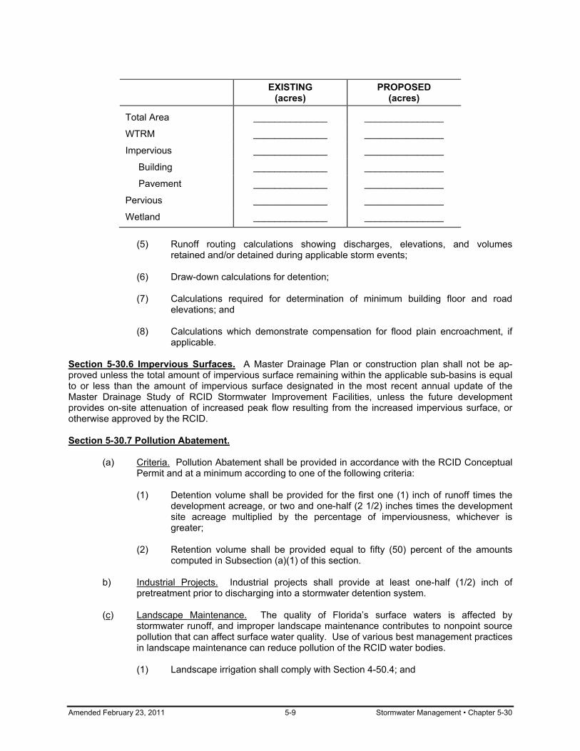
Amended February 23, 2011 5-9 Stormwater Management • Chapter 5-30
EXISTING
(acres) PROPOSED
(acres)
Total Area ______________ _______________
WTRM ______________ _______________
Impervious ______________ _______________
Building ______________ _______________
Pavement ______________ _______________
Pervious ______________ _______________
Wetland ______________ _______________
(5) Runoff routing calculations showing discharges, elevations, and volumes
retained and/or detained during applicable storm events; (6) Draw-down calculations for detention; (7) Calculations required for determination of minimum building floor and road
elevations; and (8) Calculations which demonstrate compensation for flood plain encroachment, if
applicable. Section 5-30.6 Impervious Surfaces. A Master Drainage Plan or construction plan shall not be ap-proved unless the total amount of impervious surface remaining within the applicable sub-basins is equal to or less than the amount of impervious surface designated in the most recent annual update of the Master Drainage Study of RCID Stormwater Improvement Facilities, unless the future development provides on-site attenuation of increased peak flow resulting from the increased impervious surface, or otherwise approved by the RCID. Section 5-30.7 Pollution Abatement. (a) Criteria. Pollution Abatement shall be provided in accordance with the RCID Conceptual
Permit and at a minimum according to one of the following criteria:
(1) Detention volume shall be provided for the first one (1) inch of runoff times the development acreage, or two and one-half (2 1/2) inches times the development site acreage multiplied by the percentage of imperviousness, whichever is greater;
(2) Retention volume shall be provided equal to fifty (50) percent of the amounts
computed in Subsection (a)(1) of this section. b) Industrial Projects. Industrial projects shall provide at least one-half (1/2) inch of
pretreatment prior to discharging into a stormwater detention system.
(c) Landscape Maintenance. The quality of Florida’s surface waters is affected by stormwater runoff, and improper landscape maintenance contributes to nonpoint source pollution that can affect surface water quality. Use of various best management practices in landscape maintenance can reduce pollution of the RCID water bodies.
(1) Landscape irrigation shall comply with Section 4-50.4; and

Chapter 5-30 • Stormwater Management 5-10 Amended February 23, 2011
(2) Horticulture practices shall comply with all Ordinances/Resolutions within the
RCID which Ordinances/Resolutions may be amended from time to time. Section 5-30.8 Protection from Flooding. (a) Design. Protection from flooding shall be accomplished by a design that will provide for:
(1) Collector roadway and local roadway areas to be flood-free during a storm with a ten (10) year return frequency and duration of seventy two (72) hours;
(2) Arterial roadway areas to be flood-free during a storm with a fifty (50) year return
frequency and duration of seventy two (72) hours; and (3) Habitable structures to be flood-free and commercial and industrial structures to
be either flood-free or flood-proofed during a storm of one hundred (100) year return frequency and duration of seventy two (72) hours.
(b) Discharge Attenuation. In some cases, due to capacity limitations of the primary
stormwater conveyance system, the RCID may impose requirements for attenuation of post development peak rate of discharge from the site.
Section 5-30.9 Development Within Floodplain Areas. (a) Floodplains. All development within floodplain areas, as determined by the RCID, shall
comply with the following requirements:
(1) Set minimum finished floor elevations at least one (1.0) foot above the one hundred (100) year flood. In areas where the one hundred (100) year flood elevation has not yet been established, the applicant shall establish to the satisfaction of the RCID, the elevation of the one hundred (100) year flood.
(2) For commercial or industrial developments, flood proofing may be substituted in
lieu of elevating the finished floor above the one hundred (100) year flood level. (3) Provide compensating storage for all flood water displaced by development
below the elevation of the base one hundred (100) year flood. (4) The applicant shall submit to the RCID calculations demonstrating a floodplain
compensation ratio of one to one (1:1) for any fill placed within the floodplain boundaries. The floodplain compensation area must be located within the same drainage sub-basin where the encroachment is proposed unless significant natural areas will be disturbed by the floodplain compensation, in which case compensating storage may be provided elsewhere with RCID approval. The compensating area must also be contiguous and hydraulically connected to the floodplain such that no rise in the one hundred (100) year flood waters may occur.
(b) Riverine Flood Hazard. All developments within the riverine flood hazard areas shall be
designed to maintain the flood carrying capacity of the floodplain such that the upstream and downstream base flood elevations are not increased.
Section 5-30.10 Disposition of Stormwater Runoff. The disposition of stormwater runoff shall comply with the provisions of this section.
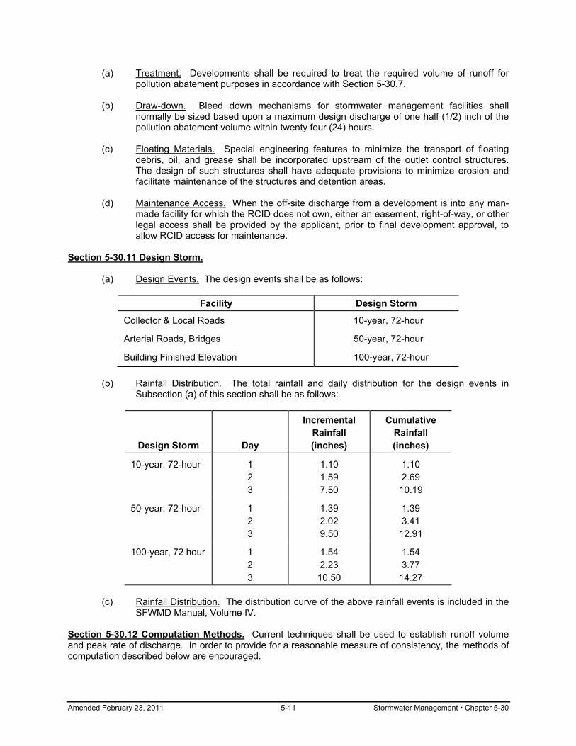
Amended February 23, 2011 5-11 Stormwater Management • Chapter 5-30
(a) Treatment. Developments shall be required to treat the required volume of runoff for pollution abatement purposes in accordance with Section 5-30.7.
(b) Draw-down. Bleed down mechanisms for stormwater management facilities shall
normally be sized based upon a maximum design discharge of one half (1/2) inch of the pollution abatement volume within twenty four (24) hours.
(c) Floating Materials. Special engineering features to minimize the transport of floating
debris, oil, and grease shall be incorporated upstream of the outlet control structures. The design of such structures shall have adequate provisions to minimize erosion and facilitate maintenance of the structures and detention areas.
(d) Maintenance Access. When the off-site discharge from a development is into any man-
made facility for which the RCID does not own, either an easement, right-of-way, or other legal access shall be provided by the applicant, prior to final development approval, to allow RCID access for maintenance.
Section 5-30.11 Design Storm. (a) Design Events. The design events shall be as follows:
Facility Design Storm
Collector & Local Roads 10-year, 72-hour
Arterial Roads, Bridges 50-year, 72-hour
Building Finished Elevation 100-year, 72-hour (b) Rainfall Distribution. The total rainfall and daily distribution for the design events in
Subsection (a) of this section shall be as follows:
Design Storm Day
Incremental Rainfall (inches)
Cumulative Rainfall (inches)
10-year, 72-hour 1 2 3
1.10 1.59 7.50
1.10 2.69
10.19
50-year, 72-hour 1 2 3
1.39 2.02 9.50
1.39 3.41
12.91
100-year, 72 hour 1 2 3
1.54 2.23
10.50
1.54 3.77
14.27 (c) Rainfall Distribution. The distribution curve of the above rainfall events is included in the
SFWMD Manual, Volume IV. Section 5-30.12 Computation Methods. Current techniques shall be used to establish runoff volume and peak rate of discharge. In order to provide for a reasonable measure of consistency, the methods of computation described below are encouraged.

Chapter 5-30 • Stormwater Management 5-12 Amended February 23, 2011
(a) Primary Basins or Sub-Basins. Computations for primary basins or sub-basins shall comply with the following provisions:
(1) Hydrographs should be developed using the modified Santa Barbara Urban
hydrograph method for pre-and post-development conditions; and (2) Time of Concentration (Tc) values may be obtained from the Federal Highway
Administration Kinematic Wave Formula (in the RCID Stormwater Manual) for sheet flow or overland flow, and the Manning Equation of concentrated flows (i.e., gutter flow, ditch flow, pipe flow, etc.).
(b) Secondary Basins. Computations for secondary basins shall comply with the following
provisions:
(1) The rational method shall be used to generate the instantaneous peak rate of discharge for both the developed and undeveloped sub-basins within a project area; and
(2) The time of concentration shall dictate the rainfall intensity. The Florida
Department of Transportation Rainfall Intensity-Duration Curves for Zone 7 shall be used to determine the intensities.
(c) Soil Storage. Soil storage utilized during the design event may be evaluated based on
either of the following methods, provided however, that in no case shall soil storage during the design event be accumulated for depths to seasonal high water table greater than six (6) feet below ground level:
(1) The Soil Conservation Service method of utilizing the Orange County and
Osceola County Soil Mapping; or
(2) The SFWMD. Section 5-30.13 Dry Ponds. Dry ponds shall comply with the provisions of this section. (a) Draw-down. Bleed down mechanisms for stormwater management facilities shall be
sized based upon a maximum design discharge of one half (1/2) inch of pollution abatement volume within twenty four (24) hours.
(b) Pond Bottom. The pond bottom shall be at a minimum of one (1) foot above the existing
wet season groundwater level, unless otherwise approved by the RCID. (c) Side Slopes. Side slopes shall be a minimum of 3:1 (horizontal: vertical) and must be
stabilized in accordance with Subsection (c) of Section 5-50.8. The pond bottom shall not be sodded.
(d) Freeboard. One (1) foot of freeboard shall be required above the design high water level
of the appropriate design event as specified in Subsection (a) of Section 5-30.11. (e) Maintenance Berm. An unobstructed maintenance berm, a minimum of fifteen (15) feet
in width, shall be required along the pond perimeter.
(f) Exfiltration System. Exfiltration systems must conform with the following:
(1) Pipe diameter – twelve (12) inches minimum; (2) Trench width – three (3) feet minimum;

Amended February 23, 2011 5-13 Stormwater Management • Chapter 5-30
(3) Rock in trench must be enclosed in filter material, at least on the top and
sides; and (4) Maintenance sumps in inlets.
Section 5-30.14 Wet Ponds. Wet ponds shall comply with the provisions of this section: (a) Side Slopes. For the purposes of public safety and maintenance, all wet ponds shall
have side slopes no steeper than 4:1 (horizontal: vertical) out to a depth of two (2) feet below the normal water level. Should site limitations dictate steeper side slopes, the perimeter of the pond may be fenced to prohibit all public access. Side slopes shall be stabilized in accordance with Subsection (c) of Section 5-50.8.
(b) Control Water Elevation. The draw down bleeder shall be set no lower than the existing
wet season groundwater level. (c) Littoral Zones. To promote nutrient uptake and enhance water quality, littoral zones shall
be established along a minimum of twenty (20) percent of the pond perimeter. This zone shall be planted from two (2) feet below to one (1) foot above the normal water level.
(d) Freeboard. One (1) foot of freeboard shall be required above the design high water level
of the appropriate design event as specified in Subsection (a) of Section 5-30.11. (e) Areas Adjacent to Ponds. Areas adjacent to ponds shall be graded to preclude the
entrance of stormwater except at planned locations. (f) Maintenance Berm. An unobstructed maintenance berm, a minimum of fifteen (15) feet
in width, shall be required along the pond perimeter. Section 5-30.15 Discharge Structures. Discharge structures shall comply with the provisions of this section. (a) General Requirements. All design discharges shall be made through structural discharge
facilities or properly compacted and stabilized earth berms. (b) Discharge Levels. Discharge structures shall be fixed so that discharge cannot be made
below the control elevation. (c) Grating. Discharge structures shall include gratings for safety and maintenance
purposes. (d) Baffles and Skimmers. Discharge structures from areas with greater than fifty (50)
percent impervious area or from systems with inlets in paved areas shall include both a baffle and a skimmer. The skimmer is to limit oil and grease discharging from reten-tion/detention areas. The baffle is to encourage discharge from the center of the water column, rather than the top or bottom.
(e) Direct Discharges. Direct discharges shall normally be allowed to discharge directly into
receiving waters, which by virtue of their large capacity, are easily able to absorb concentrated discharges. Such receiving waters may include existing storm water system and man-made ditches, canals, and lakes. The final determination shall be at the discretion of the RCID.
(f) Indirect Discharges. Discharge structures shall be required to discharge to overflow and
spreader swales where the receiving water or its adjacent supporting ecosystem may be
Chapter 5-30 • Stormwater Management 5-14 Amended February 23, 2011
degraded by a direct discharge. Such receiving waters may include natural streams, hardwood wetlands, marshes, and land naturally receiving overland sheetflow. The final determination shall be at the discretion of the RCID.
(g) Pumped Discharges. Pumped discharges shall not be allowed. Section 5-30.16 Open Drainage Ways. Open drainage ways shall comply with the provisions of this section. (a) Side Slopes. Drainage ways with standing water (canals) must meet the same side slope
and freeboard requirements as wet ponds as set forth in Section 5-30.14. Dry drainage ways (conveyance swales) shall meet the requirements as set forth in Section 5-30.13.
(b) Stabilization/Erosion Protection. Stabilization/erosion protection must be provided within
conveyance swales (also see Subsection (c) of Section 5-50.8). (c) Maintenance. Outfall ditches and canals shall have sufficient right-of-way for the facility
plus an unobstructed maintenance berm of at least fifteen (15) feet width on a minimum of one side. If the bottom width of the drainage way is greater than fifteen (15) feet, an unobstructed maintenance berm of at least fifteen (15) feet in width shall be required on both sides.
Section 5-30.17 Control Devices. Control devices and bleed-down mechanisms shall comply with the provisions of this section. (a) Size of Gravity Devices. Gravity control devices shall be sized based on a design
discharge of one half (1/2) inch of the detention volume in the first day. The devices shall incorporate dimensions no smaller than six (6) square inches of cross sectional area, two (2) inches minimum dimension, and twenty (20) degrees for "V" notches.
(b) Configuration of Gravity Devices. Gravity control devices shall be of a "V" or circular
shaped configuration to increase detention time during minor events. Section 5-30.18 Maintenance of Water Table. Drainage systems shall be designed to maintain water table elevations at their pre-development levels. Section 5-30.19 Roadways: Swales. Swale drainage shall be permitted only when the wet season water table is a minimum of one (1) foot below the invert of the swale. Section 5-30.20 Roadways: Curbs, Gutters, and Inlets. Curbs, gutters, and inlets for roads shall comply with the provisions of this section. (a) Roadway Design Standards. All roadway drainage not considered suitable for swale
and/or ditch type drainage shall be designed in accordance with FDOT Manual of Uniform Minimum Standards for Design, Construction and Maintenance for Streets and Highways and Design Standards for Design, Construction, Maintenance and Utility Operations on the State Highway System.
(b) Inlet Locations and Standards.
(1) All inlets at low points (sumps) shall be designed to intercept one hundred (100) percent of the design flow, precluding spread of water onto the traveled lanes. Inlet and pavement hydraulic calculations shall be required to demonstrate that a rainfall intensity of four (4) inches per hour does not result in spread/encroachment of drainage into a travel lane.

Amended February 23, 2011 5-15 Stormwater Management • Chapter 5-30
(2) On arterial roadways, in order to prevent siltation and to provide for a safety factor against clogging of a single inlet in a sump location, multiple inlets shall be constructed at all sump locations. Three (3) inlets shall be constructed at each sump location, one (1) at the low point and one (1) on each side at a point 0.2 feet higher than the low point, unless otherwise approved by the RCID.
(3) Inlets must be provided at the terminal point of shoulder gutters and shall be
designed to intercept one hundred (100) percent of the flow resulting from the ten (10) year design storm. No spread resulting from a rainfall intensity of four (4) inches per hour is allowed to encroach on the travel lanes, and the spread resulting from a ten (10) year design storm shall not exceed one (1) foot beyond the outside edge of the gutter.
(c) Shoulder Gutter Standards. Shoulder gutters may be used as part of the stormwater
conveyance system of a rural section roadway. Shoulder gutters shall be used on fill slopes and at bridge ends to protect the slopes from erosion.
Section 5-30.21 Secondary Drainage: Design Discharges. The storm sewer system design shall be based upon a ten (10) year frequency event. The system shall be designed to handle the flows from the contributory area within the proposed development. Section 5-30.22 Secondary Drainage: Pipe Requirements. Pipe requirements for secondary drainage shall comply with the provisions of this section. (a) Material. All storm-sewer piping shall be RCP. (b) Sizes. The minimum size of pipe used for public storm sewer systems shall be fifteen
(15) inches diameter, or equivalent elliptical. Designs shall be based upon six (6) inch increments in size above eighteen (18) inches, or elliptical equivalents.
(c) Velocities. All storm sewers shall be designed and constructed to produce a minimum
velocity of two and one-half (2.5) feet per second when flowing full. No sewer system or portion thereof shall be designed to produce velocities in excess of twenty (20) feet per second for reinforced concrete pipe or ten (10) feet per second for metal pipe. Outlet ends shall have sufficient erosion protection and/or energy dissipaters when velocities exceed five (5) feet per second.
(d) Construction. All pipes shall terminate with a mitered end section or headwall unless
termination is within a wet pond and completely below the seasonal low water table elevation.
(e) Maximum Runs. The following maximum runs of pipe shall be used when spacing
access structures of any type:
Pipe Size Maximum
15 inches 200 feet
18 inches 300 feet
24 to 36 inches 400 feet
42 inches and larger 500 feet Section 5-30.23 Secondary Drainage: Tailwater and Hydraulic Grade Computations. Tailwater and hydraulic grade computations shall comply with the provisions of this section.

Chapter 5-30 • Stormwater Management 5-16 Amended February 23, 2011
(a) Tailwaters. All storm sewer systems shall be designed to reflect the tailwater of the receiving facility. Where a pond is the receiving facility, the design tailwater level can be estimated from the information generated by routing through the pond the hydrograph resulting from a ten (10) year frequency storm of seventy two (72) hour duration. Then the design tailwater level can be assumed to be the ten (10) year pond level.
(b) Hydraulic Gradient. The hydraulic gradient line for the storm sewer system shall be
computed by taking into consideration the design tailwater on the system; the energy losses associated with entrance into and exit from the system; friction through the system; and turbulence in the individual manholes, catch basins, and junctions within the system.
(c) Losses. Energy losses associated with the turbulence in the individual manholes may be
significant for a pressure or surcharged storm sewer system and shall be accounted for in establishing a reasonable hydraulic gradient line.

Amended February 23, 2011 5-17 Groundwater Protection • Chapter 5-40
CHAPTER 5-40
GROUNDWATER PROTECTION Sections: 5-40.1 Purpose 5-40.2 Protection of Recharge Areas 5-40.3 Wellhead Protection 5-40.4 Sludge Disposal 5-40.5 Hazardous Waste Holding Section 5-40.1 Purpose. The purpose of this chapter, Chapter 5-40, Groundwater Protection, is to control development in designated recharge areas and in the cones of influence for potable water wellfields. This chapter implements Section 163.3202(2)(c) F.S. Section 5-40.2 Protection of Recharge Areas. (a) Analysis Required. All projects on project sites larger than five (5) acres shall require an
analysis of the recharge potential of the site. (b) Prohibited Uses. The following uses shall be prohibited in those portions of the project
site that are within a designated prime recharge area:
(1) septic tanks; (2) landfills; (3) facilities for the bulk storage, handling, or processing of materials on the Florida
Substance List; (4) wastewater treatment plants; and (5) other wastewater disposal systems.
(c) Development Guidelines. The following guidelines shall apply in those portions of the
project site are within a designated prime recharge area:
(1) clustering of development shall be encouraged; and (2) pervious surfaces shall be used whenever feasible.
Section 5-40.3 Wellhead Protection. (a) Restrictions Within 200 Feet. All new development other than water pumping facilities,
small structures, roads, and parking shall be prohibited within two hundred (200) feet of a potable water well. Small structures may be allowed only if they are less than 1,500 square feet, connected to a sanitary sewer, and are not used for storage except for incidental storage approved by the District Administrator. Roads and parking may be allowed only if they have an impervious surface, are more than fifty (50) feet from the well, and the drainage outflow occurs at least three hundred (300) feet from the well.
(b) Restrictions Within 300 Feet. Wet retention/detention areas shall be prohibited within
three hundred (300) feet of each potable water well.

Chapter 5-40 • Groundwater Protection 5-18 Amended February 23, 2011
(c) Restrictions Within 400 Feet. The following new development shall be prohibited within
four hundred (400) feet of each potable water well:
(1) Landfills; (2) Bulk storage of materials on the Florida Substance List; (3) Any activities that require the storage, use, or handling of agricultural chemicals
or hazardous wastes; (4) Wastewater treatment plants and facilities, including the disposition of sludge;
and (5) Septic tanks.
Section 5-40.4 Sludge Disposal. No composting or landspreading of sludge shall be allowed until the applicant or operator can demonstrate that this activity will cause no measurable impact on surface or groundwater quality. Section 5-40.5 Hazardous Materials Holding. No holding of hazardous materials shall be allowed until the applicant or operator can demonstrate that this activity will cause no measurable impact on surface or groundwater quality. (a) Restrictions within the 100-year Flood Plain. The storage/holding of hazardous materials
is prohibited within the 100-year flood plain as defined by the RCID Master Drainage Study.
(b) Restrictions within 200 Feet of Wetlands. The storage/holding of hazardous materials is
prohibited within two hundred (200) feet of a Class I or Class II wetland.

Amended February 23, 2011 5-19 Erosion Control • Chapter 5-50
CHAPTER 5-50
EROSION CONTROL
Sections: 5-50.1 Purpose 5-50.2 Compliance 5-50.3 Discharges 5-50.4 Adverse Impacts 5-50.5 Responsibilities 5-50.6 Erosion Control Plan 5-50.7 RCID Approvals 5-50.8 Requirements 5-50.9 General Provisions 5-50.10 Best Practices 5-50.11 Dewatering 5-50.12 Certificate of Occupancy Section 5-50.1 Purpose. The purpose of this chapter, Chapter 5-50, Erosion Control, is to minimize sediment deposition into the air and/or water and to ensure compliance with erosion control laws and regulations. This will be implemented through planning and engineering reviews, pre-construction meetings, site inspections, and environmental monitoring in order to protect environmental resources while allowing responsible development. Problems caused by erosion include adverse impacts to the environment, lowered aesthetic values, regulatory agency penalties, and increased maintenance costs. Section 5-50.2 Compliance. Erosion control measures are to be designed so that local, state and federal water quality standards are achieved prior to discharge from a site. Best management practices are to be incorporated during construction in accordance with F.A.C. Chapter 17-25.025(7) and other applicable statutes or codes. Section 5-50.3 Discharges. All surface water discharge from the site, including dewatering discharge, shall meet state water quality standards unless temporarily exempted by specific permit conditions. Water discharges from the site shall at all times meet the minimum standard of less than 29 NTUs above background. In critical areas, additional turbidity monitoring will be required and a reduction in turbidity levels below the value stated above may be required. Section 5-50.4 Adverse Impacts. All erosion, sedimentation, and turbidity measures must perform in a manner so as to minimize any adverse impact of the activities on fish, wildlife, natural environmental values, and water quality. Section 5-50.5 Responsibilities. It is the responsibility of the landowner or its designee to ensure that all discharges leaving the site meet all local, state, and federal discharge standards. The landowner or its designee shall be responsible for all sediment leaving the project boundary. Section 5-50.6 Erosion Control Plan. Erosion Control Plans shall be submitted and used as provided in this section: (a) Contents. Prior to any construction activities, the applicant for all projects within the
RCID drainage basin must submit an Erosion Control Plan for review to RCID Planning and Engineering. The plan must detail the following:
(1) Project description, location, and limits of construction;

Chapter 5-50 • Erosion Control 5-20 Amended February 23, 2011
(2) Proximity to wetlands, lakes, streams and canals and/or other environmentally sensitive areas;
(3) Wetland impacts (if any); (4) Proposed stormwater drainage system and receiving waters; (5) Soil types; (6) Sequence of construction; (7) Construction entrance(s); (8) Soil stockpile (if any); (9) Fill material (if any); (10) Erosion control devices; (11) Maintenance schedule; (12) Dewatering plan; and (13) Temporary and permanent soil stabilization plan.
(b) Minimum Standards. The measures set forth in the Erosion Control Plan are intended as
the minimum standards. Any erosion control measure beyond that specified in the Plan, that is required to comply with local, state, and federal law, shall be implemented.
(c) RCID Approval. Written approval of the Erosion Control Plan must be received from
RCID before proceeding with project construction. Approval of the proposed plan by RCID does not relieve the landowner or its designee from meeting all local, state, and federal discharge standards.
(d) Alternatives. In the event that erosion prevention and control devices shown in the
Erosion Control Plan prove not to be effective, alternate methods for maintaining state water quality standards for discharge from the construction site will be required. All alternate erosion prevention and control devices must be reviewed by RCID designated compliance personnel prior to placement.
Section 5-50.7 RCID Approvals. All erosion prevention and control measures must be inspected and approved by RCID designated compliance personnel prior to any construction activities. Removal of these same erosion controls and prevention measures may be done only after authorization is obtained from RCID designated compliance personnel. Any deviation from this procedure may result in an immediate requirement for work stoppage. Section 5-50.8 Requirements. The following provisions shall apply: (a) Ditch Blocks and Dams. In order to comply with the Federal National Pollutant Discharge
Elimination System (NPDES) permit issued to the District in 1998 for the operation of the Master Drainage System, also known as the Municipal Separate Stornwater System (MS4), RCID does not allow earthen ditch blocks or dams or other erodible material to be placed in live streams, canals, or active water bodies. Ditch blocks or dams must be composed of non-erodible materials. Materials commonly approved by RCID are sheet piling, portable cofferdams, inflatable water structures, and other comparable devices.
Amended February 23, 2011 5-21 Erosion Control • Chapter 5-50
(b) Hay Bales. Hay bales are not allowed as a perimeter erosion control device within the District.
(c) Stabilization.
(1) Side slopes of water bodies without an active discharge structure shall be stabilized within forty-eight (48) hours after completing the final grade. Stabilization may consist of sodding (Bahia), hydro-seeding, ground cover with stabilization matting or fabric, or other measure as approved by RCID.
(2) Side slopes of flowing water bodies shall be provided with temporary seeding or
equivalent soil protection for all areas that have been cleared but do not have ongoing construction. Within forty-eight (48) hours after completing final grading, side slopes shall be stabilized. Stabilization may consist of sodding (Bahia), hydro-seeding, ground cover with stabilization matting or fabric, or other measure as approved by RCID.
(d) Site Stabilization. During site construction, the landowner or its designee, shall provide
temporary seeding and mulching or equivalent soil protection for all areas that have been cleared but do not have ongoing construction. This soil protection must occur within seven (7) calendar days during the wet season (April to September) and fourteen (14) calendar days during the dry season (October to March).
(e) Daily Activities. Daily inspections shall be made by the landowner or its designee to
determine the effectiveness of sediment and erosion control efforts. Any necessary remedies shall be performed without delay. All sediment, erosion, and turbidity control measures shall be in working condition at the end of each workday.
Section 5-50.9 General Provisions. The following provisions are to be adhered to unless exempted in writing by RCID Planning and Engineering as part of the approval of the Erosion Control Plan. (a) Timing of Measures. Erosion and sediment control measures are to be placed prior to, or
as the first step in, construction. (b) Sediment Control. Sediment control practices are to be applied as a perimeter defense
against any transport of silt and/or turbid water off site. Erosion and sediment control using silt fences is one of the most widely used Best Management Practices during project construction. The silt fence decreases velocity of sheet flows and low-to-moderate-level channel flows. When properly installed around the perimeter, this device can effectively intercept and detain small amounts of sediment from disturbed areas during construction operations in order to prevent sediment from leaving the site.
(c) Double Rows. A double row of trenched-in silt fence or other perimeter erosion and/or
turbidity containment measure is required along natural areas within the District because these areas are of critical concern. The double rows of silt fence should be separated by at least three (3) feet to allow room for maintenance and reduce damage to the outer row during mishaps. Exceptions to the double rows may be requested from the RCID when work is in a non-critical area such as uplands or existing grassed open spaces. In these areas a single row of trenched-in silt fence may be allowed with written approval from RCID Planning and Engineering.
(d) Installation of Fences. It is imperative that silt fences be properly installed in order to
avoid compliance violations and costly delays. Proper installation consists of the following:
(1) Trenching-in the fabric edge four (4) inches wide by four (4) inches deep;

Chapter 5-50 • Erosion Control 5-22 Amended February 23, 2011
(2) Installing the stakes on the downstream side of anticipated water flow; (3) Attaching two (2) silt fence sections so as to become one continuous seal of
fabric by rolling and wrapping; (4) Driving all posts 10-12 inches into the ground and pulling tight on each section;
and (5) Backfilling and compacting trench fill over ground flap.
(e) Location of Silt Fences. Silt fences shall be placed within project limits. (f) Stormwater Ponds. The stormwater pond(s) shall be constructed to final elevations with
all slopes stabilized and sodded immediately after the silt fence has been installed and inspected and prior to any other construction activities on the site.
(g) Duration for Screens and Barriers. Silt screens and turbidity barriers shall remain in
place and in good condition at all locations shown in plans and as required until the construction is completed and soils are stabilized and vegetation has been established.
(h) Protection of Fences. Whenever practical, the landowner or its designee shall avoid
creating acres of long, flat, compacted surface upgradient of silt fences. When this situation cannot be avoided, the landowner or its designee shall construct windrows or the equivalent to reduce runoff velocity in order to protect the silt fence.
(i) Project Materials. Materials from work on the project shall be contained and not allowed
to collect in any off-perimeter areas or in waterways. These areas include both natural and man-made open ditches, streams, storm drains, lakes, ponds and wetlands.
(j) Inlet Protection Devices. All sediment shall be prevented from entering any stormwater
drainage system through the use of inlet protection devices (i.e., sandbags, gravel and screening, boards, drainfield pipe or other protective devices).
(k) Materials on Roadways. All mud, dirt or other materials tracked or spilled onto existing
state, county, city, or other public or private roads and facilities from a construction site shall be promptly removed by the landowner or its designee. Sediment shall not be washed or swept into any existing stormwater inlet(s).
(l) Permanent Measures. Permanent soil erosion control measures for all slopes, channels,
ditches or any disturbed land areas shall be completed immediately after final grading. When it is not possible to permanently protect a disturbed area immediately after grading operations, temporary erosion control measures shall be installed. All temporary protection shall be maintained until permanent measures are in place and established. Temporary erosion control may consist of, but is not limited to, grass, sod, mulch, sandbags, piping, slope drains, settlement basins, artificial coverings, berms, hay bales, straw, and dust control.
(m) Quality of Fill. The landowner or its designee shall use clean fill, free of silt and muck,
whenever possible in the project. In critical areas, such as sand beaches, testing of the material by the landowner or its designee shall be required, and test results must be submitted to RCID prior to material placement.
(n) Severe Rain Events. It is the responsibility of the landowner or its designee to develop
contingency plans for dealing with all weather conditions, including the severe rain events
Amended February 23, 2011 5-23 Erosion Control • Chapter 5-50
(more than two (2) inches in four (4) hours) which may occur repeatedly during the summer months.
(o) Muck and Clay. Soils containing muck and/or clay are difficult to deal with and will often
require the use of chemical treatment in order to meet acceptable discharge standards. Section 5-50.10 Best Practices. RCID may elect to restrict or prohibit certain erosion control Best Management Practices due to poor performance or because the device(s) may increase environmental degradation. It is the responsibility of the landowner or its designee to inquire about these restrictions. Section 5-50-11 Dewatering. Dewatering activities shall comply with the provisions of this section. (a) Schedule. The landowner or its designee shall prepare a schedule of dewatering for
storm drainage items. The schedule will consist of estimates of points of discharge, discharge flows, site map, and dates and durations for all storm drainage items that will require dewatering. The schedule will include retention basins, weir structures, storm sewer, and other storm system components. This schedule shall be submitted to RCID Planning & Engineering for permitting of the dewatering operations prior to pumping activities. Preparation of all such permits is the responsibility of the landowner or its designee.
(b) Discharges. Rapid discharge of large volumes of groundwater into existing surface
waters can cause fishkills, algal blooms and other water quality problems due to a lack of dissolved oxygen, excessive nutrients, and/or an imbalance with respect to pH. The direct discharge of groundwater into an active surface water system (i.e., stormwater pond, canal, lake, etc.) will be reviewed on a case-by-case basis. Discharge will be allowed into a pond or impoundment not actively connected (under construction); prior to connection to the surface water system testing may be required. Dewatering activities may discharge clean water (less than 29 NTU above background) in a sheet flow over rooted vegetation.
(c) Pumping Systems. Use of a floating intake is required on all surface-impoundment
pumping systems. Fuel containment must be provided for each pump in the event of a leak or spill. This may be provided via an earthen berm covered with plastic or a double-walled factory containment system. The containment volume must be greater than fuel capacity.
(d) Pumping Reports. Pumping reports documenting time, duration, accumulated volume,
location, and type of pump used must be sent to RCID Planning & Engineering weekly. Reports are due each Monday for the previous week. Failure to properly maintain reports will result in shutdown of all pumping activities for that project.
Section 5-50.12 Certificate of Occupancy. The Planning and Engineering Department will recommend issuance of a certificate of occupancy pursuant to this section. (a) Inspection. An inspection by RCID of the stormwater system associated with all new
construction is required prior to issuance of a certificate of occupancy. (b) Submitted Items. Prior to the inspection the applicant must provide two (2) copies of the
project's stormwater system As-builts and two (2) copies of the SFWMD Construction Completion/Construction Certification forms. All copies must be signed and sealed by an engineer licensed to work within the State of Florida. The signatures and seals cannot be photocopies. No recommendation for issuance of a Certificate of Occupancy will be given until receipt of these items.

Chapter 5-60 • Sanitary Sewer 5-24 Amended February 23, 2011
CHAPTER 5-60
SANITARY SEWER Sections: 5-60.1 Purpose 5-60.2 General Requirements 5-60.3 Wastewater Collection Systems 5-60.4 Independent Package Plants and Septic Tanks Section 5-60.1 Purpose. The purpose of this chapter, Chapter 5-60, Sanitary Sewer, is to specify the requirements for sanitary sewer and wastewater disposal throughout the District. Section 5-60.2 General Requirements. The following general requirements for sanitary sewer and wastewater disposal shall apply to all development projects unless otherwise specified in this chapter. This chapter implements Section 163.3202(2)(g) F.S. (a) Compliance with Federal and State Law. Sanitary sewer and wastewater services shall
comply with federal and state regulations. The Planning and Engineering Department shall ensure compliance with these standards.
(1) Sanitary sewer service shall comply with the Florida legislation entitled Sewage
Disposal Facilities: Advanced and Secondary Waste Treatment (Chapter 403.086), that implements the Federal Water Pollution Control Act (PL 92-500) at the state level.
(2) Sanitary sewer services shall comply with state legislation (Chapter 17-6, Florida
Administrative Code) and adopted regulations of FDEP. (3) Coordination of wetlands, basins, refuse disposal, and a groundwater monitoring
program shall be developed before rapid infiltration basins become operational in accordance with Chapter 17-4, Florida Administrative Code.
(b) Hookup to Centralized System. All new development shall be linked to the central
wastewater treatment system, except as provided in Section 5-60.4. Section 5-60.3 Wastewater Collection Systems. Wastewater collection systems shall comply with the provisions of this section. (a) General. Every development within the District shall provide a local wastewater
collection system that shall be connected to the District's main wastewater collection, treatment and re-use system, except as provided in Section 5-60.4.
(b) Line Sizes. The local wastewater collection system shall be of sufficient size and design
to receive and carry all wastewater from all buildings and structures within the development to the District's main system. The minimum gravity sanitary sewer size shall be eight (8) inches in diameter for main lines and four (4) inches for lateral lines.
(c) Other Provisions. The local wastewater collection system shall be constructed and
maintained in conformity with all applicable statutes, ordinances, and regulations of the District.
Amended February 23, 2011 5-25 Sanitary Sewer • Chapter 5-60
(d) Camping Facilities. Every camping facility within the District shall connect to the central system or provide for an independent wastewater collection system. Where individual wastewater collection connections to vehicle spaces are not provided, there shall be a central collection station for servicing vehicles with self-contained wastewater systems. Such station or stations shall have wastewater connections at the rate of one (1) for each two hundred (200) spaces or fractional part thereof.
Section 5-60.4 Independent Package Plants and Septic Tanks. New independent package plants and individual septic tank systems shall not be permitted unless accompanied by a detailed plan that ensures that the project will be connected to the central system five (5) years after the final development order. (a) Septic Tank Applications. Septic tanks shall be allowed only for the following
applications:
(1) A residential development that meets the following criteria:
(i) average maximum gross density of one (1) unit per acre within the developable portion of the site;
(ii) the central sewer system is not available; and (iii) soils are demonstrably suitable for septic tank use.
(2) Free-standing recreational or service buildings that meet the following criteria:
(i) located more than one-fourth (1/4) mile from a developed area; (ii) the average daily wastewater flow does not exceed one thousand
(1,000) gpd; (iii) the central sewer system is not available; and (iv) soils are demonstrably suitable for septic tank use.
(3) Temporary trailers used in conjunction with construction compounds, which meet
the following criteria:
(i) the central sewer system is not available; and (ii) soils are demonstrably suitable for septic tank use.
(b) Standards.
(1) All septic tanks shall comply with requirements of the County H.R.S. Department of the county in which the septic tank is located.
(2) Septic tank and drainfield installations shall comply with the adopted rules of the
Florida Department of Health, Division of Environmental Health (Rule No 64E-6).

Chapter 5-70 • Solid Waste 5-26 Amended February 23, 2011
CHAPTER 5-70
SOLID WASTE Sections: 5-70.1 Purpose 5-70.2 General Requirements 5-70.3 Hazardous Waste Section 5-70.1 Purpose. The purpose of this chapter, Chapter 5-70, Solid Waste, is to specify the requirements for solid waste disposal throughout the District. This chapter implements Section 163.3202(2)(g) F.S. Section 5-70.2 General Requirements. The following general requirements for solid waste shall apply to all development projects unless otherwise specified in this chapter. The Planning and Engineering Department shall ensure compliance with applicable state and federal standards. (a) Florida Resource Recovery and Management Act. Solid waste service shall comply with
the RCID Solid Waste Management Plan required by the Florida Resource Recovery and Management Act (Florida Statutes, Chapter 403.706).
(b) FDEP Regulations. Solid waste handling and disposal shall comply with adopted
regulations of FDEP (Florida Administrative Code, Chapter 62-701. (c) Solid Waste Management and Reduction Act. All new development that employs or
houses more than ten (10) people shall be required to set aside areas for source separation of solid waste as required by the Florida Solid Waste Management and Reduction Act.
(d) Compacting and Collection Sites. All development projects shall provide adequate
space, as determined by the RCID, for solid waste compacting and collection equipment and for the collection of recyclable material.
(e) Collection Services. All development projects shall be required to use the solid waste
collection system operated by the RCID. (f) Disposal Sites. No solid waste disposal sites shall be located within the District except
for those sites operated by the RCID. Section 5-70.3 Hazardous Materials (a) Holding Restrictions. The holding of hazardous materials shall be prohibited within a 100-year flood plain, within two hundred (200) feet of a wetland designated pursuant to Chapter 373 or Chapter 403 of the Florida Statutes or Chapter 404 of the Federal Water Pollution Control Act, and within four-hundred (400) feet of a potable water well.
(b) Regulatory Compliance. Hazardous materials management shall comply with the Florida Resource Recovery and Management Act (Florida Statutes, Chapter 403.706) and the RCID Hazardous Waste Management Program.
Amended February 23, 2011 5-27 Soils and Minerals • Chapter 5-80
CHAPTER 5-80
SOILS AND MINERALS Sections: 5-80.1 Purpose 5-80.2 Geotechnical Studies 5-80.3 Waterways 5-80.4 Construction Sites 5-80.5 Mineral Extraction Section 5-80.1 Purpose. The purpose of this chapter, Chapter 5-80, Soils and Minerals, is to protect soil and mineral resources. This chapter implements Section 163.3202(2) F.S. Section 5-80.2 Geotechnical Studies. A geotechnical study shall be prepared by a licensed geotechnical engineer for development proposals on sites containing one (1) or more of the listed soils or soils identified as moderate to severe in the soil survey of the county in which the project is located. Section 5-80.3 Waterways. Soil erosion along the banks of all canals and lakes shall be controlled by retaining and protecting natural vegetation, by planting vegetation that acts to hold the soil in place, or by adding materials for the purpose of side-slope stabilization. Additional measures may be required to meet state turbidity standards, as found in Chapter 17-3, F.A.C., if the vegetative cover is not adequate to control erosion. Section 5-80.4 Construction Sites. (a) Turbidity of Water. Runoff shall be controlled from construction sites in compliance with
Section 5-30.5 to minimize soil erosion and ensure that the turbidity of the receiving water body does not exceed state standards as found in Chapter 17-3, F.A.C. and Federal NPDES guidelines.
(b) Control Measures. All construction sites and discharges from project sites shall comply
with Section 5-30.5 contained herein, Federal NPDES guidelines and Chapter 17.3, F.A.C.
(c) Mitigation Measures. If any part of the project is not in compliance with the turbidity
standards as determined by the RCID, construction shall cease on those parts of the project causing the noncompliance.
Section 5-80.5 Mineral Extraction. Mineral extraction shall be prohibited in areas designated on the Comprehensive Plan Future Land Use Map as Conservation or Public Facilities. Exceptions for Public Facilities shall be made on a temporary basis during construction or landscaping.
Chapter 5-90 • Flora and Fauna 5-28 Amended February 23, 2011
CHAPTER 5-90
FLORA AND FAUNA Sections: 5-90.1 Purpose 5-90.2 General Requirements 5-90.3 Gopher Tortoise Management Program 5-90.4 Scrub Jay Habitat Protection Program 5-90.5 Bald Eagle Management Zones Section 5-90.1 Purpose. The purpose of this chapter, Chapter 5-90, Flora and Fauna, is to specify the requirements for protection of natural vegetative communities and species that are endangered, threatened, or of special state concern. This chapter implements Section 163.3202(2) F.S. Section 5-90.2 General Requirements. State and federal standards and regulations regarding development in wetlands, and the habitat of species that are endangered, threatened, or of special state concern shall be followed within the District boundaries. The following requirements shall apply to all development unless otherwise specified in this chapter. (a) Compliance with Laws. The requirements of the following laws shall be adhered to and
enforced by the District in its review of development proposals:
(1) The Bald Eagle Protection Act (16 USC 668-668d) and (50 CRFR 22); (2) Section 9 of the Endangered Species Act of 1973 (16 USC 1531); (3) The Migratory Bird Treaty Act (16 USC 703-711); and (4) Florida Endangered and Threatened Species Act of 1977 (Section 372.072, F.S).
(b) Protection of Natural Areas. Development in the areas designated as Conservation shall
be prohibited. In areas designated as Resource Management/Recreation, removal, encroachment or alteration will be allowed only when deemed appropriate and necessary.
(c) Protected Plant Species. Unavoidable impacts to the threatened plants shown in Table
6-4 of the RCID Comprehensive Plan shall be minimized. (d) Wetland Jurisdictional Areas. Development shall minimize any impacts on wetland
jurisdictional areas and shall comply with all policies related to wetlands that are included as part of Objective 3 of the Future Land Use Element of the Comprehensive Plan.
Section 5-90.3 Gopher Tortoise Management Program. Gopher Tortoise Management is addressed by Florida Game and Fresh Water Fish Commission Permit OSC#4. Relocation of the species to sites designated for Conservation, Resource Management/Recreation, or Public Facility uses is encouraged in the event gopher tortoises are discovered on future development sites. Section 5-90.4 Scrub Jay Habitat Protection Program. In the event that significant populations of the Florida Scrub Jay are determined to be present on proposed development sites, the District shall require compliance with Florida Game and Freshwater Fish Commission mitigation requirements if impacts to a Scrub Jay nest are deemed unavoidable.

Amended February 23, 2011 5-29 Flora and Fauna • Chapter 5-90
CHAPTER 5-100
ARCHAEOLOGICAL AND HISTORIC RESOURCES Sections: 5-100.1 Purpose 5-100.2 Survey 5-100.3 Mitigation 5-100.4 State Archaeological Sites Section 5-100.1 Purpose. The purpose of this chapter, Chapter 5-100, Archaeological and Historic Resources, is to specify the requirements for any development in an area encompassing a historically or archaeologically significant site. This chapter implements Section 163.3202(2) F.S. Section 5-100.2 Survey. An archaeological or historical survey shall be required for any development in an area that encompasses a historically or archaeological significant site as identified in the Comprehensive Plan. Section 5-100.3 Mitigation. If the project will cause damage to a unique historical or archaeological resource, the applicant shall avoid the site or incorporate the site into interpretative areas, passive recreation sites, or open space, if feasible. If this is not feasible, the applicant may be required to delay construction for up to one hundred and twenty (120) days in order that the site may be excavated, inventoried, and/or cataloged under the supervision of a licensed archeologist. Section 5-100.4 State Archaeological Sites. A permit or letter to proceed from the Division of Historical Resources shall be required before disturbing any state archaeological landmark or state archaeological landmark zone designated pursuant to Section 267.11 Florida Statues.

Amended February 23, 2011 6-1 Procedures: Intent • Chapter 6-10
ARTICLE 6 - PROCEDURES
CHAPTER 6-10
PROCEDURES: INTENT Sections: 6-10.1 Title and Purpose 6-10.2 Organization Section 6-10.1 Title and Purpose. Article 6 of the Land Development Regulations is entitled Procedures. The purpose of this article and the chapters within it is to specify the procedures for processing development applications, enforcing the Land Development Regulations, and amending the Comprehensive Plan and Land Development Regulations. Section 6-10.2 Organization. Article 6 consists of the following chapters: (a) 6-10 Procedures: Intent (b) 6-20 Consistency Review (c) 6-30 Development Review (d) 6-40 Subdivision Review (e) 6-50 Specifications for Subdivision Plans and Plats (f) 6-60 Variances (g) 6-70 Review and Appeals (h) 6-80 Enforcement (i) 6-90 Amendment of Land Development Regulations (j) 6-100 Amendment of Comprehensive Plan
(k) 6-110 (Section Number Reserved) (l) 6-120 Fees

Chapter 6-20 • Consistency Review 6-2 Amended December 20, 2011
CHAPTER 6-20
CONSISTENCY REVIEW Sections: 6-20.1 Purpose 6-20.2 Applicability 6-20.3 Pre-Application Conference 6-20.4 Concept Plan 6-20.5 Consistency Determination 6-20.6 Record Keeping 6-20.7 Determination if Concurrency Review Required 6-20.8 Determination if Site Plan Review Required 6-20.9 Determination if Environmental Review Required 6-20.10 Appeals 6-20.11 Changes in Concept Plan Section 6-20.1 Purpose. The purpose of this chapter, Chapter 6-20, Consistency Review, is to provide for an initial review of a development application to determine if the use is allowed by the Comprehensive Plan and what subsequent review process is applicable. Section 6-20.2 Applicability. The provisions of this chapter shall apply to all development that requires a building permit, impacts pre-existing drainage patterns, involves the establishment or reconfiguration of parking areas, or has an area of disturbance larger than five (5) acres, but shall not apply to those projects described below except as specifically provided. The provisions of this chapter are in addition to any requirements for a permit from the SFWMD or any other county, state, or federal agency. (a) Totally Exempt. The following projects are exempt from the provisions of this chapter:
(1) interior or exterior maintenance, rehabilitation, or replacement of existing facilities or structures, provided the use does not change and the size or capacity does not increase;
(2) relocation of temporary uses; (3) wells and septic tanks; (4) resurfacing of existing driveways, roads, and parking lots; and (5) demolitions.
(b) Administrative Review. The following projects are exempt from the provisions of this
chapter except that they do require an administrative review of their height, size, and location by the Department of Planning and Engineering.
(1) exterior signs; (2) temporary construction trailers; (3) fences and walls; (4) nature trails constructed entirely in uplands; and

Amended December 20, 2011 6-3 Consistency Review • Chapter 6-20
(5) replacement structures for those that were destroyed or demolished, provided the use does not change and the size does not increase.
Section 6-20.3 Pre-Application Conference. Applicants shall meet with the Department of Planning and Engineering and other affected parties (including but not limited to representatives from Energy Services, Fire Department, Building and Safety, and Environmental Affairs) as soon as possible in the development process. The Department of Planning and Engineering may waive this meeting for projects he or she deems to be minor. No processing of permits of any type will be conducted until this meeting takes place or has been waived. The applicant shall provide a concept plan in portable document format (PDF) or five paper copies, prepared pursuant to Section 6-20.4, ten (10) days prior to the date of the meeting. Section 6-20.4 Concept Plan. The concept plan shall include the information called for in this section: (a) Project Description. A project description that includes the following:
(1) Name of project; (2) Name, address, and phone number and email of contact person; (3) List of all proposed uses by use type; (4) Approximate size and shape of all structures; (5) Future land use designation from the Comprehensive Plan; and (6) Size of the area of disturbance (acres).
(b) Preliminary Site Plan. A preliminary site plan that includes the following:
(1) The boundaries of the area of disturbance and limits of construction shown on the Disney Grid or the State Plane Coordinate System;
(2) A surveyed point; and (3) The approximate location of all structures and parking facilities.
(c) Building Program. A building program that includes the following:
(1) Estimated amount of potable water consumption, including average daily demand, peak day demand, and fire flow requirement, by phase and at buildout, including all calculations;
(2) Estimated amount of wastewater to be generated, including average daily
generation and peak day generation, by phase and at buildout, including all calculations;
(3) Estimated amount of solid waste to be generated, by phase and at buildout,
including all calculations; (4) Estimated amount of wastewater reuse consumption, including average day and
peak demand, by phase and at buildout; (5) Total area to be irrigated, by phase and at buildout, expressed in square feet or
acres as appropriate.

Chapter 6-20 • Consistency Review 6-4 Amended December 20, 2011
(6) Unadjusted daily and p.m. peak-hour/peak-direction trip generation characteristics at buildout;
(7) Total area of the development (project site) expressed in acres; (8) Number of residential or guest rooms in the development; and (9) Number of all required parking spaces, including disabled-person spaces.
(d) Open Space. Development shall not intrude into Open Space as designated in the RCID
Open Space Map, unless an Open Space Map revision has been reviewed and approved by the District Administrator.
(e) Other Information. Other information required by the District Administrator to make the
determinations called for in this chapter. Section 6-20.5 Consistency Determination. Within five (5) working days after the conclusion of the pre-application conference or the receipt of a complete concept plan, whichever occurs later, the District Administrator shall make a consistency determination and issue a Certificate of Consistency or a letter stating that a certificate cannot be issued. A Certificate of Consistency shall be issued if the proposed project complies with all of the criteria listed below: (a) The proposed project does not reduce the amount of open space below thirty (30)
percent of the total acreage within the RCID, excluding the Wildlife Management and Conservation Area, as identified on the RCID Open Space Map;
(b) The proposed uses are allowed by Chapter 2-20; (c) The proposed project does not exceed the growth standards in Chapter 3-20; and (d) The preliminary site plan is approved. Section 6-20.6 Record Keeping. If a Certificate of Consistency is issued, the Department of Planning and Engineering shall enter the size of the development and its infrastructure requirements into a written or computerized record system for use in subsequent consistency determinations. Section 6-20.7 Determination if Concurrency Review Required. Within fifteen (15) working days after the conclusion of the pre-application conference or the receipt of a complete concept plan, whichever occurs later, the District Administrator shall make a determination if a project requires a concurrency determination. (a) Traffic. A traffic concurrency review shall be required if the p.m. peak-hour, peak-
direction traffic generation from the project exceeds one-tenth of one percent (0.1%) of the maximum service flow rate on any of the links to which the project has adjacent access.
(b) Potable Water. A potable water concurrency review shall be required if the project is
expected to use more than thirty thousand (30,000) gallons of potable water per day; (c) Wastewater. A wastewater concurrency review shall be required if the project is
expected to generate more than thirty thousand (30,000) gallons of wastewater per day; (d) Solid Waste. A solid waste concurrency review shall be required if the project is
expected to generate more than two (2) tons of solid waste per day;

Amended December 20, 2011 6-5 Consistency Review • Chapter 6-20
(e) Drainage. A drainage concurrency review shall be required if the project involves the disturbance of more than one (1) acre of land area;
(f) Parks and Recreation. A parks and recreation review shall be required if the project is
expected to add more than ten (10) permanent or functional residents to the District. (g) Scope of Determination. A concurrency review shall be conducted only for those facilities
or services having infrastructure impacts that meet or exceed the standards in Subsections (a) through (f) of this section.
(h) Submitted Projects Awaiting Approval. A concurrency review is not required for projects
that meet both the following criteria:
(1) The project has its final discretionary approval dated prior to November 15, 1991; and
(2) The applicant has expended substantial sums of money or incurred substantial
obligations in reliance upon the final development order. (i) Integrated Development Projects. A concurrency review is not required for the following
projects:
(1) Infill projects within theme parks existing and operating on November 15, 1991 if services and facilities were originally sized for ultimate build out of the theme park; or
(2) Infill projects which are an integral part of a larger development project and
whose traffic, water, sanitary sewer, solid waste, drainage, and parks and recreation impacts were adequately addressed in the approved plans for the larger development project.
(j) Review Required. If a concurrency review is required, the review shall be conducted as
set forth in Chapter 6-30. (k) Review Not Required. If a concurrency review is not required, no further action on
concurrency need be taken except that the capacity used by the approved project must be subtracted from the total capacity available for future projects.
Section 6-20.8 Determination if Site Plan Review Required. Within fifteen (15) working days after the conclusion of the pre-application conference or the receipt of a complete concept plan, whichever occurs later, the District Administrator shall make a determination if a project requires a site plan review in order to ensure that it complies with these Land Development Regulations. (a) Criteria. A site plan review is required if any of the following apply:
(1) The project site is more than five (5) acres; (2) The project is subject to concurrency review pursuant to Section 6-20.7; or (3) The District Administrator determines that a proposed project has the potential of
adversely impacting the environment. (b) Review Required. If a site plan review is required, the review shall be conducted as set
forth in Chapter 6-30.
Chapter 6-20 • Consistency Review 6-6 Amended December 20, 2011
(c) Review Not Required. If a site plan review is not required, the application shall be reviewed by the Department of Planning and Engineering to ensure that it complies with the provisions of these Land Development Regulations.
Section 6-20.9 Determination if Environmental Review Required. Within fifteen (15) working days after the conclusion of the pre-application conference or the receipt of a complete concept plan, whichever occurs later, the District Administrator shall make a preliminary determination on what environmental review is required pursuant to Article 5 of these Land Development Regulations. This preliminary determination may be subsequently modified as more information becomes available on the project. Section 6-20.10 Appeals. Determinations by the District Administrator, made pursuant to this chapter may be appealed pursuant to Chapter 6-70. Section 6-20.11 Changes in Concept Plan. If information in the concept plan changes significantly as deemed by the District Administrator for the following items, the revised plan shall be re-submitted for review and new determinations of consistency, concurrency, site plan review, and environmental review shall be conducted as necessary. Items changed which may warrant re-submittal include: the size of structures; the location of structures; projected impacts on public facilities and services; or adverse projected impacts on the environment.

Amended December 20, 2011 6-7 Development Review • Chapter 6-30
CHAPTER 6-30
DEVELOPMENT REVIEW Sections: 6-30.1 Purpose 6-30.2 Site Plan Information 6-30.3 Site Plan Review 6-30.4 Concurrency Information 6-30.5 Timing of Concurrency Review 6-30.6 Process for Concurrency Determination 6-30.7 Determination of Concurrency 6-30.8 Availability of Potable Water, Wastewater, Solid Waste, and Drainage Facilities 6-30.9 Availability of Parks and Recreation Facilities 6-30.10 Availability of Roads 6-30.11 Period of Validity 6-30.12 Changes in Project 6-30.13 Transferability 6-30.14 Semi-Annual Reports 6-30.15 Fees 6-30.16 Appeals Section 6-30.1 Purpose. The purpose of this chapter, Chapter 6-30, Development Review, is to ensure that adequate road, potable water, sanitary sewer, solid waste, drainage, and park and recreation facilities and services are in place concurrent with the impacts of development projects, and that proposed projects comply with other provisions of these Land Development Regulations. Section 6-30.2 Site Plan Information. If a site plan is required pursuant to Chapter 6-20, the applicant shall submit the information required by this section. (a) Format. All development applications shall include a site plan, signed and sealed by a
professional engineer with a current license to practice in the State of Florida, on a paper copy located on the Walt Disney World Grid and on a computer readable medium as specified by the District Administrator.
(b) Contents. The site plan shall show the following:
(1) Boundary of the project site; (2) Indication of current land uses on adjacent properties; (3) Existing condition of the project site; (4) Final grading of the project site; (5) Footprints of all structures; (6) Location of landscaped areas, plazas, and other major design features; (7) Landscaping and irrigation plans that comply with Chapter 4-50; (8) Location and geometry of all existing and proposed access points;

Chapter 6-30 • Development Review 6-8 Amended December 20, 2011
(9) Location and number of all required parking spaces, including disabled-person spaces;
(10) Location and size of road rights-of-way, fire lanes, transit corridors or facilities as
may be appropriate, and pedestrian facilities; (11) Location and size of all stormwater management facilities within the project site; (12) Limits of the one hundred (100) year floodplain as defined by RCID; (13) Most landward limits of the wetland jurisdiction of the SFWMD and the Army
Corps of Engineers; (14) Delineation of wetland buffers as required by Subsection (a)(2) of Section 5-20.8; (15) Delineation of existing natural vegetation and ecological communities to be
preserved and integrated into the landscaping plan, where appropriate and as feasible;
(16) Information related to on-site transit service such as circulation path of buses,
necessary queuing areas for passengers and buses, and areas to be designated as bus stops and shelters.
(c) Other Materials. The site plan shall be accompanied by the following:
(1) Breakdown of pervious and impervious surface on the project site by phase and at buildout;
(2) Evidence that the soil conditions are suitable for the proposed project; (3) An analysis of the aquifer recharge potential of any site larger than five (5) acres; (4) Copies of potable water and wastewater permits as applicable; (5) Copies of the FDEP completed NOI and acknowledgment letter for the NPDES
Generic Permit for Stormwater Discharge from Large and Small Construction Activities (also known as the CGP) for projects that are greater than one (1) acre; and
(6) Any updates to the information submitted pursuant to Section 6-20.7. (7) Activities within a wetland buffer, as defined by Subsection (a)(2) of Section 5-
20.8, or a Class I or Class II Wetland Area will require a RCID Environmental Impact Report. The report shall at a minimum describe the proposed project, identify and describe the types of impacts expected/proposed and their significance and identify conservation measures to minimize or compensate for adverse environmental impacts.
(d) Submittal. The site plan shall be filed with the Department of Planning and Engineering.
The Department shall determine if the site plan is complete within ten (10) working days after its receipt. If it is not, the applicant shall be notified immediately, and no further processing shall occur until it is made complete. This determination shall not prevent the RCID from requesting additional information if necessary to ensure that the development complies with these Land Development Regulations.

Amended December 20, 2011 6-9 Development Review • Chapter 6-30
(e) Distribution. Upon a finding that the site plan is complete, the Department of Planning and Engineering shall immediately transmit one copy to the Department of Building and Safety, Reedy Creek Fire Department, Department of Environmental Services, and Reedy Creek Energy Services.
Section 6-30.3 Site Plan Review. The site plan review shall be coordinated by the District Administrator. (a) Time Period for Action. The District Administrator shall ensure that the review is
completed within thirty (30) days after the complete site plan is submitted. (b) Staff Review. The RCID staff shall review the development review application and
approve, approve with conditions, modify, modify with conditions, or deny the application based on the standards set forth in Article 4 of these Land Development Regulations.
(c) Findings. Prior to issuing a Site Plan Approval, the District Administrator shall find that
the development meets the following criteria:
(1) No health or safety hazard is created on any property within or adjacent to the RCID boundary as a result of the development; and
(2) The development complies with the provisions of these Land Development
Regulations and is consistent with the Goals, Objectives and Policies of the Comprehensive Plan.
(d) Additional Reviews. Approval of the site plan does not relieve the applicant from
complying with:
(1) All relevant building and accessibility codes nor does it eliminate the need for the applicant to apply for and receive a building permit from the Department of Building and Safety before construction commences; or
(2) All relevant codes and requirements of the Reedy Creek Fire Department and
Reedy Creek Energy Services.
(e) Period of Validity. An approved site plan is effective for a period of two (2) years or the life of the building permit obtained following site plan approval, whichever is longer. If construction is not commenced within the period that the site plan is effective, no construction can take place unless there has been an extension approved by the District Administrator. Before an extension is granted, there must be compliance with all applicable site plan requirements in effect at the time of the extension request.
Section 6-30.4 Concurrency Information. If a concurrency review is required pursuant to Chapter 6-20, the applicant shall submit the information required by this section. (a) Potable Water. No information, in addition to that required by Chapter 6-20, is required
for making a concurrency determination on potable water. (b) Wastewater. No information, in addition to that required by Chapter 6-20, is required for
making a concurrency determination on wastewater. (c) Roadway System. In addition to the requirements of Chapter 6-20, information on traffic
at times other than the p.m. peak hour is required if the RCID determines that such information is necessary.
(d) Solid Waste. No information, in addition to that required by Chapter 6-20, is required for
making a concurrency determination on solid waste.

Chapter 6-30 • Development Review 6-10 Amended December 20, 2011
(e) Drainage. No information, in addition to that required by Chapter 6-20, is required for
making a concurrency determination on drainage. Section 6-30.5 Timing of Concurrency Review. The applicant may request that a final concurrency determination be completed at any time after sixty (60) days have elapsed since the complete information required by Section 6-30.4 is submitted, but prior to the issuance of any building permit for the project. No ground disturbance may be undertaken and no construction may begin before the final determination is made and a Certificate of Concurrency has been issued. Section 6-30.6 Process for Concurrency Determination. The RCID Department of Planning and Engineering is responsible for conducting the concurrency determination. (a) Concurrent. If the application is deemed concurrent and meets the standards in this
chapter, a Certificate of Concurrency shall be issued by the District Administrator. (b) Not Concurrent. If the application is deemed to be not concurrent, the applicant shall be
notified that a Certificate of Concurrency cannot be issued. The applicant shall be provided an opportunity to modify the project, mitigate the impacts of the development upon the public services, or provide the needed capital improvements as set forth in a development agreement.
(c) Building Permits. No building permits shall be issued for a development project requiring
a concurrency review until a Certificate of Concurrency is issued. Section 6-30.7 Determination of Concurrency. The concurrency determination shall comply with the provisions of this section. (a) General. The concurrency determination shall be made by comparing the available
capacity of a facility or service to the demand created by the proposed project. Available capacity shall be determined by adding together the total excess capacity of existing facilities and the total capacity of any new facilities which meet the previously defined concurrency standards and subtracting any capacity committed by projects that have a vested right to proceed and projects that have previously issued Certificates of Concurrency.
(b) Level of Service Standards. An application shall be deemed concurrent only if the
proposed development does not lower the level of service for the roadway system, potable water, wastewater, solid waste, drainage, and parks and recreation below the level of service standards as set forth in Chapter 3-30.
Section 6-30.8 Availability of Potable Water, Wastewater, Solid Waste, and Drainage Facilities. A project shall be deemed concurrent only if the proposed development does not lower the levels of service for potable water, wastewater, solid waste, and drainage below the adopted standards as set forth in Chapter 3-30 and one of the following provisions are met: (a) The facilities and services necessary to achieve concurrency are in place at the time a
development permit is issued; (b) The facilities necessary to achieve concurrency are under construction at the time a
development permit is issued; (c) The development permit is issued subject to the condition that the facilities and services
necessary to achieve concurrency will be in place concurrent with the impacts of develop-ment; or

Amended December 20, 2011 6-11 Development Review • Chapter 6-30
(d) The necessary public facilities and services necessary to achieve concurrency are guaranteed in an enforceable development agreement to be in place concurrent with the impacts of development.
Section 6-30.9 Availability of Parks and Recreation Facilities. A project shall be deemed concurrent for parks and recreation only if the proposed development does not lower the level of service for parks and recreation below the adopted standards as set forth in Chapter 3-30 and one of the following provisions are met: (a) Prior Provisions. Any of the provisions in Section 6-30.8 are met; or (b) Provisions. Either of the following is met:
(1) The facilities and services necessary to achieve concurrency are the subject of a binding contract, executed at or before the time the development permit is issued, which provided for the commencement of actual construction of the required facilities or the provision of services within one year of the issuance of the development permit; or
(2) The facilities and services necessary to achieve concurrency are guaranteed in
an enforceable development agreement which requires the commencement of actual construction of the facilities or the provision of services within one year of the issuance of the development permit.
Section 6-30.10 Availability of Roads. Concurrency for the roadway system shall be determined as set forth in this section. (a) Determination Methodology. A project shall be deemed concurrent for the
roadway system only if the traffic impacts of the proposed development does not lower the level of service for any of the concurrency management roadway links identified in the RCID Transportation Concurrency Management System Manual below the level of service standards as set forth in Chapter 3-30. This determination shall be made as follows:
(1) The determination shall be made using the RCID Transportation Concurrency
Management System (CMS) roadway network in effect at the time the application is submitted. The CMS roadway network is described in the RCID Transportation Concurrency Management System Manual.
(2) The CMS roadway network may include any improvements for which
construction is scheduled to commence by the third year of the currently adopted RCID Capital Improvement Program and any improvements to be made by other public agencies within three years, provided the construction is included in an interlocal agreement or memorandum of understanding between the RCID and the agency.
(3) The determination shall evaluate the total traffic impacts of the proposed project,
existing development, proposed projects that have a Certificate of Concurrency, and proposed projects that have submitted a complete concurrency application.
(4) The determination shall use the most recent RCID trip generation rates unless
such rates are not available for the specific use(s). If RCID rates are not available, ITE (Institute of Transportation Engineers) trip generation rates will be used.
Chapter 6-30 • Development Review 6-12 Amended December 20, 2011
(5) Any special distribution, routing, and internal capture factors that differ from those used in the RCID Subarea Model shall not be used unless approved by the RCID.
(6) The determination shall evaluate the roadway network capacity availability on a
link-by-link basis using the most recent capacities for each link of the roadway network, as established by the RCID. If the traffic generated by the project does not exceed the available capacity or lower the adopted level of service standard on any RCID roadway network link, the project is deemed to be concurrent.
(7) If the traffic generated by the project exceeds the available capacity on any RCID
roadway network link, mitigation techniques may be approved by the RCID to correct deficiencies in traffic capacity. If the traffic generated by the project, as mitigated, does not exceed the available capacity or lower the adopted level of service standard on any RCID roadway network link, the project is deemed to be concurrent.
(8) The RCID shall prepare a written concurrency determination report. It shall keep
at least one copy in its records and provide the applicant with at least one copy. (b) Plan Amendment. If concurrency is based on Subsection (a)(2) of this section, a plan
amendment shall be required to eliminate, defer, or delay construction of any facility or service needed to maintain the adopted LOS standard.
Section 6-30.11 Period of Validity. A Certificate of Concurrency shall be valid for the period as set forth in this section. (a) General. A Certificate of Concurrency shall remain in effect for a minimum term of thirty
six (36) months. As long as both commencement of actual construction of any building structure related to the primary use of the site and continuous activity toward completion of construction occurs during such thirty-six (36) month term, the Certificate of Concurrency shall continue and remain in effect until construction is completed even if construction is not completed within such thirty-six (36) month term.
(b) Renewal or Extension. If construction on a project ceases prior to completion and an
applicant anticipates recommencing construction during the thirty-six (36) months following the date such construction ceases, an applicant may apply for and obtain an extension of the Certificate of Concurrency through completion of the project, so long as construction actually recommences within thirty-six (36) months following the cessation of construction and thereafter continuous activity towards completion of construction occurs. If at any time thereafter there are subsequent cessations of construction, an applicant may apply for additional extension periods which will be reviewed and granted by the District Administrator on a case by case basis with consideration of extenuating circumstances, such as without limitation, unfavorable economic conditions, changes in regulations, or other mitigating circumstances.
(c) Appeals. If a Certificate of Concurrency is issued, but approval of the project is
challenged in an administrative or judicial forum, the period of time in Subsection (a) of this section shall be extended for the period required to reach a final resolution on the appeal.
(d) Voidance. A Certificate of Concurrency may be voided as set forth in Section 6-30.12. Section 6-30.12 Changes in Project. Changes in a project shall comply with the provisions of this section.

Amended December 20, 2011 6-13 Development Review • Chapter 6-30
(a) Modified Project. If a project is modified after a Certificate of Concurrency has been issued but before construction begins, the District Administrator shall require a new concurrency determination if he or she determines that the requirements for the types of infrastructure subject to the provisions of this chapter are likely to increase by five (5) percent or greater.
(b) Voidance. If the applicant has a change in its development program, it can request that a
Certificate of Concurrency be voided for a project on which construction has not commenced.
Section 6-30.13 Transferability. A Certificate of Concurrency may be transferred only as provided in this section. (a) Another Project. A Certificate of Concurrency cannot be transferred to another
development project. (b) Another Owner. A Certificate of Concurrency shall run with the land and shall transfer to
a successor in interest to the original applicant, provided the land remains within the jurisdiction of the RCID.
Section 6-30.14 Semi-Annual Reports. The Department of Planning and Engineering shall prepare a concurrency status report by July 1 and January 1 of each year. This report shall list the permitting activity for the previous six (6) month period and provide the status of available capacity for those services included in the concurrency management system pursuant to this chapter. The semi-annual reports shall be used in preparing the annual updates to the Capital Improvement Element of the Comprehensive Plan and Capital Improvement Program. Section 6-30.15 Fees. The fee for site plan and concurrency reviews shall be as set forth in Chapter 6-120. Section 6-30.16 Appeals. The decisions of the District Administrator made pursuant to this chapter may be appealed pursuant to Chapter 6-70.
Chapter 6-40 • Subdivision Review 6-14 Amended February 23, 2011
CHAPTER 6-40
SUBDIVISION REVIEW Sections: 6-40.1 Purpose 6-40.2 Application Requirements 6-40.3 Notice 6-40.4 Review Procedures: Preliminary Subdivision Plan 6-40.5 Planning Board Action: Preliminary Subdivision Plan 6-40.6 Appeal of Denial 6-40.7 Board Action: Preliminary Subdivision Plan 6-40.8 Review Procedures: Final Subdivision Plan 6-40.9 Board Action: Final Subdivision Plan 6-40.10 Plat Approval and Recording 6-40.11 Start of Construction 6-40.12 Variances, Modifications, and Waivers 6-40.13 Vacating of Plats Section 6-40.1 Purpose. The purpose of this chapter, Chapter 6-40, Subdivision Review, is to provide the process for the subdivision of land by recorded plat. Section 6-40.2 Application Requirements. Subdivision applications shall comply with the provisions of this section. (a) Initiation of Subdivision. The Board of Supervisors or the Planning Board may initiate a
subdivision of land. An owner of real property or the property owner's authorized agent may initiate a subdivision of land through an application to the District Administrator.
(b) Pre-Application Conference. An applicant shall request a pre-application conference with
the Department of Planning and Engineering to discuss subdivision review, specifications for plats and subdivision plans, and subdivision standards and improvements.
(c) Filing of Preliminary Subdivision Plan. The subdivider shall submit a preliminary
subdivision plan and appropriate documentation as specified in Chapter 6-50 to the Department of Planning and Engineering.
(d) Filing of Final Subdivision Plan. Within one (1) year upon approval of the preliminary
plan, the subdivider shall submit a final subdivision plan, as specified in Chapter 6-50, to the Department of Planning and Engineering for distribution to appropriate District offices and departments. Final subdivision plans shall conform to the preliminary plan as approved. Preliminary plan approval by the Board of Supervisors shall be automatically voided if final subdivision plans are not submitted within one (1) year.
(e) Pre-Approval Conference. Prior to final approval of a subdivision plan, the subdivider
shall schedule a conference with the Department of Planning and Engineering to review the manner in which and the extent to which streets, sidewalks, water, sewer, and other utility connections or mains, piping and any other necessary physical improvements shall be installed, and the specifications thereof.
(f) Fees. The subdivider shall pay the fees required by Chapter 6-120 upon the filing of the
preliminary subdivision plan. The date for the payment of the fee is the application date.
Amended February 23, 2011 6-15 Subdivision Review • Chapter 6-40
Section 6-40.3 Notice. Notice shall be given in accordance with the provisions of this section. (a) Notice of Property Owners by Mail. A notice setting forth the time, place, purpose of
hearing, and map or physical description of the land involved shall be sent by mail at least ten (10) days before the hearing to the following persons:
(1) All owners of real property subject to the subdivision of land; and (2) Each property owner within three hundred (300) feet of the property subject to
the subdivision of land. (b) Notice in the Newspaper. A notice setting forth the date, time, and place of the hearing
shall be published approximately seven (7) days prior to the hearing date in a newspaper of general circulation in the county in which the property is located. The notice shall describe the proposed subdivision; describe the parcels, properties, or areas that are affected by the subdivision request; and provide other pertinent information in such a manner that the subdivision request and its effect(s) can be clearly identified.
Section 6-40.4 Review Procedures: Preliminary Subdivision Plan. Preliminary subdivision plans shall be reviewed in accordance with the provisions of this section. (a) Staff Review.
(1) The District Administrator shall review the plan for compliance with Chapter 6-50 and other applicable regulations and shall accept or reject the application as complete within fifteen (15) days after submittal.
(2) Within five (5) days after the preliminary plan has been found to be complete, the
Department of Planning and Engineering shall submit the preliminary plan to Orange County or Osceola County, depending on the location of the proposed land subdivision. The Department of Planning and Engineering shall request comments from the appropriate county within fifteen (15) days after submittal.
(b) Staff Report. The Department of Planning and Engineering shall prepare a staff report
making recommendations to the Planning Board. The Manager shall submit the report to the Planning Board within forty-five (45) days after the preliminary plan has been found to be complete.
Section 6-40.5 Planning Board Action: Preliminary Subdivision Plan. The Planning Board shall take action on the preliminary subdivision map as set forth in this section. (a) Hearing. The Planning Board shall hold a public hearing within forty-five (45) days from
the date the complete application was submitted to it. Failure of the Planning Board to hold a public hearing shall constitute recommendation of approval of the preliminary subdivision plan.
(b) Action. The Planning Board may take action to recommend approval or deny the
preliminary plan at the conclusion of the public hearing, but shall take action no later than sixty (60) days after the complete application was submitted to it. An extension of time for Planning Board action may be granted if mutually agreed upon between the applicant and the District Administrator.
(c) Findings. When making its recommendation to the Board of Supervisors, for approval of
a preliminary subdivision plan, the Planning Board shall, at a minimum, make the following findings of fact:

Chapter 6-40 • Subdivision Review 6-16 Amended February 23, 2011
(1) The subdivision is consistent with and promotes the intent of the Comprehensive Plan;
(2) The subdivision will not adversely affect other implementation programs for
elements of the Comprehensive Plan; and (3) The subdivision promotes the public health, safety, and welfare within the
District. (d) Effect of Planning Board Denial. In the event the Planning Board denies a preliminary
subdivision plan, that action is final unless appealed to the Board of Supervisors. (e) Planning Board Report. Within fifteen (15) days of the action by the Planning Board on
the subdivision application, a report describing the proposed subdivision, discussion at the public hearing, and recommendation and vote of the Planning Board shall be transmitted to the Board of Supervisors. If the Planning Board does not recommend approval, it shall state why it could not make the findings in Subsection (c) of this section.
Section 6-40.6 Appeal of Denial. A denial action by the Planning Board made pursuant to this chapter may be appealed pursuant to Chapter 6-70. Section 6-40.7 Board Action: Preliminary Subdivision Plan. The Board of Supervisors shall review the preliminary subdivision plan in accordance with the provisions of this section. (a) Time Period for Hearing. The Secretary of the Board of Supervisors shall schedule a
public hearing before the Board on the recommendation of approval by the Planning Board. The hearing shall be scheduled within thirty (30) days of the filing of the appeal or receipt of the Planning Board's action.
(b) Notice. The public hearing shall be noticed as required by Section 6-40.3. (c) Action.
(1) The Board of Supervisors may take action to approve the preliminary subdivision as recommended by the Planning Board if no modification of the Planning Board's recommendation is proposed.
(2) If the Board of Supervisors proposes a substantial modification to the recommen-
dation of approval from the Planning Board, the proposed modification shall be referred to the Planning Board for consideration. The Planning Board shall not be required to hold a public hearing on the modification. The Planning Board shall submit a report on the proposed modification to the Board of Supervisors within forty-five (45) days from the date of referral by the Board of Supervisors. Failure to report shall be deemed a recommendation of approval. Prior to making a final decision on a substantially modified recommendation, the Board of Supervisors shall be required to conduct a second public hearing and notice this hearing pursuant to Section 6-40.3.
(3) When taking action on the Planning Board's recommendation, the Board of
Supervisors shall make part of the record their affirmation, modification, or rejection of the findings of fact provided in the Planning Board's final recommendation, as well as any other findings of fact that the Board of Supervisors deems to be relevant.
(d) Majority Vote. Action to approve the preliminary subdivision plan shall require a simple
majority of the total membership of the Board.

Amended February 23, 2011 6-17 Subdivision Review • Chapter 6-40
Section 6-40.8 Review Procedures: Final Subdivision Plan. The District Administrator shall take action on the final subdivision plan as set forth in this section. (a) Final Staff Review. The Department of Planning and Engineering shall review the plan
for compliance with the preliminary map. (b) Final Staff Report. If the final plan complies with the preliminary plan and all required
public improvements have been installed or guaranteed, the Department of Planning and Engineering shall prepare a final staff report recommending approval.
Section 6-40.9 Board Action: Final Subdivision Plan. The Board of Supervisors shall take action on the final subdivision plan as set forth in this section. (a) Time Period for Hearing. The Secretary of the Board of Supervisors shall schedule a
public hearing before the Board within thirty (30) days of receipt of the final staff report. (b) Notice. The public hearing shall be noticed as required by Section 6-40.3. (c) Final Action. Upon finding that all required public improvements have been installed or
guaranteed and that the final plan is in compliance with the preliminary plan, the Board of Supervisors shall take final action to approve the final subdivision plan.
(d) Majority Vote. Action to approve the final subdivision plan shall require a simple majority
of the total membership of the Board. Section 6-40.10 Plat Approval and Recording. All subdivisions shall be recorded as set forth in this section. (a) Place of Recordation. The final plat shall be recorded in the County Clerk's Office of
Orange or Osceola Counties, as determined by the location of the subdivision. (b) Enforcement. Any final plat recorded in violation of this code shall be invalid and subject
to expungement. The recording by or presentation for recording to any clerk of any circuit court of any final plat in violation of this code shall constitute a misdemeanor.
Section 6-40.11 Start of Construction. Construction of the subdivision prior to release of approved drawings by the District shall be limited to clearing and grubbing for construction of access areas to and within the site and to pollution control facilities required during the construction phase. Section 6-40.12 Variances, Modifications, and Waivers. No variance, waiver, or modification to the subdivision regulations shall be approved except as provided in this section. (a) Variances. Where the Board of Supervisors finds that extraordinary hardships may result
from strict compliance with the subdivision and platting regulations set forth in these Land Development Regulations, the Board may grant variances to regulations provided that such variances shall not nullify the intent and purpose of the RCID Comprehensive Plan.
(b) Modifications. In cases of a plan and program for a new town, complete community, or a
neighborhood unit, the Board of Supervisors may modify the subdivision and platting standards and requirements of these Land Development Regulations provided that such modifications shall be consistent with the RCID Comprehensive Plan.
(c) Waivers. The Board of Supervisors may waive any or all of the subdivision regulations of
these Land Development Regulations if it is determined upon reviewing the plans and data submitted by the applicant that compliance with the subdivision regulations of these
Chapter 6-40 • Subdivision Review 6-18 Amended February 23, 2011
regulations is not required because the said plan or plat shall not conflict with or nullify the intent or purpose of the RCID Comprehensive Plan. If a waiver is granted, compliance with the subdivision regulations of these regulations shall not be required as long as the plan, plat, and use of the land upon which the waiver is granted shall not be altered, changed, or modified by the applicant or subsequent owner.
Section 6-40.13 Vacating of Plats. Plats or integrated portions or parcels of land platted within the District may be vacated in accordance with the provisions of this section. (a) Initiation of Vacation. The Board of Supervisors or the Planning Board may initiate a plat
vacation through resolution. An owner of real property or the property owner's authorized agent may initiate a vacation through an application to the Department of Planning and Engineering.
(b) Legal Description. The applicant shall submit a legal description of the area of vacation
prepared by a licensed surveyor with an application for plat vacation. (c) Complete Information. No application shall be processed when the information
necessary to review and decide upon it is deemed to be incomplete by the Department of Planning and Engineering. Upon acceptance of a complete application, the Department of Planning and Engineering shall submit the application and supporting documents to the Planning Board.
(d) Recommendation by Planning Board. The Planning Board shall hold a hearing on the
application after notifying the applicant as required by Section 6-40.3. The Planning Board shall make its recommendation on the application based on the provisions contained within this section. The Planning Board shall make its recommendation to the Board of Supervisors within sixty (60) days after the complete application was submitted to it. Failure of the Planning Board to make a recommendation within this time frame shall constitute a recommendation of approval.
(e) Hearing by Board. The Board of Supervisors shall hold a public hearing on the
application for vacation not less than five (5) days nor more than forty-five (45) days after the notice is first published.
(f) Final Action by Board. If, upon public hearing, the Board is satisfied that the public will
not be materially injured by the proposed vacation, it shall order the plat or integrated portions or parcels of land platted vacated. The Board may make the order conditional, and the order becomes effective only upon fulfillment of the conditions prescribed.
(g) Majority Vote. Final action to approve the vacation shall require a simple majority of the
total membership of the Board. Upon approval by the Board of the vacating of a plat, the approval to such vacating shall not be required by any other body, authority, or agency of Orange or Osceola County or political subdivision thereof.
(h) Payments. In any vacation of plats or integrated portions or parcels of platted land, the
Board may require the payment of all taxes and assessments and the redemption from the redemption from all outstanding sales taxes, including those within other political subdivisions (Orange and Osceola Counties).
(i) Reservations. In any vacation of plats or integrated portions or parcels of platted land,
the Board may reserve and except therefrom any easements, rights, or interests therein which it deems desirable for the use of the District of any public utility.
(j) Consistency with Plan. No procedures or approvals that are provided for in this section
may be in contravention to the RCID Comprehensive Plan.
Amended February 23, 2011 6-19 Subdivision Review • Chapter 6-40
(k) Reapplication. When an application for vacation has been denied, a subsequent
application for the same vacation shall not be submitted for the next six (6) months commencing from the date of the final action by the Board of Supervisors.
Chapter 6-50 • Specifications for Subdivision 6-20 Amended February 23, 2011 Plans and Plats
CHAPTER 6-50
SPECIFICATIONS FOR SUBDIVISION PLANS AND PLATS Sections: 6-50.1 Purpose 6-50.2 Land Use Category 6-50.3 Preliminary Plans: Preparation 6-50.4 Preliminary Plans: Contents 6-50.5 Final Subdivision Plans 6-50.6 Platting Requirements Section 6-50.1 Purpose. The purpose of this chapter, Chapter 6-50, Specification for Subdivision Plans and Plats, is to specify the requirements regarding the approval of plans and plats. Section 6-50.2 Land Use Category. All property being subdivided shall be in the appropriate land use category for the land uses being proposed. Section 6-50.3 Preliminary Plans: Preparation. Two (2) copies of preliminary plans shall be submitted, drawn to minimum scale of one inch equals one hundred feet (1" = 100'). Preliminary plans shall be prepared by a registered land surveyor in accordance with Chapter 177, Florida Statutes. A registered civil engineer or landscape architect licensed to practice in the State of Florida, or a professional planner may assist in the preparation of a preliminary plans. Section 6-50.4 Preliminary Plans: Contents. All preliminary subdivision plans shall include, when applicable, the information required by this section. Specific subdivision standards and improvements are set forth in Chapter 6-40. A combined site plan and preliminary plan may be submitted, provided the requirements of Section 6-30.2 and this section are met. (a) General. Proposed subdivision name and any previous or former subdivision name,
north arrow, scale, date, section, township and range, and the appropriate County Property Appraiser's parcel number(s) shall be provided.
(b) Owner. Name, address, and telephone number of the owner and/or developer shall be
provided. Where a corporation or company is the owner, the name and address of the president and secretary shall be shown.
(c) Preparers. Name, business address, and telephone number of the surveyor, engineer,
and other consultants involved in plan preparation shall be provided. (d) Vicinity Map. A general vicinity map shall be included, showing the site in relation to
existing roads and development. (e) Legal Description. Legal description of the tract to be subdivided, boundary survey, tract
dimensions, lot and block designations, and location and description of existing and proposed permanent reference monuments shall be provided.
(f) Property Lines. All existing and proposed property lines with approximate dimensions
shall be included. (g) Topographic Study. A recent topographic study of existing conditions shall be provided
based on United States Coast and Geodetic Survey, Mean Sea Level (MSL) Datum, National Oceanographic Survey contoured to an interval of one (1) foot. The survey shall
Amended February 23, 2011 6-21 Specification for Subdivision • Chapter 6-50 Plans and Plats
include the proposed plat area plus adjacent lands within a minimum of one hundred (100) feet of the boundaries thereof.
(h) Abutting Property. Names of all adjacent subdivisions, uses on all adjacent property, and
location of adjacent platted lots and parcel lines within one hundred (100) feet shall be included, including those within other political subdivisions (Orange and Osceola Counties).
(i) Size. Area of the tract, number of lots and/or blocks, and number of dwelling units shall
be included. (j) Uses. Amount of area devoted to and location of all existing and proposed land uses,
including schools, open space, parks, recreation areas, churches, and residential and commercial uses shall be included.
(k) Phasing. Approximate phasing of the project, if applicable, shall be provided. (l) Natural Resources. Location of natural water bodies, wetlands, flood plains, native
vegetative communities, and wildlife habitats shall be provided. (m) Vegetation Removed. A plat or aerial photograph shall be provided at the same scale as
the layout plan and of sufficient detail to indicate all groupings of native vegetation proposed to be removed.
(n) Access. Location, names, and width of existing and proposed streets, accesses to the
parcel, highways, easements, sidewalks/bikeways, building lines, alleys, and parks and other open public spaces shall be provided for the tract being subdivided and adjacent property.
(o) Vacation. The location of any proposed vacations of streets, easements, public ways, or
places shall be provided. (p) Trip Generation. The projected Average Daily Traffic (ADT) from the development shall
be provided based upon trip generation rates contained in the Institute of Transportation Engineers (ITE) Manual, unless other standards are justified and approved.
(q) Drainage. Existing and proposed major drainage patterns, drainage courses, and
easements. (r) Drainage Documents. Legal documents shall be provided for all off-site drainage rights-
of-way and easements. (s) Floodplain. One-hundred (100) year flood elevation data shall be provided for all subdivi-
sions within a floodplain. (t) Borrow Pits. Preliminary grades and quantities shall be provided for proposed borrow
operations. (u) Stormwater. A stormwater management plan shall be provided with a schematic diagram
of the proposed stormwater collection system, method of pollution control, and stormwater retention/detention with preliminary calculations as to pond sizing. The direction of flow for all surface drainage and existing storm sewers on or abutting the tract shall be shown.

Chapter 6-50 • Specifications for Subdivision 6-22 Amended February 23, 2011 Plans and Plats
(v) Utility Structure. The location of any underground or overhead utilities, culverts, and drains on the property to be subdivided and within two hundred (200) feet of the proposed plat boundary shall be provided.
(w) Utility Facilities. Location of the nearest available public water supply, sewage disposal
system, and the proposed tie-in points shall be provided. (x) Easements. The boundaries of proposed utility easements over or under private property
shall be provided. Such easements shall provide satisfactory access to an existing public right-of-way or other public open space for maintenance or other activities by utility companies. Drainage easements shall also be shown.
(y) Common-Area Documents. Preliminary drafts of any legal documents necessary to the
control of ownership and maintenance of common areas. (z) Protective Covenants. Data on existing and proposed protective covenants shall be
provided. Section 6-50.5 Final Subdivision Plans. All final subdivision plans shall contain, at a minimum, the information required by this section. Final subdivision plans and supporting documents submitted to the Department of Planning and Engineering for review and approval shall bear the date, seal, and signature of the project engineer responsible for the development. A minimum of five (5) copies of the final subdivision plans and specifications for paving, drainage, utility system, and other improvements shall be submitted and approved prior to the commencement of construction. (a) Distribution Systems. Plan and profile of all streets, storm sewers, sanitary
sewers, and outfall ditches shall be provided. (b) Grading Plan. Grading plan showing original and final contours at one-foot
intervals shall be provided. Final contours may be omitted if sufficient information, such as pad elevations and sport elevations, is provided to show final detailed grading in all areas, with particular emphasis on the periphery of the property and areas around lakes and along water course. Pollution abatement swales shall be provided upland of streams and canals and the normal high water elevation on all lakes.
(c) Water. Water distribution facilities, including off-site main extensions and
proposed treatment plant, if applicable, shall be provided. (d) Sanitary Sewer. Sanitary sewage facilities, including collection systems, lift
stations, and wastewater treatment plant facilities, if applicable, shall be provided. (e) Stormwater. Stormwater management plan that complies with Chapter 5-30
shall be provided. (f) Soils. Soils profiles prepared under the supervision of a registered geotechnical
engineer or engineering geologist shall be provided. The soils profiles shall include soil borings along street centerlines and utility easements (for primary utilities) along with standard classifications and high/low seasonal water table elevations.
(g) Conservation Areas. All identified conservation areas which are to be retained
shall be shown as a separate tract or as an easement over affected portions of a lot and noted as a "conservation easement." Provisions are to be noted on the plat or in accompanying recorded documents delineating ownership and maintenance responsibilities. Additionally, a "dedication of development rights," which formally grants the District all future development rights on the easements and tracts, shall be provided and recorded along with the recording of the plat.

Amended February 23, 2011 6-23 Specification for Subdivision • Chapter 6-50 Plans and Plats
(h) Landscape and Screening. Landscaping and screening details, if applicable,
shall be provided. (i) Sidewalk and Bikeways. Location and width of sidewalks and bikeways, if
applicable, shall be provided. (j) Calculations. Engineering calculations in support of proposed plans and
specifications shall be provided. Section 6-50.6 Platting Requirements. Final subdivision plans if platted shall comply with the provisions of this section. (a) General. The following provisions shall apply:
(1) The final subdivision plat shall be drawn with permanent black drawing ink on mylar or equally durable material, using sheet twenty-four (24) inches by thirty (30) inches;
(2) Plats shall meet all the requirements of F.S. Ch. 177, F.S. Sec. 472.027 and
F.A.C. Ch. 5J-17, and shall be so certified by a land surveyor registered in the State;
(3) If previously platted lands are proposed for replatting, it will be necessary that the
existing plat, or portion thereof, be vacated pursuant to Chapter 6-40, prior to or concurrent with approval of the new plat by the Board of Supervisors; and
(4) The requirements of this subsection also shall be met by the final subdivision
plat. (b) Estimated Costs. A construction cost estimate shall be submitted, providing the
estimated cost of installing all improvements. Such estimates shall be prepared by the project engineer and shall be based upon recent bid information. As an alternative, bids of two reputable contractors or a copy of an executed contract for the installation of the improvements may be submitted.
(c) Surety for Improvements. When platting is proposed prior to completion of construction,
the District Administrator may require subdivider to submit to the District a surety bond or cash deposits acceptable to the Board of Supervisors. The above sureties shall cover the cost of all public improvements. One (1) of the following alternatives may be used upon approval by the Board of Supervisors:
(1) Submit a surety bond executed by a company authorized to do business in the
State that is satisfactory to the Board of Supervisors payable to the District. Such bond shall be in the penal sum of an amount equal to one hundred fifteen (115) percent of the estimated cost.
(2) Deposit cash in an escrow account in an amount equal to one hundred fifteen
(115) percent of the estimated cost. (3) Record a developer's agreement acceptable to the Board of Supervisors which
commits the developer and/or financial institution to comply with these regulations.
(4) Submit an irrevocable letter of credit from a financial institution doing business in
the State, acceptable to the Board of Supervisors. Such irrevocable letter of

Chapter 6-50 • Specifications for Subdivision 6-24 Amended February 23, 2011 Plans and Plats
credit shall be in the penal sum of one hundred fifteen (115) percent of the estimated costs.
(5) Any other alternative acceptable to the Board of Supervisors.
(d) Dedication. All dedications of land required for public purposes shall be dedicated at no cost to the District or other appropriate jurisdictional authority. If the property is encumbered by a mortgage, the owner and mortgage shall join in the dedication or in some other manner subordinate the mortgagee's interest to the dedication of the public property. (e) Certificate of Payment of Taxes. Certification shall be required showing that all due taxes have been paid in full and all tax certificates against the land have been redeemed. (f) Tax Escrow Receipt. A receipt indicating escrow of the current year's taxes shall be submitted. (g) Certificate of Title and Encumbrances. Title certification shall be provided as required by F.S. Ch. 177, as amended. (h) School or Other Public Site. The applicant shall provide one (1) copy of the executed deed or other conveyance documents and/or any agreements regarding the dedication or reservation of any school, park or other public site to the District. (i) MSTU Requests. Letters requesting creation of Municipal Service Taxing Units (MSTU's) for street lights, retention ponds or other uses shall be submitted if required. (j) Outstanding Liens. Any capital improvement liens existing on a parcel being subdivided, must be paid in full as a prerequisite of plat approval. (k) Deed Restrictions. The subdivider shall provide one (1) copy of all deed restrictions affecting the subdivision.
Amended February 23, 2011 6-25 Variances • Chapter 6-60
CHAPTER 6-60
VARIANCES Sections: 6-60.1 Purpose 6-60.2 Requirements for Application 6-60.3 Review Procedures 6-60.4 Notice 6-60.5 Planning Board Action 6-60.6 Appeals 6-60.7 Wait on Denials 6-60.8 Modification 6-60.9 Expiration 6-60.10 Revocation Section 6-60.1 Purpose. The purpose of this chapter, Chapter 6-60, Variances, is to provide a means of altering the requirements of these Land Development Regulations in specific instances where the strict application of the requirements would deprive a property of privileges enjoyed by other properties in the vicinity and under identical land use categories because of special circumstances applicable to the property involved. Section 6-60.2 Requirements for Application. Variance applications shall comply with the provisions of this section. (a) Applicant. Applications for variances may be initiated by the property owner or a property
owner's authorized agent. (b) Place to be Filed. Applications shall be filed with the District Administrator. (c) Site Description. A request for a variance shall include a site description which clearly
delineates the locations and extent of the regulation to be varied. (d) Evidence for Findings. The applicant shall provide evidence showing how the findings
required by Section 6-60.5 can be met. (e) Fees. A fee, as specified in Chapter 6-120, shall be required. (f) Completeness. No variance shall be processed until the information necessary to review
and decide upon the proposed variance is deemed complete by the District Administrator. Section 6-60.3 Review Procedures. The District Administrator shall review variances in accordance with the provisions of this section. (a) Transmittal. The Department of Planning and Engineering shall transmit the variance to
other RCID departments, as appropriate. (b) General Provisions. The Department of Planning and Engineering shall prepare a staff
report and submit it, together with the request for a variance to the Planning Board. The Planning Board shall conduct a public hearing, with notification, for the purpose of receiving oral and written evidence relative to the application. The evidence shall be reviewed to determine if the application is consistent with existing policies, standards, and required findings.
Chapter 6-60 • Variances 6-26 Amended February 23, 2011
(c) Concurrent Processing of Applications. If a proposed project requires a site plan review
in addition to a variance, the applications shall be filed at the same time and processed concurrently. The time periods for hearings and actions shall be those for the development review.
(d) Time Period for Hearing. The public hearing shall be held within thirty (30) days from the
date of acceptance of the complete application. (e) Time Period for Action. The Planning Board may take action on the proposed variance at
the conclusion of the public hearing, but shall take action no later then forty-five (45) days after the complete application was accepted. An extension of time for action may be granted if mutually agreed upon between the applicant and Chair of the Planning Board.
Section 6-60.4 Notice. Notice shall be given in accordance with the provisions of this section. (a) Notice of Property Owners by Mail. A notice setting forth the time, place, purpose of
hearing, and map or physical description of the land involved shall be sent by mail at least ten (10) days before the meeting to the following persons:
(1) All owners of real property subject to the variance; and (2) Each property owner within three hundred (300) feet of the property subject to
the variance. (b) Notice in the Newspaper. A notice setting forth the date, time, and place shall be
published not less than ten (10) days prior to the hearing date in a newspaper of general circulation in the county in which the property is located. The notice shall describe the proposed variance request; describe the parcels, properties, or areas that are affected by the variance request; and provide other pertinent information in such a manner that the variance request and its effect(s) can be clearly identified.
Section 6-60.5 Planning Board Action (a) Action. The Planning Board may take action to approve, approve with conditions, modify,
modify with conditions, or deny the variance request. (b) Findings. Prior to approving an application for a variance, the Planning Board shall make
written findings supporting a determination that the following are true:
(1) The variance does not detract from the public health, safety, and welfare within the District;
(2) Because of the special circumstances applicable to the property, including size,
shape, topography, location, or surroundings, the strict application of the regulation deprives the property of privileges enjoyed by other property in the vicinity and under identical circumstances; and
(3) The variance will not authorize a use or activity which is not otherwise expressly
authorized by the regulations governing the property in question. (c) Effective Date of Action. Action on the variance application, unless otherwise specified,
shall be effective upon expiration of the appeal period.

Amended February 23, 2011 6-27 Variances • Chapter 6-60
(d) Copy of Decision. The District Administrator shall send a copy of the final decision to other RCID Departments, as appropriate, within three (3) days of the effective date of the variance.
Section 6-60.6 Appeals. The decision of the Planning Board may be appealed pursuant to Chapter 6-70. Section 6-60.7 Wait on Denials. After the denial of a variance, no application for a variance from the same or a similar regulation may be accepted for six (6) months immediately following the denial. This section shall not apply to applications denied without prejudice, which may be refiled within six (6) months. Section 6-60.8 Modification. Modification of the terms of the approved variance itself or the waiver or alteration of conditions imposed incident to the granting of the variance shall require a new application following the same procedure required for an initial variance. Section 6-60.9 Expiration. A variance shall expire as provided in this section. (a) Time Period. A variance shall expire and become null and void at the time specified
therein. If no time is specified, the variance shall expire and become null and void in five (5) years if any required building permit associated with the variance has not been applied for or, if applied for and issued, has lapsed and become void.
(b) Discontinuance. A variance shall expire and become null and void twelve (12) months
after the purpose for which it was granted has been discontinued or abandoned. Section 6-60.10 Revocation. Revocation of a variance shall be subject to the requirements of this section. (a) Initiation of Action. The District Administrator or the Planning Board may initiate an action
to revoke a variance. (b) Grounds for Revocation. A variance may be revoked pursuant to the provisions of this
section upon a findings of any one (1) or more of the following grounds:
(1) That the variance approval was obtained or extended by fraud; or (2) That one (1) or more of the conditions upon which such development approval
was granted have been violated. (c) Planning Board Public Hearing. The Planning Board shall hold a public hearing upon the
revocation of the variance. The hearing shall be noticed in accordance with Section 6-60.4. The Planning Board shall make a decision based on any one or more of the ground listed in Subsection (b) of this section. The decision of the Planning Board may be appealed pursuant to Chapter 6-70.

Chapter 6-70 • Review and Appeals 6-28 Amended February 23, 2011
CHAPTER 6-70
REVIEW AND APPEALS Sections: 6-70.1 Purpose 6-70.2 Administrative Review 6-70.3 Formal Appeal 6-70.4 Submittal 6-70.5 Notices 6-70.6 Public Hearing Section 6-70.1 Purpose. The purpose of this chapter, Chapter 6-70, Review and Appeals, is to set forth the procedure for reviewing a decision of a department manager or appealing a decision of the District Administrator or Planning Board. Section 6-70.2 Administrative Review. Any person aggrieved by a decision of the Planning and Engineering Department with respect to these Land Development Regulations may request an administrative review by the District Administrator pursuant to the provisions of this section. (a) Time Limits. The review shall be requested within five (5) working days after the decision
under consideration was made. (b) Review Meeting. Within fifteen (15) days after the request, the District Administrator shall
convene a meeting consisting of himself or herself, manager of the department whose decision is being appealed, primary staff person on the matter, applicant, and party filing the appeal. During the meeting, the District Administrator shall offer all participants the opportunity to express their views and ask and answer questions.
(c) Decision. Within five (5) working days after the meeting, the District Administrator shall
render a decision. The original decision shall be reversed only if the District Administrator finds that it was not in accordance with the Land Development Regulations.
(d) Effect. If the District Administrator modifies or reverses the original decision, the original
decision shall be vacated and the District Administrator's decision made a part of the record.
Section 6-70.3 Formal Appeal. Any person aggrieved by any decision of the District Administrator or Planning Board with respect to these Land Development Regulations may file a notice of appeal to the Board of Supervisors within fifteen (15) days after such decision is rendered. Section 6-70.4 Submittal. The notice of appeal shall be submitted to the District Administrator who shall process such notice. Section 6-70.5 Notices. The following notice procedures shall govern an appeal: (a) Notice to the Board. The District Administrator shall promptly deliver a copy of the notice
of appeal to the Secretary of the Board of Supervisors, and shall transmit to the Board all papers, photographs, and exhibits constituting the record upon which the action appealed from was taken, or properly certified copies thereof in lieu of originals, as the Board may elect.

Amended February 23, 2011 6-29 Review and Appeals • Chapter 6-70
(b) Notice to other Parties. Upon the filing of the notice of appeal, the District Administrator shall promptly mail a copy of such notice by U.S. mail, postage prepaid, to the original applicant, to the owner or person having legal interest in the subject property, to the owners of abutting property whose names shall be furnished by the person who filed the original appeal, to any person requesting such notice, and to the attorney for the District.
(c) Notice of Hearing. The District Administrator shall give to the parties in Subsection (b) of
this section at least fourteen (14) days notice of the date, time, place, and purpose of the public hearing on the appeal.
Section 6-70.6 Public Hearing. (a) Open Meetings. Meetings of the Board of Supervisors shall be open to the public. Any
party may appear in person, or by agent or attorney, to testify. (b) Testimony and Evidence. The Board of Supervisors shall hear the testimony of
witnesses and other evidence offered by the aggrieved person and interested parties to the appeal and may, in conformity with these regulations and rules adopted thereunder, reverse or affirm, wholly or partly, or may modify the order, requirement, decision, or determination.
(c) Time Period for Decision. The Board of Supervisors shall render its decision on the
appeal within thirty (30) days after the filing of the notice of appeal. For good cause, the Board of Supervisors may extend the time for holding its hearing and rendering its decision to a time certain provided notice is given to all parties to whom notice of such hearing is required pursuant to Section 6-70.4.
(d) Stay of Proceedings. An appeal to the Board of Supervisors shall stay all proceedings
concerning appeal unless the District Administrator shall certify to the Board of Supervisors that, by reason of the facts stated in the notice of appeal, a stay would cause imminent peril to life or property. In such cases, proceedings shall not be stayed otherwise than by restraining order, which may be granted by the Board of Supervisors on due cause shown.
(e) Minutes and Records. The Board of Supervisors shall keep minutes of the hearing,
showing the vote of each member, and shall file such minutes and records in the office of the District Administrator.

Chapter 6-80 • Enforcement 6-30 Amended February 23, 2011
CHAPTER 6-80
ENFORCEMENT Sections: 6-80.1 Purpose 6-80.2 Responsibility for Enforcement 6-80.3 Applicability 6-80.4 Enforcement Procedures 6-80.5 Immediate Threat 6-80.6 Penalties 6-80.7 Remedies Section 6-80.1 Purpose. The purpose of this chapter, Chapter 6-80, Enforcement, is to provide the process for the enforcement of the Land Development Regulations. Section 6-80.2 Responsibility for Enforcement. All officials charged with the issuance of licenses and permits, department managers, and the District Administrator shall enforce the provisions of the Land Development Regulations. Section 6-80.3 Applicability. Any building or structure erected or maintained or any use of property contrary to the provisions of the Land Development Regulations shall be and is hereby declared to be unlawful and a public nuisance. Section 6-80.4 Enforcement Procedures. The following procedures shall apply to enforce the provisions of the Land Development Regulations in those situations involving a violation, but when an immediate threat to the health, safety, and/or welfare of the public does not exist. (a) Order to Comply. In the event of a violation of the Land Development Regulations, any of
the persons listed in Section 6-80.2 may deliver to the person or persons in violation of the Land Development Regulations an order to comply with the provisions of the Land Development Regulations within twenty (20) days of receipt of the order to comply.
(b) Failure to Comply. Upon failure of any person in violation of the Land Development
Regulations to comply, any of the persons listed in Section 6-80.2 shall notify the Board of Supervisors.
(1) The Board of Supervisors shall hold a public hearing with notice sent to the
alleged violator by certified mail, return receipt requested, or by personal service. (2) If the Board finds a violation, it shall issue an order to comply by a date certain
and a fine, not to exceed two hundred fifty (250) dollars per day for each day the violation continues beyond the specified compliance date. In addition, the Board shall direct that until the violation has been corrected the violator shall not proceed on the project except to correct the violation and the RCID shall not issue any subsequent permits for the project.
(3) If the violation is not corrected by the specified date, the RCID may institute any
appropriate civil and/or criminal action in any appropriate court to prevent a further violation, or correct or abate the violation.

Amended February 23, 2011 6-31 Enforcement • Chapter 6-80
Section 6-80.5 Immediate Threat. The following procedures shall apply to enforce the provisions of the Land Development Regulations when an immediate threat to the health, safety, and/or welfare of the public exists. (a) Immediate Action. In the event of a violation of the Land Development Regulations that
is deemed by the District Administrator to be an immediate threat to the health, safety, or welfare of the public, any of the persons listed in Section 6-80.2 shall deliver to the person or persons in violation of this chapter an order to comply with the provisions of this chapter immediately. The order to comply may provide for the complete or partial cessation of activities that create the immediate threat to the health, safety, or welfare of the public.
(b) Enjoining Activity. Upon failure of any person in violation of the Land Development
Regulations to comply with an order issued pursuant to a finding that an immediate threat to the health, safety, or welfare of the public exists, the District Administrator may immediately request the appropriate legal authority to seek and have issued by a court of appropriate jurisdiction an order enjoining the complete or partial operation that creates the immediate threat to health, safety, or welfare of the public.
Section 6-80.6 Penalties. The penalties set forth in this section shall apply to violations of the Land Development Regulations. (a) Misdemeanor. Any person, whether as principal, agent, employee, or otherwise, violating
any provision of the Land Development Regulations or violating or failing to comply with any other or regulation made thereunder, is guilty of a misdemeanor, and upon conviction thereof shall be subject to fine and/or imprisonment as provided by law.
(b) Separate Offense. Such person as defined by Subsection (a) of this section shall be
deemed guilty of a separate offense for each day during which such violation of the Land Development Regulations continues.
Section 6-80.7 Remedies. All remedies provided for the Land Development Regulations shall be cumulative and not exclusive. The conviction and punishment of any person shall not relieve such person from the responsibilities of correcting prohibited conditions or removing prohibited buildings, structures, or improvements nor prevent the enforced correction or removal thereof.
Chapter 6-90 • Amendment of 6-32 Amended February 23, 2011 Land Development Regulations
CHAPTER 6-90
AMENDMENT OF LAND DEVELOPMENT REGULATIONS Sections: 6-90.1 Purpose 6-90.2 Requirements for Application 6-90.3 Review Procedures 6-90.4 Notice 6-90.5 Planning Board Action 6-90.6 Appeal of Denial 6-90.7 Action by Board 6-90.8 Effective Date 6-90.9 Wait on Denials 6-90.10 Modification Section 6-90.1 Purpose. The purpose of this chapter, Chapter 6-90, Amendment of Land Development Regulations, is to provide the method for amending the RCID Land Development Regulations. Section 6-90.2 Requirements for Application. Amendment applications shall comply with the provisions of this section. (a) Initiation of Amendment. The Board of Supervisors or the Planning Board may initiate an
amendment through resolution. An owner of real property or the property owner's authorized agent may initiate an amendment through an application to the Planning and Engineering Department.
(b) Description. A description of the amendment shall be included with the amendment
application. Text amendments shall be shown by striking through old language and underlining new language.
(c) Fees. A fee, as specified in Chapter 6-120, shall be required. (d) Completeness. No amendment to the Land Development Regulations shall be
processed until the information necessary to review and decide upon the proposed amendment is deemed complete by the District Administrator.
Section 6-90.3 Review Procedures. The Planning Board shall review an amendment to the Land Development Regulations in accordance with the provisions of this section. (a) General Provisions. The District Administrator shall prepare an analysis of the proposed
amendment. The Planning Board shall then conduct at least one (1) public hearing with notification for the purpose of receiving oral and written evidence relative to the application.
(b) Concurrent Processing of Applications. If a proposed project requires a development
review and/or variance in addition to an amendment, the applications shall be filed at the same time and processed concurrently. If more than one (1) review authority is involved, the District Administrator shall determine the sequence for action by the review authorities.
Amended February 23, 2011 6-33 Amendment of • Chapter 6-90 Land Development Regulations
(c) Time Period for Hearing. Public hearings conducted by the Planning Board shall be held within ninety (90) days from the date the resolution was adopted or the complete application was accepted.
(d) Time Period for Action. The Planning Board may take action on the proposed
amendment at the conclusion of the public hearing, but shall take action no later then one-hundred and twenty (120) days after the resolution was adopted or the complete application was accepted. An extension of time for Planning Board action may be granted if mutually agreed upon between the applicant and the District Administrator.
Section 6-90.4 Notice. Notice shall be given in accordance with the provisions of Section 166.041
Florida Statutes and other applicable state laws. Section 6-90.5 Planning Board Action. The Planning Board shall take action on the amendment in accordance with the provisions of this section. (a) Action. The Planning Board may take action to recommend approval or deny the
amendment request. A recommendation of approval of an amendment request shall be by resolution. Failure of the Planning Board to hold a public hearing or take action within the time frames provided in Subsections (c) and (d) of Section 6-90.3 shall constitute recommendation of approval of the amendment application.
(b) Findings. When making its recommendation to the Board of Supervisors for approval of
an amendment, the Planning Board shall, at a minimum, make the following findings of fact:
(1) The amendment is consistent with and promotes the intent of the Comprehensive
Plan; (2) The amendment will not adversely affect other implementation programs for
elements of the Comprehensive Plan; and (3) The amendment promotes the public health, safety, and welfare within the
District. (c) Effect of Planning Board Denial. In the event the Planning Board denies an amendment
application, that action is final unless appealed to the Board of Supervisors. (d) Planning Board Report. Within fourteen (14) days of the action by the Planning Board on
the amendment, a report describing the amendment, discussion at the public hearing, and recommendation and vote of the Planning Board shall be transmitted to the Board of Supervisors. If the Planning Board does not recommend approval, it shall state why it could not make the findings in Subsection (b) of this section.
Section 6-90.6 Appeal of Denial. A denial action of the Planning Board made pursuant to this chapter may be appealed pursuant to Chapter 6-70. Section 6-90.7 Action by Board. If the Planning Board has recommended approval, the Board of Supervisors shall review the amendment in accordance with the provisions of this section. (a) Time Period for Hearing. The Secretary of the Board of Supervisors shall schedule two
(2) public hearings before the Board on the recommendation of approval by the Planning Board. The first shall be scheduled within forty-five (45) days of the filing of the appeal or receipt of the Planning Board's action, and the second shall be scheduled at least ten (10) days following the first hearing.
Chapter 6-90 • Amendment of 6-34 Amended February 23, 2011 Land Development Regulations
(b) Time of Hearings. The public hearings shall be held at the time set by the majority of the members of the Board of Supervisors plus one.
(c) Notice of Hearings. The public hearings shall be noticed as required by Section 6-90.4. (d) Final Action.
(1) The Board of Supervisors may take final action after the second hearing to adopt the amendment as recommended by the Planning Board if no modification of the Planning Board's recommendation is proposed.
(2) If the Board of Supervisors proposes a substantial modification to the recommen-
dation of approval from the Planning Board, the proposed modification shall be referred to the Planning Board for consideration. The Planning Board shall not be required to hold a public hearing on the modification. The Planning Board shall submit a report on the proposed modification to the Board of Supervisors within sixty (60) days from the date of referral by the Board of Supervisors. Failure to report shall be deemed a recommendation of approval. Prior to making a final decision, the Board of Supervisors shall be required to conduct a public hearing and notice this hearing pursuant to Section 6-90.4.
(3) When taking final action on the Planning Board's recommendation, the Board of
Supervisors shall make part of the record their affirmation, modification, or rejection of the findings of fact provided in the Planning Board's final recommendation, as well as any other findings of fact that the Board of Supervisors deems to be relevant.
(e) Majority Vote. A majority of the members of the Board shall institute a quorum. Final
action to approve the amendment shall require a simple majority of the quorum. Section 6-90.8 Effective Date. An amendment of the Land Development Regulations shall become effective immediately upon approval by resolution of the Board of Supervisors. Section 6-90.9 Wait on Denials. After the denial of an amendment to the Land Development Regulations by the Planning Board or Board of Supervisors, no application for the same or a similar amendment may be accepted for six (6) months immediately following the denial. This section shall not apply to applications denied without prejudice, which may be refiled within six (6) months. Section 6-90.10 Modification. Proposed modifications of approved amendment to the Land Development Regulations shall require a new application following the same procedure required for an initial application.
Amended February 23, 2011 6-35 Amendment of Comprehensive Plan • Chapter 6-100
CHAPTER 6-100
AMENDMENT OF COMPREHENSIVE PLAN Sections: 6-100.1 Purpose 6-100.2 Frequency of Amendments 6-100.3 Requirements for Application 6-100.4 Review Procedures 6-100.5 Notice 6-100.6 Planning Board Action 6-100.7 Appeal of Denial 6-100.8 Action by Board 6-100.9 Transmittal of Proposed Amendment 6-100.10 Transmittal Package 6-100.11 Adoption of Amendment 6-100.12 Effective Date 6-100.13 Submittal of Adopted Amendment 6-100.14 Amendment Not in Compliance 6-100.15 Amendment Not Adopted 6-100.16 Amendments Not Subject to Compliance Review 6-100.17 Small-Scale Development 6-100.18 Wait on Denials 6-100.19 Modification 6-100.20 Amendments to Land Development Regulations 6-100.21 Changes in Jurisdictional Boundaries Section 6-100.1 Purpose. The purpose of this chapter, Chapter 6-100, Amendment of Comprehensive Plan, is to provide the method for amending the RCID Comprehensive Plan. Section 6-100.2 Frequency of Amendments. Amendments to comprehensive plans adopted pursuant to this chapter may be made not more than two (2) times during any calendar year, except as provided in Section 163.3187(1) Florida Statutes. Section 6-100.3 Requirements for Application. Plan amendment applications shall comply with the provisions of this section. (a) Initiation of Amendment. The Board of Supervisors or the Planning Board may initiate an
amendment through resolution. An owner of real property or the property owner's authorized agent may initiate an amendment through an application to the Planning and Engineering Department. The District Administrator may initiate amendments pursuant to Section 6-100.21.
(b) Description. A description of the amendment shall be included with the amendment
application. Text amendments shall be shown by striking through old language and underlining new language. Map amendments shall clearly identify the exact changes proposed.
(c) Ordinance Amendments. A list and description of the provisions of the Land
Development Regulations that would require modification if the proposed plan amendment was adopted shall be included with the amendment application.
(d) Fees. A fee, as specified in Chapter 6-120, shall be required.
Chapter 6-100 • Amendment of Comprehensive Plan 6-36 Amended February 23, 2011
(e) Completeness. No amendment to the Comprehensive Plan shall be processed until the
information necessary to review and decide upon the proposed amendment is deemed complete by the District Administrator.
Section 6-100.4 Review Procedures. The Planning Board shall review an amendment to the Comprehensive Plan in accordance with the provisions of this section. (a) General Provisions. The District Administrator shall prepare an analysis of the proposed
amendment. The Planning Board shall then conduct at least one (1) public hearing with notification for the purpose of receiving oral and written evidence relative to the application.
(b) Concurrent Processing of Applications. If the proposed plan amendment is part of a
package of other actions such as an amendment to the Land Development Regulations, development review, and/or variance, the applications shall be filed at the same time and processed concurrently. If more than one (1) review authority is involved, the District Administrator shall determine the sequence for action by the review authorities, provided however, that no final action shall be taken on the other applications until the plan amendment is adopted.
(c) Time Period for Hearing. Public hearings conducted by the Planning Board shall be held
within ninety (90) days from the date the resolution was adopted or the complete application was accepted.
(d) Time Period for Action. The Planning Board may take action on the proposed
amendment at the conclusion of the public hearing, but shall take action no later then one hundred and twenty (120) days after the resolution was adopted or the complete application was accepted. An extension of time for Planning Board action may be granted if mutually agreed upon between the applicant and the District Administrator.
(e) Day of Hearing. All hearings shall be held on a weekday. Section 6-100.5 Notice. Notice shall be given in accordance with the provisions of Section 163.3184(15) Florida Statutes and other applicable state laws. Section 6-100.6 Planning Board Action. The Planning Board shall take action on the Comprehensive Plan amendment in accordance with the provisions of this section. (a) Action. The Planning Board may take action to recommend approval or deny the
amendment request. A recommendation of approval of an amendment request shall be by resolution. Failure of the Planning Board to hold a public hearing or take action within the timeframes provided in Subsections (c) and (d) of Section 6-100.4 shall constitute recommendation of approval of the amendment application.
(b) Findings. When making a recommendation to the Board of Supervisors for approval of
an amendment, the Planning Board shall, at a minimum, make the following findings of fact:
(1) The amendment preserves the internal consistency of the Comprehensive Plan;
and (2) The amendment promotes the public health, safety, and welfare within the
District.
Amended February 23, 2011 6-37 Amendment of Comprehensive Plan • Chapter 6-100
(c) Effect of Planning Board Denial. In the event the Planning Board denies an amendment application, that action is final unless appealed to the Board of Supervisors.
(d) Planning Board Report. Within fourteen (14) days of the action by the Planning Board on
the amendment, a report describing the amendment, the discussion at the public hearing, and recommendation and vote of the Planning Board shall be transmitted to the Board of Supervisors. If the Planning Board does not recommend approval, it shall state why it could not make the findings in Subsection (b) of this section.
Section 6-100.7 Appeal of Denial. A denial action of the Planning Board made pursuant to this chapter may be appealed pursuant to Chapter 6-70. Section 6-100.8 Action by Board. If the Planning Board has recommended approval, the Board of Supervisors and the City Councils of the City of Bay Lake and the City of Lake Buena Vista (City Councils) shall review the amendment in accordance with the provisions of this section. (a) Time Period for Hearing. Within sixty (60) days of receipt of the Planning Board’s
recommendation for approval public hearings shall be scheduled before the Board of Supervisors and the City Councils.
(b) Notice of Hearing. The public hearing shall be noticed as required by Section 6-100.5. (c) Action to be Taken. The Board of Supervisors and the City Councils shall take action on
the proposed amendment as follows:
(1) For all amendments except those that meet the requirements of Section 6-100.16, the Board and City Councils shall ensure that an announcement is made before the conclusion of the public hearing of its intention to hold and advertise a second public hearing to adopt the amendment. At the conclusion of the first hearing, the Board shall transmit the amendment to the Department of Community Affairs, reject the amendment, or refer the amendment back to the Planning Board.
(2) For all amendments that meet the requirements of Section 6-100.16, the Board
and City Councils shall adopt the amendment, reject the amendment, or refer the amendment back to the Planning Board.
(3) For all amendments that meet the requirements of Section 6-100.17, the Board
and City Councils have the option of taking action pursuant to Subsection (c)(1) or Subsection (c)(2) of this section. If it takes action pursuant to Subsection (c)(2), the adopted amendment shall be forwarded immediately to the Department of Community Affairs pursuant to Section 6-100.13.
(d) Action to Transmit Amendment
(1) The Board of Supervisors and City Councils may take action to transmit or adopt the amendment as recommended by the Planning Board if no modification of the Planning Board's recommendation is proposed.
(2) If the Board of Supervisors or City Councils proposes a substantial modification
to the recommendation of approval from the Planning Board, the proposed modification shall be referred to the Planning Board for consideration. The Planning Board shall not be required to hold a public hearing on the modification. The Planning Board shall submit a report on the proposed modification to the Board of Supervisors and City Councils within sixty (60) days from the date of referral by the Board of Supervisors or City Councils. Failure to report shall be

Chapter 6-100 • Amendment of Comprehensive Plan 6-38 Amended February 23, 2011
deemed a recommendation of approval. Prior to making a final decision, the Board of Supervisors and City Councils shall be required to conduct public hearings and notice these hearings pursuant to Section 6-100.5.
(3) When taking action on the Planning Board's recommendation, the Board of
Supervisors and City Councils shall make part of the record their affirmation, modification, or rejection of the findings of fact provided in the Planning Board's final recommendation, as well as any other findings of fact that the Board of Supervisors or City Councils deems to be relevant.
(e) Majority Vote. Action to transmit or adopt the amendment shall require a simple majority
of a quorum. Section 6-100.9 Transmittal of Proposed Amendment. All proposed amendments, except those subject to the provisions of Section 6-100.16 or Section 6-100.17, shall be transmitted to the Department of Community Affairs as set forth in Section 163.3184, F.S. and/or Chapter 9J-11, F.A.C., as applicable. Section 6-100.10 Adoption of Amendment. As soon as possible after receipt of the written comments from the Department of Community Affairs, the final proposed amendment shall be submitted to the Planning Board for their review and the Board of Supervisors and City Councils for their adoption. Both actions shall require a public hearing with notice as provided by Section 6-100.5, except that the hearing shall be held approximately five (5) days after the notice was published. The Comprehensive Plan amendment shall be adopted by ordinance/resolution. Action to adopt the amendment shall require a simple majority of a quorum. Section 6-100.11 Effective Date. An amendment of the Comprehensive Plan shall not become effective until the Florida Department of Community Affairs or Administration Commission issues a final order determining the adopted amendment to be in compliance with applicable state law. Section 6-100.12 Submittal of Adopted Amendment. The adopted amendment shall be submitted to the state as set forth in Section 163.3184, F.S, and/or Chapter 9J-11, F.A.C, as applicable. Section 6-100.13 Amendment Not in Compliance. If the Department of Community Affairs issues a notice of intent to find the plan amendment not in compliance, the process in Sections 163.3184(10), (11), and (16) Florida Statutes shall apply. Section 6-100.14 Amendment Not Adopted. If the RCID does not adopt the amendment that was transmitted to the Department of Community Affairs pursuant to Section 6-100.9, the Planning and Engineering Department shall so notify the Department by letter. The letter shall include a list of findings, if any, which provided the basis for the determination not to adopt the proposed plan amendment. Section 6-100.15 Amendments Not Subject to Compliance Review. Amendments listed in this section are not subject to compliance review. Final action of these amendments shall be taken at the hearing described in Section 6-100.8, and these amendments shall become effective immediately upon approval. (a) Capital Improvements Element. Correction, updates, and modifications to the Capital
Improvements Element regarding costs, revenue sources, acceptance of facilities, or facility construction dates; and
(b) Other Elements. Corrections, updates, and modifications to other elements of the
Comprehensive Plan regarding current costs. Section 6-100.16 Small-Scale Development. Small-scale development activities may be subject to an abbreviated review process pursuant to Section 163.3187(1)(c) Florida Statutes.
Amended February 23, 2011 6-39 Amendment of Comprehensive Plan • Chapter 6-100
Section 6-100.17 Wait on Denials. After the denial of an amendment to the Comprehensive Plan by the Planning Board or Board of Supervisors, no application for the same or a similar amendment may be accepted for six (6) months immediately following the denial. This section shall not apply to applications denied without prejudice, which may be refiled within six (6) months. Section 6-100.18 Modification. Proposed modifications of approved amendment to the Comprehensive Plan shall require a new application following the same procedure required for an initial application. Section 6-100.19 Amendments to Land Development Regulations. If the adopted amendments to the Comprehensive Plan require amendments to be made to the Land Development Regulations, the proposed amendments to the Land Development Regulations shall be submitted to the Planning Commission not later than sixty (60) days after the effective date of the plan amendments. The amendments to the Land Development Regulations shall be processed pursuant to Chapter 6-90. During the interim period before adoption of the regulatory amendments, the adopted plan amendments shall govern any action taken in regard to a development order. Section 6-100.20 Changes in Jurisdictional Boundaries. When property is annexed to or de-annexed from the District, the District Administrator shall initiate a plan amendment to be adopted as a part of the next set of plan amendments, but in no case less than nine (9) months after the annexation or deannexation.

Chapter 6-120 • Fees 6-40 Amended February 23, 2011
CHAPTER 6-120
FEES Sections: 6-120.1 Purpose 6-120.2 Fee Schedule 6-120.3 Exempt Entities 6-120.4 Simultaneous Applications 6-120.5 Expired Approval 6-120.6 Amendment to Approval 6-120.7 Reinitiation of Withdrawn Applications 6-120.8 Specialists Section 6-120.1 Purpose. The purpose of this chapter, Chapter 6-120, Fees, is to provide for the collection of fees for processing applications pursuant to these Land Development Regulations. Section 6-120.2 Fee Schedule. The Board of Supervisors may adopt a fee schedule by resolution to cover the costs of processing applications submitted pursuant to these Land Development Regulations. Section 6-120.3 Exempt Entities. No fees shall be required pursuant to this article of the following: (a) A governmental entity or agency thereof; or (b) A nonprofit corporation organized solely for educational, religious, medical, scientific, or
charitable purposes, or a combination of those purposes. Section 6-120.4 Simultaneous Applications. If an applicant simultaneously makes more than one (1) type of application for a single project, the total fee for all such applications shall be the following: (a) If two (2) applications are made, the fee shall be the sum of the fees divided by two (2);
or (b) If three (3) or more applications are made, the fee shall be the sum of the fees divided by
three (3). Section 6-120.5 Expired Approval. If an application is made for an approval that was granted but has expired, the fee shall be twenty-five (25) percent of the permit application fee. Section 6-120.6 Amendment to Approval. If an application is made to amend a previously granted approval, the fee shall be fifty (50) percent of the permit application fee. Section 6-120.7 Reinitiation of Withdrawn Applications. At the discretion of the District Administrator, an application that has been withdrawn may be reinitiated with no fee requirements if the following requirements are met: (a) The new application is substantially the same as the withdrawn application; (b) Processing of the new application will generally proceed from the point processing
stopped on the withdrawn application; (c) Less than one (1) year has elapsed since the application was withdrawn; and

Amended February 23, 2011 6-41 Fees • Chapter 6-120
(d) The application is consistent with current provisions of these Land Development
Regulations. Section 6-120.8 Specialists. Whenever evaluation of any development application requires the use of professional assistance not available within the RCID staff, processing of the application may be conditioned upon payment by the applicant of the reasonable cost of obtaining such assistance.

Amended February 23, 2011 7-1 Officers and Boards • Chapter 7-10
ARTICLE 7 - OFFICERS AND BOARDS
CHAPTER 7-10
OFFICERS AND BOARDS: INTENT Sections: 7-10.1 Title and Purpose 7-10.2 Organization Section 7-10.1 Title and Purpose. Article 7 of the Land Development Regulations is entitled Officers and Boards. The purpose of this article and the chapters within it is to specify the bodies empowered to regulate and restrict the development of land and the uses and structures thereon and to justify and equitably administer the Land Development Regulations in the interest of the public health, safety, and general welfare. Section 7-10.2 Organization. Article 7 consists of the following chapters: (a) 7-10 Officers and Boards: Intent (b) 7-20 Board of Supervisors
(c) 7-30 Planning Board (d) 7-40 (Section Number Reserved)
(e) 7-50 Planning and Engineering Department
Chapter 7-20 • Board of Supervisors 7-2 Amended February 23, 2011
CHAPTER 7-20
BOARD OF SUPERVISORS Sections: 7-20.1 Purpose 7-20.2 Comprehensive Plan 7-20.3 Land Development Regulations 7-20.4 Environmental Regulations 7-20.5 Safety and Sanitary Codes 7-20.6 Other Standards 7-20.7 Implementation of Regulations 7-20.8 Procedures 7-20.9 Planning Board 7-20.10 Intergovernmental Coordination 7-20.11 Appeals 7-20.12 Fees Section 7-20.1 Purpose. The purpose of this chapter, Chapter 7-20, Board of Supervisors, is to describe the responsibilities of the RCID Board of Supervisors with regard to comprehensive land use planning and land development regulations. These powers are contained in the RCID enabling legislation and Florida statutes. This chapter implements Section 163.3202 F.S. Section 7-20.2 Comprehensive Plan. The Board has the authority to adopt, review, amend, or supplement the Comprehensive plan to provide for the physical development of the area within the District. Section 7-20.3 Land Development Regulations. The Board has the authority to adopt, review, amend or supplement Land Development Regulations that are consistent with and implement the Comprehensive Plan. These regulations shall, at a minimum, accomplish the following: (a) Regulate the subdivision of land; (b) Regulate the use of land and water for those land use categories included in the land use
element of the Comprehensive Plan, ensure the compatibility of adjacent uses, and provide for open space;
(c) Provide for protection of potable water wellfields; (d) Regulate areas subject to seasonal and periodic flooding and provide for drainage and
stormwater management; (e) Ensure the protection of environmentally sensitive lands designated in the
Comprehensive Plan; (f) Regulate signage; (g) Provide that public facilities and services meet or exceed the standards established in the
Capital Improvement Element of the Comprehensive Plan and are available when needed for the development, or that development orders and permits are conditioned on the availability of these public facilities and services necessary to serve the proposed development; and
Amended February 23, 2011 7-3 Board of Supervisors • Chapter 7-20
(h) Ensure safe and convenient on-site traffic flow, considering needed vehicle parking. Section 7-20.4 Environmental Regulations. The Board has the authority to adopt, review, amend, or supplement other environmental regulations to prohibit or control the pollution of air and water, and require electrical power, telephone and other utility lines, cables, pipes and ducts to be placed underground. Section 7-20.5 Safety and Sanitary Codes. The Board has the authority to adopt, review, amend, or supplement codes regulating building safety, elevators, escalators and similar devices; prevention of fire hazards; plumbing and electrical installations; operation of amusement and recreation parks and facilities, water supply wells and drainage wells; and such other safety or sanitary codes as the Board may determine to be necessary or desirable. Section 7-20.6 Other Standards. The Board has the authority to adopt, review, amend, or supplement other standards at least equivalent to the minimum standards in applicable statewide regulations protecting the general safety and welfare of the public. Section 7-20.7 Implementation of Regulations. The Board has the authority to perform such actions as are assigned to it in these Land Development Regulations. Section 7-20.8 Procedures. The Board has the authority to provide for the manner in which comprehensive plans, codes, regulations, and restrictions shall be determined, established, and enforced. Section 7-20.9 Planning Board. The Board has the authority to establish a Planning Board and prescribe the powers, duties, and functions of such Planning Board, the requirements for membership, the term or terms of office of members, the rules and procedure to be followed in proceedings before or involving the Planning Board, and all other matters affecting the organization and functioning of the Planning Board. The Board shall appoint the members of the Planning Board. Section 7-20.10 Intergovernmental Coordination. The Board has the authority to enter into agreements to further its planning and land development activities. These agreements include, but are not limited to the following: (a) The Board may enter into agreements with the City of Bay Lake and the City of Lake
Buena Vista to plan for and regulate land uses within the boundaries of the District; (b) The Board may enter into agreements with cities and counties outside the boundaries of
the District to implement the Comprehensive Plan; and (c) The Board may enter into agreements with regional, state, or federal agencies to
implement the Comprehensive Plan. Section 7-20.11 Appeals. The Board has the authority to hear appeals from decisions of the District Administrator and Planning Board. Section 7-20.12 Fees. The Board may collect fees from applicants and assess municipalities located within the District such fees and charges as may be necessary to cover the cost of enforcing these regulations.
Chapter 7-30 • Planning Board 7-4 Amended February 23, 2011
CHAPTER 7-30
PLANNING BOARD Sections: 7-30.1 Purpose 7-30.2 Local Planning Agency 7-30.3 Powers of the Planning Board 7-30.4 Evaluation and Appraisal of the Comprehensive Plan 7-30.5 Appointment of Members 7-30.6 Terms of Membership Section 7-30.1 Purpose. The purpose of this chapter, Chapter 7-30, Planning Board, is to describe the responsibilities of the RCID Planning Board. This chapter implements Section 163.3202 F.S. Section 7-30.2 Local Planning Agency. The Planning Board shall act as the "local planning agency" and perform those duties as set forth in Section 163.3174 Florida Statutes. Section 7-30.3 Powers of the Planning Board. The responsibilities and duties of the Planning Board are as follows: (a) Prepare the Comprehensive Plan in accordance with state statutes and regulations, and
recommend amendments and revisions for meeting current requirements and such future requirements as may be foreseen;
(b) Prepare and recommend to the Board of Supervisors, City Council of Bay Lake, and City
Council of Lake Buena Vista, policies that promote orderly future development in conformance with the Comprehensive plan;
(c) Conduct such public hearings as may be required to gather information necessary for the
periodic review and maintenance of the Comprehensive Plan, such additional public hearings as are specified under these Land Development Regulations, and such other hearings as may be required by the Board of Supervisors;
(d) Cooperate with neighboring municipalities, counties, regional planning councils, and
other state and local government agencies for the purpose of achieving a harmonious and coordinated plan for the development of the land resources under their respective jurisdictions;
(e) Determine the establishment of land use boundaries in cases where the exact location of
a boundary is in question; (f) Perform such actions as are assigned to it in these Land Development Regulations; and (g) Perform any other duties which may lawfully be assigned to it by the Board of
Supervisors. Section 7-30.4 Evaluation and Appraisal of the Comprehensive Plan. The Planning Board shall evaluate and appraise the Comprehensive Plan and submit a report to the Board of Supervisors at least once every five (5) years after the adoption of the Comprehensive Plan. The report shall present an assessment of the success or failure of the Comprehensive Plan or elements or portions thereof and shall contain appropriate statements using words, maps, illustrations, or other forms related to:

Amended February 23, 2011 7-5 Planning Board • Chapter 7-30
(a) The major problems of development, physical deterioration, and the location of land uses and the social and economic effects of such uses in the area;
(b) The condition of each element in the Comprehensive Plan at the time of adoption and at
date of report; (c) The Comprehensive Plan objectives as compared with actual results at date of report;
and (d) The extent to which unanticipated and unforeseen problems and opportunities occurred
between the date of adoption and date of report. Section 7-30.5 Appointment of Members. The membership of the Planning Board shall be five (5) members appointed by the Board of Supervisors. At all times, at least one (1) of the members must be professionally knowledgeable in the field of land use planning and regulations. Section 7-30.6 Terms of Membership. All appointments to the Planning Board are for a period of three (3) years.
Chapter 7-50 • Planning and Engineering Department 7-6 Amended February 23, 2011
CHAPTER 7-50
PLANNING AND ENGINEERING DEPARTMENT Sections: 7-50.1 Purpose 7-50.2 Responsibilities 7-50.3 Manager of Planning and Engineering 7-50.4 Authority of Manager 7-50.5 Hearing Officer Section 7-50.1 Purpose. The purpose of this chapter, Chapter 7-50, Planning and Engineering Department, is to describe the responsibilities of the RCID Planning and Engineering Department. This chapter implements Section 163.3202 F.S. Section 7-50.2 Responsibilities. The Planning and Engineering Department is responsible for administering and enforcing the RCID Comprehensive Plan and its implementing regulations. These responsibilities include the following: (a) Review and coordinate the administration of the Comprehensive Plan; (b) Review and coordinate the administration of these Land Development Regulations; (c) Review plans for all development that requires a permit pursuant to the Land
Development Regulations; (d) Coordinate the determination of the adequacy of infrastructure for new development; (e) Make inspections as required in the administration of the Land Development Regulations; (f) Enforce all of these regulations within the incorporated municipalities located within the
District, provided such municipalities have authorized the Board of Supervisors to act on their behalf;
(g) Review development applications to ensure that they comply with the drainage, wetlands,
water quality, and other environmental standards in the Comprehensive Plan, these Land Development Regulations, and applicable state and federal statutes; and
(h) Issue environmental permits as prescribed by these Land Development Regulations or by
state or federal statutes. Section 7-50.3 Manager of Planning and Engineering. The District Administrator shall appoint a Manager of Planning and Engineering to manage the Planning and Engineering Department. Section 7-50.4 Authority of Manager. The Manager of Planning and Engineering shall act to cause the Planning and Engineering Department to carry out its responsibilities as set forth in Section 7-50.2 and shall perform other duties which may lawfully be assigned to him or her by the District Administrator, Planning Board, or Board of Supervisors. The Manager shall have the power to employ such staff as authorized by the District Administrator and to delegate authority to staff members in the performance of his or her duties. Section 7-50.5 Hearing Officer. The District Administrator shall serve as the RCID Hearing Officer and perform such duties that the office requires as set forth in these Land Development Regulations.