laura laura joss joss date: 2020.06.17 june 17, 2020
TRANSCRIPT

U.S.
National Park Service Golden Gate National Recreation Area Department of the Interior Fort Mason Building 201
San Francisco, California 94123
(415) 561-4720 phone (415) 561-4710 fax
2020 Superintendent’s Compendium Of Designations, Closures, Permit Requirements and Other Restrictions Imposed Under Discretionary Authority
Digitally signed byLAURA LAURA JOSSApproved: Date: 2020.06.17JOSS 16:23:26 -07'00' June 17, 2020 Laura E. Joss Date General Superintendent Golden Gate National Recreation Area
In accordance with the regulations and delegated authority provided in Title 36, Code of Federal
Regulations, Chapter 1, Parts 1 through 7, authorized by Title 54, United States Code, Section 100751(a),
the following regulatory provisions are established for the proper management and protection of all lands
and waters administered by the National Park Service within the Golden Gate National Recreation Area
south of the Bolinas-Fairfax Road, including Muir Woods National Monument and Fort Point National
Historic Site. Unless otherwise stated, these regulatory provisions apply in addition to the requirements
contained in 36 CFR, Chapter 1, Parts 1-6, and Sections 7.6 and 7.97 in Part 7.
Written determinations that explain the reasoning behind the Superintendent’s use of discretionary authority
as required by Section 1.5 (c) appear in this document identified by italicized print. The Compendium and its
exhibits are available on the Golden Gate National Recreation Area’s (GGNRA or Park) website.
1
TABLE OF CONTENTS
PART 1 – GENERAL PROVISIONS 3 Section 1.1 Definitions 3 Section 1.2 Applicability and Scope 5 Section 1.5 Visiting Hours, Public Use Limits and Closures 5 Section 1.6 Permit applications 20
PART 2 – RESOURCE PROTECTION, PUBLIC USE AND RECREATION 22 Section 2.1 Preservation of Natural, Cultural and Archeological Resources 22 Section 2.2 Wildlife Protection 24 Section 2.10 Camping and Food Storage 24 Section 2.11 Picnicking 25 Section 2.13 Fires 25 Section 2.15 Pets 27 Section 2.16 Horses and Pack Animals 30 Section 2.20 Skating, Skateboards and Similar Devices 31 Section 2.21 Smoking 32 Section 2.23 Recreation Fees 32 Section 2.35 Alcohol Beverages and Controlled Substances 33 Section 2.50 Special Events 34 Section 2.51 Demonstrations 34 Section 2.52 Sale of Distribution of Printed Matter 34 Section 2.62 Memorialization 34
PART 3 – BOATING AND WATER USE ACTIVITIES 35 Section 3.8 Boating Operations 35 Section 3.17 Swimming areas and Beaches 35
PART 4 VEHICLES AND TRAFFIC SAFETY 36 Section 4.10 Travel on Park Roads 36 Section 4.11 Vehicle Load, Weight, and Size Limits 36 Section 4.21 Speed Limits 36 Section 4.30 Bicycles 36 Section 4.31 Hitchhiking 38
PART 5 COMMERCIAL AND PRIVATE OPERATIONS 38 Section 5.3 Business Operations (CUA) 38
PART 7 SPECIAL REGULATIONS 39 Section 7.6 Muir Woods National Monument 39 Section 7.97(a) Alcatraz Island 39 Section 7.97(b) Powerless Flight 39 Section 7.97(c)(1) Designated Bicycle Routes 39 Section 7.97(d) Snowy Plover Protection Leash Requirement 41
COMPENDIUM EXHIBITS
2

PART 1 – GENERAL PROVISIONS The specific discretionary authority for National Park Service Superintendents to establish reasonable schedules for visiting hours, impose public use limits, and close park areas to all public use or to a specific use is found at Title 36 Code of Federal Regulations (CFR) §1.5 and other relevant provisions of Title 36. These park-specific restrictions are also based upon 36 CFR, Chapters 1-7 to protect park resources, visitors and employees. Under 36 CFR §1.7, notice of all restrictions, closures, designations and permit requirements will be made available to the general public by a least one or more of the following methods of notifications: maps, brochures, signs, permits, or other appropriate methods, as well as within this compendium.
Section 1.1 -- DEFINITIONS
The following terms are defined as follows for this Compendium:
• BICYCLE means a device upon which any person may ride, propelled exclusively by human power through a belt, chain, or gears, and having one or more wheels, except a manual wheelchair. Persons riding bicycles are subject to the provisions of the CA Vehicle code specified in Sections 21200 and 21200.5.
• BICYCLE ROUTE means any lane, way, or path, designated by appropriate signs, that explicitly provides for bicycle travel.
• COMMERCIAL CARRIER means any type of motor vehicle used for Commercial Transportation Service to areas administered by GGNRA, including but not limited to sedans, SUVs, minivans, vans, mini-busses, motor coaches, and limousines. Commercial Carriers are required to obtain Commercial Use Authorizations (CUAs) before providing Commercial Transportation Services in areas administered by GGNRA. The following carriers are exempt from CUA requirements: vehicles contracted for use by school programs; vehicles contracted for use by nonprofit organizations; taxis and ride-hailing/sharing services (e.g., Uber, Lyft); and public transportation providers such as MUNI.
• COMMERCIAL TRANSPORTATION SERVICE means a service for the conveyance of visitors via motor vehicle into and/or out of any area administered by GGNRA for a direct or indirect fee or other consideration and, except for on-board interpretative services and transit, no other services are provided.
• COMMERCIAL USE AUTHORIZATION means a written authorization issued by the Superintendent under which persons are allowed to provide certain commercial services to visitors of the GGNRA.
• ELECTRIC BICYCLE (E-BIKE) means a two- or three-wheeled cycle with fully operable pedals and an electric motor of not more than 750 watts that meets the requirements of one of the following three classes:
• ‘‘Class 1 electric bicycle’’ shall mean an electric bicycle equipped with a motor that provides assistance only when the rider is pedaling, and that ceases to provide assistance when the bicycle reaches the speed of 20 miles per hour.
• ‘‘Class 2 electric bicycle’’ shall mean an electric bicycle equipped with a motor that may be used exclusively to propel the bicycle, and that is not capable of providing assistance when the bicycle reaches the speed of 20 miles per hour.
• ‘‘Class 3 electric bicycle’’ shall mean an electric bicycle equipped with a motor that provides assistance only when the rider is pedaling, and that ceases to provide assistance when the bicycle reaches the speed of 28 miles per hour.
• ELECTRIC POWERED MOBILITY ASSISTANCE DEVICE means a device such as an electric scooter, Segway®, or any self-balancing, non-tandem, two-wheeled device that is not greater than 20 inches deep and 25 inches wide and can turn in place, is designed to transport only one person with an electric propulsion system averaging less than 750 watts (1 horsepower), the maximum speed of which, when powered solely by a propulsion system on a paved level surface, is no more than 12.5 miles per hour. An EPMAD and is considered a motor vehicle as defined in 36 CFR Section 1.4.
• ELECTRONIC NICOTINE DELIVERY SYSTEM means an electronic device, such as an electronic cigarette, that a person uses to simulate smoking by inhaling vapor from the device.
• FIRE means any combustion of combustible materials of any type outdoors. • GUIDED SERVICE means any type of guided commercial activity provided to GGNRA visitors for a
3

direct to indirect fee or charge or other consideration. This includes, but is not limited to, guided activities such as hiking, bicycling, kayaking, and equestrian activities, and education, instruction, and recreation for groups of all sizes.
• IDLING means the engine is running while a truck, bus or any vehicle is stationary. • INDIVIDUAL WITH A DISABILITY has the same meaning as Handicapped Person as defined in 43
CFR Section 17.503. • KITE BUGGY means a light, purpose-built vehicle powered by a traction kite (power kite). It is single-
seated and has one steerable front wheel and two fixed rear wheels. Kite buggies are considered skateboards for the purposes of this Compendium.
• KITESURFING OR KITEBOARDING means using a kite to pull a rider through the water on a surfboard, windsurf board, or kite-board (a wakeboard-like board). The use of these devices falls under surfing regulations.
• MANAGED DOG means those dogs under control of their owner/handler at all times. This control may be by voice or by leash, depending on the legal dog walking status of the area visited. The criterion is that the dog may not harass any person or animal.
• OPEN-TOP COMMERCIAL CARRIER means a commercial carrier in which all or part of the vehicle roof is removed.
• ORGANIZED GAMES AND SPORTS means recreation that requires the erection of associated equipment, use of uniforms, and/or exclusive use of more than one-third of the designated area or patterns of routine use.
• OUTDOOR FITNESS means any type of commercial guided exercise activity provided to GGNRA visitors for a direct to indirect fee or charge. This includes, but is not limited to, fitness instruction, education, and motivational exercises for groups of all sizes.
• OVERNIGHT PARKING means a vehicle that is continuously parked, standing, or left in an area closed to such uses between the hours of 12 a.m. and 6:00 a.m. of any day.
• PICNICKING means an excursion or outing in which the participants carry food with them and have a meal in the open air.
• PORTABLE FIRE PIT means a free-standing portable fire basin used with wood or wood products. The use of these devises falls under Section 2.13 relating to fires.
• POWERLESS FLIGHT. The use of devices designed to carry persons through the air in powerless flight.
• PUBLIC PIER OR JETTY has the same meaning as defined in Section 1.88 of Title 14 of the California Code of Regulations.
• SERVICE ANIMAL means any dog or miniature horse that is individually trained to do work or perform tasks for the benefit of an Individual with a Disability, including a physical, sensory, psychiatric, intellectual, or other mental disability. Miniature Horses are recognized as Service Animals for the purposes of this definition. Other species of animals, whether wild or domestic, trained or untrained, are not Service Animals for the purpose of this definition. (See 28 CFR Section 35.104.)
• SKATEBOARD means a board having a set of wheels mounted under it or on the side, ridden in a standing, crouching or seated position. Skateboarding includes Mountain-boarding, Roll-surfing, Dirt- surfing and Kite Buggying.
• SKATESAILING means a form of skating where a person on skates, a skateboard or a similar device is propelled by a sail. Skatesailing includes Street-sailing, Wind-skating, Sporting-sailing and Land- surfing.
• UNMANNED AIRCRAFT means a device that is used or intended to be used for flight in the air without the possibility of direct human intervention from within or on the device, and the associated operational elements and components that are required for the pilot or system operator in command to operate or control the device (such as cameras, sensors, communication links). This term includes all types of devices that meet this definition (e.g., model airplanes, quadcopters, drones) that are used for any purpose, including for recreation or commerce.
• UNMANAGED DOG means dogs that annoy, harass, or attack people, wildlife, livestock or other dogs, are presumed to be not under control.
• VOICE CONTROL means dogs are within earshot and eyesight of their owner/handler and respond immediately to commands to return to leash when called
4

Section 1.2 -- APPLICABILITY AND SCOPE
The regulations and public use limits and restrictions contained in this Compendium apply to all persons entering, using, visiting or otherwise within the boundaries of lands and waters controlled, leased, administered or otherwise subject to the jurisdiction of the National Park Service, Golden Gate National Recreation Area.
Section 1.5(a)(1) – VISITING HOURS, PUBLIC USE LIMITS, CLOSURES The following visiting hours and public use limits are established for all or for a specific portion of the Park. [Note: Due to public health and safety requirements during this Covid-19 pandemic, operational adjustments will be necessary and will affect visitor center and park site openings. See the GGNRA website for current updates about such changes: https://www.nps.gov/goga/index.htm]. The closures apply to all public use or to a specified use or activity:
What Are The Visiting Hours? The Park is open to the public every day of the year, 24 hours, except as provided below:
VISITOR CENTER and other Park site hours are as follows:
Marin County • Marin Headlands Visitor Center: open year-round from 9:30 to 4:30 p.m., closed on
Tuesdays, Thanksgiving Day, Christmas Day and New Year’s Day. San Francisco • William Penn Mott, Jr. Presidio Visitor Center: open daily from 10:00 a.m. to 5:00 p.m.
except on Thanksgiving Day, Christmas Day and New Year’s Day. • Lands End Lookout: open daily from 9:00 a.m. to 5:00 p.m., except Thanksgiving Day and
Christmas Day and one day of annual inventory (September 31st or October 1st). • Golden Gate Bridge Welcome Center: open daily from 9:00 a.m. to 6:00 p.m. except
Thanksgiving Day and Christmas Day.
DAY USE: The following areas are closed to all public use from one hour after sunset (or when gates are closed), until 6:00 a.m. year-round:
Marin County • Conzelman Road: Closed to motorized vehicle traffic from its junction with McCullough Road
traffic circle, westward to its junction with FieldRoad. • Kirby Cove (except registered campers with valid permits) • Muir Beach • Muir Beach Overlook • Stinson Beach
San Francisco • Fort Point National Historic Site: Marine Drive north of the gate and all areas adjacent to the
Historic Fort. • China Beach • Fort Funston
Fort Mason- Black Point Battery stairway path leading to Van Ness Avenue • Lands End • Sutro Heights Park
DAY USE AS POSTED: Public use of the following areas is allowed only as indicated below:
Marin County BATTERY TOWNSLEY (interior):
5
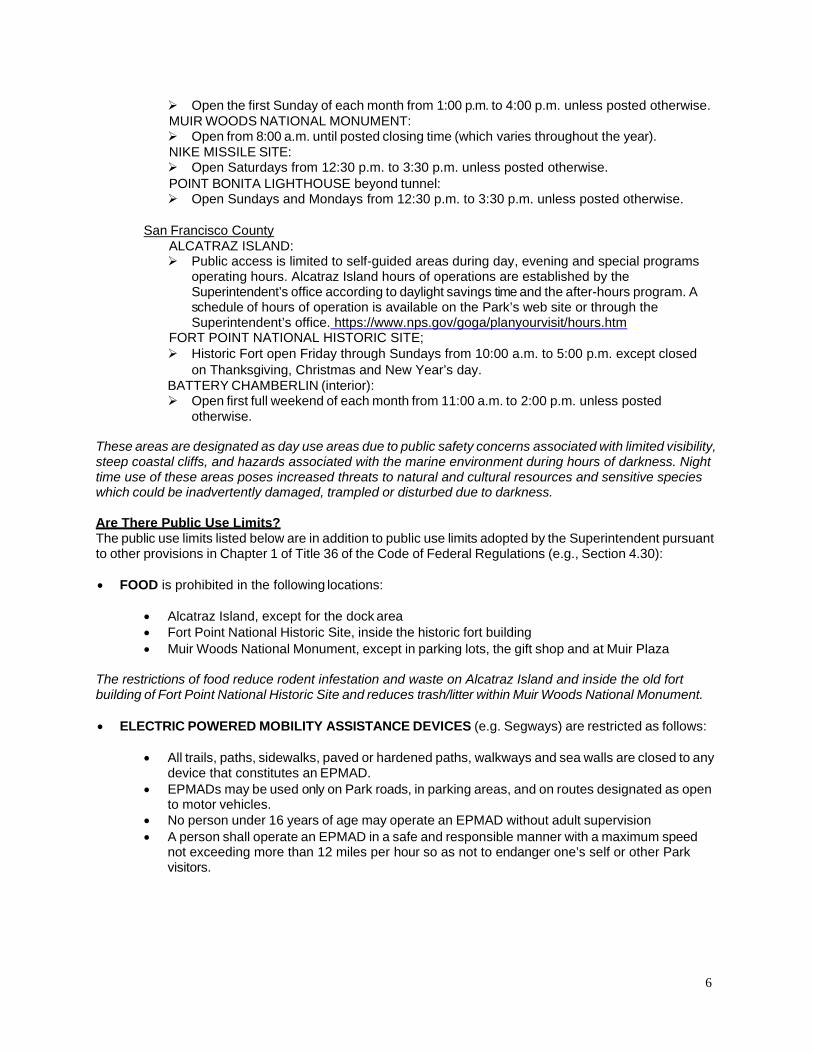
Open the first Sunday of each month from 1:00 p.m. to 4:00 p.m. unless posted otherwise. MUIR WOODS NATIONAL MONUMENT:
Open from 8:00 a.m. until posted closing time (which varies throughout the year). NIKE MISSILE SITE:
Open Saturdays from 12:30 p.m. to 3:30 p.m. unless posted otherwise. POINT BONITA LIGHTHOUSE beyond tunnel:
Open Sundays and Mondays from 12:30 p.m. to 3:30 p.m. unless posted otherwise.
San Francisco County ALCATRAZ ISLAND:
Public access is limited to self-guided areas during day, evening and special programs operating hours. Alcatraz Island hours of operations are established by the Superintendent’s office according to daylight savings time and the after-hours program. A schedule of hours of operation is available on the Park’s web site or through the Superintendent’s office. https://www.nps.gov/goga/planyourvisit/hours.htm
FORT POINT NATIONAL HISTORIC SITE; Historic Fort open Friday through Sundays from 10:00 a.m. to 5:00 p.m. except closed on Thanksgiving, Christmas and New Year’s day.
BATTERY CHAMBERLIN (interior): Open first full weekend of each month from 11:00 a.m. to 2:00 p.m. unless posted otherwise.
These areas are designated as day use areas due to public safety concerns associated with limited visibility, steep coastal cliffs, and hazards associated with the marine environment during hours of darkness. Night time use of these areas poses increased threats to natural and cultural resources and sensitive species which could be inadvertently damaged, trampled or disturbed due to darkness.
Are There Public Use Limits? The public use limits listed below are in addition to public use limits adopted by the Superintendent pursuant to other provisions in Chapter 1 of Title 36 of the Code of Federal Regulations (e.g., Section 4.30):
• FOOD is prohibited in the following locations:
• Alcatraz Island, except for the dock area • Fort Point National Historic Site, inside the historic fort building • Muir Woods National Monument, except in parking lots, the gift shop and at Muir Plaza
The restrictions of food reduce rodent infestation and waste on Alcatraz Island and inside the old fort building of Fort Point National Historic Site and reduces trash/litter within Muir Woods National Monument.
• ELECTRIC POWERED MOBILITY ASSISTANCE DEVICES (e.g. Segways) are restricted as follows:
• All trails, paths, sidewalks, paved or hardened paths, walkways and sea walls are closed to any device that constitutes an EPMAD.
• EPMADs may be used only on Park roads, in parking areas, and on routes designated as open to motor vehicles.
• No person under 16 years of age may operate an EPMAD without adult supervision • A person shall operate an EPMAD in a safe and responsible manner with a maximum speed
not exceeding more than 12 miles per hour so as not to endanger one’s self or other Park visitors.
6
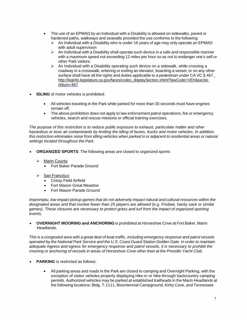
• The use of an EPMAD by an Individual with a Disability is allowed on sidewalks, paved or hardened paths, walkways and seawalls provided the use conforms to the following:
An Individual with a Disability who is under 16 years of age may only operate an EPMAD with adult supervision An Individual with a Disability shall operate such device in a safe and responsible manner with a maximum speed not exceeding 12 miles per hour so as not to endanger one’s self or other Park visitors. An Individual with a Disability operating such device on a sidewalk, while crossing a roadway in a crosswalk, entering or exiting an elevator, boarding a vessel, or on any other surface shall have all the rights and duties applicable to a pedestrian under CA VC § 467. http://leginfo.legislature.ca.gov/faces/codes_displaySection.xhtml?lawCode=VEH§io nNum=467
• IDLING of motor vehicles is prohibited:
• All vehicles traveling in the Park while parked for more than 30 seconds must have engines remain off.
• The above prohibition does not apply to law enforcement patrol operations, fire or emergency vehicles, search and rescue missions or official training exercises.
The purpose of this restriction is to reduce public exposure to exhaust, particulate matter and other hazardous or toxic air contaminants by limiting the idling of buses, trucks and motor vehicles. In addition, this restriction eliminates noise from idling vehicles when parked in or adjacent to residential areas or natural settings located throughout the Park.
• ORGANIZED SPORTS: The following areas are closed to organized sports:
Marin County • Fort Baker Parade Ground
San Francisco • Crissy Field Airfield • Fort Mason Great Meadow • Fort Mason Parade Ground
Impromptu, low-impact pickup games that do not adversely impact natural and cultural resources within the designated areas and that involve fewer than 25 players are allowed (e.g. Frisbee, hacky sack or similar games). These closures are necessary to protect grass and turf from the impact of organized sporting events.
• OVERNIGHT MOORING and ANCHORING is prohibited at Horseshoe Cove at Fort Baker, Marin Headlands.
This is a congested area with a great deal of boat traffic, including emergency response and patrol vessels operated by the National Park Service and the U.S. Coast Guard Station Golden Gate. In order to maintain adequate ingress and egress for emergency response and patrol vessels, it is necessary to prohibit the mooring or anchoring of vessels in areas of Horseshoe Cove other than at the Presidio Yacht Club.
• PARKING is restricted as follows:
• All parking areas and roads in the Park are closed to camping and Overnight Parking, with the exception of visitor vehicles properly displaying hike-in or hike-through backcountry camping permits. Authorized vehicles may be parked at established trailheads in the Marin Headlands at the following locations: Bldg. T-1111, Bicentennial Campground, Kirby Cove, and Tennessee
7
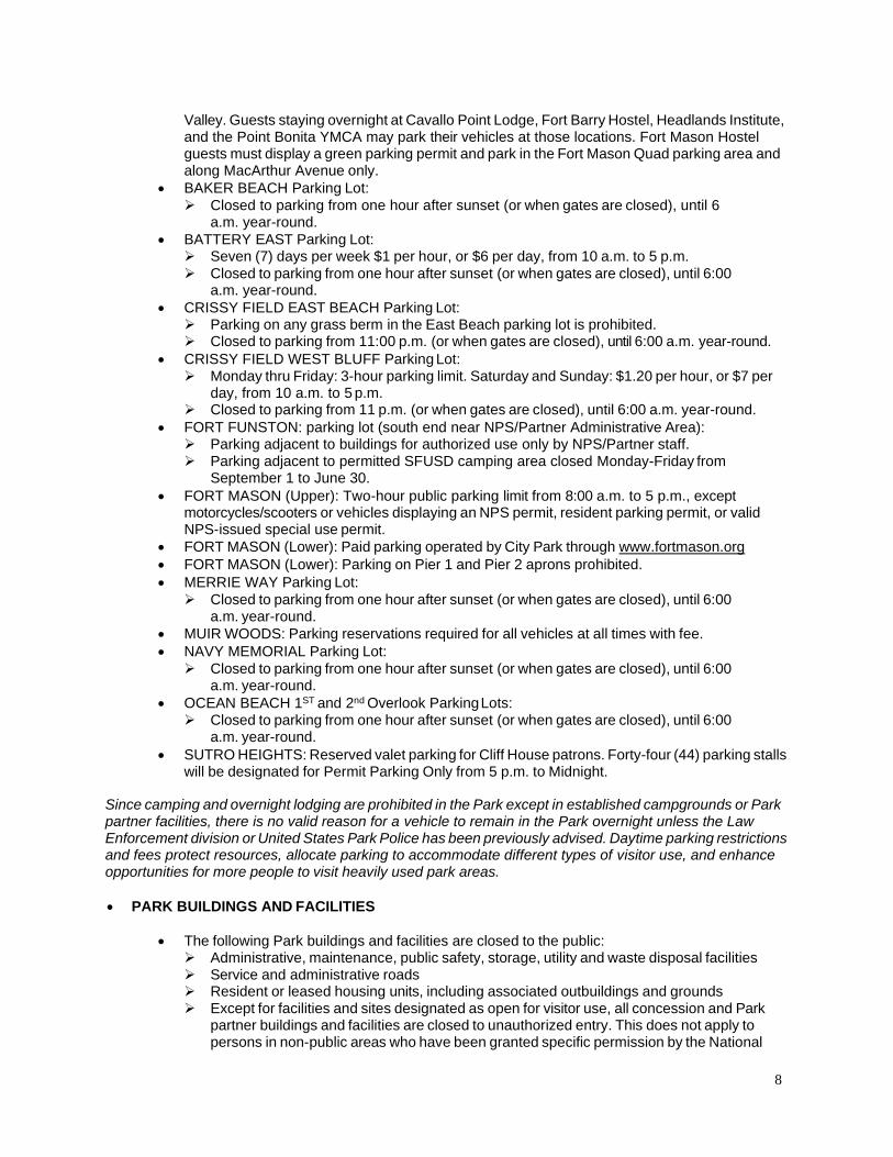
Valley. Guests staying overnight at Cavallo Point Lodge, Fort Barry Hostel, Headlands Institute, and the Point Bonita YMCA may park their vehicles at those locations. Fort Mason Hostel guests must display a green parking permit and park in the Fort Mason Quad parking area and along MacArthur Avenue only.
• BAKER BEACH Parking Lot: Closed to parking from one hour after sunset (or when gates are closed), until 6 a.m. year-round.
• BATTERY EAST Parking Lot: Seven (7) days per week $1 per hour, or $6 per day, from 10 a.m. to 5 p.m. Closed to parking from one hour after sunset (or when gates are closed), until 6:00 a.m. year-round.
• CRISSY FIELD EAST BEACH Parking Lot: Parking on any grass berm in the East Beach parking lot is prohibited. Closed to parking from 11:00 p.m. (or when gates are closed), until 6:00 a.m. year-round.
• CRISSY FIELD WEST BLUFF Parking Lot: Monday thru Friday: 3-hour parking limit. Saturday and Sunday: $1.20 per hour, or $7 per day, from 10 a.m. to 5 p.m. Closed to parking from 11 p.m. (or when gates are closed), until 6:00 a.m. year-round.
• FORT FUNSTON: parking lot (south end near NPS/Partner Administrative Area): Parking adjacent to buildings for authorized use only by NPS/Partner staff. Parking adjacent to permitted SFUSD camping area closed Monday-Friday from September 1 to June 30.
• FORT MASON (Upper): Two-hour public parking limit from 8:00 a.m. to 5 p.m., except motorcycles/scooters or vehicles displaying an NPS permit, resident parking permit, or valid NPS-issued special use permit.
• FORT MASON (Lower): Paid parking operated by City Park through www.fortmason.org • FORT MASON (Lower): Parking on Pier 1 and Pier 2 aprons prohibited. • MERRIE WAY Parking Lot:
Closed to parking from one hour after sunset (or when gates are closed), until 6:00 a.m. year-round.
• MUIR WOODS: Parking reservations required for all vehicles at all times with fee. • NAVY MEMORIAL Parking Lot:
Closed to parking from one hour after sunset (or when gates are closed), until 6:00 a.m. year-round.
• OCEAN BEACH 1ST and 2nd Overlook ParkingLots: Closed to parking from one hour after sunset (or when gates are closed), until 6:00 a.m. year-round.
• SUTRO HEIGHTS: Reserved valet parking for Cliff House patrons. Forty-four (44) parking stalls will be designated for Permit Parking Only from 5 p.m. to Midnight.
Since camping and overnight lodging are prohibited in the Park except in established campgrounds or Park partner facilities, there is no valid reason for a vehicle to remain in the Park overnight unless the Law Enforcement division or United States Park Police has been previously advised. Daytime parking restrictions and fees protect resources, allocate parking to accommodate different types of visitor use, and enhance opportunities for more people to visit heavily used park areas.
• PARK BUILDINGS AND FACILITIES
• The following Park buildings and facilities are closed to the public: Administrative, maintenance, public safety, storage, utility and waste disposal facilities Service and administrative roads Resident or leased housing units, including associated outbuildings and grounds Except for facilities and sites designated as open for visitor use, all concession and Park partner buildings and facilities are closed to unauthorized entry. This does not apply to persons in non-public areas who have been granted specific permission by the National
8

Park Service; another authorized Federal agency; licensed concessionaires or lessees; Park partners, their authorized representatives and guests; or contractors; or to those who are escorted by an NPS employee.
Enhanced security for employees, residents of Park housing, and government property and utilities require these sites to have limited access.
• UNMANNED AIRCRAFT: Launching, landing, or operating an unmanned aircraft from or on lands and waters administered by the National Park Service within the boundaries of Golden Gate National Recreation Area is prohibited except as approved in writing by the superintendent. (Exhibit #1)
The following are the only areas open to unmanned aircraft flight and operations:
Marin County • Shoreline Highway: coast side shoulder and bench area (aka “Tick Point”) north of Muir
Beach Overlook just beyond mile marker 7.0 is open except between February 1 and July 31.
San Francisco • Fort Funston (when hang gliders or para-gliders are not in the air)
Unmanned aircraft are a hazard to the safety of people piloting hang gliders and para-gliders in the Fort Funston area. The Marin County site is closed to unmanned aircraft for a six-month period each year to protect raptors that nest and breed near this location.
What Park Areas Are Closed To The Public?
All areas fenced and / or posted as closed
Marin County J FORT BAKER (Exhibit # 2)
• Baker/Barry Tunnel closed to pedestrians • Battery Yates Wildlife Protection Area – designated by cable fencing • Battery Cavallo • Battery Spencer historic fortification pill boxes above slope from Golden Gate Bridge • Golden Gate Bridge north anchorage andpylons • U.S. Coast Guard Station Golden Gate facilities and docks • Vista Point service road accessed from lower Conzelman Road • Lower Conzelman Road (south of parking lot to Lime Point access road) closed to vehicles
only • Lime Point access road and light station
• MUIR BEACH & MUIR WOODS NATIONAL MONUMENT (Exhibit #4) • Redwood Creek • Big Lagoon and its seasonal inlet
9
J POINT BONITA LIGHTHOUSE AREA (Exhibit #6) • Bird Island Overlook – beyond cable fencing, cliff areas and coastal fortifications • Bonita Cove and tide pools • Travel off lighthouse main access road and trail • U.S. Coast Guard Vessel Traffic Service radar site
J TENNEESEE VALLEY (Exhibit #7) • Tennessee Valley Pond (next to thebeach)
San Francisco County • ALCATRAZ ISLAND (Exhibit #8)
The following locations on ALCATRAZ ISLAND are closed to public use (Closed areas may be accessed under special circumstances with site supervisor approval):
• All tide pools • All designated sensitive bird breeding habitats • Casemates under recreation yard • Catwalk circling recreation yard • Cistern area • Incinerator area • Lower west road over Barker Beach from Windy Gulch path to New Industries building • Morgue • Northeast perimeter path (dock to north foghorn) • Officers Club • Parade Ground rubble piles • Plaza northeast of Model Industries building (as posted) • Quartermaster building • Top tiers of cell house (A, B, C, & D Blocks) • Warden’s house • Western and northwestern cliffs • Windy Gulch path • The Gardens • Any area barricaded and signed “Area Closed for Your Safety” • Any Buildings not open to the Public, such as Building 64, Upper Tiers • West Side: lower west road from Parade Ground gate past Apt. A; bird blind; incinerator;
and west side of New Industries building.
The following locations on ALCATRAZ ISLAND will be closed seasonally to public use each year from February 1 through September 30, or the end of the nesting season, as determined by the Park’s wildlife specialist:
• Agave Trail: from dock to tide pools west of steps • Parade Ground and Agave Steps
• BAKER BEACH (Exhibits #9A and 9B) • See Presidio Area A below
• FORT FUNSTON (Exhibit #10) • Habitat protection area • Coastal Trail, intersection of Horse trail to Great Highway, closed due to erosion.
10
• FORT MASON (Lower) (Exhibit #11) • Pier One • Pier Four
• FORT POINT HISTORIC SITE (Exhibit #12) • Historic Seawall • Golden Gate Bridge anchorage and pylons
• LANDS END (Exhibit #13) • Dead Man’s Point • Point Lobos Archeological District • Off trail area in between Coastal Trail and ocean from Painted Rock to Eagles Point
• PRESIDIO OF SAN FRANCISCO (Area A) (Exhibit #14) • Lobos Creek riparian corridor (Exhibits #9A and 9B) • Former Coast Guard Pier • Crissy Tidal Marsh consisting of an open water lagoon, sand flats, mud flats and vegetated
marsh plain located in the central portion of Crissy Field. The tidal marsh is defined as: starting at the eastern edge, from the channel inlet promenade footbridge extending along the shoreline; along the northern edge of the wetland; west to the perimeter of the restored airfield; and to the south along the vegetation buffer and barrier fencing parallel and adjacent to Mason Street. Public use is permitted on designated trails, including boardwalks and footbridges.
• Presidio Water Treatment Plant, Bldg. 1773
San Mateo County
J MORI POINT (Exhibit #16) • Ponds and fenced or posted wetlands and habitat • Vertical bluffs and cove belowMori Bluff Trail
J PHLEGER ESTATE (Exhibit #17) • West Union Creek
J RANCHO CORRAL DE TIERRA (Exhibit #18) • Pond and wetlands (Charthouse Mitigation Site)
Areas are designated as closures due to public safety concerns (e.g., limited visibility, steep coastal cliffs, hazards associated with the marine environment).
Alcatraz Island areas are closed to protect breeding birds Certain bird species nesting on Alcatraz have demonstrated extreme sensitivity to human presence during the breeding season. These closures minimize the disturbance to their nesting activity.
Natural and cultural resources in these areas are highly sensitive to damage. In addition, they contain vital habitat for shorebirds, Mission Blue butterflies, Red-legged frog, salmonids, riparian species, marine mammals, and other sea life.
Vegetated areas contain significant native plant communities and habitats that are subject to human-induced impacts. Coastal bluffs and dunes are also sensitive to human-induced impacts and additionally are significant geological features.
U.S. Coast Guard radar site, U.S. Coast Guard Station Golden Gate, and Golden Gate Bridge facilities are restricted use areas due to the presence of critical infrastructure and the need for security around law enforcement facilities. Residential areas inside the Park are primarily maintained for the use of Park residents and their invited guests.
The Baker/Barry Tunnel is a one-way, traffic-controlled tunnel for motor vehicles with bicycle lanes in both directions. There are no pedestrian walkways. The tunnel is unsafe for pedestrian traffic.
11

• Dept. of Homeland Security ENHANCED SECURITY CLOSURES – ELEVATED
Fort Point National Historic Site • Marine Drive closed at Wavegate • Long Avenue
Golden Gate Bridge North Anchorage (MarinHeadlands) • Lower Conzelman road access at Northwest ParkingLot. • Golden Gate Bridge North Anchorage (Fort Baker) Lower Conzelman Road access closed at
Bunker Road & Murray Circle intersection. • Sommerville Road access road to Lower Conzelman; boat launch and fishing pier closed east
of USCG Station Golden Gate.
Land and waters surrounding the north and south anchorage of the Golden Gate Bridge: • Fort Point National Historic Site 100 yards offshore from the low water mark. • Fort Baker 100 yards offshore from the low watermark. • No vessel shall:
(a) anchor beneath the Golden Gate Bridge, or within 100 feet of the east or west edges of the bridge; (b) operate or remain beneath the Golden Gate Bridge, or within 100 feet east or west of the edges of the bridge, for longer than reasonably necessary to traverse the area, except in an emergency or with the permission of the Captain of the Port, SF Bay (USCG).
These closures are necessary when the condition is declared due to a high risk of terrorist attack. These closures will remain in effect during National Threat Level – ELEVATED. These closures will be rescinded when threat level high condition ELEVATED is reduced or eliminated.
• Dept. of Homeland Security ENHANCED SECURITY CLOSURES – IMMINENT
Fort Point National Historic Site • Marine Drive closed at Wavegate • Long Avenue • Coastal trail closed at Fort Point administration Building to Battery East • Coastal trail closed at Battery East to Golden Gate Bridge
Coastal Trail • Coastal trail closed at Battery Boutelle east to Golden Gate Bridge
Marshall Beach to Fort Point Beach (Golden Gate Bridge South Anchorage) • Batteries to Bluffs trail from Lincoln Ave to Marshall Beach
Golden Gate Bridge North Anchorage (Marin Headlands) • Lower Conzelman Road access at North West Parking Lot
Golden Gate Bridge North Anchorage (Fort Baker) • Lower Conzelman Road access closed at Bunker Road & Murray Circle intersection • Sommerville Road access road to Lower Conzelman; boat launch and fishing pier closed east
of USCG Station Golden Gate
12

Land and waters surrounding the north and south anchorage of the Golden Gate Bridge: • Fort Point National Historic Site 300 offshore from the low water mark • Fort Baker 500 yards offshore from the low watermark • No vessels shall:
(a) anchor beneath the Golden Gate Bridge, or within 100 feet of the east or west edges of the bridge; (b) operate or remain beneath the Golden Gate Bridge, or within 100 feet east or west of the edges of the bridge, for longer than it is reasonably necessary to traverse the area, except in an emergency or with the permission of the Captain of the Port, SF Bay, U.S. Coast Guard.
These closures are necessary when the condition is declared due to an extreme risk of terrorist attacks. These closures will remain in effect during National Threat Level – IMMINENT. These closures will be rescinded when threat level extreme condition IMMINENT is reduced or eliminated.
36 CFR §1.5(a)(2) Areas Designated for A Specific Use Or Activity, And Special Conditions Or Restrictions That Apply To Regulated Activities
• BOATING: The following areas are closed to all vessels, including rowboats, kayaks, rafts, surfboards, sail boards, kite boards and windsurfing boards:
Marin County • Bird Rock: All waters within 300 ft. of Bird Rock are closed to boating for the protection of
nesting and roosting seabirds, and sensitive intertidal areas (Exhibit #6) • Point Bonita Cove and tide pools and marine area 300 ft. offshore are closed to boating due
to marine mammal habitat and haul-out area (Exhibit #6) • Redwood Creek • Rodeo Lagoon and seasonal inlet, Marin Headlands (Exhibit #3A) • Rodeo Lake, Marin Headlands
San Francisco • Alcatraz Island docks* (Except NPS contracted ferry/barge service and NPS and United
States Coast Guard vessels.) • Alcatraz Island Seasonal Closure: From February 1 to September 30, boats are prohibited
from entering the Alcatraz Seasonal Closure Area, which extends from the shoreline seaward to 300 feet, excluding the East shoreline area between the guard tower and the South East corner of the island (122 25’07.9”W 37 49’29.9”N) where only NPS contracted ferry/barge service and NPS and United States Coast Guard vessels access the island. (Exhibit #8)
• Crissy Field Wildlife Protection Area which encompasses the shoreline and beach north of the Crissy Field Promenade (excluding the paved parking area, sidewalks and grass lawn of the former Coast Guard Station complex) then stretches east from Torpedo Wharf to approximately 700 feet east of the former Coast Guard station landside, and all tidelands and submerged lands to 300 feet offshore. (Exhibit #14)
• Lobos Creek, Presidio Area A (Exhibits #9Aand 9B)
These restrictions are for the purpose of protecting sensitive natural resources. These areas provide vital habitat for water birds, shorebirds and marine life. These restrictions are necessary to protect water quality in wetland areas. Boat traffic, loud noise and the use of public address systems from tour vessels and night lighting may cause seabirds to abandon nests. The prohibition on boating will provide important areas of reduced disturbance for wildlife. In addition, there is a need to maintain clearance and reduce hazards to navigationfor ferries transporting visitors to Alcatraz Island.
*NOTE: Special regulations pertaining to boat landings on Alcatraz Island are found in 36 CFR Section 7.97(a).
13

•
ELECTRIC BIKES (E-BIKES): The following conditions apply to the use and operation of E-bikes in the Park: • E-bikes are allowed in the Golden Gate National Recreation Area on certain designated
routes where traditional bicycles are allowed. E-bikes remain prohibited where traditional bicycles are prohibited; and E-bikes are subject to additional use restrictions on six (6) trails (e.g., downhill use only or Class Level limitations on trails connecting to State park trails where such limitations already exist).
• Except where use of motor vehicles by the public is allowed, using the electric motor to move an e-bike without pedaling is prohibited.
• A person operating an e-bike is subject to the following sections of 36 CFR Part 4 that apply to the use of traditional bicycles: sections 4.12, 4.13, 4.20, 4.21, 4.22, 4.23, and 4.30(h)(2)- (5).
• Except as specified in this Compendium, the use of an e-bike within the Golden Gate National Recreation Area is governed by the laws of the State of California including Section 24016 and Division 11, Chapter 1, Article 4 of the California Vehicle Code, which laws are adopted and made a part of this Compendium. Any violation of state law adopted by this paragraph is prohibited.
• The maximum number of e-bicyclists in any one group is 10. Larger groups of e-bicyclists must divide into groups not larger than 10.
• E-bicyclists may ride abreast of one another on the Crissy Field Promenade but not during special use permit activities.
• The speed limit for e-bicycles in developed and undeveloped areas is 15 mph except that e-bicycles shall not exceed 5 mph around any blind curve and on all roads and paved paths in the following areas:
San Francisco • McDowell Road, Fort Mason • Great Meadow, Fort Mason • Mason Avenue Bike Path on Sidewalk, Crissy Field • Crissy Field Promenade • Battery East Trail
E-BIKE CLOSURES AND LIMITED USE ROUTES: In the Park areas listed below, e-bike use is prohibited, or allowed with restrictions, in generally the same manner as bicycle use is prohibited or restricted under 36 CFR 4.30:
Marin County (Exhibits #20-21) • Battery Yates Trail (top of battery), FortBaker • Deer Park Fire Road between (Frank’s Valley) Muir Woods Road and Coastal Trail near Pan
Toll (major portion is in Mt. Tamalpais State Park): OPEN TO CLASS 1 AND 2 E-BIKES ONLY • Dias Ridge Trail between Mt. Tamalpais State Park boundary and Highway 1 near Muir Beach:
OPEN TO DOWNHILL USE ONLY and CLASS LEVEL 1 AND 2 E-BIKES ONLY • Middle Green Gulch Trail (above Zen Center) • Miwok Trail between Miwok Stables and Highway 1: OPEN TO DOWNHILL USE ONLY from
Tennessee Valley to County View Trail • Muir Woods National Monument, all trails except Deer Park Fire Road (see above) • Old Springs Trail between Miwok Trail and Miwok Stables: OPEN TO DOWNHILL USE ONLY. • Point Bonita Trail, Marin Headlands • Willow Camp Fire Road between Stinson Beach and Ridgecrest Boulevard (major portion is in
Mt. Tamalpais State Park): OPEN TO CLASS LEVEL 1 AND 2 E-BIKES ONLY
San Francisco (Exhibits #22-24) • Coastal Trail, Lands End • Crissy Field Lagoon Boardwalk • Fort Point Pier (Torpedo Wharf)
14

San Mateo County (Exhibits #25-26) J MILAGRA RIDGE
• Milagra Battery Trail: OPEN TO DOWNHILL USE ONLY • Milagra Creek Overlook • Milagra Ridge Trail • Milagra Summit Trail
J MORI POINT • Bootlegger’s Steps • Mori Bluff Trail • Mori Headlands Trail • Mori Peak Trail • Timigtac Trail
J SWEENEY RIDGE • Notch Trail • Sweeney Horse Trail • Sweeney Meadow Trail
J RANCHO CORRAL DE TIERRA • Almeria Trail • Alta Vista Trail • Clipper Ridge Trail: OPEN TO DOWNHILL USE ONLY • Corona Pedro Trail • Ember Ridge Trail • Farallon Trail • Farmer’s Daughter Trail • Flat top Trail • French Trail: OPEN TO DOWNHILL USE ONLY • Le Conte Trail • Ranchette Trail • San Carlos Trail • San Vicente Trail • Spine Trail
J PHLEGER ESTATE
Trails and other Park sites listed above are closed to e-bikes for the following reasons. E-bike use of steep or narrow trails, trails with stairs, erosion prone areas, areas adjacent to steep drop offs and congested areas have been closed to e-bikes to protect public health and safety, soils and vegetation. E-bikes are restricted from certain equestrian trails in order to better manage visitor use conflicts. Batteries and other historic features could be harmed by e-bikes. E-bike use is inconsistent with the contemplative atmosphere of Muir Woods National Monument. The NPS determined that it was appropriate to close many of the trails and routes listed above to bicycles as part of the following environmental review and public planning processes: the Marin Trail Use Designation Plan and its associated rulemaking process (57 Fed. Reg. 58716, Dec. 11, 1992); Redwood Creek Trail Realignment and Dias Ridge Trail Extension Project (2015); and the Muir Woods National Monument Sustainable Access Project (2017). NPS policy directs that e-bikes are to be managed in a manner consistent with traditional bicycles. Therefore, the use of e-bikes is also prohibited in the areas listed above.
15
The group size restriction is necessary for the safety of the e-bicyclists using public roadways and authorized trails within the Park and for the safety of other Park visitors. Roadways and trails must be shared with other vehicles, pedestrians and horses. The group size limit does not exempt e-bicyclists from adhering to California Vehicle Code regulations. Speed limits are designed to protect the health and safety of e-bicyclists and other visitors in areas of high visitation or with limited visibility.
• DESIGNATED E-BIKE ROUTES: The following routes, which are designated as open to bicycles under 36 CFR 4.30, are also designated as open to e-bikes:
Marin County (Exhibits #20 and 21)
J MARIN HEADLANDS AND FORT BAKER • Alta Trail between Rodeo Ave and MarinCity • Baker-Barry Tunnel • Batteries Loop Trail • Fort Baker Bay Trail between Golden Gate Bridge and Sausalito. • Bobcat Trail between Miwok Trail and MarincelloTrail. • Rodeo Valley Trail between Capehart Bridge (north of Bunker and McCullough
intersection) and Bobcat Trail. • Capehart and Smith Road Bridges connecting Bunker Road to Rodeo Valley Trail • Old Bunker Road (adjacent to the Roads & Trails Maintenance Yard to Battery
Townsley) • Slacker Ridge Trail: from McCullough Road to Slacker Hill. • Julian Trail (Fire road): between Conzelman Road at McCullough and the Fort
Barry Rifle Range at Bunker Road • Coastal Trail between Rodeo Beach Parking and Hill 88. • Coastal Trail from Tennessee Valley to Kaashi Way, Muir Beach • Coyote Ridge trail • Drown Road, Fort Baker • Hawk Camp Trail (between Bobcat Trail and Hawk Camp). • Haypress Camp Trail (between Tennessee Valley Road and Haypress Campground). • Kirby Cove Road • Marincello Trail between Tennessee Valley Parking Area and Bobcat Trail. • Miwok Trail between Rodeo Lagoon and OldSprings Trail • Miwok Trail between Miwok Stable and Highway1 • Oakwood Valley Trail between Tennessee Valley Road and Oakwood Pond (Does not
include Oakwood Meadow Trail between Pond and Alta Avenue.) • Rodeo Avenue Trail between US Highway 101 and Alta Avenue • Marin Drive/Smith Road between Marinview and MiwokTrail • Tennessee Valley Trail
J MUIR BEACH • Kaashi Way
16
• San Francisco (Exhibits #22-24)
J PRESIDIO • Coastal Trail, from GG Bridge to intersection of Lincoln and Washington Blvds., except
Battery to Bluffs Trail Section • Coastal Trail, Fort Point, except Presidio Promenade • Crissy Promenade • Mason Street multi-use path
J FT. MASON • Great Meadows paths • Fort Mason Bay trail (formerly McDowell road)
J LAND’S END • El Camino Del Mar Trail
J FORT FUNSTON • Coastal Trail (except north of Horse Trail intersection)
• San Mateo County (Exhibits #25-26)
J MILAGRA RIDGE • Milagra Ridge Road
J MORI POINT • Lishumsha Trail • Old Mori Trail • Upper Mori Trail • Coastal Trail
J SWEENEY RIDGE • Baquiano Trail • Mori Ridge Trail • Sneath Lane • Sweeney Ridge Trail, except Notch Trailportion
J RANCHO CORRAL DE TIERRA • Deer Creek Trail • Old San Pedro Mountain Road, except E-bikes must be walked along Old San
Pedro Mountain Road through Ocean View Farms • Ranch Road
NPS policy directs that e-bikes are to be managed in a manner consistent with traditional bicycles. Trails that are designated as open to e-bikes have been reviewed under Categorical Exclusion 94816 – “Designation of Routes and Use Restrictions for E-bikes, Marin/San Francisco/San Mateo Counties.” In addition, trails that are open to traditional bicycles have been subject to environmental review and public comment as part of the following public planning processes: Marin Trail Use Designation Plan and associated rulemaking process (57 Fed. Reg. 58716, Dec. 11, 1992); Marin Headlands and Ft. Baker Transportation and Infrastructure Plan (FEIS 2009); Milagra Battery Trail and Signs (CE 2015); Re-surface Crissy Field Promenade and Repair East Beach Parking Area (CE 2016).
17
DESIGNATED FISHING PIERS: the following areas are open to recreational fishing and do not require fishing licenses:
Marin County • Fort Baker pier and jetty
San Francisco • Fort Mason Piers Two & Three (Herbst and Festival Pavilions) • Fort Point pier (a.k.a. Torpedo Wharf)
In accordance with California law, (Fish and Game Code § 7153 and Section 1.88 of Title 14 of the California Code of Regulations) public fishing piers and jetties, open 24 hours a day, do not require a state fishing license.
FISHING: The following areas are closed tofishing:
Marin County • Easkoot Creek, Stinson Beach • Muir Woods National Monument (36 CFR 7.6) • Redwood Creek (including Muir Beach Lagoon and tidewaters) • Tennessee Valley Pond (next to thebeach) • Rodeo Lagoon, Marin Headlands • Rodeo Lake, Marin Headlands
San Francisco • Alcatraz Island shoreline • Crissy Field Former Coast Guard Pier, breakwater and seawall • Lobos Creek, Presidio Area A
These restrictions provide protection for threatened and endangered species and anadromous fish found in these areas. Alcatraz Island and the Coast Guard pier are closed to fishing due to public safety concerns associated with steep drop-offs and hazards of the marine environment. Alcatraz Island is also closed to fishing due to the congestion caused by heavy visitation. Lobos Creek is closed to protect the public drinking water supply. The prohibitions on fishing will also provide important areas of reduced disturbance for wildlife and sensitive habitats.
GLASS BOTTLES/CONTAINERS: Possession is prohibited in the following areas:
Park wide • All beach areas and 15 feet adjacent • All historic coastal defense structures
San Francisco • Crissy Field, north of promenade. • Upper Fort Mason Great Meadow
The purpose of this regulation is to reduce the amount of injurious trash in the Park and to prevent injury to Park visitors.
PICNICKING: The following areas are closed topicnicking:
• Muir Woods National Monument, except Muir Plaza (former upper main parking lot). • Inside the Historic Fort at Fort Point NHS • Alcatraz Island, except the pier.
18

SWIMMING BEACHES: Stinson Beach is designated as a swimming beach. (Please refer to §3.16 and §3.17 for specific swimming area designation uses.)
SURFING: Restricted at Stinson Beach, including Kite surfing and Kite boarding, when swimmers are present, and allowed only in areas designated as “Non-Swimming Areas” and only at such times as are deemed safe by the Supervisory Ranger or by his/her representative.
VAPING, E-CIGARETTES AND ELECTRONIC NICOTINE DELIVERY SYSTEMS (ENDS): The following restrictions apply to the use of these devices:
• Concession facilities providing food service will comply with all contract terms and applicable federal, state and local ordinances and regulations regarding these devices.
• Use of these devices by government employees and contractors and Park partner employees and contractors is allowed in designated, outdoor employee break areas.
• Use of these devices is prohibited in or on: All government buildings, facilities, vehicles and vessels (excluding residences in accordance with tenant lease agreements and designated outdoor smoking areas). All Park partner and tenant facilities (excluding residences and designated smoking areas in accordance with tenant lease agreements and concession contracts). Areas within 25’ of building entrances normally used by the pubic and areas within 25’ of entrances not normally used by the public if vapor from these devices is able to enter the building. Alcatraz Island, except in the area designated for smoking in the dock area. Fort Point NHS (within the historic fort) Muir Woods National Monument, except in designated parking areas. During extreme fire danger periods, use of ENDS is also prohibited in Monument parking areas. All trails within all areas of the Park when the Superintendent has determined that fire danger is extreme. NPS and Park partner employee use of ENDS in designated, outdoor break areas during extreme fire danger is allowed, but employees must be extra cautious.
These restrictions are intended to protect public health from the potentially harmful effects of exposure to Vaping, E- cigarettes and ENDS, reduce the risk of fire, and prevent conflicts among visitor use activities.
VOICE CONTROL DOG WALKING*: The 1979 Pet Policy allows for Managed Dogs, leashed or under Voice Control, in the following areas:
Marin County (Exhibits #27-31B) • Alta Trail between Marin City and junction with Oakwood Valley Trail • Muir Beach • Oakwood Valley Trail (formerly Oakwood Valley Fire Road) to Alta Avenue • Orchard and Pacheco Trails between Marin City and Alta Trail • Rodeo Beach and South Rodeo Beach, Fort Cronkhite • Tamalpais Area: 4 Corners tract above Mill Valley bounded by State Route 1, Panoramic
Highway, Sequoia Valley Road and Homestead Valley area • Trail corridors (3) in Marin Headlands:
1. Former Coastal Trail (now named the SCA trail from Conzelman road and Golden Gate Bridge to Slacker trail and Julian trail on to Old Fisherman’s trail before connecting back to Coastal Trail) on to junction with Wolf Ridge Trail 2. Loop Trail from Rodeo Beach parking lot up Coastal Trail paved road (Old Bunker Road) near Battery Townsley and return to Rodeo Beach on paved road 3. Wolf Ridge Loop (Coastal Trail to Wolf Ridge Trail; Wolf Ridge Trail to Miwok Trail; Miwok Trail back down to Coastal Trail)
San Francisco (Exhibits #32-36) 19

• Baker Beach north of Lobos Creek • Crissy Field, excluding picnic areas and the Wildlife Protection Area seasonal leash
restriction (For on-leash seasonal restriction from July 1 - May 15, see weblink below)**.
• Fort Funston, except in the 12-acre closure in northwest Fort Funston. • Fort Miley, east • Fort Miley, west • Lands End • Ocean Beach, excluding Snowy Plover Protection Area seasonal leash restriction.
(For on-leash restriction from Stairwell 21 south to Sloat Boulevard from July1 - May 15, see weblink below)**.
San Mateo County • None
** For information about the seasonal on leash requirements at Ocean Beach and Crissy Field, see the 2008 Special Regulation codified at 36 CFR 7.97(d). (Also available at: https://www.nps.gov/goga/planyourvisit/dog-friendly-areas.htm).
As stated in the 1979 Pet Policy, “Unmanaged animals are not allowed in GGNRA.”
*In all other areas where dogs are allowed, 36 CFR 2.15(a)(2), the federal regulation requiring dogs to be on-leash, applies. See exhibits 27 - 44 for dog walking areas.
Refer to 36 CFR 2.15 “Pets” in this Compendium for additional areas closed to pets and special conditions imposed by the Superintendent.
Additional information about dog walking in the Park is available at: https://www.nps.gov/goga/planyourvisit/dog-friendly-areas.htm
36 CFR §1.6 – ACTIVITIES THAT REQUIRE A PERMIT
(f) The following is a compilation of those activities for which a permit from the Superintendent is required: Permits applications may be obtained by contacting the Special Park Uses office at (415) 5614300 or by visiting the Park website: https://www.nps.gov/goga/planyourvisit/specialparkuses.htm
J §1.5(d) The following activities related to Public Use Limits: • Entry into closed area • Guide and Service dog training
J §2.4(d) Carrying or possessing a weapon, trap, or net in circumstances where a permit is required under Section 2.4
J §2.5(a) Specimen collection (Take of plants, fish, wildlife, rocks or minerals)
J §2.10(a) Camping activities: https://www.nps.gov/goga/planyourvisit/camping.htm • Kirby Cove, Bicentennial, Haypress and Hawk Camp • Kirby Cove Day-use site
J §2.11 Picnicking: • Groups of 50 or more • Groups of any size with significant equipment
J §2.12 Audio Disturbances: 20

• (a)(2) Operating a chain saw in developedareas • (a)(3) Operation of any type of portable motor or engine, or device powered by a portable motor
or engine in non-developed areas • (a)(4) Operation of a public address system in connection with a special event or demonstration
for which a permit has been issued pursuant to §2.50 or §2.51, or in connection with a demonstration that otherwise meets the requirements for the small group exception under §2.51
J §2.13(a)(1) Beach Fires • Groups over 25 people and/or with significant equipment including, but not limited to tents,
caterings, etc.
J §2.17 Aircraft & Air Delivery: • (a)(3) Delivery or retrieval of a person or object by parachute, helicopter or other airborne
means • (c)(1) Removal of a downed aircraft
J §2.37 Soliciting gifts, money goods or services except pursuant to the terms and conditions of a permit issued under §2.50, §2.51 or §2.52
J §2.38 Explosives: • (a) the use, possession, storage, or transport of explosives or blasting agents • (b) the use or possession of fireworks
J §2.50(a) Conducting a sports event, pageant, regatta, public spectator attraction, entertainment, ceremony, and similar event
J §2.51(a) Public assemblies, meetings, gatherings, demonstrations, parades and other public expressions of views that involve the use of a public address system regardless of size or that do not meet the requirements of the small group exception in §2.51(b)(1). The areas formally designated for such use are listed under §2.51 of this Compendium.
J §2.52(c) Sale or distribution of printer matter (that is not solely commercial advertising regulated under §5.1) other than by groups meeting the small group exception under §2.52. The areas designated for such use are listed under §2.51 of this Compendium.
J §2.60(b) Livestock use
J §2.61(a) Residing on federal lands
J §4.11(a) Exceeding of established vehicle load, weight and size limits
J §5.1 Advertisements - (Display, posting or distribution.)
J §5.3 Engaging in or soliciting any business on lands or waters administered by the Park is prohibited except as authorized under a permit, contract or other written agreement with the NPS, or pursuant to a special regulation. Examples of business activities that require a permit or other written agreement with the NPS include: • Commercial Visitor Services that meet the definitions and requirements of the Park’s
Commercial Use Authorization Program as described at https://www.nps.gov/goga/getinvolved/dobusinesswithus.htm
• Commercial Carriers • Outdoor Fitness Programs • Guided Services • Commercial Dog Walking: The walking of four or more dogs, with the maximum of six, at one
time by any one person for consideration (commercial dog walking) is prohibited within San 21

Francisco and Marin County sites administered by the Golden Gate National Recreation Area (GGNRA) unless:
The person has been issued a current valid permit from GGNRA. The walking of four or more dogs, with a maximum of six, is done pursuant to the terms and conditions of that permit. Permit holders abide by all National Park Service regulations, including 36 CFR 2.15(a), which requires that dogs be restrained by a leash no longer than 6 feet in sites that are not open to voice-control dog walking per the 1979 Pet Policy. The permit is visibly displayed and produced for inspection upon request by an officer with law enforcement authority in areas administered by GGNRA. For further information about Commercial Dog Walking permit applications and requirements, visit the Park’s website: https://www.nps.gov/goga/planyourvisit/cdswup.htm
J §5.5 Commercial Photography/Filming(a) Commercial filming of motion pictures or television involving the use of professional casts, settings or crews, other than bona fide newsreel or news television (b) Still photography of vehicles, or other articles of commerce or models for the purpose of commercial advertising
J §5.6(c) Use of commercial vehicles on Park roads (The Superintendent shall issue a permit to access private lands within or adjacent to the Park when access is otherwise not available.)
J §5.7 Construction of buildings, facilities, trails, roads, boat docks, path, structure, etc.
J §7.97(a) Boat landings on Alcatraz
PART TWO – RESOURCE PROTECTION, PUBLIC USE AND RECREATION
36 CFR §2.1 – PRESERVATION OF NATURAL, CULTURAL AND ARCHEOLOGICAL RESOURCES
(b) Where must I stay on the trail? Hiking and pedestrian use of areas outside the beaten track of the following trails is prohibited:
Marin County (Exhibits #2, 3A-B, 4, 5, 6 and 7) J FORT BAKER
• Drown (Fire) Road • Fort Baker Bay Trail (Battery Yates section) • Chapel Trail (Steps)
J MARIN HEADLANDS • Slacker Trail • Slacker Ridge Trail • Coastal Trail (includes renamed sections of Julian trail from Slacker Trail to Upper
Fisherman’s trail) to Rodeo Beach • Hawk Hill Connector (from Coastal trail to Hawk Hill) • Point Bonita Lighthouse Trail • Student Conservation Assoc. (SCA) Trail • Kirby Cove Road – from Conzelman Gate to Campground Parking Lot • Alta Trail
J MUIR BEACH • Coastal Trail, Tennessee Valley to Muir Beach • Muir Beach Access Trail, Muir Beach • Muir Beach Overlook Trail • Kaashi Way Trail
22

J MUIR WOODS NATIONAL MONUMENT • All Trails
San Francisco (Exhibits #8, 9A & B, 12, and 13) • Alcatraz Island, Agave Trail (when open) • Coastal Trail, Battery East Earthworks • Batteries to Bluffs Trail, Presidio • Coastal Trail, Presidio and Land’s End
San Mateo County (Exhibits #15-19) J MILAGRA RIDGE
• Milagra Summit Trail • Milagra Battery Trail • Milagra Creek Overlook Trail • Milagra Ridge Trail; southern junction of the Milagra Ridge Spur Trail to the northern
junction of the Milagra Ridge Road
J MORI POINT • Pollywog Path • Old Mori Trail west of junction with PollywogPath • Headlands Trail
J PHLEGER ESTATE • Miramontes Trail
J RANCHO CORRAL DE TIERRA • All trails within the Ocean View Farms, Ember Ridge, Moss Beach Ranch, and Renegade
Ranch equestrian operations (Old San Pedro Mountain Road trail north of intersection with Farallone Trail; San Vicente Trail; Ranchette Trail; and Ember Ridge Trail)
J SWEENEY RIDGE • Notch Trail
These restrictions are for the purpose of visitor safety associated with uneven surfaces, loose rock formations, and steep drop-offs. These areas have been identified as the sites of multiple fatalities and serious injuries over the years. Other areas require protection of irreplaceable cultural resources. In addition, these areas provide vital habitat for federally listed species (e.g., Mission blue butterfly) other terrestrial species, marine mammals, and other sea life. The vegetated areas contain native and historical vegetation that is sensitive to trampling from shortcutting and human-induced erosion.
(c)(1), (c)(2) The following fruits, nuts, berries or unoccupied seashells may be gathered by hand for personal use or consumption, in accordance with the noted size, quantity, collection sites and/or use or consumption restrictions:
• Plums, apples, figs, blackberries and unoccupied seashells may be gathered for personal consumption or use in quantities of less than one (1) quart per person per day and no more than 5 total quarts per person per year.
• Muir Woods National Monument: No collecting of any kind is allowed.
It has been determined that the gathering or consumption of above-listed fruits and berries will not adversely affect Park wildlife, the reproduction potential of any plant species, or otherwise adversely affect Park resources. If future monitoring indicates that such gathering or consumption is likely to cause adverse effects to Park resources, the authorization of this consumptive use will be terminated. Use of these items for any purpose other than personal consumption or use is specifically prohibited.
23
See http:// www.presidio.gov PART 1002 § 1002.1(c)(2) for areas available for mushroom harvesting on Presidio Trust jurisdiction.
36 CFR §2.2 - WILDLIFE PROTECTION
(e) The following areas are closed to the viewing of wildlife with the use of an artificial light and infrared devices:
• The entire Park is closed to viewing wildlife by artificial and infrared light.
The purpose of this regulation is to protect wildlife from poaching activity and the effect of temporary blinding which can jeopardize wildlife safety. This prohibition does not apply to night vision devices that do not project artificial or infrared light.
36 CFR §2.10 – CAMPING and FOOD STORAGE
(a) The sites and areas listed below have been designated for camping activities as noted. A permit system has been established for all campgrounds or camping activities, and conditions for camping and camping activities are in effect as noted. Visit the Park website at https://www.nps.gov/goga/planyourvisit/camping.htm for specific stay and site limits and reservation systems.
• Designated Campgrounds
Marin Headlands • Bicentennial • Haypress • Hawk Camp • Kirby Cove, including day-use area
• Camping Activities
• Camping, overnight parking, and multiple day parking in any type of motor vehicle is prohibited upon lands administered by Golden Gate National Recreation Area except in campgrounds and designated sites by permit.
• Campground check out time is noon on the day of departure. • Campground use fees, if applicable, shall be paid prior to arrival. • Up to 15 people may visit registered campers per campsite between the hours of 6:00 a.m. and
10:00 p.m. between the hours of 10:00 p.m. and 6:00 a.m., only registered campers not exceeding the designated campsite capacity shall be present at the campsite.
• Minors must be supervised. A responsible leader, 21 years or older, must be present for every 10 children under 18 years of age.
• The minimum age of any camper is 18 years of age, unless accompanied by an adult or unless a legal guardian provides a letter of permission. This letter must state the name of minor that has permission to camp, dates allowed to camp, contact name and number of legal guardian.
• Dogs and other pets are prohibited in campgrounds, except Service Animals • Amplified music is prohibited. • Vehicles are prohibited within the boundaries of walk-in or hike-in campgrounds. • Drive-in access will be allowed at Kirby Cove for any Individual with a Disability. This drive-in access
is allowed for the ease of loading and unloading the Individual with a Disability only and his or her gear, and not for loading andunloading other gear.
24
(b)(3) Camping within 25 feet of a fire hydrant or main road, or within 100 feet of a flowing stream, river or body of water is authorized only in the following areas:
• In established campsites in the designated Marin Headlands campgrounds listed above.
(d) Conditions for the storage of food are in effect, as noted, for designated campgrounds:
• When not in use, all food (including canned, bottled or otherwise packaged); equipment used to cook or store food; garbage; and toiletries such as soap, toothpaste and cosmetics must be stored in the food lockers provided.
• When the amount of the above-listed items exceeds the capacity of the locker, canned or bottled items that have never been opened may be stored in the trunk of the vehicle parked in a designated parking area, or if there is no trunk, as low in the vehicle as possible, provided that the cans and bottles are stored out of sight in odor-tight containers and all vehicle doors, windows and vents are closed.
36 CFR §2.11 – PICNICKING
Areas closed to picnicking are listed under Section 1.5(a)(2) above. In areas where picnicking is allowed, the following conditions apply:
• The picnic areas at Battery Wallace in the Marin Headlands, and at West Bluff and East Beach in Crissy Field are first come, first served and do not require a permit for groups of less than 50 people.
• West Fort Miley picnic area and West Bluff Amphitheater picnic area can be reserved. No minimum group size is required to reserve. Visitors can reserve these sites by calling the Office of Special Park Uses at (415) 561-4300.
• Groups of fifty (50) persons or more or with significant equipment including, but not limited to tents, caterings, etc., are considered a special event and require a permit.
• Due to high seasonal visitation, picnic permits will not be issued for groups of fifty (50) or more persons on weekends and holidays from March 15 to October 15 at the following sites:
J Marin County • Muir Beach • Muir Beach Overlook • Rodeo Beach • Stinson Beach
J San Francisco • Baker Beach • China Beach
36 CFR 2.13 – FIRES
(a)(1) The lighting or maintaining of fires is generally prohibited, except as provided for in the following designated areas and receptacles, and under the conditions noted:
CAMPFIRES J Designated Campfire Areas:
• Campfires are permitted only in established campgrounds or picnic areas that have fire enclosures, grills or fire grates provided bythe NPS.
• NPS and Park partners are allowed to have fires in approved portable containers and fixed fire pits when associated with a programmatic element that interprets the Park. These fires will be set as part of a planned civic event or program designed to educate or otherwise benefit the public. The fire shall be set or allowed by NPS or Park partner employees in the performance of their official duty.
25

J Established Conditions for Campfires:
• All firewood must be brought into the Park. No gathering, cutting or scavenging of firewood or kindling is permitted in the Park from anysource.
• Chemically treated wood, painted wood, and wood with nails or staples shall not be used in any fire.
• Fires in the areas designated above are prohibited on Spare the Air Days. In order to protect public health, no person shall ignite, maintain, or cause to be ignited or maintained any recreational fire, including any campfire, beach fire, or outdoor grill fire, during a Spare the Air Day designated by the Bay Area Air Quality Management District.
BEACH FIRES
Designated Beach Fire Areas:
J MUIR BEACH • Fires permitted from 9:00 a.m. until one hour after sunset. • Only in NPS designated fire rings • Fires for groups of 25 people or more require a permit; Call 415-561-4300
J OCEAN BEACH: (Exhibit #45) • Fires permitted from 6:00 a.m. to 9:30 p.m. from March 1st to October 31st
• Only in NPS designated fire rings between Stairwells # 15 and 20 • Fires for groups of 25 people or more require a permit; Call 415-561-4300
J Established Conditions for Beach Fires:
• All firewood must be brought into the Park. No gathering, cutting or scavenging of firewood or kindling is permitted in the Park from anysource.
• Fires must be attended at all times. • Chemically treated wood, painted wood, and wood with nails or staples shall not be used in
any fire. • Debris burning is not permitted, including Christmas trees. • All refuse must be removed from thePark. • Minors must be supervised. A responsible adult, 18 years or older, must be present for every
10 children under 18 years of age. • Ceramic pit fires are prohibited.
(a)(2) The following restrictions are in effect for the use of grills and stoves:
GRILLS AND STOVES
J Receptacles Allowed: • Fires may be ignited and maintained in fixed charcoal grills provided by the Park • Fires may be ignited and maintained in a visitor’s portable liquid fuel stove or charcoal
barbecue grill when used in established picnic areas, campgrounds, and beaches, unless signed otherwise.
J Established Conditions for Grill/Stove Fires: • Debris burning is not permitted. • Portable charcoal and liquid fuel stoves are prohibited on Upper Fort Mason Great Meadow. • Only liquid fuel stoves are permitted in Haypress Campground, Hawk Campground and
Bicentennial Campground.
26

(b) Fires must be extinguished according to the following conditions: • Campfires will be completely extinguished with water, doused and stirred. • Beach fires will be completely extinguished with water, doused and stirred. Fires may not be
covered with sand as it will only insulate the heat and create an unseen danger for visitors and wildlife.
• Grill and Stove fire coals must be extinguished and disposed of in specifically marked receptacles provided by the NPS.
(c) Fire danger closures will be in effect as noted:
J Fires in the areas designated in section (a) above are prohibited when fire danger is high, very high, or extreme and on Spare the Air days, except as noted below:
• During hot, dry weather conditions; strong winds; or other conditions conducive the high fire danger; the Superintendent may close any or all of the above designated areas to fires. Park provided grills and portable charcoal stoves may be used when fire danger is high, but are not permitted when fire danger is very high or extreme. All beach fire permits will become null and void in the event of closure of beachfire areas.
• Fires in the areas designated above are prohibited on Spare the Air Days. In order to protect public health, no person shall ignite, maintain, or cause to be ignited or maintained any recreational fire, including any campfire, beach fire, or outdoor grill fire, during a Spare the Air Day designated by the Bay Area Air Quality Management District.
• Liquid fuel stoves are exempt from theseclosures. • Visitors may call the Park communications center (415-561-5510) to check on current
conditions.
Past events have demonstrated that the Park experiences periods of increased fire danger, which require aggressive fire management. These restrictions reduce human health hazards from fire and associated air pollution, protect natural and cultural resources that are vulnerable to harm from fire and associated air pollution, and protect opportunities for the recreational enjoyment of the Park and its resources.
NOTE: No fires are allowed in Muir Woods National Monument per 36 CFR 7.6.
36 CFR §2.15 – PETS
(a)(1) The structures and areas listed below are CLOSED to pets by the Superintendent.
• All Park buildings and facilities, including outdoor restrooms and public showers.
Marin County (Exhibit #37) J FORT BAKER
• Chapel Trail • Fort Baker Pier
J MARIN HEADLANDS (Exhibits #27-31B) • Alta Trail (only between Oakwood Valley Trail intersection and Wolfback Ridge Road) • Bicentennial Campground • Bobcat Trail • (new) Coastal Trail segment between the SCA Trail and Upper Fishermen’s Trail (Note –
the “Coastal Trail” identified in the 1979 Pet Policy has been renamed and includes the SCA Trail from Conzelman Road to the Julian Trail, and the Julian Trail to the Upper Fishermen’s Trail)
• Coyote Ridge Trail • Dias Ridge • Fort Baker Pier • Fox Trail • Green Gulch Trail
27

• Hawk Campground and Trail • Haypress Campground and Trail • Kirby Cove area • Lower Fisherman Trail & Beach • Marincello Trail • Middle Green Gulch Trial • Miwok Cutoff Trail • Miwok Trail, between Wolf Ridge and BobcatTrail • Morning Sun Trail • Old Springs Trail • Point Bonita Lighthouse Trail • Rodeo Avenue Trail • Rodeo Beach Lagoon • Rodeo Lake • Rodeo Valley Trail • SCA Trail between Slacker Trail and AltaTrail • Slacker Ridge Trail • Tennessee Valley Beach • Tennessee Valley Trail from Parking Lot toBeach • Rhubarb Trail • Upper Fisherman Trail & Black Sands Beach
J MUIR BEACH (Exhibit #28A) • Big Lagoon • Owl Trail • Redwood Creek
J MUIR WOODS NATIONAL MONUMENT (Exhibit #28B) • Muir Woods National Monument • Redwood Creek Trail
J STINSON BEACH (Exhibit #38) • All Stinson Beach areas, except on leash dog walking is allowed in parking and picnic
areas. • Trails within the Stinson Beach area that are closed to dogs include:
Coastal Trail Dipsea Trail Matt Davis Trail McKennan Trail Willow Camp Fire Road
San Francisco J ALCATRAZ ISLAND (Exhibit #8)
J BAKER BEACH (Exhibit #32) • See Presidio Area A below.
J CRISSY FIELD (Exhibit #33B) • Crissy Field Tidal Marsh and Lagoon
J FORT FUNSTON (Exhibit #34) • Signed NPS and Park Partner administrative and operational areas. • Fort Funston Habitat Protection Area • Coastal Trail, intersection of Horse Trail to Great Highway, closed due to erosion.
28
J FORT POINT (Exhibit #39) • Fort Point (inside historic fort) • Fort Point pier (also known as TorpedoWharf)
J PRESIDIO AREA A (western coastal area) (Exhibit #32) • Battery to Bluffs Trail • Lobos Creek (Baker Beach) • Marshall Beach
J CHINA BEACH (formerly Phelan Beach) J UPPER FORT MASON (Exhibit #40)
• Community Garden
San Mateo County J PHLEGER ESTATE
J SWEENEY RIDGE (Exhibit #41) • Notch Trail
• The above prohibitions or restrictions do not apply to: Emergency search and rescue missions or official NPS-sponsored training exercises Law enforcement patrol or bomb dogs Service Animals, as defined by 28 CFR section 34.104, accompanying an Individual with a Disability, as defined by 43 CFR Part 17.503. (NOTE: Crime deterrent effects of an animal’s presence do not constitute work or tasks for the purposes of the definition of Service Animal but are considered “pets” with no access rights under federal statute.)
These restrictions are for the purpose of protecting sensitive natural resources. These areas provide important habitat, resting and feeding areas for native marine life, shorebirds, water birds and other sensitive species. Other areas are closed to pets in order to protect public health and safety or to avoid visitor use conflicts in popular or congested areas.
Additional information about visiting the Park with pets is available at: https://www.nps.gov/goga/planyourvisit/dog-friendly-areas.htm
(a)(3) Pets may be left unattended under the following conditions:
• Pets may be left unattended while using the bollards at the Warming Hut at Crissy Field • Pets will not be left unattended in areas or in circumstances that they will create a nuisance to
other visitors or cause disturbance to wildlife. • Pets will notbe left unattended in vehicles where food, water, shade, ventilation and other basic
needs are inadequate.
This requirement is intended to ensure that pets do not harass wildlife or disturb Park visitors and also to ensure that pets are properly cared for in the Park.
(a)(5) Pet excrement must be disposed of in accordance with the following conditions: • In all areas of the Park, pet excrement shall be removed immediately from the Park or be deposited
in an appropriate trash/waste container by the person(s) controlling the pet(s).
(e) Pets may be kept by Park residents under the following conditions:
• Pets may be kept by tenants of residential units leased by NPS or its authorized agents provided that the tenant complies with the provisions of 36 CFR 2.15, this Compendium, and the terms and
29

provisions of their rental agreement.
36 CFR §2.16 – HORSES and PACK ANIMALS
(a) The use of horses or pack animals is permitted on the following trails, routes or areas:
Marin County (Exhibits #46-47) • MARIN HEADLANDS
• Alta Trail • Bobcat Trail • Bunker Road • Former Coastal Trail segments:
McCullough Rd. to Slacker Hill (vista pointonly) Julian (Fire Road) Trail (McCullough to RifleRange)
• Coastal Trail From Visitor Center to Rodeo Beach Between Tennessee Valley Trail and Kaashi Way Trail
• Countyview Trail • Coyote Ridge Trail • Dias Ridge Trail • Field Road • Fox Trail • Green Gulch Trail • Haypress Campground and Trail • Hawk Camp and Trail • Marincello Trail • Miwok Trail • Miwok Connector Trail (across from Rifle Range) • Oakwood Valley Trail between Tennessee Valley road and its intersection with Oakwood
Meadow Trail • Old Springs Trail • Rodeo Avenue Trail: US 101 to AltaAvenue • Rodeo Beach • Rodeo Valley Trail • Tennessee Valley Trail (except Lower Tennessee Valley Trail) • Upper Rodeo Trail
J MT. TAMALPAIS AREA (Exhibits #46-47) • Coastal Trail-Bob Cook Memorial Stretch between apple orchard and Bolinas Ridge Trail • Bolinas Ridge Trail • Dipsea (Deer Park Fire Road) • Muir Beach Area (except not in Redwood creek, the seasonal surface water connection
between the creek and the ocean, or the lagoon and associated riparian and wetland habitat closed to the public under Section 1.5)
• Willow Camp Fire Road
San Francisco (Exhibit #48) J OCEAN BEACH
J FORT FUNSTON • Fort Funston Beach • Horse trail (between NPS southern boundary and northern intersection with Coastal trail)
San Mateo County (Exhibits #49-51) 30

J MILAGRA RIDGE • Milagra Ridge Road, except Summit Trail • Milagra Battery Trail
J MORI POINT • Old Mori Trail • Upper Mori Trail • Lishumsha Trail • Coastal Trail
J SWEENEY RIDGE • All official trails except Notch Trail
J RANCHO CORRAL DE TIERRA • All official trials except Alta Vista Trail
J PHLEGER ESTATE • all trails, except Miramontes trail (which is currently closed to equestrian use due to
significant erosion)
Many trails within the Park are steep and narrow and receive high levels of use by hikers. Certain trails are also open to bicyclists. These restrictions are intended to reduce conflicts between equestrians and other Park users.
36 CFR §2.20 – SKATING, SKATEBOARDS and SIMILAR DEVICES Skates, skateboards or similar non-motorized devices are permitted on hard surfaces wherever pedestrian use is allowed, except that such devices are prohibited from being used on any historic military coastal defense battery, emplacement or structure and on any stairway, walkway, bench, sea wall, seat wall, railing, ramp or curb. In addition, such devices are prohibited from being use in the following areas:
Marin County MARIN HEADLANDS • Conzelman Road • McCullough Road • Field Road • Marine Mammal Center • Nike Missile Site • Rodeo Beach parking lot MUIR WOODS NATIONAL MONUMENT • All areas within the National Monument are closed to this use.
San Francisco ALCATRAZ ISLAND FORT POINT NATIONAL HISTORIC SITE (INSIDE FORT) FORT MILEY (EAST & WEST) LANDS END • Paved sidewalks • Merrie Way Parking Lot • Navy Memorial Overlook
San Mateo County SWEENEY RIDGE • Historic Buildings and Bunkers
31
MILAGRA RIDGE • Historic Bunkers
• Extreme skateboarding (e.g. mountain boarding, roll surfing, dirt surfing or sport-sailing) is prohibited in the Park.
• The use of any purpose-built vehicle powered by a traction kite or power kite (e.g. Kite buggy, land surfing or land sailing) is prohibited in thePark.
The Park contains many historic resources that are sensitive to damage from wheeled devices. Park infrastructure (e.g. curbs and walls) can also be damaged by wheeled devises. Many roads and paved walkways within the Park are steep and narrow and receive high levels of visitor use. These restrictions are intended to reduce conflicts between users; protect natural, cultural and archeological resources; and provide for public safety. Power kiting and extreme boarding of any type allow for passage across almost any type of terrain at very high speed. These activities are prohibited because of the inherent risks involved and because of the increased potential for resource damage, and threats to wildlife and human health and safety.
36 CFR §2.21 – SMOKING
(a) The following portions of the Park, and all or portions of buildings, structures or facilities are closed to smoking:
• Concession facilities providing food service will comply with all contract terms and applicable federal, state and local ordinances and regulations regarding smoking.
• Smoking of tobacco products by government employees and contractors and Park partner employees and contractors is allowed in designated, outdoor employee break areas.
• Smoking is prohibited on or at: All government buildings, facilities, vehicles and vessels (excluding residences and designated outdoor smoking areas). All Park partner and tenant facilities (excluding residences and designated smoking areas in accordance with tenant lease agreements and concession contracts). Areas within 25’ of building entrances normally used by the pubic and areas within 25’ of entrances not normally used by the public if vapor from these devices is able to enter the building. Alcatraz Island, except in the area designated for smoking in the dock area. Fort Point NHS (within the historic fort) Muir Woods National Monument, except in designated parking areas. During extreme fire danger periods, public smoking is prohibited throughout the Monument, including parking areas. Employees may smoke in designated, outdoor break areas during extreme fire danger but must be extra cautious. All trails within all areas of the Park when the Superintendent has determined that fire danger is extreme.
These restrictions are intended to protect park resources and public health, reduce the risk of fire and prevent conflicts among visitor use activities.
36 CFR §2.23 – RECREATION FEES https://www.nps.gov/goga/planyourvisit/specialparkuses.htm
(b) Recreation fees and permit fees, in accordance with 36 CFR Part 71, are established for the following entrance fee areas; for the use of the following specialized sites, facilities, equipment and services; and for participation in the following group activities, recreation events and specialized recreation uses:
Entrance Fee Areas:
32

• Muir Woods National Monument Individuals 16 years of age and older: $15.00 per day, under 16 is free. Local Passport is good for 12 months and admits pass holder and all accompanying passengers in a private vehicle for an annual fee of $40.00. Interagency senior, access, and annual pass – admission free with pass in possession and applies to all vehicle occupants.
• Alcatraz Island Tickets must be purchased through contract ferry service, Alcatraz Cruises. http://www.alcatrazcruises.com/
Expanded Amenity Fee (Such as but not limited to parking fees in designated parking lots)
Battery East Parking – $1 per hour or $6 per day between the hours of 10 a.m. and 5 p.m. (except Federally observed holidays) or with a permit West Bluff Parking – Monday thru Friday 3-hour parking limit. Saturday and Sunday $1.20 per hour or $7 per day, and between the hours of 10 a.m. and 5 p.m. (except Federally observed holidays) or with a permit
Special Recreation Permit Fees:
Activities for which a special use permit fee is charged: (See https://www.nps.gov/goga/planyourvisit/specialparkuses.htm)
Special Events such as festivals, concerts, and athleticevents Commercial Photography/Filming. Weddings and ceremonies Picnics and beach fires as described above Use of conference centers & reception facilities Alcatraz Island
The authority to establish entrance fees, recreational use fees and special recreation permit fees is provided in 36 CFR Part 71. Fees collected by the Park for the above-described activities have been established in accordance with the criteria in Part 71.
36 CFR §2.35 – ALCOHOLIC BEVERAGES
(a)(3)(i) The following public use areas, portions of public use areas, and/or public facilities are closed to consumption of alcoholic beverages, and to the possession of a bottle, can or other receptacle containing an alcoholic beverage, unless otherwise authorized by permit:
J Marin County • Muir Woods National Monument
J San Francisco • Alcatraz Island • Kegs are prohibited in Upper Fort Mason GreatMeadow • Fort Point National Historic Site (inside theFort) • Navy Memorial parking area • Merrie Way parking lot andsidewalks • Sutro Baths • Ocean Beach, including walkways and seawall
Prohibitions on alcohol use at Ocean Beach, Sutro Baths, Merrie Way, the Navy Memorial, and the Great Meadow are required due to the history of aberrant behavior directly attributed to the use of alcohol which
33
has led to assaults, unruly crowds, disorderly conduct, and vandalism to both public and private property. Prohibitions on alcohol use at Fort Point NHS, Muir Woods NM and Alcatraz Island are intended to reduce conflicts between users and enhance visitor safety. In addition, consumption of alcohol in Muir Woods and at nationally significant historic sites like Fort Point is inappropriate considering the historic and/or contemplative atmosphere that NPS seeks to maintain in these locations.
36 CFR §2.50(a) – SPECIAL EVENTS INCLUDING WEDDINGS AND CEREMONIES
Indoor and outdoor weddings, ceremonies and other types of special events require a permit except as noted below.
A permit is not required for outdoor events at the first-come, first-served picnic sites at Battery Wallace and the West Bluff picnic area provided that the event is similar in nature to a small picnic. In order to quality for this exception, the event must include fewer than 50 people and must not have involve equipment except that associated with the picnic (e.g., no stage, no band, no rice throwing, no commercial catering). Please consult the Park’s website for additional regulations, including a list of prohibited flowers. https://www.nps.gov/goga/planyourvisit/specialparkuses.htm
The NPS receives an overwhelming number of requests for these types of events, many of which require additional support in the form of utilities, services and oversight. In order to maintain public access for multi-use recreation and protect resources, permits for special events are required, except as noted.
36 CFR §2.51(c) – DEMONSTRATIONS and 36 CFR §2.52(c) SALE OR DISTRIBUTION OF PRINTED MATTTER
The following areas, as depicted on Exhibits #52-55, have been formally designated for 1st Amendment activities*:
• Crissy Field: mapped location in East Beach Parking Lot • Crissy Field: mapped location in northwest corner of East Airfield adjacent to Crissy Promenade • Fort Baker: mapped location at southern end of parade ground near Murray Circle and Center
Road • Fort Point NHS: mapped location in paved area adjacent to the main parking area • Upper Fort Mason: mapped location on island across from Bldg. 201 • Lower Fort Mason: mapped location south of Building A • Muir Woods: mapped location in Plaza area • Stinson Beach: mapped location in central picnicarea
*Other areas may be requested by following instructions on the Park’s special use program’s website: https://www.nps.gov/goga/planyourvisit/specialparkuses.htm
These areas have been designated as available for demonstrations and the sale or distribution of printed matter for the following reasons. The designated areas are either paved, hardened or resilient enough to avoid damage to park resources. These areas consistently receive high levels of visitor use, are not designated as natural or wilderness areas, and are not managed as commemorative areas. Use of these areas will therefore not disrupt peace or tranquility or be incompatible with the traditional use of these areas. Demonstrations and distribution of printed matter in these areas can be accommodated in a manner that avoids unreasonable interference with interpretive and other program and administrative activities. These areas are not within areas assigned to Park partners,or are in paved areas that are not critical to the operation of Park partner facilities. As a result, demonstrations and distribution of printed matter in these areas can be accommodated in a manner that will not substantially impair the use of authorized concession and commercial operations. These areas are located in places where it is safe to congregate. Demonstrations or distribution of printed matter in these areas will not unreasonably interfere with traffic and circulation patterns.
36 CFR §2.62(b) – MEMORIALIZATION
34
The scattering of human ashes from cremation is prohibited except in accordance with the following terms and conditions:
• Remains to be scattered must have been cremated and pulverized. • The scattering of remains within the park is to be performed at least 100 yards from any trail,
road, developed facility, or any interior bodyof water. • The scattering of remains is prohibited into any inland waters, including any lake, lagoon or
stream, and into ocean and tidal waters from uplands or tidelands and from structures, including bridges and piers.
• Scattering shall be distributed in general areas so as not to create a memorial or resource damage.
• The scattering of remains is prohibited in Muir Woods National Monument.
PART 3 – BOATING AND WATER USE ACTIVITIES
36 CFR §3.8 – PROHIBITED OPERATIONS
(a)(2) The following areas/sites are designated for the launching or recovery of vessels using a trailer:
• Horseshoe Cove, Fort Baker boat launch
(d)(3) Vessels may not create a wake or exceed 5 mph in the following areas:
• Horseshoe Cove, Fort Baker
These prohibitions do not apply to U.S. Army Corps of Engineers or U.S. Coast Guard operations or to emergency search and rescue missions.
36 CFR §3.16 - MAY I SWIM OR WADE IN PARK WATERS?
(a) The following areas are closed to swimming and bathing (Note: please also see public closures under 1.5 herein):
Marin County • Rodeo lagoon and seasonal inlet • Rodeo Lake • Muir Beach (all waterbodies, including Redwood Creek, lagoon, seasonal tidal inlets, and other
features)
San Francisco • Lobos Creek, Baker Beach, Presidio Area A • Crissy Marsh, south of inlet bridge
36 CFR §3.17 – WHAT REGULATIONS APPLY TO SWIMMING AREAS AND BEACHES?
(a) Designated Swimming Beaches: Stinson Beach is designated as a swimming beach.
(b) Surfing: Restricted at Stinson Beach, including Kite surfing and kite boarding, when swimmers are present, and allowed only in areas designated as “Non-Swimming Areas” and only at such times as are deemed safe by the Supervisory Ranger or by his/her representative.
(c) The use of flotation devices, glass containers, kites, or incompatible sporting activities is not permitted on the following swimming beaches:
J Stinson Beach • Flotation devices (inner tubes, air mattresses, boats, rafts, etc.)
35

• Glass containers • During periods of high visitation and limited open space, incompatible sporting activities such as
ball games, kite flying, foot racing, and Frisbee will be prohibited. When allowed during periods of lower visitation, such activities may be restricted to a designated area.
Due to high visitation levels in these areas, these restrictions will reduce conflict between users, minimize the amount of injurious debris, and protect the safety of the visiting public.
PART 4 – VEHICLES AND TRAFFIC SAFETY
36 CFR §4.10 – TRAVEL ON PARK ROADS AND ROUTES
(a) Park roads that are open travel by motor vehicles are those indicated below and those identified in the following publications:
• Park maps and brochures identifying roads open to motor vehicles can be found on https://www.nps.gov/goga/planyourvisit/maps.htm
36 CFR §4.11 – VEHICLE LOAD, WEIGHT and SIZE LIMITS
(a) The following load, weight and size limits, which are more restrictive that State law, apply to the roads indicated below unless otherwise allowed under an NPS permit:
• Oversized vehicles (over 24 feet), buses, and vehicles with trailers are prohibited in the Marin Headlands on Conzelman Road west of the McCullough Road intersection to Field Road.
• Buses and RVs are prohibited in Fort Baker on Satterlee Road. • Vehicles longer than 35 feet are prohibited from entering Muir Woods NM. • Vehicles longer than 17 feet are prohibited from entering the Muir Woods annex parking lot, Conlon
Avenue parking area, and Muir Beach parking lot in Muir Woods NM and the West Bluff Parking lot at Crissy Field.
• Crissy Field East Beach – no vehicles over 27 feet, except school buses or other vehicles operated by nonprofit organizations supporting educational programs in NPS areas.
• SEE PART 5 - BUSINESS OPERATIONS, Commercial Use Authorizations for specific conditions and size limits for vehicles on roads and parking lots.
These size limits are due to the small turning radiuses of these roads and parking lots. In addition, the steep grade of the one-way section of Conzelman Road prevents the use of oversized vehicles and weights to maintain the established speed limit. Government vehicles are excluded from these restrictions as operational necessities may require vehicles to enter these areas accordingly.
36 CFR §4.21 – SPEED LIMITS
(b) The following speed limits are established for the routes/roads indicated:
• The maximum speed limit on paved Park roads is 35 mph unless otherwise posted. • The maximum speed limit on graded Park roads is 25 mph unless otherwise posted.
Variations from the speed limit designations in the general regulations have been made where road conditions allow either a higher speed without jeopardizing public safety or require a lower speed limit for public safety and to prevent road deterioration.
36 CFR §4.30 – BICYCLES
(f) Closures and Other Use Restrictions:
• CLOSURES: Bicycle use is prohibited (or restricted in the case of the two equestrian areas in Rancho 36
Corral de Tierra) in the following Park areas:
Marin County (Exhibits #56-57) • Battery Yates Trail (top of battery), FortBaker • Muir Woods National Monument, except Deer Park Fire Road • Point Bonita Trail, Marin Headlands
San Francisco (Exhibits #58-60) • Crissy Field Lagoon Boardwalk • Fort Point Pier (Torpedo Wharf)
San Mateo County (Exhibits #61-62) J MILAGRA RIDGE
• Milagra Ridge Trail • Milagra Creek Overlook • Milagra Summit Trail
J MORI POINT • Bootlegger’s Steps • Timigtac Trail • Mori Bluff Trail • Mori Peak Trail • Mori Headlands Trail
J SWEENEY RIDGE • Notch Trail
J RANCHO CORRAL DE TIERRA • Alta Vista Trail, Rancho Corral deTierra • Ember Ridge Trail, Rancho Corral de Tierra • Bicycles must be walked on the portion of the Spine Trail through the Ember Ridge
Equestrian Center and along Old San Pedro Mountain Road through Ocean View Farms.
J PHLEGER ESTATE
• BICYCLE GROUPS: The maximum number of bicyclists in any one group is 10. Larger groups of cyclists must divide into groups not larger than 10.
• SPEED LIMITS: The speed limit for bicycles in developed areas is 15 mph except that bicycles shall not exceed 5 mph around any blind curve and on all roads and paved paths in the following areas:
San Francisco • McDowell Road, Fort Mason • Great Meadow, Fort Mason • Mason Avenue Bike Path on Sidewalk, Crissy Field • Crissy Field Promenade • Battery East Trail
(h)(4) Riding Abreast: Bicyclists may ride abreast of one another on the Crissy Field Promenade except during special use permit activities.
Trails and other Park sites listed above have been closed to bicycle for the following reasons. Bicycle use of steep or narrow trails, trails with stairs, erosion prone areas, areas adjacent to steep drop offs and congested areas have been closed to bicycles to protect public health and safety, soils and vegetation. Bicycles are restricted from certain equestrian trails in order to better manage visitor use conflicts. Batteries
37
and other historic features could be harmed by bicycles. Bicycle use is inconsistent with the contemplative atmosphere of Muir Woods National Monument. The NPS determined that it was appropriate to close many of the trails and routes listed above as part of the following environmental review and public planning processes: the Marin Trail Use Designation Plan and its associated rulemaking process (57 Fed. Reg. 58716, Dec. 11, 1992); Redwood Creek Trail Realignment and Dias Ridge Trail Extension Project (2015); and the Muir Woods National Monument Sustainable Access Project (2017).
The group size restriction is necessary for the safety of the cyclists using public roadways and authorized trails within the Park and for the safety of other Park visitors. Roadways and trails must be shared with other vehicles, pedestrians and horses. The group size limit does not exempt bicyclists from adhering to California Vehicle Code regulations. Speed limits are designed to protect the health and safety of bicyclists and other visitors in areas of high visitation or with limitedvisibility.
NOTE: Refer to Section 7.97 below for regulations pertaining to the use, speed and equipment associated with bicycle use in non-developed areas of the Park.
36 CFR §4.31 – HITCHHIKING
Hitchhiking is permitted in the following areas:
Marin County J Marin Headlands
San Francisco Muni Public transportation to the Marin Headlands is available on weekends only. The Baker/Barry tunnel is a one-way traffic-controlled tunnel for motor vehicles with bicycle lanes in both directions. It is unsafe to allow pedestrian traffic. By permitting hitchhiking in the Marin Headlands, those visitors without personal transportation visiting the Youth Hostel and other overnight camping facilities will not be forced into non-compliance with other applicable regulations.
PART 5 – COMMERCIAL AND PRIVATE OPERATIONS
36 CFR §5.3 – BUSINESS OPERATIONS
Engaging in commercial activity or business in the park is prohibited unless in accordance with an NPS- issued authorization (Contract, Permit, Commercial Use Authorization,etc.).
• COMMERCIAL USE AUTHORIZATIONS (CUAs): CUA holders are required to comply with all CUA conditions. Applications and other information about CUAs can be found at https://www.nps.gov/goga/learn/management/cua.htm. The following commercial activities are currently authorized by CUA within the Park:
Commercial Carriers: Operators that offer Commercial Transportation Service within the Park more than one (1) time per month are required to obtain a CUA from the Superintendent. Specific CUA stipulations include but are not limited to:
• Vehicle size, weight and load limits as described in 4.11 of this Compendium • Idling for more than 30 seconds while loading, unloading or waiting for passengers is prohibited. • Special conditions and restricted access and parking at Muir Woods National Monument as well
as certain roadways and parking lots in San Francisco as detailed in the CUA. • Open-Top Commercial Carriers are prohibited from using public address systems or
loudspeakers within lands managed and administered by GGNRA.
Guided Services: Operators that offer commercial guided services within the Park more than four (4) times per year are required to obtain a CUA from the Superintendent.
• Guided Services are prohibited at Muir Woods, Alcatraz, and Fort Point 38
Outdoor Fitness: Operators that offer fitness programs on lands or waters administered by GGNRA more than one (1) time per week, or four (4) times per month, are required to obtain a CUA from the Superintendent.
• Authorized sites for Outdoor Fitness activities are limited to Baker Beach, Crissy Field, and Rodeo Beach.
PART 7 – SPECIAL REGULATIONS
36 CFR § 7.6 -- MUIR WOODS NATIONAL MONUMENT SPECIAL REGULATIONS http://edocket.access.gpo.gov/cfr_2009/julqtr/36cfr7.6.htm
(a) Fires: Fires are prohibited in Muir Woods National Monument.
36 CFR § 7.97 – GOLDEN GATE NATIONAL RECREATION AREA SPECIAL REGULATIONS http://edocket.access.gpo.gov/cfr_2009/julqtr/36cfr7.97.htm
(a) Boat Landings On Alcatraz Island: Except in emergencies, the docking of any privately-owned vessel or the landing of any person at Alcatraz Island without a permit or contract is prohibited.
(b) Powerless Flight: The use of devices designed to carry persons through the air in powerless flight is allowed at the following locations, as depicted in Exhibit #1, pursuant to terms and conditions of a permit:
FORT FUNSTON and MORI POINT:
• Hang gliding launching and landing is permitted only within designated areas of Fort Funston. • Paragliding launching and landing is permitted only within designated areas on the Olympic
Club Easement (Fort Funston Stables) and at Mori Point. • For more information on these permitting requirements, contact the Business Management
Division and/or visit the following website: Fellow Feathers Hang Gliding (www.flyfunston.org).
(c) Designated Bicycle Routes and Speed Limits:
The following speed limits are established for the routes/roads indicated:
• The speed limit for the bicycles in undeveloped areas is 15 mph, except bicycles shall not exceed 5 mph in areas of limited visibility, steep terrain, blind curves, or when passing other trail users, etc.
The following routes are designated as open tobicycles:
Marin County (Exhibits #56- 57)
J MARIN HEADLANDS AND FORT BAKER • Alta Trail between Rodeo Ave and MarinCity • Baker-Barry Tunnel • Batteries Loop Trail • Fort Baker Bay Trail between Golden Gate Bridge and Sausalito. • Bobcat Trail between Miwok Trail and MarincelloTrail. • Rodeo Valley Trail between Capehart Bridge (north off of Bunker and McCullough
intersection) and Bobcat Trail. • Capehart and Smith Road Bridges connecting Bunker Road to Rodeo Valley Trail • Old Bunker Road (adjacent to the Roads & Trails Maintenance Yard to Battery
Townsley) • Slacker Ridge Trail: from McCullough Road to SlackerHill. • Julian Trail (Fire road): between Conzelman Road at McCullough and the Fort
39

Barry Rifle Range at Bunker Road • Coastal Trail between Rodeo Beach Parking and Hill 88 • Coyote Ridge Trail • Drown Fire Road • Hawk Camp Trail (between Bobcat Trail and Hawk Camp). • Haypress Camp Trail (between Tennessee Valley Road and Haypress Campground) • Kirby Cove Road • Marincello Trail between Tennessee Valley Parking Area and Bobcat Trail. • Miwok Trail between Rodeo Lagoon and OldSprings Trail • Miwok Trail between Miwok Stable and Highway1 • Oakwood Valley Trail between Tennessee Valley Road and Oakwood Pond (Does not
include Oakwood Meadow Trail between Pond and Alta Avenue.) • Old Springs Trail between Miwok Trail and MiwokStable. • Rodeo Avenue Trail between US Highway 101 and Alta Avenue • Marin Drive/Smith Road between Marinview and MiwokTrail • Tennessee Valley Trail
J MUIR WOODS NM / MT. TAMALPAISAREA • Deer Park Fire Road between (Frank’s Valley) Muir Woods Road and Coastal Trail
near Pan Toll (Major portion is in Mt. Tamalpais State Park.) • Dias Ridge Trail between Mt. Tamalpais State Park boundary and Highway 1 near Muir
Beach.
J MUIR BEACH • Kaashi Way • Middle Green Gulch (above Zen Center) only uphill
J STINSON BEACH • Willow Camp Fire Road between Stinson Beach and Ridgecrest Boulevard. (Major
portion is in Mt. Tamalpais State Park.)
San Francisco (Exhibits #58-60)
J PRESIDIO • Coastal Trail, from GG Bridge to intersection of Lincoln and Washington Blvds., except
Battery to Bluffs Trail Section • Coastal Trail, Fort Point, except Presidio Promenade • Crissy Promenade • Mason Street multi-use path
J FT. MASON • Great Meadows paths • Fort Mason Bay trail (formerly McDowell road)
J LAND’S END • Coastal Trail, Land’s End up to, but not including, hiking only portion. • El Camino Del Mar Trail
J FORT FUNSTON • Coastal Trail (except north of Horse Trail intersection)
San Mateo County (Exhibits #61-62)
J MILAGRA RIDGE • Milagra Ridge Road
40
• Milagra Battery Trail
J MORI POINT • Lishumsha Trail • Old Mori Trail • Upper Mori Trail • Coastal Trail
J SWEENEY RIDGE • Sneath Lane • Baquiano Trail • Mori Ridge Trail • Sweeney Ridge Trail, except Notch Trailportion • Sweeney Meadow Trail • Sweeney Horse Trail
J RANCHO CORRAL DE TIERRA • Le ConteTrail • Farallone Trail • Corona Pedro Trail • Old San Pedro Mountain Road • San Vicente Trail • Ranchette Trail • Farmer’s Daughter Trail • Spine Trail • French Trail • Flat Top Trail • San Carlos Trail • Ranch Road • Almeria Trail • Clipper Ridge Trail • Deer Creek Trail
Trails that are designated as open to bicycle use have been subject to environmental review and public comment as part of the following public planning processes: Marin Trail Use Designation Plan and associated rulemaking process (57 Fed. Reg. 58716, Dec. 11, 1992), Marin Headlands and Ft. Baker Transportation and Infrastructure Plan (FEIS 2009); Milagra Battery Trail and Signs (CE 2015); Resurface Crissy Field Promenade and Repair East Beach Parking Area (CE 2016).
(d) Dogs – Crissy Field and Ocean Beach Snowy Plover Areas (Exhibit #63):
In the Crissy Field Wildlife Protection Area and the Ocean Beach Snowy Plover Protection Area, as designated in §7.97, dogs are required to be on leash all year except from May 15 to July 1.
41