lesto tools in jgrasstoolbox
DESCRIPTION
The presentation given at FOSS4G OsakaTRANSCRIPT

Estimating forest structure and biomass through LiDAR data:
the L.E.S.T.O. toolbox
Andrea Antonello, Franceschi Silvia, Floreancig Valentino, Comiti Francesco, Tonon Giustino
FOSS4G Osaka October 2014

INTRODUCTION
● co-founder of HydroloGIS with Andrea Antonello
● environmental engineer specialized in hydrology, hydraulics and geomorphology
● PhD student of Science and Technology at the University of Bolzano (Italy)
● developed scientific models contained in the JGrassTools library in the field of:
– hydrology
– hydraulics
– forestry● OSGeo Charter Member

JGRASSTOOLS
● geospatial library containing modules for:
– vector and raster processing
– geomorphology
– forestry
– mobile mapping support● it is the core behind the Spatial Toolbox of uDig GIS
● it can be used stand alone using the Stage (http://bit.ly/stage_downloads): Spatial Toolbox And Geoscripting Ennvironment tool for environmental modelling

JGRASSTOOLS

JGRASSTOOLS

JGRASSTOOLS

JGRASSTOOLS

JGRASSTOOLS

JGRASSTOOLS
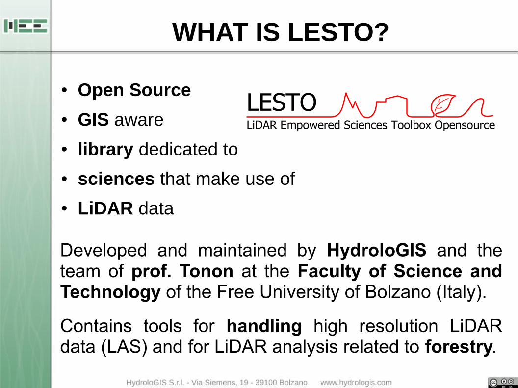
WHAT IS LESTO?
● Open Source
● GIS aware
● library dedicated to
● sciences that make use of
● LiDAR data
Developed and maintained by HydroloGIS and the team of prof. Tonon at the Faculty of Science and Technology of the Free University of Bolzano (Italy).
Contains tools for handling high resolution LiDAR data (LAS) and for LiDAR analysis related to forestry.

Utilitie
s
las re
ading
/writ
ing
las sp
atial
inde
x
las in
fo, o
verv
iew
las p
oint d
ensit
y
Rasterlas interpolation
- DTM- DSM
- CHM
Filterslas height distribution
las histogram
las merge
las threshold
Tools
Buildin
g ex
tracti
on
Fores
try a
nalys
is
Inte
nsity
ana
lysis
MODULES OVERVIEW

MODULES OVERVIEW IN STAGE

MODULES OVERVIEW IN STAGE

PREPROCESSING
Packages including the available pre-processing operations are:
● Utilities
– LasIndexer: creates indexes for LAS files

LasIndexer

LasIndexer

PREPROCESSING
Packaging including the available pre-processing operations are:
● Utilities
– LasIndexer: creates indexes for LAS files
– LasInfo: prints out information of a LAS file/folder

LasInfo

LasInfo

PREPROCESSING
Packaging including the available pre-processing operations are:
● Utilities
– LasIndexer: creates indexes for LAS files
– LasInfo: prints out information of a LAS file/folder
– LasOverviewCreator: creates a shp with overview

LasOverviewCreator

LasOverviewCreator

PREPROCESSING
Packaging including the available pre-processing operations are:
● Utilities
– LasIndexer: creates indexes for LAS files
– LasInfo: prints out information of a LAS file/folder
– LasOverviewCreator: creates a shp with overview
– LasPointDensityExtractor: creates a shp with point cloud density on a given grid

LasPointDensityExtractor

LasPointDensityExtractor

PREPROCESSING
Packaging including the available pre-processing operations are:
● Utilities
– LasIndexer
– LasInfo
– LasOverviewCreator
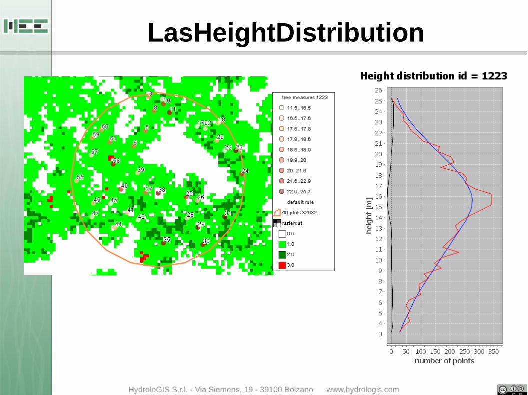
– LasPointDensityExtractor● Filter
– LasHeightDistribution: analyze the height distribution and categorize the forest type

LasHeightDistribution
LasHeightDistribution

PREPROCESSING
Packaging including the available pre-processing operations are:
● Utilities
– LasIndexer
– LasInfo
– LasOverviewCreator
– LasPointDensityExtractor● Filter
– LasHeightDistribution
– LasHistogram: creates an histogram of the elevation or intensity of all the points in the LAS file

LasHistogram

LasHistogram

PREPROCESSING
Packaging including the available pre-processing operations are:
● Utilities
– LasIndexer
– LasInfo
– LasOverviewCreator
– LasPointDensityExtractor● Filter
– LasHeightDistribution
– LasHistogram
– LasMerger: merges all the LAS file contained in a folder in a single one

LasMerger
PREPROCESSING
Packaging including the available pre-processing operations are:
● Utilities
– LasIndexer
– LasInfo
– LasOverviewCreator
– LasPointDensityExtractor● Filter
– LasHeightDistribution
– LasHistogram
– LasMerger
– LasThresholder: extracts the points with values in an interval

LasThresholder

LasThresholder

LasThresholder

RASTER
Raster package contains all the available modules to interpolate and create a raster (DTM, DSM) from raw point cloud. The different interpolation algorithms are
● AdaptiveTinFilter: the implementation of the adaptive TIN method of Axelsons
● Las2BivariateRasterMosaic: uses the bivariate function to interpolate a raster from the point cloud and creates a mosaic of TIF
● Las2RasterInterpolator: interpolates a raster from LAS points using the Inverse Distance Weight method
● LasOnRasterMapper: creates a raster by mapping max/min elevation point in each pixel
● LasTriangulation2Dsm: creates a DSM from the triangulation of the point cloud

RASTER
ADAPTIVE TIN

RASTER
ADAPTIVE TIN

RASTER
MAX HEIGHT

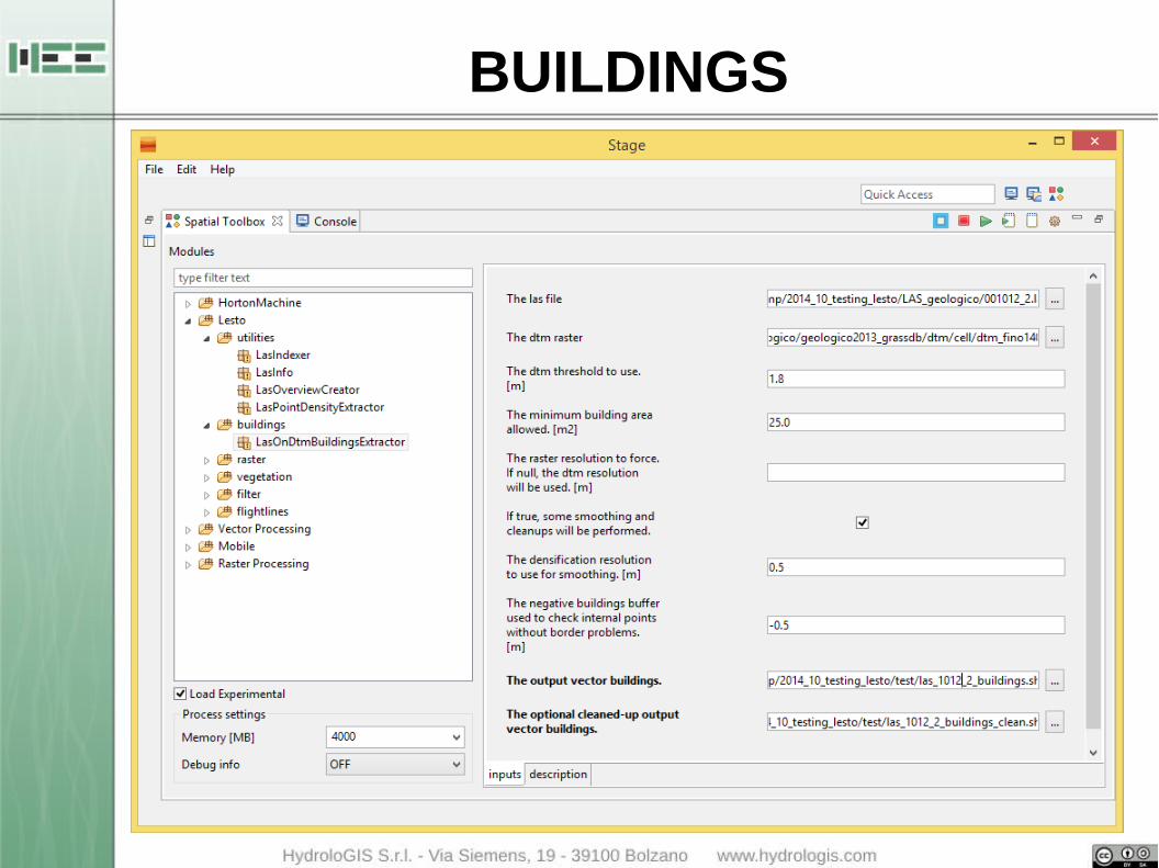
BUILDINGS
This package contains a module to extract the vector data of the buildings from a LAS file.
● LasOnDtmBuildingExtractor: based on the identification of the holes in the ground generated by cutting all the points with an elevation on the ground over a given threshold
● the output shapefile can be cleaned from noise data and smoothed on the boundaries
BUILDINGS

BUILDINGS
FLIGHTLINES
Modules to separate different flightlines inside a LAS file:
● FlightLinesExtractor: creates different las files for each of the different flightlines inside the single las
FLIGHTLINES

FLIGHTLINES
FLIGHTLINES

FLIGHTLINES
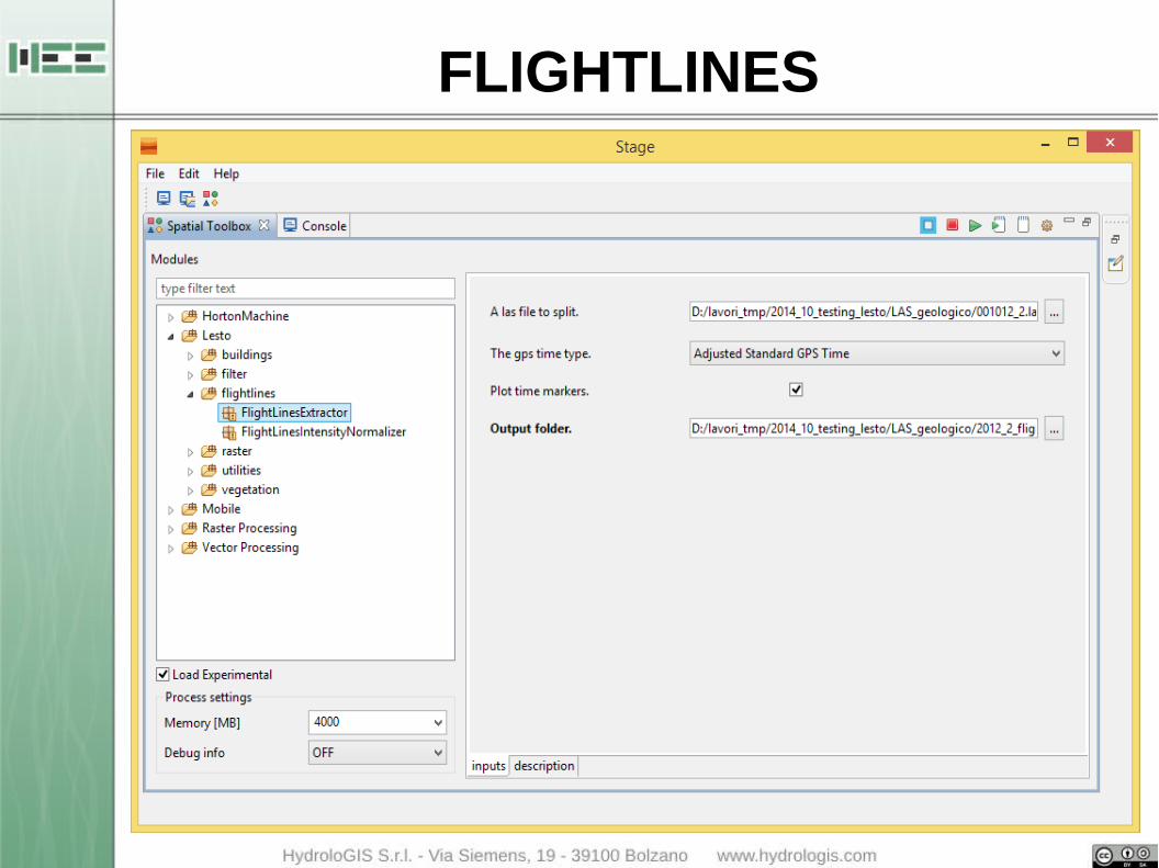
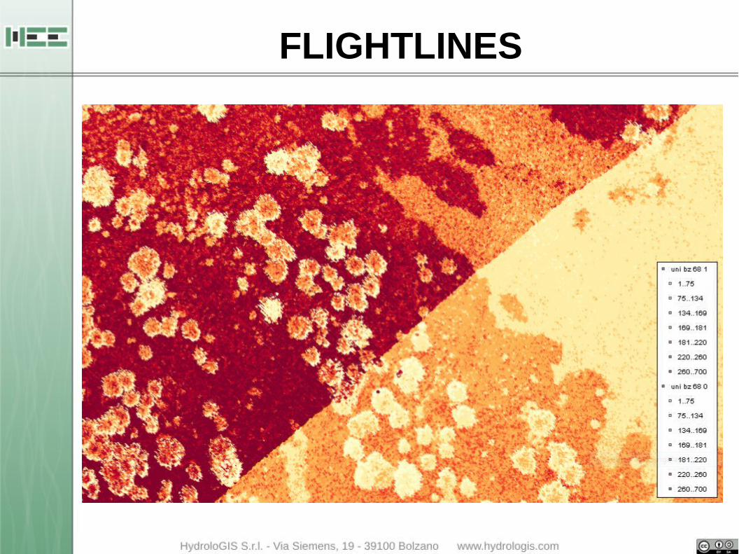
Modules to separate different flightlines inside a LAS file:
● FlightLinesExtractor: creates different las files for each of the different flightlines inside the single las
● FlightLinesIntensityNormalizer: normalize intensity values between different flightlines considering the position of the aircraft (x,y,z)

FLIGHTLINES

FLIGHTLINES

VEGETATION
Extrapolation of the whole forest biometric data (e.g. forest biomass) can be obtained through two approaches:
● area-based approaches (AB): forest attributes are estimated by relating plot data to ALS data by statistically procedure
● individual tree crown (ITC) approaches: can use both raster CHM and point ALS data and are aimed to detect position and main characteristics of each single tree. Single-tree records can then be aggregated at plot, forest, watershed or regional scale.

VEGETATION
Extrapolation of the whole forest biometric data (e.g. forest biomass) can be obtained through two approaches:
● area-based approaches (AB): forest attributes are estimated by relating plot data to ALS data by statistically procedure
● individual tree crown (ITC) approaches: ITC approaches can use both raster CHM and point ALS data and are aimed to detect position and main characteristics of each single tree. Single-tree records can then be aggregated at plot, forest, watershed or regional scale.

VEGETATION
The position of trees and vegetation information are used to evaluate:
● the forest structure
● the volume of biomass
● the source of hydro-geological hazard related to
– hillslopes stability
– transport of wood in rivers.

STUDY AREA: DESCRIPTION
high local variety in forest structure
AURINA VALLEY
VEGETATION:●Norway spruce (Picea abies)●Larch (Larix decidua)●Stone pine (Pinus cembra)
AREA = 10 km2

STUDY AREA: LiDAR SURVEY (2012)
points classification
points difference DTM
DTM + DSM
points density = 10 p/m2

12 CIRCULAR PLOTS
AREA = 0.07 ha
RADIUS = 15 m
BUFFER 150 m ROADS
FOREST STRUCTURES:●young●biplane●adult●multilayer
STUDY AREA: FIELD SURVEY (2013)

ALLOMETRIC RELATIONSHIPS
V(tree) = f(h,DBH)
STUDY AREA: FIELD SURVEY (2013)

Sample plots: forest metrics

Sample plots: forest metrics

Sample plots: forest metrics

VEGETATION MODULES
The available modules for single tree extraction are based on the identification of local maxima:
● RasterMaximaFinder: identifies local maxima on raster input data

RasterMaximaFinder

RasterMaximaFinder

RasterMaximaFinder

RasterMaximaFinder

RasterMaximaFinder

VEGETATION MODULES
The available modules for single tree extraction are based on the identification of local maxima:
● RasterMaximaFinder: identifies local maxima on raster input data
● PointCluodMaximaFinder: identifies local maxima on point cloud input data

PointCloudMaximaFinder

PointCloudMaximaFinder

PointCloudMaximaFinder

VEGETATION MODULES
The available modules for single tree extraction are based on the identification of local maxima:
● RasterMaximaFinder: identifies local maxima on raster input data
● PointCluodMaximaFinder: identifies local maxima on point cloud input data
● WatershedAlgorithm: delineates the crowns of the trees based on raster data

WatershedAlgorithm

WatershedAlgorithm

● stabilize and release some new algorithms of pre/post processing of extracted maximum points to improve the results
● implement Particle Swarming Optimizer for automatic calibration of the models
● integrate a visualizer for LAS point data● use the results in the models for the evaluation of
the hazard related to transport of wood during floods
FUTURE PLANS

LESTO is released under Open Source License (GPL v3) on the JGrasstools website.
The toolbox is open to contributions on any LiDAR related (future might even bring roads or power lines).
LICENCE AND DISTRIBUTION

http://www.jgrasstools.orghttp://bit.ly/stage_downloadshttp://www.udig.eu
USEFUL LINKS