local development framework development control · pdf filelocal development framework...
TRANSCRIPT

Development Control Policies
08450 450 500www.scambs.gov.uk
Adopted July 2007
Development Plan Document
Local Development Framework


Local Development Framework Development Control Policies
Development Plan Document
Adopted July 2007
Published by South Cambridgeshire District Council
ISBN: 0906016568 © July 2007
Gareth Jones, BSc. (Hons), MRTPI – Corporate Manager (Planning and Sustainable Communities)
Development Control Policies DPDIncorporating Inspectors’ Binding Changes
Development Control Policies DPDIncorporating Inspectors’ Binding Changes
Development Control Policies DPDIncorporating Inspectors’ Binding Changes
Development Control Policies DPDIncorporating Inspectors’ Binding Changes
Development Control Policies DPDIncorporating Inspectors’ Binding Changes

July 2007 Development Control Policies DPD i
Development Control Policies DPDIncorporating Inspectors’ Binding Changes
Development Control Policies DPDAdopted July 2007
CONTENTS
Page Chapter 1 Introduction To The South Cambridgeshire LDF 1
Context 2 Community Strategy 3
Relationship With Other Plans and Strategies 4 Cornerstone of Sustainability 4
Community Involvement 5
Chapter 2 Development Principles 7 Objectives 7
Introduction 7 Sustainable Development 8
Design of New Development 10 Development Criteria 13
Infrastructure and New Developments 15 Cumulative Development 16
Construction Methods 17 Development Frameworks 19
Chapter 3 Green Belt 21
Objectives 21 Development in the Green Belt 21
Mitigating the Impact of Development in the Green Belt 22 Mitigating the Impact of Development Adjoining the Green Belt 23
Major Developed Sites in the Green Belt 23 Recreation in the Green Belt 25
Chapter 4 Housing 27
Objectives 27 Housing Density 27
Housing Mix 28 Affordable Housing 30
Housing in the Countryside 34

Development Control Policies DPD July 2007
ii
Development Control Policies DPD Adopted July 2007
Chapter 5 Economy And Tourism 41
Objectives 41 Limitations on the Occupancy of New Premises in South Cambridgeshire 41
Promotion of Clusters 44 Development in Established Employment Areas in the Countryside 45
New Employment Development in Villages 46 Development for the Expansion of Firms 47
Loss of Rural Employment to Non-Employment Uses 49 Conversion of Rural Buildings for Employment 50
Replacement Buildings in the Countryside 51 Farm Diversification 51
Tourist Facilities and Visitor Accommodation 52
Chapter 6 Services And Facilities 55 Objectives 55
Village Services and Facilities 56 Retailing 56
Retailing in the Countryside 58 Public Art 59
Underground Pipes, Wires, Fibres and Cables 60 Lord’s Bridge Radio Telescope 61
Protection of Existing Recreation Areas 62 Outdoor Playspace and New Developments 62
Open Space Standards 64 The River Cam 65
Chapter 7 Natural Environment 67
Objectives 67 Introduction 67
Energy 68 Landscapes 70 Biodiversity 72
Water and Flooding 79 Sustainable Drainage Systems 81
Water Conservation 82 Hazardous Installations 82
Lighting 83 Noise 84
Air Quality 85 Agricultural Land 86

July 2007 Development Control Policies DPD iii
Development Control Policies DPDIncorporating Inspectors’ Binding Changes
Development Control Policies DPDAdopted July 2007
Chapter 8 Cultural Heritage 89
Objectives 89 Historic Landscapes 89
Archaeology 90 Listed Buildings and their Settings 90
Conservation Areas 92 Village Character 93
Advertisements 94 Shop Fronts 95
Linton Special Policy Area 96 Duxford Imperial War Museum 96
Chapter 9 Travel 99
Objectives 99 Introduction 100
Planning for More Sustainable Travel 100 Parking Standards 102
Mitigating Travel Impact 103 Non-motorised Modes 105
Rail Freight 107 Aviation-Related Development Proposals 107
Appendix 1 Standards For Car Parking Provision 111
Appendix 2 Standards For Cycle Parking Provision 119
Chapter 10 Monitoring 123
Objective 123 Plan Monitor Manage 123 Monitoring Indicators 124
Table 1: Core and Local Output Indicators 127
Glossary of Terms 135

Development Control Policies DPD July 2007
iv
Development Control Policies DPD Adopted July 2007
July 2007 Development Control Policies DPD v
Development Control Policies DPDIncorporating Inspectors’ Binding Changes
Development Control Policies DPDAdopted July 2007
INDEX OF POLICIES
Page DP/1 Sustainable Development 8
DP/2 Design of New Development 10 DP/3 Development Criteria 13
DP/4 Infrastructure and New Developments 15 DP/5 Cumulative Development 16
DP/6 Construction Methods 17 DP/7 Development Frameworks 19
GB/1 Development in the Green Belt 21 GB/2 Mitigating the Impact of Development in the Green Belt 22
GB/3 Mitigating the Impact of Development Adjoining the Green Belt 23 GB/4 Major Developed Sites in the Green Belt 23
GB/5 Recreation in the Green Belt 25 HG/1 Housing Density 27
HG/2 Housing Mix 28 HG/3 Affordable Housing 30
HG/4 Affordable Housing Subsidy 32 HG/5 Exceptions Sites for Affordable Housing 32
HG/6 Extensions to Dwellings in the Countryside 34 HG/7 Replacement Dwellings in the Countryside 35
HG/8 Conversion of Buildings in the Countryside for Residential Use 36 HG/9 Dwelling to Support a Rural-based Enterprise 38
ET/1 Limitations on the Occupancy of New Premises in South Cambridgeshire 41 ET/2 Promotion of Clusters 44
ET/3 Development in Established Employment Areas in the Countryside 45 ET/4 New Employment Development in Villages 46
ET/5 Development for the Expansion of Firms 47 ET/6 Loss of Rural Employment to Non-Employment Uses 49
ET/7 Conversion of Rural Buildings for Employment 50 ET/8 Replacement Buildings in the Countryside 51
ET/9 Farm Diversification 51 ET/10 Tourist Facilities and Visitor Accommodation 52
SF/1 Protection of Village Services and Facilities 56 SF/2 Applications for New Retail Development 56
SF/3 Retail Development on Land Allocated for Other Uses 57 SF/4 Retailing in Villages 58
SF/5 Retailing in the Countryside 58 SF/6 Public Art and New Development 59
SF/7 Underground Pipes, Wires, Fibres And Cables 60 SF/8 Lord’s Bridge Radio Telescope 61
SF/9 Protection of Existing Recreation Areas 62 SF/10 Outdoor Playspace, Informal Open Space, and New Developments 62
SF/11 Open Space Standards 64 SF/12 The River Cam 65
Development Control Policies DPD July 2007
vi
Development Control Policies DPD Adopted July 2007
NE/1 Energy Efficiency 68 NE/2 Renewable Energy 69
NE/3 Renewable Energy Technologies in New Development 69 NE/4 Landscape Character Areas 70
NE/5 Countryside Enhancement Areas 71 NE/6 Biodiversity 72
NE/7 Sites of Biodiversity or Geological Importance 76 NE/8 Groundwater 79
NE/9 Water and Drainage Infrastructure 79 NE/10 Foul Drainage - Alternative Drainage Systems 80
NE/11 Flood Risk 81 NE/12 Water Conservation 82
NE/13 Hazardous Installations 82 NE/14 Lighting Proposals 83
NE/15 Noise Pollution 84 NE/16 Emissions 85
NE/17 Protecting High Quality Agricultural Land 86 CH/1 Historic Landscapes 89 CH/2 Archaeological Sites 90
CH/3 Listed Buildings 90 CH/4 Development Within the Curtilage or Setting of a Listed Building 91
CH/5 Conservation Areas 92 CH/6 Protected Village Amenity Areas 93
CH/7 Important Countryside Frontages 94 CH/8 Advertisements 94
CH/9 Shop Fronts 95 CH/10 Linton Special Policy Area 96
CH/11 Duxford Imperial War Museum 96 TR/1 Planning for More Sustainable Travel 100
TR/2 Car and Cycle Parking Standards 102 TR/3 Mitigating Travel Impact 103
TR/4 Non-motorised Modes 105 TR/5 Rail Freight Interchanges 107
TR/6 Aviation-Related Development Proposals 107 M/1 Plan Monitor Manage 123
July 2007 Development Control Policies DPD
1
Development Control Policies DPDAdopted July 2007
1. INTRODUCTION TO THE SOUTH CAMBRIDGESHIRE LDF
1.1 The Local Development Framework (LDF) for South Cambridgeshire will
replace the existing Local Plan which was adopted in February 2004. It is being prepared under the new Government legislation for development plans. The LDF comprises a number of Development Plan Documents (DPDs) that set out policies and proposals for the development and use of land in the district, the first DPDs cover the period to 2016. The LDF includes a vision for the future of South Cambridgeshire and objectives and targets, which developments must meet to secure that vision. Once adopted, planning applications and other decisions will be made in accordance with it.
1.2 The Local Development Framework:
• Takes account of national, regional and strategic planning policies;
• Identifies sites for, and requirements of, major development;
• Provides the framework of policies for assessing all planning applications;
• Enables infrastructure and service providers to bring forward their
services when needed by new development; • Enables the public to be fully involved in developing local policies and
proposals. 1.3 The Local Development Framework forms part of the Development Plan for
South Cambridgeshire. The Development Plan is made up of those plans which have been statutorily adopted and which cover the District. The composition of the current development plan is set out in the Council’s Local Development Scheme. This document sets out how the Council will move from the previous to the current development plans system, and lists which local development documents are to be produced and when.
1.4 The East of England Regional Spatial Strategy will replace the
Cambridgeshire and Peterborough Structure Plan when it is published in its final form by the Secretary of State. A number of Structure Plan policies will be ‘saved’, and remain valid until at least 28 September 2007, under the transitional provisions of the Planning and Compulsory Purchase Act 2004. Whilst under the terms of the new plan making system the LDF must be in general conformity with RPG6, in the circumstances of the Cambridge Area it is also appropriate and consistent for the LDF to have regard to the policy requirements of the Structure Plan.
Development Control Policies DPD July 2007
2
Development Control Policies DPD Adopted July 2007
CONTEXT 1.5 South Cambridgeshire is located centrally in the East of England region at
the crossroads of the M11 / A14 roads and with direct rail access to London and to Stansted Airport. It is a largely rural district, which surrounds the city of Cambridge and comprises over 100 villages, none currently larger than 8,000 persons. It is surrounded by a ring of market towns just beyond its borders, which are generally 10–15 miles from Cambridge. Together, Cambridge, South Cambridgeshire and the Market Towns form the Cambridge Sub-Region. South Cambridgeshire has long been a fast growing district and in 2003 had a population of over 130,000 persons (bigger than Cambridge itself) and has become home to many of the clusters of high technology research and development in the Cambridge Sub-Region.
1.6 The regional context is set out in the Regional Planning Guidance for East
Anglia (RPG6), which was approved in November 2000. It aims to focus a higher proportion of Cambridgeshire’s growth into the Cambridge Sub-Region and proposes a sequential approach to the planning of development, with much of the development concentrated into and on the edge of Cambridge (subject to a review of the Cambridge Green Belt), including development in South Cambridgeshire, and into a new town beyond the outer boundary of the Green Belt.
1.7 The LDF will enable the step change in growth required in the Regional
Spatial Strategy and Structure Plan, particularly in the rate of housing development. South Cambridgeshire will be experiencing an almost 40% increase in housing development between 1999 and 2016. In the past much of the housing development in the Cambridge area has been directed to the villages and towns beyond the city. Whilst there has been employment growth elsewhere, Cambridge has remained the dominant centre of employment. As demand has outstripped the supply of housing close to Cambridge, people have located further from Cambridge increasing commuter flows through the District. Most of the new development in the District (on sites not yet committed) will in future take place on the edge of Cambridge and in a new town near to Longstanton and Oakington, named Northstowe.
1.8 The national context is set out in Planning Policy Statements (the
replacement to Planning Policy Guidance Notes), Circulars and other advice from Government. Whilst some of those national policies will require local interpretation, a great number do not. The Local Development Framework will not repeat that advice which must also be taken into account in determining planning applications.

July 2007 Development Control Policies DPD
3
Development Control Policies DPDAdopted July 2007
COMMUNITY STRATEGY 1.9 The Local Development Framework will be a key mechanism for delivering
the South Cambridgeshire Community Strategy. All local authorities are required by the Local Government Act 2000 to "prepare a community strategy for promoting the economic, environmental and social well-being of their areas and contributing to the achievement of sustainable development in the UK.”
1.10 The Strategy is the result of a partnership between the District and County
Councils, working with the health services, the police, parish councils, the business and voluntary sector. These groups have come together in the South Cambridgeshire Strategic Partnership to produce the Community Strategy. The Local Strategic Partnership will continue to develop a joint approach to the important issues, whenever possible, and will oversee the delivery of the Strategy. The Local Development Framework will be important in securing those parts of the Community Strategy which involve the development, or use of land and buildings.
1.11 The Community Strategy's vision is split into 6 aims as set out below:
• ACTIVE, SAFE AND HEALTHY COMMUNITIES where residents can play a full part in community life, with a structure of thriving voluntary and community organisations.
• BUILDING SUCCESSFUL NEW COMMUNITIES where large-scale
developments have created attractive places with their own identity, supported by a range of quality services.
• A PROSPEROUS DISTRICT where jobs, skills and learning are
developed and sustained to benefit everyone. • GOOD ACCESS TO SERVICES for all sections of the community,
including older people, children and families, through better transport links and improved local services.
• QUALITY HOMES FOR ALL with new affordable homes developed to
meet local needs and assistance provided for those needing help. • A HIGH QUALITY ENVIRONMENT with better access to a more
biodiverse countryside, which is protected and improved, and sustainable measures implemented, minimising waste and tackling climate change.
1.12 The Community Strategy is reviewed regularly and includes actions for the
following 3 year period which focus on meeting key aspects of the vision taking priority at the time and reflecting potential opportunities. Some of
Development Control Policies DPD July 2007
4
Development Control Policies DPD Adopted July 2007
these will relate to district wide policies contained in the LDF, including issues such as affordable housing. Others will relate to the major developments in the district, which are addressed in planning terms in Area Action Plans, and which are a key priority for many of the stakeholders and service providers involved in the Local Strategic Partnership.
RELATIONSHIP WITH OTHER PLANS AND STRATEGIES 1.13 The Council has consulted all key stakeholders at three stages in the
preparation of the DPDs and it is for them to advise the Council how their own strategies affect the South Cambs LDF. Where such information has been received, this has been taken into account in preparing the DPDs. Where organisations did not advise the Council of their delivery plans, it will be for Cambridgeshire Horizons, as the delivery vehicle for the Cambridge Sub-Region, to draw together the delivery plans for all aspects of the major developments as part of the negotiations on the planning obligations agreements.
CORNERSTONE OF SUSTAINABILITY 1.14 The LDF aims to improve the overall quality of life for residents of South
Cambridgeshire in a way, which will also benefit future generations. Taking a sustainable approach to economic, social and environmental issues will be at the heart of the plan and will be closely related to the national strategy for sustainable development, which has four objectives:
• Social progress, which recognises the needs of everyone;
• Effective protection and enhancement of the environment; • Prudent use of natural resources; and • Maintenance of high and stable levels of economic growth and
employment.
1.15 European Directive 2001/42/EC requires an ‘Environmental Assessment’ of plans and programmes prepared by public authorities that are likely to have a significant effect upon the environment. This process is commonly known as ‘Strategic Environmental Assessment’ (SEA), and covers relevant plans and programmes whose formal preparation begins after 21 July 2004. Among the documents to which this requirement will apply are land use plans that cover a wide area, such as the LDF.
July 2007 Development Control Policies DPD
5
Development Control Policies DPDAdopted July 2007
1.16 The Planning and Compulsory Purchase Act 2004 requires a Sustainability Appraisal (SA) of all emerging Development Plan Documents and Supplementary Planning Documents. As the draft guidance explaining this requirement makes clear, SA and SEA are similar processes that involve a comparable series of steps. If there is a difference between them, it lies in the fact that SEA focuses on environmental effects whereas SA is concerned with the full range of environmental, social and economic matters.
1.17 A Sustainability Appraisal Scoping Report has been prepared, and been the
subject of public participation. This highlights economic, social and environmental issues relevant to the area, and objectives to test the LDF against. A Sustainability Report, incorporating an ‘Environmental Report’ has been prepared to accompany each DPD.
1.18 A further requirement comes from the Habitats Directive (Council Directive
92/43/EEC), which requires Assessment of plans or projects affecting Natura 2000 sites. Natura 2000 is a Europe-wide network of sites of international importance for nature conservation. Ramsar sites support internationally important wetland habitats, and are also included in the Assessment in line with Government policy in PPS9. The DPD has been subject to a Screening Assessment, which identifies the likely impacts of the DPD on a Natura 2000 site or Ramsar site, either alone or in combination with other projects or plans, and considers whether these impacts are likely to be significant. The sites assessed have been agreed with Natural England and include those within and outside the district where assessment is required because of their proximity to South Cambridgeshire and / or the nature of their conservation interest. The Assessment objectively concluded that the DPD is not likely to have any significant effects on any Natura 2000 or Ramsar sites. There is therefore no requirement to proceed to the next stage of an Appropriate Assessment.
COMMUNITY INVOLVEMENT 1.19 The Development Control Policies DPD has been prepared following a
programme of consultation and public participation. Consultation with the community on the future planning of South Cambridgeshire began at the end of 2001 with the publication of an Issues Report. In April 2004 the Council carried out an initial consultation with statutory bodies, as required under the new system of plan making, to ensure that it was aware at an early stage of any programmes and plans that would affect the LDF. This was followed in October 2004 by consultation on issues and options, which gave people the opportunity to comment on how the local planning authority should approach the preparation of a particular development plan document. The Issues and Options Reports focused on key issues for the
Development Control Policies DPD July 2007
6
Development Control Policies DPD Adopted July 2007
DPDs and issues where there were choices to be made on the policy direction. A Preferred Options Report (pre-submission draft) of the DPD was published in June 2005 and was subject to a six-week long public participation period, allowing people to make representations to be considered by the Council.
1.20 The DPD was then submitted to the Secretary of State in January 2006, and
made available for a further six-week consultation period. Representations received were considered at an independent Examination, conducted by Inspectors appointed by the Secretary of State to consider the “soundness” of the plan. The independent Inspector subsequently produced a report, which was binding on the Council. Further information on the plan preparation process can be found on the Council's website: www.scambs.gov.uk.
1.21 The policies in this document apply district wide. That means that they will
govern development in the areas of major change, covered by separate Area Action Plan documents, except where those documents include a policy or policies which vary the requirements. In the latter case, the policies of the AAP will take precedence within the area covered by that document.
1.22 A Glossary of Technical and Other Terms is to be found at the back of this
document.
July 2007 Development Control Policies DPD
7
Development Control Policies DPDAdopted July 2007
2. DEVELOPMENT PRINCIPLES
OBJECTIVES
DP/a To ensure essential infrastructure is provided appropriately. DP/b To ensure provision of appropriate community facilities to
meet the needs of new developments, working in partnership with other service providers and voluntary organisations.
DP/c To ensure that new development, activities and uses of land
uphold and promote the principles of sustainable development.
DP/d To ensure high quality new development that protects and enhances the character of the district and local distinctiveness through careful integration with the existing built form.
DP/e To ensure that major new developments create distinctive,
sustainable and healthy environments that meet the needs of residents and users, and contribute towards the creation of vibrant socially inclusive communities.
DP/f To ensure that all new development makes appropriate
provision of services and infrastructure to meet its needs.
INTRODUCTION 2.1 Significant levels of new development are proposed for the Cambridge
Sub-Region, and for South Cambridgeshire in particular, over the period to 2016. This is in response to the importance of the area for high technology research and development businesses and its attractiveness as a good place to live. The predominantly rural character of the district makes it particularly important that new development is sensitively located and designed to a high quality.
2.2 There are a number of principles that need to be taken into account fully in
new development, whether large or small and for whatever use, whether new buildings or conversions of existing ones, so that the special qualities of the area remain. It is also essential that we achieve attractive, high quality sustainable places where people want to live, work and relax. This chapter therefore contains policies relating to sustainable development, design quality and development principles.
Development Control Policies DPD July 2007
8
Development Control Policies DPD Adopted July 2007
SUSTAINABLE DEVELOPMENT
POLICY DP/1 Sustainable Development
1. Development will only be permitted where it is demonstrated that it is consistent with the principles of sustainable development, as appropriate to its location, scale and form. It should:
a. Be consistent with the sequential approach to development,
as set out in the Strategy chapter of the Core Strategy DPD; b. Minimise the need to travel and reduce car dependency;
c. Make efficient and effective use of land by giving priority to
the use of brownfield sites and achieve adaptable, compact forms of development through the use of higher densities;
d. Include mixed-use development of compatible uses as
appropriate to the scale and location of the development;
e. Where practicable, use sustainable building methods and verifiably sustainable, locally sourced materials, including recycled materials, and include a Travel Plan to address the travel needs of labour during construction;
f. Where practicable, minimise use of energy and resources;
g. Where practicable, maximise the use of renewable energy
sources;
h. Incorporate water conservation measures;
i. Minimise flood risk;
j. Where practicable, use sustainable drainage systems (SuDS);
k. Mitigate against the impacts of climate change on
development through the location, form and design of buildings;
l. Ensure no unacceptable adverse impact on land, air and
water;
m. Contribute to the creation of mixed and socially inclusive communities and provide for the health, education,
July 2007 Development Control Policies DPD
9
Development Control Policies DPDAdopted July 2007
recreation, community services and facilities, and social needs of all sections of the community;
n. Where practicable, include infrastructure for modern
telecommunications and information technology to facilitate home working;
o. Conserve and wherever possible enhance biodiversity of
both wildlife and the natural environment;
p. Conserve and wherever possible enhance local landscape character;
q. Involve community and providers of community services in
the design process;
r. Conserve and wherever possible enhance cultural heritage.
2. In criteria e, f, g, j and n it will be for any applicant or developer proposing to compromise sustainability to demonstrate the impracticability of use of sustainable methods, systems, materials and energy sources and provision of sustainable infrastructure. Additional cost will not, on its own, amount to impracticability.
3. For major developments, applicants must submit a Sustainability Statement and a Health Impact Assessment, to demonstrate that principles of sustainable development have been applied.
2.3 The principles of sustainable development are fundamental to international
obligations and to national, regional and strategic planning policy. These principles also underpin the strategy, and all policies and proposals of the South Cambridgeshire Local Development Framework. The eastern region is the driest in the UK. It is also a low-lying area that is vulnerable to the implications of climate change. However, it is also a rural area that is to accommodate a great deal of growth surrounding the important historic city of Cambridge. It is therefore of key importance to the continuing success of the district that development is sustainable and achieves environmental, economic and social gains for current and future generations.
2.4 This key policy draws together sustainability issues to ensure that the
fundamental principles of sustainable development underpin all development proposals. The issues dealt with are covered in greater detail in the later subject chapters. It also includes references to key sustainability issues of building methods and materials, which will be part of the overall
Development Control Policies DPD July 2007
10
Development Control Policies DPD Adopted July 2007
consideration of the development proposal, but are not directly related to the planning system.
2.5 All planning applications for major development are required to submit a
Sustainability Appraisal and a Health Impact Statement to demonstrate that they have addressed sustainability issues, including impact on health, in their development proposals. Major development is defined as:
• Residential development: the erection of 20 or more dwellings, or, if
this is not known, where the site area is 0.5 hectares or more; or • Other development: where the floor area to be created is 1,000 m2 or
more, or the site area is 1 hectare or more. 2.6 To assist in the preparation of a Sustainability Statement and Health Impact
Assessment, further guidance will be provided in a Supplementary Planning Document.
DESIGN OF NEW DEVELOPMENT POLICY DP/2 Design of New Development New Development Design
1. All new development must be of high quality design and, as appropriate to the scale and nature of the development, should:
a. Preserve or enhance the character of the local area;
b. Conserve or enhance important environmental assets of the
site;
c. Include variety and interest within a coherent design, which is legible and provides a sense of place whilst also responding to the local context and respecting local distinctiveness;
d. Achieve a legible development, which includes streets,
squares and other public spaces with a defined sense of enclosure and interesting vistas, skylines, focal points and landmarks, with good interrelationship between buildings, routes and spaces both within the development and with the surrounding area;
July 2007 Development Control Policies DPD
11
Development Control Policies DPDAdopted July 2007
e. Achieve a permeable development for all sectors of the community and all modes of transport, including links to existing footways, cycleways, bridleways, rights of way, green spaces and roads;
f. Be compatible with its location and appropriate in terms of
scale, mass, form, siting, design, proportion, materials, texture and colour in relation to the surrounding area;
g. In the case of residential development, provide higher
residential densities, and a mix of housing types including smaller homes;
h. Provide high quality public spaces;
i. Provide an inclusive environment that is created for people,
that is and feels safe, and that has a strong community focus;
j. Include high quality landscaping compatible with the scale
and character of the development and its surroundings.
Design and Access Statements
2. Design and Access Statements submitted to accompany planning applications and applications for listed building consent should be compatible with the scale and complexity of the proposal and, as appropriate should include:
k. A full site analysis of existing features and designations;
l. An accurate site survey including landscape features and
site levels;
m. The relationship of the site to its surroundings;
n. Existing accesses for pedestrians, cyclists, equestrians and vehicles;
o. Any known historic importance;
p. Opportunities for maximising energy efficiency and
addressing water and drainage issues.
3. The Access element of the Statement should demonstrate that the development will achieve an inclusive environment that can be used by everyone, regardless of age, gender or disability. It

Development Control Policies DPD July 2007
12
Development Control Policies DPD Adopted July 2007
should also address how the development has taken account of the transport policies of the development plan.
2.7 All new development will have an impact on its surroundings. The aim must
be that any development, from a major urban extension to Cambridge to an extension to an existing home, takes all proper care to respond to its surroundings, including existing buildings, open spaces and villages edges, and ensure an integrated scheme that does not harm local amenity and wherever possible, brings benefits to the area.
2.8 A fully integrated and responsive design-led approach to development is
therefore needed. In the case of residential development, it will allow significant increases in residential densities, extend the range of housing choice and, at the same time, improve the environmental quality and integration of new development. Development at higher densities may require more innovative design to incorporate off-street car parking, for example, through integrating garages within the footprint of dwellings or underground parking. Higher densities and smaller gardens place added importance on the need for quality landscaping and open space in developments in order to maintain quality of life. For all development, an urban design led approach will ensure that every proposal, whatever its scale, responds positively to the particular characteristics of a site and its surroundings and reinforces local distinctiveness.
2.9 Achieving higher density development will require innovation in both
building design and development layout, to ensure that the significant scale of development that will take place in South Cambridgeshire over the plan period is designed very much with people in mind and results in places where people want to live. This will include layouts of residential areas that are permeable and easy to move around and that are legible to people, as well as increased densities over those achieved in the district in the recent past. This means a move away from cul-de-sac developments to more imaginative design solutions that deliver quality sustainable environments.
2.10 This policy must be read in conjunction with any design Supplementary
Planning Document adopted by the District Council, which will be used in decisions on planning applications. This may include district-wide design guidance and also individual Village Design Statements or Parish Plans that have been prepared by the local community, where these have been adopted by the Council as a Supplementary Planning Document (SPD). The Council will only adopt such guidance or elements of it, as SPD where it is consistent with the policies contained in the Local Development Framework.
2.11 The Town and County Planning Act 1990 and the Listed Building Act 1990
(both amended by the Planning and Compulsory Purchase Act 2004)
July 2007 Development Control Policies DPD
13
Development Control Policies DPDAdopted July 2007
require that the majority of applications for planning permission or listed building consent include a Design and Access Statement. These statements will enable applicants to demonstrate to the Council that they have properly considered the impact of their proposal and taken into account all relevant factors in the design of the scheme, including landscaping matters. It is important that developments are made accessible to everybody, and the access element of the Statements provide a means of establishing that this goal is achieved. The level of detail of the Statement will vary according to the scale and complexity of the application. The policy sets out the issues that should be addressed in the Statements.
2.12 Further guidance on Design and Access Statements can be found in Design
and Access Statements - How to Write, Read and Use Them (CABE 2006), and DCLG Circular 01/2006.
DEVELOPMENT CRITERIA POLICY DP/3 Development Criteria
1. All development proposals should provide, as appropriate to the nature, scale and economic viability:
a. Affordable housing (in housing schemes); b. Appropriate access from the highway network that does not
compromise safety, enhanced public and community transport and cycling and pedestrian infrastructure;
c. Car parking, with provision kept to a minimum;
d. Safe and secure cycle parking;
e. Outdoor play space;
f. Safe and convenient access for all to public buildings and
spaces, and to public transport, including those with limited mobility or those with other impairment such as of sight or hearing;
g. For the screened storage and collection of refuse, including
recyclable materials;
h. A design and layout that minimises opportunities for crime;

Development Control Policies DPD July 2007
14
Development Control Policies DPD Adopted July 2007
i. Financial contributions towards the provision and, where appropriate, the maintenance of infrastructure, services and facilities required by the development in accordance with Policy DP/4;
2. Planning permission will not be granted where the proposed
development would have an unacceptable adverse impact:
j. On residential amenity; k. From traffic generated;
l. On village character;
m. On the countryside, and landscape character;
n. From undue environmental disturbance such as noise,
lighting, vibration, odour, noxious emissions or dust;
o. On ecological, wildlife and archaeological interests;
p. On flooding and flood risk;
q. On the best and most versatile agricultural land;
r. On quality of ground or surface water;
s. On recreation or other community facilities. 2.13 It is important that development proposals make proper provision to meet
their needs. Read together with Policies DP/1 and DP/2 on Sustainable Development and Design of New Development, this policy provides a check-list for developers to help ensure that all requirements are met. To avoid an overly lengthy and complex policy, many of the criteria cross-refer to other policies in the Plan, which provide the full detail.
2.14 The Council will prepare a Supplementary Planning Document for various
aspects of development dealt with in this policy, and for storage and collection of waste and recycling.
July 2007 Development Control Policies DPD
15
Development Control Policies DPDAdopted July 2007
INFRASTRUCTURE AND NEW DEVELOPMENTS POLICY DP/4 Infrastructure and New Developments
1. Planning permission will only be granted for proposals that have made suitable arrangements for the improvement or provision of infrastructure necessary to make the scheme acceptable in planning terms. The nature, scale and phasing of any planning obligations sought will be related to the form of the development and its potential impact upon the surrounding area.
2. Contributions may also be required towards the future
maintenance and upkeep of facilities either in the form of initial support or in perpetuity in accordance with Government guidance.
2.15 Contributions may be necessary for some or all of the following:
• Affordable housing, including for Key Workers;
• Education (including nursery and pre-school care);
• Health care;
• Public open space, sport and recreation facilities (including Strategic Open Space);
• Improvements (including infrastructure) for pedestrians, cyclists, equestrians, highways and public and community transport;
• Other community facilities (e.g. community centres, youth facilities, library services social care, and the provision of emergency services);
• Landscaping and biodiversity;
• Drainage / flood prevention;
• Waste management (pursuant to the Waste Development Plan);
• Arts and cultural provision;
• Community development workers and youth workers;
• Other utilities and telecommunications.
• Preservation or enhancement of the historic landscape or townscape
Development Control Policies DPD July 2007
16
Development Control Policies DPD Adopted July 2007
2.16 Depending on the nature of the services and facilities, contributions may also be required to meet maintenance and / or operating costs either as pump priming or in perpetuity, provided through an obligation.
2.17 Standards and formulae for calculating “local” infrastructure requirements
and capital and maintenance contributions will be set out in a Supplementary Planning Document. They will take account of and complement strategic infrastructure requirements that use standard charges where appropriate, which will also be detailed in a Supplementary Planning Document.
2.18 Development can create additional demands for physical infrastructure and
social facilities, as well as having impacts on the environment. In such cases planning obligations will be required, in accordance with Government guidance, to make the necessary improvements, provide new facilities, or secure compensatory provision for any loss or damage created. Such obligations will take account of the wider needs of the Cambridge Sub-Region, in order to achieve wider planning objectives, with contributions pooled where appropriate to meet strategic requirements. In such cases, the nature and scale of contributions sought will be related to the size of the scheme and the extent to which it places additional demands upon the area.
CUMULATIVE DEVELOPMENT POLICY DP/5 Cumulative Development
1. Development will not be permitted where it:
a. Forms part of a larger site where there would be a requirement for infrastructure provision if developed as a whole;
b. Would result in a piecemeal, unsatisfactory form of
development;
c. Would prejudice development of another site adjacent or nearby.
2.19 It is important that sites make proper contribution to the infrastructure needs commensurate with the size of the development. Many requirements are based on development thresholds. Clearly if development were permitted cumulatively as a number of small developments, the full requirements of a site would not be met.
July 2007 Development Control Policies DPD
17
Development Control Policies DPDAdopted July 2007
2.20 PPS3 places an emphasis on the efficient use of land. Some developments by their nature could potentially sterilise a larger site, for example by impeding access. Such a situation must be avoided if sites are to be used efficiently. A number of small developments on a clearly larger site could also limit potential for a holistic approach to be taken to design. Where this would result in an unsatisfactory form of development planning permission should be refused.
CONSTRUCTION METHODS POLICY DP/6 Construction Methods
1. Where practicable, development which by its nature or extent is likely to have some adverse impact upon the local environment and amenity during construction and / or is likely to generate construction waste should:
a. Recycle construction waste; b. Prepare a ‘Resource Re-use and Recycling Scheme’ to
cover all waste arising during the construction;
c. Be bound by a ‘Considerate Contractors Scheme’ or similar arrangement, including restrictions on hours of noisy operations;
d. Where appropriate accommodate construction spoil within
the development, taking account of the landscape character and avoiding creation of features alien to the topography;
e. Maximise the re-use and recycling of any suitable raw
materials currently available on sites during construction, such as redundant buildings or infrastructure.
2. Any haul roads must be agreed with the Local Planning Authority
and developers must employ an agreed methodology for haul roads where they cross public rights of way. They must be located, designed and landscaped (where appropriate) in such a way as to avoid any noise, smell, dust, visual or other adverse impact on residents and businesses. At any point where on-site temporary haul routes for construction traffic enter the public highway, provision should be made for the cleaning of vehicle tyres to avoid deposition of mud / debris on the public highway and the generation of dust.
Development Control Policies DPD July 2007
18
Development Control Policies DPD Adopted July 2007
3. Storage compounds, plant or machinery must be located, designed and used to avoid noise, smell, dust, visual, or other adverse impact on existing residents and businesses.
4. The impact on existing residents of developing the major sites
will be minimised by requiring construction traffic for development at Northstowe, Cambridge East, Cambridge Southern Fringe, Cambridge North West, Cambridge Northern Fringe and Cambourne to be routed to avoid roads passing through villages.
2.21 As well as designing developments to be sustainable when complete, the
construction process utilises a significant amount of resources. 2.22 Any existing resources available on the site, such as materials from
redundant buildings, can help reduce the amount of materials that have to be imported onto a site. In particular this may provide a local source of hardcore. While it will not be appropriate to accommodate all types of spoil on site and in every location, minimising the unnecessary movement of materials can also reduce energy use in the construction process.
2.23 A Resource Re-use and Recycling Scheme requires categorising of nature
and type of waste or surplus material arising, its volume, and proposals for dealing with each component. This promotes waste minimisation, and maximises opportunities for re-use and recycling of materials.
2.24 The overarching principle for mitigating the effects of noise from construction
will be that there will be no works that are audible at the site boundary outside permitted hours of work, unless by prior agreement with the Council. On very large sites, construction may, therefore, be possible without any audible effect at the site boundary but otherwise hours of work limitations will be necessary and appropriate. Normal working hours need not be a single time period but can take into account the nature of adjoining uses with development close to employment and other commercial activities having longer hours than for construction close to housing.
2.25 The development process itself can have a significant impact on
surrounding residents and businesses. Haul routes, storage compounds, plant and machinery can all be located in such a way as to minimise this impact. In some instances, it will be appropriate for haul roads to further mitigate their impact through landscaping, for example, in locations where the duration and scale of development is extensive, such as at the major development locations.
July 2007 Development Control Policies DPD
19
Development Control Policies DPDAdopted July 2007
DEVELOPMENT FRAMEWORKS POLICY DP/7 Development Frameworks
1. Outside urban and village frameworks, only development for agriculture, horticulture, forestry, outdoor recreation and other uses which need to be located in the countryside will permitted.
2. Development and redevelopment of unallocated land and
buildings within development frameworks will be permitted provided that:
a. Retention of the site in its present state does not form an
essential part of the local character; and
b. Development would be sensitive to the character of the location, local features of landscape, ecological or historic importance, and the amenities of neighbours; and
c. There is the necessary infrastructure capacity to support
the development; and
d. Development would not result in the loss of local employment, or a local service or facility, protected by Policies ET/6: Loss of Rural Employment to Non-Employment Uses: SF/1: Protection of Village Services and Facilities and SF/9: Protection of Existing Recreation Areas.
2.26 The development frameworks define where policies for the built-up areas of
settlements give way to policies for the countryside. This is necessary to ensure that the countryside is protected from gradual encroachment on the edges of villages and to help guard against incremental growth in unsustainable locations. However, the efficient re-use of previously developed land within development frameworks will generally be supported, subject to the satisfaction of relevant policies, in the interests of sustainability. Frameworks have been defined to take into account the present extent of the built-up area, development committed by planning permissions and other proposals included in the Local Development Framework. Buildings associated with countryside uses (e.g. farm buildings, houses subject to agricultural occupancy conditions or affordable housing schemes permitted under the rural exceptions policy) are not normally included within the framework.
2.27 Frameworks have not been defined around small clusters of houses or
areas of scattered development where such buildings are isolated in open
Development Control Policies DPD July 2007
20
Development Control Policies DPD Adopted July 2007
countryside or detached from the main concentration of buildings within Cambridge or a nearby village. Although it is recognised that such dwellings may be considered locally as ‘part’ of the nearest village in community terms it is important in planning policy terms to limit the amount of new development that can take place in rural areas with few services and little or no public transport.
2.28 Property boundaries shown on the Ordnance Survey map have been taken
into account in defining frameworks. However, since there are many large gardens on the edge of settlements the framework boundaries sometimes cut across such gardens, especially (but not solely) if parts of those gardens relate more to the surrounding countryside than they do to the built-up areas. The ‘cutting’ of some gardens is regarded as a positive development control tool to limit the potential for further residential development in smaller villages with few facilities and little or no public transport. However, in such circumstances this policy will not be operated to establish a presumption against the grant of planning permission for ancillary domestic buildings in those parts of residential curtilages excluded from the framework. Where permission is required for such developments, applications will be considered on their individual merits.
July 2007 Development Control Policies DPD
21
Development Control Policies DPDAdopted July 2007
3. GREEN BELT
OBJECTIVES
GB/a To secure a Green Belt around Cambridge whose boundaries are clearly defined and which will endure for the plan period and beyond.
GB/b To maintain the purposes and openness of the Cambridge
Green Belt. GB/c To preserve the unique setting of the city by maintaining the
character and appearance of the surrounding villages. GB/d To provide for improvements in biodiversity, the landscape,
farm diversification, outdoor sport and recreation and public access to the countryside.
DEVELOPMENT IN THE GREEN BELT POLICY GB/1 Development in the Green Belt There is a presumption against inappropriate development1 in the Cambridge Green Belt as defined on the Proposals Map. NOTE:
1 Inappropriate development is defined in Section 3 of PPG2: Green Belts. 3.1 Core Strategy Policy ST/1 maintains a Green Belt around Cambridge, and
the supporting text to the Policy sets out the purposes of the Cambridge Green Belt. The Policy goes on to say that the detailed boundaries of the Green Belt will be established in Development Plan Documents, and this reflects the review of the Green Belt now being undertaken.
3.2 The main purpose of a Green Belt is to keep land open by placing a
permanent and severe restriction on inappropriate development; therefore most types of development can only be permitted in exceptional circumstances, in accordance with PPG2. Such exceptional circumstances will be regarded as Departures from the Development Plan and will only be permitted where other considerations outweigh the harm to the Green Belt. It is not sufficient justification to override Green Belt policies because a development would be inconspicuous or would not harm the site or locality.
Development Control Policies DPD July 2007
22
Development Control Policies DPD Adopted July 2007
3.3 For uses appropriate in the Green Belt, development which would adversely affect the open and rural character would be contrary to the objectives of the Green Belt. Where development is permitted, appropriate landscaping conditions, together with a requirement that any planting is adequately maintained, will be attached to any planning permission in order to ensure that the impact on the Green Belt is mitigated. MITIGATING THE IMPACT OF DEVELOPMENT IN THE GREEN BELT POLICY GB/2 Mitigating the Impact of Development in the Green Belt
1. Any development considered appropriate within the Green Belt must be located and designed so that it does not have an adverse effect on the rural character and openness of the Green Belt.
2. Where development is permitted, landscaping conditions,
together with a requirement that any planting is adequately maintained, will be attached to any planning permission in order to ensure that the impact on the Green Belt is mitigated.
3.4 Any development, even for uses appropriate in the Green Belt, can erode its
open and rural character. In order to protect the purposes of the Green Belt, such development should be located within or adjoining existing groups of buildings or entail the redevelopment of redundant buildings. Similarly, where existing buildings are not capable of re-use or conversion, the redevelopment of such buildings or development within or adjacent to existing groups of buildings will be preferable to development on entirely new sites. Careful consideration should be given to the design of any development, including ancillary uses and associated lighting, to ensure there is no adverse effect on the Green Belt.
3.5 Modern farming methods have led to a decline in the quality of the
landscape particularly in areas such as the Cambridge Green Belt. In addition much of the Green Belt landscape is over-mature and requires new tree and hedge planting to ensure the quality of the landscape does not continue to deteriorate.
3.6 Where there are areas of poor or damaged landscape, the District Council
will seek improvements through tree and hedge planting, the creation of ponds and other areas of water and by the removal of rubbish and unsightly features. Such changes can also be helpful in creating wildlife habitats and thus adding to biodiversity. The District Council will work in partnership with other organisations including voluntary groups, such as the Wildlife Trust,
July 2007 Development Control Policies DPD
23
Development Control Policies DPDAdopted July 2007
Cam Valley Forum, and landowners to secure such improvements. The Cambridge Green Belt Project is an example of good practice of such partnerships.
3.7 This policy must be read in conjunction with any design Supplementary
Planning Document adopted by the District Council, which will be used in decisions on planning applications.
MITIGATING THE IMPACT OF DEVELOPMENT ADJOINING THE GREEN BELT POLICY GB/3 Mitigating the Impact of Development Adjoining the Green Belt
1. Where development proposals are in the vicinity of the Green Belt, account will be taken of any adverse impact on the Green Belt.
2. Development on the edges of settlements which are surrounded
by the Green Belt must include careful landscaping and design measures of a high quality in order to protect the purposes of the Green Belt.
3.8 In many cases this will require extensive landscaping, both within the
development area and in the Green Belt, but there will be areas where a well designed and distinctive edge, with landmark buildings, including gateway buildings, may also be appropriate. However, account will also need to be taken of the impact of proposals on the adjoining Green Belt, including views from the Green Belt.
3.9 This policy must be read in conjunction with any design Supplementary
Planning Document adopted by the District Council, which will be used in decisions on planning applications. MAJOR DEVELOPED SITES IN THE GREEN BELT POLICY GB/4 Major Developed Sites in the Green Belt
1. Within the Cambridge Green Belt, the following are designated as Major Developed Sites:
a. Babraham Hall

Development Control Policies DPD July 2007
24
Development Control Policies DPD Adopted July 2007
b. Fulbourn and Ida Darwin Hospital
c. Girton College
2. Within the boundary of Major Developed Sites, as identified on the Proposals Map, limited infilling or redevelopment may be permitted:
d. Infilling is defined as the filling of small gaps between built
development. Such infilling should have no greater impact upon the open nature of the Green Belt and should not lead to a major increase in the developed proportion of the site. The cumulative impact of infilling proposals will be taken into account.
e. Redevelopment will be limited to that which would not result
in:
i. A greater floor area than the existing built form; ii. A greater footprint unless there are significant
environmental improvements;
iii. The existing height of the built development being exceeded;
iv. There being a greater impact than the existing
development on the openness of the Green Belt.
3.10 Major Developed Sites, as identified on the Proposals Map, continue to be
part of the Green Belt and remain subject to Green Belt policies. However, redevelopment where appropriate and infilling may be permitted within the defined confines of these sites subject to there being no adverse impact on the purposes of the Green Belt. The footprint of existing development within these sites excludes temporary buildings, open spaces with external access between wings of buildings, and areas of hard standing.
3.11 Development Briefs, adopted as Supplementary Planning Documents, are
required for all these sites.
July 2007 Development Control Policies DPD
25
Development Control Policies DPDAdopted July 2007
RECREATION IN THE GREEN BELT POLICY GB/5 Recreation in the Green Belt Proposals for the use of the Green Belt for increased or enhanced opportunities for access to the open countryside and which provide opportunities for outdoor sport and recreation, appropriate to the Green Belt, will be encouraged where it will not harm the objectives of the Green Belt.
3.12 The Green Belt has a positive role to play in providing opportunities for
access to the countryside for the urban population and it is essential that the residents of new developments have direct and easy access by foot, cycle or horseback to open countryside for recreation. Much of the Green Belt consists of large arable fields and there are few woods, pastures or other areas of semi-natural vegetation, which limits the opportunities for public access and recreation.
3.13 In many instances access to the countryside can be assisted by
improvements to the public rights of way network, including the provision of new routes for footpaths, bridleways and cycleways. One project which is being developed is the “Cam Cycle Rings” – developing a network of circular cycle routes radiating out of Cambridge, which will provide routes into and around Cambridge and provide circular routes into the Green Belt countryside. As well as providing for recreation such routes can also contribute to sustainable commuting.
3.14 By working in partnership, the local authorities can improve access in the
Green Belt by better signing and improvements to and the maintenance of stiles, gates and footbridges. The maintenance of public rights of way to a high standard is also important in order to encourage use. Improvements to public rights of way may be implemented directly by the District Council, through the Green Belt Project or through the Parish Paths Partnership initiative with the support of Cambridgeshire County Council and the Countryside Agency.
3.15 The need for improvements to the landscape and biodiversity will need to
be taken into account when considering improvements for recreation and public access. There may be parts of the Green Belt where public access has to be restricted, such as some parts of the riverbanks, if improvements to biodiversity are to be achieved.

Development Control Policies DPD July 2007
26
Development Control Policies DPD Adopted July 2007
July 2007 Development Control Policies DPD
27
Development Control Policies DPDAdopted July 2007
4. HOUSING
OBJECTIVES
HG/a To ensure the provision of a range of housing types and sizes, including affordable housing, to meet the identified needs of all sectors of the community, including Key Workers.
HG/b To protect and enhance the environment by making best use
of land and ensuring that new residential development, whether through new build or extensions and alterations to existing homes and buildings, is appropriate to its location.
HOUSING DENSITY POLICY HG/1 Housing Density Residential developments will make best use of the site by achieving average net densities of at least 30 dwellings per hectare unless there are exceptional local circumstances that require a different treatment. Higher average net densities of at least 40 dwellings per hectare should be achieved in more sustainable locations close to a good range of existing or potential services and facilities and where there is, or there is potential for, good local public transport services.
4.1 Residential proposals should comply with the policies in the Development
Principles Chapter and Design Supplementary Planning Document in order to achieve quality living environments. For new homes to meet the needs of current and future residents, it is important that they are designed to a high quality and create an attractive environment that functions well, where people want to live, which meets their needs, and which creates a sense of place where community identity can develop. Higher residential densities are required by PPS3, in the interests of achieving more sustainable forms of development, and reducing use of greenfield land. There is no reason why higher densities should compromise the quality of new development.
4.2 In the urban extensions in Cambridge and the new town of Northstowe,
higher densities should be sought, particularly close to the centres of those developments and in locations with access to High Quality Public Transport services, as set out in Area Action Plans.
Development Control Policies DPD July 2007
28
Development Control Policies DPD Adopted July 2007
HOUSING MIX POLICY HG/2 Housing Mix
1. Residential developments will contain a mix of units providing accommodation in a range of types, sizes and affordability, to meet local needs.
2. Affordable housing should be of an appropriate mix to respond
to identified needs at the time of the development, in accordance with HG/3.
3. In developments of up to 10 dwellings, market properties should
provide:
a. At least 40% of homes with 1 or 2 bedrooms; and b. Approximately 25% of homes with 3 bedrooms; and
c. Approximately 25% of homes with 4 or more bedrooms;
unless it can be demonstrated that the local circumstances of the particular settlement or location suggest a different mix would better meet local needs. In developments of more than 10 dwellings a mix of units will be sought providing a range of accommodation, including one and two bed dwellings, having regard to economic viability, the local context of the site and the need to secure a balanced community. A proportion of new dwellings should be designed to lifetime mobility standards.
4.3 Nationally, the trend is towards smaller household size and PPS3 requires
the needs of all households to be met. A key element in ensuring that new homes meet local needs is providing homes of the appropriate type, size and affordability.
4.4 There has been a strong trend in South Cambridgeshire in the recent past
for large new homes, and in the period 1991 to 2001, 46% of new homes had four or more bedrooms. This is despite longstanding planning policies seeking a mix of house types, including smaller properties. This trend has limited the number of smaller new homes being built, particularly 1 and 2 bedroom properties (5% and 25% respectively), to meet more general needs. In an area of high house prices, this also has the effect of limiting the stock of cheaper market housing that is accessible to people on average salaries and those trying to get into the housing market.
July 2007 Development Control Policies DPD
29
Development Control Policies DPDAdopted July 2007
4.5 The South Cambridgeshire Housing Needs Survey 2002 assessed the mix of market housing required to meet local needs. It identified a need for 89% of all new market housing to be one and two bedroom properties. It also advised that no more new homes of four or more bedrooms are required to meet identified market needs for the period to 2007. This has regard to a combination of factors, including the size of property that people need as well as the type of property to which they aspire. The District Council considers that this provides a reasonable assessment of need. The study advises that provision of larger sized accommodation would be likely to polarise the social structure of the district.
4.6 The District Council has therefore introduced specific targets for market
housing mix to respond to the failure of the housing market to respond to need. In the interests of achieving balanced communities and also to provide choice and ensure viability of schemes, the targets do not go as far as the Housing Needs Survey suggests. However, they do seek a significant change from the recent past in the general mix in market housing schemes. The targets are set for smaller developments of up to 10 dwellings. Developments of more than 10 dwellings will require assessment with the target as a starting point, but having regard to economic viability including any infrastructure provision, the context of the site and the need to secure a locally balanced community.
4.7 The general shift towards a greater mix in the sizes of homes and more
smaller homes will sit alongside the need for increasing densities in residential schemes. A Supplementary Planning Document will be produced on housing mix.
4.8 For new homes to meet the needs of current and future residents, it is
important that they are designed to a high quality and create an attractive environment that functions well, where people want to live, which meets their needs, and which creates a sense of place where community identity can develop. A key element in ensuring that new homes meet local needs is providing homes which are adaptable to the changing needs of most households.
4.9 Lifetime mobility standards for dwellings have been developed by the
Joseph Rowntree Foundation to provide dwellings that cater for the needs of residents throughout their lifetime, including the possibility of impaired mobility. These standards exceed the requirements of the Building Regulations. Affordable housing is already providing a proportion of lifetime homes. In market housing, a proportion of dwellings designed to lifetime mobility standards will be sought.
Development Control Policies DPD July 2007
30
Development Control Policies DPD Adopted July 2007
AFFORDABLE HOUSING POLICY HG/3 Affordable Housing
1. Proposals for housing developments will only be permitted if
they provide an agreed mix of affordable housing, as defined in PPS31, to meet local needs.
2. The amount of affordable housing sought will be 40% or more of
the dwellings for which planning permission may be given on all sites of two or more dwellings. The occupation of such housing will be limited to people in housing need. It must be available over the long-term.
3. Within individual developments, the proportion and type of
affordable housing will be the subject of negotiation with applicants. Account will be taken of any particular costs associated with the development (e.g. site remediation, infrastructure provision) and other viability considerations, whether there are other planning objectives which need to be given priority, and the need to ensure balanced and sustainable communities.
4. The appropriate mix in terms of housing tenures and house sizes
of affordable housing within a development will be determined by local circumstances at the time of planning permission, including housing need, development costs, the availability of subsidy, and the achievement of mixed and balanced communities.
5. In order to ensure sustainable communities, affordable housing
will be distributed through the development in small groups or clusters. In exceptional circumstances, on smaller sites, the Council may accept financial contributions towards an element of off-site provision.
NOTE:
1 National policy on affordable housing and its definition is set out in PPS3, and Policy
HG/3 should be interpreted in accordance with that statement. It includes social rented housing and intermediate affordable housing, but excludes low-cost market housing which should be delivered as part of the overall housing mix.
4.10 The availability of housing that is affordable and accessible to those in need
in South Cambridgeshire is a major and growing issue. Policy P9/1 of the Structure Plan states that 40% or more of the new housing in the sub-region will be affordable which will include Key Worker housing.
July 2007 Development Control Policies DPD
31
Development Control Policies DPDAdopted July 2007
4.11 The South Cambridgeshire Housing Needs Survey 2002 identified that there was a backlog of housing need of 800 households. In addition, a further 1,047 households per annum are falling into housing need. It is also estimated that there will be a supply of affordable housing through re-lets of existing properties of 323 units per annum. Advice in the Government’s best practice guide for assessing net annual need for affordable housing is to spread the backlog over 5 years. The annual net affordable housing requirement for the period 2002-2007 is estimated at 884 units per annum. The Survey advises that the best practice guide methodology suggests a target for affordable housing of 66% of all new dwellings (assuming no minimum site size threshold). However, taking account of realistic levels of demand and commercial viability, a target of 40% is justifiable in South Cambridgeshire, or more where this can be achieved in negotiation.
4.12 The policy applies to all developments of two or more dwellings, whether
allocations or windfall development. The mix in the types of affordable housing appropriate for an individual site, will be considered having regard to the nature of identified need at the time of planning permission (on a district-wide basis for the major developments, Rural Centres and Minor Rural Centres; and for other villages, in the individual village or the area it serves), the location and scale of the development, and the development economics of the site having regard to the overall infrastructure calls on the development.
4.13 Affordable housing should be of a high quality and integrated with market
housing. In order to ensure sustainable communities, affordable housing will be distributed through the development in small groups or clusters, typically of 6 to 8 units. The appropriate size of affordable housing groups or clusters will vary depending on the scale of development.
4.14 In smaller developments, where individual units of affordable housing
cannot reasonably be provided on the development site itself, it may be appropriate for a financial contribution towards off-site provision to be secured through Section 106 agreements. This approach will only be applicable to small sites where there may be difficulties over delivery or management of small numbers of affordable houses. Financial contributions will be secured towards the provision of affordable housing on other sites. It will not be appropriate for major developments to provide financial contributions in lieu of built provision, as on-site provision is a key part of creating a sustainable community. Where possible, the financial contributions secured through Section 106 agreements will be used to provide affordable housing in locations as close to the site as possible, either elsewhere within the same village or in nearby villages. However, as monies will be time limited, they may need to be spent elsewhere in the South Cambridgeshire District Council area if no local scheme is sufficiently advanced.

Development Control Policies DPD July 2007
32
Development Control Policies DPD Adopted July 2007
4.15 A Supplementary Planning Document will be prepared to provide guidance on the application of affordable housing policy.
POLICY HG/4 Affordable Housing Subsidy In exceptional circumstances, where there is a considerable time lag between the grant of planning permission and implementation, and where it can be demonstrated at the time of development that there are insurmountable subsidy issues or there are demonstrable changes to the viability of the development, the Council may negotiate a lower proportion of built affordable housing units to be provided on site.
4.16 Given the uncertainties over the future funding of affordable housing, there is a need for an element of flexibility in order to achieve affordable housing to assist in meeting the assessed housing need. In exceptional circumstances, where there is a substantial time gap between the grant of planning permission and the commencement of development, and where there are insurmountable subsidy issues in relation to a particular site or there is a demonstrable change in the economic viability of the development, a lower proportion of built units on site could be appropriate. The detailed guidance on the operation of this policy will be set out in a Supplementary Planning Document.
POLICY HG/5 Exceptions Sites for Affordable Housing
1. As an exception to the normal operation of the policies of this plan, planning permission may be granted for schemes of 100% affordable housing designed to meet identified local housing needs on small sites within or adjoining villages. The following criteria will all have to be met:
a. The development proposal includes secure arrangements
for ensuring that all the dwellings within the scheme provide affordable housing in perpetuity for those in housing need;
b. The number, size, design, mix and tenure of the dwellings
are all confined to, and appropriate to, the strict extent of the identified local need;

July 2007 Development Control Policies DPD
33
Development Control Policies DPDAdopted July 2007
c. The site of the proposal is well related to the built-up area of the settlement and the scale of the scheme is appropriate to the size and character of the village;
d. The site is well related to facilities and services within the
village;
e. The development does not damage the character of the village or the rural landscape.
2. In the case of sites within the Cambridge Green Belt, before
planning permission is granted for such development, the District Council will have to be assured that no alternative appropriate sites can be found for the scale and type of development proposed and that the scheme fulfils all the criteria set out in the Council’s policies, including those relating to the impact of new development on local surroundings.
4.17 National policy allows for the exceptional release of small sites for
affordable housing within or adjoining villages in circumstances where planning permission would not normally be given and where there is a demonstrable local need for affordable housing that cannot be met in any other way. These ‘rural exceptions’ sites provide a small but important source of affordable housing in rural areas and are regarded as additional to the provision of housing to meet the general needs identified by the Structure Plan.
4.18 In every case the needs of the particular village are carefully surveyed and
assessed by the Council before a scheme is progressed. Occupancy controls are imposed to ensure that the benefits of affordability (usually gained by the low land value derived from the exceptional basis of the scheme) are preserved in perpetuity for subsequent occupiers.
4.19 PPG2: Green Belts states that limited affordable housing may be
appropriate within the Green Belt. However, given the nature of the Cambridge Green Belt, which is relatively small in extent, and the need to avoid prejudicing other strategic and local policies, the District Council will implement this policy with caution.

Development Control Policies DPD July 2007
34
Development Control Policies DPD Adopted July 2007
HOUSING IN THE COUNTRYSIDE POLICY HG/6 Extensions to Dwellings in the Countryside
1. Extensions to dwellings in the countryside (i.e. outside development frameworks, as shown on the Proposals Map) will only be permitted where:
a. The proposed development would not create a separate
dwelling or be capable of separation from the existing dwelling;
b. The extension does not exceed the height of the original
dwelling;
c. The extension does not lead to a 50% increase or more in volume or gross internal floor area of the original dwelling;
d. The proposed extension is in scale and character with the
existing dwelling and would not materially change the impact of the dwelling on its surroundings;
e. The dwelling is of permanent design and construction.
2. In exceptional circumstances, material considerations may justify
an exception to criteria (b) and (c), for example, dwellings with a very small original footprint which do not meet modern living standards.
3. Large extensions to dwellings which are the subject of an
occupancy condition are not likely to be acceptable unless it can be demonstrated that the resultant accommodation can be supported by the viability of the holding and that its value would not be such as to be out of reach of workers employed in agriculture, forestry or a rural enterprise.
4. Limited extension or alteration of existing buildings in the Green
Belt is regarded as appropriate development provided the development does not result in disproportionate additions over and above the original building. Policy GB/1 enforces this matter.
4.20 Extensions to dwellings outside frameworks need particularly careful
consideration in terms of their impact on the landscape in the generally open countryside of South Cambridgeshire. In addition, housing needs in the District make it important to impose some limitation on the proportionate

July 2007 Development Control Policies DPD
35
Development Control Policies DPDAdopted July 2007
increase in dwelling sizes as a result of any extension, with the aim of preventing a gradual reduction in the stock of smaller and medium sized dwellings in countryside areas.
4.21 Policy HG/6 provides guidelines to assist the achievement of the above two
aims. However, it is recognised that there may be some instances in which other material considerations justify a departure from Criteria b and c. This could include dwellings with a very small original footprint that do not meet modern living standards. Criterion c considers extensions in the context of the original dwelling in order to avoid incremental increases which, when combined, have a greater impact on the countryside. POLICY HG/7 Replacement Dwellings in the Countryside
1. The District Council will permit the one-for-one replacement of dwellings in the countryside subject to the requirements of the General Permitted Development Order (i.e. a maximum enlargement of 15% of volume) and the need to provide satisfactory internal layout and amenities, where:
a. It can be shown that the use of a dwelling has not been
abandoned;
b. The proposed replacement dwelling is in scale with the dwelling it is intended to replace and is in character with its surroundings;
c. The proposed replacement dwelling would not materially
increase the impact of the site on the surrounding countryside.
2. This will apply to dwellings both inside and outside the Green
Belt. 3. Caravans and mobile homes are distinct from permanent
dwellings since they can be removed. Given the restrictions on development in the countryside the replacement of caravans and mobile homes with permanent dwellings will be resisted outside development frameworks.
4.22 Where it can be shown that the use of a dwelling has not been abandoned,
replacement on a one-for-one basis may be permitted. As a new dwelling, it is likely to have a greater impact on the countryside than the dwelling it replaces and will benefit from permitted development rights when completed

Development Control Policies DPD July 2007
36
Development Control Policies DPD Adopted July 2007
and occupied. Thus replacements ought to be similar in size and height to the original structure. The District Council may control the further expansion of replacement dwellings by the use of planning conditions to remove the rights under the General Permitted Development Order. This will apply to dwellings both inside and outside the Green Belt. (See also the Green Belt Chapter.)
POLICY HG/8 Conversion of Buildings in the Countryside for Residential Use
1. Planning permission for conversion of rural buildings for residential use will not generally be permitted. Planning permission will only exceptionally be granted where it can be demonstrated, having regard to market demand or planning considerations:
a. Firstly it is inappropriate for any suitable employment use;
and b. Secondly it is inappropriate for employment with residential
conversion as a subordinate part of a scheme for business re-use.
2. Any conversion must meet the following criteria:
c. The buildings are structurally sound;
d. The buildings are not of a makeshift nature and have not
been allowed to fall into such a state of dereliction and disrepair that any reconstruction would require planning permission as a new building;
e. The buildings are capable of re-use without materially changing their existing character or impact upon the surrounding countryside;
f. The form, bulk and general design of the buildings are in keeping with their surroundings;
g. Perform well against sustainability issues highlighted by policy DP/1.
3. Any increase in floor area will not be permitted except where it is necessary for the benefit of the design, or in order to better integrate the development with its surroundings. Future
July 2007 Development Control Policies DPD
37
Development Control Policies DPDAdopted July 2007
extensions of such buildings will not be permitted. Incidental uses such as car parking and storage should be accommodated within any group of buildings, or on well related land where landscaping can reduce the visual impact of the new site.
4. Development must be in scale with the rural location. Residential
uses must be located close to local services and facilities, and in an accessible location with a choice of means of travel, including non-motorised modes. The cumulative impact of the conversion of a number of buildings on adjoining sites or the local area will also be considered.
5. Residential conversion permitted as a subordinate part of a
scheme for business re-use, will be secured by planning condition or agreement to ensure the occupation of the dwelling remains directly related to the operation of the enterprise. The dwelling part of the unit must be interdependently linked with the commercial part. A live-work unit should have a minimum of 40m2 of definable functional workspace in addition to the residential element. Internal uses may be horizontally or vertically split. The workspace must be flexible, and capable of accommodating a range of employment uses.
4.23 PPS7: Sustainable Development in Rural Areas requires authorities to include policies setting out criteria for permitting conversion of rural buildings for residential uses. There has been considerable pressure to convert barns and vacant rural buildings into residential units, but this is clearly contrary to the general policy of restricting housing proposals outside established village limits. Policy ET/7 supports conversion of appropriate buildings for employment uses, and this remains the preferred use for such buildings. If this cannot be achieved the second preference is for a residential unit directly tied to operation of a rural enterprise, often referred to as a live-work unit. This would be more sustainable, than a conversion for a purely residential use, due to the reduced implications for commuting. Conversion purely for residential use will only be permitted as a last resort, particularly to secure the future of buildings of particular architectural quality or character.
4.24 Residential conversion, particularly on a large scale involving several
residential units, will only be appropriate in locations close to local service centres such as Cambridge, the market towns and larger villages, including Rural Centres and Minor Rural Centres. Development must also be in a location with, or capable of providing, a sufficient standard of accessibility to offer an appropriate choice of travel by non-car modes, in accordance with Policy TR/1.
Development Control Policies DPD July 2007
38
Development Control Policies DPD Adopted July 2007
POLICY HG/9 Dwelling to Support a Rural-based Enterprise
1. Development of a new permanent dwelling for agricultural or forestry purposes, or for a rural-based enterprise, will only be permitted if it is demonstrated to the satisfaction of the District Council that:
a. There is a clear, existing functional need relating to a
full-time worker or one who is primarily employed in agriculture;
b. It relates to a well-established agricultural unit (which
has been established for at least three years, has been profitable for at least one of them, is currently financially sound, and has a clear prospect of remaining so);
c. There are no suitable existing buildings available in the
area;
d. The conversion of appropriate nearby buildings would not provide suitable accommodation;
e. No existing dwelling serving the unit or closely
connected with it has either recently been sold off or in some way separated from it.
2. Where criterion b cannot, for the time being, be met, or it
relates to a new farming activity on a well established unit, development of a temporary dwelling may be permitted for up to three years where all the other criteria above are met, and there is clear evidence demonstrating:
f. A firm intention and ability to develop the enterprise
concerned; g. That the proposed enterprise has been planned on a
sound financial basis;
h. That the functional need cannot be fulfilled by another existing building on the unit or any existing accommodation.
3. The District Council will require “Functional” and “Financial”
tests to be undertaken in accordance with PPS7 to demonstrate the above criteria have been met.
July 2007 Development Control Policies DPD
39
Development Control Policies DPDAdopted July 2007
4. Dwellings associated with the keeping of horses are an inappropriate form of development in the countryside. Where the future need for accommodation is anticipated, stables should be located close to an existing dwelling, or suitable building capable of conversion to such use. Dwellings connected to the keeping of horses where the scale of the business meets the test of a rural enterprise will be considered in accordance with the tests included in this policy.
5. Where a new dwelling is permitted, this will be the subject of a
condition ensuring the occupation will be limited to a person solely or mainly working, or last working in the locality in agriculture, forestry or a rural-based enterprise that requires a dwelling in the countryside, or a surviving partner of such a person, and to any resident dependants.
6. The relaxation of an occupancy condition will only be permitted
where it can be demonstrated that the dwelling is no longer required by the unit or those working, or last working, in the locality in agriculture, forestry or a rural-based enterprise that requires a dwelling in the countryside, or a surviving partner of such a person, and to any resident dependants. When considering applications to relax such a condition, the District Council will require evidence of the steps taken to market the dwelling with the occupancy condition.
4.25 Although Structure Plan and Local Development Framework policies resist
new dwellings in the countryside, the District Council acknowledges that many agricultural workers require accommodation close to their enterprises for husbandry and security and other reasons. Where applicants are able to demonstrate genuine need for new dwellings associated with their enterprise, the District Council may grant planning permission. Since such an approach is a departure from restrictive countryside policy, the planning permission will be subject to a condition restricting occupation. Such a condition will only be discharged in exceptional cases.
4.26 In general, preference will be given to the re-use or replacement of existing
buildings over those, which propose the erection of a new dwelling in order to avoid further development in the countryside. Where new buildings are proposed to be erected they should be sited and designed to minimise impact on the countryside, and where possible be grouped around existing development.
4.27 The erection of a further dwelling would not be justified where an existing
dwelling serving the unit or closely connected with it has either recently been sold off or in some way separated from it.
Development Control Policies DPD July 2007
40
Development Control Policies DPD Adopted July 2007
4.28 When considering planning applications for new enterprises in the countryside and the need for any associated accommodation, the District Council seeks advice concerning the commercial viability of the proposed enterprise. Where such advice indicates that the viability of the enterprise is uncertain, the District Council will firmly resist a permanent dwelling in the countryside. In such circumstances, temporary planning permission may be granted for a caravan associated with the enterprise to enable the applicant to prove that it can provide his / her main livelihood.
4.29 With increasing leisure time and the changes in agriculture bringing forward
pressures for farmers to diversify, the District Council has experienced increasing demand for horse-riding and the setting up of equestrian activities (often referred to as “horsiculture”). In this context, planning permission is usually required for the construction of new buildings or the conversion of existing buildings for stabling horses and for the change of use of land for exercise, training or jumping horses.
4.30 With these approvals, on occasion, there may be pressure to develop a
dwelling on site for security purposes - this will be invariably outside village frameworks. It is not considered that the security of horses justifies the provision of a dwelling and there are other methods of providing site security. The District Council will resist such proposals since they introduce new residential development in the countryside which can often be conspicuous in the generally flat landscape of South Cambridgeshire.
4.31 Policy HG/9 will also apply to development proposals associated with studs
in the district where they comprise a rural enterprise. 4.32 A Supplementary Planning Document will be prepared for dwellings
associated with rural enterprises.
July 2007 Development Control Policies DPD
41
Development Control Policies DPDAdopted July 2007
5. ECONOMY AND TOURISM
OBJECTIVES
ET/a To support the Cambridge Area’s position as a world leader in research and technology based industries, higher education and research, particularly through the development and expansion of clusters.
ET/b To manage carefully development pressures in South
Cambridgeshire by favouring those uses which need to be located near to Cambridge.
ET/c To support existing businesses by applying positive policies
towards the appropriate expansion of existing firms where appropriate, including through use of previously developed land, and the conversion / adaptation or replacement of suitable buildings for business use.
ET/d To reduce commuting distances and the need to travel,
particularly by car, by bringing home and workplace closer together, and by encouraging employment opportunities in accessible locations, or accessible by sustainable modes of travel.
ET/e To support the rural economy and enable farm diversification. ET/f To support the growth of the tourism industry of South
Cambridgeshire, whilst ensuring new facilities and accommodation do not have an adverse impact on the built and natural environment.
LIMITATIONS ON THE OCCUPANCY OF NEW PREMISES IN SOUTH CAMBRIDGESHIRE POLICY ET/1 Limitations on the Occupancy of New Premises in South Cambridgeshire
1. Employment development, including change of use, will only be permitted if it is demonstrated that it falls into one or more of the following:
a. Offices or other development in the use class B1 (a),
providing an essential service for Cambridge as a local or sub-regional centre;1
Development Control Policies DPD July 2007
42
Development Control Policies DPD Adopted July 2007
b. High technology and related industries and services, in use class B1 (b), primarily concerned with research and development, which show a special need to be located close to the universities or other established research facilities or associated services in the Cambridge Area;2
c. Use classes D1 educational uses, and sui generis research
establishments that can show a special need, to be located close to existing major establishments in related fields (such as the universities, the teaching hospital, or private research establishments), in order to share staff, equipment or data, or to undertake joint collaborative working;3
d. Other small-scale industries, in use classes B1 (c), B2, and
B8 (up to 1,850 m2), which contribute to a greater range of local employment opportunities, particularly if it takes advantage of the development of locally-based skills or expertise (large scale expansion of such firms will not be permitted). 4
2. The occupation of development will be controlled by condition or
legal agreement, for a period of 10 years from the first date of occupation.
NOTES:
1 Offices: User restrictions will apply to offices over 300 m2. 300 m2 reflects PPG4
Industrial and Commercial Development and Small Firms (1992), which states that user occupancy restrictions are not necessary for developments of under 300 m2 of office floor area. However, a condition or legal agreement may be necessary to prevent multiple small units being combined or let to a single office user who does not comply with the policy. Essential Service: Local and sub-regional service or administrative facility with the majority of its business based in the Cambridge Sub-Region. Services might include banking, finance, management and business services, property services, legal and accounting services, educational, housing and recruitment services, medical and other professional scientific service and patent agents, and specialist component assembly.
2 High Technology and Research and Development: The investigation, design and development of an idea, concept, material, component, instrument, machine, product or process, up to and including production for testing (but excluding mass production) where the work routine requires daily discussion and action on the part of the laboratory and design staff.

July 2007 Development Control Policies DPD
43
Development Control Policies DPDAdopted July 2007
Cambridge Area: The area covered by Cambridge City Council and South Cambridgeshire District Council.
3 Research Establishments: Provide accommodation for organisations whose primary purpose is to research or investigate ideas, theories and concepts, and / or to design and develop instruments, processes or products, up to and including production for testing, but excluding manufacture.
4 Other small-scale industries: 1850m2 refers to the maximum size of occupation of any one user on a site.
5.1 New employment growth must be managed to ensure the very qualities that
attract firms in the first place remain, and to ensure employment land is reserved for firms that need it most. RSS6 Policy 26 states that Development Plans should continue to include policies for the selective management of development within the area close to Cambridge, discriminating in favour of uses that have an essential need for a Cambridge location. This approach is continued in Policy P9/7 of the Cambridgeshire and Peterborough Structure Plan 2003.
5.2 The policy reserves employment land for development that can demonstrate
a clear need to be located in the area, to serve local needs, or contribute to the continued success of the Cambridge Sub-Region as a centre of high technology and research. This may be in order to share staff, equipment or data, or undertake joint collaborative projects.
5.3 Large-scale manufacturing, distribution and warehousing, and office firms
that could equally well locate in other areas of the county, will not be permitted. This approach is necessary to manage the intensive development pressure in and around Cambridge. Given the need to protect the environment, employment land in the district is a scarce resource. The policy also supports the further development of the clusters of high technology, research and development.
5.4 Small-scale developments in industry will be permitted, where they can
contribute to providing a better balance of local job opportunities, and contribute to the development of local skills.
5.5 South Cambridgeshire already contains a number of research institutes of
national importance, associated with the University or other research establishments. Proposals for new research establishments, or the expansion of those existing, must demonstrate a specific need to be located near the existing establishments in the Cambridge area. Where there is conflict between proposals and other policies and proposals in the plan, the applicant must demonstrate that they are outweighed by evidence of national interest. Proposals will be considered against the development

Development Control Policies DPD July 2007
44
Development Control Policies DPD Adopted July 2007
principles detailed in the plan, and environmental impact of new development should be minimised. Future occupation will be restricted to the uses specified by conditions or legal agreement.
5.6 Supporting text to Cambridgeshire and Peterborough Structure Plan 2003
Policy P9/8 states that exceptionally, office style employment serving a regional function may be located in the sub-region. However, it would not be desirable for national headquarters, call centres, or similar to develop in the vicinity of Cambridge. As any regional offices are to be an exception, it is appropriate that they are focussed in the city of Cambridge itself, rather than the rural areas of South Cambridgeshire.
PROMOTION OF CLUSTERS POLICY ET/2 Promotion of Clusters
1. Development proposals in suitable locations will be permitted which support the development of clusters, in the following sectors:
a. Biotechnology and biomedical; b. Computer services;
c. Electronic engineering;
d. Information technology / telecommunications;
e. Healthcare, teaching and research;
f. Research and development;
g. Other locally driven clusters as they emerge.
2. Employment land allocations especially suited for cluster
development are Northstowe, and the urban extensions to Cambridge. Area Action Plans will indicate the availability and suitability of sites for cluster development, and encourage provision of a range of suitable units, including incubator units.
5.7 South Cambridgeshire is home to a number of clusters. A cluster is a group
of independent organisations or companies operating in a specific field of industrial or economic activity with representation from across the value chain, ranging from academic institutions with sector expertise to venture
July 2007 Development Control Policies DPD
45
Development Control Policies DPDAdopted July 2007
capitalists and specialized suppliers (Regional Economic Strategy, EEDA 2004). The benefits of clustering may be spread over a relatively wide area, depending on the nature of the firm. Clusters are of great importance to the success of not only the local, but also the regional and national economy.
5.8 Clusters have specific requirements for premises and development sites.
The Local Development Framework will aim to allow suitable sites for small firms to start up and expand, but also support the development of more mature clusters. This is consistent with Policy ST/8 of the Core Strategy DPD which seeks to ensure sufficient employment land is available to enable further development of the high technology clusters.
DEVELOPMENT IN ESTABLISHED EMPLOYMENT AREAS IN THE COUNTRYSIDE POLICY ET/3 Development in Established Employment Areas in the Countryside
1. In defined Established Employment Areas in the Countryside, redevelopment of existing buildings, and appropriate development for employment use may be permitted.
2. The following Established Employment Areas in the Countryside
are defined on the Proposals Map:
a. Buckingway Business Park b. Cambourne Business Park c. Cambridge Research Park, Landbeach d. Site to North of Cambridge Research Park, Landbeach e. Granta Park, Great Abington f. Wellcome Trust Genome Campus, Hinxton g. Norman Way Industrial Estate, Over h. Land at Hinxton Road, South of Duxford i. Convent Drive / Pembroke Avenue site, Waterbeach j. Brookfields Business Estate / Park, Twentypence Road,
Cottenham
Development Control Policies DPD July 2007
46
Development Control Policies DPD Adopted July 2007
k. Spicers Ltd, Sawston
l. Daleshead Foods Ltd, Cambridge Road, Linton.
3. Permission will be refused where there would be a negative impact on surrounding countryside, or landscape character area. Developments will be subject to other policies in the document, in particular Policy ET/5 on Development for the Expansion of Firms.
5.9 New employment development outside village frameworks will not generally
be permitted. This is to protect the countryside from unnecessary development, which can be visually intrusive, but also lead to unsustainable patterns of development. However, South Cambridgeshire contains a number of Established Employment Areas in the Countryside, which are identified on the Proposals Map. The policy provides a context for considering planning applications on these sites.
5.10 Within these areas, appropriate development and redevelopment will be
permitted, subject to consideration of land supply across the district, and other policy concerns. This will enable more efficient use of the sites, and allow them to be adapted for the needs of existing and future users.
5.11 The sites identified are outside village frameworks, and not in the Green
Belt. Employment sites created from the conversion of agricultural buildings have not been included, as these were permitted through specific policies, and are not intended for extension.
5.12 This policy does not cover Major Developed Sites in the Green Belt, which
are dealt with elsewhere in the plan.
NEW EMPLOYMENT DEVELOPMENT IN VILLAGES POLICY ET/4 New Employment Development in Villages Planning permission will be granted at an appropriate scale for new small-scale employment in the B1 to B8 Use Classes provided that the development would contribute to a greater range of local employment opportunities, or facilitate cluster development within village frameworks, and on previously developed sites adjoining or very close to the village frameworks of Rural Centres or Minor Rural Centres. Small-scale employment development in villages is defined as employing no more than 25 people as follows:
July 2007 Development Control Policies DPD
47
Development Control Policies DPDAdopted July 2007
a. Offices (B1a): 400m2. b. High tech / R & D (B1b): 725m2. c. Light Industry (B1c): 800m2. d. General Industry (B2-B7): 850m2. e. Warehousing (B8): 1,250m2.
5.13 Sensitive small-scale employment development can help sustain the rural economy, and achieve a wider range of local employment opportunities. It can enhance the vitality of rural centres, and reduce the need to travel. There is also potential for cluster related firms to develop on an appropriate scale.
5.14 Employment development may provide the opportunity to make best use of
a previously developed site, including vacant, derelict, or under used land. The policy provides an element of flexibility for the redevelopment of suitable sites adjoining or near to the more sustainable villages in the district.
5.15 Small-scale is defined as the employment of up to 25 people. The actual
scale of new employment which would be appropriate in any village will be determined having regard to the size of each village and the amount of locally available employment. 25 jobs is converted into floor space using the English Partnerships publication 'Employment Densities: A Simple Guide'. DEVELOPMENT FOR THE EXPANSION OF FIRMS POLICY ET/5 Development for the Expansion of Firms
1. Development for the expansion of firms will be permitted that:
a. Meets the tests and is regulated by Policy ET/1; or b. Other existing firms for their own occupation and use.
2. Expansion will be permitted:
c. Within village frameworks, or previously developed sites
next to or very close to village frameworks (subject to provisions of ET/4);
Development Control Policies DPD July 2007
48
Development Control Policies DPD Adopted July 2007
d. Within Northstowe and Cambridge East; e. Within Established Employment Areas in the Countryside
listed in Policy ET/3.
3. A firm or business will be considered as ‘existing’ if a significant element of its operation has been based in the Cambridge Area for a minimum of five years prior to the date of any planning application for development and within that time has maintained a viable business operation locally.
4. Expansion will not be permitted where it consolidates a non-
conforming use1, or causes problems with traffic, noise, pollution, or other damage to the environment. It would not be permitted if it would conflict with other policies of the Plan.
5. Other than expansion of firms subject to condition or legal
agreement detailed by Policy ET/1, occupation will be limited for a period of 10 years after first occupation, by condition or legal agreement to persons, firms, companies or other organisations existing in the Cambridge Area.
Expansion means additions or alterations to an existing building, or physically related in terms of its siting and use, within the curtilage or immediately adjacent land. NOTE:
1 Non-conforming Use - a use which does not conform to the general provisions of the
development plan for the area in which it is located, and may have an adverse impact on an area's principal use.
5.16 It is important that existing firms that do not meet the requirements of Policy
ET/1 have the opportunity to expand and adapt for the continued success of the business, but this must be in appropriate circumstances. The scale of growth must not conflict with other policies in the plan, and must not result in an unsustainable level of development in a particular location. Firms seeking large scale expansion are encouraged to seek locations outside the Cambridge Area, for example in the surrounding market towns.

July 2007 Development Control Policies DPD
49
Development Control Policies DPDAdopted July 2007
LOSS OF RURAL EMPLOYMENT TO NON-EMPLOYMENT USES POLICY ET/6 Loss of Rural Employment to Non-Employment Uses
1. The conversion, change of use or re-development of existing employment sites to non-employment uses within village frameworks should be resisted unless one of the following criteria is met:
a. It is demonstrated that the site is inappropriate for any
employment use to continue having regard to market demand. Applications will need to be accompanied by documentary evidence that the site is not suitable or capable of being made suitable for continued employment use. Evidence would be required that the property has been adequately marketed for a period of not less than twelve months on terms that reflect the lawful use and condition of the premises; or
b. The overall benefit to the community of the proposal
outweighs any adverse effect on employment opportunities and the range of available employment land and premises; or
c. The existing use is generating environmental problems
such as noise, pollution, or unacceptable levels of traffic and any alternative employment use would continue to generate similar environmental problems.
5.17 Employment sites within village frameworks are a scarce resource, which
should be retained. It will often be the case that new employment developments in village frameworks will be limited due to their potential impact on village character. Making best use of existing employment sites reduces the pressure for development of new sites, including new sites in the countryside. It also provides a greater range of employment opportunities and reduces the need to travel. Sites should be retained to provide local employment, unless specific factors indicate otherwise.
Development Control Policies DPD July 2007
50
Development Control Policies DPD Adopted July 2007
CONVERSION OF RURAL BUILDINGS FOR EMPLOYMENT POLICY ET/7 Conversion of Rural Buildings for Employment
1. The change of use or adaptation of buildings (without extension) in the countryside for employment use will be permitted provided the following apply:
a. The buildings are structurally sound; b. The buildings are not makeshift in nature and are of
permanent, substantial construction;
c. The buildings are capable of re-use without materially changing their existing character or impact upon the surrounding countryside;
d. The form, bulk and general design of the buildings are in
keeping with their surroundings.
2. Any increase in floor area will be strictly controlled, and must be for the benefit of the design, or in order to better integrate the development with its surroundings. There will be a general presumption against future extensions of such buildings. Incidental uses such as car parking and storage should be accommodated within the group of buildings, or on well related land where landscaping can reduce the visual impact of the new site.
3. Employment generated must be in scale with the rural location.
Developments resulting in significant numbers of employees or visitors must only be located near to larger settlements or accessible by public transport, cycling, or walking. The cumulative impact of the conversion of a number of buildings on adjoining sites will also be considered.
5.18 South Cambridgeshire contains a stock of rural buildings. Where buildings
are no longer required for their original use, predominantly agriculture, they can provide a valuable opportunity to provide employment and support the rural economy. Potential uses include commerce and industry, and for tourism or recreation. There is also potential for ‘lower tech’ industries, contributing to providing a greater diversity of employment opportunities across the district.
5.19 Due to their location, such developments must be carefully controlled. It is
crucial that design takes account of the character and appearance of the

July 2007 Development Control Policies DPD
51
Development Control Policies DPDAdopted July 2007
existing building, and the surrounding area. It is not sufficient to simply retain the frame of a building, and substantially reconstruct around it.
5.20 Developments should be of a scale appropriate to their location, as large
employment developments in the countryside may conflict with the principles of sustainable development, resulting in unsustainable traffic movements, and potential environmental harm. Developments resulting in significant numbers of employees or visitors should be located near to settlements or accessible by public transport, cycling, or walking. In areas without such access, small-scale business development may still be appropriate where it results in only a modest increase in daily vehicle movements. This may require the production of a Travel Plan and / or mitigation of traffic impact in accordance with Policy TR/3.
REPLACEMENT BUILDINGS IN THE COUNTRYSIDE POLICY ET/8 Replacement Buildings in the Countryside When considering proposals for replacement buildings in the countryside for employment use, any increase in floor area will be strictly controlled, and must be for the benefit of the design, or in order to better integrate the development with its surroundings.
5.21 Planning Policy Statement 7 paragraph 19 is supportive of the replacement
of suitably located, existing buildings of permanent design and construction in the countryside for economic development purposes where it would bring about environmental improvement, and result in a more sustainable development.
FARM DIVERSIFICATION POLICY ET/9 Farm Diversification
1. Well-conceived farm diversification schemes, where they are directly related to supporting a working farm, will be permitted if:
a. They are consistent in scale with their rural location;
b. Existing buildings are re-used where possible, and if not
replaced, in accordance with Policies ET/7 and ET/8;
Development Control Policies DPD July 2007
52
Development Control Policies DPD Adopted July 2007
c. Any new development is part of an existing group of buildings.
2. Applications must include a Farm Business Plan, to demonstrate
how the proposal will support a working farm. 5.22 Farming still makes an important contribution to the South Cambridgeshire
economy, but increasingly farms are having to diversify into non-agricultural activities, for the business to remain viable. This could include planting of woodland, farm shops, farm-based food processing and packaging, craft workshops, sporting facilities, fishing lakes, equestrian businesses, nature trails or holiday accommodation. In order to protect the quality and distinctiveness of the local landscape, the Council wishes to prevent uncoordinated development in rural areas and the piecemeal stripping of assets from farms without regard for the viability of the holding.
5.23 Paragraph 30 of PPS7 advises that local planning authorities should be
supportive of well-conceived farm diversification schemes for business purposes that contribute to sustainable development objectives and help to sustain the agricultural enterprise, and are consistent in their scale with their rural location. RSS6 Policy 12 supports diversification appropriate to the environmental and ecological setting, and Policy P2/6 of the Cambridgeshire and Peterborough Structure Plan 2003 also supports employment growth on an appropriate scale to allow farm diversification.
5.24 It is important that diversification proposals are well founded in terms of
effectively contributing to the farm business and the rural economy and integrating new activities into the environment and the rural scene. Farmers are required to submit a Farm Business Plan with any planning application for diversification. This should include details of existing farm activities, the need for diversification, details of the proposal and implications of the proposal on, for example, the rural economy and the environment.
TOURIST FACILITIES AND VISITOR ACCOMMODATION POLICY ET/10 Tourist Facilities and Visitor Accommodation
1. Outside development frameworks, development to provide overnight visitor accommodation, holiday accommodation, public houses and restaurants will only be permitted by change of use / conversion, or through appropriate replacement of buildings not requiring large extension, or by appropriately modest extensions to existing facilities.
July 2007 Development Control Policies DPD
53
Development Control Policies DPDAdopted July 2007
2. Development of holiday accommodation will be limited to short-term holiday lets through conditions or legal agreement. Permitted development rights may be removed in the interests of amenity.
5.25 The city of Cambridge and surrounding attractions draw large numbers of
visitors every year, and consequently there is significant demand for tourist accommodation. The focus for new accommodation should be the villages, and development must be of a type in keeping with the settlement size, scale and form. Consequently developments may be more suited to Rural Centres. Focusing new tourist accommodation into the larger villages allows access for visitors to the public transport network and local services, thus promoting the goals of sustainable development.
5.26 In the countryside, holiday accommodation is a vital part of the rural
economy, providing another means of farm diversification, and opportunity to reuse redundant rural buildings, but at the same time the countryside must be protected from inappropriate development. Developments permitted under this policy must be carefully controlled to ensure housing policies restricting development in the countryside are not compromised. Developments will therefore be restricted by legal agreement to ensure they are only used for short-term holiday lets.

Development Control Policies DPD July 2007
54
Development Control Policies DPD Adopted July 2007
July 2007 Development Control Policies DPD
55
Development Control Policies DPDAdopted July 2007
6. SERVICES AND FACILITIES
OBJECTIVES SF/a To encourage provision and retention of village services and
facilities within villages consistent with the scale and function of existing centres.
SF/b To ensure that Cambridge continues as the main sub-regional
comparison shopping centre for South Cambridgeshire and to protect the vitality of other established centres and villages within South Cambridgeshire.
SF/c To limit retail development in the countryside to goods
produced in the immediate locality of any individual enterprise.
SF/d To encourage the provision of public art in new development. SF/e To meet the formal and informal sport and recreation needs of
the district, including provision of high quality indoor and outdoor facilities.
SF/f To base, where possible, any major new indoor sports
facilities at school sites, to enable dual use of facilities. SF/g To protect and enhance important areas of local and strategic
open space for their recreation and amenity value, and create connectivity with existing public rights of way and the wider countryside.
SF/h To ensure the proper provision and maintenance of open
space and sports facilities consistent with levels of planned residential development and identified open space standards.
SF/i To ensure the provision of adequate health facilities,
including mental health provision, in appropriate accommodation and locations to cater for the existing and proposed population of Cambridgeshire.

Development Control Policies DPD July 2007
56
Development Control Policies DPD Adopted July 2007
VILLAGE SERVICES AND FACILITIES POLICY SF/1 Protection of Village Services and Facilities
1. Planning permission will be refused for proposals which would result in the loss of a village service, including village pubs, shops, post offices, community meeting places or health centres, where such loss would cause an unacceptable reduction in the level of community or service provision in the locality.
2. The following matters will be considered in determining the
significance of the loss:
a. The established use of the premises and its existing and potential contribution to the social amenity of the local population;
b. The presence of other village services and facilities which
provide an alternative with convenient access by good local public transport services, or by cycling or walking; and
c. The future economic viability of the use including, in
appropriate cases, financial information and the results of any efforts to market the premises for a minimum of 12 months at a realistic price.
6.1 Cambridgeshire and Peterborough Structure Plan 2003 Policy P3/4 requires local authorities to encourage the retention of village shopping facilities and key community facilities to support the vitality of rural communities. Village services and facilities perform a vital function in rural communities, particularly for the less mobile. Once a facility is lost, it may be lost forever, as alterations to the building make it difficult to restore to its previous use. When considering proposals which involve the loss of such facilities, the District Council will consider the impact of the loss on the local community, in terms of the availability and access to alternatives, and the social implications, including the impact on the viability of the village as a whole.
RETAILING POLICY SF/2 Applications for New Retail Development
1. Other than retail developments in villages under Policy SF/4 or in AAPs, planning permission for retail development will not be granted unless the applicant has successfully demonstrated that:
July 2007 Development Control Policies DPD
57
Development Control Policies DPDAdopted July 2007
a. A sequential approach has been adopted to site selection and the availability of suitable alternative sites;
b. In the case of proposals in defined centres, the development would be of a scale in accordance with that centre’s position in the hierarchy, or, in the case of proposals outside defined centres, the impact of a development would not have an adverse effect on the vitality and viability of other town centres, district centres and local centres identified in development plans, and on the rural economy, including village shops;
c. It would be conveniently accessible by a wide range of modes of transport other than the car, including good local public transport services from a wide catchment area, and effective measures would be taken to enhance such accessibility, including that for pedestrians and cyclists.
2. In addition, in the case of proposals to develop sites in edge-of-
centre or out-of-centre locations (or to extend existing stores in such locations) developers will be required to demonstrate a positive need for the additional floor area before any of the above tests are applied.
6.2 Policy SF/2 provides guidance on the way in which the District Council will
consider applications for new retail development or for the extension of existing retail development. Applications for new retail will also be considered in accordance with the retail hierarchy in Policy ST/9 of the Core Strategy DPD. As stated, the policy does not apply to proposals for new shops and extensions to existing shops in villages. These will be considered under Policy SF/4.
POLICY SF/3 Retail Development on Land Allocated for Other Uses
1. Retail development will only be permitted on land allocated for housing, employment or other uses, where it can be demonstrated that the effect of such a loss would not limit the range and quality of sites available for that particular use or the quantity of land required to meet Core Strategy requirements for housing and employment.
2. The policy will not be operated to prevent the provision of
appropriate retail facilities to complement the other elements of
Development Control Policies DPD July 2007
58
Development Control Policies DPD Adopted July 2007
mixed development schemes, subject to the provisions of Policies SF/2 and ST/9 of the Core Strategy DPD.
6.3 It is necessary to resist retail development on land allocated for other forms
of development in the LDF where this would result in there being a shortage in the range and quality of sites available for that particular use, or the quantity of land required to meet Core Strategy requirements.
POLICY SF/4 Retailing in Villages Proposals for new shops, redevelopment or extension of existing shops, or the change of use of buildings to shops within a village framework will only be permitted where the size and attraction of the shopping development is of a scale appropriate to the function and size of village.
6.4 Village shops play a vital role in achieving sustainability in villages, reducing
the need for residents to travel to meet everyday needs. In smaller villages they also play an important community function, supporting those who have difficulty travelling further afield, and forming a hub to village life. The District Council will, wherever possible, support provision of new shops and facilities of an appropriate scale to the village.
RETAILING IN THE COUNTRYSIDE POLICY SF/5 Retailing in the Countryside
1. Planning permission for the sale of goods in the countryside will not be granted except for:
a. Sales from farms and nurseries of produce and / or craft
goods, where the majority of goods are produced on the farm or in the locality; or
b. Exceptionally, the sale of convenience goods, ancillary to
other uses, where proposals, either individually or cumulatively, do not have a significant adverse impact on the viability of surrounding village shops, or the vitality of rural centres or other village centres.
July 2007 Development Control Policies DPD
59
Development Control Policies DPDAdopted July 2007
2. Where permission is granted, conditions may be imposed on the types of goods that may be sold.
6.5 Sporadic development for retail uses in the countryside could result in
unsustainable patterns of development, and could harm the vitality and viability of village centres.
PUBLIC ART POLICY SF/6 Public Art and New Development
1. In determining planning applications the District Council will encourage the provision or commissioning of publicly accessible art, craft and design works.
2. The Public Art policy will apply to:
a. Residential developments comprising 10 or more dwellings;
and b. Other developments where the floor area to be built is
1,000 m2 gross or more, including office, manufacturing, warehousing and retail developments.
3. On smaller developments, developers will be encouraged to
include Public Art within their scheme as a means of enhancing the quality of their development.
4. Contributions and commuted maintenance sums for up to 10
years will be required, to include the cost of decommissioning where appropriate.
6.6 The provision of quality visual arts and crafts as part of new developments
can bring social, cultural, environmental, educational and economic benefits, both to the new development and the community at large. It can assist in adding local distinctiveness and creating a sense of place. As well as landmark works such as a sculpture, it may be an integrated or functional element of a development (e.g. lighting, landscape, floor designs and signage).
6.7 The District Council has adopted a Public Art Policy, that provides guidance
for developers (and contracted builders) implementing large-scale developments, including residential and commercial. It encourages

Development Control Policies DPD July 2007
60
Development Control Policies DPD Adopted July 2007
developers to allocate a proportion of the budget (ideally between 1% and 5% of the total cost of the development) for the implementation of a carefully considered public art scheme. Plans and budgets will need to be agreed in association with the District Council’s officers prior to planning approval, at a level appropriate to the type of application. The involvement of a lead artist(s) at an early stage in the planning and design of developments is actively encouraged, particularly in major new developments. Public art will be sought though negotiation, but it is not a mandatory requirement.
UNDERGROUND PIPES, WIRES, FIBRES AND CABLES POLICY SF/7 Underground Pipes, Wires, Fibres and Cables
1. Utility companies will be strongly urged to place all pipes, fibres, wires and cables underground where this would not damage identified areas of ecological or archaeological importance or have other unacceptable environmental impacts (e.g. on the landscape or agricultural land quality). In such circumstances, careful line routing would usually be the most appropriate way to minimise the visual impacts of overhead wires and cables.
2. In view of the substantial practical, technical and cost
disadvantages involved, the under-grounding of high voltage power lines (275kV and above) will only be sought in exceptional circumstances. Underground services can be damaging to the water environment and advice should be sought from the Environment Agency on any mitigation measures.
6.8 New overhead lines require consent under Section 37 of the Electricity Act
1989 from the Secretary of State for Trade and Industry. Local planning authorities must be consulted on proposals within their district. In order to minimise the effect on the countryside, the District Council will encourage utility companies to site new electricity lines and sub stations carefully. There are substantial differences between under-grounding high and low voltage electricity lines, technically, practically and in terms of cost. High voltage electricity lines are expensive and complex to install, underground and maintain, and can cause environmental damage such as soil contamination and / or the sterilisation of land. In view of the substantial practical, technical and cost disadvantages involved, the under-grounding of high voltage power lines (275 kV and above) can only be sought in exceptional circumstances. At the distribution voltage level (132kV and below) where the power carried is much less, the technical complexity and cost of under-grounding is reduced significantly as the voltages decrease.
July 2007 Development Control Policies DPD
61
Development Control Policies DPDAdopted July 2007
LORD’S BRIDGE RADIO TELESCOPE POLICY SF/8 Lord’s Bridge Radio Telescope
1. Within the ‘Lord’s Bridge Restricted Area’ (defined on the Proposals Map), planning permission will only be granted for development that would not result in any risk of interference to the Mullard Radio Astronomy Observatory at Lord’s Bridge.
2. Within the ‘Lords Bridge Consultation Area 1’ (defined on the
Proposals Map), development proposals that could adversely affect the operation of the Mullard Radio Astronomy Observatory at Lord’s Bridge will be subject to consultation with the University of Cambridge, and account will be taken of the risk of interference to the equipment being used at the Observatory. Planning permission will be refused where interference would be caused that could not be overcome by conditions or by the use of planning obligations.
3. Within the ‘Lords Bridge Consultation Area 2’ (defined on the
Proposals Map), development proposals for telecommunications and microwave operations that could adversely affect the operation of the Mullard Radio Astronomy Observatory at Lord’s Bridge will be subject to consultation with the University of Cambridge, and account will be taken of the risk of interference to the equipment being used at the Observatory. Planning permission will be refused where interference would be caused that could not be overcome by conditions or by the use of planning obligations.
6.9 The international importance of the Mullard Radio Astronomy Observatory
at Lord’s Bridge must be safeguarded. The Observatory contains unique radio and optical telescopes operated by the Universities of Cambridge and Manchester / Jodrell Bank. The telescopes measure signals that are very weak, and hence highly susceptible to many forms of interference, specifically electrical interference, light pollution and mechanical vibration from domestic, industrial plant and other sources such as vehicles and aircraft. Accordingly, ‘Restricted’ and ‘Consultation Areas’ are defined on the Proposals Map; within the latter, arrangements are made to consult the University of Cambridge about the technical consequences for the Observatory of proposed development. Harm caused to the Observatory will be overcome with the use of conditions or planning obligations to regulate the installation and use of equipment likely to interfere with the operation of the Observatory.

Development Control Policies DPD July 2007
62
Development Control Policies DPD Adopted July 2007
PROTECTION OF EXISTING RECREATION AREAS
POLICY SF/9 Protection of Existing Recreation Areas Planning Permission will not be granted for proposals resulting in the loss of land or buildings providing for recreational use except where:
1. They would be replaced by an area of equivalent or better
quantity and quality and in a suitable location; or
2. The proposed development includes provision for open space, sports and recreation facilities of sufficient benefit to recreation provision to outweigh the loss; or
3. An excess of provision in quantitative and qualitative terms is
clearly demonstrated in all functions it can perform, taking into account potential future demand and in consultation with local people and users.
6.10 Recreational facilities, including outdoor play space, informal open space, and built recreation facilities, are of great significance to local communities. This is not only for the recreational amenity they offer, but also the impact open space has on the quality of the built and natural environment. Planning Policy Guidance Note 17 paragraph 10 states that, “Existing open space, sports and recreational buildings and land should not be built on unless an assessment has been undertaken which has clearly shown the open space or the buildings and land to be surplus to requirements.”
6.11 The District Council has undertaken an Audit and Assessment of Need for
Outdoor Play Space and Informal Open Space, to examine existing and future needs of local communities. This should be referred to in seeking to determine whether there is an excess of provision in an area. There may however, be special circumstances where the development of existing recreation land can be justified through enhancement of the site as a whole, or appropriate alternative provision found elsewhere to recompense the loss.
OUTDOOR PLAYSPACE AND NEW DEVELOPMENTS POLICY SF/10 Outdoor Play Space, Informal Open Space and New Developments
1. All residential developments will be required to contribute towards Outdoor Playing Space (including children’s play space
July 2007 Development Control Policies DPD
63
Development Control Policies DPDAdopted July 2007
and formal outdoor sports facilities) and Informal Open Space to meet the additional need generated by the development in accordance with the standards in Policy SF/11.
2. Only family dwellings of two or more bedrooms will be required
to contribute to the provision of Children’s Play Space. Sheltered dwellings and residential homes will not be required to provide Outdoor Play Space.
3. Where appropriate, provision will involve all or some types of
space within the development site. However, an appropriate contribution will be required for “off-site” provision of the types of space not provided on-site. This may be for new provision and / or improvements to existing facilities.
4. In developments of less than 10 homes, it is expected that only
Informal Open Space will be provided on-site. Where an individual phase comprises 10 or fewer dwellings, but will form part of a larger scheme exceeding that total, a proportional contribution to future on-site provision will be required.
5. Depending on the nature of provision, contributions may also be
required to meet maintenance and / or operating costs either as pump priming or in perpetuity.
6. Where on-site provision is required, the Council may seek the
option of a commuted capital sum to construct the facility. In these circumstances, a serviced site (as appropriate for the facility concerned) will be transferred to the Council free of charge by the developer.
6.12 New developments create additional need for recreation and outdoor play space. Planning Policy Guidance note 17: Planning for Open Space, Sport and Recreation states that, ‘Local authorities will be justified in seeking planning obligations where the quantity or quality of provision is inadequate or under threat, or where new development increases local needs.’ This becomes particularly important given the requirement for higher densities in new housing developments, resulting in potentially smaller gardens.
6.13 On-site provision of open space is generally preferable to off-site provision.
It can be an integral part of the development, in a location well related to the proposed new dwellings. The figure of 10 dwellings or above for on site provision of play space is set because it is a reasonable size of development needed to achieve a useful play space on-site, capable of being reasonably maintained by a parish council or other body.
Development Control Policies DPD July 2007
64
Development Control Policies DPD Adopted July 2007
6.14 Where appropriate, contributions secured from new housing developments will be used not only towards providing additional land for play space, but also enhancing existing facilities, to the benefit of the new occupants. Financial sums secured will be utilised where it is impractical to provide play space on-site (where the land area would be too small or in an inappropriate location), to be pooled and contribute towards additional land provision, or the enhancement of existing facilities (off-site provision).
6.15 A Recreation and Community Supplementary Planning Document will detail
mechanisms for implementation, including costings, and further details on standards for quantity and quality of provision.
OPEN SPACE STANDARDS POLICY SF/11 Open Space Standards The minimum standard for outdoor play space and informal open space is 2.8 hectares per 1,000 people, comprising:
1. Outdoor Sport1 – 1.6 hectares per 1,000 people 2. Children’s Playspace2 – 0.8 hectares per 1,000 people 3. Informal Open Space3 – 0.4 hectares per 1,000 people
NOTES: 1 Outdoor Sport – Facilities such as grass pitches for a range of sports, bowling greens,
tennis courts, athletics tracks and multi-use games areas. 2 Children’s Play Space – Designated areas for children and young people containing a
range of facilities and an environment that has been designed to provide focused opportunities for outdoor play. Also includes informal playing space within housing areas.
3 Informal Open Space – Used by people for informal unstructured recreation such as
walking, relaxing, or a focal point, ranging from formal planted areas and meeting places to wilder, more natural spaces, including green linkages.
6.16 In the past South Cambridgeshire has used the National Playing Fields Association ‘Six Acre Standard’ when considering the open space requirements of new developments. Planning Policy Guidance Note 17 now requires local authorities to undertake robust assessments of the existing and future needs of communities for recreation and open space in order to
July 2007 Development Control Policies DPD
65
Development Control Policies DPDAdopted July 2007
set open space standards locally. The District Council has undertaken an audit assessment of need in order to guide local standards for provision and requirements from new developments. It investigates quantity and quality of provision, and how it is meeting local need, and utilises these assessments to create a local standard of provision. This has been subject to public consultation. It indicates that many South Cambridgeshire villages have insufficient outdoor play space, both in terms of quantity and quality. The Area Action Plans for urban extensions to Cambridge contain their own Open Space Standards.
THE RIVER CAM POLICY SF/12 The River Cam The District Council will only permit extensions to the curtilage of existing marinas or boatyards, or new marinas and boatyards if development would not have an adverse impact on the landscape and character of the River Cam corridor.
6.17 The waterways in South Cambridgeshire are a major recreation and tourism
resource, and careful management is required to preserve the special qualities that attract users. Due to the sensitive environment, the need to protect their setting, and the associated public rights of access, the policy strictly limits further development.

Development Control Policies DPD July 2007
66
Development Control Policies DPD Adopted July 2007
July 2007 Development Control Policies DPD
67
Development Control Policies DPDAdopted July 2007
7. NATURAL ENVIRONMENT
OBJECTIVES
NE/a To address climate change mitigation and adaptation issues including the need to ensure that new developments are “climate proofed”.
NE/b To protect and enhance the character and appearance of
landscapes and natural heritage. NE/c To protect and enhance biodiversity. NE/d To protect and improve the quality of the water environment. NE/e To protect and improve the ambient noise environment. NE/f To minimise light pollution. NE/g To safeguard resources by maximising the re-use and
recycling of materials. NE/h To ensure that any risks to human health or the environment
are addressed in the re-use of land. NE/i To protect and improve air quality. NE/j To protect high quality agricultural land.
INTRODUCTION 7.1 The need to conserve and protect the Earth’s natural resources underlines
the importance of ensuring future development is achieved within known biophysical limits. This now lies at the heart of international commitments on sustainable development and sustainability. These same principles also need to be applied within the context of South Cambridgeshire where large-scale developments are now proposed.
7.2 It will therefore be important for the strategy to contain policies which ensure
that this wide range of issues is taken into account. Climate proofing aims to ensure buildings and associated infrastructure are capable of enduring the future impacts of climate change, for example minimising risk of flooding, minimising risk of subsidence, installing water saving measures and devices (greywater recycling, rainwater harvesting systems, water efficient systems and appliances), fitting and / or making future provision for
Development Control Policies DPD July 2007
68
Development Control Policies DPD Adopted July 2007
installing heating and power systems that have low or zero carbon dioxide (CO2) and greenhouse gas (GHG) emissions, constructing buildings that are naturally ventilated and capable of enduring higher diurnal and nocturnal temperatures without the need to install air conditioning systems, and using materials that have low / zero CO2 and GHG emissions (i.e. wood rather than concrete etc.).
ENERGY 7.3 The UK is committed to reducing its CO2 and GHG emissions by 12.5%
from 1990 levels by 2012. At the same time there is a target to reduce CO2 emissions in the UK by 20% by 2010, and the target is 10.4% of electricity to be from renewable sources by 2011.
7.4 South Cambridgeshire District Council signed the Nottingham Declaration
on climate change in February 2002. As a signatory the District Council is committed to complying with the Kyoto Protocol (an international treaty signed in 1997 which included a binding commitment to reduce CO2
emissions) and producing its own climate change strategy for reducing CO2 and GHG emissions. The authority is also participating in the European Climate Menu Programme that will produce a Europe-wide version of the climate change menu used by over 250 local authorities in the Netherlands. South Cambridgeshire’s involvement will help deliver a fully costed climate change action plan for the authority.
POLICY NE/1 Energy Efficiency
1. Development will be required to demonstrate that it would achieve a high degree of measures to increase the energy efficiency of new and converted buildings, for example through location, layout, orientation, aspect, and external design.
2. Developers are encouraged to reduce the amount of
CO2 m3 / year emitted by 10% compared to the minimum Building
Regulation requirement when calculated by the Elemental Method in the current building regulations for a notional building of the same size and shape as that proposed, particularly for new or substantially demolished buildings.
7.5 Further guidance on the way in which development should increase energy
efficiency of new and converted buildings is contained in the district-wide

July 2007 Development Control Policies DPD
69
Development Control Policies DPDAdopted July 2007
Design Guide, which will be adopted as a Supplementary Planning Document.
POLICY NE/2 Renewable Energy The District Council will grant planning permission for proposals to generate energy from renewable sources, subject to proposals according with the development principles set out in Policies DP/1 to DP/3 and complying with the following criteria:
1. The proposal can be connected efficiently to existing national grid
infrastructure unless it can be demonstrated that energy generation would be used on-site to meet the needs of a specific end user;
2. The proposal makes provision for the removal of the facilities and
reinstatement of the site, should the facilities cease to be operational.
7.6 Given the commitment by government and the District Council to reduce the
use of fossil fuels, opportunities to increase the proportion of energy, especially electricity, generated from renewable sources will be permitted unless there is clear adverse impact on the environment or amenity of the area.
7.7 In South Cambridgeshire, with greater than the UK average levels of
sunshine, solar power can make a significant contribution. The District Council will seek the incorporation of measures such as solar panels or electricity generation from photo-voltaic cells in new or converted buildings and structures.
7.8 Individual or small groups of wind turbines may also be appropriate.
POLICY NE/3 Renewable Energy Technologies in New Development All development proposals greater than 1,000 m2 or 10 dwellings will include technology for renewable energy to provide at least 10% of their predicted energy requirements, in accordance with Policy NE/2.
Development Control Policies DPD July 2007
70
Development Control Policies DPD Adopted July 2007
7.9 Policy ENV8 of the Draft Regional Spatial Strategy for the East of England (RSS14) requires all Local Development Documents to include policies to promote and encourage energy efficiency and renewable energy. The Government is committed under the 1997 Kyoto Agreement to reduce greenhouse gas emissions.
7.10 A recent study “Delivering Renewable Energy in the Cambridge
Sub-Region” (June 2004) has considered the technical potential for the larger development sites to exploit various renewable energy sources to help meet their energy needs.
7.11 Given the scale of new development proposed, the potential contribution
which new development can make towards meeting the targets for renewable energy provision is considerable. This could take various forms including localised wind powered generators, solar panels and photo-voltaic cells being incorporated into the design of buildings. The provision of these technologies may also be off-site as appropriate.
7.12 Electricity generation from renewable resources will be directed into the
national grid where it could help smooth out fluctuations in supply and demand; it would also not require the developments receiving the electricity to be limited to a single energy supply company.
LANDSCAPES POLICY NE/4 Landscape Character Areas Development will only be permitted where it respects and retains or enhances the local character and distinctiveness of the individual Landscape Character Area in which is it located.
7.13 Over the years many features of local character and distinctiveness have
been lost as a result of changing practices in land management and through development. This is particularly so in South Cambridgeshire where there has been much development in recent decades and where farming is largely arable and intensive. It makes even more important the need to retain the remaining elements of local distinctiveness, and, where possible, to add or restore them.
7.14 The 1996 Countryside Agency / English Nature publication “The Character
of England - landscapes, wildlife and natural features” marked the first step in providing a framework identifying unique landscape character areas across the country. This was refined in the 1999 publication “Countryside Character Volume 6: East of England”.
July 2007 Development Control Policies DPD
71
Development Control Policies DPDAdopted July 2007
7.15 South Cambridgeshire contains five of the character areas identified in these documents (see Figure 7.1):
• The Bedfordshire Greensand Ridge
• The Bedfordshire and Cambridgeshire Claylands
• The Fens
• The East Anglian Chalk
• The South Suffolk and North Essex Claylands.
7.16 The District Council will prepare a district-wide Design Guide, to be adopted
as a Supplementary Planning Document, which will include more detailed guidance to ensure that development respects the local distinctiveness of these landscape character areas. The District Council will carry out Village Landscape Character Assessments of the landscapes in the district, the results of which will be included in the Design Guide.
7.17 Development on the urban fringe and adjoining the countryside requires
special consideration because these areas are most vulnerable to a range of adverse environmental pressures. It will be important to maintain a clear transition between the urban areas and the countryside and to ensure that development on the edge of the urban area does not create obtrusive and unattractive skylines. It will also be necessary to enhance the appearance of the urban fringe through landscape treatment and habitat creation The Area Action Plans for Cambridge East, Cambridge Southern Fringe and Northstowe set out the strategies for the maintenance and enhancement of urban fringe areas at each of the new developments.
POLICY NE/5 Countryside Enhancement Areas Any development which would materially affect a Countryside Enhancement Area will be expected to mitigate its impact, or enhance the area, as part of the planning proposal.
7.18 Structure Plan Policy P7/3 requires district councils to identify Countryside
Enhancement Areas. Countryside Enhancement Areas are areas that have potential for undisturbed enjoyment of the countryside and for their landscapes and habitats to be significantly enhanced. Major improvements to biodiversity and countryside access can be concentrated in these areas with the greatest chance of multiple benefits. The Biodiversity Strategy, which will be adopted as a Supplementary Planning Document, identifies a
Development Control Policies DPD July 2007
72
Development Control Policies DPD Adopted July 2007
number of Countryside Enhancement Areas. Areas are identified because of their existing, or potential, biodiversity value for a wide range of species and habitats, or because of their proximity to significant habitat and / or access creation projects.
BIODIVERSITY POLICY NE/6 Biodiversity
1. New development should aim to maintain, enhance, restore or add to biodiversity. Opportunities should be taken to achieve positive gain through the form and design of development. Where appropriate, measures may include creating, enhancing and managing wildlife habitats and natural landscape. The built environment should be viewed as an opportunity to fully integrate biodiversity within new development through innovation. Priority for habitat creation should be given to sites which assist in achieving targets in the Biodiversity Action Plans (BAPs).
2. The District Council will refuse development that would have an
adverse significant impact on the population or conservation status of protected species or priority species or habitat1 unless the impact can be adequately mitigated or compensated for by measures secured by planning conditions or obligations.
3. Where there are grounds to believe that a proposal may affect a
protected species or priority species or habitat,1 applicants will be expected to provide an adequate level of survey information to establish the extent of the potential impact together with possible alternatives to the development, mitigation schemes and / or compensation measures.
4. New development will have regard to the impact, either direct or
indirect, of a proposal on people’s opportunity to enjoy and experience nature on a site together with opportunities to improve public access to nature in addition to understanding local environmental characteristics.
5. Previously developed land will not be considered to be devoid of
biodiversity. The re-use of such sites must be undertaken carefully with regard to existing features of biodiversity interest. Development proposals will be expected to include measures that maintain and enhance important features whilst incorporating them within any development of the site.
July 2007 Development Control Policies DPD
73
Development Control Policies DPDAdopted July 2007
6. Exceptionally, where the economic or social benefits of a proposal outweigh harm to an important site or species, the approach will be first to avoid or minimise the harm, then to seek mitigation of the impact, and finally to secure appropriate compensation for any residual impact in order to ensure no net loss of biodiversity. Planning conditions and obligations will be used as appropriate to secure this.
7. Planning permission will not be granted for development which
would have an unacceptable adverse impact on the biodiversity of the Natural Areas shown on Figure 7.1.
NOTE: 1 ‘Priority species or habitats’ are those identified in a Biodiversity Action Plan, such as
the UK, County or District Biodiversity Action Plans.
7.19 The District Council is committed to the protection and enhancement of biodiversity and will work with partners to ensure a proactive approach to the protection, enhancement and management of biodiversity in support of the National, County and District Biodiversity Action Plans (BAPs). Whilst the need for development will be carefully considered against its impact on biodiversity, opportunities can arise through sensitively located and carefully designed developments. Change can bring about new opportunities where the use of conditions and Section 106 agreements can be used to create new habitats and manage existing ones. The integration of biodiversity within new developments is an important measure of sustainable development.
7.20 Biodiversity Action Plans provide guidance on targets and actions for
habitats and species conservation. Further guidance on sites, species and habitats will be set out in the Council’s Biodiversity Strategy, which will be adopted as a Supplementary Planning Document. Guidance for developers is also set out in the Biodiversity Checklist for Land Use Planners in Cambridgeshire and Peterborough (Cambridgeshire County Council, 2001).
7.21 ‘Protected species’ are those species of plants and animals that are
afforded legal protection, for example, under the European Union Birds Directive and Habitats Directive (these “European Protected Species” are the highest priority for protection), or under Schedules 1, 5 and 8 of the Wildlife & Countryside Act 1981 (as amended) and the Protection of Badgers Act 1992.
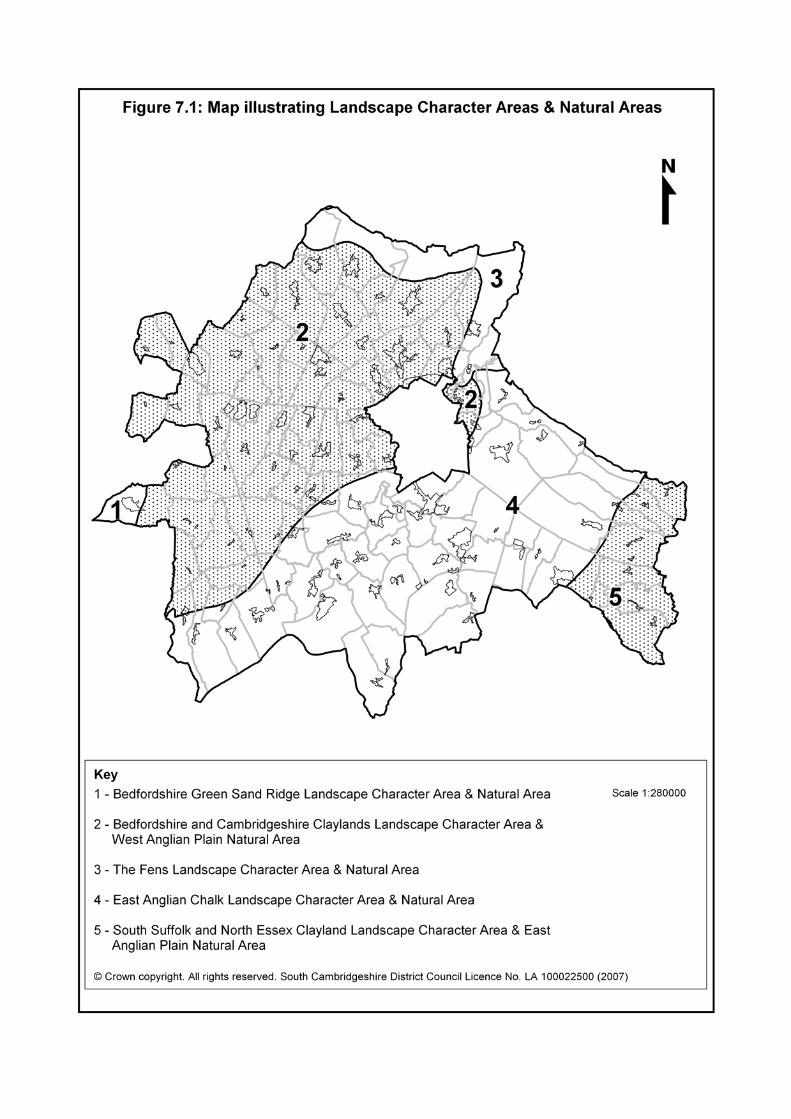
July 2007 Development Control Policies DPD
75
Development Control Policies DPDAdopted July 2007
7.22 Policy NE/6 is in accordance with species protection legislation and to Biodiversity Action Plan targets, and ensures that any harm to a species or its habitat is weighed against the benefit of a development proposal. The judgement will be made on the basis of the expected effect on the species, the local, national or international significance of the population of the species, and its abundance, rate of decline or degree of threat.
7.23 As is detailed in the South Cambridgeshire Design Guide and in this DPD,
when considering development proposals it is important to first afford priority to the maintenance and enhancement of existing habitats and species. The translocation of species should only be considered as a measure of last resort. Mitigation and compensation measures should facilitate the survival of the species’ population, reduce disturbance to a minimum and provide adequate habitats to sustain at least the current level of a population.
7.24 Mitigation may include the provision of specific measures to reduce
disturbance, harm or potential impacts, provision of adequate alternative habitats to sustain, and where possible enhance the affected population, or facilitating the survival of individual members of the species.
7.25 Policy NE/6 also applies to the effects of development on people’s
opportunity to enjoy and experience nature on a site; development on or adjacent to an important site can have an adverse impact upon people’s enjoyment of the site’s biodiversity and landscape value, for example, through intrusive visual features, restrictions on access or a significant increase in noise levels.
7.26 The District Council recognises the importance of the river valley
environments within South Cambridgeshire. The most important of these are the River Cam north of Cambridge, the River Rhee to the south and west, the River Great Ouse, the River Granta to the south and the smaller tributary valley of Bourn Brook. In view of the specialist characteristics of river valley habitats and their importance to the biodiversity of the district as a whole, detailed guidance on the way in which development proposals should respect these habitats, natural features and species characteristics of the river valleys is included in the Council’s Biodiversity Strategy Supplementary Planning Document.
7.27 In 1996 English Nature identified Natural Areas covering the whole of
England in “The Character of England: landscape, wildlife and natural features”. Natural Areas are identified by a unique combination of physical attributes such as geology, plant and animal species, land-use and culture. These attributes combine to give an area its distinctive biodiversity. The Natural Area concept acknowledges that biodiversity does not recognise administrative boundaries nor does it classify species according to whether they are rare or common. Natural Areas therefore provide scope for the

Development Control Policies DPD July 2007
76
Development Control Policies DPD Adopted July 2007
rare and unusual to be conserved alongside the widespread and typical, thus contributing to the overall concept of biodiversity conservation. South Cambridgeshire is covered by parts of five different Natural Areas.
7.28 Further guidance on the way in which development proposals should
respect the distinctive habitats, natural features and species characteristics of these Natural Areas is included in the Council’s Biodiversity Strategy Supplementary Planning Document.
POLICY NE/7 Sites of Biodiversity or Geological Importance
1. Planning permission will not be given for proposals that may have an unacceptable adverse impact, either directly or indirectly, on a Site of Biodiversity or Geological Importance.
2. In determining any planning application affecting international,
national or non-statutorily protected sites the District Council will ensure that the intrinsic natural features of particular interest are safeguarded or enhanced having regard to:
a. The nature and quality of the site’s features, including its
rarity value; b. The extent of any adverse impacts on the features of
interest;
c. The likely effectiveness of any proposed mitigation with respect to the protection of the features of interest;
d. The need for compensatory measures in order to protect
and enhance remaining features or to recreate habitats on or off the site;
e. The status and designation of the site.
3. Where appropriate the District Council will ensure the effective
management of designated sites through the imposition of planning conditions or Section 106 agreements as appropriate.
7.29 Sites of Biodiversity or Geological Importance are identified on the
Proposals Map. Together these sites represent a strategic framework for the conservation of biodiversity. These sites include the statutorily protected international (Special Areas of Conservation and Special
July 2007 Development Control Policies DPD
77
Development Control Policies DPDAdopted July 2007
Protection Areas) and national (Sites of Special Scientific Interest) and the non-statutorily protected Local Nature Reserves and County Wildlife Sites.
7.30 Sites of Biodiversity Importance provide the most important spatial elements
of habitat across the district. The policy applies to both direct and indirect effects; development outside an important site can still have a damaging impact on it.
7.31 PPS9: Biodiversity and Geological Conservation and Circular 06/2005:
Biodiversity and Geological Conservation provides for the tiered protection of designated sites of international, national, regional and local importance. Sites of international importance are classified under EC Directives (Special Protection Areas: SPAs and Special Areas of Conservation: SACs) or listed under conventions (e.g. Ramsar sites).
7.32 At present the only site of international importance within South
Cambridgeshire is the Eversden and Wimpole Woods Special Area of Conservation (SAC). The site provides a habitat for a colony of the barbestelle bat, one of the rarest bats in Western Europe. The bats have been recorded at a small number of other sites up to eleven kilometres from the Woods. The SAC is shown on the Proposals Map. The area of particular interest for the bat’s flight and feeding areas is shown within the South Cambridgeshire Biodiversity Strategy.
7.33 The Habitats Regulations, 1994, require all European Sites to be given full
protection. Furthermore, Circular 06/2005 states that as a matter of policy Ramsar and potential SPAs or SACs should be afforded similar protection as if they were legally designated. English Nature will be consulted on any planning application in or adjacent to a European Site, or any such candidate site. It is therefore a requirement that all proposals that might adversely affect the special interest of a European Site of International Importance be given special scrutiny. Any planning application relevant to any site so designated will be judged according to the guidance set out in Circular 06/2005, Parts I, II & III.
7.34 Although there are currently no Regionally Important Geological /
Geomorphological Sites in South Cambridgeshire (RIGS), it is possible that one or more could be designated during the lifetime of the plan. Such sites have important geological or geomorphological features but are not significant enough to be designated as a SSSI, which has to be of national importance. Any site designated, as a RIGS will be protected by this policy.
7.35 In considering any development proposal, the District Council will have regard to the need to allow suitable opportunities to study and record exposures and features, and the opportunity to incorporate within the development the preservation of geological features of interest.
Development Control Policies DPD July 2007
78
Development Control Policies DPD Adopted July 2007
7.36 Applications for development within or near to a Site of Special Scientific Interest (SSSI) will be subject to special scrutiny and particular account will be taken of any direct or indirect effects on the particular features giving rise to designation. Indirect effects can include increased use and disturbance, hydrological changes (for example, due to increased hard surfaces or underground development), level of noise and pollution.
7.37 Sites of Special Scientific Interest (SSSI) are designated by English Nature
under the Wildlife and Countryside Act, 1981. The sites in South Cambridgeshire are shown on the Proposals Map, although the policy will apply equally to any future sites so designated during the plan period. English Nature will therefore be consulted on any planning application in or adjacent to an SSSI. For any wetland SSSI such consultation may extend up to 2 km from its boundary because development at some distance could have an adverse effect by a lowering of the water table.
7.38 PPS9 recognises that Regional or Local Sites have a fundamental role to
play in meeting overall national biodiversity targets; contributing to the quality of life and the well-being of the community; and in supporting research and education. Local Nature Reserves (LNRs) are formally designated sites under the National Parks and Access to the Countryside Act, 1949. Section 21 of the Act gives local authorities the power to acquire, declare and manage nature reserves. In declaring an LNR a local authority accepts a commitment to manage the land as a nature reserve and to protect it from inappropriate use or development. In South Cambridgeshire County Wildlife Sites (CWS) are identified by the Wildlife Trust in accordance with published criteria and are marked on the Proposals Map. As the SSSI network is only a representative sample, many CWSs are equivalent ecological value to SSSIs and a majority of CWSs support priority BAP habitats and species. They will be treated as material to the consideration of development proposals. The knowledge of such sites and their condition is always changing and sites may be added and removed from the list. PPS9 also recognises the value provided by networks of natural habitats. They may link sites of biodiversity importance and provide routes or stepping stones for the migration, dispersal and genetic exchange of species in the wider environment. In South Cambridgeshire such networks may include public rights of way, important roadside verges which need to be protected from road improvements or new access points, ponds, moats, marshes and ditches that can be adversely affected by changes in local hydrology, woodlands, copses, pollarded willow and hedgerows, semi-natural grasslands and disused gravel, chalk or clunch pits. The management of such features is crucial to maintaining the existing biodiversity interest and to assisting further colonisation of habitats by various species.
7.39 Public rights of way can often be green corridors in their own right,
especially when in open arable countryside. Some rights of way can be up
July 2007 Development Control Policies DPD
79
Development Control Policies DPDAdopted July 2007
to 18 metres (60 feet) wide strips through the countryside, and should consequently be protected for the biodiversity opportunities that they provide. These corridors often co-exist with SSSIs, Local Nature Reserves, County Wildlife Sites, and Scheduled Ancient Monuments, and need to be very carefully managed to balance the complex rights and various statutory protections.
.
WATER AND FLOODING POLICY NE/8 Groundwater Development will not be permitted which poses an unacceptable risk to the quality of the underlying groundwater from the chalk aquifer to the south and east of Cambridge.
7.40 Groundwater resources are critical to the public water supply in South Cambridgeshire. The chalk aquifer to the south and east of Cambridge is an important strategic resource and the principal source for the Cambridge Water Company. It is highly vulnerable to any development which could pollute it or prevent it from re-charging. The Groundwater Protection Maps, prepared by the Environment Agency, represent zones where groundwater is at varying degrees of risk from potentially polluting activities and developments. The District Council will be guided by the Environment Agency on all proposals that may pose a threat to groundwater resources. The abstraction of water from groundwater sources or watercourses is also controlled by the Environment Agency through abstraction licences.
POLICY NE/9 Water and Drainage Infrastructure Planning permission will not be granted where there is inadequate water supply, sewerage or land drainage systems (including water sources, water and sewage treatment works) available to meet the demands of the development unless there is an agreed phasing agreement between the developer and the relevant service provider to ensure the provision of the necessary infrastructure.
7.41 Most developments require a water supply and adequate arrangements for
the disposal of foul and surface water. Where there is an inadequate water supply, sewerage, or drainage system, there is a potential risk to public health which would justify the imposition of planning conditions on a planning permission.
Development Control Policies DPD July 2007
80
Development Control Policies DPD Adopted July 2007
7.42 Anglian Water and the Cambridge Water Company are the statutory undertakers responsible for water supply, sewerage and sewage disposal. Water resource management, land drainage, river management, pollution control and regulating the handling and disposal of waste are the Environment Agency's responsibility. Internal Drainage Boards manage all drainage within their districts excluding main rivers. Those applying for planning permission should consult statutory undertakers as they may levy an infrastructure charge.
7.43 These organisations rely on the planning system to help prevent problems
associated with water supply, land drainage or flood defence arising from development and therefore require close co-operation with the District Council. However, the planning system cannot duplicate controls which are the statutory responsibility of other organisations. Major developments which have strategic implications for service provision need to be co-ordinated and phased by the District Council to avoid danger to public health or safety through the overloading of water, foul or surface water drainage systems and watercourses. Planning obligations or conditions phasing the development in these circumstances may therefore be imposed.
POLICY NE/10 Foul Drainage - Alternative Drainage Systems
1. The development of sites where drainage to a public sewer is not feasible will only be permitted if proposed alternative facilities are considered adequate and would not pose an unacceptable risk to the quality or quantity of ground or surface water, pollution of local ditches, watercourses or sites of biodiversity importance. Drainage to a public sewer should be provided wherever possible. A package treatment plant should be provided where this is not possible. Only where it is clearly demonstrated that neither of these options is feasible will a system incorporating septic tank(s) be acceptable.
2. Where petrol, chemical or oil tanks or other facilities form part of
a proposed development, the District Council will require them to be contained by bund walls of sufficient size to prevent spillage or seepage. The drainage of roads, including adoptable highways and private roads and hard surface areas used by vehicles will be required to be connected to trapped gullies and petrol / oil interceptors or suitable other methods of pollution control.

July 2007 Development Control Policies DPD
81
Development Control Policies DPDAdopted July 2007
7.44 Development in the countryside, normally being development for agricultural purposes, including slurry from large agricultural installations, may be unacceptable if untreated effluent could enter local watercourses and the wider water environment. It will therefore be essential for such developments to provide plant which will treat their effluent if connection to the public sewer is not feasible. The policy makes clear that the District Council will not give planning permission for any development where it may prejudice the quality of ground or surface water, watercourses or sites of biodiversity importance unless measures are undertaken to mitigate the harm.
POLICY NE/11 Flood Risk In relation to flood risk, applications for planning permission will be judged against national policy (currently in PPS25).
7.45 The Proposals Map shows the flood zones, produced by the Environment
Agency (EA) in 2005. These are defined in accordance with government guidance in PPG25: Development and Flood Risk and support a risk based approach to assessing flood risk. PPG25 requires the use of a sequential test when considering development proposals, to determine the suitability of types of development within the different flood zones (Zone 1 - Little or No Risk Less than 0.1% annual probability; Zone 2 - Low to Medium Risk 0.1% to 1.0% annual probability; Zone 3 - High Risk Greater than 1.0% annual probability).
7.46 Although the maps show areas of possible flooding from rivers, streams,
watercourses or the sea, they do not take account of flood defences and always take a conservative approach where detailed information is available. The flood zones are regularly updated by the EA and the most up to date maps, including those from the South Cambridgeshire Flood Risk Assessment, modelling and other studies, will be relevant in determining planning applications. (These can be viewed on the Agency’s Website: www.environment-agency.gov.uk)
SUSTAINABLE DRAINAGE SYSTEMS
7.47 It is preferable to manage surface water runoff through the use of
Sustainable Drainage Systems (SuDS) as they provide environmental, biodiversity and aesthetic benefits. SuDS may take the form of swales, lagoons, permeable paving, green roofs and sensitively re-engineered
Development Control Policies DPD July 2007
82
Development Control Policies DPD Adopted July 2007
channels or reed beds, depending on the nature of the development and the area.
7.48 The Council supports the Environment Agency in promoting sustainable
drainage systems which maintain or reduce pre-development rates of run-off and will seek advice from the agency to determine allowable rates of run-off. Developers will be required to fund the scheme and legal agreements will ensure maintenance and the control of run-off to those levels in perpetuity. WATER CONSERVATION POLICY NE/12 Water Conservation Development must incorporate all practicable water conservation measures. All development proposals greater than 1,000 m2 or 10 dwellings will be required to submit a Water Conservation Strategy prior to the commencement of the development to demonstrate how this is to be achieved.
7.49 The importance of water resources in the area was highlighted through the
Sustainability Appraisal of the LDF. There are a number of ways water conservation can be achieved, such as water saving devices, rainwater harvesting, and greywater recycling, and the policy offers a degree of flexibility on the exact methods used. Large developments, or cumulatively large developments, incorporating such measures could potentially reduce surface water run-off and therefore reduce levels in water courses and water tables, and have an impact on biodiversity. A balance must be achieved between management of water recycling and ensuring no adverse impact on the water environment and biodiversity.
HAZARDOUS INSTALLATIONS POLICY NE/13 Hazardous Installations In considering proposals for hazardous substances consent or development in the vicinity of hazardous installations, account will be taken of the amount, type and location of hazardous substances present, and the need for special precautions to protect future users of the site and any other affected land.
July 2007 Development Control Policies DPD
83
Development Control Policies DPDAdopted July 2007
7.50 Hazardous installations, notifiable pipelines and licensed explosive sites are installations handling or storing hazardous materials. The siting of installations handling hazardous substances are subject to planning controls aimed at keeping them separate from housing and other land uses with which such installations might be incompatible from the safety viewpoint. The operators of such installations are required to notify the Health and Safety Executive (HSE) on certain types of development. The District Council is required to consult the HSE on proposals for certain types of development within specified distances of notifiable installations. The District Council will therefore seek the advice of the HSE and other regulatory authorities about off-site risks to the public arising from any proposed development which would introduce one or more hazardous substances.
7.51 Within South Cambridgeshire there are 9 installations handling hazardous
substances and 11 high-pressure natural gas transmission pipelines. Whilst they are subject to stringent controls under existing health and safety legislation, it is necessary to control the kinds of development permitted in the vicinity of these installations. In determining a planning application on land within the specified consultation zone of one of these installations, the District Council will take account of advice from the HSE and other regulatory authorities.
7.52 Under the present system of controls over hazardous development and over
development within the vicinity of hazardous installations, the activities and substances (and quantities) to which the above statements apply are those defined by the Planning (Hazardous Substances) Regulation 1992, the Planning (Control of Major Accident Hazards) Regulations 1999 and referred to in the Department of the Environment Circular 04/00 "Planning Controls for Hazardous Substances".
LIGHTING POLICY NE/14 Lighting Proposals
1. Development proposals which include external lighting should ensure that:
a. The proposed lighting scheme is the minimum required for
reasons of public safety and security; b. There is no light spillage above the horizontal;
c. There is no unacceptable adverse impact on neighbouring
or nearby properties or on the surrounding countryside;

Development Control Policies DPD July 2007
84
Development Control Policies DPD Adopted July 2007
d. There is no dazzling or distraction to road users including cyclists, equestrians and pedestrians;
e. Road and footway lighting meets the District and County
Councils’ adopted standards.
7.53 Artificial lighting is essential for reasons of safety and security. In some cases it can also add to the amenity of the built environment by highlighting buildings and open spaces of character. However, insensitive lighting can cause what is termed as light pollution. South Cambridgeshire, as a predominantly rural area, is sensitive to light pollution through sky glow which can affect the tranquillity of the countryside. Light pollution can have a negative impact upon biodiversity by affecting the normal diurnal patterns of plants and animals.
7.54 External lighting is needed for commercial use and for some community and
sports facilities such as floodlit sports pitches. Whilst the lighting has to be adequate for the purpose, it is important that there is no significant nuisance to the amenity of surrounding properties. This may require the use of planning conditions to limit the times when lighting is used to minimise the disturbance.
NOISE POLICY NE/15 Noise Pollution
1. Planning permission will not be granted for development which:
a. Has an unacceptable adverse impact on the indoor and outdoor acoustic environment of existing or planned development;
b. Has an unacceptable adverse impact on countryside areas
of tranquillity which are important for wildlife and countryside recreation; or
c. Would be subject to unacceptable noise levels from existing
noise sources, both ambient levels and having regard to noise impulses whether irregular or tone.
2. Conditions may be attached to any planning permission to
ensure adequate attenuation of noise emissions or to control the noise at source. Consideration will be given to the increase in
July 2007 Development Control Policies DPD
85
Development Control Policies DPDAdopted July 2007
road traffic that may arise due to development and conditions or Section 106 agreements may be used to minimise such noise.
3. In particularly sensitive locations, business use development
may be restricted to office use only (B1 (a)). 4. Where a planning application for residential development is near
an existing noise source, the applicant will be required to demonstrate that the proposal would not be subject to an unacceptable noise levels.
5. The District Council will seek to ensure that noise from proposed
commercial, industrial, recreational or transport use does not cause any significant increase in the background noise level of nearby existing noise sensitive property which includes dwellings, hospitals, residential institutions, nursing homes, hotels, guesthouses, and schools and other educational establishments.
7.55 Planning Policy Guidance Note 24 paragraph 5 requires development plans
to include policies which ensure noise sensitive developments are located away from existing sources of significant noise, and that potentially noisy developments are located in areas where noise will not be such an important consideration or where its impact can be minimised. Aviation-related development proposals must also comply with Policy TR/6.
AIR QUALITY POLICY NE/16 Emissions
1. Development proposals will need to have regard to any emissions arising from the proposed use and seek to minimise those emissions to control any risks arising and prevent any detriment to the local amenity by locating such development appropriately.
2. Where significant increases in emissions covered by nationally
prescribed air quality objectives are proposed, the applicant will need to assess the impact on local air quality by undertaking an appropriate modelling exercise to show that the national objectives will still be achieved. Development will not be permitted where it would adversely affect air quality in an Air Quality Management Area.

Development Control Policies DPD July 2007
86
Development Control Policies DPD Adopted July 2007
7.56 Air pollutants (including dust and odour) have been shown to have adverse effects on health and the environment. Emissions arising from any development including indirect emissions such as those attributable to associated traffic generation must therefore be considered in determining planning applications. Where emissions from industrial processes are subject to pollution control legislation (PPC, LAPC, LAPPC) the regulatory authority will be consulted with respect to control of these emissions.
AGRICULTURAL LAND POLICY NE/17 Protecting High Quality Agricultural Land
1. The District Council will not grant planning permission for development which would lead to the irreversible loss of Grades 1, 2 or 3a agricultural land unless:
a. Land is allocated for development in the Local Development
Framework; b. Sustainability considerations and the need for the
development are sufficient to override the need to protect the agricultural value of the land.
2. Uses not involving substantial built development but which take
agricultural land, such as golf courses and camping and caravan sites, will be regarded as permanent unless restricted specifically by condition.
7.57 Most of South Cambridgeshire’s farmland is in the higher grades of the
Agricultural Land Classification maps produced by the Department for Environment, Food and Rural Affairs. Grades 1, 2 and 3a are the grades which comprise the best and most versatile land which is a national resource; this land is flexible and the most productive and efficient for agriculture.
7.58 The scale of development in South Cambridgeshire means that there will
inevitably be some loss of agricultural land of these higher grades, particularly at the major development locations, and the land allocated for development in this plan seeks to minimise this by, for example, making maximum use of previously developed land. Land outside these allocations should therefore remain as an agricultural resource wherever possible. Development outside development frameworks is restricted to that required for agriculture, horsiculture, forestry, outdoor recreation and other uses which need to be located in the countryside, by Policy DP/7.

July 2007 Development Control Policies DPD
87
Development Control Policies DPDAdopted July 2007
7.59 Some development, such as golf courses and camping and caravan sites, may seek justification on the basis that it would maintain the openness of a site, and it could therefore be returned to agricultural use in the future. However, once land is developed for alternative uses, it may not be feasible to return it to its original state and quality. The policy therefore requires any such uses to be regulated by condition requiring the ultimate restitution of the land to its former quality.

Development Control Policies DPD July 2007
88
Development Control Policies DPD Adopted July 2007

July 2007 Development Control Policies DPD
89
Development Control Policies DPDAdopted July 2007
8. CULTURAL HERITAGE
OBJECTIVES
CH/a To protect historic landscapes and public rights of way. CH/b To protect, preserve and enhance the archaeological heritage. CH/c To maintain the character of villages including important
open areas. CH/d To protect and enhance Conservation Areas and their
settings. CH/e To protect Listed Buildings and their settings.
HISTORIC LANDSCAPES POLICY CH/1 Historic Landscapes Planning permission will not be granted for development which would adversely affect or lead to the loss of important areas and features of the historic landscape whether or not they are statutorily protected.
8.1 The landscape is the product of human action on the natural landscape over
many thousands of years. This is most obvious in the parklands, waterways, trackways, hedges, field patterns, woodlands and wetlands of the District. Some of these are individual features (such as Wandlebury Hill Fort, Wholeway, Car Dyke, Fleam Dyke and the Roman Road) while others cover wide tracts of countryside (such as Wimpole Hall Park).
8.2 Historic landscapes are particularly valuable in South Cambridgeshire
where they add interest and variety to an intensively farmed countryside. Some historic landscapes and features are protected by other policies or legislation, for instance if they are a Site of Special Scientific Interest (SSSI) or a Scheduled Ancient Monument. However, the complexity of the historic landscape means that there are many sites and features which do not have such a designation but nevertheless they should be retained because of their contribution to the wider landscape and our ability to read our heritage. The Cambridgeshire Historic Landscape Database, developed by the County Council, provides a valuable tool in defining the evolution of landscape and in identifying historic landscapes. Regard will be had to the database in determining whether proposals would have an adverse impact on historic landscapes.
Development Control Policies DPD July 2007
90
Development Control Policies DPD Adopted July 2007
8.3 Parkland as an important landscape feature is relatively rare in the district and so those parks that there are make a particularly valuable contribution. Some of these are included in English Heritage’s Register of Parks and Gardens of Special Interest and are of national importance; they are shown on the Proposals Map. They may be added to over the plan period. Others have a more local value, often forming the setting of a Listed Building. Parks and gardens which have a local significance will be identified in a Supplementary Planning Document.
ARCHAEOLOGY POLICY CH/2 Archaeological Sites Archaeological sites will be protected in accordance with national policy (currently PPG16).
8.4 The Cambridgeshire Historic Environment Record, held by Cambridgeshire
County Council, gives information on archaeological sites and monuments. However, given the wealth of the past in South Cambridgeshire, this record can never be complete and new areas will be added as new information comes forward. Prospective developers should contact the County Council’s Archaeological Officer for information to establish whether there is potential archaeological interest and establish the need for investigation and evaluation at an early stage. Where it is deemed that there is archaeological potential, the developer will be required to commission an archaeological evaluation to define the character and condition of any remains. This will include the character and depth of remains together with the impact of development upon the remains together with any mitigation measures to avoid unnecessary damage.
LISTED BUILDINGS AND THEIR SETTINGS POLICY CH/3 Listed Buildings
Applications for planning permission and Listed Building Consent (including applications for alterations, extensions, change of use or demolition of Listed Buildings) will be determined in accordance with legislative provisions and national policy (currently in PPG15). In assessing such applications the District Council will adopt a presumption in favour of the retention and preservation of local materials and details on Listed Buildings in the district.
July 2007 Development Control Policies DPD
91
Development Control Policies DPDAdopted July 2007
8.5 Listed Buildings represent a heritage of national importance as they are included in the Government’s Statutory List of Buildings of Special Architectural or Historic Importance. They are a finite resource and they contribute significantly to the character of the district.
8.6 PPG15: Planning and the Historic Environment sets out the criteria to be
applied where the demolition of a Listed Building is proposed. There is a presumption in favour of retaining Listed Buildings so permission to demolish will be the exception and only allowed if all other options to retain the building are demonstrated to have been thoroughly explored.
8.7 Given the finite nature of the resource of Listed Buildings it is essential to
retain as much information and material from those rare cases where there is no alternative to demolition. The District Council will therefore require by condition an appropriate record to be made and the appropriate salvage of materials.
8.8 The repair, renovation, alteration and extension of a Listed Building should
not be at the expense of its intrinsic value. It is important to guard against unnecessary change or over-restoration. In any change, materials should be sympathetic to those used in the original building. In particular the District Council will resist applications that result in the loss of traditional long straw roofs and their ridge, barge and dormer details, or the loss of traditional gault clay pegtiles and pantile roofs, their ridge, valley, verge and abutment details.
8.9 Listed Buildings may become vacant and derelict if no acceptable
alternative use can be found. The original use may be the most appropriate and will be encouraged where possible. Where this is not practicable the alternative use proposed must not require alteration to the extent that the character and historical importance of the building is destroyed.
8.10 The District Council will adopt a Supplementary Planning Document, and
provide detailed specialist advice on the maintenance, repair, alteration and other changes proposed for Listed Buildings.
POLICY CH/4 Development Within the Curtilage or Setting of a Listed Building Planning permission will not be granted for development which would adversely affect the curtilage or wider setting of a Listed Building. Proposals must provide clear illustrative and technical material to allow that impact to be properly assessed.
Development Control Policies DPD July 2007
92
Development Control Policies DPD Adopted July 2007
8.11 Where the District Council considers that a proposal would have an impact on the setting of a Listed Building, it will require the submission of illustrative and technical material to allow that impact to be properly assessed. This will include details to show the existing situation and the precise effect on the fabric and character of the Listed Building and its setting. Planning permission will be refused where the District Council considers that the proposal would dominate the Listed Building or buildings within its curtilage by scale, form, mass or appearance or harm the visual relationship between the Listed Building and its formal or natural landscape surroundings. CONSERVATION AREAS POLICY CH/5 Conservation Areas Planning applications for development proposals (including applications for Conservation Area Consent for demolitions) in or affecting Conservation Areas will be determined in accordance with legislative provisions and national policy (currently in PPG15) and guidance contained in specific Conservation Area Appraisals (where they exist) and the District Design Guide.
8.12 The District Council is required to survey its area from time to time to
determine whether to designate Conservation Areas (areas of special architectural or historic interest). Conservation Areas are designated not on the basis of individual buildings but because of the overall quality of the area, its mix of uses, historic layout, characteristic materials, scale and detailing of buildings and open spaces. It also takes into account the need to protect trees, hedges, walls, railings and other characteristic features. Once designated, special attention must be paid in all planning decisions to the desirability of preserving or enhancing its character and appearance. In South Cambridgeshire there are over 80 Conservation Areas which make a very significant contribution to protecting the attractiveness of the district.
8.13 In order to assess the impact of development proposals, the District Council
will require details including drawings or other pictorial material which shows the proposed development in its context. In most cases this means that outline planning applications will not be acceptable.
8.14 The District Council will be looking for development to provide a level of
visual interest equivalent to that of the existing buildings in the Conservation Area. The choice of materials and detailed design are vital elements in achieving new buildings worthy of the small-scale village context which typifies South Cambridgeshire’s Conservation Areas.
July 2007 Development Control Policies DPD
93
Development Control Policies DPDAdopted July 2007
8.15 Further advice on development in Conservation Areas will be set out in a Supplementary Planning Document. The District Council will prepare detailed appraisals of its Conservation Areas. Such appraisals will review the appropriateness of the Conservation Area boundary, define their special character and evolve guidelines for development and enhancement schemes. Where appropriate they will be adopted as Supplementary Planning Documents.
VILLAGE CHARACTER POLICY CH/6 Protected Village Amenity Areas Development will not be permitted within or adjacent to Protected Village Amenity Areas if it would have an adverse impact on the character, amenity, tranquillity or function of the village.
8.16 Protected Village Amenity Areas (PVAAs) are important to the amenity and
character of villages and should be protected for their own sake. 8. 17 The character of villages is made up of a blend of buildings and open
spaces. Given the pressure for development in the district, the remaining open land within villages is threatened. Some undeveloped land can be built on without harm to the character of the village and can contribute to the full and effective use of land in accordance with national policy, but others are important to maintain the village character and should not be developed. PVAAs have therefore been designated on sites within village frameworks in order to safeguard those areas of undeveloped land within villages which are important to retain.
8.18 Some of the PVAAs may have important functions for the village such as
allotments, recreation grounds and playing fields whilst others have an important amenity role in providing a setting for buildings and offer tranquil areas where there is minimum activity. Not all PVAAs have public access as some undeveloped areas which are important may be private gardens. They also vary from those which are very open to visual penetration to those which may be enclosed or semi-enclosed.
8.19 Whilst PVAAs are identified, smaller gaps or spaces between buildings may
also be important for local amenity or character and should also be protected from development.

Development Control Policies DPD July 2007
94
Development Control Policies DPD Adopted July 2007
POLICY CH/7 Important Countryside Frontages
1. Important Countryside Frontages are defined where land with a strong countryside character either:
a. Penetrates or sweeps into the built-up area providing a
significant connection between the street scene and the surrounding rural area; or
b. Provides an important rural break between two nearby but
detached parts of a village framework.
2. Planning permission for development will be refused if it would compromise these purposes.
8.20 In many places land with a strong countryside character penetrates or
sweeps into South Cambridgeshire’s villages or separates two parts of the built-up area. Such land enhances the setting, character and appearance of the village by retaining the sense of connection between the village and its rural origins and surroundings. The frontage where this interface particularly occurs is identified to indicate that the frontage and the open countryside beyond should be kept open and free from development. In most cases it is land which adjoins the village built-up area but in some cases it separates two parts of the village and the open intervening land therefore assumes an importance for the character of the village as a whole.
ADVERTISEMENTS POLICY CH/8 Advertisements
1. Advertisements will be restricted to the number, size, format, materials and design appropriate to the building or locality to which it is proposed they be attached in order not to detract from the character and appearance of the district.
2. Advertisements alongside roads will not be permitted where they
would prejudice road safety. 3. In Conservation Areas and on, or affecting, Listed Buildings,
advertisements will be kept to a minimum in order to maintain the character and appearance of Conservation Areas and to avoid harm to the fabric, character or setting of Listed Buildings.

July 2007 Development Control Policies DPD
95
Development Control Policies DPDAdopted July 2007
8.21 Advertisements can greatly influence the appearance of an area. A balance has to be made between commercial needs and the protection of the environment.
8.22 The most stringent controls are needed in Conservation Areas, which are
often the original village centres where most commercial activity is located. Advertisements can also detract from the appearance of Listed Buildings.
8.23 In Conservation Areas the District Council will seek to ensure that
advertisements are kept to the minimum necessary to identify the building and its function in order to protect the appearance of the area. It is therefore unlikely that any advertisement will be permitted which involves:
• Internally illuminated or other projecting fascia signs;
• Obtrusive blinds or window / door canopies;
• Obtrusive externally illuminated signs;
• Obtrusive lettering, lighting, symbols, material or colour of fascia
displays, window stickers, pavements signs and signs advertising particular products.
8.24 In the case of Listed Buildings, permission will not be given where the
District Council considers there would be harm caused by advertisements, lighting, colour schemes and blinds or canopies.
SHOP FRONTS POLICY CH/9 Shop Fronts
1. The District Council will only grant planning permission for shop fronts and alterations to existing shop fronts which:
a. Create a fascia and shop window which is in character with
the building itself and the street scene; b. Do not result in a needless loss of architectural features; or
c. Do not introduce ‘house styles’ and materials which are
alien to the building and its surroundings. 8.25 Both customers and shopkeepers benefit if the environment of the street
scene is enhanced by well-designed and maintained shop fronts. In villages
Development Control Policies DPD July 2007
96
Development Control Policies DPD Adopted July 2007
it will be important to respect the existing street and village character, while in major new developments like Northstowe new town and the urban extensions to Cambridge the emphasis will be on creating a quality and vibrant environment.
LINTON SPECIAL POLICY AREA POLICY CH/10 Linton Special Policy Area South of the A1307 bypass at Linton, in the area defined on the Proposals Map, further residential development will not be permitted other than improvements to existing properties.
8.26 The southern part of the village, severed by the A1307 bypass, is characterised by three distinct uses; employment, a sensitive residential area much of which lies within the Conservation Area, and the site of Linton Zoo. It is also isolated from the main village, and further residential development would not be sustainable with its poor access to the village facilities and services.
DUXFORD IMPERIAL WAR MUSEUM
POLICY CH/11 Duxford Imperial War Museum
1. The Imperial War Museum site at Duxford Airfield will be treated as a special case as a major tourist / recreation facility. Proposals will be considered with regard to the particular needs and opportunities of the site, other policies in the plan, and the following specific criteria:
a. Any proposal must be associated with the continued use of
the site as a museum of aviation and modern conflict;
b. The District Council will require additional details concerning the scale, form and design to accompany any outline application;
c. Details of projected increases in aircraft noise will be required with all proposals which would lead to increased flying activity.
July 2007 Development Control Policies DPD
97
Development Control Policies DPDAdopted July 2007
8.27 The Imperial War Museum is a major tourist attraction based upon a long established airfield. Given its national significance, the District Council will give it special consideration within the context of protecting the quality of the surrounding landscape in this sensitive site on the edge of the Cambridge Green Belt.

Development Control Policies DPD July 2007
98
Development Control Policies DPD Adopted July 2007

July 2007 Development Control Policies DPD
99
Development Control Policies DPDAdopted July 2007
9. TRAVEL
OBJECTIVES
TR/a To provide a transport system that meets the needs of the economy.
TR/b To reduce the need to travel, and where travel is unavoidable,
to increase the use of sustainable modes. TR/c To promote the use of more sustainable modes of travel such
as public transport, community transport, walking and cycling by making such modes more integrated, highly accessible, safer and more attractive to use.
TR/d To promote sustainable travel by ensuring new development
takes place in locations with, or with potential for, good accessibility by non-motorised modes to facilities and services and ensuring provision for all transport modes.
TR/e To minimise the amount of car parking provided in new
developments, within the context of maximum car parking standards, compatible with its location and availability of alternative transport modes, to avoid over-reliance on the car.
TR/f To promote a healthy lifestyle through travel choice.
TR/g To improve the safety of travel for all people and all modes,
including measures to reduce the number and severity of road accidents.
TR/h To improve personal safety and accessibility for all modes
and all people, including those with disabilities. TR/i To reduce the environmental impact of travel, to conserve
energy and reduce air pollution by limiting the growth in road traffic.
TR/j To provide transport proposals that protect or enhance the
built and natural environment. TR/k To safeguard land for highways and other transport
proposals. TR/l To encourage the provision of transport improvements through
the development process.
Development Control Policies DPD July 2007
100
Development Control Policies DPD Adopted July 2007
INTRODUCTION
9.1 Government policy is to promote more sustainable transport choices, to improve access to major trip generators by non-motorised modes, and to reduce the need to travel, especially by car. Although the potential for using public transport and non-recreational walking and cycling is more limited in rural areas such as South Cambridgeshire, the same overall policy approach is required. In addition, in recognition of increasingly sedentary lifestyles, the health impacts of travel, and the health benefits from walking and cycling, national policy initiatives seek to improve health through encouraging use of walking and cycling which are sustainable modes.
9.2 Responsibility for transport is generally shared between central government
and its agencies and Cambridgeshire County Council. The District Council has a limited direct role in transport provision, although it can use its legal powers to divert, create or extinguish rights of way, and can provide and maintain off-street car parks. However, the District Council also has planning responsibilities, which can have important transport implications. For example, by ensuring development takes place in locations that are accessible by a range of modes of transport, the District Council can promote more sustainable travel patterns by reducing reliance on the private car.
9.3 Meeting the travel objectives will require action on two fronts. Firstly, there
needs to be positive action co-ordinated by the County Council through the Cambridgeshire Local Transport Plan (LTP) to provide a vision and strategy for integrated transport in the county. Secondly, the Local Development Framework (LDF) needs to provide strong policies to ensure that the location of new development supports the above objectives. Partnership working is essential to the achievement of these objectives.
PLANNING FOR MORE SUSTAINABLE TRAVEL POLICY TR/1 Planning for More Sustainable Travel
1. Planning permission will not be granted for developments likely to give rise to a material increase in travel demands unless the site has (or will attain) a sufficient standard of accessibility to offer an appropriate choice of travel by public transport or other non-car travel mode(s).
2. In considering planning applications the Council will seek to
ensure that every opportunity is taken to increase integration of travel modes and accessibility to non-motorised modes by appropriate measures including:
July 2007 Development Control Policies DPD
101
Development Control Policies DPDAdopted July 2007
a. Securing appropriate improvements to public and
community transport (including infrastructure requirements) in accordance with the aims of the Local Transport Plan;
b. Securing on-site and / or off-site design proposals that
promote integrated travel and access by non-motorised modes as far as practicable (including walking and cycling) and facilitate and encourage their use;
c. Minimising the amount of car parking provision in new
developments, compatible with their location, by encouraging shared use parking (where appropriate) and restricting car parking to the maximum levels;
d. Ensuring that new developments are located and designed
at the outset with permeable layouts to facilitate and encourage short distance trips by cycle and walking, including to public transport interchanges;
e. Requiring safe and secure cycle parking.
3. The Local Transport Plan road user hierarchy will be taken into
account in the determination of planning applications to ensure adequate emphasis has been placed on the relevant modes, although no modes should be promoted to the exclusion of others.
9.4 In accordance with national travel objectives, policies in the Structure Plan Movement and Access chapter, and the Local Transport Plan, seek to reduce the need to travel and enable more sustainable travel. At the local level, there is a need to ensure development is located such to minimise distances to travel to facilities and services, and that adequate quality infrastructure is provided for all modes to integrate with that which already exists. This is reflected in Objective ST/b of the Core Strategy DPD. Such infrastructure provision should be integrated into the design of new development.
9.5 In assessing whether the development proposal is likely to give rise to a
material increase in travel demand, the Council will consider the existing use of the building(s) / site, existing transport conditions in the immediate and wider area, and likely transport generation from the development proposals.
9.6 All development should strive to offer travel choice by non-motorised modes
appropriate in scale and kind to the development. An indicative list of

Development Control Policies DPD July 2007
102
Development Control Policies DPD Adopted July 2007
measures which may assist in achieving suitable modal choice are listed. The measures applicable to each development proposal will vary on a case-by-case basis, according the type and scale of development proposed, its location, and the level of existing transport infrastructure and services in the immediate area. This could also include a financial contribution into a "pot" for the implementation of schemes beyond the scope of an individual development to deliver.
9.7 The Structure Plan and the Local Transport Plan (LTP) strive to achieve
High Quality Public Transport (HQPT) provision within the urban area of Cambridge and along the corridors between Cambridge and the surrounding market towns, and good local services in the rural areas. Feeder services, including more flexible public transport, community transport and taxis, will serve the wider area and feed into these corridors at rural interchanges.
9.8 Other improvements to public transport are set out in the County Council’s
Bus Information Strategy and include the provision of better information, including Real Time information. The Council will seek to secure improvements to public transport services to achieve these standards, including developer contributions to complement the lower levels of car parking provided.
9.9 The LTP road user hierarchy sets out the priorities for different modes within
each of the three main strategy areas; along main roads, within urban areas and in the rural areas and will need to be considered in the determination of planning applications to ensure adequate emphasis has been placed on the relevant modes, although no modes should be promoted to the exclusion of others.
PARKING STANDARDS POLICY TR/2 Car and Cycle Parking Standards
1. Car parking should be provided in accordance with the maximum standards set out in Appendix 1, to reduce over-reliance on the car and to promote more sustainable forms of transport.
2. In some locations, such as those with good accessibility to
facilities and services, and served by High Quality Public Transport, the Council will seek to reduce the amount of car parking provided. Where opportunities arise, for example, on mixed-use sites, shared use parking and car pooling will be encouraged to minimise provision.

July 2007 Development Control Policies DPD
103
Development Control Policies DPDAdopted July 2007
3. Cycle parking should be provided in accordance with the minimum standards set out in Appendix 2 to ensure the provision of adequate secure parking.
9.10 Structure Plan Policy P8/5 requires car parking standards to be set as maximum standards, and not exceed those in PPG13. In addition, Structure Plan Policy P8/8 is a requirement for the provision of adequate cycle facility provision, including cycle parking.
MITIGATING TRAVEL IMPACT POLICY TR/3 Mitigating Travel Impact
1. New developments will be required to mitigate their travel impact, including their environmental impact, such as noise, pollution and impact on amenity and health. This may mean ensuring adequate provision is made for integrated and improved transport infrastructure or appropriate mitigation measures, through direct improvements and Section 106 contributions, in accordance with the tests in Circular 05/2005.
2. Financial contributions will be sought towards improvements in
transport infrastructure in the wider area affected by increased development, in particular to support public transport, cycling and walking.
3. Proposals for 'major development'1 or where a proposal is likely
to have 'significant transport implications'2 the Council will require developers to submit the following alongside planning applications:
a. A Transport Assessment; and b. A Travel Plan.
4. All other planning applications should be accompanied by a
Transport Statement to demonstrate that the development will achieve adequate mitigation of its transport impacts.
5. Travel Plans should demonstrate how it is intended to meet the
tests in the first paragraph above. In appropriate cases the content of the Travel Plan may be reflected in planning conditions or a planning obligation. Travel Plans should have measurable outputs, related to targets or aims in the LTP, and
Development Control Policies DPD July 2007
104
Development Control Policies DPD Adopted July 2007
provide monitoring and enforcement arrangements. A Travel Plan could also help address a particular local traffic problem associated with a planning application, which might otherwise have to be refused on local traffic grounds. The weight to be accorded to a Travel Plan will be influenced by the extent to which it affects the acceptability of the proposal and how far it can be enforced. Planning conditions or obligations may be appropriate means of securing the provision of some or all of a Travel Plan, including a requirement for the production of an annual monitoring and progress report.
6. In relation to outline planning applications, a framework for the
preparation of Travel Plans will be submitted with the application proposals.
NOTES: 1 'Major development' will be interpreted as set out in paragraph 2.5.
2 ‘Significant transport implications’ will be interpreted as set out in paragraph 89 of
PPG13.
9.11 It is important that all development mitigates its transport impact. 'Major
development' proposals or development proposals with a 'significant transport implications' will be required to produce a Transport Assessment and a Travel Plan (for non-residential proposals). A Transport Statement should be submitted alongside all other development proposals to enable the applicant to demonstrate to the Council that they have properly considered the transport impact of the proposal and taken into account how to mitigate them. The level of detail of the Transport Statement will vary according to the scale and complexity of the application.
9.12 A Transport Assessment guidance note has been produced jointly by
Cambridgeshire County Council and all District Councils in Cambridgeshire and provides guidance to applicants, developers, their agents and local authority officers on when a Transport Assessment (TA) is required and what it should contain. It also gives guidance on what information may be required for smaller applications, which may not require a full TA.
9.13 The Council has adopted the Northern and Western Corridor Area
Transport Plans. The plans each cover a segment of Cambridge City and the surrounding necklace villages in South Cambridgeshire. Each of the Plans contains a formula for assessing trip generation and levels of financial contributions that will be sought from developments to mitigate the impact of additional trips generated.
July 2007 Development Control Policies DPD
105
Development Control Policies DPDAdopted July 2007
NON-MOTORISED MODES POLICY TR/4 Non-motorised Modes
1. The District Council will use its planning powers to support increased use of non-motorised modes by all sectors of society, including cycle use and walking, by ensuring that new developments are located and designed at the outset to facilitate and encourage short distance trips between home, work, schools and colleges, other suitable destinations and for leisure. Apart from minimising the distance between trip origins and destinations it will be important to ensure:
a. That adequate safe and secure cycle parking is provided in
accordance with the standards in Policy TR/2; b. That individual developments contribute to the maximum
possible extent to achieving the aims of the Local Transport Plan;
c. That detailed designs and layouts are permeable and
encourage cycle use and walking for all or part of a journey, e.g. by including safe, direct links to schools, nearby centres of attraction and public transport interchanges, contributing towards the provision of an improved and integrated walking and cycling network in the locality, and providing safe crossing places over main roads.
2. In assessing such future provision for non-motorised modes, the
District Council will use the following priorities:
d. 1st priority – provide links to centres with a good range of facilities / services, including major employment areas;
e. 2nd priority – safer routes to schools, provided school buses
are not put at risk;
f. 3rd priority – leisure and recreation routes.
3. Any new routes must form safe, highly accessible and convenient connections with Cambridge, Northstowe, the market towns and surrounding villages and link to the existing network.
4. Planning decisions will need to consider the effect of proposed
development on the effectiveness and amenity of these routes and take account of the need to extend or improve the attractiveness of the network, including through improved

Development Control Policies DPD July 2007
106
Development Control Policies DPD Adopted July 2007
maintenance, crossings, signposting and waymarking of cycleways, footpaths and other rights of way. Where appropriate the District Council will negotiate with the relevant landowners and organisations to extend, or where necessary amend, the network of public rights of way including circular routes.
9.14 The hierarchy sets out the priority for the delivery of infrastructure provision for non-motorised modes through the planning process, for example through Section 106 contributions. Although listed in priority order, no one priority should be promoted to the exclusion of others. The first priority is to connect to larger centres of attraction, both within or adjacent to the district, including Cambridge and the market towns. These centres have a range of services and facilities, including schools and employment areas. This offers greater value for money in terms of the range of the population who could potentially use the routes. In addition, Safer Routes to School, whilst contributing to the overall aims of improving infrastructure, is already delivered from a separate pot of money. Leisure and recreation routes are also an important resource, particularly to improve access to the surrounding countryside as part of a healthy lifestyle.
9.15 The Cambridgeshire Local Transport Plan includes separate strategies on
walking and cycling. The Structure Plan also recognises the importance of walking and cycling and the need to secure improvements to the capacity, quality and safety of the network. At the same time, existing public rights of way need protecting. The County Council, as the local highways authority, is responsible for keeping the definitive rights of way maps up to date and developing Rights of Way Improvement Plans. Public paths in rural areas (footpaths, bridleways and byways) provide an important resource for walkers and, in appropriate cases, for cyclists and horse riders. Cambridgeshire County Council’s ‘Public Rights of Way – A Guide for Planners and Developers’ offers guidance and advise on how adverse impact of development on public rights of way can be avoided, and how opportunities for enhancing the path network can be pursued.
9.16 The National Cycling Strategy aims to quadruple cycle trips between 1992
and 2012 and a National Cycle Network is being developed by local authorities working in partnership with Sustrans. One project which is being developed is the “Cam Cycle Rings” – developing a network of circular cycle routes radiating out of Cambridge, which will provide routes into and around Cambridge and provide circular routes for recreation and such routes can also contribute to sustainable commuting. This will be particularly important in addressing the needs of recreational cycling and encouraging sustainable tourism.
July 2007 Development Control Policies DPD
107
Development Control Policies DPDAdopted July 2007
RAIL FREIGHT POLICY TR/5 Rail Freight Interchanges
In order to promote the use of rail for freight movements, freight interchange facilities will be permitted where they accord with other relevant proposals of this plan.
9.17 Rail has an important role in the movement of freight. There is a general
acceptance that the transfer of freight from road to rail will provide significant environmental improvement and will help to develop sustainable distribution. Whilst only two of the rail freight sites in the district are in operation, the remaining three are maintained. As with bus services, new and upgraded existing facilities can help make the railway more attractive to potential users. It is therefore important to retain and safeguard existing rail freight facilities within the district.
9.18 Policy SP/19 in the Site Specific Policies DPD safeguards existing rail
freight facilities and sidings at Chesterton Junction, Foxton, Duxford, Fulbourn and Whittlesford.
AVIATION-RELATED DEVELOPMENT PROPOSALS POLICY TR/6 Aviation-Related Development Proposals
1. In assessing any planning applications for new airfields or flying sites, or for the expansion of any existing airfields or flying sites, the District Council will take account of the following factors:
a. The economic, employment or emergency services
advantages likely to accrue to the area; b. The likely noise impact of the proposal on local residents
and the users / occupiers of any other noise-sensitive buildings in the area, including (where relevant) any cumulative impacts of flying in the area;
c. The accessibility of the site in relation to the transport
infrastructure;
d. The effect of the proposal on nature conservation interests;
Development Control Policies DPD July 2007
108
Development Control Policies DPD Adopted July 2007
e. The impact of the proposal on the landscape, including the effects of any lighting that would form a necessary part of the scheme;
f. Any resulting increase in the range of recreation provision;
g. Any safety issues arising from the proposal, including the
safety of users of public rights of way close to, or crossing, the site;
h. The effect of the proposal on sites with potential for
renewable energy generation.
2. Aircraft noise will usually be assessed in terms of the daytime noise exposure index (LAeq, 16h) supplemented as appropriate by other considerations such as the maximum noise level of individual events.
3. In assessing the impact of noise, consideration will be given,
where relevant, to the types of flying activities that are proposed at the site (or are likely to be associated with it), e.g. aerobatics, aero-towing, ballooning, flying training (including ab-initio flights), helicopters, historic aircraft, parachuting, and special event days. Applicants will be required to state what types of flying activities are proposed, and on what scale.
4. Other factors relevant to a judgement as to whether or not a
development would give rise to an unacceptable amount of noise could be:
i. The type and weight of aircraft to be operated from the
airfield; j. The total number of proposed movements in and out of the
airfield;
k. The type of aircraft activities proposed including any touch-and-go movements or circuit training;
l. The proposed total number of daily movements;
m. The proposed hours of operation.
5. Where necessary or appropriate, conditions may be imposed to
cover these and any other essential matters. In certain cases such conditions may allow for a limited number of exceptions above the imposed restriction.
July 2007 Development Control Policies DPD
109
Development Control Policies DPDAdopted July 2007
6. In all cases the Council will require applicants to state whether their proposals are intended to provide for these kinds of activities and, if so, to describe their intended scale. In appropriate cases the degree of any nuisance arising from proposed flying activities may be assessed:
n. By the use of on-site demonstrations; o. By the imposition of a temporary permission to give a
reasonable ‘trial run’ during which a careful programme of monitoring will be undertaken.
7. In the case of small airfields / airstrips in tranquil rural areas a
special case would have to be demonstrated to justify the granting of planning permission for development that would generate activities of a type (or on a scale) that would be materially at odds with a primarily recreational function and low level of activity.
8. Where planning permission is granted conditions may be
imposed in appropriate circumstances to restrict matters such as:
p. The total number of take-offs and / or touch-and-go
movements (normally on a daily maximum basis); q. The types or weights of aircraft to be operated; and
r. The hours of operation of the site.
9.19 South Cambridgeshire has a long association with flying and there are a
number of established aerodromes and smaller airfields in the district. Aviation contributes to national, regional and local economies and there are a number of industries established on local airfields. Airfields can, however, raise environmental issues, which need careful consideration to balance the different interests that can be in conflict. In particular, noise resulting from flying activities has been a source of complaints in the past and is still a very sensitive issue in some areas of the district.
9.20 In view of the variety of airfields within the district, the range of operating
and planning regimes under which they are administered, and the differences in their local geographical circumstances and relationships, it is not possible to devise detailed prescriptive policies that can be applied to all sites with equal precision or fairness. Rather, Policy TR/6 is intended to provide a flexible framework within which any individual proposal can be considered in the light of all the particular local circumstances.
Development Control Policies DPD July 2007
110
Development Control Policies DPD Adopted July 2007
9.21 Aircraft noise will usually be assessed in terms of the daytime noise exposure index supplemented as appropriate by other considerations such as the maximum noise level of individual events. It may also be necessary to adopt acceptability criteria for the noise exposure level appropriate to local circumstances, for example to account for public perception of increased annoyance where local background noise conditions are unusually low or where flying activities are already experienced from the use of other local airfields.
9.22 Certain types of flying activity may result in a different level or type of
potential impact from that caused by conventional modern aeroplanes taking part in ‘normal’ flights. Such disturbance may often (but not always) be more severe.
9.23 It will be helpful in the determination of planning applications if the
promoters of any proposal are able to demonstrate the existence (or proposed existence) of a local liaison committee comprising representatives of a suitable range of interested local bodies. The completion of a Section 106 planning obligation may be an appropriate way of demonstrating this commitment.

July 2007 Development Control Policies DPD
111
Development Control Policies DPDAdopted July 2007
APPENDIX 1 STANDARDS FOR CAR PARKING PROVISION
INTRODUCTION 1. Car parking standards will ensure that new developments provide adequate
off-street parking to accommodate the needs they generate and to protect surrounding areas and development. Developers will be required to provide car parking spaces in accordance with the maximum standards; over provision of car parking will encourage a car-dominated culture which would not be sustainable.
2. The standards cover the space needs of residents, visitors, employees and
customers, but do not provide for the space requirements of vehicles which deliver and collect goods. Consequently, in addition to the requirements set out in these standards, sufficient space will also be required within the site to allow for the parking and manoeuvring of such vehicles.
3. The shared use of parking will be encouraged, particularly in town centres
and as part of major proposals: for example offices and leisure uses might share parking because the peak levels of use do not coincide, provided adequate attention is given at the design stage.
4. For individual developments, the standards will apply as a maximum unless,
in exceptional circumstances, the applicant has demonstrated through a Transport Assessment that a higher level of parking is needed. In such cases the applicant should show the measures to be taken (for instance in the design, location and implementation of the scheme) to minimise the need for parking. In addition, there will be a requirement for the production of a Travel Plan.
5. It is important to consider how parking space is to be designed and laid out
in new developments and what impact it may have on the quality of the environment. When considering the layout and design of parking, reference should be made to Policy DP/2 and the Design Supplementary Planning Document.
6. The standards are set out in the same form as the Town and Country
Planning (Use Classes Amendment) Order 2005. There are some land use types whose transport patterns are difficult to generalise and it is not possible to establish general parking standards. For these very specific uses, car parking provision will be approved on merit, on the basis of a Transport Assessment.
7. Although not specifically referred to in the parking standards, developers
should also consider the needs of powered two-wheeled vehicles.
Development Control Policies DPD July 2007
112
Development Control Policies DPD Adopted July 2007
DISABLED CAR PARKING 8. At least 5% of the total number of car parking spaces should be reserved for
people with disabilities in addition to the standards set out below. However, it should be noted that this does not guarantee that the requirements of the Disability Discrimination Act would be met. It should be noted that under the Disability Discrimination Act, it is the responsibility of the site occupiers to ensure that adequate provision is made for the needs of the disabled.
9. Developers will be required to provide designated parking spaces for people
with disabilities in accordance with current good practice. Spaces should be located adjacent to entrances, be convenient to use and have dimensions that conform to Part M of the Building Regulations. Such car parking spaces should also be clearly identified.
MIXED-USE DEVELOPMENTS
10. For mixed-use development, the gross floor area given over to each use should be used to calculate the overall total maximum parking figure.
USE CLASSES ORDER A1: SHOPS
(Shops including retail warehouses, hairdressers, undertakers, travel and ticket agencies, post offices, dry cleaners, internet cafés, sandwich bars, showrooms, domestic hire shops).
Food Shop: 1 space per 14 m2 of gross floor area. Non-food Shop: 1 space per 20 m2 of gross floor area. Retail Warehouses selling bulky comparison goods like furniture and carpets:
1 space per 25 m2 of gross floor area.
11. The need of most single shops will be for short stay parking which is best
provided in front of the shop. Rear of the shop parking is unlikely to be used in the absence of parking restrictions on adjacent roads, except in the case of longer stay facilities such as launderettes and hairdressers. Most shops will, however, generate a demand for at least 1 staff parking space which can be sited to the rear.
12. Where on-site parking is not possible, a figure of 1 car per 28 m2
(300 sq. ft.) sales area is a good average indicator of how the proposal will
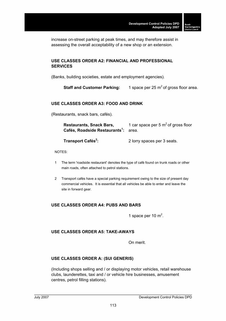
July 2007 Development Control Policies DPD
113
Development Control Policies DPDAdopted July 2007
increase on-street parking at peak times, and may therefore assist in assessing the overall acceptability of a new shop or an extension. USE CLASSES ORDER A2: FINANCIAL AND PROFESSIONAL SERVICES
(Banks, building societies, estate and employment agencies).
Staff and Customer Parking: 1 space per 25 m2 of gross floor area.
USE CLASSES ORDER A3: FOOD AND DRINK (Restaurants, snack bars, cafés).
Restaurants, Snack Bars, Cafés, Roadside Restaurants1:
1 car space per 5 m2 of gross floor area.
Transport Cafés2: 2 lorry spaces per 3 seats.
NOTES: 1 The term 'roadside restaurant' denotes the type of café found on trunk roads or other
main roads, often attached to petrol stations. 2 Transport cafés have a special parking requirement owing to the size of present day
commercial vehicles. It is essential that all vehicles be able to enter and leave the site in forward gear.
USE CLASSES ORDER A4: PUBS AND BARS
1 space per 10 m2.
USE CLASSES ORDER A5: TAKE-AWAYS
On merit.
USE CLASSES ORDER A: (SUI GENERIS) (Including shops selling and / or displaying motor vehicles, retail warehouse clubs, launderettes, taxi and / or vehicle hire businesses, amusement centres, petrol filling stations).

Development Control Policies DPD July 2007
114
Development Control Policies DPD Adopted July 2007
Staff Parking: 7 spaces per 10 employees. Car Sales, Motor Repair Garages:
1 space per 45 m2 of display area, 1 per staff, 1 per 35 m2 for motor service centre and 1 per 20 m2 retail floor area at petrol filling stations plus space for requirements of servicing.
USE CLASSES ORDER B1: BUSINESS
a) Offices not within A2 b) Research and development, studios, laboratories, high tech c) Light industry
1 space per 25 m2 of gross floor area
(under 2,500 m2). 1 space per 30 m2 of gross floor area
(over 2,500 m2).
USE CLASSES ORDER B2: GENERAL INDUSTRIAL
1 space per 50 m2 of gross floor area.
USE CLASSES ORDER B8: STORAGE OR DISTRIBUTION (Storage or distribution including wholesale warehouse, distribution centres, repositories).
1 space per 100 m2 of gross floor
area.
USE CLASSES ORDER C1: HOTELS (Including hotels, boarding and guest houses).
Parking for Guests and Staff: 13 spaces for 10 guest bedrooms.
NOTES:
1 Resident staff

July 2007 Development Control Policies DPD
115
Development Control Policies DPDAdopted July 2007
The standard relating provision to the number of guest bedrooms includes the demand generated by staff parking, whether they be resident or otherwise. In consequence, staff dwelling units within the building need not be subject to extra residential parking requirements.
2 Parking demand generated by use of bars, restaurants and function rooms by the
general public The standard quoted differs from those laid down for ordinary bars, restaurants and public rooms. It is unlikely that the peak demand from guests and staff parking will coincide with peak demands from all three of these ancillary uses. Consequently, an allowance has been made for dual use of parking areas.
13. Parking demand at hotel premises arises not only from the staff1 and
resident guests but also from use of facilities such as bars, restaurants and function rooms2 which are open to the visiting public.
USE CLASSES ORDER C2: RESIDENTIAL INSTITUTIONS (Including residential schools and colleges, hospitals and convalescent / nursing homes).
Hospitals: 1 space per 4 staff plus 1 per 3 daily
visitors. Convalescent / Nursing Homes:
1 space per residential staff plus 1 per 3 bed spaces.
14. Residential schools and colleges: to be determined by individual circumstances.
USE CLASSES ORDER C3: DWELLING HOUSES (Including dwellings, small businesses at home, communal housing of elderly and handicapped).
Dwellings: Average of 1.5 spaces per dwelling across the district (up to a maximum of 2 per 3 or more bedrooms in poorly accessible areas).
NOTE: Garages are counted as parking spaces.
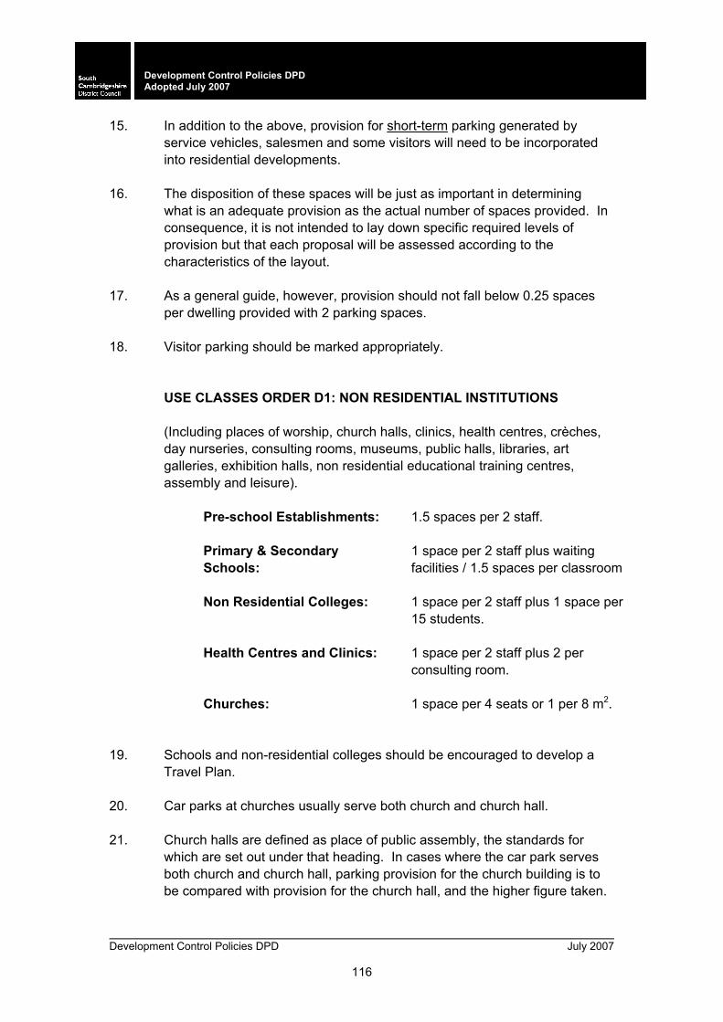
Development Control Policies DPD July 2007
116
Development Control Policies DPD Adopted July 2007
15. In addition to the above, provision for short-term parking generated by service vehicles, salesmen and some visitors will need to be incorporated into residential developments.
16. The disposition of these spaces will be just as important in determining
what is an adequate provision as the actual number of spaces provided. In consequence, it is not intended to lay down specific required levels of provision but that each proposal will be assessed according to the characteristics of the layout.
17. As a general guide, however, provision should not fall below 0.25 spaces
per dwelling provided with 2 parking spaces. 18. Visitor parking should be marked appropriately.
USE CLASSES ORDER D1: NON RESIDENTIAL INSTITUTIONS (Including places of worship, church halls, clinics, health centres, crèches, day nurseries, consulting rooms, museums, public halls, libraries, art galleries, exhibition halls, non residential educational training centres, assembly and leisure).
Pre-school Establishments: 1.5 spaces per 2 staff. Primary & Secondary Schools:
1 space per 2 staff plus waiting facilities / 1.5 spaces per classroom
Non Residential Colleges: 1 space per 2 staff plus 1 space per
15 students. Health Centres and Clinics: 1 space per 2 staff plus 2 per
consulting room. Churches: 1 space per 4 seats or 1 per 8 m2.
19. Schools and non-residential colleges should be encouraged to develop a
Travel Plan. 20. Car parks at churches usually serve both church and church hall. 21. Church halls are defined as place of public assembly, the standards for
which are set out under that heading. In cases where the car park serves both church and church hall, parking provision for the church building is to be compared with provision for the church hall, and the higher figure taken.

July 2007 Development Control Policies DPD
117
Development Control Policies DPDAdopted July 2007
In cases where the church building combines as a hall, the church hall standard is to be taken.
USE CLASSES ORDER D2: ASSEMBLY AND LEISURE (Including cinemas, music and concert halls, dance and sports halls, swimming baths, skating rinks, gymnasiums, other indoor and outdoor sports and leisure uses, bingo halls, casinos).
Places of Public Assembly: 1 space per 4 seats or 1 per 8 m2 of gross floor area.
22. The standard set out above relates to buildings such as village halls and
community centres. Applications for larger development such as dance halls and concert halls which serve a wider hinterland will be considered individually on their own merit should they arise.
Cinema / Conference: 1 space per 5 seats Leisure: 1 space per 22 m2 (over 1,000 m2).
23. The role of leisure facilities will need to be taken into consideration when
applying the above standards. Facilities serving a wider hinterland rather than a primarily local function will be considered individually on their own merit should they arise.

Development Control Policies DPD July 2007
118
Development Control Policies DPD Adopted July 2007
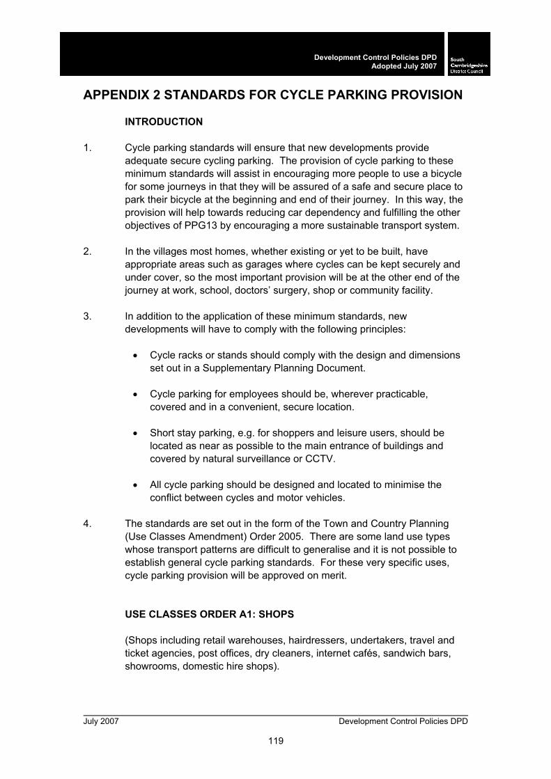
July 2007 Development Control Policies DPD
119
Development Control Policies DPDAdopted July 2007
APPENDIX 2 STANDARDS FOR CYCLE PARKING PROVISION
INTRODUCTION 1. Cycle parking standards will ensure that new developments provide
adequate secure cycling parking. The provision of cycle parking to these minimum standards will assist in encouraging more people to use a bicycle for some journeys in that they will be assured of a safe and secure place to park their bicycle at the beginning and end of their journey. In this way, the provision will help towards reducing car dependency and fulfilling the other objectives of PPG13 by encouraging a more sustainable transport system.
2. In the villages most homes, whether existing or yet to be built, have
appropriate areas such as garages where cycles can be kept securely and under cover, so the most important provision will be at the other end of the journey at work, school, doctors’ surgery, shop or community facility.
3. In addition to the application of these minimum standards, new
developments will have to comply with the following principles:
• Cycle racks or stands should comply with the design and dimensions set out in a Supplementary Planning Document.
• Cycle parking for employees should be, wherever practicable, covered and in a convenient, secure location.
• Short stay parking, e.g. for shoppers and leisure users, should be located as near as possible to the main entrance of buildings and covered by natural surveillance or CCTV.
• All cycle parking should be designed and located to minimise the conflict between cycles and motor vehicles.
4. The standards are set out in the form of the Town and Country Planning
(Use Classes Amendment) Order 2005. There are some land use types whose transport patterns are difficult to generalise and it is not possible to establish general cycle parking standards. For these very specific uses, cycle parking provision will be approved on merit.
USE CLASSES ORDER A1: SHOPS (Shops including retail warehouses, hairdressers, undertakers, travel and ticket agencies, post offices, dry cleaners, internet cafés, sandwich bars, showrooms, domestic hire shops).
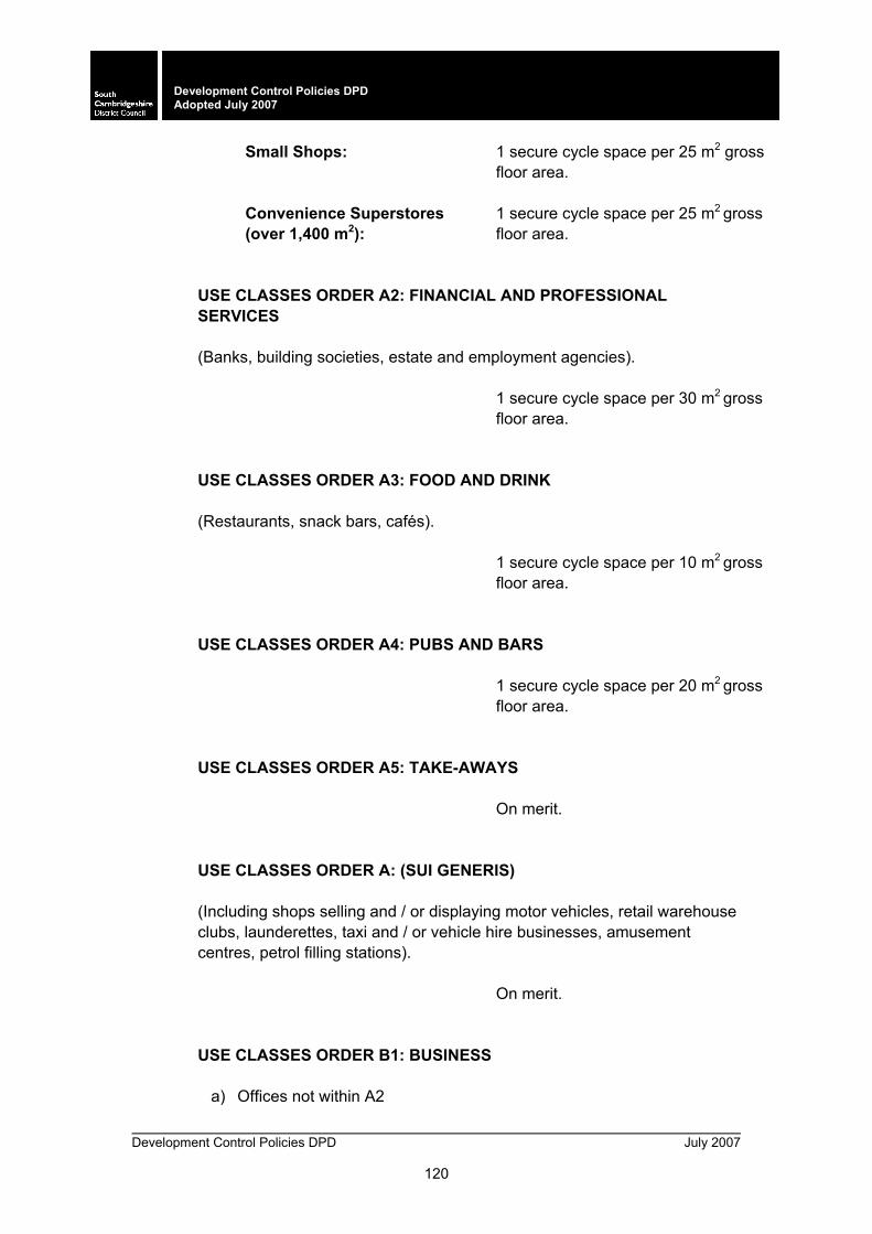
Development Control Policies DPD July 2007
120
Development Control Policies DPD Adopted July 2007
Small Shops: 1 secure cycle space per 25 m2 gross floor area.
Convenience Superstores (over 1,400 m2):
1 secure cycle space per 25 m2 gross floor area.
USE CLASSES ORDER A2: FINANCIAL AND PROFESSIONAL SERVICES (Banks, building societies, estate and employment agencies).
1 secure cycle space per 30 m2 gross floor area.
USE CLASSES ORDER A3: FOOD AND DRINK (Restaurants, snack bars, cafés).
1 secure cycle space per 10 m2 gross
floor area.
USE CLASSES ORDER A4: PUBS AND BARS
1 secure cycle space per 20 m2 gross
floor area.
USE CLASSES ORDER A5: TAKE-AWAYS
On merit.
USE CLASSES ORDER A: (SUI GENERIS) (Including shops selling and / or displaying motor vehicles, retail warehouse clubs, launderettes, taxi and / or vehicle hire businesses, amusement centres, petrol filling stations).
On merit.
USE CLASSES ORDER B1: BUSINESS
a) Offices not within A2
July 2007 Development Control Policies DPD
121
Development Control Policies DPDAdopted July 2007
b) Research and development, studios, laboratories, high tech c) Light industry
1 secure cycle space per 30 m2 gross
floor area. USE CLASSES ORDER B2: GENERAL INDUSTRIAL
1 secure cycle space per 40 m2 gross
floor area.
USE CLASSES ORDER B8: STORAGE OR DISTRIBUTION (Storage or distribution including wholesale warehouse, distribution centres, repositories).
On merit.
USE CLASSES ORDER C1: HOTELS (Including hotels, boarding and guest houses).
1 secure cycle space per 2 members
of staff working at the same time.
USE CLASSES ORDER C2: RESIDENTIAL INSTITUTIONS (Including residential schools and colleges, hospitals and convalescent / nursing homes).
1 secure cycle space per 2 members
of staff working at the same time. Hospitals will be determined according to the needs of each proposal.
USE CLASSES ORDER C3: DWELLING HOUSES (Including dwellings, small businesses at home, communal housing of elderly and handicapped).
1 secure cycle space to be provided,
Development Control Policies DPD July 2007
122
Development Control Policies DPD Adopted July 2007
Residential Dwellings: within the curtilage where possible. 5. For residential purposes cycle parking should be within a covered, lockable
enclosure. For individual houses this could be in the form of a shed or garage, and account should be had for this in their design. For flats either individual lockers or cycle stands within a lockable, covered enclosure are required.
USE CLASSES ORDER D1: NON RESIDENTIAL INSTITUTIONS (Including places of worship, church halls, clinics, health centres, crèches, day nurseries, consulting rooms, museums, public halls, libraries, art galleries, exhibition halls, non residential educational training centres, assembly and leisure).
Clinics and Surgeries: 2 secure cycle spaces per consulting
room.
Educational Establishments: Secure cycle parking at a rate of 30% for pupils over 5 years of age and at a rate of 60% for pupils over 12 years of age. In any university development, the rate shall be 100% of secure cycle parking provision for the number of students using the building at any one time.
Churches and Other Places of Assembly:
1 secure cycle space per 15 m2 of gross floor area.
Crèches and Nurseries 1 secure cycle space per 2 members
of staff working at the same time.
USE CLASSES ORDER D2: ASSEMBLY AND LEISURE (Including cinemas, music and concert halls, dance and sports halls, swimming baths, skating rinks, gymnasiums, other indoor and outdoor sports and leisure uses, bingo halls, casinos).
Sports / Recreational Facilities:
1 secure cycle space per 25 m2 of net floor area and for every 15 seats provided for spectators.
Cinemas: 1 secure cycle space per 3 seats.
July 2007 Development Control Policies DPD
123
Development Control Policies DPDAdopted July 2007
10. MONITORING
OBJECTIVE
M/a To ensure appropriate mechanisms are in place to monitor the efficient and timely delivery of the development control policies.
PLAN MONITOR MANAGE POLICY M/1 Plan Monitor Manage
1. Compliance with policies and allocations in the Local Development Framework (LDF) will be continuously monitored throughout the plan period. If, through monitoring, it appears that policies and allocations are not being met, the following mechanisms will be triggered:
a. Review of housing and employment land supply and
allocations; b. Action to bring forward sites for development, wherever
possible in partnership with landowners and developers;
c. Action to bring forward development on previously developed land;
d. Action to secure the timely provision of infrastructure;
e. Review of relevant parts of the LDF.
2. If land supply significantly exceeds estimated take-up rates,
applications may be refused, until the plan is reviewed.
10.1 Monitoring provides information on the performance of policy, the delivery of development and impacts on the environment. Monitoring will help the local planning authority assess whether its plans remain sound or whether adjustments need to be made to continue to meet the plan’s objectives. The presence of clear mechanisms for implementation and monitoring forms part of the test of soundness of the Local Development Framework.
10.2 In order to assess the effectiveness of the policies in the delivery of
development and protection of the environment, it is important that continuous monitoring and review of policies in the LDF is undertaken.
Development Control Policies DPD July 2007
124
Development Control Policies DPD Adopted July 2007
Monitoring and review will take place on an annual basis. If, as a result of monitoring and review, it appears that development is not coming forward in a sustainable or timely manner, the District Council will be proactive in using its powers to respond to changing circumstances, for example, through the use of Compulsory Purchase Orders to unlock sites, or through the review of land allocations or policies in the LDF.
10.3 Policy ST/3 of the Core Strategy DPD requires a minimum of 37% of new
dwellings in South Cambridgeshire to be built on previously developed land between 1999 and 2016. Achieving this will depend particularly on the rate and phasing of development at Cambridge East and the new town of Northstowe. The Plan Monitor Manage approach will be used to guide the phasing of development and performance against the previously developed land target. Where monitoring shows that sites are not coming forward as anticipated, other sites will be brought forward in the programme, having particular regard to the priority for previously developed land.
MONITORING INDICATORS
10.4 Every local planning authority now has to produce an Annual Monitoring Report (AMR) for submission to the Secretary of State. This forms part of the overall package of documents making up the Local Development Framework for each district.
10.5 A set of indicators has been developed specifically for monitoring the LDF,
building on guidance in the ODPM publication Annual Monitoring Reports: A Good Practice Guide. These comprise the following types of indicator:
o Output Indicators:
Core Output Indicators: these are indicators that all local authorities must monitor and they are listed in the Good Practice Guide. The Core Indicators address a number of key planning variables which fall under the topic areas of Business Development, Housing, Transport, Local Services, Minerals, Waste, Flood Protection, Biodiversity and Renewable Energy. The Core Indicators that local authorities are required to monitor are based on the existing regional Core Output Indicators that regional planning bodies are required to monitor. This reflects the need for compatibility to exist between the Annual Monitoring Reports of the regional planning body and the LDF Annual Monitoring Reports of the local authorities within that region.

July 2007 Development Control Policies DPD
125
Development Control Policies DPDAdopted July 2007
Local Indicators: these address the outputs of policies which are not covered by the Local Development Framework Core Indicators. Local Indicators provide scope for addressing issues which are of particular local importance; the Local Indicators therefore reflect local circumstances and issues that prevail in South Cambridgeshire.
o Significant Effects Indicators: these measure the significant effects
of the plan or programme. Significant Effects Indicators are drawn from the Sustainability Appraisal Scoping Report. Whereas Output Indicators are intended to measure the direct effect of a policy in terms of the extent to which it has achieved its objective, Significant Effects Indicators provide a more holistic view of the impact of a policy by allowing the examination of any unintended positive and negative effects of the policy.
o Contextual Indicators: these describe the wider social,
environmental and economic background against which local development framework policy operates.
10.6 Indicators have been developed through the LDF Monitoring Strategy 2005.
Indicators relating to the Development Control Policies DPD are included at Table 1.

Development Control Policies DPD July 2007
126
Development Control Policies DPD Adopted July 2007
July 2007 Development Control Policies DPD
127
Development Control Policies DPDAdopted July 2007
Table 1: Core and Local Output Indicators Strategic Objectives ST/a and ST/b, and Strategic Objectives ST/e-ST/k, are addressed in this table. Strategic Objectives ST/d and ST/e, which respectively relate to Northstowe and to the developments at Cambridge East and Cambridge Southern Fringe, are addressed in Tables 1a, 1b, and 1c

Development Control Policies DPD July 2007
128
Development Control Policies DPD Adopted July 2007
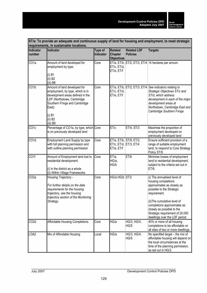
July 2007 Development Control Policies DPD
129
Development Control Policies DPDAdopted July 2007
ST/a: To provide an adequate and continuous supply of land for housing and employment, to meet strategic requirements, in sustainable locations. Indicator number
Indicator Type of Indicator
Related Chapter Objectives
Related LDF Policies
Targets
CO1a Amount of land developed for employment by type: (i) B1 (ii) B2 (iii) B8
Core ET/a, ET/b, ET/c, ET/d, ET/e, ET/f
ET/2, ET/3, ET/4 14 hectares per annum.
CO1b Amount of land developed for employment, by type, which is in development areas defined in the LDF (Northstowe, Cambridge Southern Fringe and Cambridge East): (i) B1 (ii) B2 (iii) B8
Core ET/a, ET/b, ET/c, ET/d, ET/e, ET/f
ET/2, ET/3, ET/4 See indicators relating to Strategic Objectives ST/c and ST/d, which address development in each of the major development areas at Northstowe, Cambridge East and Cambridge Southern Fringe.
CO1c Percentage of CO1a, by type, which is on previously developed land
Core ET/c ET/4, ST/3 Maximise the proportion of employment developed on previously developed land
CO1d Employment Land Supply by type with full planning permission and with outline planning permission
Core ET/a, ET/b, ET/c, ET/d, ET/e, ET/f
ST/8, ET/2, ET/3, ET/4
Ensure sufficient provision of a range of suitable employment land, to respond to Core Strategy Policy ST/8.
CO1f Amount of Employment land lost to residential development: (i) in the district as a whole (ii) Within Village Frameworks
Core ET/a, HG/a, HG/b
ET/6 Minimise losses of employment land to residential development, subject to the criteria set out in ET/6.
CO2a Housing Trajectory - For further details on the data requirements for the housing trajectory, see the housing trajectory section of the Monitoring Strategy.
Core
HG/a HG/b ST/2 (i) The annualised level of housing completions approximates as closely as possible to the Strategic requirement. (ii)The cumulative level of completions approximates as closely as possible to the Strategic requirement of 20,000 dwellings over the LDF period.
CO2d Affordable Housing Completions Core HG/a HG/3, HG/4, HG/5
40% or more of all housing completions to be affordable on all sites of two or more dwellings.
LOA2 Mix of Affordable Housing Local HG/a HG/3, HG/4, HG/5
No specified target – the mix of affordable housing will depend on the local circumstances at the time of the planning permission, as set out in HG/3.
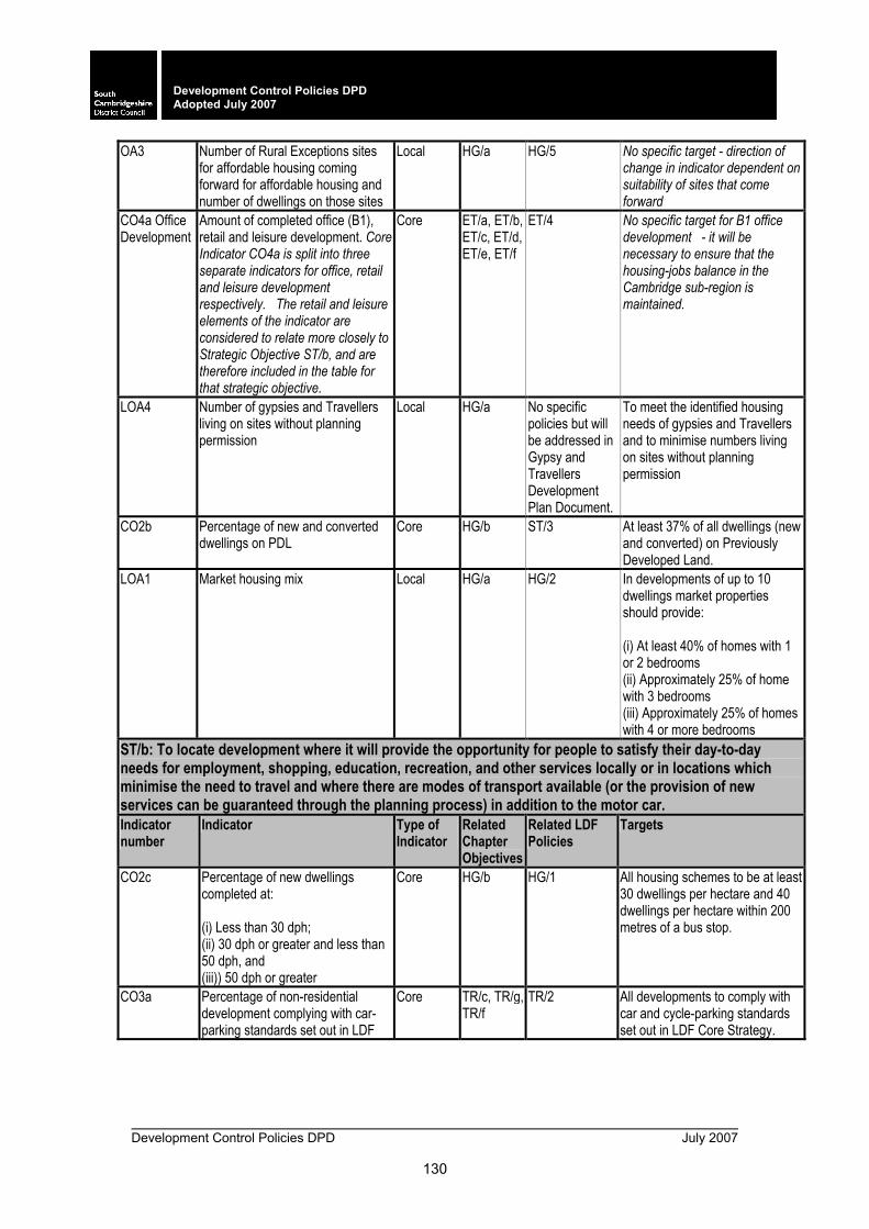
Development Control Policies DPD July 2007
130
Development Control Policies DPD Adopted July 2007
OA3 Number of Rural Exceptions sites for affordable housing coming forward for affordable housing and number of dwellings on those sites
Local HG/a HG/5 No specific target - direction of change in indicator dependent on suitability of sites that come forward
CO4a Office Development
Amount of completed office (B1), retail and leisure development. Core Indicator CO4a is split into three separate indicators for office, retail and leisure development respectively. The retail and leisure elements of the indicator are considered to relate more closely to Strategic Objective ST/b, and are therefore included in the table for that strategic objective.
Core ET/a, ET/b, ET/c, ET/d, ET/e, ET/f
ET/4 No specific target for B1 office development - it will be necessary to ensure that the housing-jobs balance in the Cambridge sub-region is maintained.
LOA4 Number of gypsies and Travellers living on sites without planning permission
Local HG/a No specific policies but will be addressed in Gypsy and Travellers Development Plan Document.
To meet the identified housing needs of gypsies and Travellers and to minimise numbers living on sites without planning permission
CO2b Percentage of new and converted dwellings on PDL
Core HG/b ST/3 At least 37% of all dwellings (new and converted) on Previously Developed Land.
LOA1 Market housing mix Local HG/a HG/2 In developments of up to 10 dwellings market properties should provide: (i) At least 40% of homes with 1 or 2 bedrooms (ii) Approximately 25% of home with 3 bedrooms (iii) Approximately 25% of homes with 4 or more bedrooms
ST/b: To locate development where it will provide the opportunity for people to satisfy their day-to-day needs for employment, shopping, education, recreation, and other services locally or in locations which minimise the need to travel and where there are modes of transport available (or the provision of new services can be guaranteed through the planning process) in addition to the motor car. Indicator number
Indicator Type of Indicator
Related Chapter Objectives
Related LDF Policies
Targets
CO2c Percentage of new dwellings completed at: (i) Less than 30 dph; (ii) 30 dph or greater and less than 50 dph, and (iii)) 50 dph or greater
Core HG/b HG/1 All housing schemes to be at least 30 dwellings per hectare and 40 dwellings per hectare within 200 metres of a bus stop.
CO3a Percentage of non-residential development complying with car-parking standards set out in LDF
Core TR/c, TR/g,TR/f
TR/2 All developments to comply with car and cycle-parking standards set out in LDF Core Strategy.
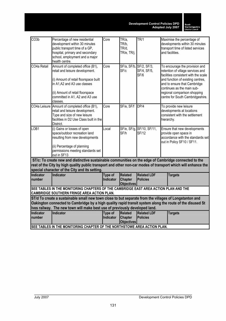
July 2007 Development Control Policies DPD
131
Development Control Policies DPDAdopted July 2007
CO3b Percentage of new residential development within 30 minutes public transport time of a GP, hospital, primary and secondary school, employment and a major health centre.
Core TR/a, TR/b, TR/d, TR/e, TR/j.
TR/1 Maximise the percentage of developments within 30 minutes transport time of listed services and facilities.
CO4a Retail Amount of completed office (B1), retail and leisure development. (i) Amount of retail floorspace built in A1,A2 and A3 use classes (ii) Amount of retail floorspace committed in A1, A2 and A3 use classes.
Core SF/a, SF/b, SF/c
SF/2, SF/3, SF/4, SF/5, SF/6
To encourage the provision and retention of village services and facilities consistent with the scale and function of existing centres, and to ensure that Cambridge continues as the main sub-regional comparison shopping centre for South Cambridgeshire.
CO4a Leisure Amount of completed office (B1), retail and leisure development. Type and size of new leisure facilities in D2 Use Class built in the District.
Core SF/e, SF/f DP/4 To provide new leisure developments at locations consistent with the settlement hierarchy.
LOB1 (i) Gains or losses of open space/outdoor recreation land resulting from new developments (ii) Percentage of planning permissions meeting standards set out in SF13
Local SF/e, SF/g, SF/h
SF/10, SF/11, SF/12
Ensure that new developments provide open space in accordance with the standards set out in Policy SF10 / SF11.
ST/c: To create new and distinctive sustainable communities on the edge of Cambridge connected to the rest of the City by high quality public transport and other non-car modes of transport which will enhance the special character of the City and its setting. Indicator number
Indicator Type of Indicator
Related Chapter Objectives
Related LDF Policies
Targets
SEE TABLES IN THE MONITORING CHAPTERS OF THE CAMBRIDGE EAST AREA ACTION PLAN AND THE CAMBRIDGE SOUTHERN FRINGE AREA ACTION PLAN. ST/d To create a sustainable small new town close to but separate from the villages of Longstanton and Oakington connected to Cambridge by a high quality rapid transit system along the route of the disused St Ives railway. The new town will make best use of previously developed land. Indicator number
Indicator Type of Indicator
Related Chapter Objectives
Related LDF Policies
Targets
SEE TABLES IN THE MONITORING CHAPTER OF THE NORTHSTOWE AREA ACTION PLAN.

Development Control Policies DPD July 2007
132
Development Control Policies DPD Adopted July 2007
ST/e To protect the varied character of the villages of South Cambridgeshire by ensuring that the scale and location of development in each village is in keeping with its size and character and that the buildings and open spaces which create their character are maintained and where possible enhanced. Indicator number
Indicator Type of Indicator
Related Chapter Objectives
Related LDF Policies
Targets
LOE1 (i) Average size of housing developments in Rural Centres, Minor Rural Centres, Group Villages and Infill Villages (ii) Largest development coming forward in Rural Centres, Minor Rural Centres, Group Villages and Infill Villages (iii) Total dwellings built by village category
Local HG/a, HG/b, CH/c
ST/4, ST/5, ST/6, ST/7
Rural Centres: None; Minor Rural Centres: Indicative maximum scheme size of 30 dwellings; Group Villages: Indicative maximum scheme size of 8 dwellings (or exceptionally up to 15 dwellings); Infill Villages: Not more than 2 dwellings (indicative size) (or exceptionally up to 8 dwellings).
LOE2 Amount of land designated as (i) Protected Village Amenity Areas and (ii) Adjacent to an Important Countryside Frontage lost to development each year
Local HG/a, HG/b, CH/c
CH/6, CH/7
Minimise the loss of land in Protected Village Amenity Areas and adjacent to Important Countryside Frontage lost to development each year.
ST/f To provide and enable provision of enhanced infrastructure to meet the needs of the expanded population. Indicator number
Indicator Type of Indicator
Related Chapter Objectives
Related LDF Policies
Targets
LOF1 Investment secured for infrastructure and community facilities through developer contributions
Local DP/b, DP/a, F/12, SF/13
DP/4 Secure appropriate provision of infrastructure for all new developments.
ST/g To ensure development addresses sustainability issues, including climate change mitigation and adaptation issues, maximising recycling and reuse of resources, and reduce waste and pollution. Indicator number
Indicator Type of Indicator
Related Chapter Objectives
Related LDF Policies
Targets
LOG1 Amount of new development completed: - on previously-undeveloped functional flood-plain land, and - in flood risk areas, without agreed flood defence measures
Local NE/a, NE/d, NE/g, NE/h, NE/I, DP/c
NE/11 NE/13
No new completed development to be at risk from flooding.
CO9 Renewable Energy Capacity installed by type
Core NE/a, NE/d, NE/g, NE/h, NE/I, DP/c
NE/2 Maximise overall provision of renewable energy capacity.
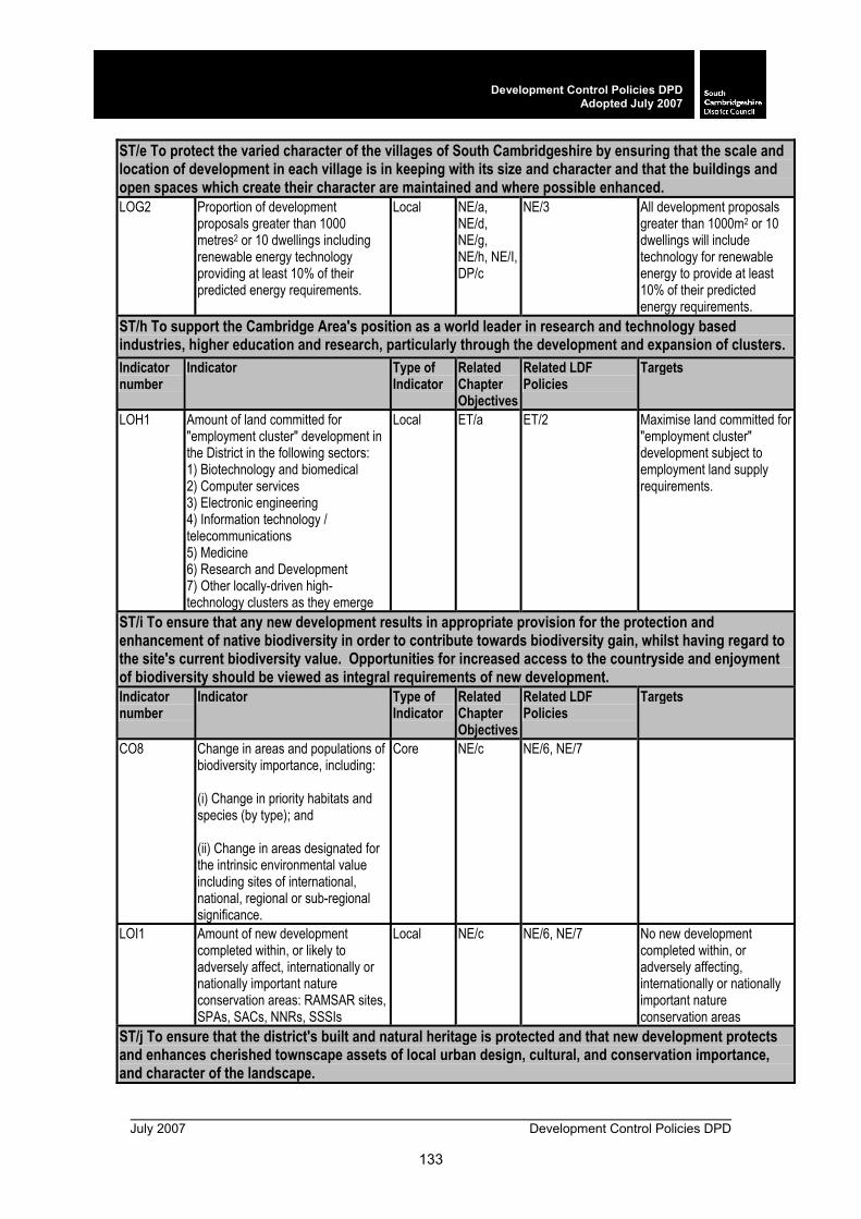
July 2007 Development Control Policies DPD
133
Development Control Policies DPDAdopted July 2007
ST/e To protect the varied character of the villages of South Cambridgeshire by ensuring that the scale and location of development in each village is in keeping with its size and character and that the buildings and open spaces which create their character are maintained and where possible enhanced. LOG2 Proportion of development
proposals greater than 1000 metres2 or 10 dwellings including renewable energy technology providing at least 10% of their predicted energy requirements.
Local NE/a, NE/d, NE/g, NE/h, NE/I, DP/c
NE/3 All development proposals greater than 1000m2 or 10 dwellings will include technology for renewable energy to provide at least 10% of their predicted energy requirements.
ST/h To support the Cambridge Area's position as a world leader in research and technology based industries, higher education and research, particularly through the development and expansion of clusters. Indicator number
Indicator Type of Indicator
Related Chapter Objectives
Related LDF Policies
Targets
LOH1 Amount of land committed for "employment cluster" development in the District in the following sectors: 1) Biotechnology and biomedical 2) Computer services 3) Electronic engineering 4) Information technology / telecommunications 5) Medicine 6) Research and Development 7) Other locally-driven high-technology clusters as they emerge
Local ET/a ET/2 Maximise land committed for "employment cluster" development subject to employment land supply requirements.
ST/i To ensure that any new development results in appropriate provision for the protection and enhancement of native biodiversity in order to contribute towards biodiversity gain, whilst having regard to the site's current biodiversity value. Opportunities for increased access to the countryside and enjoyment of biodiversity should be viewed as integral requirements of new development. Indicator number
Indicator Type of Indicator
Related Chapter Objectives
Related LDF Policies
Targets
CO8 Change in areas and populations of biodiversity importance, including: (i) Change in priority habitats and species (by type); and (ii) Change in areas designated for the intrinsic environmental value including sites of international, national, regional or sub-regional significance.
Core NE/c NE/6, NE/7
LOI1 Amount of new development completed within, or likely to adversely affect, internationally or nationally important nature conservation areas: RAMSAR sites, SPAs, SACs, NNRs, SSSIs
Local NE/c NE/6, NE/7 No new development completed within, or adversely affecting, internationally or nationally important nature conservation areas
ST/j To ensure that the district's built and natural heritage is protected and that new development protects and enhances cherished townscape assets of local urban design, cultural, and conservation importance, and character of the landscape.
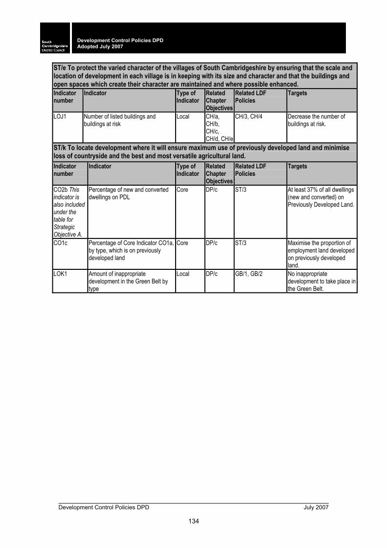
Development Control Policies DPD July 2007
134
Development Control Policies DPD Adopted July 2007
ST/e To protect the varied character of the villages of South Cambridgeshire by ensuring that the scale and location of development in each village is in keeping with its size and character and that the buildings and open spaces which create their character are maintained and where possible enhanced. Indicator number
Indicator Type of Indicator
Related Chapter Objectives
Related LDF Policies
Targets
LOJ1 Number of listed buildings and buildings at risk
Local CH/a, CH/b, CH/c, CH/d, CH/e
CH/3, CH/4 Decrease the number of buildings at risk.
ST/k To locate development where it will ensure maximum use of previously developed land and minimise loss of countryside and the best and most versatile agricultural land. Indicator number
Indicator Type of Indicator
Related Chapter Objectives
Related LDF Policies
Targets
CO2b This indicator is also included under the table for Strategic Objective A.
Percentage of new and converted dwellings on PDL
Core DP/c ST/3 At least 37% of all dwellings (new and converted) on Previously Developed Land.
CO1c Percentage of Core Indicator CO1a, by type, which is on previously developed land
Core DP/c ST/3 Maximise the proportion of employment land developed on previously developed land.
LOK1 Amount of inappropriate development in the Green Belt by type
Local DP/c GB/1, GB/2 No inappropriate development to take place in the Green Belt.
July 2007 Development Control Policies DPD
135
Development Control Policies DPDAdopted July 2007
GLOSSARY OF TERMS
Above Ordnance Datum The Ordnance Datum is the mean sea level at Newlyn in Cornwall calculated between 1915 and 1921, taken as a reference point for the height data on Ordnance Survey maps.
Affordable Housing A wide variety of types and tenures of housing where the common feature is that it is subsidised in some way to make it affordable to those who cannot afford a home on the open market.
AMR Annual Monitoring Report An annual report monitoring the LDF’s performance against a number of national and local indicators.
AAP Area Action Plan A Development Plan Document setting out policy and proposals for a specific area.
Biodiversity Biodiversity is a term used to describe the richness of the living environment around us. It is the variety of life in all its forms, including richness of species, complexity of ecosystems and genetic variation.
BAP Biodiversity Action Plan Encouraging a wide range of fauna and flora in a locality.
Biophysical Biophysics is an interdisciplinary field which applies techniques from the physical sciences to understanding biological structure and function. The subject lies at the borders of biology, physics, chemistry, mathematics, engineering, genetics, physiology and medicine.
Biotechnology The application of science and engineering to the direct or indirect use of living organisms, or parts or products of living organisms, in their natural or modified forms.
Brownfield land Previously developed land (PDL) which is or was occupied by a permanent structure (excluding agricultural or forestry buildings), and associated with fixed surface infrastructure. The definition covers the curtilage of development. Previously developed land can occur in both urban and rural settings. The precise definition can be found in PPS3.
Development Control Policies DPD July 2007
136
Development Control Policies DPD Adopted July 2007
Building Regulations Building Regulations ensure the health and
safety of people in and around buildings by providing functional requirements for building design and construction. They also promote energy efficiency in buildings and contribute to meeting the needs of disabled people. Builders and developers are required by law to obtain building control approval - an independent check that the Building Regulations have been complied with. There are two types of building control providers - the Local Authority and Approved Inspectors.
BIS Bus Information Strategy Part of the Local Transport Plan. Cambridge Area The area covered by Cambridge City Council
and South Cambridgeshire District Council. Cambridgeshire and
Peterborough Structure Plan Statutory plan that sets out broad development requirements in the County to 2016 (Prepared by the County Council).
CGB Cambridgeshire Guided Busway
Proposed bus-based Rapid Transit System to operate along the former St. Ives railway line. See Rapid Transit System.
Cambridgeshire Horizons Cambridgeshire Horizons is the local delivery vehicle established by the Cambridgeshire local authorities to drive forward the development of new communities and infrastructure in the Cambridge Sub-Region in a sustainable way, in accordance with the approved planning policies.
Cambridge Sub-Region Comprises Cambridge, South Cambridgeshire and the Market Towns.
Car Pooling Shared use of a car(s) by a group of people. CiWS City Wildlife Site
Sites designated of particular local importance for nature conservation by Cambridge City Council and the Wildlife Trust.
Climate Proofing Climate proofing aims to ensure buildings and associated infrastructure are capable of enduring the future impacts of climate change, for example minimising risk of flooding, minimising risk of subsidence, installing water saving measures and devices, and using materials that have low / zero CO2 and green house gas emissions.
July 2007 Development Control Policies DPD
137
Development Control Policies DPDAdopted July 2007
Cluster Clusters are defined as concentrations of
companies in related activities, specialised suppliers, service providers and institutions, which are co-operating, collaborating and competing to build competitive advantage often across sector boundaries (EEDA Regional Economic Strategy 2001). Clusters may be concentrated in a particular location or linked locations.
CPZ Controlled Parking Zone An area in which special parking controls are applied.
Community facilities Facilities, which help meet the varied needs of the residents for health, educational and public services as well as social, cultural and religious activities.
Community Strategy Strategy for promoting the economic, environmental and social well-being of the area and contributing to the achievement of District Wide sustainable development.
Comparison shopping Goods that are purchased occasionally and for longer term use, such as electrical goods, clothing, household goods, books, jewellery, furniture etc. which consumers will compare before making a choice.
Concept Plan Shows in diagrammatic form the structure and the distribution of the main land uses and their inter-relationships within the new development.
Conservation Area Areas identified by the Council, which have ‘special architectural or historic interest', which makes them worth protecting and improving.
Conservation Area Appraisals
Produced by the Council covering various Conservation Areas within the district. The appraisals define the special character and evolve guidelines for development and enhancement schemes.
Considerate Contractors Scheme
Requires that all contractors, sub contractors, suppliers and others working on a project minimise disturbance on neighbouring uses.
Convenience shopping Goods that are purchased regularly and for immediate consumption, such as foods, drink, groceries, confectionary, tobacco, newspapers for which convenience is a prime consideration.
Core Strategy An element of planning policy within the LDF.
Development Control Policies DPD July 2007
138
Development Control Policies DPD Adopted July 2007
Countryside Enhancement
Areas Areas that have potential for undisturbed enjoyment of the countryside and for their landscapes and habitats to be significantly enhanced.
Country Park An area of countryside which is landscaped and managed for informal recreation and includes some visitor facilities such as car parking, toilets and an interpretation centre.
CWS County Wildlife Site Sites identified as being of particular local importance for nature conservation at county, rather than at national level.
Definitive Map A legal record of the public's rights of way. The maps are produced by the Local Authority (Cambridgeshire County Council). Note there may be additional rights over land, which have not yet been recorded on the map or there may be rights, which are incorrectly recorded on the map.
Design and Access Statement
A statement submitted alongside a planning application by the applicant to demonstrate that:
• proper consideration has been given to the impact of the proposal and account taken of all relevant factors in the design and landscaping of the scheme
• development will be accessible to everybody regardless of age, gender or disability.
Design Code Will guide the nature, scale and form of new development.
Design Guide Identifies the particular character of an area and sets out the general principles for good design.
Development Brief Describes how proposals for a site will be implemented.
Development Framework Line on the Proposals Map defining where policies for the built-up areas of settlements give way to policies for the countryside.
DPD Development Plan Document
Statutory document having been through Independent Examination.
dph Dwellings per hectare 30 dph is the national indicative minimum, as set out in PPS3: Housing.
EEDA East of England Development Agency
EERA East of England Regional Assembly
EA Environment Agency

July 2007 Development Control Policies DPD
139
Development Control Policies DPDAdopted July 2007
EIA Environmental Impact
Assessment Considers the potential environmental effects of land use change, enabling decisions on land use change to be taken with full knowledge of the likely environmental consequences.
EiP Examination in Public Inquiry led by an independent Planning Inspector into proposals for and objections to LDDs.
Farm diversification Where a farm diversifies into non-agricultural activities.
FRA Flood Risk Assessment An assessment of impact of development on flooding, including the run-off implications of proposals.
Flood Zones Zones identified by the Environment Agency to indicate the risk of flooding.
GPDO General Permitted Development Order
Provides permitted development rights which allow certain types of development to proceed without the need for a planning application.
Good local public transport service
Minimum service frequencies of every 30 minutes during the day, hourly in the evenings and on Saturdays. Every 2 hours or better on Sundays.
GO-East
Government Office for the Eastern Region
Grampian condition Planning condition restricting development unless and until an event had occurred which was not within the power of the applicant to bring about. (Grampian Regional Council v. Aberdeen DC (1984) JPL 590 H.L).
Green Belt A statutory designation made for the purposes of: checking the unrestricted sprawl of large built-up areas, preventing neighbouring towns from merging into each other, assisting in safeguarding the countryside from encroachment, preserving the setting and special character of historic towns and assisting in urban regeneration by encouraging the recycling of derelict and other urban land.
Green Corridor Areas of open land which penetrate into an urban area for amenity and recreation.
Green Fingers As Green Corridors, but on a smaller scale. Green Separation An area of open land required to keep apart two
separate communities and maintain their individual identities.
Greenfield land Land which has not previously been developed or which has returned to greenfield status over time.

Development Control Policies DPD July 2007
140
Development Control Policies DPD Adopted July 2007
Greenhouse Gases Carbon Dioxide and other emissions, causing
global warming. Greywater The mildly polluted wastewater from shower /
bath, washbasin and washing machine. HIA Health Impact Assessment An assessment of the impact of the proposed
development on health and identifies actions that can enhance positive effects and reduce or eliminate negative effects.
HSA Health and Safety Executive The Health and Safety Executive is responsible for health and safety regulation in Great Britain.
High Quality Agricultural Land
Land designated as Grades 1, 2 and 3a on the Agricultural Land Classification maps produced by Department for Environment, Food and Rural Affairs.
HQPT High Quality Public Transport
Generally service frequencies of at least a 10 minutes peak / 20 minutes inter-peak. Weekday evening frequencies of ½ hourly until 11pm, Saturday ½ hourly 7am - 6pm, then hourly and Sunday hourly 8am - 11pm. Also provides high quality low floor / easy access buses, air conditioning, prepaid / electronic ticketing, Real Time information and branding to encourage patronage.
Home Zone Roads / neighbourhoods that are designed not just to allow the passage of motor vehicles, but so that all road users, pedestrians and cyclists as well as drivers can share the road space. Streets will be safer, greener, friendlier and more attractive, encouraging both social interaction and child's play to be part of the normal use of the street.
Housing Association Sometimes referred to as a Registered Social Landlord; a non profit making organisation which provides housing for people in need.
HNS Housing Needs Survey Assessment of housing needs across the whole district.
Housing Trajectory Assessments showing past, and estimating future, housing performance. They should consider past rates of housing completions and conversions and projected completions and conversions to the end of the specified framework period or ten years from the adoption of the relevant development plan document.
July 2007 Development Control Policies DPD
141
Development Control Policies DPDAdopted July 2007
Important Countryside
Frontages Land with a strong countryside character that penetrates or sweeps into the villages or separates two parts of the built-up area. Such land enhances the setting, character and appearance of the village by retaining the sense of connection between the village and its rural origins and surroundings.
Infrastructure Basic structure of systems such as utilities (gas, electricity, water) drainage, flood defences, transportation, roads, healthcare, education and other community facilities.
Infrastructure Partnership Responsible for co-ordination of the delivery of housing and infrastructure across the Cambridge Sub-Region. See: Cambridgeshire Horizons
Intermediate housing Housing for those who do not qualify for social rented housing, but whose incomes are such in relation to local housing costs that they are nonetheless not able to access market housing. This includes intermediate rented and low cost home ownership.
Intermediate rented housing Rents are not to exceed 30% of net median household incomes in Cambridge and South Cambridgeshire taken as a whole except where provided for specific groups of workers, where they should not exceed 30% of the net median income for the specific group.
Key Diagram Illustrates the broad strategy for the area in a diagrammatic format.
Key Worker Housing Discounted market housing targeted at specific groups, including teachers, nurses and others whose role relates to the care and comfort of the community or sustaining the local economy, and who are unable to meet their housing needs on the open market.
Landscape Character Assessment
Assessment of the landscapes, wildlife and natural features into distinct Landscape Character Areas.
Landscape Statement A statement submitted alongside a planning application by the applicant to demonstrate that they have properly considered the impact of their proposal on the particular site and surroundings.
Legible A legible place is one whose landmarks or pathways are easily identified; a place that can be easily understood and which people can navigate simply and safely.
Development Control Policies DPD July 2007
142
Development Control Policies DPD Adopted July 2007
Lifetime mobility standard /
lifetime homes Developed by the Joseph Rowntree Foundation to provide dwellings that cater for the needs of residents throughout their lifetime, including the possibility of impaired mobility. These standards exceed the requirements of the Building Regulations.
Listed Building A building or structure of special architectural or historic interest and included in a list, approved by the Secretary of State. The owner must get Listed Building Consent to carry out alterations, which would affect its character.
LAP Local Area for Play A small area of unsupervised open space specifically designated for young children for play activities close to where they live. The target user is mainly for 4-6 year olds, although they can attract other children in slightly older and younger age groups.
LAPC Local Authority Pollution Control
LAPPC Local Authority Pollution Prevention and Control
Local Centre Smaller scale than a District Centre, and includes a primary school, provides for the day-to day shopping needs of local residents for convenience shopping and service provision, and small-scale local employment.
LDD Local Development Document
Development Plan Documents (DPDs) and Supplementary Planning Documents (SPDs).
LDF Local Development Framework
A “folder” containing LDDs, LDS, SCI etc.
LDS Local Development Scheme Sets out the LDDs to be produced over the next 3 years.
LEAP Local Equipped Area for Play
Mainly for accompanied children from 4 to 8 although consideration is given to the needs of supervised children from 4 years, and unaccompanied children older than 8.
LNR Local Nature Reserve Reserves with wildlife or geological features that are of special interests locally.
LPA Local Planning Authority e.g. South Cambridgeshire District Council. LSP Local Strategic Partnership Public service providers, local communities,
voluntary, public and private sectors co-ordinate improvements in public services to achieve sustainable economic, social and physical regeneration.
LTP Local Transport Plan Sets out transport strategy for Cambridgeshire.

July 2007 Development Control Policies DPD
143
Development Control Policies DPDAdopted July 2007
Long Term Transport
Strategy Sets out the longer term transport strategy for Cambridgeshire to 2021.
Low cost home ownership Including shared ownership, equity share, and discounted market housing. Costs (mortgage and any rent) are not to exceed 30% of gross median household incomes in Cambridge and South Cambridgeshire taken as a whole except where provided for specific groups of workers, where they should not exceed 30% of the gross median household income for that specific group.
Material consideration Something, which should be taken into account when making planning decisions such as determining planning applications.
MOD Ministry of Defence Mixed-use development Development comprising two or more uses as
part of the same scheme. This could apply at a variety of scales from individual buildings to an urban extension. Mixed-use development can help create vitality and diversity and can help to reduce the need to travel, which is more sustainable.
Monitoring Strategy Sets out how the LDF will be monitored against a number of indicators.
MUGA Multi-Use Games Area Used for ball rebound sports such as tennis, netball, basketball, and five-a-side football, hockey, lacrosse and general sports, training and play depending upon the surface material.
NNR National Nature Reserve Protect the important areas of wildlife habitat and geological formations.
Natural Areas Natural Areas are identified by a unique combination of physical attributes such as geology, plant and animal species, land-use and culture.
NEAP Neighbourhood Equipped Area for Play
Unsupervised site servicing a substantial residential area, equipped mainly for older children but with opportunities for play for younger children. Equipment will be similar to that of LEAP's but on a larger scale and may well include facilities for teenagers.
Open Space Standards The amount of open space required as part of new development.
Parish Plan A vision of how a town or village should be, addressing social, economic or environmental issues.
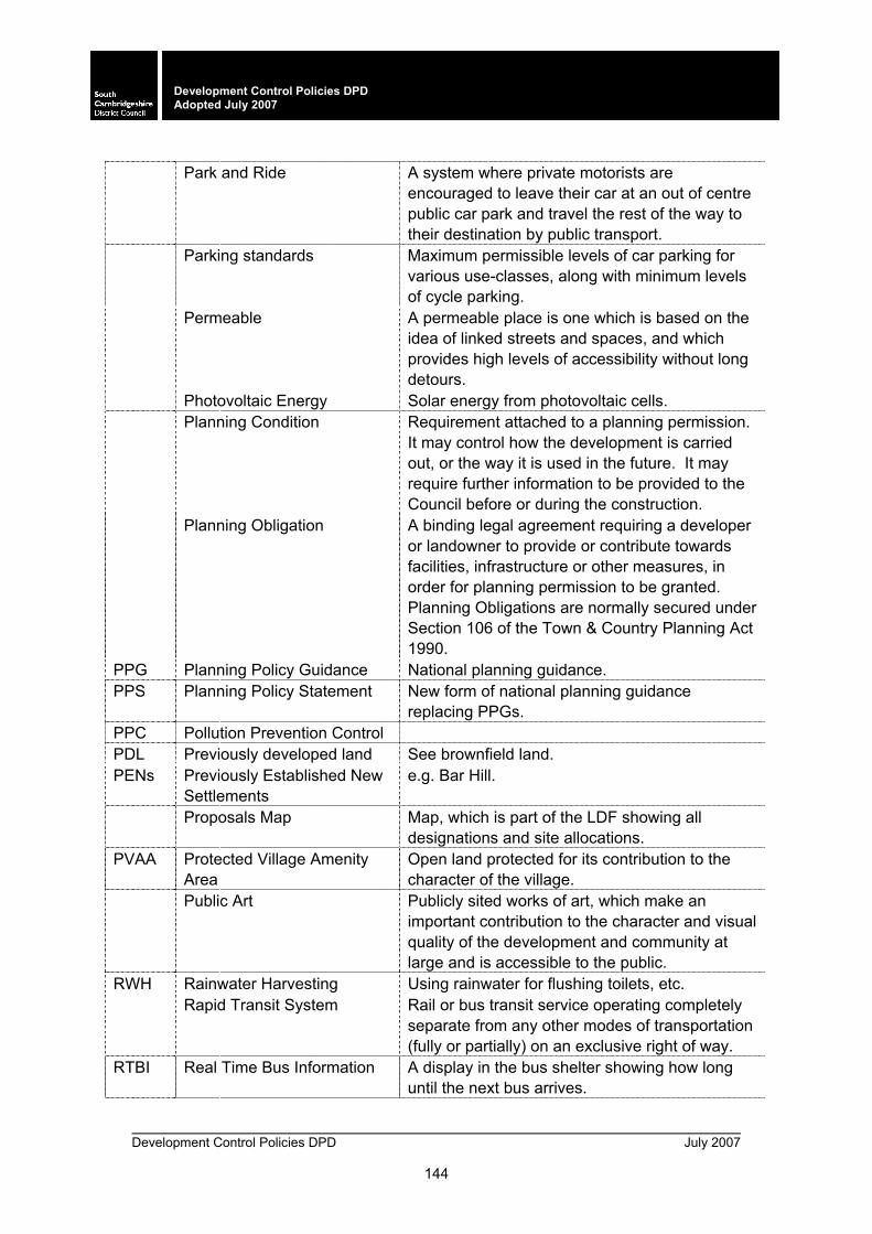
Development Control Policies DPD July 2007
144
Development Control Policies DPD Adopted July 2007
Park and Ride A system where private motorists are
encouraged to leave their car at an out of centre public car park and travel the rest of the way to their destination by public transport.
Parking standards Maximum permissible levels of car parking for various use-classes, along with minimum levels of cycle parking.
Permeable A permeable place is one which is based on the idea of linked streets and spaces, and which provides high levels of accessibility without long detours.
Photovoltaic Energy Solar energy from photovoltaic cells. Planning Condition Requirement attached to a planning permission.
It may control how the development is carried out, or the way it is used in the future. It may require further information to be provided to the Council before or during the construction.
Planning Obligation A binding legal agreement requiring a developer or landowner to provide or contribute towards facilities, infrastructure or other measures, in order for planning permission to be granted. Planning Obligations are normally secured under Section 106 of the Town & Country Planning Act 1990.
PPG Planning Policy Guidance National planning guidance. PPS Planning Policy Statement New form of national planning guidance
replacing PPGs. PPC Pollution Prevention Control PDL Previously developed land See brownfield land. PENs Previously Established New
Settlements e.g. Bar Hill.
Proposals Map Map, which is part of the LDF showing all designations and site allocations.
PVAA Protected Village Amenity Area
Open land protected for its contribution to the character of the village.
Public Art Publicly sited works of art, which make an important contribution to the character and visual quality of the development and community at large and is accessible to the public.
RWH Rainwater Harvesting Using rainwater for flushing toilets, etc. Rapid Transit System Rail or bus transit service operating completely
separate from any other modes of transportation (fully or partially) on an exclusive right of way.
RTBI Real Time Bus Information A display in the bus shelter showing how long until the next bus arrives.
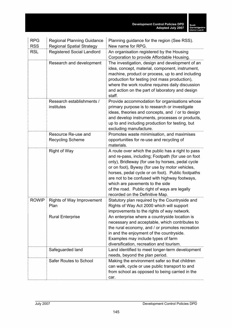
July 2007 Development Control Policies DPD
145
Development Control Policies DPDAdopted July 2007
RPG Regional Planning Guidance Planning guidance for the region (See RSS). RSS Regional Spatial Strategy New name for RPG. RSL Registered Social Landlord An organisation registered by the Housing
Corporation to provide Affordable Housing. Research and development The investigation, design and development of an
idea, concept, material, component, instrument, machine, product or process, up to and including production for testing (not mass production), where the work routine requires daily discussion and action on the part of laboratory and design staff.
Research establishments / institutes
Provide accommodation for organisations whose primary purpose is to research or investigate ideas, theories and concepts, and / or to design and develop instruments, processes or products, up to and including production for testing, but excluding manufacture.
Resource Re-use and Recycling Scheme
Promotes waste minimisation, and maximises opportunities for re-use and recycling of materials.
Right of Way A route over which the public has a right to pass and re-pass, including; Footpath (for use on foot only), Bridleway (for use by horses, pedal cycle or on foot), Byway (for use by motor vehicles, horses, pedal cycle or on foot). Public footpaths are not to be confused with highway footways, which are pavements to the side of the road. Public right of ways are legally recorded on the Definitive Map.
ROWIP Rights of Way Improvement Plan
Statutory plan required by the Countryside and Rights of Way Act 2000 which will support improvements to the rights of way network.
Rural Enterprise An enterprise where a countryside location is necessary and acceptable, which contributes to the rural economy, and / or promotes recreation in and the enjoyment of the countryside. Examples may include types of farm diversification, recreation and tourism.
Safeguarded land Land identified to meet longer-term development needs, beyond the plan period.
Safer Routes to School Making the environment safer so that children can walk, cycle or use public transport to and from school as opposed to being carried in the car.

Development Control Policies DPD July 2007
146
Development Control Policies DPD Adopted July 2007
Scheduled Ancient
Monument Archaeological sites, buried deposits or structures of national importance by virtue of their historic, architectural, traditional or archaeological interest.
S106 Section 106 Planning agreements that secure contributions (in cash or in kind) to the infrastructure and services necessary to facilitate proposed developments.
Sequential approach A sequential approach to site selection and the planning of development encouraging a more sustainable pattern of living, with much of the development concentrated into and on the edge of Cambridge and at a new town.
SSSI Site of Special Scientific Interest
Designated site of national importance to wildlife and / or geology.
Social rented housing Housing provided at below market rents at levels controlled by the Housing Corporation, normally provided by Registered Social Landlords (Housing Associations).
SIP Space for Imaginative Play Spatial Masterplan Describes how proposals for a site will be
implemented. The level of detail required in a spatial masterplan will vary according to the scale at which the masterplan is produced.
SAC Special Areas of Conservation
Designated site of international importance to wildlife and / or geology.
SPA Special Protection Areas Designated site of international importance to wildlife and / or geology.
SAP Standard Assessment Procedure
Assessment procedure for energy rating of dwellings.
SCI Statement of Community Involvement
Shows how the wider community and stakeholders are to be involved in the process of producing a LDF.
SEA Strategic Environmental Assessment
Integration of environmental considerations into the preparation and adoption of plans, promoting sustainable development.
Sui-generis Those uses not allocated to a particular Use Class. See Use Class Order.
SPD Supplementary Planning Document
Informal policy which has been the subject of public participation (the new name for SPG).
SPG Supplementary Planning Guidance
See SPD.
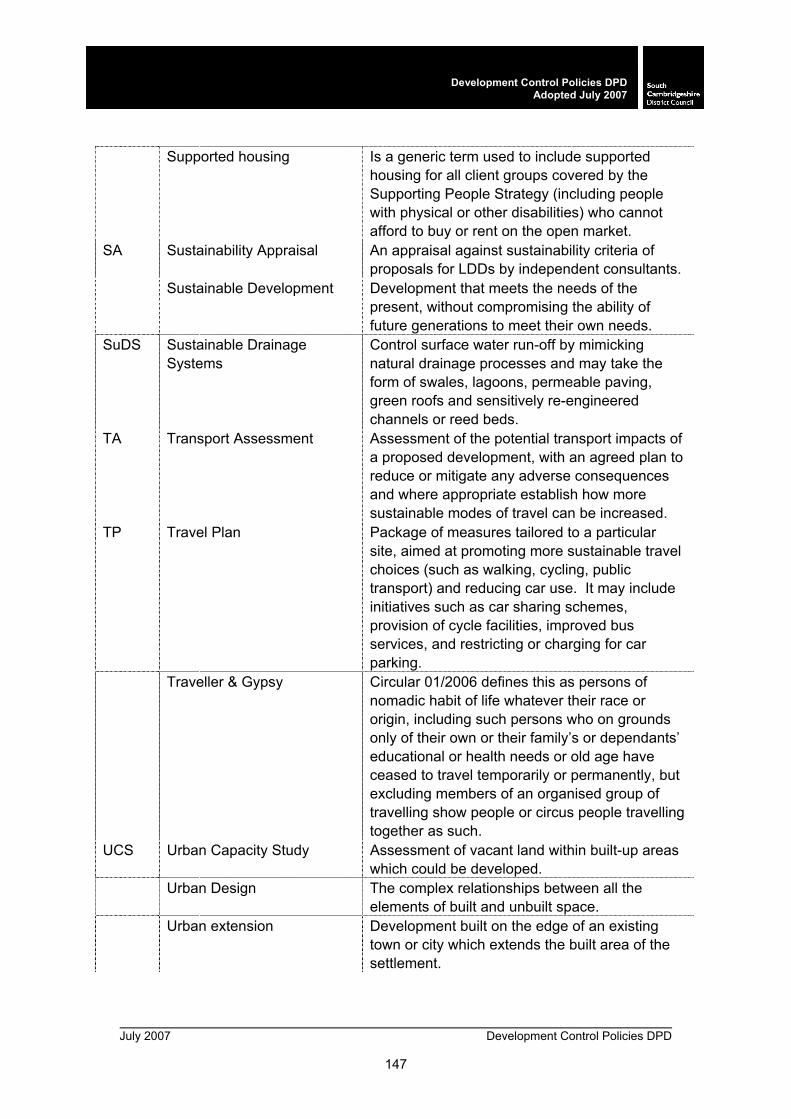
July 2007 Development Control Policies DPD
147
Development Control Policies DPDAdopted July 2007
Supported housing Is a generic term used to include supported
housing for all client groups covered by the Supporting People Strategy (including people with physical or other disabilities) who cannot afford to buy or rent on the open market.
SA Sustainability Appraisal An appraisal against sustainability criteria of proposals for LDDs by independent consultants.
Sustainable Development Development that meets the needs of the present, without compromising the ability of future generations to meet their own needs.
SuDS Sustainable Drainage Systems
Control surface water run-off by mimicking natural drainage processes and may take the form of swales, lagoons, permeable paving, green roofs and sensitively re-engineered channels or reed beds.
TA Transport Assessment Assessment of the potential transport impacts of a proposed development, with an agreed plan to reduce or mitigate any adverse consequences and where appropriate establish how more sustainable modes of travel can be increased.
TP Travel Plan Package of measures tailored to a particular site, aimed at promoting more sustainable travel choices (such as walking, cycling, public transport) and reducing car use. It may include initiatives such as car sharing schemes, provision of cycle facilities, improved bus services, and restricting or charging for car parking.
Traveller & Gypsy Circular 01/2006 defines this as persons of nomadic habit of life whatever their race or origin, including such persons who on grounds only of their own or their family’s or dependants’ educational or health needs or old age have ceased to travel temporarily or permanently, but excluding members of an organised group of travelling show people or circus people travelling together as such.
UCS Urban Capacity Study Assessment of vacant land within built-up areas which could be developed.
Urban Design The complex relationships between all the elements of built and unbuilt space.
Urban extension Development built on the edge of an existing town or city which extends the built area of the settlement.
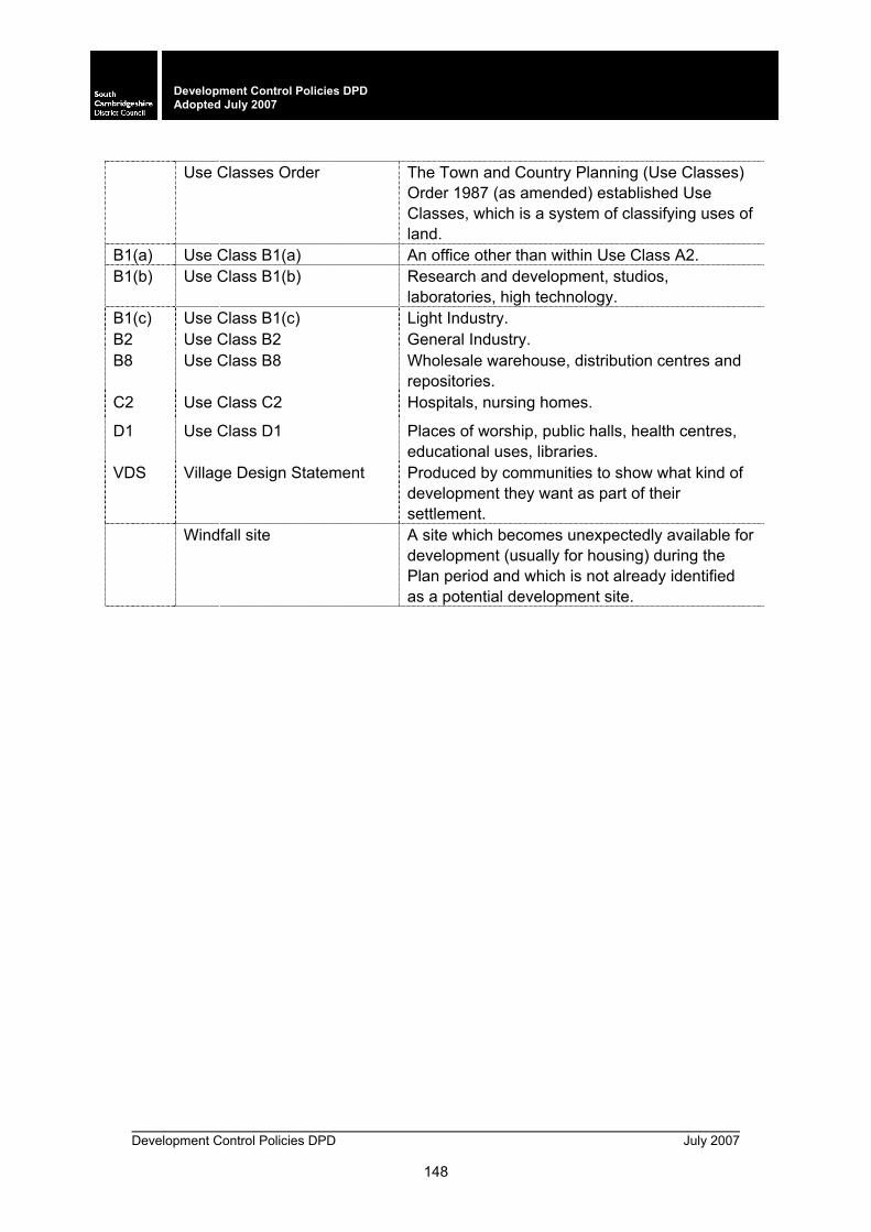
Development Control Policies DPD July 2007
148
Development Control Policies DPD Adopted July 2007
Use Classes Order The Town and Country Planning (Use Classes)
Order 1987 (as amended) established Use Classes, which is a system of classifying uses of land.
B1(a) Use Class B1(a) An office other than within Use Class A2. B1(b) Use Class B1(b) Research and development, studios,
laboratories, high technology. B1(c) Use Class B1(c) Light Industry. B2 Use Class B2 General Industry. B8 Use Class B8 Wholesale warehouse, distribution centres and
repositories. C2 Use Class C2 Hospitals, nursing homes.
D1 Use Class D1 Places of worship, public halls, health centres, educational uses, libraries.
VDS Village Design Statement Produced by communities to show what kind of development they want as part of their settlement.
Windfall site A site which becomes unexpectedly available for development (usually for housing) during the Plan period and which is not already identified as a potential development site.
