local development framework development policies · local development framework development...
TRANSCRIPT
Local Development Framework
Development Policies
A new vision for developing Wakefield District
www.wakefield.gov.uk/ldf

InformationThe Development Policies Development Plan Document and its accompanying Sustainability Appraisal are available to viewand download on the Council’s web-site at: www.wakefield.gov.uk/ldf. Copies are also available to view at main libraries. If youwould like to talk to a planning officer working on the Local Development Framework about any aspect of this document pleasecontact the Spatial Policy Group on (01924) 306417 or 306495.
If you would like an extract or summary of this document on cassette, in large type, in Braille or any other format,please call the Spatial Group Policy on (01924) 306495.
Yorkshire Planning Aid provides a free, independent and professional planning advice service to individuals and groups fromwithin the Yorkshire and Humber region who cannot afford professional fees. The organisation may be able to assist groupsand individuals who would like support and advice in order to get involved in this consultation process. Contact the RegionalCo-ordinator on 0113 204 2462, email [email protected] for further information.
Wakefield Metropolitan District Local Development Framework - Adopted 15 April 2009
Development Policies
Wakefield Metropolitan District Local Development Framework - Adopted 15 April 2009
Development Policies
21 Introduction & Explanation
2The Local Development Framework
2Core Strategy and Development Policies Development Plan Documents
62 Conformity
6Conformity to National, Regional and Local Policy
83 Meeting Local Needs in Sustainable Locations
8Housing Density
9Housing in Rural Areas
11Windfall Housing
12Safeguarded Land
144 Creating Mixed & Balanced Communities
14Affordable Housing
15Types of Housing
15Accommodation for Gypsies, Travellers and Travelling Showpeople
185 Supporting a Dynamic & Efficient Local Economy
18Protecting Employment Land
20Sustaining the Rural Economy
226 Creating High Quality, Distinctive & Safe Environments
22Nature Conservation
25Wildlife Habitat Network
27Trees
29Landscape Character
30Design
34Landscape Design
35Open Space
36Access and Highway Safety
37Safety and Security
38Advertisements & Shopfront Design
39Telecommunications
40Archaeology
41Development Affecting Historic Locations
42Listed Buildings
43Buildings of Local Interest
Wakefield Metropolitan District Local Development Framework - Adopted 15 April 2009
Development Policies
Pollution Control 44
46Hazardous Operations
47Contaminated Land
48Green Belt
49Existing Uses in the Green Belt
50Major Developed Sites in the Green Belt
527 Tackling Climate Change & Resource Management
52Flood Risk
54Drainage
56Protection of Agricultural Land
57Renewable Energy
59Sustainable Construction and Efficient Use of Resources
60Mineral Extraction
628 Delivery & Monitoring
Appendices
741 Replaced Unitary Development Plan Policies
782 Glossary of Terms
Wakefield Metropolitan District Local Development Framework - Adopted 15 April 2009
Development Policies
Introduction & Explanation
1Wakefield Metropolitan District Local Development Framework - Adopted 15 April 2009
Development Policies
1 Introduction & Explanation
The Local Development Framework
1.1 The Council is introducing a new type of plan, known as the Local Development Framework (LDF), to guide the use ofland and new development throughout the district. It is being prepared under government legislation for developmentplans (1) and is replacing the Unitary Development Plan First Alteration (UDP) which was adopted in January 2003.
1.2 The LDF includes strategies, policies and proposals for the development and use of land in the district for the period to2026. It is closely linked to Wakefield District Partnership’s Community Strategy (2),addressing issues which relate toland use and development in different places, with the overall intention of making the district a more attractive andprosperous place to live.
1.3 The LDF conforms to the Regional Spatial Strategy (RSS) which now forms part of Wakefield's development plan.
Core Strategy and Development Policies Development Plan Documents
Local Development Framework Documents
1.4 Whereas the UDP is a single plan, the LDF is made up of a number of separate documents produced at different times.The LDF should be read as a whole and decisions about future development must have due regard to all its relevantparts. The Core Strategy and Development Policies documents contain all the strategic elements of the LDF and mostof the development policies relating to specific topics. A separate Site Specific Proposals document will include detailsof proposed land allocations and designations and will be accompanied by a Proposals Map. Further documents will beproduced covering topics for which there are no detailed policies in this document, such as the Waste document.
1.5 The Core Strategy document is the over-arching strategic policy document of the LDF and all other LDF documentsmust be in general conformity with it. The Core Strategy:
sets out the context within which the LDF is being prepared, including the issues facing the district;defines the spatial vision for Wakefield district to 2026;sets out a series of objectives designed to achieve the vision;identifies five themes to provide focus and link the objectives to the development strategy and policies;includes a spatial development strategy embracing all five themes to meet the objectives and accommodatenew development, including that needed to deliver the Community Strategy;includes strategic policies, grouped under the five themes, to guide and control the overall scale, type and locationof new development and investment which will enable the vision, objectives and strategy to be achieved; andincludes a statement of the number of additional dwellings to be provided in the district.
1.6 The Development Policies document sets out policies which will be used, in conjunction with the strategic policies inthe Core Strategy, when determining planning applications to manage and guide specific types of development in differentlocations to deliver sustainable communities.
PurposeReferencesWhere found
in thedocument
Subject
Gives a summary of the LDF process and background to theDevelopment Policies documentChapter 1Introduction & Explanation
1 The Planning and Compulsory Purchase Act 20042 Developing Knowledge Communities, March 2007
Wakefield Metropolitan District Local Development Framework - Adopted 15 April 20092
Development Policies
PurposeReferencesWhere found
in thedocument
Subject
Sets out the policy context of the Development PoliciesdocumentChapter 2Conformity to National, Regional
& Local Policy
Sets out detailed Development Policies which translate thevision, objectives, strategy and development principles intocourses of action for different types of activity
PoliciesD1-D28
Chapters 3 -7Development Policies
Sets out how the policies will be monitoredChapter 8Delivery & Monitoring
Table 1 Contents of the Development Policies Document
How does the Development Policies document fit into the Local Development Framework?
1.7 The following diagram shows how this document relates to the strategies which influence its content and its relationshipto other parts of the LDF:
Figure 1 Relationship of the Development Policies document to other documents
How does the Development Policies document relate to the Unitary Development Plan?
1.8 Eventually, the LDF will replace the UDP as part of the statutory development plan for Wakefield District. However, untilall the new LDF documents are in place, some parts of the UDP will be ‘saved’ to ensure comprehensive planning policycoverage remains in place. Saved parts of the UDP remain in force and will be used in the determination of planningapplications until replaced. Details of which policies and proposals in the UDP are saved after 27 September 2007 arereferred to in the latest Local Development Scheme and are listed in the Direction issued by the Secretary of State (3).Appendix 1 sets out which UDP policies are being replaced by new policies in this document.
3 Direction under paragraph 1(3) of Schedule 8 to the Planning and Compulsory Purchase Act 2004
3Wakefield Metropolitan District Local Development Framework - Adopted 15 April 2009
Development Policies

Wakefield Metropolitan District Local Development Framework - Adopted 15 April 20094
Development Policies
Conformity
5Wakefield Metropolitan District Local Development Framework - Adopted 15 April 2009
Development Policies
2 Conformity
Conformity to National, Regional and Local Policy
2.1 The national policy context for the preparation of Wakefield’s LDF is provided by government planning policy statementsand guidance. There are also many strategies and policy statements at regional, district and local level that the LDFtakes into account and which in turn the LDF influences. Two of these are of key significance, the Regional SpatialStrategy (RSS) and Wakefield’s Community Strategy.
Conformity
2.2 Together, these provide a clear framework for the LDF’s core strategy, policies and proposals. The LDFmust take accountof national planning policy, must be in general conformity with RSS and has to demonstrate clear links with the CommunityStrategy. In turn, the LDF is an important means by which these higher level strategies and policies are implemented.The Regional Planning Body has confirmed that this document is in general conformity with the RSS. (4)
2.3 The Development Policies document themes reflect the Core Strategy objectives which link to the Community Strategy,the core approach in RSS and the government’s five guiding principles for sustainable development. This demonstratesthat the Development Policies document is clearly rooted in the Core Strategy and conforms to higher level strategiesand objectives.
4 Required under Section 24 of the Planning and Compulsory Purchase Act 2004
Wakefield Metropolitan District Local Development Framework - Adopted 15 April 20096
Development Policies

Meeting Local Needs in Sustainable Locations
7Wakefield Metropolitan District Local Development Framework - Adopted 15 April 2009
Development Policies
3 Meeting Local Needs in Sustainable Locations3.1 The framework for meeting local needs in sustainable locations is set out under Theme 1 of the Core Strategy. The
following policies are particularly relevant:
CS1 Location of Development
CS2 Retail and Town Centres
CS3 The Scale and Distribution of Additional Housing
CS4 Sustainable Transport
3.2 The underlying principle in national and regional policy is to deliver sustainable development. Key to this approach is toguide and influence the location and scale of housing within easy access to services and to ensure that it is accessibleby public transport, cycling and walking. The policies grouped under this theme provide the broad spatial framework tomeeting local needs in sustainable locations. This section contains information and policies which address:
housing density;rural housing;development on windfall sites;ensuring land is safeguarded for future development.
Housing Density
3.3 RSS policy sees raising urban density as one means of combating climate change and reducing greenhouse gasemissions. Policy CS1 of the Core Strategy sets out the the broad policy framework for delivering the spatial developmentstrategy for Wakefield District based around the settlement hierarchy which defines urban areas, local service centresand villages in the district. Policy CS3 sets out the requirement for housing within the district, its scale, distribution anddensity.
3.4 National planning policy on density standards is set out in Planning Policy Statement 3: Housing. The national indicativeminimum net density is 30 dwellings per hectare, though a range of minimum densities is advocated, depending particularlyon the accessibility of the location to public transport. All proposals for residential development should achieve a minimumdensity of 30 dwellings per hectare. There may be local circumstances where site characteristics and other constraintslimit what can be achieved on site in terms of density. In these circumstances a lower density may be acceptable andthis will need to be justified.
3.5 Higher densities of at least 40 dwellings per hectare will be expected in the urban areas of Wakefield, Castleford andPontefract, with a minimum of 50 dwellings per hectare in Wakefield city centre and Castleford and Pontefract towncentres. Higher densities can be achieved by developing apartments however these will only be appropriate within urbanareas and local service centres.
Wakefield Metropolitan District Local Development Framework - Adopted 15 April 20098
Development Policies
Housing in Rural Areas
Policy D 1
Housing in Rural Areas
1. In small settlements not within the Green Belt housing proposals shall be limited to meet identified local needs whereit comprises of:
a. closing a small gap in an otherwise built-up frontage to an existing road; orb. the redevelopment or sub-division of an existing residential curtilage; orc. the sub-division of an existing dwelling; ord. the change of use or redevelopment of a non-residential building where this would not result in a loss of local
employment or service provision.
Development proposals must fall wholly within the confines of the settlement. In very exceptional cases a slightlylarger development may be permitted if this would lead to the sustainable recycling of a brownfield site bringingpositive overall benefit to the settlement.
2. Within the infill boundary of Green Belt settlements shown on the Proposals Maps housing proposals shall be limitedto meet identified local needs comprising of:
a. closing a small gap in an otherwise built-up frontage to an existing road; orb. the sub-division or replacement of an existing dwelling; orc. the change of use of a non-residential building where this would not result in a loss of local employment or
service provision.
The development must fall wholly within the confines of the infill boundary.
3. Elsewhere within the Green Belt housing development will only be acceptable where it involves the change of useof a rural building or the subdivision or replacement of an existing dwelling. Proposals shall be limited to meetidentified local needs.
Policy Justification
Small Settlements excluded from the Green Belt
3.6 Principles governing the location and distribution of housing are set out in policy CS3 of the Core Strategy. Most newhousing is focused on the district’s urban areas, though smaller amounts of housing are acceptable in local servicecentres and villages. There are also a number of settlements and groups of buildings in the district which are not withinthe Green Belt but are too small to be classed as villages. The development strategy aims to limit the scale of new housingin these places within the confines of each settlement. Core Strategy spatial objective 3(c) aims for limited housingdevelopment to take place in rural settlements to meet identified local needs or maintain the viability of local services.The development strategy therefore allows for limited infill in small settlements not within the Green Belt to meet localhousing needs. The following settlements fall into this category:
Ackton, FeatherstoneBottomboat, WakefieldGreat Cliff, CrigglestoneKirkthorpeNewmillerdamNew Sharlston
9Wakefield Metropolitan District Local Development Framework - Adopted 15 April 2009
Development Policies
Bleakley, NottonOakenshaw, CroftonStanley Ferry, WakefieldWoolley Colliery
Small Settlements in the Green Belt
3.7 In the Green Belt new housing normally constitutes inappropriate development unless it is for agricultural, forestry andother rural occupational dwellings. However, within established settlements in the Green Belt small infill housingdevelopments which do not adversely affect the openness of the Green Belt may be acceptable. Development must takeplace within the settlement infill boundaries which are shown on the Proposals Maps.
Carr GateChapelthorpeEast HardwickMidgleyNorth ElmsallOld SnydaleWarmfieldWentbridgeWragby
3.8 Planning Policy Guidance 2: Green Belts provides national planning guidance on limited infilling in identified smallsettlements in the Green Belt and advises that the re-use of buildings in the Green Belt is not inappropriate providingcertain criteria are met.
3.9 Occasionally there may be circumstances where housing development may be permitted as an exception to normalpolicy considerations in order to provide affordable housing to meet an identified local need. Proposals will be consideredon their individual circumstances in accordance with national policy.
Elsewhere in the Green Belt
3.10 Outside established settlements housing development will only be acceptable in the Green Belt where it involves thechange of use of a rural building or the subdivision of an existing dwelling. In line with policy CS3, when proposing thechange of use of a non-residential building to residential use in smaller settlements, developers will need to demonstratethat alternative employment and community uses have been properly considered before conversion for residential use.
Delivery & Implementation
3.11 This policy will be implemented by ensuring that proposals for residential development in rural areas meet its requirements.The number of dwellings built in small settlements and elsewhere in rural areas will be recorded as part of the overallmonitoring of house-building in the district. The results will be reported in the Annual Monitoring Report.
Replaced UDP Policy
3.12 This policy replaces policy OL16 in the Wakefield UDP.
Wakefield Metropolitan District Local Development Framework - Adopted 15 April 200910
Development Policies
Windfall Housing
3.13 Windfall housing is that which takes place on land which is not allocated specifically for housing in the LDF. It usuallyrepresents a sustainable option for the reuse of previously developed land and buildings within urban areas, especiallywhere the reuse of redundant or surplus employment land or buildings is involved. A significant proportion of all the newhouse-building in the district in recent years has been on windfall sites and with the emphasis in the spatial developmentstrategy on housing within urban areas and local service centres, it is anticipated that levels of windfall housing onbrownfield land will continue to be high.
3.14 However, it is necessary to consider the needs of other land uses and activities as well as housing to maintain balancedcommunities and there is some concern about the increasing loss of unallocated former employment land to housing.
3.15 Proposals for housing on greenfield windfall sites will usually not be acceptable, but there are circumstances when thiscan represent a sustainable option. Where there is a danger that the housing requirement for the district or a settlementwill not be met or a particular housing need can not be met because of a shortage of previously developed land and agreenfield site has no amenity value and is currently underused, the use of the site for housing could represent sustainabledevelopment.
3.16 Planning Policy Statement 3 advises that where a windfall proposal is sustainable, it will make effective use of land andis in line with the housing and wider objectives of the plan, planning permission for housing should be granted.
11Wakefield Metropolitan District Local Development Framework - Adopted 15 April 2009
Development Policies
Safeguarded Land
Policy D 2
Safeguarded Land
Areas of safeguarded land have been identified on the edge of settlements which may be suitable to meet longer termdevelopment needs for housing or employment land. Within these areas shown as Protected Areas of Search for LongTerm Development on the Proposals Maps, development will be restricted to that which is necessary for the operation ofexisting uses together with such temporary uses that would not prejudice the possibility of long term development.
Policy Justification
3.17 The Council's policy on safeguarded land is set out in section 9 of the Core Strategy. This safeguarded land is designatedas Protected Areas of Search for Long Term Development and will be identified on the Proposals Maps.
3.18 Land covered by the Protected Areas of Search designation should not automatically be regarded as long-term developmentland. Future reviews of LDF documents may reconsider the suitability of safeguarded land but in themeantime developmentwill be restricted to that which is necessary for the operation of existing uses, or to such temporary uses as would notprejudice longer term development needs.
3.19 Planning Policy Guidance 2: Green Belts sets out national planning policy guidance on identifying and controllingdevelopment on safeguarded land to reflect the broad scale and location of anticipated development beyond the planperiod and secure the long term stability of Green Belt boundaries. The possible need to identify additional safeguardedland in the district will be considered in the Site Specific Proposals document in accordance with RSS policy and nationalplanning guidance.
Delivery & Implementation
3.20 This policy will be implemented by ensuring that proposals for development on safeguarded land meet its requirements.The loss of safeguarded land to permanent development will be monitored and the results will be reported in the AnnualMonitoring Report.
Replaced UDP Policy
3.21 This policy replaces policy OL4 in the Wakefield UDP.
Wakefield Metropolitan District Local Development Framework - Adopted 15 April 200912
Development Policies
Creating Mixed & Balanced Communities
13Wakefield Metropolitan District Local Development Framework - Adopted 15 April 2009
Development Policies
4 Creating Mixed & Balanced Communities4.1 The framework for creating mixed and balanced communities is set out under Theme 2 of the Core Strategy. The following
policies are particularly relevant:
CS5 Community Facilities and Services
CS6 Housing Mix, Affordability and Quality
CS7 Accommodation for Gypsies, Travellers and Travelling Showpeople
4.2 This section outlines how housing will be developed that is affordable and meets the needs of people from all sectionsof the community.
Affordable Housing
4.3 The context for the provision of affordable housing in the district is set out in the Core Strategy. Policy CS6 outlines theneed to develop and maintain a varied mix of housing in terms of type, size, tenure and affordability. This section givesmore details of particular types of accommodation the Council will expect developers to take into consideration whendesigning their proposals.
4.4 Affordable housing is defined in Planning Policy Statement 3 which also sets out the circumstances in which affordablehousing will be required where it is viable to do so and the approach to seeking developer contributions. Developersshould also refer to the Councils Developer Contributions Supplementary Planning Document. Affordable housing shouldnormally be provided on the application site so that it contributes towards creating mixed communities. However, thereare occasions where a financial contribution in lieu of on-site provision may be preferred. Wakefield's proposals for theprovision of affordable housing follow national planning policy guidance.
4.5 The Councils Strategic Housing Market Assessment together with housing needs surveys set out the requirements foraffordable housing within the district. This will include the need for affordable housing in both urban and rural settlements.
Rural Exception Sites
4.6 In the smallest settlements, housing development falling within the scope of policies CS3(e & f), and D1 will normally belimited to infill to meet identified local need. Planning Policy Statement 3 allows local planning authorities to grant planningpermission on small sites within or adjoining existing settlements which would not normally be released for market housing,as an exception to normal policies. Priority will be given to previously developed land and sites within settlements beforegreenfield sites. The need for affordable housing to be provided as an exception should be established by means of alocal needs assessment undertaken in consultation with the local community and agreed with the Council and shouldcontribute to creating sustainable rural communities. Suitable sites should be identified based on the locational principlesset out in policy CS1.
Wakefield Metropolitan District Local Development Framework - Adopted 15 April 200914
Development Policies
Types of Housing
4.7 Planning Policy Statement 3 and RSS aim to ensure that a wide choice of housing types is available and sustainable,inclusive, mixed communities in all areas. Planning Policy Statement 1 promotes the creation of socially inclusivecommunities, including suitable mixes of housing. Developers should consider the needs of everyone in the community.Where there is a particular requirement for special types of dwelling these should be integrated into schemes for residentialor mixed development. Policy CS6 of the Core Strategy sets out criteria to provide dwellings which will meet all types ofneed in the district, that are constructed to appropriate standards.
4.8 The Code for Sustainable Homes was introduced in April 2007. It is a voluntary national standard designed to improvethe sustainability of new homes by setting a framework within which homes can be designed and constructed to higherenvironmental standards. Minimum standards for compliance have been set above the requirements of BuildingRegulations. From May 2008 onwards mandatory ratings against the code were introduced. The Council will encouragedevelopment to meet Level 3 Current Best Practice or above.
4.9 The Building Regulations require that all new dwellings are constructed to mobility standards, having regard to thecharacteristics of each site. New dwellings should also be built to or easily be adaptable to lifetime standards. Lifetimehomes incorporate features which make the dwellings easily adaptable to changing family needs and enable everyoneto live independently. The Council advises developers to discuss development proposals with the Council's SustainableCommunities Service and recommends consulting a specialist in this field, such as the Joseph Rowntree Foundation. (5)
Accommodation for Gypsies, Travellers and Travelling Showpeople
4.10 The government’s approach to providing for the needs of gypsies, travellers and travelling showpeople is set out in ODPMCircular 01/06 and DCLG Circular 04/07. RSS policy on the provision of sites for gypsies and travellers states thatadditional provision is needed within the region and points to the need for local assessments to establish the scale ofneed. Policy CS7 of the Core Strategy sets out criteria for assessing the suitability of sites which are proposed to meetfuture or unexpected demand on the provision of accommodation for gypsies, travellers and travelling show people. Ifsub-regional or local assessments indicate a need for additional provision in Wakefield District, sites will be identified inthe Site Specific Proposals document.
5 Lifetime Homes Standards, Joseph Rowntree Foundation. See website - www.jrf.org.uk/housingandcare/lifetimehomes/
15Wakefield Metropolitan District Local Development Framework - Adopted 15 April 2009
Development Policies

Wakefield Metropolitan District Local Development Framework - Adopted 15 April 200916
Development Policies

Supporting a Dynamic & Efficient Local Economy
17Wakefield Metropolitan District Local Development Framework - Adopted 15 April 2009
Development Policies
5 Supporting a Dynamic & Efficient Local Economy5.1 The framework for supporting a dynamic and efficient local economy is set out under Theme 3 of the Core Strategy. The
overall approach to economic development, supporting the rural economy, farm diversification and tourism relateddevelopment, including themain locational principles are considered under this theme. The following policies are particularlyrelevant:
CS8 The Local Economy
CS9 Transport Network
5.2 This section sets out policy for protecting employment land and the local economy within the district.
Protecting Employment Land
Policy D 3
Protecting Employment Land
The districts most sustainable and valued employment areas are identified as Employment Zones which are shown onthe Proposals Maps shall continue to be occupied primarily by employment uses. Proposals for development orre-development for employment uses in these zones will generally be supported. Non-employment uses will be permittedwhere:
1. It can be demonstrated that:
a. alternative employment sites are available in the locality which are suitable in terms of quality and quantity soas not to prejudice opportunities for local employment uses;
b. where a site is in use suitable alternative provision has been made to accommodate any existing occupiersof the site or premises;
c. where a site or premises are not in use appropriate marketing shows that the site or premises are not indemand for employment use;
2. In each case the following criteria are met:
a. existing neighbouring uses are not restricted by the introduction of new uses and the amenities of the newoccupiers are not compromised by existing neighbouring uses; and
b. the proposal would not result in environmental, amenity or traffic problems; andc. the zone retains a mix of uses including a proportion which generates employment.
3. General retailing will not be permitted on land allocated for employment use.
Policy Justification
5.3 Achieving the district's economic objectives depends on protecting and enhancing existing employment sites as well ason creating new opportunities. The Existing Employment Areas paragraphs in the Local Economy section of the CoreStrategy seeks to protect the district's most sustainable and valued employment areas that are designated as EmploymentZones by applying policies to favour employment use in these areas.
5.4 Most of these zones are close to city and town centres and provide job opportunities close to where people live. Theyare a valuable source of employment land and buildings and an important location for small businesses and industries,especially those just starting up or growing. In some of these zones, there are strong redevelopment pressures for otheruses, notably residential. In order to maintain a reasonable balance between jobs and homes, and reduce the need totravel, key existing employment locations should be offered a degree of protection.
Wakefield Metropolitan District Local Development Framework - Adopted 15 April 200918
Development Policies
5.5 All Employment Zones have been reviewed to ensure their continuing suitability for employment use and a number ofnew zones are proposed. Details of proposed changes are in the Site Specific Proposals document and the zones areidentified on the accompanying Proposals Maps. This policy is designed to protect existing employment within EmploymentZones from redevelopment for other uses, unless specific requirements are met. Until new Proposals Maps are adopted,this policy will apply to Employment Zones in the UDP.
5.6 Government guidance (6) confirms that land and buildings allocated in development plans for industrial and commercialuse should be reviewed and consideration given to whether housing would be a more appropriate use. This approachis supported by RSS policy which provides the context for the review of employment allocations and zones undertakenduring preparation of the LDF.
5.7 However, RSS policy on safeguarding employment land notes that LDF’s should define criteria or areas where it isconsidered necessary to protect designated employment sites because of high levels of competing demand from otherland uses. The sites support the RSS core approach and a review of employment land has been carried out in accordancewith RSS policies. This policy has been drawn up in the light of this guidance and reflects the need to protect EmploymentZones within the district.
Other Land in Employment Use
5.8 Around the district there are a number of sites in employment use which do not have any specific notation in the LDF.They contribute to the sustainability of the settlements in which they are located by providing jobs and reducing the needto travel. It is expected that these sites should retain their existing use, or conform to the predominant use of the surroundingarea. Proposals for development, re-development and change of use which affect employment areas without specificnotation will be considered on merit, having due regard to the LDF policies and supporting statements, particularly thoserelating to sustainability. Whilst the re-use of brownfield land for housing is a high national priority this has to be balancedagainst sustaining settlements and local jobs, particularly in small rural settlements with limited employment opportunities(see policy D1).
Delivery & Implementation
5.9 This policy will be implemented by proactively managing development through planning applications and related planningprocesses for non-employment uses in Employment Zones. The effectiveness of the policy will be assessed by monitoringthe following which will be reported in the Annual Monitoring Report:
1. the loss of vacant land in Employment Zones;2. amount of land in Employment Zones lost to residential development;3. the loss of non-allocated employment land to residential development.
Replaced UDP Policy
5.10 This policy replaces policy I5 in the Wakefield UDP.
6 Planning Policy Statement 3: Housing, DCLG, 2006 and Employment Land Reviews: Guidance Note, ODPM, 2004
19Wakefield Metropolitan District Local Development Framework - Adopted 15 April 2009
Development Policies
Sustaining the Rural Economy
5.11 Policy CS8 in the Core Strategy is designed to deliver a dynamic local economy, including the rural economy. The RuralEconomy section of the Core Strategy explains the aim of supporting the rural economy and establishes the principlesgoverning the location of employment development in rural areas in line with the spatial development strategy.
5.12 One of the ways of supporting the rural economy is to encourage the continuation of agriculture as the most appropriateuse for most of the rural areas. However, the 2001 Census found that only 1,055 people in the district were employed inagriculture. Maintaining existing businesses and supporting new businesses which do not rely on agriculture is, therefore,important to sustain the viability of smaller settlements. This includes, where appropriate, supporting farm diversificationschemes, equine related activities and developments which provide facilities for tourists.
5.13 A careful balance will need to be achieved in supporting proposals that assist the economic sustainability of localcommunities whilst addressing any potential environmental consequences. All of the open countryside and many villageswithin the district are in the Green Belt. It is recognised that in promoting the economic diversification of rural areas abalance has to be struck between protecting the openness of land in the Green Belt and supporting different types ofactivity.
5.14 RSS policy on the rural economy promotes rural diversification, giving priority to the re-use of existing buildings, andessential development connected with agriculture and forestry, while focusing most rural employment development inlocal service centres. Where the re-use of existing buildings is proposed in villages and rural areas, priority will be givento employment and community uses before residential conversions.
5.15 There are also a number of employment sites in the rural areas of the district which do not have any specific designationand are expected to remain in their current use for the life of the LDF. These areas help to maintain a healthy and diverselocal economy and a supply of jobs close to where people live. The Council will support the rural economy by enablingemployment development and the expansion of existing firms at a scale which is appropriate to the location. Developmentproposals will need to comply with other LDF policies, particularly Green Belt policy and those dealing with the impactof development on the countryside and landscape character.
Wakefield Metropolitan District Local Development Framework - Adopted 15 April 200920
Development Policies

Creating High Quality, Distinctive & Safe Environments
21Wakefield Metropolitan District Local Development Framework - Adopted 15 April 2009
Development Policies
6 Creating High Quality, Distinctive & Safe Environments6.1 The framework for creating high quality, distinctive and safe environments is set out under Theme 4 of the Core Strategy.
The following policies are particularly relevant:
CS10 Design, Safety and Environmental Quality
CS11 Leisure, Recreation and Open Space
CS12 Green Belt
6.2 The quality and condition of the environment has a direct impact on the quality of life. Policies on design, safety,conservation and control of pollution help maintain and improve the local environment and prevent development whichcould have detrimental effects on environmental quality. The provision of open space and protection of the Green Beltalso make an important contribution to creating high quality environments. This section contains more detailed policieswhich address:
the impact of development on the landscape and protection of the countryside;promotion of biodiversity, conservation and enhancement of wildlife species and habitats;the need to improve the built and natural environment through good quality design, landscaping, access andprotection of open space;safety & security and measures to tackle crime;the preservation and enhancement of historic buildings and the archaeological heritage;prevention of pollution to protect public health and the environment.
Nature Conservation
Policy D 4
Sites Designated for Biological or Geological Conservation
Within the district are a number of sites designated for biological or geological conservation of international, national,regional and local importance. Where the Council considers that any designated site or any species of principal importancefor conservation may be affected by a development proposal, an ecological assessment to be required to be submittedwith the planning application.
1. Development that is likely to have either a direct or indirect adverse affect on a nationally designated site will onlypermitted if it can clearly be demonstrated that exceptional reasons of public interest for development clearly outweighany impact on its features of ecological importance and on the national network of designated sites. The developmentmust further the conservation and enhancement of the site.
2. Development that is likely to have either a direct or indirect adverse affect on a regional or locally designated sitewill only be permitted if it can clearly be demonstrated that:
a. development cannot reasonably be located on an alternative site; andb. reasons of public interest for development clearly outweigh its features of ecological importance; andc. the need for development clearly outweighs any harm which may be caused to the ecological or geological
conservation value of the site; andd. harm can be reduced to acceptable limits; ande. positive environmental mitigation measures can be implemented either on site or in a suitable alternative
location.
3. Where development is permitted the Council will require developers to:
Wakefield Metropolitan District Local Development Framework - Adopted 15 April 200922
Development Policies
a. minimise disturbance;b. protect and enhance the site’s ecological value;c. ensure appropriate management;d. ensure appropriate mitigation measures are designed into the proposal and work on the site does not commence
until these measures are in place;e. work to approved methods; andf. create new or replacement habitats equal to or above the current ecological value of the site if damage or loss
is unavoidable.
Policy Justification
6.3 Sites designated for biological and geological conservation within Wakefield District will be identified as:
International and European Designation: Special Areas of ConservationNational Designation: Sites of Special Scientific InterestRegional and Local Designations: Regionally Important Geological Sites, Sites of Scientific Interest, Local NatureReserves, Ancient Woodland and Wakefield Nature Areas.
These designated sites will be shown on the Proposals Maps. Developers should refer to Planning Policy Statement 9where they are proposing development which may directly or indirectly affect any of these Designated Sites.
6.4 The LDF does not contain specific protection policies for International and European Designations as they are protectedby law. Reference should be made to Planning Policy Statement 9: Biodiversity and Geological Conservation (paragraph6), and ODPM/Defra Circulars 06/2005 & 01/2005 Biodiversity and Geological Conservation – Statutory Obligations andtheir Impact within the Planning System. Development is not permitted unless imperative reasons of overriding publicinterest exist which are sufficient to override the harm to the ecological importance of the designation. Where proposalsfor development may affect an International or European designated wildlife site developers are required to demonstratethat there will not be any adverse impacts on the integrity of the site. If this is not demonstrated to the Council's satisfactionplanning permission will not be granted. Developers should refer to the Circular where they are proposing developmentwhich may directly or indirectly affect an Internationally Designated site.
6.5 The Council has designatedWakefield Nature Areas which are sites of local wildlife value containing habitats and speciesidentified in the The Wakefield District Local Biodiversity Report. Some of these are candidate Local Nature Reserves,details will be given in the Site Specific Proposals document.
6.6 Particular species of flora and fauna within England are subject to special protection. The two principal pieces of legislationprotecting wild species are Part I of the Wildlife and Countryside Act 1981 and the Habitats Regulations. Some animalsare also protected under their own legislation (e.g. The Protection of Badgers Act 1992). A breech of protected specieslegislation is a criminal offence.
6.7 In addition to the category above, some habitats and species are listed as priorities in the UK Biodiversity Action Plan,and by Local Biodiversity partnerships, together with policies in the England Biodiversity Strategy. These are listed inthe Countryside and Rights of Way Act 2002 Section 74: List of Habitats and Species of Principal Importance in England,and can also be found in Annex C of Planning Policy Statement 9.
6.8 Where a proposal for development is likely to affect a designated site for biodiversity or geological conservation, anyspecies protected by law or its habitat, or Biodiversity Action Plan priority species and habitats, the Council will expecta suitable ecological assessment to be submitted prior to planning permission being determined. Any necessary measuresto protect the species and their habitat are required to be in place before work affecting the site commences. The Councilmay use planning conditions and/or legal agreements to secure protection and enhancement of biodiversity and positivemitigation measures.
23Wakefield Metropolitan District Local Development Framework - Adopted 15 April 2009
Development Policies
Delivery & implementation
6.9 This policy will be implemented through allocations in the Sites Specific Proposals document and by proactively managingplanning applications and related planning processes.
Replaced UDP Policies
6.10 This policy replaces policy E2 in the Wakefield UDP.
Watercourses and Water Bodies
Policy D 5
Ecological Protection of Watercourses and Water Bodies
The Wakefield District Local Biodiversity Report identifies watercourses and water bodies as important ecological assets.Development on or adjacent to watercourses and water bodies will not be permitted unless it can clearly be demonstratedthat there will be no significant harm to any ecological features. Where development is permitted proposals shall include:
a. environmentally sensitive engineering methods;b. appropriate wetland features and landscaping; andc. appropriate management schemes for the planning and use of areas of water.
Policy Justification
6.11 River corridors are recognised as essential features for protection and enhancement in the Habitats Directive and in theWakefield District Local Biodiversity Report. Where development is proposed that may affect watercourses and otherwater bodies such as lakes, ponds and marshes the Council may require developers to submit an ecological assessmentwith the planning application. The assessment should identify potential impact on the ecology and quality of the water,and appropriate mitigation measures. Opportunities for habitat management and enhancement should also be included.
6.12 Proposals for development that affect watercourses must have regard to the corridor and its ecological features. Weirscan act as significant barriers to the passage of migratory fish and other wildlife such as otters. Where possible opportunitiesto remove weirs or install fish passes should be taken, especially on the River Aire and River Calder. Proposals affectingwatercourses should include an assessment of the riverbank treatments to be included within the development. Theseshall be undertaken in line with the following hierarchy:
1. Naturalisation2. Bioengineering3. Ecologically enhanced hard engineering4. Hard engineering
Riverbank Buffer Strips
6.13 Riverbank buffer strips to watercourses are required for the following purposes:
to allow the watercourse to undergo natural processes of erosion and deposition, and associated changes inalignment and bank profile, without the need for artificial bank protection works and the associated destruction ofnatural bank habitat;to provide for the terrestrial life stages of aquatic insects, for nesting of water-related bird species, and for bankdwelling small mammals;to provide a "wildlife corridor" bringing more general benefits by linking a number of habitats and affording speciesa wider and therefore more robust and sustainable range of linked habitats;
Wakefield Metropolitan District Local Development Framework - Adopted 15 April 200924
Development Policies
to allow for the maintenance of a zone of natural character with vegetation that gives rise to a range of conditionsof light and shade in the watercourse itself. This mix of conditions encourages proliferation of a wide range ofaquatic species, including fish;to allow, where appropriate, for the regrading of banks to a lower and safer profile, in areas where there is publicaccess;to prevent overshadowing of watercourses by buildings;to reduce the risk of accidental pollution from run-off.
6.14 Watercourses and their banks are valuable habitats to many species. A highly effective way of protecting this habitat andcontributing to wildlife habitat networks and green infrastructure is to retain buffer strips along watercourses. Whereverpossible, development along riverbanks shall include an eight metre naturalised buffer strip, and more if the developmentallows. Development proposals should contain a feasibility assessment of incorporating this buffer strip from the top ofthe bank to the landward side of the development to allow river corridors to return to their natural state where possible.
6.15 Minimising culverting of water courses and aspiring to reopen existing culverts is beneficial for ecology and also helpsreduce flooding. Within new developments culverts should be avoided unless absolutely necessary for essential access,and existing culverting should be reopened wherever possible.
6.16 Planning Policy Statement 9: Biodiversity and Geological Conservation and Planning for Biodiversity and GeologicalConservation: A Guide to Good Practice set out the government's national policy for the protection and enhancement ofbiodiversity. There are also wide ranging European legislation and Statutory Regulations that protect wildlife and habitatsincluding ODPM/Defra Circulars 06/2005 & 01/2005 Biodiversity andGeological Conservation, TheWildlife and CountrysideAct 1981, The Countryside and Rights of Way Act 2002 and Habitats Regulations. RSS sets out policy on biodiversityand geological conservation. The Environmental Quality section of the Core Strategy and policy CS10 set out theframework for these policies.
Delivery & implementation
6.17 This policy will be implemented through allocations in the Sites Specific Proposals document and by proactively managingplanning applications and related planning processes.
Replaced UDP Policies
6.18 This policy replaces policy E3 in the Wakefield UDP.
Wildlife Habitat Network
Policy D 6
Wildlife Habitat Network
Development that would adversely affect the integrity and value of the Wildlife Habitat Network across the district or themovement of flora and/or fauna species will only be permitted in if it can be demonstrated that reasons of public interestfor the development clearly outweigh any significant harm. Proposals for development shall make provision for the retentionof the network and protection of its wildlife links and ecological conservation value. Where development is permitted theCouncil will require developers to:
a. minimise disturbance;b. protect and enhance the site's ecological conservation value;c. contribute towards the objectives of the Wakefield District Biodiversity Action Plan;d. ensure appropriate management; ande. create new or replacement habitats equal to or above the current ecological value of the site if damage or loss is
unavoidable.
25Wakefield Metropolitan District Local Development Framework - Adopted 15 April 2009
Development Policies
The Wildlife Habitat Network will be shown on the Proposals Maps which will accompany the Site Specific Proposals document.Until this is adopted the Wildlife Habitat Network policy will apply to Green Corridors in the UDP.
Policy Justification
6.19 The Wildlife Habitat Network connects designated sites of ecological and geological conservation and habitats listed asBiodiversity Action Plan priorities such as watercourses, woodland, natural and semi-natural areas. The creation of theWildlife Habitat Network is intended to prevent further fragmentation of ecological resources within the district. The networkwill allow migration, dispersal and genetic exchange of species in the wider environment, and includes links to adjoiningdistricts. Within this network nature conservation interests will be protected and opportunities taken to restore and enhanceexisting habitat, create new priority habitats and manage the landscape to improve both biodiversity and landscapequality.
6.20 RSS sets out new policy on green infrastructure which requires the provision, protection and enhancement of a networkof greenspace in urban and rural areas that connects ecological, historic, cultural and landscape assets. The WildlifeHabitat Network will provide a major element of green infrastructure throughout Wakefield District.
6.21 The Wildlife Habitat Network will fulfil the following broad functions:
protect and enhance areas of wildlife and landscape value, including water, woodland, wetland areas and otherpriority habitats identified in the Wakefield Biodiversity Action Plan;protect, enhance and develop linkages through the creation of new habitats;connect habitats throughout Wakefield District and provide links to adjoining districts to allow migration, dispersaland genetic exchange of species;increase the district’s wildlife resources by preventing further fragmentation of habitats and encouraging appropriatemanagement;enhance the district’s landscape quality.
6.22 The Wildlife Habitat Network will not necessarily preclude development but will seek to ensure that it is carried out in amanner which consolidates the network and does not break its continuity. Where development proposals affect theWildlife Habitat Network the Council may require an appropriate ecological assessment to be submitted prior to planningpermission being determined. Where development is permitted the Council may use planning conditions and/or legalagreements to secure protection and enhancement of biodiversity and positive mitigation measures.
6.23 Planning Policy Statement 9: Biodiversity and Geological Conservation and Planning for Biodiversity and GeologicalConservation: A Guide to Good Practice sets out the government's national policy for the protection and enhancementof biodiversity. RSS sets out policy on biodiversity and habitat networks. The Environmental Quality section of the CoreStrategy and Policy CS10 set out the framework for this policy.
Delivery & Implementation
6.24 This policy will be implemented through allocations on the Site Specific Proposals document and by proactively managingdevelopment through planning applications and related planning processes.
Replaced UDP Policies
6.25 This policy replaces policies E11 and E12 in the Wakefield UDP.
Wakefield Metropolitan District Local Development Framework - Adopted 15 April 200926
Development Policies
Trees
Policy D 7
Protection of Trees and Woodland
The district's woodland, hedgerows and trees are important ecological assets identified in the Wakefield District LocalBiodiversity Report. Where the Council considers that trees or woodland may be affected by a development proposal, itwill require an appropriate tree survey to be submitted with the planning application.
1. Development that would detrimentally affect or result in the loss of Ancient Woodland will only be permitted if it canclearly be demonstrated that:
a. development cannot reasonably be located on an alternative site; andb. exceptional reasons of public interest for development clearly override the ecological and historical importance
of Ancient Woodland; andc. the need for development clearly outweighs any harm which may be caused to the ecological and landscape
value of the woodland; andd. harm can be reduced to acceptable limits through the implementation of positive environmental mitigation
measures within the site.
2. Development that would damage or result in the loss of trees, particularly veteran trees, areas of woodland orhedgerows, will only be permitted if it can clearly be demonstrated that:
a. development cannot reasonably be redesigned or located on an alternative site; andb. the need for development clearly outweighs any harm to the ecological value and landscape quality of the
area; andc. harm can be reduced to acceptable limits through the implementation of positive environmental mitigation
measures either on site or in a suitable alternative location.
Policy Justification
6.26 Trees, woodland and hedgerows are a valuable part of the environment. They provide visual interest, amenity, shadeand shelter. They are also a vital part of the ecological balance of the area. Trees can be important individually and withinformal groups, copses and woodland. Only 3.8% of Wakefield District is covered with woodland compared to the nationalfigure of 10.5%. Whilst recognising that the quality of Wakefield’s woodland will vary, the very low total indicates that allwoodland in the district is important for local biodiversity as set out in the Wakefield District Local Biodiversity Report.Priority will be given to the protection and enhancement of trees and woodland throughout the district. The Council willsupport the planting of new woodland in urban and rural areas where this is sympathetic to local topography, enhancesecology and contributes positively to landscape character.
Ancient Woodland
6.27 Ancient Woodland is defined as an area that has been wooded continuously since 1600 AD. It is sub-divided into ancientsemi-natural woodland and plantations on ancient woodland sites. Ancient Woodland is particularly valuable for itsbiodiversity because of its longevity and is identified in the Wakefield District Biodiversity Action Plan. Once lost AncientWoodland cannot be recreated. Consequently development which would destroy or damage areas of Ancient Woodlandwill not be permitted unless there are overriding exceptional circumstances.
6.28 Natural England has developed an Ancient Woodland Inventory for England which is available as a national database.However only sites over 2 hectares are shown on this inventory. In Wakefield District all known Ancient Woodland hasbeen designated for protection in the LDF regardless of its site area and is shown on the Proposals Maps. Developersare advised to consult the Council's Tree Officer prior to submitting any proposals which may affect any type of woodland.
27Wakefield Metropolitan District Local Development Framework - Adopted 15 April 2009
Development Policies
Veteran Trees
6.29 A veteran tree can be defined as a tree that is of biological, cultural or aesthetic interest because of its age, size orcondition, and cannot be readily replaced. Veteran trees are important for biological reasons, providing conditions thatsupport a wide range of other plants and wildlife, many of which require the special environment created in an old tree.They are also of historic interest, relics of former landscapes such as field boundaries, parkland or woodland and canprovide information about management practices and past ways of life, for example coppice and pollards. They are alsoimportant for their aesthetic qualities within the landscape where they may be formally designed elements within parklandor semi natural features. Within Wakefield District modern farming practices and the development of land have led to adecline of veteran trees. It is therefore particularly important to protect those veteran trees which survive.
Tree Preservation Orders
6.30 Statutory protection is also given to trees through Tree Preservation Orders which the Council has powers to serve andenforce. Tree Preservation Orders are generally used to secure the retention of trees in urban areas which may be underthreat from development.
6.31 The Council has a number of strategies aiming to provide protection and seek enhancement of trees and woodland,including the Wakefield District Local Biodiversity Report and the Tree and Woodland Strategy for Wakefield District. TheCouncil will also protect trees and promote planting through it's LDF policies.
6.32 Where the Council considers that development might adversely affect trees or woodland it will require the applicant tosubmit an appropriate tree survey with the planning application. Where development is permitted damage shall be keptto a minimum and the Council will use planning conditions and/or legal agreements to:
ensure appropriate replacement trees are planted;ensure appropriate maintenance/management is carried out; andenhance the site’s ecological and landscape value by planting native species unless site conditions make non-nativespecies more suitable.
6.33 Planning Policy Statement 9: Biodiversity and Geological Conservation and Planning for Biodiversity and GeologicalConservation: A Guide to Good Practice set out the government's national policy for the protection and enhancement ofbiodiversity and geological conservation. Regional policy on woodland and trees is set out in RSS and in the RegionalForestry Strategy. The Environmental Quality section of the Core Strategy and policy CS10 set out the framework forthis policy.
Delivery & Implementation
6.34 This policy will be implemented through allocations in the Site Specific Proposals document and by proactively managingdevelopment through planning applications and related planning processes.
Replaced UDP Policies
6.35 This policy replaces policies E5, E6, E7, and E9 in the Wakefield UDP.
Wakefield Metropolitan District Local Development Framework - Adopted 15 April 200928
Development Policies
Landscape Character
Policy D 8
Landscape Character
Landscape is an important and highly valued environmental resource within Wakefield District. Development within thecountryside, on the edge of settlements or within areas of open urban green space shall contribute towards the protection,maintenance and enhancement of the character of the district's landscape, its biodiversity, and where appropriate, therecreational quality of the area. The Council may require an evaluation of the impact of development on the landscape tobe submitted with development proposals. Impact upon the landscape will be assessed having regard to the extent towhich development would:
a. adversely affect landscape elements which contribute to landscape character such as landform, field boundaries,or settlement patterns;
b. adversely affect vegetation and trees which are characteristic of that landscape type;c. cause unacceptable visual intrusion; andd. introduce or remove incongruous landscape elements.
Policy Justification
6.36 Landscape is a significant element of the district's identity. It provides a setting for day to day life and contributes to theeconomy by attracting business and visitors. The landscape is often a source of enjoyment and inspiration.
6.37 Landscape Character Assessment tells us what makes a place distinctive. It is a tool for identifying the features thatgive a locality its ‘sense of place’ and pinpointing what makes it different from its neighbouring areas. It provides aframework for describing an area in a systematic way. It allows better judgements regarding development, by knowingwhat is present and what is distinctive. This information can be used to achieve high quality development that is not onlyin the right place, but also respects and enhances its surroundings. It can also inform land management decisions thatwill sustain the environment, and help the economy.
6.38 The Landscape Character Assessment of Wakefield District is a background document to the LDF and will be used asthe basis for determining the appropriateness of development proposals which might have an impact upon the landscapecharacter of the district. It identifies six landscape character types, the Calder Valley, Went River Basin, Northern Coalfield,South East Coalfield, South West Coalfield and Limestone Escarpment. The Landscape Character Assessment can beused to help planning and development by:
informing policies in the LDF;informing the siting and design of particular types of development, such as housing, minerals and business;assessing land availability for a range of uses, including new development;providing information for Environmental Assessments of plans, policies and individual development proposals,including Flood Risk Assessments;informing programmes for environmental enhancement, such as woodland expansion, or the regeneration of towns.
6.39 Proposals for development should not only respect local character, but should incorporate appropriate measures topreserve, enhance or improve the character of the locality. The Council’s policy for protecting the character of thecountryside and open green space in urban areas is set out below. Where development is permitted the Council mayuse planning conditions and/or legal agreements to secure protection and enhancement of the landscape and positivemitigation measures.
6.40 Planning Policy Statement 1: Delivering Sustainable Development and Planning Policy Statement 7: SustainableDevelopment in Rural Areas set out the government's national policy on sustainable development, landscape and thecountryside. RSS sets out Regional policy on the landscape. The Environmental Quality section of the Core Strategyand policy CS10 set out the framework for this policy.
29Wakefield Metropolitan District Local Development Framework - Adopted 15 April 2009
Development Policies
Delivery & Implementation
6.41 This policy will be implemented by proactively managing development through planning applications and related planningprocesses.
Replaced UDP Policy
6.42 None
Design
Policy D 9
Design of New Development
Within the district are a diverse range of settlements which have distinctive local characteristics. In order to maintain andenhance local diversity all new development shall make a positive contribution to the environment and amenity of its localityby virtue of high quality design, layout and landscaping. The Council will support the enhancement of public spaces,including provision of works of art in public places, and in appropriate cases this may be required as part of majordevelopment proposals. In particular proposals shall:
a. respect, and where appropriate enhance the character of the locality in terms of design, scale, massing, height,density, layout, materials and colour;
b. provide a quality setting within the development;c. retain, and where appropriate enhance important ecological and landscape features;d. respect, and where appropriate enhance existing natural and built features, skyline, landmarks or key views that
contribute to the character and local distinctiveness of the area;e. incorporate high quality landscaping and boundary treatment;f. incorporate arrangements for access of vehicles, pedestrians and cyclists;g. incorporate arrangements for servicing, waste handling, recycling and storage;h. incorporate sensitive treatment of ancillary development such as parking and service areas and provide satisfactory
screening where appropriate;i. incorporate sensitive treatment of wiring, cabling and pipelines either by laying underground or providing adequate
screening or landscaping;j. allow for flexibility to adapt non-residential development to alternative uses to meet changing needs and circumstances
over the lifetime of the development;k. have no significant detrimental impact on the amenity of neighbouring users or residents and existing or prospective
users;l. allow easy access for all members of the community such as disabled people, elderly people and people with
pushchairs or young children;m. allow the opportunity for access to adjoining undeveloped land so it may subsequently be developed; andn. provide open space and recreational facilities in all new housing developments which is related to the scale, type
and density of the development, and to the nature of the site and its surroundings.
Policy Justification
6.43 Many of the settlements within Wakefield District have a distinct local character. For example in villages such as Woolley,Heath and Ackworth local stone is the dominant material. In the mining areas and towns such as Castleford, Pontefractand Normanton locally produced brick predominates with blue slate or stone flag roofs, although stone was still favouredfor some civic buildings. The rich variety of architectural and historic features in the district needs to be protected andenhanced for future generations. In areas with strong local architectural styles the character and local distinctiveness of
Wakefield Metropolitan District Local Development Framework - Adopted 15 April 200930
Development Policies
the area should be respected so that it is maintained and where appropriate, enhanced. Alterations to existing buildingsand new development should be designed to complement the local distinctiveness of an area and make a positivecontribution to the quality of the environment.
6.44 New development can have a significant impact on the character and quality of an area. Developers should aim for highquality design and landscaping to create places that are attractive, safe, accessible and people friendly. Buildings shouldbe designed having regard to scale, density, orientation, building lines, materials and fenestration. Materials shouldcomplement local materials in terms of form, colour and texture. Wherever possible local building materials and sustainableproducts should be used. New developments which are out of scale or whose design is incongruous with surroundingbuildings or the area will be opposed. Buildings of innovative contemporary design will be supported where they complementlocal architectural styles, adjoining buildings and the street scene.
6.45 Car parks, service areas, wiring, cabling and pipelines can be intrusive and detrimental to the character of an area orindividual buildings. The Council will consider the impact of these on the amenity of residential areas, and other sensitivelocations such as Listed Buildings, Conservation Areas and areas of landscape value. In these areas cabling and pipelinesshould be laid underground and car parking and service areas should be adequately screened or landscaped.
6.46 Higher density, more intensive development is being promoted by the government to make more effective use of landand buildings. Residential development will need to take particular care in the design, layout, orientation and location ofbuildings in relation to one another, so that amenity is not damaged by the effects of overlooking or overshadowing.Infilling of open spaces and large gardens with new development will be opposed if it would cause a significant detrimentalimpact on residential amenity or the character of the area.
6.47 The Council will promote and require high quality and inclusive design for all development throughout the district. Theappearance of development, its appropriateness to the site, and its relationship to its surroundings will be taken intoaccount when determining planning applications. Planning applications should be accompanied by sufficient supportinginformation to demonstrate how design related considerations have been addressed, including an appropriate Designand Access Statement. The Council may use planning conditions and/or legal agreements to ensure that proposals fordevelopment include good quality design which protects or enhances the character of the district’s settlements andlandscape.
6.48 Developers should consult prevailing guidance particularly the Code for Sustainable Homes, which is a new nationalstandard for designing and constructing homes to a higher standard of sustainability. (7) Policy CS13 of the Core Strategyand the Sustainable Construction and Efficient Use of Resources section and policy D28 in this document set out theCouncil's policy on sustainable construction and renewable resources.
6.49 Given the national priorities for recycling and waste reduction, it is important that proper provision is made for the storageand collection of waste materials in the design of new development. Part H of the Building Regulations sets out generalrequirements for solid waste storage whilst Approved Document H includes guidance on the separate storage of wastefor recycling for domestic and commercial premises. Minimum standards for household waste storage are included inthe Code for Sustainable Homes and should be incorporated into the design of all new dwellings.
6.50 New housing development must include sufficient open space and recreational facilities to meet the needs of residents.Open spaces should be integrated into schemes and be compatible with the nature of the development and the surroundingarea. Particular attention will be paid to the location of open space to avoid loss of amenity to adjoining residents andensure the provision of useable areas of open space. Major new developments will place a greater load on generalrecreational facilities, and developers may be required to include additional facilities either within the development or tomake a contribution to the extension of off-site facilities, in order to meet the needs arising from the development. Furtherpolicy and advice will be set out in the Leisure, Recreation & Open Space Development Plan Document, the ResidentialDesign Supplementary Planning Document and the Developer Contributions Supplementary Planning Document.
6.51 Planning Policy Statement 1: Delivering Sustainable Development sets out the government's national planning policyon sustainable development and design. Circular 01/2006: Guidance on Changes to the Development Control Systemsets out the requirements for Design and Access Statements. These will be required for most planning applications and
7 Code for Sustainable Homes: A step change in sustainable home building practice (DCLG 2006) and Code for Sustainable Homes Technical Guide (DCLG 2007).
31Wakefield Metropolitan District Local Development Framework - Adopted 15 April 2009
Development Policies
developers should refer to the Circular. Guidance is also given in "By Design - Urban Design in the Planning System:Towards Better Practice" DETR/CABE 2000, "By Design - Better Places to Live" DETR 2001, "Planning and Access forDisabled People: A Good Practice Guide" ODPM 2003 and "Safer Places - The Planning System and Crime Prevention"ODPM/Home Office 2003. Local development documents must include policies on design and access in accordancewith regulations (8). Planning Policy Statement 1 requires policies which encourage high quality and inclusive design thatcreates well-mixed and integrated development that avoids segregation and has well-planned public spaces which bringpeople together and provide opportunities for physical activity and recreation. Taken together with other policies in theLDF this policy provides part of a suite of policies that help to achieve this. Planning Policy Statement 3: Housing setsout a requirement for local planning authorities to have clear policies for the protection and creation of open space andplaying fields, and new housing developments should incorporate sufficient provision where such spaces are not alreadyadequately provided within easy access of the new housing. The Council will also refer to the detailed guidance onprotection and enhancement of open space and recreational and sport facilities contained in Planning Policy Guidance17: Planning for Open Space, Sport and Recreation when determining planning applications. The Design section of theCore Strategy and Policy CS10 set out the framework for these policies.
Delivery & Implementation
6.52 This policy will be implemented by proactively managing development through planning applications and related planningprocesses.
Replaced UDP Policies
6.53 This policy replaces policy E36, E64, E52, E54, E60, E61, H8, H9, H16 and H17 in the Wakefield UDP.
Extensions and Alterations to Dwellings
Policy D 10
Extensions and Alterations to Dwellings
Throughout the district's settlements are a diverse range of residential neighbourhoods, many of which have distinctivelocal characteristics which should be maintained or enhanced. Extensions and alterations to dwellings shall respectresidential amenity, the character and scale of the dwelling, and its location. Development will only be permitted if it wouldnot:
a. reduce the space about the dwelling resulting in significant harm to residential amenity or character of the area;b. significantly reduce the privacy of occupants of the dwelling or neighbouring properties;c. significantly overshadow neighbouring dwellings resulting in harm to the amenity of occupants of the dwelling or
neighbouring properties;d. be discordant with the style of the original dwelling or result in significant harm to the character of the area.
Policy Justification
6.54 Although extensions and alterations to dwellings are often small in scale they can have a significant impact on amenityand the character of the area. Proposals for extensions and alterations to dwellings should respect the design featureson the host building and the character of the surrounding area. Some minor extensions or alterations to dwellings willfall in to the category of permitted development. Where planning consent is required, the Council will oppose proposalswhich would have a detrimental impact on the amenity of occupiers or users of neighbouring buildings.
8 Regulation 6(1)(a)(ii) of the Town and Country Planning (Local Development) (England) Regulations, 2004.
Wakefield Metropolitan District Local Development Framework - Adopted 15 April 200932
Development Policies
6.55 Planning Policy Statement 1: Delivering Sustainable Development sets out the government's national policy on sustainabledevelopment. Circular 01/2006: Guidance on Changes to the Development Control System sets out the requirementsfor Design and Access Statements. These will be required for most planning applications and developers should referto the Circular. The Design and Environmental Quality sections of the Core Strategy and policy CS10 set out the frameworkfor this policy.
Delivery & Implementation
6.56 This policy will be implemented by proactively managing development through planning applications and related planningprocesses.
Replaced UDP Policies
6.57 None
Waterfront Design
Policy D 11
Waterfront Design
Development adjacent to the River Aire, River Calder, the district's canals and other bodies of water shall be orientatedto face the watercourse or water body and must be designed to enhance the waters edge and biodiversity. The Councilwill require that public access and recreational opportunities are provided where compatible with the proposed developmentand the capacity of the site to accommodate them. In particular development along rivers and canals shall:
a. enhance the architectural quality and character of the waterway;b. improve the visual and physical relationship between the development site, the waterway and any adjoining public
areas;c. improve access along and across the river or canal corridor where appropriate;d. be orientated and designed to promote surveillance of the river or canal frontage;e. enhance the public amenity value of the waterwayf. enhance important views outward from the river or canal corridor; andg. enhance recreational opportunities of the waterway, where appropriate.
Policy Justification
6.58 The Aire and Calder Rivers are important elements in the district's landscape, and flow through the urban areas of theFive Towns and Wakefield. Development along these waterfronts offers unique opportunities to enhance the characterof the townscape, improve public access and provide recreation, and enhance biodiversity. Other watercourses andbodies of water also have significant value for amenity, recreation and biodiversity within the district such as the RiverWent, Calder and Hebble Navigation, Barnsley Canal, Wintersett Reservoir and Anglers and Pugneys lakes. The Councilwill require that development respects and enhances these valuable assets. Developers should also refer to the floodrisk and nature conservation policies sections of this document when considering development which affects watercoursesand other water bodies.
6.59 Historically many waterside schemes have been poorly designed and the opportunity offered by the presence of thewaterway has been lost. Waterside sites have increasingly been the focus for high quality development and havedemonstrated that good urban design can bring added value to waterside development “The Value of Urban Design”,CABE and DETR, 2001. “Planning a Future for the Inland Waterways” IWAAC, December 2001 identifies a number ofmeasures which can be employed to support good design on waterside sites, including:
integration of the waterspace with surrounding uses;
33Wakefield Metropolitan District Local Development Framework - Adopted 15 April 2009
Development Policies
taking a corridor approach to waterside development;treating the towpath as a ‘pedestrianised street’ with buildings orientated to front the waterway and linked publicspaces with active edges overlooking the waterway which are accessed from the tow path in order to generatenatural surveillance and policing.
6.60 Planning Policy Statement 1: Delivering Sustainable Development sets out the governments national policy on sustainabledevelopment. Circular 01/2006: Guidance on Changes to the Development Control System sets out the requirementsfor Design and Access Statements. These will be required for most planning applications and developers should referto the Circular. The Design and Environmental Quality sections of the Core Strategy and policy CS10 set out the frameworkfor this policy.
Delivery & Implementation
6.61 This policy will be implemented by proactively managing development through planning applications and related planningprocesses.
Replaced UDP Policies
6.62 This policy replaces policy E55 in the Wakefield UDP.
Landscape Design
Policy D 12
Landscape Design
Landscape is an important and highly valued environmental resource within Wakefield District. New development shall bedesigned so that important existing landscaping features such as water bodies, trees, hedgerows, stone walls and otherelements identified in the Landscape Character Assessment together with any new features are incorporated as an integralpart of the proposal. In particular development proposals shall:
a. conserve and integrate existing natural features;b. use new landscape features such as planting, shelter belts, and green spaces to integrate development with the
wider landscape;c. integrate new and existing development at the boundaries of the site through the continuity of landscape;d. create areas of valuable habitat for wildlife by additional planting of native species rather than by using purely
decorative planting; ande. where appropriate allow public access and/or provide opportunities for recreation.
Policy Justification
6.63 Landscaping forms an essential part of the quality of the environment and contributes to the character and identity oflocal areas. It can also contribute to the successful functioning of areas used by the public and offer opportunities forrecreation. The design of landscaping should be an integral part of proposals for development and not treated as anafterthought. Landscaping schemes should be of a quality and type that is appropriate to the development and in keepingwith the landscape characteristics of the site and its setting. The Landscape Character Assessment of Wakefield Districtidentifies landscape character types and important landscape elements within the district.
6.64 Landscaping schemes should include details of existing landscape elements such as trees, water bodies and landformand should indicate which elements will be retained and which will be altered or removed. They should set out thetreatment and location of hard and soft landscaping with full details of materials and species. Materials used for hardsurfaces should respect local character and complement local materials, for example stone paving flags and setts are
Wakefield Metropolitan District Local Development Framework - Adopted 15 April 200934
Development Policies
commonly used within the district. Planting schemes should use species suitable for the location taking future maintenanceand management into consideration. In larger schemes landscaping should be designed to contribute to enhancingbiodiversity using native species wherever practical.
6.65 The Council will promote and require high quality landscape design for all development throughout the district. Planningapplications should be accompanied by sufficient supporting information to demonstrate how landscape considerationshave been addressed. Applications for full planning permission shall include a detailed landscape scheme together withdetails of the protection of existing wildlife habitats and the creation of new habitats where this is appropriate to thedevelopment. The Council may use planning conditions and/or legal agreements to ensure that development includesgood quality landscape design which protects or enhances the character of the district’s settlements and landscape andensures that schemes are adequately managed and maintained.
6.66 Planning Policy Statement 1: Delivering Sustainable Development sets out the government's national policy on sustainabledevelopment. Circular 01/2006: Guidance on Changes to the Development Control System sets out the requirementsfor Design and Access Statements. These will be required for most planning applications and developers should referto the Circular. The Design and Environmental Quality sections of the Core Strategy and policy CS10 set out the frameworkfor this policy.
Delivery & Implementation
6.67 This policy will be implemented by proactively managing development through planning applications and related planningprocesses.
Replaced UDP Policies
6.68 This policy replaces policies E56 in the Wakefield UDP.
Open Space
Policy D 13
Protected Areas of Open Land
Areas of Protected Open Land identified on the Proposals Maps shall be safeguarded from development to maintain localcharacter and amenity of settlements and their communities. Within the areas of open land identified under this policy,development will only be permitted in very special circumstances for purposes other than those which would not substantiallyaffect the openness and character of the land or detract from its amenity value.
Policy Justification
Protected Areas of Open Land within Urban Areas
6.69 Within some settlements in the district there are areas of open land which need to be safeguarded from urban encroachmentto preserve the identities of settlements and amenity of their communities. These may consist of parks and publicrecreational space or open areas of green space of amenity value. Proposals for development that would detract fromthe open character or amenity value of the landscape will not be be supported unless exceptional circumstances ofcommunity benefit can be demonstrated. Proposals for recreational and amenity uses may be acceptable providing thatthe open character of the land remains substantially unaffected. Currently one Protected Area of Open Land has beenidentified in Wrenthorpe in the Sites Specific Proposals document and Proposals Maps. Further Protected Areas of OpenLand may be identified in the Leisure, Recreation and Open Space document.
Delivery & Implementation
6.70 The Open Land policy will be implemented through allocations in the Site Specific Proposals document and by proactivelymanaging development through planning applications and related planning processes.
35Wakefield Metropolitan District Local Development Framework - Adopted 15 April 2009
Development Policies
Replaced UDP Policy
6.71 This policy replaces policy OL3 in the Wakefield UDP.
Access and Highway Safety
Policy D 14
Access and Highway Safety
Highway safety, road traffic congestion, and the impact of vehicles on environmental quality and amenity are increasinglyof concern within the district. Development proposals shall demonstrate that they can be accessed conveniently and safelyand by modes of transport other than the car. In particular proposals shall:
a. ensure the safe and free flow of traffic within the development and on the surrounding highway network;b. be supported by travel plans which encourage the use of public transport, cycling and walking, where appropriate;c. allow access and penetration by public transport, where appropriate;d. provide pedestrian and cycling connections within the site and to its surroundings, including linking into existing and
proposed pedestrian and cycling routes where appropriate, and ensuring these can be accessed easily and safelyby all sections of the community;
e. include provision for safe cycle storage;f. provide a level of parking provision appropriate to the proposal and its location (applying the agreed maximum
standards set out in current guidance), ensuring that such provision is located in safe and accessible locations,paying particular attention to the needs of wheelchair/pram users which should be located close to entrances;
g. take into account changes in site levels to ensure the development can be accessed easily and safely by all sectionsof the community and by different modes of transport;
h. take into account the features of surrounding roads and footpaths and provide adequate layout and visibility to allowthe development to be accessed safely; and
i. take into account access for emergency, service and refuse collection vehicles.
Policy Justification
6.72 New development should help to create places that connect with each other sustainably, providing the right conditionsto encourage walking, cycling and the use of public transport. People should come before traffic and the Council's aimis to promote designs and layouts which are safe (both in terms of road safety and personal security) and take accountof crime prevention and community safety considerations.
6.73 The government places great emphasis on people being able to travel safely whatever their chosen mode. The planningsystem has a substantial influence on the safety of pedestrians, cyclists and occupants of vehicles through the designand layout of footpaths, cycleways and roads. Planning can also influence road safety through its control of newdevelopment. When thinking about new development, and in adapting existing development, the needs and safety ofeveryone in the community should be considered from the outset taking account of the importance of good design.
6.74 Core Strategy policy CS4 Sustainable Transport, CS9 Transport Network and CS14 Influencing the Demand for Travel,particularly when considering parking provision, should be considered with this policy. Reference should also be madeto the Parking Standards Supplementary Planning Document. Planning applications should be accompanied by Designand Access Statements which should clearly detail the access and highway issues related to the development proposal.Applicants are encouraged to take the criteria set out in this policy into account when developing such statements. Adviceon transport assessments and the use of travel plans is set out in Planning Policy Guidance 13. Local development
Wakefield Metropolitan District Local Development Framework - Adopted 15 April 200936
Development Policies
documents must include policies on design and access in accordance with regulations (9). The Sustainable Transport,Transport Network and Influencing The Demand For Travel sections of the Core Strategy and policies CS4, CS9 andCS14 set out the framework for this policy.
Delivery & Implementation
6.75 This policy will be implemented by proactively managing development through planning applications and related planningprocesses.
Replaced UDP Policies
6.76 This policy replaces policies T2, T3, T11, T12 and T16 in the Wakefield UDP.
Safety and Security
Policy D 15
Safety and Security Through Design
Safety and security is a key objective of the Wakefield District Community Strategy. Development proposals shall bedesigned to ensure a safe and secure environment that reduces the opportunities for crime. Development will be permittedwhere the following have been taken into account:
a. the use and creation of defensible space;b. the creation of opportunities for natural surveillance;c. the location and design of lighting;d. the location, number and design of footpaths and access points;e. the location and design of parking facilities; andf. the design of landscaping, in particular maximising opportunities for surveillance to avoid creating hiding places and
secluded areas.
Policy Justification
6.77 Safety and tackling fear of crime is an important issue in Wakefield District. Improving safety and security is a key objectiveof the Community Strategy. Crime and the fear of crime affects the way people use and enjoy the places they live andwork in, and the areas they use for recreation. The careful consideration of the design, layout, lighting and landscapingof new development can reduce opportunities for crime, deter anti-social behaviour and cut the fear of crime. Proposalsfor development should incorporate the principles of 'Secured by Design' which is a national police scheme which aimsto minimise and reduce the opportunities for crime through employing more security conscious building design methods.Developers are advised to seek the advice of the Police Architectural Liaison Officer at the pre-application planning stage.
6.78 Measures to reduce crime through design include:
integrating natural surveillance into the development by ensuring that the design and layout of buildings and estatesallows people to see communal areas such as streets, car parks, footpaths and open space, and the frontages ofother buildings. Hiding places and dark secluded areas should be avoided, and adequate lighting is essential.Footpaths around the rear of properties and short cuts which allow unrestricted access and quick escape routesshould be avoided;integrating defensible space into developments so that all spaces are clearly defined and adequately protected interms of their use and ownership. The various areas of private and public space can be defined by barriers suchas gates and fences, landscaping, narrowed entrances and changes in highway surface and texture. This enablespeople to feel they own and control their neighbourhood and private space.
9 Regulation 6(1)(a)(ii) of the Town and Country Planning (Local Development) (England) Regulations, 2004.
37Wakefield Metropolitan District Local Development Framework - Adopted 15 April 2009
Development Policies
6.79 Further detailed advice and requirements for designing for safety and security will be set out in a Supplementary PlanningDocument.
6.80 Planning Policy Statement 1: Delivering Sustainable Development and "Safer Places - The Planning System and CrimePrevention" ODPM/HomeOffice 2003 set out the government's policy and guidance on sustainability, safety and security.The Safety section of the Core Strategy and policy CS10 set out the framework for this policy.
Delivery & Implementation
6.81 This policy will be implemented by proactively managing development through planning applications and related planningprocesses.
Replaced UDP Policy
6.82 None
Advertisements & Shopfront Design
Policy D 16
Advertisements and Shopfront Design
Shopfronts, signs and advertisements make a significant contribution to the character and local identity of the district'stown centres.
1. The development of new or replacement shopfront units and display of advertisements will only be permitted if theysatisfy the following criteria:
a. the design is consistent with the character of the existing building in terms of scale, quality and use of materials;b. proposals respect the character of the locality and any features of scenic, historic, architectural, cultural or
other special interest;c. the shop fascia is designed to be in scale, in its depth and width, with the façade and street scene of which it
forms part.
2. Proposals for the alteration of existing shopfronts or installation of new shopfronts and display of advertisements ona Listed Building or within a Conservation Area should preserve and enhance the character and appearance of thebuilding, the area in which it is located and any features of architectural or historical interest. Existing traditionalshopfronts shall be retained and restored unless exceptional circumstances apply. Proposals for new shopfrontsand advertisements must be of a high standard of design and be appropriate in style, scale and materials to thebuilding and its setting.
Policy Justification
6.83 Shopfronts, signs and advertisements are an important element in the character and appearance of our town centres.In Wakefield District centres such asWakefield, Pontefract, Castleford and Normanton still retain many original traditionalshopfronts. These make a significant contribution to the distinct local identities of town centres and the Council is keento preserve this. Traditional shopfronts are increasingly under threat as shops are enlarged, frontages are replaced andmodern illuminated signs installed.
6.84 The design of shopfronts and advertisements should respect the architectural style of the host building and the localcharacter of the area. Good innovative designs which would make a positive contribution to the vitality of a centre will besupported, but they must not detract from the quality of the host building or adjacent premises. Shopfronts, signs and
Wakefield Metropolitan District Local Development Framework - Adopted 15 April 200938
Development Policies
advertisements in Conservation Areas or affecting Listed Buildings will be expected to retain and enhance the characterof the building, its special historic or architectural elements, and the appearance of the surrounding area. Internallyilluminated box signs and neon strip lighting for example, will not be acceptable on Listed Buildings.
6.85 The Town and Country Planning (Control of Advertisements) (England) Regulations 2007, Planning Policy Guidance 19:Outdoor Advertisement Control and Planning Policy Guidance 15: Planning and the Historic Environment (amended byCirculars 01/2001 and 09/2005) set out the government's national policy for controlling advertisements and protectingthe historic environment. The Design section of the Core Strategy and policy CS10 set out the framework for this policy.
Delivery & Implementation
6.86 This policy will be implemented by proactively managing development through planning applications and related planningprocesses and Listed Building Consent.
Replaced UDP Policies
6.87 This policy replaces policy E58 in the Wakefield UDP.
Telecommunications
6.88 Telecommunications equipment can have a significant effect on the amenity of the area in which it is located in terms ofvisual impact. Planning Policy Guidance 8: Telecommunications sets out the government's national policy ontelecommunications development. It is not considered necessary to repeat this as a detailed policy in the LDF. TheCouncil will consider proposals on their merits, depending on the location and effect on the landscape. The installationof equipment in historic or environmentally sensitive areas such as in Conservation Areas and designated sites forbiodiversity conservation will not be supported. Operators should be able to demonstrate that alternatives to new mastssuch as mast sharing have been considered. The Council will take account of national policy on growth oftelecommunications systems and the limitations imposed by the nature of networks and systems.
6.89 There are public concerns over the effect of mobile phone equipment on health although Planning Policy Guidance 8states that it is the government's firm view that the planning system is not the place for determining health safeguards.In the government's view, if a proposed mobile phone base station meets the International Commission on Non-IonizingRadiation Protection guidelines for public exposure it should not be necessary for the Council to consider further thehealth aspects and concerns about them. The Council will require that all new mobile phone base stations meet theguidelines and a statement confirming this should be submitted with proposals. The developer will be required to providedetails of the location of telecommunications equipment and height of antennae, the frequency and modulationcharacteristics, and details of power output. Where a mobile phone base station is added to an existing mast or site, theoperator shall confirm that the cumulative exposure will not exceed the guidelines.
39Wakefield Metropolitan District Local Development Framework - Adopted 15 April 2009
Development Policies
Archaeology
Policy D 17
Development Affecting Archaeological Sites
Within the District are a number of Scheduled Ancient Monuments, and other unique archaeological assets. NewDevelopment has also led to the discovery and excavation of remains of national, regional and local importance such asRoman and Iron age Settlements and a chariot burial.
1. Development that affects the site or setting of a Class I or Class II archaeological site will only be permitted if thereare exceptional circumstances of overriding public interest and suitable protective and mitigation measures can beimplemented to safeguard the archaeological value of the site.
2. In the case of Class III sites permission will only be permitted where:
a. The archaeological remains will be preserved in situ through careful design, layout and siting of the proposeddevelopment; or
b. When in-situ preservation is not justified or feasible, appropriate provision is made by the developer forexcavation and recording before and/or during development and for the post-excavation analysis, publication,and archive deposition of any findings.
3. Where development proposals affect sites of known or potential archaeological interest, an appropriate archaeologicalassessment and evaluation will be required to be submitted as part of the planning application. Planning permissionwill not be granted without adequate assessment of the nature, extent and significance of the remains present andthe degree to which the proposed development is likely to affect them.
Policy Justification
6.90 West Yorkshire Archaeological Advisory Service maintains the County Historic Environment Record of archaeologicalremains and sites of archaeological interest and are the Council's retained professional advisors on all aspects of thehistoric environment. Developers should consult the West Yorkshire Historic Environment Record at the early stages ofdrawing up proposals for development, to understand any potential impact of the development on the historic environmentand how this might be suitably mitigated.
6.91 Archaeological sites for special protection will be identified as follows:
1. Scheduled Ancient Monuments (Class I sites);2. Areas of Special Archaeological Value (Class II sites) which are registered in theWest Yorkshire Historic Environment
Record where evidence exists to indicate the presence or strong probability of remains of particular archaeologicalimportance that are potentially worthy of preservation in-situ;
3. Areas of Archaeological Value (Class III sites) which are registered in the West Yorkshire Historic EnvironmentRecord where evidence exists to indicate the presence or probability of remains of archaeological or historicimportance not defined above. This category includes unlisted buildings of archaeological or historic interest.
6.92 Where development that affects an archaeological site is acceptable, planning conditions and/or legal agreements maybe attached requiring the appropriate archaeological recording of the site before development commences.
6.93 Planning Policy Guidance 16: Archaeology and Planning and Planning Policy Guidance 15: Planning and the HistoricEnvironment (amended by Circulars 01/2001 & 09/2005) set out the government's national policy for protecting archaeologyand the historic environment. RSS sets out Regional policy on the historic environment and archaeology. Policy CS10of the Core Strategy sets out the framework for this policy.
Wakefield Metropolitan District Local Development Framework - Adopted 15 April 200940
Development Policies
Delivery & Implementation
6.94 This policy will be implemented through allocations in the Site Specific Proposals document and by proactively managingdevelopment through planning applications and related planning processes.
Replaced UDP Policies
6.95 This policy replaces polices E13, E15, E16, E17, E18 and E19 in the Wakefield UDP.
Development Affecting Historic Locations
Policy D 18
Development Affecting Historic Locations
Development within or likely to affect the district’s Historic Parks & Gardens, Historic Landscapes, Conservation Areasand Sites of Historic Battles will only be permitted where there is no adverse impact on:
a. open spaces, views, landmarks and landscape that contribute to their character, appearance or setting;b. the character of any buildings or structures having regard to local scale, proportion, details and materials;c. the preservation of features of architectural, archaeological and historic interest.
The Council will require that plans for development clearly illustrate the impact of the proposal on any features of architectural,archaeological and historic interest of the area. Such applications must also be supported with full details of the proposal.
Policy Justification
Historic Parks & Gardens, Landscapes and Battle Sites
6.96 Within the district there are three Registered Parks and Gardens of Special Historic Interest. The Council has alsodesignated the historic site of the Battle of Wakefield and the historic landscape of Heath for protection under this policy.Details of these designations are given in the Site Specific Proposals document and Proposals Maps. Although thereare no statutory controls over these sites it is the government's policy that they are protected in the LDF from inappropriatedevelopment which may be detrimental to their historic elements and character.
6.97 Where development proposals affect sites within historic locations such as Historic Parks & Gardens, Historic Landscapesand Sites of Historic Battles, an archaeological assessment will be required to be submitted as part of the planningapplication. Planning permission will not be granted without adequate assessment of the impact which the proposeddevelopment is likely to have on any historic or archaeological features. Where development is acceptable, planningconditions and/or legal agreements may be attached requiring the appropriate archaeological recording of the site beforedevelopment commences.
Conservation Areas
6.98 The Council is required to have special regard to the preservation and enhancement of the character or appearance ofConservation Areas. The demolition of buildings and works to trees require consent of the Council. The Council willexercise strict control over the siting and design of new development within Conservation Areas. Permitted developmentrights are more restricted, and the Council may declare an Article 4 Direction to remove permitted development rights inorder to avoid piecemeal alterations which might detract from the character or appearance of an area.
6.99 The preservation or enhancement of the special character or appearance of Conservation Areas and their settings willbe secured by:
a programme of Conservation Area Appraisals and management schemes to manage change;
41Wakefield Metropolitan District Local Development Framework - Adopted 15 April 2009
Development Policies
a presumption in favour of the preservation of buildings and structures, both listed and unlisted, identified as makinga positive contribution to the special character or appearance of that Conservation Area;ensuring that development within or which would affect the setting of a Conservation Area will not have an adverseimpact on its special character or appearance;safeguarding spaces, street patterns, views, vistas, uses and trees which contribute to the special character orappearance of that Conservation Area.
6.100 There are 28 Conservation Areas withinWakefield District. These will be shown on the Proposals Maps that will accompanythe Sites Specific Proposals document. The Council will expect planning applications to be submitted with full details toenable an assessment of the impact of the proposed development on the character of the Conservation Area to be made.The Council may use planning conditions and/or legal agreements to preserve or enhance buildings, open spaces andother features that contribute to the character of Conservation Areas.
6.101 Procedures for the control of development that affects Conservation Areas is established in the Listed Buildings andConservation Areas Act 1990. Planning Policy Guidance 15: Planning and the Historic Environment (amended by Circulars01/2001 & 09/2005), and Planning Policy Guidance 16: Archaeology and Planning, set out the government's nationalpolicy for protecting the historic environment and archaeology. RSS sets out regional policy on the historical environment.Policy CS10 of the Core Strategy sets out the framework for this policy.
Delivery & Implementation
6.102 This policy will be implemented through allocations in the Site Specific Proposals document and by proactively managingdevelopment through planning applications and related planning processes.
Replaced UDP Policy
6.103 This policy replaces policy E28, E29, E30, E33, E35 and E63 in the Wakefield UDP.
Listed Buildings
6.104 It is a criminal offence to alter a Listed Building in any way which affects its character except in accordance with ListedBuilding Consent. The Council is required to have special regard to the preservation of Listed Buildings and their settings.Development including extensions, alterations, and changes of use of a Listed Building will only be permitted where thereis no adverse impact on its special features of architectural or historic interest, such as original external and internaldetails. There is a presumption against demolition unless exceptional circumstances of overriding public interest can bedemonstrated. Planning Policy Guidance 15: Planning and the Historic Environment (amended by Circulars 01/2001 &09/2005) sets out the government's national policy for protecting historic buildings, conservation areas and other elementsof the historic environment. It is not considered necessary to repeat this as a detailed policy in the LDF.
6.105 The preservation of buildings and structures of special architectural or historic interest and their settings will be securedby:
a presumption in favour of the preservation of Listed Buildings and structures;ensuring that proposed alterations, extensions or changes of use to Listed Buildings, or development within theirvicinity, will not have an adverse impact on the special architectural or historic interest of such buildings and theirsettings;taking measures to ensure that neglected Listed Buildings are appropriately repaired and re-used.
6.106 Planning applications will be expected to be submitted with full details to enable an assessment of the impact of theproposed development on the Listed Building to be made. Prior to development commencing, planning conditions and/orlegal agreements may be attached requiring the appropriate recording of architectural or historic features within the sitebefore work commences.
6.107 Procedures for listing and the control of development affecting Listed Buildings are established by the Listed Buildingsand Conservation Areas Act 1990.
Wakefield Metropolitan District Local Development Framework - Adopted 15 April 200942
Development Policies
Buildings of Local Interest
Policy D 19
Development affecting Buildings of Local Interest
Within the district are a number of buildings which are identified for protection because of their local significance in termsof their historical or architectural interest. These include buildings of local community interest, individual buildings or groupsof buildings that contribute to the character or identity of an area, and buildings which are examples of important work bylocal architects or builders. Development including extensions, alterations, and changes of use to Buildings of Local Interestwill only be permitted where there is no adverse impact on:
a. any features of special architectural or historic interest; andb. the character, appearance and setting of the building.
Policy Justification
6.108 Within the district are buildings which are not on the statutory list of Listed Buildings and may not be in ConservationAreas, but are of local significance and need to be identified as such and protected because of their local interest. TheCouncil maintains a list of Buildings of Local Interest, which includes buildings of local community interest, individualbuildings or groups of buildings that contribute to the character or identity of an area, and buildings which are examplesof important work by local architects or builders.
6.109 The Council supports measures which ensure that Buildings of Local Interest are appropriately repaired and re-used.Proposals for development which do not preserve the building's architectural or historic features will be opposed. Planningapplications will be expected to be submitted with full details to enable an assessment of the impact of the proposeddevelopment on the Building of Local Interest to be made. The Council may use planning conditions and/or legalagreements to ensure that Buildings of Local Interest are preserved and enhanced.
6.110 The Listed Buildings and Conservation Areas Act 1990 and Planning Policy Guidance 15: Planning and the HistoricEnvironment (amended by Circulars 01/2001 & 09/2005) set out national policy and detailed policy guidance for protectinghistoric buildings, conservation areas and other elements of the historic environment. RSS sets out regional policy onthe historical environment. Policy CS10 of the Core Strategy sets out the framework for this policy.
Delivery & Implementation
6.111 This policy will be implemented by proactively managing development through planning applications and related planningprocesses.
Replaced UDP Policy
6.112 This policy replaces policy E26 in the Wakefield UDP.
43Wakefield Metropolitan District Local Development Framework - Adopted 15 April 2009
Development Policies
Pollution Control
Policy D 20
Pollution Control
Within the district there is a legacy of activities such as mining, quarrying, heavy industrial processes and chemical workswhich have resulted in the degradation of environmental quality in the past and have potential to cause further pollutionor damage to amenity. Air pollution from road traffic is also an increasing problem. In order to protect public health andthe environment, and to encourage regeneration, the Council will require that:
1. Development proposals which are likely to cause pollution or are likely to be exposed to potential sources of pollutionwill only be permitted if can be demonstrated that measures can be implemented to minimise emissions to asatisfactory level that protects health, environmental quality and amenity. In determining proposals particularconsideration will be given to:
a. the likelihood of emissions which may have an unacceptable affect on the amenity of the local area;b. where there is an identified risk that public health may be affected;c. where there is a possibility that any proposed development will lead to a breach of national air quality objectives
or lead to a deterioration of local air quality;d. there would be no adverse impact on water bodies and groundwater resources, in terms of their quantity,
quality and the important ecological features that they support;e. an appropriate impact assessment is submitted with the planning application; andf. approved mitigation measures are carried out prior to occupation or operation of the development commencing.
2. Where the Council considers that an Air Quality Management Area may be affected by development, it will requirethe proposal to be consistent with the aims and objectives of the Council's Air Quality Action Plan.
3. Development proposals that include external artificial lighting which would cause unacceptable light pollution in theform of sky-glow, glare or intrusion onto other property and land will only be permitted if the Council is satisfied thatadequate and reasonable controls can be put in place to protect dwellings and other sensitive property, the ruralnight-sky, observatories, road users, and designated sites for conservation of biodiversity or protected species fromthe intrusive effects of the light pollution.
Policy Justification
6.113 Pollution causes adverse health risks, damages the environment and amenity. It can detrimentally affect neighbouringland uses, cause long term contamination and hinder urban regeneration. Control of pollution involves several agencies,national regulation and Council powers. The duty for control of pollution lies with the Council's Environmental HealthService and with the Environment Agency providing a regulatory and advisory role.
6.114 Development has the potential to harm the environment in a variety of ways, including the emission of pollutants to theair, water courses and soils. The Council will consider the possible polluting affects of a development proposal on aspectssuch as amenity and surrounding land-uses. These considerations will be complemented by legislation outside theplanning process, such as the Pollution Prevention and Control Regulations.
6.115 Safeguarding water supplies and their quality now and for the future is essential. It is a legal duty not to cause or allowwater pollution. The Environment Agency has powers to control discharges into watercourses and to prevent pollution.Proposals likely to have an impact on water quality will receive careful consideration by the Council in consultation withthe Environment Agency.
6.116 Where development proposals have the potential to result in pollution of the environment, including at the demolition orconstruction phase, the Council will expect details of appropriate mitigation measures to be submitted with the planningapplication. Where necessary the Council will use planning conditions and/or legal agreements to help limit the impactof pollution.
Wakefield Metropolitan District Local Development Framework - Adopted 15 April 200944
Development Policies
Noise Pollution
6.117 When considering a proposal for development the presence of noise generating uses close to the site, and the potentialnoise generated by the proposal will be taken into account. Some uses are particularly sensitive to noise. Examplesinclude housing, educational establishments, care establishments such as hospitals and nursing homes, public buildingssuch as libraries and museums, and offices. Planning conditions and/or legal agreements may be used to control theimpact of noise in relation to the proposed development or to the benefit of the wider community.
6.118 Highways, railways and aircraft are a major source of noise nuisance. Noise generated may vary at different times, andthere are maximum levels set out in government regulations that are considered to be reasonable. Measures cansometimes be incorporated into development to reduce noise to acceptable limits. Buildings can be sited away from thenoise and constructed with materials that reduce noise. Externally recreation areas and gardens can be sited away fromhighways, and protected by planting, mounding or fencing. Where a development proposal is acceptable in principle,and appropriate noise reduction measures are incorporated to achieve an acceptable degree of amenity for occupiers,permission may be granted. However, sites that are adjacent to existing noisy transport uses will generally not beacceptable for noise sensitive development.
6.119 Proposals for industrial development or other uses which have implications for generating noise will be assessed on theircircumstances. Locational characteristics will be taken into account and consideration given to appropriate noise reduction.The applicant will be required to demonstrate that the development is constructed to a standard and/or incorporatesnoise reduction measures which will ensure that the resulting noise levels at specified locations will not exceed acceptablemaximum levels.
Air Quality
6.120 The Council undertakes local air quality reviews and assessment in accordance with the Environment Act 1995. Wherelevels of air pollution exceed national standards and objectives, Air Quality Management Areas are designated by theCouncil. In Wakefield District there are Air Quality Management Areas along parts of the M1, M62 and A1 corridors andwithin Wakefield, Castleford, Pontefract, Featherstone and Knottingley. These are largely due to pollution caused byroad traffic. Development within these Air Quality Management Areas will be controlled to ensure that the air quality isnot made worse.
6.121 The Council is concerned to ensure that all new development, particularly commercial, industrial and traffic generatinguses, does not result in an unacceptable level of air pollution to the detriment of public health and other land uses.Developers will be expected to take proper account of air quality issues when drawing up their proposals. Within AirQuality Management Areas an air quality assessment will be required to be submitted with proposals for development.In addition, proposals for new development will be required to contribute to air quality improvement measures.
6.122 Development outside Air Quality Management Areas may also require an air quality assessment. The Council hasproduced an Air Quality Action Plan, and developers will be expected to take this into account when proposing developmentwhich could have an impact on air quality. Where proposals are acceptable mitigation measures may be secured throughplanning conditions and/or legal agreements.
Light Pollution
6.123 Floodlighting and other forms of artificial lighting are often a key component of security, safety and design. Externallighting and security floodlights can however also cause significant amenity problems. Poorly situated or badly designedlighting can have an adverse impact on residential amenity, the sky at night and wildlife such as birds. In WakefieldDistrict there is significant public concern about this issue. In order to balance the requirements for security whilst protectingamenity and the environment generally, the Council will require that proposals for development include adequateinformation about floodlighting and other external lighting. Planning conditions and/or legal agreements may be used tocontrol the effects of external lighting that are particular to the proposed development or to the benefit of the widercommunity.
45Wakefield Metropolitan District Local Development Framework - Adopted 15 April 2009
Development Policies
6.124 Planning Policy Statement 1: Delivering Sustainable Development, Planning Policy Statement 23: Planning and PollutionControl and Planning Policy Guidance 24: Planning and Noise set out the government's national policy on sustainabledevelopment and pollution control. In all cases where development is likely to have a significant effect on the environmentthrough the creation of pollution, developers will be expected to undertake an Environmental Impact Assessment. Thetypes of development for which Environmental Impact Assessment may be required is listed in the Town and CountryPlanning (Environmental Impact Assessment) (England andWales) Regulations 1999 and Circular 2/99 provides guidanceon the procedures to be followed. Developers should contact the Council at the pre-application stage to determine whetheran Environmental Impact Assessment is necessary. The Environmental Quality section of the Design, Safety andEnvironmental Quality chapter in the Core Strategy and policy CS10 set out the framework for these policies.
Delivery & Implementation
6.125 This policy will be implemented by proactively managing development through planning applications and related planningprocesses.
Replaced UDP Policies
6.126 This policy replaces policies E43, E46, and E51 in the Wakefield UDP.
Hazardous Operations
Policy D 21
Protection from Hazardous Operations
There are a number of sites and pipelines within the district which are designated as dangerous substances establishmentsand major accident hazard pipelines by virtue of the quantities of hazardous substances present. Whilst they are subjectto stringent controls under existing health and safety legislation, it is considered prudent to control the kinds of developmentpermitted in the vicinity of these installations. Development proposals which involve either:
a. notifiable quantities of hazardous substances or which are in the vicinity of notified sites or other known hazards; orb. sensitive development which is likely to be exposed to hazardous processes or other potentially hazardous activities
will only be permitted if it can be demonstrated that measures can be implemented to protect public health and safety.
Policy Justification
6.127 Proposals related to hazardous industry will receive careful consideration by the Council in consultation with the Healthand Safety Executive (10).
6.128 Where hazardous processes are carried out the implications extend beyond the boundaries of the site. The release oftoxic chemicals or effects of an explosion could be serious not only for those people working on the premises, but to thewider community living and working in the vicinity. The Health and Safety Executive has identified a number of MajorHazard Installation Consultation Zones in the district within which development proposals need to be assessed in termsof their location and proximity to hazardous operations. It will not be appropriate for new development to be permittedwhich could result in significant numbers of people living, working or congregating close to hazardous operations. Sensitivedevelopment such as housing, educational establishments, hospitals, places of worship and community facilities aregenerally considered to be incompatible with hazardous processes or activities. Some development within Major HazardInstallation Consultation Zones may be appropriate however, and in these circumstances the Council may use planningconditions and/or legal agreements to prevent or control risk to public safety.
10 In accordance with Circular 04/2000 the Council will consult the Health and Safety Executive, as appropriate, about the siting of any proposed dangerous substanceestablishments
Wakefield Metropolitan District Local Development Framework - Adopted 15 April 200946
Development Policies

6.129 Development within Major Hazard Installation Consultation Zones will not normally be permitted if the Health and SafetyExecutive advise against its approval. In the exceptional circumstances of a proposal for development making a significantcontribution to the regeneration of a town centre or local community, the Council may determine that a level of risk (11)
above that acceptable to the Health and Safety Executive is outweighed when all relevant planning considerations aretaken into account.
6.130 Planning Policy Statement 1: Delivering Sustainable Development and Planning Policy Statement 23: Pollution Control,Air andWater Quality, Appendix 1F Hazardous Substances Control set out the government's national policy on sustainabledevelopment and environmental protection and enhancement. The Environmental Quality section of the Design, Safetyand Environmental Quality chapter in the Core Strategy and Policy CS10 set out the framework for this policy.
Delivery & Implementation
6.131 This policy will be implemented by proactively managing development through planning applications and related planningprocesses.
Replaced UDP Policy
6.132 This policy replaces policy E49 of the Wakefield UDP.
Contaminated Land
Policy D 22
Contaminated Land
Within the district are areas where there are adverse ground conditions caused by unstable or contaminated land, includingthe presence of methane gas, as a result of past activities such as mining, quarrying, heavy industrial processes andchemical works.
1. Development on or adjacent to land where there are adverse ground conditions will not be permitted unless it hasbeen adequately demonstrated that these conditions have been properly identified and safely treated. Proposals fordevelopment should include a desk study of the previous uses of the site identifying possible ground contamination.Where contamination has been identified or is strongly suspected, a full site investigation shall be submitted withthe planning application. This investigation shall clearly identify the contamination, assess the risk to human healthand controlled waters, and propose remediation requirements where necessary.
2. Development proposals that lie within 250 metres of a former or current landfill site shall be accompanied by anassessment of the likelihood of gas migration affecting the development. Where necessary, remediation measuresshall be identified to ensure the safety of the development and its occupants. Where development proposals arewithin 50 metres of a landfill site development will only be permitted if suitable investigations indicate there is no riskto people or property or where mitigation measures will provide suitable protection.
Policy Justification
6.133 Redevelopment of previously developed land is an important element in the plan to achieve regeneration and sustainabledevelopment objectives and to improve the environment generally. Much has been done to improve environmental qualitywithin the district such as restoration of collieries, decontamination and redevelopment of sites, however there areremaining areas where significant improvements are still required. Where a proposed development site is known orsuspected of being contaminated, developers will be expected to provide a full assessment of the contamination and
11 The risk is to the life or health of persons who would be present on the site as a consequence of the proposed development
47Wakefield Metropolitan District Local Development Framework - Adopted 15 April 2009
Development Policies
proposals for any necessary remediation work. Development will be permitted where it can be demonstrated that thecontamination will not cause a threat to health, safety or the environment following the implementation of remedialmeasures.
6.134 Where development is permitted which is likely on its cessation to leave its site or premises in a derelict, contaminatedor unsightly state the Council may impose decommissioning and/or restoration conditions.
6.135 Planning Policy Statement 1: Delivering Sustainable Development, Planning Policy Guidance 14: Development onUnstable Land and Planning Policy Statement 23: Planning and Pollution Control sets out the government's nationalpolicy on sustainable development and contamination. The Environmental Quality section of the Design, Safety andEnvironmental Quality chapter in the Core Strategy and policy CS10 set out the framework for this policy.
Delivery & Implementation
6.136 This policy will be implemented by proactively managing development through planning applications and related planningprocesses.
Replaced UDP Policy
6.137 This policy replaces policy E47 in the Wakefield UDP.
Green Belt
6.138 National planning policy for development in the Green Belt is set out in Planning Policy Guidance 2: Green Belts, whichprovides detailed guidance on its purpose and the use of land within it. Development proposals on land in the Green belt,as shown on the Proposals Maps, will be determined in accordance with the policies and guidance set out in PlanningPolicy Guidance 2 or any subsequent revision of national planning policy or guidance on Green Belts and Core Strategypolicy CS12.
6.139 The main purpose of the Green Belt is to keep land open by providing a strong presumption against inappropriatedevelopment, which would, by definition, be harmful to the Green Belt. This essentially limits uses to those that are ruralin nature or require extensive areas of land and will, above all, retain the open character of the Green Belt. Occasionallyvery special circumstances may justify some inappropriate development if the harm to the Green Belt is clearly outweighedby other planning considerations. Developers will be required to justify their proposals.
6.140 Green Belt policy applies to new buildings, the change of use of buildings and land, and to re-building and redevelopmentproposals. Exceptions to this policy will not be justified merely because land is underused, degraded or derelict. Suchland will normally be capable of reclamation or re-use for a compatible Green Belt purpose. Even where a Green Beltlocation is suited in principle to a particular use, it is essential that its character is not adversely affected by developmentthat is out of scale or character by virtue of its visual impact or intensity of use.
6.141 Developments adjacent to the Green Belt quite often result in hard development immediately abutting the Green Beltboundary. To ensure a transition between hard and soft development an appropriate level of landscaping should beprovided between the development and the Green Belt boundary. On smaller developments, where it many not bepossible to accommodate a landscaped transition zone, the Council will accept permanent means of enclosure such aswalls and fences to be erected along the Green Belt boundary to prevent encroachment into the Green Belt. This shouldassist in the prevention of encroachment of developments into the Green Belt, which has occurred in several parts ofthe district over the last few years.
Wakefield Metropolitan District Local Development Framework - Adopted 15 April 200948
Development Policies
Existing Uses in the Green Belt
Policy D 23
Existing Uses in the Green Belt
Within Wakefield District a number of industrial, educational and community uses are located in the Green Belt that providelocal employment opportunities or important community facilities. In order to allow for their continued operation, limited,small-scale development will be permitted providing the following criteria are met:
1. Proposals for redeveloping existing uses within the Green Belt will only be permitted if very special circumstancescan be demonstrated or the proposal meets the criteria set out in national planning policy.
2. Extensions and/or free standing buildings within an existing developed site and extensions and/or alterations toexisting dwellings may be appropriate where:
a. extensions are not disproportionate over and above the size of the existing building(s) when originallyconstructed;
b. the scale, materials and general design are in keeping with the character of the buildings and their surroundings;and
c. it does not lead to major increase in the developed proportion of the site.
Policy Justification
6.142 Core Strategy objective 3c sets out how the Council will meet issues facing rural areas which includes the need to diversifyand strengthen the rural economy by allowing new development of appropriate scale where this is compatible with theGreen Belt designation and national planning policy.
6.143 Within the Green Belt limited extensions and alterations to a residential property may be appropriate development providedthey are not disproportionate to the original building. Extensions and alterations to residential properties will be acceptablein the Green Belt providing they comply with the criteria specified in the policy.
6.144 A number of industrial, educational and community uses have occupied the same site since before the Green Belt wasfirst brought into effect. It is not the intention of Green Belt policy to unnecessarily force the relocation of such uses outof the Green Belt and in many cases these uses are providing local employment opportunities or important communityfacilities. In order to allow for their continued operation, limited, small-scale development could be appropriate providingcertain criteria are met. The policy will allow some small businesses and important local educational and communityfacilities within the Green Belt to expand.
6.145 For the most part, the LDF relies on national Green Belt policy in Planning Policy Guidance 2 and Core Strategy policyCS12. However, as noted above, there are circumstances inWakefield District where it is considered that limited extensionsto some educational, employment and community facilities in the Green Belt should be allowed and that a specific policyis necessary to establish the conditions which should be met. The policy also sets out the criteria which extensions todwellings should comply with.
Delivery & Implementation
6.146 This policy will be implemented through proactively managing development through planning applications and relatedplanning processes.
Replaced UDP Policy
6.147 This policy replaces policy OL14 and justification text in paragraph 10.5.23 of Volume 2 in the Wakefield UDP.
49Wakefield Metropolitan District Local Development Framework - Adopted 15 April 2009
Development Policies
Major Developed Sites in the Green Belt
6.148 There are a number of major developed sites within Wakefield's Green Belt. These are substantial sites that pre-datethe Town and Country Planning legislation and the Green Belt designation and either continue in use such as AckworthSchool or have become redundant such as Bretton College. Major developed sites in the Green Belt are identified onthe Proposals Maps.
6.149 Annex C in Planning Policy Guidance 2: Green Belts sets out detailed guidance and criteria where infilling andredevelopment of major developed sites is appropriate. It is not considered necessary to repeat the national planningpolicy position on Green Belt development in the Local Development Framework in a detailed policy. Major DevelopedSites identified on the Proposals Maps will be determined in accordance with the policies and guidance set out in PlanningPolicy Guidance 2 or any subsequent revision of national planning policy or guidance on Green Belts and Core Strategypolicy CS12.
Wakefield Metropolitan District Local Development Framework - Adopted 15 April 200950
Development Policies

Tackling Climate Change & Resource Management
51Wakefield Metropolitan District Local Development Framework - Adopted 15 April 2009
Development Policies
7 Tackling Climate Change & Resource Management7.1 The framework for tackling climate change and resource management is set out under Theme 5 of the Core Strategy.
The following policies are particularly relevant:
CS13 Mitigating and Adapting to Climate Change and Efficient Use of Resources
CS14 Influencing the Demand for Travel
CS15 Waste Management
CS16 Minerals
7.2 The prudent use of resources means using them wisely and efficiently, in a way that respects the needs of futuregenerations. Resources must be used in ways which do not endanger availability of the resource or cause environmentaldamage such as pollution.
7.3 This section contains policies which take account of environmental issues such as:
tackling climate change through encouraging energy efficiency, sustainable construction, use of renewable energy,waste reduction and recycling;flooding and sustainable drainage;protecting the quality of natural resources such as water, air, and land.
Flood Risk
Policy D 24
Flood Risk
Following flooding events in the district the Council is concerned that development proposals are not at unacceptable riskfrom flooding or give rise to flooding elsewhere. The Council will adopt a sequential approach to discourage developmentin areas at risk of flooding. If after applying the sequential approach it is not possible to avoid flood risk then the Councilwill adopt a precautionary approach to managing flood risk by seeking to minimise probability and consequence andensuring developments are safe.
The Council's Strategic Flood Risk Assessment will be used to inform the Sequential Test and, where development canonly be situated in flood risk areas, it must have wider sustainability benefits that outweigh the flood risk, and should reduceflood risk overall. The Council will adopt the following approach to determining applications in relation to flood risk:
a. applicants proposing development in Flood Zone 2 and 3 must provide evidence of the Sequential Test to the Council;b. an appropriate Flood Risk Assessment will be required for proposals in;
Flood Zone 1 (low probability) of 1 hectare or more;Flood Zone 1 where there is known to be a risk of localised flooding;Flood Zone 2 (medium probability) following successful completion of the Sequential Test;Flood Zone 3 (high probability) following successful completion of the Sequential Test.
The Flood Risk assessment will form part of the Exception Test where required;
c. applicants must demonstrate that developments can be considered safe over their predicted lifetime, and that theywill not increase flooding elsewhere. The council's Strategic Flood Risk Assessment and national flooding guidancewill inform this process;
d. measures to mitigate the risk of flooding and to manage any residual flood risk must be provided as part of thedevelopment and provision must be made for their future maintenance;
Wakefield Metropolitan District Local Development Framework - Adopted 15 April 200952
Development Policies
e. within functional floodplain (Flood Zone 3b as mapped in the Strategic Flood Risk Assessment), development willonly be permitted where it is for essential transport or utilities infrastructure for which no alternative location isavailable. The development shall be designed to remain operational at times of flood, shall not result in any net lossof floodplain storage and shall not impede water flow or increase flood risk elsewhere;
f. a sequential approach to site layout will be required to ensure the most vulnerable aspects of a development aresited on the lowest risk areas of the site, and that the least vulnerable are sited on the highest risk areas.
Policy Justification
7.4 Climate change is likely to mean new and increased risks of flooding. The floods that caused widespread damage withinWakefield District in 2007 and 2008 are likely to be repeated. The Council will work with its partners, particularly theEnvironment Agency, to ensure that development proposals do not give rise to an unacceptable level of risk to the safetyof existing and future occupants, the wider community and the environment from flooding through the operation of naturalforces and human activity.
7.5 The Environment Agency publishes Flood Zone maps, which are updated regularly, showing areas at different degreesof risk from fluvial and tidal flooding. The zones vary between Zone 1 where there is considered to be little or no probabilityof flooding to Zone 3 where the probability is high. A full description of the flood risk zones can be seen in Planning PolicyStatement 25 Annex D, together with the Sequential Exception Tests which must be considered when allocating landand considering proposals for development. Development should preferably be located in Zone 1. If this is not possibledevelopment in Flood Zone 2, then Flood Zone 3 may be appropriate if the requirements relating to flood risk assessmentsare met and the development can be shown to be safe. Some developments are entirely inappropriate in flood risk areasregardless of the Sequential and Exception Tests or a flood risk assessment. These are highlighted in Annex D of PlanningPolicy Statement 25.
7.6 The Council has undertaken a Strategic Flood Risk Assessment together with Calderdale and Kirklees Councils. Thishas analysed flood risk along the River Calder and other main watercourses. Amongst other matters the Strategic FloodRisk Assessment includes further guidance on how to consider development proposals which may arise within Zone 3.In determining planning applications the Council will take into account advice given and considerations identified in theStrategic Flood Risk Assessment. Prospective developers will be required to submit flood risk assessments as necessaryas part of planning applications, which should take into account the Strategic Flood Risk Assessment and where appropriateother relevant plans, programmes and strategies such as the Aire and Calder Catchment Flood Management Plans.Where development is permitted, the Council will use planning conditions and/or legal agreements to ensure thatappropriate flood protection or mitigation measures are undertaken and provision is made for their future maintenanceas part of the development.
7.7 Planning Policy Guidance 1: Delivering Sustainable Development and Planning Policy Statement 25: Development andFlood Risk set out the government's national policy guidance on sustainability and flood risk. RSS sets out regional policyon flood risk. Theme 5 and policies CS1 and CS13 of the Core Strategy set out the Council's policy for adapting to climatechange and efficient use of resources, the location of new development and the sequential approach to flood risk.
Delivery & Implementation
7.8 This policy will be implemented by proactively managing development through planning applications and related planningprocesses and the allocation of land.
Replaced UDP Policies
7.9 This policy replaces policy OL6 of the Wakefield UDP.
53Wakefield Metropolitan District Local Development Framework - Adopted 15 April 2009
Development Policies
Drainage
Policy D 25
Drainage
Major flooding events have occurred within the district caused by surface water and sewer flooding.
1. Surface water from new developments must be managed using sustainable drainage techniques unless it can bedemonstrated that they are not technically feasible. New developments on brownfield sites will be expected to reducerun-off rates by at least 30%, and must not increase existing rates on greenfield sites. Change of use developmentsand conversions will be expected to incorporate sustainable drainage techniques wherever possible.
2. Development will only be permitted if infrastructure required to service the development is available or the provisionof infrastructure can be co-ordinated to meet the demand generated by the new development.
Policy Justification
Surface Water Drainage
7.10 Much of the major flooding events within the district in 2007 and 2008 were caused by surface water and sewer flooding.This is a significant issue of concern for the Council and is predicted to get worse with the impact of climate change.Planning Policy Statement 25 predicts that rainfall intensity will increase by 30%. A range of sustainable drainagetechniques are available to tackle flooding from surface water run-off and associated pollution. Sustainable drainagetechniques include the use of ponds, reed beds, swales, permeable paved surfaces and soakaways. Developers will beexpected to submit an assessment of the feasibility of using sustainable drainage systems with their proposals fordevelopment. The Council will expect sustainable drainage techniques to be incorporated into the development whereverpractical and planning conditions and/or legal agreements may be used to ensure that suitable maintenance plans forsustainable drainage systems are in place.
7.11 Developers are expected to reduce run-off rates by 30%, the onus will be on the developer to demonstrate as part oftheir planning application, what the existing run-off rate is. The reduction must be applied to a 1 in 1 year rainfall event.Developments must also incorporate on-site storage for surface water for a 1 in 100 year event. If a new point of dischargeto a watercourse is proposed as part of a development, the run-off rate must not exceed greenfield rate (which is normally2.5 litres per second per second), regardless of whether the site is brownfield or greenfield. Developers will not beexpected to reduce run-off rates below the greenfield run-off rate.
Foul Water Drainage
7.12 New development will be permitted where foul sewers and waste water treatment works of adequate capacity and designare available or will be provided in time to serve the development. When determining proposals the disposal of sewagewill be considered in accordance with the following hierarchy:
1. Public Sewer2. Package Treatment Plant3. Septic Tank4. Cesspool
7.13 If it can be shown to the satisfaction of the Council that connection to a public sewer is not feasible, a package treatmentplant should be used for foul drainage disposal providing it is acceptable to the sewage undertakers and the EnvironmentAgency. Connection to a septic tank should be considered only if it can be demonstrated that a package treatment plantis not feasible. The use of septic tanks will only be acceptable where:
mains drainage is not available, and
Wakefield Metropolitan District Local Development Framework - Adopted 15 April 200954
Development Policies
ground conditions are satisfactory and the plot is of adequate size to provide a suitable sub-soil drainage system,andthere is no risk of pollution by septic tank effluent.
Cesspools are the least sustainable form of drainage and may be used only in exceptional circumstances for temporarydevelopments.
7.14 Planning Policy Statement 1: Delivering Sustainable Development, Planning Policy Statement 23: Pollution and PollutionControl and Planning Policy Statement 25: Development and Flood Risk set out the government's national policy onsustainability, the prevention of pollution and protection of the environment. Theme 5 and policy CS13 of the Core Strategyset out the Council's policy for adapting to climate change and efficient use of resources, which includes sustainabledrainage and flood risk.
Delivery & Implementation
7.15 This policy will be implemented by proactively managing development through planning applications and related planningprocesses. Developers will be required to enter into legal agreements securing the long-term maintenance of sustainabledrainage infrastructure, where it is not possible for them to be adopted.
Replaced UDP Policy
7.16 This policy replaces policy E65 of the Wakefield UDP.
55Wakefield Metropolitan District Local Development Framework - Adopted 15 April 2009
Development Policies
Protection of Agricultural Land
Policy D 26
Protection of Agricultural Land
Agricultural land within the district is under pressure from proposals to work minerals, to plant crops for biofuel and fromurban expansion. As the climate is changing it is prudent to ensure that the most productive agricultural land is safeguardedfor the future. The best and most versatile agricultural land within the district will be protected from irreversible development.In particular, development involving a significant loss from agricultural land graded 3a or higher will not be permitted whereland of a lower quality could be developed for the particular purpose. Proposals to work minerals on the best and mostversatile agricultural land will only be permitted if it can be demonstrated that a high standard of restoration to good qualityagricultural land can be achieved.
Policy Justification
7.17 It is national policy that the protection of the best and most versatile agricultural land (grades 1, 2 and 3a) should betaken into account alongside other sustainability considerations. In Wakefield District the best land is generally grade3a, although there are areas of grade 2 land in the north western and eastern parts of the district. There is increasingconcern over climate change and its impact on world food shortages, which is being exacerbated by production of cerealsfor biofuels rather than for food. Some of the best agricultural land in the district is under pressure from proposals forminerals working (such as limestone quarrying), planting with willow coppicing for wood chip to co-fire the power stationswithin and adjoining the district, and urban expansion as Wakefield District has been identified as a housing growth areain the Leeds City Region. In view of these concerns the Council considers that it is prudent to ensure that the mostproductive agricultural land within the district is safeguarded for the future.
7.18 Proposals which would result in the loss of agricultural land of grades 2 and 3a in the district will not be acceptable unlessit can be demonstrated that there is a particular need for the development, that no alternative site of a lower grade isavailable, and the proposal would not result in the severance, fragmentation or reduction in the size of agricultural holdingswhich would prejudice their continuing viability. These considerations will be applicable to all proposals including thosewith little or no built development such as golf courses and minerals workings, because restoration of the land back toagricultural use may not be capable of reproducing the original soil quality.
7.19 Planning Policy Statement 7: Sustainable Development in Rural Areas sets out the government's national policy onagricultural land. RSS sets out regional policy on protection of the best agricultural land. Theme 5 of the Core Strategyand policy CS13 criterion c sets out the framework for adapting to climate change and efficient use of resources, includingmaking the best use of resources such as agricultural land.
Delivery & Implementation
7.20 This policy will be implemented by proactively managing development through planning applications and other relatedplanning processes.
Replaced UDP Policy
7.21 This policy replaces policy OL5 of the Wakefield UDP.
Wakefield Metropolitan District Local Development Framework - Adopted 15 April 200956
Development Policies
Renewable Energy
Policy D 27
Renewable Energy Generation Technology
In order to meet regional and district targets for renewable energy generation new developments of 0.5 hectares or morein site area, or 10 or more dwellings, or 1,000 square metres or more floor area for employment, commercial, leisure andcommunity development will be required to incorporate on-site renewable energy generation technology unless it can bedemonstrated that it is not technically feasible or financially viable, or there are demonstrable alternative decentralisedrenewable or low carbon energy services. Predicted carbon emissions shall be reduced by at least 10% until the end of2010, from 2011 until the end of 2015 the requirement will be at least 15% rising to at least 20% thereafter.
Policy Justification
Renewable Energy Generation
7.22 The Renewable Energy section of the Core Strategy refers to national and regional targets for renewable energy generationcapacity. RSS also gives a target of 11 mega watts by 2010 and 41 mega watts by 2021 for Wakefield District, basedon the Sub-Regional Renewable Energy Assessments & Targets Study (2004). The study also indicates that the mostpotential would be from technologies incorporated into buildings such as photovoltaic panels. To help meet these targetsthe Council will require that all major proposals for development will incorporate appropriate renewable technologies foron-site renewable energy generation for heating and power unless it can be demonstrated that it is not technically feasibleor financially viable, or there are demonstrable decentralised renewable or low carbon energy sources. In line with otherlocal authorities and established case law the expectation will be that at least a 10% reduction of the predicted annualcarbon emissions should be met until 2010. This will increase to at least 15% until 2015 and 20% thereafter. This staggeredincrease will allow policy to develop in line with national and regional policy.
7.23 There are a number of micro-generation technologies which developers could install to meet the targets. These includesolar thermal panels, solar photovoltaic panels, combined heat and power plants, wood fuel boilers, ground source heatpumps, small scale wind turbines, small scale hydro turbines and fuel cells. The Council will expect developers to submitsupporting information with their proposals and may use planning conditions and/or legal agreements to ensure suchtechnology is provided.
Renewable Energy Development
7.24 The continuing production of “greenhouse gasses” and carbon dioxide in particular, is contributing to the increasing rateof global warming and climate change, contrary to the aims of sustainable development. Energy generated from renewablenatural sources such as the sun, wind, water, biomass and energy crops, landfill gas and mine workings makes animportant contribution to meeting the requirements to reduce greenhouse gas emissions and tackling climate change.
7.25 Planning Policy Statement 22 emphasises the need to balance the need to generate energy from renewable sourceswith the impact of proposals on the environment. The Council will support proposals which generate energy from renewablesources, but will expect the proposals to be appropriate and suitable for their location. Many renewable energy projectssuch as wind and hydro will need to be located close to the source of power. Suitable sites will often be within the GreenBelt and may also raise important landscape, ecological, archaeological and amenity issues. The Council will considerproposals in terms of their impact on neighbouring land uses and their contribution to meeting renewable energy targets.For projects of a significant scale, such as wind farms, applicants will be expected to undertake an Environmental ImpactAssessment. Developers should contact the Council at the pre-application stage to determine whether an EnvironmentalImpact Assessment is necessary.
57Wakefield Metropolitan District Local Development Framework - Adopted 15 April 2009
Development Policies
Wind
7.26 Wind power involves harnessing the wind to drive turbines. Developments can consist of single turbines on an individualproperty to substantial schemes with many turbines. Whilst wind turbines can be justified in order to provide renewableenergy, they can have an unacceptable impact on the landscape, ecology, archaeological or historic sites by virtue oftheir size and distribution within a locality. It is preferable that wind turbines are located away from the more environmentallysensitive parts of the district such as Designated Sites for ecological and geological conservation, Historic Parks, Gardensand Landscapes. Developers will be expected to seek locations that make the best use of topography and physicalfeatures to reduce the impact of wind turbines on the character of the landscape.
7.27 Wind turbines can pose a physical obstacle to air navigation or affect signals from aeronautical systems. Where proposalsfor wind turbines are within a 30 kilometres of an airport the Council is required to consult the Civil Aviation Authority.Developers are advised to check whether their proposals may be affected either by Leeds-Bradford or Doncaster-Sheffieldairports. If proposals are likely to be affected it is good practice to provide details of proposals to the Civil Aviation Authorityprior to submitting any planning applications.
Coal Bed Methane
7.28 Coal bed methane occurs in former mine workings, and is a potential source of natural energy which has been identifiedin Wakefield District. There are current agreements and several planning permissions in place for abstraction of coalmine methane for purposes of local electricity generation. Other than where planning permission has already been grantedfor coal bed methane developments, it is not possible to know the extent of any commercial reserves until explorationand appraisal have taken place.
7.29 The government has issued guidance (12) which provides advice to mineral planning authorities and the industry on howto ensure that the development of coal bed methane and underground gas resources can take place with full and properprotection of the environment. In line with latest guidance, it is appropriate for the LDF to recognise the potential fordevelopments to use coal bed methane, subject to the merits and environmental acceptability of individual proposals.
7.30 Planning Policy Statement 22: Renewable Energy, Planning for Renewable Energy A Companion Guide to PPS 22 andRSS set out the government's national policy and regional policy on renewable energy. Policy CS13 and Theme 5 of theCore Strategy set out the Council's policy on tackling climate change and renewable energy.
Delivery & Implementation
7.31 This policy will be implemented by proactively managing development through planning applications and other relatedplanning processes.
Replaced UDP Policy
7.32 This policy replaces policy OL20 of the Wakefield UDP.
12 Planning and Minerals: Practice Guide, November 2006.
Wakefield Metropolitan District Local Development Framework - Adopted 15 April 200958
Development Policies
Sustainable Construction and Efficient Use of Resources
Policy D 28
Sustainable Construction and Efficient Use of Resources
The Council will require that new development within the district shall be energy and water efficient and incorporate built-inconservation measures. Opportunities to conserve energy and water resources through the layout and design of thedevelopment shall be maximised. In considering planning applications the Council will require where practical:
a. the use of solar energy, passive solar gain and heat recycling (such as combined heat and power);b. layouts which reduce wind-chill and maximise the efficient use of natural light;c. the use of green roofs, rainwater and grey water storage and recycling, and sustainable drainage systems;d. the use of renewable and recycled materials during construction and provision for the recycling of construction,
demolition and excavation wastes.
Policy Justification
7.33 To be sustainable, development should make a contribution towards reducing greenhouse gas emissions, use of orproduction of renewable energy, waste recycling and moving towards zero carbon development. Buildings account foralmost half the UK’s consumption of energy and carbon dioxide emissions. The design and layout of buildings can makea significant contribution to sustainable development by reducing greenhouse gas emissions and utilising resourcesefficiently.
7.34 Energy efficiency measures in buildings are largely covered by the requirements of the Building Regulations. The CoreStrategy refers to the government’s intention that all new housing should be ‘zero carbon rated’ by 2016 (13) and theintroduction of the Code for Sustainable Homes (14) encourages higher standards than required by the Building Regulations.New and converted dwellings should be built to at least the prevailing minimum standard of the code. Planning has animportant complementary role in determining layout and design of buildings.
7.35 All new developments should also contribute towards reducing mains water use by incorporating the collection of rainwaterand the reuse of ‘grey’ (non-foul) water. New dwellings should achieve the prevailing standard of the Code for SustainableHomes. New developments should also show how they will contribute to making more efficient use of non-renewablematerials during construction and how the recycling of construction, demolition and excavation wastes will be achieved.
7.36 Developers are expected to consult prevailing guidance particularly the Code for Sustainable Homes. They are encouragedto incorporate into their developments as many as possible of the principles and techniques set out below. Developmentshould wherever practical:
incorporate active solar technologies e.g. photovoltaic solar panels;make the maximum use of solar gain by orientating buildings to face within 30 degrees of due south;incorporate large south facing windows to maximise solar gain and keep to a minimum the number and size ofnorth facing windows;ensure the enhanced insulation of all buildings, particularly those that are not orientated to the South;design internal layouts to include the positioning of rooms requiring higher temperatures (e.g. living rooms) to thesouth side in order to maximise passive solar heating;use storage areas, corridors, or rooms with lower demands for heating or lighting to act as buffer zones to thecolder northern aspect of the building;use timber window and door frames in preference to UPVC;design elements of the building to take advantage of earth insulation;
13 Consultation on Building a Greener Future: Towards Zero Carbon Development (DCLG December 2006).14 Code for Sustainable Homes: A step change in sustainable home building practice (DCLG December 2006) and Code for Sustainable Homes Technical Guide (DCLG
2007)
59Wakefield Metropolitan District Local Development Framework - Adopted 15 April 2009
Development Policies
position external doors in sheltered locations and provide them with conservatories or porches to conserve heat;incorporate pitched roofs into a development as these require less maintenance than flat roofs;provide south facing pitched roofs angled at between 15 to 40 degrees as these provide the ideal gradient for solarpanels;incorporate steep pitched roofs facing prevailing winds as these can help to break up wind flow;use recycled and locally sourced and manufactured materials;use materials which are energy efficient to produce such as timber;provide for the collection and recycling of rainwater and grey water (i.e. non-foul water) on site;locate taller buildings on the northern parts of development sites.
7.37 For large developments over 0.5 hectares site area, or above 1,000 square metres in floor area, or of 10 or more dwellings,the Council may require a sustainability statement to be submitted which should give details of the sustainable constructiontechniques and energy and water conservation measures designed into the development. The Council may use planningconditions and/or legal agreements to ensure sustainable construction techniques and energy and water conservationmeasures are incorporated. These will not duplicate the requirements of the Building Regulations.
7.38 Planning Policy Statement 1: Delivering Sustainable Development sets out national planning policy on sustainabledevelopment. The Code for Sustainable Homes provides a national standard for the building industry relating to energyand water efficiency, construction materials and waste recycling in the construction of new homes. Policy CS13 and theEfficient Use of Resources section of the Core Strategy set out the Council's policy on tackling climate change, sustainableconstruction and the efficient use of resources.
Delivery & Implementation
7.39 This policy will be implemented by proactively managing development through planning applications and related planningprocesses.
Replaced UDP Policy
7.40 None.
Mineral Extraction
7.41 It is recognised that the extraction of all types of mineral can cause environmental damage and disturbance to neighbouringproperties either through the extraction process itself or from traffic generation. It is necessary to ensure that any proposalfor extraction is acceptable environmentally and that controls are in place to minimise disturbance whilst extraction is inprogress. It is also necessary to ensure that a satisfactory restoration scheme is agreed before work begins.
7.42 The Minerals section and policy CS16 of the Core Strategy set out the Council's minerals policy. The Core Strategy alsosets out how the Council will work with other local authorities to establish and maintain a supply of aggregate mineralsto contribute to the regional and sub-regional demand. Development proposals may also need to be accompanied by anEnvironmental Impact Assessment under separate legislation.
7.43 Planning conditions and/or legal agreements will be used to ensure that the environmental impact of mineral extractionis minimised, acceptable arrangements are made for transporting minerals and that a satisfactory restoration scheme isin place.
7.44 Mineral proposals will be determined in accordance with the policies and guidance set out in national planning policycontained in Minerals Policy Statement 1 and any subsequent revision of national policy and guidance. The provision ofaggregates is contained in Annex 1 of Minerals Policy Statement 1. Minerals Policy Guidance 3 provides guidance oncoal mining updated in part by Minerals Policy Statement 1 and Minerals Policy Statement 2. RSS sets out the regionalpolicy on minerals including aggregate production and a supporting table giving figures for aggregate production forsub-regions.
Wakefield Metropolitan District Local Development Framework - Adopted 15 April 200960
Development Policies

Delivery & Monitoring
61Wakefield Metropolitan District Local Development Framework - Adopted 15 April 2009
Development Policies
8 Delivery & Monitoring8.1 Review and monitoring are key aspects of the planning system with emphasis on delivering sustainable development
and sustainable communities. They are crucial to the successful delivery of the spatial vision and spatial objectives setout in the Core Strategy. Monitoring and reviewing policies set out in LDF documents will indicate:
what impact the policies are having in respect of national, regional and local policy targets and other specific targetsset out in the LDF;whether policies need adjusting or replacing because they are not working as intended; orwhether they need to be changed in the light of changes to national or regional policy.
8.2 In accordance with the Planning and Compulsory Purchase Act 2004, the Council produces an Annual Monitoring Report.This contains an assessment of LDF documents that are being prepared against the milestones set out in the LocalDevelopment Scheme, and the extent to which policies are being achieved and targets met. The Annual MonitoringReport is the main mechanism for assessing the LDF's performance and effect. As well as linking with spatial objectivesand policies, indicators in the Annual Monitoring Report also link to sustainability appraisal objectives in order to identifythe significant effects of implementing the policies. If, as a result of monitoring, areas are identified where a policy is notworking, or key policy targets are not being met, this may give rise to a review of the Core Strategy, Development Policiesdocument, or other parts of the LDF.
8.3 The Annual Monitoring Report includes an updated housing trajectory showing housing delivery in terms of net additionaldwellings, within the context of past achievement and estimated future performance.
8.4 The following table sets out the indicators, targets, main bodies involved in delivering each policy and a broad indicationof how the policy will be implemented. The spatial themes, LDF objectives and sustainability appraisal objectives arealso shown to demonstrate how each policy will deliver its strand of the LDF and to indicate the link between policiesand objectives. Further details of the types of indicator and sources of information are included in the Annual MonitoringReport.
8.5 The indicators have been developed in accordance with the national guidance on monitoring (15). Where possible theyare based on national core indicators or links with monitoring work being undertaken for other plans, programmes andstrategies.
8.6 The initial indicators and targets set out in this document may be reviewed in order to take into account the developmentof more advanced monitoring systems, new sources of information and possible changes in government guidance inrelation to monitoring. The indicators and targets will be reported annually unless otherwise stated, together with anyupdates in the Annual Monitoring Report.
8.7 A number of indicators depend on an assessment of whether a particular policy has been complied with. This assessmentis carried out when determining planning applications. Development Control data recording systems are being revisedto ensure that the Annual Monitoring Report can identify the success or otherwise of these policies.
15 LDF Monitoring: A Good Practice Guide, DCLG, March 2005.
Wakefield Metropolitan District Local Development Framework - Adopted 15 April 200962
Development Policies
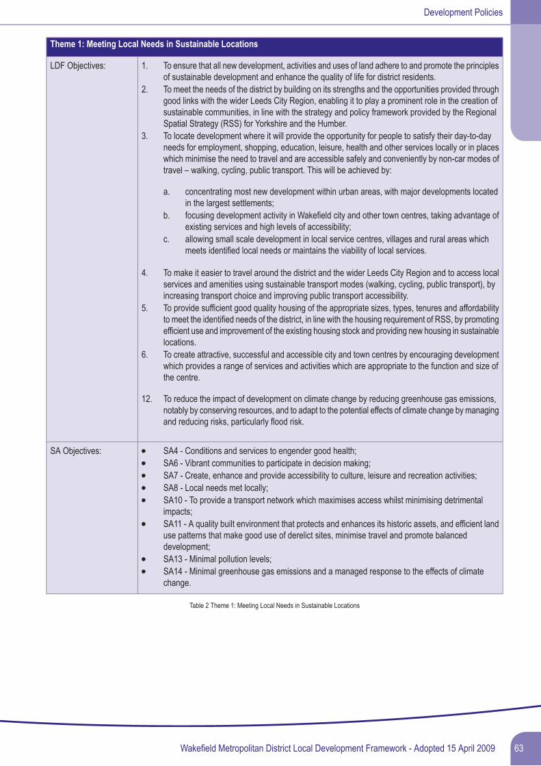
Theme 1: Meeting Local Needs in Sustainable Locations
LDF Objectives: 1. To ensure that all new development, activities and uses of land adhere to and promote the principlesof sustainable development and enhance the quality of life for district residents.
2. To meet the needs of the district by building on its strengths and the opportunities provided throughgood links with the wider Leeds City Region, enabling it to play a prominent role in the creation ofsustainable communities, in line with the strategy and policy framework provided by the RegionalSpatial Strategy (RSS) for Yorkshire and the Humber.
3. To locate development where it will provide the opportunity for people to satisfy their day-to-dayneeds for employment, shopping, education, leisure, health and other services locally or in placeswhich minimise the need to travel and are accessible safely and conveniently by non-car modes oftravel – walking, cycling, public transport. This will be achieved by:
a. concentrating most new development within urban areas, with major developments locatedin the largest settlements;
b. focusing development activity in Wakefield city and other town centres, taking advantage ofexisting services and high levels of accessibility;
c. allowing small scale development in local service centres, villages and rural areas whichmeets identified local needs or maintains the viability of local services.
4. To make it easier to travel around the district and the wider Leeds City Region and to access localservices and amenities using sustainable transport modes (walking, cycling, public transport), byincreasing transport choice and improving public transport accessibility.
5. To provide sufficient good quality housing of the appropriate sizes, types, tenures and affordabilityto meet the identified needs of the district, in line with the housing requirement of RSS, by promotingefficient use and improvement of the existing housing stock and providing new housing in sustainablelocations.
6. To create attractive, successful and accessible city and town centres by encouraging developmentwhich provides a range of services and activities which are appropriate to the function and size ofthe centre.
12. To reduce the impact of development on climate change by reducing greenhouse gas emissions,notably by conserving resources, and to adapt to the potential effects of climate change by managingand reducing risks, particularly flood risk.
SA Objectives: SA4 - Conditions and services to engender good health;SA6 - Vibrant communities to participate in decision making;SA7 - Create, enhance and provide accessibility to culture, leisure and recreation activities;SA8 - Local needs met locally;SA10 - To provide a transport network which maximises access whilst minimising detrimentalimpacts;SA11 - A quality built environment that protects and enhances its historic assets, and efficient landuse patterns that make good use of derelict sites, minimise travel and promote balanceddevelopment;SA13 - Minimal pollution levels;SA14 - Minimal greenhouse gas emissions and a managed response to the effects of climatechange.
Table 2 Theme 1: Meeting Local Needs in Sustainable Locations
63Wakefield Metropolitan District Local Development Framework - Adopted 15 April 2009
Development Policies
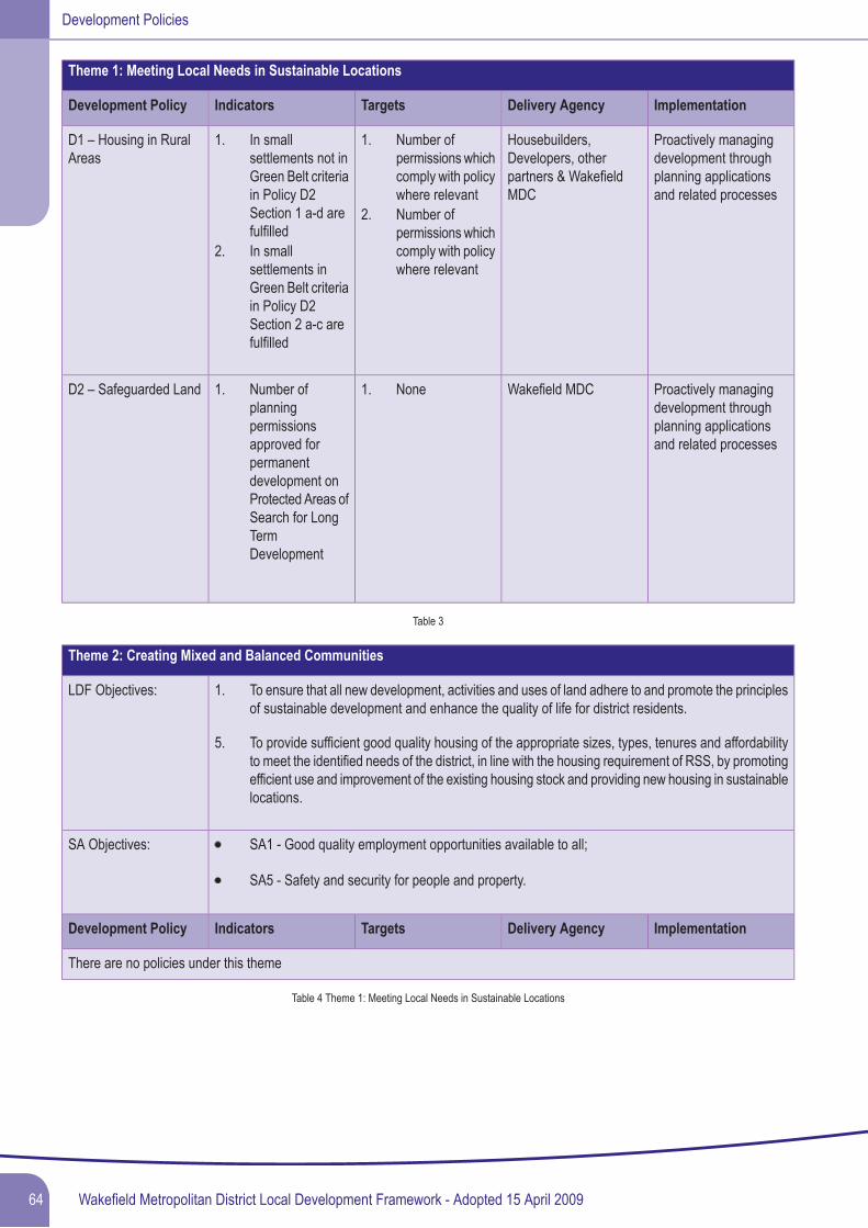
Theme 1: Meeting Local Needs in Sustainable Locations
ImplementationDelivery AgencyTargetsIndicatorsDevelopment Policy
Proactively managingdevelopment throughplanning applicationsand related processes
Housebuilders,Developers, otherpartners & WakefieldMDC
D1 – Housing in RuralAreas
1.1. Number ofpermissions whichcomply with policywhere relevant
In smallsettlements not inGreen Belt criteriain Policy D2Section 1 a-d arefulfilled
2. Number ofpermissions whichcomply with policywhere relevant
2. In smallsettlements inGreen Belt criteriain Policy D2Section 2 a-c arefulfilled
Proactively managingdevelopment throughplanning applicationsand related processes
Wakefield MDCD2 – Safeguarded Land 1.1. NoneNumber ofplanningpermissionsapproved forpermanentdevelopment onProtected Areas ofSearch for LongTermDevelopment
Table 3
Theme 2: Creating Mixed and Balanced Communities
LDF Objectives: 1. To ensure that all new development, activities and uses of land adhere to and promote the principlesof sustainable development and enhance the quality of life for district residents.
5. To provide sufficient good quality housing of the appropriate sizes, types, tenures and affordabilityto meet the identified needs of the district, in line with the housing requirement of RSS, by promotingefficient use and improvement of the existing housing stock and providing new housing in sustainablelocations.
SA Objectives: SA1 - Good quality employment opportunities available to all;
SA5 - Safety and security for people and property.
ImplementationDelivery AgencyTargetsIndicatorsDevelopment Policy
There are no policies under this theme
Table 4 Theme 1: Meeting Local Needs in Sustainable Locations
Wakefield Metropolitan District Local Development Framework - Adopted 15 April 200964
Development Policies
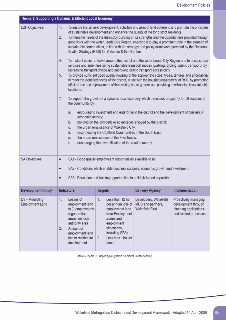
Theme 3: Supporting a Dynamic & Efficient Local Economy
LDF Objectives: 1. To ensure that all new development, activities and uses of land adhere to and promote the principlesof sustainable development and enhance the quality of life for district residents.
2. To meet the needs of the district by building on its strengths and the opportunities provided throughgood links with the wider Leeds City Region, enabling it to play a prominent role in the creation ofsustainable communities, in line with the strategy and policy framework provided by the RegionalSpatial Strategy (RSS) for Yorkshire & the Humber.
4. To make it easier to travel around the district and the wider Leeds City Region and to access localservices and amenities using sustainable transport modes (walking, cycling, public transport), byincreasing transport choice and improving public transport accessibility.
5. To provide sufficient good quality housing of the appropriate sizes, types, tenures and affordabilityto meet the identified needs of the district, in line with the housing requirement of RSS, by promotingefficient use and improvement of the existing housing stock and providing new housing in sustainablelocations.
7. To support the growth of a dynamic local economy which increases prosperity for all sections ofthe community by:
a. encouraging investment and enterprise in the district and the development of clusters ofeconomic activity;
b. building on the competitive advantages enjoyed by the district;c. the urban renaissance of Wakefield City;d. reconnecting the Coalfield Communities in the South East;e. the urban renaissance of the Five Towns;f. encouraging the diversification of the rural economy.
SA Objectives: SA1 - Good quality employment opportunities available to all;
SA2 - Conditions which enable business success, economic growth and investment;
SA3 - Education and training opportunities to build skills and capacities.
ImplementationDelivery AgencyTargetsIndicatorsDevelopment Policy
Proactively managingdevelopment throughplanning applicationsand related processes
Developers, WakefieldMDC and partners,Wakefield First
D3 – ProtectingEmployment Land
1.1. Less than 12 haper annum loss ofemployment landfrom Employment
Losses ofemployment landin (i) employment/regenerationareas, (ii) localauthority area
Zones andemploymentallocations,including SPAs
2. Amount ofemployment landlost to residentialdevelopment
2. Less than 1 ha perannum
Table 5 Theme 3: Supporting a Dynamic & Efficient Local Economy
65Wakefield Metropolitan District Local Development Framework - Adopted 15 April 2009
Development Policies
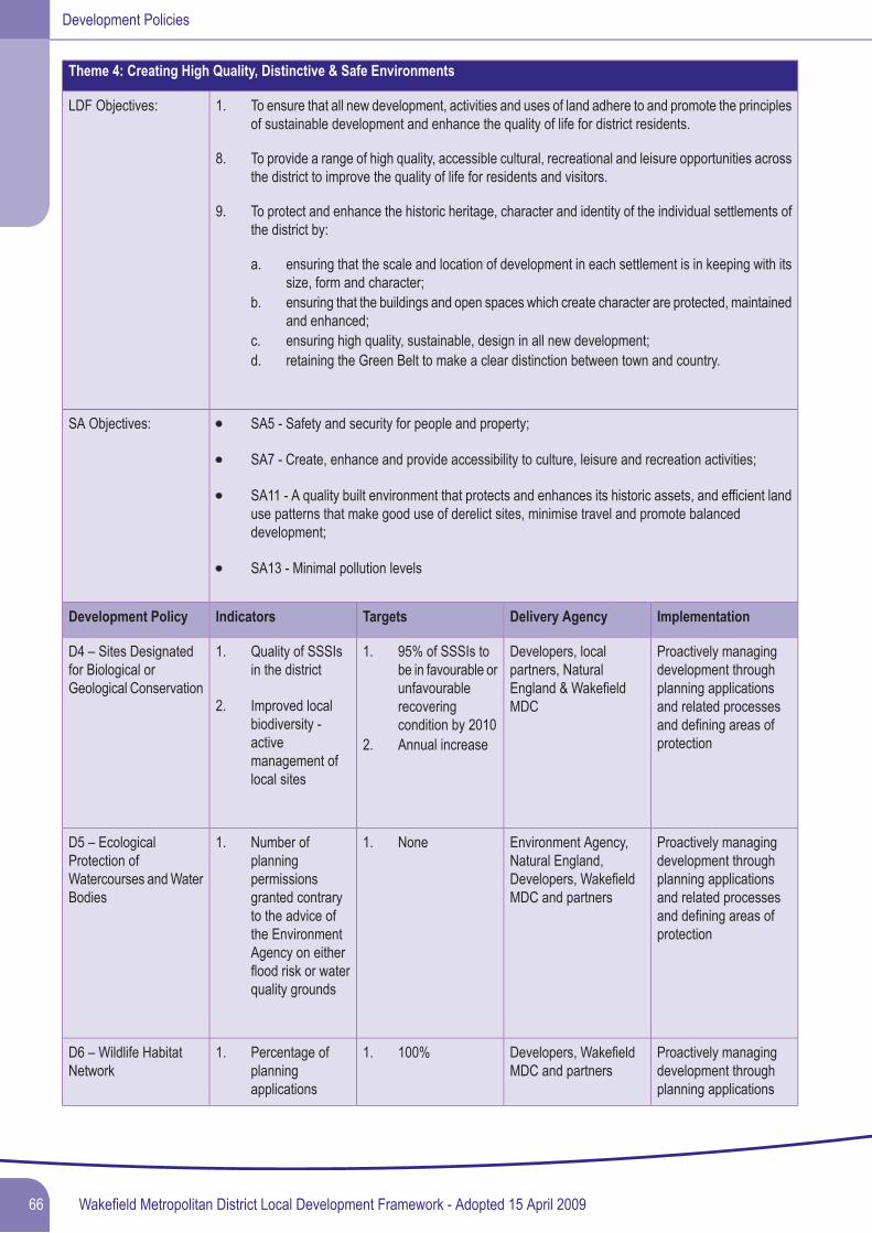
Theme 4: Creating High Quality, Distinctive & Safe Environments
LDF Objectives: 1. To ensure that all new development, activities and uses of land adhere to and promote the principlesof sustainable development and enhance the quality of life for district residents.
8. To provide a range of high quality, accessible cultural, recreational and leisure opportunities acrossthe district to improve the quality of life for residents and visitors.
9. To protect and enhance the historic heritage, character and identity of the individual settlements ofthe district by:
a. ensuring that the scale and location of development in each settlement is in keeping with itssize, form and character;
b. ensuring that the buildings and open spaces which create character are protected, maintainedand enhanced;
c. ensuring high quality, sustainable, design in all new development;d. retaining the Green Belt to make a clear distinction between town and country.
SA Objectives: SA5 - Safety and security for people and property;
SA7 - Create, enhance and provide accessibility to culture, leisure and recreation activities;
SA11 - A quality built environment that protects and enhances its historic assets, and efficient landuse patterns that make good use of derelict sites, minimise travel and promote balanceddevelopment;
SA13 - Minimal pollution levels
ImplementationDelivery AgencyTargetsIndicatorsDevelopment Policy
Proactively managingdevelopment throughplanning applications
Developers, localpartners, NaturalEngland & WakefieldMDC
D4 – Sites Designatedfor Biological orGeological Conservation
1.1. 95% of SSSIs tobe in favourable orunfavourablerecoveringcondition by 2010
Quality of SSSIsin the district
2. Improved localbiodiversity -activemanagement oflocal sites
and related processesand defining areas ofprotection2. Annual increase
Proactively managingdevelopment throughplanning applications
Environment Agency,Natural England,Developers, WakefieldMDC and partners
D5 – EcologicalProtection ofWatercourses andWaterBodies
1.1. NoneNumber ofplanningpermissionsgranted contrary and related processes
and defining areas ofprotection
to the advice ofthe EnvironmentAgency on eitherflood risk or waterquality grounds
Proactively managingdevelopment throughplanning applications
Developers, WakefieldMDC and partners
D6 – Wildlife HabitatNetwork
1.1. 100%Percentage ofplanningapplications
Wakefield Metropolitan District Local Development Framework - Adopted 15 April 200966
Development Policies
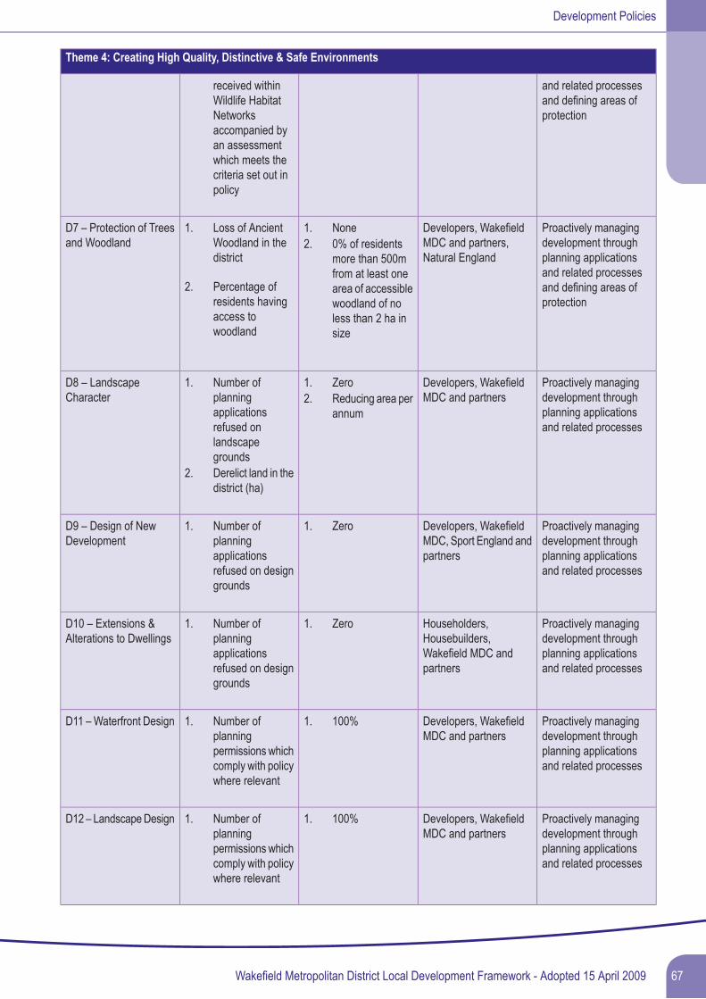
Theme 4: Creating High Quality, Distinctive & Safe Environments
received withinWildlife Habitat
and related processesand defining areas ofprotectionNetworks
accompanied byan assessmentwhich meets thecriteria set out inpolicy
Proactively managingdevelopment throughplanning applications
Developers, WakefieldMDC and partners,Natural England
D7 – Protection of Treesand Woodland
1.1. NoneLoss of AncientWoodland in thedistrict
2. 0% of residentsmore than 500mfrom at least onearea of accessible
and related processesand defining areas ofprotection
2. Percentage ofresidents havingaccess towoodland
woodland of noless than 2 ha insize
Proactively managingdevelopment throughplanning applicationsand related processes
Developers, WakefieldMDC and partners
D8 – LandscapeCharacter
1.1. ZeroNumber ofplanningapplicationsrefused on
2. Reducing area perannum
landscapegrounds
2. Derelict land in thedistrict (ha)
Proactively managingdevelopment throughplanning applicationsand related processes
Developers, WakefieldMDC, Sport England andpartners
D9 – Design of NewDevelopment
1.1. ZeroNumber ofplanningapplicationsrefused on designgrounds
Proactively managingdevelopment throughplanning applicationsand related processes
Householders,Housebuilders,Wakefield MDC andpartners
D10 – Extensions &Alterations to Dwellings
1.1. ZeroNumber ofplanningapplicationsrefused on designgrounds
Proactively managingdevelopment throughplanning applicationsand related processes
Developers, WakefieldMDC and partners
D11 –Waterfront Design 1.1. 100%Number ofplanningpermissions whichcomply with policywhere relevant
Proactively managingdevelopment throughplanning applicationsand related processes
Developers, WakefieldMDC and partners
D12 – LandscapeDesign 1.1. 100%Number ofplanningpermissions whichcomply with policywhere relevant
67Wakefield Metropolitan District Local Development Framework - Adopted 15 April 2009
Development Policies
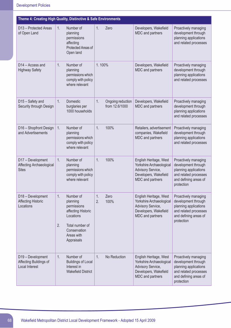
Theme 4: Creating High Quality, Distinctive & Safe Environments
Proactively managingdevelopment through
Developers, WakefieldMDC and partners
D13 – Protected Areasof Open Land
1.1. ZeroNumber ofplanning
planning applicationsand related processes
permissionsaffectingProtected Areas ofOpen land
Proactively managingdevelopment throughplanning applicationsand related processes
Developers, WakefieldMDC and partners
1. 100%D14 – Access andHighway Safety
1. Number ofplanningpermissions whichcomply with policywhere relevant
Proactively managingdevelopment throughplanning applicationsand related processes
Developers, WakefieldMDC and partners
D15 – Safety andSecurity through Design
1.1. Ongoing reductionfrom 12.6/1000
Domesticburglaries per1000 households
Proactively managingdevelopment throughplanning applicationsand related processes
Retailers, advertisementcompanies, WakefieldMDC and partners
D16 – Shopfront Designand Advertisements
1.1. 100%Number ofplanningpermissions whichcomply with policywhere relevant
Proactively managingdevelopment throughplanning applications
English Heritage, WestYorkshire ArchaeologicalAdvisory Service,Developers, WakefieldMDC and partners
D17 – DevelopmentAffecting ArchaeologicalSites
1.1. 100%Number ofplanningpermissions whichcomply with policywhere relevant
and related processesand defining areas ofprotection
Proactively managingdevelopment throughplanning applications
English Heritage, WestYorkshire ArchaeologicalAdvisory Service,Developers, WakefieldMDC and partners
D18 – DevelopmentAffecting HistoricLocations
1.1. ZeroNumber ofplanningpermissionsaffecting HistoricLocations
2. 100%
and related processesand defining areas ofprotection
2. Total number ofConservationAreas withAppraisals
Proactively managingdevelopment throughplanning applications
English Heritage, WestYorkshire ArchaeologicalAdvisory Service,Developers, WakefieldMDC and partners
D19 – DevelopmentAffecting Buildings ofLocal Interest
1.1. No ReductionNumber ofBuildings of LocalInterest inWakefield District and related processes
and defining areas ofprotection
Wakefield Metropolitan District Local Development Framework - Adopted 15 April 200968
Development Policies
Theme 4: Creating High Quality, Distinctive & Safe Environments
Proactively managingdevelopment throughplanning applications
Environment Agency,Health and SafetyExecutive, Developers,Wakefield MDC andpartners
D20 – Pollution Control 1.1. NoneNumber ofplanningpermissionsgranted contraryto the advice of
2. None3. 40ug/m3 annual
average or lower and related processesand defining areas ofprotection
4. 100%the EnvironmentAgency or HSE onpollution andwhere nomitigationmeasuresintroduced
2. Number ofplanningpermissionsgranted contraryto the advice ofthe EnvironmentAgency on waterquality grounds
3. NO2 annualaverageconcentration indesignatedAQMAs.
4. Number ofplanningpermissions whichcomply with policywhere relevant
Proactively managingdevelopment throughplanning applications
Health and SafetyExecutive, EnvironmentAgency, Developers,Wakefield MDC andpartners
D21 – Protection fromHazardous Operations
1.1. NonePercentage ofplanningpermissionsgranted withinHSE ConsultationZones contrary toHSE advice
and related processesand defining HSEConsultation Zones
Proactively managingdevelopment throughplanning applicationsand related processes
Environment Agency,Developers, WakefieldMDC and partners
D22 – ContaminatedLand
1.1. Reducing numberNumber of 'sites ofpotential concern'within the localauthority area,
2. Increasing number
with respect tolandcontamination
2. Number of sitesfor which sufficientdetailed
69Wakefield Metropolitan District Local Development Framework - Adopted 15 April 2009
Development Policies
Theme 4: Creating High Quality, Distinctive & Safe Environments
information isavailable to decidewhetherremediation of theland is necessary,as a percentage of'sites of potentialconcern'
Proactively managingdevelopment throughplanning applicationsand related processes
Developers, WakefieldMDC and partners
D23 – Existing Uses inthe Green Belt
1.1. 100%Number ofplanningpermissions whichcomply with policywhere relevant
Table 6 Theme 4: Creating High Quality, Distinctive & Safe Environments
Wakefield Metropolitan District Local Development Framework - Adopted 15 April 200970
Development Policies
Theme 5: Tackling Climate Change & Resource Management
LDF Objectives: 1. To ensure that all new development, activities and uses of land adhere to and promote the principlesof sustainable development and enhance the quality of life for district residents.
10. To ensure that the district's natural environment, including wildlife habitats and landscape character,is conserved and protected and that new development identifies, protects and enhances importantassets.
11. To promote and maintain a clean, attractive and safe environment by reducing waste, avoidingpollution, addressing climate change including flood risk, ensuring efficient use of resources andpromoting high quality design in all new development.
12. To reduce the impact of development on climate change by reducing greenhouse gas emissions,notably by conserving resources, and to adapt to the potential effects of climate change by managingand reducing risks, particularly flood risk.
SA Objectives: SA10 - To provide a transport network which maximises access whilst minimising detrimentalimpacts;
SA11 - A quality built environment that protects and enhances its historic assets, and efficient landuse patterns that make good use of derelict sites, minimise travel and promote balanceddevelopment;
SA12 - A bio-diverse and attractive natural environment;
SA13 - Minimal pollution levels;
SA14 - Minimal greenhouse gas emissions and a managed response to the effects of climatechange;
SA15 - Prudent and efficient use of energy and natural resources with minimal production of waste.
ImplementationDelivery AgencyTargetsIndicatorsDevelopment Policy
Proactively managingdevelopment throughplanning applications
Environment Agency,Developers, WakefieldMDC and partners
D24 – Flood Risk 1.1. 100%Number ofplanningpermissions
2. Reducing
granted contrary and related processes,to the advice of allocation of land through
the LDF, Strategic FloodRisk Assessment
the EnvironmentAgency on floodrisk grounds
2. Number of windfallhousingdevelopmentsapproved in FloodZone 2 or 3
Proactively managingdevelopment throughplanning applicationsand related processes
Developers,Housebuilders, YorkshireWater, EnvironmentAgency, Internal
D25 – Drainage 1.1. 100% ofpracticableschemes
Number ofplanningpermissionsincorporating
Drainage Boards,Wakefield MDC andpartners
sustainabledrainagetechniques
71Wakefield Metropolitan District Local Development Framework - Adopted 15 April 2009
Development Policies
Theme 5: Tackling Climate Change & Resource Management
Proactively managingdevelopment throughplanning applications
Developers,WakefieldMDC and partners
D26 – Protection ofAgricultural Land
1.1. 100%Number ofplanningpermissions which
and related processesand allocation of landthrough the LDF
comply with policywhere relevant
Proactively managingdevelopment throughplanning applicationsand related processes
Developers, WakefieldMDC and partners
D27 – RenewableEnergy GenerationTechnology
1.1. 100% whererelevant
Number of eligibleplanningpermissionsgranted whichincorporate on-siterenewable energygenerationtechnology toprovide (i) at least10% of itspredicted energyrequirements until2010 (ii) at least15% between2010 and 2015and (iii) at least20% between2015 and 2020
Proactively managingdevelopment throughplanning applicationsand related processes
Developers, WakefieldMDC and partners
D28 – SustainableConstruction andEfficient Use ofResources
1.1. Increasing numberNumber of newresidentialdevelopmentswhich achieve theCode forSustainableHomes level 6
Table 7 Theme 5:Tackling Climate Change & Resource Management
Wakefield Metropolitan District Local Development Framework - Adopted 15 April 200972
Development Policies

Replaced Unitary Development Plan Policies
73Wakefield Metropolitan District Local Development Framework - Adopted 15 April 2009
Development Policies
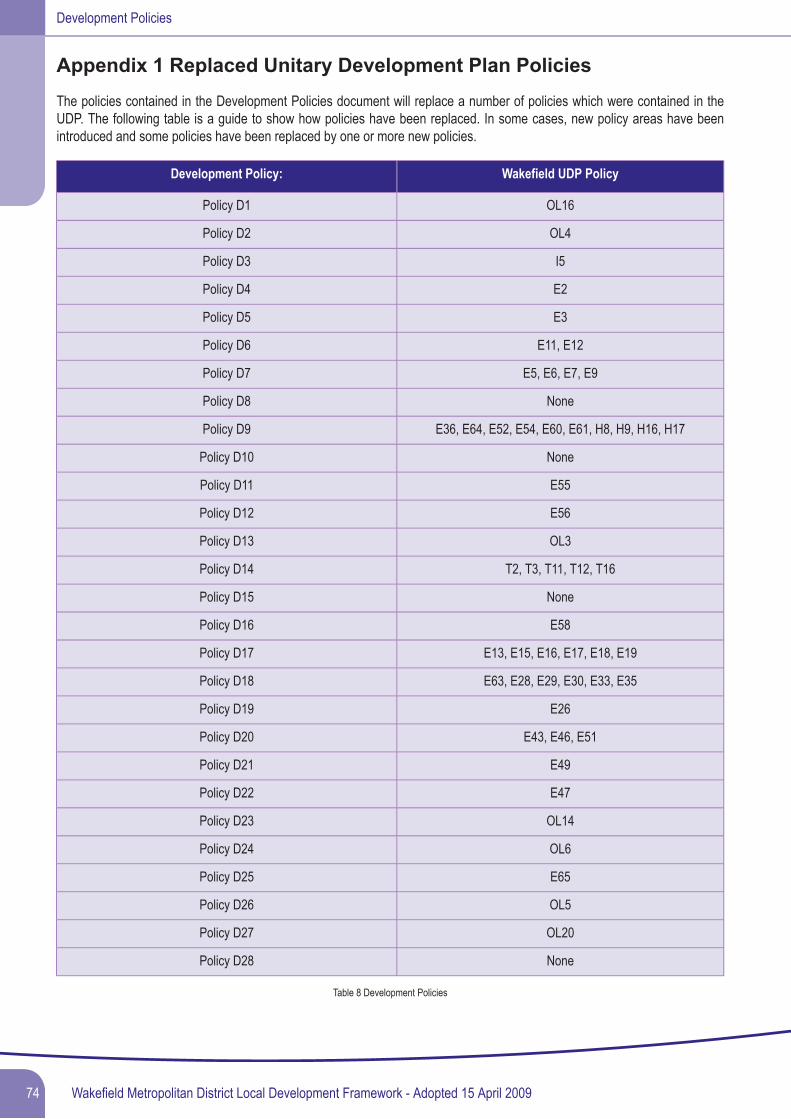
Appendix 1 Replaced Unitary Development Plan PoliciesThe policies contained in the Development Policies document will replace a number of policies which were contained in theUDP. The following table is a guide to show how policies have been replaced. In some cases, new policy areas have beenintroduced and some policies have been replaced by one or more new policies.
Wakefield UDP PolicyDevelopment Policy:
OL16Policy D1
OL4Policy D2
I5Policy D3
E2Policy D4
E3Policy D5
E11, E12Policy D6
E5, E6, E7, E9Policy D7
NonePolicy D8
E36, E64, E52, E54, E60, E61, H8, H9, H16, H17Policy D9
NonePolicy D10
E55Policy D11
E56Policy D12
OL3Policy D13
T2, T3, T11, T12, T16Policy D14
NonePolicy D15
E58Policy D16
E13, E15, E16, E17, E18, E19Policy D17
E63, E28, E29, E30, E33, E35Policy D18
E26Policy D19
E43, E46, E51Policy D20
E49Policy D21
E47Policy D22
OL14Policy D23
OL6Policy D24
E65Policy D25
OL5Policy D26
OL20Policy D27
NonePolicy D28
Table 8 Development Policies
Wakefield Metropolitan District Local Development Framework - Adopted 15 April 200974
Development Policies
The following UDP policies have not been specifically replaced by new LDF policies, as the matters are covered by planninglegislation and national planning policy:
Policies R2, E25, H5, OL17, OL21, OL22
With the adoption of the Core Strategy and the Development Policies documents the policies are no longer saved.
75Wakefield Metropolitan District Local Development Framework - Adopted 15 April 2009
Development Policies

Wakefield Metropolitan District Local Development Framework - Adopted 15 April 200976
Development Policies

Glossary of Terms
77Wakefield Metropolitan District Local Development Framework - Adopted 15 April 2009
Development Policies
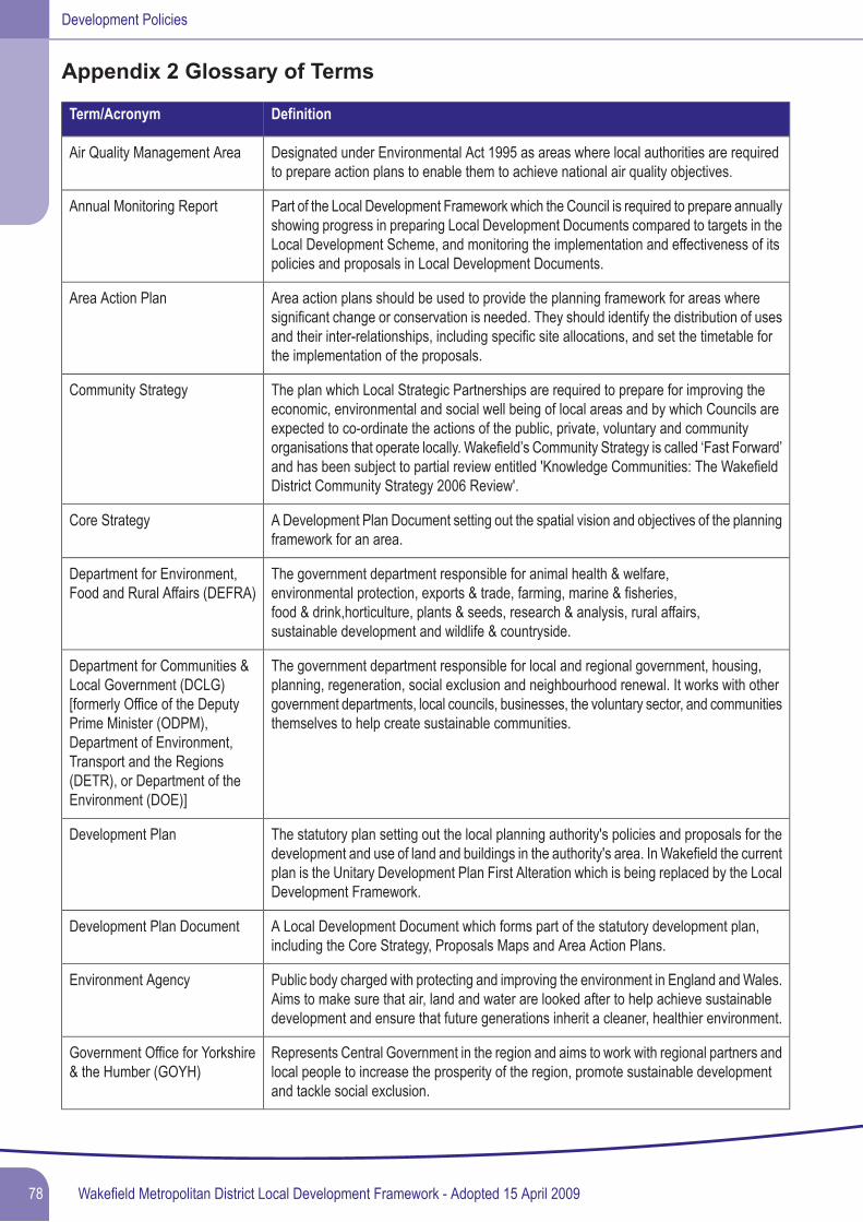
Appendix 2 Glossary of Terms
DefinitionTerm/Acronym
Designated under Environmental Act 1995 as areas where local authorities are requiredto prepare action plans to enable them to achieve national air quality objectives.
Air Quality Management Area
Part of the Local Development Framework which the Council is required to prepare annuallyshowing progress in preparing Local Development Documents compared to targets in theLocal Development Scheme, and monitoring the implementation and effectiveness of itspolicies and proposals in Local Development Documents.
Annual Monitoring Report
Area action plans should be used to provide the planning framework for areas wheresignificant change or conservation is needed. They should identify the distribution of usesand their inter-relationships, including specific site allocations, and set the timetable forthe implementation of the proposals.
Area Action Plan
The plan which Local Strategic Partnerships are required to prepare for improving theeconomic, environmental and social well being of local areas and by which Councils areexpected to co-ordinate the actions of the public, private, voluntary and community
Community Strategy
organisations that operate locally. Wakefield’s Community Strategy is called ‘Fast Forward’and has been subject to partial review entitled 'Knowledge Communities: The WakefieldDistrict Community Strategy 2006 Review'.
A Development Plan Document setting out the spatial vision and objectives of the planningframework for an area.
Core Strategy
The government department responsible for animal health & welfare,environmental protection, exports & trade, farming, marine & fisheries,food & drink,horticulture, plants & seeds, research & analysis, rural affairs,sustainable development and wildlife & countryside.
Department for Environment,Food and Rural Affairs (DEFRA)
The government department responsible for local and regional government, housing,planning, regeneration, social exclusion and neighbourhood renewal. It works with othergovernment departments, local councils, businesses, the voluntary sector, and communitiesthemselves to help create sustainable communities.
Department for Communities &Local Government (DCLG)[formerly Office of the DeputyPrime Minister (ODPM),Department of Environment,Transport and the Regions(DETR), or Department of theEnvironment (DOE)]
The statutory plan setting out the local planning authority's policies and proposals for thedevelopment and use of land and buildings in the authority's area. In Wakefield the currentplan is the Unitary Development Plan First Alteration which is being replaced by the LocalDevelopment Framework.
Development Plan
A Local Development Document which forms part of the statutory development plan,including the Core Strategy, Proposals Maps and Area Action Plans.
Development Plan Document
Public body charged with protecting and improving the environment in England andWales.Aims to make sure that air, land and water are looked after to help achieve sustainabledevelopment and ensure that future generations inherit a cleaner, healthier environment.
Environment Agency
Represents Central Government in the region and aims to work with regional partners andlocal people to increase the prosperity of the region, promote sustainable developmentand tackle social exclusion.
Government Office for Yorkshire& the Humber (GOYH)
Wakefield Metropolitan District Local Development Framework - Adopted 15 April 200978
Development Policies
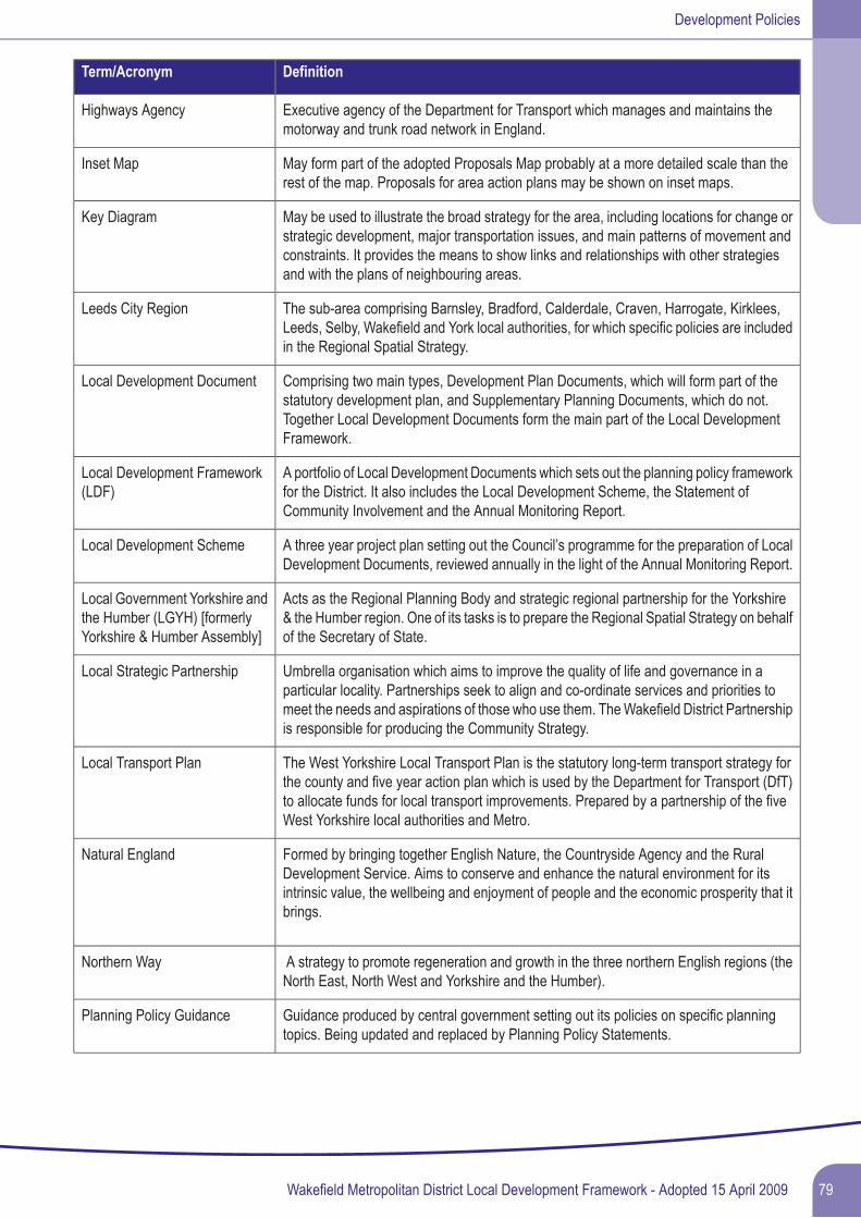
DefinitionTerm/Acronym
Executive agency of the Department for Transport which manages and maintains themotorway and trunk road network in England.
Highways Agency
May form part of the adopted Proposals Map probably at a more detailed scale than therest of the map. Proposals for area action plans may be shown on inset maps.
Inset Map
May be used to illustrate the broad strategy for the area, including locations for change orstrategic development, major transportation issues, and main patterns of movement andconstraints. It provides the means to show links and relationships with other strategiesand with the plans of neighbouring areas.
Key Diagram
The sub-area comprising Barnsley, Bradford, Calderdale, Craven, Harrogate, Kirklees,Leeds, Selby, Wakefield and York local authorities, for which specific policies are includedin the Regional Spatial Strategy.
Leeds City Region
Comprising two main types, Development Plan Documents, which will form part of thestatutory development plan, and Supplementary Planning Documents, which do not.Together Local Development Documents form the main part of the Local DevelopmentFramework.
Local Development Document
A portfolio of Local Development Documents which sets out the planning policy frameworkfor the District. It also includes the Local Development Scheme, the Statement ofCommunity Involvement and the Annual Monitoring Report.
Local Development Framework(LDF)
A three year project plan setting out the Council’s programme for the preparation of LocalDevelopment Documents, reviewed annually in the light of the Annual Monitoring Report.
Local Development Scheme
Acts as the Regional Planning Body and strategic regional partnership for the Yorkshire& the Humber region. One of its tasks is to prepare the Regional Spatial Strategy on behalfof the Secretary of State.
Local Government Yorkshire andthe Humber (LGYH) [formerlyYorkshire & Humber Assembly]
Umbrella organisation which aims to improve the quality of life and governance in aparticular locality. Partnerships seek to align and co-ordinate services and priorities to
Local Strategic Partnership
meet the needs and aspirations of those who use them. TheWakefield District Partnershipis responsible for producing the Community Strategy.
The West Yorkshire Local Transport Plan is the statutory long-term transport strategy forthe county and five year action plan which is used by the Department for Transport (DfT)to allocate funds for local transport improvements. Prepared by a partnership of the fiveWest Yorkshire local authorities and Metro.
Local Transport Plan
Formed by bringing together English Nature, the Countryside Agency and the RuralDevelopment Service. Aims to conserve and enhance the natural environment for itsintrinsic value, the wellbeing and enjoyment of people and the economic prosperity that itbrings.
Natural England
A strategy to promote regeneration and growth in the three northern English regions (theNorth East, North West and Yorkshire and the Humber).
Northern Way
Guidance produced by central government setting out its policies on specific planningtopics. Being updated and replaced by Planning Policy Statements.
Planning Policy Guidance
79Wakefield Metropolitan District Local Development Framework - Adopted 15 April 2009
Development Policies
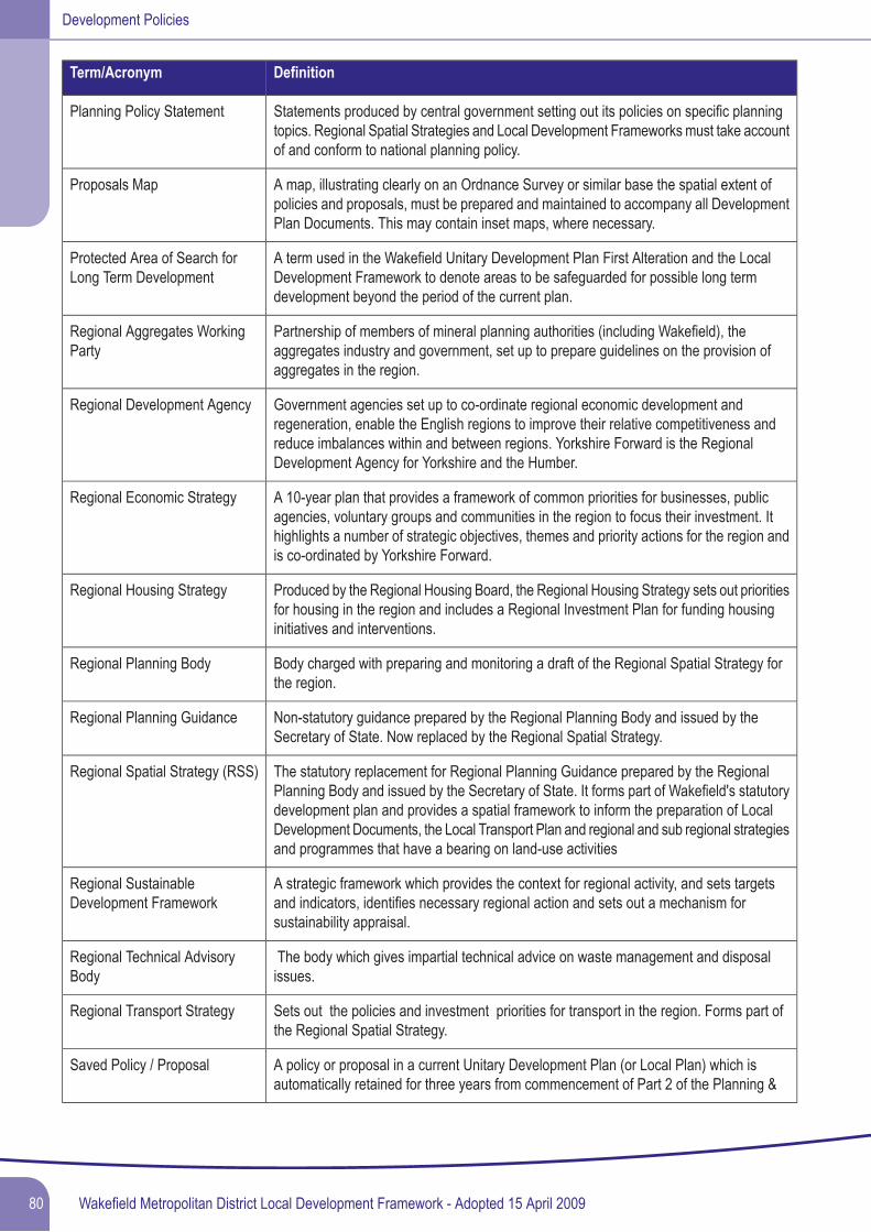
DefinitionTerm/Acronym
Statements produced by central government setting out its policies on specific planningtopics. Regional Spatial Strategies and Local Development Frameworks must take accountof and conform to national planning policy.
Planning Policy Statement
A map, illustrating clearly on an Ordnance Survey or similar base the spatial extent ofpolicies and proposals, must be prepared and maintained to accompany all DevelopmentPlan Documents. This may contain inset maps, where necessary.
Proposals Map
A term used in the Wakefield Unitary Development Plan First Alteration and the LocalDevelopment Framework to denote areas to be safeguarded for possible long termdevelopment beyond the period of the current plan.
Protected Area of Search forLong Term Development
Partnership of members of mineral planning authorities (including Wakefield), theaggregates industry and government, set up to prepare guidelines on the provision ofaggregates in the region.
Regional Aggregates WorkingParty
Government agencies set up to co-ordinate regional economic development andregeneration, enable the English regions to improve their relative competitiveness and
Regional Development Agency
reduce imbalances within and between regions. Yorkshire Forward is the RegionalDevelopment Agency for Yorkshire and the Humber.
A 10-year plan that provides a framework of common priorities for businesses, publicagencies, voluntary groups and communities in the region to focus their investment. It
Regional Economic Strategy
highlights a number of strategic objectives, themes and priority actions for the region andis co-ordinated by Yorkshire Forward.
Produced by the Regional Housing Board, the Regional Housing Strategy sets out prioritiesfor housing in the region and includes a Regional Investment Plan for funding housinginitiatives and interventions.
Regional Housing Strategy
Body charged with preparing and monitoring a draft of the Regional Spatial Strategy forthe region.
Regional Planning Body
Non-statutory guidance prepared by the Regional Planning Body and issued by theSecretary of State. Now replaced by the Regional Spatial Strategy.
Regional Planning Guidance
The statutory replacement for Regional Planning Guidance prepared by the RegionalPlanning Body and issued by the Secretary of State. It forms part of Wakefield's statutory
Regional Spatial Strategy (RSS)
development plan and provides a spatial framework to inform the preparation of LocalDevelopment Documents, the Local Transport Plan and regional and sub regional strategiesand programmes that have a bearing on land-use activities
A strategic framework which provides the context for regional activity, and sets targetsand indicators, identifies necessary regional action and sets out a mechanism forsustainability appraisal.
Regional SustainableDevelopment Framework
The body which gives impartial technical advice on waste management and disposalissues.
Regional Technical AdvisoryBody
Sets out the policies and investment priorities for transport in the region. Forms part ofthe Regional Spatial Strategy.
Regional Transport Strategy
A policy or proposal in a current Unitary Development Plan (or Local Plan) which isautomatically retained for three years from commencement of Part 2 of the Planning &
Saved Policy / Proposal
Wakefield Metropolitan District Local Development Framework - Adopted 15 April 200980
Development Policies
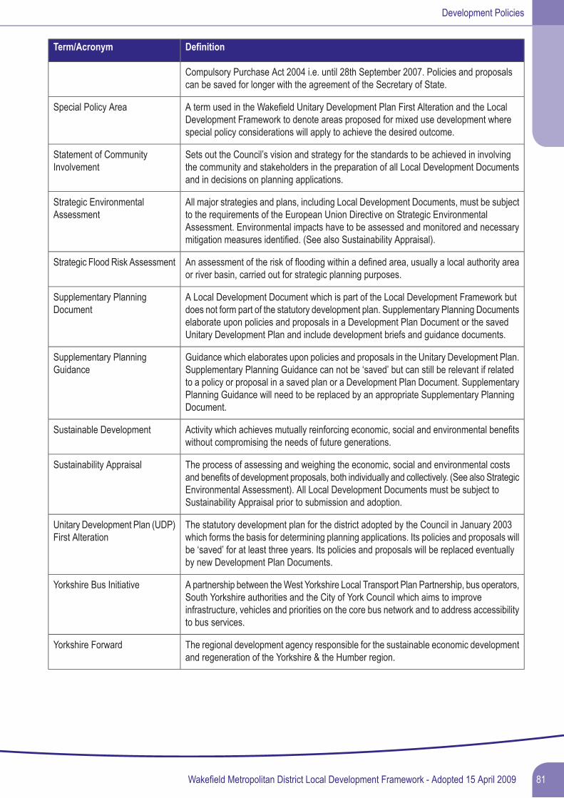
DefinitionTerm/Acronym
Compulsory Purchase Act 2004 i.e. until 28th September 2007. Policies and proposalscan be saved for longer with the agreement of the Secretary of State.
A term used in the Wakefield Unitary Development Plan First Alteration and the LocalDevelopment Framework to denote areas proposed for mixed use development wherespecial policy considerations will apply to achieve the desired outcome.
Special Policy Area
Sets out the Council’s vision and strategy for the standards to be achieved in involvingthe community and stakeholders in the preparation of all Local Development Documentsand in decisions on planning applications.
Statement of CommunityInvolvement
All major strategies and plans, including Local Development Documents, must be subjectto the requirements of the European Union Directive on Strategic Environmental
Strategic EnvironmentalAssessment
Assessment. Environmental impacts have to be assessed and monitored and necessarymitigation measures identified. (See also Sustainability Appraisal).
An assessment of the risk of flooding within a defined area, usually a local authority areaor river basin, carried out for strategic planning purposes.
Strategic Flood Risk Assessment
A Local Development Document which is part of the Local Development Framework butdoes not form part of the statutory development plan. Supplementary Planning Documents
Supplementary PlanningDocument
elaborate upon policies and proposals in a Development Plan Document or the savedUnitary Development Plan and include development briefs and guidance documents.
Guidance which elaborates upon policies and proposals in the Unitary Development Plan.Supplementary Planning Guidance can not be ‘saved’ but can still be relevant if related
Supplementary PlanningGuidance
to a policy or proposal in a saved plan or a Development Plan Document. SupplementaryPlanning Guidance will need to be replaced by an appropriate Supplementary PlanningDocument.
Activity which achieves mutually reinforcing economic, social and environmental benefitswithout compromising the needs of future generations.
Sustainable Development
The process of assessing and weighing the economic, social and environmental costsand benefits of development proposals, both individually and collectively. (See also Strategic
Sustainability Appraisal
Environmental Assessment). All Local Development Documents must be subject toSustainability Appraisal prior to submission and adoption.
The statutory development plan for the district adopted by the Council in January 2003which forms the basis for determining planning applications. Its policies and proposals will
Unitary Development Plan (UDP)First Alteration
be ‘saved’ for at least three years. Its policies and proposals will be replaced eventuallyby new Development Plan Documents.
A partnership between theWest Yorkshire Local Transport Plan Partnership, bus operators,South Yorkshire authorities and the City of York Council which aims to improve
Yorkshire Bus Initiative
infrastructure, vehicles and priorities on the core bus network and to address accessibilityto bus services.
The regional development agency responsible for the sustainable economic developmentand regeneration of the Yorkshire & the Humber region.
Yorkshire Forward
81Wakefield Metropolitan District Local Development Framework - Adopted 15 April 2009
Development Policies
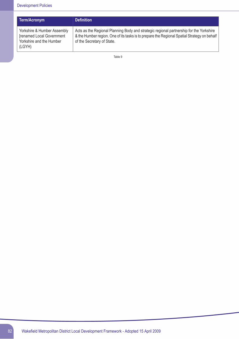
DefinitionTerm/Acronym
Acts as the Regional Planning Body and strategic regional partnership for the Yorkshire& the Humber region. One of its tasks is to prepare the Regional Spatial Strategy on behalfof the Secretary of State.
Yorkshire & Humber Assembly[renamed Local GovernmentYorkshire and the Humber(LGYH)
Table 9
Wakefield Metropolitan District Local Development Framework - Adopted 15 April 200982
Development Policies