lower pool 2 channel management study: boulanger...
TRANSCRIPT
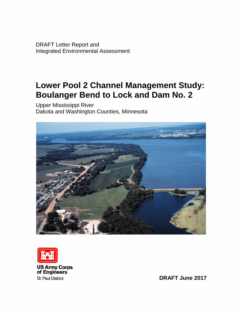
DRAFT Letter Report and Integrated Environmental Assessment Lower Pool 2 Channel Management Study: Boulanger Bend to Lock and Dam No. 2 Upper Mississippi River Dakota and Washington Counties, Minnesota
DRAFT June 2017

This page intentionally left blank.
i
Contents
EXECUTIVE SUMMARY ................................................................................................ 1
CHAPTER 1. INTRODUCTION ................................................................................. 5 1.1 Authority ................................................................................................. 5 1.2 Project Location and Study Area ............................................................ 5 1.3 Purpose and Need .................................................................................... 6 1.4 Related Studies and Reports .................................................................... 7
CHAPTER 2. AFFECTED ENVIRONMENT ............................................................ 10 2.1 Socioeconomic Conditions .................................................................... 10
2.1.1 Commercial Navigation ....................................................................... 11 2.1.2 Recreation ............................................................................................ 12 2.1.3 Aesthetic Resources ............................................................................. 12
2.2 Natural Resources ................................................................................. 13 2.2.1 Physical Setting .................................................................................... 13 2.2.2 Aquatic Habitat .................................................................................... 20 2.2.3 Fisheries ............................................................................................... 20 2.2.4 Aquatic Invertebrates ........................................................................... 21 2.2.5 Threatened and Endangered Species .................................................... 22 2.2.6 Aquatic Vegetation............................................................................... 25 2.2.7 Birds ..................................................................................................... 26 2.2.8 Water Quality ....................................................................................... 26 2.2.9 Terrestrial Habitat ................................................................................ 27 2.2.10 Air Quality ........................................................................................... 28
2.3 Cultural Resources ................................................................................ 28 2.4 Resource Significance ........................................................................... 30 2.5 Expected Future Without Project Conditions ........................................ 31
2.5.1 Climate Change .................................................................................... 31
CHAPTER 3. PLANNING PROCESS ..................................................................... 33 3.1 Problem and Opportunity Identification ............................................... 33 3.2 Project Goals and Objectives ................................................................ 35 3.3 Planning Constraints and Assumptions ................................................. 36 3.4 Alternative Measures ............................................................................. 36
3.4.1 No Action ............................................................................................. 37 3.4.2 Channel Control Structures .................................................................. 37 3.4.3 Channel Realignment ........................................................................... 37
ii
3.4.4 Increased Channel Maintenance .......................................................... 37
CHAPTER 4. ALTERNATIVE PLAN FORMULATION AND EVALUATION ........... 38 4.1 Alternative 1 - No Action Alternative ................................................... 40 4.2 Alternative 2 – Revetments and Wing Dams Channel Control
Structures ............................................................................................... 41 4.3 Alternative 3 - Nininger Slough Channel Realignment ........................ 44 4.4 Alternative 4 - Increased Channel Maintenance ................................... 47 4.5 Alternative 5 - Boulanger Slough Channel Realignment ...................... 50 4.6 Alternative 6 - Increased Channel Maintenance with Rock Sill Training
Structures ............................................................................................... 54 4.7 Final Array of Alternatives Carried Forward for Further Development 58
CHAPTER 5. ALTERNATIVE PLAN SELECTION .................................................. 61 5.1 Alternative 1 - No Action Alternative ................................................... 61 5.2 Alternative 5 - Boulanger Slough Channel Realignment ...................... 61 5.3 Alternative 6 – Increased Channel Maintenance and Rock Sill Training
Structures ............................................................................................... 63 5.4 Comparison of Final Array of Alternatives ........................................... 67 5.5 Plan Selection ........................................................................................ 68
5.5.1 Summary of Accounts for the National Economic Development Plan 69 5.6 Tentatively Selected Plan ...................................................................... 69
5.6.1 Plan Features ........................................................................................ 70 5.6.2 Design Considerations ......................................................................... 70 5.6.3 Environmental Mitigation .................................................................... 71 5.6.4 Construction Considerations ................................................................ 72 5.6.5 Lands, Easements, Rights-of Way, Relocations, and Disposal Site
Considerations ...................................................................................... 75 5.6.6 Real Estate Considerations ................................................................... 75 5.6.7 Operation, Maintenance, Repair, Rehabilitation and Replacement ..... 75 5.6.8 Construction Cost Estimate .................................................................. 75
CHAPTER 6. EVALUATION OF ENVIRONMENTAL EFFECTS ........................... 77 6.1 Socioeconomic Effects .......................................................................... 77
6.1.1 Commercial Navigation ....................................................................... 77 6.1.2 Recreation ............................................................................................ 78 6.1.3 Aesthetics ............................................................................................. 78 6.1.4 Noise .................................................................................................... 78 6.1.5 Existing/Potential Land Use ................................................................. 79
6.2 Natural Resource Effects ....................................................................... 80 6.2.1 Physical Setting .................................................................................... 80 6.2.2 Aquatic Habitat .................................................................................... 83 6.2.3 Fisheries ............................................................................................... 84 6.2.4 Aquatic Invertebrates ........................................................................... 85
iii
6.2.5 Threatened and Endangered Species .................................................... 87 6.2.6 Aquatic Vegetation............................................................................... 90 6.2.7 Birds ..................................................................................................... 91 6.2.8 Water Quality ....................................................................................... 91 6.2.9 Terrestrial Habitat ................................................................................ 92 6.2.10 Air Quality ........................................................................................... 92
6.3 Cultural Resource Effects ...................................................................... 94 6.3.1 Wing Dams .......................................................................................... 94 6.3.2 Boulanger Island Remnant ................................................................... 94 6.3.3 Submerged High Probability Landforms ............................................. 95 6.3.4 Proximal Recorded Cultural Resources ............................................... 96 6.3.5 Coordination ......................................................................................... 96
6.4 Cumulative Effects ................................................................................ 97 6.4.1 Scope of Cumulative Effects Analysis ................................................. 97 6.4.2 Actions Identified Within the Project Impact Zone ............................. 97 6.4.3 Environmental Consequences of Cumulative Effects .......................... 99
6.5 Summary of Environmental Effects .................................................... 101
CHAPTER 7. ENVIRONMENTAL COMPLIANCE AND REVIEW ......................... 103 7.1 Applicable Environmental Laws and Executive Orders ..................... 103 7.2 Public Involvement ............................................................................. 103 7.3 Coordination ........................................................................................ 104
7.3.1 Clean Water Act ................................................................................. 104 7.3.2 Fish and Wildlife Coordination Act, Endangered Species Act .......... 104 7.3.3 Minnesota State Environmental Review and Permits ........................ 104 7.3.4 Cultural Resources and Tribal Coordination...................................... 104 7.3.5 Additional Environmental Review ..................................................... 104
7.4 Distribution of Draft Environmental Assessment ............................... 105 7.5 Comments on the Environmental Assessment .................................... 105
TABLES Table 1 Summary of Lower Pool 2 Dredge Sites Average Annual Dredge Volume 1981-2000................................................................................................................................... 19 Table 2 Summary of Lower Pool 2 Dredge Sites Average Annual Dredge Volume 2001 -2016................................................................................................................................... 19 Table 3 Federally-Protected Species that May Occur Within Project Area ..................... 23 Table 4 Minnesota State-Protected Species with records within one-mile of the Project Area. .................................................................................................................................. 24 Table 5 Other Rare Species and Native Plant Communities within one-mile of Project Area ................................................................................................................................... 25 Table 6 Recorded Cultural Resources within One Mile of the Project Area .................... 30
iv
Table 7 Summary of Problems, Objectives and Measures ............................................... 37 Table 8 Alternative Screening Matrix ............................................................................... 59 Table 9 Benefit – Benefit - Cost Summary ....................................................................... 67 Table 10 Project Cost Summary (2016 price level) .......................................................... 76 Table 11 Environmental Assessment Matrix .................................................................. 102 Table 12 Compliance review with all applicable Federal environmental regulations and guidelines ........................................................................................................................ 107
FIGURES Executive Figure 0-1 Project Location ............................................................................... 1 Executive Figure 0-2 Tentatively Selected Plan Features ................................................. 2 Figure 1-1 Study Area ......................................................................................................... 6 Figure 2-1 Area Names ..................................................................................................... 11 Figure 2-2 Lock and Dam 2 Commodities ....................................................................... 12 Figure 2-3 Mississippi River Commission Map, 1890 ..................................................... 14 Figure 2-4 Five Year Running Mean Discharge Minnesota River at Jordan, MN ........... 18 Figure 3-1 Lower Pool 2 Tow Boat Groundings 1990 – 2016 ......................................... 34 Figure 4-1 Alternative 2 Revetments and Wing Dams ..................................................... 42 Figure 4-2 Alternative 3 Nininger Slough Realignment ................................................... 44 Figure 4-3 Increased Channel Maintenance Corridor and Current Width Comparison ... 47 Figure 4-4 Alternative 5 Boulanger Slough Realignment ................................................ 51 Figure 4-5 Alternative 6 Increase Channel Maintenance with Training Structure ........... 55 Figure 5-1 Boulanger Slough Channel Realignment Alternative Features ...................... 62 Figure 5-2 Alternative 6 Increased Channel Maintenance and Rock Sill Channel Training Structures .......................................................................................................................... 63 Figure 5-3 Proposed Dredged Material Placement Site for Alternative 6 ........................ 64 Figure 5-4 Pool 2 Operating Curves ................................................................................. 65 Figure 5-5 Rock Mound Cross Section ............................................................................. 66 Figure 6-1 Existing Condition Velocity (meters per second at 20,560 cfs)...................... 82 Figure 6-2 Project Condition Velocity (meters per second at 20,560 cfs)........................ 82 Figure 6-3 Existing and Predicted Habitat Conditions ..................................................... 84 Figure 6-4 Project-Funded Mussel Surveys ...................................................................... 86
PLATES
Plate 1 – Boulanger Site Plan/Study Area Plate 2 – Boulanger Historic Channel 1927 Plate 3 – Boulanger Bathymetry Plate 4 – Boulanger Channel Width Plate 5 – Boulanger Channel Historic Dredge cuts Plate 6 – Boulanger Tentatively Selected Plan Plate 7 – Historic Channel with Rock Mounds
v
Plates 8 – 24 – Preliminary Construction Plates
APPENDICES
Appendix A. Coordination/Correspondence Appendix B. Clean Water Act Section 404(b)(1) Evaluation Appendix C. Economic Analysis and Cost Estimate Appendix D. Hydrology and Hydraulics Appendix E. Mississippi River (Pool 2) 2-D ADH Model Development Appendix F. ERDC Letter Report: “Pool 2 Numerical Modeling” Appendix G. Freshwater Mussel Mitigation Plan and Surveys Appendix H. HTRW Sediment Quality Analyses Appendix I. Minnesota EAW Supplement Appendix J. Geotechnical Report Appendix K. Draft Finding of No Significant Impacts (FONSI) Appendix L. Real Estate Appendix M. Value Engineering Study

Executive Summary 1
Executive Summary
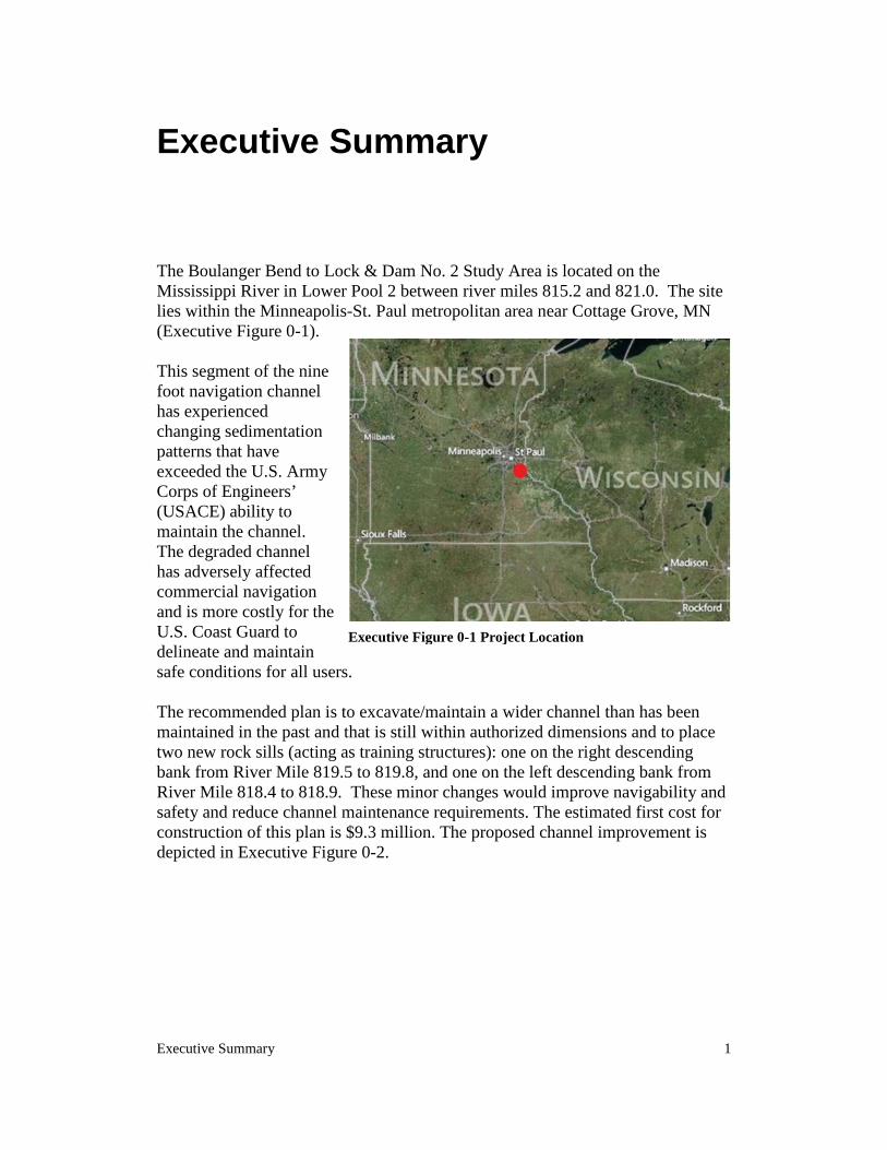
The Boulanger Bend to Lock & Dam No. 2 Study Area is located on the Mississippi River in Lower Pool 2 between river miles 815.2 and 821.0. The site lies within the Minneapolis-St. Paul metropolitan area near Cottage Grove, MN (Executive Figure 0-1). This segment of the nine foot navigation channel has experienced changing sedimentation patterns that have exceeded the U.S. Army Corps of Engineers’ (USACE) ability to maintain the channel. The degraded channel has adversely affected commercial navigation and is more costly for the U.S. Coast Guard to delineate and maintain safe conditions for all users.
The recommended plan is to excavate/maintain a wider channel than has been maintained in the past and that is still within authorized dimensions and to place two new rock sills (acting as training structures): one on the right descending bank from River Mile 819.5 to 819.8, and one on the left descending bank from River Mile 818.4 to 818.9. These minor changes would improve navigability and safety and reduce channel maintenance requirements. The estimated first cost for construction of this plan is $9.3 million. The proposed channel improvement is depicted in Executive Figure 0-2.
Executive Figure 0-1 Project Location
2 Lower Pool 2 Channel Management Study
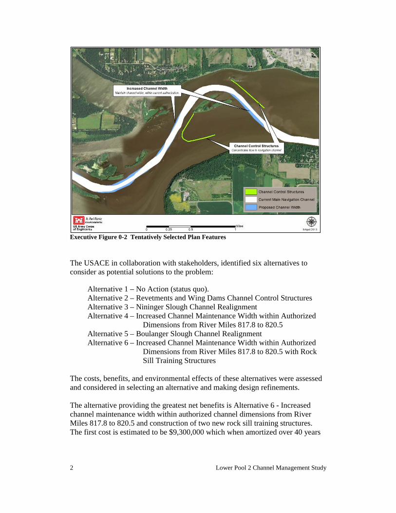
Executive Figure 0-2 Tentatively Selected Plan Features The USACE in collaboration with stakeholders, identified six alternatives to consider as potential solutions to the problem:
Alternative 1 – No Action (status quo). Alternative 2 – Revetments and Wing Dams Channel Control Structures Alternative 3 – Nininger Slough Channel Realignment Alternative 4 – Increased Channel Maintenance Width within Authorized
Dimensions from River Miles 817.8 to 820.5 Alternative 5 – Boulanger Slough Channel Realignment Alternative 6 – Increased Channel Maintenance Width within Authorized
Dimensions from River Miles 817.8 to 820.5 with Rock Sill Training Structures
The costs, benefits, and environmental effects of these alternatives were assessed and considered in selecting an alternative and making design refinements. The alternative providing the greatest net benefits is Alternative 6 - Increased channel maintenance width within authorized channel dimensions from River Miles 817.8 to 820.5 and construction of two new rock sill training structures. The first cost is estimated to be $9,300,000 which when amortized over 40 years
Executive Summary 3
at 2.875% interest equals an average annual cost of $399,000. Average annual benefits are $909,521 with net benefits of $547,000 and a benefit to cost ratio of 2.37. This alternative would require that the channel be widened from 300 feet to 350 feet at River Miles 818.0 to 820.5 and widened from 300 feet to 450 feet at River Miles 820.5 to 821.0 as shown on plate 6. In addition, two new channel rock sills (acting as training structures) would be placed on the left and right descending bank (see plate 6). These structures would help control the breakout flows and also increase channel velocity in conjunction with a wider channel so less sediment would accumulate in this part of the channel. Construction of the proposed channel widening and control structures is anticipated to require two construction seasons and would take place during the navigation season. The proposed project would have minor adverse impacts on aesthetic values and aquatic habitat; temporary minor impacts on public safety during construction, recurring temporary minor adverse impacts on noise levels, air quality, biological productivity, and surface water quality; substantial beneficial effects on commercial navigation; and minor beneficial effects on public safety (post construction). A complete explanation of these determinations can be found in Chapter 6 of the Letter Report and Integrated Environmental Assessment.

Affected Environment 5
CHAPTER 1. Introduction
1.1 Authority
The Corps of Engineers is responsible for maintaining a navigable channel on the Mississippi River. Authority for continued operation and maintenance of the Mississippi River Nine-Foot Channel project is provided in the River and Harbor Act of 1930. Original authority for the Corps of Engineers to work on the Mississippi River was provided in the River and Harbor Act of 1878. The project proposed here is authorized by the referenced legislation and its purpose is compatible with the annual Operations and Maintenance appropriation. The 1930 Rivers and Harbors Act authorizes dredging the straight reaches of the Pool 2 channel to a width of 200 feet. Bends in the channel are authorized at increased widths. The recommended bends widths in Lower Pool 2, as recommended in the Channel Maintenance Management Plan and the Great River Environmental Action Team study are listed below:
• Boulanger Bend (River Miles 820.3 - 821.5): Maximum: 500', Suggested: 500'
• Boulanger Bend Lower Light (River Mile 818.4 - 820.3): Maximum 500', Suggested: 400'
• Nininger Bend (River Mile 817.8 - 818.4): Maximum 500', Suggested: 400'
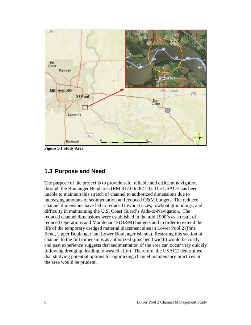
1.2 Project Location and Study Area
The study area is on the Mississippi River 9-Foot Navigation Channel between River Miles 815.2 and 821, and is depicted in Figure 1-1 and as shown on Plate 1. The study area is located near the southeastern edge of the Minneapolis–St. Paul Metropolitan area. The study area is bordered by the municipalities of Cottage Grove, MN to the north and Hastings, MN to the south. The geographic scope for the environmental analysis of the proposed action and alternatives encompasses the immediate project area and surrounding floodplain.
6 Lower Pool 2 Channel Management Study
Figure 1-1 Study Area
1.3 Purpose and Need
The purpose of the project is to provide safe, reliable and efficient navigation through the Boulanger Bend area (RM 817.0 to 821.0). The USACE has been unable to maintain this stretch of channel to authorized dimensions due to increasing amounts of sedimentation and reduced O&M budgets. The reduced channel dimensions have led to reduced towboat sizes, towboat groundings, and difficulty in maintaining the U.S. Coast Guard’s Aids-to-Navigation. The reduced channel dimensions were established in the mid 1990’s as a result of reduced Operations and Maintenance (O&M) budgets and in order to extend the life of the temporary dredged material placement sites in Lower Pool 2 (Pine Bend, Upper Boulanger and Lower Boulanger islands). Restoring this section of channel to the full dimensions as authorized (plus bend width) would be costly, and past experience suggests that sedimentation of the area can occur very quickly following dredging, leading to wasted effort. Therefore, the USACE determined that studying potential options for optimizing channel maintenance practices in the area would be prudent.
Affected Environment 7
This report documents the plan formulation efforts conducted by the U.S. Army Corps of Engineers. The study product is an implementation document in the form of an Integrated Letter Report and NEPA document in accordance with the Corps’ Planning Guidance Notebook, Engineer Regulation (ER) 1105-2-100.
1.4 Related Studies and Reports
Numerous studies and reports are available for the Upper Mississippi River that include Pool 2. The following studies and projects addressing channel maintenance, resource management, land use, and recreational planning in pool 2 have the most relevance to this study. Additional reports and studies may be available upon request.
1.4.1 Nine Foot Navigation Channel Project Environmental Impact Statement This document, completed in 1974, assesses the environmental effects of the operation and maintenance of the 9-Foot Navigation Channel project within the St. Paul District.
1.4.2 Great River Environmental Action Team Study (GREAT I) This 9-volume report (completed in 1980) documents the results of the 5-year Great River Environmental Action Team study for the St. Paul District reach of the Mississippi River. The report contained numerous recommendations for improved management of the river, the most important of which was a 40-year plan for dredged material placement for all of the historic dredging locations in the St. Paul District. Many of the study's recommendations have been implemented. Of particular application to this study is GREAT I further study item #2 which states – “A plan should be developed to use the river's sediment transport capability to cause necessary dredging requirements to occur near long-term placement sites as environmentally and economically feasible.”
1.4.3 Channel Maintenance Management Plan and EIS This 1996 plan and accompanying environmental impact statement is the St. Paul District's plan for management of channel maintenance. Much of the plan is devoted to the designation and design of dredged material placement sites. Included in this report is a discussion of the District's program for channel management. This channel management study for lower pool 2 is part of that program.
1.4.4 Lower Pool 2 Channel Management Study (DPR/EA) This 2003 report documents an in-depth review of channel maintenance needs and
8 Lower Pool 2 Channel Management Study
related natural resource considerations from St. Paul to Lock and Dam 2. The 2003 report briefly considered the issue addressed in this report, but recommended that it be considered independently at a later date, due to its scope.
1.4.5 - Dredged Material Placement Reconnaissance Report Lower Pool 2 This 1995 report recommended the pre-excavation of the Upper and Lower Boulanger islands and Pine Bend sites with material to be placed in the Shiely sand and gravel pits on Lower Grey Cloud Island.
1.4.6 – Pigs Eye Lake Section 204 This 2017 draft report assesses the feasibility of constructing habitat enhancement features in Pigs Eye Lake using material dredged during maintenance of the main channel of the Mississippi River navigation channel, under the authority of Section 204 of the Corps’ Continuing Authorities Program. The Tentatively Selected Plan includes islands, sand benches, marsh habitat, and terrestrial plantings. Such features have the objective of improving aquatic and terrestrial habitat as well as maintaining the shoreline of Pigs Eye Lake.
1.4.7 – Pool 2 Dredged Material Management Plan This draft report was under development in 2017. Long term planning for dredged material placement has been ongoing since the mid‐1970’s to maximize opportunities for beneficial use, starting with the Great River Environmental Action Team (GREAT) study from 1974 ‐1980. As a result of the GREAT recommendations, seventeen reconnaissance reports were developed in the mid‐1980’s assessing specific dredging locations and subsequent management of the material. These documents have reached the end of their planning period and are being updated on a pool‐by‐pool basis. Issues to be addressed in the Pool 2 Dredged Material Management Plan (DMMP) include increased sedimentation throughout Pool 2 and the lack of long‐term upland dredged material placement sites available for use.
1.4.8 – Lock and Dam 2 Embankment Repair This effort is in plan formulation and the project design will be initiated and completed in 2017, with construction award scheduled for 2018. Lock and Dam (LD) 2 is located at approximately river mile 815, near Hastings, Minnesota, between Dakota and Washington Counties. This site consists of the main lock, and one auxiliary lock on the Washington County side, and the embankment on the Dakota County side. The LD 2 embankment will undergo an embankment repair and improvement project to ensure it is protected from potential erosion due to high waters, ice action, and wind fetch.
Affected Environment 9
1.4.9 – Section 216 Disposition Study, Upper and Lower St. Anthony Falls and Lock and Dam 1, Upper Mississippi River An initial appraisal (IA) report was completed in October 2015. The IA recommended further study under the authority of Section 216 of the Flood Control Act of 1970. A Section 216 study would investigate the appropriate future disposition of three locks and dams located in Minneapolis, Minnesota, including Upper St. Anthony Falls, Lower St. Anthony Falls and Lock and Dam 1.
1.4.10 - Grey Cloud Slough Restoration Feasibility Study This report and subsequent updates were completed by the South Washington County Watershed District and describe the efforts taken to evaluate the feasibility of restoring connectivity of a 2.8-mile long meander loop in Lower Pool 2 to the main channel. An emergency road-raise in response to flooding in 1965 resulted in the upper end of Grey Cloud Slough being disconnected from the main channel. The Washington County Watershed District is planning to reconnect this slough by installing a new bridge or culvert.
10 Lower Pool 2 Channel Management Study
CHAPTER 2. Affected Environment
A description of components of the nearby environment is given here to provide a measure of the current state of the project location. This description is necessary to establish an understanding of the resources that may be affected by the alternative actions under consideration.
2.1 Socioeconomic Conditions
The project area is located in Pool 2 of the Upper Mississippi River approximately 20 miles downstream of St. Paul, Minnesota and is within the 13-county Minneapolis-St. Paul-Bloomington, MN/WI metropolitan statistical area (MSA). The 2010 population for this area was 3,279,833, an increase of 10.5% over the 2000 population. MSA per capita income in 2010 was $32,226 which is 9.6% greater than the state level and 20.7% greater than the nation as a whole. Important industries for employment include social services (includes education and health care – 23.2% vs. 23.2% for U.S.), trade (14.7% vs. 14.4% for U.S.), manufacturing (13.4% vs. 10.4% for U.S.), professional services (12.4% vs. 10.7% for U.S.), finance (8.5% vs. 6.6% for U.S.), and leisure and tourism (8.4% vs. 9.4% for U.S.).
Land Use The project area is located primarily within the Mississippi River floodplain. Islands within the floodplain are mostly low-lying, flood-prone, and undeveloped. Much of these low-lying areas are significantly affected by erosion and sedimentation, which continue to slowly change the island configuration in Lower Pool 2.
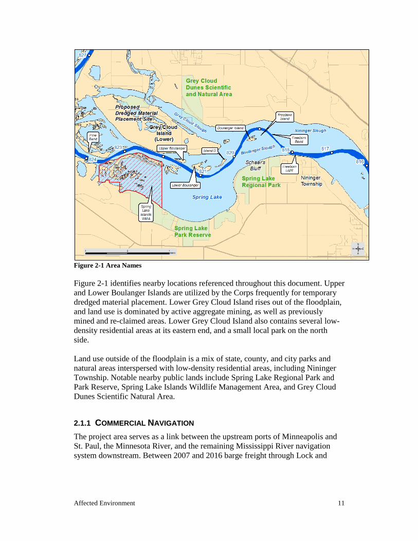
Affected Environment 11
Figure 2-1 Area Names Figure 2-1 identifies nearby locations referenced throughout this document. Upper and Lower Boulanger Islands are utilized by the Corps frequently for temporary dredged material placement. Lower Grey Cloud Island rises out of the floodplain, and land use is dominated by active aggregate mining, as well as previously mined and re-claimed areas. Lower Grey Cloud Island also contains several low-density residential areas at its eastern end, and a small local park on the north side. Land use outside of the floodplain is a mix of state, county, and city parks and natural areas interspersed with low-density residential areas, including Nininger Township. Notable nearby public lands include Spring Lake Regional Park and Park Reserve, Spring Lake Islands Wildlife Management Area, and Grey Cloud Dunes Scientific Natural Area.
2.1.1 COMMERCIAL NAVIGATION The project area serves as a link between the upstream ports of Minneapolis and St. Paul, the Minnesota River, and the remaining Mississippi River navigation system downstream. Between 2007 and 2016 barge freight through Lock and
12 Lower Pool 2 Channel Management Study
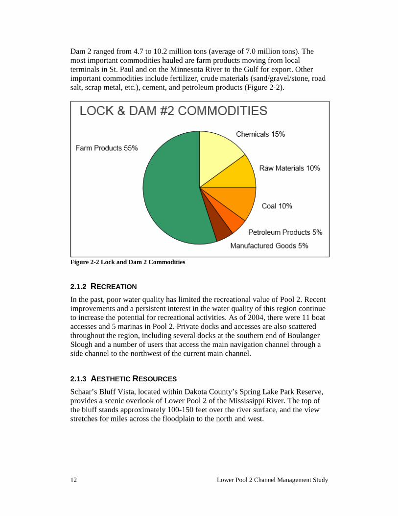
Dam 2 ranged from 4.7 to 10.2 million tons (average of 7.0 million tons). The most important commodities hauled are farm products moving from local terminals in St. Paul and on the Minnesota River to the Gulf for export. Other important commodities include fertilizer, crude materials (sand/gravel/stone, road salt, scrap metal, etc.), cement, and petroleum products (Figure 2-2).
Figure 2-2 Lock and Dam 2 Commodities
2.1.2 RECREATION In the past, poor water quality has limited the recreational value of Pool 2. Recent improvements and a persistent interest in the water quality of this region continue to increase the potential for recreational activities. As of 2004, there were 11 boat accesses and 5 marinas in Pool 2. Private docks and accesses are also scattered throughout the region, including several docks at the southern end of Boulanger Slough and a number of users that access the main navigation channel through a side channel to the northwest of the current main channel.
2.1.3 AESTHETIC RESOURCES Schaar’s Bluff Vista, located within Dakota County’s Spring Lake Park Reserve, provides a scenic overlook of Lower Pool 2 of the Mississippi River. The top of the bluff stands approximately 100-150 feet over the river surface, and the view stretches for miles across the floodplain to the north and west.
Affected Environment 13
2.2 Natural Resources
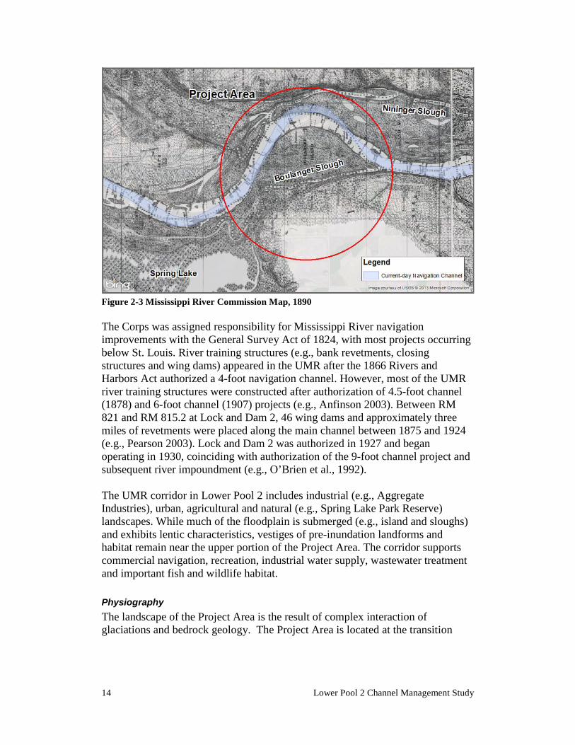
2.2.1 PHYSICAL SETTING The Boulanger Bend project area (Project Area) is located in Lower Navigation Pool 2, Upper Mississippi River (UMR) between River Mile (RM) 817 and 821 in Washington and Dakota counties, Minnesota (Figure 1-1). The Project Area is approximately 26.5 river miles below Lock and Dam 1 in Minneapolis, 18 miles below St. Paul and 1.8 miles above Lock and Dam 2 at Hastings. Corporate jurisdictions run along the main channel sailing line with the City of Cottage Grove (Washington County) to the north and Nininger Township (Dakota County) to the south. The Project Area is within the Mississippi National River and Recreation Area (MNRRA) corridor. The Project Area is situated in an area where the main-navigation channel meanders back and forth across the floodplain that is mostly inundated from Lock and Dam 2. The river is approximately 160 feet below the surrounding upland bluffs. The floodplain at the upstream portion of the Project Area (RM 821) is just over two miles wide with the main-navigation channel situated between Lower Grey Cloud Island and Spring Lake. Between RM 820 and Lock and Dam 2 the valley width constricts to just less than one mile in width. Prior to river modification projects during the late Nineteenth Century and Lock and Dam 2 induced inundation after 1930, this stretch of the UMR contained islands, natural levees, point bars, backwater sloughs, lakes, ponds and wetlands (e.g., MRC 1895). The historic channel is shown in Plate 2. Nininger Slough ran north of the main-navigational channel from approximately RM 819.5 to 816.5, above islands No. 17 and No. 18. Grey Cloud Slough ran above Lower Grey Cloud Island, entering the main channel from the west near RM 819.5. Boulanger Slough ran south of the main-navigation channel from approximately RM 820.7 to 818.2, below Boulanger Island (Figure 2-3).
14 Lower Pool 2 Channel Management Study
Figure 2-3 Mississippi River Commission Map, 1890 The Corps was assigned responsibility for Mississippi River navigation improvements with the General Survey Act of 1824, with most projects occurring below St. Louis. River training structures (e.g., bank revetments, closing structures and wing dams) appeared in the UMR after the 1866 Rivers and Harbors Act authorized a 4-foot navigation channel. However, most of the UMR river training structures were constructed after authorization of 4.5-foot channel (1878) and 6-foot channel (1907) projects (e.g., Anfinson 2003). Between RM 821 and RM 815.2 at Lock and Dam 2, 46 wing dams and approximately three miles of revetments were placed along the main channel between 1875 and 1924 (e.g., Pearson 2003). Lock and Dam 2 was authorized in 1927 and began operating in 1930, coinciding with authorization of the 9-foot channel project and subsequent river impoundment (e.g., O’Brien et al., 1992). The UMR corridor in Lower Pool 2 includes industrial (e.g., Aggregate Industries), urban, agricultural and natural (e.g., Spring Lake Park Reserve) landscapes. While much of the floodplain is submerged (e.g., island and sloughs) and exhibits lentic characteristics, vestiges of pre-inundation landforms and habitat remain near the upper portion of the Project Area. The corridor supports commercial navigation, recreation, industrial water supply, wastewater treatment and important fish and wildlife habitat.
Physiography The landscape of the Project Area is the result of complex interaction of glaciations and bedrock geology. The Project Area is located at the transition
Affected Environment 15
between the Eastern St. Croix Moraine and Rochester Till Plain physiographic areas (Wright 1972a). The area is underlain by Paleozoic era sedimentary rocks that formed in marine environments of the Hollandale Embayment. Exposed outcrops include, in descending order, Galena formation dolomitic limestone, Decorah shale, Platteville limestone, Glenwood shale and St. Peter Sandstone (e.g., Mossler 1972). Overlying the bedrock is glacial drift and glaciofluvial deposits of various thicknesses. The till is largely from the Superior and Des Moines lobes deposited during the late Wisconsin glaciation (ca. 30,000 to 12,000 years before present [BP]) although drift from earlier glacial episodes may be present (e.g., Wright 1972b). The Superior lobe ice margin (St. Croix Moraine), just north of the Project Area, buried previous Glacial Mississippi River channels during its advance that culminated ca. 15,500 BP. The Des Moines lobe margin (Bemis Moraine), a few miles west of the Project Area, reached its furthest extent ca. 14,000 BP. Melt water from the retreating Superior and Des Moines lobes created large outwash plains north and south of the Project Area and partially excavating fill of ancestral Mississippi River channels. Subsequently, the Grantsburg sublobe, an offshoot of the Des Moines Lobe, overrode the St. Croix Moraine ca. 13,500 BP blocking southward drainage with flows diverted to the St. Croix River. With retreat of the Grantsburg sublobe, lower outlets were uncovered, establishing the modern course of the UMR. A series of downcutting events ensued that excavated previous valley fills with sustained high magnitude discharges of sediment free melt water that formed a series of terraces (e.g., Knox 2008; Wright 1972b, 1985). The lowest terrace (e.g., Lower Grey Cloud Island) was established during the drainage of Glacial Lake Agassiz through catastrophic flooding down its outlet stream Glacial River Warren (modern Minnesota River) between ca. 12,000 and 9,400 BP (e.g., Dobbs et al., 1991; Fisher 2003; Upham 1895). As glacial ice receded, diminished flows with increased sediments resulted in alluviation of the deeply incised UMR. In some areas, massive alluvial fans accumulated at tributary mouths, forming dams that produced a series of river lakes (e.g., Lake Pepin). Sediment cores indicate a sequence of riverine lakes (i.e., Vermillion, Cannon, Pepin) occupied Pool 2 that were subsequently filled with sediments of the UMR delta, prograding past Hastings ca. 6,000 BP (e.g., Blumentritt et al., 2009; Zumberge 1952). Additional Holocene environmental changes (e.g., vegetation, climate) deposited a veneer of loess over the till and contributed to remobilization of colluvial and alluvial sediments that influenced floodplain geomorphology and fluvial activity, such as lateral channel migration and Paleoflood events (e.g., Knox 1993, 1998).
2.2.1.1 – Geomorphology Before 1875, when construction of river training structures ensued, the lower Pool 2 locality contained a diverse floodplain geomorphology characteristic of an
16 Lower Pool 2 Channel Management Study
anastimosed (ie. multiple channel) river. The area included outwash terraces (Grey Cloud Island), side channels (e.g., Grey Cloud, Boulanger, Nininger sloughs), islands (Islands 17 and 18), lakes (Balden, Baldwin, King, Spring), ponds, point bars, natural levees and marsh complexes (cf. MRC 1895). The historic channel is shown in Plate 2. More recently, beginning in the mid-Nineteenth Century, widespread areas of vegetation (i.e., prairie and forests) were removed for grazing and cropland causing erosion and the establishment of basin-wide artificial drainage networks which have accelerated sediment deposition in the floodplain (e.g., Knox 2001). These activities, combined with construction and operation of the lock and dam system have significantly affected the geomorphic processes occurring in Lower Pool 2. Submergence of the natural levees and backwaters, combined with the shift in vegetation communities, has decreased flow resistance in the backwaters causing secondary channel formation and expansion, and leading to increased backwater conveyance over time. Under existing conditions, Baldwin Lake and Spring Lake - the two largest backwaters in Lower Pool 2 – convey significant portions of the total river discharge (approximately 18-percent and 23 percent of the flow at a total river discharge of 20,600). Downstream of Spring Lake, flow is spread out over the completely submerged floodplain, which causes a decrease in stream power in the main channel resulting in sediment deposition. Several recent geomorphologic changes have impacted the navigation channel. The channel at Freeborn Bend has been migrating downstream. The channel between River Miles 818 and 820 is moving east. Most of the wing dams in this area have been buried due to sedimentation, and a significant portion of the revetment below river mile 819 has been inundated. Each of these factors contributes to allowing significant flows to break out of the main channel and reduce the sediment capacity of the river in the project area.
2.2.1.2 Sediment Transport The total sediment transported by a river consists of bed material sediments and wash load sediments. The bed material is the sediment that can be found on the bed of the channel, is transported along the bed of the river or in suspension during flood events, and generally consists of larger-sized particles (e.g. sand and coarse silts). In contrast, wash load sediments are those which are not found on the bed of the channel, are transported suspended in the water column, and generally consist of smaller-sized particles (e.g. silt & clay). Deposition of material commonly occurs where water velocity is not adequate to move as much sediment as is arriving from upstream. Boulanger Bend and Freeborn Bend are areas where the bed material accumulates due to these conditions. The tightness of the bends also contributes to dredging problems because the resulting point bar
Affected Environment 17
encroaches into the navigation channel. This is particularly a problem given the narrower channel width that is maintained in this reach of the river. In general, sediment sources include the upstream portion of the river under study and any tributaries that flow into that river. Sediment sinks are localized areas where stream power decreases, and include backwater areas and dredge cuts in the main navigation channel. The head of Lake Pepin is a major sediment sink and an area where the stream power drops to almost zero. Therefore, the majority of the sediment that makes its way past the other sinks upstream is destined to deposit in Lake Pepin. Major sediment sources that feed the Mississippi River above the head of Lake Pepin are the Minnesota River, the Mississippi River upstream of Anoka, and the St. Croix River. The Minnesota River is the largest source of sediment by far, contributing 1.33 million tons of suspended sediment and 0.31 million tons of bed material each year. The estimated annual contribution of the Mississippi River above Anoka is 0.19 million tons of suspended sediment and 0.14 million tons of bed material. The St. Croix River contributes a minimal amount of suspended sediments and no bed material. Overall, approximately one-million tons of sediment are deposited in Lake Pepin annually (Engstrom, 2009).
2.2.1.3 Hydrology & Hydraulics Pool 2 extends approximately 32 river miles between Lock and Dam 1 (RM 847.5) in Minneapolis to Lock and Dam 2 (RM 815.2) at Hastings. The UMR upstream of Lock and Dam 2 extends approximately 579 miles to its source at Lake Itasca and its basin incorporates approximately 22,450 square miles. The major tributary entering Pool 2 is the Minnesota River, extending approximately 332 miles from its mouth in Pool 2 to its source at Big Stone Lake and draining approximately 17,000 square miles. Several named streams (e.g., Minnehaha, Phalen, Battle and Fish creeks) and unnamed drainages enter Pool 2. In addition, bedrock (e.g., St. Peter sandstone) and glacial outwash (e.g., springs on the south side of Spring Lake) aquifers contribute flows to the pool. The UMR through Pool 2 collectively drains approximately 39,450 square miles (MNDNR 2013b). Discharge rates are variable across the basin, in part driven by a continental climate characterized by extremes and modern landscape use (e.g., vegetation removal, cultivation, drainage of wetlands, tile systems, stream channelization). In the period of record (from 1898 to 2015), annual peak discharges at the St. Paul gage (USGS 2016) range from a low of 9,670 cubic feet per second (cfs) in 1931 to a high of 171,000 cfs in 1965 (USACE 2004). Between 1996 and 2011, UMR annual average flows below Lock and Dam 2 at Hastings were approximately 18,000 cfs (USGS 2013). In general, mean annual flows show an increasing trend over the period of record. On the Minnesota River, average annual discharge
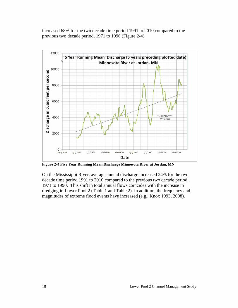
18 Lower Pool 2 Channel Management Study
increased 68% for the two decade time period 1991 to 2010 compared to the previous two decade period, 1971 to 1990 (Figure 2-4).
Figure 2-4 Five Year Running Mean Discharge Minnesota River at Jordan, MN On the Mississippi River, average annual discharge increased 24% for the two decade time period 1991 to 2010 compared to the previous two decade period, 1971 to 1990. This shift in total annual flows coincides with the increase in dredging in Lower Pool 2 (Table 1 and Table 2). In addition, the frequency and magnitudes of extreme flood events have increased (e.g., Knox 1993, 2008).
Affected Environment 19
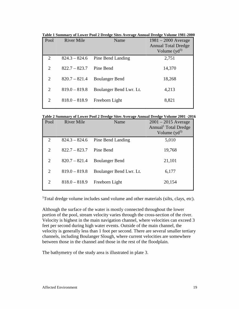
Table 1 Summary of Lower Pool 2 Dredge Sites Average Annual Dredge Volume 1981-2000
Pool River Mile Name 1981 – 2000 Average Annual Total Dredge
Volume (yd3)
2 824.3 – 824.6 Pine Bend Landing 2,751
2 822.7 – 823.7 Pine Bend 14,370
2 820.7 – 821.4 Boulanger Bend 18,268
2 819.0 – 819.8 Boulanger Bend Lwr. Lt. 4,213
2 818.0 – 818.9 Freeborn Light 8,821
Table 2 Summary of Lower Pool 2 Dredge Sites Average Annual Dredge Volume 2001 -2016
Pool River Mile Name 2001 – 2015 Average Annual1 Total Dredge
Volume (yd3)
2 824.3 – 824.6 Pine Bend Landing 5,010
2 822.7 – 823.7 Pine Bend 19,768
2 820.7 – 821.4 Boulanger Bend 21,101
2 819.0 – 819.8 Boulanger Bend Lwr. Lt. 6,177
2 818.0 – 818.9 Freeborn Light 20,154
1Total dredge volume includes sand volume and other materials (silts, clays, etc). Although the surface of the water is mostly connected throughout the lower portion of the pool, stream velocity varies through the cross-section of the river. Velocity is highest in the main navigation channel, where velocities can exceed 3 feet per second during high water events. Outside of the main channel, the velocity is generally less than 1 foot per second. There are several smaller tertiary channels, including Boulanger Slough, where current velocities are somewhere between those in the channel and those in the rest of the floodplain. The bathymetry of the study area is illustrated in plate 3.
20 Lower Pool 2 Channel Management Study
2.2.2 AQUATIC HABITAT A variety of aquatic habitats exist in the Project Area as classified by Wilcox (1993). The main navigation channel conveys the majority of river discharge with the 200 foot (61 m) wide navigation channel marked with buoys, lights and daymarks. The navigation channel is maintained so that tow boats drafting nine feet (2.6 m) can travel along its length. Typically, flows within the main channel are at a higher velocity with shifting substrates and devoid of vegetation. Main channel border areas lie between the main navigation channel and the riverbank (i.e., island shorelines) and may harbor river training structures, submerged logs and riprap that provide habitat for a variety of biota. Secondary channels (i.e., Boulanger and Nininger sloughs) are large channels that carry less flow than the main channel, and are defined by the apparent shorelines or inundated natural bank lines. Secondary channels offer variable habitats depending on flow, water depth, substrate, submerged structures, light penetration, wind, water quality, etc. Boulanger Slough ranges between 6 – 20 feet deep, and is dominated by a hard-packed clay substrate with scattered woody debris. Boulanger Slough is situated in the lower portion of Pool 2, in an area that is laterally connected across the entire floodplain because of impoundment. These contiguous impounded areas of large open water exist adjacent to and upstream of Lock and Dam 2, due to the dam’s influence on water levels. Habitat in impounded areas is variable and influenced by water depth, substrate, wind, submerged structures, light penetration, water quality, flow, etc. The impounded area that separates Boulanger Slough from the current main channel generally ranges from 4-6 feet deep with a hard clay substrate overlain by a flocculent layer of silt and interspersed by woody debris. The flocculent silt is often suspended by current flowing through the area and by wind-driven waves. Contiguous backwater floodplain lakes (i.e., Spring Lake) are hydraulically connected to the main channel with low current velocity that offer a wide variety of plant and animal habitat determined by local conditions.
2.2.3 FISHERIES The UMR on a whole supports a diverse assemblage of freshwater fish. Approximately 100 species of fish representing as many as 25 families have been recently sampled from the UMR between Minneapolis and Lock and Dam 10 (Schmidt & Proulx, 2009). Most of the fish present are native warmwater species. Common game species include walleye, sauger, northern pike, channel catfish, largemouth bass, bluegill, and white and black crappie. Common non-game fish include freshwater drum, carp, redhorses, buffaloes, and a wide variety of minnows. Exotic species currently residing in the UMR include common carp, grass carp, bighead carp, goldfish, and rainbow and brown trout.
Affected Environment 21
In comparison to other UMR pools, Pool 2 supports a moderate fishery. Surveys have indicated that fish species diversity tends to increase from upstream to downstream between Minneapolis and Lock and Dam 10, reflecting an increase in backwater areas, improved water quality, and improved habitat (Schmidt & Proulx, 2009; Pitlo et al., 1995). Upper Pool 2 provides mostly main channel and main channel border habitat because the floodplain is restricted by bluffs throughout the upper portion. In lower Pool 2 where the floodplain expands, there are a few backwater areas and side channels available. Water quality also influences the fish community in Pool 2 – high turbidity and high nutrient levels decrease the suitability of this habitat for some fish (See also chapter 2.2.8 – Water Quality). The project area is in the lower, impounded portion of the pool, where the majority of the floodplain is submerged. The most common habitat types are main channel, main channel border, secondary channel, tertiary channel, and artificially impounded river-lake. Main channel habitats typically provide swift current, deep water, and coarse sand, gravel, or rock bottom. Freshwater drum and channel catfish are common commercial fish that use this habitat type. Game fish that use the main channel include walleye, sauger, smallmouth bass, and white bass. In contrast to main channel and main channel border habitat, river lakes and backwaters in the impounded reach of the river typically have little current and provide habitat for fish species adapted to a lentic environment. Commercial species that commonly utilize backwater habitat include carp, bigmouth buffalo, and catfish, while typical sport fish include northern pike, largemouth bass, crappies, and bluegill. Secondary and tertiary channels are channels that carry less flow than the main channel. They represent a transition between main channel and backwater habitats. Secondary channels of the Mississippi River tend to provide more varied habitat and support a more diverse fish assemblage than main channel habitat (Weigel, Lyons, & Rasmussen, 2006).
2.2.4 AQUATIC INVERTEBRATES The Upper Mississippi River supports 48 known species of native freshwater mussels. Freshwater mussels are important food items for some mammals like raccoon and muskrat, as well as for some species of fish. They also play a role in maintaining water quality by filtering contaminants and feeding on algae and other small floating particles. Historically, as many as 41 species have occurred in Pool 2. Presently there are 29 known species living, ten of which are now either federally or state protected. Surveys in the late 1970s revealed that the mussel fauna in the UMR above Lake
22 Lower Pool 2 Channel Management Study
Pepin (including Pool 2) had declined significantly since the early 1900s – presumably due to water pollution (Fuller 1980). Since then, the Minnesota Department of Natural Resources conducted mussel surveys in the UMR between the Coon Rapids Pool and Upper Pool 3 in 2000 and 2001 and reported a “recovering mussel community” compared to those reported in the 1970s. These surveys recovered 22 of the 29 species known to be living in Pool 2 and noted areas of high density as well as evidence of recent recruitment (Kelner and Davis 2008).
2.2.5 THREATENED AND ENDANGERED SPECIES The U.S. Fish and Wildlife Service’s “Information for Planning and Conservation (IPaC) website was consulted on November 3, 2016 to determine if any proposed, candidate, threatened, or endangered species occurred within the project area. The results indicated that a total of four Federally-listed endangered species and two Federally-listed threatened species may occur in in the vicinity of the proposed project. Three species listed as endangered are freshwater mussels: the Higgins eye pearlymussel (Lampsilis higginsii), sheepnose (Plethobasus cyphyus), and snuffbox (Epioblasma triquetra). The other species listed as endangered is an insect – the rusty-patched bumble bee (Bombus affinus). Species listed as threatened include one mammal - the northern long-eared bat (Myotis septentrionalis), and one flowering plant – the prairie bush-clover (Lespedeza leptostachya). These species and their federal status as of January 2017 are listed in Table 3, at the end of this section. Suitable habitat for the Higgins’ eye pearlymussel includes areas of various stable substrates in large streams and rivers (U.S. Fish and Wildlife Service 2004). Although rare, live specimens of the Higgins’ eye pearlymussel have been found recently in Pool 2. Higgins’ eye are most commonly associated with high-density and diverse mussel beds. Suitable habitat for the sheepnose is similar to that for the Higgins’ eye (Ohio River Valley Ecosystem Team 2002). The Federally-listed endangered spectaclecase is a habitat specialist, found in large rivers in a variety of substrates, but particularly within microhabitats sheltered from strong currents (Butler 2002). The spectaclecase and sheepnose are not known to be extant in Pool 2 of the Upper Mississippi River (Kelner, 2015). The rusty patched bumble bee occupies grasslands and tallgrass prairies of the Upper Midwest and Northeast. This bumble bee needs areas that provide food (nectar and pollen from flowers), nesting sites (underground and abandoned rodent cavities or clumps of grasses above ground), and overwintering sites for hibernating queens (undisturbed soil) (USFWS 2016).

Affected Environment 23
Suitable habitat for the northern long-eared bat is variable depending on the season and the life stage of the individual. In the summer, these bats often roost under the bark of tree species such as maples and ashes within diverse mixed-age and mixed-species tree stands, commonly close to wetlands. In the winter, the northern long-eared bat hibernates in caves and abandoned mines. During periods of migration and foraging, these bats tend to use the ‘edge habitat’ where a transition between two types of vegetation occurs (Wisconsin DNR 2013b). Suitable habitat for the prairie bush clover includes well-drained soils in prairies of the Midwest. Table 3 Federally-Protected Species that May Occur Within Project Area
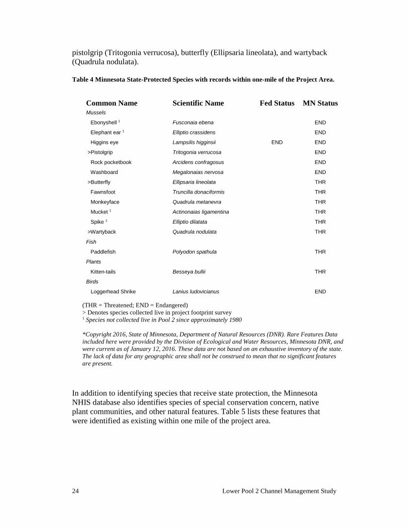
Species of Local Significance A number of species that are listed by the State Minnesota as endangered or threatened have been historically documented in the vicinity of the project area. These species include freshwater mussels, a fish, a plant, and a bird, and are listed in Table 4. The table includes species historically documented within one mile of the proposed project features, based on a search of the Minnesota Natural Heritage Information System, conducted December 2016. The historically-documented mussel species were compared with the results of recent mussel survey efforts in Lower Pool 2 to determine which species have recent records of occurrence. Of the historically-recorded mussel species, four have not been found live within Lower Pool 2 in thirty-five or more years: the mucket (Actinonaias ligamentina), elephant ear (Elliptio crassidens), spike (Elliptio dilatata), and ebonyshell (Fusconaia ebena). Two of these species – the mucket and spike – have been reintroduced in Upper Pool 2, but there has been no evidence of recruitment within Lower Pool 2. Therefore, it is assumed that these species do not currently occur in the proposed project area. The remaining eight species have been recently collected within Lower Pool 2; three of which were found in the surveys conducted specifically for the proposed project: the
Common Name Scientific Name Fed Status Higgins eye Lampsilis higginsii END
Sheepnose Plethobasus cyphyus END
Spectaclecase Epioblasma triquetra END
Rusty patched bumblebee Bombus affinus END
Northern long-eared bat Myotis seprentrionalis THR
Prairie bush clover Lespedeza leptostachya THR
(END = Endangered; THR = Threatened)
24 Lower Pool 2 Channel Management Study
pistolgrip (Tritogonia verrucosa), butterfly (Ellipsaria lineolata), and wartyback (Quadrula nodulata). Table 4 Minnesota State-Protected Species with records within one-mile of the Project Area.
In addition to identifying species that receive state protection, the Minnesota NHIS database also identifies species of special conservation concern, native plant communities, and other natural features. Table 5 lists these features that were identified as existing within one mile of the project area.
Common Name Scientific Name Fed Status MN Status Mussels
Ebonyshell 1 Fusconaia ebena END
Elephant ear 1 Elliptio crassidens END
Higgins eye Lampsilis higginsii END END
>Pistolgrip Tritogonia verrucosa END
Rock pocketbook Arcidens confragosus END
Washboard Megalonaias nervosa END
>Butterfly Ellipsaria lineolata THR
Fawnsfoot Truncilla donaciformis THR
Monkeyface Quadrula metanevra THR
Mucket 1 Actinonaias ligamentina THR
Spike 1 Elliptio dilatata THR
>Wartyback Quadrula nodulata THR
Fish
Paddlefish Polyodon spathula THR
Plants
Kitten-tails Besseya bullii THR
Birds
Loggerhead Shrike Lanius ludovicianus END
(THR = Threatened; END = Endangered) > Denotes species collected live in project footprint survey 1 Species not collected live in Pool 2 since approximately 1980 *Copyright 2016, State of Minnesota, Department of Natural Resources (DNR). Rare Features Data included here were provided by the Division of Ecological and Water Resources, Minnesota DNR, and were current as of January 12, 2016. These data are not based on an exhaustive inventory of the state. The lack of data for any geographic area shall not be construed to mean that no significant features are present.
Affected Environment 25
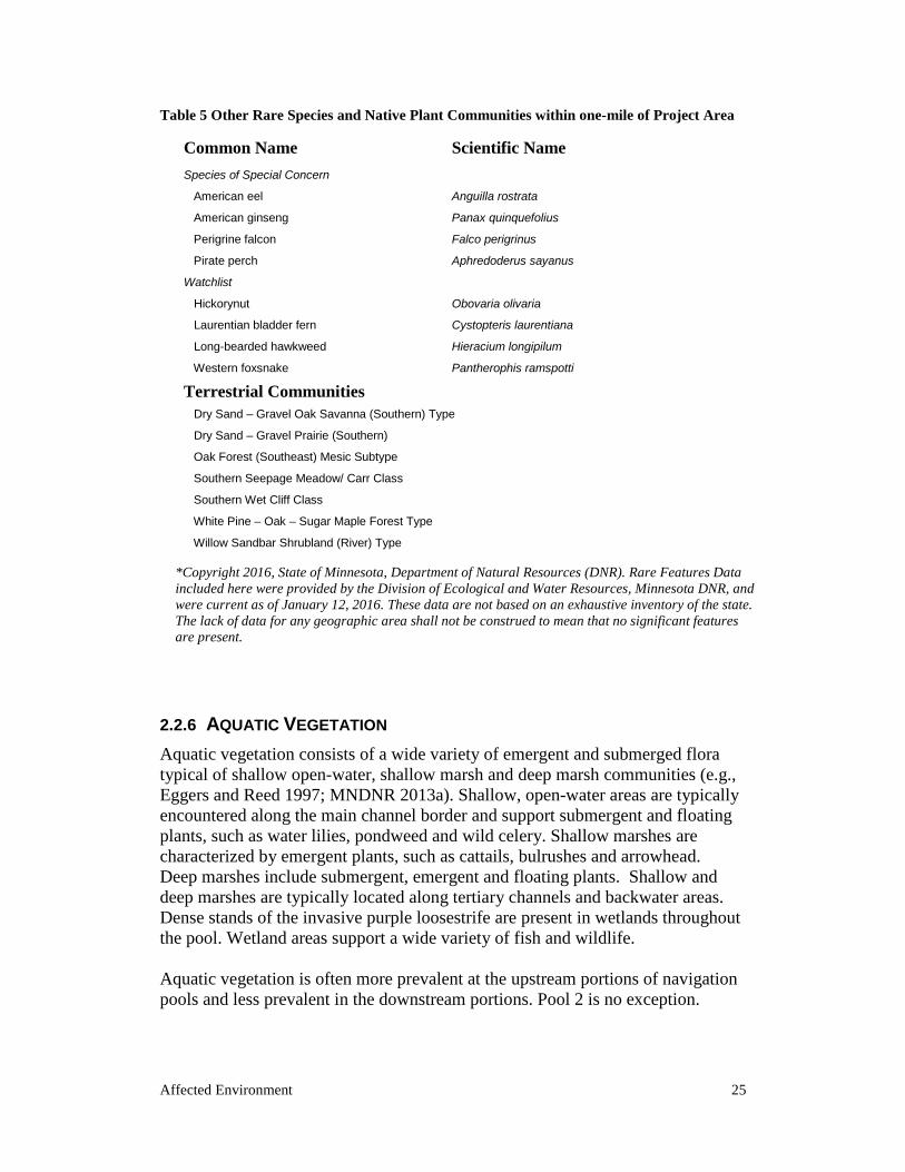
Table 5 Other Rare Species and Native Plant Communities within one-mile of Project Area
2.2.6 AQUATIC VEGETATION Aquatic vegetation consists of a wide variety of emergent and submerged flora typical of shallow open-water, shallow marsh and deep marsh communities (e.g., Eggers and Reed 1997; MNDNR 2013a). Shallow, open-water areas are typically encountered along the main channel border and support submergent and floating plants, such as water lilies, pondweed and wild celery. Shallow marshes are characterized by emergent plants, such as cattails, bulrushes and arrowhead. Deep marshes include submergent, emergent and floating plants. Shallow and deep marshes are typically located along tertiary channels and backwater areas. Dense stands of the invasive purple loosestrife are present in wetlands throughout the pool. Wetland areas support a wide variety of fish and wildlife. Aquatic vegetation is often more prevalent at the upstream portions of navigation pools and less prevalent in the downstream portions. Pool 2 is no exception.
Common Name Scientific Name Species of Special Concern
American eel Anguilla rostrata
American ginseng Panax quinquefolius
Perigrine falcon Falco perigrinus
Pirate perch Aphredoderus sayanus
Watchlist
Hickorynut Obovaria olivaria
Laurentian bladder fern Cystopteris laurentiana
Long-bearded hawkweed Hieracium longipilum
Western foxsnake Pantherophis ramspotti
Terrestrial Communities
Dry Sand – Gravel Oak Savanna (Southern) Type
Dry Sand – Gravel Prairie (Southern)
Oak Forest (Southeast) Mesic Subtype
Southern Seepage Meadow/ Carr Class
Southern Wet Cliff Class
White Pine – Oak – Sugar Maple Forest Type
Willow Sandbar Shrubland (River) Type
*Copyright 2016, State of Minnesota, Department of Natural Resources (DNR). Rare Features Data included here were provided by the Division of Ecological and Water Resources, Minnesota DNR, and were current as of January 12, 2016. These data are not based on an exhaustive inventory of the state. The lack of data for any geographic area shall not be construed to mean that no significant features are present.
26 Lower Pool 2 Channel Management Study
Downstream of Spring Lake in the inundated portion of the pool, aquatic vegetation is scarce and tends to occur mostly in areas almost entirely protected by islands. In this area, wind and wave action, combined with the high turbidity levels contribute to these conditions.
2.2.7 BIRDS At least 300 species of birds, about 60 percent of the total number of species in the conterminous United States, are known to use the UMR. The UMR valley is a major bird migration corridor for the mid-continental United States through which an estimated 40 percent of the continent’s waterfowl migrate (U.S. Fish and Wildlife Service, 2006). The Mississippi Flyway also provides migration habitat for songbirds, colonial nesting birds, secretive marsh birds, and raptors, making the UMR a resource of national and international importance. Waterfowl are considered particularly important due to their large numbers and visibility. Approximately 30 species of waterfowl use the UMR. Widgeon, mallards, scaup, canvasbacks, and wood ducks are species which commonly use the river. Based on weekly waterfowl surveys conducted by the USFWS during the fall of 2011, birds which utilized the lower Pool 2 area in high numbers included Canada geese, mallards, ringnecks, cormorants, white pelicans, and coots.
2.2.8 WATER QUALITY According to the MPCA's online 'Impaired Waters Viewer' tool (accessible at: https://www.pca.state.mn.us/water/impaired-waters-viewer-iwav), the Mississippi River between Rock Island Bridge to Lock and Dam 2 (RM 830 to 815.2) is “suitable for swimming and wading, with low bacteria levels throughout the open water season. Concentrations of PCB, PFOS, and mercury in fish tissue, and mercury in the water column exceed the water quality standard”. In 2009, a MPCA water quality assessment of Lower Pool 2 listed the reach as having impaired beneficial use for aquatic life caused by turbidity. Currently, there are two TMDLs that cover Lower Pool 2: Upper Mississippi River Bacteria TMDL and the Lake Pepin Watershed Nutrients TMDL.
Sediment Quality Sediment quality in Lower Pool 2 is relatively poor compared with other pools in the Upper Mississippi River. Lower Pool 2 seems to be a sink for surrounding and upstream contaminate sources due to a decrease in water velocity and high silt content of the sediments. In general, silts have a higher affinity to attach to contaminates than larger mineral sands. Historical USACE grain size analyses of
Affected Environment 27
the sediment in the navigational channel have shown silts contents of around 75% in the stretch of river around Boulanger Bend (rm 819.7 to 818.5). Off-channel sediments in the vicinity are commonly found to be over 90% silts. To ascertain the extent of sediment pollution in the Boulanger Bend area, USACE staff completed a sediment survey in 2015 within the footprint of the preferred project plan and compared the results to MPCA’s soil reference values (SRVs) and sediment quality targets (SQTs) (See Appendix H Sediment Quality Analysis for further testing details). The MPCA’s SRVs are limits on pollutant concentrations for material being placed at two types of upland sites, either Recreational/Residential or Commercial/Industrial. The MPCA is currently in the process of updating their values for SRVs, and therefore the Draft values from August 2016 are used in this report. The Draft values are expected to be finalized in 2017. The SQTs (Level I and Level II) are guidelines used to identify contaminant concentrations that cause harmful effects on sediment-dwelling organisms. Level I SQTs are the concentrations which will provide a high level of protection for benthic invertebrates. Level II SQTs are the concentrations which will provide a moderate level of protection for benthic invertebrates. Results of the 2015 survey showed that the sediment in the preferred project area was fairly clean. Exceedances were restricted to only polycyclic aromatic hydrocarbons (PAHs) and/or metals and except for one sample (15‐70M/1), which is from a location that will be buried by fill during project construction, there were no exceedances of Level II SQTs or SRVs. The most abundant contaminant that was detected at levels above the SQT I guidelines was cadmium. Cadmium has been widely dispersed into the environment through the air by its mining and smelting as well as by other man-made routes: usage of phosphate fertilizers, presence in sewage sludge, and various industrial uses such as NiCd batteries, plating, pigments and plastics (ATSDR 1999).
2.2.9 TERRESTRIAL HABITAT The project area is situated within the Eastern Broadleaf Forest Province where the pre-European settlement vegetation consisted of tallgrass prairie and oak savanna (e.g., Marschner 1974). During the Holocene, a succession of vegetation regimes were established after deglaciation in response to climate change driven in part by seasonal air mass boundaries originating from the Arctic, Pacific Ocean and the Gulf of Mexico (e.g., Bryson 1966). Tundra was replaced by a boreal spruce forest, succeeded by pine forests before warm and drier conditions expanded prairie vegetation ca. 8,000 BP. Oak increased with a return of cool and moist conditions and the pre-European prairie-forest ecotone was in place by ca. 4,000 BP (e.g., Blumentritt et al., 2009; Wright 1972b, 1992; Wright et al., 1998). With more stable conditions following episodes of paleofloods, floodplain forests and productive wetland communities were established by the Late Holocene (e.g., Baker et al., 2001; Knox 1993; Wright et al 1998).
28 Lower Pool 2 Channel Management Study
Floodplain Vegetation Alluvial bottomlands host wet floodplain forests dominated by maple and elm as well as river shore communities typically dominated by willows. Higher elevation landforms support more xeric communities (e.g., MNDNR 2013a). These habitats support a wide of variety of fauna.
Terrestrial Vegetation In general, tallgrass prairie and oak savanna occupy uplands and portions of terraces. Maple-basswood dominated forests occupy slopes and ravines in areas protected from fire that occasionally include relict pine stands. Bedrock exposures support an assortment of cliff and talus communities, such as lichens, ferns and patchy trees and shrubs (e.g., MNDNR 2013a).
2.2.10 AIR QUALITY The U.S. Environmental Protection Agency (EPA) is required by the Clean Air Act to establish air quality standards that primarily protect human health. These National Ambient Air Quality Standards (NAAQS) regulate six major air contaminants across the United States. When an area meets criteria for each of the six contaminants, it is called an ‘attainment area’ for that contaminant; those areas that do not meet the criteria are called ‘nonattainment areas.’ Washington County is classified as an attainment area for each of the six contaminants and is therefore not a region of impaired ambient air quality (EPA 2011). A portion of Dakota County (approximately 4 miles away from the project site) is classified as a nonattainment area for lead, and the rest of the county is designated as an attainment area for each of the six contaminants (MPCA 2009). This designation means that the project area has relatively few air pollution sources of concern.
2.3 Cultural Resources
The Pool 2 locality contains numerous cultural resources indicating continual human occupation over approximately the last 13,000 years. Cultural resources include a variety of precontact and historic archaeological sites. Precontact sites include lithic and artifact scatters, village sites, petroglyphs, and burial mounds. Historic sites include standing structures, early town sites, forts, shipwrecks, bridges and river training structures. Cultural resources are situated on a variety of landforms, such as uplands, terraces, cliffs, islands and the river floodplain. Several cultural resource sites within this locality are listed on the National Register of Historic Places (NRHP) or are eligible for listing on the NRHP. In addition, the pool contains several Historic Districts.
Affected Environment 29
Interest in the archaeological record of the upper Mississippi River Valley, including the Pool 2 area, has been ongoing since the late nineteenth century (e.g., Anfinson et al 2003; Brower 1903; Winchell 1911). Early research in the area centered on the contents of burial mounds and who built them, such as amateur excavations at the Dayton’s Bluff mounds (21RA5) just east of downtown St. Paul (e.g., Arzigian and Stevenson 2003). By the early twentieth century most practitioners rejected the popular notion that a race of non-American Indians constructed the mounds and non-scientific investigations gave way to systematic mapping and excavation (e.g., Anfinson et al. 2003). Despite an awareness of cultural resources in the pool, no comprehensive pre-impoundment survey was completed prior to construction and subsequent operation of Lock and Dam 2 in 1930. Modern archaeological research within the pool began during the 1940s with research projects by the University of Minnesota and the St. Paul Science Museum (now the Science Museum of Minnesota) (Johnson 1959; Johnson and Taylor 1956). In the 1970s, the Corps sponsored a survey of dredged material placement sites and the Minnesota Historical Society completed investigations at Grey Cloud Island (Birk 1973; Johnson and Hudak 1975). Since the last quarter of the twentieth century, numerous cultural resource investigations have been completed within the Pool 2 locality near the Project Area as well as several literature based overviews (e.g., Anfinson et al 2003; Dobbs et al 1991; Flemming and Hager 2010; Gronhovd and O’Brien 2008a, 2008b; Harrison 2010a, 2010b; Jalbert et. al. 1996; Jensen 1992; Madigan and Shermer 2001; Meyer and Schmidt 1995; Pearson 2003; Vogel and Stanley 1987; Withrow, et al 1987; Woolworth 1976). Only one previous investigation in Pool 2 included areas within the project area: Pearson (2003) for an overview and NRHP evaluation for channel structures. In the larger context of Upper Mississippi River constriction works and wing dams appear to be eligible for listing on the NRHP. As navigation features, they have been periodically modified as dictated by river conditions and navigation needs, especially after the 9-foot channel project began operation in the 1930s. In some cases, they were reduced or extended in length and height or outright removed. Under the current operations, the wing dams are submerged, although portions of some of the wing dams may be visible during low water events. While a number of wing dams are extant within the project area none will be affected by the undertaking. No cultural resources have been identified within the project area. However, no comprehensive surveys have been conducted along island shorelines or for submerged high probability landforms (e.g., natural levees) in the project area. A total of eight recorded cultural resource sites exist within one mile of the project area, all located in upland settings (Table 5). Several of these sites are listed on or
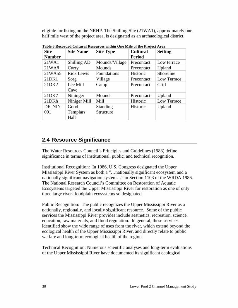
30 Lower Pool 2 Channel Management Study
eligible for listing on the NRHP. The Shilling Site (21WA1), approximately one-half mile west of the project area, is designated as an archaeological district. Table 6 Recorded Cultural Resources within One Mile of the Project Area Site Number
Site Name Site Type Cultural Period
Setting
21WA1 Shilling AD Mounds/Village Precontact Low terrace 21WA8 Curry Mounds Precontact Upland 21WA55 Rick Lewis Foundations Historic Shoreline 21DK1 Sorg Village Precontact Low Terrace 21DK2 Lee Mill
Cave Camp Precontact Cliff
21DK7 Nininger Mounds Precontact Upland 21DKh Niniger Mill Mill Historic Low Terrace DK-NIN-001
Good Templars Hall
Standing Structure
Historic Upland
2.4 Resource Significance
The Water Resources Council’s Principles and Guidelines (1983) define significance in terms of institutional, public, and technical recognition. Institutional Recognition: In 1986, U.S. Congress designated the Upper Mississippi River System as both a “…nationally significant ecosystem and a nationally significant navigation system…” in Section 1103 of the WRDA 1986. The National Research Council’s Committee on Restoration of Aquatic Ecosystems targeted the Upper Mississippi River for restoration as one of only three large river-floodplain ecosystems so designated. Public Recognition: The public recognizes the Upper Mississippi River as a nationally, regionally, and locally significant resource. Some of the public services the Mississippi River provides include aesthetics, recreation, science, education, raw materials, and flood regulation. In general, these services identified show the wide range of uses from the river, which extend beyond the ecological health of the Upper Mississippi River, and directly relate to public welfare and long-term ecological health of the region. Technical Recognition: Numerous scientific analyses and long-term evaluations of the Upper Mississippi River have documented its significant ecological
Affected Environment 31
resources. Since the early 20th century, researchers, government agencies, and private groups have studied the large river floodplain system. The Upper Mississippi River ecosystem consists of hundreds of thousands of acres of bottomland forest, islands, backwaters, side channels, and wetlands, all of which support more than 300 species of birds; 57 species of mammals; 45 species of amphibians and reptiles; 150 species of fish; and nearly 50 species of mussels. More than 40 percent of North America’s migratory waterfowl and shorebirds depends on the food resources and other life requisites (shelter, nesting habitats, etc.) that the ecosystem provides.
2.5 Expected Future Without Project Conditions
If no action is taken at the study area, the channel conditions will remain degraded and may worsen over time as a result of changed sedimentation patterns. The degraded channel will continue to negatively impact commercial navigation, to result in higher maintenance dredging costs, and to strain the U.S. Coast Guard’s ability to delineate safe conditions for all users.
2.5.1 CLIMATE CHANGE The U.S. Global Research Program’s Third National Climate Assessment was completed in 2014. It states that:
“in the Upper Midwest extreme heat, heavy downpours, and flooding will affect infrastructure, health, agriculture, forestry, transportation, air and water quality, and more. Climate change will tend to amplify existing risks climate poses to people, ecosystems, and infrastructure. Climate change also alters pests and disease prevalence, competition from non-native or opportunistic native species, ecosystem disturbances, land-use change, landscape fragmentation, atmospheric and watershed pollutants, and economic shocks such as crop failures, reduced yields, or toxic blooms of algae due to extreme weather events.”
Important driving climate variables include seasonal precipitation and air temperature and both variables are expected to increase in the future. In the project area this could alter hydrologic characteristics such as the magnitude, duration, and timing of river flows; water quality variables such as temperature, dissolved oxygen, and turbidity; and geomorphic processes like sediment deposition and secondary channel erosion.
32 Lower Pool 2 Channel Management Study
While climate change modeling and assessment at the project scale relies on qualitative information at this point in time, the existing hydrologic record can provide some insight on recent changes. An analysis of the Mississippi River discharge record at the nearby USGS gage at Prescott, Wisconsin indicates that the average annual discharge and the number of days of overbank flows per year have increased over the last 3 or 4 decades. Most of the increase is occurring during the spring and early summer months with smaller increases in the fall. During the winter months of December, January, and February overbank flooding has not occurred. Given that climate modeling indicates a wetter climate in the future, the increased flows indicated in the recent hydrologic record are likely to persist and potentially get worse. These changes will be considered during project planning and design.
CHAPTER 3. Planning Process
Plan formulation has been conducted in accordance with the six-step planning process described in Economic and Environmental Principles and Guidelines (P&G) for Water and Related Land Resources Implementation Studies (1983) and the Planning Guidance Notebook (ER 1105-2-100, dated April 2000). The six steps in the iterative plan formulation process are:
1. Specify the water and related land resources problems and opportunities of the study area;
2. Inventory and forecast existing conditions;
3. Formulate alternative plans;
4. Evaluate alternative plans;
5. Compare alternative plans; and
6. Select the recommended plan.
The basis for selection of the recommended plan is fully documented below, including the logic used in the plan formulation and selection process.
3.1 Problem and Opportunity Identification
One of the critical steps in the planning process is the identification of problems and opportunities within the study area. Problems are issues that will be addressed with the project and opportunities are future desirable conditions. Opportunities can be directly related to solving the problem at hand, but can also be ancillary to the identified problem. Taking the existing and forecasted future conditions into consideration, the following water resource related problems and opportunities were identified: The problems in Lower Pool 2 are:
• Reduced commercial navigability, • Increased sedimentation, and therefore increased dredging and costs, and • Increased costs to maintain aids to navigation.
The commercial navigation industry has identified reduced navigability of this stretch as a problem. Historically, the bend was maintained at a width that would allow passage of fifteen-barge tows – the standard operating size on the UMR. The difficulty of navigating the sharp bend
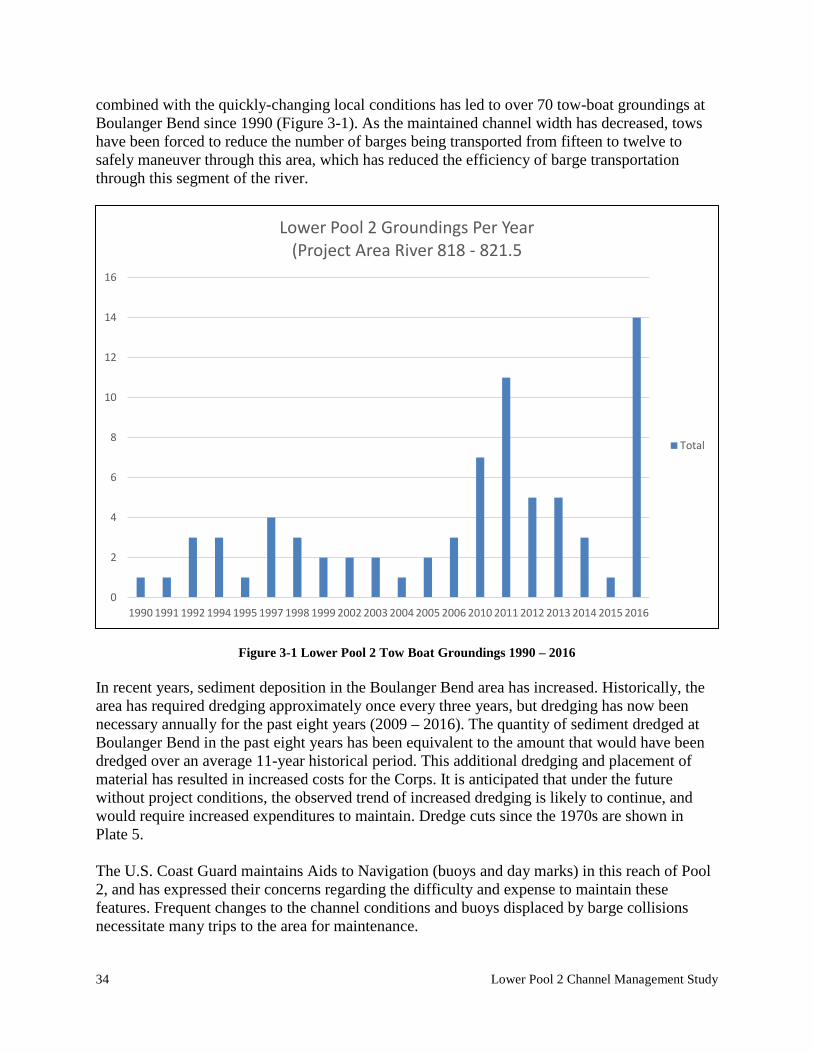
34 Lower Pool 2 Channel Management Study
combined with the quickly-changing local conditions has led to over 70 tow-boat groundings at Boulanger Bend since 1990 (Figure 3-1). As the maintained channel width has decreased, tows have been forced to reduce the number of barges being transported from fifteen to twelve to safely maneuver through this area, which has reduced the efficiency of barge transportation through this segment of the river.
Figure 3-1 Lower Pool 2 Tow Boat Groundings 1990 – 2016 In recent years, sediment deposition in the Boulanger Bend area has increased. Historically, the area has required dredging approximately once every three years, but dredging has now been necessary annually for the past eight years (2009 – 2016). The quantity of sediment dredged at Boulanger Bend in the past eight years has been equivalent to the amount that would have been dredged over an average 11-year historical period. This additional dredging and placement of material has resulted in increased costs for the Corps. It is anticipated that under the future without project conditions, the observed trend of increased dredging is likely to continue, and would require increased expenditures to maintain. Dredge cuts since the 1970s are shown in Plate 5. The U.S. Coast Guard maintains Aids to Navigation (buoys and day marks) in this reach of Pool 2, and has expressed their concerns regarding the difficulty and expense to maintain these features. Frequent changes to the channel conditions and buoys displaced by barge collisions necessitate many trips to the area for maintenance.
0
2
4
6
8
10
12
14
16
1990 1991 1992 1994 1995 1997 1998 1999 2002 2003 2004 2005 2006 2010 2011 2012 2013 2014 2015 2016
Lower Pool 2 Groundings Per Year(Project Area River 818 - 821.5
Total
Planning Process 35
Opportunities in Lower Pool 2 are to:
• Provide a safe and reliable navigation channel, • Improve aquatic vegetation growth, • Enhance recreational opportunities,
A safe and reliable navigation channel provides multiple types of users with passage for purposes of commerce, transportation, or recreation. Under the current maintenance strategy, conditions are frequently unsafe and unreliable, particularly during times when vessels are grounded and obstructing the channel. A safe and reliable channel would optimally consist of the suggested and authorized dimensions and would require minimal and manageable maintenance. Lower Pool 2, like the lower portion of many navigation pools, has been inundated due to the construction of dams, and has lost most of its natural islands and physical character. This has resulted in large lake-like areas where excessive wind fetch leads to waves and the frequent re-suspension of sediment. This, combined with the uniquely large sediment load delivered to Pool 2 by the Minnesota River makes aquatic vegetation relatively rare in Lower Pool 2. The effects of inundation also impact recreational use. Waves that result from the high wind fetch can make this stretch of river difficult for a small boat to navigate.
3.2 Project Goals and Objectives
Planning goals are broad, conceptual statements that describe the ultimate and overarching purposes for the study. The overarching national goal of water resources planning is to contribute to national economic development while protecting the nation's environment. The overall goal of this project is to maintain a commercially navigable channel in the Upper Mississippi River. Planning objectives are concise and focused descriptions of what an alternative plan should achieve. They are developed based on the problems and opportunities that are identified for a study. Clear objectives are used to identify measures and formulate alternatives that will achieve the project’s goals. The guidance for developing objectives is provided in USACE planning guidance ER 1105-2-100 and specifies that objectives must be clearly defined, must provide information on the effect desired, the subject of the objective, the location where the effect will occur and the timing and duration of the effect. For the purpose of this report, the timing or duration of the objectives is assumed to be the 40 year period of analysis. The project life is set at 40 years. This is based on the Channel Maintenance Management Plan (CMMP) and associated EIS which were both based on a 40-year planning period. This time period is consistent with the GREAT I study and is meant to address a sufficient time period for measuring the long-term impacts of channel maintenance at a given location. The objectives for the proposed project are:
• Minimize channel maintenance costs associated with sedimentation in Lower Pool 2.
36 Lower Pool 2 Channel Management Study
• Provide an economically-justified level of commercial navigation in Lower Pool 2. • Minimize maintenance costs of U.S. Coast Guard’s Aids to Navigation in Lower Pool 2
3.3 Planning Constraints and Assumptions
Planning constraints are temporary or permanent limits imposed on the scope of the planning process and choice of solutions. Constraints represent restrictions that should not be violated. Planning assumptions underlie the logic of the planning process. Although these states of nature and anticipated human activities are not certain, they are assumed to apply in the future. The planning constraints and assumptions identified in this study are specified as follows:
Constraints • Flood Stage Impacts – Any project features should not increase flood heights or adversely affect
private property or infrastructure.
• A Federally-listed endangered freshwater mussel species, the Higgins’ eye pearlymussel (Lampsilis higginsii), was found near the project location in 2010. Any project developed in Lower Pool 2 must avoid unnecessarily adversely affecting this species, or any other Federally-listed endangered species.
• Contaminated Sediments – Avoid or minimize disturbance of contaminated sediments
Assumptions • Funding for the operation and maintenance of the 9 foot channel has declined in recent
years and is not expected to improve markedly in the near future.
• Nearby placement sites for dredged material are limited and it is expected that it will be increasingly difficult to secure them in the future.
3.4 Alternative Measures
A management measure is a feature (a structural element that requires construction or assembly on-site) or an activity (a nonstructural action) that can be combined with other management measures to form alternative plans. Based on management measures, the alternative plans were developed to address study area problems, to capitalize upon study area opportunities, and to meet the goals and objectives of the study. Alternative plans are different combinations of various sizes and scales of alternative measures that would contribute to attaining the planning objectives. An alternative measure may stand alone as an alternative plan that can be implemented independently of other measures, resulting in some achievement of the planning objectives. Problems, objectives, and measures are summarized in Table 6 at the end of this chapter.
Planning Process 37
3.4.1 NO ACTION The no action measure is defined as no implementation of a project to modify channel conditions in the study area. This measure is carried forward for further consideration.
3.4.2 CHANNEL CONTROL STRUCTURES Channel control structures could be used to better transport sediment through the study area. Modifications to existing channel control structures could be effective in concentrating the flow through the main navigation channel and preventing sediment from dropping out of suspension around Boulanger Bend. New structures could also be constructed, such as revetments, wing dams, or rock sills, to help concentrate or train the flow to reduce sedimentation in Boulanger Bend. This measure is carried forward for further consideration.
3.4.3 CHANNEL REALIGNMENT Realigning the channel would involve relocating the main navigation channel and dredging a channel in that new location. The relocated channel could be aligned straighter than the existing channel and would be designed for increased conveyance to reduce sedimentation in the area. A channel realignment may require a closing structure to prevent the flow from entering the existing main navigation channel and direct the flow into the new channel. This measure is carried forward for further consideration.
3.4.4 INCREASED CHANNEL MAINTENANCE Increased maintenance would mean maintaining the navigation channel at the authorized width (as shown on Plate 4). Table 7 Summary of Problems, Objectives and Measures
Problem Objectives Measures Reduced commercial navigability
Provide an economically-justified level of commercial navigability in Lower Pool 2
Channel control structures, channel realignment, increased channel maintenance
Increased sedimentation and increased dredging costs
Minimize channel maintenance costs associated with sedimentation in Lower Pool 2.
Channel control structures, channel realignment
Increased costs to maintain aids to navigation
Minimize maintenance costs of U.S. Coast Guard’s Aids to Navigation in Lower Pool 2
Channel control structures, channel realignment, increased channel maintenance
38 Lower Pool 2 Channel Management Study
CHAPTER 4. Alternative Plan Formulation and Evaluation
This chapter describes the full array of alternative plans developed and the evaluation and screening of these alternatives. The conclusions presented in this chapter are based on a lower level of detail as appropriate for this stage of the planning process. Additional data was collected for the final array of alternatives that were carried forward as project planning progressed, and is described more thoroughly in Chapter 6 – The Evaluation of Environmental Effects. The purpose of evaluation and screening is to determine which alternative plans meet project objectives, avoid project constraints and should be carried forward for more detailed analysis towards the identification of the National Economic Development (NED) plan. Evaluation and screening also serves to eliminate alternatives that have fatal flaws or do not meet the primary project objectives. Several criteria, including the evaluation criteria identified in the P&G, were used to evaluate and screen alternatives and to further refine alternatives to be considered in detail. For each of the P&G criteria, specific indicators for this feasibility study are described; in addition, risk was added as a criterion for consideration.
• Effectiveness - Effectiveness is the extent to which an alternative plan alleviates the specified problems and achieves the specified objectives. Specifically in Lower Pool 2 effectiveness is defined by whether or not the alternative would be effective in maintaining an acceptable navigation channel.
• Acceptable - Acceptability refers to the workability and viability of the alternative with respect to acceptance by state and local entities and the public compatibility with existing laws. In this study, environmental effects and socioeconomic effects were used as indicators of acceptability.
o Environmental Effects - Whether or not there would be unacceptable environmental effects including impacts to natural resources as well as historical and cultural resources.
o Socioeconomic Effects - Whether or not there would be unacceptable effects on socio-economic resources such as transportation, public safety, recreation, public facilities, and public services.
• Completeness - Completeness is the extent to which the alternative plans provide and account for all necessary investments or other actions to ensure the realization of the planned effects. Implementability was considered as specific indicator of completeness for this study, consideration of whether or not there are significant outstanding technical, social, legal, or institutional issues that affect ability to implement the alternative.
Planning Process 39
• Efficiency - Efficiency refers to cost-effectiveness and the most efficient allocation of other resources. Efficiency is the extent to which an alternative plan is the most cost-effective means of alleviating the specified problems and achieving the specified objectives. For the purposes of the feasibility study, the costs evaluated were the first costs of the project and expected future operation and maintenance costs. Cost impacts may be realized not only in pool 2 where the project would be constructed but also in pools 3 and 4 if dredging needs change as a result of changing sedimentation patterns. Different alternatives would allow more or less material to flow through Pool 2. If more material flows through pool 2, it will later deposit in pool 3 and upper pool 4. Conversely, if less material flows through pool 2, less material will reach pools 3 and 4. These impacts from the project in Pool 2 would impact the dredging requirements and costs for pools 3 and 4.
• Risk - The uncertainties, vulnerabilities, and potential consequences of the alternative.
40 Lower Pool 2 Channel Management Study
4.1 Alternative 1 - No Action Alternative
Alternative Description Under this alternative, the Corps would continue current channel maintenance practices. This is considered to be the base condition against which the other alternatives are compared. It includes those actions expected to be undertaken in the future in the absence of an additional project. Good indicators of expected future actions are those actions taken in the past. Likewise, the impacts to each of the resource categories under the no action alternative are likely to be a continuation of those that have been caused by current channel maintenance practices resulting from sedimentation in this segment of the river. The Boulanger Bend area (River Mile 818-821) of Lower Pool 2 is an area where the navigation channel meanders back and forth between the banks of the floodplain, which creates a near 90-degree bend in the river at mile 819. Navigating this area is difficult for commercial towboats: more than 70 groundings have occurred since 1990. The river also deposits a lot of sediment in the area, which periodically narrows the width of the channel around the bend. The Corps maintains this area by frequent dredging. Since 1981, on average, the Corps has dredged the area once every three years, but during the last 8 years (2009 – 2016) the Corps has dredged the area every year. The increase in dredging is likely due to increased flows carrying more sediment into the area. Based on these historical dredging records, it would be assumed that there may continue to be a demand for frequent dredging in the future without project condition. Large quantities of dredging also increase the demand on nearby placement sites.
Effectiveness The effectiveness of the No Action alternative would vary depending on the year. The historic average dredging frequency has been approximately once every three years. However, the past eight years (2009 – 2016) have required annual dredging. In any case, this location would have a high dredging frequency, and it has been difficult to manage this area to provide a safe and reliable navigation channel. Overall, the effectiveness of this alternative is considered to be low.
Environmental Effects Natural Resources: The high sedimentation and shoaling rate in this area would lead to high-frequency dredging events, similar to the current conditions. The dredging events would cause temporary periods of increased turbidity. Turbidity would also increase on occasions when barges are grounded and try to dislodge themselves from the shoal. Overall, the potential environmental effects of the No Action alternative are considered to be low adverse.
Socioeconomic Effects The No Action alternative would continue to impair the safety of towboat crews and other river users due to the narrow, shifting channel and subsequent groundings. These conditions increase costs to the navigation industry due to the time lost during groundings and by necessitating
Planning Process 41
reduced tow sizes to fit through the channel. Additionally, the U.S. Coast Guard would incur continued maintenance costs to maintain Aids to Navigation in the project area (buoys and day markers). Overall, the socioeconomic effects of the No Action alternative are considered to be moderate adverse.
Risk The unpredictable nature of the shoaling at this location could cause the main navigation channel to become impassable to navigation traffic (a channel closure). A channel closure could lead to emergency dredging, which needs to be completed very quickly. These situations provide fewer opportunities for planning and review, and therefore have a higher risk of overlooking an environmental concern. Safety is also at risk, because it is often difficult to inform the public about emergency situations in the channel, and underwater obstructions are often not detectable. Overall, the risk of the No Action alternative is considered to be high.
Cost As stated above, cost impacts may be realized not only in pool 2 but also in pools 3 and 4 if dredging needs change as a result of changing sedimentation patterns. For this reason, recent dredging patterns (2007-2016) in Pools 2, 3, and 4 were evaluated to estimate future maintenance dredging costs of the channel in its present condition. The average annual dredging volume from this channel is estimated at 144,600 cubic yard. A Dredged Material Management Plan (DMMP) for Pool 2 is currently in development. This DMMP shows the cost of maintenance dredging in Pool 2 is $13.00/CY to dredge and place sand in its final placement site. In Pool 3 an extra step is required to unload the sand from a temporary site to the final placement site. This annual cost is estimated to be $539,000. Therefore the average annual maintenance cost over the 40-year planning period for the No-Action alternative is 144,600 CY x $13.00/CY + $539,000 = $2,418,800. This value will serve as the basis for comparison of the dredging cost savings benefit for other alternatives.
Conclusion The Future Without Project Condition (No Action) is the base condition against which other alternatives are compared to quantify and determine the significance of impacts. This alternative must be presented in the National Environmental Policy Act (NEPA) document prepared for any Corps project that may be proposed. This alternative will be carried forward for detailed evaluation.
4.2 Alternative 2 – Revetments and Wing Dams Channel Control Structures
Alternative Description
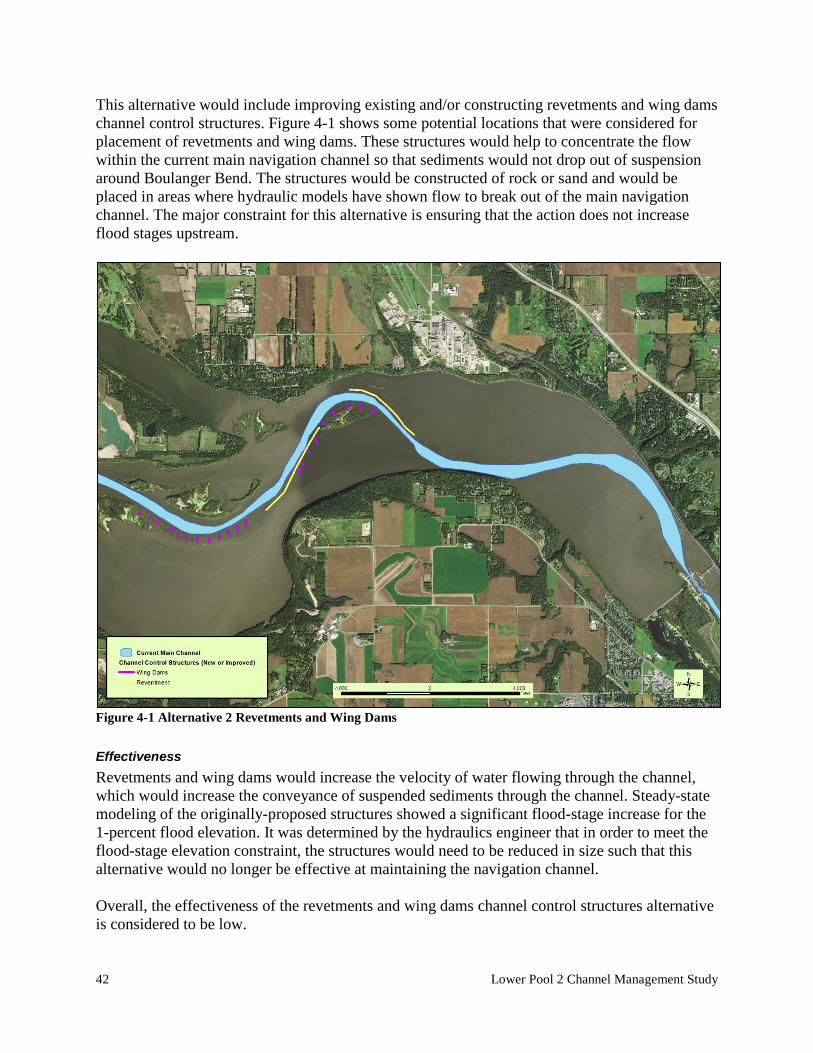
42 Lower Pool 2 Channel Management Study
This alternative would include improving existing and/or constructing revetments and wing dams channel control structures. Figure 4-1 shows some potential locations that were considered for placement of revetments and wing dams. These structures would help to concentrate the flow within the current main navigation channel so that sediments would not drop out of suspension around Boulanger Bend. The structures would be constructed of rock or sand and would be placed in areas where hydraulic models have shown flow to break out of the main navigation channel. The major constraint for this alternative is ensuring that the action does not increase flood stages upstream.
Figure 4-1 Alternative 2 Revetments and Wing Dams
Effectiveness Revetments and wing dams would increase the velocity of water flowing through the channel, which would increase the conveyance of suspended sediments through the channel. Steady-state modeling of the originally-proposed structures showed a significant flood-stage increase for the 1-percent flood elevation. It was determined by the hydraulics engineer that in order to meet the flood-stage elevation constraint, the structures would need to be reduced in size such that this alternative would no longer be effective at maintaining the navigation channel. Overall, the effectiveness of the revetments and wing dams channel control structures alternative is considered to be low.
Planning Process 43
Environmental Effects Natural resources effects would occur from the placement of material in the river. Any macroinvertebrates within the footprint of the material placement, such as freshwater mussels, would be killed. If a dense and diverse mussel bed were to be found in the project footprint, it may be warranted to relocate mussels out of the impact area. Flows would be more concentrated within the main navigation channel, and flows in the backwater areas of the Boulanger and Nininger sloughs would likely be slightly decreased. The sandy main channel border habitat would be transformed into a shallower rock habitat. There would likely be some turbidity caused by construction, but less than the other structural alternatives. Overall, the potential environmental effects of the revetments and wing dams alternative are considered to be moderate adverse.
Socioeconomic Effects The revetments and wing dams channel control structures alternative would improve public safety by reducing the hazard associated with groundings. River users must be cautions of any new underwater structures. The project would also decrease costs to the navigation industry by allowing the more efficient transit of 15-barge tows and reducing the number of trips into and out of the St. Paul harbor. The Coast Guard would also realize cost savings in the form of reduced maintenance of navigation aids. Overall, the socioeconomic effects of the revetments and wing dams alternative are considered to be moderate positive.
Implementability As described under Planning Constraints in Section 3.3, flood-stage increases must be avoided. Hydraulic modeling showed that for features significant enough to keep higher velocities in the channel, stage increases for the 1-percent flood would be unacceptable. Overall, the implementability of the revetments and wing dams channel control structures alternative is considered to be low.
Cost This alternative was screened out before cost analyses were prepared.
Risk It is likely that material not deposited in the main channel in the project area would be deposited in another location resulting in increased dredging at that location. There is also the risk that the revetments and wing dams would not convey sediment or maintain the channel as well as predicted. Overall, the risk associated with the revetments and wing dams alternative is considered to be moderate.
Conclusion
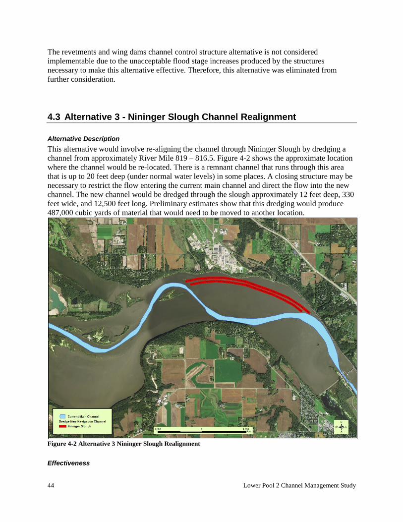
44 Lower Pool 2 Channel Management Study
The revetments and wing dams channel control structure alternative is not considered implementable due to the unacceptable flood stage increases produced by the structures necessary to make this alternative effective. Therefore, this alternative was eliminated from further consideration.
4.3 Alternative 3 - Nininger Slough Channel Realignment
Alternative Description This alternative would involve re-aligning the channel through Nininger Slough by dredging a channel from approximately River Mile 819 – 816.5. Figure 4-2 shows the approximate location where the channel would be re-located. There is a remnant channel that runs through this area that is up to 20 feet deep (under normal water levels) in some places. A closing structure may be necessary to restrict the flow entering the current main channel and direct the flow into the new channel. The new channel would be dredged through the slough approximately 12 feet deep, 330 feet wide, and 12,500 feet long. Preliminary estimates show that this dredging would produce 487,000 cubic yards of material that would need to be moved to another location.
Figure 4-2 Alternative 3 Nininger Slough Realignment
Effectiveness
Planning Process 45
The channel realignment would reduce the overall need for maintenance dredging by conveying more sediment through the channel, and would remove the near 90-degree bend in the channel and make navigation easier and safer. Overall, the effectiveness of the Nininger Slough Channel Realignment alternative is considered to be high.
Environmental Effects Natural resources effects would be higher in the short-term and likely decreased in the long-term. In general, dredging the new channel would convert the Nininger Slough secondary channel into main channel habitat. The current main channel area would have a reduction in flows and would be expected to become a secondary channel. Freshwater mussels, macroinvertebrates, and fish in the area of the cutoff would be directly impacted by the construction, and animals living in other areas nearby could be indirectly impacted by a change in the hydrology. According to initial surveys, no federally-listed endangered mussels are known to exist at the project location, although there does appear to be a diverse mussel community with high densities in some locations. Some state-listed endangered species have been found within the project footprint, but these species, although rare in Minnesota as a whole, are very prevalent throughout Pool 2. If further surveys identified a dense and diverse mussel bed within the project footprint, it may be warranted to relocate mussels out of the impact area. According to NWI wetland maps, there are some areas of lacustrine wetland that could be impacted by the project. Any impacts to wetland would require appropriate mitigation. Due to a nearby industrial plant that has been in operation for over 60 years, contaminants would likely be present in the sediment that would need to be dredged. In a 2008 USACE sediment survey of the Upper Mississippi River, three samples collected in Nininger Slough were tested for Perfluorochemicals (PFCs) from the upper 10 cm of the sediment. All three samples had detectable levels in line with samples collected from Lake Pepin and downstream boat harbors located above and below Lake Pepin. In 2012, Nininger Slough sediment was randomly sampled along the potential channel alignment. Twelve boreholes were drilled and 23 composite samples from varying stratums were analyzed. Sample results from Nininger Slough showed lower levels of silt, but considerably more contamination than samples collected from Boulanger Slough. Throughout the proposed dredge cut, several boreholes had frequent exceedances of level I and level II SQTs and a few boreholes had MPCA’s level 1 Soil Reference Value (SRVs) exceedances of PCBs, and/or mercury and/or manganese. Based on these results, the USACE determined that all material dredged under this alternative would need to be disposed of in a permitted landfill. Overall, the potential environmental effects of the Nininger Slough Channel Realignment alternative are considered to be high adverse.
Socioeconomic Effects The Nininger Slough Alternative would improve public safety by reducing the hazard associated with groundings. The project would also decrease costs to the navigation industry by allowing the more efficient transit of 15-barge tows and reducing the number of trips into and out of the
46 Lower Pool 2 Channel Management Study
St. Paul harbor. The Coast Guard would also realize cost savings in the form of reduced maintenance of navigation aids. Compared to the Channel Control Structure alternative, the socioeconomic benefits provided by the Nininger Slough alternative would be of a greater magnitude because the straightening the channel would further reduce the difficulty of navigating this stretch of river. Overall, the socioeconomic impacts of the Nininger Slough Channel Realignment alternative would be considered high positive.
Implementability There are no known insurmountable technical, social, legal, or institutional issues that would prevent this alternative from being implemented, but placement sites would need to be located for all of the dredged material including any contaminated material. A larger placement site would be needed for this alternative than for the Boulanger Slough channel realignment –Alternative 5 because more material would be generated. Overall, the implementability of the Nininger Slough Channel Realignment alternative is considered to be moderate.
Cost Detailed costs were not developed for this alternative. It was determined that the quantity of dredging required to construct this alternative would be approximately twice that necessary for the Boulanger Slough channel realignment; therefore, for the purposes of alternative screening, it was assumed that the cost would be roughly twice that of the Boulanger Bend alternative. Overall, the cost of the Nininger Slough Channel Realignment alternative is considered to be high.
Risk Risks for this alternative include problems with the removal of contaminated material, lack of sediment conveyance, and increased dredging downstream. Overall, the risk of the Nininger Slough Channel Realignment alternative is considered to be moderate.
Conclusion Although this alternative appears to meet the objectives of this study, the risk and costs associated with dredging and disposing of the contaminated material and the high overall project costs make the alternative not feasible. Therefore, this alternative was eliminated from further consideration.
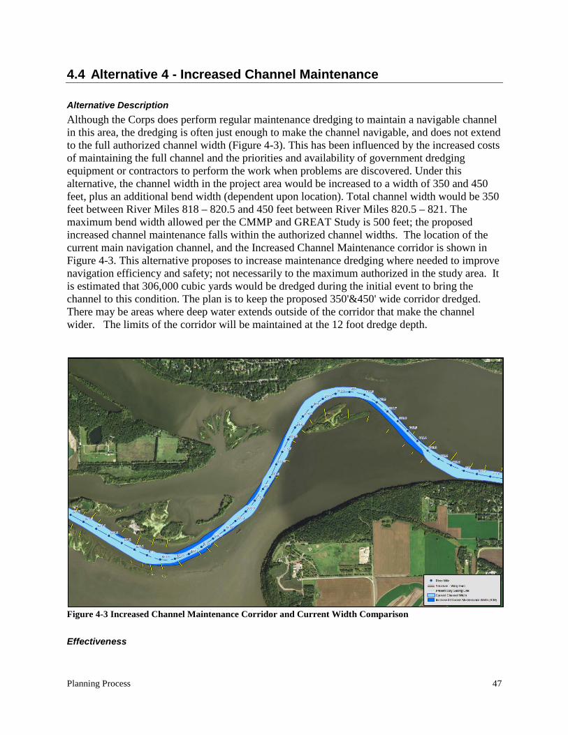
Planning Process 47
4.4 Alternative 4 - Increased Channel Maintenance
Alternative Description Although the Corps does perform regular maintenance dredging to maintain a navigable channel in this area, the dredging is often just enough to make the channel navigable, and does not extend to the full authorized channel width (Figure 4-3). This has been influenced by the increased costs of maintaining the full channel and the priorities and availability of government dredging equipment or contractors to perform the work when problems are discovered. Under this alternative, the channel width in the project area would be increased to a width of 350 and 450 feet, plus an additional bend width (dependent upon location). Total channel width would be 350 feet between River Miles 818 – 820.5 and 450 feet between River Miles 820.5 – 821. The maximum bend width allowed per the CMMP and GREAT Study is 500 feet; the proposed increased channel maintenance falls within the authorized channel widths. The location of the current main navigation channel, and the Increased Channel Maintenance corridor is shown in Figure 4-3. This alternative proposes to increase maintenance dredging where needed to improve navigation efficiency and safety; not necessarily to the maximum authorized in the study area. It is estimated that 306,000 cubic yards would be dredged during the initial event to bring the channel to this condition. The plan is to keep the proposed 350'&450' wide corridor dredged. There may be areas where deep water extends outside of the corridor that make the channel wider. The limits of the corridor will be maintained at the 12 foot dredge depth.
Figure 4-3 Increased Channel Maintenance Corridor and Current Width Comparison
Effectiveness
48 Lower Pool 2 Channel Management Study
This alternative would improve safety and navigability of the channel. The increased channel width would accommodate a fifteen-barge tow, based on historical experience. However, because the channel would still contain the near 90-degree bend and would still allow for significant amounts of river flow to break out of the channel, the project area would still be expected to accumulate sediments and require at least as much maintenance dredging as under current conditions. Overall, the effectiveness of the Increased Channel Maintenance alternative is considered moderate.
Environmental Effects There would be two stages of impacts under this alternative: first would be the initial project construction impacts, and following would be the ongoing future maintenance impacts. The initial construction of widening the channel would disturb an estimated 40 acres of main channel border habitat and 80 acres of main channel habitat. Any benthic organisms currently living there would be removed and likely killed by the dredging. However, much of this habitat is unstable, shifting sand that does not provide suitable habitat for benthic organisms. The effects of ongoing, semi-annual maintenance dredging would be similar to the without project condition, but turbidity caused by dredging events may be slightly increased due to the increased dredging, and turbidity caused by groundings would be decreased. This alternative would reduce the bed load sediments transported downstream to Pool 3 and Upper Pool 4. This would have a minor positive impact on these downstream resources by reducing the sedimentation in the delta areas of backwaters. Overall, the potential environmental effects of the Increased Channel Maintenance alternative are considered to be low adverse.
Socioeconomic Effects This scenario would create enhanced public safety to towboat crews because the channel would be wider than it is currently maintained. The channel would also provide a greater area of suitable depth for recreational traffic. Navigation outside the marked channel in Lower Pool 2 can be dangerous due to shifting sediments and significant stump fields. Overall, the socioeconomic effects of the Increased Channel Maintenance alternative are considered high positive.
Implementability The implementability of this alternative is highly influenced by resource management. Maintaining a wider channel in this reach of the river would require the commitment of more resources to this area on an annual basis. These resources include funding, human labor, and time. Perhaps the most difficult resource constraint is managing the division of work between the available dredging plants. Currently, there are five dredging plants under employ in the St. Paul District. The workload of the St. Paul District (and sometimes the Rock Island and St. Louis Districts as well) is divided among these plants based on the size and locations of individual
Planning Process 49
dredging jobs during a dredging season. The five year annual dredging average (2007-2011) used in the cost analysis is a sufficient workload to occupy four dredging plants. Under this alternative, the project area would require additional annual maintenance dredging, and would therefore increase pressure on the dredge plants. During years of high channel maintenance, this alternative would increase the chance that it would be necessary to sacrifice other critical dredging needs or employ an additional plant at a greatly increased expense (as discussed in the ‘Cost’ screening criteria below). For example, in 2011, a situation arose where emergency channel dredging was required. Because the regular dredge plants already had a full workload, a contract for a one-time dredging event was sought. Cost per cubic yard for this event was $10.50, compared to $8.40 for dredging conducted with other plants. For the 13,191 cubic yard job, this increased the job cost by $27,701. In addition, mobilization costs that would not otherwise be incurred added $46,800. In this instance, the mobilization cost was relatively low because the dredging plant was already close to the job location. However, this is seldom the case, and costs have been significantly higher. Another institutional constraint is the availability of both temporary and permanent dredged material placement sites from St. Paul to the head of navigation. Currently, there are four active sites throughout Pool 2. One of the four, Southport, is not feasible for placement as it is approximately 16 river miles from the project. All three sites feasible for placement are temporary, thus a cost for excavation will be incurred at some point in time. The three active, temporary sites (Pine Bend, Upper Boulanger, and Lower Boulanger) are all nearing capacity. More importantly, the future availability of nearby and available permanent placement sites in the area is unknown at this point, and may make future temporary site unloading difficult and expensive. Overall, the implementability of the Increased Channel Maintenance alternative is considered to be low.
Cost The initial enlargement, (the construction) of the channel to the authorized dimensions is considered the first cost of this alternative. It includes the initial dredging and final placement of this material. The first cost is estimated to be $5,700,000. The Interest During Construction is estimated to be $75,000. These 2 costs, when amortized over 40 years at 2.875% interest equals an average annual cost of $245,000. The result of this alternative will be an increase in maintenance dredging. The estimated annual maintenance cost would be $2,472,300, which includes $2,042,300 for the costs of dredging and $430,000 for the cost of unloading the temporary placement sites for Pools 2, 3, and Upper Pool 4. The total annual cost for this alternative is $245,000 + $2,472,300 = $2,717,300 compared to the No Action Alternative of $2,418,800. This is an increase of $298,500.
50 Lower Pool 2 Channel Management Study
Other costs that would be expected to rise under the increased channel maintenance alternative, though difficult to quantify, include:
• Labor costs for inspection, oversight, and management of additional dredge plants • Costs associated with adding additional plant (mobilization, transportation, etc.)
Cost to navigation industry would decrease as full-sized tows (15 barges) could transit this stretch of the river resulting in fewer trips into and out of St. Paul harbor. Costs to the U.S. Coast Guard would be expected to drop due to the wider channel. Overall, the costs associated with the Increased Channel Maintenance alternative are considered to be moderate.
Risk There is a high risk compared to the other alternatives. This alternative does provide a wider and generally safer channel than without project conditions, but it would be more volatile than any of the other structural alternatives, and would still be prone to the problems discussed in the without project condition. The risks include dredge plant unavailability, placement site uncertainty, increased maintenance costs, and declining budgets. Overall, the risk associated with the Increased Channel Maintenance alternative is considered to be high.
Conclusion Although this alternative appears to meet the objectives of this study, it would not be feasible due to implementation constraints, increased annual costs, and high risk. Therefore, increased channel maintenance as a standalone alternative was screened from further analysis.
4.5 Alternative 5 - Boulanger Slough Channel Realignment
Alternative Description This alternative would involve re-aligning the navigation channel through Boulanger Slough by dredging a channel from approximately River Mile 820 – 818. Figure 4-4 shows the approximate location of the Boulanger Slough Channel. There is a remnant channel that runs through this area that is up to 20 feet below Low Control Pool (LCP) elevation in some places. A partial closing structure would be necessary to restrict the flow entering the current main channel and direct the flow into the new channel. The new channel would be dredged through the slough approximately 12 feet deep, 330 feet wide (top width), and 8,000 feet long. Preliminary estimates show that this dredging would produce 298,000 cubic yards of material that would need to be moved to another location.
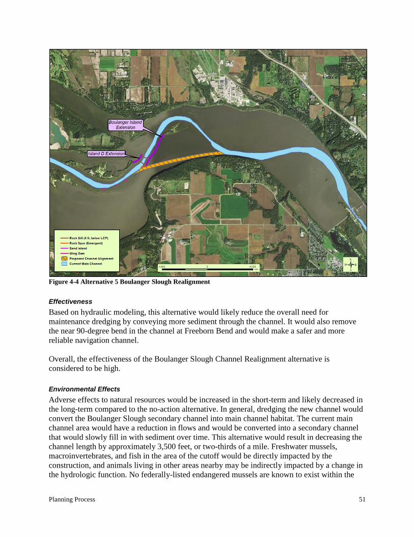
Planning Process 51
Figure 4-4 Alternative 5 Boulanger Slough Realignment
Effectiveness Based on hydraulic modeling, this alternative would likely reduce the overall need for maintenance dredging by conveying more sediment through the channel. It would also remove the near 90-degree bend in the channel at Freeborn Bend and would make a safer and more reliable navigation channel. Overall, the effectiveness of the Boulanger Slough Channel Realignment alternative is considered to be high.
Environmental Effects Adverse effects to natural resources would be increased in the short-term and likely decreased in the long-term compared to the no-action alternative. In general, dredging the new channel would convert the Boulanger Slough secondary channel into main channel habitat. The current main channel area would have a reduction in flows and would be converted into a secondary channel that would slowly fill in with sediment over time. This alternative would result in decreasing the channel length by approximately 3,500 feet, or two-thirds of a mile. Freshwater mussels, macroinvertebrates, and fish in the area of the cutoff would be directly impacted by the construction, and animals living in other areas nearby may be indirectly impacted by a change in the hydrologic function. No federally-listed endangered mussels are known to exist within the
52 Lower Pool 2 Channel Management Study
project footprint. Some state-listed endangered species have been found within the project footprint, but these species, although rare in Minnesota as a whole, are very prevalent throughout Pool 2. It is estimated that approximately 529,000 ± 132,000 mussels currently inhabit the project footprint areas and would be killed during construction of project features. The project would also have indirect effects of increasing sediment deposition in Pool 3, Upper Pool 4, and Lake Pepin because of the reduced sediment deposition in Lower Pool 2. Some positive environmental impacts would also be expected to occur from this alternative. The total acres of side channel habitat would be increased, while the main channel habitat would be decreased. Side channel habitat is less abundant in Lower Pool 2, and would generally support greater species diversity and abundance than main channel habitat. Also, an island would be constructed along the right descending bank of the current main channel as a part of this alternative. Island habitat would be beneficial to many types of wildlife in Lower Pool 2. This island could help to promote vegetative growth by restricting wind and wave action in the shallow area between Boulanger Slough and the current main navigation channel, and could serve to protect and stabilize this area. Overall, the potential environmental effects of the Boulanger Slough Channel Realignment alternative are considered to be high adverse.
Socioeconomic Effects The Boulanger Slough Alternative would improve public safety by reducing the hazard associated with groundings. The project would also decrease costs to the navigation industry by allowing the more efficient transit of 15-barge tows and reducing the number of trips into and out of the St. Paul harbor. The Coast Guard would also realize cost savings in the form of reduced maintenance of navigation aids. The socioeconomic benefits provided by the Boulanger Slough Channel Realignment would be similar to those provided by the Nininger Slough alternative. The benefits would be of a greater magnitude than the Channel Control Structure Alternative or the Increased Channel Maintenance Alternative because straightening the channel would further reduce the difficulty of navigating this stretch of river. Overall, the socioeconomic effects of the Boulanger Slough Channel Realignment alternative are considered to be high positive.
Implementability Several factors have been identified that could influence the implementability of this alternative. Two natural gas pipelines cross from one bank of the river to the other and are buried under the river. However, the pipelines may not be buried deep enough under the proposed channel route, and at least one of the pipelines would need to be relocated. Additionally, a special placement site would be necessary for any material dredged from the new channel that is determined to be contaminated. Finally, construction of the new channel and associated training structures would impact a large number of freshwater mussels. Feasible measures to mitigate these impacts would need to be developed, and may be costlier or technically infeasible.
Planning Process 53
Overall, the implementability of the Boulanger Slough Channel Realignment alternative is considered to be moderate.
Cost The construction cost of this alternative is estimated to be $14,000,000. The mitigation cost for this alternative is estimated to be $2,600,000. The cost to relocate the Northern Natural Gas pipeline is $18,000,000 The Interest During Construction is estimated to be $454,000. The above 4 costs, when amortized over 40 years at 2.875% interest equals an average annual cost of $1,486,000. With this project in place, an increase of sand will flow through the channel and need to be dredged in Pools 3 and 4. Therefore the annual maintenance costs (dredging and unloading) will increase from $2,418,800 to $2,529,800. The total annual cost for this alternative is $1,486,000 + $2,529,800 = $4,015,800 compared to the No Action Alternative of $2,418,800. This is an increase of $1,597,000. Overall, the cost of the Boulanger Slough Channel Realignment alternative is considered to be high.
Risk There is a small chance that the newly created channel would not convey as much sediment as expected and frequent maintenance dredging remains necessary for the area. Also, the sediment that flows through the channel at this area of Pool 2 will eventually settle out somewhere downstream, so there is a small chance that the extra sediment could cause another area of the channel downstream to build faster and increase the necessary maintenance dredging at another location. The modeling that has been provided has showed the risk of these problems to be low. Overall, the risk associated with the Boulanger Slough Channel Realignment alternative is considered to be low.
Conclusion This alternative meets the primary objectives of the project and appears to be feasible. This alternative has been carried forward for detailed evaluation.
54 Lower Pool 2 Channel Management Study
4.6 Alternative 6 - Increased Channel Maintenance with Rock Sill Training Structures
Alternative Description Under this alternative, a corridor has been established that would be maintained to a dredging depth of 12 feet. This corridor ranges from 450 feet wide upstream of the daymark in Boulanger Bend and 350 feet wide downstream of the daymark (light). The channel width in the project area would be increased to 350 and 450 feet, within authorized channel dimensions, plus any deeper areas outside of the corridor as described in 4.4, Increased Channel Maintenance. It is estimated that 306,000 cubic yards of material would be dredged during the initial event to bring the channel to this condition. The dredged material would be placed in an inactive mining pit in Lower Grey Cloud Island (See Figure 5-3). In addition, rock sills acting as river training structures would be constructed to help maintain flow in the channel and therefore reduce sediment deposition in this reach. The enlarged channel, were it to be constructed without other additional features, would drop the velocity in many parts of the channel particularly in the northern part of Freeborn Bend. By adding rock sill river training structures it is possible to keep the channel velocity up and also address the breakout flow conditions upstream and downstream of Freeborn Island. The rock sill features are shown with the historic channel in Plate 7 illustrating that the rock sill training structures would be used to maintain the channel approximately in the historic location. The structures would be built of riprap with a top width of approximately 10 feet. The top two vertical feet of the rock sill training structure would have a slope of 5H:1V to allow expanding and moving ice to ramp over the structure without pushing it over. The slopes below two vertical feet from the crest will have a 1.5H:1V side slope. These components together form the Increased Channel Maintenance with Rock Sill Training Structure Alternative (Figure 4-5).
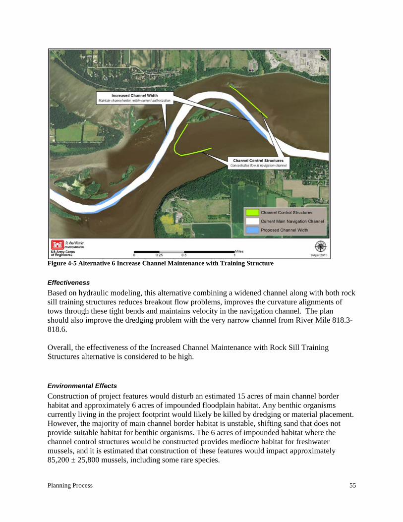
Planning Process 55
Figure 4-5 Alternative 6 Increase Channel Maintenance with Training Structure
Effectiveness Based on hydraulic modeling, this alternative combining a widened channel along with both rock sill training structures reduces breakout flow problems, improves the curvature alignments of tows through these tight bends and maintains velocity in the navigation channel. The plan should also improve the dredging problem with the very narrow channel from River Mile 818.3-818.6. Overall, the effectiveness of the Increased Channel Maintenance with Rock Sill Training Structures alternative is considered to be high.
Environmental Effects Construction of project features would disturb an estimated 15 acres of main channel border habitat and approximately 6 acres of impounded floodplain habitat. Any benthic organisms currently living in the project footprint would likely be killed by dredging or material placement. However, the majority of main channel border habitat is unstable, shifting sand that does not provide suitable habitat for benthic organisms. The 6 acres of impounded habitat where the channel control structures would be constructed provides mediocre habitat for freshwater mussels, and it is estimated that construction of these features would impact approximately 85,200 ± 25,800 mussels, including some rare species.
56 Lower Pool 2 Channel Management Study
The effects of ongoing, semi-annual maintenance dredging would be similar to the without project condition, but turbidity caused by groundings would be decreased. Overall, the potential environmental effects of the Increased Channel Maintenance with Control Structures alternative are considered to be moderate adverse.
Socioeconomic Effects This alternative would improve public safety by reducing the hazard associated with groundings. The project would also decrease costs to the navigation industry by allowing the more efficient transit of 15-barge tows and reducing the number of trips into and out of the St. Paul harbor. The Coast Guard would also realize cost savings in the form of reduced maintenance of navigation aids. Overall the socioeconomic effects of this alternative are considered to be high positive.
Implementability A close eye was kept on the impacts to the 1 percent (100 year) flood profile throughout the consideration of features for this alternative. Impacts to flood stages are a study constraint which cannot be violated. Combinations of project features were balanced in order to avoid flood stage impacts. The alternative is a combination of channel excavation which lowers flood stages and the construction of rock sill training structures which tends to increase stages. The proposed rock sill river training structures combined with the increased channel dimensions are designed to be effective in concentrating river flows while not impacting flood stages. Overall, the implementability of the Increased Channel Maintenance with Rock Sill Training Structures alternative is considered to be high.
Full Array and Screening of Alternatives 57
Cost The construction cost of this alternative is estimated to be $9,000,000. The mitigation cost for this alternative is estimated to be $300,000. The Interest During Construction is estimated to be $122,000. The above 3 costs, when amortized over 40 years at 2.875% interest equals an average annual cost of $399,000. With this project in place, the annual maintenance costs (dredging and unloading) will increase from $2,418,800 to $2,419,600. The total annual cost for this alternative is $399,000 + $2,419,600 = $2,818,600 compared to the No Action Alternative of $2,418,800. This is an increase of $399,800. Overall, the cost of the Increased Channel Maintenance with Rock Sill Training Structures alternative is considered to be moderate.
Risk It is likely that material not deposited in the main channel in the project area would result in increased dredging at another location. There is also the risk that the structures would not convey sediment or maintain the channel as well as predicted. Overall, the risk associated with the increased channel maintenance with rock sill training structures alternative is considered to be moderate.
Conclusion This alternative meets the primary objectives of the project and appears to be feasible. This alternative has been carried forward for detailed evaluation.
58 Lower Pool 2 Channel Management Study
4.7 Final Array of Alternatives Carried Forward for Further Development
Following alternative plan evaluation and screening, the final array of alternatives carried forward are the No Action alternative, the Boulanger Slough Channel Realignment alternative, and the increased Channel Maintenance with Rock Sill Channel Training Structures alternative. The Alternative Screening Matrix (Table 7) summarizes the final screening criteria for each alternative.
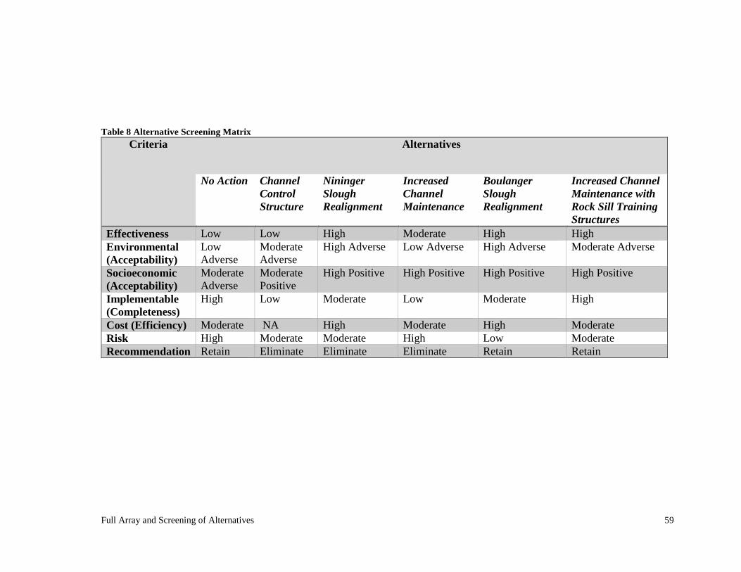
Full Array and Screening of Alternatives 59
Table 8 Alternative Screening Matrix
Criteria Alternatives
No Action Channel Control Structure
Nininger Slough Realignment
Increased Channel Maintenance
Boulanger Slough Realignment
Increased Channel Maintenance with Rock Sill Training Structures
Effectiveness Low Low High Moderate High High Environmental (Acceptability)
Low Adverse
Moderate Adverse
High Adverse Low Adverse High Adverse Moderate Adverse
Socioeconomic (Acceptability)
Moderate Adverse
Moderate Positive
High Positive High Positive High Positive High Positive
Implementable (Completeness)
High Low Moderate Low Moderate High
Cost (Efficiency) Moderate NA High Moderate High Moderate Risk High Moderate Moderate High Low Moderate Recommendation Retain Eliminate Eliminate Eliminate Retain Retain

Full Array and Screening of Alternatives 61
CHAPTER 5. Alternative Plan Selection
This chapter describes the development and comparison of the final array of alternatives and the alternative plan selection.
5.1 Alternative 1 - No Action Alternative
The No Action Alternative is the plan in which none of the measures or combinations thereof would be constructed. There would be no cost to the No Action Alternative. This alternative required no further development. Refer to chapter 4.1 for a description of this alternative.
5.2 Alternative 5 - Boulanger Slough Channel Realignment
Figure 5-1 shows the proposed project features for the Boulanger Slough Channel Realignment Alternative.
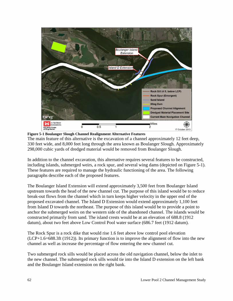
62 Lower Pool 2 Channel Management Study
Figure 5-1 Boulanger Slough Channel Realignment Alternative Features The main feature of this alternative is the excavation of a channel approximately 12 feet deep, 330 feet wide, and 8,000 feet long through the area known as Boulanger Slough. Approximately 298,000 cubic yards of dredged material would be removed from Boulanger Slough. In addition to the channel excavation, this alternative requires several features to be constructed, including islands, submerged weirs, a rock spur, and several wing dams (depicted on Figure 5-1). These features are required to manage the hydraulic functioning of the area. The following paragraphs describe each of the proposed features. The Boulanger Island Extension will extend approximately 3,500 feet from Boulanger Island upstream towards the head of the new channel cut. The purpose of this island would be to reduce break-out flows from the channel which in turn keeps higher velocity in the upper end of the proposed excavated channel. The Island D Extension would extend approximately 1,100 feet from Island D towards the northeast. The purpose of this island would be to provide a point to anchor the submerged weirs on the western side of the abandoned channel. The islands would be constructed primarily from sand. The island crests would be at an elevation of 688.8 (1912 datum), about two feet above Low Control Pool water surface (686.7 feet (1912 datum). The Rock Spur is a rock dike that would rise 1.6 feet above low control pool elevation (LCP+1.6=688.3ft (1912)). Its primary function is to improve the alignment of flow into the new channel as well as increase the percentage of flow entering the new channel cut. Two submerged rock sills would be placed across the old navigation channel, below the inlet to the new channel. The submerged rock sills would tie into the Island D extension on the left bank and the Boulanger Island extension on the right bank.
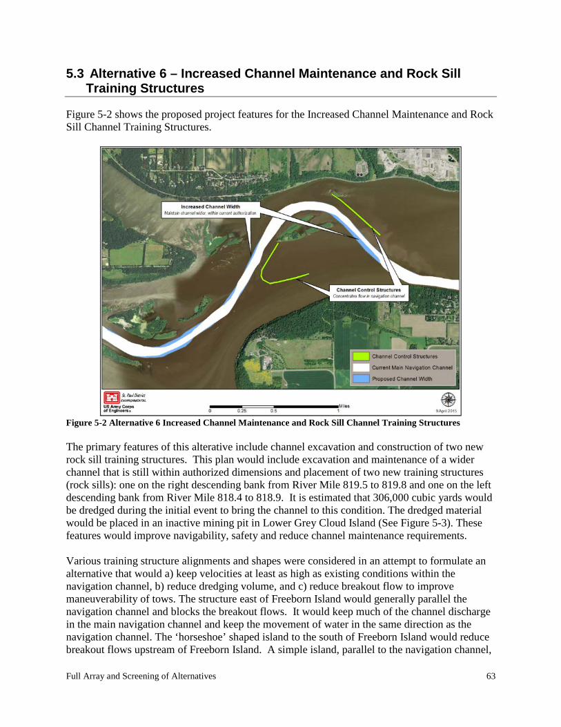
Full Array and Screening of Alternatives 63
5.3 Alternative 6 – Increased Channel Maintenance and Rock Sill Training Structures
Figure 5-2 shows the proposed project features for the Increased Channel Maintenance and Rock Sill Channel Training Structures.
Figure 5-2 Alternative 6 Increased Channel Maintenance and Rock Sill Channel Training Structures The primary features of this alterative include channel excavation and construction of two new rock sill training structures. This plan would include excavation and maintenance of a wider channel that is still within authorized dimensions and placement of two new training structures (rock sills): one on the right descending bank from River Mile 819.5 to 819.8 and one on the left descending bank from River Mile 818.4 to 818.9. It is estimated that 306,000 cubic yards would be dredged during the initial event to bring the channel to this condition. The dredged material would be placed in an inactive mining pit in Lower Grey Cloud Island (See Figure 5-3). These features would improve navigability, safety and reduce channel maintenance requirements. Various training structure alignments and shapes were considered in an attempt to formulate an alternative that would a) keep velocities at least as high as existing conditions within the navigation channel, b) reduce dredging volume, and c) reduce breakout flow to improve maneuverability of tows. The structure east of Freeborn Island would generally parallel the navigation channel and blocks the breakout flows. It would keep much of the channel discharge in the main navigation channel and keep the movement of water in the same direction as the navigation channel. The ‘horseshoe’ shaped island to the south of Freeborn Island would reduce breakout flows upstream of Freeborn Island. A simple island, parallel to the navigation channel,
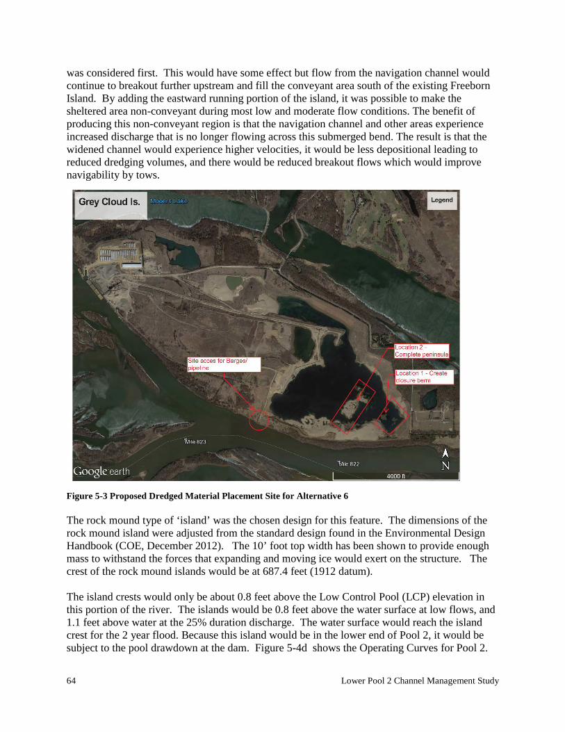
64 Lower Pool 2 Channel Management Study
was considered first. This would have some effect but flow from the navigation channel would continue to breakout further upstream and fill the conveyant area south of the existing Freeborn Island. By adding the eastward running portion of the island, it was possible to make the sheltered area non-conveyant during most low and moderate flow conditions. The benefit of producing this non-conveyant region is that the navigation channel and other areas experience increased discharge that is no longer flowing across this submerged bend. The result is that the widened channel would experience higher velocities, it would be less depositional leading to reduced dredging volumes, and there would be reduced breakout flows which would improve navigability by tows.
Figure 5-3 Proposed Dredged Material Placement Site for Alternative 6 The rock mound type of ‘island’ was the chosen design for this feature. The dimensions of the rock mound island were adjusted from the standard design found in the Environmental Design Handbook (COE, December 2012). The 10’ foot top width has been shown to provide enough mass to withstand the forces that expanding and moving ice would exert on the structure. The crest of the rock mound islands would be at 687.4 feet (1912 datum). The island crests would only be about 0.8 feet above the Low Control Pool (LCP) elevation in this portion of the river. The islands would be 0.8 feet above the water surface at low flows, and 1.1 feet above water at the 25% duration discharge. The water surface would reach the island crest for the 2 year flood. Because this island would be in the lower end of Pool 2, it would be subject to the pool drawdown at the dam. Figure 5-4d shows the Operating Curves for Pool 2.
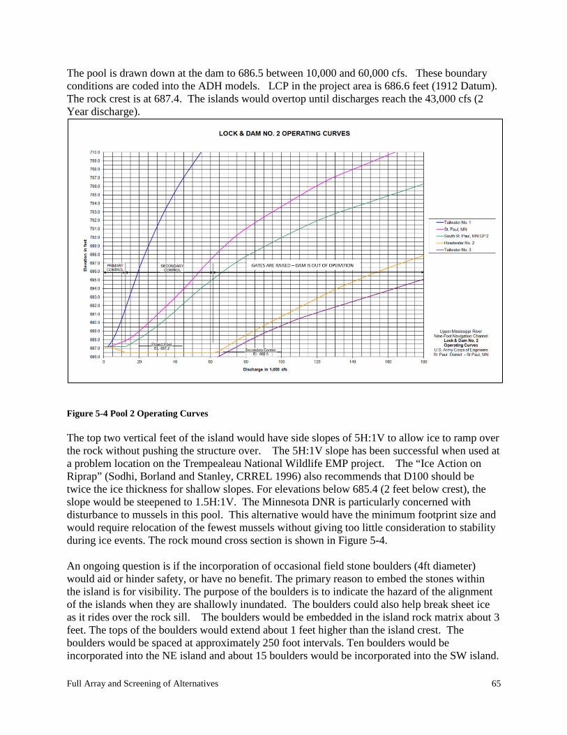
Full Array and Screening of Alternatives 65
The pool is drawn down at the dam to 686.5 between 10,000 and 60,000 cfs. These boundary conditions are coded into the ADH models. LCP in the project area is 686.6 feet (1912 Datum). The rock crest is at 687.4. The islands would overtop until discharges reach the 43,000 cfs (2 Year discharge).
Figure 5-4 Pool 2 Operating Curves The top two vertical feet of the island would have side slopes of 5H:1V to allow ice to ramp over the rock without pushing the structure over. The 5H:1V slope has been successful when used at a problem location on the Trempealeau National Wildlife EMP project. The “Ice Action on Riprap” (Sodhi, Borland and Stanley, CRREL 1996) also recommends that D100 should be twice the ice thickness for shallow slopes. For elevations below 685.4 (2 feet below crest), the slope would be steepened to 1.5H:1V. The Minnesota DNR is particularly concerned with disturbance to mussels in this pool. This alternative would have the minimum footprint size and would require relocation of the fewest mussels without giving too little consideration to stability during ice events. The rock mound cross section is shown in Figure 5-4. An ongoing question is if the incorporation of occasional field stone boulders (4ft diameter) would aid or hinder safety, or have no benefit. The primary reason to embed the stones within the island is for visibility. The purpose of the boulders is to indicate the hazard of the alignment of the islands when they are shallowly inundated. The boulders could also help break sheet ice as it rides over the rock sill. The boulders would be embedded in the island rock matrix about 3 feet. The tops of the boulders would extend about 1 feet higher than the island crest. The boulders would be spaced at approximately 250 foot intervals. Ten boulders would be incorporated into the NE island and about 15 boulders would be incorporated into the SW island.
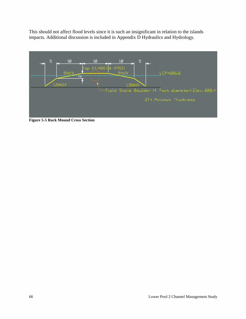
66 Lower Pool 2 Channel Management Study
This should not affect flood levels since it is such an insignificant in relation to the islands impacts. Additional discussion is included in Appendix D Hydraulics and Hydrology.
Figure 5-5 Rock Mound Cross Section
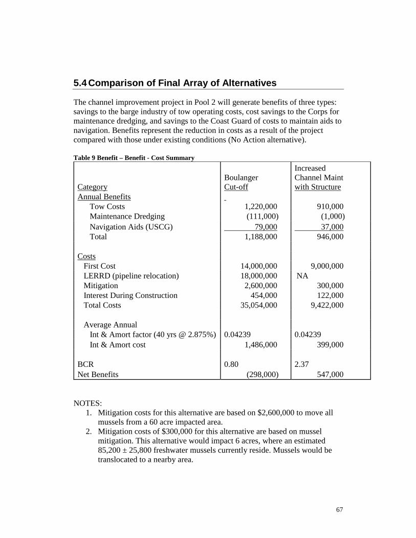
67
5.4 Comparison of Final Array of Alternatives
The channel improvement project in Pool 2 will generate benefits of three types: savings to the barge industry of tow operating costs, cost savings to the Corps for maintenance dredging, and savings to the Coast Guard of costs to maintain aids to navigation. Benefits represent the reduction in costs as a result of the project compared with those under existing conditions (No Action alternative). Table 9 Benefit – Benefit - Cost Summary Category
Boulanger Cut-off
Increased Channel Maint with Structure
Annual Benefits Tow Costs 1,220,000 910,000 Maintenance Dredging (111,000) (1,000) Navigation Aids (USCG) 79,000 37,000 Total 1,188,000 946,000 Costs First Cost 14,000,000 9,000,000 LERRD (pipeline relocation) 18,000,000 NA Mitigation 2,600,000 300,000 Interest During Construction 454,000 122,000 Total Costs 35,054,000 9,422,000 Average Annual Int & Amort factor (40 yrs @ 2.875%) 0.04239 0.04239 Int & Amort cost 1,486,000 399,000 BCR 0.80 2.37 Net Benefits (298,000) 547,000
NOTES:
1. Mitigation costs for this alternative are based on $2,600,000 to move all mussels from a 60 acre impacted area.
2. Mitigation costs of $300,000 for this alternative are based on mussel mitigation. This alternative would impact 6 acres, where an estimated 85,200 ± 25,800 freshwater mussels currently reside. Mussels would be translocated to a nearby area.
68 Lower Pool 2 Channel Management Study
3. Utility relocation costs. For the Boulanger Cut-off alternative there are two Northern Natural Gas pipelines one 24 inch and the other 30 inches buried under the channel including Boulanger Slough. In order to maintain a 12 foot navigation channel depth, excavation would come within a few feet of the 30 inch gas line for at least half the length of the gas line and then taper down for the rest of the channel width. There is a concern with 1) safely excavating over the pipe line and 2) the buoyancy of the pipeline once the work is done and the line is placed back in operation. Per NNG they would like 15 feet of fill over their lines to counteract the buoyancy and provide protection from marine vessels. NNG estimates it would cost $36 million to relocate both pipelines. These are large diameter pipelines and would require horizontal directional drilling (HDD) to route new pipelines 1-1/4 miles each under the Mississippi River. Utility relocations are part of the total project costs and included in Lands, Easements, Right-of-ways, Relocations and Disposals (LERRD’s). The cost to relocate even one line is significant enough that this alternative is not economically justified compared to the Channel Maintenance with Structure alternative.
4. Utility relocation costs. For the Channel Maintenance with Structure alternative, there is a single 4-foot diameter HDPE Sewer outfall pipe buried approximately 10 feet under the rock sill alignment. This pipe discharges treated water from the Eagle Point Sewage treatment plant directly into the navigation channel. Presently, it is assumed that this pipe will not need to be relocated.
Increased Channel Maintenance with Rock Sill Training Structure is the plan with the highest net benefits and the highest benefit to cost ratio. Corps planning guidance defines the National Economic Development plan as the plan that maximizes net benefits. Alternative Six Increased Channel Maintenance with Rock Sill Training Structure is identified as the Lower Pool 2 Channel Management Study NED Plan.
5.5 Plan Selection
The Tentatively Selected Plan (TSP) is the NED Plan Alternative 6 Increased Channel Maintenance with Rock Sill Training Structures (ICMS). The TSP is shown in Plates 6 and 7.
69
5.5.1 SUMMARY OF ACCOUNTS FOR THE NATIONAL ECONOMIC DEVELOPMENT PLAN
• The national economic development (NED) account displays changes in
the economic value of the national output of goods and services • The environmental quality (EQ) account displays non-monetary effects on
significant natural and cultural resources • The regional economic development (RED) account registers changes in
the distribution of regional economic activity that result from each alternative plan.
• The other social effects (OSE) account registers plan effects from perspectives that are relevant to the planning process, but are not reflected in the other three accounts.
The Federal objective is to determine the project alternative with the maximum net benefits while protecting or minimizing impacts to the environment. Under the National Economic Development (NED) account, which measures benefits of the recommended plan, the increased channel maintenance with rock sill river training structures demonstrates the highest net benefits of $547,000 and a Benefit to Cost ratio of 2.37. The features of the increased channel maintenance with river training structures alternative were designed to minimize environmental impacts under the EQ account. Environmental effects are more fully described in Chapter 6. Under the RED account, the area will most likely experience regional economic benefits during implementation of the project. The OSE account includes public safety, which will be improved by reducing the hazard associated with groundings and improving navigability of the channel. The channel would also provide a greater area of suitable depth for recreational traffic. Navigation outside the marked channel in Lower Pool 2 can be dangerous due to shifting sediments and significant stump fields.
5.6 Tentatively Selected Plan
This section discusses the details of the TSP, which was determined by the plan formulation process described in Chapters 4 and 5. The recommended plan is to excavate a wider channel that is still within authorized dimensions and place two new training structures (rock sills) one on the right descending bank River Mile 819.5 to 819.8 and one on the left descending bank from River Mile 818.4 to
70 Lower Pool 2 Channel Management Study
818.9. The widened channel and restriction of breakout flow and outdraft conditions should significantly improve navigation in this reach of Lower Pool 2.
5.6.1 PLAN FEATURES The TSP consists of the two rock sill structures and tie-in to existing islands. The navigation channel will also be widened. The plan is described in detail in Section 5.3 as Alternative 6. The plan consists of:
A. Enhanced Channel Maintenance plan where a defined corridor will be excavated and maintained to a depth of 12 feet. This will make the bends easier to navigate and improve some of the difficult dredging locations.
B. Rock Sill River Training Structures. A rock structure would be constructed upstream of Freeborn Island. The structure is horseshoe shaped and is parallel the navigation channel and to Boulanger Slough. The structure ties into Freeborn Island at its terminus. Another rock sill structure will be constructed to the left side of the navigation channel downstream of Freeborn Island. This structure will parallel the navigation channel.
C. There will need to be some riprap features (riprap/rock trench/offshore rock mound) included to tie the rock sills into existing island. These relatively minor features are required to minimize negative impacts from erosion on the existing islands.
5.6.2 DESIGN CONSIDERATIONS The Project has been developed to a feasibility level of design. Design details are included in the technical appendices and plates. As with all feasibility level studies, these details will be refined in the Plans and Specifications (P&S) Stage. A consolidation settlement analysis was performed to determine a reasonable range of expected settlement of the rock sill structures on top of the existing clay foundation. Beneath the alignment of the proposed structures, the clay layer ranges from 10 feet to 30 feet thick. Since existing borings have not been tested, consolidation test data from soil boring 86-24M at Lock and Dam 2 were used in the settlement analysis. Boring 86-24M was initiated for the foundation investigation for construction of the Central Control Station for Lock and Dam 2, which is just upstream of the Boulanger Bend project. Standard Penetration Test N-values for the Lock and Dam 2 sample are similar to those recorded at the Boulanger Bend project. The change in stress after construction of the rock sill structures were computed using surface loads on a semi-infinite mass. The change in stress is based on the additional load that the foundation would experience with the construction of the rock sill structures.
71
Because consolidation test data are unavailable at the project site and the clay layer thicknesses vary from 10 to 30 feet, there is a high level of uncertainty in the estimated range of expected settlement. Once additional borings are advanced and more consolidation tests are performed, the settlement analysis will be updated. Settlement calculations reveal that roughly 7 to 12 inches of settlement can be expected over the lifetime of the project. Observable settlement is expected to take several years. Typically, settlement has been taken into account by overbuilding the structure, but an impact on the one-percent flood profile has been identified as a constraint. While the excavation of the channel increases conveyance and drops the water surface about 0.05 feet, the construction of the rock sill training structures decreases conveyance-subsequently raising the water surface. Stage increases higher than 0.005 feet are unacceptable. To avoid increased flood stages, the rock sill structure top elevation should not exceed 0.8 feet above low control pool (+ or - 0.3 feet). Overall the average elevation of the rock sills should be within (+ or - 0.1 feet). Boulders may be included in the design and may rise about 1 foot above the crest of rock sill. They would be spaced infrequently (250 foot spacing is expected). These boulders should have no additional effect on flood stages. The constraint of avoiding flooding stage impacts prevents overbuilding of the rock sill structures to mitigate consolidation settlement. If the rock structures settle below the pool surface, their intended performance is compromised. Since there is a high level of uncertainty associated with the current estimate settlement range, settlement monitoring and mitigation plans will be determined after more sampling and testing has been performed.
5.6.3 ENVIRONMENTAL MITIGATION Freshwater mussel surveys conducted in the proposed project footprint were used to estimate that project construction would kill approximately 85,200 ± 25,800 individual mussels, including individuals representing four species of conservation concern in the State of Minnesota (survey and estimate details in Appendix G). Freshwater mussels fill important ecological roles including nutrient cycling, substrate stabilization, and as a food source for fish and mammals. In accordance with Corps’ planning guidance1 and CMMP guidance,2 the Corps has incorporated mitigation measures that would ensure that the project does not have more than a negligible adverse effect on this ecological resource. Project effects were first minimized by selecting narrow rock mounds for the channel training structures to reduce the project footprint. Unavoidable impacts of the selected TSP would be offset by relocating the mussels currently within the 1 USACE Planning Guidance Notebook, Engineering Regulation 1105-2-100, C-3.e.(1) 2 CMMP EIS Paragraph 5.2.2; Appendix G (IV.B.4)
72 Lower Pool 2 Channel Management Study
footprint of the proposed structures prior to project construction. This would involve divers collecting as many mussels from the footprints as possible, and moving the mussels to a location or locations that would augment nearby existing populations. The Mussel Mitigation Plan in included in Appendix G.
5.6.4 CONSTRUCTION CONSIDERATIONS
5.6.4.1 ROCK SILLTRAINING STRUCTURES Rock sill training structure would be placed along the right descending bank from River Mile 819.5 to 819.8 and one on the left descending bank from River Mile 818.4 to 818.9. These structures will parallel the navigation channel. The purpose of using these types of structures is to keep velocities as high as existing conditions, reduce dredging volume over the project life, and reduce breakout flow and improve maneuverability of tows. Typical designs for the rock mound are shown in Sheet C-105 of the civil drawings. Construction of the rock measures would likely be a combination of marine plant (backhoe on barges and push boats) and land based equipment (trucks and dozers). The equipment used to place the rock would likely be hydraulic backhoe on a barge. No site preparation work would be necessary from the work area. Rock material delivery/staging would be at LD 2 as noted on Sheet C-101. All areas used for rock loading and equipment staging at LD2 must be restored to pre-project conditions
5.6.4.2 CHANNEL EXCAVATION As part of the recommended plan, the channel will be excavated and maintained at wider dimensions as it has been maintained in the past and that is still within authorized dimensions. The Tentatively Selected Plan proposes to increase maintenance dredging where needed to improve navigation efficiency and safety; not necessarily to the maximum authorized in the study area. It is estimated that 306,000 cubic yards would be dredged during the initial event to bring the channel to this condition. The granular material would be placed on Lower Grey Cloud Island which is an approved permanent disposal site noted in the Channel Maintenance Management Plan and Dredged Material Placement Plan. The material could be unloaded either mechanically or hydraulically (note: over 1.3 million yards was hydraulically unloaded onto this site in 1999-2000. Mechanical excavation would require a hydraulic backhoe typically using a 3 or 5 cubic yard bucket. The granular material would be placed on barges and unloaded at the existing ramp that has used before for unloading. The barges would be unloaded unto trucks and placed at specific locations in or around the current gravel pit. If excavated hydraulically, a contractor would mobilize a hydraulic dredge and install a floating pipeline that would end at the disposal location. The pipeline would follow an alignment parallel to the navigation channel and exit on land near the loading ramp. The pipeline will be submerged at the navigation channel
73
and is required to be marked for boater safety. Material would be pumped onto the site and dozers would push the sand to its final location. Because of the depth of existing mining pit and existing surrounding sandy soils, an effluent return waterline directly back into the river would not be required.
5.6.4.3 CONSTRUCTION METHODS Construction of the rock measures would likely be a combination of marine plant and land based equipment. The equipment used to place the rock would likely be hydraulic backhoe on a barge. No site preparation work would be necessary from the work area. Rock material delivery/staging would be at LD 2 as noted on Sheet C-101.
5.6.4.4 CONSTRUCTION RESTRICTIONS Construction restrictions could be applied for any number of reasons. The following are the basic construction restrictions that would likely be applied in the construction of the rock mounds.
a) Commercial navigation. The work is taking place at two locations adjacent to the navigation channel during the navigation season.
b) Access dredging is not anticipated and will not be allowed to construct the project.
c) Utilities – There are two underground natural gas pipelines owned by Northern Natural Gas (NNG). There is also a 4 –foot diameter sewage outfall pipe that is owned by Metropolitan Council. Caution needs to be exercised when accessing these areas and if barges are going to be spudded in place.
5.6.3.5 SOURCES OF ROCK MATERIAL The rock would come from an approved local quarry from surrounding counties. The loading site would most likely be at LD 2 loading dock. Some quarries used in the past for Pool 2 projects are listed below. Draft list for the Lower Pool 2 (will need inspection prior to use) QUARRY NAME AND OPERATOR QUARRY LOCATION NOTES Larson Plant NE1/4, Sec.26, T27N, R22W 1, 2 Aggregate Industries Washington County, Minnesota 2915 Waters Road Eagan, MN 55121 (651) 683-0600
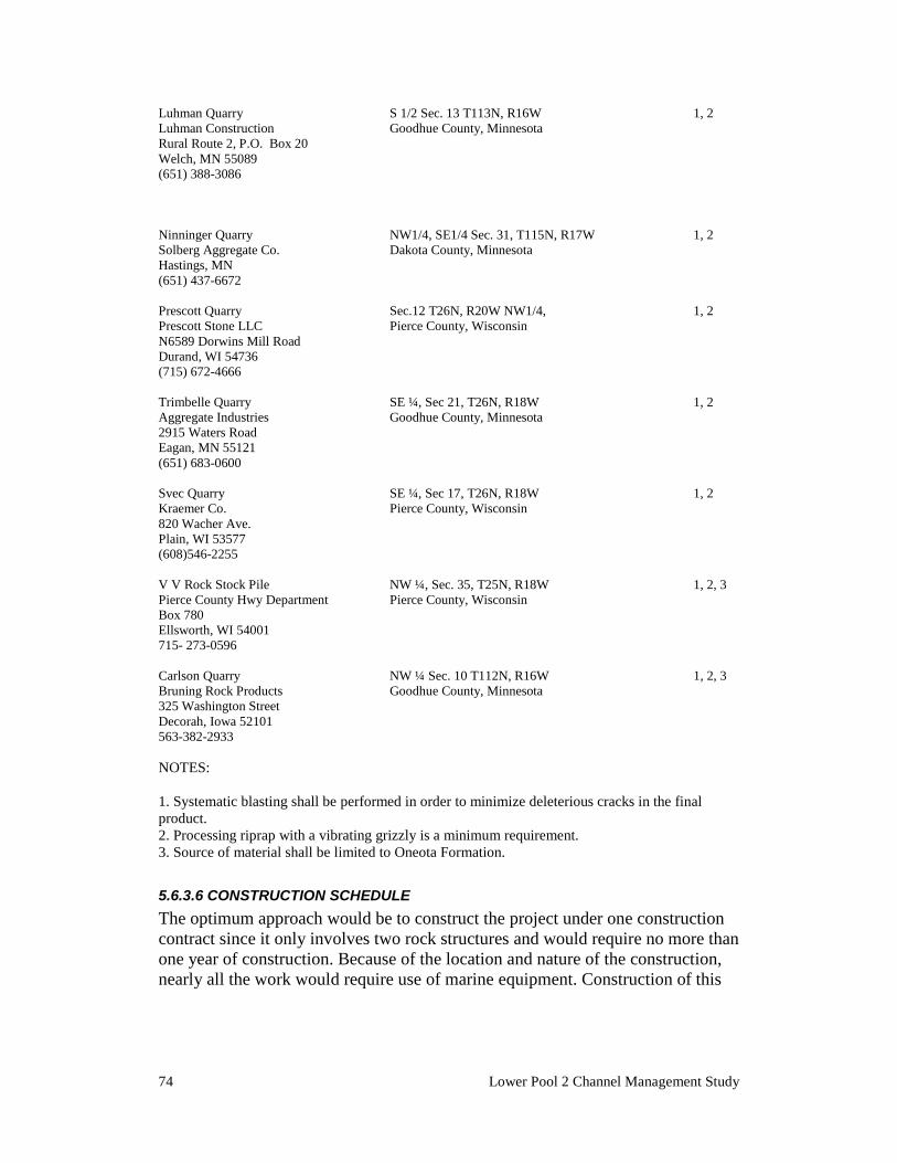
74 Lower Pool 2 Channel Management Study
Luhman Quarry S 1/2 Sec. 13 T113N, R16W 1, 2 Luhman Construction Goodhue County, Minnesota Rural Route 2, P.O. Box 20 Welch, MN 55089 (651) 388-3086 Ninninger Quarry NW1/4, SE1/4 Sec. 31, T115N, R17W 1, 2 Solberg Aggregate Co. Dakota County, Minnesota Hastings, MN (651) 437-6672 Prescott Quarry Sec.12 T26N, R20W NW1/4, 1, 2 Prescott Stone LLC Pierce County, Wisconsin N6589 Dorwins Mill Road Durand, WI 54736 (715) 672-4666 Trimbelle Quarry SE ¼, Sec 21, T26N, R18W 1, 2 Aggregate Industries Goodhue County, Minnesota 2915 Waters Road Eagan, MN 55121 (651) 683-0600 Svec Quarry SE ¼, Sec 17, T26N, R18W 1, 2 Kraemer Co. Pierce County, Wisconsin 820 Wacher Ave. Plain, WI 53577 (608)546-2255 V V Rock Stock Pile NW ¼, Sec. 35, T25N, R18W 1, 2, 3 Pierce County Hwy Department Pierce County, Wisconsin Box 780 Ellsworth, WI 54001 715- 273-0596 Carlson Quarry NW ¼ Sec. 10 T112N, R16W 1, 2, 3 Bruning Rock Products Goodhue County, Minnesota 325 Washington Street Decorah, Iowa 52101 563-382-2933 NOTES: 1. Systematic blasting shall be performed in order to minimize deleterious cracks in the final product. 2. Processing riprap with a vibrating grizzly is a minimum requirement. 3. Source of material shall be limited to Oneota Formation.
5.6.3.6 CONSTRUCTION SCHEDULE The optimum approach would be to construct the project under one construction contract since it only involves two rock structures and would require no more than one year of construction. Because of the location and nature of the construction, nearly all the work would require use of marine equipment. Construction of this
75
type is limited to the open water season on the Upper Mississippi River. Construction in certain years can begin in April, but May is more typical for beginning construction due to the constraints associated with spring high water. At the other end of the spectrum, late November is the end of the construction season due to winter freeze-up. Based on current funding it is estimated that a two separate contracts would be required. One contract would be awarded in summer of 2017 for construction of the rock structures with a construction start and completion in 2018, and one contract would be awarded in summer of 2018 for the increased channel dredging to be completed in 2019.
5.6.5 LANDS, EASEMENTS, RIGHTS-OF WAY, RELOCATIONS, AND DISPOSAL SITE CONSIDERATIONS
All of the land for project construction lies within the 9-Foot Mississippi River Project, and is subject to navigational servitude. Staging will take place on U.S. Government property located at Lock and Dam 2 and placement of any dredged material will be placed on an approved dredge placement site.
5.6.6 REAL ESTATE CONSIDERATIONS No acquisitions are anticipated since all lands necessary for project construction are within the navigational servitude or on lands owned by the Government. Real Estate considerations are further described in Appendix L Real Estate Plan.
5.6.7 OPERATION, MAINTENANCE, REPAIR, REHABILITATION AND REPLACEMENT
All maintenance to project structures would be conducted by the Corps; however, based on experiences with previous projects, little or no maintenance would be expected to be necessary for the proposed features.
5.6.8 CONSTRUCTION COST ESTIMATE The construction of the TSP alternative is considered as the first cost. The first cost is estimated to be $9,300,000 and when amortized over 40 years at 2.875% interest equals an average annual cost of $381,510. Costs are summarized in Table 9.
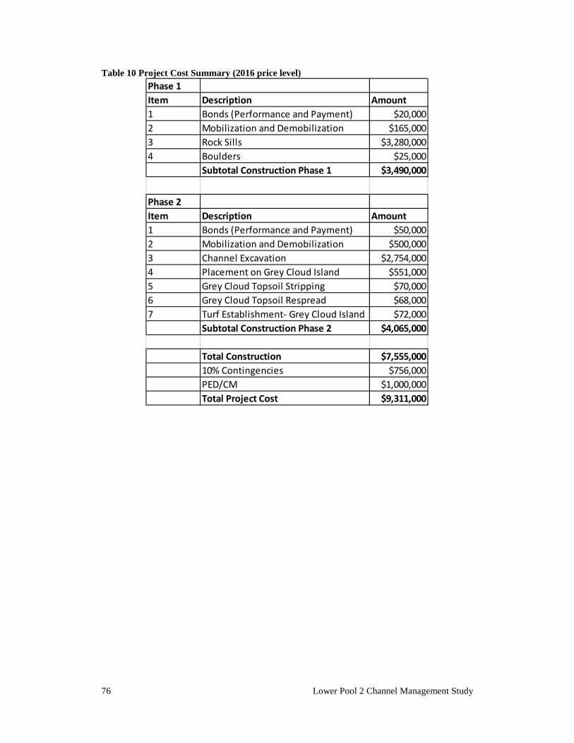
76 Lower Pool 2 Channel Management Study
Table 10 Project Cost Summary (2016 price level)
Phase 1Item Description Amount1 Bonds (Performance and Payment) $20,0002 Mobilization and Demobilization $165,0003 Rock Sills $3,280,0004 Boulders $25,000
Subtotal Construction Phase 1 $3,490,000
Phase 2Item Description Amount1 Bonds (Performance and Payment) $50,0002 Mobilization and Demobilization $500,0003 Channel Excavation $2,754,0004 Placement on Grey Cloud Island $551,0005 Grey Cloud Topsoil Stripping $70,0006 Grey Cloud Topsoil Respread $68,0007 Turf Establishment- Grey Cloud Island $72,000
Subtotal Construction Phase 2 $4,065,000
Total Construction $7,555,00010% Contingencies $756,000PED/CM $1,000,000Total Project Cost $9,311,000
77
CHAPTER 6. Evaluation of Environmental Effects
An environmental analysis has been conducted for the proposed action, and a discussion of the impacts is presented in the following paragraphs. Because fill would be placed into waters of the United States as a part of the proposed action, a Clean Water Act Section 404(b)(1) evaluation was prepared (Appendix B). Water quality certification as required by Section 401 of the Clean Water Act would be obtained prior to construction. The effects of the no-action alternative are those expected to occur in the near-term and into the future without the proposed alternative. The no-action alternative serves as the base condition against which the proposed alternative is compared for evaluating effects. The effects of the proposed alternative are the results of the expected differences in conditions short-term and into the future between the no-action and the proposed alternative. The environmental effect of the no-action and proposed alternative are summarized in Table 4 in Chapter 6.
6.1 Socioeconomic Effects
6.1.1 COMMERCIAL NAVIGATION Under the No-Action alternative, there would be minor adverse impacts to commercial navigation due to the time lost during groundings and by necessitating reduced tow sizes to fit through the channel. The primary socioeconomic effect of the proposed project is the improved efficiency of the local navigation system between Red Wing and St. Paul. Improved efficiency is realized by the ability to group barges into 15-barge tows rather than 12-barge tows as current channel conditions allow. The related savings in operating costs to the towing industry is an economic benefit of the project.
78 Lower Pool 2 Channel Management Study
Other economic benefits include costs savings to (1) the Corps of Engineers related to reduced maintenance dredging and (2) the Coast Guard related to reduced maintenance of aids to navigation (buoys and lights).
6.1.2 RECREATION Under the No-Action alternative, there would be no impacts to recreation. Under the proposed alternative, there would be both minor adverse and minor positive effects on recreation safety. The proposed rock sills would increase safety of recreational boaters by helping to maintain a wider and more reliable navigation channel. However, the structures themselves would also present a navigation hazard. This would be similar to other rock channel training structures in place throughout the river system. Boulders would be installed along the rock sills to help boaters notice the structures under medium-high discharge conditions.
6.1.3 AESTHETICS The No-Action alternative would have no impact on aesthetics. The proposed alternative would have a minor adverse effect on local aesthetics. The channel training structures would be constructed of rock riprap and would be viewed as appearing unnatural to most. This would mostly be limited to river users, but would also affect shoreline users in some areas; for example, users of the scenic overlook at Schaar’s Bluff Vista at Spring Lake Regional Park would likely be able to see the structures. These structures would be apparent at most discharges: at discharges lower than the 50-percent annual exceedance probability flood (i.e., “2-year flood”), the channel control structures would be above the water surface and would be visible to those on the vista or by river users near the structures. When the Pool is at the lowest-controlled elevation, the top of the channel control structures would be approximately 0.8 feet (10 inches) inches above the water. At river discharges higher than the 50-percent annual exceedance probability, the structures would become submerged.
6.1.4 NOISE The No-Action alternative would have no impact on noise. The proposed alternative would have a temporary minor adverse increase in noise in the project vicinity. Construction would require heavy equipment to operate in the area, such as towboats, barges, dredges, excavators, and dozers, and these machines would generate noise during construction. This effect would be minor and would disappear upon construction completion.
79
6.1.5 EXISTING/POTENTIAL LAND USE The no-action alternative would not have any effect on land use. No conflicts between the proposed project and existing local land uses or land use plans have been identified. The following interactions were considered. Placement of sand from the channel onto Lower Grey Cloud Island is in keeping with the current approved Reclamation Plan that Aggregate Industries has developed as part of their permit. In addition, in the recently published Mississippi River Corridor Critical Area District Map, Lower Grey Cloud Island is designated as a Rural & Open Space District (CA-ROS). Filling in portions of the gravel pit with sand, placing top soil and plantings of native grasses and trees is in keeping with this designation. Dakota County's Comprehensive Land Use Plan provides a Land Use Forecast for the Year 2030. This plan identifies the upland shoreline area along Shaar's Bluff and the area south of Spring Lake as Park and Recreational area, and the shoreline area to the east of Schaar's Bluff as Rural Residential. These uses are commensurate with the current land uses. Washington County's Comprehensive Plan discusses Grey Cloud Island Township. The shoreland area of Grey Cloud Island Township is zoned as parkland and rural residential, and is part of the Mississippi Critical Area. Washington County adopted the Critical Area Plan by reference (Reference Mississippi Critical Area Act of 1973 and Executive Order No. 79-19). Open space is to be provided in the open river valley lands for public use and the protection of unique natural and scenic resources. All local governments in the river corridor are required to have a plan that meets the Critical Area Act requirements. Grey Cloud Island and Denmark townships are within the Critical Area and are classified as a rural open space district; Washington County has land use authority in these townships. The Grey Cloud Island Township 2030 Land Use Plan states that, "The goal of the Grey Cloud Island Township Plan is to protect its semi-rural nature and preclude the premature demand for municipal services. The minimum residential lot size is 2.5 acres. Continuation of the limestone mining is encouraged. Grey Cloud Island Township consists of portions of two islands; most of the lower island is in Cottage Grove. The township has a significant amount of floodplain and shoreline, including many small islands, peninsulas, and backwaters on the Mississippi River. The township is in the Mississippi River Critical Area. No land use changes are proposed." However, Washington County does identify Lower Grey Cloud Island as an opportunity for preservation and recreation, and discusses potential future plans to create a large regional park. A master plan for the park was adopted in 1994. 1,336 acres of land acquisition on the island are proposed. The Comprehensive Plan states that the
80 Lower Pool 2 Channel Management Study
implementation strategy is to, "Monitor and respond to acquisition opportunities as they become available on a willing seller basis."
6.2 Natural Resource Effects
6.2.1 PHYSICAL SETTING This section summarizes the results of analyses conducted to determine the effects of the proposed project on physical characteristics of the project area such as sediment transport and hydrology. Further details of the analyses can be found in Appendix D: Hydrology and Hydraulics.
6.2.1.1 Geomorphology Under the No-Action Alternative, there would be no impacts to geomorphology. Under the proposed alternative, the geomorphology of the river in the immediate project area would be modified by consistently maintaining the channel to its authorized dimensions and by constructing the channel control structures to maintain velocities within the channel. These geomorphological changes would alter local bed material sediment deposition patterns. The consistent maintenance of the navigation channel would tend towards an increase sediment deposition within the channel by increasing the trap efficiency, while the channel control structures would reduce the sediment deposition by increasing the flow velocity. Modeling of the sedimentation patterns indicated that these two opposing factors would nearly cancel each other out, and showed no significant overall reduction in dredging quantities for this stretch of river over a 5-year modeling period.
6.2.1.2 Hydrology & Hydraulics The No-Action Alternative would not have any impacts on local hydrology or hydraulics. The proposed project would not negatively impact the one-percent flood profile. The proposed project is a combination of channel excavation, which lowers flood stages, and construction of control structures, which increases stages. Hydraulic modeling indicates that structures identified in the area would experience stage increases of less than 0.005 feet at the 1% annual chance exceedance event (or the 100-year flood). Further discussion and maps depicting the localized stage changes can be found in Appendix D: Hydrology and Hydraulics. Stream velocity in the immediate project area would be altered by the construction of the proposed project. The magnitude of change in current velocity
81
is dependent upon the discharge conditions being considered. Four different discharge conditions were evaluated during hydraulic modeling: a low-discharge condition (flows exceeded 75% of the time); a medium discharge condition (flows exceeded 25% of the time); a high discharge condition (the 2-year flood condition); and an extreme discharge condition (the 100-year flood condition). The medium flow condition (20,560 cubic feet per second) is used in this evaluation to represent the magnitude of the general changes to current velocity due to the project because it is a common condition experienced in the area. Figures 6-1 and 6-2 show the velocity (meters per second) magnitude and vectors for the medium flow condition under existing conditions and project conditions, respectively. (Both figures show where the proposed rock sill structures would be constructed). Inspection of the figures shows how the breakout flows are contained, particularly east of Freeborn Island, and how the orientations of the directional flow vectors are altered by the project. The color contour shading shows how velocity compares between existing and project conditions. In general, channel velocities are higher in the in the navigation channel for project conditions. Velocities are much lower in the area downstream of the horseshoe-shaped rock sill, although not eliminated as the model is not able to incorporate the water that would seep through the pores in the riprap of the sills or the eddy flows that would form behind the rock sill.
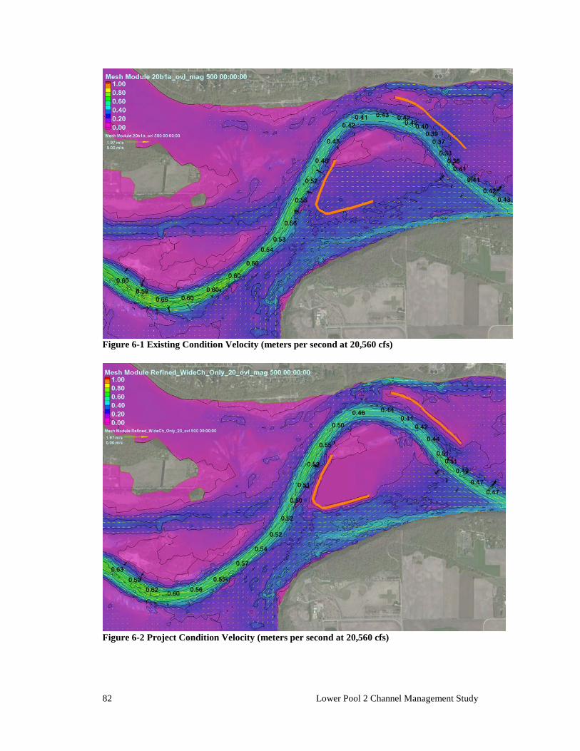
82 Lower Pool 2 Channel Management Study
Figure 6-1 Existing Condition Velocity (meters per second at 20,560 cfs)
Figure 6-2 Project Condition Velocity (meters per second at 20,560 cfs)
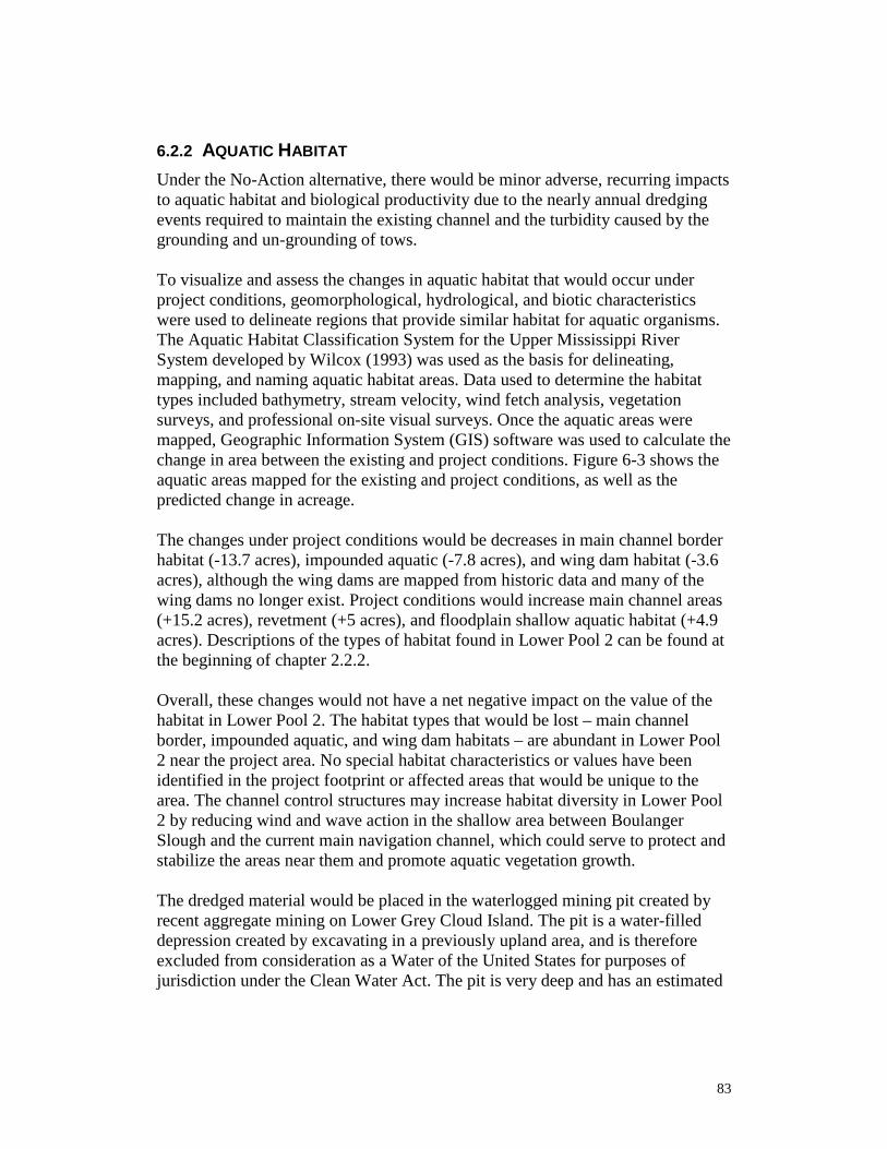
83
6.2.2 AQUATIC HABITAT Under the No-Action alternative, there would be minor adverse, recurring impacts to aquatic habitat and biological productivity due to the nearly annual dredging events required to maintain the existing channel and the turbidity caused by the grounding and un-grounding of tows. To visualize and assess the changes in aquatic habitat that would occur under project conditions, geomorphological, hydrological, and biotic characteristics were used to delineate regions that provide similar habitat for aquatic organisms. The Aquatic Habitat Classification System for the Upper Mississippi River System developed by Wilcox (1993) was used as the basis for delineating, mapping, and naming aquatic habitat areas. Data used to determine the habitat types included bathymetry, stream velocity, wind fetch analysis, vegetation surveys, and professional on-site visual surveys. Once the aquatic areas were mapped, Geographic Information System (GIS) software was used to calculate the change in area between the existing and project conditions. Figure 6-3 shows the aquatic areas mapped for the existing and project conditions, as well as the predicted change in acreage. The changes under project conditions would be decreases in main channel border habitat (-13.7 acres), impounded aquatic (-7.8 acres), and wing dam habitat (-3.6 acres), although the wing dams are mapped from historic data and many of the wing dams no longer exist. Project conditions would increase main channel areas (+15.2 acres), revetment (+5 acres), and floodplain shallow aquatic habitat (+4.9 acres). Descriptions of the types of habitat found in Lower Pool 2 can be found at the beginning of chapter 2.2.2. Overall, these changes would not have a net negative impact on the value of the habitat in Lower Pool 2. The habitat types that would be lost – main channel border, impounded aquatic, and wing dam habitats – are abundant in Lower Pool 2 near the project area. No special habitat characteristics or values have been identified in the project footprint or affected areas that would be unique to the area. The channel control structures may increase habitat diversity in Lower Pool 2 by reducing wind and wave action in the shallow area between Boulanger Slough and the current main navigation channel, which could serve to protect and stabilize the areas near them and promote aquatic vegetation growth. The dredged material would be placed in the waterlogged mining pit created by recent aggregate mining on Lower Grey Cloud Island. The pit is a water-filled depression created by excavating in a previously upland area, and is therefore excluded from consideration as a Water of the United States for purposes of jurisdiction under the Clean Water Act. The pit is very deep and has an estimated
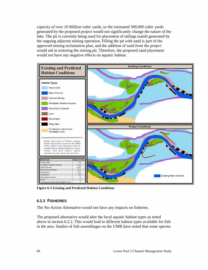
84 Lower Pool 2 Channel Management Study
capacity of over 10 Million cubic yards, so the estimated 309,000 cubic yards generated by the proposed project would not significantly change the nature of the lake. The pit is currently being used for placement of tailings (sand) generated by the ongoing adjacent mining operation. Filling the pit with sand is part of the approved mining reclamation plan, and the addition of sand from the project would aid in restoring the mining pit. Therefore, the proposed sand placement would not have any negative effects on aquatic habitat.
Figure 6-3 Existing and Predicted Habitat Conditions
6.2.3 FISHERIES The No-Action Alternative would not have any impacts on fisheries. The proposed alternative would alter the local aquatic habitat types as noted above in section 6.2.2. This would lead to different habitat types available for fish in the area. Studies of fish assemblages on the UMR have noted that some species
85
appear to exhibit preferences for localized types of habitat (e.g. Madejczyk, Mundahl, & Lehtinen 1998; Barko, Herzog, & Hrabik 2004). Both of these studies noted that certain species assemblages tended to be associated with sampling conducted near artificial rocky structure. The channel side of the control structures that would be exposed to current would likely continue to provide habitat characteristics preferred by species such as walleye, sauger, and flathead catfish. The downstream side of the channel control structures would be better-suited to species seeking refuge from current.
6.2.4 AQUATIC INVERTEBRATES The No-Action Alternative would not have any impacts on aquatic invertebrates. The proposed project would have minor adverse effects on the biological productivity of macroinvertebrates including freshwater mussels. A mussel relocation effort planned in the footprint of the proposed training structures would reduce this adverse effect, but a small number of mussels would still be expected to be killed as a result of the proposed project. Mussel surveys were conducted in and around the study area to quantify the mussel resources within the project footprint. A survey was conducted in and around the footprints of the channel training structures that would be constructed under the proposed plan. Another survey focused on the area that would be disturbed by the Boulanger Slough Channel alternative. Timed searches were conducted in the current main navigation channel and main navigation channel border areas. Several searches were also conducted in Lower Spring Lake, although no currently proposed project features would extend into that area. Figure 6-4 shows all of the points surveyed as a part of the planning process for this project. Within the proposed training structure footprints, about half (16) of the species known to be living in the pool were present. Four of these species are listed for state protection. No federally listed species were present. A full report detailing the survey’s findings can be found in Appendix G. Density was relatively low (3.34/m2 ± 1.01) compared to high-quality mussel areas in Pool 2. Davis (2007) reported native mussel density about three times greater, 9.02/m2 ± 1.29 in upper Pool 2 at Hidden Falls County Park. Similarly, across the navigation channel from the study area adjacent to Lower Grey Cloud Island in Pool 2 (River Mile 822 to 820), Kelner and Davis (2002) reported average mussel density of 9.8/m2 ± 0.8. Conversely, the current study area does appear to support a slightly more abundant mussel community than the other areas surveyed as a part of the Lower Pool 2 Channel Management Study: In the nearby Boulanger Slough area, average native mussel densities were 2.41±0.6 mussels/m2 (Kelner 2012), and in
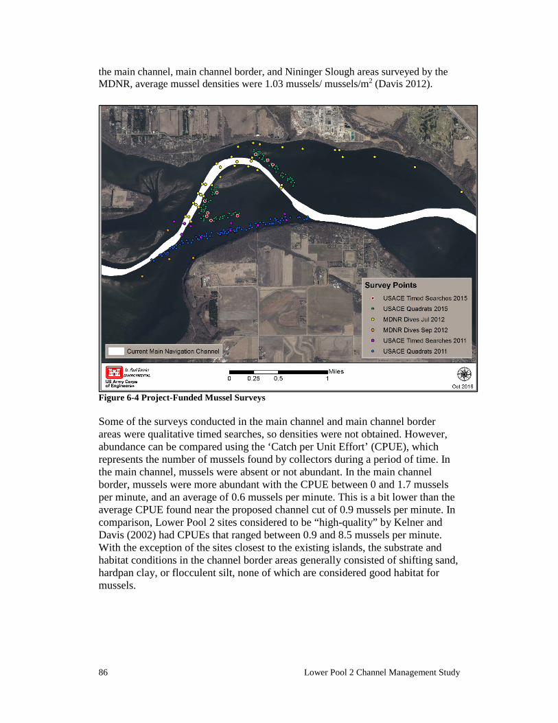
86 Lower Pool 2 Channel Management Study
the main channel, main channel border, and Nininger Slough areas surveyed by the MDNR, average mussel densities were 1.03 mussels/ mussels/m2 (Davis 2012).
Figure 6-4 Project-Funded Mussel Surveys Some of the surveys conducted in the main channel and main channel border areas were qualitative timed searches, so densities were not obtained. However, abundance can be compared using the ‘Catch per Unit Effort’ (CPUE), which represents the number of mussels found by collectors during a period of time. In the main channel, mussels were absent or not abundant. In the main channel border, mussels were more abundant with the CPUE between 0 and 1.7 mussels per minute, and an average of 0.6 mussels per minute. This is a bit lower than the average CPUE found near the proposed channel cut of 0.9 mussels per minute. In comparison, Lower Pool 2 sites considered to be “high-quality” by Kelner and Davis (2002) had CPUEs that ranged between 0.9 and 8.5 mussels per minute. With the exception of the sites closest to the existing islands, the substrate and habitat conditions in the channel border areas generally consisted of shifting sand, hardpan clay, or flocculent silt, none of which are considered good habitat for mussels.
87
Any macroinvertebrates living in the areas within the footprint of the project features (the dredge cuts and training structures) would be directly impacted during project construction. Those within the dredge cuts would be removed from the substrate and placed on land by the dredging process. Impacts to freshwater mussels from dredging would be minimal, as mussel surveys in the main channel and main channel border areas showed low-density, little diversity, and consisted of common species. These results are to be expected because the same conditions that tend to precipitate channel maintenance problems (i.e., dynamic, shifting sediment) make these areas poor habitat for mussels. Mussels within the footprints of the rock training structures would be buried and killed. Because mussel surveys of these footprints revealed moderate mussel density which included several rare species, mitigation measures are being incorporated into the project to minimize the project’s effects. Divers would be tasked with searching the footprints of the proposed training structures and collecting as many freshwater mussels as they can find. These mussels would be relocated to other nearby areas in order to augment the mussel communities. Past studies on mussel relocation efforts have shown that a high percentage of the mussels can be collected (90% or greater), and that survival following relocation is good. Appendix G describes the methodologies and protocols that would be used during the mussel relocation. Mussels could also be impacted by indirect effects of the project. There are two primary potential impacts outside of the footprints: flow and deposition. Flow behind the structures is anticipated to be reduced, but not eliminated. The project would be expected to change the habitat in the area slowly over time. This may impact colonization of new mussels, but would not be expected to negatively affect the mussels that currently exist in the area. Deposition rates will likely also change, but as shown on Figures 28 & 29 in the H&H appendix (Appendix D), the largest changes in deposition predicted by the ADH model were ~0.6 feet over the course of approximately 5 years (476 total days were modeled, and the model assumes 100 days of active sediment movement per year. Appendix D describes this further). Mussels would not be negatively impacted by that level of sediment deposition. Therefore, the Corps does not believe the project would cause measurable indirect effects to mussels, and does not propose to relocate these mussels. Nonetheless, surveys to monitor changes in the area will be performed during the relocation effort pre-project and by the Corps 5-years post-project to verify that impacts are absent or negligible.
6.2.5 THREATENED AND ENDANGERED SPECIES
Federally-Listed Species
88 Lower Pool 2 Channel Management Study
The proposed action would not affect any Federally-listed threatened or endangered species. Mussel surveys conducted in and around the project area (as described in Chapter 6.2.4) recovered no Federally-listed species. Surveys that were conducted nearby for unrelated purposes were also reviewed, including surveys conducted by the Minnesota DNR and Ecological Specialists, Inc. There has been one recent collection (2010) of a single, live individual Federally-listed endangered Higgins eye pearlymussel approximately one-tenth of a mile upstream from the proposed project, located off of the main channel behind a small rock island. However, it is unlikely that the species occurs within the area that would be disturbed by the project given the marginal habitat conditions identified during the surveys, as Higgins’ eye are typically associated with dense, high-quality mussel beds. Substrate conditions in the project area are less than ideal for the Higgins eye, consisting of a loose, ‘mucky’ mixture of silt, clay, and sand, but with pockets of homogenous sand and hardpan clay. Furthermore, it is highly unlikely that any other species of Federally-listed endangered mussels inhabit the project area. The snuffbox was recently re-introduced in upper Pool 2, but has not otherwise been recently collected in Pool 2. The sheepnose is not known to be extant in Pool 2 of the Upper Mississippi River. The northern long-eared bat, prairie bush clover, and rusty patched bumblebee are largely terrestrial species, not closely associated with the riverine environment. No habitat suitable for these species, as described in Chapter 2.2.5, would be disturbed by the proposed project. If any upland disturbance is proposed as part of the dredged material placement, this determination will be reviewed prior to construction.
Species of Local Significance Nine State-listed mussel species are known to exist in Lower Pool 2 that could be affected by the proposed project. The effects on individuals of these species would be the same as those discussed for other freshwater mussel species in Chapter 6.2.4 – Aquatic Invertebrates. Effects to these species would be negligible due to the mussel relocation mitigation that has been incorporated into the project plan. Of the nine, five State-listed mussel species were collected in surveys conducted within the proposed project footprint - the pistolgrip (Tritogonia verrucosa), listed as endangered in Minnesota, the wartyback (Quadrula nodulata) and the butterfly (Ellipsaria lineolata), listed as threatened in Minnesota, the black sandshell (Ligumia recta), listed as a species of special concern in Minnesota, and the hickorynut (Obovaria olivaria), a ‘watchlist’ species.
89
The wartyback is listed as Threatened by the state of Minnesota, and was found during quantitative sampling throughout the two structure footprints at a relative abundance of nearly 9%. Based on the sampled density, it is estimated that approximately 1,340 ± 890 wartyback are present per acre within the project area, and therefore approximately 5,340 ± 3,560 are estimated to exist within the footprint of the proposed channel control structures. Although the wartyback is rare throughout the state including other locations within the UMR, the species has healthy populations in Pool 2. Studies of the mussel community in Pool 2 reflect the good health of the wartyback species in the area. Two individuals of the state-endangered pistolgrip, one individual of the state-threatened butterfly, and eight individuals of the state-special concern black sandshell were found in qualitative timed-searches. A population estimate cannot be calculated based on survey data for these species because they were only found in qualitative searches. It is reasonable to assume that a small number of individuals of each of these species exist within the project footprint. The remaining four species were not collected during the mussel surveys conducted in the project footprint, but have been previously found live in other areas of Lower Pool 2. These are the Higgins’ eye (Lampsilis higginsii), which is listed as endangered both federally and by Minnesota (and discussed at length earlier in this section), the washboard (Megalonaias nervosa), which is listed as endangered in Minnesota, the monkeyface (Quadrula metanevra) and the fawnsfoot (Truncilla donaciformis), listed as threatened in Minnesota. It is possible that individuals of these species occur within the project area, but based on their absence in the project surveys it is not likely that the project area includes significant portions of their populations and therefore, the proposed project would have no effect on these species or their state status. The paddlefish (Polydon spathula) is a large and long-lived planktivorous fish species that has been historically observed in Pool 2, (last documented Pool 2 observation in 2003 (Schmidt & Proulx 2009)). Paddlefish are listed as threatened in Minnesota and Wisconsin. It is not known if paddlefish use the project area, and surveys for paddlefish were not conducted because the rarity of the fish makes it extremely difficult to detect their presence using standardized sampling methods (Schmidt 2004). However, if any paddlefish are present in the project area, the project would not be likely to directly impact them since fish present in the construction areas would be expected to vacate when the area is disturbed. The habitat changes that would follow due to the project could impact paddlefish, but it is unclear whether the effect would be positive or negative. During the majority of the year, studies have associated paddlefish with deeper water (usually >3m) and generally low current velocities (Zigler et al. 2003). During spawning, paddlefish use gravel substrates or hard surfaces with enough current to keep eggs free of silt (Jennings & Zigler 2000). Neither of these habitats are present in the
90 Lower Pool 2 Channel Management Study
project footprint, and no such areas would be impacted by proposed project actions. Kitten-tails (Besseya bullii) is an upland perennial herb that primarily inhabits oak savanna communities, and less frequently, other dry prairies woodlands. Many of Minnesota’s populations of kitten-tails occur on the bluffs and terraces of the Mississippi River valley. No suitable habitat for kitten-tails would be impacted by the proposed project. The loggerhead shrike (Lanius ludovicianus) generally inhabits upland grassland and agricultural areas, and is not strongly associated with riverine habitats. Therefore, the proposed project would not have any effect on loggerhead shrike. Seven additional species listed as “Species of Special Concern” and on the “watchlist” have been documented near the project area. This includes two fish: the American eel (Anguilla rostrata) and pirate perch (Aphredoderus sayanus); three terrestrial vascular plants: American ginseng (Panax quinquefolius), Laurentian bladder fern (Cystopteris laurentiana), and long-bearded hawkweed (Hieracium longipilum); one bird: the peregrine falcon (Falco perigrinus); and one reptile: western foxsnake (Pantherophis ramspotti). The fish, snake, and bird are mobile species and would avoid the project area during construction. Wild ginseng favors deep shade in dense deciduous forests, and no such habitat would be disturbed by the proposed project. The Laurentian bladder fern is found on wet limestone cliffs which also would not be disturbed by the proposed project. Long-bearded hawkweed is found on high-quality dry prairies. The proposed project would not adversely affect habitat for any of these species. Seven terrestrial communities were identified as existing within a mile of the project area, as listed in Table 5 in Chapter 2.2.5. No habitat of these types would be impacted by the proposed project.
6.2.6 AQUATIC VEGETATION The U.S. Army Corps of Engineers Environmental Laboratory’s 1987 Wetland Delineation Manual defines and describes three parameters that must be present to define an area as a wetland: “hydrophytic vegetation, hydric soils, and wetland hydrology.” A wetland delineation has not been completed at the site. However, no vegetation (submergent or emergent) has been identified within the project footprints during numerous other site visits, including mussel sampling (which includes activities such as diving and substrate extraction). The lack of vegetation in the project area is likely due to site conditions that are not conducive to vegetative growth. Project features are located near the main channel where the substrate is often unstable and where wind and wave action are high.
91
6.2.7 BIRDS Neither the No-Action or proposed alternatives are expected to affect birds.
6.2.8 WATER QUALITY Under the No-Action alternative, there would be minor adverse effects on water quality associated with the disturbance of the sediments caused by the frequent dredging events required to maintain the existing navigation channel. The proposed project would have temporary and minor adverse effects on water quality from the disruption and displacement of sediments during project construction, both during the dredging of the channel and the construction of project features. The proposed alternative would also have periodic minor adverse effects on water quality associated with maintenance dredging events similar to the No-Action alternative. Dredging re-suspends bottom sediments, increasing turbidity. These increases in are generally local and short term. Anticipated impacts on water quality are generally related to the type of equipment used to complete a dredging job. Hydraulic dredging equipment tends to have a lesser impact on water quality at the dredge cut site than mechanical equipment. Conversely, mechanical dredging equipment tends to have a lesser impact on water quality at the placement site; because there is no carriage water to manage either on- or off-site. However, regardless of these minor differences, both methods of dredging can be conducted using best management practices that minimize effects to water quality, resulting in negligible impacts to water quality.
Sediment Quality The No-Action alternative would cause disturbances of the sediments caused by the frequent dredging events required to maintain the existing navigation channel. However, based on the sediment testing results presented in Chapter 2.2.8 and in Appendix H, the sediments within the navigational channel present only a low risk of affecting benthic invertebrates due to slight exceedances of MPCA’s SQT Level I concentrations for a few PAHs and metals. The proposed project would present temporary and minor adverse effects on adjacent and downstream suspended sediment and surficial sediment from the disruption and displacement of sediments during project construction, both during the dredging of the channel and the construction of project features. The widening of the channel would also expose more sediment to disruption, but this material only showed slight SQT Level I exceedances. The bigger concern is the substrate quality in the footprints of the training structures. The 2015 testing showed several parameters with SQT Level II and MPCA’s SRV Recreational/Residential
92 Lower Pool 2 Channel Management Study
exceedances in these areas (See Appendix H for full sampling details). However, following the construction, these sediments would effectively be capped from further movement under normal circumstances. And through coordination with the MPCA, there may be certain BMPs employed during construction that could also reduce disturbance.
6.2.9 TERRESTRIAL HABITAT The placement site for the material dredged from the navigation channel would be the only upland area that would be disturbed by the proposed project. The site(s) that will be used for this purpose would be the same sites used for routine channel maintenance, and have been or will be addressed in separate planning and environmental documentation.
6.2.10 AIR QUALITY Under the No-Action alternative, there would be minor adverse impacts on air quality due to the frequent dredging events required for maintaining the existing navigation channel. The proposed project is being assessed for air quality effects on several levels: compliance with the rules provided by the Federal Clean Air Act, analysis of greenhouse gas emissions and potential effects on climate change, and impacts to local receptors. The 1990 Federal Clean Air Act Amendments directed the Environmental Protection Agency (EPA) to develop Federal conformity rules. Those rules (promulgated as 40 CFR parts 51 and 93) are designed to ensure that Federal actions do not cause, or contribute to, air quality violations in areas that do not meet the National Ambient Air Quality Standards (NAAQS). The EPA has developed NAAQS for six principal air quality pollutants: carbon monoxide, nitrogen dioxide, ozone, lead, particulate matter, and sulfur dioxide. The final rule dictates that a conformity review be performed when a Federal action generates air pollutants in a region that has been designated a non-attainment area for one or more of the six NAAQS criteria pollutants. Washington County is in “attainment” of the NAAQS for each of the criteria pollutants, so no conformity review is required. Dakota County is listed as a nonattainment region for Lead under the 2008 standard. However, because no lead would be emitted during the construction of or as a result of this project, the action would be exempt from the Federal conformity rules. Therefore, no conformity analysis is required for the proposed project.
93
Greenhouse gas emissions and their effect on climate change are global issues resulting from numerous and varied sources, with each source making a relatively small addition to global atmospheric greenhouse gas concentrations. Additionally, the ability to accurately predict the localized or short-term effects of changes in greenhouse gas emissions is extremely limited. Nevertheless, it is imperative for agencies to identify the potential emissions from project alternatives when it may inform the agency’s decision-making. The proposed project would be expected to produce greenhouse gasses during construction in the form of exhaust from various types of machinery used for dredging, material transport, and material placement. The proposed project would also have recurring minor adverse impacts on air quality from dredging events required for maintaining the navigation channel at approximately the same level as the No-Action alternative. The Council on Environmental Quality (CEQ) released draft NEPA guidance for consideration of the effects of climate change and greenhouse gas emissions in February, 2010. The guidance proposed a level of 25,000 metric tons or more of CO2-equivalent GHG emissions annually as an indicator that detailed assessment of greenhouse gasses may be meaningful to decision makers and the public. Using estimates of fuel usage and production quantities for mechanical dredging, it was estimated that dredging and associated placement would result in a release of approximately 1,000 metric tons of CO2-equivalent greenhouse gas emissions. Although more difficult to estimate the emissions related to the construction of the training structures, the level of effort is anticipated to be similar to that of the dredging, and would utilize similar construction equipment. Based on these initial estimates, it does not appear that a detailed assessment of GHG emissions is warranted for this project. At a local scale, the nearest sensitive receptor is Spring Lake Regional Park, which is located on top of the bluff, a little over 1,000 feet south of the upstream proposed training structure. Several residential properties lie to the east of the park, also on top of the bluff, and would be approximately 2,000 feet away from the tip of one of the proposed training structures. No other receptor sites have been identified within 2,000 feet of any proposed construction. During project construction, the project would have a temporary, minor, and localized adverse effect on air quality due to emissions produced by construction equipment. This would be short-lived and would disappear upon project completion. Construction activities are expected to produce very little dust because the materials to be handled would be either wet (dredged material) or larger materials than are generally mobilized by wind (large rocks for training structure construction).
94 Lower Pool 2 Channel Management Study
6.3 Cultural Resource Effects
A variety of Project features have the potential to affect identified and unidentified cultural resources. These include direct and indirect impacts to islands and high potential landforms that are now submerged. Cultural resources investigations included pedestrian surveys along island shorelines and interiors and execution of a submerged sediment boring program to detect inundated and deeply buried sites. No cultural resources were identified. In general, a combination of navigation channel maintenance activities and post 1930s fluvial processes appear to have dramatically altered, severely degraded or otherwise destroyed much of the pre-lock and dam landforms in the Project Area. The potential for the Project Area to contain intact, significant cultural resources is remote. The Corps has determined that the Project would have no potential to effect historic properties. A synopsis of the cultural resources investigations for the Project follows.
6.3.1 WING DAMS Collectively, Wing Dams are considered eligible for listing on the NRHP (Pearson 2003). Between RM 821 and RM 815.2 at Lock and Dam 2, 46 wing dams were placed along the main channel between 1875 and 1924. Many of these were modified several times during the 20th century (e.g., lengths reduced) or subsequently removed or otherwise destroyed during channel dredging with the eastward or downstream drift of the main channel. No wing dams or training structures remain in the areas proposed for revetment construction. Thus, the project has no potential to effect wing dams or their allies.
6.3.2 BOULANGER ISLAND REMNANT The island along the right descending bank near RM 819.5 is a remnant of the greater Boulanger Island, also known as Island no. 16. It has been enhanced with dredged material. The main channel side of the island likely hosted a natural levee, with the back side lower in elevation and grading into wetlands. A proposed revetment for the project would tie into the western portion of the existing island. The island was subjected to a surface reconnaissance in August 2013. The island has received extensive deposits from historic side casting of dredged material. The remnants of a wing dam are present at the head of the island. However, the project would not impact this relic. Because proposed project features would not involve disturbing sub-surface sediments, no deep site testing was completed. Other than the wing dam residuum, no cultural resources were identified. As above, the Project has no potential to effect historic properties.
95
6.3.3 SUBMERGED HIGH PROBABILITY LANDFORMS Prior to its inundation after 1930, the Pool 2 floodplain contained a suite of landforms. Principal among these are natural levees, areas within the floodplain that often remained above water during minor floods, are well drained and therefore attractive areas for a variety of human activities. A number of cultural resource sites have been identified on natural levees in the UMR and these landforms are considered to have a high potential to contain cultural resources (e.g., Benn and Lee 2005; Kolb and Boszhardt 2004; Perkl 2005; Hudak et al 2002). Within the Project Area, natural levees were evident along both sides of the main channel. An analysis of the pre-inundation landforms in the Project Area uses the MRC 1895 chart as a proxy for elevations. Low-lying areas average approximately 680 feet above mean sea level (amsl). Areas thought to coincide with natural levees approach elevations of approximately 690 feet amsl. Pool 2 is currently maintained with a water surface elevation of approximately 687 ft amsl, equating to a water level rise of approximately seven feet since 1930. By 1937, much of the floodplain was inundated, although narrow islands along the main channel-the tops of natural levees-remained. By 1953 these features were absent. Recent bathymetry indicates that the depth of the river bottom ranges between approximately less than one foot to three feet over natural levees and from approximately three to nine feet in lower areas. The main navigation channel is nine feet or deeper. From this information, it appears that approximately a minimum four feet of the natural levees have eroded across the area. While some of the pre-1930 topography can be detected, in many low-lying areas sedimentation has occurred in the range of three to four feet of overburden. Despite the apparent degradation of natural levees in the Project Area, deeply buried cultural resources may exist in these landforms (e.g., Florin and Lindbeck 2008; Stoltman 2005). Therefore, these features warranted cultural resources investigations. The method of choice for detecting submerged cultural resources was through a boring program that is informed from sediment cores and adapts geotechnical boreholes to recover cultural material (Perkl 2007). This program uses equipment mounted on a pontoon barge. River bottom sediments and stratigraphy are initially examined using a 3-inch split-spoon core sampler. Important characteristics of the sediment column that may indicate cultural phenomena include buried surfaces, freshwater shell concentrations and artifacts. This is followed by an adjacent borehole ‘drilled’ using a jerk-line apparatus. A 4-inch casing is set at intervals of several vertical feet to depth and the matrix flushed out with a water-bentonite mix using a 3-inch chopper head. The slurry is passed through 1/8 inch hardware cloth and the contents examined for cultural material.
96 Lower Pool 2 Channel Management Study
This method can reach depths sufficient to penetrate pre-inundated river bottom surfaces well below near-surface to detect deeply-buried cultural deposits. Three episodes of boring activities have been completed in the Project Area, in August 2011, November 2012, and June 2013. A total of 41 bore holes were placed in three areas: along Boulanger Slough (n=21) and Boulanger Island south (n=12) and north (n=8) of the slough’s head. On average, bore holes penetrated 15 feet below the bottom surface of the river. Sediments varied across the area from silts, sands, and clays and contained various inclusions, such as shell, bark and wood fragments. Typically, organic matter was encountered at the top of the bores denoting the river bottom. No deeply buried soil horizons were detected. None of the bore holes were positive for cultural material. Results of the boring program reveal extensive scouring and sedimentation across the area, as predicted in the review of historical information. No remnants of the natural levee were detected in the area along the main channel below the slough’s head (ca. RM 819.5-820.1). In this area, it appears that the main channel has obliterated the natural levee as it shifts downstream and to the east. Likewise, between RM 819.5 and 818.3 the natural levee residing along the left descending bank has been removed by channel migration. The proposed revetments in this area will be placed on elevations below 690 ft amsl. In fact, borings along this stretch reveal wetland sediments (i.e., gley soils) prior to 1930s river improvements with inundation of the floodplain. If the natural levees in the area once harbored cultural deposits, they have been destroyed or extensively disturbed from fluvial processes. Based on extensive investigations of submerged land forms in the Project Area with negative results, the Project has no potential to effect historic properties in such areas.
6.3.4 PROXIMAL RECORDED CULTURAL RESOURCES Anticipated indirect effects to identified cultural resources proximal to the Project Area are restricted to visual impacts. However, visual impacts from the project should not be detrimental as those sites that are visible from the project area would not be significantly altered by visual changes, such as vegetation removal or construction of river training structures.
6.3.5 COORDINATION The proposed project has no effect on historic properties; as such, additional coordination is not required.
97
6.4 Cumulative Effects
6.4.1 SCOPE OF CUMULATIVE EFFECTS ANALYSIS Cumulative effects are defined by the Council on Environmental Quality as, “[T]he impact on the environment which results from the incremental impact of the action when added to other past, present, and reasonably foreseeable future actions regardless of what agency (Federal or non-Federal) or person undertakes such actions. Cumulative impacts can result from individually minor but collectively significant actions taking place over a period of time.” The time frame considered for the scoping of potential future cumulative impacts was bounded by the project life considered during other analyses, which was 40 years. This is the life-span for project costs, benefits, and effects that is normally considered during the planning of Corps projects. Although this life-span is somewhat arbitrary, no reasonably foreseeable future actions were identified beyond this time scale. The environmental analysis for the proposed project did not identify significant effects outside of the direct project area. Therefore, the geographic scale analyzed for cumulative impacts was limited to potential actions that have or would have effects in the immediate project area. However, this does not mean that only activities with footprints overlapping the proposed project were considered - this is because the proposed project is a part of a large river system, which necessitates considering if actions upstream or downstream could also impact this particular reach of the river.
6.4.2 ACTIONS IDENTIFIED WITHIN THE PROJECT IMPACT ZONE The following past, present, and reasonably foreseeable future actions were identified as having the potential to interact with or have impacts related to those of the proposed project.
Past Actions:
Modifications to the Upper Mississippi River for Navigation The floodplain geomorphology, stream hydraulics, and water levels of the Upper Mississippi River have been modified by impoundment and other navigation features since the 1820s. The most relevant navigation improvement actions within the project impact area are likely the construction of hundreds of channel training structures placed between 1866 and 1907 as part of the 4-foot, 4.5-foot, and 6-foot navigation channel projects. Following the construction of these structures was the construction of Lock and Dam Number 2 in 1930, which raised
98 Lower Pool 2 Channel Management Study
water levels by several feet in the immediate project area and allowed for a 9-foot-deep navigation channel. The cumulative effect of these actions has played a large role in the development of the habitat that currently exists in the project area.
Closure of Upper St. Anthony Falls Lock and Dam to Navigation Due to concerns regarding the spread of invasive Asian carp, Section 2010 of the Water Resources Reform and Development Act of 2014 (WRRDA 2014) directed the Secretary of the Army to close the Upper St. Anthony Falls lock to navigation within one year after enactment. The WRRDA 2014 was signed into law on June 10, 2014. The WRRDA 2014 allows the lock to continue to be operated for emergency flood control. The lock was closed to navigation on June 9, 2015. The WRRDA 2014 did not direct further disposition of the lock.
Concurrent and Ongoing Actions:
Lake Pepin Eutrophication Total Maximum Daily Load (TMDL) Study and South Metro Mississippi River Total Suspended Solids TMDL Study The Minnesota Pollution Control Agency has identified the Mississippi River from Lock and Dam 1 to the head of Lake Pepin to be impaired for phosphorus and total suspended solids (TSS). Ongoing TMDL studies are being undertaken to identify the maximum quantities of these pollutants that can be allowed to enter the water body without exceeding water quality standards. The proposed project would have a minor effect on TSS and turbidity levels. Turbidity in this reach of the river began increasing in the early 1920s as the Twin Cities metropolitan area grew and agricultural use of the Minnesota River Basin increased. Sediment cores from Lake Pepin have shown that the sediment load to Lake Pepin doubled between the 1930s and the 1960s and has stabilized at that level, although the source of the sediment has shifted from farm fields to increased erosion of stream banks and bluffs.
Pool 2 DMMP A dredged material management plan (DMMP) is being prepared for Pool 2 to identify long term placement of channel maintenance dredged material. The DMMP will identify a “base plan” for managing dredged material over the next 40 years. The base plan is the least costly and environmentally acceptable method of managing dredged material. The Pool 2 DMMP will be completed in 2017 and material dredged as a part of the TSP and future material dredged as part of ongoing channel maintenance will be placed in the site identified in the DMMP.
99
Reasonably Foreseeable Future Actions:
Proposed Nelson Mine Expansion There is an ongoing mining operation utilizing an area of Grey Cloud Island, adjacent to the proposed project area. The mining company, Aggregate Industries, has produced a Draft Environmental Impact Statement for a proposed expansion of the mining activities. Mining operations would be expanded into 230 acres of privately-owned backwaters in order to access approximately twenty-one million tons of aggregate material. The project would extend the useful life of the equipment currently being used for mining on the island, and would be estimated to proceed for approximately twenty years.
Dakota County Park Expansion Dakota County has expressed interest in expanding Spring Lake Park Reserve in the future. Plans may include development along the shore of Spring Lake for recreational boat launching or day-use areas.
Grey Cloud Island Slough Restoration Grey Cloud Island is located adjacent to and slightly upstream of the project area. The upper end of the slough is located at approximately River Mile 827.5, and the lower end of the slough is located in the northwest of Freeborn Bend, at approximately River Mile 819.5. The slough once conveyed flow, but the connectivity has been severed since approximately 1965 when flooding provoked an emergency raise of the bridge during which the bridge culverts were filled. Since 1965, the ecological condition of the two disconnected ends of the slough has degraded. A number of potential alternative projects are being considered that would restore connectivity and flow to the slough, resulting in a diversion of an estimated 1-5% of the total Mississippi River flow through this slough.
6.4.3 ENVIRONMENTAL CONSEQUENCES OF CUMULATIVE EFFECTS The environmental consequences outlined below are organized by resource categories, in the same order the resources are discussed in Chapters 2 and 6. Refer to Chapter 2 for detailed descriptions of the affected environment or to the respective sections of Chapter 6 for detailed descriptions of environmental effects.
Recreation Recreational opportunities would not be adversely affected by the proposed project. Any expansion of river access within Spring Lake Regional Park would be expected to further improve the recreational opportunities.
100 Lower Pool 2 Channel Management Study
Aesthetic Values The proposed project would have minor adverse effects on aesthetic values by introducing two low, rock training structures into the viewshed that would be visible from locations such as the scenic overlook at Schaar’s Bluff in Spring Lake Regional Park. The proposed Nelson Mine Expansion project also has the potential to cause minor impacts to this scenic overlook: construction and mining equipment may be visible and several berms are proposed for temporary use (years) during active mining.
Hydrology, Hydraulics, and Sediment Transport The proposed Nelson Mine Expansion project may include the construction of a berm that would reduce or eliminate flows entering the side channel where mining is proposed. This would have the effect of increasing flows in the main channel upstream of the project area. Any sediment that under current conditions would have been be deposited in the slough would instead continue downstream. The proposed Grey Cloud Island Slough Restoration would have minor effects on the hydraulic function of the area, by redirecting 1-5% of the Mississippi River’s flows through the slough. This minor change is not expected to impact the sediment capacity of the navigation channel. The closure of Upper Saint Anthony Falls Lock could have an impact on dredging quantities in Pool 2, however this depends on future dredging practices in the Upper St. Anthony Falls (USAF) Pool and Pool 1. If dredging in just the USAF Pool was eliminated, the increase in dredging in Pool 2 would be minimal, as long as dredging in Pool 1 was increased to account for the additional sediment load from the USAF Pool. If dredging in both the USAF pool and Pool 1 were eliminated, the increase in dredging in Pool 2 could be substantial. Sediment budget analysis indicates that annual dredging volumes could increase by as much as 40-percent, however an unknown is the amount of time for the increase in Pool 2 dredging to occur. Observation from other river reaches where large changes in sediment transport capacity or dredging volumes have occurred suggest that it could be a decade or more before increased dredging occurs in lower pool 2.
Mussels According to the draft EIS, the proposed Nelson Mine Expansion project would destroy all of the mussels currently found within the mining area, totaling approximately 230 acres. Depending on reclamation strategies following mining, much of the 230 acres may remain unsuitable habitat for mussels after project completion. There may also be effects on downstream mussel communities due to degraded water quality during the period of project operation. Mitigation to offset these effects has been proposed as part of the project and is currently under
101
evaluation. Without a definite long-term plan, it is difficult to further assess the long-term impacts of the proposed project on freshwater mussels. The proposed project would not be expected to have long-term negative impacts on mussel populations due to the incorporation of relocation of the mussels.
Water Quality The proposed Nelson Mine Expansion Project would cause increases in suspended sediment load downstream of the project area during periods of high flow. The Draft EIS for the proposed project estimates that over the 20-year life of the project, a total of approximately 60,000 tons of sediment (an average of 3,000 tons per year) would be introduced to Lower Pool 2. The project would cause minor increases in turbidity during dredging and construction of project features, which would be temporary and would disappear upon project completion.
6.5 Summary of Environmental Effects
Table 10 provides a summary of the environmental consequences of the No-Action alternative and the potential effects of the proposed project. The No-Action alternative is considered to be the base condition, and includes those actions expected to be undertaken in the future in the absence of an additional project, including channel maintenance actions that have previously been authorized. Therefore, the impacts to each of the resource categories under the No-Action alternative are in general a continuation of those that have been caused by current channel maintenance practices. The impacts listed under the proposed alternative are those discussed in detail within Chapter 6. Temporary impacts, denoted in the table by the letter “T,” represent short-term effects, which are usually related to one-time construction efforts. In general, the No-Action Alternative would have minor adverse impacts on commercial navigation; and temporary minor adverse effects on noise levels, air quality, aquatic habitat, biological productivity, and surface water quality. In comparison, the proposed project would have similar temporary minor adverse impacts on noise levels, air quality, biological productivity, and surface water quality, and would have additional minor adverse impacts on aesthetic values, public safety, and aquatic habitat; substantial beneficial effects on commercial navigation; and minor beneficial effects on public safety.
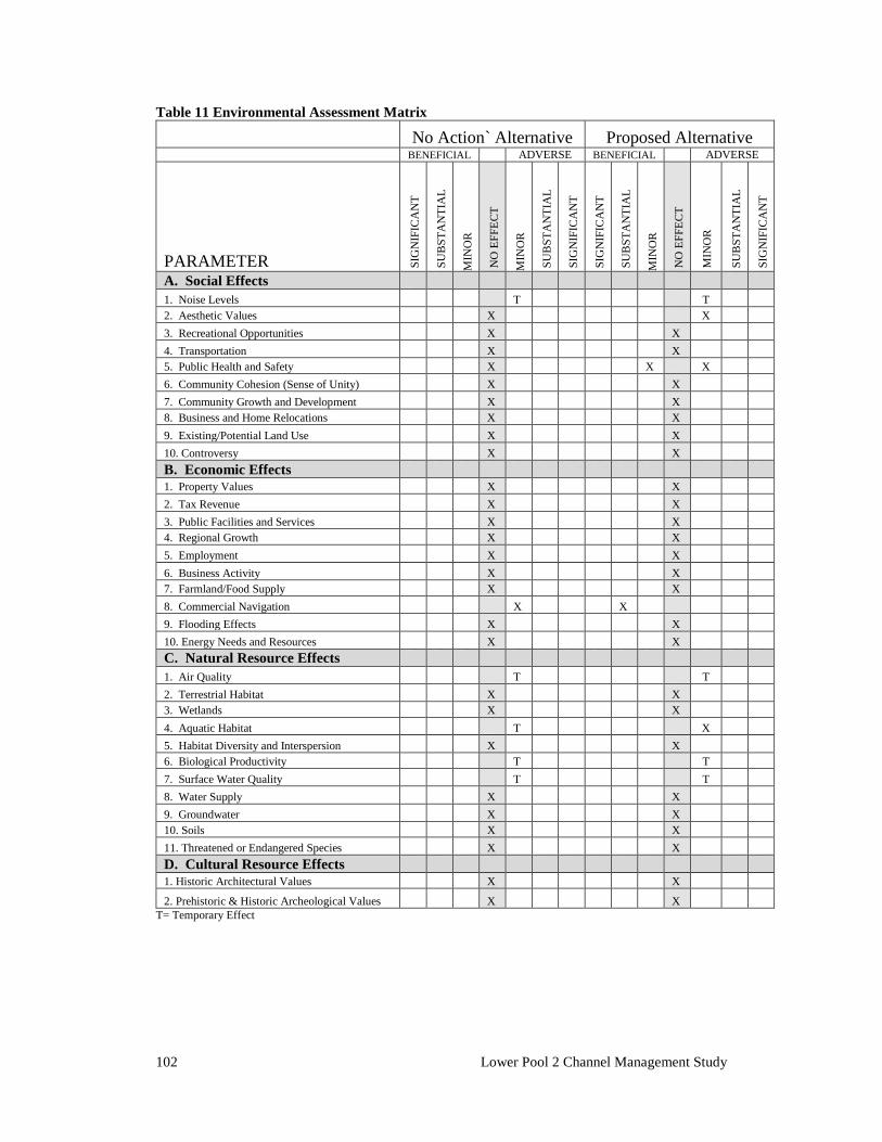
102 Lower Pool 2 Channel Management Study
Table 11 Environmental Assessment Matrix Blank No Action` Alternative Proposed Alternative blank
BENEFICIAL blank
ADVERSE BENEFICIAL blank
ADVERSE
PARAMETER SIG
NIF
ICA
NT
SU
BST
AN
TIA
L
MIN
OR
NO
EFF
ECT
MIN
OR
SU
BST
AN
TIA
L
SIG
NIF
ICA
NT
SIG
NIF
ICA
NT
SU
BST
AN
TIA
L
MIN
OR
NO
EFF
ECT
MIN
OR
SU
BST
AN
TIA
L
SIG
NIF
ICA
NT
A. Social Effects blank
blank blank blank blank blank blank blank blank blank blank blank blank blank
1. Noise Levels blank blank blank blank Blank T
blank blank blank blank blank blank T
blank blank
2. Aesthetic Values Blank Blank Blank X
blank blank blank blank blank blank blank X
blank blank
3. Recreational Opportunities Blank Blank Blank X
blank blank blank blank blank blank X
blank blank blank
4. Transportation Blank Blank Blank X
blank blank blank blank blank blank X
blank blank blank
5. Public Health and Safety Blank Blank Blank X
blank blank blank blank blank X
blank X blank blank
6. Community Cohesion (Sense of Unity) Blank Blank Blank X
blank blank blank blank blank blank X
Blank blank blank
7. Community Growth and Development Blank Blank Blank X
blank blank blank blank blank blank X
Blank blank blank
8. Business and Home Relocations Blank Blank Blank X
blank blank blank blank blank blank X
blank blank blank
9. Existing/Potential Land Use Blank Blank Blank X
blank blank blank blank blank blank X
blank blank blank
10. Controversy Blank Blank Blank X
blank blank blank blank blank blank X
blank blank blank
B. Economic Effects blank blank blank blank blank blank blank blank blank blank blank blank blank blank
1. Property Values Blank Blank
blank X
blank blank blank blank blank blank X
blank blank blank
2. Tax Revenue Blank Blank
blank X
blank blank blank blank blank blank X
blank blank blank
3. Public Facilities and Services Blank Blank
blank X
blank blank blank blank blank blank X
blank blank blank
4. Regional Growth Blank Blank
blank X
blank blank blank blank blank blank X
blank blank blank
5. Employment Blank Blank
blank X
blank blank blank blank blank blank X
blank blank blank
6. Business Activity Blank Blank
blank X
blank blank blank blank blank blank X
blank blank blank
7. Farmland/Food Supply Blank Blank
blank X
blank blank blank blank blank blank X
blank blank blank
8. Commercial Navigation Blank Blank
blank Blank X
blank blank Blank X
Blank blank blank blank blank
9. Flooding Effects Blank Blank
blank X
blank blank blank blank blank Blank X
blank blank blank
10. Energy Needs and Resources Blank Blank
blank X
blank blank blank blank blank blank X
blank blank blank
C. Natural Resource Effects blank blank blank Blank blank blank blank blank blank blank blank blank blank blank
1. Air Quality Blank Blank
blank Blank T
blank blank blank blank blank blank T
blank blank
2. Terrestrial Habitat Blank Blank
blank X
blank blank blank blank blank blank X
blank blank blank
3. Wetlands Blank Blank
blank X
blank blank blank blank blank blank X
Blank blank blank
4. Aquatic Habitat Blank Blank
blank Blank T
blank blank blank blank blank blank X
blank blank
5. Habitat Diversity and Interspersion Blank Blank
blank X
Blank blank blank blank blank blank
X Blank
blank blank
6. Biological Productivity Blank Blank
blank Blank T
blank blank blank blank blank blank T
blank blank
7. Surface Water Quality Blank Blank
blank Blank T
blank blank blank blank blank blank T
blank blank
8. Water Supply Blank Blank
blank X
blank blank blank blank blank blank X
blank blank blank
9. Groundwater Blank Blank
blank X
blank blank blank blank blank blank X
blank blank blank
10. Soils Blank Blank
blank X
blank blank blank blank blank blank X
blank blank blank
11. Threatened or Endangered Species Blank Blank
blank X
blank blank blank blank blank blank X
blank blank blank
D. Cultural Resource Effects blank blank blank blank blank blank blank blank blank blank blank blank blank blank
1. Historic Architectural Values Blank Blank
blank X
blank blank blank blank blank blank X
blank blank blank
2. Prehistoric & Historic Archeological Values blank Blank
blank X
blank blank blank blank blank blank X
blank blank blank
T= Temporary Effect
Environmental Compliance and Review 103
CHAPTER 7. Environmental Compliance and Review
7.1 Applicable Environmental Laws and Executive Orders
The proposed action would comply with federal environmental laws, Executive Orders and policies, and applicable state and local laws including but not limited to the Clean Air Act, as amended; the Clean Water Act, as amended; the Endangered Species Act of 1973, as amended; the Fish and Wildlife Coordination Act of 1958, as amended; the Land and Water Conservation Fund Act of 1965, as amended; the National Historic Preservation Act of 1966, as amended; the National Environmental Policy Act of 1969, as amended; Executive Order 11990 - Protection of Wetlands; Executive Order 12898 - Environmental Justice; the Farmland Protection Policy Act of 1981 (the proposed action would not result in the conversion of farmland, as defined by the Farmland Policy Act, to non-agricultural uses); and Executive Order 11988 - Floodplain Management.
7.2 Public Involvement
A public notice of availability of the Draft Report was published on June 26, 2017, on the Corps website. A public meeting will be held if requested and the results of the meeting would be documented in this section, and in the Coordination & Correspondence Appendix A following the finalization of this report. Comments received will be documented in the Coordination and Correspondence section as well. The draft report has also been concurrently published for a 30-day review and public comment period by the Minnesota DNR, in fulfilment of state requirements of the Minnesota Environmental Protection Act. The Minnesota DNR has adopted this Draft Federal Environmental Assessment for use as a Minnesota State Environmental Assessment Worksheet (EAW). Appendix I has been prepared to help reviewers of the state publication to find the information typically included in an EAW.
104 Lower Pool 2 Channel Management Study
7.3 Coordination
Planning for the overall project has been coordinated with the public, state and federal agencies, and other interested parties. Several coordination meetings were held in and around Hastings, MN to discuss alternatives and their potential effects with members of interested agencies and stakeholders. The views expressed by the public and agencies have been considered throughout project planning. In addition to the meetings, informal coordination took place on an as-needed basis to address specific problems, issues, and ideas. Table 11 lists applicable environmental regulations and guidelines and provides their current review status. Detailed descriptions of compliance efforts for certain regulations follow.
7.3.1 CLEAN WATER ACT The dredging and fill activities associated with training structure construction would have effects on water quality. The Corps has completed a 404(b)(1) analysis which describes these effects (Appendix B). The Corps will also apply for 401 Water Quality Certification from the Minnesota Pollution Control Agency based on final estimates of quantities of materials determined as part of the Plans and Specifications phase.
7.3.2 FISH AND WILDLIFE COORDINATION ACT, ENDANGERED SPECIES ACT In compliance with the FWCA, project plans have been coordinated with the USFWS and the Minnesota DNR.
7.3.3 MINNESOTA STATE ENVIRONMENTAL REVIEW AND PERMITS The Corps will submit an application to the Minnesota DNR for a Public Waters Work Permit, out of comity. The project as planned would exceed the threshold requiring preparation of a Minnesota EAW, as defined in Minnesota Rules, part 4410.4300, subpart 27, item A. The Corps has worked with the Responsible Government Unit (the Minnesota DNR) to ensure that the federal EA will fulfill the requirements of the EAW. A supplement has been prepared to assist reviewers in locating sections which pertain to EAW requirements (see Appendix I).
7.3.4 CULTURAL RESOURCES AND TRIBAL COORDINATION Consultation with Native American groups and the Minnesota State Historic Preservation Office (SHPO) is in progress.
7.3.5 ADDITIONAL ENVIRONMENTAL REVIEW Some additional permits and environmental planning may fall under the responsibility of the contractor conducting the proposed work. The contractor would be responsible for obtaining construction permits as necessary, such as a National Pollutant Discharge
Environmental Compliance and Review 105
Elimination System permit. These responsibilities would be detailed in the Specifications provided to the Contractor.
7.4 Distribution of Draft Environmental Assessment
This environmental assessment has been provided via computer on the St. Paul District’s public website and a press release was published. The following agencies were notified directly regarding the availability of the report:
Federal U.S. Environmental Protection Agency U.S. Fish and Wildlife Service U.S. National Park Service U.S. Coast Guard
State of Minnesota Department of Natural Resources Pollution Control Agency Department of Transportation Metropolitan Council
Tribes Ho-Chunk Nation Lower Sioux Indian Community Prairie Island Indian Community Shakopee Sioux Community Upper Sioux Indian Community
Others Dakota County Washington County Navigation Industry Representatives Friends of Pool 2 American Rivers
7.5 Comments on the Environmental Assessment
We request and welcome written comments on environmental assessment. Please provide written comments by July 26, 2017, to the St. Paul District, U.S. Army Corps of Engineers, ATTN: Mr. Aaron McFarlane, CEMVP-PD-E, 180 Fifth Street East, Suite 701, St. Paul, Minnesota 55101, or by email to: [email protected].

106 Lower Pool 2 Channel Management Study
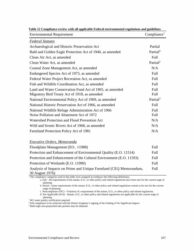
Environmental Compliance and Review 107
Table 12 Compliance review with all applicable Federal environmental regulations and guidelines Environmental Requirement
Compliance1
Federal Statutes
Archaeological and Historic Preservation Act
Partial Bald and Golden Eagle Protection Act of 1940, as amended
Partial4
Clean Air Act, as amended
Full Clean Water Act, as amended
Partial2
Coastal Zone Management Act, as amended
N/A Endangered Species Act of 1973, as amended
Full
Federal Water Project Recreation Act, as amended
Full Fish and Wildlife Coordination Act, as amended
Full
Land and Water Conservation Fund Act of 1965, as amended
Full Migratory Bird Treaty Act of 1918, as amended Full National Environmental Policy Act of 1969, as amended
Partial3
National Historic Preservation Act of 1966, as amended
Full National Wildlife Refuge Administration Act of 1966
Full
Noise Pollution and Abatement Act of 1972 Full Watershed Protection and Flood Prevention Act
N/A
Wild and Scenic Rivers Act of 1968, as amended
N/A Farmland Protection Policy Act of 1981
N/A
Executive Orders, Memoranda
Floodplain Management (EO.. 11988)
Full Protection and Enhancement of Environmental Quality (E.O. 11514)
Full
Protection and Enhancement of the Cultural Environment (E.O. 11593)
Full Protection of Wetlands (E.O. 11990)
Full
Analysis of Impacts on Prime and Unique Farmland (CEQ Memorandum, 30 August 1976)
Full
1 The compliance categories used in this table were assigned according to the following definitions: a. Full - All requirements of the statute, E.O., or other policy and related regulations have been met for the current stage of
planning. b. Partial - Some requirements of the statute, E.O., or other policy and related regulations remain to be met for the current
stage of planning. c. Noncompliance (NC) - Violation of a requirement of the statute, E.O., or other policy and related regulations. d. Not Applicable (N/A) - Statute, E.O., or other policy and related regulations not applicable for the current stage of
planning. 2 401 water quality certification required. 3 Full compliance to be achieved with the District Engineer’s signing of the Finding of No Significant Impact. 4 Bald eagle non-purposeful take permits may be obtained.

References 109
References Anfinson, John O. 2003 The River We Have Wrought: A History of the Upper Mississippi River.
University of Minnesota Press, Minneapolis. Anfinson, John O., Thomas Madigan, Drew Forsburg and Patrick Nunnally. 2003 River of
History: A Historic Resources Study of the Mississippi National River and Recreation Area. U.S. Army Corps of Engineers, St. Paul District, St. Paul.
Arzigian, Constance and Katherine Stevenson. (2003). Minnesota’s Indian Mounds and Burial Sites: A Synthesis of Prehistoric and Early Historic Archaeological Data. Publication No. 1. The Minnesota Office of the State Archaeologist, St. Paul.
Baker, Richard G., E. Arthur Bettis, III, R. F. Denniston and L. A. Gonzalez. (2001). Plant
Remains, Alluvial Chronology, and Cave Speleothem Isotopes Indicate Abrupt Holocene Climate Chane at 6 ka in the Midwestern USA. Global and Planetary Change 28:285-291.
Barko, V.A., Herzog, D. P., & Hrabik, R. A. (2004). Relationship among Fish Assemblages and
Main-Channel-Border Physical Habitats in the Unimpounded Upper Mississippi River. Transactions of the American Fisheries Society, 133, 371-384.
Benn, David W., and Derek V. Lee. (2005). Erosion Monitoring Program on Archaeological
Shoreline Sites Along the Upper Mississippi River on U.S. Fish and Wildlife Service and U.S. Army Corps of Engineers, St. Paul District Lands Pools 3 and 7-10. Reports of Investigations 1279, Bear Creek Archaeology Inc., Cresco.
Birk, Douglas. (1973). The Survey of Grey Cloud Island, Washington County, Minnesota: An
Archaeological Approach. The Minnesota Archaeologist 32 (1&2). Blumentritt, Dylan J., Herbert E. Wright, Jr. and Vania Stefanova. (2009). Formation and Early
History of Lakes Pepin and St. Croix of the Upper Mississippi River. Journal of Paleolimnology 41:545-562.
Brooker, Michael P. (1985). The effects of channelization. The Geographical Journal 151(1):63-
69. http://www.jstor.com/stable/633280 Brower, Jacob. (1903). Memoirs of Explorations in the Basin of the Mississippi. Volume VI,
Minnesota. H.L. Collins Co., St. Paul. Bryson, R.A. (1966). Airmasses, Streamlines and the Boreal Forest. Geographic Bulletin 8:228-
269. Buchanan, A.C. (1980). Mussels (naiads) of the Meramec River basin, Missouri. Missouri
Department of Conservation Aquatic Series 17. Jefferson City, MO. Butler, R.S. (2002). Status assessment report for the spectaclecase, Cumberlandia monodonta,
occurring in the Mississippi River system (U.S. Fish and Wildlife Service Regions 3, 4, 5, and 6). U.S. Fish and Wildlife Service, Asheville, N.C. 69 pp.
110 Lower Pool 2 Channel Management Study
Cummings, K. S., and C. A. Mayer. (1992). Field guide to freshwater mussels of the Midwest.
Illinois Natural History Survey Manual 5. 194 pp. Daugherty, D.J. & T.M. Sutton. (2005). Seasonal movement patterns, habitat use, and home range
of flathead catfish in the Lower St. Joseph River, Michigan. North American Journal of Fisheries Management, 25: 256-269.
Dobbs, Clark A., Howard Mooers and Kim Breakey. (1991). Geomorphology and Archaeology in
the Vicinity of Grey Cloud Island, Washington County, Minnesota. Reports of Investigations Number 158. Institute for Minnesota Archaeology, Minneapolis.
Eggers, Steve D., and Donald M. Reed. (1997). Wetland Plants and Plant Communities of
Minnesota and Wisconsin. U.S. Army Corps of Engineers, St. Paul District, St. Paul. Engstrom, D. R.; Almendinger, J. E.; Wolin, J. A. (2009). Historical changes in sediment and
phosphorus loading to the upper Mississippi River: mass-balance reconstructions from the sediments of Lake Pepin. J. Paleolimnol 41, 563–588.
Environmental Laboratory. (1987). "Corps of Engineers Wetlands Delineation Manual,"
Technical Report Y-87-1, U.S. Army Engineer Waterways Experiment Station, Vicksburg, Miss.
Flemming, Edward P., and Travis Hager. (2010). Archaeological Investigations at the Ranelius
Site, 1954-1955 and 2010. The Minnesota Archaeologist 69:53-96. Fisher, Timothy G. (2003). Chronology of Glacial Lake Agassiz Meltwater Routed to the Gulf of
Mexico. Quaternary Research 59: 271-276. Florin, Frank and James J. Lindbeck. (2008) Phase II Evaluations of Archaeological Sites
47CR356, 47CR358 and 47CR364, Upper Mississippi River Navigation Pool 10, Crawford County, Wisconsin. Reports of Investigations No 060. Florin Cultural Resource Services, Prairie Farm.
Gronhovd, Amanda and Molly O’Brien. (2008a). Phase I Archaeological Survey of the Proposed
Aggregate Industries Expansion Area at the Nelson Plant on Grey Cloud Island, Washington County, Minnesota. 10,000 Lakes Archaeology, Inc., South St. Paul.
Gronhovd, Amanda and Molly O’Brien. (2008b). Addendum to The Phase I Archaeological
Survey of the Proposed Aggregate Industries Expansion Area at the Nelson Plant on Grey Cloud Island, Washington County, Minnesota. 10,000 Lakes Archaeology, Inc., South St. Paul.
Harrison, Christina (2010a). Report on Archaeological Reconnaissance Survey Conducted for
the Proposed Expansion of Aggregate Industries Nelson Mine Plant, Grey Cloud Island Township, Washington County, Minnesota. Archaeological Research Services, Minneapolis.
Harrison, Christina (2010b). Report on Archaeological Phase I and Phase II Investigations
Conducted Within the Nelson Mine Expansion EIS Study Area, Lower Grey Cloud, Washington County, Minnesota. Archaeological Research Services, Minneapolis.
References 111
Hawkinson, B. & G. Grunwald. (1979). Observation of a wintertime concentration of catfish in
the Mississippi River. Minnesota Department of Natural Resources, Section of Fisheries, Investigational Report 365, Saint Paul.
Jennings, C.A. & S.J. Zigler. (2000). Ecology and biology of paddlefish in North America:
historical perspectives, management approaches, and research priorities Reviews in Fish Biology and Fisheries, Volume 10, Issue 2, pp 167-181
Johnson, S.L. (1995). Instream flow requirements of Quadrula fragosa and the aquatic
community in the Lower St. Croix River downstream of the Northern States Power Hydroelectric Dam at St. Croix Falls, Wisconsin. Report submitted to: Bureau of Endangered Resources, Wisconsin Department of Natural Resources, Madison Wisconsin. 100 pp.
Hudak, G. Joseph, Elizabeth Hobbs, Allyson Brooks, Carol Sersland and Crystal Phillips. (2002).
A Predictive Model of Precontact Archaeological Site Location for the State of Minnesota. MN/Model Final Report. Minnesota Department of Transportation, St. Paul.
Jalbert, Andrew, D. Overstreet and J. Richards (1996). Cultural Resources Inventory of the Upper
Mississippi River, St. Anthony Falls to Pool 10, Wisconsin, Iowa and Minnesota. Reports of Investigations No. 384, Great Lakes Archaeological Research Center, Inc., Milwaukee.
Jensen, John O. (1992). Gently Down the Stream: An Inquiry Into the History of Transportation
on the Northern Mississippi River and the Potential for Submerged Cultural Resources. State Underwater Archeology Program, Division of Historic Preservation, State Historical Society of Wisconsin, Madison.
Johnson, Elden (1959). Spring Lake Archaeology: The Sorg Site. Science Bulletin 3(3). The
Science Museum of the St. Paul Institute, St. Paul. Johnson, E. and G.J. Hudak. (1975). Archaeological Survey of1975 Season Dredge Spoil Deposit
Sites in Mississippi River Pools USAF, 1, 2, 3, 4, and 5. The Science Museum of Minnesota. St. Paul.
Johnson, Elden and P.S. Taylor. (1956). Spring Lake Archaeology: The Lee Mill Cave. Science
Bulletin 3(2). The Science Museum of the St. Paul Institute, St. Paul. Kelner, Daniel E. (2015). Distribution and Relative Abundance of Upper Mississippi and Illinois
River Mussels, 2011. Updated 2016. (Unpublished planning document.) Knox, James C. (1993). Large Increases in Flood Magnitude in Response to Modest Changes in
Climate. Nature 361:430-432. Knox, James C. (1988). Climatic Influences on Upper Mississippi Valley Floods. In Flood
Geomorphology, edited by V.R. Baker, R.C. Kochel and P.C. Patton, pp. 279-300. John Wiley and Sons, New York.
Knox, James C. (2001). Agricultural Influence on Landscape Sensitivity in the Upper Mississippi
River Valley. Catena 42(2-4): 193-224.
112 Lower Pool 2 Channel Management Study
Knox, James C. (2008). The Mississippi River System. In Large Rivers: Geomorphology and
Management, edited by Avijit Gupta, pp. 145- 182. John Wiley and Sons, West Sussex. Koel, T.M. and K.E. Severson (2002). Effects of dredge material placement on benthic
macroinvertebrates of the Illinois River. Natural History, 474(1976), 229-238. Springer. Retrieved from http://www.springerlink.com/index/6UKUK9DT0NRP3TG9.pdf
Kolb, Michael F. and Robert F. Boszhardt. (2004). A Geoarchaeological Investigation and
Overview of Navigation Pool 10, Upper Mississippi River. Reports of Investigations No. 456. Mississippi Valley Archaeology Center at the University of Wisconsin, La Crosse.
Madejczyk, J. C., Mundahl, N. D., & Lehtinen, R. M. (1998). Fish Assemblages of Natural and
Artificial Habitats within the Channel Border of the Upper Mississippi River. American Midland Naturalist, 139(2), 296-310.
Madigan, Thomas and R. Shermer. (2001). Geomorphological Mapping and Archaeological
Sites of the Upper Mississippi River Valley, Navigation Pools 1-10, Minneapolis, Minnesota to Guttenberg, Iowa. Reports of Investigations No. 522, Hemisphere Field Services, Inc., Minneapolis.
Marschner, F.J. (1974). The Original Vegetation of Minnesota. U.S. Department of Agriculture,
Washington. Meyer, Scott and Andrew Schmidt. (1995). Metropolitan Wastewater Treatment Plant
Environmental Inventory Phase II-Implementation Cultural Resources Investigations for the Metropolitan Council Wastewater Services St. Paul, Minnesota. The 106 Group Project No. 94-016, St. Paul.
Minnesota Department of Natural Resources (MNDNR). (2013a). Native Plant Community
Classification: http://www.dnr.state.mn.us/npc/classification.html Minnesota Department of Natural Resources (MNDNR). (2013b). Major Basins and Watersheds
of Minnesota: http://www.dnr.state.mn.us/watersheds/map.html Mississippi River Commission (MRC). (1895). Survey of the Mississippi River. Charts 185 and
186. Mississippi River Commission, Vicksburg. Mossler, John H. (1972). Paleozoic Structure and Stratigraphy of the Twin City Region. In
Geology of Minnesota: A Centennial Volume, edited by P.K. Sims and G.B. Morey, pp. 485-497. Minnesota Geological Survey, Minneapolis.
Newcomb, B.A. (1989). Winter Abundance of Channel Catfish in the Channelized Missouri
River, Nebraska. North American Journal of Fisheries Management, 9:2,195-202. O’Brien, William P., Mary Y. Rathburn and Patrick O’Bannon. (1992). Gateways to Commerce:
The U.S. Army Corps of Engineers’ 9-Foot Channel Project on the Upper Mississippi River. National Park Service, Rocky Mountain Region, Denver.
References 113
Pearson, Marjorie. (2003). National Register Evaluation of the Channel Structures of the Upper Mississippi River, Pools 1-10 (From Saint Paul, Minnesota to Guttenberg, Iowa). Hess, Roise and Company, Minneapolis.
Perkl, Bradley E. (2005). St. Paul District Bank Erosion Sites. Presentation at the Island and
Shoreline Erosion Workshop, Upper Mississippi-Illinois Waterway Navigation and Ecosystem Restoration Program. Rock Island, Illinois.
Perkl, Bradley E. (2007). Using Geotechnical Borings to Detect Deeply Buried Archaeological
Sites Along the Upper Mississippi River. Presentation at the U.S. Army Corps of Engineers Cultural Resources Review in conjunction with the Society for American Archaeology 72nd Annual Meeting. Austin, Texas.
Pitlo, J.; A.V. Vooren; and J. Rasumssen. (1995). Distribution and Relative Abundance of Upper
Mississippi River Fishes. Published by Upper Mississippi River Conservation Committee, Fish Technical Section.
Rohweder, J., J. Rogala, B. Johnson, D. Anderson, S. Clark, F. Chamberlin, and K. Runyon.
2008. Application of wind fetch and wave models for Habitat Rehabilitation and Enhancement Projects. Contract report prepared for the U.S. Army Corps of Engineers’ Upper Mississippi River Restoration – Environmental Management Program.
Schmidt, K. and N. Proulx (2009). State Wildlife Grant Final Report: Status and critical habitat of
rare fish species in the Mississippi River from the Coon Rapids Dam to the Iowa Border. Minnesota Department of Natural Resources, Division of Ecological Services. Accessed at: http://files.dnr.state.mn.us/eco/nongame/projects/consgrant_reports/2009/2009_schmidt_proulx2.pdf
Stoltman, James B. (2005). Tillmont (47CR460), A Stratified Prehistoric Site in the Upper
Mississippi Valley. The Wisconsin Archeologist 86(2):1-126. U.S. Army Corps of Engineers (2004). Upper Mississippi River System Flow Frequency Study.
Rock Island District, Rock Island. U.S. Fish and Wildlife Service. (2006). Upper Mississippi River National Wildlife Refuge Final
Environmental Impact Statement and Comprehensive Conservation Plan. Winona, MN. U.S. Fish and Wildlife Service. (2016). Fact Sheet for the Rusty Patched Bumblebee (Bombus
affinus). Accessed at: https://www.fws.gov/midwest/endangered/insects/rpbb/factsheetrpbb.html
U.S. Geological Survey. (2013). National Water Information System. Surface-Water Annual
Statistics, Mississippi River below L&D #2 at Hastings, Minnesota. USGS Streamgauge 05331580.
Upham, Warren. (1895). The Glacial Lake Agassiz. United States Geological Survey Monograph
25, pp. 1–685. Vogel, Robert C. and David G. Stanley. (1987). An Overview of the Upper Mississippi Valley
Prehistory with Special Reference to Cottage Grove, Minnesota. Prepared for the Parks,

114 Lower Pool 2 Channel Management Study
Recreation and Natural Resources Commission and the Advisory Committee on Historic Preservation, Cottage Grove, Minnesota.
Weigel, B.M., J. Lyons, and P.W. Rasmussen. (2006). Fish assemblages and biotic integrity of a
highly modified floodplain river, the Upper Mississippi, and a large, relatively unimpacted tributary, the Lower Wisconsin. River Research and Applications 22, 923-936.
Wilcox, D.B. (1993). An Aquatic Habitat Classification System for the Upper Mississippi River
System. Environmental Technical Center: EMTC 93-T003. U.S. Fish and Wildlife Service, Onalaska.
Winchell, Newton. (1911). The Aborigines of Minnesota. The Minnesota Historical Society, St.
Paul. Withrow, Randy, Elden Johnson and Mary Whelan. (1987). The Schilling Site (21WA1), Cottage
Grove, Minnesota. Cottage Grove Cultural Resources Survey Archaeological Field Survey and Documentation Project. Cottage Grove.
Woolworth, Allan. (1976). An Archaeological Survey of the Koch Refinery Barge Slip Area,
Pine Bend, Dakota County, Minnesota. Prepared for Wheeler and Tillit, Consulting Engineers, Minneapolis. White Bear Lake.
Wright, H.E., Jr. (1972a). Physiography of Minnesota. In Geology of Minnesota: A Centennial
Volume, edited by P.K. Sims and G.B. Morey, pp. 561-578. Minnesota Geological Survey, Minneapolis.
Wright, H.E., Jr. (1972b). Quaternary History of Minnesota. In Geology of Minnesota: A
Centennial Volume, edited by P.K. Sims and G.B. Morey, pp. 515-547. Minnesota Geological Survey, Minneapolis.
Wright, H.E., Jr. (1985) History of the Mississippi River Below St. Paul. In Pleistocene Geology
and Evolution of the Upper Mississippi Valley, Minnesota, edited by R.S. Lively, pp 1-2. Minnesota Geological Survey. University of Minnesota, Minneapolis.
Wright, H.E., Jr. (1992). Patterns of Holocene Climate Change in the Midwestern United States.
Quaternary Research 38:129-134. Wright, H.E., Jr., K Lease and S. Johnson. (1998). Glacial River Warren, Lake Pepin, and the
Environmental History of Southeastern Minnesota. In Contributions to Quaternary Studies in Minnesota, edited by C.J. Patterson and H.E. Wright Jr., pp. 131-140. Minnesota Geological Survey, Minneapolis.
Zigler, S.J., M.R. Dewey , B.C. Knights , A.L. Runstrom & M.T. Steingraeber (2003). Movement
and Habitat Use by Radio-Tagged Paddlefish in the Upper Mississippi River and Tributaries, North American Journal of Fisheries Management, 23:1, 189-205
Zumberge, J.H. (1952). The Lakes of Minnesota: Their Origin and Classification. Minnesota
Geological Survey Bulletin 25. University of Minnesota, Minneapolis.

References 115

