m mount maxwell provincial park - british columbia adjacent patterns of land use ... mount maxwell...
TRANSCRIPT

Mount Maxwell Provincial Park Management Plan
M
July 2012

Photo Credits: BC Parks and Peggy Burfield
This document replaces the direction provided in the Mount Maxwell Provincial Park Purpose Statement and Zoning Plan (2003).
Mount Maxwell Provincial Park Management Plan
Approved by:
Don Cadden Regional Director, West Coast Region BC Parks
July 6, 2012
Brian Bawtinheimer Executive Director, Parks Planning and Management BC Parks
July 10, 2012


Mount Maxwell Provincial Park Management Plan July 2012 i
Acknowledgements
Peggy Burfield coordinated the management planning process with the assistance of the
management planning team of Sharon Erickson, Brett Hudson, Jaime Hilbert, Joe Benning, Ron
Quilter, and Andy Macdonald from the Ministry of Environment, along with Marlene Caskey
from the Ministry of Forests, Lands, and Natural Resource Operations. All members of the
management planning team contributed in the development of this management plan and
assisted in the community consultation process.
Harry Parsons and Shannon Macey‐Carroll of Bufo Incorporated assisted in the stakeholder and
community consultation process then drafted and revised the initial draft management plan
based on direction from the management planning team. Peggy Burfield wrote the final version
of the management plan. Doug Fetherston with BC Ministry of Forests, Lands, and Natural
Resource Operations produced the zoning map for this management plan.
Numerous other people provided input and information for this management plan as members
of the Salt Spring Island Management Planning Project Technical Advisory Committee. The
advisory committee contributed their local knowledge, expertise, and information. In addition,
local and regional stakeholders and community members provided valuable input and
comments in the development of this management plan.

Mount Maxwell Provincial Park Management Plan July 2012 ii

Mount Maxwell Provincial Park Management Plan July 2012 iii
Table of Contents
Acknowledgements .....................................................................................................................i
Table of Contents ...................................................................................................................... iii
1.0 Introduction ..........................................................................................................................1
1.1 Management Plan Purpose ................................................................................................1 1.2 Planning Area ....................................................................................................................2 1.3 Legislative Framework .......................................................................................................5 1.4 Relationship with First Nations ..........................................................................................5 1.5 Relationship with Communities and Stakeholders .............................................................5 1.6 Adjacent Patterns of Land Use ...........................................................................................7 1.7 The Planning Process .........................................................................................................7
2.0 Values and Roles of the Park ................................................................................................9
2.1 Significance in the Parks and Protected Areas System .......................................................9 2.2 Natural Heritage ................................................................................................................9 2.3 Cultural Heritage .............................................................................................................16 2.4 Recreation .......................................................................................................................17
3.0 Management Direction .......................................................................................................18
3.1 Vision ..............................................................................................................................18 3.2 Management Objectives, Issues, and Strategies ..............................................................19 3.3 Zoning .............................................................................................................................21
4.0 Plan Implementation ..........................................................................................................26
4.1 Policy Context ..................................................................................................................26 4.2 Implementation ...............................................................................................................26 4.3 Adaptive Management ....................................................................................................26
5.0 References ..........................................................................................................................28
6.0 Glossary ..............................................................................................................................29
Appendix I: Mount Maxwell Provincial Park Summary of Public Consultation ........................32
Appendix II: Terrestrial Ecosystem Mapping ............................................................................34
Appendix III: Terrestrial Ecosystem Mapping Polygon Codes and Status .................................35
Appendix IV: Mount Maxwell Provincial Park Plant Species List ..............................................36
Appendix V: Garry Oak Ecosystem Recovery Team Goals & Strategies ....................................43

Mount Maxwell Provincial Park Management Plan July 2012 iv
List of Figures
Figure 1: View from Mount Maxwell Provincial Park ...................................................................1 Figure 2: Salt Spring Island Protected Areas Context Map (2010) ................................................3 Figure 3: Mount Maxwell Provincial Park ....................................................................................4 Figure 4: Salt Spring Island Management Planning Project Open House ......................................8 Figure 5: Mount Maxwell Garry Oak Meadow ...........................................................................13 Figure 6: Cliffs along the Scarp of Baynes Peak ..........................................................................14 Figure 7: View of Fulford Valley from Baynes Peak ....................................................................18 Figure 8: Mount Maxwell Provincial Park Zoning Map ...............................................................22 Figure 9: Burgoyne Bay & Mount Maxwell Provincial Parks Zoning Map....................................23 Figure 10: Mount Maxwell Provincial Park Viewpoint ................................................................27
List of Tables
Table 1: Ecosystem Representation ...........................................................................................10 Table 2: Management Objectives, Issues, and Strategies ...........................................................19 Table 3: Appropriate Use Table .................................................................................................24

Mount Maxwell Provincial Park Management Plan July 2012 1
1.0 Introduction
1.1 Management Plan Purpose
The purpose of this management plan is to provide strategic management direction for Mount
Maxwell Provincial Park.
This management plan replaces the 2003 Mount Maxwell Provincial Park Purpose Statement
and Zoning Plan.
The primary objectives of the management plan are to:
outline the role the park plays in British Columbia’s (B.C.) protected areas system;
identify management objectives and strategies for the protection of natural values, cultural values, and outdoor recreation values;
present a zoning plan; and,
identify the role of First Nations, the local community, and others will play in implementing the management plan.
Figure 1: View from Mount Maxwell Provincial Park

Mount Maxwell Provincial Park Management Plan July 2012 2
1.2 Planning Area Mount Maxwell Provincial Park is located on the west side of Salt Spring Island in the southern
Gulf Islands off the east coast of Vancouver Island, about half way between Nanaimo and
Victoria. The summit of Mount Maxwell, called Baynes Peak (560 metres) is one of the highest
points of land on Salt Spring Island. The park contains a variety of natural features including the
summit of Mount Maxwell (Baynes Peak), Douglas‐fir forests, Garry oak meadows (one of a
number of ecosystems‐at‐risk), moss‐covered rocky outcrops and bluffs several species‐at‐
risk.The steep cliff portion of Baynes Peak is identified as a sensitive habitat, supporting
potential and active habitat for cliff‐nesting species including raptors and bats. The park offers
impressive views of Fulford Valley, Burgoyne Bay, across Sansum Narrows to Vancouver Island,
the southern Gulf Islands, and the San Juan Islands. Access to the park is by Mount Maxwell
Park Road.
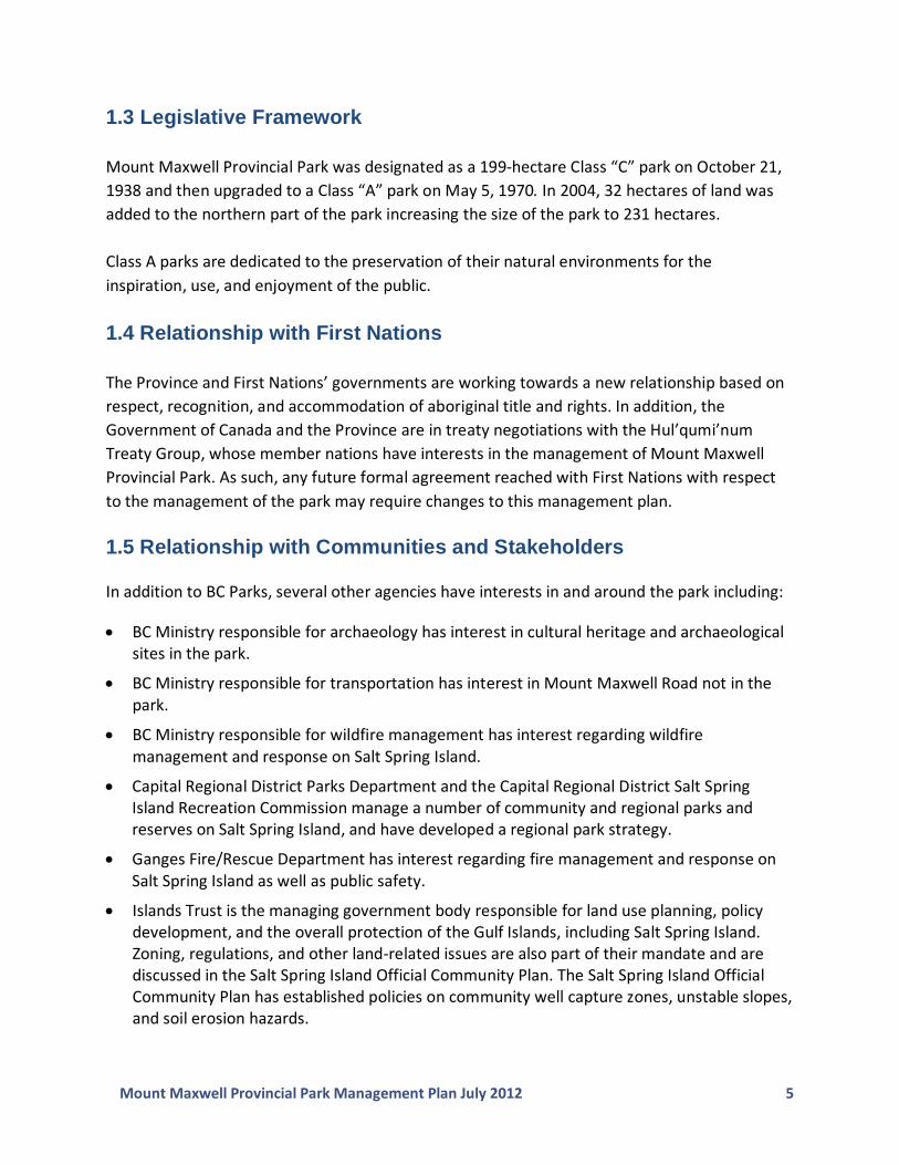
The park is one of a group of provincial parks, provincial ecological reserves, regional parks, and
private protected areas on Salt Spring Island. These protected areas include Ruckle Provincial
Park, Mount Tuam Ecological Reserve, Mill Farm Regional Park Reserve, Burgoyne Bay
Provincial Park, Mount Maxwell Ecological Reserve, Manzanita Ridge Nature Reserve, Mount
Erskine Provincial Park, and Lower Mount Erskine Nature Reserve (Figure 2).
The park is adjacent and connected to Burgoyne Bay Provincial Park and Mount Maxwell
Ecological Reserve (Figure 3), and is a part of a contiguous protected area network that along
with Capital Regional District park reserve forms one of the largest blocks of protected areas in
the Gulf Islands. These protected areas protect and conserve over 1,400 hectares on south‐
western Salt Spring Island, including one of Canada's largest Garry oak meadows. These
protected areas have high conservation values as they contribute to the protection of the
under‐represented Coastal Douglas‐fir biogeoclimatic zone; old‐growth Douglas‐fir, several
species and ecosystems ‐at‐risk, including extensive Garry oak meadows.
Mount Maxwell Provincial Park Management Plan July 2012 3
Figure 2: Salt Spring Island Protected Areas Context Map (2010)
Legend
Provincial Park
Ecological Reserve
Gulf Island National Park Reserve
Community Park
Regional Park
Regional Facility
Island Trust Fund Reserve
North Salt Spring Water District
SSI Water Preservation Society
SSI Conservancy Manzanita Ridge
Crown Tenure
Federal Crown (Transport Canada)
First Nations Reserve
Crown Land
Mount Erskine
Provincial Park
Lower Mount Erskine Nature Reserve
Mount Maxwell Ecological Reserve
Mount Maxwell Provincial Park
Burgoyne Bay
Provincial Park
Mill Farm Regional Park Reserve
Map courtesy of the Islands Trust
Ruckle Provincial Park
Mount TuamEcological Reserve
Manzanita Ridge Nature Reserve

Mount Maxwell Provincial Park Management Plan July 2012 4
Figure 3: Mount Maxwell Provincial Park
LEGEND
Mount Maxwell Provincial Park
Burgoyne Bay Provincial Park
Mount Maxwell Ecological Reserve
Recommended Addition to Mount Maxwell Ecological Reserve (2012)
Mount Maxwell Provincial Park Management Plan July 2012 5
1.3 Legislative Framework
Mount Maxwell Provincial Park was designated as a 199‐hectare Class “C” park on October 21,
1938 and then upgraded to a Class “A” park on May 5, 1970. In 2004, 32 hectares of land was
added to the northern part of the park increasing the size of the park to 231 hectares.
Class A parks are dedicated to the preservation of their natural environments for the
inspiration, use, and enjoyment of the public.
1.4 Relationship with First Nations
The Province and First Nations’ governments are working towards a new relationship based on
respect, recognition, and accommodation of aboriginal title and rights. In addition, the
Government of Canada and the Province are in treaty negotiations with the Hul’qumi’num
Treaty Group, whose member nations have interests in the management of Mount Maxwell
Provincial Park. As such, any future formal agreement reached with First Nations with respect
to the management of the park may require changes to this management plan.
1.5 Relationship with Communities and Stakeholders In addition to BC Parks, several other agencies have interests in and around the park including:
BC Ministry responsible for archaeology has interest in cultural heritage and archaeological sites in the park.
BC Ministry responsible for transportation has interest in Mount Maxwell Road not in the park.
BC Ministry responsible for wildfire management has interest regarding wildfire management and response on Salt Spring Island.
Capital Regional District Parks Department and the Capital Regional District Salt Spring Island Recreation Commission manage a number of community and regional parks and reserves on Salt Spring Island, and have developed a regional park strategy.
Ganges Fire/Rescue Department has interest regarding fire management and response on Salt Spring Island as well as public safety.
Islands Trust is the managing government body responsible for land use planning, policy development, and the overall protection of the Gulf Islands, including Salt Spring Island. Zoning, regulations, and other land‐related issues are also part of their mandate and are discussed in the Salt Spring Island Official Community Plan. The Salt Spring Island Official Community Plan has established policies on community well capture zones, unstable slopes, and soil erosion hazards.
Mount Maxwell Provincial Park Management Plan July 2012 6
The Land Conservancy of BC has interest in the protection of sensitive ecosystems and cultural areas and holds a conservation covenant on 106 hectares of land adjacent to the Mount Maxwell Lake watershed.
The Nature Conservancy of Canada has interest in the protection of sensitive ecosystems, species and the conservation of cultural areas.
The Nature Trust of British Columbia owns 273.7 hectares of the adjacent Mount Maxwell Ecological Reserve and has a lease agreement with the Province. In December 2011 The Nature Trust of B.C., acquired the final 22.3 hectares of private land in Burgoyne Bay with funding support from the federal government through the Natural Area Conservation Program that was facilitated by Nature Conservancy of Canada. This 22.3‐hectare waterfront property has been leased to the Province and is recommended as an addition to Mount Maxwell Ecological Reserve.
Several other key stakeholder groups have an interest in the park including:
Friends of Saltspring Parks Society (FOSP) has interest in ensuring protection of natural values and the continuance of low‐impact recreational activities in the parks and protected areas on Salt Spring Island.
Garry Oak Meadow Preservation Society has interest in preserving Garry oaks and their ecosystems. The society organizes activities that help Garry oaks and their habitats, such as broom removal projects.
Garry Oak Ecosystems Recovery Team was established to coordinate efforts to protect and restore endangered Garry oak and associated ecosystems and the species at risk that inhabit them.
Private Land Owners have interest in any impacts to their properties from park visitors, forest fires, and park development.
Salt Spring Island Conservancy has interest in preserving natural habitats on Salt Spring Island and the surrounding waters. Its core functions are public education, conservation covenants, land acquisitions and helping landowners carry out good land stewardship.
Salt Spring Island Mountain Bikers Association, South Island Mountain Biking Society (SIMBS), and International Mountain Biking Association ‐ Canada (IMBA) has interest in mountain biking trails on Salt Spring Island.
Salt Spring Island Stream and Salmon Enhancement Society has interest in the protection of fish bearing streams, riparian areas and the removal of invasive species.
Salt Spring Island Trail Riders and the Back Country Horsemen of B.C. ‐ Salt Spring Island Chapter have interest in horseback riding trails on Salt Spring Island.
Salt Spring Island Water Preservation Society is dedicated to promoting the protection of the sources of drinking water on Salt Spring Island.
The Salt Spring Island Trail and Nature Club has interest in providing trails for walkers and hikers on Salt Spring Island, including trails in the park.

Mount Maxwell Provincial Park Management Plan July 2012 7
1.6 Adjacent Patterns of Land Use
Other provincial protected areas, watershed land, and private lands surround Mount Maxwell
Provincial Park (Figure 3). To the south, the park borders Burgoyne Bay Provincial Park; to the
west Mount Maxwell Ecological Reserve, and the western part of the north boundary is
adjacent to the North Salt Spring Island Water District land. The rest of the northern boundary
and the eastern boundary are adjacent to private lands including property off Seymour Heights
Road and Armand Way.
1.7 The Planning Process
This management plan was developed between the summer of 2006 and spring 2012. It was
developed concurrently with the management plans for the five other provincial protected
areas on Salt Spring Island: Burgoyne Bay, Mount Erskine, and Ruckle provincial parks, and
Mount Maxwell and Mount Tuam ecological reserves. Each provincial protected area on Salt
Spring Island has its own special features, values, and roles; however, they all share common
characteristics and management needs. A combined management planning process provided
BC Parks with the benefit of effectively understanding Salt Spring Island’s unique characteristics
and efficiently provided opportunities for public involvement in the management planning
process.
In the winter of 2007, a technical advisory committee was formed to assist BC Parks with the
Salt Spring Island Protected Areas Management Planning project. The technical advisory
committee included representatives from the Salt Spring Island Conservancy, The Nature
Conservancy of Canada, BC Parks, the Islands Trust, the Capital Regional District, The Land
Conservancy of British Columbia, The Nature Trust of British Columbia, the Friends of Saltspring
Parks Society, and the planning consultants working on the project. To assist BC Parks in
preparing the management planning documents, a series of technical advisory committee
meetings were held.
A series of meetings, focus group discussions, and field trips with partners, stakeholders, and
individuals expressing an interest in Salt Spring Island’s provincial parks and ecological reserves
and the BC Parks’ management planning process occurred during the summer and fall of 2007.
Open houses and public meetings were held on Salt Spring Island in July 2007 and January
2008. In addition, information on the protected areas was posted on the BC Parks website. The
information gathered from the public consultation was used in the development of the draft
management plans. Appendix I provides a summary of what the public identified as Mount
Maxwell Provincial Park’s key values, activities, and management issues.

Mount Maxwell Provincial Park Management Plan July 2012 8
In summer 2009, the draft Mount Maxwell Provincial Park Management Plan, along with the
five other Salt Spring Island protected area draft management plans, was posted on the BC
Parks website for public review and comment. In addition, public meetings took place on Salt
Spring Island in October 2009. These meetings included an open house and a public forum
where the public had the opportunity to discuss the draft management plans and provide
comments. The information from this stage of the public process was considered in the
development of the final management plans.
The park is within the traditional territory of the Chemainus First Nation, Cowichan Tribes,
Halalt First Nation, Lake Cowichan First Nation, Lyackson First Nation, and Penelakut First
Nation (all members of the Hul’qumi’num Treaty Group) and the Tsawwassen First Nation. BC
Parks invited all the First Nations to participate in the Salt Spring Island management planning
process.
Figure 4: Salt Spring Island Management Planning Project Open House

Mount Maxwell Provincial Park Management Plan July 2012 9
2.0 Values and Roles of the Park
2.1 Significance in the Parks and Protected Areas System
Mount Maxwell Provincial Park is significant to B.C.’s parks and protected areas system because:
it protects a series of coastal ecosystems, which have very low representation in the system;
it provides a critical contribution to the protection of eight red‐listed and two blue‐listed ecosystems and provides habitat for several ecosystems‐at‐risk and species‐at‐risk, including habitat and nesting sites for the red‐listed peregrine falcon and potential habitat for sharp‐tailed snake;
it protects some of the most extensive and significant cultural landscapes for First Nations which are of increasing interest for cultural research, landscape conservation, and ecosystem restoration and,
it protects public recreation values in a region where the majority of land is privately owned.
The group of provincial parks and protected areas on Salt Spring Island is important because as
a group they protect 17.2% of the provincially protected red‐listed Coastal Douglas‐fir moist
maritime biogeoclimatic subzone (CDFmm), protect twelve red‐listed ecosystems, and provide
habitat for several species‐at‐risk. In addition, they provide protection and interpretation of the
island’s cultural values, including First Nations and farming history; and the provincial parks
provide low‐impact recreational opportunities for Salt Spring Island residents and visitors.
2.2 Natural Heritage
The information in this section comes primarily from the Salt Spring Island Parks and Ecological Reserves – Terrestrial Ecosystem Mapping and Conservation Assessment completed by Madrone Environmental Services in 2007. Definitions for technical terms are summarized in the glossary in Section 6.0.
Ecosystem Representation
As a group, the provincial protected areas on Salt Spring Island, including Mount Maxwell
Provincial Park, play an important role in protecting significant representative ecosystems in
the Southern Gulf Island Ecosection. The provincial protected areas on Salt Spring Island protect
1,678 hectares of the Coastal Douglas‐fir moist maritime (CDFmm) biogeoclimatic subzone,
representing 17.2% of the total CDFmm protected provincially. In addition, they also protect
487 hectares of the Coastal Western Hemlock, very dry maritime subzone, eastern variant
(CWHxm1) representing 4.89% of the total CWHxm1 protected provincially (see Table 1).
Mount Maxwell Provincial Park Management Plan July 2012 10
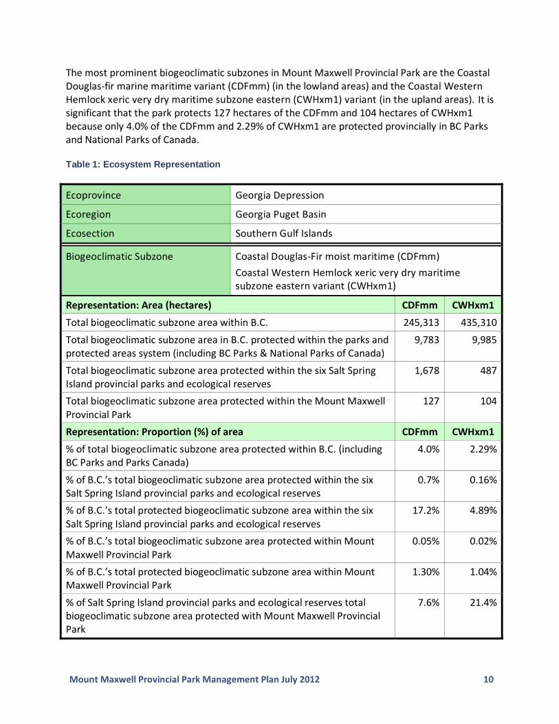
The most prominent biogeoclimatic subzones in Mount Maxwell Provincial Park are the Coastal Douglas‐fir marine maritime variant (CDFmm) (in the lowland areas) and the Coastal Western Hemlock xeric very dry maritime subzone eastern (CWHxm1) variant (in the upland areas). It is significant that the park protects 127 hectares of the CDFmm and 104 hectares of CWHxm1 because only 4.0% of the CDFmm and 2.29% of CWHxm1 are protected provincially in BC Parks and National Parks of Canada. Table 1: Ecosystem Representation
Ecoprovince Georgia Depression
Ecoregion Georgia Puget Basin
Ecosection Southern Gulf Islands
Biogeoclimatic Subzone Coastal Douglas‐Fir moist maritime (CDFmm)
Coastal Western Hemlock xeric very dry maritime subzone eastern variant (CWHxm1)
Representation: Area (hectares) CDFmm CWHxm1
Total biogeoclimatic subzone area within B.C. 245,313 435,310
Total biogeoclimatic subzone area in B.C. protected within the parks and protected areas system (including BC Parks & National Parks of Canada)
9,783 9,985
Total biogeoclimatic subzone area protected within the six Salt Spring Island provincial parks and ecological reserves
1,678 487
Total biogeoclimatic subzone area protected within the Mount Maxwell Provincial Park
127 104
Representation: Proportion (%) of area CDFmm CWHxm1
% of total biogeoclimatic subzone area protected within B.C. (including BC Parks and Parks Canada)
4.0% 2.29%
% of B.C.’s total biogeoclimatic subzone area protected within the six Salt Spring Island provincial parks and ecological reserves
0.7% 0.16%
% of B.C.’s total protected biogeoclimatic subzone area within the six Salt Spring Island provincial parks and ecological reserves
17.2% 4.89%
% of B.C.’s total biogeoclimatic subzone area protected within Mount Maxwell Provincial Park
0.05% 0.02%
% of B.C.’s total protected biogeoclimatic subzone area within Mount Maxwell Provincial Park
1.30% 1.04%
% of Salt Spring Island provincial parks and ecological reserves total biogeoclimatic subzone area protected with Mount Maxwell Provincial Park
7.6% 21.4%

Mount Maxwell Provincial Park Management Plan July 2012 11
Ecosystems
Mount Maxwell Provincial Park supports a series of ecosystems that have very restricted
distribution provincially. With a Mediterranean type climate and a long growing season, the
southern Gulf Islands and the south‐eastern part of Vancouver Island form a unique ecological
region in Canada. This ecological region supports many rare ecosystems, which are at risk
because of intense human pressure.
The southern facing slopes of Mount Maxwell contain one of Canada’s largest Garry oak
woodlands, one of the most threatened ecosystems in the country. A majority of stands
associated with the Garry oak on Mount Maxwell are located within the adjacent Mount
Maxwell Ecological Reserve. A small section of the park, where it borders Mount Maxwell
Ecological Reserve, contains the ecosystem complex Garry oak ‐ Brome/mixed grasses ecosystem.
This ecosystem type grows in a mosaic with the Fescue ‐ Camas community, and the sites are highly
likely to contain several species‐at‐risk.
The park’s ecosystems include five red‐listed ecosystems in the CDFmm biogeoclimatic subzone
and three red‐listed and two blue‐listed ecosystems in the CWHxm1 biogeoclimatic subzone.
The most predominant ecosystems found in the park are the dry Douglas‐fir – Western hemlock
– salal forest and the Douglas‐fir – Western hemlock – Oregon beaked moss and a small section
of Garry oak. The remainder of the area is comprised largely of younger second‐growth forests
aged from less than 40 years up to 80 years old. These forests are dominated by Douglas‐fir
with varying amounts of western hemlock and western red cedar towards the top of Mount
Maxwell, and scattered western yew, with an understory of salal, red huckleberry, oval‐leaved
blueberry, sword fern, and other species.
On cool aspects at lower elevations, red alder, bigleaf maple, and grand fir replace western
hemlock and western yew. On dry sites, particularly on the side slopes, arbutus is moderately
frequent. On lower warm‐aspect slopes and polygons with shallow soils, arbutus increases in
abundance, but typically, forms open‐canopied stands, with under‐stories that include Oregon
beaked moss, dicranum moss, common and trailing snowberry, ocean spray, Nootka rose,
western trumpet, and hairy honeysuckle. A few small areas with shallow soils, stony surface,
and hummocky to flat terrain support forested ecosystems with fluctuating water tables.
All ecosystems found in Mount Maxwell Provincial Park are shown on the map in Appendix II
along with a list of each polygon found in the park and its conservation information. Appendix
III provides a description of each ecosystem found in the Salt Spring Island Parks and Ecological
Reserves – Terrestrial Ecosystem Mapping and Conservation Assessment and its status
according to the British Columbian Conservation Data Centre (2009).

Mount Maxwell Provincial Park Management Plan July 2012 12
The park’s ecosystems have all been assigned a conservation ranking (see Appendix II). The
conservation ranking provides objective and quantitative rankings of the park’s ecosystems
with respect to:
their rarity;
the occurrence of rare elements;
their sensitivity to disturbance;
their resilience;
the level of fragmentation;
the age of the stand; and,
the presence of invasive species.
Mount Maxwell Provincial Park conservation rankings ranged widely reflecting the diversity of
habitats and ecosystem condition. Overall, the majority of the park ranks high to very high
conservation value due to their association with:
rare species;
CDFmm biogeoclimatic subzone;
older undisturbed age class forests;
sites supporting communities of Garry oak and Garry oak meadows;
the steep cliffs
the ecosystems supported by very shallow soils;
the ecosystems supported by herbaceous meadows; and,
the ecosystems supported by rock outcrops.
The younger forest ecosystems are rated as moderate. These young forested areas are examples of
ecosystems‐at‐risk and as they mature, their conservation ranking will increase since mature forests
are more ecologically diverse than younger forests.
Vegetation Mount Maxwell Provincial Park contains significant stands of Garry oak including the red‐listed
Garry oak / California brome and Douglas‐fir / Alaska onion grass ecosystems. In addition to the
Garry oak stands, almost all mature coniferous and mixed forested ecosystems found in the
park have potential to support red‐listed and blue‐listed plant species.
No detailed plant surveys have occurred within the park. However, Dr. Hans Roemer (1999)
and Dr. Adolf Ceska and Oluna Ceska (2003) conducted rare plant surveys in the adjacent
Mount Maxwell Ecological Reserve. It is likely that plant species found within the ecological
reserve also occur within the park, as the two areas contain the similar habitat types. Appendix
IV provides the list of species found in the ecological reserve 2003 plant survey.

Mount Maxwell Provincial Park Management Plan July 2012 13
Records of rare plant species occurring in the park include the red‐listed California hedge‐
parsley, scalepod Gray’s desert‐parsley or Lomatium and yellow montane violet. In addition,
the blue‐listed slimleaf onion is found on rock outcrops and there are two records of the blue‐
listed farewell‐to‐spring noted by Dr. Adolf Ceska and Oluna Ceska in 2003 located on the
southwestern boundary of Mount Maxwell Provincial Park and the ecological reserve. In 2009,
Hans Roemer discovered a ledge along the upper section of the Garry oak meadow in the park
where he identified small populations of the red‐listed fern‐leaved desert‐parsley and the
small‐flowered godetia.
While invasive species were not particularly prevalent in the forested ecosystems of Mount
Maxwell Provincial Park, meadow sites often contained low to moderate cover of Scotch broom
(1 ‐ 25%), and similar proportions of invasive grass species. Other invasive species that frequently
occur throughout Salt Spring Island, and are most likely dispersed in Mount Maxwell Provincial
Park by seed detaching from mud or crevices on vehicles and visitors on foot, include foxglove,
orange hawkweed, hairy cat's ear, common dandelion, sweet vernalgrass, hedgehog dogtail,
early hairgrass, lamb's quarters and spurge‐laurel.
Figure 5: Mount Maxwell Garry Oak Meadow
Mount Maxwell Provincial Park Management Plan July 2012 14
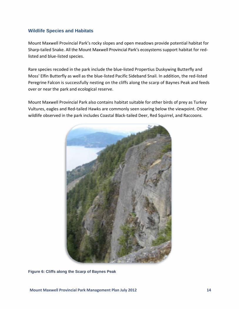
Wildlife Species and Habitats
Mount Maxwell Provincial Park’s rocky slopes and open meadows provide potential habitat for
Sharp‐tailed Snake. All the Mount Maxwell Provincial Park’s ecosystems support habitat for red‐
listed and blue‐listed species.
Rare species recoded in the park include the blue‐listed Propertius Duskywing Butterfly and
Moss' Elfin Butterfly as well as the blue‐listed Pacific Sideband Snail. In addition, the red‐listed
Peregrine Falcon is successfully nesting on the cliffs along the scarp of Baynes Peak and feeds
over or near the park and ecological reserve.
Mount Maxwell Provincial Park also contains habitat suitable for other birds of prey as Turkey
Vultures, eagles and Red‐tailed Hawks are commonly seen soaring below the viewpoint. Other
wildlife observed in the park includes Coastal Black‐tailed Deer, Red Squirrel, and Raccoons.
Figure 6: Cliffs along the Scarp of Baynes Peak
Mount Maxwell Provincial Park Management Plan July 2012 15
Level of Human Disturbance
Historically, fire was a common occurrence in this area and First Nations may have increased
fire frequency in the oak meadows to encourage propagation of food plants. Fire suppression in
oak meadows has led to increased frequency and size of oak and other trees, and a
corresponding decrease in herbaceous species, particularly ephemeral species, and species
dependent on fire for regeneration. These disturbance‐maintained oak meadows may be
succeeding to oak forests, and eventually may become Douglas‐fir – Garry oak‐forested
ecosystems.
In Douglas‐fir‐dominated sites, influences of past harvesting remain in the form of stumps,
woody debris, and modified tree species representation and stocking. The understory may be
atypical relative to other site characteristics, reflecting past disturbance to the soil and/or
seedbed. Some sites showed evidence of past clear‐cutting, while others were selectively
harvested and/or thinned.. After thinning, the canopy closes in rapidly as the remaining stems
grow quickly with the increased sunlight to their needles.
Historic homestead use of the area included permitting livestock to forage freely in the area,
resulting in dispersal of invasive herbaceous species, such as orchardgrass, foxtail barley,
bluegrass species, timothy, plantain, alfalfa, and many others. These were most common along the
roadside in open canopy areas, and in relatively accessible meadow sites. During the Madrone
2003 and 2007 site visits, evidence of use of the area by feral sheep was recorded.
Currently, the primary disturbance influencing the ecological conditions in Mount Maxwell
Provincial Park is the access road. It may act as a barrier to some species such as invertebrates and
reptiles that would be vulnerable to traffic‐caused mortality. The trails throughout the park are
too small to cause substantial disturbance. Around the parking lot and viewpoint, however,
trampling has impacted some plants and soils, and the occurrence of invasive species immediately
around the parking lot is more frequent.

Mount Maxwell Provincial Park Management Plan July 2012 16
2.3 Cultural Heritage First Nations
The park is within the traditional territory of the Chemainus First Nation, Cowichan Tribes, the
Halalt First Nation, the Lake Cowichan First Nation, the Lyackson First Nation, and the Penelakut
First Nation (all members of the Hul’qumi’num Treaty Group), and the Tsawwassen First Nation.
The west side of Salt Spring Island, from Burgoyne Bay to Vesuvius Bay, was part of the
traditional summer gathering area for Cowichan Tribes. There are no recorded archaeological
sites in the park.
The cultural information comes primarily from the Hwmet’utsum: A Coastal Salish Cultural
Landscape. An Archaeological Reconnaissance of the Mount Maxwell Ecological Reserve, Salt
Spring Island, British Columbia done by E. McLay in 2003. In the Coast Salish Hul’qumi’num
language, Mount Maxwell is known as Hwmet’utsum, ‘Bent Over Place’ – a mountain
commemorated in Coast Salish legend and creation narratives. Oral traditions of Hwmet’utsum
on Salt Spring Island report this mountain is an important wilderness spirit place used in
historical times by Coast Salish people during the winter spirit dance initiations, as well as a site
for defensive refuge. First Nation heritage site conservation at Mount Maxwell Provincial Park
and Mount Maxwell Ecological Reserve involves not only the protection and stewardship of
archaeological heritage sites determined by direct observation of physical evidence, but the
recognition of intangible, symbolic heritage sites identified through the study of oral tradition.
The Mount Maxwell area is part of a larger Coast Salish ‘cultural landscape’ – a broadly defined
heritage designation that integrates both these tangible and intangible elements of aboriginal
land use. Mount Maxwell represents a significant First Nation archaeological heritage site on
Salt Spring Island. Two inland rock shelter habitation sites have previously been recorded
among the colossal boulder fall found beneath the slopes of Mount Maxwell. This
archaeological reconnaissance study confirmed that the location of these two archaeological
sites were in the Mount Maxwell Ecological Reserve. This physical evidence indicates repeated,
short‐term settlement of these mountain rock shelters by past First Nation peoples over time
and further indicate physical evidence of a continuity of aboriginal settlement activity at
Hwmet’utsum into the historical, if not contemporary, era.

Mount Maxwell Provincial Park Management Plan July 2012 17
European Settlers
Europeans first settled the area in the mid‐1800s. Mount Maxwell was originally named Mount
Baynes around 1859 by Captain Richards and labelled as such on British Admiralty Chart 2840,
1861. Captain Richards named several of the mountains in the area while conducting surveys
for the British Admiralty along the west coast of Canada during 1858 – 1860. Local residents
began calling the mountain Mount Maxwell after the Maxwell family living in the Burgoyne
Valley, resulting in the May 2, 1911, decision to adopt the name Mount Maxwell, although
retaining the name Baynes Peak for the highest point on the mountain. 2.4 Recreation Tourism is a major industry on Salt Spring Island and there is a desire by the residents, local
government, and the Chamber of Commerce to offer a variety of recreational opportunities
to island visitors.
There is a long history of use at Mount Maxwell Provincial Park as it is a favourite destination
for local residents and visitors to Salt Spring Island and is one of the most popular destinations
for tourists in the southern Gulf Islands. According to BC Parks records, from 2007 to 2011, the
park receives an average of 33,500 visitors per year. Park facilities include a parking lot, viewing
area, benches, pit toilet, information shelter, signs, picnic tables, and several trails.
The park offers a number of walking/hiking opportunities with spectacular views.
Approximately six kilometres of maintained trails start at the parking lot and range from easy
strolls to more demanding hikes. Trails to the north and east travel through wooded areas of
old‐growth and second‐growth Douglas‐fir. Two trails lead from east of the parking lot; one
exits the park at Seymour Heights Road to the northeast and the other trail leads down a very
steep slope to the east, ultimately linking up with Armand Way. The trail to the west follows
along the ridge of Mount Maxwell and links up with the park entrance road approximately two
kilometres from the parking lot. Outstanding views exist from various points along the trails,
particularly at Baynes Peak, one of the highest points on Salt Spring Island. From here, visitors
can get a panoramic look at Fulford Valley, Vancouver Island, the surrounding Gulf Islands, and
the mainland of British Columbia.
Bouldering1, Horseback riding, cycling, mountain biking, , rock climbing, dirt bike riding and ATV
riding have occurred in the Mount Maxwell area, however, not all of these activities are
appropriate in the park (see Management Direction section).
1 Bouldering is a style of rock climbing undertaken without a rope and normally limited to very short climbs so that a fall will not result in serious injury. It is typically practiced on large boulders or artificial man‐made boulders. However, it may also be
practiced at the base of larger rock faces, or even on buildings or public architecture.

Mount Maxwell Provincial Park Management Plan July 2012 18
3.0 Management Direction
Management direction for Mount Maxwell Provincial Park is guided by the park’s status as a Class A park.
3.1 Vision
Mount Maxwell Provincial Park conserves and protects the dry Coastal Douglas‐fir biogeoclimatic zone, its ecosystems including the Garry oak meadow ecosystem, species‐at‐risk, and the steep rocky cliffs of Baynes Peak. It preserves regionally significant First Nation’s cultural values as this area is of spiritual significance connected to the creation story of the Hul’qumi’num peoples. In addition, it offers a variety of day use recreational activities; including hiking, nature appreciation, picnicking, photography, scenic views, and wildlife viewing.
Figure 7: View of Fulford Valley from Baynes Peak

Mount Maxwell Provincial Park Management Plan July 2012 19
3.2 Management Objectives, Issues, and Strategies
Table 2 outlines the management objectives, issues, and strategies to address them. Table 2: Management Objectives, Issues, and Strategies
Objectives Issues Strategies
CONSERVE AND PROTECT NATURAL ECOLOGICAL VALUES
To maintain the natural diversity of park ecosystems and protect the park’s natural values
Unrecorded species‐at‐risk are likely found in the park but there is a lack of information about the presence and location of these species.
Lack of knowledge of the health of the Garry oak trees and meadows.
Encourage authorized local groups to participate in research and vegetation management initiatives.
Implement, where feasible, the Garry Oak Ecosystems Recovery Teams’ Goals and Strategies (Appendix V);
Initiate research on Garry oak ecosystems and species‐at‐risk.
Work with the appropriate provincial government agency, Pacific Forestry Centre, Garry Oak Ecosystem Recovery Team, and others to determine the health of the Garry oak trees and to monitor the stand for harmful insects.
Sensitive ecosystems and species‐at‐risk are threatened by the introduction and impacts of invasive species including plants, feral animals, and an unnaturally high population of deer.
Collaborate with Invasive Species Council of BC, other agencies, stakeholders, and the public on the reduction and/or eradication of invasive plants and feral animals.
Feral animals (e.g. sheep) are causing impacts to the native plant species. Conduct control and/or removal of feral animals as resources permit.
Assess and monitor the impacts of deer on sensitive ecosystems and species‐at‐risk.
Garry oak ecosystems and associated species‐at‐risk are at risk from succession and long‐term fire suppression.
There is a threat of a severe forest fire from unnatural forest fuel loads in the park and adjacent properties.
Develop a fuel management plan that defines long‐term fuel management objectives and actions.
Assess potential for controlled burns or mechanical thinning to maintain Garry oak meadow ecosystem.
Update fire management and emergency response plans to recommend minimum levels of heavy equipment and retardant use.
Nesting bird habitats are at risk from impacts of rock climbing, hand gliding, and paragliding.
Do not allow rock‐climbing, paragliding, and hand gliding to ensure protection of nesting birds and safety of visitor.
Allow bouldering in a designated area. Some types of recreational use such as unauthorized trail building, camping, mountain biking, and motorized vehicle use (ATVs and dirt bikes) are negatively impacting the park’s sensitive ecosystems.
Do not allow dirt bike and ATV riding. Do not allow horseback riding. Do not allow mountain biking or cycling except on Mount
Maxwell Park Road.
Monitor recreational use including unauthorized trail building, mountain biking and motorized vehicle use (ATVs and dirt bikes) and enforce as required.
Monitor recreational impacts on natural values.
Increase barriers and, where feasible, direct trails away from sensitive habitats.
Reptile and invertebrate populations are at risk from Mount Maxwell Road traffic.
Monitor reptile and invertebrate mortality due to Mount Maxwell Road traffic.

Mount Maxwell Provincial Park Management Plan July 2012 20
Objectives Issues Strategies
CLIMATE CHANGE To gain a better understanding of the effects of climate change on the park’s natural values.
Species‐at‐risk and ecosystems‐at‐risk may be negatively impacted by climate change related variations to precipitation and temperature.
Encourage ongoing research on native plants and ecosystems to get a better understanding of the effects of climate change on these values.
CONSERVE, PROTECT, AND RESPECT CULTURAL HERITAGE VALUESTo conserve, protect, and respect cultural values and maintain First Nations social, ceremonial, and cultural uses.
Limited knowledge of the park’s cultural values, including archaeological sites and First Nations’ cultural uses, makes it difficult to protect these values.
Continue building relationships with First Nations to assist in theprotection of archaeological sites and their cultural use of the park.
Ensure management direction is developed for any new archaeological sites or cultural values that are identified.
RECREATION To provide for safe and low‐impact recreational activities
The location of trails and lack of boundary identification pose a threat to the adjacent Mount Maxwell Ecological Reserve from increased recreational use.
The location of trails and the condition of some trails is reducing the quality of the visitor experience and negatively affecting the park’s values (e.g., trail braiding and erosion).
In consideration of the steep and rocky terrain, the lack of public safety information along trails and at viewpoints may pose a risk to park visitors.
Erect additional signage at the boundary between the park and the ecological reserve.
Close the braided portions of viewpoint trail and rehabilitate with native vegetation.
Increase accessibility to the viewpoint for mobility impaired visitors.
Monitor use on existing trails (e.g., install trail counters).
Construct a small loop trail connecting the viewpoints to the parking area.
Provide interpretation and informational signage to deliver park messages, and provide other information to enhance the visitor experience.
Evaluate options for fencing the viewpoint area that are less intrusive.
Do not allow open fires, camping, and accommodation buildings/huts in the park.
RELATIONSHIP WITH STAKEHOLDERS AND NEIGHBOURSTo maintain a relationship with stakeholders and neighbours.
Collaboration with other agencies and groups for the management of the park and surrounding properties will improve the protection of the park’s values
Work collaboratively with other agencies and stakeholders to manage provincial and other protected lands in the area.

Mount Maxwell Provincial Park Management Plan July 2012 21
3.3 Zoning BC Parks uses zoning to assist in the management of protected areas. Zoning divides a park into
logical units to apply consistent management for conservation, recreation, and cultural values.
The zones reflect the intended land use, existing patterns of use, the degree of human use
desired, and the level of management and development required. Mount Maxwell Provincial
Park is zoned Intensive Recreation, Nature Recreation, and Special Feature (Figure 8).
Intensive Recreation Zone ‐The Intensive Recreation Zone follows the road corridor from the
park boundary to the main parking lot near the destination viewing area at the summit of
Mount Maxwell. It covers the majority of the recreational facilities, including picnic tables, a pit
toilet, trails, barrier fencing, benches, and interpretation and informational signage. This zone is
approximately 10 hectares, or 4% of the park.
Special Feature Zone ‐ The lower portion of the park below Mount Maxwell Road is zoned
Special Feature. This zone protects and preserves the cliffs along the scarp of Baynes Peak, the
remnant old‐growth Douglas‐fir forests, the Garry oak meadows that are contiguous to Mount
Maxwell Ecological Reserve, the other park areas ranked very high for conservation values, and
significant cultural features. A contiguous Special Feature Zone also exists in the adjacent
Burgoyne Bay Provincial Park, creating a buffer around Mount Maxwell Ecological Reserve
(Figure 9). Recreational activities will be restricted to a few established trails and a designated
area for bouldering. This zone is approximately 80 hectares, or 35% of the park.
Nature Recreation Zone ‐ The remainder of the park is zoned Nature Recreation to protect the
park values and to provide for limited recreational opportunities in a relatively undisturbed
natural environment. A large section of this zone contains areas with a high conservation
ranking and management direction for this zone will ensure these values are not adversely
affected. This zone is approximately 141 hectares, or 61% of the park.
The Appropriate Use Table (Table 3) lists existing and potential future uses in Mount Maxwell
Provincial Park. However, this is not an exhaustive list of uses that may be considered in this
protected area.
Mount Maxwell Provincial Park Management Plan July 2012 22
Figure 8: Mount Maxwell Provincial Park Zoning Map

Mount Maxwell Provincial Park Management Plan July 2012 23
Figure 9: Burgoyne Bay & Mount Maxwell Provincial Parks Zoning Map

Mount Maxwell Provincial Park Management Plan July 2012 24
Table 3 is provided to summarize the uses, which the management planning process has confirmed are appropriate, and those, which are not appropriate in Mount Maxwell Provincial Park. The table must be reviewed in conjunction with the other sections of the management plan. Table 3: Appropriate Use Table
Activities
Appropriate in Intensive Recreation
Zone
Appropriate in Nature Recreation
Zone
Appropriate in Special Feature Zone
Comments
Bouldering N N Y Designated area only
Camping N N N
Commercial Recreation Opportunities (facilities based)
N N N
Commercial Recreation Opportunities (no facilities)
Y Y Y BC Parks Authorization required
Exotic or Non Exotic Pack Animal Use
N N N
Filming (commercial) Y Y Y BC Parks Authorization required
Fire Management Y Y Y
Hang Gliding and Paragliding N N N
Horseback Riding N N N
Hunting or Guide Outfitting N N N
Invasive Species Control Y Y Y BC Parks Authorization required
Mechanized Off‐road Access non‐motorized (e.g., mountain biking)
N N N
Motorized Off‐road Access
(e.g., ATVs or motorcycles) N N N
On‐Road Cycling & Mountain Biking
Y N N Mount Maxwell Road only
Rock Climbing N N N
Scientific Research
(manipulative activities) Y Y Y BC Parks Authorization required
Scientific Research
(specimen collection) Y Y Y BC Parks Authorization required

Mount Maxwell Provincial Park Management Plan July 2012 25
Facilities
Appropriate in Intensive Recreation
Zone
Appropriate in Nature Recreation
Zone
Appropriate in Special Feature Zone
Comments
Administrative Buildings & Compounds
N N N
Campgrounds N N N
Picnic Areas Y Y N
Communication Sites N N N
Fixed Roof Accommodation N N N
Interpretation & Information Structures
Y Y Y
Roads and Parking Lots Y N N
Utility Corridors (power/transmission lines and other rights‐of‐way)
N N N
Water Control Structures N N N
Legend
N Not an appropriate use in this zone
It has been confirmed during the management planning process that this use is not appropriate in this zone.
This may be an existing use, which the management planning process has determined is no longer an appropriate use in this zone. The management plan details strategies for addressing this inappropriate use (e.g., phasing out, closing).
Y May be an appropriate use in this zone
This indicates that some degree or scale of this use may be appropriate.
For existing uses, the management plan will provide guidance on the appropriate level or scale of this use (e.g., direction to reduce, restrict or increase the current level of this activity) and may address specific restrictions or enhancements (e.g., capacity, appropriate sites, designated trails, purposes, party size, time of year, etc.).
For new or expanded uses, this does not constitute approval. This indicates that the use may be considered for further evaluation and possible approval (e.g., park use permit adjudication, completion of a review as part of the BC Parks’ Impact Assessment Process). In some cases, the appropriateness may not be confirmed until further assessments are completed.
Definition of BC Parks’ authorizations
Park Use Permit
Contract Volunteer Agreement
Stewardship Agreement

Mount Maxwell Provincial Park Management Plan July 2012 26
4.0 Plan Implementation
4.1 Policy Context
In addition to any protected area specific policies highlighted in the management plan, there
are numerous other provincial/regional policies and guidelines that will be considered during
management plan implementation. This includes items such as BC Parks’ policies on
conservation, permitting, and impact assessment processes.
4.2 Implementation
The management of Mount Maxwell Provincial Park will conform to the directions set forth in
this management plan. The implementation of the outlined management strategies is subject
to the availability of resources. As capacity allows, BC Parks will facilitate discussions with First
Nations and stakeholders to identify and determine how to implement management strategies.
Trail repair, monitoring of recreational use, and development and installation of signage, will
require close cooperation and involvement with the community, First Nations, partner groups,
and stakeholders to ensure that the park is well managed, and the park’s values are maintained
and protected.
BC Parks will continue to coordinate the management of Mount Maxwell Provincial Park with
The Land Conservancy of B.C., The Nature Trust of B.C., the Salt Spring Island Conservancy, The
Nature Conservancy of Canada, Islands Trust, the Capital Regional District, First Nations and
other stakeholders.
4.3 Adaptive Management
In order to ensure the management of Mount Maxwell Provincial Park remains relevant and
effective, an adaptive management approach will be used. Adaptive management involves a
five‐step process of planning, action, monitoring, evaluation, and revision of the management
plan to reflect lessons learned, changing circumstances, and/or objectives achieved. Adaptive
management is flexible, collaborative, and responsive to public input.
The management plan will be reviewed as required by the BC Parks. A review of the
management plan should generally be triggered by the complexities of the management issues
in the protected area and/or a significant change in circumstances (e.g., a natural disaster,
major environmental change or discovery of a major new archaeological site), and not by a
specific time period.

Mount Maxwell Provincial Park Management Plan July 2012 27
A management plan review looks for any necessary updates to the management plan that: are
required to keep management direction current and relevant; correct the intent of a policy
statement; address some error or omission; and/or, address a new proposal. Any updates or
changes to the content of the management plan will be addressed through a formal
management plan amendment process. The amendment process will include an opportunity for
public input.
Figure 10: Mount Maxwell Provincial Park Viewpoint

Mount Maxwell Provincial Park Management Plan July 2012 28
5.0 References
British Columbia Conservation Data Centre (BC CDC). 2009. Retrieved April 2009, from http://www.env.gov.bc.ca/cdc/. Madrone Environmental Services Ltd. 2003. Mount Maxwell Terrestrial Ecosystem Mapping and
Ecological Assesement. Unpublished contract report to BC Ministry of Water, Land and Air Protection, Environemental Stewardship Division, Vancouver Island Region, Nanaimo, BC.
Madrone Environmental Services Ltd. 2007. Salt Spring Island Parks and Ecological Reservers –
Terrestrial Ecosystem Mapping and Conservation Assessment. Unpublished contract report to BC Ministry of Environment, Environemental Stewardship Division, Vancouver Island Region, Nanaimo, BC. pp. 63 – 66.
McLay, E. 2003. Hwmet’utsum: A Coastal Salish Cultural Landscape. An Archaeological
Reconnaissance of the Mount Maxwell Ecological Reserve, Salt Spring Island, British Columbia. Hul’quimi’num Treaty Group.

Mount Maxwell Provincial Park Management Plan July 2012 29
6.0 Glossary
Blue List List of ecosystems, and indigenous species and subspecies of special concern (formerly vulnerable) in British Columbia.
COSEWIC Committee on the Status of Endangered Wildlife in Canada is a committee of experts that assesses and designates which wildlife species are in some danger of disappearing from Canada.
Ecological Community
The BC Conservation Data Centre and NatureServe use this term to include natural plant communities and plant associations and the full range of ecosystems that occur in British Columbia. These may represent ecosystems as small as a vernal pool, or as large as an entire river basin, an Ecoregion or a Biogeoclimatic Zone.
Ecoregion The Ecoregion Classification system is used to stratify British Columbia's terrestrial and marine ecosystem complexity into discrete geographical units at five levels. The two highest levels, Ecodomains and Ecodivisions, are very broad and place British Columbia globally. The three lowest levels, Ecoprovinces, Ecoregions, and Ecosections are progressively more detailed and narrow in scope and relate segments of the province to one another. They describe areas of similar climate, physiography, oceanography, hydrology, vegetation, and wildlife potential. Within each terrestrial ecoregion, climatic zones occur where specific soils, plant and animal communities and aquatic systems develop because of the interaction of climate with the land surface and surficial materials. These zones are defined within the Biogeoclimatic Ecosystem Classification system. For a complete explanation of this complex classification system, visit http://www.env.gov.bc.ca/ecology/ecoregions/index.html/
Ecosystem An ecosystem is a dynamic complex of plant, animal, and microorganism communities and the nonliving environment interacting as a functional unit. Ecosystems vary enormously in size: a temporary pond in a tree hollow and an ocean basin can both be ecosystems.
Ecosystem at Risk An extirpated, endangered, or threatened ecosystem or an ecosystem of special concern (formerly called vulnerable).
Endangered Facing imminent extirpation or extinction.
Extinct Species that no longer exist.
Extirpated A species or an ecosystem that no longer exist in the wild in an area but does occur elsewhere.
Forest An ecosystem group in BC Species and Ecosystems Explorer: ecosystems with greater than 10% tree cover including coniferous, deciduous, and mixed forests with more‐or‐less continuous canopies and trees not clumped.
Forest Structure Pole/Sapling Trees less than 40 years oldYoung Forest 40 ‐ 80 years old Mature Forest 80 ‐ 250 years old Old Growth Forest 250 years or older
Herbaceous An ecosystem group in BC Species and Ecosystems Explorer: ecosystems dominated by herbaceous vegetation. Shrubs generally account for less than 20% of vegetation cover, and tree cover is generally less than 10%.

Mount Maxwell Provincial Park Management Plan July 2012 30
Invasive Species Species those are not native to an area and whose introduction causes or is likely to cause economic or environmental harm or harm to human health.
Polygons In mapping, any multi‐sided area that shares the same characteristics; commonly used to map ecosystems.
Provincial Conservation Status Ranking
Conservation status rank for an element occurring or formerly occurring in B.C.
Status Definition
SX Presumed Extirpated—Species or community is believed to be extirpated from the province. Not located despite intensive searches of historical sites and other appropriate habitat, and virtually no likelihood that it will be rediscovered
SH Possibly Extirpated (Historical)—Species or community occurred historically in the nation or state/province, and there is some possibility that it may be rediscovered. Its presence may not have been verified in the past 20‐40 years. A species or community could become SH without such a 20‐40 year delay if the only known occurrences in a nation or state/province were destroyed or if it had been extensively and unsuccessfully looked for. The SH rank is reserved for species or communities for which some effort has been made to relocate occurrences, rather than simply using this status for all elements not known from verified extant occurrences.
S1 Critically Imperilled—Critically imperilled in the province because of extreme rarity (often 5 or fewer occurrences) or because of some factor(s) such as very steep declines making it especially vulnerable to extirpation from the province.
S2 Imperilled—Imperilled in the province because of rarity due to very restricted range, very few populations (often 20 or fewer), steep declines, or other factors making it very vulnerable to extirpation from the province.
S3 Vulnerable—Vulnerable in the province due to a restricted range, relatively few populations (often 80 or fewer), recent and widespread declines, or other factors making it vulnerable to extirpation.
S4 Apparently Secure—Uncommon but not rare; some cause for long‐term concern due to declines or other factors.
S5 Secure—Common, widespread, and abundant in the nation or state/province.
SNR Unranked—Nation or state/province conservation status not yet assessed
Provincial Lists List of elements considered to be either endangered or threatened (Red List), special concern (Blue List) or not at risk (Yellow List) in B.C.
Red List List of ecosystems, and indigenous species and subspecies that are extirpated, endangered, or threatened in B.C. Red‐listed species and sub‐species may be legally designated as, or may be considered candidates for legal designations as Extirpated, Endangered, or Threatened under the Wildlife Act (see http://www.env.gov.bc.ca/wld/faq.htm#2). Not all Red‐listed taxa will necessarily become formally designated. Placing taxa on these lists flags them as being at risk and requiring investigation.
Riparian An ecosystem group in BC Species and Ecosystems Explorer: ecosystems influenced by proximity to water bodies (rivers, streams, lakes) and processes associated with moving water.

Mount Maxwell Provincial Park Management Plan July 2012 31
Riparian Habitats Areas situated, or dwelling on the bank of a river or other body of water
Sparsely Vegetated An ecosystem group in BC Species and Ecosystems Explorer: ecosystems dominated by exposed rock or mineral soil, with a generally sparse vegetation layer (less than 10 ‐ 25% cover) dominated by lichens and xerophytes, or low herbaceous vegetation.
Species at Risk An extirpated, endangered, or threatened species or a species of special concern (formerly called vulnerable).
Special Concern Particularly sensitive to human activities or natural events but not endangered or threatened (as used by COSEWIC ‐ A wildlife species that may become a threatened or an endangered species because of a combination of biological characteristics and identified threats.) Special Concern was formerly referred to as Vulnerable.
Threatened Likely to become endangered if limiting factors are not reversed.
Vulnerable Particularly sensitive to human activities or natural events. (As used by NatureServe ‐Vulnerable due to a restricted range, relatively few populations (often 80 or fewer), recent and widespread declines, or other factors making it vulnerable to extirpation.)
Yellow List List of ecosystems and indigenous species that are not at risk in British Columbia.

Mount Maxwell Provincial Park Management Plan July 2012 32
Appendix I: Mount Maxwell Provincial Park Summary of Public Consultation
Through input provided at one public meeting, two public open houses, one stakeholder
meeting, and through mail, e‐mail, and the website, in 2007 and 2008, the public showed
overall support for the key values and management issues identified for this park.
The public input for the Mount Maxwell Provincial Park included the protection of natural and
cultural values balanced with recreational use. One of the key comments/requests was the
need for better quality information about the park and the adjacent ecological reserve
including signs providing information regarding the species‐at‐risk, identification and protection
measures of natural species especially the Garry Oak ecosystem, First Nations cultural values
and accurate trail maps. There was significant concern expressed over unsanctioned access and
activities in the park, particularly by ATVs, mountain bikes, dirt bikes, and horses. In addition
there were requests for a better trail joining Burgoyne Bay Provincial Park and Mount Maxwell
Provincial Park and possibly over to Maxwell Lake for hikers.
Key values, activities, and management issues identified through the management planning process included: Key Ecological Values:
Recreation – picnicking, hiking, walking;
Views and scenery;
Accessible and clean washroom facilities;
Trail and viewpoint accessibility for disabled visitors;
Natural ecosystems;
Natural and cultural history; and,
Accessibility. Appropriate Activities:
Sightseeing;
Nature appreciation;
Hiking/walking;
Picnicking; and,
Research and education.
Mount Maxwell Provincial Park Management Plan July 2012 33
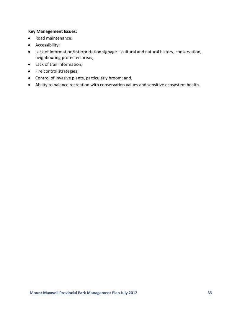
Key Management Issues:
Road maintenance;
Accessibility;
Lack of information/interpretation signage – cultural and natural history, conservation, neighbouring protected areas;
Lack of trail information;
Fire control strategies;
Control of invasive plants, particularly broom; and,
Ability to balance recreation with conservation values and sensitive ecosystem health.

Mount Maxwell Provincial Park Management Plan July 2012 34
Appendix II: Terrestrial Ecosystem Mapping
Legend

Mount Maxwell Provincial Park Management Plan July 2012 35
Appendix III: Terrestrial Ecosystem Mapping Polygon Codes and Status
Mount Maxwell Provincial Park ecosystems in italic bold red and blue
COASTAL DOUGLAS FIR MOIST MARITIME BIOGEOCLIMATIC SUBZONE
Polygon Code Ecosystem Rating Status
CS western redcedar / slough sedge S2S3 Blue
DA Douglas‐fir ‐ arbutus (lodgepole pine or shore pine) S2 Red
DG Douglas‐fir ‐ grand fir / dull Oregon‐grape S2 Red
DO Douglas‐fir / Alaska oniongrass S1 Red
DS Douglas‐fir / salal (Dry Maritime) S2 Red
FC Roemer's fescue – camas S1 Red
GO Garry oak / oceanspray S1 Red
HL hardhack – Labrador tea S3 Blue
QB Garry oak / California brome/mixed grasses S1 Red
RF western redcedar – grand fir/three‐leaved foamflower (Very Dry Maritime)
S2 Red
RK western redcedar ‐ Douglas‐fir / Oregon beaked‐moss S1 Red
RP western redcedar / Indian‐plum S1 Red
RS western redcedar / common snowberry SI Red
RV western redcedar / vanilla leaf SI Red
SC Cladina (reindeer lichen) – Wallace's selaginella S2 Red
COASTAL WESTERN HEMLOCK VERY DRY MARITIME BIOGEOCLIMATIC SUBZONE
Polygon Code Ecosystem Rating Status
AM arbutus / hairy manzanita S2 Red
DC Douglas‐fir ‐ lodgepole pine / Cladina (reindeer lichen) S2 Red
DF Douglas‐fir / sword fern S2 Red
DS Douglas‐fir ‐ western hemlock / salal (Dry Maritime) S2S3 Blue
HD western hemlock ‐ western redcedar / deer fern S2 Red
HL hardhack – Labrador tea S3 Blue
HK western hemlock ‐ Douglas‐fir / Oregon beaked‐moss S2 Red
RF western redcedar / three‐leaved foamflower (Very Dry Maritime) S2 Red
RS western redcedar / sword fern (Very Dry Maritime) S2S3 Blue
SC Cladina (reindeer lichen) – Wallace's selaginella S2 Red
OTHER features found in Mount Maxwell Provincial Park in bold italic
Polygon Code Feature Polygon Code Feature
BE Beach ES Exposed Soil
CF Cultivated Field GP Gravel Pit
CL Cliff RO Rocky Outcrop
CO Cultivated Orchard RW Rural Residential

Mount Maxwell Provincial Park Management Plan July 2012 36
Appendix IV: Mount Maxwell Provincial Park Plant Species List
List of Vascular Plants, Bryophytes, and Fungi of Mount Maxwell Ecological Reserve and Provincial Park by Dr. Adolf Ceska and Oluna Ceska April 10, 2003. (Updated with common names by Tania Tripp, October 2007) Alphabetical Scientific Name ‐ (BC CDC species‐at‐risk in italic bold red and blue)
Scientific Name English Name
Abies grandis grand fir
Acer macrophyllum bigleaf maple
Agoseris grandiflora large‐flowered agoseris
Agrostis capillaris colonial bentgrass
Aira praecox early hairgrass
Allium acuminatum Hooker's onion
Allium amplectens (blue‐listed) slimeleaf onion
Allium cernuum nodding onion
Anthoxanthum ordoratum vernal grass
Anthriscus caucalis burr chervil
Anus rubra red alder
Aphanes microcarpa small‐fruited parsley‐piert
Aquilegia formosa red columbine
Arbutus menziesii arbutus
Arctium minus common burdock
Athysanus pusillus common sandweed
Brodiaea coronaria harvest brodiaea
Bromus vulgaris common brome
Calandrinia ciliata desert rock purslane
Calypso bulbosa fairy‐slipper
Camassia quamash common camas
Cardamine hirsuta hairy bitter‐cress
Cardamine nuttallii Nuttall’s bitter‐cress
Cardamine occidentalis western bitter‐cress
Cardamine oligosperma Siberian bitter‐cress
Carex inops long‐stoloned sedge
Cerastium arvense field chickweed
Clarkia amoena (blue‐listed) farewell‐to‐spring
Claytonia exigua pale spring beauty
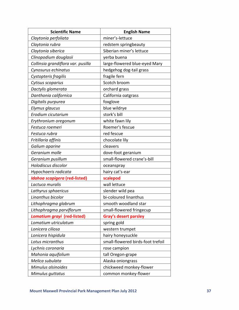
Mount Maxwell Provincial Park Management Plan July 2012 37
Scientific Name English Name
Claytonia perfoliata miner’s‐lettuce
Claytonia rubra redstem springbeauty
Claytonia siberica Siberian miner’s lettuce
Clinopodium douglasii yerba buena
Collinsia grandiflora var. pusilla large‐flowered blue‐eyed Mary
Cynosurus echinatus hedgehog dog‐tail grass
Cystopteris fragilis fragile fern
Cytisus scoparius Scotch broom
Dactylis glomerata orchard grass
Danthonia californica California oatgrass
Digitalis purpurea foxglove
Elymus glaucus blue wildrye
Erodium cicutarium stork’s bill
Erythronium oregonum white fawn lily
Festuca roemeri Roemer's fescue
Festuca rubra red fescue
Fritillaria affinis chocolate lily
Galium aparine cleavers
Geranium molle dove‐foot geranium
Geranium pusillum small‐flowered crane’s‐bill
Holodiscus discolor oceanspray
Hypochaeris radicata hairy cat's‐ear
Idahoa scapigera (red‐listed) scalepod
Lactuca muralis wall lettuce
Lathyrus sphaericus slender wild pea
Linanthus bicolor bi‐coloured linanthus
Lithophragma glabrum smooth woodland star
Lithophragma parviflorum small‐flowered fringecup
Lomatium grayi (red‐listed) Gray’s desert parsley
Lomatium utriculatum spring gold
Lonicera ciliosa western trumpet
Lonicera hispidula hairy honeysuckle
Lotus micranthus small‐flowered birds‐foot trefoil
Lychnis coronaria rose campion
Mahonia aquifolium tall Oregon‐grape
Melica subulata Alaska oniongrass
Mimulus alsinoides chickweed monkey‐flower
Mimulus guttatus common monkey‐flower

Mount Maxwell Provincial Park Management Plan July 2012 38
Scientific Name English Name
Mimulus sookensis Sooke monkey‐flower
Moehringia macrophylla big‐leaved sandwort
Montia dichotoma dwarf montia
Montia fontana blinks (water chickweed)
Montia howellii Howell’s montia
Montia parvifolia small‐leaved montia
Nemophila parviflora small‐flowered nemophila
Nemophila pedunculata meadow nemophila
Osmorhiza berteroi mountain sweet‐cicely
Pentagramma triangularis goldenback fern
Perideridia gairdneri yampah root
Plectritis congesta sea blush
Poa canbyi Canby bluegrass
Poa pratensis Kentucky bluegrass
Polypodium glycyrrhiza licorice fern
Polystichum munitum sword fern
Pseudotsuga menziesii Douglas‐fir (coast)
Quercus garryana Garry oak
Ranunculus occidentalis western buttercup
Rosa gymnocarpa baldhip rose
Rosa nutkana Nootka rose
Rumex acetosella sheep sorrel
Sanicula crassicaulis Pacific sanicle
Saxifraga integrifolia grassland saxifrage
Sedum spathulifolium broad‐leaved stonecrop
Selaginella wallacei Wallace's selaginella
Silene gallica small‐flowered catchfly
Stellaria media chickweed
Stellaria nitens shining starwort
Symphoricarpos albus common snowberry
Symphoricarpos hesperius trailing snowberry
Taraxacum officinale common dandelion
Taxus brevifolia western yew
Teesdalia nudicaulis shepherd’s cress
Thuja plicata western redcedar
Trifolium repens white clover
Trifolium variegatum white‐tipped clover
Trifolium wormskioldii springbank clover

Mount Maxwell Provincial Park Management Plan July 2012 39
Scientific Name English Name
Tsuga heterophylla western hemlock
Urtica dioica stinging nettle
Verbascum thapsus great mullein
Vicia lathyroides spring vetch
Viola praemorsa ssp. praemorsa yellow montain violet (red‐listed)
Yabea microcarpa (red‐listed) California hedge parsley
Alphabetical Common Name ‐ (BC CDC species‐at‐risk are in bold)
English Name Scientific Name
Alaska oniongrass Melica subulata
arbutus Arbutus menziesii
baldhip rose Rosa gymnocarpa
bi‐coloured linanthus Linanthus bicolor
bigleaf maple Acer macrophyllum
big‐leaved sandwort Moehringia macrophylla
blinks (water chickweed) Montia fontana
blue wildrye Elymus glaucus
broad‐leaved stonecrop Sedum spathulifolium
burr chervil Anthriscus caucalis
California hedge parsley (red‐listed) Yabea microcarpa
California oatgrass Danthonia californica
Canby bluegrass Poa canbyi
chickweed Stellaria media
chickweed monkey‐flower Mimulus alsinoides
chocolate lily Fritillaria affinis
cleavers Galium aparine
colonial bentgrass Agrostis capillaris
common brome Bromus vulgaris
common burdock Arctium minus
common camas Camassia quamash
common dandelion Taraxacum officinale
common monkey‐flower Mimulus guttatus
common sandweed Athysanus pusillus
Common snowberry Symphoricarpos albus
desert rock purslane Calandrinia ciliata
Douglas‐fir (coast) Pseudotsuga menziesii
dove‐foot geranium Geranium molle

Mount Maxwell Provincial Park Management Plan July 2012 40
English Name Scientific Name
dwarf montia Montia dichotoma
early hairgrass Aira praecox
fairy‐slipper Calypso bulbosa
farewell‐to‐spring (blue‐listed) Clarkia amoena.
field chickweed Cerastium arvense
foxglove Digitalis purpurea
fragile fern Cystopteris fragilis
Garry oak Quercus garryana
goldenback fern Pentagramma triangularis
grassland saxifrage Saxifraga integrifolia
grand fir Abies grandis
great mullein Verbascum thapsus
Gray’s desert parsley (red‐listed) Lomatium grayi
hairy bitter‐cress Cardamine hirsuta
hairy cat's‐ear Hypochaeris radicata
hairy honeysuckle Lonicera hispidula
harvest brodiaea Brodiaea coronaria
hedgehog dog‐tail grass Cynosurus echinatus
Hooker's onion Allium acuminatum
Howell’s montia Montia howellii
Kentucky bluegrass Poa pratensis
large‐flowered agoseris Agoseris grandiflora
large‐flowered blue‐eyed Mary Collinsia grandiflora var. pusilla
licorice fern Polypodium glycyrrhiza
long‐stoloned sedge Carex inops
meadow nemophila Nemophila pedunculata
miner’s‐lettuce Claytonia perfoliata
mountain sweet‐cicely Osmorhiza berteroi
nodding onion Allium cernuum
Nootka rose Rosa nutkana
Nuttall’s bitter‐cress Cardamine nuttallii
oceanspray Holodiscus discolor
orchard grass Dactylis glomerata
Pacific sanicle Sanicula crassicaulis
pale spring beauty Claytonia exigua
red alder Anus rubra
red columbine Aquilegia formosa
red fescue Festuca rubra

Mount Maxwell Provincial Park Management Plan July 2012 41
English Name Scientific Name
redsteam springbeauty Claytonia rubra
Roemer's fescue Festuca roemeri
rose campion Lychnis coronaria
scalepod (red‐listed) Idahoa scapigera
Scotch broom Cytisus scoparius
sea blush Plectritis congesta
sheep sorrel Rumex acetosella
shepherd’s cress Teesdalia nudicaulis
shining starwort Stellaria nitens
Siberian bitter‐cress Cardamine oligosperma
Siberian miner’s lettuce Claytonia siberica
slimeleaf onion (blue‐listed) Allium amplectens
slender wild pea Lathyrus sphaericus
small‐flowered birds‐foot trefoil Lotus micranthus
small‐flowered catchfly Silene gallica
small‐flowered crane’s‐bill Geranium pusillum
small‐flowered fringecup Lithophragma parviflorum
small‐flowered nemophila Nemophila parviflora
small‐fruited parsley‐piert Aphanes microcarpa
small‐leaved montia Montia parvifolia
smooth woodland star Lithophragma glabrum
Sooke monkey‐flower Mimulus sookensis
spring gold Lomatium utriculatum
spring vetch Vicia lathyroides
springbank clover Trifolium wormskioldii
stinging nettle Urtica dioica
stork’s bill Erodium cicutarium
sword fern Polystichum munitum
tall Oregon‐grape Mahonia aquifolium
trailing snowberry Symphoricarpos hesperius
vernal grass Anthoxanthum ordoratum
wall lettuce Lactuca muralis
Wallace's selaginella Selaginella wallacei
western bitter‐cress Cardamine occidentalis
western buttercup Ranunculus occidentalis
western hemlock Tsuga heterophylla
western redcedar Thuja plicata
western trumpet Lonicera ciliosa

Mount Maxwell Provincial Park Management Plan July 2012 42
English Name Scientific Name
western yew Taxus brevifolia
white clover Trifolium repens
white fawn lily Erythronium oregonum
white‐tipped clover Trifolium variegatum
yampah root Perideridia gairdneri
yellow montain violet (red‐listed) Viola praemorsa ssp. praemorsa
yerba buena Clinopodium douglasii
Bryophytes Fungi
Antitrichia curtipendula Bryum sp. Dicranum scoparium Eurhyncium oreganum Hedwigia stellata Homalothecium sp. Mnium sp. Philonotis fontana Polytrichum juniperinum Polytrichum piliferum Racomitrium elongatum Rhytidiadelphus triquetrus Riccia sorocarpa Tortula sp.
Cortinarius subgen. Telamonia Dacryomyces palmatus Nolanea hirtipes Psathyrella sp. Psilocybe inquilina Psilocybe montana

Mount Maxwell Provincial Park Management Plan July 2012 43
Appendix V: Garry Oak Ecosystem Recovery Team Goals & Strategies
The Garry Oak Ecosystem Recovery Team identifies five strategic approaches for recovery of Garry oak ecosystems (GOERT, 2008).
Goals Strategies
Complete the inventory, mapping and plant community classification
Develop standardized plant community classification, and determine and map the historical and current extend of Garry oak and associated ecosystems.
Protection of ecosystems and essential ecosystem characteristics
Secure high priority sites towards the establishment of a network of protected areas that represent the full diversity of Garry oak and associated ecosystems throughout their geographic range in Canada that are of sufficient size and appropriately situated to sustain essential ecosystems characteristics over the long term
Restoration and management of protected areas, landscape linkage, buffers, and the general landscape
Facilitate the establishment of landscape linkages and buffers and promote the restoration and management of protected areas, landscape linkages, buffers, and the general landscape to sustain essential ecosystem characteristics over the long term.
Protection and recovery of species at risk
Complete assessment and initial planning, initiate actions towards sustaining and expanding populations of species at risk in Garry oak, and associated ecosystems that are designated Endangered, Threatened, or are of management concerns.
Research Expand basic and applied research relevant to conserving and restoring Garry oak and associated ecosystems.
Outreach Ensure that conservation of Garry oak and associated ecosystems in incorporated into the planning and programs of governmental and non‐governmental agencies
Develop public awareness of, support for, and participation in recovery activities
Facilitate communication, coordination, and information sharing among recovery partners to ensure efficient, coordinated delivery of the recovery program.