m n r au a k knp c a t i o n a l park knp - … · cc ee nn t rr aa ll kk kk o o ruu mm nn att ii o...
TRANSCRIPT
The Central Karakorum National ParkAn Innovative
Approach
KNPCCENTRAL
KA
RAKU
RAM NATIONAL PARK
KNPCCENTRAL
KA
RAKU
RAM NATIONAL PARK
KNPCCENTRAL
KA
RAKU
RAM NATIONAL PARK
KNPCCENTRAL
KA
RAKU
RAM NATIONAL PARK
Central Karakorum National Park
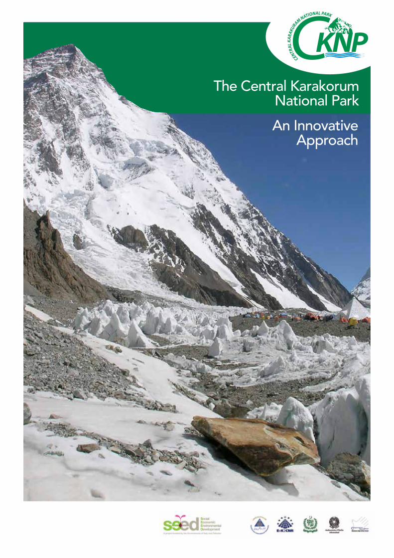
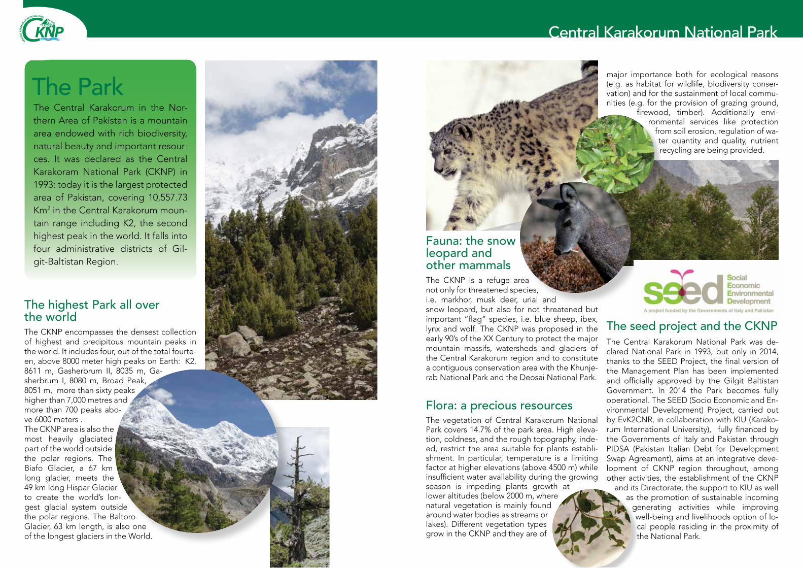
The ParkThe Central Karakorum in the Nor-thern Area of Pakistan is a mountain area endowed with rich biodiversity, natural beauty and important resour-ces. It was declared as the Central Karakoram National Park (CKNP) in 1993: today it is the largest protected area of Pakistan, covering 10,557.73 Km2 in the Central Karakorum moun-tain range including K2, the second highest peak in the world. It falls into four administrative districts of Gil-git-Baltistan Region.
The highest Park all over the worldThe CKNP encompasses the densest collection of highest and precipitous mountain peaks in the world. It includes four, out of the total fourte-en, above 8000 meter high peaks on Earth: K2, 8611 m, Gasherbrum II, 8035 m, Ga-sherbrum I, 8080 m, Broad Peak, 8051 m, more than sixty peaks higher than 7,000 metres and more than 700 peaks abo-ve 6000 meters .The CKNP area is also the most heavily glaciated part of the world outside the polar regions. The Biafo Glacier, a 67 km long glacier, meets the 49 km long Hispar Glacier to create the world’s lon-gest glacial system outside the polar regions. The Baltoro Glacier, 63 km length, is also one of the longest glaciers in the World.
Fauna: the snow leopard and other mammalsThe CKNP is a refuge area not only for threatened species, i.e. markhor, musk deer, urial and snow leopard, but also for not threatened but important “flag” species, i.e. blue sheep, ibex, lynx and wolf. The CKNP was proposed in the early 90’s of the XX Century to protect the major mountain massifs, watersheds and glaciers of the Central Karakorum region and to constitute a contiguous conservation area with the Khunje-rab National Park and the Deosai National Park.
The seed project and the CKNPThe Central Karakorum National Park was de-clared National Park in 1993, but only in 2014, thanks to the SEED Project, the final version of the Management Plan has been implemented and officially approved by the Gilgit Baltistan Government. In 2014 the Park becomes fully operational. The SEED (Socio Economic and En-vironmental Development) Project, carried out by EvK2CNR, in collaboration with KIU (Karako-rum International University), fully financed by the Governments of Italy and Pakistan through PIDSA (Pakistan Italian Debt for Development Swap Agreement), aims at an integrative deve-lopment of CKNP region throughout, among other activities, the establishment of the CKNP
and its Directorate, the support to KIU as well as the promotion of sustainable incoming
generating activities while improving well-being and livelihoods option of lo-cal people residing in the proximity of the National Park.
Flora: a precious resources The vegetation of Central Karakorum National Park covers 14.7% of the park area. High eleva-tion, coldness, and the rough topography, inde-ed, restrict the area suitable for plants establi-shment. In particular, temperature is a limiting factor at higher elevations (above 4500 m) while insufficient water availability during the growing season is impeding plants growth at lower altitudes (below 2000 m, where natural vegetation is mainly found around water bodies as streams or lakes). Different vegetation types grow in the CKNP and they are of
major importance both for ecological reasons (e.g. as habitat for wildlife, biodiversity conser-vation) and for the sustainment of local commu-nities (e.g. for the provision of grazing ground,
firewood, timber). Additionally envi-ronmental services like protection
from soil erosion, regulation of wa-ter quantity and quality, nutrient recycling are being provided.
KNPCCENTRAL
KA
RAKU
RAM NATIONAL PARK
KNPCCENTRAL
KA
RAKU
RAM NATIONAL PARK
Central Karakorum National Park
C e n t r a l K a r a k o r u m N a t i o n a l P a r kC e n t r a l K a r a k o r u m N a t i o n a l P a r k
0 10 20 305Kilometers
1:600.000
C K N P U s e R i g h t s M a pC K N P U s e R i g h t s M a p
Legend
CKNP Border - Buffer Zone
CKNP Core Zone
watershed
Use Rights (up 5000)Astak Shengus
Baghicha Tormik
Bagrote
Basha
Daghoni
Danyore Jutal Juglot
Ghulmat
Haramosh
Hushey
Lower Braldo
Miachar
Nagar
Shigar
Thalley
Upper Braldo
March 2014
ThagasDaghoni
YugoSermik
Kiris
Askoli
Shengus
Dasu
Dassu
BunjiJaglot
Jalalabad
NewJagot
SumayarKarimabad
Passu
Gumit
Skardu
Gilgit
Hushey
Khaplu
BBaa
ggrr oo tt ee
NN aa gg aarr
D Daagghhoonnii
SShh
iigg
aarr
LLoo
wwe e
r rB Br ra a
l lddoo
BB
aa ss hh aa
M i a c h a rM i a c h a r
GG hh uu ll mm aa tt
BBaagghh ii cchhaa
TToorrmmii kk
T h a l l e yT h a l l e y
HHuu
ss hh ee yy
H a r a m o s hH a r a m o s h
UU pp pp ee rrBB rr aa ll dd oo
ÐKKH
ÐKKH
ÐKKH
ÐKKH
Astakest
Bulc
Sinak
TaysotBarchi
Hispar
Hispar
Hopar
Jaglot
Juti
Marzigond
Kande
Talis
Hushey
AstakOvest
Hanuc
450000,000000
450000,000000
475000,000000
475000,000000
500000,000000
500000,000000
525000,000000
525000,000000
550000,000000
550000,000000
575000,000000
575000,000000
600000,000000
600000,000000
625000,000000
625000,000000
650000,000000
650000,000000
3900
000,0
0000
0
3900
000,0
0000
0
3925
000,0
0000
0
3925
000,0
0000
0
3950
000,0
0000
0
3950
000,0
0000
0
3975
000,0
0000
0
3975
000,0
0000
0
4000
000,0
0000
0
4000
000,0
0000
0
4025
000,0
0000
0
4025
000,0
0000
0
P a k i s t a nP a k i s t a n
C h i n aC h i n a
I n d i aI n d i a
A f g h a n i s t a nA f g h a n i s t a n
Internal division for each village
0 10 20 305Miles
KNPCCENTRAL
KA
RAKU
RAM NATIONAL PARK
KNPCCENTRAL
KA
RAKU
RAM NATIONAL PARK
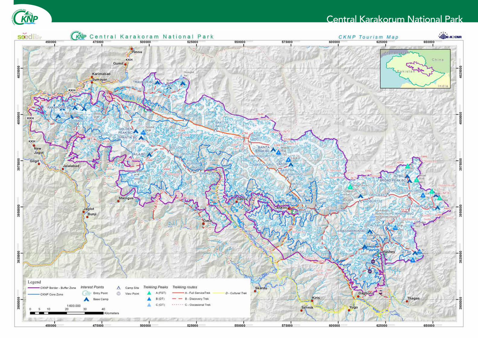
Park zones, valleys & populationIn order to facilitate the maintenance of Central Karakorum National Park ecological integrity while, at the same time, providing sustainable management opportunities for local communi-ties and visitors, a zoning system has been im-plemented.This consists of two main zones, the Buffer Zone and the Core Zone, for a total of 10,557.73 Km² :
CORE ZONE (7,606.83 Km2): It aims at preser-ving a unique ecosystem, representative of
CKNP Area. A higher degree of conserva-tion must be ensured.
BUFFER ZONE (2,950.9 Km2): It is an inter-mediate zone within the Park’s boundaries, where the existing community use rights
are permitted and developed in a sustai-nable way, to assure nature conservation and
the possibility of their use on long term for the local communities.
15 Valleys (Hushey, Thalley, Dhagoni, Shigar, Up-per Braldu (Shigar), Lower Braldu (Shigar), Ba-sha (Shigar), Baghicha/Tormik, Astak/Shengus, Haramosh, Bagrote, Ghulmatm, Miachar, Nagar Hunza, Danyore/Jutal/Juglot) - for a total of 150 villages and 19.688 households (populations 151.047) – detain the use rights of Park Surface. The use rights percentages are defined conside-ring the percentage of the area of jurisdiction of the aggregate valleys on the total of valleys’ use rights, on the total Buffer Zone surface.
Park management structureThe Central Karakorum National Park (CKNP) is currently managed by Project Director with a team of 50 members including project Director, Ecologist, Social Organizer, Admin & Finance officer, Range Forest Officers, Game Inspectors, Game Watchers and support staff, and Park Di-rectorate office is established at Skardu. Further the two sub field offices/ visitors registration cen-ters have been established at Askoli and Hushey having CKNP buildings while the one rented building is situated in Hisper where registration process of visitors is in progress.
Central Karakorum National ParkC e n t r a l K a r a k o r u m N a t i o n a l P a r kC e n t r a l K a r a k o r u m N a t i o n a l P a r k
0 10 20 305Kilometers
1:600.000
C K N P L a n d C o v e r M a pC K N P L a n d C o v e r M a p
Legend
CKNP Border - Buffer Zone
CKNP Core Zone
Glaciers
Land CoverIce and Snow
Bare soil
Scattered vegetation
Sparse Trees
Open Forest
Close Forest
Pasture
Agriculture
March 2014
ThagasDaghoni
YugoSermik
Kiris
AskoliShengus
Dasu
Dassu
BunjiJaglot
Jalalabad
NewJagot
SumayarKarimabad
Passu
Gumit
Skardu
Gilgit
Hushey
Khaplu
ÐKKH
ÐKKH
ÐKKH
ÐKKH
450000,000000
450000,000000
475000,000000
475000,000000
500000,000000
500000,000000
525000,000000
525000,000000
550000,000000
550000,000000
575000,000000
575000,000000
600000,000000
600000,000000
625000,000000
625000,000000
650000,000000
650000,000000
3900
000,0
0000
0
3900
000,0
0000
0
3925
000,0
0000
0
3925
000,0
0000
0
3950
000,0
0000
0
3950
000,0
0000
0
3975
000,0
0000
0
3975
000,0
0000
0
4000
000,0
0000
0
4000
000,0
0000
0
4025
000,0
0000
0
4025
000,0
0000
0
P a k i s t a nP a k i s t a n
C h i n aC h i n a
I n d i aI n d i a
A f g h a n i s t a nA f g h a n i s t a n
0 10 20 305 Miles
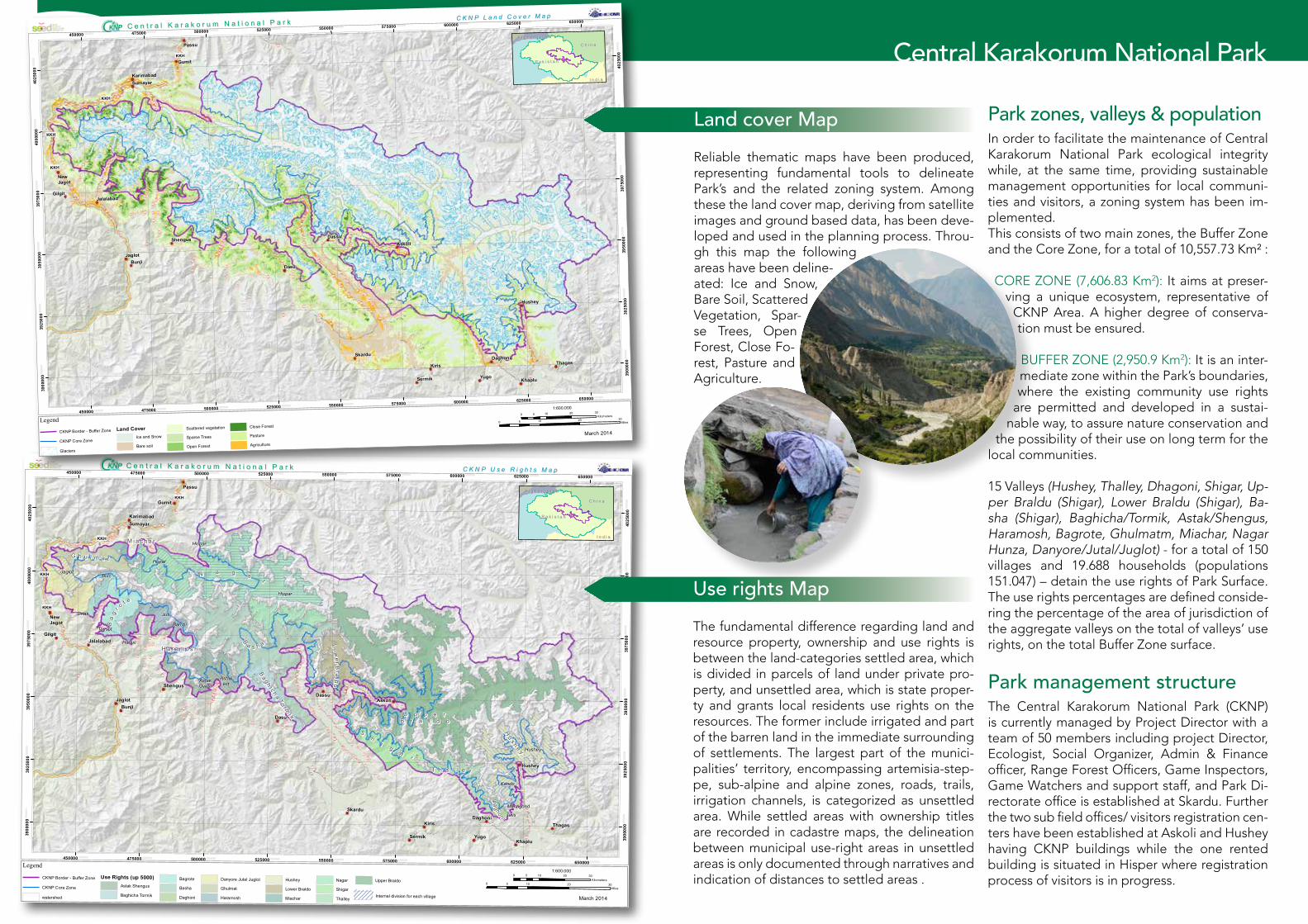
Land cover MapReliable thematic maps have been produced, representing fundamental tools to delineate Park’s and the related zoning system. Among these the land cover map, deriving from satellite images and ground based data, has been deve-loped and used in the planning process. Throu-gh this map the following areas have been deline-ated: Ice and Snow, Bare Soil, Scattered Vegetation, Spar-se Trees, Open Forest, Close Fo-rest, Pasture and Agriculture.
Use rights MapThe fundamental difference regarding land and resource property, ownership and use rights is between the land-categories settled area, which is divided in parcels of land under private pro-perty, and unsettled area, which is state proper-ty and grants local residents use rights on the resources. The former include irrigated and part of the barren land in the immediate surrounding of settlements. The largest part of the munici-palities’ territory, encompassing artemisia-step-pe, sub-alpine and alpine zones, roads, trails, irrigation channels, is categorized as unsettled area. While settled areas with ownership titles are recorded in cadastre maps, the delineation between municipal use-right areas in unsettled areas is only documented through narratives and indication of distances to settled areas .
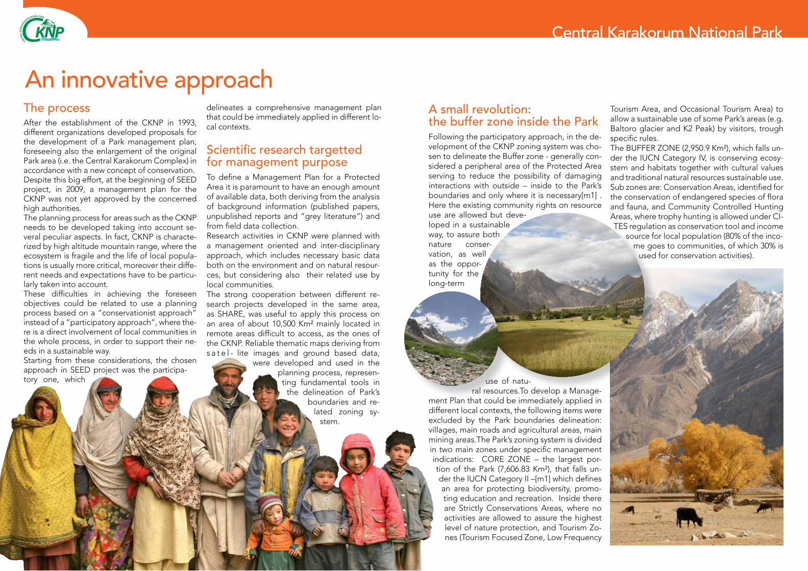
A small revolution: the buffer zone inside the ParkFollowing the participatory approach, in the de-velopment of the CKNP zoning system was cho-sen to delineate the Buffer zone - generally con-sidered a peripheral area of the Protected Area serving to reduce the possibility of damaging interactions with outside – inside to the Park’s boundaries and only where it is necessary[m1] . Here the existing community rights on resource use are allowed but deve-loped in a sustainable way, to assure both nature conser-vation, as well as the oppor-tunity for the long-term
use of natu-ral resources.To develop a Manage-
ment Plan that could be immediately applied in different local contexts, the following items were excluded by the Park boundaries delineation: villages, main roads and agricultural areas, main mining areas.The Park’s zoning system is divided in two main zones under specific management indications: CORE ZONE – the largest por-tion of the Park (7,606.83 Km²), that falls un-der the IUCN Category II –[m1] which defines an area for protecting biodiversity, promo-ting education and recreation. Inside there are Strictly Conservations Areas, where no activities are allowed to assure the highest level of nature protection, and Tourism Zo-nes (Tourism Focused Zone, Low Frequency
KNPCCENTRAL
KA
RAKU
RAM NATIONAL PARK
KNPCCENTRAL
KA
RAKU
RAM NATIONAL PARK
Central Karakorum National Park
Tourism Area, and Occasional Tourism Area) to allow a sustainable use of some Park’s areas (e.g. Baltoro glacier and K2 Peak) by visitors, trough specific rules.The BUFFER ZONE (2,950.9 Km²), which falls un-der the IUCN Category IV, is conserving ecosy-stem and habitats together with cultural values and traditional natural resources sustainable use. Sub zones are: Conservation Areas, identified for the conservation of endangered species of flora and fauna, and Community Controlled Hunting Areas, where trophy hunting is allowed under CI-TES regulation as conservation tool and income
source for local population (80% of the inco-me goes to communities, of which 30% is
used for conservation activities).
An innovative approachThe process After the establishment of the CKNP in 1993, different organizations developed proposals for the development of a Park management plan, foreseeing also the enlargement of the original Park area (i.e. the Central Karakorum Complex) in accordance with a new concept of conservation. Despite this big effort, at the beginning of SEED project, in 2009, a management plan for the CKNP was not yet approved by the concerned high authorities.The planning process for areas such as the CKNP needs to be developed taking into account se-veral peculiar aspects. In fact, CKNP is characte-rized by high altitude mountain range, where the ecosystem is fragile and the life of local popula-tions is usually more critical, moreover their diffe-rent needs and expectations have to be particu-larly taken into account.These difficulties in achieving the foreseen objectives could be related to use a planning process based on a “conservationist approach” instead of a “participatory approach”, where the-re is a direct involvement of local communities in the whole process, in order to support their ne-eds in a sustainable way.Starting from these considerations, the chosen approach in SEED project was the participa-tory one, which
Scientific research targetted for management purposeTo define a Management Plan for a Protected Area it is paramount to have an enough amount of available data, both deriving from the analysis of background information (published papers, unpublished reports and “grey literature”) and from field data collection. Research activities in CKNP were planned with a management oriented and inter-disciplinary approach, which includes necessary basic data both on the environment and on natural resour-ces, but considering also their related use by local communities. The strong cooperation between different re-search projects developed in the same area, as SHARE, was useful to apply this process on an area of about 10,500 Km² mainly located in remote areas difficult to access, as the ones of the CKNP. Reliable thematic maps deriving from s a t e l - lite images and ground based data,
were developed and used in the planning process, represen-ting fundamental tools in
the delineation of Park’s boundaries and re-
lated zoning sy-stem.
delineates a comprehensive management plan that could be immediately applied in different lo-cal contexts.
KNPCCENTRAL
KA
RAKU
RAM NATIONAL PARK
KNPCCENTRAL
KA
RAKU
RAM NATIONAL PARK
Central Karakorum National Park
The operational plan and the sustainabilityAn important part of the approved Integration and Operational Document is the Operational Plan, structured in two complementary sections: the first one is functional to ensure structuring of the Park’s needs and activities, while the second one gives, trough the development of specific conservation and development plans for each of the 15 CKNP valleys, the sustainable use of the renewable resources inside the CKNP area
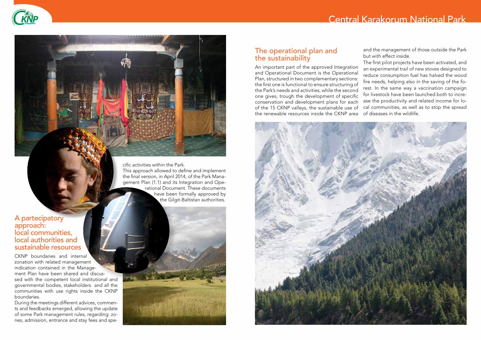
A partecipatory approach: local communities, local authorities and sustainable resourcesCKNP boundaries and internal zonation with related management indication contained in the Manage-ment Plan have been shared and discus-sed with the competent local institutional and governmental bodies, stakeholders and all the communities with use rights inside the CKNP boundaries. During the meetings different advices, commen-ts and feedbacks emerged, allowing the update of some Park management rules, regarding: zo-nes, admission, entrance and stay fees and spe-
cific activities within the Park. This approach allowed to define and implement the final version, in April 2014, of the Park Mana-gement Plan (1.1) and its Integration and Ope-
rational Document. These documents have been formally approved by
the Gilgit-Baltistan authorities.
and the management of those outside the Park but with effect inside. The first pilot projects have been activated, and an experimental trail of new stoves designed to reduce consumption fuel has halved the wood fire needs, helping also in the saving of the fo-rest. In the same way a vaccination campaign for livestock have been launched both to incre-ase the productivity and related income for lo-cal communities, as well as to stop the spread of diseases in the wildlife.
KNPCCENTRAL
KA
RAKU
RAM NATIONAL PARK
KNPCCENTRAL
KA
RAKU
RAM NATIONAL PARK
EvK2CNR is an autonomous, non-profit association, which pro-motes scientific and technological research in mountain areas. Particular emphasis is placed on work in the Hindu Kush - Ka-
rakorum - Himalaya region. EvK2CNR is best represented by its Pyramid Laboratory located at 5,050 meters a.s.l. in Nepal at the base of Mount Everest.Today EvK2CNR’s work is mainly organized via broad-scale integrated multi-disciplinary programs aimed at helping resolve urgent environ-mental and development issues
EvK2CNR Associazione riconosciuta, Via San Bernardino 145, - 24126 Bergamo. Tel. 0039 – 035.3230511 [email protected] - www.evk2cnr.orgEvK2CNR Pakistan, Islamabad Officie - Tel 0092-51-2655835 - Fax 0092-51-2655836
Established in 2002 by a charter from the federal government, the Karakoram International University (KIU) has a main cam-
pus located in Gilgit that hosts 2300 students, nearly 100 facul-ty members and over a hundred administrative staff in sixteen academic departments and four disciplines.
Karakoram International University, University Road, Gilgit (15100) [email protected] - www.kiu.edu.pk
Directorate of Central Karakoram National ParkSadpara Road Skardu, Gilgit-Baltistan, PakistanTel: +92-5815-921018Email: [email protected]
Gilgit
Skardu
Khaplu
Karimabad
Shigar
Askole
Hushe
Central Karakorum National Park