marentette-mangin drainage report (1may2020draft)...in 2010, the province of ontario commissioned...
TRANSCRIPT

1
May 1,2020 Project No.: 16-020
The Corporation of the City of Windsor 350 City Hall Square West, 3rd Floor Windsor, ON N9A 6S1
Re: Drainage Report for the
Marentette-Mangin Drain City of Windsor – County of Essex
Dear Mayor and Council:
In accordance with Council Resolution #511/2016 dated August 22, 2016, and City of Windsor (hereafter City) administration’s subsequent instructions, we have completed our examinations into the improvement of the Marentette-Mangin Drain. The following report addresses the outcome of our examinations, our findings, and our recommendations for improvements to the subject drain.
1.0 Introduction
In 2010, the Province of Ontario commissioned the Windsor Essex Mobility Group (WEMG) to construct the Rt. Hon. Herb Gray Parkway (hereafter Parkway). Its construction necessitated substantial modifications or impacts to several municipal drains within the City, Town of LaSalle and Town of Tecumseh, including the Marentette-Mangin Drain. The Marentette-Mangin Drain provides drainage for approximately 50 hectares of lands in the City. The drain commences from its upstream limit near Lamont Street and flows southerly to its outlet into the Grand Marais Drain, approximately 550 m southwest of the Parkway corridor.
An approximate 190m upstream segment of drain was eliminated in conjunction with construction of the Parkway; the eliminated portion had originally lied within the boundary of the Parkway lands. Construction of the Parkway altered the tributary area of the Marentette-Mangin Drain, land-use characteristics within the drain boundary, as well as the physical state of the drain proper.

2
In 2013, following substantial completion of the Parkway construction, the Ministry of Transportation of Ontario (MTO) filed petitions with the City for Council to appoint an engineer to examine and report on the municipal drains that provide a drainage outlet for the Parkway. City Council resolved to authorize Landmark Engineers Inc. to prepare a report on the Marentette-Mangin Drain under Section 4 of the Drainage Act.
2.0 Background Information
2.1 Watershed Description
The Marentette-Mangin Drain is an intermittent flowing watercourse due to its limited watershed size and watershed characteristics. Based on Ontario Ministry of Agriculture, Food and Rural Affairs (OMAFRA) mapping, it is classified as a Class F drain. The drain and watershed have been substantially altered over the past few decades by way of urbanization of a portion of the tributary lands in the late 1980s and construction of the Parkway in 2013. The watershed currently exists as a mixture of residential lands, open wooded areas and portions of the Parkway corridor. Some of the undeveloped areas that remain are designated for future urban development. However, some of the open lands are designated as environmentally significant and may remain undeveloped into the future.
The topography of the watershed is relatively flat, having an overall watershed slope in the order of 0.05%. Surface soils predominantly consist of Berrein Sand over clayey, impermeable soils.
2.2 Drain History
The City has long regarded the Marentette-Mangin Drain as a municipal drain established under the Drainage Act. Aerial mapping maintained by the Essex Region Conservation Authority also identifies this drainage feature as a municipal drain. However, a search of the City’s archives did not produce any historic reports or bylaws to confirm when the drain was established, or when the drain was last maintained.
Given the foregoing, it was concluded that a report prepared under Section 4 would be most appropriate to properly address and accommodate the drainage issues, and to ensure that appropriate outlet for all of the public and private lands within the affected watershed was maintained – both initially following construction of the Parkway, and into the future.
Therefore, in order to protect the drainage rights of the drainage community at-large, the City required that the Ministry of Transportation petition for the repair and improvement of the Marentette-Mangin Drain under the provisions of the Drainage Act. The City appointed Landmark Engineers to examine and report on the drain.

3
2.3 Construction of Rt. Hon. Herb Gray Parkway
As noted previously, construction of the Parkway resulted in modification of the upstream 190 m long segment of the drain as well as the drainage area boundary. Parkway construction also significantly changed the hydrologic characteristics of the lands that it occupies, some of which outlet to the Marentette-Mangin Drain and other municipal drains in the region. The Parkway Infrastructure Engineers (PIE) undertook an independent hydrologic modelling exercise to calculate peak flood flows generated by the Parkway, and more relevantly, the flows that would be outlet to the respective receiving watercourses. PIE documented their independent hydrologic analysis and findings in various stormwater management reports, which formed the basis for sizing of the parkway drainage infrastructure and modification of the affected municipal drains through the parkway corridor.
Prior to construction of the works that impacted the drains, reports were prepared pursuant to Section 77 of the Drainage Act by Tom H. Marentette, P.Eng. of Dillon Consulting. The report entitled “Drain Improvements to the Marentette-Mangin Drain as Part of the Windsor-Essex Parkway” dated April 12, 2013, addressed the impact of the Parkway drainage improvement on the subject drain.
The most relevant aspects of the aforementioned reports that were relied on for this report are summarized below.
2.3.1 Stormwater Management Report (SWM Report)
The flows that were calculated by the PIE were used to design the new Parkway drainage infrastructure including a stormwater management pond known as Pond#5, which discharges into the existing open-channel portion of the Drain. Modification of the watershed boundary and upstream portion of the drain by WEMG prompted the need for a new report under the provisions of the Drainage Act to ensure a secure outlet for Pond#5 and to ensure that the risk of flooding of downstream lands was not worsened. The following paragraphs summarize the information provided in the SWM report that we consider most relevant to this undertaking. This information was relied on for the purpose of completing our assessment of the drain.
The detailed SWM plan for the Parkway includes five pumping stations and seven SWM ponds to service all new sections of Highway 401 and the majority of Highway 3.
Pond 5 is the only stormwater management pond associated with the Marentette-Mangin Drain and will receive flows from PS-1. Pond 5 has been designed to provide water quality and quantity treatment in accordance with the Ontario Ministry of the Environment (MOE) Stormwater Management Planning and Design Manual (2003) to meet Ministry and project specific design criteria
Stormwater Conveyance – The roadway drainage system for Highway 401 and roadways below grade will be constructed to convey the 100-year design event. The drainage system will be designed to prevent flooding of the travelled Highway 401 lanes. For sections of Highway 3
4
that are at-grade, the minor system will be designed to convey the 10-year design storm flow and the major system will be design to convey the 100-year design storm flow.
Stormwater Quantity Control – Post development peak flows will be controlled to pre-development levels for a range of design events up to and including the 100-year event.
SWM Pond 5 operating characteristics are summarized in Table 9.4 of the SWM Report. The 24-hour duration results were summarized and presented in the table, since the 24-hour duration produced the most conservative storage requirements. The table presented the peak discharges/outflows from Pond 5 during the 5-year and 100-year events to be 0.29 and 0.45 m3/s respectively.
Works for the Marentette-Mangin Drain will be completed under a Letter of Opinion in accordance with Section 77(3) of the Drainage Act.
A copy of the main body of the SWM Report is provided for reference as Appendix A.
2.3.2 Report under Section 77 of the Drainage Act
The following summarize the information provided in the report prepared by PEI under the provisions of Section 77(3) of the Drainage Act that we consider most relevant to this undertaking.
The report concluded that if the work were carried out in accordance with the drawings and specifications, that the portion of the Marentette-Mangin Drain being improved can proceed without adversely affecting any person(s) and / or property.
The total contributing area to the sewer inlet near the Lambton St. Cul-de-sac is approximately 33 ha.
The report recommended that the drainage associated with the Marentette-Mangin Drain be constructed in accordance with the Windsor-Essex Parkway New Construction Sheets D500, D501, D502 and D800.
A copy of the entire report is provided for reference as Appendix B.
2.4 Basis of Hydrologic Modelling
From 1982 through 2013, the Water Survey of Canada (WSC) had maintained a stream gauge (Station No. 02GH004) that recorded water levels and flow rates on the Grand Marais Drain at a location immediately upstream of Huron Church Road. The flow data generated by the gauge had been used to calibrate numerous hydrologic models within the Grand Marais Drain watershed over the past 30 years, including the hydrologic models that formed the basis for the design of drainage elements within the Parkway project. This gauge was decommissioned and removed during the construction of the Parkway. A new gauge has since been installed by WSC slightly upstream of the old gauge.

5
Within the past 5 years, it was discovered that the flow rate portion of the historic gauge data was unreliable, due to an issue with its rating curve. Consequently, any hydrologic models that had been calibrated against the historic hydrographs may also be considered unreliable. A new hydrologic model developed by Landmark for the Grand Marais Drain was calibrated against the new gauge and then used to calculate design flows. The new model forecasted peak runoff rates that were 50 to 70% higher than the historic estimates.
Given the foregoing, we deemed it appropriate to undertake an independent hydrologic and hydraulic evaluation of the subject drain as part of this report, in order to confirm the drains capabilities to receive and safely convey flows to a sufficient outlet.
3.0 On-site Meeting
The on-site meeting required under Section 9 of the Drainage Act was held on 28 August 2018 at the Capri Pizza Recreation Complex at 2555 Pulford Street. A copy of the Notice of On-Site Meeting that was issued by the City Clerk is attached herein as Appendix C. All property owners that would potentially be impacted by the drainage improvement works were invited to attend the meeting.
The meeting opened by introducing the attendees and highlighting the purpose of the meeting. With the aid of a PowerPoint presentation, the purpose of the meeting was highlighted, some brief history status of the Marentette-Mangin Drain was provided, the Drainage Act process was explained and opportunities for input by interested members of the public were identified. Specific needs for drainage improvements and the known issues with the drain were reviewed. At the end of the formal presentation, the meeting was opened up for questions and discussion.
A resident queried whether the Parkway construction resulted in removal of any pumps along the Grand Marais Drain. We noted that the Grand Marais Drain always has, and continues to, function as a gravity open drain.
Another resident from Lambton Street expressed their opinion that the existing sewer was too small to handle flow from the drain. We advised that the drain capacity and sewer capacity would be assessed as part of the exercise.
A resident presented some history of land expropriation in the area and referenced a letter that they received in 2004. We confirmed that there was no intention to expropriate land or address future land development issues as part of the assessment of the drain. In regard to the matter of future land development, we noted that some of the land in the area may be undevelopable due to environmental constraints and that it would not be possible to resolve these issues through the Drainage Act process.
A resident asked if the drain was connected to pump stations along the Parkway. It was noted that the assessment will determine what portions of the Parkway drainage are contributing flow to the drain, including pump stations. The resident asked if the drain had more than one outlet
6
to the Grand Marais Drain. Mr, Krutsch responded that currently there is only one outlet from the Marentette-Mangin Drain to the Grand Marais Drain.
A record of the on-site meeting is provided in Appendix C.
4.0 Field Surveys and Investigations
Due to the quality of available topographic information throughout the watercourse, a limited amount of survey work was needed to complete our examinations and this report.
The existing topography of the drain was acquired from:
LiDAR data obtained from Land Information Ontario. Accordingly, the base mapping for this project contains information licensed under Open Government License - Ontario;
information contained in as-built drawings of the Huron Estates Subdivision (hereafter Huron Estates) prepared by R. Meo and Associates Inc. in 1994; and,
localized topographic surveys by Landmark staff to infill data gaps and confirm the existing channel profile.
For the purpose of ground-proofing the foregoing information and data, and confirming the condition of the existing drain, an inspection of the entire drain was undertaken by Landmark in December 2018.
5.0 Design Considerations
A recent document published by OMAFRA (Publication 852) entitled “A Guide for Engineers working under the Drainage Act in Ontario” is the current reference document used by engineers carrying out works under the Act. That document addresses the application of Drainage Act, 1990 requirements and other regulations, policy and legislative aspects of completing drainage undertakings. The document also provides guidelines on the technical design components of engineering reports.
5.1 Design Event / Level of Service
Historically, the drainage standard that has been applied to most municipal drains in rural Ontario is the 2-year storm, a storm return period that has a 50% chance of occurring each year. In residential and commercial areas, the 5-year and 10-year events are recommended due to the increase risk of flooding or where the location of flooding may result in significant losses. These events have chances of occurring of 20% and 10% respectively. The Act assigns the responsibility for selection of an appropriate design storm / level of service to the appointed engineer. Due to the occurrence of the Huron Estates Subdivision within the watershed, and the need to ensure that an appropriate degree of flood proofing is provided to those lands, the 5-year and 100-year event have been adopted as the design event for the drain.

7
5.2 New Hydrologic and Hydraulic Analysis
A new hydrologic model of the Marentette-Mangin Drain watershed was developed and analyzed by Landmark for the purpose of independently confirming flood flows and assessing the capability of the recommended drainage improvements to safely convey these flood flows. This was deemed to be the best course of action for the following reasons:
There are remaining uncertainties with regard to the reliability of the previously completed hydrologic modelling due to discovered issues with calibration data; and,
The analysis of PIE only extended to the upstream limit of the Huron Estates Subdivision sewer system, and was not extended through the subdivision to a suitable outlet.
The complete modeling approach and results are presented in Section 6.3 of this report.
6.0 Findings and Recommendations
6.1 Outlet Considerations
The report authored by PIE under Section 77 of the Drainage Act represented the downstream drain boundary to be the limit of the existing open channel, where flows enter the municipal sewer system. Section 15 of the Drainage Act prescribes that every drainage works shall be continued to a sufficient outlet. Drains shall be discharged at a point where they can do no damage to other lands or roads.
As noted previously, the upstream open-channel segment of the drain discharges to a 1,200 mm sewer, thence to a 1,350 mm sewer, thence to the Grand Marais Drain. During the on-site meeting, a resident expressed concern that the sewer system through Huron Estates may not have sufficient capacity to receive the flows that are being delivered by upstream lands.
Based on these considerations, we elected to include the trunk sewer system through Huron Estates as part of the drain. The Marentette-Mangin Drain outlets to the Grand Marais Drain, which we consider to be a sufficient outlet for the subject drainage project for the following reasons:
A report prepared by the undersigned in 2019, under Section 28 of the Drainage Act for the portion of the Grand Marais Drain lying with the City limits, was recently adopted by City Council; and,
An engineer has been appointed under the provisions of the Drainage Act, to examine and report on what improvements need to be undertaken to the Grand Marais Drain / Turkey Creek, through the downstream municipality to provide a secure outlet for its tributary area.
8
6.2 Existing Drain State and Condition
Based on our examinations of the drain, and our consideration of the various background reports and documents, we have summarized the current state and condition of the drain below. For convenience, we have presented our findings based on the delimited drain segments that exhibit similar characteristics. In addition to listing bounding landmarks, channel station locations are also provided. We have designated the outlet of the Marentette-Mangin Drain into the Grand Marais Drain as Station 0+000.
Drain Outlet at Grand Marais Drain to Sewer Inlet near Lambton Street (Sta. 0+000 to 0+650). The drain through this segment consists of an enclosed drain, comprised of the existing concrete trunk storm sewer system that services Huron Estates. During construction of the subdivision in the late 1980s, an open-channel segment of the Marentette-Mangin Drain was replaced with the enclosed drain system. A copy of Sheets 1, 2, 8, 9a, 10, and 18 of the as-built drawings that depict the former route of the open drain and the existing sewer system is presented as Appendix D.
The drain segment from Sta. 0+000 to Sta. 0+335 has a diameter of 1,350mm and a slope that ranges from 0.13 to 0.22% From Sta. 0+335 to 0+507, the drain has a diameter of 1,200mm and a slope in the range of 0.14 to 0.15%. A 6m long segment of the drain consists of twin 900mm diameter pipes immediately upstream of Sta. 0+507. From Sta. 0+514 to Sta. 0+650, the drain has a diameter of 1,200mm and a slope in the range of 0.07 to 0.15%.
The sewer system for Huron Estates discharges to the Grand Marais Drain via a concrete outlet structure that serves as the ultimate outlet for the Marentette-Mangin Drain. The structure consists of a 2.4 x 2.4 x 4.85 m high concrete box chamber. The outlet features a 1,350 mm diameter low-level discharge pipe, and a 1,800 x 1,440 mm (width x height) grated overflow spillway. The lower discharge pipe is fitted with a 600 mm diameter orifice through a brick bulkhead.
We observed a significant accumulation of gabion stone within the outlet chamber. The quantity of rock appears sufficient enough to partially obstruct low flows from the sewer system. The stone appears to have originated from erosion protection placed downstream of the structure during its original construction, and appears to have been hand bombed through openings in the safety grating.
The enclosed segment of the drain terminates at Sta. 0+654, west of the Lambton Street cul-de-sac, where it transitions to an open, earth-lined channel. Flows discharge from the open-channel segment and enter the sewer system via a daylighted 1200 mm diameter concrete sewer. The upstream sewer end is fitted with a vertical bar grating. We observed a significant accumulation of woody debris at the sewer inlet during our examinations, which is clearly restricting the inlet capacity.
Sewer Inlet near Lambton Street to Upstream limit near Lamont Street (Sta. 0+650 to 1+004). The drain through this segment consists of an open, earth-lined channel. Over its entire

9
length, the drain has a bottom width ranging from 1.5 to 3m, an approximate depth in the range of 1.5 to 2 m, and an average longitudinal slope in the order of 0.2%.
In general, the open-channel segment of the drain is well defined, and has sufficient size and adequate conveyance capacity to provide outlet for the upstream tributary lands. However, the channel traverses a mature woodlot and therefore exhibits a heavy growth of large trees over its length – along its channel banks and within the drain itself. There is an excessive amount of blowdown (large trees that have been blown over by the wind) throughout the drain segment. In some instances, the blowdown has dislodged large root balls that have disturbed the drain bottom. Some of the blowdown is crossing the drain and has the potential to induce clogging and impede flow as the trees decompose over time.
Portions of the open-channel segment of the drain border on, and in some locations, encroach within the east boundary of a provincially-designated Area of Natural and Scientific Interest (ANSI) known as the Spring Garden Natural Area. In addition, portion of the open-channel traverse areas that have been previously mapped as Provincially Significant Wetland (PSW) and Environmental Significant Area (ESA). Any works along the open channel will require approval of governing agencies and ministries.
6.3 Hydrologic and Hydraulic Assessment of Drain Capacity
In order to assess the capabilities of the drain to safely convey the anticipated flows, we constructed a PCSWMM model to represent the existing site condition within the Marentette-Mangin Drain watershed. Simulations were then undertaken to estimate the runoff rates that would be produced during a range of statistical runoff events.
A few notable aspects of the modelling are summarized below:
i. The hydrologic and hydraulic analysis was performed using the PCSWMM 2019 Professional 2D software version 7.2.2780. PCSWMM provides a modern, easy-to-use graphical user interface for the U.S. EPA SWMM5 program. The EPA Storm Water Management Model (SWMM) is a dynamic rainfall-runoff simulation model used for single event or long-term (continuous) simulation of runoff quantity and quality from primarily urban areas.
ii. The open channel segment of the drain was represented based on surveyed cross sections with a channel roughness of 0.035 and an overbank roughness of 0.05. The enclosed segment of the drain was constructed from as-built sewer information and assumed a pipe roughness of 0.013.
iii. The major storm events selected for the analysis included the Chicago 5-year and 100-year 4-hour storms. A 20-minute time step was used for the simulations.
iv. The estimated pond discharge rates that were presented in Table 9.4 of the SWM report authored by PIE were applied to the model at constant rates. The discharge rates for the 1:5 and 1:100 year events were 0.29 and 0.45 m3/s respectively.
10
The modelling revealed that the open-segment of the drain has sufficient capacity to safely convey both the 5-year and 100-year events, without overtopping the drain banks. The existing enclosed segment of the drain has capacity to convey the 5-year event without surcharging significantly, but cannot convey the 100-year event without causing a backing up into the open channel segment.
Model simulations were undertaken to assess the impact of the orifice that exists within the outfall chamber near the Grand Marais Drain. Simulations were run with the orifice in place, and with it removed, to determine its potential effect on outflows to the Grand Marais Drain. Our evaluations revealed that removal of the orifice would only slightly increase flows at the outlet, which would have negligible impact on downstream flows and water levels. However, removal of the orifice would significantly lower the internal hydraulic grade line along the Huron Estates trunk sewer, which would significantly reduce the flood risk within the subdivision.
The timing of the subdivision construction in relation to improvement of the Grand Marais Drain / Turkey Creek through the Town of LaSalle (hereafter LaSalle) is relevant to justifying its removal. When the subdivision was planned and constructed in the late 1980s, the lower Grand Marais Drain through the LaSalle was unimproved and known to have significant capacity limitations. Design of the subject sewer outlet structure and orifice was presumably intended to mitigate potential outflow increases so that the downstream flood risk was not increased. In 1994, the lower Grand Marais Drain / Turkey Creek was substantially enlarged and improved through LaSalle, to increase its capacity to accommodate a 100-year flood flow. The 1989 hydrologic modeling that established the channel improvement requirements would have accounted for the land use at that existed in 1989, which would have included the Huron Estates residential lands.
6.4 Recommended Drain Improvements
Based on our consideration of the drain history, the information obtained during the site meeting, our examination and analysis of the survey data, and our hydrologic and hydraulic analyses, we recommend that the following improvements to the Marentette-Mangin Drain be undertaken:
Given that the open drain has sufficient size and gradient to convey up to the estimated 100-year storm event, no excavation works are recommended. The existing growth of vegetation on the channel banks and within the drain is not critically limiting drain capacity at this time. However, some of the blowdown is lying within the channel cross section and has the potential to create a flow obstruction or deflect flows towards channel banks causing erosion. We recommend that all blowdown that exists along the drain bottom and drain banks be removed, in accordance with the drawings and specifications that form part of this report. Work should entail the following:
o Complete removal of all trees that have blown over within the limits of the channel; and,

11
o Removal of brush along the channel banks within the lower half of the channel.
The downstream segment of drain that consists of the trunk municipal storm sewer through Huron Estates Subdivision is in good condition and has sufficient capacity to convey the 5-year storm flow. However, under the 100-year storm event, significant portions of the sewer system will surcharge severely. Ponding depths near the west limit Lambton Street could achieve depths greater than 450mm. In order to mitigate the potential for flooding within the subdivision during a 1:100 year runoff event, a continuous overland spill corridor to the Grand Marais Drain would need to be established. The only practical route would be along the east border of the Spring Garden ANSI, immediately west of and adjacent to the lots along Amy Lynn Park Dr. The associated disruption to the natural environment would likely render the proposal impermissible.
Significant relief from flood potential during the 100-year event can be achieved by removing the orifice from within the outfall structure. Since our analysis revealed no significant impact to downstream lands, its removal is recommended. In combination with removal of the orifice, the gabion rock that has been placed within the chamber should be removed and openings in the safety grating repairs. The improvements to the outlet structure should entail the following:
o Break out and remove concrete-parged, masonry bulkhead from within the outlet chamber;
o Remove and dispose of gabion rock from within outlet chamber; and, o Repair damaged bar grate.
The current design of the ditch inlet bar screen is prone to clogging with brush and other floating debris. We observed a significant accumulation of debris during our inspections. We recommend that a more substantial cage be installed over the end of inlet sewer to mitigate the potential for future clogging. The work should be completed as depicted in the attached design drawings.
7.0 Allowances
In accordance with Sections 29 and 30 of the Drainage Act, we have assessed the warrants for allowances and compensation to the owners of lands affected by the work for the following:
loss of land and use of land for rights-of-way damages to lands, fences, ornamental trees, etc.
The downstream portion of the drain, from Sta. 0+000 to 0+654 is located completely with City-owned road rights-of-way. Lands owned by the City will be provided at no cost to the drain.
We also evaluated the warrants for assessing allowances and compensation for lands taken for various reasons as a result of the drainage works, and concluded that a very nominal allowance was in order for the following reasons:

12
i. Without exception, the lands occupied by the drainage works have very limited development potential due to their environmental significance. Restrictions imposed by regulatory agencies such as the Ministry of Natural Resources and the Ministry of Environment, Conservation and Parks, whom govern development of environmentally sensitive lands, would likely prohibit development of the existing woodlot. Construction of the drainage works will not encumber any privately-owned lands beyond what currently exists.
ii. Should development of the lands within the woodlot be approved in the future, replacement of the open-channel portion of the Marentette-Mangin Drain with an enclosed drain would likely be required as a development condition. Again, construction of the drainage works will not encumber any privately-owned lands beyond what currently exists.
iii. Any temporary damage to property (i.e., lawns, etc.), that may occur for the purpose of accessing the drain for construction or maintenance will be restored to a condition that matches, or is better than, pre-construction conditions. Consequently, there will be no permanent negative impact to privately-owned lands as a result of the works.
iv. No excavated material will be disposed of on privately-owned lands, either during initial improvement of the drain or during maintenance activities.
v. The drainage improvements will be carried out to a sufficient outlet.
vi. The drainage works will not result in any loss of access to privately-owned lands.
The following table summarizes the allowances and compensation that we have assessed.
Lot or
Part Con Owner Roll No.
Section 29 Allowance
($)
49 2 Luma Aoda Wahib Al Tamimi 080-720-12300 1049 2 Terry Albert Gee & Prospera
Gee080-720-10500 10
49 2 Terry Albert Gee & Prospera Gee
080-720-10600 10
49 2 George Popmarkov & Nadezda Popmarkov
080-720-10700 10
48 2 South Windsor Properties Inc Trustee
080-720-08600 10
48 2 Heather Mable Brunelle 080-720-08700 10
Total Allowances $ 60.00

13
We have provided for the above allowances in the estimate of costs as set out in Section 29 of the Drainage Act.
8.0 Cost Estimate
The total estimate of the cost of the work, including incidental expenses, is $174,438.66 made up as follows:
CONSTRUCTION
Our estimate of the cost to complete the drainage works is summarized below. The works should be completed in accordance with the specifications provided in Appendix F and the design drawings contained in Appendix G.
Item Description Cost ($)
a) Remove blowdown trees from within open channel; brush and woody vegetation from open-channel from Sta. 0+650 to 1+004 including piling of brush on City-owned lands on the east or west side of the drain.
75,000.00
c) Complete repair and improvement works to drain outlet structure including removal of concrete-parged, masonry orifice; removal of gabion stone and debris from within outlet chamber, repair of steel gratings and installation of cable concrete erosion protection as shown in the drawings and as specified.
10,000.00
d) Replace existing sewer inlet grate with new inlet cage 10,000.00
SUB-TOTAL CONSTRUCTION COST……….. $ 95,000.00
NET HST (1.76%) ON CONSTRUCTION……….. $ 1,672.00 _________________
TOTAL CONSTRUCTION COST $ 96,672.00
ENGINEERING AND INCIDENTALS
a) Allowances under Section 29 of the Drainage Act $ 60.00
b) Surveys, Report, Estimate, Drawings, Specifications, attend Council meeting, attend Court of Revision $ 53,500.00
c) Duplication Cost of Report and Drawings $ 2,500.00
d) Estimated Cost of Letting Contract $ 5,000.00
e) Estimated Cost of Construction Related Services $ 7,500.00

14
f) Net H.S.T. on Incidental Items $ 1,206.66
g) Estimated Cost of Finance and Eligible Municipal Administration $ 3,000.00
h) Contingency Allowance for Engineering and Incidentals $ 5,000.00 _________________
TOTAL ENGINEERING AND INCIDENTALS $ 77,766.66
_________________
TOTAL ESTIMATE $ 174,438.66
9.0 Assessment
No detailed schedule of assessment is included in this report. From 2007 through 2015, costs associated with undertakings completed under the provisions of the Drainage Act within the City of Windsor have been addressed in accordance with CR388/2007, which states:
That the City of Windsor undertakes drain maintenance and costing in the following method:
I. City of Windsor CONTINUE to use the general tax levy or the sewer surcharge levy, depending on location for drain maintenance costs in accordance with the City of Windsor Act, 1968: a) with the exception of private access structures, which are to be assessed to the benefiting property owners as per completed engineer’s report and assessment schedule as a “special benefit” in accordance with s. 24 of the Drainage Act; b) Municipal Drains, excluding access structures will BE MAINTAINED at the general tax rate or sewer surcharge, depending on location, provided the landowners allow soil from the drains to be spread on their lands, as provided for in the Engineer’s Report.
CR388/2007 was later amended by Council Resolution CR64/2015, which extended the exception of private access structures to include exemption of “special benefit” works that benefit individual properties.
Having regard for the foregoing, as well as the provisions of Section 25 of the Drainage Act, I propose that all of the costs associated with this project be assessed and levied against the rateable properties and roads within the watershed. Given that the primary function of the drain is to provide outlet for the Parkway and local storm sewers, we find that it is appropriate to assess 50% of the costs as “Benefit” and 50% of the cost as “Outlet Liability”.
Accordingly, we recommend that all costs associated with the improvement of the Marentette-Mangin Drain, including construction costs, incidental expenses, and the preparation of this report, be charged against the lands and roads that it services as set out in the Schedule of Assessment below. An explanation of the methodology used to calculate assessments is attached as Appendix E.

15
SCHEDULE OF ASSESSMENT MARENTETTE-MANGIN DRAIN
(Refer to Appendix E for CALCULATION OF ASSESSMENT APPORTIONMENT)
Description
Area Affected
(ha)
Area Affected(acres)
Value of Benefit
($)
Value of Outlet
($)
Total Assessment
($)
Total on Roads 26.2 64.7 69,077.71 69,077.71 138,155.42
Total on Lands 23.2 57.3 18,141.62 18,141.62 36,283.24
Totals 49.4 122.0 87,219.33 87,219.33 174,438.66
The foregoing represents block assessments for the portions allocated to the lands and roads within the watershed.
10.0 Future Maintenance Provisions
10.1 Working / Maintenance Corridors
Access to the drain for the purpose its of improvement and maintenance shall be limited to the corridors indicated in the following table.
From To Working Corridor Description 0+000 0+654 City-owned road right-of-way0+654 1+008 Within drain plus 10 m wide on west and east side of drain
The above working corridors should be used to access the drain during construction of initial improvements (where needed) as well as for any future maintenance that may be required. The large majority of the drain can be accessed from City-owned lands and road rights-of-way that directly abut the drain.
Access to some drain segments, or portions thereof, is only available across privately-owned lands. Given that impacts will occur occasionally (i.e., once every 10 years) and would be temporary (no permanent impacts), we have assessed a very nominal allowance for what equates to a minor inconvenience to the owner(s). All construction activities will be confined to the limits described above or within the working limits defined by the Engineer at the time of construction.

16
10.2 Recommended Maintenance
I recommend that the drain be maintained in a good state of repair as provided for in the Drainage Act.
11.0 Approvals
The works recommended herein, and any future maintenance works are subject to approval of various local, provincial and federal authorities, including the Essex Region Conservation Authority (ERCA), Ministry of Natural Resources and Forestry (MNRF), Ministry of the Environment, Conservation and Parks (MECP), and Department of Fisheries and Oceans Canada (DFO).
We note that some of the works occur within areas that have been designated as Area of Natural and Scientific Interest (ANSI), Environmentally Sensitive Area (ESA), and Provincially Significant Wetland (PSW). These designations by the provincial Government of Ontario are applied to contiguous geographical regions within the province that have geological or ecological features which are significantly representative provincially, regionally, or locally. These areas also are known to contain endangered species and species-at-risk.
As noted previously, portions of the open channel segment of the drain run through these designated areas. There are very minimum works proposed within the designated. Nevertheless, the tree removal, brushing, and installation of the sewer inlet cage will require review and approval by the MECP, and possibly MNRF to address these issues.
As of April 1, 2019, the administration of the Endangered Species Act, 2007 (ESA) transitioned responsibility from the Ministry of Natural Resources and Forestry (MNRF) to the Ministry of the Environment, Conservation and Parks (MECP). Since then, the MECP has not been engaged in reviewing project proposals, pending official reform of the Act. Therefore, the most appropriate action is to seek approval for the proposed drain improvements prior to construction.
12.0 Utilities
The cost estimates presented herein do not provide for relocating or adjusting existing utilities as needed to complete the recommended works. In accordance with Section 26 of the Drainage Act, if any existing utilities interfere with the construction of the recommended drainage works, and require relocating or adjusting, the added cost of completing the works is directly chargeable to the affected utility. Potential utilities that may have existing infrastructure within the project limits include Union Gas Ltd., ENWIN Utilities Ltd., Bell Canada, MNSi, Windsor Utilities Commission, and Hydro One.

17
13.0 Attachments
The following documents form part of this report and are appended hereto.
A. PIE Stormwater Management Report (main body only) B. Drainage Report prepared by PEI under Section 77(3) of the Drainage ActC. On-site meeting minutes D. As-built drawing for Huron Estates Subdivision (Sheets 1, 2, 8, 9a, 10, and 18) E. Calculation of Assessment Apportionment F. Specifications G. Drawings (Including: Watershed Plan, Plan Drawing, Drain Profile, Sections)
All of which is herewith submitted for consideration with copies for the affected Owners, the relevant Ministries and any other agencies or departments with environmental or other interest.
Respectfully submitted,
Landmark Engineers Inc.
Daniel M. Krutsch, P.Eng. Encl.

APPENDIX A
PEI Stormwater Management Report (main body only)

Marentette Mangin Drain Stormwater Management Report
June 2013
Hatch Mott MacDonald 2800 Speakman Drive Mississauga, Ontario L5K 2R7 Canada Tel: 905 855 2010 Fax: 905 855 2607

Project: Windsor-Essex Parkway Date: June 2013
Document: Marentette Mangin Drain Stormwater Management Report Rev: B
Doc No.: 285380-70-119-0009 Page No.: Cover
Marentette Mangin DrainStormwater Management Report
Revision History Revision Date Status Prepared By Checked By Reviewed By
A 31 Jan 12 Draft for HMQ Review KTL PED BGH
B 04 Jun 13 Final Draft for HMQ Review HSI PED BGH
Name, Title Signature Date
Prepared By Hanna Ibrahim 04/06/13
Reviewed By Paul Donahue, P. Eng. 04/06/13
Approved By Brian Huston, P. Eng. 04/06/13
This document has been prepared for the titled project or named part thereof and should not be relied upon or used for any other project without an independent check being carried out as to its suitability and prior written authority of HMM being obtained. HMM accepts no responsibility or liability for the consequence of this document being used for a purpose other than the purposes for which it was commissioned. Any person using or relying on the document for such other purpose agrees, and will by such use or reliance be taken to confirm his agreement to indemnify HMM for all loss or damage resulting therefrom. HMM accepts no responsibility or liability for this document to any party other than the person by whom it was commissioned.
Project: Windsor-Essex Parkway Date: June 2013
Document: Marentette Mangin Drain Stormwater Management Report Rev: B
Doc No.: 285380-70-119-0009 Page No.: Index
List of Contents and Appendices Page
1 Introduction...................................................................................................................................... 1 2 Proceedings Under the Drainage Act ............................................................................................... 1 3 Stormwater Management and Drainage Strategy............................................................................. 2 4 Study Location and Extents ............................................................................................................. 2
4.1 Purpose and Objectives ....................................................................................................... 3 4.2 Supplementary Design Information .................................................................................... 3
5 Background Review......................................................................................................................... 4 5.1 DRIC Environmental Assessment....................................................................................... 4 5.2 The Windsor-Essex Parkway Preliminary Design Report .................................................. 4 5.3 The Windsor-Essex Parkway Stormwater Management Report ......................................... 4 5.4 Stakeholder Agency Consultation ....................................................................................... 5
6 Description of Existing Conditions.................................................................................................. 5 6.1 Watercourse Characterization ............................................................................................. 5 6.2 Watershed Characterization ................................................................................................ 6 6.3 Geology ............................................................................................................................... 6
7 Description of Proposed Conditions ................................................................................................ 6 8 Design Analysis ............................................................................................................................... 7
8.1 Design Criteria .................................................................................................................... 7 8.2 Hydrology ........................................................................................................................... 8
8.2.1 Updated MTO IDF Standards ................................................................................ 8 8.2.2 Data Collection and Model Parameters ................................................................ 10 8.2.3 Model Results....................................................................................................... 10
9 Stormwater Management Plan ....................................................................................................... 11 9.1 Design Rationale ............................................................................................................... 11 9.2 Water Quality Control....................................................................................................... 12 9.3 Water Quantity Control..................................................................................................... 12 9.4 SWM Pond 5 Design Summary ........................................................................................ 13 9.5 Erosion and Sediment Control (During Construction)...................................................... 14
10 Conclusions.................................................................................................................................... 14
List of Tables
Table 8.1 – Comparison of Windsor Airport and New MTO IDF Curves ................................................... 9 Table 8.2 – Comparison of MTO Drainage Management Manual, 1997 and New MTO IDF Curves ........ 9 Table 8.3 – Summary of Existing Drainage Area to the Marentette Mangin Drain ................................... 10 Table 8.4 - Summary of Proposed Drainage Area to the Marentette Mangin Drain .................................. 10 Table 8.5 - Summary of Existing and Proposed Peak Flow Rates at Lambton Street Storm Sewer Inlet .. 11 Table 9.4 – Summary of SWM Pond 5 Operating Characteristics ............................................................. 13

Project: Windsor-Essex Parkway Date: June 2013
Document: Marentette Mangin Drain Stormwater Management Report Rev: B
Doc No.: 285380-70-119-0009 Page No.: Index
List of Figures
Figure 4.1 Windsor-Essex Parkway Regional Context............................................................ Appendix A Figure 4.2 Key Parkway Infrastructure.................................................................................... Appendix A Figure 4.3 Key Parkway Infrastructure.................................................................................... Appendix A Figure 4.4 Marentette Mangin Drain Study Area .................................................................... Appendix A Figure 6.0 Marentette Mangin Drain Existing Conditions Survey .......................................... Appendix A Figure 6.1 Marentette Mangin Drain Existing Conditions Drainage Area Plan ...................... Appendix A Figure 6.2 Regional Soils Map ................................................................................................ Appendix A Figure 7.1 Proposed Parkway Infrastructure ........................................................................... Appendix A Figure 8.1 Marentette Mangin Drain Proposed Conditions Drainage Area Plan .................... Appendix A
List of Appendices
Appendix A Report Figures Appendix B Regulatory Mapping Appendix C Photograph Inventory of the Marentette Mangin Drain Appendix D Hydrologic Modeling Parameters and Output Appendix E Stormwater Management Pond 5 Design Drawings and Calculations

Project: Windsor-Essex Parkway Date: June 2013
Document: Marentette Mangin Drain Stormwater Management Report Rev: B
Doc No.: 285380-70-119-0009 Page No.: 1
1 Introduction
The Detroit River International Crossing (DRIC) Study is a bi-national transportation improvement study
that has been undertaken by the governments of Canada, United States, Ontario and Michigan who have
formed the Canada-United States-Ontario-Michigan Border Transportation Partnership (the Partnership).
The purpose of the undertaking is to provide for the safe, efficient and secure movement of people and
goods across the Canadian-U.S. border in the Detroit River area to support the economies of Ontario,
Michigan, Canada and the U.S. The Canadian portion of the DRIC study consists of three primary
components: the Detroit River crossing, a new inspection plaza and new access roads linking these to the
existing Highway 401.
The Partnership retained URS Canada Inc. (URS) to assist in the undertaking of the Ontario
Environmental Assessment for the DRIC Study which was submitted to the Ontario Minister of the
Environment on December 31, 2008. Through the EA process, the Windsor-Essex Parkway
(The Parkway) was identified as the technically and environmentally preferred alternative (TEPA) to
connect the new inspection plaza to the existing Highway 401 terminus. A Preliminary Design was also
completed by URS on behalf of the Ministry of Transportation of Ontario (MTO) in November 2009.
In November 2010 the Windsor-Essex Mobility Group (WEMG) was awarded the Detailed Design of The
Parkway along with the construction, finance and maintenance of the new parkway infrastructure. The
WEMG is a consortium of three of the world’s premiere infrastructure developers and contractors, each
with an equal share:
• Acciona Concessions Canada, Inc. • ACS Infrastructure Canada • Fluor Canada, Ltd.
The Windsor-Essex Parkway is an integrated transportation corridor consisting of a six lane extension of
Highway 401, a new four lane Highway 3 service road and parkland with a trail system. It is important to
note that when referring to “The Parkway”, this refers to the entire integrated transportation corridor and
when referring to any one portion of the system, they must be referred to by their individual names.
2 Proceedings Under the Drainage Act
The Drainage Act (Act) provides the legislative vehicle for the construction and management of many of
the communal drainage systems in Ontario. The local municipality is responsible for the management of
the drainage systems located within their municipal boundaries and the cost of the work is normally
assessed to the landowners in the watershed of the drain.
The Drainage Act is fairly precise in its description of how drainage works are to be handled, however
some discretion on the application of the Act is left to the appointed Engineer.

Project: Windsor-Essex Parkway Date: June 2013
Document: Marentette Mangin Drain Stormwater Management Report Rev: B
Doc No.: 285380-70-119-0009 Page No.: 2
On March 16, 2010, the Ontario Ministry of Transportation (MTO) issued Ministry Directive PLNG –
B012 which clarifies and documents the Ministry’s policy with respect to proceedings under the Drainage
Act. The purpose of the Directive is:
“To define the responsibilities and key activities for the Ministry’s area and regional staff in the
initiation, review, and approval of drainage works implemented under the Drainage Act within or
affecting highway rights of way and other lands owed by the Ministry, in both organized and
unorganized territory. The directive is not intended to provide a detailed summary of Drainage
Act procedures.”
The Road Authority, as commonly referred to in the Drainage Act, refers to the MTO or the municipality
in which the roadway lies. In situations where the drainage works extend outside of the MTO controlled
lands, but remains within a municipal road right of way, the Road Authority refers to the entity that is
responsible for control and maintenance of that roadway. Municipal drainage works for The Parkway are
largely contained within the MTO right of way. Works for the Marentette Mangin Drain will be
completed under a Letter of Opinion in accordance with Section 77(3) of the Drainage Act.
3 Stormwater Management and Drainage Strategy
In order to facilitate the review and approval process, stormwater management (SWM) reports will be
issued that provide stormwater and drainage design information on an outlet by outlet basis. These
reports will demonstrate how the stormwater quality and quantity criteria specified in the Project
Agreement are met and will include the hydrologic and hydraulic analyses completed to support the
design of SWM and drainage infrastructure for The Parkway. The following individual SWM reports will
be issued:
• Grand Marais Drain SWM Report • Grand Marais Drain Supplementary SWM • Burke Drain SWM Report • Wolfe, Cahill and Talbot Drains SWM Report • McKee Drain SWM Report • Lennon Drain SWM Report • Marentette Mangin Drain SWM Report • Basin and Youngstown Drains SWM Report.
This SWM Report has been prepared to document the development of the SWM plan and the design of
drainage infrastructure for the section of The Parkway associated with the Marentette Mangin Drain.
4 Study Location and Extents
The Windsor-Essex Parkway will be approximately 11 kilometres long, beginning at the current terminus
of Highway 401 and concluding at the future inspection plaza at Ojibway Parkway. The Parkway will
traverse through three municipalities: the Town of Tecumseh, Town of LaSalle and City of Windsor. The
alignment of The Parkway, in general, will be along Talbot Road, Huron Church Road and E.C. Row
Expressway. Figure 4.1 (all report figures are provided in Appendix A) illustrates the regional context

Project: Windsor-Essex Parkway Date: June 2013
Document: Marentette Mangin Drain Stormwater Management Report Rev: B
Doc No.: 285380-70-119-0009 Page No.: 3
of The Parkway. Access to local roadways will be provided via the new Highway 3. Figure 4.2 and
Figure 4.3 illustrate key Parkway infrastructure.
The Marentette Mangin Drain begins on the west side of Huron Church Road, approximately 150 m south
of Bethlehem Avenue. The Drain flows southwest, and then southerly to a storm sewer inlet immediately
west of the Lambton Street Cul-de-Sac. The section of The Parkway associated with the Marentette
Mangin Drain is from approximately Highway 401 Station 12+040 to Station 13+650. Further details of
the Marentette Mangin Drain are provided in Section 6.1 of this report. Figure 4.4 illustrates the entire
study area considered for the hydrologic analysis of the Marentette Mangin Drain.
4.1 Purpose and Objectives
This SWM Report has been prepared in support of the detailed design of the proposed Highway 401 and
Highway 3; and to demonstrate that the proposed design has met the requirements of Schedule 15-2,
Part 2, Article 7 of the Windsor-Essex Parkway Executed Project Agreement.
This report documents the hydrologic analyses and detailed design rationale for the proposed drainage
infrastructure including stormwater management Pond 5, pumping station PS-1 and storm sewers. These
analyses were used in the development of the proposed SWM Plan for the section of The Parkway that is
directly associated with the Marentette Mangin Drain.
The objectives of this report are to demonstrate that:
• The Parkway drainage design can safely convey stormwater runoff across and through The Parkway
• The Parkway is adequately protected against extreme flood events • The Parkway will not result in adverse flooding impacts on upstream and downstream properties • The Parkway will not adversely impact aquatic habitat.
4.2 Supplementary Design Information
This report is supplemented by additional technical studies completed as part of the Detailed Design of
The Parkway; including but not limited to the following:
• Phase 2 Highway and Roadway Drainage Design Report (PIE/Dillon Consulting, 2012) • Phase 3 Highway and Roadway Drainage Design Report (PIE/Dillon Consulting, 2012) • Phase 2 New Construction IFC Drawings (PIE/Hatch Mott MacDonald, 2012) • Phase 3 New Construction IFC Drawings (PIE/Hatch Mott MacDonald, 2012) • Technical Memo: Flooding Assessment in Depressed Highway Sections (PIE/Dillon Consulting,
September 21, 2011) • Windsor Essex Parkway Project – Marentette Mangin Drain: Letter of Opinion (PIE/Dillon
Consulting, 2013).
Project: Windsor-Essex Parkway Date: June 2013
Document: Marentette Mangin Drain Stormwater Management Report Rev: B
Doc No.: 285380-70-119-0009 Page No.: 4
5 Background Review
Key stakeholder agencies were consulted to inform the analysis and design of the Marentette Mangin
Drain SWM Plan. Several sub-watershed studies have been completed in and around the study area,
including technical studies completed in support of the Environmental Assessment. The following
sections provide a brief overview of the technical studies and agency feedback received in preparation for
this study.
5.1 DRIC Environmental Assessment
An Ontario Environmental Assessment Report (EA Report) was prepared as part of the DRIC study. The
EA Report documents the formal federal and provincial environmental assessment processes undertaken
for a new or expanded Detroit River International Crossing; and the selection of the Technically and
Environmentally Preferred Alternative (TEPA).
Chapters 4, 10 and 11 of the Ontario EA Report were reviewed in detail to inform decisions in the design
of the proposed Marentette Mangin Drain SWM plan. Chapter 4 describes the existing conditions relative
to land use, socio-economic environment and natural environment. Chapter 10 of the EA Report contains
details on the environmental effects and proposed mitigation measures of the Recommended Plan and
commitments to future work. Chapter 11 outlines commitments to consultation, compliance monitoring
and permits/approvals that must be obtained during future stages of the project.
5.2 The Windsor-Essex Parkway Preliminary Design Report
The Preliminary Design Report (PDR) completed by URS was issued in November 2009. The PDR
expands on Chapter 9 of the EA report (Description of the Recommended Plan) and provides details on
the preliminary design of the Windsor-Essex Parkway. As part of the preliminary design, a preliminary
stormwater management plan was developed by URS and is outlined in The Windsor-Essex Parkway Stormwater Management Report (November 2009).
5.3 The Windsor-Essex Parkway Stormwater Management Report
The Windsor-Essex Parkway Stormwater Management Report (URS; November 2009) outlines the
preliminary SWM Plan that was developed for The Parkway to address the highway drainage and the
potential impacts of The Parkway on the drains and drain crossings. The Report included the preliminary
design of several drainage elements and, in conjunction with the EA Report, established the basis for the
detailed design of the Windsor-Essex Parkway. The stormwater management criteria are summarized as
follows:
• Enhanced Protection (Level 1) water quality treatment • Minimum 24 hours of extended detention of 40 m3/ha of the contributing upstream drainage area
and/or the 25 mm storm storage requirements • Water quantity control to mitigate potential impacts on downstream peak flows within the
receiving watercourse.

Project: Windsor-Essex Parkway Date: June 2013
Document: Marentette Mangin Drain Stormwater Management Report Rev: B
Doc No.: 285380-70-119-0009 Page No.: 5
As part of the preliminary stormwater management plan, the preliminary design of seven SWM facilities
was completed using the Windsor Airport Intensity-Duration-Frequency (IDF) curves with a 6-hour
Chicago rainfall distribution. A StormNET hydrologic model was developed to evaluate the operating
characteristics of each facility. SWM Pond 5 is the only facility associated with the Marentette Mangin
Drain.
5.4 Stakeholder Agency Consultation
Stakeholder consultation has been an on-going commitment of the Windsor-Essex Mobility Group since
the initiation of the detailed design process. Core agency consultation group meetings have been held on
an average of every two to four weeks. These provided opportunities for the design team to present
aspects of the design in advance of submissions to MTO and solicit feedback to identify additional design
considerations and/or concerns. Key stakeholder agencies consulted in the development of the Marentette
Mangin SWM plan include Fisheries and Oceans Canada (DFO), the Town of LaSalle and the City of
Windsor.
Supplementary meetings were held with the Town of LaSalle and the City of Windsor to discuss drainage
requirements for the service roads connecting the future Highway 401 to existing municipal roads,
confirm Drainage Act requirements and appointments, and address peak flow impacts to downstream
municipal drainage systems.
6 Description of Existing Conditions
The existing conditions within The Parkway project limits, and beyond the property line, are described in
detail in Chapter 4 of the Environmental Assessment Report (URS, December 2008) completed for the DRIC Study and in the PDR SWM Report which was completed as part of the Preliminary Design. A
detailed survey of The Parkway right-of-way (ROW) and existing infrastructure was completed by Dietz
for MTO and augmented by AGM in support of the detailed design phase. This information was used to
assess existing drainage patterns for both the minor and major flows. The following sections summarize
the existing conditions within the study area for the Marentette Mangin Drain (Figure 6.0).
6.1 Watercourse Characterization
The Marentette Mangin Drain is a regulated municipal drain and lies within the Turkey Creek Watershed.
The headwaters of the Drain are in the City of Windsor and flow southerly, outletting to the Grand Marais
Drain. Drain has an existing contributing drainage area (to Lambton Street) of approximately 20.1 ha.
As previously discussed in Section 4.0, the headwaters of the Marentette Mangin Drain begin on the west
side of Huron Church Road, approximately 150 m south of Bethlehem Avenue. The Drain flows
southwest, and then southerly to a storm sewer inlet immediately west of the Lambton Street Cul-de-Sac.
The total contributing drainage area to the inlet is approximately 33 ha.

Project: Windsor-Essex Parkway Date: June 2013
Document: Marentette Mangin Drain Stormwater Management Report Rev: B
Doc No.: 285380-70-119-0009 Page No.: 6
The Marentette Mangin Drain is considered and intermittently flowing watercourse and is not fish habitat.
Based on the Ontario Ministry of Agriculture, Food and Rural Affairs (OMAFRA) mapping (provided in
Appendix B), the Drain is classified as a Class F drain.
It is noteworthy that the Essex Region Conservation Authority (ERCA) and OMAFRA mapping have not
been updated to reflect the enclosure of the Marentette Mangin Drain at Lambton Street, or upstream of
Huron Church Road. The minor and major system flows contributing to the Drain were confirmed using
information from the City of Windsor Sewer Atlas sheet H12 which is provided in Appendix C.
6.2 Watershed Characterization
The Turkey Creek is under the jurisdiction of ERCA and the Ontario Ministry of Natural Resources
(OMNR) Aylmer District.
Watershed characteristics for the Marentette Mangin Drain Sub-watershed were determined using
information from the previous studies (discussed in Section 5.0), information obtained from ERCA’s
online GIS database (refer to Appendix B for GIS mapping), topographic mapping from the AGM survey
(Figure 6.1), the City of Windsor Storm Sewer Atlas (also provided in Appendix B) and field
investigations.
The Marentette Mangin Drain Sub-watershed has been significantly impacted by residential deveopments
both upstream and downstream of Huron Church Road. These impacts are the result of enclosure and
barriers to flow, in addition to the introduction of metals, organic compounds and nutrients into the
Marentette Mangin Drain. The current land uses in the Marentette Mangin Sub-watershed consist of
residential developments, improved land and fragmented woodlots. The existing condition drainage area
is shown in Figure 6.1.
6.3 Geology
The soil characteristics were determined based regional soil mapping obtained from OMAFRA. The soils
within the vicinity of the Marentette Mangin Drain are composed primarily of Berrien Sand, which
corresponds to hydrologic soil group (HSG) ‘AB.’ A weighted average curve number (CN) of 63 was
calculated based on the existing land use and soil information. The distribution of soil types within the
Marentette Mangin Drain study area is illustrated in Figure 6.2.
7 Description of Proposed Conditions
Several new drainage elements are proposed as part of the Windsor-Essex Parkway integrated drainage
design; including a system of storm sewers, pumping stations, and stormwater management facilities.
This section outlines the components of the integrated design and details are provided in later sections of
this report. Refer to Figure 7.1 for proposed conditions associated with Marentette Mangin Drain.

Project: Windsor-Essex Parkway Date: June 2013
Document: Marentette Mangin Drain Stormwater Management Report Rev: B
Doc No.: 285380-70-119-0009 Page No.: 7
Oil & Grit Separators (OGS), Spill Containment Chambers (SCC) and Pumping Stations (PS)
A series of storm sewer networks will collect and convey rainfall runoff from the majority of The
Parkway corridor. Refer to the Phase 2 Highway and Roadway Drainage Design Report (PIE/Dillon
Consulting; 2012) for design details of The Parkway storm sewer system.
There are two storm sewer networks associated with the Marentette Mangin Drain. The first one will
collect rainfall runoff from Highway 3 EBL (SR-1) and a portion of the T-2 tunnel top. Flows will
discharge by gravity to Pond 5. The second storm sewer network will discharge to OGS-1 for pre-
treatment prior to discharging to SCC-1. The SCC will in turn discharge to PS-1 which is designed with
100 percent peak flow redundancy for the 100-year return period event peak flow with a minimum of four
pumps. Details of the pumping station will be provided under separate cover.
Stormwater Management Facilities
Pond 5 is the only stormwater management associated with the Marentette Mangin Drain and will receive
flows from PS-1. Pond 5 has been designed to provide water quality and quantity treatment in accordance
with the Ontario Ministry of the Environment (MOE) Stormwater Management Planning and Design Manual (2003) to meet Ministry and project specific design criteria
8 Design Analysis
8.1 Design Criteria
Project specific design standards and criteria are defined in the Executed Project Agreement (Schedule
15-2, Part 2 – Design and Construction Requirements, Article 7 Drainage and Erosion Control Design
Criteria). Article 7 lists drainage design requirements for The Parkway and provides a list of reference
documents applicable to The Parkway drainage design and stormwater management plan.
The design standards and criteria from Article 7 provide design guidance with respect to drainage
elements such as storm sewers, roadside ditches, pumping stations, stormwater management facilities and
watercourses. In general, the design criteria provided the drainage design requirements for the
conveyance of stormwater, quantity control, quality control and flood protection. They can be
summarized as follows:
Stormwater Conveyance – The roadway drainage system for Highway 401 and roadways below grade
will be constructed to convey the 100-year design event. The drainage system will be designed to prevent
flooding of the travelled Highway 401 lanes. For sections of Highway 3 that are at-grade, the minor
system will be designed to convey the 10-year design storm flow and the major system will be design to
convey the 100-year design storm flow.
Stormwater Quantity Control – Post development peak flows will be controlled to pre-development levels
for a range of design events up to and including the 100-year event.
Project: Windsor-Essex Parkway Date: June 2013
Document: Marentette Mangin Drain Stormwater Management Report Rev: B
Doc No.: 285380-70-119-0009 Page No.: 8
Stormwater Quality Control – Enhanced (i.e., long term average removal of 80 percent of suspended
solids) water quality control will be provided to treat storm runoff from Highway 401 and Highway 3.
8.2 Hydrology
Consistent with the methods adopted by the URS in the Preliminary Design, the StormNET model with
the EPA SWMM runoff procedure was used for the watershed hydrology to define design flows for
drainage infrastructure. StormNET was also used to evaluate the proposed conditions and demonstrate
that the design complies with the Executed Project Agreement and Regulatory Authority design criteria.
Figure 8.1 illustrates the proposed conditions sub-watershed catchment delineation.
8.2.1 Updated MTO IDF Standards
The MTO has developed new Intensity-Duration-Frequency (IDF) curves which are to be used in the
design of Ministry highway infrastructure. The new IDF curves replace those in the MTO Drainage Management Manual, 1997. The implementation date for these new curves was 28 February 2011. As
per Highway Design Bulletin 2011- 001, projects that have passed the 30 percent completion stage are to
assess the impacts of using the new IDF curve values on the design. If the new rainfall intensities are
greater than 10 percent of the values used in the design, the new values should be used.
The design of the drainage elements proposed for the Windsor-Essex Parkway was developed to the
60 percent completion stage and is based on two IDF curves, as follows:
• The system of storm sewers, oil and grit separators, pump stations and stormwater management
facilities are designed based on the IDF curves in the MTO Drainage Management Manual, 1997
• The sub-watershed hydrology, municipal drain re-alignments and crossings are designed based on
the Windsor Airport IDF curves.
The Windsor Airport IDF curves were selected and deemed more appropriate for the sub-watershed
hydrology and drain realignments as the station is within 15 km of The Parkway study area and provides
rainfall statistics that are more representative of the area compared to the MTO District 1 curves.
The new IDF curves were reviewed and a comparison of the rainfall intensities for the 100-year return
period event, which the design of the drainage infrastructure is based on, is provided in the following
tables.

Project: Windsor-Essex Parkway Date: June 2013
Document: Marentette Mangin Drain Stormwater Management Report Rev: B
Doc No.: 285380-70-119-0009 Page No.: 9
Table 8.1 – Comparison of Windsor Airport and New MTO IDF Curves
100-Year Return Period
Windsor Airport MTO Updated IDF Difference
Time (mins) Intensity (mm/hr) Intensity (mm/hr) %
5 228.5 212.4 -7
10 161.5 158.4 -2
15 142.6 136 -5
30 98.9 102.4 4
60 62.1 66.5 7
120 35.1 40.5 15
360 14.5 16.8 16
720 8.3 9.5 14
1440 4.6 5 9
Table 8.2 – Comparison of MTO Drainage Management Manual, 1997 and New MTO IDF Curves
100-Year Return Period
MTO District 1 - South of Dresden MTO Updated IDF Difference
Time (mins) Intensity (mm/hr) Intensity (mm/hr) %
5 235 212.4 -10
10 165 158.4 -4
15 135 136 1
30 100 102.4 2
60 64 66.5 4
120 43 40.5 -6
360 14 16.8 20
720 9.1 9.5 4
1440 4.5 5 11
A preliminary evaluation of the 30 percent design of drainage elements was undertaken to estimate the
impacts of the new IDF curves on peak flows and water surface elevations. Although for the drain
realignments and crossings, it was demonstrated that the criteria for freeboard could not be met; no
changes to the design storms for these elements were completed. This was based on an assessment of
flood risk potential by HMQ, given that these elements were designed to convey the Hurricane Hazel
Storm Event.
The evaluation of the performance of the stormwater management ponds with the new MTO IDF curves
demonstrated that none of the seven ponds were capable of meeting the criteria for freeboard. However,
with the exception of Ponds 4 and 6, all ponds were capable of controlling post-development peak flow
rates to pre-development rates. As such, as directed by HMQ, only Ponds 4 and 6 were redesigned to
provide the additional required active storage. Refer to the Lennon Drain Stormwater Management Report (PIE/Dillon Consulting, 2012) for the design of Pond 4, and the McKee Drain Stormwater Management Report (PIE/Dillon Consulting, 2012) for the design of Pond 6.
Project: Windsor-Essex Parkway Date: June 2013
Document: Marentette Mangin Drain Stormwater Management Report Rev: B
Doc No.: 285380-70-119-0009 Page No.: 10
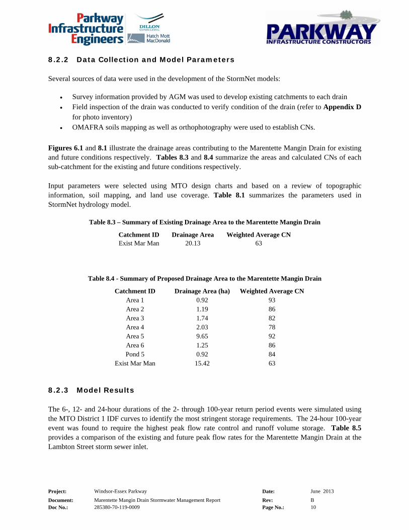
8.2.2 Data Collection and Model Parameters
Several sources of data were used in the development of the StormNet models:
• Survey information provided by AGM was used to develop existing catchments to each drain
• Field inspection of the drain was conducted to verify condition of the drain (refer to Appendix D
for photo inventory)
• OMAFRA soils mapping as well as orthophotography were used to establish CNs.
Figures 6.1 and 8.1 illustrate the drainage areas contributing to the Marentette Mangin Drain for existing
and future conditions respectively. Tables 8.3 and 8.4 summarize the areas and calculated CNs of each
sub-catchment for the existing and future conditions respectively.
Input parameters were selected using MTO design charts and based on a review of topographic
information, soil mapping, and land use coverage. Table 8.1 summarizes the parameters used in
StormNet hydrology model.
Table 8.3 – Summary of Existing Drainage Area to the Marentette Mangin Drain
Catchment ID Drainage Area Weighted Average CN
Exist Mar Man 20.13 63
Table 8.4 - Summary of Proposed Drainage Area to the Marentette Mangin Drain
Catchment ID Drainage Area (ha) Weighted Average CN
Area 1 0.92 93
Area 2 1.19 86
Area 3 1.74 82
Area 4 2.03 78
Area 5 9.65 92
Area 6 1.25 86
Pond 5 0.92 84
Exist Mar Man 15.42 63
8.2.3 Model Results
The 6-, 12- and 24-hour durations of the 2- through 100-year return period events were simulated using
the MTO District 1 IDF curves to identify the most stringent storage requirements. The 24-hour 100-year
event was found to require the highest peak flow rate control and runoff volume storage. Table 8.5
provides a comparison of the existing and future peak flow rates for the Marentette Mangin Drain at the
Lambton Street storm sewer inlet.
Project: Windsor-Essex Parkway Date: June 2013
Document: Marentette Mangin Drain Stormwater Management Report Rev: B
Doc No.: 285380-70-119-0009 Page No.: 11
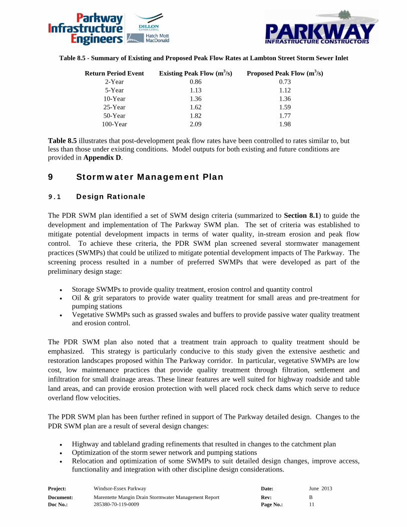
Table 8.5 - Summary of Existing and Proposed Peak Flow Rates at Lambton Street Storm Sewer Inlet
Return Period Event Existing Peak Flow (m3/s) Proposed Peak Flow (m3/s)
2-Year 0.86 0.73
5-Year 1.13 1.12
10-Year 1.36 1.36
25-Year 1.62 1.59
50-Year 1.82 1.77
100-Year 2.09 1.98 Table 8.5 illustrates that post-development peak flow rates have been controlled to rates similar to, but less than those under existing conditions. Model outputs for both existing and future conditions are provided in Appendix D.
9 Stormwater Management Plan
9.1 Design Rationale
The PDR SWM plan identified a set of SWM design criteria (summarized to Section 8.1) to guide the
development and implementation of The Parkway SWM plan. The set of criteria was established to
mitigate potential development impacts in terms of water quality, in-stream erosion and peak flow
control. To achieve these criteria, the PDR SWM plan screened several stormwater management
practices (SWMPs) that could be utilized to mitigate potential development impacts of The Parkway. The
screening process resulted in a number of preferred SWMPs that were developed as part of the
preliminary design stage:
• Storage SWMPs to provide quality treatment, erosion control and quantity control • Oil & grit separators to provide water quality treatment for small areas and pre-treatment for
pumping stations • Vegetative SWMPs such as grassed swales and buffers to provide passive water quality treatment
and erosion control.
The PDR SWM plan also noted that a treatment train approach to quality treatment should be
emphasized. This strategy is particularly conducive to this study given the extensive aesthetic and
restoration landscapes proposed within The Parkway corridor. In particular, vegetative SWMPs are low
cost, low maintenance practices that provide quality treatment through filtration, settlement and
infiltration for small drainage areas. These linear features are well suited for highway roadside and table
land areas, and can provide erosion protection with well placed rock check dams which serve to reduce
overland flow velocities.
The PDR SWM plan has been further refined in support of The Parkway detailed design. Changes to the
PDR SWM plan are a result of several design changes:
• Highway and tableland grading refinements that resulted in changes to the catchment plan • Optimization of the storm sewer network and pumping stations • Relocation and optimization of some SWMPs to suit detailed design changes, improve access,
functionality and integration with other discipline design considerations.

Project: Windsor-Essex Parkway Date: June 2013
Document: Marentette Mangin Drain Stormwater Management Report Rev: B
Doc No.: 285380-70-119-0009 Page No.: 12
The detailed SWM plan includes five pumping stations and seven SWM ponds to service all new sections
of Highway 401 and the majority of Highway 3. Runoff from the remaining sections of Highway 3 and
other tableland areas, which cannot outlet to a pumping station or SWM pond, will be managed utilizing a
combination of oil & grit separators and vegetated swales. Landscaping and environmental design
elements are also integrated into the detailed SWM plan to provide passive water quality treatment.
These measures serve as at-source controls by reducing runoff potential, promoting infiltration and
evapotranspiration, and serve as a landscape buffer at the property line and along roadsides.
With respect to the detailed SWM plan for the Marentette Mangin Drain, runoff from The Parkway will
be captured and conveyed by two systems of storm sewers; one that outlets to Pumping Station 1 (PS-1)
and one that outlets to Pond 5. PS-1 will pump runoff to Pond 5 which will provide water quality and
quantity treatment prior to discharging to the Drain. Refer to the Phase 2 Highway and Roadway Drainage Design Report (PIE/Dillon Consulting, 2012) for design details of The Parkway storm sewer
system.
9.2 Water Quality Control
As noted in Section 9.1, water quality treatment will be achieved by means of vegetated swales and
stormwater management Pond 5. The Marentette Mangin Drain SWM plan utilizes a multi component
approach to achieve the water quality control criterion outlined in Section 8.1. Water quality treatment in
the table land areas will be provided by managing runoff through a landscaping planting strategy. Further
water quality enhancement will be achieved via swales along the recreational trail. Pond 5 has been
designed as a wet pond in accordance with the MOE Stormwater Management Planning and Design Manual (2003) to provide enhanced water quality treatment for The Parkway runoff.
9.3 Water Quantity Control
As previously discussed in Section 8.2.3 and illustrated in Table 8.5, the 6-, 12- and 24-hour durations of
the 2- through 100-year return period events were simulated using the MTO 1997 IDF curves to identify
the most stringent storage requirements. The 24-hour 100-year event was found to require the highest
peak flow rate control and runoff volume storage requirements, and was therefore used as the basis for the
design of Pond 5.
Table 8.5 (provided again on the following page) summarizes the existing and future peak flow rates at the at the Lambton Street storm sewer inlet for the 24-hour duration of the 2- through 100-year return period events using the MTO District 1 IDF curves. The table illustrates that future peak flow rates have been controlled to rates similar to, but less than existing. The existing and future conditions modeling parameters and output are provided in Appendix D.

Project: Windsor-Essex Parkway Date: June 2013
Document: Marentette Mangin Drain Stormwater Management Report Rev: B
Doc No.: 285380-70-119-0009 Page No.: 13
Table 8.5 - Summary of Existing and Proposed Peak Flow Rates at Lambton Street Storm Sewer Inlet
Return Period Event Existing Peak Flow (m3/s) Proposed Peak Flow (m3/s)
2-Year 0.86 0.73
5-Year 1.13 1.12
10-Year 1.36 1.36
25-Year 1.62 1.59
50-Year 1.82 1.77
100-Year 2.09 1.98
9.4 SWM Pond 5 Design Summary
SWM Pond 5 operating characteristics are summarized in Table 9.4. Only the 24-hour duration results
have been summarized, since the 24-hour duration produced the most conservative storage requirements.
Table 9.4 – Summary of SWM Pond 5 Operating Characteristics
Return Period (years) Inflow (m3/s) Outflow (m3/s) Maximum Storage (m3) WSEL (m)
Extended Detention 0.94 0.06 2086 179.45
2-Year 1.47 0.11 4117 179.82
5-Year 1.91 0.29 5107 179.99
10-Year 2.23 0.37 5867 180.12
25-Year 2.60 0.40 6902 180.28
50-Year 2.89 0.43 7779 180.42
100-Year 3.18 0.45 8677 180.55
The detailed design of SWM Pond 5 is in accordance with the MOE Stormwater Management Planning and Design Manual (2003). Design features include:
• Permanent pool storage volume of 4202 m3 (required volume is 3717 m3) at an elevation of 177.50 m to achieve Enhanced level water quality treatment.
• Permanent pool depth of 1.5 m (minimum 1.0 m), a forebay length-to-width ratio of 2:1 and an overall length-to-width ration of 5:1.
• Approximately 65 hours of extended detention (minimum 24 hours extended detention) for the runoff generated from the 25 mm Event (4-hour Chicago distribution).
• Access road to the outlet control maintenance hole and access road extending into the sediment forebay (max slope 10%).
• Maximum side slopes of 6H:1V for 3 m on both sides of the permanent pool edge and maximum side slopes of 5H:1V elsewhere.
• Bottom draw low flow outlet pipe to mitigate potential thermal impacts. • Orifice flow controls to attenuate the 2- through 100-year return period event pond outflows to
pre-development rates: o 230 mm diameter orifice plate to control frequent flows o 450 mm diameter orifice plate to control high flows
• 25 m wide emergency spillway set at 0.05 m above the 100-year return period event water surface elevation to provide emergency relief flow in the event of an outlet blockage.
Supporting calculations for the sizing of Pond 5 are provided in Appendix E of this report. The 90%
detailed design drawings for SWM Pond 5 are also provided in Appendix E; and include plan, section,

Project: Windsor-Essex Parkway Date: June 2013
Document: Marentette Mangin Drain Stormwater Management Report Rev: B
Doc No.: 285380-70-119-0009 Page No.: 14
and detail drawings. Refer to the Landscaping Planting Plan drawings for details on the planting strategy
for SWM Pond 5.
A geotechnical and hydrogeological investigation was completed during the 60% design stage to confirm
liner requirements, entitled Estimates of In/Outflows – Stormwater Management, Fish Habitat Compensation Ponds and Realigned Drains (PIE/AMEC, 2012). The report indicates the pond is in
contact with the Upper Granular Deposits and is expected to gain water during wet periods, and lose
water during dry periods. Accordingly, an impermeable liner system will be required for Pond 5.
To ensure that the SWM pond continues to operate as designed, a pond maintenance plan should be
developed for routine maintenance of the facility and should include:
• Frequency of pond inspection (during wet weather operation) to assess its performance and operation
• Repair and maintenance protocols • Frequency of removal of accumulated sediment.
9.5 Erosion and Sediment Control (During Construction)
An Erosion and Sediment Control Plan will be developed by PIC and submitted under separate cover.
10 Conclusions
This report documents the detailed design SWM plan and drainage design for the section of The Parkway
that is contributing flows to the Marentette Mangin Drain sub-watershed. The PDR SWM plan developed
in support of the PDR was used as the basis and was further refined by integrating hydraulic, hydrologic,
highway, structural and environmental design considerations to meet the requirements of the Project
Agreement. Stakeholder agencies were consulted to ensure that the detailed design meets the current
policy requirements and concerns associated with the Marentette Mangin Drain. In view of the objectives
stated in Section 4.1, the following conclusions are provided:
• The Parkway drainage design conveys the 100-year return period event flows for depressed
sections of the highway and 10-year return period flows for sections at-grade.
• The SWM plan is developed to demonstrate that there are no adverse impacts to downstream
properties in terms of peak flows.
• Pond 5 has been sized to provide enhanced water quality treatment. Additional passive water quality treatment will be provided via the landscape planting strategy and vegetated swales.
APPENDIX B
Drainage Report prepared by PEI under Section 77(3) of the Drainage Act

Doc No: 285380-70-126-0030, Rev. 0, Attachment, Page 3
April 12, 2013
Mayor and Council Corporation of the City of Windsor 360 City Hall Square West Windsor, Ontario N9A 6S1
Attention: Ms. Anna Godo, P. Eng. Drainage Superintendent
Drain Improvements to the
MARENTETTE MANGIN DRAINAs part of the Windsor-Essex ParkwayCity of Windsor
Dear Ms. Godo:
Instruction
We have reviewed the proposed drainage improvements contained within the Marentette Mangin Drain Stormwater Management Report as prepared by the Parkway Infrastructure Engineers (PIE), and have made an examination of the area for improvement to the Marentette Mangin Drain in the City of Windsor. Instructions were initiated by a request from the Windsor-Essex Mobility Group (WEMG), acting as agents for the Ministry of Transportation (MTO) as part of the infrastructure construction and development of the Windsor-Essex Parkway.
The proposed work as it affects the Marentette Mangin Drain is consistent with the hydraulic analysis and design prepared by PIE. We find that if the work is carried out in accordance with the drawings and specifications, that the portion of the Marentette Mangin Drain being improved can proceed without adversely affecting any person(s) and / or property. All of the works recommended shall be at the cost of the MTO (Road Authority) and the entirety of the proposed work is on lands solely under the jurisdiction of the City of Windsor or the Ministry of Transportation. We hereby recommend that the improvements, as described in this letter, may proceed as set out in our written opinion in accordance with Section 77(3) of the Drainage Act. As such, a formal report under the Drainage Act is not required.
Watershed Description
The Marentette Mangin Drain is a regulated municipal drain and lies within the Turkey Creek Watershed. The headwaters of the Drain are located on the west side of Huron Church Road, approximately 150 m south of Bethlehem Avenue. The Drain flows southwest, and then southerly to a storm sewer inlet immediately west of the Lambton Street Cul-de-Sac. The total contributing area to the inlet is approximately 33 ha. The current land uses in the Marentette Mangin Drain Sub-Watershed consist of residential developments, improved land and fragmented woodlots.
The Marentette Mangin Drain is under the jurisdiction of the Essex Region Conservation Authority (ERCA) with respect to hydraulic performance and floodplain management, and the Ontario Ministry of
Doc No: 285380-70-126-0030, Rev. 0, Attachment, Page 4
Natural Resources (OMNR) with respect to species at risk (SAR). Watershed characteristics for the Marentette Mangin Drain Sub-Watershed were determined using information obtained from ERCA’s online GIS database, topographic survey completed as part of The Parkway Project, the City of Windsor Storm Sewer Atlas and field investigations.
Existing Conditions
The Marentette Mangin Drain is an intermittently flowing watercourse and is not considered fish habitat. Based on Ontario Ministry of Agriculture, Food and Rural Affairs (OMAFRA) mapping, the Marentette Mangin Drain is classified as a Class F drain.
The Marentette Mangin Drain Sub-Watershed has been significantly impacted by residential
developments both upstream and downstream of Huron Church Road. These impacts are the result of
enclosure, and barriers and diversion of flows. It is noteworthy that the ERCA and OMAFRA mapping
have not been updated to reflect the enclosures of the drain and diversion of flows.
The soil characteristics within and surrounding the Marentette Mangin Drain study area were determined
based on regional soil mapping obtained from OMAFRA. The soils within the sub-watershed are
composed primarily of Berrien Sand, which corresponds to hydrologic soil group (HSG) ‘AB.’ A
weighted average curve number (CN) of 63 was calculated based on the existing land use and soil
information.
Design Considerations
In general, the design criteria provide the design requirements for the conveyance of stormwater, quantity control, quality control and flood protection. These criteria are summarized in the stormwater management (SWM) report prepared as part of the detailed design of drainage infrastructure for the section of the Windsor-Essex Parkway associated with the Marentette Mangin Drain.
Proposed drainage conditions have been reviewed and hydraulic modeling has determined that there are
no adverse impacts on upstream properties in terms of water surface elevations. Additionally, the SWM
plan demonstrates that there are no adverse impacts on downstream properties in terms of peak flows
during the design events.
Recommendations
We recommend that the drainage associated to the existing Marentette Mangin Drain be constructed in accordance with the Windsor-Essex Parkway New Construction Drawings Sheets D500, D501, D502 and D800. Also attached is a figure identifying the proposed sub-watershed area for the Marentette Mangin Drain.
All of the works recommended shall be entirely on lands solely under the jurisdiction of the City of Windsor and Ministry of Transportation (MTO). However all costs shall be borne by the MTO. Therefore, a detailed summary of the items for construction and cost are not included as part of this letter. Detailed plans & specifications are not included as part of this letter, but they will be provided for tendering and construction and will provide the basis for future maintenance.
Doc No: 285380-70-126-0030, Rev. 0, Attachment, Page 5
The portions of the Marentette Mangin Drain and associated structures within The Parkway property will be maintained by the Windsor-Essex Mobility Group (WEMG), acting as agents for the Ministry of Transportation (MTO) as part of the infrastructure construction and development of the Windsor-Essex Parkway.
Sincerely yours,
Tom H. Marentette, P. Eng. Drainage EngineerT 519-948-5000 F 519-948-5054 [email protected]
THM:KDH
encls.


90% SUBMISSION
KEY PLAN
WINDSOR-ESSEX PARKWAY PROJECT
PHASE 2 - POND #5
NOT FORCONSTRUCTION
SITE
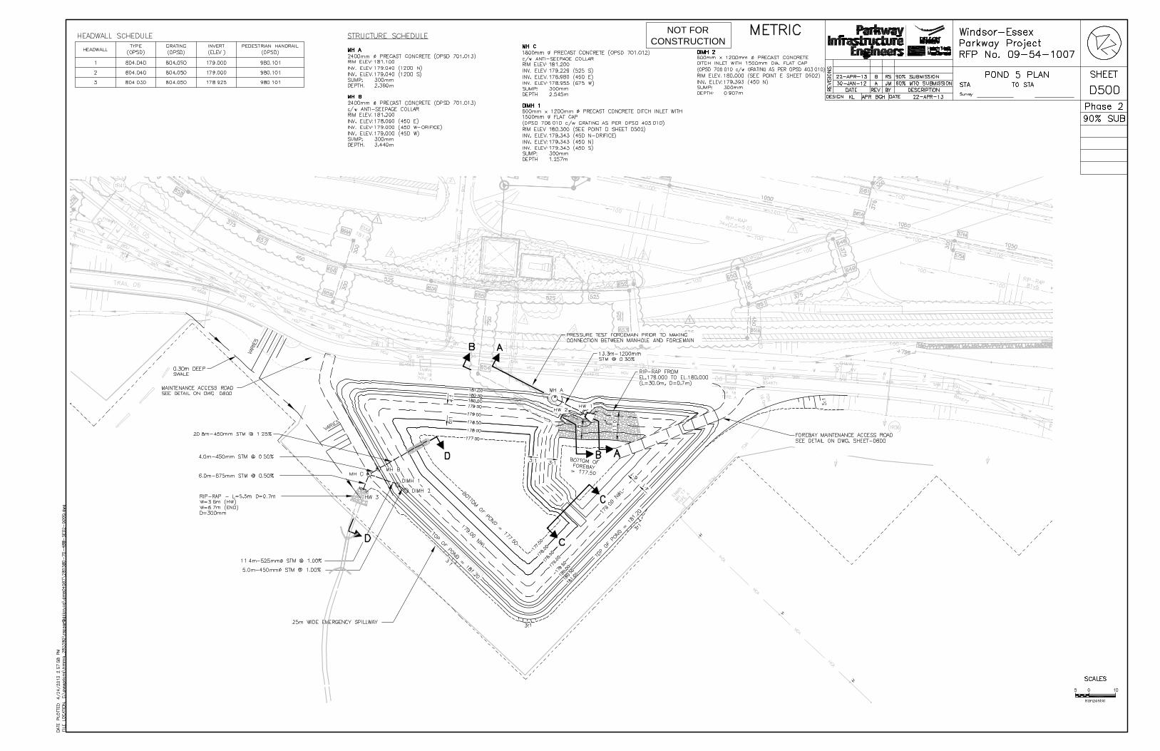
NOT FORCONSTRUCTION

NOT FORCONSTRUCTION
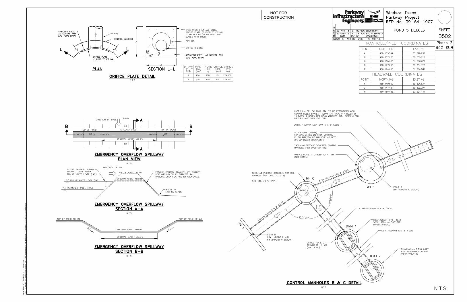
NOT FORCONSTRUCTION


APPENDIX C
On-site Meeting Minutes
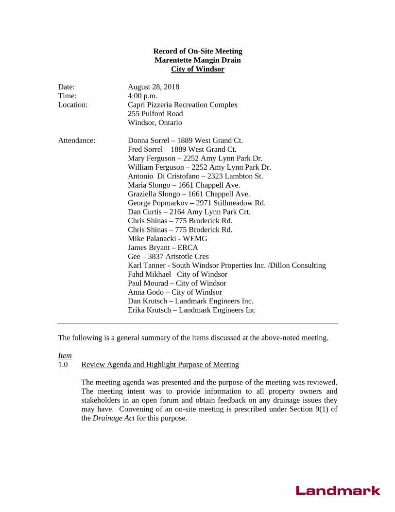
Record of On-Site Meeting Marentette Mangin Drain
City of Windsor
Date: August 28, 2018 Time: 4:00 p.m. Location: Capri Pizzeria Recreation Complex
255 Pulford Road Windsor, Ontario
Attendance: Donna Sorrel – 1889 West Grand Ct. Fred Sorrel – 1889 West Grand Ct. Mary Ferguson – 2252 Amy Lynn Park Dr. William Ferguson – 2252 Amy Lynn Park Dr. Antonio Di Cristofano – 2323 Lambton St. Maria Slongo – 1661 Chappell Ave. Graziella Slongo – 1661 Chappell Ave. George Popmarkov – 2971 Stillmeadow Rd. Dan Curtis – 2164 Amy Lynn Park Crt. Chris Shinas – 775 Broderick Rd. Chris Shinas – 775 Broderick Rd. Mike Palanacki - WEMG James Bryant – ERCA Gee – 3837 Aristotle Cres Karl Tanner - South Windsor Properties Inc. /Dillon Consulting Fahd Mikhael– City of Windsor Paul Mourad – City of Windsor Anna Godo – City of Windsor Dan Krutsch – Landmark Engineers Inc. Erika Krutsch – Landmark Engineers Inc
The following is a general summary of the items discussed at the above-noted meeting.
Item 1.0 Review Agenda and Highlight Purpose of Meeting
The meeting agenda was presented and the purpose of the meeting was reviewed. The meeting intent was to provide information to all property owners and stakeholders in an open forum and obtain feedback on any drainage issues they may have. Convening of an on-site meeting is prescribed under Section 9(1) of the Drainage Act for this purpose.

2
2.0 Present Brief History of the Subject Drain
A brief history of the subject drain and the need for improvement was presented. The Marentette-Mangin Drain is considered a municipal drain that was established under the provisions of the Drainage Act, however copies of historic reports and bylaws pertaining to the drain could not be located. Therefore, the report is being prepared under Section 4 of the Act.
The WEMG has entered into an agreement with the City of Windsor, whereby the Province will maintain the portion of the Drin lying within the Parkway lands . The City and WEMB require a secure outlet for the drainage system that services the Parkway.
3.0 Highlight the Drainage Act Process
A summary of the process that will be followed in preparing the new reports, and what the process entails once the new Engineer’s Report have been filed with the City, was presented. The opportunities that the property owners have for appeal were highlighted.
A new engineer’s report will be prepared and for the Marentette-Mangin Drain, and the report will be filed with the Clerk’s office within the next few months. The City will send copies of the report, and notice of meeting to consider report, to owners within the municipalities who are subject to assessment or compensation, as well as to the conservation authority, railways, road authorities, public utilities, the Ministry of Natural Resources and the Director. Council will consider the reports at meeting held not less than 10 days after the notices have been sent. Council may adopt report, by provisional by-law. Council, within 30 days of the adoption of the report, will send a copy of the provisional by-law and the date of the Court of Revision to all assessed or compensated owners.
The Court of Revision will be held by the City not sooner than 20, nor later than 30 days from the date of mailing the by-law. Any owner wishing to appeal their assessment must serve notice on the Clerk of the City at least 10 days before first sitting of the Court. Any owner may appeal to Drainage Tribunal against the decision of Court of Revision by notifying Clerk within 21 days of the pronouncement of the decision of the Court of Revision. Any owner or public utility may appeal the findings or recommendations of the Engineer’s Report to the Drainage Tribunal within 40 days of mailing the notices, or the adoption of the report. Council of the City may pass provisional by-law authorizing the work after appeal period has elapsed, and there are no appeals, or all appeals are completed.

3
4.0 Questions
Donna Sorrel of 1889 West Grand Crt asked what the process was for enlarging the drain. It was noted that the scope of work and next steps needed would be established through the process. Ms. Sorrel asked if pumps were removed from, or added to, the Grand Marais Drain. It was noted that the Grand Marais Drain has always been a gravity driven, open channel, and that no part of the Grand Marais Drain had ever been pumped.
Mary Ferguson asked if an assessment of the sanitary pump houses along the Parkway would be part of the assessment. Mr. Krutsch expressed that a review of the sanitary sewer system was not included in the assessment of the drain. Ms. Godo indicated that the City will be reviewing the performance of the sanitary sewer system as part of an overall City-wide sewer study.
Antonio DiCristofano of 2323 Lambton Street expressed concern that the existing sewer cannot handle the flow from the drain, and noted that the sewer only consisted of a 24 inch sewer. Mr. Krutsch noted that the drain capacity and sewer capacity will be assessed as part of the exercise.
George Popmarkov addressed some history of land expropriation referencing a letter from 2004. Mr. Krutsch indicated that it was not intended to address future land development issues as part of the assessment of the drain and suggested that any questions concerning future development potential of the lands should be directed to the City’s planning department. Mr. Popmarkov asked that if the lands were developed in the future, would the drain be replaced with a sewer. Mr. Krutsch noted that the City would make separate inquiries with the planning department. He noted that some of the land may be undevelopable due to environmental constraints and that it would not be possible to resolve these issues through the Drainage Act process.
William Ferguson asked if the drain was connected to pump stations along the Parkway. Mr. Krutsch noted that the assessment will determine the what portions of the Parkway drainage are contributing flow to the drain, including pump stations. Mr. Ferguson asked if the drain had more than one outlet to the Grand Marais Drain. Mr, Krutsch indicated that currently there is only one outlet from the Marentette Mangin Drain to the Grand Marais Drain.
The meeting was adjourned at approximately 4:45 p.m.
This meeting summary was prepared by Mr. Daniel M. Krutsch, P.Eng.

APPENDIX D
As-Built Drawings for Huron Estates Subdivision (Sheets 1, 2, 8, 9a, 10, and 18)

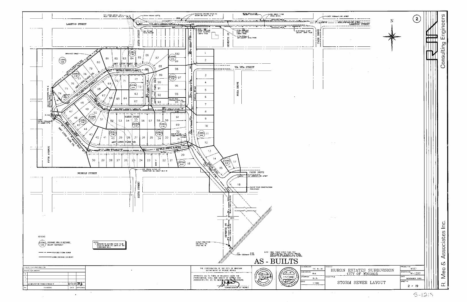


APPENDIX E
Calculation of Assessment Apportionment
APPENDIX E EXPLANATION OF CALCULATION OF ASSESSMENT SCHEDULE
FOR THE MARENTETTE-MANGIN DRAIN
CITY OF WINDSOR
1.0 Apportionment of Benefit, Outlet Liability and Special Benefit
We have assessed that none of the works are associated with improvement or maintenance of privately-owned access structures. Therefore, all costs the works are assessed as Benefit and Outlet Liability.
We assess that the function of the Marentette-Mangin Drain is to provide drainage for local roadways and local development lands. Therefore, we assess that 50% of the cost of the works should be assessed as benefit, and that remaining 50% of the project costs should be assessed as outlet and injury liability.
2.0 Equivalent Area Method
Having due regard for the runoff generating potential of the road rights-of-way (accounting for the pavement, sidewalk and driveway areas) compared to the runoff generating potential of other lands within the watershed, we assess that roads should be assessed at a higher rate than residential lots and other lands. Based on our independent calculations we have adopted a multiplication factor of 2.0 for the roadways, 1.0 for residential lands, and 0.4 for open lands.
3.0 Overview of Assessment Calculation
STEP 1
The total project cost were first apportioned into benefit and outlet liability as follows:
Benefit = Estimated Cost x 0.5 = $174,438.66 x 0.5 = $87,219.33Outlet = Estimated Cost x 0.5 = $174,438.66 x 0.5 = $87,219.33
STEP 2
The total calculated tributary land area of 49.4 ha was separated into highway, local roads, residential lands, and open land areas of 23.0 ha., 3.2 ha., 7.6 ha., and 15.6 ha., respectively. The subareas were factored by the multipliers noted above. An equivalent subareas and total area was calculated as follows:
Equivalent Highway and Road Area = (23 + 3.2) x 2.0 = 52.4 ha. Equivalent Residential Land Area = 7.6 x 1.0 = 7.6 ha. Equivalent Open Area = 15.6 x 0.4 = 6.2 ha.
The Equivalent Total Area was calculated to be 52.4 + 7.6 + 6.2 = 66.2 ha.
STEP 3
The ratio of Roads and Lands assessments were calculated by proportioning the equivalent areas as follows:
Roads Apportionment Equivalent Road Area / Equivalent Total Area = 52.4 / 66.2 = 79.2%
Lands Apportionment Land Area / Equivalent Total Area = 13.8 / 66.2 = 20.8%
STEP 4
The Benefit and Outlet Assessments were assessed against the roads and lands at the foregoing proportions as follows:
Benefit Apportionment Roads = $87,219.33 x 0.792 = $ 69,077.71 Lands = $87,219.33 x 0.208 = $ 18,141.62
Outlet Apportionment Roads = $87,219.33 x 0.792 = $ 69,077.71 Lands = $87,219.33 x 0.208 = $ 18,141.62
The Schedule of Assessment reflects the foregoing methodology.
APPENDIX F
Specifications

i
APPENDIX F SPECIFICATIONS FOR THE
MARENTETTE-MANGIN DRAIN CITY OF WINDSOR
1.0 Description of Work
The work to be completed under this Contract consists of the furnishing of all labour, equipment, supervision and materials necessary to carry out the following:
Clearing of blowdown (trees that have been blown down by the wind) from within the drain bottom and drain banks from Station 0+648 to 1+002, in accordance with the drawings and specifications. Work should entail the following:
o Complete removal of all trees that have blown over within the limits of the channel; and,
o Removal of brush along the channel banks within the lower half of the channel.
Improvements to the outlet structure at Station 0+000 entailing the following:
o Break out and remove concrete-parged, masonry bulkhead from within the outlet chamber;
o Remove and dispose of gabion rock from within outlet chamber; and, o Repair damaged bar grate.
Install a custom fabricated steel bar inlet cage be installed over the end of inlet sewer as depicted in the attached design drawings.
In addition to the project specific specifications, reference is made to applicable OPSS Forms and City of Windsor Standard Specifications. OPSS Forms can be accessed at:
http://www.raqsb.mto.gov.on.ca/techpubs/ops.nsf/OPSHomepage
Applicable sections of the City of Windsor Standard Specifications can be accessed at:
https://www.citywindsor.ca/business/buildersanddevelopers/Pages/Standard-Specifications.aspx
Both standards shall govern the drainage improvement works.
2.0 List of Drawings
The following drawings are part of this Contract.

ii
16-020-01 - WATERSHED PLAN 16-020-02 - PLAN DRAWING (STA. 0+000 TO 1+004) 16-020-03 - PROFILE DRAWING (STA. 0+000 TO 1+004) 16-020-04 - SECTIONS & MISCELLANEOUS DETAILS
In addition to the above drawings that depict the proposed works, copies of some of the as-built drawings that depict the primary trunk sewer through the Huron Estates Subdivision have been appended to the report and should be referenced as needed.
3.0 Clearing and Brushing
OPSS Form 201 shall apply and govern except as amended or extended herein. The Contractor shall clear, remove and dispose of all woody vegetation (i.e. trees, stumps, woody shrubs and brush, etc.) from within the channel to complete the drain improvements.
Any trees located below the top of slope and within the upper one half of the drain bank, that are larger than 200mm in diameter shall be flagged for assessment by the Engineer prior to their removal. The Contractor shall take precautions to prevent damage to any trees, shrubs, etc. that are designated to be protected and saved. The replacement and/or repairs of damaged trees shall be undertaken by a qualified person, approved by the Engineer.
All brush and trees removed by the Contractor shall be disposed of by piling on City Owned property in proximity to the drain.
Upon completion of the work, the contractor shall trim any broken limbs or branches from standing trees. The proper disposal of all brush and trees removed during the course of construction shall be to the satisfaction of the Drainage Superintendent and Engineer.
4.0 Excavation and Trucking of Excavated Material
No excavation of the channel is recommended at this time. The following specification is provided in the event that excavation is required as part of future maintenance.
OPSS Form 206 (MUNI) and City of Windsor Standard Specification S3, shall apply and govern except as amended or extended herein. The channel shall be excavated to within 50mm of the design profile. The remainder of the channel cross-section shall be constructed to within 50mm of the design section. Over-excavation of the drain bottom will be corrected using compacted site selected material as approved by the Engineer and at no cost to the Owner. Over-excavation of the drain bank beyond the specified tolerances shall require that the bank be repaired in accordance with a repair detail prepared by a Professional Engineer (retained by the Contractor). The repair detail shall be subject to review by the Engineer. The full cost of the repair, including the fees of the aforementioned Professional Engineer, shall be borne by the Contractor.

iii
All excavated materials, in excess of those required for infilling of the existing drain, shall be disposed of off-site. The procurement of, and fees associated with, any and all approvals required prior to hauling and disposing of surplus materials off-site shall be the sole responsibility of the Contractor. Any areas that are damaged by hauling or disposal operations shall be restored to original or better condition.
5.0 Fill Existing Drain
No filling of the channel is recommended at this time. The following specification is provided in the event that filling of the channel is required as part of future maintenance.
OPSS Form 206 (MUNI) shall apply and govern except as amended or extended herein. The existing drain shall be filled to the lines and grades shown on the Drawings including grading, compaction and benching of the existing slopes. The soils used for filling shall be Class II soils (non-impacted) from the on-site excavation of the new channel. The fill shall be placed in lifts, as is required to achieve a uniform compaction of 95% Standard Proctor Density.
6.0 Disposal of Surplus Earthen Material
No disposal of earth materials is recommended at this time. The following specification is provided in the event that disposal of earth materials is required as part of future maintenance.
All surplus excavated material shall be disposed of off-site unless otherwise designated in the contract drawings. A portion of the material will be used to fill the existing drain. Suitable excess material will be incorporated into other fill locations associated with the drain corridor or disposed of as directed by the Engineer.
7.0 Remove and Dispose of Existing Sewer Intake Grate
The Contractor shall carefully remove the existing bar grate from the end of the 1200 mm diameter concrete sewer at Station 0+650, and dispose of the grate off-site. Care shall be taken to ensure that the sewer is not disturbed during removal.
7.0 Supply and Install New Steel Sewer Intake Cage
The Contractor shall supply and install the new steel sewer intake gage as detailed in the Drawings. Steel posts and railings, base plates and connection to the new headwalls, precast blocks and pile caps shall be as illustrated. All steel components of the intake cage shall conform to ASTM A325M or A490M and shall be hot-dipped galvanized in conformance with CAN/CSA G164-M92.

iv
13.0 Topsoil
No placement of topsoil is recommended at this time. The following specification is provided in the event that excavation is required as part of future maintenance.
OPSS Forms 802 and City of Windsor Standard Specification S34, apply and govern except as amended or extended herein. This work shall consist of supply, placement and grading a minimum thickness of 100mm (4”) of clean topsoil at the locations indicated in the Drawings. The topsoil supplied shall be free from roots, vegetation and other debris and shall be from a source approved by the Owner/Engineer.
16.0 Seed and Mulch
No disposal of seeding and mulching is recommended or anticipated at this time. The following specification is provided in the event that seeding and mulching is required as part of future maintenance or if significant areas are disturbed that require restoration.
This work shall consist of all material, labour and equipment required to supply and place hydraulic seed, mulch and fertilizer on the areas indicated in the Contract Drawings and areas that have been disturbed during construction.
The seed mixture supplied shall have the following composition:
10% Red Clover (Medium Type) 15% Quebec Perennial Ryegrass 25% Tall Fescue 25% Creeping Red Fescue 15% Richmond Timothy 10% Kentucky Bluegrass
The mix shall be applied at the rate of 100 kg/hectare and the fertilizer (8-32-16) shall be applied at a rate of 200 kg/hectare.
The Contractor shall be responsible to water the planted areas as required to ensure that the seed germinates and the grass grows. Areas of the site with less than 75% germination shall be re-seeded. The mulch shall be a bonded fibre matrix (Soil Guard bonded fibre matrix or equivalent).
The Contractor’s price shall include all watering required to ensure that the seed germinates and the grass grows. Areas of the site with less than 75% germination shall be re-seeded.
17.0 Trees and Shrubs
No supply or placement of trees and shrubs is recommended or anticipated at this time. The following specification is provided in the event that supply or placement of trees and

v
shrubs is required as part of future maintenance or if significant areas are disturbed that require restoration.
This work shall include all labour, equipment and materials required to supply and place trees and shrubs in the locations indicated in the Contract Drawings. The trees and shrubs used for this item shall be from a supplier approved by the City. The Contractor’s price shall include all watering required.
18.0 Fish Salvage
Prior to undertaking any improvements or repairs were fish may exist, measures shall be taken to collect and transfer fish and other aquatic or amphibious species from work areas to other areas of the Marentette-Mangin Drain.
In an effort to minimize fish stress and mortality, the Contractor shall be required to subcontract this work to a qualified fisheries biologist.
18.1 Coordination
The contractor shall be solely responsible for coordination of the fish salvage works with other works so as to ensure that the fish collection/transfer can occur in advance of other work included in this contract. Neither the Owner nor the Engineer will bear any responsibility for delays that may occur as a result of inadequate coordination of the work by the Contractor.
18.2 Fish Handling Guidelines
General fish handling guidelines are detailed below.
a) The drain(s) will be blocked or diverted according to individual project section drawings.
b) All fish will be removed from the project site through electrofishing, small seine and dip nets (various mesh size 1/8 – 1/4) and immediately transferred to aerated coolers located onshore.
c) Fish will be graded (size) and transferred in aerated tanks to sites upstream of the project area. Size separation is conducted to reduce damage and stress on the fish.
d) All transfer tanks will contain water from the original water body in order to reduce thermal or chemical stress on the fish.
e) All Round Gobies encountered (Neogobius melanostomus) will be humanely euthanized by MS222 overdose on site according to Canadian Council on Animal Care protocols. Fish carcasses will be disposed as biological waste through protocols issued through Chemical Control Center (Waste) University of Windsor.
f) All fish will be rapidly inspected for signs of obvious disease and excessive parasite infection. Fish that have been damaged by sampling,

vi
exhibit loss of equilibrium or have obvious signs of terminal disease will also be euthanized.
g) All fish will be acclimated prior to release. Water from the release site will be slowly introduced in to the transfer tank in order to ensure both thermal and chemical equilibrium has been achieved prior to release.
h) Fish will be released into appropriate habitat that (i.e. abundant cover) to allow for adjustment and to avoid predation. Larger fish will be released into deeper water under the same conditions previously described.
i) A species diversity list will be issued to the City of Windsor upon completion of transfer.
18.3 Notifications
The Contractor shall be required to provide the Engineer with 48 hours notice of the fish transfer operation/activity.
19.0 Protection of Existing Utilities
The Contractors will satisfy themselves as to the location of any public utilities, power or transmission lines, underground cables, etcetera. which may be affected by the doing of any work and will conduct their operation so as to in no way interfere with the same. If in the doing of any work such lines, underground cables, etcetera, are damaged, the Contractor will save the Municipality or Engineer harmless from any cost or damage resulting therefrom.
It will also be the Contractor’s responsibility to get any permits that may be required to carry out the work and also to see that the proper authorities are notified that he is working in the vicinity of any public utility, power or transmission lines, underground cables, etc. All work that is carried out in the vicinity of any of the above shall be carried out in accordance with their specifications or regulations for the same, as if their specifications or regulations formed part of this specification.
Where the Contractor is working on or adjacent to a road, he shall at his own expense, provide for the safe passage and control of traffic by placing, maintaining, changing and removing such barricades, signs, flags, lights (including flashing lights and flagmen), as are required for the proper notification and protection of the public approaching or passing through any part of the work area. All signs, flags, lights, etc. so used shall be in conformance with the provisions of Book 7 of the Ontario Traffic Manual. The Contractor will save harmless the Municipality and the Engineer from any legal actions resulting from any negligence or carelessness on the part of the Contractor which may result in damage claims for improper traffic control procedures.
The Contractor shall take all risks from floods or casualties of any kind.
vii
The Contractor shall not sublet the whole or any part of this Contract without the approval of the Municipality and the Engineer.
20.0 Working Area and Access Corridor
The designated working area for this drain shall be limited to the north and south property lines from STA: 0+000 to STA: 0+270. Construction and maintenance access to this reach shall be via the 6m wide corridor between the north top of slope and the property limit.
For the remainder of the drain, from STA: 0+270 to 0+668, the designated working area along the south side of the drain is limited to 5m beyond the new top of slope, and to the road right-of-way along the north side of the drain.
vii21.0 Clean-up
After the Contractor has completed his work, he shall clean-up the site, removing all debris or any other waste materials in a neat and workmanlike manner, leaving the job in a neat and tidy condition and subject to the approval of the Drainage Superintendent and the Engineer.
APPENDIX G
Drawings
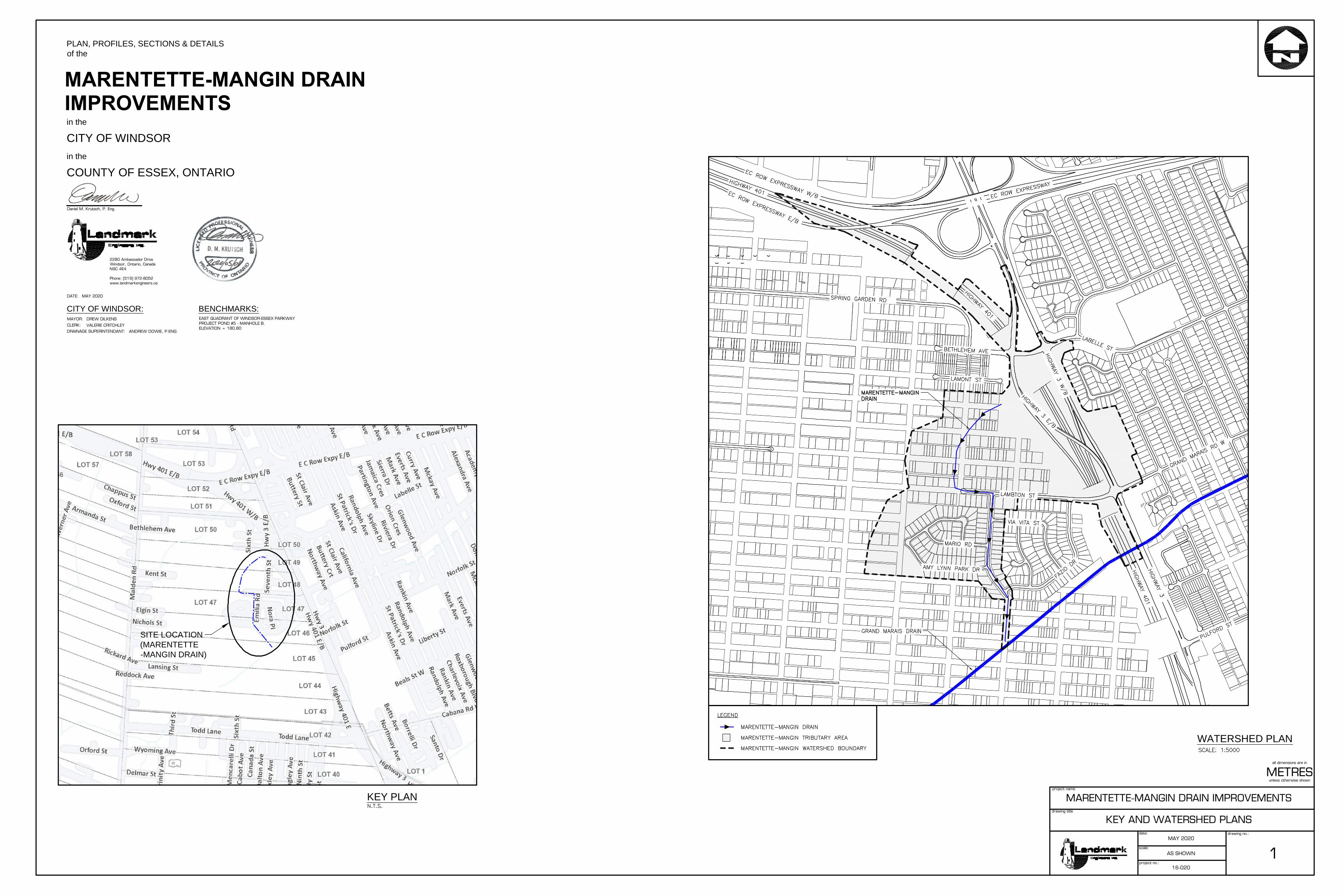
SITE LOCATION(MARENTETTE-MANGIN DRAIN)
WATERSHED PLAN
KEY PLANdrawing title
project no.:
drawing no.:
project name
scale:
date:
Daniel M. Krutsch, P. Eng.
all dimensions are in
2280 Ambassador DriveWindsor, Ontario, CanadaN9C 4E4
Phone: (519) 972-8052www.landmarkengineers.ca
unless otherwise shown
PLAN, PROFILES, SECTIONS & DETAILSof the
in the
CITY OF WINDSORin the
COUNTY OF ESSEX, ONTARIO
CITY OF WINDSOR:
DATE:
MAYOR:
CLERK:
DRAINAGE SUPERINTENDANT:
BENCHMARKS:
1
METRES
MARENTETTE-MANGIN DRAIN IMPROVEMENTS
KEY AND WATERSHED PLANS
MAY 2020
AS SHOWN
16-020
MAY 2020
DREW DILKENS
VALERIE CRITCHLEY
ANDREW DOWIE, P.ENG.
EAST QUADRANT OF WINDSOR-ESSEX PARKWAYPROJECT POND #5 - MANHOLE B.ELEVATION = 180.80
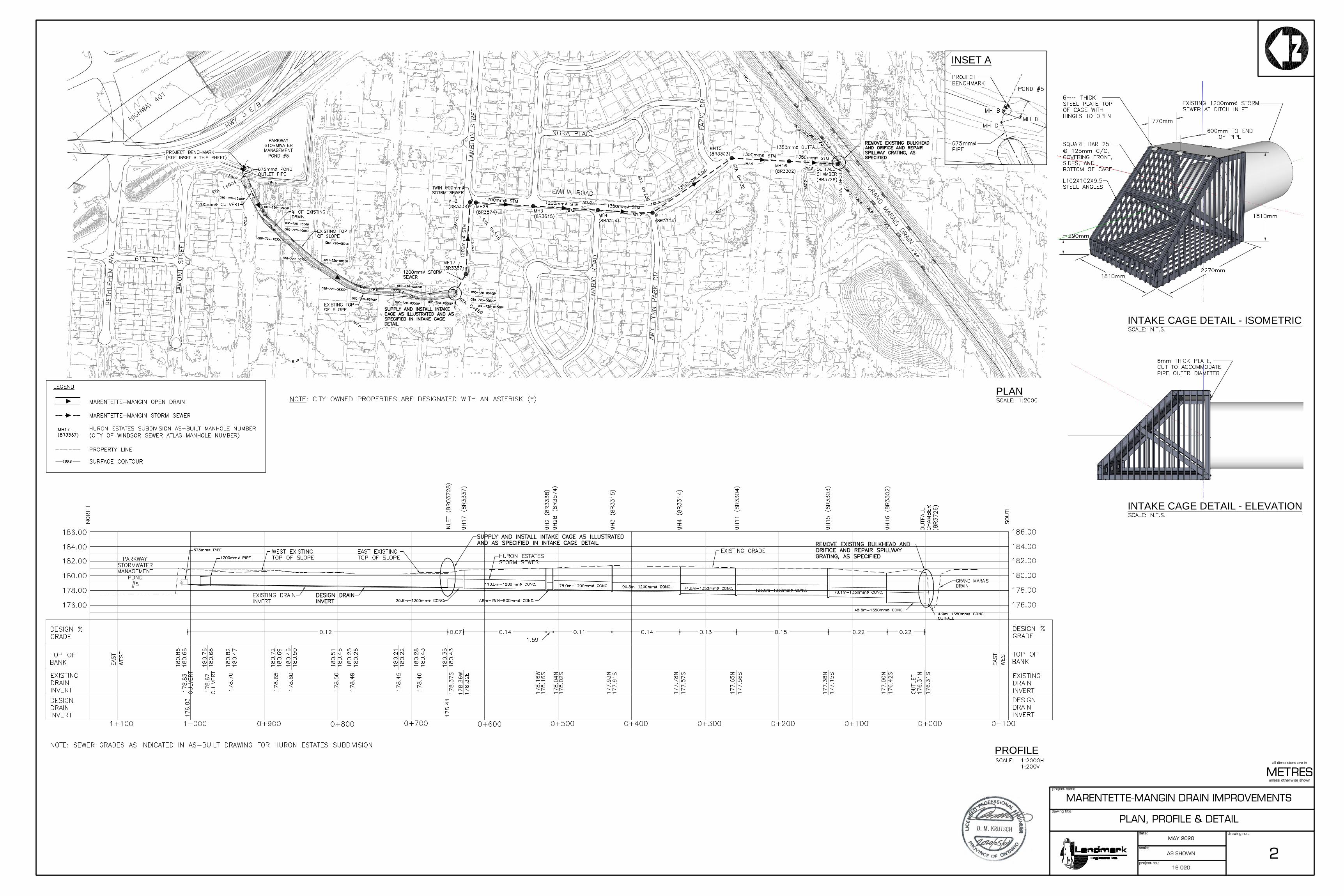
PROFILE
PLAN
dawing title
project no.:
drawing no.:
project name
scale:
date:
all dimensions are in
unless otherwise shown
2
METRES
MARENTETTE-MANGIN DRAIN IMPROVEMENTS
PLAN, PROFILE & DETAIL
MAY 2020
AS SHOWN
16-020
INTAKE CAGE DETAIL - ISOMETRIC
INTAKE CAGE DETAIL - ELEVATION
INSET A
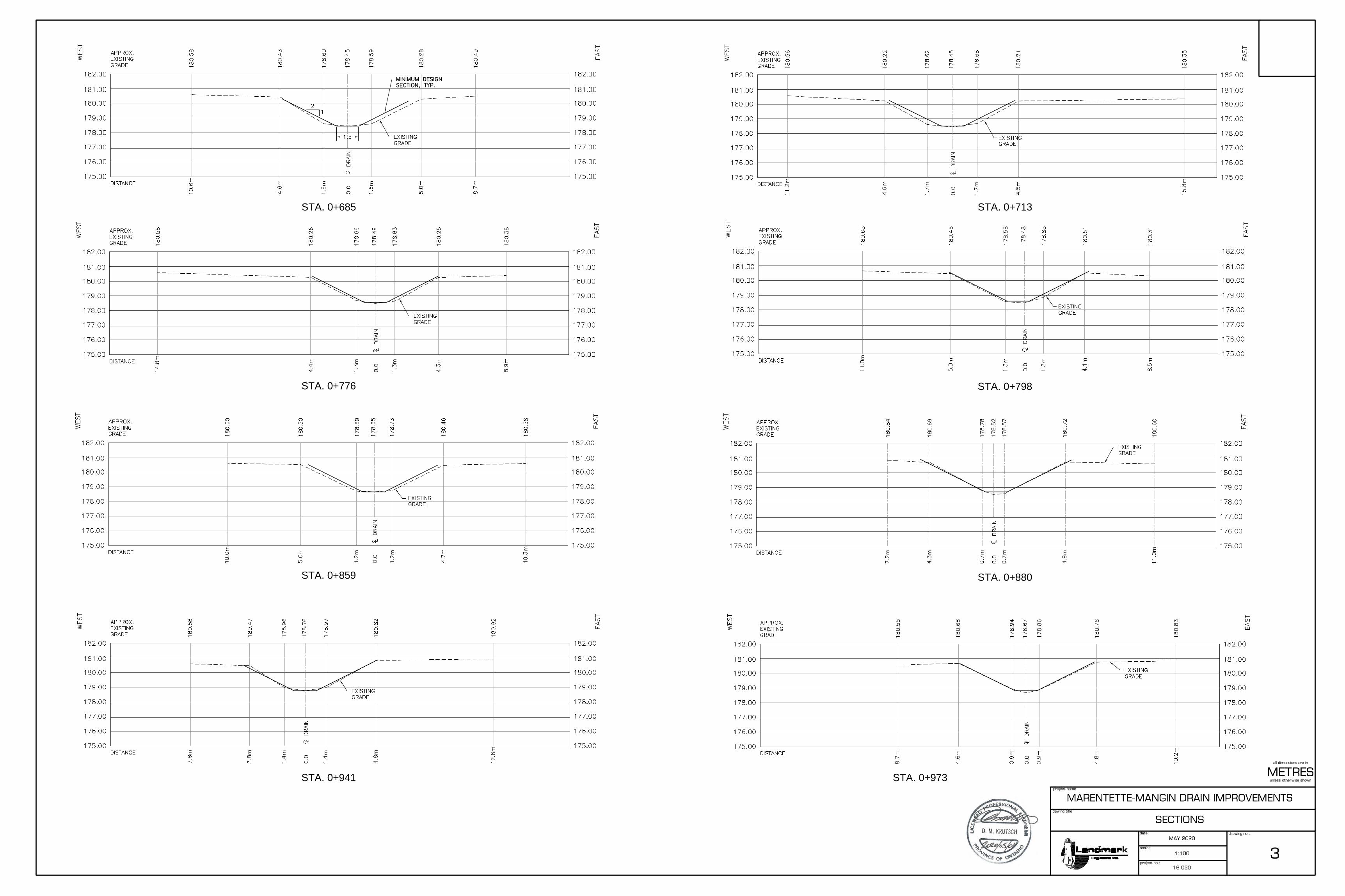
STA. 0+685
STA. 0+776
STA. 0+859
STA. 0+941 STA. 0+973
STA. 0+713
STA. 0+798
STA. 0+880
dawing title
project no.:
drawing no.:
project name
scale:
date:
all dimensions are in
unless otherwise shown
3
METRES
MARENTETTE-MANGIN DRAIN IMPROVEMENTS
SECTIONS
MAY 2020
1:100
16-020