mark twain riverfront park revitalization
DESCRIPTION
Riverfront Park, located in Elmira, NY. A DesignConnect project representing an inter-disciplinary student team working over two semesters to execute a public participation process resulting in a new vision for the park's future.TRANSCRIPT
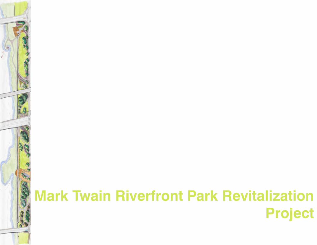
Mark Twain Riverfront Park Revitalization Project
Prepared by DesignConnect Students
Brooke Eddis Business & Real EstateChris Hardy Landscape ArchitectureJulie Johnstone City & Regional PlanningNick Pettinati Landscape ArchitectureLee M. Pouliot Landscape ArchitectureHowie Russell ArchitectureMatt Sturz Landscape ArchitectureJosh Yost City & Regional Planning
Advisor:Jamie Vanucchi Lecturer, Cornell University Landscape Architecture
Mark Twain Riverfront Park Revitalization Proposal
for the City of Elmira
Mark Twain Riverfront Park Revitalization
Acknowledgements
We are very grateful to the City of Elmira and Mayor John Tonello for providing direction, resources and support, enabling us to engage in a meaningful project.
We would also like to thank our Project Advisor Jamie Vanucchi, and Community Contact, Zsuzi Kadar, as well as the Department of Landscape Architecture at Cornell University: their support and advice were critical to the success of this process.
We would like to thank all the steering committee members: Andy Avery (City of Elmira), Ron Bentley (Chemung Canal Trust Company), Sherri Geary (Southern Tier Economic Growth), Jenn Herrick (Elmira Downtown Development), Mike Hosey (Elmira Savings Bank), Zsuzsi Kadar (Elmira Community Development), Mike Kenna (Clemens Center), Jim Lynch (NYSDEC), John Maycumber (City of Elmira), Jenn Miller (Elmira Community Development), Bill Ostrander (Chemung Valley Audubon Society), Jim Pfiffer (Friends of the Chemung River Watershed), Scott Rodabaugh (NYSDEC), Charlie Shaffer (City of Elmira), and Dan Smithers (City of Elmira). Forming a solid foundation for the project, the steering committee guided our goals and objectives. They helped us form strong ties with the community at large and also disseminated information about community meetings.
The participants in community meetings and design charrettes fundamentally shaped the Mark Twain Riverfront Park Revitalization proposal. We relied on participants’ intrinsic expertise about the City of Elmira and Riverfront Park. As we moved forward through process stages, from research to concept and then to proposal formation, City of Elmira residents provided both qualitative and quantitative information about design preferences, priorities, program preferences and goals.
We would also like to thank the Elmira Star-Gazette, WENY, and WETM for diligently tracking our progress and reporting back to Elmira.
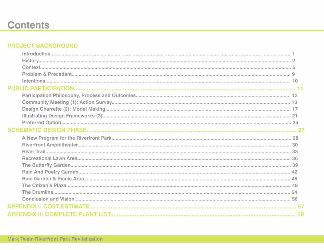
Contents
Mark Twain Riverfront Park Revitalization
PRojECT BACkgRounD Introduction............................................................................................................................................................................ 1 History..................................................................................................................................................................................... 2 Context.................................................................................................................................................................................... 5 Problem & Precedent............................................................................................................................................................. 9 Intentions................................................................................................................................................................................ 10
PuBlIC PARTICIPATIon........................................................................................................................................ 11 Participation Philosophy, Process and outcomes............................................................................................................... 12 Community Meeting (1): Action Survey................................................................................................................................ 13 Design Charrette (2): Model Making.......................................................................................................................... .......... 17 Illustrating Design Frameworks (3)....................................................................................................................................... 21 Preferred option...................................................................................................................................................... .............. 25
SCHEMATIC DESIgn PHASE................................................................................................................................. 27 A new Program for the Riverfront Park............................................................................................................... ................. 28 Riverfront Amphitheater......................................................................................................................................................... 30 River Trail................................................................................................................................................................................ 33 Recreational lawn Area......................................................................................................................................................... 36 The Butterfly garden.............................................................................................................................................................. 39 Rain And Poetry garden........................................................................................................................................................ 42 Rain garden & Picnic Area.................................................................................................................................................... 45 The Citizen’s Plaza................................................................................................................................................................. 48 The Drumlins.......................................................................................................................................................................... 54 Conclusion and Vision........................................................................................................................................................... 56
APPEnDIx I: CoST ESTIMATE............................................................................................................................... 57APPEnDIx II: CoMPlETE PlAnT lIST.................................................................................................................. 59

PRojECT BACkgRounD
Mark Twain Riverfront Park Revitalization 1
Introduction
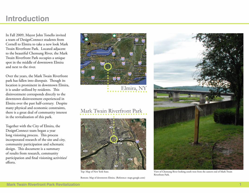
In Fall 2009, Mayor John Tonello invited a team of DesignConnect students from Cornell to Elmira to take a new look Mark Twain Riverfront Park. Located adjacent to the beautiful Chemung River, the Mark Twain Riverfront Park occupies a unique spot in the middle of downtown Elmira and next to the river.
Over the years, the Mark Twain Riverfront park has fallen into disrepair. Though its location is prominent in downtown Elmira, it is under utilized by residents. This disinvestment corresponds directly to the downtown disinvestment experienced in Elmira over the past half-century. Despite many physical and economic constraints, there is a great deal of community interest in the revitalization of this park.
Together with the City of Elmira, the DesignConnect team began a year long visioning process. This process incorporated research of the site and city, community participation and schematic design. This document is a summary of results from research, community participation and final visioning activities/efforts.
Elmira, NY
Mark Twain Riverfront Park
Top: Map of New York State.
Bottom: Map of downtown Elmira. (Reference: maps.google.com)
View of Chemung River looking south west from the eastern end of Mark Twain Riverfront Park.
Mark Twain Riverfront Park Revitalization
Yates
Steuben
Schuylylerylyl
ChemungC
Ontario
Livingston
Elmira
Canal Outlet
Canal
Corning
Bath
2
History
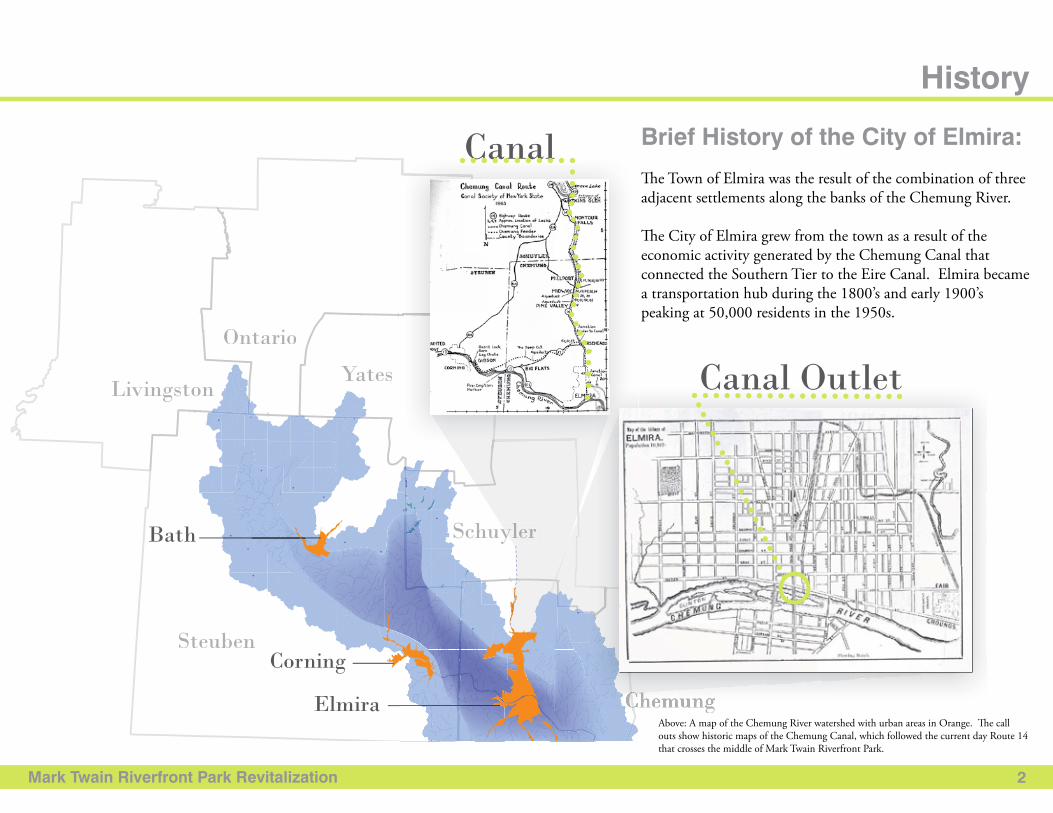
Brief History of the City of Elmira:
The Town of Elmira was the result of the combination of three adjacent settlements along the banks of the Chemung River.
The City of Elmira grew from the town as a result of the economic activity generated by the Chemung Canal that connected the Southern Tier to the Eire Canal. Elmira became a transportation hub during the 1800’s and early 1900’s peaking at 50,000 residents in the 1950s.
Above: A map of the Chemung River watershed with urban areas in Orange. The call outs show historic maps of the Chemung Canal, which followed the current day Route 14 that crosses the middle of Mark Twain Riverfront Park.
Mark Twain Riverfront Park Revitalization 3
History (cont.)
The origin of Mark Twain Riverfront Park:
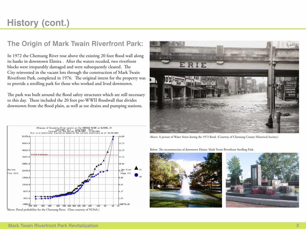
In 1972 the Chemung River rose above the existing 20 foot flood wall along its banks in downtown Elmira . After the waters receded, two riverfront blocks were irreparably damaged and were subsequently cleared. The City reinvested in the vacant lots through the construction of Mark Twain Riverfront Park, completed in 1976. The original intent for the property was to provide a strolling park for those who worked and lived downtown.
The park was built around the flood safety structures which are still necessary to this day. These included the 20 foot pre-WWII floodwall that divides downtown from the flood plain, as well as toe drains and pumping stations.
Above: A picture of Water Street during the 1972 flood. (Courtesy of Chemung County Historical Society.)
Below: The reconstruction of downtown Elmira: Mark Twain Riverfront Strolling Park.
Above: Flood probability for the Chemung River. (Data courtesy of NOAA.)
Mark Twain Riverfront Park Revitalization 4
Mark Twain Riverfront Park Today:
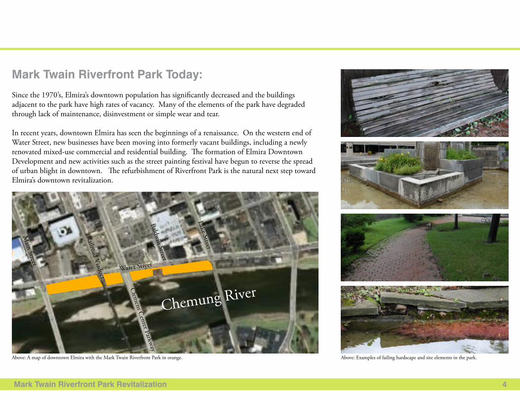
Since the 1970’s, Elmira’s downtown population has significantly decreased and the buildings adjacent to the park have high rates of vacancy. Many of the elements of the park have degraded through lack of maintenance, disinvestment or simple wear and tear.
In recent years, downtown Elmira has seen the beginnings of a renaissance. On the western end of Water Street, new businesses have been moving into formerly vacant buildings, including a newly renovated mixed-use commercial and residential building. The formation of Elmira Downtown Development and new activities such as the street painting festival have begun to reverse the spread of urban blight in downtown. The refurbishment of Riverfront Park is the natural next step toward Elmira’s downtown revitalization.
Above: A map of downtown Elmira with the Mark Twain Riverfront Park in orange. Above: Examples of failing hardscape and site elements in the park.
Water Street
Clem
ens Center Parkway
Main Street
Railroad Viaduct
Baldwin Street
Lake StreetChemung River
Mark Twain Riverfront Park Revitalization
Project Context:
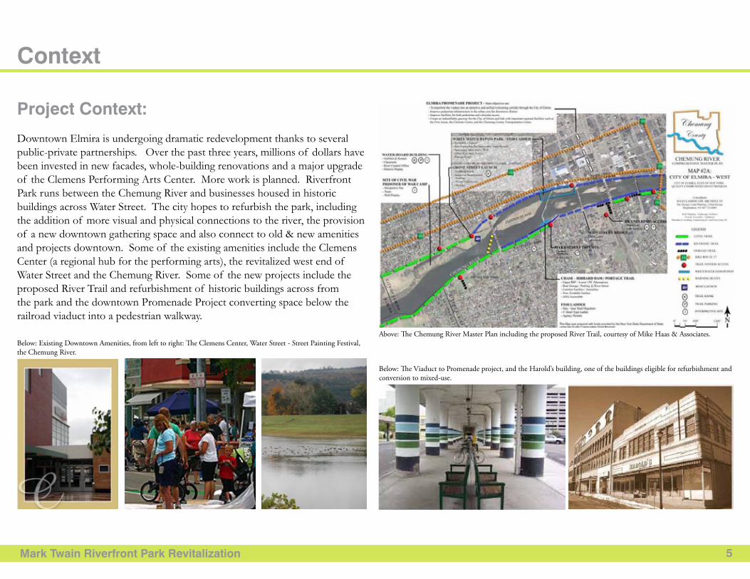
Downtown Elmira is undergoing dramatic redevelopment thanks to several public-private partnerships. Over the past three years, millions of dollars have been invested in new facades, whole-building renovations and a major upgrade of the Clemens Performing Arts Center. More work is planned. Riverfront Park runs between the Chemung River and businesses housed in historic buildings across Water Street. The city hopes to refurbish the park, including the addition of more visual and physical connections to the river, the provision of a new downtown gathering space and also connect to old & new amenities and projects downtown. Some of the existing amenities include the Clemens Center (a regional hub for the performing arts), the revitalized west end of Water Street and the Chemung River. Some of the new projects include the proposed River Trail and refurbishment of historic buildings across from the park and the downtown Promenade Project converting space below the railroad viaduct into a pedestrian walkway.
5
Context
Above: The Chemung River Master Plan including the proposed River Trail, courtesy of Mike Haas & Associates.
Below: The Viaduct to Promenade project, and the Harold’s building, one of the buildings eligible for refurbishment and conversion to mixed-use.
Below: Existing Downtown Amenities, from left to right: The Clemens Center, Water Street - Street Painting Festival, the Chemung River.
Mark Twain Riverfront Park Revitalization
Community Context:
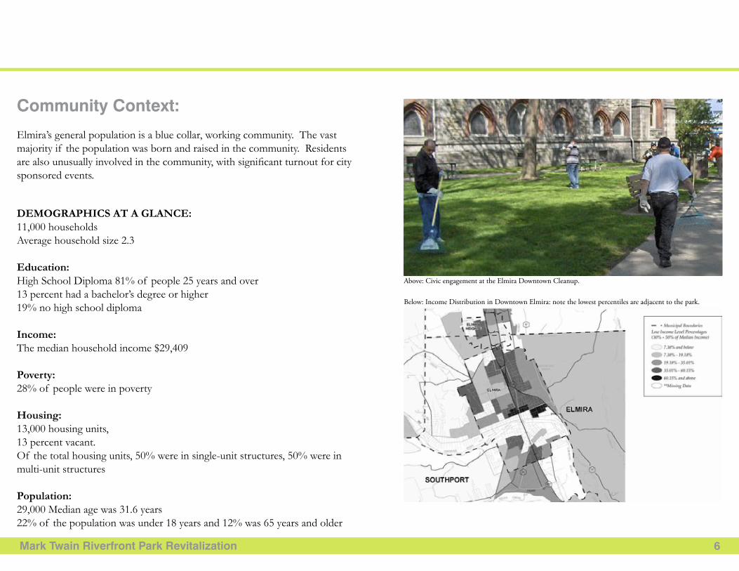
Elmira’s general population is a blue collar, working community. The vast majority if the population was born and raised in the community. Residents are also unusually involved in the community, with significant turnout for city sponsored events.
DEMOGRAPHICS AT A GLANCE: 11,000 households Average household size 2.3
Education:High School Diploma 81% of people 25 years and over 13 percent had a bachelor’s degree or higher19% no high school diploma
Income:The median household income $29,409
Poverty: 28% of people were in poverty
Housing: 13,000 housing units, 13 percent vacant. Of the total housing units, 50% were in single-unit structures, 50% were in multi-unit structures
Population: 29,000 Median age was 31.6 years22% of the population was under 18 years and 12% was 65 years and older
6
Below: Income Distribution in Downtown Elmira: note the lowest percentiles are adjacent to the park.
Above: Civic engagement at the Elmira Downtown Cleanup.
Mark Twain Riverfront Park Revitalization 7
Context (cont.)
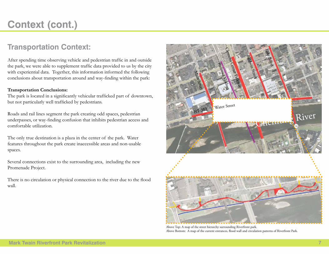
Transportation Context:
After spending time observing vehicle and pedestrian traffic in and outside the park, we were able to supplement traffic data provided to us by the city with experiential data. Together, this information informed the following conclusions about transportation around and way-finding within the park:
Transportation Conclusions:The park is located in a significantly vehicular trafficked part of downtown, but not particularly well trafficked by pedestrians.
Roads and rail lines segment the park creating odd spaces, pedestrian underpasses, or way-finding confusion that inhibits pedestrian access and comfortable utilization.
The only true destination is a plaza in the center of the park. Water features throughout the park create inaccessible areas and non-usable spaces.
Several connections exist to the surrounding area, including the new Promenade Project.
There is no circulation or physical connection to the river due to the flood wall.
Water StreetC
lemens C
enter Parkway
Main Street
Railroad Viaduct
Baldwin Street
Lake Street
Chemung River
Above Top: A map of the street hierarchy surrounding Riverfront park.Above Bottom: A map of the current entrances, flood wall and circulation patterns of Riverfront Park.
Mark Twain Riverfront Park Revitalization 8
Above: Lake Street Bridge. Above: Clemens Center Parkway Bridge. Above: Railroad Viaduct Bridge. Above: Main Street Bridge.
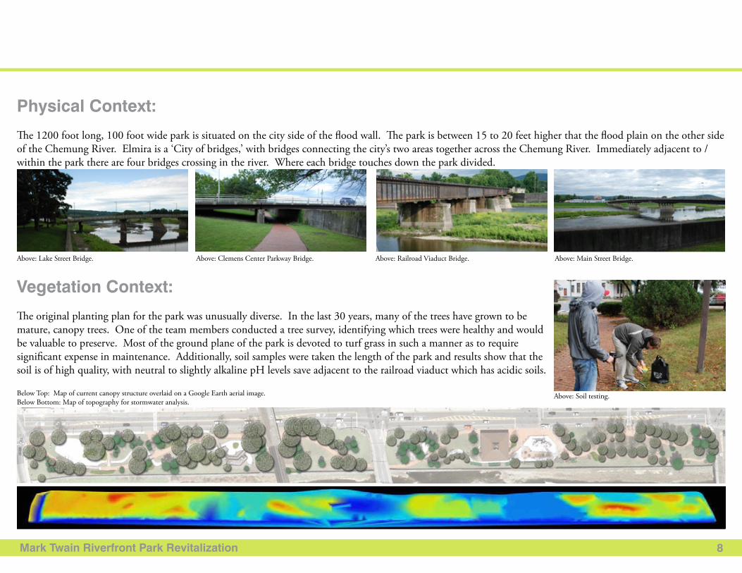
Physical Context:
The 1200 foot long, 100 foot wide park is situated on the city side of the flood wall. The park is between 15 to 20 feet higher that the flood plain on the other side of the Chemung River. Elmira is a ‘City of bridges,’ with bridges connecting the city’s two areas together across the Chemung River. Immediately adjacent to / within the park there are four bridges crossing in the river. Where each bridge touches down the park divided.
Vegetation Context:
The original planting plan for the park was unusually diverse. In the last 30 years, many of the trees have grown to be mature, canopy trees. One of the team members conducted a tree survey, identifying which trees were healthy and would be valuable to preserve. Most of the ground plane of the park is devoted to turf grass in such a manner as to require significant expense in maintenance. Additionally, soil samples were taken the length of the park and results show that the soil is of high quality, with neutral to slightly alkaline pH levels save adjacent to the railroad viaduct which has acidic soils.
Below Top: Map of current canopy structure overlaid on a Google Earth aerial image.Below Bottom: Map of topography for stormwater analysis.
Above: Soil testing.
Mark Twain Riverfront Park Revitalization 9
Problem & Precedent
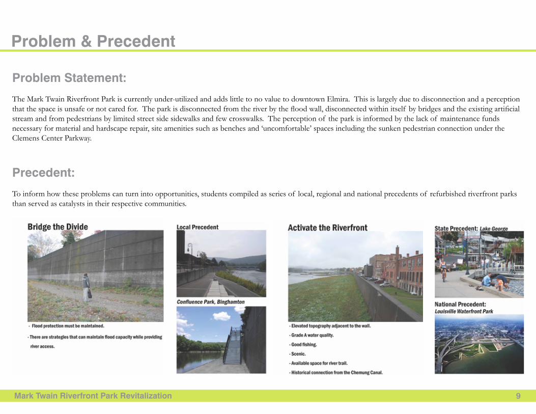
Problem Statement:
The Mark Twain Riverfront Park is currently under-utilized and adds little to no value to downtown Elmira. This is largely due to disconnection and a perception that the space is unsafe or not cared for. The park is disconnected from the river by the flood wall, disconnected within itself by bridges and the existing artificial stream and from pedestrians by limited street side sidewalks and few crosswalks. The perception of the park is informed by the lack of maintenance funds necessary for material and hardscape repair, site amenities such as benches and ‘uncomfortable’ spaces including the sunken pedestrian connection under the Clemens Center Parkway.
Precedent:
To inform how these problems can turn into opportunities, students compiled as series of local, regional and national precedents of refurbished riverfront parks than served as catalysts in their respective communities.
Mark Twain Riverfront Park Revitalization 10
Intentions
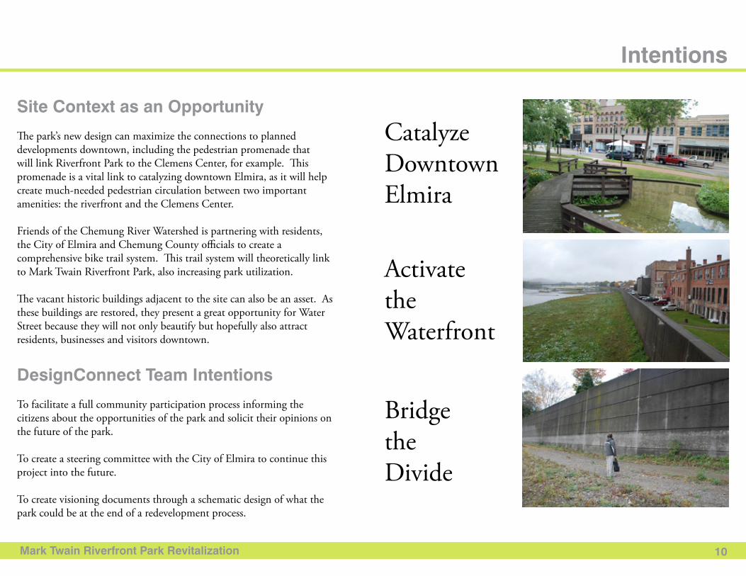
Site Context as an opportunity
The park’s new design can maximize the connections to planned developments downtown, including the pedestrian promenade that will link Riverfront Park to the Clemens Center, for example. This promenade is a vital link to catalyzing downtown Elmira, as it will help create much-needed pedestrian circulation between two important amenities: the riverfront and the Clemens Center.
Friends of the Chemung River Watershed is partnering with residents, the City of Elmira and Chemung County officials to create a comprehensive bike trail system. This trail system will theoretically link to Mark Twain Riverfront Park, also increasing park utilization.
The vacant historic buildings adjacent to the site can also be an asset. As these buildings are restored, they present a great opportunity for Water Street because they will not only beautify but hopefully also attract residents, businesses and visitors downtown.
DesignConnect Team Intentions
To facilitate a full community participation process informing the citizens about the opportunities of the park and solicit their opinions on the future of the park.
To create a steering committee with the City of Elmira to continue this project into the future.
To create visioning documents through a schematic design of what the park could be at the end of a redevelopment process.
Catalyze Downtown Elmira
Activate the Waterfront
Bridge the Divide

Public ParticiPation
Mark twain riverfront Park revitalization 12
In order to ensure that the community begins to utilize Riverfront Park more often, we decided to engage community stakeholders. We thought the best way to engage Elmira would be through a steering committee. Once DesignConnect and the City of Elmira had identified community leaders, Mayor John Tonello invited them to join this steering committee.
When we began working with the steering committee and Elmira residents, we hoped to function as a unit attempting to arrive at consensus about park uses and priorities. Ultimately, we hoped that through asking the community to voice their vision for Riverfront Park that they would see how the plan realized their vision, which would generate a higher sense of community ownership.
Each community meeting built upon the previous one. Thus, when we arrived at the conclusion that seemed the most desirable to participants, we could trace back the logic starting at the first meeting. Throughout the two semesters, the steering committee met seven times, discussing goals, objectives and reviewing public meeting results. Our team facilitated three open community participation meetings with the City of Elmira and four additional public presentations.
In the first participation meeting we asked community members about their design preferences, park usage activities and program preferences. Then, at the next design charrette we asked groups of participants to design a scaled model of the park utilizing scaled park elements and then describe to other groups their plan. Once we had compiled design charrette information, we could sketch potential park frameworks. We presented these frameworks to Elmira residents and asked them to give opinions about specific elements and program placement. In May 2010, we presented the final design during the Elmira Downtown Cleanup event. In the following pages, we present the results from steering committee meetings and community meetings. Ultimately, the participants shaped the design proposal from the beginning and we believe that the present document accurately reflects their vision.
Participation Philosophy, Process & outcomes
Foundations for public investment
Qualitative and Quantitative input
community Meetings
Design charrette
community ownership
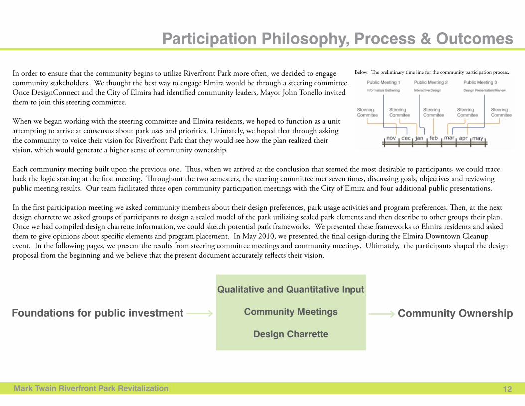
Below: The preliminary time line for the community participation process.
Mark twain riverfront Park revitalization 13
community Meeting (1): action Survey
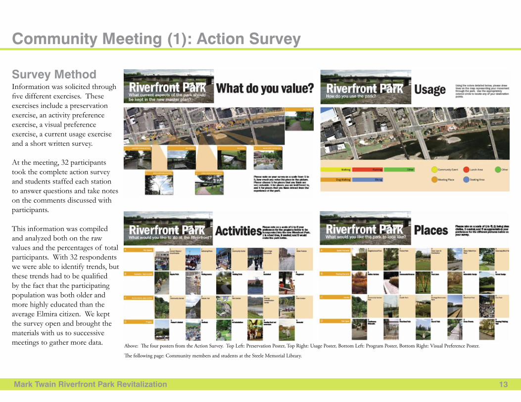
Information was solicited through five different exercises. These exercises include a preservation exercise, an activity preference exercise, a visual preference exercise, a current usage exercise and a short written survey.
At the meeting, 32 participants took the complete action survey and students staffed each station to answer questions and take notes on the comments discussed with participants.
This information was compiled and analyzed both on the raw values and the percentages of total participants. With 32 respondents we were able to identify trends, but these trends had to be qualified by the fact that the participating population was both older and more highly educated than the average Elmira citizen. We kept the survey open and brought the materials with us to successive meetings to gather more data.
Survey Method
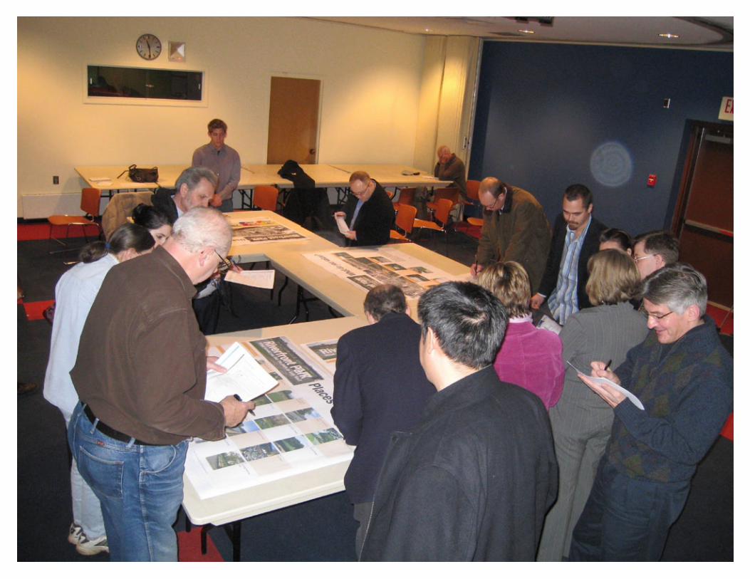
Above: The four posters from the Action Survey. Top Left: Preservation Poster, Top Right: Usage Poster, Bottom Left: Program Poster, Bottom Right: Visual Preference Poster.
The following page: Community members and students at the Steele Memorial Library.
Mark twain riverfront Park revitalization X
Mark twain riverfront Park revitalization 15
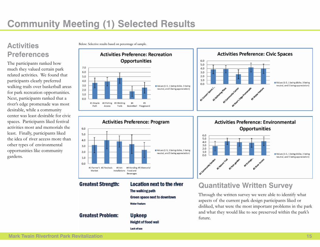
The participants ranked how much they valued certain park related activities. We found that participants clearly preferred walking trails over basketball areas for park recreation opportunities. Next, participants ranked that a river’s edge promenade was most desirable, while a community center was least desirable for civic spaces. Participants liked festival activities most and memorials the least. Finally, participants liked the idea of river access more than other types of environmental opportunities like community gardens.
community Meeting (1) Selected results
Through the written survey we were able to identify what aspects of the current park design participants liked or disliked, what were the most important problems in the park and what they would like to see preserved within the park’s future.
activitiesPreferences
Quantitative Written Survey
Below: Selective results based on percentage of sample.

Mark Twain Riverfront Park Revitalization 15
The participants ranked how much they valued certain park related activities. We found that participants clearly preferred walking trails over basketball areas for park recreation opportunities. Next, participants ranked that a river’s edge promenade was most desirable, while a community center was least desirable for civic spaces. Participants liked festival activities most and memorials the least. Finally, participants liked the idea of river access more than other types of environmental opportunities like community gardens.
Community Meeting (1) Selected Results
Through the written survey we were able to identify what aspects of the current park design participants liked or disliked, what were the most important problems in the park and what they would like to see preserved within the park’s future.
ActivitiesPreferences
Quantitative Written Survey
Below: Selective results based on percentage of sample.
Mark Twain Riverfront Park Revitalization 16
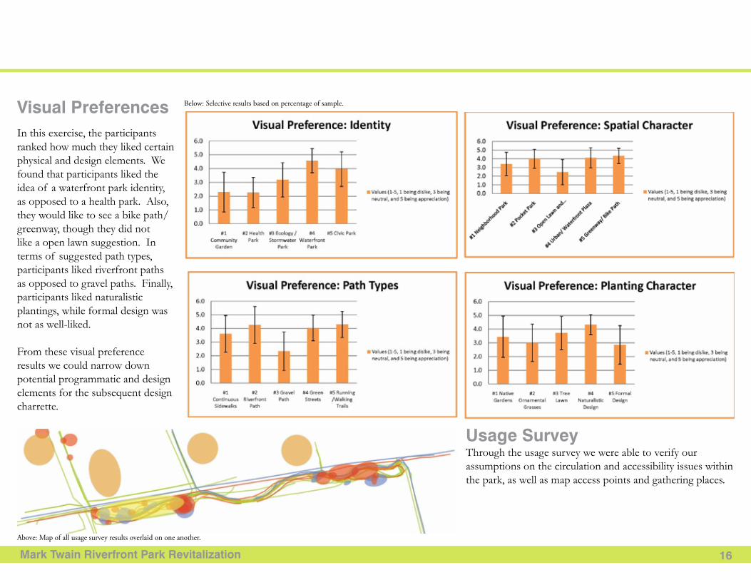
In this exercise, the participants ranked how much they liked certain physical and design elements. We found that participants liked the idea of a waterfront park identity, as opposed to a health park. Also, they would like to see a bike path/greenway, though they did not like a open lawn suggestion. In terms of suggested path types, participants liked riverfront paths as opposed to gravel paths. Finally, participants liked naturalistic plantings, while formal design was not as well-liked.
From these visual preference results we could narrow down potential programmatic and design elements for the subsequent design charrette.
Through the usage survey we were able to verify our assumptions on the circulation and accessibility issues within the park, as well as map access points and gathering places.
Visual Preferences
Usage Survey
Below: Selective results based on percentage of sample.
Above: Map of all usage survey results overlaid on one another.
Mark Twain Riverfront Park Revitalization 17
Charrette Design:
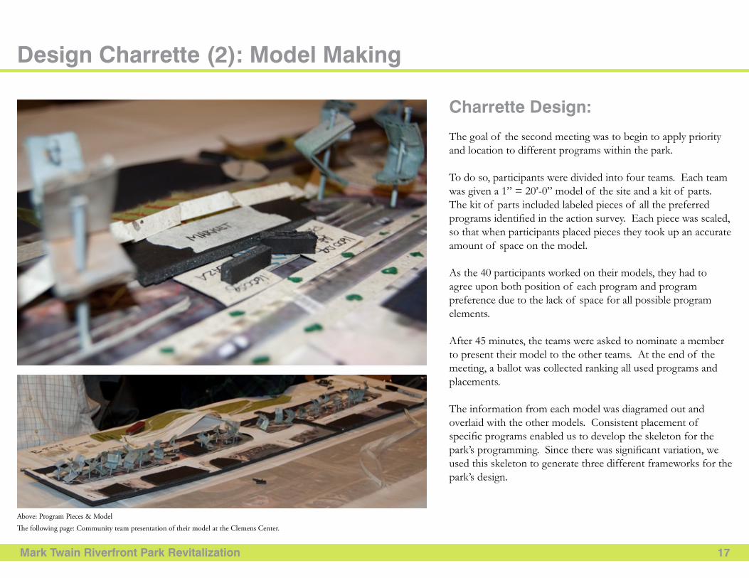
The goal of the second meeting was to begin to apply priority and location to different programs within the park.
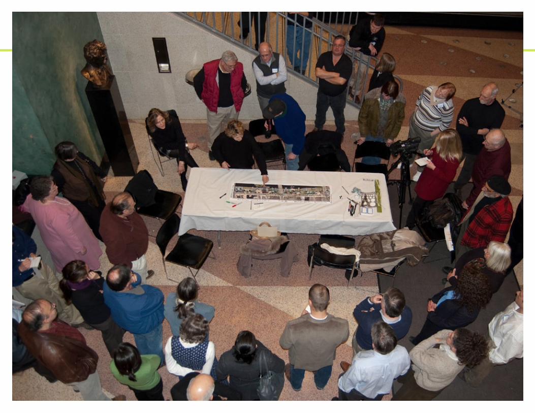
To do so, participants were divided into four teams. Each team was given a 1” = 20’-0” model of the site and a kit of parts. The kit of parts included labeled pieces of all the preferred programs identified in the action survey. Each piece was scaled, so that when participants placed pieces they took up an accurate amount of space on the model.
As the 40 participants worked on their models, they had to agree upon both position of each program and program preference due to the lack of space for all possible program elements.
After 45 minutes, the teams were asked to nominate a member to present their model to the other teams. At the end of the meeting, a ballot was collected ranking all used programs and placements.
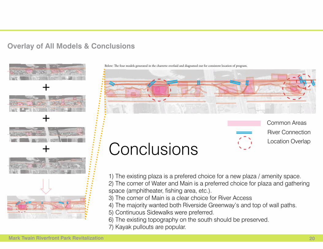
The information from each model was diagramed out and overlaid with the other models. Consistent placement of specific programs enabled us to develop the skeleton for the park’s programming. Since there was significant variation, we used this skeleton to generate three different frameworks for the park’s design.
Design Charrette (2): Model Making
Above: Program Pieces & ModelThe following page: Community team presentation of their model at the Clemens Center.
Mark Twain Riverfront Park Revitalization X
Mark Twain Riverfront Park Revitalization 19
General Results
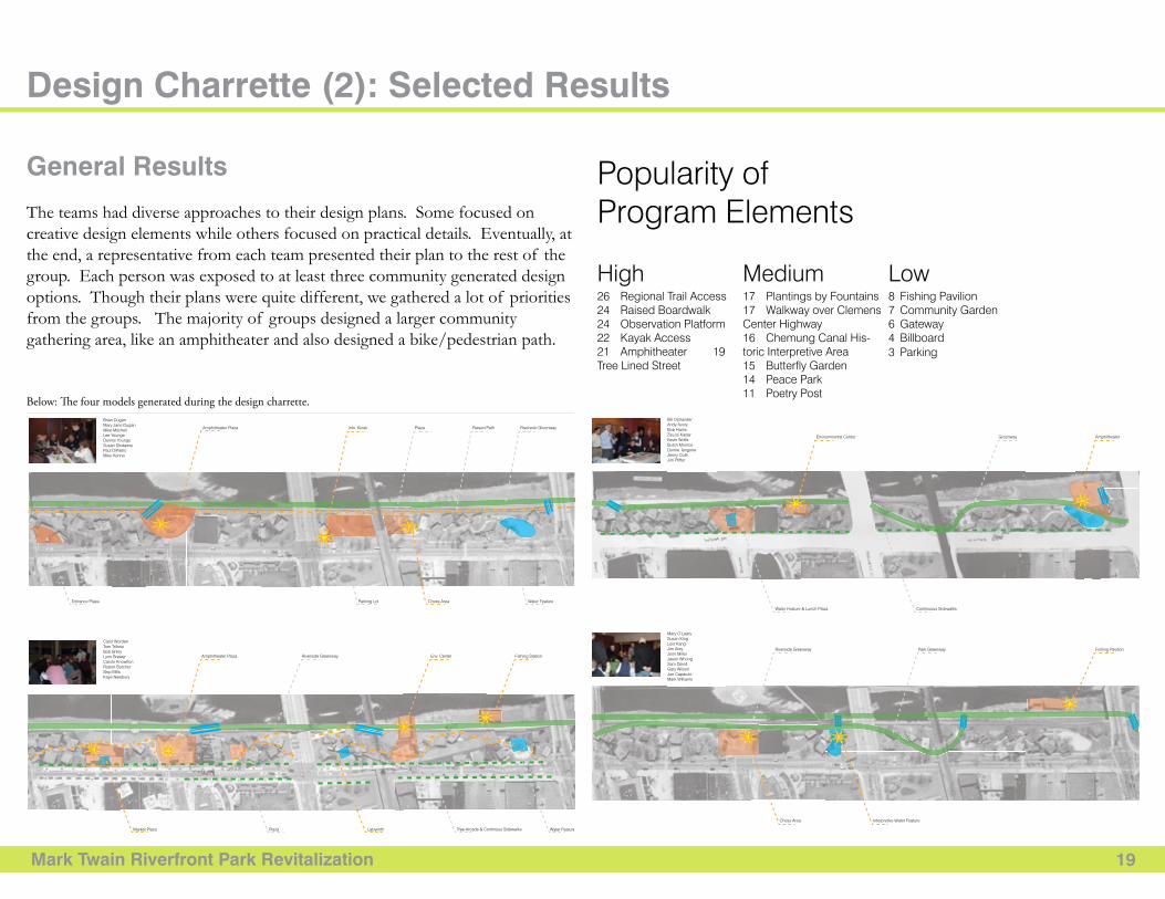
The teams had diverse approaches to their design plans. Some focused on creative design elements while others focused on practical details. Eventually, at the end, a representative from each team presented their plan to the rest of the group. Each person was exposed to at least three community generated design options. Though their plans were quite different, we gathered a lot of priorities from the groups. The majority of groups designed a larger community gathering area, like an amphitheater and also designed a bike/pedestrian path.
Design Charrette (2): Selected Results
Charrette ResultsMark Twain Riverfront
with the generous support of
www.DesignConnectCornell.com · Cornell University · 440 Kennedy Hall · Ithaca NY · 14850
Project Description:Redesign and revitalize this downtown strip park along the Chemung River. This will require signifi cant landscape archi-tecture work, design, parking solutions, and engineering.
ConclusionsRiver Trail GreenwayNew PathwayNew SidewalksImage ReferenceCall out
Plaza/Gathering Space
Water Feature
Special Feature
River Connection26 Regional Trail Access 24 Raised Boardwalk24 Observation Platform 22 Kayak Access 21 Amphitheater 19 Tree Lined Street
High
Popularity of Program Elements
Medium Low17 Plantings by Fountains17 Walkway over Clemens Center Highway16 Chemung Canal His-toric Interpretive Area 15 Butterfly Garden14 Peace Park 11 Poetry Post
1) The existing plaza is a prefered choice for a new plaza / amenity space.2) The corner of Water and Main is a preferred choice for plaza and gathering space (amphitheater, fishing area, etc.).3) The corner of Main is a clear choice for River Access4) The majority wanted both Riverside Greenway’s and top of wall paths.5) Continuous Sidewalks were preferred.6) The existing topography on the south should be preserved.7) Kayak pullouts are popular.
8 Fishing Pavilion 7 Community Garden6 Gateway4 Billboard3 Parking
Brian Dugan Mary Jane Dugan Mike MitchellLee YoungeDennis YoungeSusan ShidawrePaul DiPietroMike Kenna
Amphitheater Plaza
Amphitheater Plaza
Market Plaza Plaza
Environmental Center Greenway Amphitheater
Continuous SidewalksWater Feature & Lunch Plaza
Riverside Greenway Park Greenway Fishing Pavilion
Interpretive Water FeatureChess Area
Tree Arcade & Continous SidewalksLabyrinth Water Feature
Riverside Greenway Env. Center Fishing Station
Entrance Plaza Parking Lot Chess Area Water Feature
Info. Kiosk Plaza Riverside GreenwayRaised Path
Mary O’LearySusan KingLois KangJim AreyJenn MillerJason WhongSam David Gary WilsonJoe CaparuloMark Williams
Bill OstranderAndy AveryBob HarrisZsuzsi KadarKevin WolfeButch MonroeDonne TangoneJenny ColeJim Pfiffer
Carol Worden Tom TrifosoBob BrileyLynn BrewerCarole KnowltonRobert ButcherSkip MillsKaye Newbury
Common Areas
River Connection
Location Overlap
Below: The four models generated during the design charrette.
Mark Twain Riverfront Park Revitalization 20
Charrette ResultsMark Twain Riverfront
with the generous support of
www.DesignConnectCornell.com · Cornell University · 440 Kennedy Hall · Ithaca NY · 14850
Project Description:Redesign and revitalize this downtown strip park along the Chemung River. This will require signifi cant landscape archi-tecture work, design, parking solutions, and engineering.
ConclusionsRiver Trail GreenwayNew PathwayNew SidewalksImage ReferenceCall out
Plaza/Gathering Space
Water Feature
Special Feature
River Connection26 Regional Trail Access 24 Raised Boardwalk24 Observation Platform 22 Kayak Access 21 Amphitheater 19 Tree Lined Street
High
Popularity of Program Elements
Medium Low17 Plantings by Fountains17 Walkway over Clemens Center Highway16 Chemung Canal His-toric Interpretive Area 15 Butterfly Garden14 Peace Park 11 Poetry Post
1) The existing plaza is a prefered choice for a new plaza / amenity space.2) The corner of Water and Main is a preferred choice for plaza and gathering space (amphitheater, fishing area, etc.).3) The corner of Main is a clear choice for River Access4) The majority wanted both Riverside Greenway’s and top of wall paths.5) Continuous Sidewalks were preferred.6) The existing topography on the south should be preserved.7) Kayak pullouts are popular.
8 Fishing Pavilion 7 Community Garden6 Gateway4 Billboard3 Parking
Brian Dugan Mary Jane Dugan Mike MitchellLee YoungeDennis YoungeSusan ShidawrePaul DiPietroMike Kenna
Amphitheater Plaza
Amphitheater Plaza
Market Plaza Plaza
Environmental Center Greenway Amphitheater
Continuous SidewalksWater Feature & Lunch Plaza
Riverside Greenway Park Greenway Fishing Pavilion
Interpretive Water FeatureChess Area
Tree Arcade & Continous SidewalksLabyrinth Water Feature
Riverside Greenway Env. Center Fishing Station
Entrance Plaza Parking Lot Chess Area Water Feature
Info. Kiosk Plaza Riverside GreenwayRaised Path
Mary O’LearySusan KingLois KangJim AreyJenn MillerJason WhongSam David Gary WilsonJoe CaparuloMark Williams
Bill OstranderAndy AveryBob HarrisZsuzsi KadarKevin WolfeButch MonroeDonne TangoneJenny ColeJim Pfiffer
Carol Worden Tom TrifosoBob BrileyLynn BrewerCarole KnowltonRobert ButcherSkip MillsKaye Newbury
Common Areas
River Connection
Location Overlap
Overlay of All Models & Conclusions
+
+
+
Charrette ResultsMark Twain Riverfront
with the generous support of
www.DesignConnectCornell.com · Cornell University · 440 Kennedy Hall · Ithaca NY · 14850
Project Description:Redesign and revitalize this downtown strip park along the Chemung River. This will require signifi cant landscape archi-tecture work, design, parking solutions, and engineering.
ConclusionsRiver Trail GreenwayNew PathwayNew SidewalksImage ReferenceCall out
Plaza/Gathering Space
Water Feature
Special Feature
River Connection26 Regional Trail Access 24 Raised Boardwalk24 Observation Platform 22 Kayak Access 21 Amphitheater 19 Tree Lined Street
High
Popularity of Program Elements
Medium Low17 Plantings by Fountains17 Walkway over Clemens Center Highway16 Chemung Canal His-toric Interpretive Area 15 Butterfly Garden14 Peace Park 11 Poetry Post
1) The existing plaza is a prefered choice for a new plaza / amenity space.2) The corner of Water and Main is a preferred choice for plaza and gathering space (amphitheater, fishing area, etc.).3) The corner of Main is a clear choice for River Access4) The majority wanted both Riverside Greenway’s and top of wall paths.5) Continuous Sidewalks were preferred.6) The existing topography on the south should be preserved.7) Kayak pullouts are popular.
8 Fishing Pavilion 7 Community Garden6 Gateway4 Billboard3 Parking
Brian Dugan Mary Jane Dugan Mike MitchellLee YoungeDennis YoungeSusan ShidawrePaul DiPietroMike Kenna
Amphitheater Plaza
Amphitheater Plaza
Market Plaza Plaza
Environmental Center Greenway Amphitheater
Continuous SidewalksWater Feature & Lunch Plaza
Riverside Greenway Park Greenway Fishing Pavilion
Interpretive Water FeatureChess Area
Tree Arcade & Continous SidewalksLabyrinth Water Feature
Riverside Greenway Env. Center Fishing Station
Entrance Plaza Parking Lot Chess Area Water Feature
Info. Kiosk Plaza Riverside GreenwayRaised Path
Mary O’LearySusan KingLois KangJim AreyJenn MillerJason WhongSam David Gary WilsonJoe CaparuloMark Williams
Bill OstranderAndy AveryBob HarrisZsuzsi KadarKevin WolfeButch MonroeDonne TangoneJenny ColeJim Pfiffer
Carol Worden Tom TrifosoBob BrileyLynn BrewerCarole KnowltonRobert ButcherSkip MillsKaye Newbury
Common Areas
River Connection
Location Overlap
Below: The four models generated in the charrette overlaid and diagramed out for consistent location of program.
Mark Twain Riverfront Park Revitalization 21
Illustrating Design Frameworks (3)
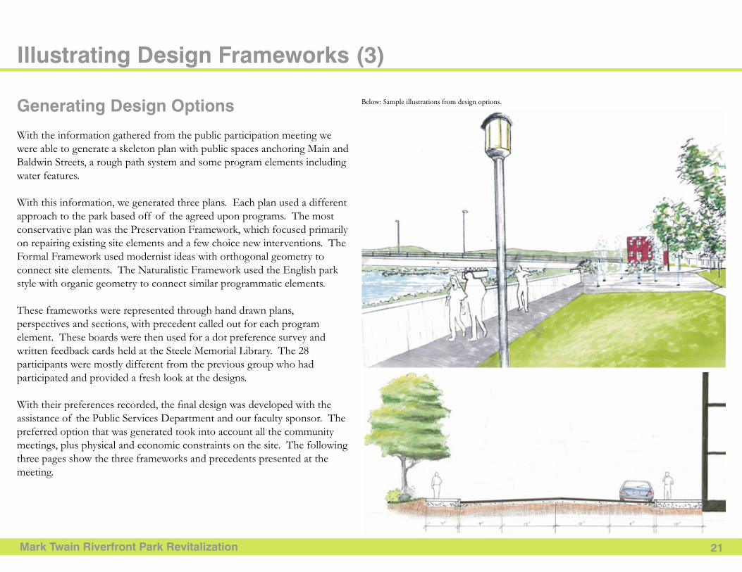
Generating Design Options
With the information gathered from the public participation meeting we were able to generate a skeleton plan with public spaces anchoring Main and Baldwin Streets, a rough path system and some program elements including water features.
With this information, we generated three plans. Each plan used a different approach to the park based off of the agreed upon programs. The most conservative plan was the Preservation Framework, which focused primarily on repairing existing site elements and a few choice new interventions. The Formal Framework used modernist ideas with orthogonal geometry to connect site elements. The Naturalistic Framework used the English park style with organic geometry to connect similar programmatic elements.
These frameworks were represented through hand drawn plans, perspectives and sections, with precedent called out for each program element. These boards were then used for a dot preference survey and written feedback cards held at the Steele Memorial Library. The 28 participants were mostly different from the previous group who had participated and provided a fresh look at the designs.
With their preferences recorded, the final design was developed with the assistance of the Public Services Department and our faculty sponsor. The preferred option that was generated took into account all the community meetings, plus physical and economic constraints on the site. The following three pages show the three frameworks and precedents presented at the meeting.
Below: Sample illustrations from design options.
Mark Twain Riverfront Park Revitalization 22
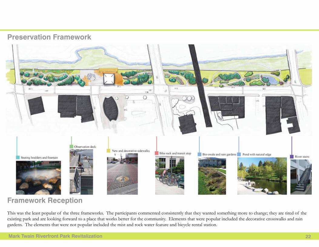
Preservation Framework
Framework Reception
This was the least popular of the three frameworks. The participants commented consistently that they wanted something more to change; they are tired of the existing park and are looking forward to a place that works better for the community. Elements that were popular included the decorative crosswalks and rain gardens. The elements that were not popular included the mist and rock water feature and bicycle rental station.
Mark Twain Riverfront Park Revitalization 23
Formal Framework
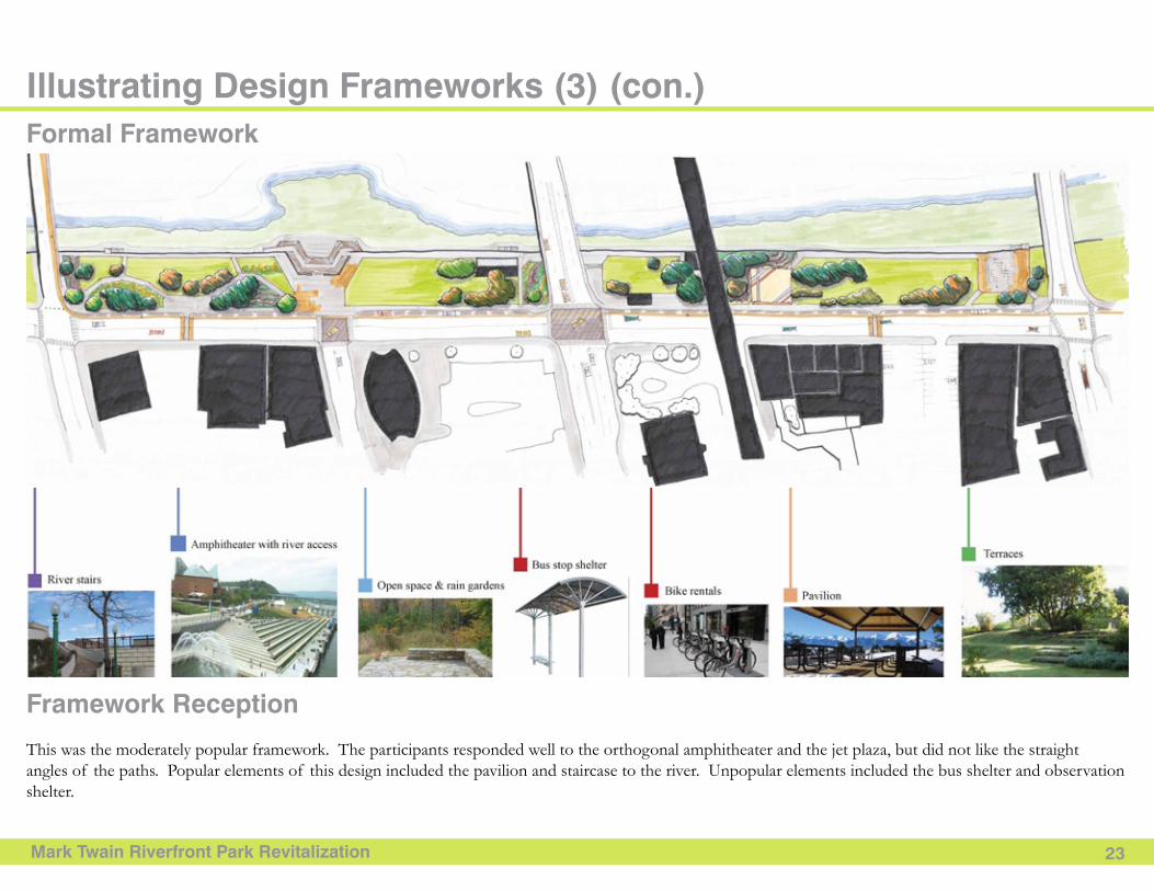
Framework Reception
This was the moderately popular framework. The participants responded well to the orthogonal amphitheater and the jet plaza, but did not like the straight angles of the paths. Popular elements of this design included the pavilion and staircase to the river. Unpopular elements included the bus shelter and observation shelter.
Illustrating Design Frameworks (3) (con.)
Mark Twain Riverfront Park Revitalization 24
Naturalistic Framework
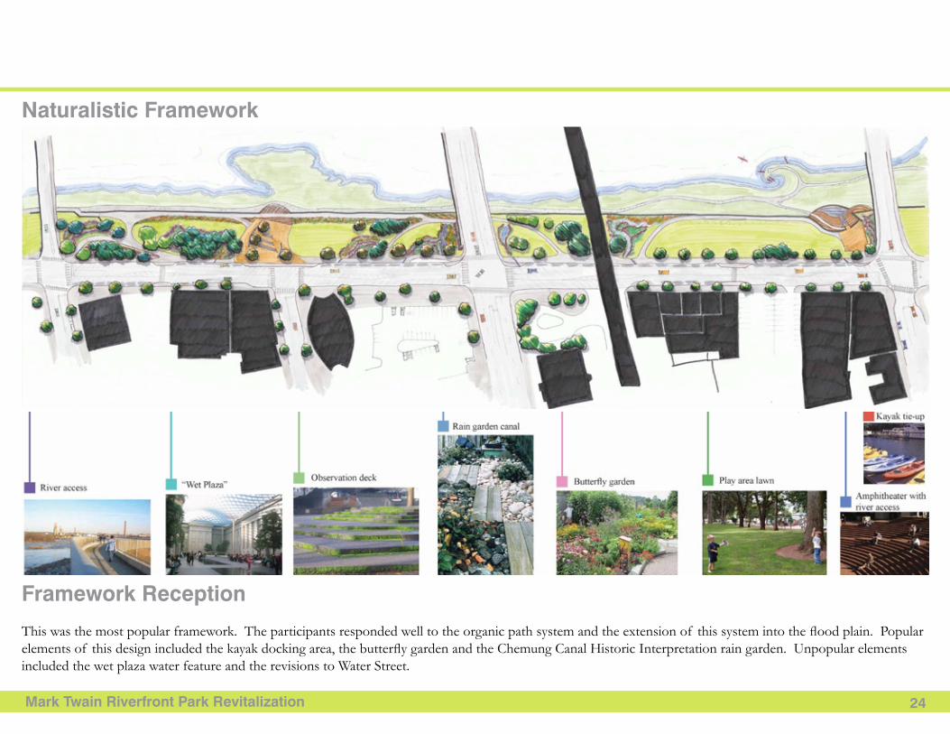
Framework Reception
This was the most popular framework. The participants responded well to the organic path system and the extension of this system into the flood plain. Popular elements of this design included the kayak docking area, the butterfly garden and the Chemung Canal Historic Interpretation rain garden. Unpopular elements included the wet plaza water feature and the revisions to Water Street.
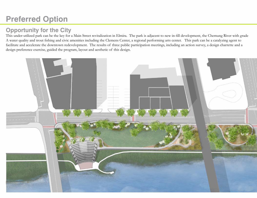
Preferred OptionOpportunity for the CityThis under-utilized park can be the key for a Main Street revitalization in Elmira. The park is adjacent to new in-fill development, the Chemung River with grade A water quality and trout fishing and civic amenities including the Clemens Center, a regional performing arts center. This park can be a catalyzing agent to facilitate and accelerate the downtown redevelopment. The results of three public participation meetings, including an action survey, a design charrette and a design preference exercise, guided the program, layout and aesthetic of this design.
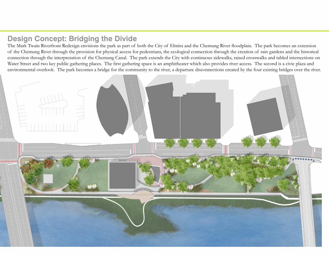
Design Concept: Bridging the DivideThe Mark Twain Riverfront Redesign envisions the park as part of both the City of Elmira and the Chemung River floodplain. The park becomes an extension of the Chemung River through the provision for physical access for pedestrians, the ecological connection through the creation of rain gardens and the historical connection through the interpretation of the Chemung Canal. The park extends the City with continuous sidewalks, raised crosswalks and tabled intersections on Water Street and two key public gathering places. The first gathering space is an amphitheater which also provides river access. The second is a civic plaza and environmental overlook. The park becomes a bridge for the community to the river, a departure disconnections created by the four existing bridges over the river.

SCHEMATIC DESIGN PHASE
Mark Twain Riverfront Park Revitalization 28
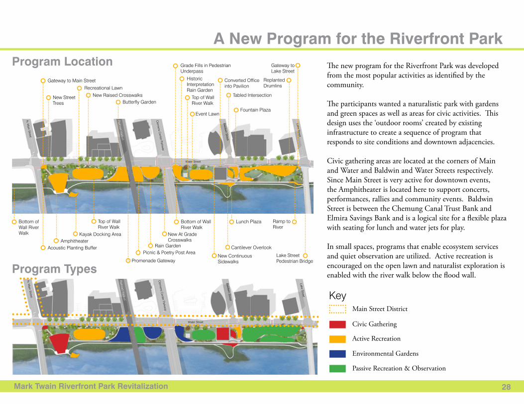
A New Program for the Riverfront Park
Program Types
Program Location
Lake Street Pedestrian Bridge
Water Street
Baldw
in Street
Lake Street
Clem
ens Center Parkw
ay
Railroad Viaduct
N. M
ain Street
Acoustic Planting Buffer
Gateway to Main Street
Picnic & Poetry Post Area
Amphitheater Rain Garden
Kayak Docking Area New At Grade Crosswalks
Cantilever Overlook
New Continuous SidewalksPromenade Gateway
Recreational Lawn
Event Lawn
Grade Fills in Pedestrian Underpass
Historic Interpretation Rain Garden
New Raised Crosswalks Tabled Intersection
Converted Office into Pavilion
Gateway to Lake Street
Replanted Drumlins
Butterfly GardenTop of Wall River Walk
New Street Trees
Fountain Plaza
Top of Wall River Walk
Bottom of Wall River Walk
Bottom of Wall River Walk
Lunch Plaza Ramp to River
The new program for the Riverfront Park was developed from the most popular activities as identified by the community.
The participants wanted a naturalistic park with gardens and green spaces as well as areas for civic activities. This design uses the ‘outdoor rooms’ created by existing infrastructure to create a sequence of program that responds to site conditions and downtown adjacencies.
Civic gathering areas are located at the corners of Main and Water and Baldwin and Water Streets respectively. Since Main Street is very active for downtown events, the Amphitheater is located here to support concerts, performances, rallies and community events. Baldwin Street is between the Chemung Canal Trust Bank and Elmira Savings Bank and is a logical site for a flexible plaza with seating for lunch and water jets for play.
In small spaces, programs that enable ecosystem services and quiet observation are utilized. Active recreation is encouraged on the open lawn and naturalist exploration is enabled with the river walk below the flood wall.
Water Street
Baldw
in Street
Lake Street
Clem
ens Center Parkw
ay
Railroad Viaduct
N. M
ain Street KeyMain Street District
Civic Gathering
Active Recreation
Environmental Gardens
Passive Recreation & Observation
Mark Twain Riverfront Park Revitalization 29
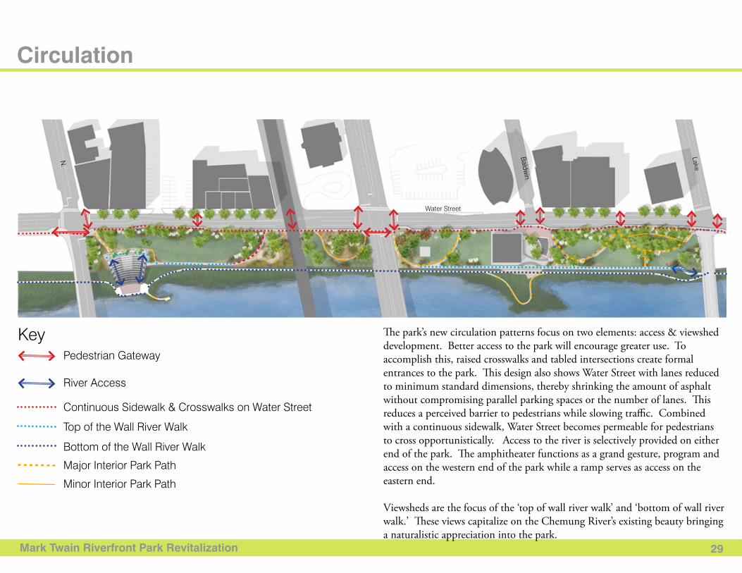
Circulation
Water StreetB
aldwin
Lake
N.
KeyPedestrian Gateway
River Access
Continuous Sidewalk & Crosswalks on Water Street
Top of the Wall River Walk
Bottom of the Wall River Walk
Major Interior Park Path
Minor Interior Park Path
The park’s new circulation patterns focus on two elements: access & viewshed development. Better access to the park will encourage greater use. To accomplish this, raised crosswalks and tabled intersections create formal entrances to the park. This design also shows Water Street with lanes reduced to minimum standard dimensions, thereby shrinking the amount of asphalt without compromising parallel parking spaces or the number of lanes. This reduces a perceived barrier to pedestrians while slowing traffic. Combined with a continuous sidewalk, Water Street becomes permeable for pedestrians to cross opportunistically. Access to the river is selectively provided on either end of the park. The amphitheater functions as a grand gesture, program and access on the western end of the park while a ramp serves as access on the eastern end.
Viewsheds are the focus of the ‘top of wall river walk’ and ‘bottom of wall river walk.’ These views capitalize on the Chemung River’s existing beauty bringing a naturalistic appreciation into the park.
Mark Twain Riverfront Park Revitalization 30
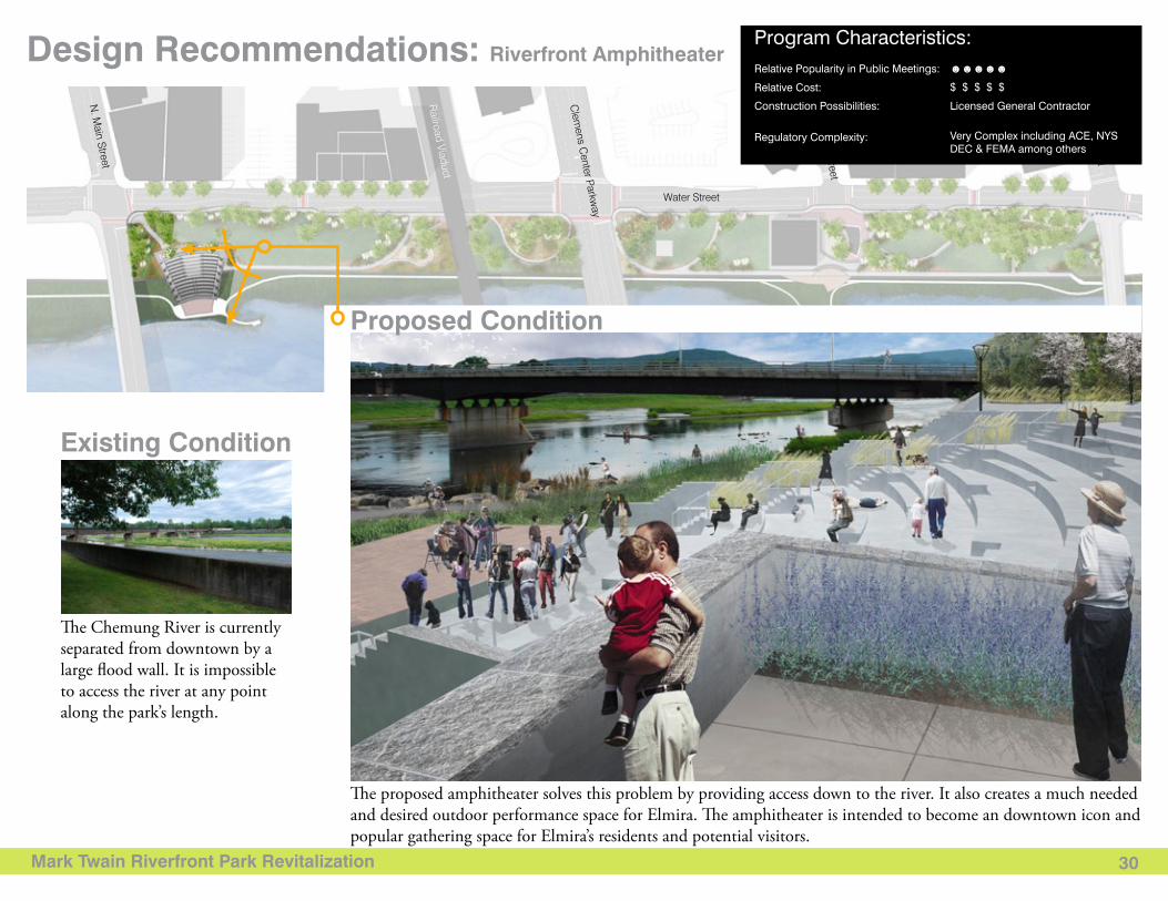
Design Recommendations: Riverfront Amphitheater
Existing Condition
Proposed Condition
The proposed amphitheater solves this problem by providing access down to the river. It also creates a much needed and desired outdoor performance space for Elmira. The amphitheater is intended to become an downtown icon and popular gathering space for Elmira’s residents and potential visitors.
The Chemung River is currently separated from downtown by a large flood wall. It is impossible to access the river at any point along the park’s length.
Water Street
Baldw
in Street
Lake Street
Clem
ens Center Parkw
ay
Railroad Viaduct
N. M
ain Street
Program Characteristics: Relative Popularity in Public Meetings: ☻☻☻☻☻
$ $ $ $ $
Licensed General Contractor
Very Complex including ACE, NYS DEC & FEMA among others
Relative Cost:
Construction Possibilities:
Regulatory Complexity:
Mark Twain Riverfront Park Revitalization
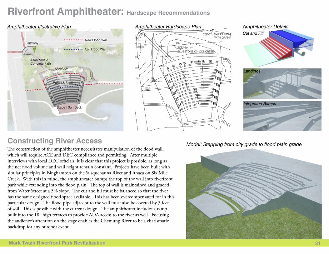
Amphitheater DetailsCut and Fill
Landings
Integrated Ramps
31
Riverfront Amphitheater: Hardscape Recommendations
Constructing River AccessThe construction of the amphitheater necessitates manipulation of the flood wall, which will require ACE and DEC compliance and permitting. After multiple interviews with local DEC officials, it is clear that this project is possible, as long as the net flood volume and wall height remain constant. Projects have been built with similar principles in Binghamton on the Susquehanna River and Ithaca on Six Mile Creek. With this in mind, the amphitheater bumps the top of the wall into riverfront park while extending into the flood plain. The top of wall is maintained and graded from Water Street at a 5% slope. The cut and fill must be balanced so that the river has the same designed flood space available. This has been overcompensated for in this particular design. The flood pipe adjacent to the wall must also be covered by 3 feet of soil. This is possible with the current design. The amphitheater includes a ramp built into the 18” high terraces to provide ADA access to the river as well. Focusing the audience’s attention on the stage enables the Chemung River to be a charismatic backdrop for any outdoor event.
Amphitheater Hardscape Plan
Model: Stepping from city grade to flood plain grade
Amphitheater Illustrative Plan
Gateway New Flood Wall
Old Flood Wall
Bluestone on Concrete Path
Overlook
Ramp & Seating
Stage / Sun Deck
Mark Twain Riverfront Park Revitalization 32
Riverfront Amphitheater: Planting Recommendations
Selected Plant List
Amphitheater Technical Plant Layout
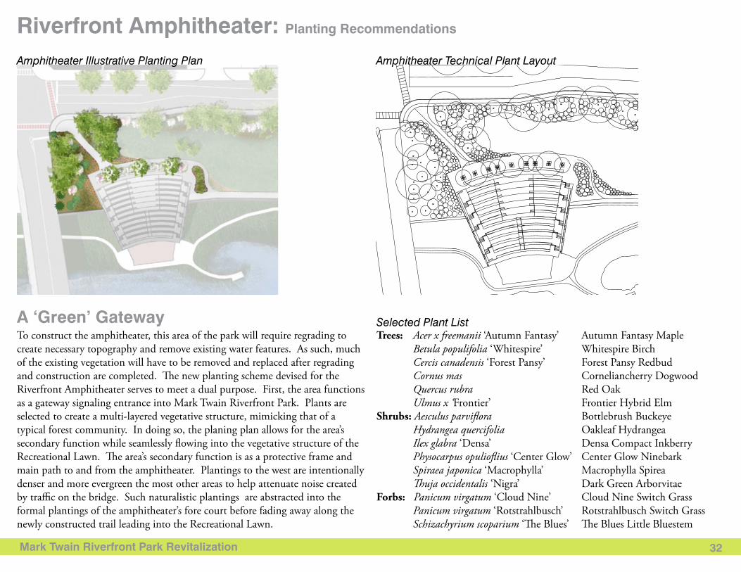
A ‘Green’ Gateway To construct the amphitheater, this area of the park will require regrading to create necessary topography and remove existing water features. As such, much of the existing vegetation will have to be removed and replaced after regrading and construction are completed. The new planting scheme devised for the Riverfront Amphitheater serves to meet a dual purpose. First, the area functions as a gateway signaling entrance into Mark Twain Riverfront Park. Plants are selected to create a multi-layered vegetative structure, mimicking that of a typical forest community. In doing so, the planing plan allows for the area’s secondary function while seamlessly flowing into the vegetative structure of the Recreational Lawn. The area’s secondary function is as a protective frame and main path to and from the amphitheater. Plantings to the west are intentionally denser and more evergreen the most other areas to help attenuate noise created by traffic on the bridge. Such naturalistic plantings are abstracted into the formal plantings of the amphitheater’s fore court before fading away along the newly constructed trail leading into the Recreational Lawn.
Trees: Acer x freemanii ‘Autumn Fantasy’ Autumn Fantasy Maple Betula populifolia ‘Whitespire’ Whitespire Birch Cercis canadensis ‘Forest Pansy’ Forest Pansy Redbud Cornus mas Corneliancherry Dogwood Quercus rubra Red Oak Ulmus x ‘Frontier’ Frontier Hybrid ElmShrubs: Aesculus parviflora Bottlebrush Buckeye Hydrangea quercifolia Oakleaf Hydrangea Ilex glabra ‘Densa’ Densa Compact Inkberry Physocarpus opulioflius ‘Center Glow’ Center Glow Ninebark Spiraea japonica ‘Macrophylla’ Macrophylla Spirea Thuja occidentalis ‘Nigra’ Dark Green Arborvitae Forbs: Panicum virgatum ‘Cloud Nine’ Cloud Nine Switch Grass Panicum virgatum ‘Rotstrahlbusch’ Rotstrahlbusch Switch Grass Schizachyrium scoparium ‘The Blues’ The Blues Little Bluestem
Amphitheater Illustrative Planting Plan
Mark Twain Riverfront Park Revitalization 33
Water Street
Baldw
in Street
Lake Street
Clem
ens Center Parkw
ay
Railroad Viaduct
N. M
ain Street
Existing Condition
Proposed Condition
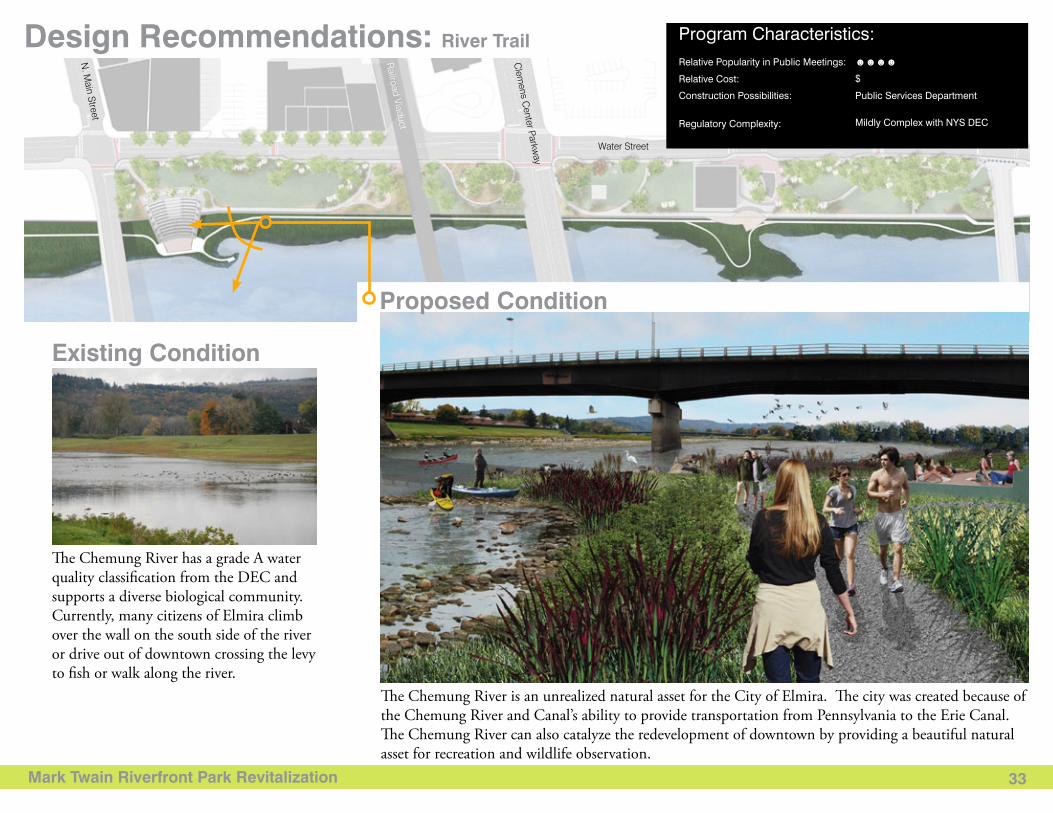
The Chemung River is an unrealized natural asset for the City of Elmira. The city was created because of the Chemung River and Canal’s ability to provide transportation from Pennsylvania to the Erie Canal. The Chemung River can also catalyze the redevelopment of downtown by providing a beautiful natural asset for recreation and wildlife observation.
The Chemung River has a grade A water quality classification from the DEC and supports a diverse biological community. Currently, many citizens of Elmira climb over the wall on the south side of the river or drive out of downtown crossing the levy to fish or walk along the river.
Design Recommendations: River Trail Program Characteristics: Relative Popularity in Public Meetings: ☻☻☻☻
$
Public Services Department
Mildly Complex with NYS DEC
Relative Cost:
Construction Possibilities:
Regulatory Complexity:
Mark Twain Riverfront Park Revitalization 34
Program Characteristics: River Trail: Hardscape Recommendations
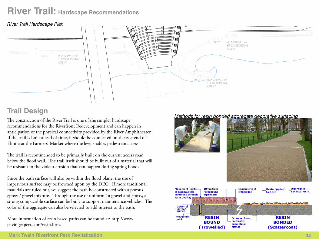
The construction of the River Trail is one of the simpler hardscape recommendations for the Riverfront Redevelopment and can happen in anticipation of the physical connectivity provided by the River Amphitheater. If the trail is built ahead of time, it should be connected on the east end of Elmira at the Farmers’ Market where the levy enables pedestrian access.
The trail is recommended to be primarily built on the current access road below the flood wall. The trail itself should be built out of a material that will be resistant to the violent erosion that can happen during spring floods.
Since the path surface will also be within the flood plane, the use of impervious surface may be frowned upon by the DEC. If more traditional materials are ruled out, we suggest the path be constructed with a porous epoxy / gravel mixture. Through the use of uniform 1a gravel and epoxy, a strong compactible surface can be built to support maintenance vehicles. The color of the aggregate can also be selected to add interest to the path.
More information of resin based paths can be found at: http://www.pavingexpert.com/resin.htm.
Trail Design
River Trail Hardscape Plan
Methods for resin bonded aggregate decorative surfacing
Mark Twain Riverfront Park Revitalization 35
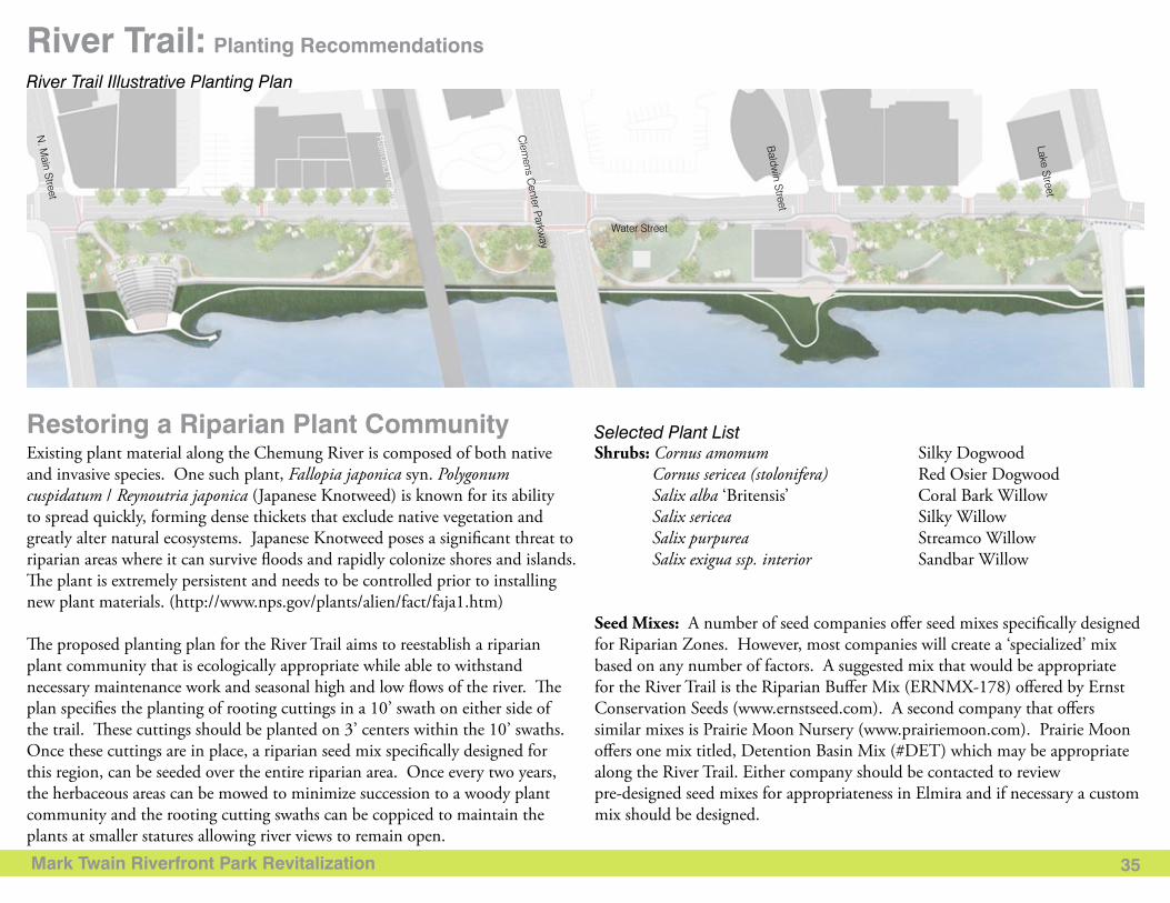
River Trail: Planting Recommendations
Water Street
Baldw
in Street
Lake Street
Clem
ens Center Parkw
ay
Railroad Viaduct
N. M
ain Street
Selected Plant ListRestoring a Riparian Plant CommunityExisting plant material along the Chemung River is composed of both native and invasive species. One such plant, Fallopia japonica syn. Polygonum cuspidatum / Reynoutria japonica (Japanese Knotweed) is known for its ability to spread quickly, forming dense thickets that exclude native vegetation and greatly alter natural ecosystems. Japanese Knotweed poses a significant threat to riparian areas where it can survive floods and rapidly colonize shores and islands. The plant is extremely persistent and needs to be controlled prior to installing new plant materials. (http://www.nps.gov/plants/alien/fact/faja1.htm)
The proposed planting plan for the River Trail aims to reestablish a riparian plant community that is ecologically appropriate while able to withstand necessary maintenance work and seasonal high and low flows of the river. The plan specifies the planting of rooting cuttings in a 10’ swath on either side of the trail. These cuttings should be planted on 3’ centers within the 10’ swaths. Once these cuttings are in place, a riparian seed mix specifically designed for this region, can be seeded over the entire riparian area. Once every two years, the herbaceous areas can be mowed to minimize succession to a woody plant community and the rooting cutting swaths can be coppiced to maintain the plants at smaller statures allowing river views to remain open.
Shrubs: Cornus amomum Silky Dogwood Cornus sericea (stolonifera) Red Osier Dogwood Salix alba ‘Britensis’ Coral Bark Willow Salix sericea Silky Willow Salix purpurea Streamco Willow Salix exigua ssp. interior Sandbar Willow
Seed Mixes: A number of seed companies offer seed mixes specifically designed for Riparian Zones. However, most companies will create a ‘specialized’ mix based on any number of factors. A suggested mix that would be appropriate for the River Trail is the Riparian Buffer Mix (ERNMX-178) offered by Ernst Conservation Seeds (www.ernstseed.com). A second company that offers similar mixes is Prairie Moon Nursery (www.prairiemoon.com). Prairie Moon offers one mix titled, Detention Basin Mix (#DET) which may be appropriate along the River Trail. Either company should be contacted to review pre-designed seed mixes for appropriateness in Elmira and if necessary a custom mix should be designed.
River Trail Illustrative Planting Plan
Mark Twain Riverfront Park Revitalization 36
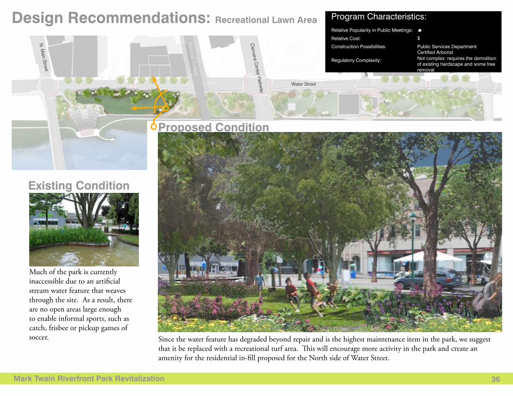
Design Recommendations: Recreational Lawn Area
Existing Condition
Proposed Condition
Since the water feature has degraded beyond repair and is the highest maintenance item in the park, we suggest that it be replaced with a recreational turf area. This will encourage more activity in the park and create an amenity for the residential in-fill proposed for the North side of Water Street.
Much of the park is currently inaccessible due to an artificial stream water feature that weaves through the site. As a result, there are no open areas large enough to enable informal sports, such as catch, frisbee or pickup games of soccer.
Water Street
Baldw
in Street
Lake Street
Clem
ens Center Parkw
ay
Railroad Viaduct
N. M
ain Street
Program Characteristics: Relative Popularity in Public Meetings: ☻
$
Public Services DepartmentCertified ArboristNot complex: requires the demolition of existing hardscape and some tree removal
Relative Cost:
Construction Possibilities:
Regulatory Complexity:
Mark Twain Riverfront Park Revitalization 37
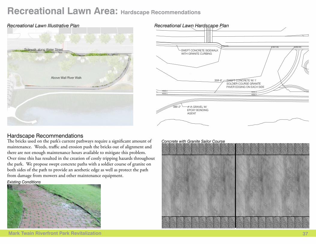
Recreational Lawn Area: Hardscape Recommendations
The bricks used on the park’s current pathways require a significant amount of maintenance. Weeds, traffic and erosion push the bricks out of alignment and there are not enough maintenance hours available to mitigate this problem. Over time this has resulted in the creation of costly tripping hazards throughout the park. We propose swept concrete paths with a soldier course of granite on both sides of the path to provide an aesthetic edge as well as protect the path from damage from mowers and other maintenance equipment.
Hardscape RecommendationsConcrete with Granite Sailor Course
Sidewalk along Water Street
Above Wall River Walk
Recreational Lawn Illustrative Plan Recreational Lawn Hardscape Plan
Existing Conditions
Mark Twain Riverfront Park Revitalization 38
Recreational Lawn Area: Planting Recommendations
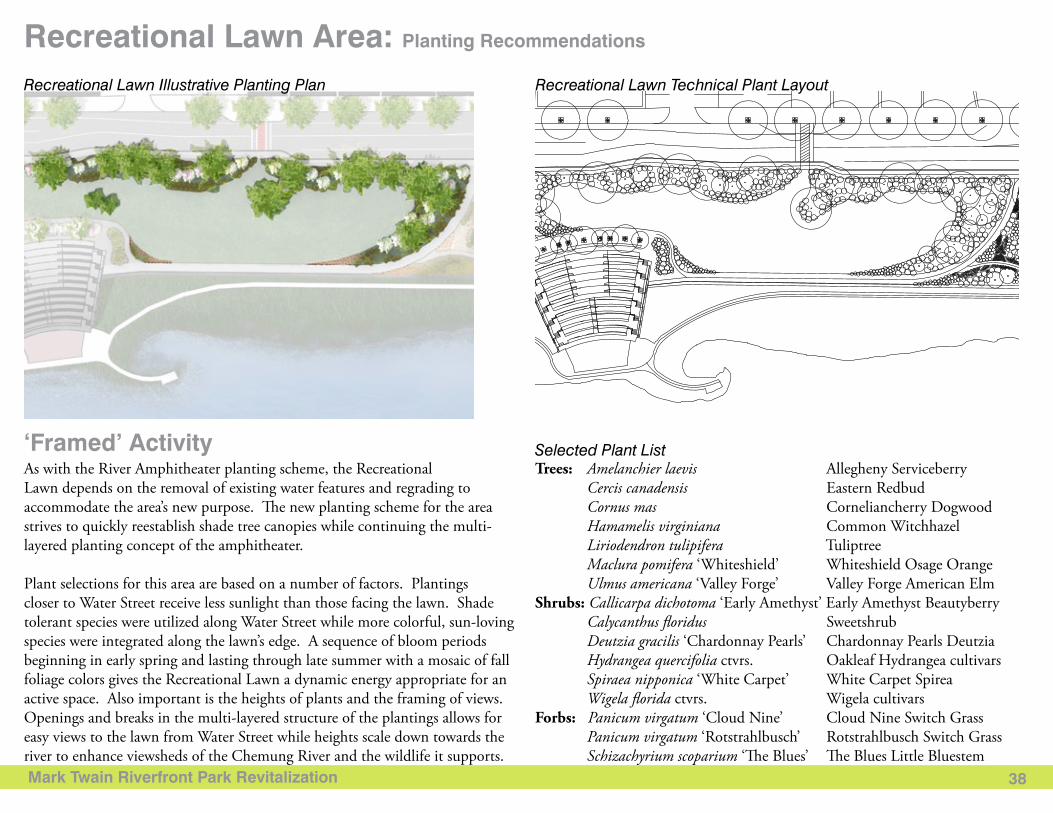
Selected Plant List‘Framed’ Activity As with the River Amphitheater planting scheme, the Recreational Lawn depends on the removal of existing water features and regrading to accommodate the area’s new purpose. The new planting scheme for the area strives to quickly reestablish shade tree canopies while continuing the multi-layered planting concept of the amphitheater.
Plant selections for this area are based on a number of factors. Plantings closer to Water Street receive less sunlight than those facing the lawn. Shade tolerant species were utilized along Water Street while more colorful, sun-loving species were integrated along the lawn’s edge. A sequence of bloom periods beginning in early spring and lasting through late summer with a mosaic of fall foliage colors gives the Recreational Lawn a dynamic energy appropriate for an active space. Also important is the heights of plants and the framing of views. Openings and breaks in the multi-layered structure of the plantings allows for easy views to the lawn from Water Street while heights scale down towards the river to enhance viewsheds of the Chemung River and the wildlife it supports.
Trees: Amelanchier laevis Allegheny Serviceberry Cercis canadensis Eastern Redbud Cornus mas Corneliancherry Dogwood Hamamelis virginiana Common Witchhazel Liriodendron tulipifera Tuliptree Maclura pomifera ‘Whiteshield’ Whiteshield Osage Orange Ulmus americana ‘Valley Forge’ Valley Forge American ElmShrubs: Callicarpa dichotoma ‘Early Amethyst’ Early Amethyst Beautyberry Calycanthus floridus Sweetshrub Deutzia gracilis ‘Chardonnay Pearls’ Chardonnay Pearls Deutzia Hydrangea quercifolia ctvrs. Oakleaf Hydrangea cultivars Spiraea nipponica ‘White Carpet’ White Carpet Spirea Wigela florida ctvrs. Wigela cultivarsForbs: Panicum virgatum ‘Cloud Nine’ Cloud Nine Switch Grass Panicum virgatum ‘Rotstrahlbusch’ Rotstrahlbusch Switch Grass Schizachyrium scoparium ‘The Blues’ The Blues Little Bluestem
Recreational Lawn Illustrative Planting Plan Recreational Lawn Technical Plant Layout
Mark Twain Riverfront Park Revitalization 39
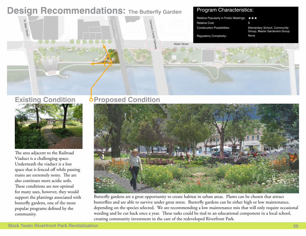
Design Recommendations: The Butterfly Garden
Proposed Condition
Butterfly gardens are a great opportunity to create habitat in urban areas. Plants can be chosen that attract butterflies and are able to survive under great stress. Butterfly gardens can be either high or low maintenance, depending on the species selected. We are recommending a low maintenance mix that will only require occasional weeding and be cut back once a year. These tasks could be tied to an educational component in a local school, creating community investment in the care of the redeveloped Riverfront Park.
Existing Condition
The area adjacent to the Railroad Viaduct is a challenging space. Underneath the viaduct is a lost space that is fenced off while passing trains are extremely noisy. The are also continues more acidic soils. These conditions are not optimal for many uses, however, they would support the plantings associated with butterfly gardens, one of the more popular programs defined by the community.
Water Street
Baldw
in Street
Lake Street
Clem
ens Center Parkw
ay
Railroad Viaduct
N. M
ain Street
Program Characteristics: Relative Popularity in Public Meetings: ☻☻☻
$
Elementary School, Community Group, Master Gardeners Group
None
Relative Cost:
Construction Possibilities:
Regulatory Complexity:
Mark Twain Riverfront Park Revitalization 40
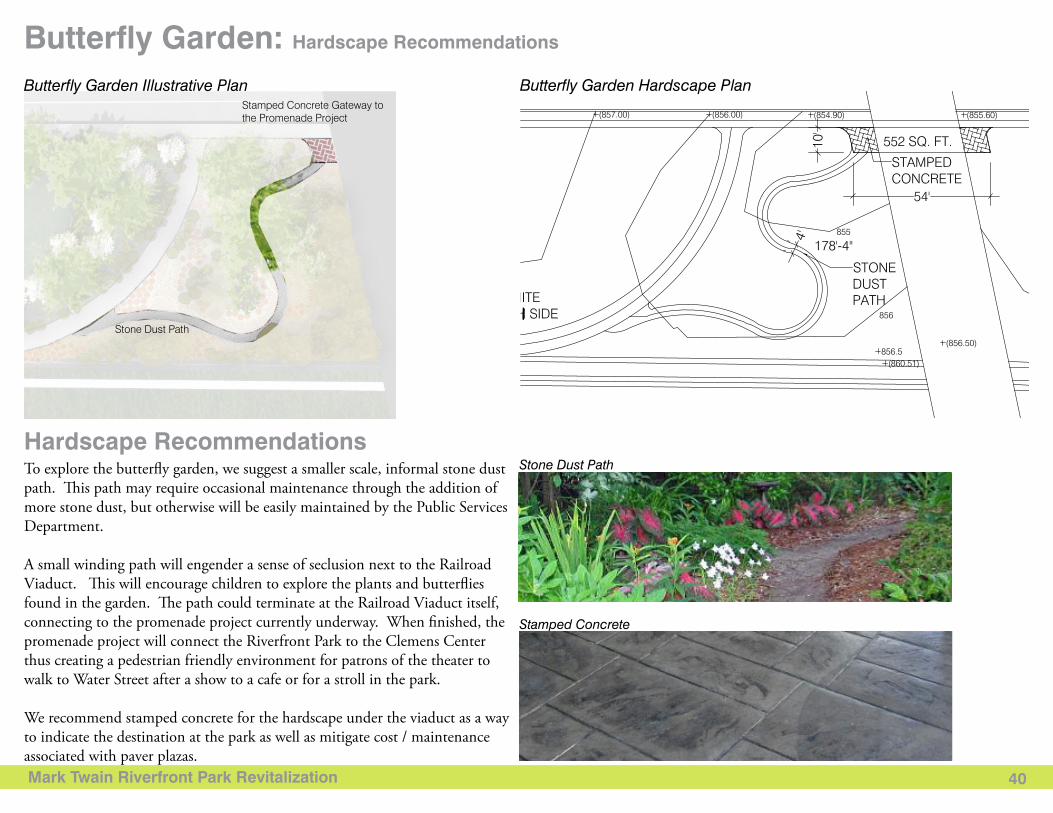
Program Characteristics: Butterfly Garden: Hardscape Recommendations
To explore the butterfly garden, we suggest a smaller scale, informal stone dust path. This path may require occasional maintenance through the addition of more stone dust, but otherwise will be easily maintained by the Public Services Department.
A small winding path will engender a sense of seclusion next to the Railroad Viaduct. This will encourage children to explore the plants and butterflies found in the garden. The path could terminate at the Railroad Viaduct itself, connecting to the promenade project currently underway. When finished, the promenade project will connect the Riverfront Park to the Clemens Center thus creating a pedestrian friendly environment for patrons of the theater to walk to Water Street after a show to a cafe or for a stroll in the park.
We recommend stamped concrete for the hardscape under the viaduct as a way to indicate the destination at the park as well as mitigate cost / maintenance associated with paver plazas.
Hardscape RecommendationsStone Dust Path
Stamped Concrete
Stone Dust Path
Stamped Concrete Gateway to the Promenade Project
Butterfly Garden Illustrative Plan Butterfly Garden Hardscape Plan
Mark Twain Riverfront Park Revitalization 41
Butterfly Garden: Planting Recommendations
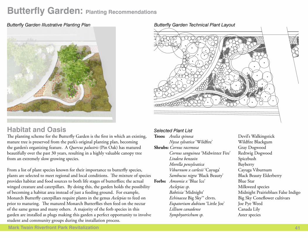
Selected Plant ListHabitat and OasisThe planting scheme for the Butterfly Garden is the first in which an existing, mature tree is preserved from the park’s original planting plan, becoming the garden’s organizing feature. A Quercus palustris (Pin Oak) has matured beautifully over the past 30 years, resulting in a highly valuable canopy tree from an extremely slow growing species.
From a list of plant species known for their importance to butterfly species, plants are selected to meet regional and local conditions. The mixture of species provides habitat and food sources to both life stages of butterflies; the actual winged creature and caterpillars. By doing this, the garden holds the possibility of becoming a habitat area instead of just a feeding ground. For example, Monarch Butterfly caterpillars require plants in the genus Asclepias to feed on prior to maturing. The matured Monarch Butterflies then feed on the nectar of the same genus and many others. A majority of the forb species in this garden are installed as plugs making this garden a perfect opportunity to involve student and community groups during the installation process.
Trees: Aralia spinosa Devil’s Walkingstick Nyssa sylvatica ‘Wildfire’ Wildfire BlackgumShrubs: Cornus racemosa Gray Dogwood Cornus sanguinea ‘Midwinter Fire’ Redtwig Dogwood Lindera benzoin Spicebush Morella pensylvatica Bayberry Viburnum x carlesii ‘Cayuga’ Cayuga Viburnum Sambucus nigra ‘Black Beauty’ Black Beauty Elderberry Forbs: Amsonia x ‘Blue Ice’ Blue Star Asclepias sp. Milkweed species Babtisia ‘Midnight’ Midnight Prairieblues False Indigo Echinacea Big Sky™ cltvrs. Big Sky Coneflower cultivars Eupatorium dubium ‘Little Joe’ Joe Pye Weed Lillium canadense Canada Lily Symphyotrichum sp. Aster species
Butterfly Garden Illustrative Planting Plan Butterfly Garden Technical Plant Layout
Mark Twain Riverfront Park Revitalization 42
Design Recommendations: Rain & Poetry Garden
Existing Proposed Condition
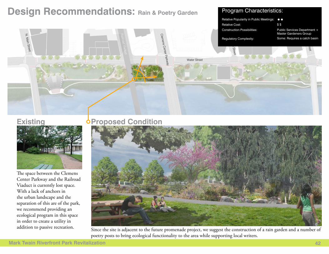
Since the site is adjacent to the future promenade project, we suggest the construction of a rain garden and a number of poetry posts to bring ecological functionality to the area while supporting local writers.
The space between the Clemens Center Parkway and the Railroad Viaduct is currently lost space. With a lack of anchors in the urban landscape and the separation of this are of the park, we recommend providing an ecological program in this space in order to create a utility in addition to passive recreation.
Water Street
Baldw
in Street
Lake Street
Clem
ens Center Parkw
ay
Railroad Viaduct
N. M
ain Street
Program Characteristics: Relative Popularity in Public Meetings: ☻☻
$ $
Public Services Department +Master Gardeners Group
Some: Requires a catch basin
Relative Cost:
Construction Possibilities:
Regulatory Complexity:
Mark Twain Riverfront Park Revitalization 43
Rain & Poetry Garden: Hardscape Recommendations
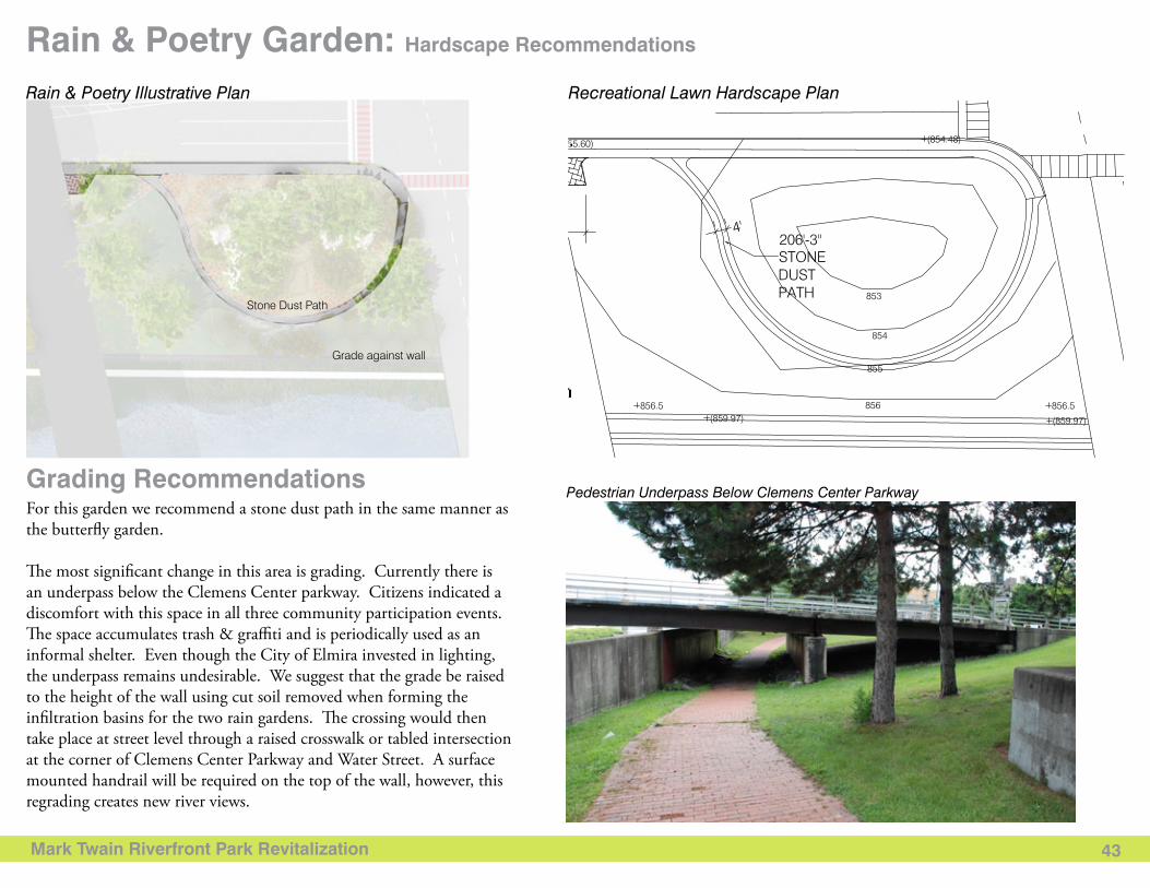
For this garden we recommend a stone dust path in the same manner as the butterfly garden.
The most significant change in this area is grading. Currently there is an underpass below the Clemens Center parkway. Citizens indicated a discomfort with this space in all three community participation events. The space accumulates trash & graffiti and is periodically used as an informal shelter. Even though the City of Elmira invested in lighting, the underpass remains undesirable. We suggest that the grade be raised to the height of the wall using cut soil removed when forming the infiltration basins for the two rain gardens. The crossing would then take place at street level through a raised crosswalk or tabled intersection at the corner of Clemens Center Parkway and Water Street. A surface mounted handrail will be required on the top of the wall, however, this regrading creates new river views.
Grading RecommendationsPedestrian Underpass Below Clemens Center Parkway
Stone Dust Path
Grade against wall
Rain & Poetry Illustrative Plan Recreational Lawn Hardscape Plan
Mark Twain Riverfront Park Revitalization 44
Rain & Poetry Garden: Planting Recommendations
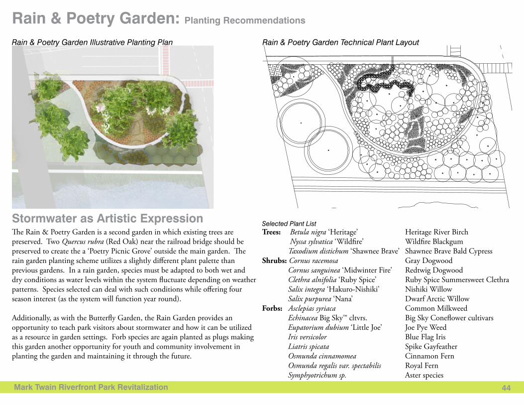
Selected Plant ListStormwater as Artistic ExpressionThe Rain & Poetry Garden is a second garden in which existing trees are preserved. Two Quercus rubra (Red Oak) near the railroad bridge should be preserved to create the a ‘Poetry Picnic Grove’ outside the main garden. The rain garden planting scheme utilizes a slightly different plant palette than previous gardens. In a rain garden, species must be adapted to both wet and dry conditions as water levels within the system fluctuate depending on weather patterns. Species selected can deal with such conditions while offering four season interest (as the system will function year round).
Additionally, as with the Butterfly Garden, the Rain Garden provides an opportunity to teach park visitors about stormwater and how it can be utilized as a resource in garden settings. Forb species are again planted as plugs making this garden another opportunity for youth and community involvement in planting the garden and maintaining it through the future.
Trees: Betula nigra ‘Heritage’ Heritage River Birch Nyssa sylvatica ‘Wildfire’ Wildfire Blackgum Taxodium distichum ‘Shawnee Brave’ Shawnee Brave Bald CypressShrubs: Cornus racemosa Gray Dogwood Cornus sanguinea ‘Midwinter Fire’ Redtwig Dogwood Clethra alnifolia ‘Ruby Spice’ Ruby Spice Summersweet Clethra Salix integra ‘Hakuro-Nishiki’ Nishiki Willow Salix purpurea ‘Nana’ Dwarf Arctic Willow Forbs: Asclepias syriaca Common Milkweed Echinacea Big Sky™ cltvrs. Big Sky Coneflower cultivars Eupatorium dubium ‘Little Joe’ Joe Pye Weed Iris versicolor Blue Flag Iris Liatris spicata Spike Gayfeather Osmunda cinnamomea Cinnamon Fern Osmunda regalis var. spectabilis Royal Fern Symphyotrichum sp. Aster species
Rain & Poetry Garden Illustrative Planting Plan Rain & Poetry Garden Technical Plant Layout
Mark Twain Riverfront Park Revitalization 45
Design Recommendations: Rain Garden & Picnic Area
Existing Condition
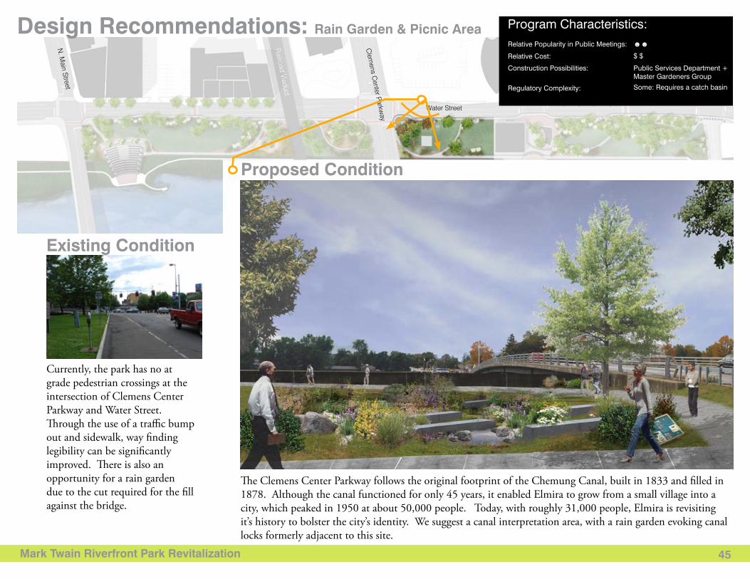
Proposed Condition
The Clemens Center Parkway follows the original footprint of the Chemung Canal, built in 1833 and filled in 1878. Although the canal functioned for only 45 years, it enabled Elmira to grow from a small village into a city, which peaked in 1950 at about 50,000 people. Today, with roughly 31,000 people, Elmira is revisiting it’s history to bolster the city’s identity. We suggest a canal interpretation area, with a rain garden evoking canal locks formerly adjacent to this site.
Currently, the park has no at grade pedestrian crossings at the intersection of Clemens Center Parkway and Water Street. Through the use of a traffic bump out and sidewalk, way finding legibility can be significantly improved. There is also an opportunity for a rain garden due to the cut required for the fill against the bridge.
Water Street
Baldw
in Street
Lake Street
Clem
ens Center Parkw
ay
Railroad Viaduct
N. M
ain Street
Program Characteristics: Relative Popularity in Public Meetings: ☻☻
$ $
Public Services Department +Master Gardeners Group
Some: Requires a catch basin
Relative Cost:
Construction Possibilities:
Regulatory Complexity:
Mark Twain Riverfront Park Revitalization 46
Program Characteristics: Rain Garden & Picnic Area: Hardscape Recommendations
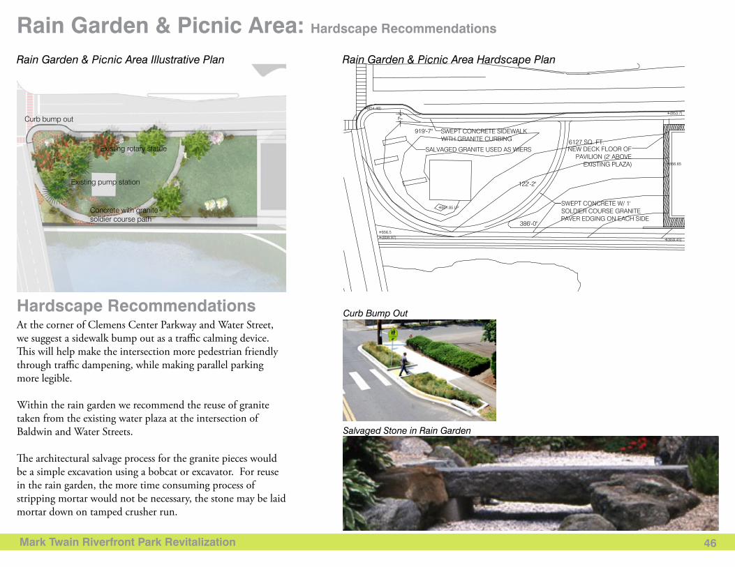
At the corner of Clemens Center Parkway and Water Street, we suggest a sidewalk bump out as a traffic calming device. This will help make the intersection more pedestrian friendly through traffic dampening, while making parallel parking more legible.
Within the rain garden we recommend the reuse of granite taken from the existing water plaza at the intersection of Baldwin and Water Streets.
The architectural salvage process for the granite pieces would be a simple excavation using a bobcat or excavator. For reuse in the rain garden, the more time consuming process of stripping mortar would not be necessary, the stone may be laid mortar down on tamped crusher run.
Hardscape Recommendations Curb Bump Out
Salvaged Stone in Rain Garden
Concrete with granite soldier course path
Curb bump out
Existing rotary statue
Existing pump station
Rain Garden & Picnic Area Illustrative Plan Rain Garden & Picnic Area Hardscape Plan
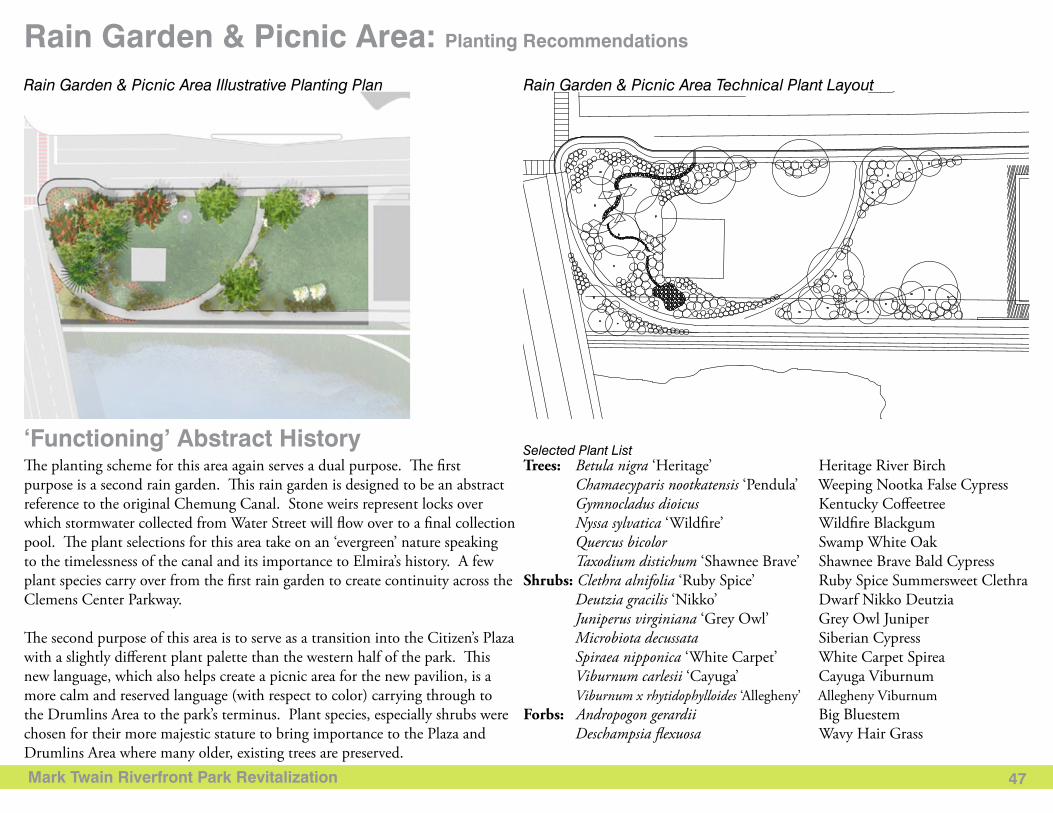
Mark Twain Riverfront Park Revitalization 47
Rain Garden & Picnic Area: Planting Recommendations
Selected Plant List‘Functioning’ Abstract HistoryThe planting scheme for this area again serves a dual purpose. The first purpose is a second rain garden. This rain garden is designed to be an abstract reference to the original Chemung Canal. Stone weirs represent locks over which stormwater collected from Water Street will flow over to a final collection pool. The plant selections for this area take on an ‘evergreen’ nature speaking to the timelessness of the canal and its importance to Elmira’s history. A few plant species carry over from the first rain garden to create continuity across the Clemens Center Parkway.
The second purpose of this area is to serve as a transition into the Citizen’s Plaza with a slightly different plant palette than the western half of the park. This new language, which also helps create a picnic area for the new pavilion, is a more calm and reserved language (with respect to color) carrying through to the Drumlins Area to the park’s terminus. Plant species, especially shrubs were chosen for their more majestic stature to bring importance to the Plaza and Drumlins Area where many older, existing trees are preserved.
Trees: Betula nigra ‘Heritage’ Heritage River Birch Chamaecyparis nootkatensis ‘Pendula’ Weeping Nootka False Cypress Gymnocladus dioicus Kentucky Coffeetree Nyssa sylvatica ‘Wildfire’ Wildfire Blackgum Quercus bicolor Swamp White Oak Taxodium distichum ‘Shawnee Brave’ Shawnee Brave Bald CypressShrubs: Clethra alnifolia ‘Ruby Spice’ Ruby Spice Summersweet Clethra Deutzia gracilis ‘Nikko’ Dwarf Nikko Deutzia Juniperus virginiana ‘Grey Owl’ Grey Owl Juniper Microbiota decussata Siberian Cypress Spiraea nipponica ‘White Carpet’ White Carpet Spirea Viburnum carlesii ‘Cayuga’ Cayuga Viburnum Viburnum x rhytidophylloides ‘Allegheny’ Allegheny ViburnumForbs: Andropogon gerardii Big Bluestem Deschampsia flexuosa Wavy Hair Grass
Rain Garden & Picnic Area Illustrative Planting Plan Rain Garden & Picnic Area Technical Plant Layout
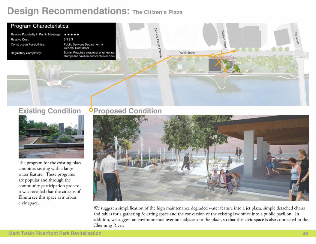
Mark Twain Riverfront Park Revitalization 48
We suggest a simplification of the high maintenance degraded water feature into a jet plaza, simple detached chairs and tables for a gathering & eating space and the conversion of the existing law office into a public pavilion. In addition, we suggest an environmental overlook adjacent to the plaza, so that this civic space is also connected to the Chemung River.
Design Recommendations: The Citizen’s Plaza
Water Street
Baldw
in Street
Lake Street
Clem
ens Center Parkw
ay
Railroad Viaduct
N. M
ain Street
Existing Condition Proposed Condition
The program for the existing plaza combines seating with a large water feature. These programs are popular and through the community participation process it was revealed that the citizens of Elmira see this space as a urban, civic space.
Program Characteristics: Relative Popularity in Public Meetings: ☻☻☻☻☻
$ $ $ $
Public Services Department +General Contractor
Some: Requires structural engineering stamps for pavilion and cantilever deck
Relative Cost:
Construction Possibilities:
Regulatory Complexity:

Mark Twain Riverfront Park Revitalization 49
The Citizen’s Plaza: Pavilion
The existing private commercial building at the intersection of Baldwin and Water Streets presents a unique challenge and opportunity. The building’s current configuration creates a barrier between two areas of the park, both physically and visually. Yet, the building’s unique construction provides an exciting opportunity for adaptive reuse as a public pavilion. The building is of simple post and beam construction with a tongue and groove wood ceiling and no exterior or interior load bearing walls. By simply removing the outside walls, the building can be converted to a beautiful open pavilion. This opportunity makes the purchase of the building serve multiple purposes. Not only is a significant barrier removed from the park, but a beautiful new gathering space is gained.
Refurbishment RecommendationsReconnecting the Plaza to the Park
Reuse of Office StructurePavilion Illustrative Plan Pavilion Hardscape Plan
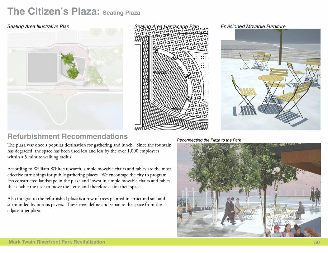
Mark Twain Riverfront Park Revitalization 50
Envisioned Movable Furniture
The Citizen’s Plaza: Seating Plaza
The plaza was once a popular destination for gathering and lunch. Since the fountain has degraded, the space has been used less and less by the over 1,000 employees within a 5 minute walking radius.
According to William White’s research, simple movable chairs and tables are the most effective furnishings for public gathering places. We encourage the city to program less constructed landscape in the plaza and invest in simple movable chairs and tables that enable the user to move the items and therefore claim their space.
Also integral to the refurbished plaza is a row of trees planted in structural soil and surrounded by porous pavers. These trees define and separate the space from the adjacent jet plaza.
Refurbishment RecommendationsReconnecting the Plaza to the Park
Seating Area Illustrative Plan Seating Area Hardscape Plan
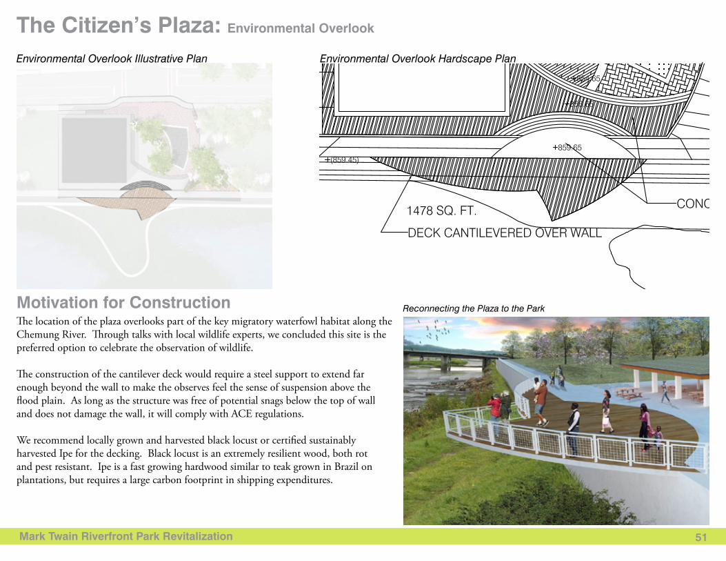
Mark Twain Riverfront Park Revitalization 51
The Citizen’s Plaza: Environmental Overlook
The location of the plaza overlooks part of the key migratory waterfowl habitat along the Chemung River. Through talks with local wildlife experts, we concluded this site is the preferred option to celebrate the observation of wildlife.
The construction of the cantilever deck would require a steel support to extend far enough beyond the wall to make the observes feel the sense of suspension above the flood plain. As long as the structure was free of potential snags below the top of wall and does not damage the wall, it will comply with ACE regulations.
We recommend locally grown and harvested black locust or certified sustainably harvested Ipe for the decking. Black locust is an extremely resilient wood, both rot and pest resistant. Ipe is a fast growing hardwood similar to teak grown in Brazil on plantations, but requires a large carbon footprint in shipping expenditures.
Motivation for Construction Reconnecting the Plaza to the Park
Environmental Overlook Illustrative Plan Environmental Overlook Hardscape Plan
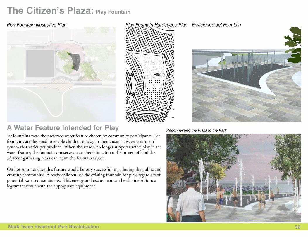
Mark Twain Riverfront Park Revitalization 52
The Citizen’s Plaza: Play Fountain
Jet fountains were the preferred water feature chosen by community participants. Jet fountains are designed to enable children to play in them, using a water treatment system that varies per product. When the season no longer supports active play in the water feature, the fountain can serve an aesthetic function or be turned off and the adjacent gathering plaza can claim the fountain’s space.
On hot summer days this feature would be very successful in gathering the public and creating community. Already children use the existing fountain for play, regardless of potential water contaminants. This energy and excitement can be channeled into a legitimate venue with the appropriate equipment.
A Water Feature Intended for Play Reconnecting the Plaza to the Park
Envisioned Jet FountainPlay Fountain Illustrative Plan Play Fountain Hardscape Plan
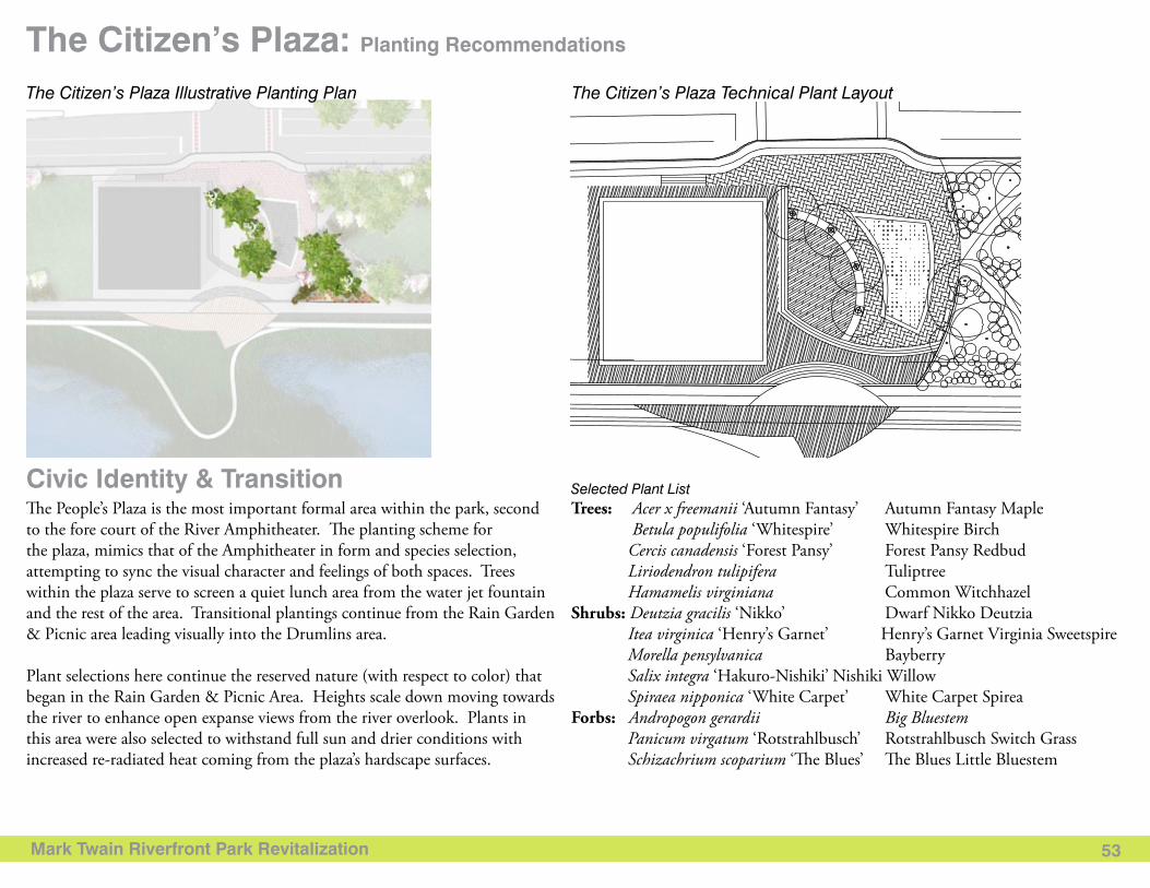
Mark Twain Riverfront Park Revitalization 53
The Citizen’s Plaza: Planting Recommendations
Selected Plant ListCivic Identity & Transition The People’s Plaza is the most important formal area within the park, second to the fore court of the River Amphitheater. The planting scheme for the plaza, mimics that of the Amphitheater in form and species selection, attempting to sync the visual character and feelings of both spaces. Trees within the plaza serve to screen a quiet lunch area from the water jet fountain and the rest of the area. Transitional plantings continue from the Rain Garden & Picnic area leading visually into the Drumlins area.
Plant selections here continue the reserved nature (with respect to color) that began in the Rain Garden & Picnic Area. Heights scale down moving towards the river to enhance open expanse views from the river overlook. Plants in this area were also selected to withstand full sun and drier conditions with increased re-radiated heat coming from the plaza’s hardscape surfaces.
Trees: Acer x freemanii ‘Autumn Fantasy’ Autumn Fantasy Maple Betula populifolia ‘Whitespire’ Whitespire Birch Cercis canadensis ‘Forest Pansy’ Forest Pansy Redbud Liriodendron tulipifera Tuliptree Hamamelis virginiana Common WitchhazelShrubs: Deutzia gracilis ‘Nikko’ Dwarf Nikko Deutzia Itea virginica ‘Henry’s Garnet’ Henry’s Garnet Virginia Sweetspire Morella pensylvanica Bayberry Salix integra ‘Hakuro-Nishiki’ Nishiki Willow Spiraea nipponica ‘White Carpet’ White Carpet Spirea Forbs: Andropogon gerardii Big Bluestem Panicum virgatum ‘Rotstrahlbusch’ Rotstrahlbusch Switch Grass Schizachrium scoparium ‘The Blues’ The Blues Little Bluestem
The Citizen’s Plaza Illustrative Planting Plan The Citizen’s Plaza Technical Plant Layout
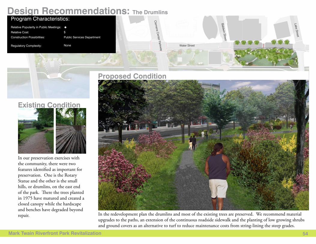
Mark Twain Riverfront Park Revitalization 54
Design Recommendations: The Drumlins
Existing Condition
Proposed Condition
In the redevelopment plan the drumlins and most of the existing trees are preserved. We recommend material upgrades to the paths, an extension of the continuous roadside sidewalk and the planting of low growing shrubs and ground covers as an alternative to turf to reduce maintenance costs from string-lining the steep grades.
In our preservation exercises with the community, there were two features identified as important for preservation. One is the Rotary Statue and the other is the small hills, or drumlins, on the east end of the park. There the trees planted in 1975 have matured and created a closed canopy while the hardscape and benches have degraded beyond repair.
Water Street
Baldw
in Street
Lake Street
Clem
ens Center Parkw
ay
Railroad Viaduct
N. M
ain Street
Program Characteristics: Relative Popularity in Public Meetings: ☻
$
Public Services Department
None
Relative Cost:
Construction Possibilities:
Regulatory Complexity:
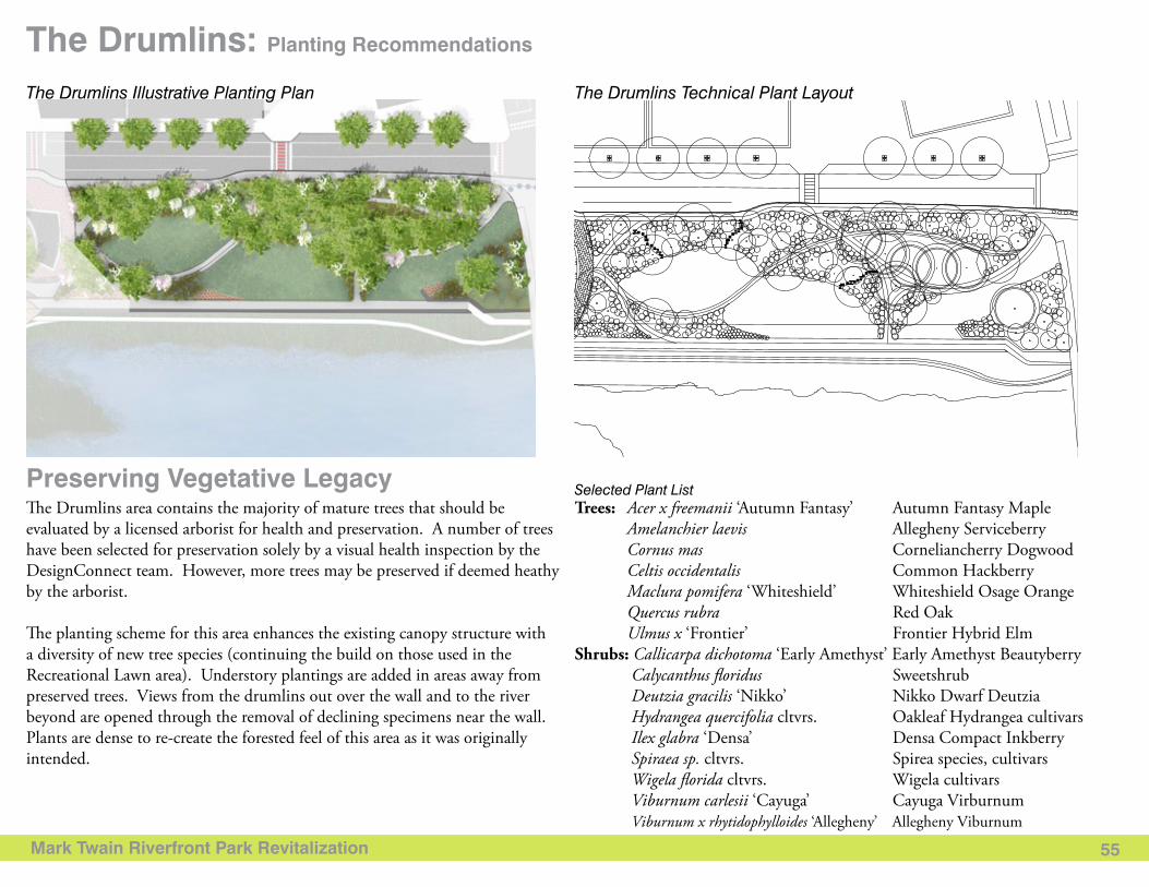
Mark Twain Riverfront Park Revitalization 55
The Drumlins: Planting Recommendations
Selected Plant ListPreserving Vegetative LegacyThe Drumlins area contains the majority of mature trees that should be evaluated by a licensed arborist for health and preservation. A number of trees have been selected for preservation solely by a visual health inspection by the DesignConnect team. However, more trees may be preserved if deemed heathy by the arborist.
The planting scheme for this area enhances the existing canopy structure with a diversity of new tree species (continuing the build on those used in the Recreational Lawn area). Understory plantings are added in areas away from preserved trees. Views from the drumlins out over the wall and to the river beyond are opened through the removal of declining specimens near the wall. Plants are dense to re-create the forested feel of this area as it was originally intended.
Trees: Acer x freemanii ‘Autumn Fantasy’ Autumn Fantasy Maple Amelanchier laevis Allegheny Serviceberry Cornus mas Corneliancherry Dogwood Celtis occidentalis Common Hackberry Maclura pomifera ‘Whiteshield’ Whiteshield Osage Orange Quercus rubra Red Oak Ulmus x ‘Frontier’ Frontier Hybrid Elm Shrubs: Callicarpa dichotoma ‘Early Amethyst’ Early Amethyst Beautyberry Calycanthus floridus Sweetshrub Deutzia gracilis ‘Nikko’ Nikko Dwarf Deutzia Hydrangea quercifolia cltvrs. Oakleaf Hydrangea cultivars Ilex glabra ‘Densa’ Densa Compact Inkberry Spiraea sp. cltvrs. Spirea species, cultivars Wigela florida cltvrs. Wigela cultivars Viburnum carlesii ‘Cayuga’ Cayuga Virburnum Viburnum x rhytidophylloides ‘Allegheny’ Allegheny Viburnum
The Drumlins Illustrative Planting Plan The Drumlins Technical Plant Layout
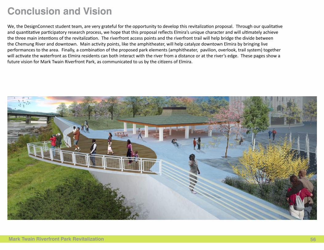
Mark Twain Riverfront Park Revitalization 56
Conclusion and VisionWe, the DesignConnect student team, are very grateful for the opportunity to develop this revitalization proposal. Through our qualitative and quantitative participatory research process, we hope that this proposal reflects Elmira’s unique character and will ultimately achieve the three main intentions of the revitalization. The riverfront access points and the riverfront trail will help bridge the divide between the Chemung River and downtown. Main activity points, like the amphitheater, will help catalyze downtown Elmira by bringing live performances to the area. Finally, a combination of the proposed park elements (amphitheater, pavilion, overlook, trail system) together will activate the waterfront as Elmira residents can both interact with the river from a distance or at the river’s edge. These pages show a future vision for Mark Twain Riverfront Park, as communicated to us by the citizens of Elmira.
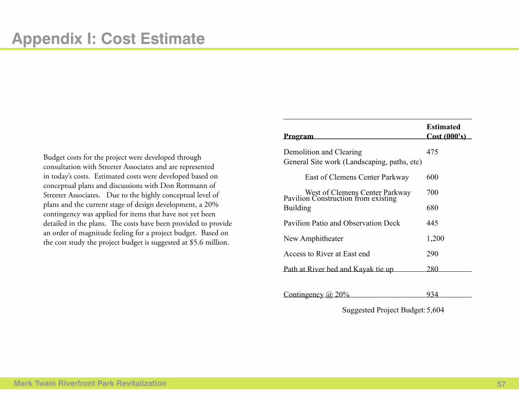
Mark Twain Riverfront Park Revitalization 57
Appendix I: Cost Estimate
Budget costs for the project were developed through consultation with Streeter Associates and are represented in today’s costs. Estimated costs were developed based on conceptual plans and discussions with Don Rottmann of Streeter Associates. Due to the highly conceptual level of plans and the current stage of design development, a 20% contingency was applied for items that have not yet been detailed in the plans. The costs have been provided to provide an order of magnitude feeling for a project budget. Based on the cost study the project budget is suggested at $5.6 million.
ProgramEstimated Cost (000's)
Demolition and Clearing 475
General Site work (Landscaping, paths, etc)
East of Clemens Center Parkway 600
West of Clemens Center Parkway 700
Pavilion Construction from existing Building
680
Pavilion Patio and Observation Deck 445
New Amphitheater 1,200
Access to River at East end 290
Path at River bed and Kayak tie up 280
Contingency @ 20% 934
Suggested Project Budget: 5,604
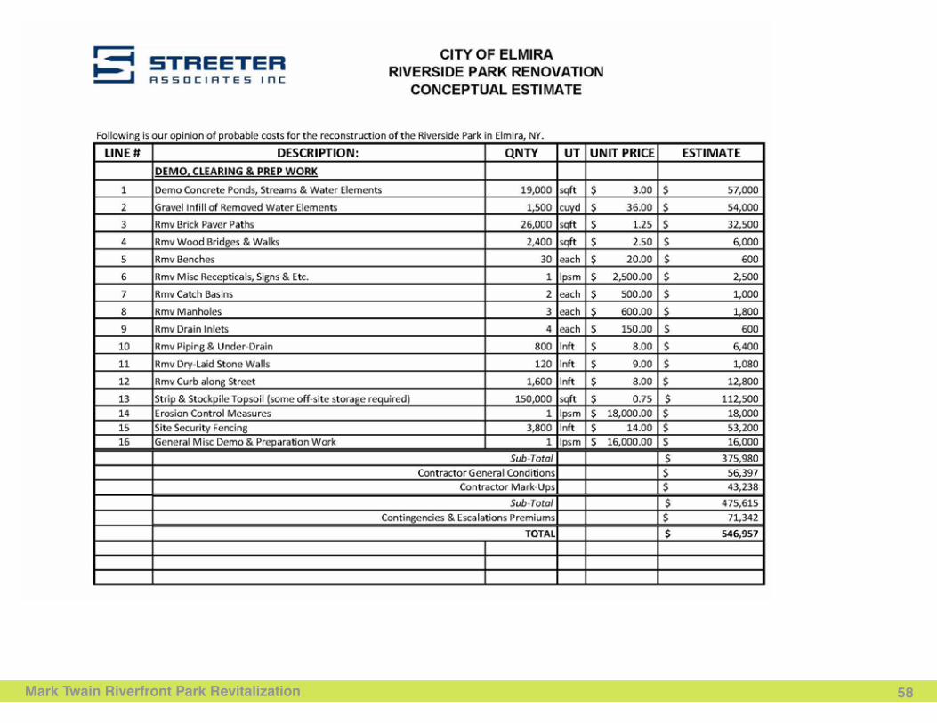
Mark Twain Riverfront Park Revitalization 58
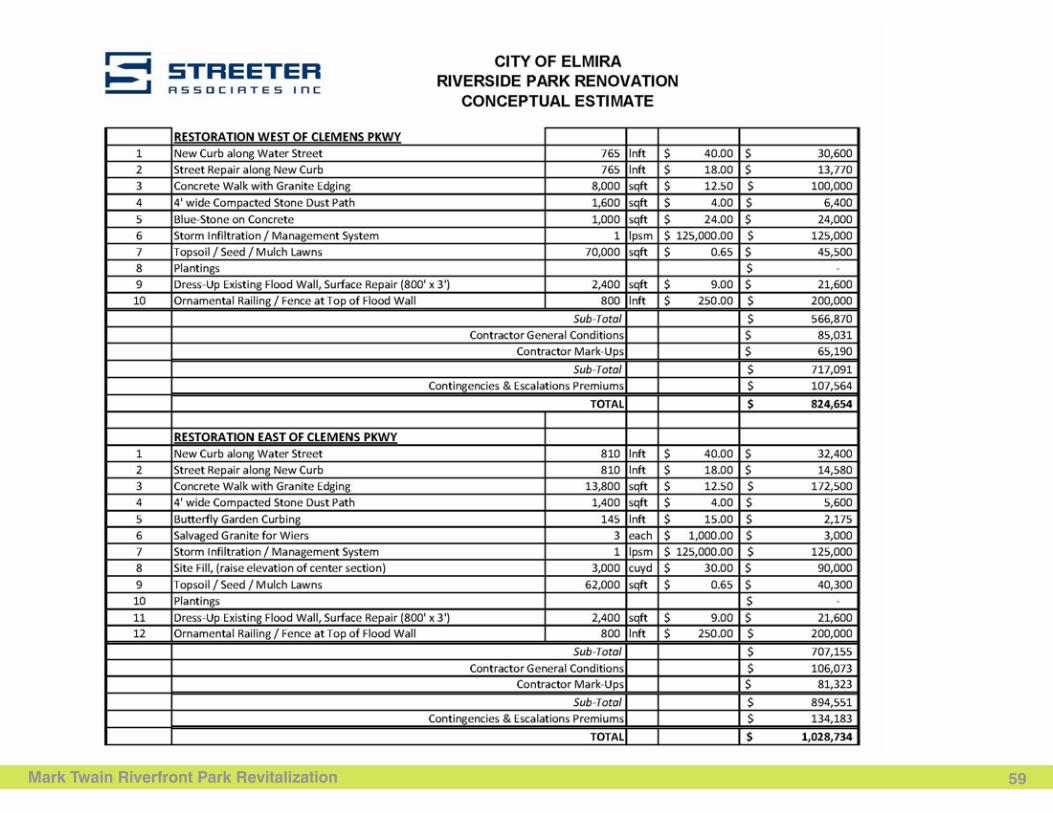
Text
(Heading)
Mark Twain Riverfront Park Revitalization 59
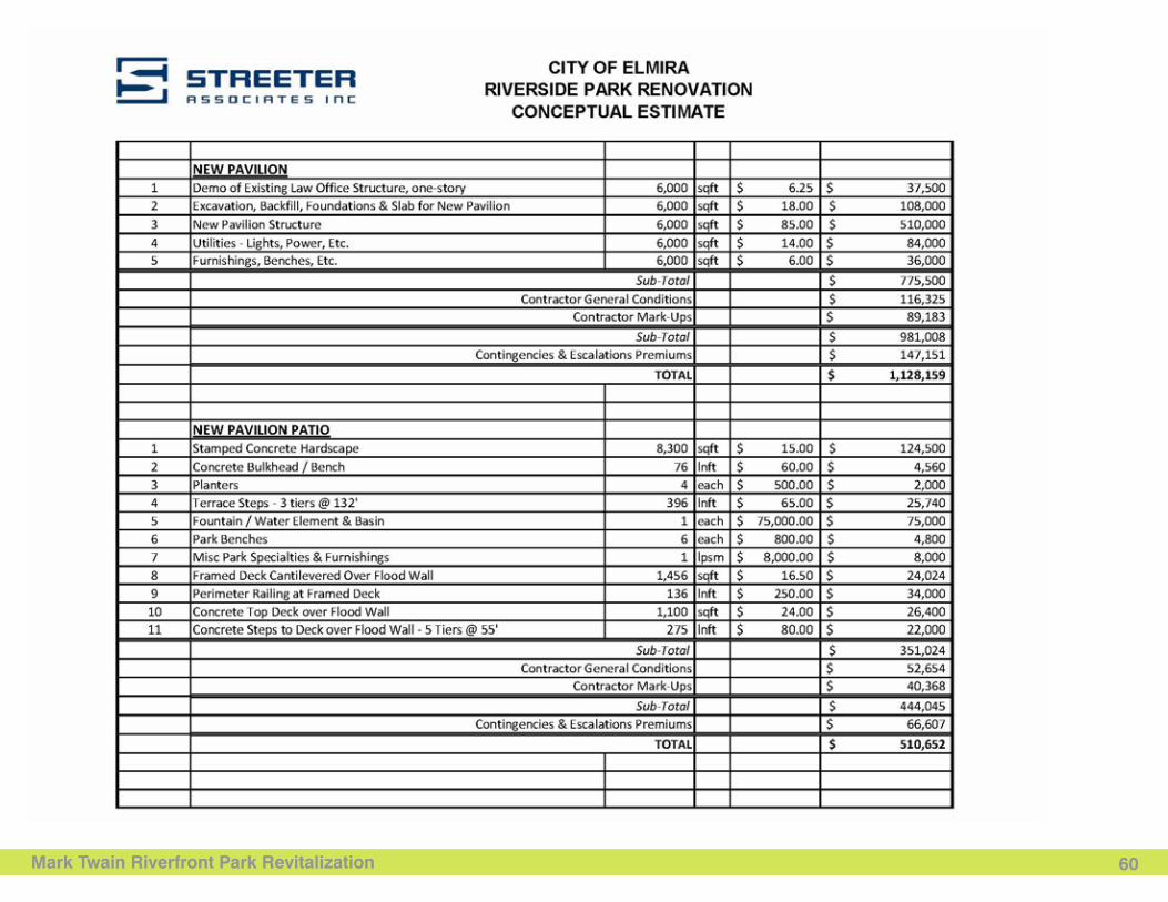
Mark Twain Riverfront Park Revitalization
Text
60
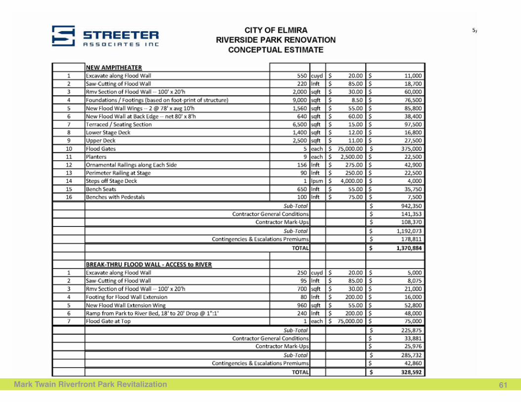
Text
(Heading)
Mark Twain Riverfront Park Revitalization 61
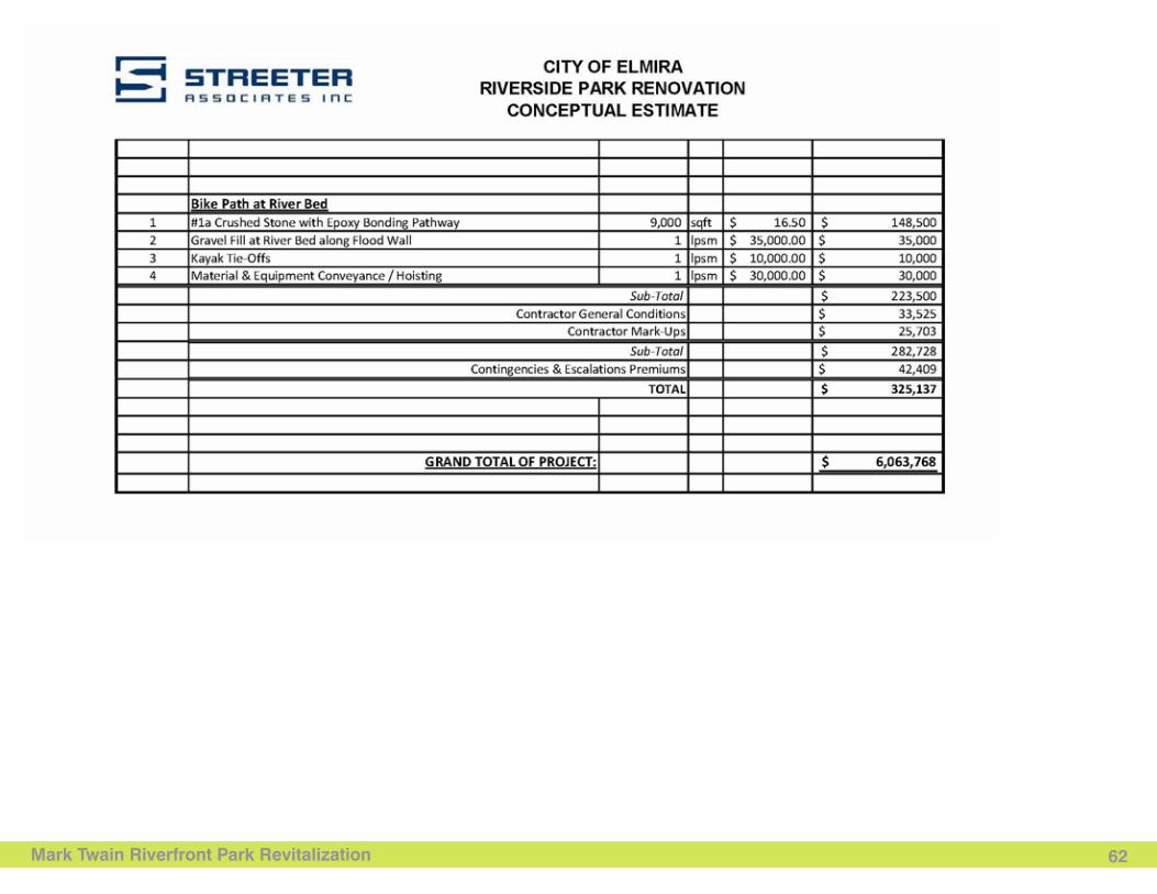
Mark Twain Riverfront Park Revitalization
Text
62
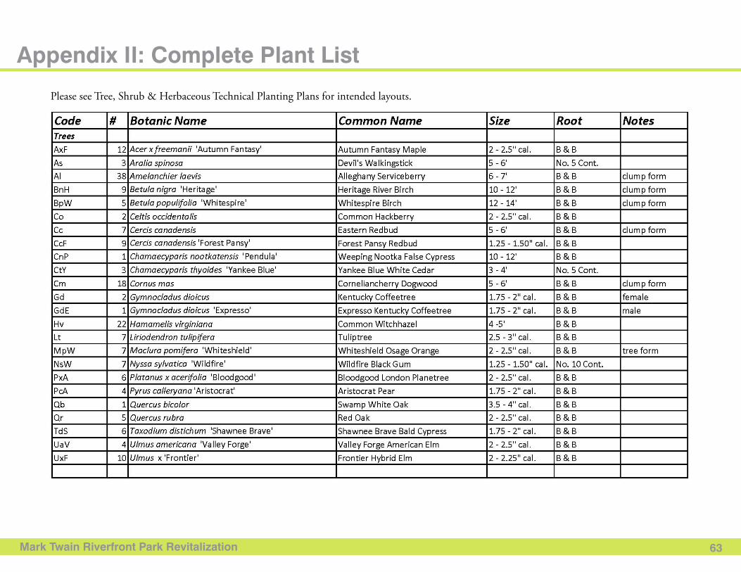
Mark Twain Riverfront Park Revitalization 63
Appendix II: Complete Plant List
Please see Tree, Shrub & Herbaceous Technical Planting Plans for intended layouts.
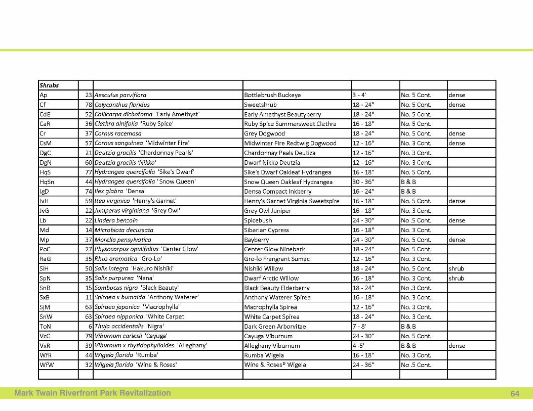
Mark Twain Riverfront Park Revitalization 64
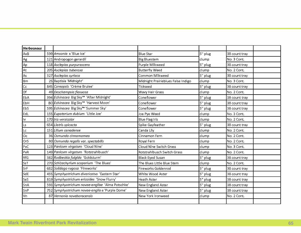
Mark Twain Riverfront Park Revitalization 65
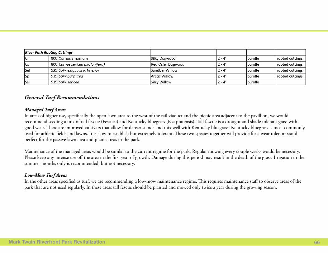
Mark Twain Riverfront Park Revitalization 66
General Turf Recommendations
Managed Turf AreasIn areas of higher use, specifically the open lawn area to the west of the rail viaduct and the picnic area adjacent to the pavillion, we would recommend seeding a mix of tall fescue (Festuca) and Kentucky bluegrass (Poa pratensis). Tall fescue is a drought and shade tolerant grass with good wear. There are improved cultivars that allow for denser stands and mix well with Kentucky bluegrass. Kentucky bluegrass is most commonly used for athletic fields and lawns. It is slow to establish but extremely tolerant. These two species together will provide for a wear tolerant stand perfect for the passive lawn area and picnic areas in the park.
Maintenance of the managed areas would be similar to the current regime for the park. Regular mowing every couple weeks would be necessary. Please keep any intense use off the area in the first year of growth. Damage during this period may result in the death of the grass. Irrigation in the summer months only is recommended, but not necessary.
Low-Mow Turf AreasIn the other areas specified as turf, we are recommending a low-mow maintenance regime. This requires maintenance staff to observe areas of the park that are not used regularly. In these areas tall fescue should be planted and mowed only twice a year during the growing season.