metro rural loop study partnership grant rural...4 metro rural loop study partnership grant land use...
TRANSCRIPT

4
Metro Rural Loop StudyPartnership Grant
Land Use / Economic Feasibility
Transportation
Habitat /Resource
Conservation
Ag Preservation
Regional Planning Efforts & Studies
Study Components
RegionalCooperation
MRL 12/12/07 (Page 1)

This page is left blank for printing.
MRL 12/12/07 (Page 2)
15
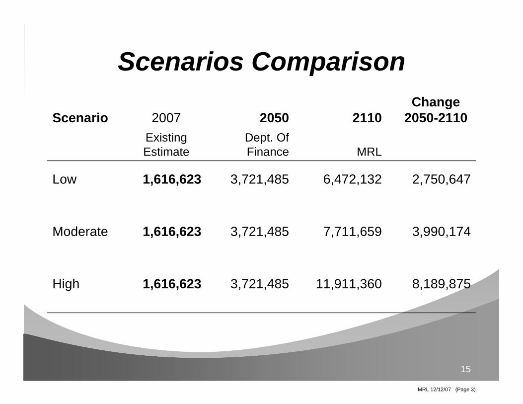
Scenarios Comparison
8,189,87511,911,3603,721,4851,616,623High
3,990,1747,711,6593,721,4851,616,623Moderate
2,750,6476,472,1323,721,4851,616,623Low
MRLDept. Of Finance
Existing Estimate
Change 2050-2110211020502007Scenario
MRL 12/12/07 (Page 3)

This page is left blank for printing.
MRL 12/12/07 (Page 4)

16
The Regional Blueprint
The form of the Fresno (Madera, Tulare & Kings) County Region envisions a system of high capacity
multi-modal transportation corridors that interconnect the metro area with the rural areas and the state.
(excerpt from Fresno COG ‘s Blueprint Vision Statement)
MRL 12/12/07 (Page 5)

This page is left blank for printing.
MRL 12/12/07 (Page 6)

Proposed High Speed Rail Alignment
Existing State Route
Conceptual State Route Alignment
Conceptual Metro Rural Loop Alternative
Existing Regional Road/Highway
Exhibit AMetro Rural Loop
Madera, Fresno, Kings & Tulare Counties
41
43
63
137
198
216
41190
99
198
99
Kings
Madera
TulareAvenal
Cutler
Woodlake
Orosi
Dinuba
Goshen
Lindsay
Pixley
Earlimart
HanfordLemoore
Chowchilla
Madera
Porterville
Tulare
Visalia
Kerman
Firebaugh
Mendota
San Joaquin
Huron
Sanger
FowlerSelma
Reedley
180180
Sierra National Forest
Sequoia National Forest
Kings Canyon National Park
M a n n i n gM a n n i n g M a n n i n g
Ac
ad
em
y
Kingsburg3333
198198
3333
198198
269269
Fresno 245245
4343
6363
N e e s
J a y n e
H a r l a n M t . Wh i t n e y
Colorado
B e lm o n t
S h i e l d s
Ru
sse
ll
McM
ulle
nD
icke
nso
n
Clo
vis
S h aw
Gra
ntl
an
d
Wil
low
Tem
pe
ran
ce
Shepherd
H e r n d o n
Bla
cks
ton
e
Be
the
lK ings Canyon
Jensen
Re
ed
Alt
o
P i ed ra
Mntn View
Clovis
168168
3333
55
55
Coalinga
145145
145145
4141
Parlier9999
180180
MRL 12/12/07 (Page 7)

This page is left blank for printing.
MRL 12/12/07 (Page 8)

Kerman
Firebaugh
Mendota
San Joaquin
Huron
Sanger
Fowler
SelmaReedley
Sierra National Forest
Sequoia National Forest
Kings Canyon National Park
M a n n i n gM a n n i n g M a n n i n g
Ac
ad
em
y3333
198198
3333
198198
269269
6363
N e e s
J a y n e
H a r l a n M t . W h it n e y
Colorado
B e l mo n t
S h i e l d s
Ru
sse
ll
McM
ulle
nD
icke
nso
n
Clo
vis
S h a wG
ran
tla
nd
Wil
low
Tem
pe
ran
ce
Shepherd
H e r n d o n
Bla
cks
ton
e
Be
the
l
K ings Canyon
Jensen
Re
ed
Alt
o
P i ed ra
Mntn View
Clovis
3333
55
Coalinga
Parlier
FresnoCounty
Oakhurst
Avenue 18 1/2
Avenue 14
Avenue 21
Avenue 17
Avenue 12
Avenue 7
Fireba
ugh
Blvd
Road 4
Road 9
Ro
ad
2
1
Rd
211
Road 2
00 Rd 2
22
Rd 225
Rd 235
Roa
d 2
23
Ro
ad
274
Rd 222
Rd 145
Road 4
00
Road
Rd 810
Road 600
Rd
800
Road 1
3
415
81
10
10
81 25
Avenue 9
Ro
ad
3
6
Rd
2
9
Rd
3
3 ½
Avenue 26
145145
145145
9999
180180180180
4141
MaderaCounty
Proposed High Speed Rail Alignment
Kingsburg
San Joaquin River
San Joaquin R
iver
Avenue 15
Chowchilla
Madera
Road
600
Ro
ad
26
Rd 426
CoarsegoldNorth Fork
Fresno
145145
99994141
145145
6565
6565
4343
4141
4949
233233152152 R
ober
tson
Existing State Route
Conceptual State Route Alignment
Conceptual Metro Rural Loop Alternative
Existing Regional Road/Highway
168168
Exhibit BMetro Rural Loop
Madera and Fresno Counties
MRL 12/12/07 (Page 9)

This page is left blank for printing.
MRL 12/12/07 (Page 10)

43
63
137
198
216
41190
99
198
KingsTulareAvenal
Cutler
Woodlake
Orosi
Dinuba
Goshen
Lindsay
Pixley
Earlimart
HanfordLemoore
Porterville
Tulare
Visalia
Kerman
Firebaugh
Mendota
San Joaquin
Huron
Sanger
FowlerSelma
Reedley
180180
Sierra National Forest
Sequoia National Forest
Kings Canyon National Park
M a n n i n gM a n n i n g M a n n i n g
Ac
ad
em
yKingsburg3333
198198
3333
198198
269269
Fresno 245245
4343
6363
N e e s
J a y n e
H a r l a n M t . Wh i t n e y
Colorado
B e lm o n t
S h i e l d s
Ru
sse
ll
McM
ulle
nD
icke
nso
n
Clo
vis
S h aw
Gra
ntl
an
d
Wil
low
Tem
pe
ran
ce
Shepherd
H e r n d o n
Bla
cks
ton
e
Be
the
l
K ings Canyon
Jensen
Re
ed
Alt
o
P i ed ra
Mntn View
Clovis
168168
3333
55
55
Coalinga
145145
145145
4141
Parlier9999
180180
Proposed High Speed Rail Alignment
Existing State Route
Conceptual State Route Alignment
Conceptual Metro Rural Loop Alternative
Existing Regional Road/Highway
Exhibit CMetro Rural Loop
Fresno, Kings & Tulare Counties
MRL 12/12/07 (Page 11)

This page is left blank for printing.
MRL 12/12/07 (Page 12)

Kerman
Firebaugh
Mendota
San Joaquin
Huron
Sanger
Fowler
SelmaReedley
Sierra National Forest
Sequoia National Forest
Kings Canyon National Park
M a n n i n gM a n n i n g M a n n i n g
Ac
ad
em
y
3333
198198
3333
198198
269269
6363
N e e s
J a y n e
H a r l a n M t . W h it n e y
Colorado
B e l mo n t
S h i e l d s
Ru
sse
ll
McM
ulle
nD
icke
nso
n
Clo
vis
S h a w
Gra
ntl
an
d
Wil
low
Tem
pe
ran
ce
Shepherd
H e r n d o n
Bla
cks
ton
e
Be
the
l
K ings Canyon
Jensen
Re
ed
Alt
o
P i ed ra
Mntn View
Clovis
3333
Coalinga
Parlier
FresnoCounty
145145
145145
9999
180180180180
4141
Proposed High Speed Rail Alignment
Kingsburg
San Joaquin River
San Joaquin R
iver
6565
4343
Existing State Route
Conceptual State Route Alignment
Conceptual Metro Rural Loop Alternative
Existing Regional Road/Highway
168168
Exhibit DMetro Rural LoopFresno County Only
55
Fresno
MRL 12/12/07 (Page 13)

This page is left blank for printing.
MRL 12/12/07 (Page 14)

Proposed High Speed Rail Alignment
Existing State Route
Conceptual State Route Alignment
Conceptual Metro Rural Loop Alternative
Existing Regional Road/Highway
Exhibit A-1Metro Rural Loop
Madera, Fresno, Kings & Tulare Counties
41
43
63
137
198
216
41190
99
198
99
Kings
Madera
TulareAvenal
Cutler
Woodlake
Orosi
Dinuba
Goshen
Lindsay
Pixley
Earlimart
HanfordLemoore
Chowchilla
Madera
Porterville
Tulare
Visalia
5
Kerman
Firebaugh
Mendota
San Joaquin
Huron
Sanger
FowlerSelma
Reedley
180180
Sierra National Forest
Sequoia National Forest
Kings Canyon National Park
M a n n i n gM a n n i n g M a n n i n g
Ac
ad
em
y
Kingsburg3333
198198
3333
198198
269269
Fresno 245245
4343
6363
N e e s
J a y n e
H a r l a n M t . Wh i t n e y
Colorado
B e lm o n t
S h i e l d s
Ru
sse
ll
McM
ulle
nD
icke
nso
n
Clo
vis
S h aw
Gra
ntl
an
d
Wil
low
Tem
pe
ran
ce
Shepherd
H e r n d o n
Bla
cks
ton
e
Be
the
l
K ings Canyon
JensenR
ee
d
Alt
o
P i ed ra
Mntn View
Clovis
168168
3333
55
Coalinga
145145
145145
4141
Parlier9999
180180
Conceptual Metro Rural Sub-Loop
MRL 12/12/07 (Page 15)

This page is left blank for printing.
MRL 12/12/07 (Page 16)

51
Potential Corridor Cross-SectionsPotential Corridor Cross-Sections
Rural & Urban village conditions with transit at side.
MRL 12/12/07 (Page 17)

This page is left blank for printing.
MRL 12/12/07 (Page 18)

48
Plan View: Urban Center Condition with Transit in the Middle of the Corridor
Plan View: Urban Center Condition with Transit in the Middle of the Corridor
MRL 12/12/07 (Page 19)

This page is left blank for printing.
MRL 12/12/07 (Page 20)

SCALE 1”: 4 MILES APPROX.
CORRIDORS CAN EXTEND TO CONNECT WITH EXISTING COMMUNITIES OUTSIDE THE LOOP.
CORRIDORS CAN EXTEND TO CONNECT WITH EXISTING COMMUNITIES OUTSIDE THE LOOP.
November 16, 2007
NOTES:--Conceptual Diagram--Existing state routes to be enhanced to Multi-Modal network.--‘Distributor’ transit system will also exist in most urban areas extending from transit nodes.--High speed rail is expected to occur within the 100-year plannin period, but is not illustrated in this diagram.
Metro Rura l LoopMetro Rura l LoopILLUSTRATIVE CONCEPT ILLUSTRATIVE CONCEPT Met ro Rura l LoopILLUSTRATIVE CONCEPT
MULTI-MODAL ‘LOOP’
MAJOR TRANSIT NODES
SMALL SCALE AGRICULTURE RESERVE
GRAZING/INDUSTRIAL AGRICULTURE RESERVE
PRESERVED OPEN SPACE
COMMERCIAL AGRICULTURE RESERVE
URBAN AREA
MULTI-MODAL CORRIDORS,INCLUDING ‘SPOKES’
SECONDARY TRANSIT NODES
EXISTING STATE ROUTES
LEGEND
MRL 12/12/07 (Page 21)

This page is left blank for printing.
MRL 12/12/07 (Page 22)

Metro Rural Loop Corridor Preservation Feasibility Study
1
Metro Rural Loop Corridor Preservation Feasibility Study
Full Proposal for Seed Grant to the California Partnership Description of Proposed Project Statement of the Overall Goal of the Project – An Initial Scope and Tasks Clarifying Preamble The California Partnership for the San Joaquin Valley has a unique opportunity to provide a $250,000 Seed Grant to the Metro Rural Loop Corridor Preservation Feasibility Committee – an opportunity for which we are very grateful. A truly historic regional collaboration is being launched in Fresno and Madera counties with the clear potential to positively impact the entire San Joaquin Valley. As documented by the attached letters of commitment and support, 17 incorporated cities, two county governments, and numerous other public, business, environmental, civic, and community-based partner organizations, are coming together with the goal of creating world class and exemplary solutions for the transportation, land use, agriculture, housing, economic development, air quality, and energy issues facing the San Joaquin Valley. The focus or goal of this remarkable collaborative effort is to evaluate and assess the feasibility of a bold concept for a high-capacity, mass transit-based, multi-modal corridor system (Metro Rural Loop) that would efficiently link cities and counties together into an effective regional metropolitan area that demonstrably balances economy, environment, and equity for the five to six million residents projected to live and work here in 100 years. The key conceptual premise of Metro Rural Loop is the possibility of wide, inter-connecting transportation corridors supported by coordinated regional land use policies adopted by local jurisdictions that clearly implement the compact urban development and higher densities necessary to support advanced, mass transit-based, multi-modal transportation options and superlative economic development opportunities, while protecting our irreplaceable commercial agriculture base and unparalleled environmental and natural resources. The first action steps of the Metro Rural Loop Corridor Preservation Feasibility Committee must be to evaluate and assess the feasibilities of geographic location, political coordination, agriculture and natural resource preservation, and economic development potentialities of the Metro Rural Loop. This initial movement toward agreement about specifically identified corridors and governmental joint powers agreements for land use policy coordination along corridors – is critical. The feasibility study framework proposed and its results, become the practical platform for all other important and related topical discussions such as air quality, innovative clean energy technologies, affordable housing, etc. It is imperative that all parties to the Metro Rural Loop Corridor Preservation Feasibility Study process and The California Partnership understand the necessary order of actions and agreements that form the basis for success. While the Metro Rural Loop concept is ultimately about mass transit and advanced technology for transportation systems and Smart Growth outcomes, it must first be about the collaborative process and tasks of testing the essential feasibilities noted and building shared inter-jurisdictional aspirations and agreements for action. Description of the Specific Program Components Metro Rural Loop is an innovative regional development approach envisioning a Multi-Modal, Multi-City, and Multi-County Transit-Oriented Transportation Corridor System that would directly and efficiently link the
MRL 12/12/07 (Page 23)

Metro Rural Loop Corridor Preservation Feasibility Study
2
development of 14 incorporated cities in Fresno and Madera Counties, and define one of the most significant, sustainable, effective, and attractive Smart Growth oriented regional metropolitan areas for the future of California. Metro Rural Loop represents a comprehensive, systems change initiative that clearly augments leadership from the California Partnership and addresses the direct implementation of 14 high priority Strategic Action Goals of the Partnership (and complements other Seed Grants and supports the implementation of nine additional goals) for Transportation; Land Use, Agriculture, and Housing; Economic Development; Air Quality; and Energy. Metro Rural Loop definitively achieves immediate and measurable regional collaboration involving all levels of government, fosters greater public-private collaboration, engages citizenry and mobilizes volunteers by bringing together 17 cities, two counties, Council of Governments, and county transportation authorities, state agencies, regional districts, and numerous business, agricultural, environmental, community and civic association leaders for shared regional planning and feasibility tasks, while laying a solid foundation for high priority goal implementation. Metro Rural Loop has its seeds in successful integrated strategies that have been implemented in other regions of the country and can be used as a prototype for the other larger cities in the San Joaquin Valley. It sets the stage for connecting the major cities and the smaller communities along the 99 corridor using multi-modal options. Looking Out 100 Years to See the Urgency for Metro Rural Loop Corridor Preservation Exploring the feasibility of Metro Rural Loop in Fresno and Madera Counties is a practical opportunity to demonstrate how local, regional and state jurisdictions, business, agriculture, environmental and civic associations in our region can effectively work together toward shared goals that achieve significant efficiencies in the use of precious resources and increased air quality while creating global scale competitive advantages for economic development. The pressures are intense in our region to grow at any cost in any direction. The San Joaquin Valley is now a key focus area for California’s growth and development for the long-term future. Based upon the historical doubling of our Valley’s population every 30 years, the eight counties of the San Joaquin Valley can grow from 3.5 million to 15 million residents over the next 100 years. Based upon the 2 percent annual population growth rates experienced - the urban areas apparently growing together in Fresno-Madera Counties that now contain an estimated 800,000 plus population can be reasonably expected to house a regional metropolitan population of between five and six million residents by 2107. Current transportation systems, land use plans and policies, development patterns, and governance processes are short-term oriented and fragmented. Such practices do not reflect the benefits of sufficiently long-term regional thinking, planning, or coordination. Conversely, the Metro Rural Loop can lead to outcomes valued by the California Partnership, and existing and potential residents, investors, businesses, employers, such as: o Innovative transportation systems, increased travel choices and improved mobility, efficient regional
and state goods movement, air quality, and economic prosperity; o Urban development directed in appropriate areas for growth, economy, conservation of agricultural
land and natural resources; and o Promotion and use of alternative energy technologies and efficiencies.
MRL 12/12/07 (Page 24)
Metro Rural Loop Corridor Preservation Feasibility Study
3
The Metro Rural Loop concept long-term outcome specifically calls for a Multi-Modal, Multi-City, and Multi-County Transit-Oriented Transportation Corridor System that would potentially: o Develop around a wheel and spoke system of wide, high-capacity transportation corridors along
expanded State Routes 99, 41, 180, and 168, and newly aligned and extended State Routes 65 and 145 (see attached maps for Alternatives represented by Exhibits A, B, C, and D);
o Provide for rail, light rail, busways, high occupancy vehicle (HOV) lanes, auto, truck traffic, and bikeways and trails to serve and be supported by SMART high-intensity compact development of mixed use, mixed income residential (providing a basis for significant production of affordable housing), commercial, industrial, public facility and open space land uses aligned and contained to a depth of 1to1 ½ miles along either side of the proposed wheel and spoke corridors;
o Significantly reduce the growth of vehicle miles traveled, fossil fuel consumption, and related air pollution;
o Connect and support the systematic and integrated development of the 14 or more cities and numerous urban activity centers in Fresno and Madera counties that currently are growing together across an area of approximately 1,500 square miles from Madera-Friant on the north to Kerman-Caruthers on the southwest, to Kingsburg-Reedley-Orange Cove on the southeast;
o Provide significantly greater investment, local and global scale economic development, entrepreneurial, and business formation opportunities, diversified employment, affordable housing, and efficient transportation throughout the regional metropolitan system for the reasonable estimate of 5.8 million people who will reside here in 100 years (by 2107);
o Permanently preserve significant amounts of commercial scale prime farmland within the corridor spokes (goal of preserving an estimated 500 - 700 square miles that will otherwise be consumed by urban and rural residential development over the next 100 years), in addition to permanent commercial scale farmland preservation outside the wheel corridors;
o Permanently preserve critical wildlife habitat, regional recreation, and other environmentally sensitive lands, and conserve natural resources, both within the spokes, and along and outside the wheel corridors;
o Engage and provide greater support for the economic development and transportation links of rural cities not in close proximity or otherwise directly connected to the Metro Rural Loop wheel and spoke corridors (all incorporated cities in the two counties should be parties to Metro Rural Loop development and benefit to the degrees possible from planning, resource development and economies created by the system); and
o Represent a model for highly effective inter-jurisdictional governance of land use policy, regional scale public-private collaboration, and sustainable agriculture, economic and community development, and environmental quality.
The purpose of the Metro Rural Loop Corridor Preservation Feasibility Study outlined in this concept proposal represents the necessary and urgent work of preserving the wide multi-modal transportation corridors needed to serve the millions who will reside and work here in the next 100 years, and which corridors are currently threatened by uncoordinated planning and development policies. Transportation corridor preservation for Metro Rural Loop has several forms: (1) Establishing and preserving new alignments and sufficient rights-of way widths on proposed SR 65, and existing and realigned SR 145, and new routes along or near other alignments in the two counties, and (2) Preserving and expanding the ability to utilize existing rights-of-way on State Routes 99, 41, 168 and 180 for rail-based mass transit, as has developed in the SF Bay Area, that is now in jeopardy of being lost in Fresno and Madera Counties according to Caltrans District 6 Staff. We must act quickly to preserve transportation options for the future of this region. Focusing and containing Smart Growth development along certain corridor segments, while generally using corridors as design boundaries for permanently protecting farmland, habitat, and natural resources, must also be assessed at the same time through the feasibility study.
MRL 12/12/07 (Page 25)

Metro Rural Loop Corridor Preservation Feasibility Study
4
How We Will Go About Working Together to Test the Feasibility of Metro Rural Loop Corridor Preservation? Memorandum of Understanding for a Multi-Jurisdictional Coalition and Steering Committee: In the event a full proposal is requested by the California Partnership, the Metro Rural Loop Corridor Feasibility Committee will work to implement a memorandum of understanding (MOU) among all the 17 municipal jurisdictions and the counties of Fresno and Madera to conduct the feasibility study together with the related Councils of Governments and transportation authorities, Caltrans, the San Joaquin Valley Air Pollution Control District, other governmental agencies and our key Madera and Fresno business, agricultural, environmental, community and civic organizational leaders and associations. A formal, representative Metro Rural Loop Steering Committee will be formed of these MOU partners. Staff and Fiscal Agency: City of Fresno Planning and Development Department has volunteered to serve as key staff, fiscal agent, and grant writer for the Metro Rural Loop Corridor Preservation Feasibility Committee until such time as a formal MOU and the Metro Rural Loop Steering Committee prescribes otherwise. Professional Technical Services for Feasibility Study: We have procure the services of VRPA Technologies, Inc and their experienced multi-disciplinary team of professionals who offer comprehensive consulting services in the fields transportation and land use planning/modeling, circulation and traffic engineering analysis, transportation demand and systems management, infrastructure financial planning, economic research, Intelligent Transportation Systems (ITS) planning and integration, as well as mass transportation, land use, regional housing needs, environmental analysis, and air quality planning and modeling. Our Commitments to Using the Feasibility Study and Budget to Accomplish the Tasks and Multifaceted Collaboration Goals of the California Partnership: o Retain the necessary professional technical services, but also encourage leadership and full
engagement from all Metro Rural Loop Steering Committee members, emphasizing participation of smaller cities by covering some of their out-of-pocket expenses, and asking all partners to provide some in-kind services and donations of time and materials.
o Strengthen our communication, mutual understandings, relationships, vision, and commitments to the success of our region, integrating all Metro Rural Loop efforts with the Regional Blueprints for Fresno and Madera Counties
o Build our shared learning about best practices and successful working models by inviting known experts from other regions to join our deliberations about each of the six products/deliverables/expected outcomes we seek.
o Leverage significantly greater financial resources to support completion of all stages of Metro Rural Loop Corridor Preservation.
Expected Outcomes and Deliverables of the Metro Rural Loop Corridor Preservation Study The Metro Rural Loop Corridor Preservation Feasibility Study has six key outcomes/deliverable areas and will evaluate four alternative conceptual design scenarios for integrating transportation and Smart Growth (see attached Corridor Map Alternative Exhibits A, B, C, & D):
1. Geographic Location and Capacity Analysis: General feasibility assessment of the conceptual locations proposed for corridors and the determination of general capacities (rights-of-way widths)
MRL 12/12/07 (Page 26)

Metro Rural Loop Corridor Preservation Feasibility Study
5
needed along existing, extended, and projected corridor alignments. This assessment will include an initial calculation of the land use development capacity of existing development areas (including the City of Fresno’s Activity Centers and Intensification Corridors) and will define a development pattern within the Metro Rural Loop to achieve the projected 100-year growth projections for population and jobs.
2. Political Assessment: General feasibility assessment of multi-jurisdictional support for corridors, potential for joint land use and zoning coordination, and adoption as Regional Blueprint Vision for Fresno and Madera Counties. The ongoing Fresno and Madera Blueprint Programs have provided the opportunity for both Fresno and Madera Counties to collaborate and jointly develop a common set of values and a vision related to future land use, transportation, and environmental planning. This Task would build on that process.
3. Agriculture Preservation: General feasibility assessment of meeting long-term agriculture preservation goals of Fresno and Madera Counties, the American Farmland Trust, and other sustainable agricultural advocates. A separate seed grant is being sought to identify methods of preserving agricultural lands in the region.
4. Natural Resource Management Planning: General feasibility assessment of meeting natural resource management and regional recreational land goals emerging from the Regional Blueprint process and of the Sierra Club and other interested environmental and civic associations, and Federal, State and local government laws and policies.
5. Economic Development Leverage: Researched estimates of the magnitude of additional local and global scale investment, increased economic development activity, and entrepreneurial and business formation opportunities created by Metro Rural Loop that would not likely occur otherwise.
6. Further Feasibility and Implementation Steps: Research and outline critical Metro Rural Loop Stage Two and Stage Three Corridor Preservation Implementation Steps including Funding Mechanism Strategies, etc.
Next Stages of Metro Rural Loop Corridor Preservation Study After Seed Grant Efforts Metro Rural Loop Corridor Preservation – Stage Two: Would generally include funding and developing:
o Specific natural resource management plans, policies, and funding strategies; o Specific agriculture preservation plans, policies, and funding strategies; o Detailed corridor rights-of way alignment studies and alignment recommendations; and o Draft joint powers agreements for adopting alignments, developing coordinated land use and
zoning, and shared long-term corridor governance. Metro Rural Loop Corridor Preservation - Stage Three: Would generally include:
o Adoption of joint powers agreements by all jurisdictions and establishment of regional Metro Rural Loop authority of some type;
o Adoption of specific corridor alignments and land use policies in all jurisdiction’s General Plans; o Obtaining state legislation to encourage and preserve joint powers and/or regional authority,
increase local, regional, and state bonding capacity, and provide formal priority for infrastructure funding from the State for agreed-upon phases of Metro Rural Loop land acquisition and system facility construction.
Description of How the Project will Contribute to the Implementation of the Partnership’s Strategic Action Proposal The matrix below summarizes the how Metro Rural Loop will contribute. Metro Rural Loop can directly implement the mission and a significant number of goals for various specific initiatives of the California Partnership for the San Joaquin Valley, such as:
MRL 12/12/07 (Page 27)

Metro Rural Loop Corridor Preservation Feasibility Study
6
CA Partnership Initiative and Mission Goals Directly
Implemented by Metro Rural Loop
Goals Supported by Metro Rural
Loop Transportation: Build innovative transportation systems to increase travel choices and improve mobility, regional and state goods movement, air quality, and economic prosperity
Goals 5 and 7 Goals 1,2,3, 9, and 10
Land Use, Agriculture, and Housing: Support and promote regional consensus on future land use through the San Joaquin Valley Regional Blueprint Plan process that identifies appropriate areas for growth and economic development, contributing to the conservation of important agricultural land and natural resources and advancing the sustainability of the region
Goals 1, 2, 3, 4, 5, 6, and 7
Economic Development: Implement creative and collaborative solutions to region-wide infrastructure challenges, focus on the growth of target industries with comparative advantages, and promote the region as a business and tourist destination
Goals 1 and 3 Goals 2 and 4
Air Quality: Enable residents to enjoy healthy air by removing the adverse impacts of poor air quality and improving the quality of life
Goals 5, 6 and 7
Energy: Promote energy use efficiencies and adoption of clean, renewable energy technologies to ensure reliable supply, grow the economy, and improve air quality
Goals 1 and 2
List of Partners Who are Committed to Supporting the Implementation of the Project as Evidenced by Written Letters of Support (see attach letters) Metro Rural Loop (MRL) Corridor Preservation Feasibility Committee
Organizations Contact Persons
Contact Information
County of Fresno
Alan Weaver, Director Department of Public Works and Planning
559-262-4078
City of Clovis Mayor Nathan Magsig, Mayor 559-324-2010, [email protected]
City of Coalinga Steve Julian , City Manager 559-935-1533 City of Firebaugh Jose Antonio Ramirez, City
Manager 559-659-2043 [email protected]
City of Fowler David Elias, City Manager
559-834-3113 [email protected]
City of Fresno Mayor Alan Autry Andy Souza, City Manager
559-621-8000, [email protected] 559-621-7770, [email protected]
City of Huron Alan J. Bengyel 559-945-2241 ext 11
MRL 12/12/07 (Page 28)

Metro Rural Loop Corridor Preservation Feasibility Study
7
City Manager [email protected] City of Kerman Ron Manfredi, City Manager 559-846-9387
[email protected] City of Kingsburg Don Pauley, City Manager
559-897 5821 [email protected]
City of Mendota
Gabriel Gonzalez, City Manager 559-655 3291 x:15 260-5057 [email protected]
City of Orange Cove Mayor Victor P. Lopez
559-626 4492, [email protected]
City of Parlier Lou Martinez, City Manager 559-646-3545 Ext. 229 [email protected]
City of Reedley Brian Nakamura, City Manager 559-637-4200 X 212 [email protected]
City of San Joaquin Amarpreet Dhaliway, Mayor 559-693-4311 City of Sanger Mike Montelongo, Mayor 559-876-6300 ext. 1300
[email protected] City of Selma D-B. Heusser, City Manager 559-891- 2200, Ext. 2250
[email protected] County of Madera Ray Beach, Planning Director
City of Madera Sally, Bomprezzi, Mayor Pro Tem
559-675-8535
City of Chowchilla Nacy Red, City Administrator 559-665-8615 Fresno Council of Fresno County Governments
Trinidad Rodriguez, Chair Cog Policy Board Barbara Goodwin, Executive Director
559-233-4148, [email protected]
Fresno County Blueprint Roundtable
Kirk Hunter, Chair 559-469-6978 [email protected]
Fresno County Transportation Authority
Ron Peterson, Executive Director
559-453-5023
Fresno Business Council – Regional Jobs Initiative
Deborah Nankivell, Executive Director
559-449-6398 [email protected]
MRL Corridor Feasibility Committee
Kevin Castanos - Co-Chair 559-432-8181 [email protected]
Fresno County Economic Development Peer Committee
Scott Johnson, Convener 559-621-8355 [email protected]
Economic Development Corp Serving Fresno County
Stephen Geil, Interim President & CEO
559-233-2564 x:20 [email protected]
Caltrans District 6
Alan McCuen, District 6 (559)488-4082 [email protected]
American Farmland Trust Edward Thompson, CA State Director
530-753-1073 [email protected]
Fresno County Farm Bureau
Ryan Jacobsen, Executive Director
559-237-0263 [email protected]
Fresno Housing Alliance Sara Hedgpeth-Harris, Chair 559-905-2150
MRL 12/12/07 (Page 29)

Metro Rural Loop Corridor Preservation Feasibility Study
8
[email protected] SJV Affordable Communities Initiative (HUD)
Rolland Smith, Director 559-487-5033 ext 240 [email protected]
Building Industry Associations
Mike Prandini, President & CEO 559-261-9344 [email protected]
Center for Air Quality and Transit Technology for Central California
Jaguar, Executive Director [email protected]
Redevelopment Agency of the City of Fresno
Marlene Murphy, Executive Director
559-621-7600 [email protected]
Don Pickett & Associates Inc.
Michael P. Pickett, Vice President
559-461-5360
Greater Fresno Area Chamber of Commerce
Al Smith, President & CEO 559-495-4800
Central California Development Council
Donald Pickett, Representative 559-431-3535
California State University of Fresno
Cynthia Teniente-Matson, Vice President and CFO
559-278-2083
Madera County Transportation Authority
Patricia Taylor, Executive Director
559-675-0721
MRL 12/12/07 (Page 30)
Metro Rural Loop Study VRPA Technologies, Inc.
1
TASK 1 – Set Parameters for Regional Cooperation Task 1.1: Work with agencies to develop a feasibility assessment of the multi-jurisdictional support for the project including regional land use and zoning policies, designations, implementation programs, and support for farmland preservation. Document the feasibility of political consensus around transportation and land use goals for the project, and the potential for meeting farmland preservation and habitat protection goals. Develop a description of what the Metro Rural Loop is envisioned to be and the extent of the Study Area. This information should be available prior to meetings with local agencies and other stakeholders are initiated. The project team (VRPA Team and Agency Staff) should meet to develop alternatives. Task 1 Timeline: Complete by end of first quarter of study. Task 1 Deliverable: Task 1.1 Working Paper – Metro Rural Loop Regional Transportation and Land Use Consensus Feasibility Task 1 Outcome: Game plan for continued regional consensus building through the development of transportation network and land use concept in Task 2. Internal Measures of Performance: Weekly conference calls, project tracking using Project Script software, coordination with regional and local agencies TASK 2 - Establish Base Demographic and Land Use Projections The VRPA Team will work with the agency demographers to develop demographic and land use projections through 2110 at the County level. The VRPA Team will then work together to provide a finer level of detail to the land use categories and the associated projections. • 2110 Projections. It is assumed that the 2050 Blueprint projections will form the basis of the
demographic and land use projections. Specifically, the Blueprint projections provide projections of population, households (by three land use categories), and employment (by three land use categories) through 2050. The VRPA Team will work with agency demographers to select and apply the appropriate method for continuing these growth projections out through 2110.
• Land Use Allocations. The VRPA Team will then work together to convert the three
residential land use categories and the three employment categories into a finer level of detail. With input from other consulting team members, The VRPA Team will determine the appropriate number of land use categories, given the goals of the study and the modeling techniques available. The VRPA Team will then allocate the jobs and households to these finer land use categories.
Task 2 Timeline: Complete by end of first quarter of study. Task 2 Deliverable: Task 2.1 Working Paper & Data – 2110 population, housing, and employment projections by sector. Task 2 Outcome: Database for determining market-based land use inputs. Internal Measures of Performance: Weekly conference calls, project tracking using Project Script software, coordination with regional and local agencies
MRL 12/12/07 (Page 31)

Metro Rural Loop Study VRPA Technologies, Inc.
2
TASK 3 – Prepare the Land Use and Transportation Network Alternatives Task 3.1: The VRPA Team will conduct a working session with the Executive Advisory Committee to establish the extent and types of transit systems and, the general land use/development character for the Metro Rural Loop Alternative. The session will help define the geographic location of the Loop, and suggest the transportation and land use relationship. The decisions and guidance from this session will inform VRPA Team’s effort to map the Metro Rural Loop for the feasibility comparison with the Blueprint growth alternative. Task 3.2: After establishing the study area, feasibility, base demographic, land use and transportation framework in Task 1, 2 and Task 3.1, the VRPA Team will develop recommendations for Regional Plan land use characterizations or conceptual designations for areas located within and adjacent to the Loop including Activity Centers and Linear Intensity Corridors. These characterizations will include the most likely set of uses (residential, office, retail, industrial), the level of intensification of the use types giving consideration to the potential for transit-oriented development along transit corridors within the Loop’s proposed “wheel-and-spoke” system (e.g. standard single family detached or a mix of single family detached and attached), and the general nature of the new development (suburban or urban). The result would be acreage estimates of land use by category. The work effort will use site planning and GIS to identify Regional Plan land use designations supportive of more intensive uses and proposed Regional Zoning designations. This Loop Alternative will be compared to a ‘Base’ Alternative that will tier off the established Blueprint ‘base’ case, or ‘agreed upon’, blended option. The Blueprint ‘base’ case will be projected from the Blueprint final year of 2050 up to year 2110, and will include incremental transportation improvements that would be mandated by the projected growth, such as freeway widening and system expansion, or be established by that time (High Speed Rail). The Metro Rural Loop Study requires the use of “parcel level” data to address infill potential and very specific geographies. The WhatIf? land use allocation model is “parcel based”, meaning that each parcel of land can be designated according to its land use type using GIS. WhatIf? provides for up to 80 land use categories. This allows the user to identify very specific land use categories or a “finer grain” of land use types for different geographic or intensity areas and to potentially distinguish between jurisdictions. “WhatIf?” can be used at a range of geographic scales, from local neighborhoods to communities to multi-jurisdictional regions. Its simple data requirements are comprised of GIS shape files of existing land use patterns and projections of future population and job growth. It can make use of land use plans (e.g.; existing General Plans or alternative land use plans), infrastructure plans, parcel data, and essentially any other relevant data provided in GIS format. Criteria may be defined to determine where certain land uses may or may not occur, including both urban and natural factors (e.g., proximity to transit nodes, and riparian corridors). Specifically, WhatIf? is used to: ♦ Map existing and future land use & transportation patterns ♦ Define additional assumptions and directions for growth ♦ Provide comprehensive & coordinated mapping of existing and future land uses ♦ Develop demographic projections
MRL 12/12/07 (Page 32)

Metro Rural Loop Study VRPA Technologies, Inc.
3
Being a rules-based model, “WhatIf?” cannot directly accommodate principles of land use economics, but approximations are possible using several configuration options and professional judgment. Up to five (5) projection years may be modeled, with any length of time between each. For the purposes of this Study, it is expected that the following data would be required: ♦ Population and Employment Growth Projections ♦ Real Estate Demand Projections, based on Growth Projections ♦ Existing Land Use data, at the parcel level ♦ Existing Transportation and Other Infrastructure ♦ Existing Land Use Plans, General and Specific Plans ♦ Existing Infrastructure and Transportation Plans ♦ Natural factors data – Topography, agricultural land, riparian corridors, valuable ecological
habitat, etc. The WhatIf? Land Use Allocation Tool will be applied to provide the following: ♦ Clarity in Land Use Assumptions
The WhatIf? tool requires that a clear set of assumptions be made regarding the future capacity of specific general plan or zoning designations.
Capacities can be calculated using more detailed geography, potential at a parcel-by-parcel basis. The assumptions that are made are clearly documented, can be replicated without much effort.
The assumptions can be fairly easily varied to test a range of future market demand or other growth variables.
♦ More Detailed and Clear Allocation of Future Growth
WhatIf? allocates growth to a level of geography that is defined by the user and the availability of data. In the case of Metro Rural Loop Study Area this will be down to the parcel level.
This level of detail allows growth alternatives to be mapped at the parcel level, which is easier to understand when compared with demographic projections to TAZ geography.
The WhatIf? tool also gives the user the ability to clearly define and direct growth based upon market and natural factors, as well as general preferences for where growth should be allocated first.
In addition to being more visually clear the outputs can be brought into the INDEX assessment tool for more fine-grained analysis.
To allow comparison with the land use and transportation alternatives that are being developed in the San Joaquin Valley Blueprint process, the Loop Alternative will include an interim allocation and transportation network illustrating growth and transportation system construction by the year 2050. The alternative will be presented in a GIS mapping illustrating land uses in a ‘grid’ pattern and set of land use categories that is comparable with UPLAN (the land use allocation model being used in the Blueprint process).
MRL 12/12/07 (Page 33)

Metro Rural Loop Study VRPA Technologies, Inc.
4
Task 3.3: Prepare a Working Paper – Metro Rural Loop Land Use Assessment that describes the recommended alternative land use scenario designations. Task 3 Timeline: Complete by end of second quarter of study. Task 3 Deliverables: Task 3.1 Memo outlining the extent, transit systems and land use/development character of the Metro Rural Loop Alternative developed in the working session. Task 3.2 WhatIf? land use allocations for a Blueprint based ‘base case’ Alternative (Year 2110) and the Metro Rural Loop Alternative (Years 2050 and 2110). Task 3.3 Working Paper – Metro Rural Loop Regional ‘Build-out’ Land Use Pattern TASK 4 – Prepare and Assess Indicators Task 4.1: Use the latest GIS-based indicator and transportation models to assess the impacts of the more intensive development futures on demographic distribution, transportation patterns and performance, and a number of other issues of concern in the Region. The proposed methodology and tools are those that were developed for the San Joaquin Growth Response Study (GRS). including INDEX and the 4-D Process or “Density, Diversity, Design, and Destinations”. INDEX The Indicator/Visualization Model or INDEX model: ♦ Determines what the effects of growth will be under alternative development plans ♦ Allows scenario testing — comparisons to baseline/business-as-usual conditions ♦ Is a GIS-based analysis tool ♦ Assesses land use and demographic patterns - sample indicators ♦ Provides for a broad range of indicators ♦ Includes a total of over 70 indicators such as:
Proximity to Amenities: The average travel distance of residents to amenities such as schools, community centers, activity centers, etc.
Transit Proximity to Housing: The average walk distance from all residents to closest transit stop.
Transit-Oriented Residential Density: Average number of dwelling units per net residential acre with a walkable distance from a transit stop.
Internal Street Connectivity: Ratio of street intersections versus cul-de-sacs and dead ends.
External Street Connectivity: Average distance between ingress/egress streets on study area extents.
Residential Multi-Modal Access: Percent of dwellings within 1/8 mi. of three or more travel modes (bike, car, transit, or walk).
Pedestrian Accessibilities: Average Percent of origins within 15 minute walk time from destination points.
Pedestrian Network Coverage: Percent of total street frontage with improved sidewalks on both sides.
Other Transportation Indicators: Street network density, street route directness, pedestrian crossing distance, transit service coverage, etc. These are useful both for direct comparison between scenarios and to guide the 4D post-processing of standard transportation model outputs, see below.
MRL 12/12/07 (Page 34)

Metro Rural Loop Study VRPA Technologies, Inc.
5
♦ Facilitates 4D Analysis INDEX can provide transportation modelers with the information necessary to understand
how variations across scenarios in land use mix, intensity, and transportation network can affect travel demand.
Data needs for INDEX are determined by the scope and number of indicators in a given version. For the current version this is likely to include parcel-level GIS coverages of: ♦ Land-use (general plan category, COG-model trip generation category) ♦ Housing ♦ Employment ♦ Transportation (transit stops, and ideally street centerlines) ♦ Infrastructure (whether or not parcel is served) Other related community data (e.g. location of key public facilities such as schools) may also be included. Data availability is a key consideration in indicator selection and use. Most of the required input data for INDEX will come from the Land Use Allocation model or WhatIf?. It will be necessary to independently develop future street and sidewalk network assumptions for local accessibility and walkability analysis. INDEX will produce indicator results in numeric and map form; comparative charting of multiple case results; and documentation of all input parameters and assumptions. Transportation Assessment – 4Ds Transportation network changes are made using regional traffic models to reflect the alternative loop configurations. These changes are made to the models using network-editing software for each alternative scenario. The assumptions about changes in land use are input to INDEX, which is used to determine the amount of each land use assigned to each TAZ as described above. The land use files and the network files then serve as inputs to the conventional four-step traffic models, and produce conventional forecasts for vehicle trips (VT) and vehicle miles traveled (VMT). Up to this point the process is exactly like any conventional model. The 4D post-processing begins by computing the differences in such TAZ land use characteristics as residential density and retail/non-retail job mix. Assumptions are also made about differences in other characteristics that are not normally found in either land use or transportation models. These include such things as sidewalk completeness, block size, and route directness. Elasticities for each of these TAZ characteristics were computed from household survey data and can be applied to the percentage differences between each of the alternative scenarios being tested. The results are adjustment factors for the forecast VT and VMT for each TAZ. If separate elasticities were computed for each trip purpose then a different adjustment factor will be produced for each purpose. These adjustment factors are then applied to the original forecasts to produce the adjusted forecast for the scenario being tested. The adjusted forecast for each alternative scenario can then be compared. This comparison included both the differences that
MRL 12/12/07 (Page 35)

Metro Rural Loop Study VRPA Technologies, Inc.
6
conventional modeling would reveal and also differences that a conventional model would have missed. The heart of the 4D methodology lies in the elasticities that are used to adjust the VT and VMT forecast. These are computed based on data on actual travel behavior obtained from household surveys. Regression analysis is used to determine the effect that each of the four Ds (residential and job density, neighborhood design, diversity of land uses, and proximity to destinations) has on the number of vehicle trips and vehicle miles traveled while holding other factors (household size, income, etc.) constant. Different formulas are tried for each of the Ds until the formula most appropriate for local circumstances, in terms of statistical significance, is found. If any given characteristic is found not to have a statistically significant effect on travel behavior, to a high degree of confidence, it is not used.
Ideally the elasticities used in the Study Area would be based on local data. Most jurisdictions that have conventional traffic models have at least some local data that can be used in the 4D application. Since recent local survey data was not available for Fresno or Madera Counties, the Study Team drew on a growing library of national survey data on analogous regions such as the Sacramento region. With regard to specific data needs, the 4-Ds post processor requires the following information: ♦ Study Area totals of employees and population added/subtracted in scenario relative to Initial
Run. ♦ TAZ maps showing number of employees and population added/subtracted relative to Initial
Run. ♦ Study Area TP+ model-based transit network, including service frequencies, capacities and
speeds. ♦ Study Area TP+ model highway network with congestion data (speeds or volume/capacity). ♦ Parcel or TAZ-level information regarding block size and sidewalks/pedestrian paths. As noted above, Fresno COG has a mode split model, which uses the comparative costs (in time, money and effort) to estimate shares of travel via transit, auto or non-motorized mode. This is the tool that will be used for estimating regional transit patronage in the Study Area. Transportation Model Enhancements to TP+ will provide for the following: ♦ Enhancement of the Fresno/Madera Region’s existing transportation and air quality models to
be more “use” specific and to test various planning policies and land use alternatives ♦ The 4D process (Density, Design, Diversity, and Destinations) because many factors affect
travel demand that are not easily reflected in traditional four-step models, e.g., due to scale of the TAZs.
♦ The 4D process allows the model to be sensitive to smart growth land use and transportation elements that encourage linking of trips and increased transit ridership, walking, and bicycling.
The outcome of the modeling process will identify the capacity and performance of the multi-modal transportation corridors and subregional transportation system or “feeder” system, which is composed of both street and highway and mass transportation corridors. Refinements to the land use designations and corridors may be recommended to enhance use of the multi-modal
MRL 12/12/07 (Page 36)

Metro Rural Loop Study VRPA Technologies, Inc.
7
transportation system. It would be assumed that the California High Speed Rail Corridor would be implemented with a major station within the Loop. The product of this Task will be a paper and model files documenting the feasibility of the Loop in terms of its ability to reduce trips and vehicle miles traveled in the Region. Task 4.2 – Working Paper describing/incorporating results of the Network Assessment. Task 4 Timeline: Complete by end of second quarter of study. Task 4 Deliverables: Task 4.1 Technical Report – Description of the methodologies used in developing the indicator (INDEX) and transportation modeling/post-processing to reflect 4Ds; Technical Data – GIS shape files & database reflecting the Year 2110 transportation network/technical data outputs for Fresno and Madera Counties; Task 4.2 Working Paper – Metro Rural Loop Transportation Assessment Task 4 Outcomes: Modeling of Year 2110 transportation characteristics for the Loop concept and recommendations regarding the feasibility of the Loop concept from a technical transportation standpoint and in regards to political feasibility; as well as recommended refinements and steps that could be taken towards further development of the concept and continuing to build a framework for regional cooperation in transportation, economic development, and land use planning in both counties. Internal Measures of Performance: Weekly conference calls, project tracking using Project Script software, coordination with regional and local agencies TASK 5 – Economic Benefit Assessment to Inform Planned Land Use and Growth Task 5.1: Task 5: Economic Benefits Analysis The VRPA Team will assess the economic benefits associated with the Metro Rural Loop Corridor. The differences between the base case alternative and the Metro Rural Loop alternative relevant to economic impacts will be determined based on the work effort in the preceding tasks. Such differences might include: ♦ Vehicle miles traveled ♦ Time spent commuting ♦ Overall footprint of development ♦ Amount of workspace by location ♦ Range of housing choices available ♦ Agricultural land lost These differences will then be evaluated both quantitatively and qualitatively to determine the economic benefits associated with implementing the Metro Rural Loop alternative. Indicators of economic benefit might include: ♦ Changes in productivity/ value of time lost associated with commuting ♦ Number and type of jobs by location ♦ Development value generated ♦ Infrastructure investment requirements ♦ Housing options and economic effects ♦ Impacts on the agricultural industry ♦ Overall quality of life effects
MRL 12/12/07 (Page 37)

Metro Rural Loop Study VRPA Technologies, Inc.
8
Task 5 Timeline: Complete by end of first quarter of study. Task 5 Deliverable: Task 5.1 Working Paper – Metro Rural Loop Economic Benefits Analysis Task 5 Outcome: Framework for determining the economic benefit of the Metro Rural Loop land use and transportation concept. Internal Measures of Performance: Weekly conference calls, project tracking using Project Script software, coordination with regional and local agencies. TASK 6 – Explore Options for Regional Cooperation in Agricultural Preservation Task 6.1: Work with regional agencies, the Agricultural Commissioners, Farm Bureaus, the American Farmland Trust, farmland preservation groups and other stakeholder groups to determine the feasibility of meeting long-term farmland preservation goals in both Counties for areas located within and adjacent to the Loop. This work activity would identify the extent of farmland preservation planning and funding required to implement preservation policies and programs. This task would also include coordination with the Model Farm Land Conservation and Land Buffer Task Force. The product of this task would be a paper that documents the process required to establish a farmland preservation program, the recommended political structure, and the schedule and funding possibilities. Task 6 Timeline: Complete by end of third quarter of study. Task 6 Deliverable: Task 6.1 Working Paper – Recommendations for Planning and Implementing a Bi-County Farmland Preservation Program Task 6 Outcome: Recommendations for continued building of regional cooperation between Fresno and Madera Counties in regards to farmland preservation and conservation. Internal Measures of Performance: Weekly conference calls, project tracking using Project Script software, coordination with regional and local agencies Task 7 - General Feasibility Assessment of Meeting Habitat and Resource Conservation Goals. Task 7.1: Work with regional agencies and stakeholder groups including the Sierra Club, Federal Highways Administration (FHWA) and others to determine the feasibility of preparing a Resource Management Plan (RMP) for areas located within and adjacent to the Loop. In addition, the RMP should address interconnected lands to the Loop located outside its environs. Identify the extent of RMP planning and funding required for establishing a RMP, the recommended political structure, applicable state and federal laws and the schedule and funding possibilities. Task 7 Timeline: Complete by end of third quarter of study. Task 7 Deliverable: Task 7.1 Working Paper – Recommendations for Planning and Implementing a Bi-County Resource Management Plan Task 7 Outcome: Recommendations for continued building of regional cooperation between the Counties regarding habitat preservation and conservation. Internal Measures of Performance: Weekly conference calls, project tracking using Project Script software, coordination with regional and local agencies
MRL 12/12/07 (Page 38)

60
COG/CTC/Electeds Feedback/Comment
• Provide us with your questions, comments and advice.
• Which Potential Corridor Alternative do you recommend?– Alternative A – 4 County MRL Corridor– Alternative B – Madera-Fresno Only– Alternative C – Fresno-Tulare-Kings Only– Alternative D – Fresno Only
• Designate Representative(s) to key MRL Feasibility Sessions
MRL 12/12/07 (Page 39)

This page is left blank for printing.
MRL 12/12/07 (Page 40)

62
Community Values • Stewardship• Boundary Crossing &
Collaboration• Commitment to
Outcomes• “Art of the Possible
Thinking”• Fact-Based Decision
Making
• Truth Telling• Power Parity• Commitment to
Resolving Conflict• Asset-Based
Approach• Disclose Conflict of
Interest
MRL 12/12/07 (Page 41)