mine site visit: asarco/troy mine | us epa archive … · laurie lamb, geologist (303) 292-2074...
TRANSCRIPT


Site Visit Report: ASARCO/Troy Mine
MINE SITE VISIT:
ASARCO/TROY MINE
U.S. Environmental Protection AgencyOffice of Solid Waste
401 M Street SWWashington, DC 20460

Site Visit Report: ASARCO/Troy Mine
2-1
2.0 MINE SITE VISIT: ASARCO/TROY MINE
2.1 INTRODUCTION
2.1.1 Background
EPA has initiated several information gathering activities to characterize mining wastes and waste
management practices. As part of these ongoing efforts, EPA is gathering data by conducting visits to mine
sites to study waste generation and management practices. As one of several site visits, EPA visited
ASARCO's Troy Mine near Troy, Montana, on July 23 and 24, 1991.
Sites to be visited were selected to represent both an array of mining industry sectors and different regional
geographies. All site visits have been conducted pursuant to RCRA Sections 3001 and 3007 information
collection authorities. When sites have been on Federal land, EPA has invited representatives of the land
management agencies (Forest Service and/or Bureau of Land Management) to participate. State agency
representatives and EPA regional personnel have also been invited to participate in each site visit.
For each site, EPA has collected waste generation and management information using a three-step approach:
(1) contacting the facility by telephone to obtain initial information, (2) contacting State regulatory agencies
by telephone to get further information, and (3) conducting the actual site visit. Information collected prior to
the site visit is then reviewed and confirmed at the site.
The site visit reports describe mine processes, mine waste generation and management practices, and
regulatory status on a site-specific basis and are based on information gathered from State and Federal agency
files as well as on observations made during the site visit. The site visit report on ASARCO's Troy Mine was
prepared from a variety of information sources including the ASARCO files from the Montana Department
of State Lands (MDSL) and the Montana Department of Health and Environmental Sciences (MDHES),
information collected during telephone conversations, the site visit, and other published information. The
following individuals participated in the ASARCO/Troy Mine site visit on July 23 and 24, 1991:
ASARCO/Troy Mine
Doug Miller, Mine Manager (406) 295-5882Larry Erickson, Senior Mine Engineer (406) 295-5882
U.S. Environmental Protection Agency
Stephen Hoffman, Chief, Mine Waste Section (703) 308-8413Van Housman, Chemical Engineer (703) 308-8419Jeff Bryan, EPA Region VIII (406) 449-5486Orville Kiehn, EPA Region VIII, Mining Engineer (303) 294-7535

Site Visit Report: ASARCO/Troy Mine
2-2
Science Applications International Corporation
Ingrid Rosencrantz, Environmental Scientist (703) 734-2508Laurie Lamb, Geologist (303) 292-2074
U.S. Forest Service
Norm Yogerst, Soil Scientist (406) 329-3634Mark Mason (406) 295-4693Richard Stearns (406) 293-6211
Montana Department of State Lands
Sandi Olsen, Director, Division of Reclamation (406) 444-2074
Participants in the site visit were provided opportunity to comment on a draft of this report. Comments were
submitted by ASARCO and EPA Region VIII. ASARCO's comments are presented in Appendix 2-A.
EPA's responses to ASARCO's comments are presented in Appendix 2-B.
2.1.2 General Facility Description
ASARCO, Inc. (ASARCO) mines copper/silver ore from the underground Troy mine located in the Cabinet
Mountains in the northwestern corner of Montana (see Figure 2-1

Site Visit Report: ASARCO/Troy Mine
2-3
Figure 2-1. General Project Location Map
(Source: Levings et al., 1984)

Site Visit Report: ASARCO/Troy Mine
2-4
). The mine is located in Lincoln County, approximately 15 miles south of Troy, Montana, the closest town
with a variety of public services. Libby, Montana, is located approximately 20 miles northeast of the mine.
The mine access and haulage road turnoff is located on the west side of Highway 56 approximately 12 miles
south of Highway 2. The mine is seven miles from the mine access and haulage road turnoff.
The relatively flat lying stratabound ore body lies under Mt. Vernon at an elevation of approximately 4,400
ft. above sea level. Mine portals and facility buildings are perched on the steep northern slopes of Mt.
Vernon (see Figure 2-2

Site Visit Report: ASARCO/Troy Mine
2-5
Figure 2-2. Facility Location Map, ASARCO Troy Mine
(Source: From 1979 MDHES Air Quality Bureau Construction Permit Application)

Site Visit Report: ASARCO/Troy Mine
2-6
according to ASARCO, the fuel storage tank is actually located south of the shop rather than as shown in
Figure 2-2). Vehicle access to the underground room and pillar workings is through two main adits.
Extracted ore is crushed underground and conveyed to the surface mill for secondary crushing, grinding, and
concentration of the silver-bearing and non-silver bearing copper minerals. Tailings generated through
beneficiation of the ore are disposed of in a

Site Visit Report: ASARCO/Troy Mine
2-7

Site Visit Report: ASARCO/Troy Mine
2-8
tailings impoundment located approximately six miles north of the mill in Lake Creek Valley. Waste rock
generated during the active phase of mining is returned to the mine or used as road or base for facility
construction. The copper/silver concentrate is shipped out of State for processing.
The active facility is located on approximately 350 acres of United States Forest Service (USFS) and
privately owned lands. The USFS lands are part of the Kootenai National Forest. According to the mine
manager, the mine is located on patented claims, the mill is located on unpatented claims, and the tailings
impoundment is located on land owned by Kennecott Minerals and leased to ASARCO. The mine holds
unpatented and patented claims on an additional 2,400 acres of Forest Service land that are currently inactive
or reserved for potential future uses. (MDSL and USFS, 1978)
2.1.3 Environmental Setting
Being located in northwestern Montana, the mine is usually under the influence of the Pacific maritime air
mass providing a moist, temperate climate. However, cold arctic air masses occasionally spill over the
Continental Divide, contributing to the extreme variation in temperatures on a seasonal basis. Temperature at
Troy ranges from -25
vary greatly depending upon the elevation. The Draft Environmental Impact Statement (DEIS) for the Troy
Project states that the annual precipitation on Mt. Vernon is over 100 inches, while the area surrounding the
tailings impoundment receives approximately 35 inches of precipitation per year. Sixty-five percent of the
precipitation occurs in the form of snow between November and March. In 1978, gross evaporation from
planned reservoirs and evaporation ponds at the site was estimated at 28-30 inches of water per year. The
primary wind direction is westerly; however, during the winter an occasional cold arctic air mass results in
strong northeasterly and easterly winds. In the fall and winter, Lake Creek Valley frequently experiences low
level inversions during periods of high pressure that tend to trap air pollutants in the valley until a front
moves through the area. (MDSL and USFS, 1978)
2.1.3.1 Surface Water
The mine complex lies in portions of both the Stanley Creek and Lake Creek drainages. Stanley Creek drains
the northern slope of Mt. Vernon, captures the flow of Fairway Creek downstream of the mill, and empties
into the northern end of Bull Lake. Lake Creek drains from the northern end of Bull Lake, acquiring flow
from several tributary streams before flowing into the Kootenai River 18 miles north of Bull Lake (see Figure
2-1). The Draft Environmental Impact Statement describes a marshy area along the southeastern border of
the proposed tailings impoundment; however, a separate section of the document states that no wetlands exist
in the mine study area. (MDSL and USFS, 1978)

Site Visit Report: ASARCO/Troy Mine
2-9
2.1.3.2 Geology
Faulting, glaciation and the erosive force of water have influenced the topography and geology of the area
around the Troy mine. The Lake Creek-Bull River Valley is a down-dropped block bordered by two major
north-south trending faults. The deep valley was in-filled primarily with fine-grained glacio-lacustrine and
glacio-fluvial sediments during Pleistocene glaciation. (MDSL and USFS, 1978)
The Cabinet Mountains are composed of partially metamorphosed, folded, and faulted argillites, quartzites,
and carbonates of the Precambrian Belt Series, intruded by Jurassic and Cretaceous age granitic plutons.
These well indurated sedimentary rocks have very low primary porosity and permeability although fractures
and faults within these units can allow the movement of water. The reviewed documents (see References)
briefly discuss several faults in and around the mine area; however, extensive information on fracture patterns
and faulting for the site was not available. (MDSL and USFS, 1978)
Mining is occurring beneath Mount Vernon in the upper section of the Precambrian Revett quartzite in
disseminated mineralization consisting of the copper minerals chalcocite, bornite, and chalcopyrite and small
amounts of copper oxides and native silver. The ore body is approximately 7,400 feet long, 1,800 feet wide,
and 60 feet thick. It trends north 5 degrees west and dips 0 to 15 degrees to the southwest. The eastern
boundary of the ore zone is cut by a fault striking north-northwest. The ore body is cut by an east-west
reverse fault dipping 70
and the upper south block. (MDSL and USFS, 1978)
Geophysical investigations and borings indicate that the thick Lake Valley deposits overlying bedrock include
coarse materials (sands, gravels, and cobbles) interlayered with the thick layers of silts and fine sandy silts
deposited by glaciation. In addition, Lake Creek has deposited clays and silty alluvial materials in its
floodplain. The sediments of Lake Creek Valley have been estimated to be over 400 feet thick. (MDSL and
USFS, 1978)
The DEIS states that the mine is located in Zone 2 of seismic risk on the seismic risk map of the United
States. Zone 2 indicates areas where moderate seismic damage should be expected as determined through
historic records. (MDSL and USFS, 1978)
2.1.3.3 Hydrogeology
The reviewed literature does not define specific aquifers, but discusses ground water in relation to the
lithology in which it is found. Ground water occurs in joints, fractures, and faults of the Belt Series bedrock.
These features control the movement of ground water and yields to wells completed in bedrock. Alluvial
deposits of Recent age are present in the Lake Creek floodplain. These deposits may yield small to moderate
quantities of water. In addition to rainfall and snowmelt infiltration, the alluvial aquifer may be recharged by
Lake Creek. In the summer, ground water provides baseflow to Lake Creek. (MDSL and USFS, 1978)

Site Visit Report: ASARCO/Troy Mine
2-10
No detailed hydrological work was conducted in the mine area prior to mine construction and development.
Small quantities of ground water were encountered in colluvium and landslide debris during drilling at one of
the proposed adits. Rapid infiltration of surface water into the Stanley Creek channel sediments suggests
significant ground-water supplies in the Stanley Creek alluvium. The facility maintains two mill supply water
wells in lower Stanley Creek between the mine administration building and the tailings impoundment. Each
well is approximately 300 to 400 feet deep. Facility representatives were unable to provide information
about the yields of the wells or the volume of water provided to the mill by these wells. Three domestic water
wells are also present in lower Stanley Creek. Another well, located 400 yards from the site, supplies potable
water to the facility. According to ASARCO, the domestic wells are completed in bedrock, but the lithology
within which the other wells are completed remains unidentified. Hydrogeological investigations in the area
of the tailings impoundment have been largely unsuccessful in determining the hydrogeology of that area.
(MDSL and USFS, 1978)
Most of the reports conclude that the hydrogeology of the tailings area is "complex" and that additional
detailed hydrogeological investigations would produce a better understanding of the site hydrogeology. Prior
to construction, ASARCO's contractors conducted an investigation of the tailings disposal area to provide
information for use in the design of the unit. Two deep test wells and 12 test holes were drilled with a total of
25 permeability tests conducted in 11 of the holes (the type of permeability tests were not clear). The DEIS
stated that no hydraulic testing of the aquifer was performed due to the presence of fine-grained materials.
The two deep test wells were completed on the east side of the proposed impoundment. Test well 1 was
completed at 283 feet below ground surface in a coarse-grained zone. The upper 167 feet of the well
encountered fine-grained material. When the screened interval was placed in the fine-grained zone, the well
collapsed and filled with sediment to the 190 feet level. The DEIS reported water levels in this well of 75.3
and 62.9 feet below the casing top. The 62.9 feet level was interpreted as below the level of Lake Creek at
the time of measurement. The other test well was drilled through silts and sands before encountering coarse-
grained materials at 165 feet. Test holes completed along the proposed tailings dam axis found medium
dense silts, sandy silts, and silty sands down to 65 feet deep. In the southern part of the tailings impoundment
site, medium dense to dense gravelly sand, sandy gravel, and cobbly gravel was encountered. Water levels in
these test holes ranged from 9 to 65 feet below ground surface four days after drilling. The permeabilities
calculated by the contractor for the materials below the proposed tailings impoundment range from 8 to 8100
ft. per year. The DEIS cautioned that the calculated figures could vary as much as two orders of magnitude
from actual conditions. (MDSL and USFS, 1978; and ASARCO, 1990)
In addition, according to ASARCO, four ground water test wells are located on the west side of the
impoundment. No information was available concerning the completion, date of installation, or monitoring of
these wells.
The DEIS stated that a coherent picture of the piezometric surface was not provided by the data collected at
that time. Low permeability, fine-grained materials were considered to be the reason for the inconclusive
testing. The DEIS assumed, for the purposes of that document, that ground water flows toward Lake Creek

Site Visit Report: ASARCO/Troy Mine
2-11
as suggested by the geophysical survey, water-level data, and the general hydrogeologic setting of the pond.
The original hydrogeological investigation was not available for review and inclusion in this report and the
available documents did not provide information concerning aquifer properties such as hydraulic
conductivity, gradient, transmissivity, and storativity. (MDSL and USFS, 1978)

Site Visit Report: ASARCO/Troy Mine
2-12
2.2 FACILITY OPERATIONS
The Troy copper/silver ore body was delineated in 1964 as a result of an exploratory drilling program.
Development and construction of the mine began in 1979, with full production following in 1982. At the
Troy mine, room and pillar methods are used to mine ore from the underground workings. Ore is hauled by
trucks to the underground crusher and then conveyed to the mill. Milling unit operations include crushing,
grinding, concentration by flotation, regrinding coarse concentrate fractions, and dewatering concentrate.
The flotation operation used at the mill is a physical separation and concentration operation that allows the
valuable minerals to float to the top and over the edge of the flotation cell in a froth. Chemicals are added to
the slurry entering the flotation cells to facilitate the separation process. The product of the flotation cell, the
froth, is dewatered in a concentrate thickener and further dewatered on a drum filter. The waste product of
flotation, gangue minerals known as tailings, flow from the bottom of the flotation cell to a tailings thickener
for dewatering. Water from the concentrate thickener, filter drum, and tailings thickener are recycled back to
the ball mill. A control room in the grinding and concentrating mill building monitors and controls the
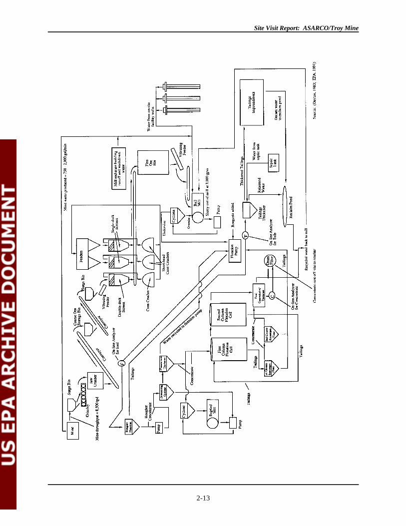
operations. The final product of flotation and filtration is a concentrate of silver and copper minerals. Figure
2-3
Site Visit Report: ASARCO/Troy Mine
2-13
F i g u r e 2 - 3 . A S A R C O T r o y F l o w D i a g r a m

Site Visit Report: ASARCO/Troy Mine
2-14
illustrates the mining and milling operations, from the input of raw materials to the output of products and
wastes.
Approximately 350 acres are disturbed by facility buildings, roads, and operations. The mine employs
approximately 320 people and operates 24 hours a day seven days a week. Mine and mill employees work
12-hour shifts. Ore is extracted from the mine at a rate of 8,500 tons per day, with yearly production at
approximately 3 million tons per year. Seventy-five percent of the 64 million ton ore reserve is recoverable
and 25 percent will remain in the supporting pillars. The ore averages 0.76 percent copper and 1.58 ounces
of silver per ton. Approximately 80 tons of ore are required to extract one ton of concentrate. The final
concentrate, averaging approximately 100 ounces of silver per ton (0.3 percent) and 45 percent copper, is
trucked to Troy where it is loaded into railcars for shipment to a smelter. The mine life is estimated to be 15
years from the start of full production in 1982. According to the mine manager, the current reserves should
last another 6 to 7 years at the current rate of production. Exploration to extend the reserves is ongoing.
(Dayton, 1983; and EPA, 1991.) A detailed explanation of the mining and milling operations, including the
products and wastes generated by each state of the operation, is discussed below.
2.2.1 Mining Operations
The underground mining operations are accessed by vehicles through two main adits, the service adit and the
main haulage adit. These two adits and the south and conveyor adits function as air intake adits. The EPA
team entered and exited the mine via the service adit. Two additional adits (the east and west adits) function
as air exhaust adits. Rock removed during adit excavation was used as fill to construct patios for the surface
buildings. (Dayton, 1983; and EPA, 1991)

Site Visit Report: ASARCO/Troy Mine
2-15
Fig
ure
2-3.
ASA
RC
O T
roy
Flo
w D
iagr
am
(Sou
rce:
Day
ton,
198
3 an
d E
PA, 1
991)

Site Visit Report: ASARCO/Troy Mine
2-16
The competent stratabound deposit is mined using headings and benching in a room-and-pillar pattern. Top
slice headings are driven 20 feet high by 45 feet wide using mobile electro-hydraulic rigs to drill horizontal
rounds. The lower 40 foot benches are drilled vertically using electro-hydraulic rigs. The 45 feet deep holes
are loaded with an emulsified slurry (ANFO). After blasting, Caterpillar 988 and 980 loaders muck the
newly blasted faces and load the ore into diesel-powered, articulated haulers. The ore is transported to a
surge bin at the underground primary crusher. (Dayton, 1983)
Mine water collected from areas throughout the mine flows to two sumps in the mine. Water is pumped from
the sumps through a secondary pumping station to the surface mill for use in the grinding and flotation
circuits. Flow rate into the sumps ranges from 750 to 2000 gallons per minute (gpm) depending upon the
season. In the event of excess water, the surplus is pumped directly to the tailings thickener. Although the
DEIS suggested that an oil/water separator or skimmer was to be used at the sumps, according to the mine
manager, none existed at the time of the site visit. (MDSL and USFS, 1978)
Ore is fed from the underground ore bin along a vibratory feeder to the Allis-Chalmers 48 x 60 inch, 250 HP
jaw crusher. The ore is crushed to minus 6 inches before it drops into the coarse ore storage bin below the
primary crusher. A conveyor transports ore from the coarse ore storage bin through the 4,400 foot long adit
decline to the surface mill. The EPA team viewed the primary ore crusher on Wednesday July 24, 1991,
when it was shut down for weekly maintenance. At the time of EPA's visit, water was in use for cleaning the
primary crusher. Particulate emissions from the jaw crusher are controlled by a baghouse.
There are several maintenance and chemical storage (oil, gas, lubricates, etc.) facilities located underground.
The EPA team visited an equipment maintenance area. Tools, welding tanks, and spare parts were observed
in this area. A 10,000 gallon diesel fuel tank is stored in a topslice heading down grade from the underground
maintenance facility. Used oils generated underground are stored in surface tanks. Drums were observed as
the EPA team toured the mine.
2.2.2 Milling Operations
Primary crushed ore is transported on a conveyor to the surface secondary crusher building. One Symons
standard cone crusher and two Symons short head crushers perform secondary crushing. According to the
mill superintendent, throughput of ore is 600 tons/hour. Ore is initially fed to the Symons standard cone
crusher along vibrating feeders to a vibrating double deck screen. Fines falling through the double deck
screen (minus 1/2 inch) are transported by belt conveyor to the fine ore bin. Oversized material is fed to the
cone crusher for size reduction. The product of the cone crusher is transferred to single deck screens (with
slots minus 1/2 or 5/8 inch by 3 inches) for sizing. Material falling through the single deck screen is
conveyed to a fine ore surge bin. Coarse materials remaining on the screen are fed into the short head cone
crushers. As crushed ore exits the short head crushers it is conveyed back to the single-deck screens for a
repeat of the sizing and crushing operations. The moisture content of coarse ore entering the secondary
crushing stage is 1.8 percent. No water is added to the ore during the secondary crushing stage. (Dayton,
Site Visit Report: ASARCO/Troy Mine
2-17
1983) The secondary crushers were down for maintenance during EPA's Tuesday, July 23, 1991, visit to the
mill area.
The secondary crushing building is equipped with a wet scrubber to treat emissions resulting from the
transfer points in the crushing circuit. A hooded vacuum system pulls the dust up into the scrubber. Slurry
produced in the scrubber is pumped to the ball mill discharge sump and joins the ball mill discharge for
additional communition circuit processing. (EPA, 1991)
Fine ore is conveyed from the fine ore surge bins to a transfer tower to facilitate transport to the fine ore bin.
The transfer tower is equipped with a baghouse to control emissions. The collected dust is returned to the
belt and transported to the fine ore bin. The mill superintendent stated that the bags are disposed of "at the
end of their life."
The fine ore bin receives materials crushed and sized to minus 3/4 inch. Six vibrating feeders transports fine
ore from the bin to a conveyor system that feeds two KVS ball mills. Forty percent of the ball mill volume is
filled with steel balls of a 3 1/2 inch top size. The balls are added continuously during operation of the mills
due to steel abrasion of approximately 2 pounds of steel balls per ton of ore. Ball mill makeup water is
supplied by a variety of sources depending on seasonal availability. These sources include mine water,
tailings decant water, tailings thickener overflow, secondary crushing wet scrubber slurry, mill patio area
runoff, and well water. The mill superintendent could not provide an estimate of the water flow rate entering
each ball mill. ASARCO's 1978 plan of operations estimated that 4,313 GPM of process water would be
required in the milling circuit (the amount added in the ball mills is not specified). The mill manager stated
that approximately 3,000 gpm of ground ore slurry leaves the ball mills and is pumped to a cyclone for
sizing. The 35-40 percent pulp density overflow from the cyclone reports to the three rougher flotation cells
and the underflow is recycled back to the ball mills for further grinding.
The mill control room is located between the grinding circuit and the flotation circuit. An on-stream analyzer
provides continuous metals content analysis of the grinding circuit feed, concentrate and tailings streams.
During the mill tour, drums of reagents were observed in storage beneath the concentration circuit.
Potassium amyl xanthate, a collector, and an 80/20 mixture of pine oil and Dowfroth 250 (a frothing agent)
are added to the cyclone overflow before it enters the flotation circuit. Collectors coat the target minerals and
make them hydrophobic. Frothers stabilize air bubbles in the flotation unit, allowing the target minerals to
cling to the bubbles and rise to the top of the flotation unit. The 80/20 frother mixture is added to the slurry
at a rate of 0.02 pound per ton of feed and the xanthate at 0.03 pound per ton of feed.
The chemically fortified ore slurry is pumped to one of three banks of seven 500 Wemco 144 flotation cells.
Air is injected from the bottom of the cell into the slurry. The ore mineral particles attach to the air bubbles
and rise to the surface. A bubbling froth is created at the surface of the cell as the minerals float to the top of
the cell. This surface froth of air bubbles, water and ore minerals overflows the cell into a collection launder.

Site Visit Report: ASARCO/Troy Mine
2-18
The froth from the first three cells of each bank is collected and pumped to the first column cell. The froth
from the remaining four cells of each bank is collected and pumped to cyclones for size classification.
Ore froth overflow (fine material) from the cyclone flows to a middlings thickener. The cyclone underflow
(coarse material) flows to the regrind ball mill. The valueless gangue minerals (e.g., quartz) settle and flow
out the bottom of the flotation cells to the tailings thickener.
The first column flotation cell is used to "clean" (remove unvaluable minerals) the froth from the first three
Wemco cells. The froth from the first column cell reports to the final concentrate thickener. The tailing or
underflow of the first column cell is pumped to a cyclone for size classification.
The thickened middlings concentrate is sent to two banks of first cleaner flotation cells. Concentrate
overflow from the first cleaner cells is sent directly to the second column cell. The tailings are sent to the
cleaner scavenger cells. Second column cell concentrate overflow goes directly to the concentrate thickener
and the tailings report back to the first cleaner flotation.
The cleaner scavenger froth concentrate is pumped to a cyclone for size classification. The cleaner scavenger
tailing flows to the tailings thickener.
A 75-foot diameter final concentrate thickener dewaters the concentrate with the aid of an anionic flocculent
added at the rate of 0.015 lbs./ton of feed. The thickened concentrate is further dewatered on a drum filter
and then stored in a bin; the water is recycled to the ball mills. The final moisture content of the concentrate
averages 12%. The final concentrate averages 45% copper and 100 ounces of silver per ton. Approximately
80 tons of ore are needed to produce one ton of concentrate.
There is an equipment and vehicle maintenance and reconditioning building located north and downhill of the
mill buildings. The EPA team did not visit this area. There is also an onsite laboratory that the EPA team
did not visit.

Site Visit Report: ASARCO/Troy Mine
2-19
2.3 WASTE MANAGEMENT
2.3.1 Types of Waste
Wastes produced at the ASARCO/Troy mine are generated as a direct result of mining and milling of ore.
Wastes generated at the Troy mine include mill tailings, tailings pipeline pigging waste, and waste rock.
Ground water seeping into the Troy underground mine workings becomes mine drainage; however, according
to the mine manager, it is currently used in the mill process or bypasses the mill process and flows with the
mill tailings to the tailings thickener. Mine water has never been discharged to surface water or ground water.
Mill tailings are the largest volume solid waste generated at the Troy mill and disposed of in the tailings
impoundment. Tailings pipeline pigging waste is produced infrequently. Exact volumes of pigging waste
were not provided by the facility. Waste rock (non-ore bearing rock removed to access the ore) is currently
removed and disposed of in the underground workings. During development and construction of the mine
complex, the removed waste rock was used as fill to create a surface area large enough to accommodate the
mill and associated buildings.
Several wastes are generated at the mine that are not uniquely associated with mining and milling operations.
According to the mine manager, waste halogenated solvents, used in the cleaning of parts and equipment, are
the primary hazardous wastes produced at the facility. A few PCB-containing transformers or capacitors are
still in use in the mine. Wet chemistry lab wastes are produced on site from the analysis of mine and mill
products (ore, concentrate and tailings) and are placed in the flotation circuit for concentration. Waste
hydraulic and motor oil, considered nonhazardous by Montana State law, are produced from their use in mine
vehicles and equipment. The waste oils are collected by a waste oil recycler and transported offsite. The
mine also generates garbage and sewage/sanitary wastewaters. Garbage is transported to a local landfill and
sanitary waste water is disposed of in the tailings impoundment via the tailings thickener.
2.3.2 Solid Waste Management Units
2.3.2.1 Tailings Thickener
Tailings leaving the flotation circuit flow to a 250-feet diameter tailings thickener, located downhill and north
of the mill buildings (see Figure 2-2). According to the mine manager, the tailings thickener also receives
wastewater from the septic system and any excess drainage from the mine water supply system that is not
required for milling operations. The thickener settles tailings to a specific density using a cationic-anionic
flocculent at a rate of 0.01 pounds per ton of feed. Overflow water drains to the partially fenced, lined (1/16-
inch Hypalon), tailings thickener reclaim pond. The reclaim water is used as needed in the mill circuit.
According to ASARCO, in the event of a reclaim pond surplus, an overflow box located on the east side of
the reclaim pond would convey the excess water to the tailings impoundment via the tailings pipeline. North
and downhill of the tailings thickener and thickener reclaim pond is an unlined basin used as the emergency
overflow pond. According to the mill superintendent there are pumps available to remove water from the
emergency overflow basin. None were noted by the EPA team. The mine manager stated that the pond is

Site Visit Report: ASARCO/Troy Mine
2-20
used infrequently; however, the last use of the emergency dump pond was within the two weeks prior to
EPA's visit. All three units are located on the cut and fill slope constructed during mine development.
The mine manager stated that the quality of the thickener reclaim water is not monitored and there are no
ground-water monitoring wells in the area. The surface-water-quality and benthic macroinvertebrate
populations of Stanley Creek, located below the thickener and the two ponds, are monitored downstream of
the plant site. No releases from these units have been documented in the State files reviewed by EPA or in
conversations with facility personnel.
2.3.2.2 Tailings Pipeline
Two eight-inch schedule 40 steel pipes convey, by gravity flow, thickened tailings seven miles to the tailings
impoundment. According to the mine manager, the pipe interiors are coated with urethane. Gravity flow of
tailings through the pipeline ranges from 7 to 12 feet/second, depending upon tonnage. No drop boxes are
used on the pipeline.
Tailings pipeline inspections are no longer conducted on a formal basis by the mine staff. However, according
to the mine manager the pipeline's primarily above ground location along the mine access road allows for
daily observation by the mine maintenance staff. According to the mine manager, a break in the pipe would
be detected immediately in the mill control system due to the loss of pipeline pressure. It is unclear if the
facility has a pressure loss detection system at the end of the pipe which would be necessary to signal a leak
in a pipeline under gravity flow. The pipeline required pigging after six years of operation and then once a
year for the past two or three years. Pigging wastes were disposed of in the tailings impoundment.
MDSL and MDHES documents indicate that the pipeline has released tailings into the environment in two
separate events. In July 1981, tailings from a break in the tailings pipeline indirectly entered Stanley Creek
when they leaked from the emergency storage impoundment, where they had been diverted. In June 1984, a
tailings pipeline break released tailings into Lake Creek.
2.3.2.3 Tailings Impoundment
The 320 acre tailings impoundment is used for the management of the estimated 2,930,000 tons of mill
tailings produced each year. It is located in the Lake Creek Valley, on a terrace east of Lake Creek and is
dammed on three sides; north, west, and south. The eastern boundary of the tailings impoundment is located
just west of a bedrock hill, which will eventually mark the eastern boundary of the tailings impoundment.
Four toe ponds (two north toe ponds, toe pond number two, and south toe pond) are located along the toe of
the west dam, as shown in Figures 2-4 and 2-5 (locations NTP, TP2, STP on Figure 2-4 and as labeled on
Figure 2-5—it should be noted that Figure 2-5 is not drawn to scale; the toe ponds are shown greatly enlarged
for illustrative purposes).

Site Visit Report: ASARCO/Troy Mine
2-21

Site Visit Report: ASARCO/Troy Mine
2-22
Figure 2-4. Location Map: Sampling StationsBase: USGS 7.5' Quadrangles: Crowell Mountain and Spar Lake 1963 (PR 1923)

Site Visit Report: ASARCO/Troy Mine
2-23
Figure 2-5. Detail of Toe Ponds in Relation to Lake Creek

Site Visit Report: ASARCO/Troy Mine
2-24
According to the mine manager, tailings impoundment construction included compacting native materials on
the bottom of the tailings impoundment and the placement of slimes along the perimeter dike before tailings
were deposited in the pond. The tailings impoundment is composed of three quadrants (term used by mine
manager) separated by east-west dividing dikes. Quadrant 1 is the south section of the pond, quadrant 2 is
the middle section, and quadrant three is the northern most section. The mine alternates tailings disposal
among the three quadrants. At the time of the site visit, the mine was spigoting tailings along the perimeter
of quadrant 3. Perimeter dams and interior quadrant dividing dikes are heightened during a quadrant's period
of inactivity when tailings are deposited in a different quadrant. Materials for these dam heightening
operations are obtained from the borrow pits dug east of the pond's current eastern perimeter. The maximum
current height of the tailings dam is 70 feet.
Tailings impoundment design allows for the addition of approximately 40 feet in height before design
capacity is reached. ASARCO estimates that the remaining reserves will require 20 feet in additional height
over the next 7 to 10 years.
Quadrants 1 and 2 were seeded with barley in the spring to prevent wind erosion of the tailings. A sprinkler
system uses tailings water to irrigate the barley and prevent wind erosion. Large areas of quadrants 1 and 2
were barren. The mine manager stated that several of the large barren areas were not seeded due to saturated
conditions at the time of planting. The southeastern section of the pond was developed over forested land,
evidenced by the tops of trees extending through the tailings.
A tailings water decant pond is located along the eastern pond boundary, adjacent to quadrant 2. The decant
pond was slimed on the bottom and sides, but the bottom was not compacted. It stores water reclaimed from
the tailings impoundment for reuse in the mill process or for irrigation and dust control on the tailings
impoundment. A pump barge is used to pump the reclaimed tailings water to the lined reclaim pond or to a
sprinkler system. EPA observed the decant pond barge pumping tailings water to the sprinkler system. The
reclaim pond is located approximately 100 yards southwest of the tailings impoundment. At the time of
EPA's site visit, the lined reclaim pond contained aquatic plants and tadpoles.
Two borrow pits, excavated in what appeared to be medium to coarse grained material, lie between the
bedrock hill and the current eastern boundary of the tailings impoundment. EPA observed one of the borrow
pits filled with water to approximately the same level as the adjacent decant pond.

Site Visit Report: ASARCO/Troy Mine
2-25
Site Visit Report: ASARCO/Troy Mine
2-26
According to the mine manager, the water is collected surface-water drainage and, due to the placement of
slimes along the pond perimeter during the construction of the decant pond, is not presumed by the company
to be the result of tailings water movement through subsurface materials.
In 1982, not long after the tailings impoundment began to receive tailings, water emerged west of the tailings
dam, apparently as a result of seepage through the west tailings impoundment dam. An earthen dike was
constructed in 1983 to contain the seepage in three toe ponds. According to a February 10, 1983, letter from
Dames and Moore, ASARCO's contractor, the dike would allow for the collection and pumpback of the water
to the tailings impoundment. The contractor cautioned that although the ponded water would not
significantly affect the overall stability of the tailings impoundment starter dam, it could result in localized
sloughing of the terrace slopes adjacent to Lake Creek downgradient of the starter dam. According to the
mine manager, the water in the toe ponds is tested quarterly and the water is pumped back to the tailings
impoundment for use in the sprinkler system. (MDSL, 1983)
In January 1991, MDSL conducted an inspection at the ASARCO tailings facility to investigate a report that
a sinkhole had formed downgradient of the west tailings dam and toe ponds, near the edge of the terrace
adjacent to Lake Creek. At the time of the State inspection, the hole was estimated to be 15 feet by 12 feet
and 10 feet deep and water was heard draining through the hole. The origin of the sinkhole was attributed to
water "piping" below ground surface. MDHES stated that water-quality data from a seep in the terrace slope,
assumed to be directly associated with the sinkhole, indicates a component of tailings water. (ASARCO
states that the original design engineer did not believe the sinkhole was the result of piping from the tailings
impoundment and that springs and seeps existed in the area prior to construction.) MDHES suggested that
the only immediate danger to the environment is from increased sedimentation to Lake Creek. Worst case
scenarios would be mass failure of the terrace bank and head cutting into the sinkhole area. During EPA's
visit to the sinkhole, the fine-grained materials along the walls of the hole appeared to be saturated, but no
water flowed in the hole. (MDHES, 1991)
Downhill (downgradient) from the toe ponds is a topsoil stockpile. Below and both north and south of the
topsoil pile are several springs located at approximately the slope break. Approximately six feet downhill
from one of the seeps is a sump which collects water to be pumped to the tailings impoundment. The pump
was operating at the time of EPA's visit. The EPA team observed iron staining along the surface flow path of
the seep water. According to the mine manager, the seeps have been sampled numerous times and a report on
the water quality of the seep indicated that the seeps were not tailings water. The MDSL sampled the seeps
on two separate occasions and concluded that the water was of good quality, but that there appeared to be a
correlation between several of the seeps and the north toe pond water. According to the mine manager similar
seeps are found on the other side of Lake Creek, both upstream and downstream of the tailings impoundment.
(MDSL, 1991; and ASARCO, 1990)

Site Visit Report: ASARCO/Troy Mine
2-27
2.3.2.4 Waste Rock
During adit excavation and mine development, development waste rock was used as fill for the construction
of the patio for the mill buildings, maintenance buildings, and general mine office buildings. Although the
patio area is not considered a waste unit by the facility, impacted surface water has been associated with the
fill materials. Therefore, for the purposes of this report, it will be discussed in this section. Waste rock is
currently excavated (exact amounts unknown) and is backfilled into the mine.
A Stanley Creek monitoring point is located at least two miles downstream of the patio area. From 1985 to
1987, extensive sampling was conducted of Stanley Creek surface water and sediment below the patio fill in
response to elevated copper concentrations detected in Stanley Creek surface water. The cause of these
elevated copper concentrations was determined to be due to erosion of the waste rock used as fill in the patio
upon which the mill was constructed. The scope of the entire corrective action was not documented in the
reviewed documents, but ASARCO apparently took some type of erosion control measures. (MDHES, 1990)
2.3.2.5 Waste Oil Storage Tanks
Waste oils are stored onsite in aboveground storage tanks. The volume of these tanks was not stated in the
available references. Moore Oil in Libby, Montana picks up the oil approximately once a month. EPA
viewed used oil shipping records during the visit to the mine. Used oil shipments are not manifested in
Montana because State laws do not consider waste oil to be a hazardous waste.
2.3.2.6 Burn Pit
Mine personnel stated that plant domestic garbage is disposed of at a landfill in Libby. Reference was made
to a burn pit used for general waste in a 1987 Montana Department of Health and Environmental Sciences -
Air Quality Bureau inspection report. However, according to ASARCO, wood products are no longer
burned. (MDHES, 1987)
2.3.3 Waste Water Management Units
2.3.3.1 Mine Water
According to facility representatives, the mine has no current discharges to surface water. Mine adit water is
used in the milling operation. According to the mine manager, if mine water discharge volumes exceed the
needs of the mill circuit, the water is sent directly to the tailings thickener. As noted previously, the mine
manager stated that the tailings are discharged from the thickener to the pipeline at a specific density in order
to maintain proper performance of the pipeline. Consequently, it is unclear how large volumes of excess
mine water may affect the performance of the tailings thickener and the density of the discharged tailings
slurry. The facility does not monitor the quality of the mine water.
2.3.3.2 Sanitary Sewage

Site Visit Report: ASARCO/Troy Mine
2-28
The facility maintains a septic tank system to treat sewage and sanitary waste. Treated septic tank effluent
flows to the tailings thickener for reuse in the mill circuit or disposal in the tailings impoundment. The septic
tank sludge has been removed once by a contractor. There is no specific monitoring of the septic system.
2.3.3.3 Assay Laboratory Wastes
According to ASARCO, dilute acids and other wastes from the wet chemistry laboratory are disposed of in
lab sinks that drain to the flotation cells.
2.3.4 Hazardous Waste Management Unit
2.3.4.1 Waste Solvent Tanks
Waste halogenated solvents are stored on site and picked up every two weeks by Safety Kleen. These tanks
were not visited by the EPA team. The location of the waste solvent storage tank(s) is not available in the
reviewed information.
Site Visit Report: ASARCO/Troy Mine
2-29
2.4 MONITORING
During the period prior to mine development and up to the time of the site visit, ASARCO has sampled
surface water, ground water and air in the areas likely to be impacted by the Troy mining activities. As
presented in ASARCO/Troy's mining operating permit, MDSL requires the mine to sample and analyze
surface-water-quality. Since the permit was issued, MDSL has modified the monitoring requirements as
needed. Ground-water monitoring was required at one time and tailings water monitoring has become a
requirement. In addition, monitoring requirements for surface water have changed as monitoring results over
time indicated a need for new analytical procedures, new monitoring locations, biological monitoring,
termination of monitoring due to inconclusive or spurious results, and other difficulties. ASARCO conducts
air monitoring as required by the Air Quality Bureau - Montana Department of Health and Environmental
Sciences. The MDSL and MDHES also sample and analyze environmental media to check analyses reported
by ASARCO and in response to citizen complaints of alleged violations.
2.4.1 Surface Water
The earliest surface-water-quality monitoring results discussed in MDSL documents provided to EPA are
from Lake Creek in 1974. This early baseline surface-water monitoring conducted by ASARCO was
complemented with monitoring in the Stanley Creek drainage in 1977, both above and below the mill site.
The United States Geological Survey (USGS) and the Montana Bureau of Mines and Geology (MBMG) have
both sampled Lake Creek below the tailings dam; the USGS monitored from 1976 to 1978 and the MBMG
monitored from 1979 to 1982. EPA did not have access to the raw data collected by ASARCO (prior to
1985), MBMG or the USGS.
Water-quality monitoring required by the MDSL since 1985 includes surface-water and aquatic benthic
macroinvertebrate sampling of three streams that could potentially be impacted by releases from the mine:
Stanley Creek, Fairway Creek and Lake Creek. Five locations are sampled during the spring, summer, and
fall quarters each year (see Figure 2-6

Site Visit Report: ASARCO/Troy Mine
2-30
Figure 2-6. Sampling Locations (e.g., FC-1): ASARCO Troy Unit Macroinvertebrate MonitoringProgram
Site Visit Report: ASARCO/Troy Mine
2-31
). MDSL also requires the sampling and analysis of tailings water during each of the three quarters. Three
sample locations are upstream of the tailings impoundment and two are downstream of the impoundment (see
Figure 2-5). Two sample sites on Stanley Creek have been and continue to be sampled by the facility, the
MDSL and the MDHES, but not as a monitoring requirement. (MDSL, MDHES, and ASARCO, 1987)
ASARCO is required to submit quarterly and yearly reports of the monitoring results. ASARCO also
submits an interpretation of the results using statistical models, although this analysis is not required by the
MDSL. The statistical models applied by ASARCO determine significant variations between study
locations, seasons, and years. In addition, ASARCO determines statistical correlations between the
macroinvertebrate and key water-quality data. (MDSL et al., 1987)

Site Visit Report: ASARCO/Troy Mine
2-32
The most recent MDSL report (1990 draft) performed basic statistics on all the ASARCO/Troy water-quality
data available in the files of the MDSL and MDHES through 1988. The results of these analyses indicate
that there is no statistical difference in the quality of the water at LC-1, LC-2, and LC-4 due to the operation
of the mine and tailings impoundment. (MDSL, 1990)
2.4.2 Ground Water
According to a MDSL review of ASARCO Troy monitoring data, five ground-water wells were monitored
from September 1983 to December 1984. The program was discontinued in 1984 due to several reasons.
For example, the background well consistently produced water that exhibited toxicity to aquatic life (i.e.,
Daphnia). In addition, there were unresolved questions about the well completions, particularly the materials
used. Finally, the MDSL determined that the ground-water hydrology under the tailings impoundment was
too complex and the four ground-water wells surrounding the impoundment were not adequate to monitor a
400-acre area. The ground-water monitoring data for the period of September 1983 to December 1984 were
not provided to EPA, and thus was not included in this report.
Although the facility is not currently required to conduct formal ground-water monitoring at the tailings
impoundment, EPA noted several piezometers drilled into the west dam. According to the facility manager,
these piezometers were installed for yearly stability analysis of the tailings dam and have not been used to
monitor ground-water quality.
2.4.3 Air
The Air Quality Bureau of the MDHES requires ASARCO/Troy to maintain one-high volume six-day air
sampler to measure total suspended particulates. Quarterly sampling reports are submitted to the State.
According to the facility, the most recent monitoring report submitted to the State (at the time of the site visit)
was for the winter quarter of 1990.

Site Visit Report: ASARCO/Troy Mine
2-33
2.5 REGULATORY REQUIREMENTS AND COMPLIANCE
2.5.1 Operating Permit
The MDSL issues Mining Operating permits as required by the Montana Metal Mine Reclamation Act, and
under the regulations promulgated in the Montana Hard Rock Mining Requirements. The operating permit is
not issued until the Montana Environmental Policy Act/National Environmental Policy Act (MEPA/NEPA)
process is complete [i.e., an Environmental Assessment (EA) or Environmental Impact Statement (EIS) has
been completed] and the State makes a decision. When Federal lands are involved, the applicant must also
obtain approval from the appropriate Federal agency (MDSL, 1990).
On February 18, 1974, ASARCO submitted application number 00128 to the MDSL for an operating permit.
Numerous additional reports and data were submitted prior to the permit approval. The Montana Board of
Land Commissioners approved ASARCO's $2,752,000 Reclamation Bond on August 19, 1978 following
MDSL's approval of ASARCO's operating plan. The MDSL issued Operating Permit Number 00093 on
November 27, 1978. The permit required ASARCO to establish and/or continue a satisfactory water-quality
monitoring program for Lake Creek (Montana Board of Land Commissioners, 1978; and MDSL, 1978).
The location of ASARCO/Troy on USFS lands necessitated the involvement of the Forest Service in the
operating permit approval process. In 1978, The MDSL and the USFS jointly produced an EIS for the Troy
mine. The USFS concurred with the operating plan (as included in the Draft EIS and slightly amended in the
Final EIS) and issued a Forest Service Record of Decision (MDHES and USFS, undated).
The MDSL has approved three operating permit amendments for the mine and ASARCO/Troy has applied
for a fourth amendment to date. USFS involvement in amendment approval was not found in the available
file documents. Amendment No. 1, approved on July 19, 1979, incorporated the construction of the Stanley
Creek tailings impoundment, the staging area, and the aggregate storage area. According to the mine
manager, Amendment No. 2 was for the construction of the emergency pond below the tailings thickener.
Amendment No. 2 was not available for review. Amendment No. 3, approved on July 14, 1983, incorporated
the construction of a secondary dike below the tailings dam toe and installation of a permanent pumping
station to maintain the water level of water ponding behind the secondary dike to at least 10 feet below the
dike crest. According to the Mine Manager, the pending fourth amendment application requests approval for
the excavation of an 18 x 18 foot ventilation adit to be driven from within the ore body to the southwest side
of the mountain (MDSL, 1979, 1983).
2.5.2 Solid Waste
Mine waste is not regulated as a solid waste in Montana. The only solid waste managed on site is domestic
garbage, used oil, and sewage sludge. The facility ships this waste offsite and is not subject to the State solid
waste permitting requirements.

Site Visit Report: ASARCO/Troy Mine
2-34
2.5.3 Surface Water
A Montana Pollutant Discharge Elimination System (MPDES) permit is required for all point source
discharges to State surface waters, under authority of the Federal Clean Water Act. Montana operates a
Federally delegated program. The MPDES permit is required regardless of whether an operating permit was
issued by MSDL. The administrating office is the Water Quality Bureau (WQB) of the MDHES, which
issues these permits and enforces the State surface-water discharge regulations. In addition, in accordance
with the issuance of a full-scale mining operation permit, MDSL requires monitoring of surface-water and
ground-water quality (MDSL, 1990).
The 1978 DEIS stated that discharges to surface water would be required to meet the State's water-quality
nondegradation standard contained in the Montana Laws Regarding Water Pollution [Title 69. Chapter 48,
69-4801.2(1)(c)(iii)]. The nondegradation standard requires waters of higher quality than the State's water-
quality standards to be maintained at the stream's higher quality. However, according to the MDSL, the Troy
mine is exempt from this standard because it was permitted prior to 1984, and therefore, must only meet the
State's water-quality standards (MDSL and USFS, 1978). In 1978, ASARCO/Troy Mine applied for a
MPDES permit to discharge mine adit water from a settling sump.
2.5.4 Ground Water
Facilities which discharge directly to ground water, such as through the operation of a percolation pond, must
obtain a Montana Groundwater Pollution Control System (MGWPCS) permit issued by the WQB of the
MDHES. This permit is not required if MDSL issues a full-scale mining operating permit. This exemption
exists because MDSL reviews and monitors the proposed operation at the same level as the WQB would
review a MGWPCS permit application (MDSL, 1990). ASARCO is exempted from the ground-water permit
requirement and the MDSL does not require ASARCO/Troy to conduct ground-water monitoring at any of
the facility areas under the facility's operating permit.
2.5.5 Air
The MDHES, Air Quality Bureau (AQB) issues permits and regulates emissions from projects expected to
exceed certain threshold values for various parameters. Generally an air permit is required if emissions of
any pollutant, including fugitive dust, exceed 25 tons/year.
ASARCO/Troy applied for an Air Quality permit in December 1978 for the construction and operation of the
secondary crushing plant. The application proposed the use of 5 baghouses to control particulate emissions
from the secondary crushing plant, specifically, to address the ore transfer points in the plant (MDHES,
1978). The AQB issued permit No. 1316 to ASARCO/Troy on May 16, 1979 with a conditional approval
(MDHES, 1979). One condition to be met by ASARCO was the installation and operation of at least one
high-volume sampler in the vicinity of the mill site. The permit was modified in 1982 when the baghouse at

Site Visit Report: ASARCO/Troy Mine
2-35
the secondary crusher building was replaced with a high efficiency wet scrubber (ASARCO, 1978; and
MDHES, 1979).
2.5.6 Hazardous Waste
The Montana Department of Health and Environmental Sciences issues identification numbers to generators
of hazardous wastes. The ASARCO/Troy Mine is assigned the hazardous waste generator identification
number MT13096199989. The facility transports its hazardous wastes (e.g., safety-kleen solvents) offsite.
There was no information in the files reviewed concerning releases of hazardous wastes. According to the
mine manager there have been no releases of any waste type (small spills of reagents, fuels, solvents, etc.
excepted).

Site Visit Report: ASARCO/Troy Mine
2-36
2.6 REFERENCES
ASARCO. 1978. Construction Permit Application.
ASARCO. 1987. Letter. To: John J. Drynan, Director Department of Health and Environmental Sciences. From: T.E. Erskine, Unit Manager, ASARCO Inc. Troy Unit. Re: Submission of Corrective ActionPlans for Mill Patio Erosion. September 29, 1987.
ASARCO. 1990. ASARCO, Troy Unit, Groundwater/Seepage Study Final Report. Prepared by EbascoEnvironmental Services. September 1990.
ASARCO. 1991. Draft Annual Report - Year Six, Comprehensive Water Quality Monitoring Program forStreams Adjacent to ASARCO's Troy, Montana Unit: Analyses of March 1986 through October 1990Samples. Prepared by Parametix, Inc. April 1991.
Dayton, S.E. 1983. "ASARCO's Troy Mine, How Rolling the Dice in a New District Can Add ToEarnings". In Engineering and Mining Journal. February, 1983.
Montana Board of Land Commissioners. 1978. Reclamation Bond, ASARCO Inc. August 19, 1978.
Montana Department of Health and Environmental Sciences. 1978a. Public Notice No. MT-78-014A andFact Sheet. October 6, 1978.
Montana Department of Health and Environmental Sciences. 1978b. Tentative (unsigned) MPDES PermitNo. MT-0024538. October 6, 1978.
Montana Department of Health and Environmental Sciences. 1979. Air Quality Bureau Permit No. 1316.
Montana Department of Health and Environmental Sciences. 1987a. Field Investigation Report, Metals andSediment Pollution of Stanley Creek near ASARCO's Troy Operation. March 20, 1987.
Montana Department of Health and Environmental Sciences. 1987b. Notice of Violation and Order to TakeCorrective Action. June 30, 1987.
Montana Department of Health and Environmental Sciences. 1987c. Summary - DHES EnforcementActions Against ASARCO, Troy Project. August 18, 1987.
Montana Department of Health and Environmental Sciences. 1987d. Letter. To Mr. T.E. Erskine, UnitManger, ASARCO, Inc. Troy Unit, Re: Corrective Measures undertaken at the Troy Mine in responseto the June 30, 1987. Notice of Violation. September 2, 1987.
Montana Department of Health and Environmental Sciences. 1987e. Memorandum. To: File From: PatDriscoll. Air Quality Inspection Report, ASARCO/Troy Mine. September 23, 1987.
Montana Department of Health and Environmental Sciences. 1987f. Letter. To Mr. T.E. Erskine, UnitManager, ASARCO, Inc. Troy Unit, Re: Compliance with June 30, 1987 Notice of Violation andOrder. December 18, 1987.
Montana Department of Health and Environmental Sciences. 1988. Memorandum. To: File. From: ChuckHomer. Air Quality Inspection Report, ASARCO/Troy Mine. August 23, 1988.

Site Visit Report: ASARCO/Troy Mine
2-37
Montana Department of Health and Environmental Sciences. 1990. ASARCO Troy Unit Review ofMonitoring Data. Prepared by Abe Horpestad. June 1990.
Montana Department of Health and Environmental Sciences. 1991. Memo to File. From: Terry Webster Re:Results and Interpretation of Water Samples Collected at the ASARCO, Troy Unit, on February 28,1991.
Montana Department of State Lands. 1978. Operating Permit No. 00093. November 27, 1978.
Montana Department of State Lands. 1979. Amendment No. 001 ASARCO, Inc., Operating Permit No.00093. July 19, 1979.
Montana Department of State Lands. 1983. Amendment No. 0003 ASARCO, Inc., Operating Permit No.00093. July 14, 1983.
Montana Department of State Lands, Montana Department of Health and Environmental Sciences, andASARCO; 1987. ASARCO Troy Mine Water Quality Monitoring Program. August 1987.
Montana Department of State Lands. 1988. Results of a Statistical Analysis of Water Quality Data from theASARCO Troy Project, Troy, Montana. May 1988.
Montana Department of State Lands. 1989. Untitled Draft Report prepared for the MDSL by DanielMcGuire [no affiliation provided]. May 1, 1989.
Montana Department of State Lands. 1990. Montana Hard Rock Mining Requirements. Revised January26, 1990)
Montana Department of State Lands and U.S. Forest Service. 1978. Draft Environmental Impact Statement,Proposed Plan of Mining and Reclamation, Troy Project ASARCO Inc., Lincoln County, Montana. Volume 1. December 26, 1978.
Montana Department of State Lands and U.S. Forest Service. Undated. Final Environmental ImpactStatement, Proposed Plan of Mining and Reclamation, Troy Project ASARCO Inc., Lincoln County,Montana, Volume III.

Site Visit Report: ASARCO/Troy Mine
2-38
APPENDIX 2-A
ASARCO COMMENTS ON DRAFT SITE VISIT REPORT

Site Visit Report: ASARCO/Troy Mine
2-39
[ASARCO comments on the draft site visit report weresubmitted in a letter dated January 14, 1992. This letter isnot reproduced in this electronic version of this document. Copies of the comment document may be received fromU.S. EPA, Office of Solid Waste, Special Waste Branch.]

Site Visit Report: ASARCO/Troy Mine
2-40
APPENDIX 2-B
EPA RESPONSES TO ASARCO COMMENTS ON DRAFT SITE VISIT REPORT

Site Visit Report: ASARCO/Troy Mine
2-41
A copy of the draft Mine Site Visit: ASARCO/Troy Mine was provided to ASARCO for their review. EPAaddressed the comments submitted by ASARCO on January 14, 1992 (see Appendix 2-A) in the revisedreport as described below.
Comment 1. The text on page 2 was changed to read: "...and concentration of the silver-bearing and non-silver bearing copper minerals." The text on page 6 now reads: "...the copper mineralschalcocite, bornite, and chalcopyrite and small amounts of copper oxides and native silver."
Comment 2. The location of the fuel storage tanks on the sketch map (Figure 2-2 in the report) was notchanged since the map was taken from the 1979 MDHES Air Quality Bureau ConstructionPermit Application. However, the text now includes a parenthetical note: "According toASARCO, the fuel storage tank is actually located south of the shop rather than as shown inFigure 2-2."
Comment 3. The sentence has been changed to read: "According to the mine manger, the mine is locatedon patented claims, the mill is located on unpatented claims, and the tailings impoundment islocated on land owned by Kennecott Minerals and leased to ASARCO."
Comment 4. EPA found that using the term "pond" for the tailings disposal area (rather than"impoundment" could lead to confusion with the various toe ponds on the site. Accordingly,the term "impoundment" was used when referring to the tailings disposal area and "pond" forthe toe ponds. (Note that ASARCO used the term impoundment throughout its commentswhen referring to the tailings disposal area.)
Comment 5. The text was changed to read: "The facility maintains two mill supply water wells in lowerStanley Creek between the mine administration building and the tailings impoundment. Each well is approximately 300 to 400 feet deep. The facility representatives were unable toprovide information about the yields of the wells or the volume of water provided to the millby these wells. Three domestic water wells or the volume of water provided to the mill bythese wells. Three domestic water wells are also present in lower Stanley Creek. Anotherwell, located 400 yards from the site, supplies potable water to the facility. Accordingly toASARCO, the domestic wells are completed in bedrock, but the lithology within which theother wells are completed remains unidentified."
Comment 6. The text was changed to read: "According to ASARCO, the domestic wells are competed inbedrock, but the lithology within which the other wells are completed remains unidentified."
Comment 7. The text now reads: "...according to ASARCO, four ground water test wells are located onthe west side of the impoundment. No information was available concerning the completion,date of installation, or monitoring of these wells."
Comment 8. The reference to chemical separation has been deleted.
Comment 9. The text now reads: "The underground mining operations are accessed by vehicles throughtwo main adits, the service adit and the main haulage adit. These two adits and the south andconveyor adits function as air intake adits. The EPA team entered and exited the mine viathe service adit. Two additional aids (the east and west adits) function as air exhaust adits. Rock removed during adit excavation was used as fill to construct patios for the surfacebuildings."

Site Visit Report: ASARCO/Troy Mine
2-42
Comment 10. ASARCO was subsequently offered the opportunity to review a more legible copy of thisfigure. Unfortunately, they were not able to provide comments prior to the time the reporthad to be revised.
Comment 11. The text has been changed to read: "Fines falling through the double deck screen (minus 1/2inch) are transported by belt conveyor to the fine ore bin. Oversized material is fed to thecone crusher for size reduction. The product of the cone crusher is transferred to single deckscreens (with slots minus 1/2 or 5/8 inch by 3 inches) for sizing. Material falling throughthe single deck screen is conveyed to a fine ore surge bin. Coarse materials remaining on thescreen are fed into the short head cone crushers."
Comment 12. The reference to Wagner ST8 machines has been removed and the use of Caterpillar 980loaders is noted.
Comment 13. The reference to a grizzley has been deleted.
Comment 14. The text has been changed to read: "A 10,000 gallon diesel fuel tank is stored in a topsliceheading down grade from the underground maintenance facility."
Comment 15. ASARCO commented that the drum storage rooms noted by EPA as having been observedduring the mine tour are unknown to them. EPA did not tour the fuel storage areas or theroom seen during the mine tour, so it is not known if the drums were of "antifreeze orgrease," as ASARCO suggested in their comment, or whether they were stored in the fuelstorage area, as also was suggested. The revised report continues to note that "drums wereobserved during the mine tour."
Comment 16. The text now reads: "Material falling through the single deck screen is conveyed to a fineore surge bin."
Comment 17. The text has been changed to read: "The collected dust is returned to the belt andtransported to the fine ore bin. The mill superintendent stated that the bags are disposed of"at the end of their life."
Comment 18. The text in these paragraphs now reads:
"Potassium amyl xanthate, a collector, and an 80/20 mixture of pine oil and Dowfroth 250 (afrothing agent) are added to the cyclone overflow before it enters the flotation circuit. Collectors coat the target minerals and make them hydrophobic. Frothers stabilize airbubbles in the flotation unit, allowing the target minerals to cling to the bubbles and rise tothe top of the flotation unit. The 80/20 frother mixture is added to the slurry at a rate of0.02 pound per ton of feed and the xanthate at 0.03 pound per ton of feed.
"The chemically fortified ore slurry is pumped to one of three banks of seven 500 Wemco144 flotation cells. Air is injected from the bottom of the cell into the slurry. The oremineral particles attach to the air bubbles and rise to the surface. A bubbling froth is createdat the surface of the cell as the minerals float to the top of the cell. This surface froth of airbubbles, water and ore minerals overflows the cell into a collection launder. The froth fromthe first three cells of each bank is collected and pumped to the first column cell. The frothfrom the remaining four cells of each bank is collected and pumped to cyclones for sizeclassification.

Site Visit Report: ASARCO/Troy Mine
2-43
"Ore froth overflow (fine material) from the cyclone flows to a middlings thickener. Thecyclone underflow (coarse material) flows to the regrind ball mill. The valueless gangueminerals (e.g., quartz) settle and flow out the bottom of the flotation cells to the tailingsthickener.
"The first column flotation cell is used to "clean" (remove unvaluable minerals) the frothfrom the first three Wemco cells. The froth from the first column cell reports to the finalconcentrate thickener. The tailing or underflow of the first column cell is pumped to acyclone for size classification.
"The thickened middlings concentrate is sent to two banks of first cleaner flotation cells. Concentrate overflow from the first cleaner cells is sent directly to the second column cell. The tailings are sent to the cleaner scavenger cells. Second column cell concentrate overflowgoes directly to the concentrate thickener and the tailings report back to the first cleanerflotation.
"The cleaner scavenger froth concentrate is pumped to a cyclone for size classification. Thecleaner scavenger tailing flows to the tailings thickener."
Comment 19. The sentence has been changed to refer only to water removal from the emergency overflowbasin.
Comment 20. The text has been changed to read: "Four toe ponds (two north toe ponds, toe pond numbertwo, and south toe pond) are located along the toe of the west dam,..."
Comment 21. The purpose of the map is to show the relationship between various elements in the tailingsdisposal area. The legend of the map notes that it is "Not to Scale." In addition, the textnow includes a note that emphasizes that the map is not drawn to scale.
Comment 22. The text now reads: "Tailings impoundment design allows for the addition of approximately40 feet in height before design capacity is reached. ASARCO estimates that the remainingreserves will require 20 feet in additional height over the next 7 to 10 years."
Comment 23. The text now notes that "...according to ASARCO, wood products are no longer burned."
Comment 24. The text has been changed to read: "According to ASARCO, dilute acids and other wastesfrom the wet chemistry laboratory are disposed of in lab sinks that drain to the flotationcells."
Comment 25. The report referred to by ASARCO was compiled by the Montana Department of StateLands and was furnished to EPA by the Department.
Comment 26. The text now reads: "The well water is currently sampled monthly for coliform and achlorinator is available for use if needed."
Comment 27. ASARCO's position has been noted in the report.
Comment 28. ASARCO's position has been noted in the "Tailing Impoundment" section (the"Conclusions" section, which contained the wording on which ASARCO commented, hasbeen deleted).
Site Visit Report: ASARCO/Troy Mine
2-44