mosman bicycle strategy 2005-2010 · playing its part in making cycling more accessible and being...
TRANSCRIPT
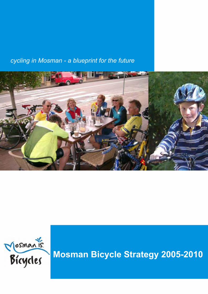
cycling in Mosman - a blueprint for the future
Mosman Bicycle Strategy 2005-2010


Mosman Municipal Council
Mosman Bike Plan 2005 - 2010 Final
April 2005
PBAI Australia
6/102 Alfred Street PO Box 705
Milsons Point NSW 2061 T – 02 9460 2444 F – 02 9460 2477

Acknowledgements
The members of the Working Group that developed the Mosman Bike Plan include:
Alan Philips Community Representative
Carolyn New Bike North/Bicycle NSW
Geoff Cox Roads and Traffic Authority
Helmet Vetisch Le Spit Cyclery
Alan Stewart Mosman Council
Gordon Brown Mosman Council
Craig Covich Mosman Council
Linda Kelly Mosman Council
Lyndall Pickering Mosman Council
Joe Vertell Mosman Council
The Working Group and consultant team would like to thank the following for their contributions to the Bike Plan –
Manly Council
North Sydney Council
Sydney Harbour Federation Trust
Mosman Youth Centre
Queenwood School for Girls, Blessed Sacrament School, Sacred Heart Primary School, Middle Harbour Public School
National Parks and Wildlife Service
And the local residents and cyclists who came along to workshops and completed questionnaires

FOREWORD This Bicycle Plan has been developed to allow Council to provide the cycling public of Mosman and those that ride through our beautiful suburb, with a cycle friendly environment. That means one which is sensitive to all cyclists needs, keeps them safe and provides them with cycle access to all the wonderful things which Mosman has to offer from its great shopping, excellent cafes, beautiful beaches and scenic vistas.
This is a five year plan which has been developed to address not only the local cycling issues in Mosman, but also to integrate with the NSW Government’s Action for Bikes, BikePlan 2010.
Cycling is a healthy pursuit and it is encouraging to know that Mosman Council is playing its part in making cycling more accessible and being pro-active in recognising the many benefits that cycling can deliver for its community.
The Bicycle Plan, via its five year implementation program, aims to create an environment where people of all ages and abilities have the knowledge supported by the appropriate cycle friendly infrastructure to feel confident enough to cycle through and within Mosman whenever they want to. We look forward to the challenges ahead in achieving this aim.
The Bicycle Plan has been prepared following extensive consultation with the Mosman community and detailed research and analysis which was supported by the efforts of the working party which Council established to guide the planning process. The community representatives and other stakeholders on the working party gave generously of their time and expertise to assist in the plan’s preparation.
The implementation of the Bicycle Plan will require dedication, hard work and an appropriate funding commitment if we are to realise its benefits. You can be assured of Council’s commitment to its success.
I would like to thank all those who have been associated with the development of this visionary plan and look forward to its implementation.
Shirley Jenkins MAYOR OF MOSMAN


Mosman Municipal Council Mosman Bike Plan 2005 - 2010 6
Contents
Executive Summary........................................................................................................................ 8 1.0 Introduction ....................................................................................................................... 10
1.1 The Vision for Cycling in Mosman................................................................................... 10 1.2 Mosman Bike Plan .......................................................................................................... 10
2.0 Background and Context ................................................................................................. 12 2.1 NSW State Government.................................................................................................. 12 2.2 Mosman Municipal Council ............................................................................................. 12 2.3 Guidance......................................................................................................................... 14 2.4 Regional Bike Plan for Lane Cove, North Sydney & Mosman (1982) ............................. 14
3.0 Data Analysis..................................................................................................................... 18 3.1 Journey to Work Data...................................................................................................... 18 3.2 Accident Data .................................................................................................................. 18 3.3 Cycle Counts ................................................................................................................... 20
4.0 Community and Stakeholder Consultation..................................................................... 22 4.1 Community Consultation ................................................................................................. 22 4.2 Stakeholder Consultation ................................................................................................ 34
5.0 Local Survey and Site Visits ............................................................................................ 38 6.0 Mosman Bike Plan Proposals .......................................................................................... 40
6.1 Introduction...................................................................................................................... 40 6.2 Bike Plan Proposals Content........................................................................................... 40 6.3 Bicycle Steering Group.................................................................................................... 40 6.4 Generic Network Proposals............................................................................................. 41 6.5 Specific Cycle Network Proposals (Including Priority Items)........................................... 45 6.6 Cycle Parking Strategy.................................................................................................... 51 6.7 Cycle Signing Strategy .................................................................................................... 57 6.8 Promotional Activities ...................................................................................................... 62
7.0 Development Planning Controls (Cycling) ..................................................................... 64 7.1 Development Control Plan .............................................................................................. 64 7.2 Spit Bridge Proposal........................................................................................................ 65
8.0 Implementation Plan ......................................................................................................... 68 8.1 Introduction...................................................................................................................... 68 8.2 Funding ........................................................................................................................... 68 8.3 Partnerships .................................................................................................................... 68 8.4 Implementation Plan........................................................................................................ 69

Mosman Municipal Council Mosman Bike Plan 2005 - 2010 7
Appendix A – Accident Locations and Reports Appendix B – Post Back Questionnaire and Analysis Appendix C – Sydney Harbour Federation Trust Proposals Appendix D – Costed Concept Proposals (Priority Items 1-5) Appendix E – Cycle Parking Guidance Appendix F – Cycle Signage Guidance Appendix G – Draft Text for Cycle Brochure

Mosman Municipal Council Mosman Bike Plan 2005 - 2010 8
Executive Summary Council commissioned this study as a result of the commitment it made in MOSPLAN to provide improved bicycle facilities.
In particular, this study provides a plan to:
Create an urban environment in Mosman which supports the safe use of bicycles for transport and recreation and includes providing safe, useful and well signed routes, sufficient and secure parking and public information on cycle facilities.
The Bike Plan is based on a thorough review and updating of the 1982 Bicycle Plan, detailed surveys of the existing network and associated infrastructure, compatibility with the NSW Government’s Action for Bikes, BikePlan 2010 and consultation with the Mosman community.
A Working Party was established consisting of Council staff, representatives of the community and bicycle groups, Bicycle NSW, a local bicycle retailer and the RTA. The Working Party was charged with guiding and overseeing the development of this report.
The key recommendations of this Bicycle Plan are:
• Recommendations to guide Council in setting up an implementation process.
• Identification of the key bicycle routes within Mosman, their links with the adjoining North Sydney and Manly Council areas and their integration with the existing and proposed RTA designated through cycle routes.
• Specific key infrastructure priorities to improve safety and useability of certain routes:
o Upgrading the facilities in the area around the top of Parriwi Road, Spit Road, Stanton and Bickell Roads.
o Improving bicycle access to and from Spit Bridge particularly between the bottom of Parriwi Road and the bridge.
o Developing an alternative South North RTA regional route to the Spit Bridge via Bay Street, Beauty Point Road, Pearl Bay Avenue and Spit Reserve.
• A schedule of generic traffic management measures directed at making the cyclist’s life easier by facilitating such things as a standardised approach to roundabouts, better access through chicanes and one-way sections, better alignment of drain covers and so on.
• A detailed cycle parking strategy to facilitate cycle parking at key locations such as transport interchanges and popular cycling destinations.
• A comprehensive signage strategy to ensure that all identified routes are easily accessible, are safe to use and guide cyclists not only to destinations in Mosman but to key destinations outside Mosman.
• Educational and promotional measures to promote cycling in Mosman and to provide public awareness of the various network improvements as they occur.
• Measures to ensure that future developments in Mosman are properly considered in terms of their impact on cycling.
• A five year schedule of key measures and funding requirements to achieve the goals of the Plan.
The Bike Plan is a comprehensive blueprint for the actions and activities required to make Mosman a more cycle friendly municipality. It will improve the current situation substantially which will not only encourage more cycling in the future but also make it far more pleasant for those that currently cycle in and through Mosman.

Mosman Municipal Council Mosman Bike Plan 2005 - 2010 9
This Bike Plan does not attempt to provide Mosman with every conceivable cycle facility but instead is a modest plan which is realistic in its aims. In order for it to be successfully implemented there will be a requirement for Mosman Council to make a funding commitment, on average of $44,000 each year for the next 5 years.

Mosman Municipal Council Mosman Bike Plan 2005 - 2010 10
1.0 Introduction PBAI Australia was commissioned by Mosman Municipal Council to produce a Bike Plan for the area, updating the 1982 Bike Plan. The development of the Bike Plan has included detailed surveys of the existing network, community and stakeholder consultation and a thorough review of background documentation, including the 1982 Bike Plan.
1.1 The Vision for Cycling in Mosman Council’s stated vision for cycling in MOSPLAN is:
To create an urban environment in Mosman which supports the safe use of bicycles for transport and recreation and includes providing safe, useful and well signed routes, sufficient and secure parking and public information on cycle facilities.
Mosman is a large scenic harbour side suburb offering great potential for recreational cyclists as well as for commuting cyclists. Cyclists within Mosman are rewarded with scenic routes, wonderful views, excellent cafés and an environment which can both challenge and promote personal fitness. There is already a wide variety of cyclists in Mosman ranging from committed tri-athletes to young children and their parents.
For cyclists Mosman is also a challenging environment. The suburb is hilly, traffic volumes can be heavy and vehicle speeds are an issue. Additionally, narrow streets, parked cars and measures such as road closures and one way sections designed to negate ‘rat-running’, combine to reduce space available for cyclists and frustrate a number of otherwise desirable bicycle routes.
This document is designed to identify the major bicycle routes within the suburb along with their connection to the routes entering Mosman from the north and the south.
The vision guiding the 2004 Mosman Bike Plan is to encourage more people living within Mosman and the wider metropolitan area to cycle more often, by creating an urban environment in Mosman which supports the safe use of bicycles for transport and recreation. To achieve this aim the Bike Plan seeks to raise awareness of the benefits that cycling can offer and remove barriers (both physical and non-physical) that prevent non-cyclists from cycling or existing cyclists from cycling more often.
This will be achieved by:
• Identifying and signing a network within Mosman that is safe, meets the needs of a range of cyclists and connects with North Sydney to the west and Manly to the north. Informing the community of the location of the cycling network and destinations through promotional material and signing is equally important.
• Constructing the infrastructure facilities needed to provide cyclists with routes that are safe to use and enhance the riding experience.
• Providing adequate facilities for cyclists, including secure parking, that are well designed and of a high quality recognising that this will provide a strong incentive to cyclists and promote cycling among non-cyclists.
• Educating cyclists and non-cyclists of a cyclist’s right to enjoy a safe and attractive cycling environment and promote better relationships between cyclists and other users of roads and pathways.
1.2 Mosman Bike Plan The Bike Plan is presented in the following sections:
• Background and context;
• Data analysis;

Mosman Municipal Council Mosman Bike Plan 2005 - 2010 11
• Community and stakeholder consultation;
• Local survey and site visits;
• Mosman Bike Plan proposals (including priority items);
• Development planning controls; and
• Implementation plan.
In addition the following appendices are included:
• Appendix A – Accident Locations and Reports
• Appendix B – Post Back Questionnaire and Analysis
• Appendix C – Sydney Harbour Federation Trust Proposals
• Appendix D – Costed Concept Proposals
• Appendix E – Cycle Parking Guidance
• Appendix F – Cycle Signage Guidance
• Appendix G – Draft Text for Cycle Brochure

Mosman Municipal Council Mosman Bike Plan 2005 - 2010 12
2.0 Background and Context This section reviews relevant State Government and Council policies and plans, including previous bicycle planning reports and proposals.
2.1 NSW State Government State Government has produced a number of documents that support the development of sustainable transport networks and promote the use of public transport, walking and cycling as alternatives to the car, including:
• Action for Transport 2010,
• Cities for Tomorrow,
• Action For Air,
• Shaping Our Cities,
• Draft SEPP 66 Integrated Land Use and Transport Planning.
Two documents specifically relate to this study:
• Action for Bikes 2010 Action for Bikes 2010 was initiated by the NSW State Government in 1998 as part of the government’s master plan for transport - Action for Transport 2010 an integrated transport plan for NSW. Action for Bikes 2010 is a costed plan for improving cycling to make it a viable alternative form of transport and a safe recreational activity. The four main objectives of Bike Plan 2010 are:
• Improving the bike network;
• Making it safer to cycle;
• Improving personal and environmental health; and
• Raising community awareness.
Action for Bikes 2010 includes a proposed arterial on road route from the Sydney CBD to Warringah via Mosman as part of the strategic bicycle network for Sydney.
• Strategic Bicycle Route – Sydney Harbour Bridge to Warringah Mall via North Sydney, RTA Blacktown, GHD May 1999 This report recommends a Sydney CBD to Warringah via Mosman route, specifically focusing on the section between the Sydney Harbour Bridge cycleway and Warringah Mall at Brookvale. The proposed route through Mosman follows Wyong Road, Killarney Street, Bullecourt Avenue, Amiens Avenue (currently one way), Bapaume Road and Bickell Road, crossing Spit Road at the existing pedestrian crossing signals and down Parriwi Road, crossing the Spit Road to continue to Spit Bridge on the western side of the road.
2.2 Mosman Municipal Council Mosman Council has a number of policy documents and plans that recognise cycling issues and seek to promote the activity within the locality. These documents include:
• MOSPLAN 2004-2007. Council's Strategic Management Plan is known as MOSPLAN. The purpose of MOSPLAN is to set the direction of the Council so that the community's needs and expectations are met in a planned, co-ordinated and cost-effective manner. MOSPLAN is divided into twelve programs which cover Council's principal activities. It links the programs and their objectives to the annual budget and to the forward financial plan, and is the basis of individual staff performance
Mosman Municipal Council Mosman Bike Plan 2005 - 2010 13
and work plans. Program 11 (Transport and Traffic) of MOSPLAN identifies the need to review the 1982 Bike Plan.
• Road Safety Strategic Plan 2003-2007 and Road Safety Action Plan 2003-2004 The Road Safety Strategic Plan identifies road safety issues and priorities within Mosman, based on analysis of accident data, a phone survey of residents, stakeholder interviews and a community focus group. The key objectives of the plan include:
o To educate the community into attitudinal and behavioural change that will improve road safety in the local area;
o To improve the road network through effective planning and infrastructure;
o To establish road safety as a priority in the management of transport and land use;
o To develop widespread community support for the improvement of road safety within the Mosman LGA; and,
o To monitor and report on the plan.
The Road Safety Action Plan 2003-2004 sets out Council’s annual priorities to meet the targets set by the Strategic Plan.
• Social/Community Plan 2004-2009 A draft of the Social/Community Plan 2004-2009 has been reviewed. The new plan is to be adopted in late 2004. ‘Community conversations’ within the draft highlight issues of concern within the community. One issue raised was the need for more cycleways and information on existing cycleways to offset the use of footpaths by cyclists. Mosman Council’s strategy is to investigate options for the provision of additional cycleways in the Mosman area and to disseminate information on existing cycleways. The Mosman Bike Plan develops these actions and supports the Social/Community Plan proposals.
• Travel Demand Management Report In November 2003 Mosman Council released a Travel Demand Management Report with the objective of reviewing sustainable transport strategies currently implemented within the Municipality and to identify opportunities for their extension. The report recognises the value of the Mosman Bicycle Advisory Group (MBAG) ‘as the most effective way of identifying and prioritising improvements that would assist cyclists in the local area’. Lack of secure cycle parking was identified as a major barrier to encouraging cycling within Mosman. The outcome of the report was a set of prioritised actions to extend the integration of sustainable transport policies. Table 2.1 outlines the prioritised actions to promote cycling in Mosman. Table 2.1: Prioritised Actions for Cycling from Travel Demand Management Report
Prioritised Actions Timescale Costs
1. Offer free annual BNSW membership for staff who cycle to work 6-12 months Low
2. Offer cycling mileage allowance (daily or weekly flat rate) 6-12 months Medium
3. Arrange discounts from local bicycle retailers 3-6 months Low
4. Offer interest-free loans for bicycle and accessory purchases 6-12 months Medium
5. Purchase 2 pool bikes for use by staff for short trips 6-12 months High
6. Install secure bike storage within Council car parks 6-12 months High
7. Provide additional showers, hair dyers, lockers (especially in the ladies’ toilet), towel drying racks and small shower kits
6-12 months High
8. Provide a bicycle toolkit at the front desk to include puncture repair equipment, a pump, spare lock and night lights.
3-6 months Medium
9. Conduct cycling training programs and organise cycling events 6-12 months Medium

Mosman Municipal Council Mosman Bike Plan 2005 - 2010 14
Prioritised Actions Timescale Costs
10. Ensure that the Mosman Bike Plan makes provision for adequate signage and cycle routes and reviews their condition
3-6 months Low
(Extract from Summary Action Table Section 5, Travel Demand Management Report1)
• Plan of Management for Rawson Park The Plan of Management is relevant to the development of cycle path proposals through the Rawson Park area as identified in the ILWAP (Integrated Land and Water Access Program) proposal and developed within this Bike Plan.
This Bike Plan identifies possible linkages through Rawson Park into Sydney Harbour Federation Trust land. These linkages are in keeping with the Plan of Management which identified this linkage as a medium priority action in 2001. In particular the Plan of Management Draft Discussion Report stated;
“The future management of Rawson Park needs to recognise its broader local and regional context, particularly in terms of the adjoining reserves. Rawson Park is directly linked to what will be a significant series of reserves (including the ex-defence land and National Park). There is a need to carefully consider links to these reserves and the relationship to future planning processes undertaken by the Interim Sydney Harbour Foreshore Federation Trust” (Plan of Management – Rawson Park and Surrounds Draft Discussion Report, page 15).
2.3 Guidance Guidance documents for the development of bike plans and the provision and design of facilities is available and has guided the development of the Mosman Bike Plan. The most relevant documents are:
• AustRoads Guide to Traffic Engineering Practice – Part 14 Bicycles,
• RTA NSW Bicycle Guidelines,
• RTA Guide to Preparing a Bike Plan, and
• Relevant Australian Standards, with particular reference to cycle parking and signing.
In addition interstate and overseas guidance has been drawn on as required to give a broader range of experience and possible solutions to the development of the bike network in Mosman. Documents include:
• VicRoads and Bicycle Victoria guidance documents (Victoria),
• CROW’s Sign up for the Bike (Netherlands), and
• Department for Transport’s Traffic Advisory Notes and Local Transport Notes (UK).
2.4 Regional Bike Plan for Lane Cove, North Sydney & Mosman (1982) In 1982 Loder & Bayly-Stapleton produced a Regional Bike Plan for the municipalities of Lane Cove, North Sydney and Mosman. The Regional Bike Plan identified and costed actions for improving cycling on arterial roads and proposed actions such as signing and bike storage in Mosman. This is the most recent Bike Plan for Mosman.
Some identified actions were not implemented and remain a priority for Council, although others are now irrelevant due to changes in road infrastructure. As evidence of cyclists in Mosman increases there is clearly a need for an updated bike plan for Mosman that reviews previous planning work and takes into account the current road network, the aspirations of cyclists and the broader expectations of the Mosman community. 1 Note: The Travel Demand Management Report has not been adopted by Council.

Mosman Municipal Council Mosman Bike Plan 2005 - 2010 15
The 1982 proposals for the Mosman area have been reviewed and tabulated below, with comments on continuing relevance. Only those actions for the municipality of Mosman have been reviewed. Actions that have been reviewed as part of the current study are shown in bold. Table 2-2 Summary of the 1982 Bike Plan Proposals in the Mosman Municipality
Location Proposal Comment Mosman
Closure of Wyong Rd to Cowles Rd
Provide dropped kerbs at both ends of crash barrier along Cowles rd North to allow movement by cyclists between Wyong Rd and Cowles Rd North and Killarney St
Dropped kerbs provided but alignment poor, location needs to be reviewed.
Intersection of Bullecourt Ave and Amiens Ave
Amiens Av is one way street narrowed at both ends. Mark the central portion as two-way and provide entry for bikes from Bullecourt Ave across half closure
Dropped kerb provided for eastbound cyclists but Amiens Ave remains one way westbound. Location needs to be reviewed.
Steps between Bapaume Rd and Mitchell Rd
Drop kerb south side of Mitchell Rd, signs waning cyclists of steps, provide ramp on south side of steps
Ramps and dropped kerbs provided but no signs. On road route avoiding steps more attractive to cyclists.
Shared path on east side of Spit Rd
Provide signalised ped crossing on Spit Rd at Lane M13 and provide shared path between Parriwi Rd and crossing (priority 1 in brief)
Signalised crossing has been installed and shared path provided between Warringah Rd and Parriwi Rd. Requires shared path between Warringah Rd and Stanton Rd.
Crossing of Military Rd near Mandolong Rd
Extend footpath at existing crossing to improve visibility for pedestrians and cyclists – facilitates movement between Mandolong Rd and library arcade
Actions completed – cyclists required to dismount. Footpath outstands force cyclists travelling along Military Rd into traffic lane.
Link Between Muston St and Mandolong Rd
Provide a contra-flow for bikes through one way section (Melaleuca Lane)
One way northbound for all vehicles remains – needs to be investigated further
Intersection of Raglan St and Muston St
Splitter islands in Raglan St Roundabout installed at this location.
Crossing of Military Rd at Belmont Rd
Link from crossing on Military Rd to Raglan St via walkway (Strand Passage) between shops and through car park. Sign for shared use.
On street route (Military Rd) likely to remain preferred option given need to dismount to use Strand Passage – proposal predated signalised crossing at Belmont Rd/Military Rd intersection.
Treatment of Belmont Rd Cycle lane if traffic flow is not reduced by new roundabouts
Roundabouts installed and pedestrian crossings with kerb outstands. Traffic volumes remain heavy. No cycle lane installed to date.
Closure of Lane M67 At Wudgong St
Provide for cycle access from Wudgong Walk to Wudgong St and sign Military Rd footpath between Wudgong St and Cardinal St for shared use to facilitate access to pedestrian crossing
Should be investigated further
Crossing of Ourimbah Rd at Countess St
Signalised pedestrian crossing Crossing installed.
Shared Path between Ballantyne St and Wolger Rd
Drop kerb at Wolger Rd and sign as shared path
Richard Arthur Walk narrow with poor sight lines – should not encourage cycle usage

Mosman Municipal Council Mosman Bike Plan 2005 - 2010 16
Location Proposal Comment Crossing of Avenue Rd at Ballantyne St/Canrobert St
Drop kerbs Dropped kerbs exist
Lane Marking of Avenue Rd
Between Canrobert St and Rangers Av - Lane mark northern side with a 3m centre lane to provide a wide kerb lane
Not implemented - review
Intersection of Canrobert St and Raglan St
Roundabout Roundabout installed
Bike Path through Rawson Park
Around western side of park to link Croquet Lane and the car park off Cross St.
Now forms part of ILWAP proposal
Balmoral
Ramp on steps Wyargine St at Edwards Bay Rd
Wheel down ramp provided but unsigned
Intersection of Awaba St and Moruben Rd
Splitter islands Roundabout installed
Bike Path between The Esplanade and Mulbring St
Along the old tramway alignment down the The Esplanade including a short section on the structure down to lawns by The Esplanade
Alternative of Coronation Ave investigated
Lane Marking of Middle Head Rd
Mark 3m centre lanes along Middle Head Rd to Cobbitee St to create kerb lanes for car parking and cycling
Wide parking lanes marked –investigate dedicated cycle lanes
Contra-flow lane off Avenue Rd
Mark 1m wide contra-flow lane from Avenue Rd along from the car park between Avenue Rd and Raglan St at Mosman Junction
Cycles excepted (sign) at one way section but no line marking – 1m wide contra flow lane unlikely to be desirable as very narrow.
Cremorne
Route along Rangers Ave Mark 3m traffic and 1.45m bike lane on south side up the hill to Oswald St sign for no standing on the side and mark 3.1m centre lane and 1.5m bike lane to Park Ave
Wide parking lane along some of this section eastbound only - review
Intersection of Oswald St and Rangers Ave
Median on Rangers Ave at intersection and bike lane on both sides of Rangers east of median
Traffic conditions have changed – not implemented - review
Link between Royalist Rd and Reginald St
Construct path to join existing path and install lighting midway
Pedestrian link exists – but signed as shared use
Belmont Rd/Military Rd Intersection
Bike lane on northern side of Belmont Rd from intersection to link with wide kerb lane (action 9). Sign footpaths Macpherson St to Hale Rd on north side of Military Rd for shared use.
Neither action realised – review
Intersection of Cabramatta Rd and Spofforth St
Splitter islands on Spofforth St Splitter islands not implemented – not favoured cycle route
Shared path in Ourimbah Rd
Between Hale Rd and Countess St and provide drop kerbs
Not implemented – review
Beauty Point
Link between Beauty Point and network to south
Sign route via Bapaume Rd, Bickell Rd to Spit Rd and west footpath of Spit Rd to Medusa St.
Covered in GHD study and proposed alternative via Beauty Point
Treatment of Mosman Junction
Proposals for Military Rd/Middle Head Rd intersection
Roundabout now located at intersection

Mosman Municipal Council Mosman Bike Plan 2005 - 2010 17
Location Proposal Comment Lane marking of Military Rd (Mosman Village)
Extend footpaths and retain wide kerb side lane to provide for cyclists
Subsequent actions unclear – space for cyclists currently limited
Lane marking of Bradleys Head Rd
Provide wide kerb side lanes between Middle Head Rd and Whiting Beach Rd
Implemented – feasibility of cycle lanes to be investigated, shoulder needs resurfacing
Link from Middle Head to Bradleys Head
Either via Chowder Bay and Clifton Gardens or Chowder Bay and Suakin Drive to Cross St – options include link from Cross St to Silex Rd via Bradleys Head Rd, then to Buena Vista Ave and via Parkinsons Walk to Bradleys Head Rd
To be investigated – links with Harbour Trust Middle Head TMP

Mosman Municipal Council Mosman Bike Plan 2005 - 2010 18
3.0 Data Analysis
3.1 Journey to Work Data Journey to work data is available from the 2001 ABS Census. Unfortunately data on the prevalence of other types of cycling trips is not readily available. In the analysis below it should be noted that it is likely many other cycle trips are made each day in Mosman but are not ‘journey to work’.
Analysis of Journey to Work data obtained from the Transport and Population Data Centre shows that 183 people cycle through Mosman on their journey to work, therefore some 400 cycle trips are made within or through Mosman each day. The majority of these trips originated either in Mosman or Warringah and the main destination was Sydney. Nearly one fifth (19%) of the trips are made by people who live in Mosman and work in Mosman. Table 3.1 shows the origin and destination of cycle trips through Mosman, where a bicycle is the sole form of transport (i.e. trips that use bicycles in combination with buses, ferries or cars are not included). The directional flow of cyclists through Mosman is illustrated in Figure 3.1. Table 3.1: Origin and destination of cycle trips through Mosman, where bicycle is the sole form of transport
Origin LGA Destination LGA
Mosman North Sydney
Warringah Manly Other Areas
Willoughby Sydney CBD
Total
Mosman 19 10 5 5 12 0 0 51 (28%)
North Sydney
8 - 14 8 - - - 30 (16%)
Willoughby 3 - 10 7 - - - 20 (11%)
Sydney CBD
25 - 19 20 - - - 64 (35%)
Warringah 0 3 - - - 0 0 3 (2%)
Manly 0 3 - - - 0 0 3 (2%)
Other Areas
12 - - - - - - 12 (7%)
Total
67
(37%)
16 (9%)
48 (26%)
40 (22%)
12 (12%)
0 0 183
(Source Transport and Population Data Centre, Table 06)
3.2 Accident Data Bicycle accident data for Mosman obtained from the RTA and Police was analysed for the seven year period from November 1997 to June 2003. There were 34 reported accidents which all resulted in injury, none were fatal. Of these, 14 occurred on Spit Road/Military Road corridor (excluding Military Road south of Spit Junction), 8 occurred on Military Road south of Spit Junction and 6 accidents occurred on Bradleys Head Road, including 2 on the bend at the intersection with Athol Wharf Road.
The actions of motorists were to blame in a number of incidents with cyclists being struck by u-turning vehicles (2), opening vehicle doors (4), cars leaving parking bays (1) and vehicles changing lanes or sideswiping (8). Cyclists were reported to have lost control in 4 accidents by the RTA (although the police reports show that 2 of these accidents were caused by motorists). Pedestrians were involved in 3 of the accidents all of which occurred on Military Road, 2 of which occurred near the Raglan Street intersection. A map showing the distribution of accidents with causal factors and the relevant accident reports is included in Appendix A.

Source: 2001 Journey to Work Data, Table 6
Figure 3.1: Journey to Work
183 people cycle through Mosman on their journey to work, equating to 366 separate cycle trips a day. In the figure below the arrows show the flow of cyclists through Mosman via the Spit Bridge and across the western boundary. Note 12 trips to Mosman from unspecified LGAs and 12 trips from Mosman to unspecified LGAs are not included in the figure.
Spit Bridge
Western Boundary
MOSMAN
78
10
19
6
10
36

Mosman Municipal Council Mosman Bike Plan 2005 - 2010 20
Total Footpath (A) Road (B) S/B Total Footpath (C) Road (D) N/BTotal S/B & N/B
Morning: 6:30am - 9:00am 19 39 58 5 4 9 67Evening: 4:30pm - 6:30pm 0 3 3 33 5 38 41Sub Total 19 42 61 38 9 47 108
Southbound (S/B) Northbound (S/B)
3.3 Cycle Counts On Wednesday the 11th of August 2004, morning (6.30am-9am) and afternoon (4.30pm-6.30pm) cycle counts were undertaken on Spit Bridge northbound and southbound (see Figure 3.2). The weather conditions were fine. In total 108 cyclists were recorded crossing Spit Bridge, 67 in the morning and 41 in the evening (see Table 3.2).
In the morning 58 (87%) cyclists travelled southbound compared to only 9 (13%) travelling northbound. During the peak hour (7:30am-8:30am) 32 cyclists crossed Spit Bridge (northbound and southbound).
In the evening only 3 (7%) cyclists travelled southbound and 38 (93%) travelled northbound. In the evening peak hour (5:30pm and 6:30pm) the hourly flow northbound on the footpath over the bridge was 25 cyclists (see Table 3.3). All cyclists in the evening used Battle Boulevard rather than Manly Road.
In the morning 49% of southbound cyclists used the western shared footpath and 58% of these cyclists used the path under Spit Bridge and continued on the eastern side of Spit Road. In the evening none of the three southbound cyclists used the western shared footpath, all used the road.
The majority of southbound cyclists in the morning, including those that used the western shared footpath over the bridge, diverted either directly or via the underpass to the eastern side of Spit Road and used the shoulder area between the angle car parking and traffic lanes. The cyclists that continued along Spit Road were ‘training cyclists’ who were travelling at speeds comparable to the traffic.
The majority of northbound cyclists used the western shared footpath morning and evening.
Figure 3.2: Southbound and northbound movement of cyclists across Spit Bridge
Table 3.2: Cycle count on Spit Bridge 11/08/04

Mosman Municipal Council Mosman Bike Plan 2005 - 2010 21
Footpath (A) Road (B) Footpath (C) Road (D)Morning 6:30 - 6:45 3 6 0 0
AM 6:45 - 7:00 1 4 1 27:00 - 7:15 0 2 2 07:15 - 7:30 2 2 0 07:30 - 7:45 3 4 0 07:45 - 8:00 2 6 0 08:00 - 8:15 3 6 1 08:15 - 8:30 2 5 0 08:30 - 8:45 1 3 1 18:45 - 9:00 1 1 0 1
Evening 4:30-4:45 0 0 2 3PM 4:45-5:00 0 0 0 0
5:00-5:15 0 2 4 05:15-5:30 0 0 2 05:30-5:45 0 0 6 05:45-6:00 0 0 9 16:00-6:15 0 0 3 06:15-6:30 0 1 7 1
Southbound Northbound
Table 3.3: Cycle count on Spit Bridge 11/08/04 with the peak hour for morning and evening in bold

Mosman Municipal Council Mosman Bike Plan 2005 - 2010 22
4.0 Community and Stakeholder Consultation To inform the development of the Bike Plan and raise awareness of cycling amongst the local community a program of community and stakeholder consultation was undertaken.
4.1 Community Consultation
4.1.1 Workshop with Local Cyclists On July 1st 2004 a workshop was held at Council chambers with invited local cyclists to discuss the issues pertaining to cycling in Mosman. Invited participants included Council staff who currently cycle to work, members of Bike North and Sydney Harbour Federation Trust (SHFT) staff who cycle to work and other local community representatives or residents who had already identified themselves as cyclists to Council. The objectives of the workshop included:
• Identify key origins and destinations;
• Identify preferred recreational, leisure fitness, commuting and shopping routes;
• Identify preferred locations for facilities, such as, cycle storage and parking and safe crossings; and,
• Identify problems and issues, including potential hazards.
4.1.2 Community Workshops Three community workshops were held:
• Saturday 3rd July, in conjunction with Mosman Market;
• Wednesday 7th July, 6pm-8pm at Council’s offices; and,
• Wednesday 28th July, 5.30pm-7.30pm at Council’s offices.
The workshops were advertised through the Mosman Daily and locally displayed posters. The purpose of the workshops was to:
• Inform the local community about Council’s action in developing the Bike Plan;
• Provide an opportunity for the community to contribute to the development of the Bike Plan;
• Raise awareness of cyclists and cycling in Mosman;
• Obtain an understanding of community aspirations with respect to cycling;
• Obtain an understanding of the level of community support for initiatives aimed at cyclists;
• Identify the types of cyclists currently cycling in Mosman and the general level of cycling;
• Identify problem locations and issues;
• Identify popular routes and desire lines; and,
• Develop an understanding of common origins and destinations.
Much of the community feedback has come through the completion of a post back questionnaire, as described below.
4.1.3 Mosman Youth Centre A group of 6 teenagers from the Mosman Youth Centre were asked their opinion on cycling issues in Mosman. The majority of the teenagers did not cycle regularly, citing that bicycles are too expensive and that they prefer motorcycles which 3 of them owned. One teenager has a bicycle with a motor attached.

Mosman Municipal Council Mosman Bike Plan 2005 - 2010 23
All the teenagers attended Mosman High School and most did not live in Mosman. They estimated that 20 out of the 800 students at Mosman High rode bikes to school. The cycle rack at school is not secure and bikes are vandalised, one teenager noted that he does not like using the rack as his bike was expensive. They commented that Mosman needs more secure cycle parking especially at the Balmoral bike track. Cycle racks are not sufficient as bikes can be vandalised and easily stolen especially if the bike has a quick release mechanism.
They would like more recreational off road bike tracks such as the Seaforth Bike Track, preferably a BMX dirt bike track and more downhill racing routes. A number of dangerous and difficult cycling routes were identified by the interviewees they included:
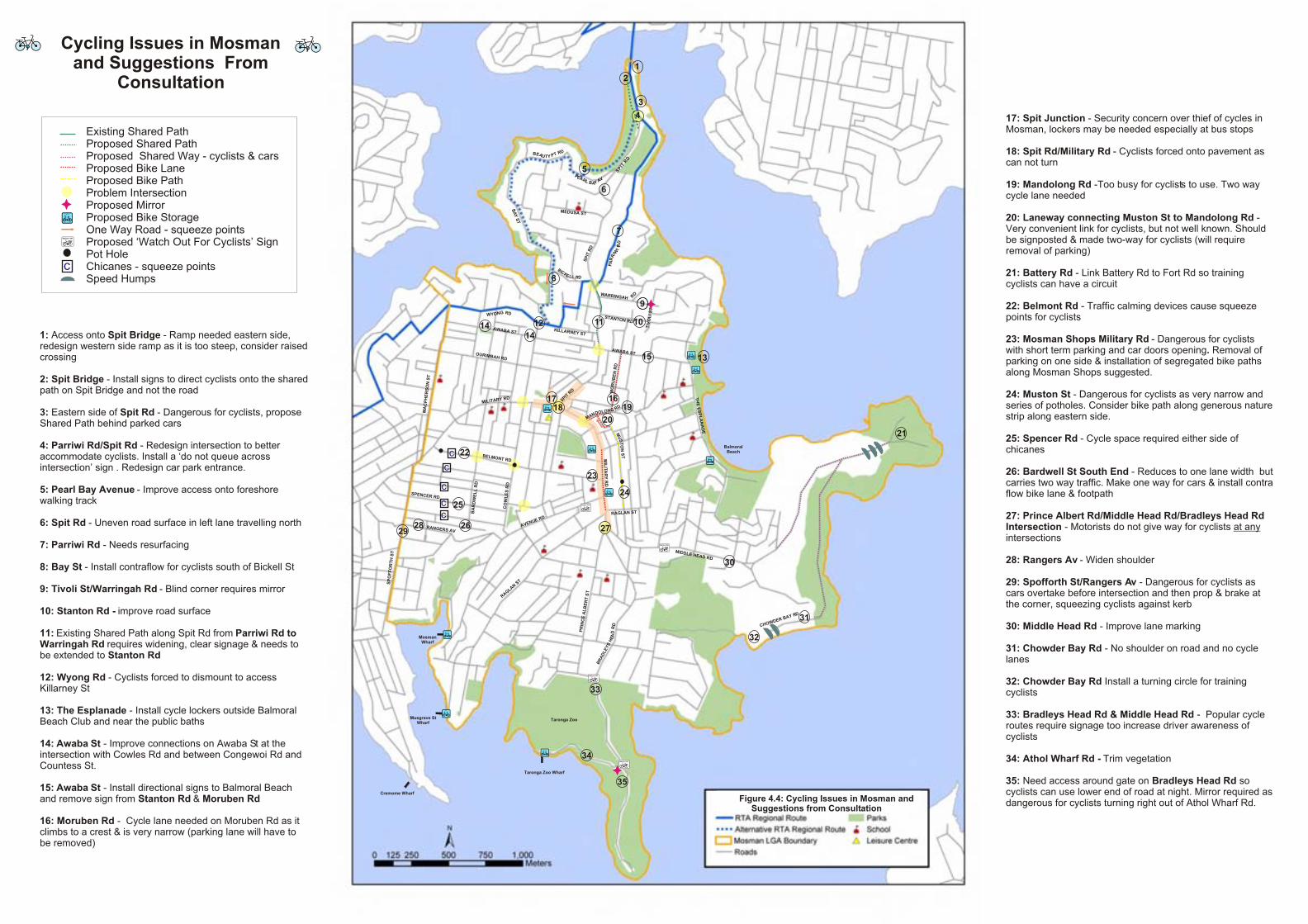
• Parriwi Road – high property walls obscure cyclists view creating blind corners;
• Middle Head Road – speeding cars;
• Prince Albert Street and Queen Street – staggered intersection is dangerous;
• Military Road – high traffic volumes and high pedestrian activity especially around Mosman Shops;
• Spit Road – high traffic volumes;
• Awaba Street – eastern end is too steep to cycle safely; and,
• Ida Avenue – difficult to see cars turning out of Ida Avenue onto Spit Road.
4.1.4 Mosman Bike Plan Questionnaire To facilitate feedback from the community a self completion questionnaire was designed with a reply paid address for return. The questionnaire is included in Appendix B. The questionnaire was handed out at the local cyclist workshop and the community workshops, with around 200 being handed out at Mosman Market. The questionnaire was also posted out to all (90) Bicycle NSW members living in Mosman (defined by the 2088 postcode) and made available through the Mosman Council website. Details about the Bike Plan in the Mosman Daily and on the local posters identified phone and email contacts for the consultant team and Council’s project manager to further promote community input.
In total, 120 questionnaires were completed and received by the due date. The results are summarised below and a full analysis is presented in Appendix B.
Of the respondents:
• 12% did not own a bicycle, or have any cycles available within the household, 57% reported their household owned between 1 and 4 cycles and 18% reported their household owned between 5 and 9 cycles. Per household there was an average of 2.8 bikes (Graph 4.1).
• 11% never make a cycle trip but 74% make a trip as a cyclist at least once a week (Graph 4.2).
• Of the 87% that said they cycled at least occasionally, 81% ride for recreational and general fitness reasons, 39% go on training rides, 37% cycle to and from shops, 35% make trips to leisure and sports facilities, 23% commute by bike (Graph 4.3). This indicates that most cyclists make different types of trips on a regular basis.
• The most popular roads for cycling along (i.e. used by at least 10% of respondents) include; Middle Head Road, Military Road, Bradleys Head Road, Spit Road, Parriwi Road, Raglan Street, Belmont Road, Moruben Road, Chowder Bay Road, Spofforth Street and Avenue Road.
• Cyclists consider traffic volumes to be the biggest problem in Mosman (67%), followed by narrow roads and traffic lanes (48%), traffic speeds (43%) and traffic management devices (21%) (Graph 4.4). Despite the topography of Mosman, hills were only considered to be a big problem by 16% of cyclists and not a problem at all by 45%.

Mosman Municipal Council Mosman Bike Plan 2005 - 2010 24
• High traffic problems were seen to be worst on Military Road and Spit Road. Other big problems identified by respondents were motorist’s attitude and behaviour towards cyclists and lack of cycling lanes and designated cycling areas in Mosman.
• Improved driver behaviour/awareness and on and off road cycle lanes/paths would encourage more cycling by cyclists as would increased cycle parking and reduced traffic (Graph 4.5).
• Non cyclists noted a lack of facilities and cycle lanes/paths, inconsiderate motorists, traffic volumes and speeds and hills as issues (Graphs 4.6 and 4.7).
• 88% of respondents said cyclists and cycling should be given more priority by Council with only 3% responding that less priority should be given by Council.
• Respondents had the following characteristics:
o 57% female, 42% male (2% did not answer),
o 78% aged between 36 and 64 years, and
o 60% live in Mosman.
Graph 4.1: Number of bicycles per household
12%
19%
25%
13%
15%
9%
3%2%
1%
3%
0%
5%
10%
15%
20%
25%
30%
0 1 2 3 4 5 6 7 8 9
Number of Bikes in Household
Perc
enta
ge o
f Res
pond
ents

Mosman Municipal Council Mosman Bike Plan 2005 - 2010 25
Graph 4.2: Frequency of cycling trips
Graph 4.3: Type of trips made by cyclists
13%
45%
16%
2%
13%11%
1%
0%
5%
10%
15%
20%
25%
30%
35%
40%
45%
50%
Everyday Several times aweek
At least once aweek
At least once amonth
Less than once amonth
Never Did not answer
Cycling Frequency
Perc
enta
ge o
f Res
pond
ents
Trips to/from school/TAFE/Uni1%
Trips to/from work10%
Trips to/from public transport2%
Trips to/from leisure or sports facilities
15%
Recreational/fitness rides36%
Training rides17%
Trips/to/from the shops16%
Trips/to/from other places3%

Mosman Municipal Council Mosman Bike Plan 2005 - 2010 26
Graph 4.4: Cycling Issues in Mosman
Graph 4.5: Factors that would encourage cyclists to cycle more often in Mosman
More cycle lanes/paths38%
Nothing19%
Being fitter6%
More cyclists6%
Bike hire company in Mosman6%
Garage to store bike6%
Less Hills19%
67%
48%43%
21%16%
6% 10% 9% 6%
32%
30%
27%
6%
37%
57%
28%
20%
22%
45%
15%10%
7% 10% 11% 13% 12%13%
1% 3%1%
0
0.1
0.2
0.3
0.4
0.5
0.6
0.7
0.8
0.9
1
Trafficvolumes
Narrow roads& traffic lanes
Trafficspeeds
Trafficmanagement
devices
Hills Blockedroads, oneway streets
Other -motorist'sattitude
Other- lack ofcycle
lanes/paths
Other - poorroad surface
Cycling Issues
Perc
enta
ge
Don’t Know
Did Not Answer
Not a Problem
Small Problem
Big Problem

Mosman Municipal Council Mosman Bike Plan 2005 - 2010 27
Graph 4.6: Factors that would encourage non-cyclists to cycle in Mosman
Graph 4.7: The main issues facing cyclists in Mosman as identified by non-cyclists
Traffic volume/speed38%
Hills14%
Motorist's attitude/behaviour14%
Other11%
Lack of cycle lanes/paths7%
Lack of bike parking4%
Narrow roads4%
Pollution4%
Pedestrians4%
Increase in driver awareness24%
Cycle lanes22%
Dedicated cycle path 10%
Off road cycle paths9%
Cycle parking7%
Reduced traffic volume4%
Shared bike path 1%
Other 23%

Mosman Municipal Council Mosman Bike Plan 2005 - 2010 28
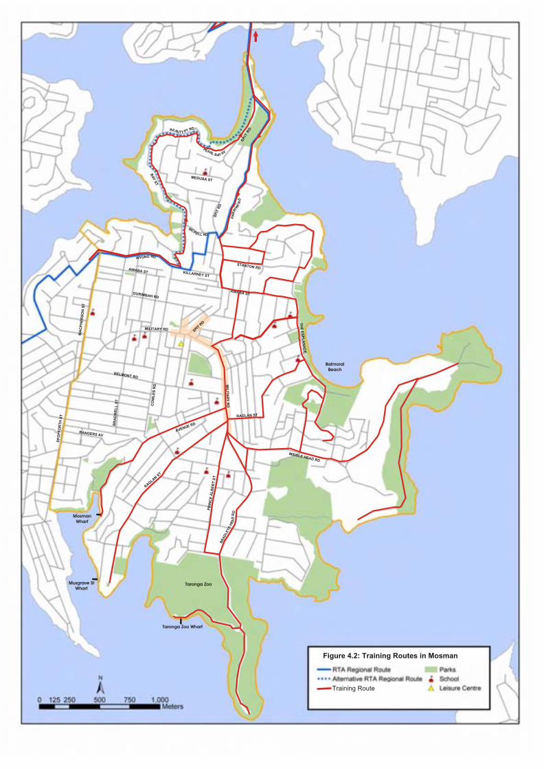
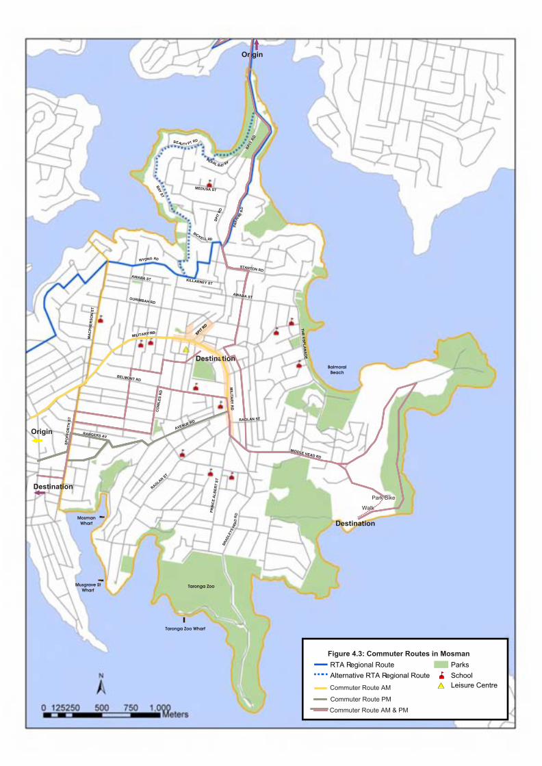
4.1.5 Community Consultation Outcomes The roads and streets used by different types of cyclist (recreational, training and commuter) are illustrated in Figures 4.1 – 4.3. The main issues identified (with suggestions for improvements) by cyclists are summarised in Figure 4.4.
An overview of desire lines and common destinations is shown in Figure 4.5.

Balmoral Beach
Taronga Zoo
Taronga Zoo Wharf
Musgrave St Wharf
Mosman Wharf
SP
IT R
D
SP
IT R
D
BA
Y S
T
AWABA ST
AWABA ST
DR B TEA P U YT
PEA VR AL B YA
MILITARY RD
DR
DA
EH
SY
EL
DA
RB
MIDDLE HEAD RD
G RN DOYW
MA
CP
HE
RS
ON
ST
SP
OF
FO
RT
H S
T
CO
WL
ES
RD
AVENUE RD
BELMONT RD
DR I
WIR
RA
P
KILLARNEY ST
RAGLAN ST
RAGLAN S
T
MEDUSA ST
STANTON RD
BICKELL RD
PR
INC
E A
LB
ER
T S
T
RANGERS AV
OURIMBAH RD
MIL
ITA
RY
RD
SPIT R
D
Figure 4.1: Recreational Routes in Mosman
Recreational Route
Note: Footpath used on Military Road
BR
AD
WE
LL
ST
CO
UN
TE
SS
ST
TH
E E
SP
LA
NA
DE
Balmoral Beach
Taronga Zoo
Taronga Zoo Wharf
Musgrave St Wharf
Mosman Wharf
SP
IT R
D
SP
IT R
D
BA
Y S
T
AWABA ST
AWABA ST
DRBE A TU PTY
PEAR VL A BAY
MILITARY RD
DR
DA
EH
SY
EL
DA
RB
MIDDLE HEAD RD
RG DNYOW
MA
CP
HE
RS
ON
ST
SP
OF
FO
RT
H S
T
CO
WL
ES
RD
AVENUE RD
BELMONT RD
DR I
WIR
RA
P
KILLARNEY ST
RAGLAN ST
RAGLAN S
T
MEDUSA ST
STANTON RD
BICKELL RD
PR
INC
E A
LB
ER
T S
T
RANGERS AV
OURIMBAH RD
MIL
ITA
RY
RD
SPIT R
D
Figure 4.2: Training Routes in Mosman
Training Route
BR
AD
WE
LL
ST
TH
E E
SP
LA
NA
DE
Balmoral Beach
Taronga Zoo
Taronga Zoo Wharf
Musgrave St Wharf
Mosman Wharf
SP
IT R
D
SP
IT R
D
BA
Y S
T
AWABA ST
AWABA ST
DRBE A TU PTY
PEAR VL A BAY
MILITARY RD
DR
DA
EH
SY
EL
DA
RB
MIDDLE HEAD RD
RG DNYOW
MA
CP
HE
RS
ON
ST
SP
OF
FO
RT
H S
T
CO
WL
ES
RD
AVENUE RD
BELMONT RD
DR I
WIR
RA
P
KILLARNEY ST
RAGLAN ST
RAGLAN S
T
MEDUSA ST
STANTON RD
BICKELL RD
PR
INC
E A
LB
ER
T S
T
RANGERS AV
OURIMBAH RD
MIL
ITA
RY
RD
SPIT R
D
Figure 4.2: Training Routes in Mosman
Training Route
BR
AD
WE
LL
ST
TH
E E
SP
LA
NA
DE
Balmoral Beach
Taronga Zoo
Taronga Zoo Wharf
Musgrave St Wharf
Mosman Wharf
SP
IT R
D
SP
IT R
D
BA
Y S
T
AWABA ST
AWABA ST
DRBE A TU PTY
PEAR VL A BAY
MILITARY RD
DR
DA
EH
SY
EL
DA
RB
MIDDLE HEAD RD
RG DNYOW
MA
CP
HE
RS
ON
ST
SP
OF
FO
RT
H S
T
CO
WL
ES
RD
AVENUE RD
BELMONT RD
DR I
WIR
RA
P
KILLARNEY ST
RAGLAN ST
RAGLAN S
T
MEDUSA ST
STANTON RD
BICKELL RDT
HE
ES
PL
AN
AD
E
PR
INC
E A
LB
ER
T S
T
RANGERS AV
OURIMBAH RD
MIL
ITA
RY
RD
SPIT R
D
Origin
Destination
Origin
Park Bike
Walk
Destination
Destination
Figure: Base Map
RTA Regional Route
Alternative RTA Regional Route
Mosman LGA Boundary
Roads
#* Leisure Centre
Parks
¹½ School
#* Leisure Centre
Figure 4.3: Commuter Routes in Mosman
Commuter Route AM & PM
Commuter Route AM
Commuter Route PM
SPIT R
D
MIDDLE HEAD RD
CHOWDER BAY RD
MIDDLE HEAD RD
CHOWDER BAY RD
MIDDLE HEAD RD
CHOWDER BAY RD
MIDDLE HEAD RD
CHOWDER BAY RD
MIDDLE HEAD RD
CHOWDER BAY RD
MIDDLE HEAD RD
CHOWDER BAY RD
MIDDLE HEAD RD
CHOWDER BAY RD
Balmoral Beach
Taronga Zoo
Taronga Zoo Wharf
Musgrave St Wharf
Mosman Wharf
SP
IT R
D
SP
IT R
D
AWABA ST
AWABA ST
DR BEA TPU TY
PEAR VL A B YA
MILITARY RD
MIDDLE HEAD RD
BA
Y S
T
RGN DOYW
MA
CP
HE
RS
ON
ST
SP
OF
FO
RT
H S
T
CO
WL
ES
RD
AVENUE RD
DR I
WIR
RA
P
KILLARNEY ST
RAGLAN S
T
MEDUSA ST
STANTON RD
BICKELL RD
TH
E E
SP
LA
NA
DE
PR
INC
E A
LB
ER
T S
T
RANGERS AV
OURIMBAH RD
MIL
ITA
RY
RD
SPIT R
D
W DARRING RAH
BELMONT RD
MIDDLE HEAD RD
CHOWDER BAY RD
Balmoral Beach
Taronga Zoo
Taronga Zoo Wharf
Musgrave St Wharf
Mosman Wharf
SP
IT R
D
SP
IT R
D
AWABA ST
AWABA ST
DR BEA TPU TY
PEAR VL A B YA
MILITARY RD
MIDDLE HEAD RD
BA
Y S
T
RGN DOYW
MA
CP
HE
RS
ON
ST
SP
OF
FO
RT
H S
T
CO
WL
ES
RD
AVENUE RD
DR I
WIR
RA
P
KILLARNEY ST
RAGLAN S
T
MEDUSA ST
STANTON RD
BICKELL RD
TH
E E
SP
LA
NA
DE
PR
INC
E A
LB
ER
T S
T
RANGERS AV
OURIMBAH RD
MIL
ITA
RY
RD
SPIT R
D
W DARRING RAH
BELMONT RD
BA
RD
WE
LL
RD
MIDDLE HEAD RD
CHOWDER BAY RD
Balmoral Beach
Taronga Zoo
Taronga Zoo Wharf
Musgrave St Wharf
Mosman Wharf
SP
IT R
D
SP
IT R
D
AWABA ST
AWABA ST
DR BEA TPU TY
PEAR VL A B YA
MILITARY RD
MIDDLE HEAD RD
BA
Y S
T
RGN DOYW
MA
CP
HE
RS
ON
ST
SP
OF
FO
RT
H S
T
CO
WL
ES
RD
AVENUE RD
DR I
WIR
RA
P
KILLARNEY ST
RAGLAN S
T
MEDUSA ST
STANTON RD
BICKELL RD
TH
E E
SP
LA
NA
DE
PR
INC
E A
LB
ER
T S
T
RANGERS AV
OURIMBAH RD
MIL
ITA
RY
RD
SPIT R
D
W DARRING RAH
BELMONT RD
BA
RD
WE
LL
RD
MO
RU
BE
N R
D
SPENCER RD
RAGLAN ST
MU
ST
ON
ST
Cycling Issues in Mosman and Suggestions From
Consultation
MIDDLE HEAD RD
CHOWDER BAY RD
Balmoral Beach
Taronga Zoo
Taronga Zoo Wharf
Musgrave St Wharf
Mosman Wharf
SP
IT R
D
SP
IT R
D
AWABA ST
AWABA ST
DR BEA TPU TY
PEAR VL A B YA
MILITARY RD
MIDDLE HEAD RD
BA
Y S
T
RGN DOYW
MA
CP
HE
RS
ON
ST
SP
OF
FO
RT
H S
T
CO
WL
ES
RD
AVENUE RD
DR I
WIR
RA
P
KILLARNEY ST
RAGLAN S
T
MEDUSA ST
STANTON RD
BICKELL RD
TH
E E
SP
LA
NA
DE
PR
INC
E A
LB
ER
T S
T
RANGERS AV
OURIMBAH RD
MIL
ITA
RY
RD
SPIT R
D
W DARRING RAH
BELMONT RD
BA
RD
WE
LL
RD
MO
RU
BE
N R
D
SPENCER RD
RAGLAN ST
MU
ST
ON
ST
Cycling Issues in Mosman and Suggestions From
Consultation
Existing Shared PathProposed Shared Path Proposed Shared Way - cyclists & carsProposed Bike Lane Proposed Bike PathProblem Intersection Proposed MirrorProposed Bike StorageOne Way Road - squeeze pointsProposed ‘Watch Out For Cyclists’ SignPot Hole Chicanes - squeeze pointsSpeed Humps
c
Figure 4.4: Cycling Issues in Mosman and Suggestions from Consultation
TIV
OL
I S
T
MIDDLE HEAD RD
CHOWDER BAY RD
Balmoral Beach
Taronga Zoo
Taronga Zoo Wharf
Musgrave St Wharf
Mosman Wharf
SP
IT R
D
SP
IT R
D
AWABA ST
AWABA ST
DR BEA TPU TY
PEAR VL A B YA
MILITARY RD
MIDDLE HEAD RD
BA
Y S
T
RGN DOYW
MA
CP
HE
RS
ON
ST
SP
OF
FO
RT
H S
T
CO
WL
ES
RD
AVENUE RD
DR I
WIR
RA
P
KILLARNEY ST
RAGLAN S
T
MEDUSA ST
STANTON RD
BICKELL RD
TH
E E
SP
LA
NA
DE
PR
INC
E A
LB
ER
T S
T
RANGERS AV
OURIMBAH RD
MIL
ITA
RY
RD
SPIT R
D
W DARRING RAH
BELMONT RD
BA
RD
WE
LL
RD
MO
RU
BE
N R
D
SPENCER RD
RAGLAN ST
MU
ST
ON
ST
Cycling Issues in Mosman and Suggestions From
Consultation
Existing Shared PathProposed Shared Path Proposed Shared Way - cyclists & carsProposed Bike Lane Proposed Bike PathProblem Intersection Proposed MirrorProposed Bike StorageOne Way Road - squeeze pointsProposed ‘Watch Out For Cyclists’ SignPot Hole Chicanes - squeeze pointsSpeed Humps
c
Figure 4.4: Cycling Issues in Mosman and Suggestions from Consultation
TIV
OL
I S
T
DR GNOLODNAM
1
1: Access onto Spit Bridge - Ramp needed eastern side, redesign western side ramp as it is too steep, consider raised crossing
2: Spit Bridge - Install signs to direct cyclists onto the shared path on Spit Bridge and not the road
3: Eastern side of Spit Rd - Dangerous for cyclists, propose Shared Path behind parked cars
4: Parriwi Rd/Spit Rd - Redesign intersection to better accommodate cyclists. Install a ‘do not queue across intersection’ sign . Redesign car park entrance.
5: Pearl Bay Avenue - Improve access onto foreshore walking track
6: Spit Rd - Uneven road surface in left lane travelling north
7: Parriwi Rd - Needs resurfacing
8: Bay St - Install contraflow for cyclists south of Bickell St
9: Tivoli St/Warringah Rd - Blind corner requires mirror
10: Stanton Rd - improve road surface
11: Existing Shared Path along Spit Rd from Parriwi Rd to Warringah Rd requires widening, clear signage & needs to be extended to Stanton Rd
12: Wyong Rd - Cyclists forced to dismount to access Killarney St
13: The Esplanade - Install cycle lockers outside Balmoral Beach Club and near the public baths
14: Awaba St - Improve connections on Awaba St at the intersection with Cowles Rd and between Congewoi Rd and Countess St.
15: Awaba St - Install directional signs to Balmoral Beach and remove sign from Stanton Rd & Moruben Rd
16: Moruben Rd - Cycle lane needed on Moruben Rd as it climbs to a crest & is very narrow (parking lane will have to be removed)
17: Spit Junction - Security concern over thief of cycles in Mosman, lockers may be needed especially at bus stops
18: Spit Rd/Military Rd - Cyclists forced onto pavement as can not turn
19: Mandolong Rd -Too busy for cyclists to use. Two way cycle lane needed
20: Laneway connecting Muston St to Mandolong Rd - Very convenient link for cyclists, but not well known. Should be signposted & made two-way for cyclists (will require removal of parking)
21: Battery Rd - Link Battery Rd to Fort Rd so training cyclists can have a circuit
22: Belmont Rd - Traffic calming devices cause squeeze points for cyclists
23: Mosman Shops Military Rd - Dangerous for cyclists with short term parking and car doors opening. Removal of parking on one side & installation of segregated bike paths along Mosman Shops suggested.
24: Muston St - Dangerous for cyclists as very narrow and series of potholes. Consider bike path along generous nature strip along eastern side.
25: Spencer Rd - Cycle space required either side of chicanes
26: Bardwell St South End - Reduces to one lane width but carries two way traffic. Make one way for cars & install contra flow bike lane & footpath
27: Prince Albert Rd/Middle Head Rd/Bradleys Head Rd Intersection - Motorists do not give way for cyclists at any intersections
28: Rangers Av - Widen shoulder
29: Spofforth St/Rangers Av - Dangerous for cyclists as cars overtake before intersection and then prop & brake at the corner, squeezing cyclists against kerb
30: Middle Head Rd - Improve lane marking
31: Chowder Bay Rd - No shoulder on road and no cycle lanes
32: Chowder Bay Rd Install a turning circle for training cyclists
33: Bradleys Head Rd & Middle Head Rd - Popular cycle routes require signage too increase driver awareness of cyclists
34: Athol Wharf Rd - Trim vegetation
35: Need access around gate on Bradleys Head Rd socyclists can use lower end of road at night. Mirror required as dangerous for cyclists turning right out of Athol Wharf Rd.
DR
DA
EH
SY
EL
DA
RB
Cremome Wharf
2
3
4
5
6
7
8
10
9
1112
13
1414
15
161718 19
20
21
22c
23
24
25
26 272829
30
31
32
33
34
35
c
c
cc

Manly Seaforth
Northern BeachesThe Spit
HMAS PenguinMiddle Head Oval
Cobblers & Obelisk Beaches
Chowder Bay
Balmoral Beach
CBDNorth SydneyMilsons PointSt Leonards
Mosman BayFerry Wharfs
Taronga ZooTaronga Zoo Wharf
Bradleys Head
Mosman VillageMosman Civic/
Community Facilities
CBDNorth SydneyMilsons Point
Balmoral Beach
Taronga Zoo
Taronga Zoo Wharf
Musgrave St Wharf
Mosman Wharf
SP
IT R
D
SP
IT R
D
BA
Y S
T
AWABA ST
AWABA ST
MA
CP
HE
RS
ON
ST
PEA VR A L B YA
MILITARY RD
D
R D
AE
H S
YE
LD
AR
B
MIDDLE HEAD RD
G RN DYOW
SP
OF
FO
RT
H S
T
CO
WL
ES
RD
AVENUE RD
DR I
WIR
RA
P
KILLARNEY ST
RAGLAN ST
RAGLAN S
T
MEDUSA ST
STANTON RD
BICKELL DR
TH
E E
SP
LA
NA
DE
PR
INC
E A
LB
ER
T S
T
RANGERS AV
OURIMBAH RD
MIL
ITA
RY
RD
SPIT R
D
Figure 4.5: Mosman Desire Lines
Cremome Wharf
DBEA Y RU ATY B
Desire Line

Mosman Municipal Council Mosman Bike Plan 2005 - 2010 34
4.2 Stakeholder Consultation During the course of the study the following stakeholders have been consulted:
• Sydney Harbour Federation Trust;
• National Parks and Wildlife Service;
• Local primary and senior schools;
• North Sydney Council; and
• Manly Council.
Bicycle NSW and Bike North are represented on the Working Group as is the local cycle store, Le Spit Cyclery, and as such have not been subject to separate consultation.
The main points arising from discussions with the above stakeholders are included below.
4.2.1 The Sydney Harbour Federation Trust (SHFT) SHFT manages the former defence land around Chowder Bay and Middle Head. The Trust has developed a Transport Management Plan for their Middle Head lands. A copy of the Trust’s plan is in Appendix C. Relevant points from the discussions include:
• There is a desire to open up Trust lands to public access with an emphasis on access via sustainable modes;
• A shared use path is proposed alongside Middle Head Road north of Cobbittee Street;
• A pedestrian route (unsurfaced) has been identified from Rawson Park to Georges Heights Oval and on through Best Avenue to Middle Head Road;
• Access from Cross Street to Rawson Park could be via the Drill Hall land in future;
• The Drill Hall on Cross Street is to be redeveloped for community uses and the inclusion of hard surface netball courts is being investigated;
• There are additional opportunities for linking into Trust land in the vicinity of the camouflaged fuel tanks; and,
• Consideration must be given to the containment of the root rot fungus, Phytophthora cinnamomi, that affects the areas to the east of Bradleys Head and south of Middle Head Road but not the area to the north of Middle Head Road.
The main conclusions from these discussions are:
• The Trust is keen to encourage cycling on and through its land; and,
• Mosman Council should lobby the Trust to ensure the link from Rawson Park to Georges Heights Oval is surfaced with a material suitable for cyclists.
4.2.2 National Parks and Wildlife Service (NPWS) NPWS is also a major land owner (on behalf of State Government) in the Mosman area. Extensive areas around Bradleys Head and Middle Head form part of the Sydney Harbour National Park. Walking tracks are provided along the coastline and through adjacent bushland within the National Park. NPWS has set out priorities for the area in the Sydney Harbour National Park Plan of Management (October 1998 and subsequent amendments). Relevant points from a review of documents and discussions include:
• Existing walking tracks around Bradleys Head and Chowder Head will not be opened up to cyclists;

Mosman Municipal Council Mosman Bike Plan 2005 - 2010 35
• Generally shared use paths are not encouraged on NPWS land, with the focus being on walking tracks;
• The area of National Park to the south of Rawson Park is not pristine bush and it is possible consideration would be given to locating a shared use trail through the edges of this land; and,
• NPWS generally does not have funding available for new paths.
The principal conclusion from these discussions is the possibility of extending a future off road network between Bradleys Head Road with Middle Head, utilising Council, SHFT and NPWS land.
4.2.3 Local Schools All schools in the Mosman area were invited to comment on cycling issues as part of the Mosman Bike Plan by letter and by phone. There are nine primary schools and two high schools in Mosman:
Queenwood School for Girls,
Blessed Sacrament School,
Scared Heart Primary School,
Queenwood Junior School,
Middle Harbour Public School,
Mosman High School,
S.C.E.G.G.S Redlands,
Mosman Church of England Preparatory School,
Scared Heart, and
Beauty Point Public School.
Four schools provided input into the Plan, including Queenwood School for Girls, Sacred Heart Primary School, Blessed Sacrament School and Middle Harbour Public School.
Of these schools:
None prohibit cycling to school but it is not encouraged by Middle Harbour and Blessed Sacrament Schools as it is considered too dangerous for students;
Interest in cycling to school by children is currently low;
Only Sacred Heart Primary School has a few students that presently cycle to school;
A few members of staff from Queenwood cycle occasionally to school and some teachers at other schools are keen recreational cyclists;
The main barriers to cycling to school are considered to be hills, traffic speeds and volumes especially during morning and afternoon peak periods and between Spit Junction and Mosman Junction;
If these barriers could be overcome it is thought that more students at Queenwood would cycle to school as sports participation and general physical activity is high;
None have cycle parking facilities but most were willing to put in cycle parking if required;
Blessed Sacrament School do not wish to encourage cycling to school by installing cycle parking as cycling is considered too dangerous for children especially those in the younger grades also there is not enough space for the parking;
Scared Heart Primary School expressed an interest in receiving advice on how to install cycle parking where it should be located and how many would be required;
None of the schools have bicycle education programs at school;

Mosman Municipal Council Mosman Bike Plan 2005 - 2010 36
All support the development of off road cycling facilities for children in Mosman; and,
Educational cycling leaflets identifying safe cycling routes to schools and other locations in Mosman are supported by most schools.
4.2.4 North Sydney Council The development of the network connections for the Mosman Bike Plan were based on North Sydney’s draft bike plan which was adopted by North Sydney Council on the 23rd of August 2004. Although minor changes were made to North Sydney’s bike plan before it was adopted the changes did not affect the connections proposed with the Mosman area. In addition discussions with North Sydney Council have indicated that priority will be given to the regional route from North Sydney to Mosman via Ellalong Road and Wyong Road. This is part of a regional route connecting Sydney CBD with Warringah Mall.
4.2.5 Manly Council Manly’s Bike Plan is in place and for the purposes of developing the Mosman Bike Plan, there is little to consider other than the connection to Manly via Spit Bridge and to ensure that signage is compatible on both sides of the Spit Bridge.

Mosman Municipal Council Mosman Bike Plan 2005 - 2010 37

Mosman Municipal Council Mosman Bike Plan 2005 - 2010 38
5.0 Local Survey and Site Visits To inform the development of the Mosman Bike Plan a saddle survey was undertaken on Sunday 25th July 2004. In addition the consultant team has undertaken numerous site visits to inspect specific locations and routes. Meetings with stakeholders have also occurred on-site as discussed in the previous section. Additional site visits have been made to the area to investigate route options and particular features.
Particular attention has been paid to the identified priority locations:
• Widening of the footway to accommodate a shared pedestrian/cycle path between Parriwi Road and Stanton Road on the east side of Spit Road and the exception of cyclists from the am peak left turn ban from Spit Road into Stanton Road.
• Provision of access for cyclists from the top of Parriwi Road to the crossing on Spit Road to the north of the intersection with Bickell Road and onto Bickell Road.
• Examination of the south-north RTA regional route to determine the feasibility of redirecting it through Beauty Point and Pearl Bay.
• Providing access to/from the northern end of Parriwi Road at Spit Road for cyclists to allow them easy passage along the cycle network.
• Examination of the possibility of providing a two way shared path along the east side of Spit Road between Parriwi Road and Spit Bridge.
• Examination of possible off road routes through Rawson Park linking Bradleys Head and Middle Head Road as part of the Taronga Zoo Wharf to Balmoral route.
The outcomes and conclusions of the saddle survey and site visits are shown on Figure 5.1.

Balmoral Beach
Taronga Zoo
Taronga Zoo Wharf
Musgrave St Wharf
Mosman Wharf
SP
IT R
D
SP
IT R
D
AWABA ST
AWABA ST
DR BEA TPU TY
PEAR VL A B YA
MILITARY RD
DR
DA
EH
SY
EL
DA
RB
CHOWDER BAY RD
BA
Y S
T
RGN DOYW
MA
CP
HE
RS
ON
ST
SP
OF
FO
RT
H S
T
CO
WL
ES
RD
AVENUE RD
DR I
WIR
RA
P
KILLARNEY ST
RAGLAN S
T
MEDUSA ST
STANTON RD
BICKELL RD
TH
E E
SP
LA
NA
DE
PR
INC
E A
LB
ER
T S
T
RANGERS AV
OURIMBAH RD
MIL
ITA
RY
RD
SPIT R
D
W DARRING RAH
BELMONT RD
BA
RD
WE
LL
RD
MO
RU
BE
N R
D
SPENCER RD
RAGLAN ST
MU
ST
ON
ST
Cycling Issues In Mosman Arising From Survey
Figure 5.1: Cycling Issues In Mosman Arising From Survey
TIV
OL
I S
T
DR GNOLODNAM
1
2
3
6
7
9
10
11
13
12
13
14
13
18
17
24
23
1: Improve link under Spit Bridge to facilitate use by cyclists
2: Provide southbound cycle lane between Spit Bridge and Parriwi Road
3: Facilitate access from Spit Road to Parriwi Road
4: Construct path to provide cyclists with access from car park (west side of Spit Road) to shared use path
5: Foreshore Walking Track is very narrow in sections
6: Cycle access/egress required between foreshore path and Pearl Bay Avenue
7: Facility required to allow cyclists to travel north through one way section of Bay Street
8: Facilitate access to/from signalised crossing near Bickell Road
9: Facilitate use of shared use path along east side of Spit Road
10: Facility required to allow cyclists to travel east along Amiens Avenue
11: Shared path connecting Wyong Road and Killarney Street poorly signed and requires improvement
12: Improve connection to the Esplanade
13: Cut back kerb outstands to width of parking lane (The Esplanade, Military Road, Cabramatta Road)
14: Chicanes in roads between Cowles Road and Spofforth Street need cycle ‘lanes’
15: Potential to provide link for cyclists along Battery Road
16: Speed humps on Middle Head Road are dangerous for cyclist
17: Provide path for pedestrians and cyclists
18: Improve cycle lane carriages along Middle Head Road
19: Staggered intersection at Queen Street and Prince Albert Road is confusing
20: Provide link through Rawson Park (ILWAP proposal) and investigate additional opportunities for connections through NPWS and SHFT land
21: Resurface shoulders along Bradleys Head Road to ensure cyclists not obstructed
22: Improve access to Clifton Gardens for cyclists
23: Improve parking along Bradleys Head Road to ensure cyclists not obstructed
24: Cut back vegetation along north kerb
25: Improve visibility and sight lines - possibly by locating mirror(s) on corner
4
8
20
21
25
One Way Road
Cremome Wharf
CABRAMATTA RD
GLOVER ST
Rawson Park
ST19
QUEEN
5
22
15
AMIENS AVE
16

Mosman Municipal Council Mosman Bike Plan 2005 - 2010 40
6.0 Mosman Bike Plan Proposals
6.1 Introduction This section presents the proposed Bike Plan, based on the work described in the previous sections of the Plan. The proposed Bike Plan incorporates engineering and non-engineering measures and supports a need for Council to take a holistic approach to planning the street network and associated infrastructure.
Through the consultation and data analysis stages of work it has become clear that there is a need for a cycle network in Mosman that is capable of being many things to many different types of cyclists. The types of cyclist identified include:
• Recreational cyclists;
• Training cyclists;
• Commuters (journey to/from work, school or college);
• Local transport cyclists (journeys to from shops and other local facilities);
• Children; and,
• Aspirational cyclists (people who do not cycle or only cycle infrequently but would like to cycle more).
In addition we have identified non-cyclists. These are people who use the road network as drivers and/or pedestrians and generally have no desire to cycle.
The network requirements identified include:
• Through routes between North Sydney and Manly Council areas;
• Connections to local destinations;
• Circuits of varying lengths and requiring varying fitness levels within Mosman; and,
• Extended sections of off road path.
6.2 Bike Plan Proposals Content The actions proposed within the Bike Plan fall under the following headings:
• Bicycle steering group;
• Generic network proposals;
• Specific cycle network proposals (including priority items);
• Cycle parking strategy;
• Cycle signing strategy; and,
• Promotional activities.
6.3 Bicycle Steering Group Council should form a bicycle steering group that is responsible for further developing the cycling culture in Mosman through monitoring, organising related activities and driving the implementation of the Bike Plan.
This Plan aims to sustain a greater interest and commitment to cycling through the formation of an organised body that is led by Council. The steering committee or Mosman Cycling Working Group’s purpose would be to drive this Bike Plan and to promote and manage activities associated
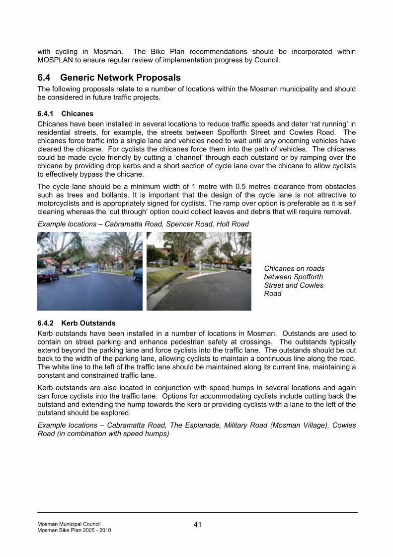
Mosman Municipal Council Mosman Bike Plan 2005 - 2010 41
with cycling in Mosman. The Bike Plan recommendations should be incorporated within MOSPLAN to ensure regular review of implementation progress by Council.
6.4 Generic Network Proposals The following proposals relate to a number of locations within the Mosman municipality and should be considered in future traffic projects.
6.4.1 Chicanes Chicanes have been installed in several locations to reduce traffic speeds and deter ‘rat running’ in residential streets, for example, the streets between Spofforth Street and Cowles Road. The chicanes force traffic into a single lane and vehicles need to wait until any oncoming vehicles have cleared the chicane. For cyclists the chicanes force them into the path of vehicles. The chicanes could be made cycle friendly by cutting a ‘channel’ through each outstand or by ramping over the chicane by providing drop kerbs and a short section of cycle lane over the chicane to allow cyclists to effectively bypass the chicane.
The cycle lane should be a minimum width of 1 metre with 0.5 metres clearance from obstacles such as trees and bollards. It is important that the design of the cycle lane is not attractive to motorcyclists and is appropriately signed for cyclists. The ramp over option is preferable as it is self cleaning whereas the ‘cut through’ option could collect leaves and debris that will require removal.
Example locations – Cabramatta Road, Spencer Road, Holt Road
6.4.2 Kerb Outstands Kerb outstands have been installed in a number of locations in Mosman. Outstands are used to contain on street parking and enhance pedestrian safety at crossings. The outstands typically extend beyond the parking lane and force cyclists into the traffic lane. The outstands should be cut back to the width of the parking lane, allowing cyclists to maintain a continuous line along the road. The white line to the left of the traffic lane should be maintained along its current line, maintaining a constant and constrained traffic lane.
Kerb outstands are also located in conjunction with speed humps in several locations and again can force cyclists into the traffic lane. Options for accommodating cyclists include cutting back the outstand and extending the hump towards the kerb or providing cyclists with a lane to the left of the outstand should be explored.
Example locations – Cabramatta Road, The Esplanade, Military Road (Mosman Village), Cowles Road (in combination with speed humps)
Chicanes on roads between Spofforth Street and Cowles Road

Mosman Municipal Council Mosman Bike Plan 2005 - 2010 42
6.4.3 On Street Angle Parking On street angle parking exists in a number of locations within Mosman and in some occurs in a fairly ad hoc manner. Poor parking discipline by motorists can force cyclists into the traffic lane and also block the view of manoeuvring vehicles. Line marking is an effective way of encouraging good parking discipline and vehicles parking outside of designated spaces can be monitored by Council’s rangers. The Esplanade and recent changes to the parking layout at Balmoral Beach, provides a good example of how angle parking can be managed.
Example locations – Spit Road (at The Spit), Bradleys Head Road
6.4.4 Carriageway Shoulders While a number of streets in Mosman are very comfortable for cycling due to their width, the poor road surface of the shoulders prevents cyclists from using the full carriageway width. There is a need to ensure shoulders are of the same quality as the carriageway surface and where a white line is used to demarcate the edge of the carriageway, it does not form a ridge as is the case in some locations.
Example locations – Bradleys Head Road, Parriwi Road
6.4.5 Storage Boxes Storage boxes or advance cycle stop lines allow cyclists to position themselves ahead of the traffic queue at signalised intersections. The positioning of vehicle detection loops and the proximity of vehicle stop lines to pedestrian crossings limits the opportunity for storage boxes within Mosman. Advance storage boxes are advantageous to cyclists and it is recommended that two options be investigated:
Poorly surfaced shoulders, Bradleys Head Road
Kerb outstands in Cabramatta Road (left) and The Esplanade
Undisciplined parking, Spit Road

Mosman Municipal Council Mosman Bike Plan 2005 - 2010 43
• The relocation of vehicle detection loops and moving of the vehicle stop line to allow for a storage box to be installed; or,
• The moving of the vehicle stop line to allow for the installation of a storage box across the left lane only, with traffic in the right hand lane triggering the signals.
Recognising the second of these solutions can only be investigated for use in locations that meet specific criteria, it is suggested that the Cowles Road/Military Road intersection may be suitable for this treatment with storage boxes facilitating the straight ahead movement of cyclists in Cowles Road across Military Road. It would be necessary to prohibit left turning on red signals from Cowles Road into Military Road, however, this would have minimal traffic flow impacts and would enhance both vehicle and pedestrian safety at this location by reducing the potential for conflict.
6.4.6 Traffic Domes A number of traffic domes exist in Mosman at intersections. While the use of traffic domes encourages motorists not to cut corners at intersections, they can be difficult to see and particularly dangerous to cyclists (and motorcyclists) if hit inadvertently. Wherever possible traffic domes should be removed and replaced with alternatives such as line markings or traffic islands/pedestrian refuges.
Example locations – Beaconsfield Road/Wolseley Road, Mandolong Road/Moruben Road
6.4.7 Drain Covers Drain covers with slots parallel to the direction of travel are dangerous to cyclists. Council should ensure that drain covers are consistently placed so slots run perpendicular to the flow of traffic or are replaced with grid style drain covers, guarding against the possibility of cycle wheels becoming caught.
Example locations: Upper Fairfax Road
Traffic dome in Beaconsfield Road
Above: Drainage grate, Upper Fairfax Road
Right: Example of bicycle friendly grate, Bickell Road

Mosman Municipal Council Mosman Bike Plan 2005 - 2010 44
6.4.8 Cycle Lanes Marked on road cycle lanes provide cyclists with a clear space in which to travel and convey a message to drivers about the presence of cyclists. Cycle lanes should be provided along key routes where carriageway widths permit. On-street parking is often not under pressure in Mosman given the prevalence of single dwelling blocks with sufficient off-street parking and so the removal of the parking lane in some locations to provide sufficient space for a cycle lane may not be a contentious issue.
Example locations – Bradleys Head Road, Middle Head Road
6.4.9 Roundabouts Roundabouts are often difficult for cyclists to negotiate due to the speed of vehicles through the intersection. Roundabouts can be made safer for cyclists through implementing measures to reduce traffic speeds on the approach and through the intersection. This can be done by making changes to the roundabout geometry to reduce overall diameter of the intersection, however, difficulties arise where roundabouts are located on bus routes.
Example locations – Avenue Road, Raglan Street, Belmont Street
At larger roundabouts cycle paths can be provided for less confident cyclists that negotiate the roundabout.
6.4.10 Road Closures and One-way Streets Road closures and one way streets generally form part of an overall traffic management strategy, protecting residential areas from “rat running” and inappropriate traffic volumes and speeds, however, they reduce the permeability of the cycle network and result in cyclists travelling much further than necessary or travelling illegally on a footpath or the wrong way in a one way street. Efforts should be made to open up road closures to cyclists, possibly through designating footpaths as shared use or providing cycle contra-flow lanes.
Example locations – Bay Street, Amiens Street
Example of roundabout treatment in Willoughby
Diagram showing the provision of cycle lanes around a roundabout

Mosman Municipal Council Mosman Bike Plan 2005 - 2010 45
6.4.11 Introduce an Integrated Planning Approach to all Infrastructure Mosman Council needs to follow other councils and adopt an integrated approach to the planning of Council works to ensure cyclists (and pedestrians) are considered from the outset in projects. This will promote the requirements of cyclists broadly and avoid the need for later retrofitting of cycle facilities.
6.5 Specific Cycle Network Proposals (Including Priority Items) The proposed cycle network is presented on Figure 6.1. The network incorporates the priority items identified in Section 5 and addresses the issues identified in the 1982 bike plan in addition to those raised through the course of this study. Much of the proposed network consists of quiet residential streets which are already relatively easy to cycle along. The focus of activity for the Bike Plan is realising connections between these quiet residential streets to form a connected and continuous network for cycling.
For ease of reference the site specific proposals are separated into:
• RTA Regional Route,
• Eastern Mosman,
• Middle Head/Bradleys Head, and
• Western Mosman.
The numbering system follows that on Figure 6.1 with the text below providing additional detail to that on the figure. A series of concept designs have been developed for the five priority items and these are included in Appendix D.
6.5.1 RTA Regional Route 1 Wyong Road/Killarney Street – Facilitate turning movements for cyclists to provide access along the RTA Regional Route. Existing shared use path and kerb ramps are poorly located and signed and do not provide a safe option for westbound cyclists turning into Wyong Road (Appendix D).
One way section, Bay Street
Cycles exempted from no entry, Avenue Road/Raglan Street car park

Mosman Municipal Council Mosman Bike Plan 2005 - 2010 46
2 Amiens Street – Designate northern footpath as shared use and sign for eastbound cyclists to provide access along Amiens Street (one way westbound). Kerb ramps already exist and provide cycle access to and from the footpath and if necessary widen the footpath, however, cycle and pedestrian use is likely to be low and cyclists will be travelling uphill and therefore relatively slowly. Southbound cyclists will continue to use the road and require no special treatments.
3 Bay Street – Install a contraflow cycle path through the reserve to allow northbound cyclists to travel past the one way section on Bay Street. Council owns the reserve and there is sufficient space for a contraflow lane (Appendix D).
4 Pearl Bay Avenue – Facilitate cycle access/egress to the foreshore path from Pearl Bay Avenue to provide a link to Spit Bridge. The access is wide but the pedestrian path and fencing does not provide for pedestrian desire lines which should also be taken into account in any proposals (Appendix D). The condition of existing asphalt path which extends 110 metres to the foreshore concrete path is substandard and requires upgrading. The path edges are crumbling due to unstable base material of sandy soil, steep slope and water erosion. In sections the path narrows to under one metre wide.
5 Spit Road (west) – Implement a shared use path between the northern end of the car park and the existing shared use path along the west side of Spit Road. The foreshore path brings cyclists into the car park to the west of Spit Road but the connection to the existing shared use path alongside Spit Road is poor. Two proposals have been devised:
• Proposal 1 – install a short section of path from the end of the car park (close to the toilet block), diagonally to the shared use path.
• Proposal 2 – construct a long section of path from the end of the car park between the two rows of pine trees, parallel to the existing shared path. The new path would join the existing shared path at the driveway entrance to D’Albora Marina before reaching Spit Bridge (Appendix D).
Both proposals would require the removal of one car parking space or the repositioning of the ticket machine to allow safe access for cyclists to and from the new path.
It is considered inappropriate to improve the connection from the car park to the shared use path, where it begins at the intersection of Spit Road and Parriwi Road, as the path takes cyclists across a bus stop and the entry to the car park which can become congested at busy times.
6 Spit Bridge – Improve the connection under Spit Bridge to ensure minimum width and height clearances are maintained. The existing path has tight and blind corners, is narrow and with limited height clearance. Proposed changes to Spit Bridge offer opportunities to improve this link. The path should be at least 2.5m wide and have a height clearance of 2.4m. AustRoads Part 14 (Bicycles) guidance indicates that for a design speed of 20km/h paths should have a minimum radius of 10m and 25m for a design speed of 30km/h. Given the location it is reasonable to design for a slow speed although consideration should be given to the need for warning signs. If blind corners cannot be negated, mirrors may improve sightlines.
7 Spit Road (east) – There is a need to provide for cyclists along the eastern side of Spit Road between Spit Bridge and Parriwi Road. A two stage approach is recommended:
• Stage 1: Install a green cycle lane southbound to the east of the carriageway of Spit Road. This lane will cater for ‘training’ and ‘road’ cyclists that prefer not to use Spit Bridge underpass as well as increasing motorists’ awareness of cyclists in Mosman.
• Stage 2: Implement a shared use boardwalk and associated shared areas between Spit Bridge and Parriwi Road. A concept design has been prepared for the boardwalk and shared use path with proposed changes to the existing angle parking (Appendix D). There is a need to facilitate cycle use of the service roads at either end and erect appropriate signs.
8 Parriwi Road / Spit Road – Facilitate cycle access between the shared use path / boardwalk and Parriwi Road. A concept design has been prepared proposing changes to the intersection

Mosman Municipal Council Mosman Bike Plan 2005 - 2010 47
which will allow cyclists to cut across the existing traffic islands (Appendix D). Consider implementing a green cycle lane through the exit/entry to the car park to inform motorists that they need to allow cyclists to cross the intersection.
9 Parriwi Road – Resurface. 10 Parriwi Road to Bickell Road – Implement proposals to facilitate cycle access across Spit Road. A concept design has been prepared proposing an extended network of shared use paths and the conversion of the existing pedestrian crossing on Military Road to shared use (Appendix D).
6.5.2 Eastern Mosman 11 Parriwi Road to Stanton Road – Paint road markings in Parriwi Road to direct cyclists to the shared use path and widen the path. Pavement markings (leader line and bicycle logo) will assist cyclists travelling southbound to identify the entry to the shared use path. Attach a ‘Buses and Bicycles Excepted’ sign onto the existing ‘no left turn sign in the AM Peak’ at the intersection of Spit Road and Stanton Road. A concept design for the widening of the shared use path between Parriwi Road and Stanton Road has been prepared (Appendix D).
12 Wyargine Street – Sign existing wheeldown to The Esplanade. There is a wheel down adjacent to steps to The Esplanade but it is unsigned and difficult to identify from both directions. Signs would help cyclists identify the link. An alternative route via Awaba Street has been identified for those who do not wish to dismount and use the steps.
13 The Esplanade – Investigate cutting back the kerb outstands. As noted in the discussion on generic treatments (section 6.4.2), kerb outstands can force cyclists into the traffic lane. The kerb outstands along The Esplanade define parking bays and promote lower traffic speeds but do extend further than the parking lane and narrow the carriageway forcing cyclists into the traffic lane. The design of the outstands should be revisited to investigate the possibility of cutting back the outstand while still maintaining the same impact on parking and driver behaviour.
14 Moruben Road – Widen carriageway at Punch Street and implement cycle friendly measures at the roundabout intersection with Awaba Street. The carriageway is narrow at Punch Street due to the geometry of the intersection with Lower Punch Street but it is possible to widen the road by reducing the nature strip. The footpath is elevated at this section so the nature strip at road level adds little to pedestrian amenity. Cycle friendly roundabout designs are discussed in section 6.4.9.
15 Melaleuca Lane – Implement contra-flow cycle lane for southbound cyclists. It may be possible to implement a contraflow lane relatively easily with signage, however, the corner at the southern end of the lane way is sharp and narrow with a driveway egress and may require the acquisition of a small triangle of land to increase widths and improve sightlines at the corner.
6.5.3 Middle Head/Bradleys Head 16 Middle Head Road – Mark cycle lanes. The carriageway of Middle Head Road is wide enough to accommodate cycle lanes although kerbside parking will have to be removed along one side in sections. As most houses have off-street parking and residential development along much of Middle Head Road is discontinuous it will be possible to alternate kerbside parking between the north and south kerbs.
17 Middle Head Road (east) – Support SHFT in realising their aim of a shared use path. This section of Middle Head Road is narrow and SHFT have proposed a shared use path to facilitate cyclist and pedestrian movement.
18 Middle Head – Advocate completion of the road connection to allow training cyclists to turn. A network of roads exists within the Middle Head NPWS reserve, however, a few metres are missing. If the connection was completed, training cyclists would be able to circuit along Chowder Bay Road and Middle Head Road.

Mosman Municipal Council Mosman Bike Plan 2005 - 2010 48
19 Rawson Park – Implement shared use paths on Council land and advocate for paths on SHFT and NPWS land. It is possible to create a network of off road paths in and around Rawson Park, connecting Rawson Oval, Georges Heights Oval, SHFT properties, including the Drill Hall and associated community and sports facilities (proposed) and Middle Head via the proposed shared use path (17). Council can implement shared use paths on its own land but will need to work with SHFT and NPWS to realise the network. SHFT has proposed a passive (grassed) path between Rawson Park and Georges Heights Oval and Council should seek to obtain commitment to a surfaced path for this link. The Rawson Park network will link with existing SHFT roads.
20 Rawson Park (south) – Investigate the potential for a link to Silex Road / Burrawong Avenue with NPWS. It may be possible to link through NPWS land from Cross Street to Silex Road, however, the level differences across the site may preclude this as a cycle option. If a cycle option cannot be realised a pedestrian only option should be pursued.
21 Parkinsons Walk – Implement shared use path through existing fire setback with a connection to Buena Vista Avenue. It is possible to locate a shared path within the fire setback which is already used as a pedestrian path.
22 Bradleys Head Road – Resurface shoulder and mark cycle lanes. The shoulders of the carriageway are rough in places and the white line marking the edge of the carriageway raised and difficult to cycle over. Resurfacing the shoulders and marking cycle lanes, at least in the wider sections, would assist cyclists.
23 Bradleys Head Road – Formalise/remove angle and kerbside parking in the vicinity of Taronga Zoo. Ad-hoc angle and kerbside parking encroaches on the carriageway and forces cyclists into the traffic lane. Parking should be formalised with marked bays and clear no parking areas to improve parking behaviour.
24 Bradleys Head Road – Cut back vegetation and install a mirror to improve sightlines at the intersection with Athol Wharf Road. This is a tight corner on a hill. Cutting back vegetation would maximise carriageway width, giving cyclists more space and a mirror would improve general visibility at the intersection for all road users.
6.5.4 Western Mosman 25 Prince Albert Street – Improve the understanding of the intersection with Queen Street for all road users. The intersection is confusing and its design should be revisited to improve understanding of priorities for all road users.
26 Raglan Street – Implement cycle friendly measures at the roundabout intersection with Canrobert Street. Cycle friendly roundabouts are discussed in section 6.4.9.
27 Avenue Road – Implement cycle friendly measures at the intersections with Canrobert Street and Rangers Avenue.
38 Rangers Avenue – Investigate increasing space for cyclists at the intersection with Oswald Street and providing access across the concrete median. The corners on Rangers Avenue are tight and it may be possible to increase space for cyclists by marking a narrower traffic lane. Providing access for cyclists to and from Oswald Street through the concrete median should be investigated as Oswald Street provides access to Spofforth Street avoiding the roundabout intersection of Ranges Avenue and Spofforth Street.
39 Spofforth Street to Cowles Road – Investigate measures to make the existing chicanes cycle friendly on linking roads. As discussed above chicane treatments on the residential streets between Spofforth Street and Cowles Road force cyclists into the path of oncoming traffic. Options to take cyclists over the chicane islands should be investigated.
30 Cowles Road – Investigate the implementation of advance storage boxes at signalised intersections with Military Road and Ourimbah Road. As discussed above it may be possible to install advance stop lines at these intersections to facilitate the straight ahead movement.

Mosman Municipal Council Mosman Bike Plan 2005 - 2010 49
31 Belmont Road – Implement cycle friendly measures at the roundabout intersections.
32 Military Road (Mosman Village) – Install bicycle route marker signs and ‘watch for bicycles’ signs.
33 Wudgong Street – Provide access through road closure at the end of Wudgong Street, and designate footpath alongside Military Road between Wudgong Street and Cardial Street as shared use allowing cyclists to access pedestrian crossing on Military Road.
34 Military Road – Designate footpath between Hale Road and Macpherson Street as shared use.
35 Ourimbah Road – Designate footpath between Hale Road and Countess Street as shared use and provide access via dropped kerbs.
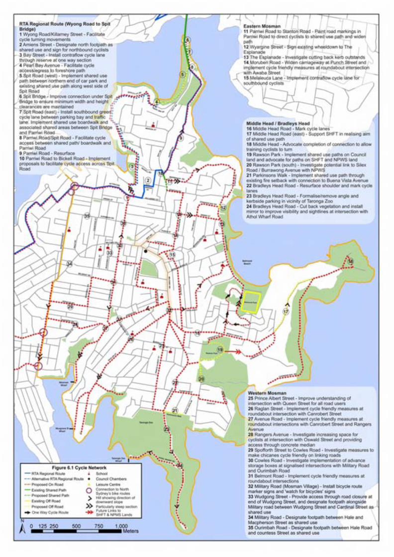

Mosman Municipal Council Mosman Bike Plan 2005 - 2010 51
6.6 Cycle Parking Strategy The cycle parking strategy is based on an assessment of land uses in Mosman, community consultation and observations of parked cycles. Existing cycle parking in Mosman is very limited. Rails were installed recently in the Council car park on Vista Street.
6.6.1 Cycle Parking Locations Common destinations with proposed cycle parking locations are shown in Table 6.1. The locations for cycle parking are based on analysis of local destinations, recognising that cyclists will look to park close to their destination with considerations such as the location of dedicated cycle parking being secondary if some other street furniture (such as a sign post) is available to secure a bike.
Research from the UK suggests cyclists will generally not divert more than 20-30m to access short term parking although they will divert further for long term parking2. Cycle parking should be located in convenient and easily accessible locations but not where it will cause an obstruction to pedestrians, particularly those who have poor sight. Cycle parking should be located where informal parking is already occurring to provide a safer and more appropriate alternative that is also attractive to cyclists.
.
D
Destinations identified through the course of the study include, cafes, supermarkets, banks, community buildings (library, Council offices), sports facilities (indoor and outdoor), open space and foreshore areas, transport interchanges, car parks and general retail strips (Figure 6.2). 2 DfT, Traffic Advisory Leaflet 05/02 – Key Elements of Cycle Parking Provision
Examples of formal and informal cycle parking in Mosman, clockwise from top left, Vista Street Council car park, Civic Square, Avenue Road/Military Road intersection and Military Road outside Westpac Bank

Mosman Municipal Council Mosman Bike Plan 2005 - 2010 52
Ideally cycle parking should be located where bikes will be visible to passers by or from within workplaces or shops to maximise passive surveillance. Out of the way corners and behind buildings will not be popular locations with cyclists and should be avoided. Good quality cycle parking in prominent locations will raise the profile of cycling within Mosman, encouraging more people to cycle.
AustRoads Part 14 gives guidance on the signing of cycle parking facilities.
Table 6.1 summarises cycle parking proposals for Mosman. It should be noted that single locations, for example Bridgepoint shopping centre, will ideally have one or two rails in two or three places convenient to the directions cyclists may approach from.
In addition Mosman Council should look to encourage all new residential multi-unit residential and commercial development to incorporate secure cycle parking for residents and employees. Commercial developments should also include shower and change facilities for staff. This is discussed in section 7.1. There is an identified need for Council to work with schools to implement secure bike lockers in addition to rails.
6.6.2 Cycle Parking Facilities Cycle parking stands should allow a cycle frame and wheels to be locked to it securely and also support the bike ensuring it does not fall over. Manufacturers including Securabike offer a number of parking rail products in a variety of colours and finishes that enhance the visibility of the rails for pedestrians and cyclists. These products meet the AustRoads guidance and Australian Standards.
In most locations within Mosman cycle parking will be associated with cafes, shops and leisure facilities and will be short stay. In some locations cyclists will look for longer stay parking and require a greater level of security. Cycle lockers are ideal for longer stay cycle parking at locations such as the ferry wharfs and Spit Junction, accommodating people transferring to buses. It would also be ideal to incorporate cycle lockers in a central location – possibly at the Civic Square for commuters who do not have secure cycle parking at their workplace.
Bicycle NSW will manage locker rentals and funding is available for cycle parking at transport interchanges from the NSW Government’s Parking Space Levy Fund.
AustRoads Guidance and pages from the current Securabike brochure are reproduced in Appendix E.
Examples of cycle rails at Manly, Sydney

Mosman Municipal Council Mosman Bike Plan 2005 - 2010 53
6.6.3 Parking Quantity Council should look to provide a small number of rails in many locations, rather than central banks of parking rails. This will maximise convenience to cyclists. Generally it is not recommended that more than four parking rails (with space for eight cycles) are implemented in a single location. This number of parking rails should only be located in popular locations, for example close to Balmoral oval. In most places one or two rails, depending on available street space, will suffice, particularly at the outset.
Regular monitoring of cycle parking to identify dumped cycles, maintenance problems and parking congestion should be incorporated into regular Council activities, possibly parking management. This will assist in identifying locations where additional stands are required. Local cyclists can also assist in this task. Monitoring should also seek to identify locations where bikes are continually locked to street furniture as this will indicate a need for parking or that existing (and under utilised) parking is in the wrong location.
6.6.4 Priority of Cycle Parking Locations To allow for a staged implementation of cycle parking facilities, locations have been prioritised. The highest priority locations (1) are transport interchanges including all ferry wharfs and Spit Junction which is an important bus interchange point. The main destinations in Mosman include Mosman Village, Spit Road shops, Bridgepoint shops, Mosman Council, Balmoral Beach, Balmoral oval, Taronga Zoo and these are also identified as high priority locations for cycle parking.
Although Rawson Park and oval will be an important destination for cyclists when the proposed off-road routes are constructed, installation of cycle parking can be delayed until these tracks have been constructed. When installing the cycle parking not all of the facilities need to be installed all at once. It is important to have a few cycle parking facilities located over a large number of locations.
Table 6.1 below provides a summary of cycle parking to be provided in each location as shown in Figure 6.2.
Table 6.1: Summary of Proposed Cycle Parking General Location No. of
Locations Rails Lockers Priority Comment
Transport Interchanges
Mosman Bay wharf 1 4 4 1
Musgrave Street wharf 1 2 2 1
Taronga Zoo wharf 1 4 4 1
Spit Junction 1 2 2 1
Wharfs should be monitored to establish demand. Café at Mosman Bay may generate additional short stay demand.
Bicycle lockers at Woy Woy Station
on the Central Coast of NSW

Mosman Municipal Council Mosman Bike Plan 2005 - 2010 54
General Location No. of Locations
Rails Lockers Priority Comment
Retail/Employment Areas
Mosman Village 9 18 1 Multiple locations with no more than 2 rails each
Avenue Road/Canrobert Street
2 2 2 1 rail o/s café/pizza takeaway & 1 rail o/s shops opposite
Spit Road shops 1 1 - 1
Spofforth Street 2 2 - 2 o/s café & shops on east (Mosman) side
Bridgepoint Shopping Centre 2 4 2 1 A convenient location exists on Brady Street/Hordern Place corner o/s café
Leisure
Greater Union Cinema/ cafe 2 4 - 2 2 stands either side of Clifford Street
Taronga Zoo 1 4 - 1 At main entrance
Athol House 1 2 - 2 Possibly located in NPWS car park
Balmoral Beach (Botanic Road to Awaba Street)
5 20 - 1 At least 5 locations with no more than 4 rails at each – Watermark, Lifesaver Café/Balmoral Café, Bathers Pavillion, fish & chip shop, rotunda are all possible locations
Bradleys Head 2 4 - 2
The Spit 3 6 - 2 Rails required both sides of Spit Road and at several locations on east side
Sports/Recreational Facilities
Mosman Park 1 2 - 1
Rawson Park and oval 1 2 - 2
George’s Heights oval 1 2 - 2
Balmoral oval 1 2 - 1
Implement small amount of parking initially & monitor use, increase supply in line with demand
Community Facilities
Mosman library 1 2 - 2
Council offices 1 2 - 1
Probably shared use of retail/employment area facilities but should ensure located close to entrances for short term parking
Total 40 91 14
6.6.5 Parking Space Levy (PSL) Funding for Cycle Parking The parking space levy (PSL) is a levy on off-street commercial parking spaces in the City of Sydney, Milsons Point, North Sydney, Chatswood, St Leonard’s and Bondi Junction. The PSL can be used to directly finance, develop and maintain infrastructure that facilitates access to and encourages the use of public transport to and from the business districts where the levy applies. The revenue has been used to fund transport interchange projects in areas that are not subject to the levy but these projects do provide for people travelling on public transport to areas subject to the levy. For example, in 2000 PSL funding was used to fund the development of the Cabarita Wharf including the installation of 4 bicycle lockers which are managed by Bicycle NSW.

Mosman Municipal Council Mosman Bike Plan 2005 - 2010 55
PSL funding of cycle parking in Mosman at transport interchanges including bus stops and ferry wharfs would encourage public transport use and reduce car dependence in areas where the levy is applied in particular the CBD and North Sydney. The levy is collected by the NSW Office of State Revenue and applications for funding can be made to the Ministry of Transport.

Figure 6.2 Existing and Proposed Cycle ParkingRTA Regional Route
Alternative RTA Regional Route
¹½ School
Council Chambers
#* Leisure Centre
"M Council Car Park
Existing Parking Rail
Proposed Parking Rail
") Proposed Cycle Locker
Local Destination
Balmoral
Beach
Taronga Zoo
Taronga Zoo Wharf
Musgrave St
Wharf
Mosman
Wharf
SP
ITR
D
SP
ITR
D
BA
YS
T
AWABA ST
AWABA ST
MA
CP
HE
RS
ON
ST
BY
EAUT PT RD
PEARL BAY AV
MILITARY RD
BR
AD
LE
YS
HE
AD
RD
MIDDLE HEAD RD
WYONG RD
SP
OF
FO
RT
HS
T
AVENUE RD
KILLARNEY ST
RAGLAN ST
RAG
LAN
ST
MEDUSA ST
STANTON RD
BICKELL RDT
HE
ES
PL
AN
AD
E
PR
INC
EA
LB
ER
TS
T
RANGERS AV
OURIMBAH RD
MIL
ITA
RY
RD
SPITRD
Cremome Wharf
PA
RR
IWIR
D
CHOWDER BAY RD
BELMONT RD
CO
WL
ES
RD
UPPER ALMORA ST
Rawson Park
Balmoral Park
WARRINGAH RD
AMIENSAV
STA
NT
ON
AV
MO
RU
BE
NR
D
CLIFFORD ST
MU
ST
ON
ST
MANDO
LONG
RD
DOMINION CR
SPENCER RD
BA
RD
WE
LL
RD
SHORT ST
GL
AD
ST
ON
EA
V
MY
AH
GA
HR
D
THOMPSON ST
DAVID ST
EDWARDS BAY RD
TH
EG
RO
VE
MO
RE
LL
AR
D

Mosman Municipal Council Mosman Bike Plan 2005 - 2010 57
6.7 Cycle Signing Strategy The provision of signing relating specifically to cyclists and the use of roads by cyclists is an important aspect of the Bike Plan. Signs need to be located so they are visible but not in the way of cyclists, allowing for minimum height and width clearances from the cycle travel lane.
Signs fall into three types:
• Regulatory signs,
• Warning signs, and
• Directional signs.
Signs can be mounted on poles or pavement markings. When erecting new signage poles, care should be taken to position signs correctly for cyclists, not to add to streetscape clutter and use existing street furniture wherever possible.
6.7.1 Review of Existing Signage Existing signage within Mosman should be comprehensively audited and reviewed. Incorrectly placed signs need to be removed or positioned in correct locations. For example, the sign for the shared path on the west side of Spit Road, opposite the intersection with Parriwi Road, has been erected back to front and needs to be turned around. Existing bicycle route signs may be inconsistent with the Bike Plan proposals and as such should be revised.
6.7.2 Regulatory Signs Regulatory signs will generally define the type of bicycle facility provided. The NSW Bicycle Guidelines clearly define the regulatory signs in use for bicycle facilities and supplementary plates for use in conjunction with regulatory signs. Regulatory signs define the start and end of facilities. The NSW Guidelines make it clear that regulatory signs should be carefully located so as not to cause confusion or ambiguity. The number of signs and their location should be based on the individual situation and reflect sightlines and visibility. Use of existing posts should be encouraged where possible to reduce street clutter.
6.7.3 Warning Signs Yellow diamond shaped signs are used to warn cyclists of changed or potentially hazardous situations ahead. The same type of sign is also used to warn other road users of intersecting or merging cycle movements ahead. Again the NSW Guidelines offer clear advice on the type of signs, the relevant Australian Standards and their use. The AustRoads Guidelines provide explicit advice on locating signs although it is noted that the exact location of signs will depend on each individual site.
Shared path sign needs to be turned to face south
End of shared path dismount at signals needs to be turned to face north

Mosman Municipal Council Mosman Bike Plan 2005 - 2010 58
6.7.4 Directional Signs Directional signs help cyclists find their way through the network, increasing understanding and connectivity of the routes that together form the overall cycle network. The NSW Guidelines note that signs designed for motorised traffic tend to be inadequate for cyclists, particularly when the bicycle network is separate from the traffic network. An independent system of signing should be used for the cycle network to remove any risk of confusion for drivers and cyclists.
Directional signage is required at each intersection to direct cyclists. Signs should be consistent throughout the network and with neighbouring municipalities. Consistency relates to both the design and destinations identified. At intersections there is frequently considerable clutter from multiple directional and regulatory signs, signal poles, telegraph poles and other street furniture. Care should be taken to ensure that cycle signs do not become lost in the clutter and are visible to cyclists, being mindful of where cyclists are likely to be located on the road.
Within Mosman, consideration should be given to signing local and regional destinations and including additional information, such as steep sections of road and wheeldowns which may impact on the route choice of some cyclists (Table 6.2). For example, at the intersection of Edwards Bay Road and Wyargine Street signs should show ‘Balmoral Beach’ via ‘steps’ or ‘Awaba Street’. Cyclists can make a clear route choice based on the available information (Figure 6.3). Figure 6.3: Examples of directional signing
Directional signs can be supplemented by local area maps identifying the cycle network. Mosman intends to produce a local area map identifying the existing and proposed network through the municipality and connections into Manly and North Sydney.

Mosman Municipal Council Mosman Bike Plan 2005 - 2010 59
Indicative locations for cycle signing based on the proposed Mosman cycle network are shown in Figure 6.4. Additional information on directional signs can be found in AustRoads Part 14 and the NSW Bicycle Guidelines. Table 6-2 – Cycle Route Destinations for Mosman/Northern Regional and Local Destinations
Regional Destination Local Destination
City (Harbour Bridge)
North Sydney
Willoughby
Manly
Warringah
Seaforth
Cremorne
Neutral Bay
Mosman Square
Mosman Council
Mosman Village/Shops
The Spit
Spit Junction
Bridgepoint Shopping Centre
Spofforth Street Shops
Balmoral Beach
Edwards Beach
Cobblers Beach
Obelisk Beach
Chowder Bay
Rawson Park
Mosman Park
Balmoral oval
George’s Heights oval
The Spit Reserve
Foreshore Walking Trail
Clifton Gardens
Athol House
Taronga Zoo
Bradleys Head
Middle Head
Mosman Wharf
Musgrave Street Wharf
Taronga Zoo Wharf
6.7.5 Pavement Markings The use of pavement markings and coloured surfaces can assist cyclists in way finding and raise the awareness of motorists to cyclists and their use of the road network. In some situations pavement markings can provide reminder signage along the cycle route, avoiding the need for signs and additional streetscape clutter. Pavement markings are also easily observable by cyclists and unlikely to be hidden behind trees or parked vehicles.
In addition road markings can support regulatory signs and controls relating to all road users. AustRoads Part 14 notes that a safety strip is desirable in certain situations between parked vehicles and cycles where there are:
• Bicycle / parking lanes with parallel (kerbside) parking,
• Bicycle / parking lanes with angle parking, and
• Contraflow bicycle lanes.
Each of these situations is likely to arise within Mosman. AustRoads provides guidance on the detailed design of safety strips. Safety strips are designed to remind drivers about the potential presence of cyclists. The accident analysis within this study identified a number of accidents related to vehicle parking movements.
Shared use paths, which exist or are proposed in a number of locations, should incorporate a white centre line. This assists in way finding, particularly where two paths meet, increases visibility of the path at night and encourages users to keep left, allowing overtaking.
Bicycle and pedestrian symbols are useful for advising users of the presence of cyclists and pedestrians and indicating permitted users of paths. AustRoads Part 14 details correct dimensions of pavement symbols.
Coloured surface treatments can be used to identify cycle facilities, particularly where the traffic environment is complicated. Surface colour raises the awareness of motorists to the potential presence of cyclists. In NSW the designated surface colour for cycle facilities is green. Mosman may consider the use of green surfacing in some situations, for example, to identify advance

Mosman Municipal Council Mosman Bike Plan 2005 - 2010 60
storage boxes at signalised intersections and cycles lanes across intersections with side roads. The NSW Guidance offers additional advice on the use of coloured pavement surfacing.
Relevant cycle signing guidance from the NSW Bike Guidelines and AustRoads Part 14 is reproduced in Appendix F.

Alternative RTA Regional Route
RTA Regional Route
Proposed On Road
Existing Off Road
Proposed Off Road
Existing Shared Path
Proposed Shared Path
WATERALL_region
¹½ School
Council Chambers
RTA Regional Route
Hill showing direction ofdownward slope
Particularly steep section
Connection to NorthSydney’s bike routes
Figure 6.4Indicative Directional Signing Locations
Indicative Sign Location
School¹½
Balmoral
Beach
Taronga Zoo
Taronga Zoo Wharf
Musgrave St
Wharf
Mosman
Wharf
SP
ITR
D
SP
ITR
D
BA
YS
T
AWABA ST
AWABA ST
MA
CP
HE
RS
ON
ST
BY
EAUT PT RD
PEARL BAY AV
MILITARY RD
BR
AD
LE
YS
HE
AD
RD
MIDDLE HEAD RD
WYONG RD
SP
OF
FO
RT
HS
T
AVENUE RD
KILLARNEY ST
RAGLAN ST
RAG
LAN
ST
MEDUSA ST
STANTON RD
BICKELL RD
TH
EE
SP
LA
NA
DE
PR
INC
EA
LB
ER
TS
T
RANGERS AV
OURIMBAH RD
MIL
ITA
RY
RD
SPITRD
Cremome Wharf
PA
RR
IWIR
D
CHOWDER BAY RD
BELMONT RD
CO
WL
ES
RD
UPPER ALMORA ST
Rawson Park
Balmoral Park
WARRINGAH RD
AMIENSAV
STA
NT
ON
AV
MO
RU
BE
NR
D
CLIFFORD ST
MU
ST
ON
ST
MANDO
LONG
RD
CROQUET LA
DOMINION CR
SPENCER RD
BA
RD
WE
LL
RD
SHORT ST
GL
AD
ST
ON
EA
V
MY
AH
GA
HR
D
THOMPSON ST
DAVID ST
EDWARDS BAY RD
TH
EG
RO
VE
MO
RE
LL
AR
D
Mosman Municipal Council Mosman Bike Plan 2005 - 2010 62
6.8 Promotional Activities The promotion of cycling within Mosman is an important part of the Bike Plan aimed at encouraging the use of measures to assist cyclists and the identified cycle network. Increased numbers of cyclists in Mosman will raise awareness of cycling and cyclists in the community, including amongst motorists. Cycling is a good form of exercise, promoting physical activity and independent travel amongst children.
6.8.1 Cycle Map and Brochure Mosman Council should prepare a cycle map and brochure to encourage people to cycle in the local area through the identification of a network of safe routes and with cycling tips and information. A map has been prepared in GIS for council’s use as part of the Bike Plan and draft text is included in Appendix G. The map should be distributed widely to the local community, for example, from Council’s stall at Mosman Market, with rates notices, at events held at Balmoral Beach (Mudgee Food and Wine Celebration, Lovedale Long Lunch etc) and through community groups.
6.8.2 Cycle Events Mosman Council can support cycle events including Ride to Work Day and Bike Week through the organisation of local activities such as a green commuter breakfast. Including cycling in other local events will integrate cycling with other forms of transport and raise general awareness amongst the community.
Events can also be used to raise the profile of cycling in Mosman amongst the wider community. Mosman Council could look to sponsor teams in cycle events such as the Sydney-Wollongong Ride and the RTA Big Cycle Ride.
6.8.3 Support Local Cyclists Council should actively support and work with local cyclists and cycling groups. Bike North is active within Mosman and operates as a Bicycle User Group (BUG) for the area under the auspices of Bicycle NSW. Groups such as the Balmoral Triathlon Club provide for specific types of cyclists and there are many other informal riding groups within the suburb.
Bike groups can assist Council in identifying maintenance issues and hazards, promoting cycling within the community and taking an advocacy role with bodies such as the State Government. Maintaining and supporting these groups will be important in the realisation of the Bike Plan. Council should include representatives of local groups on the steering group (as discussed above) and in events such as Bike Week. Council can act as a point of contact for local cyclists and cycle groups, in much the same way as book shops act as a point of contact for local book clubs. Support for local cyclists and cycle groups should be a function of the steering group.

Mosman Municipal Council Mosman Bike Plan 2005 - 2010 63

Mosman Municipal Council Mosman Bike Plan 2005 - 2010 64
7.0 Development Planning Controls (Cycling)
7.1 Development Control Plan To support the Mosman Bike Plan and the encouragement of cycling within the municipality the Development Control Plan (DCP) requires all new residential, commercial and community (including health and education facilities) buildings to cater for cyclists. Secure cycle parking, showers and change rooms should be considered as essential facilities for cyclists. Table 7-1 Mosman DCP cycle parking rates
Land Use Rate
Residential (multiple dwellings) 1 space per 4 units
Commercial/retail 1 space per 200sqm gfa or
spaces equivalent to 3-5% the number of staff/visitors
Health/education/community facility Spaces equivalent to 3-5% the number of staff/visitors
The following points should be noted in applying these rates:
• Residential cycle parking, intended for use by residents rather than visitors, should be provided with an additional level of security, for example a lockable cage or cycle lockers within the basement parking area.
• Commercial/retail cycle parking must recognise that staff and visitors frequently have different needs, in terms of the location, design and security of cycle parking.
• Schools should look to provide at least a proportion of parking as secure lockers or all cycle parking within locked cages to counteract issues such as theft and vandalism of parked bikes.
Cycle parking should be designed to comply with AS 2890.3 (Bicycle Parking Facilities). Council should offer advice on the quantity, location and design of cycle parking to developers and building occupiers.
Showers and change rooms should be provided in workplaces to facilitate cycling to work. Table 7.2: Mosman DCP recommended provision of showers
Staff Showers Change Rooms
0-12 1 -
13-49 2 (1 male and 1 female) 2 (1 male and 1 female)
50-149 4 (2 male and 2 female) 4 (2 male and 2 female)
The following points should be noted:
• In small workplaces where a single shower is provided it should be equally accessible to male and female staff, that is, it should not be located with access from only the male or female toilets.
• In larger workplaces, particularly those where the ratio of men to women is unbalanced, consideration should be given to making the showers available to both men and women, avoiding overuse of some showers while others are used relatively unfrequently.
• Hanging areas for work clothes and drying areas for wet towels again add to convenience and the presentation of staff and general office areas.

Mosman Municipal Council Mosman Bike Plan 2005 - 2010 65
• Lockable drawers in the shower rooms enable staff to leave their shower things at work.
• Making hairdryers available adds to convenience.
• Many people enjoy exercise within the working day, choosing to run, walk or go to the gym at lunchtime. Workplace showers encourage and facilitate physical activity leading to a healthier and happier workforce.
New developments are routinely required to contribute to local services and facilities to offset the impact of the development on the local area and recognise the inherent use of resources by those occupying the building. The principles of nexus and apportionment apply and as such the contributions should be identifiable as directly resulting from the impact of the development. Contribution levels are identified through Council’s Section 94 Plan.
All new developments must have a regard to the location of bicycle routes and facilities as detailed in this Bike Plan, recognising that those living or working within the development and any visitors should be encouraged to travel by more sustainable modes than the private car. New developments must make provision for identified bike routes and facilities within the local area, including the construction of adjacent footpaths to meet the AustRoads standard for a shared use path.
7.1.1 Standard Conditions of Consent The following conditions have been developed and are included in Council’s Standard Conditions of Consent for cyclists:-
CC1. Where a development is adjacent to or on Mosman Council’s Regional cycle network and is designated as a shared use pedestrian/cycle path the developer must ensure that the footpath fronting the development is constructed to the appropriate standard (to support shared use status) in accordance with Austroads Part 14 - Guide to Traffic Engineering Practice - Bicycles, Section 6.6.1. Particular attention should be made to Table 6-3 of the above guide when determining the appropriate footpath widths. Where possible desirable widths are to be provided.
CC2. To encourage and promote the use of sustainable transport modes, secure bicycle parking/storage must be provided to accommodate {x Number of Bicycles - Calculated at 1 per 4 units}. The facility must be provided in a suitable location which allows safe and easy access/exit and should be designed and installed in accordance with AS 2890.3-1993 - Parking Facilities - Bicycle Parking Facilities.
[Application - multiple dwellings]
7.2 Spit Bridge Proposal The RTA has a current proposal to widen the Spit Bridge on the western side to create a new bridge which will accommodate 6 lanes of traffic. In August 2004 this proposal was approved by the Transport Minister, Mr Craig Knowles, and Council was advised that, in accordance with the provisions of section 116E(4) (c) of the Environmental Planning and Assessment Act 1979, Council had 40 days to provide conditions of consent for the RTA's proposal to widen the Spit Bridge.
The following list has been extracted from the complete list of conditions provided by Council to the RTA as they relate to cyclists needs. It is considered necessary that these proposals be incorporated within the overall design of the Spit Bridge proposal to improve cycle safety in this area of Mosman.
7.2.1 Conditions of Consent - Cyclists 1. The footpath (east to west) on the underside of Spit Bridge at the southern end must be
widened to 3.0m to accommodate two way shared pedestrian/cycle use in accordance with AustRoads Part 14 and to improve safety.

Mosman Municipal Council Mosman Bike Plan 2005 - 2010 66
2. The western footpath on Spit Bridge must be widened to 3.0m to accommodate two way shared pedestrian/cycle use in accordance with AustRoads Part 14.
3. A cycle path must be constructed on the south-western side of Spit Bridge within Spit Reserve to facilitate the alternate RTA northbound regional cycle route.
4. The proposed lane widths on Spit Bridge must allow for a nearside lane width for both north and southbound traffic of a minimum of 3.7m in accordance with AustRoads Part 14 Section 4.4.7 to accommodate those cyclists who use the roadway.
5. That a cycle counter be installed on the western footpath of Spit Bridge for monitoring the growth of cycling in the region.

Mosman Municipal Council Mosman Bike Plan 2005 - 2010 67

Mosman Municipal Council Mosman Bike Plan 2005 - 2010 68
8.0 Implementation Plan
8.1 Introduction The implementation plan provides an indicative approach to realising the Mosman Bike Plan. It is envisaged that the Bike Plan can be achieved over a five year period. Constructed works, parking, signing and promotional/education proposals are identified to be implemented in each financial year corresponding with the Council department responsible for implementation and the resources required. The implementation plan is indicative only and if actions can be achieved earlier this would be desirable.
8.2 Funding The majority of the proposals will require funding by Council with some matched contributions from the RTA and other organisations. A memorandum of understanding exists between NSW councils and the RTA regarding the funding of cycle facilities. Annual funding applications must be submitted by Council to the RTA by 1st September for funding in the proceeding financial year. This will require the steering group to commence the coordination and preparation of the funding application by the beginning of June each year and the Mosman Bike Plan will assist greatly in this process.
It should be noted that implementation of this plan cannot be achieved solely via matched RTA/Council funding.
Other sources of funding will be available to the bicycle strategy but will not necessarily adhere to a predictable timetable. There is a need for the steering group to be flexible but also diligent in preparing applications for funding and identifying actions within the Bike Plan that will meet the requirements of available funding. Others possible sources of funding for cycle initiatives could include:
• Department of Planning, Infrastructure and Natural Resources (through its Sharing Sydney Harbour Access Program);
• Department of Sport and Recreation (through its Capital Assistance Program);
• NSW Department of Environment and Conservation (through its Environmental Trust Program); and,
• NSW Department of Environment and Heritage (through its Cycle Connect Program).
8.3 Partnerships The steering group and Council will have to work closely with other bodies to realise some actions within the Bicycle Strategy. Project partners and stakeholders include:
• RTA – particularly actions along Spit Road and in the vicinity of Spit Bridge, actions in the vicinity of Military Road (west of Spit Junction) and any routes designated by the RTA as main or regional routes.
• NPWS – close consultation required to realise actions on NPWS land at Middle Head and adjacent to Rawson Park.
• SHFT – consultation to realise connections through Rawson Park to SHFT land and support to SHFT in realising improvements on Middle Head Road.
• Local traders/businesses – consultation required prior to implementing cycle parking through shopping and activity areas.
• State Transit Authority (Sydney Ferries Corporation) – consultation required prior to locating and implementing cycle lockers at ferry wharfs.

Mosman Municipal Council Mosman Bike Plan 2005 - 2010 69
• Bicycle NSW – as the organisation responsible for letting cycle lockers, Council will need to consult with respect to the number, location and management of cycle lockers within Mosman.
• Bike North – a key group for local cyclists offering support and leading local rides for cyclists of all abilities and will be important in realising actions concerned with supporting local cyclists and promoting events.
8.4 Implementation Plan The implementation plan is structured over a five year period and prioritises the cycle proposals and activities on the basis of those which will deliver maximum benefit to cyclists relating to the following criteria:
• Coherence - Including continuity of routes with easy to understand signing and consistency in the quality of facilities.
• Directness - Removing barriers by reducing journey times through minimising the stop/start effect at intersections, eliminating circuitous routes, improving accessibility through opening one way streets to cyclists and providing cycle exemptions at banned turns.
• Safety - Including reducing the conflict between cyclists and other road users and improving existing unsafe facilities.
• Comfort - Including smoothness of riding surfaces and weather protection.
• Attractiveness - Including well lit and open appearance of the network and co-ordination with maps, signage and parking facilities.
Another important factor considered in prioritising the proposals is the integration with RTA Regional routes in line with Action for Bikes 2010.
A full detailed breakdown of prioritised cycle measures and costs year by year, including a cost summary, is provided in Tables 8.1 - 8.6.

Mosman Municipal Council Mosman Bike Plan 2005 - 2010
70
Table 8.1: Mosman Bike Plan - 5 Year Implementation Plan
Year 1 - (July 2005 - June 2006)
No. Proposals Outline Cost Responsibility Funding Source1 Establish Steering Committee n/a MMC (P&T) n/a
2Priority Item 1 - Spit Road (East side) Shared Path. (Between Warringah Road and Stanton Road) (11) $20,000 MMC (P&T/A&S) RTA/Council*
3Priority Item 2 - Parriwi Road (Southern End) - Improved cycle access between Parriwi Road & Bickle Road (10) $60,000 MMC (P&T/A&S) RTA/Council**
4 Spit Road (East Side) - Southbound surfaced cycle lane (7) $5,000 MMC (P&T/A&S) RTA/Council**5 Bradleys Head Road/Athol Wharf Road - Cut back vegetation (26) n/a MMC (A&S) n/a
Sub Total $85,000
1 Transport Interchanges - 3 x Ferry Wharves $12,500 SFC/MMC (P&T) SFC/Council/PSL/DIPNR
2Mosman Town Centre/Village (Includes Bridgepoint/Spit Road/Mosman Square/Cafes etc) $6,000 MMC (P&T) RTA/Council
Sub Total $18,500
1 Sign RTA Regional Route via Parriwi Road. (Manly to North Sydney) $3,000 MMC (P&T) RTA/Council 2 Sign all banned turn locations to allow exemptions for cyclists $1,500 MMC (P&T) RTA/Council
Sub Total $4,500
1Support Bikeweek in September 05 by holding an event at Balmoral Oval in conjunction with Le-Spit Cyclery $500 MMC (P&T) RTA (P&T - Road Safety)
Sub Total $500TOTAL $108,500
Key:- MMC - Mosman Municipal Council Notes:- 1. * - Indicates funding has already been obtained P&T- Planning and Transport 2. **- Indicates funding has been applied forA&S - Assetts and Services 3. All priority item costings include costs associated with signingSFC - Sydney Ferries Corporation 4. Numbers in brackets relate to schemes identified in Bike PlanRTA - Roads and Traffic AuthorityPSL - Parking Space LevyDIPNR - Department of Infrastructure, Planning and Natural ResourcesSHFT - Sydney Harbour Federation TrustTZ - Taronga Zoo
CONSTRUCTED WORKS/ACTIVITIES
PARKING (Rails & Lockers)
SIGNING
PROMOTION/EDUCATION

Mosman Municipal Council Mosman Bike Plan 2005 - 2010
71
Table 8.2: Mosman Bike Plan - 5 Year Implementation Plan
Year 2 - (July 2006 - June 2007)
No. Proposals Outline Cost Responsibility Funding Source
1Priority Item 4 - Parriwi Road (Northern End) - Improved cycle access from Spit West car park and the service road into Parriwi Road (8) $12,500 MMC (P&T/A&S) RTA/Council
2 Priority Item 3 - Wyong Road/Killarney Street (1) $5,000 MMC (P&T) RTA/Council3 Priority Item 3 - Bay Street Contra Flow cycle lane (3) $5,000 MMC (P&T/A&S) RTA/Council4 The Spit Bridge*** underpass and connections (5/6) $20,000 MMC (P&T) RTA***5 Middle Head and Bradleys Head Road Cycle Lanes (16/24) $2,000 MMC (P&T) MMC (P&T)6 Rawson Park - Connection from Bradleys Head Road to Middle Head Road $10,000 MMC (P&T) DIPNR/MMC*7 Bradleys Head Road/Athol Wharf Road - Install safety mirror (26) $1,000 MMC (P&T) MMC8 Moruben Road - Widen carriageway near Punch Street (14) $2,000 MMC (P&T/A&S) RTA/Council9 Prince Albert Street/Queen Street (27) $5,000 MMC (P&T) RTA/Council
Sub Total $62,500
1 Transport Interchange - Spit Junction/Council Offices $5,000 MMC (P&T/A&S) Council/PSL2 The Esplanade - Balmoral (4 Locations) $10,000 MMC (P&T/A&S) RTA/Council/DIPNR3 Council car parks (Bridgepoint) $5,000 MMC (P&T/A&S) RTA/Council
4Mosman Town Centre/Village (Includes Bridgepoint/Spit Road/Mosman Square/Cafes etc) $6,000 MMC (P&T/A&S) RTA/Council
5 Mosman Parks & Ovals (Alan Border Oval/Mosman Park) $3,000 MMC (P&T/A&S) RTA/CouncilSub Total $29,000
1 Sign alternative RTA regional route via Bay Street/Beauty Point $1,000 MMC (P&T) RTA/Council 2 Sign Mosman Town Centre to/from City cycle route (South of Military Road) $3,000 MMC (P&T) RTA/Council3 Sign Parriwi Road to/from Mosman Town Centre $1,500 MMC (P&T) RTA/Council
Sub Total $5,500
1 Mosman Local Area Cycle Map & Brochure $5,000 MMC (P&T) Council
2Support Bikeweek in September 06 by holding a cycling event in Mosman in conjunction with Le-Spit Cyclery $500 MMC (P&T) RTA (P&T - Road Safety)
Sub Total $5,500TOTAL $102,500
Key:- MMC - Mosman Municipal Council Notes:- 1. * - Indicates funding has already been obtainedP&T- Planning and Transport 2. **- Indicates funding has been applied forA&S - Assetts and Services 3. *** - Indicates that funding should be provided as part of the SFC - Sydney Ferries Corporation Spit Bridge worksRTA - Roads and Traffic Authority 4. All priority item costings include costs associated with PSL - Parking Space Levy signingDIPNR - Department of Infrastructure, Planning and Natural Resources 5. Numbers in brackets relate to schemes identified in Bike PlanSHFT - Sydney Harbour Federation TrustTZ - Taronga Zoo
CONSTRUCTED WORKS
PARKING (Rails & Lockers)
SIGNING
PROMOTION/EDUCATION

Mosman Municipal Council Mosman Bike Plan 2005 - 2010
72
Table 8.3: Mosman Bike Plan - 5 Year Implementation Plan
Year 3 - (July 2007 - June 2008)
No. Proposals Outline Cost Responsibility Funding Source1 Priority Item 3 - Spit (West) carpark access route to Spit Bridge (5) Opt 1 -$7500, Opt 2 -$2000 MMC (P&T/A&S) RTA/Council
2Priority Item 3 - Pearl Bay Avenue access to Foreshore Walking Track at Spit Reserve (4) $2,500 MMC (P&T/A&S) RTA/Council
3 Rawson Park connection to SHFT land (19) $10,000 MMC/SHFT SHFT/Council4 Middle Head - Complete loop on NPWS land (18) $10,000 MMC (P&T/A&S) Council/NPWS5 Melaleuca Lane - Contraflow Cycle Lane (15) $1,000 MMC (P&T) RTA/Council6 Amiens Road - Improve access (2) $2,000 MMC (P&T/A&S) RTA/Council7 Rangers Avenue/Oswald Street - Improve access (30) $2,000 MMC (P&T/A&S) RTA/Council8 Cowles Road/Ourimbah Road - Advanced cycle stop line (32) $1,000 MMC (P&T) RTA/Council9 Spencer Road - Amend chicanes to be more cycle friendly (31) $5,000 MMC (P&T/A&S) RTA/Council
Sub Total $41000 ($35500)
1 The Esplanade - Balmoral (Additional Locations) $1,000 MMC (P&T) RTA/Council
2Mosman Town Centre/Village (Includes Bridgepoint/Spit Road/Mosman Square/Cafes etc) $6,000 MMC (P&T) RTA/Council
3 Council car parks (Other) $5,000 MMC (P&T) RTA/Council4 Mosman Parks & Ovals (Rawson Park/Georges Heights) $3,000 MMC (P&T) SHFT/RTA/Council5 Avenue Road/Canrobert Street Shops $1,500 MMC (P&T) RTA/Council6 The Spit $4,000 MMC (P&T) RTA/Council7 Taronga Zoo (Car Park) $10,000 TZ TZ
Sub Total $30,500
1Sign Parriwi Road to Balmoral Beach cycle route. (Including wheel down at Wyargine Street) Continue through to Middle Head Road and Georges Heights $3,000 MMC (P&T) RTA/Council
Sub Total $3,000
1Support Bikeweek in September 07 by holding a cycling event in Mosman in conjunction with Le-Spit Cyclery $500 MMC (P&T) RTA (P&T - Road Safety)
Sub Total $500TOTAL $75,000
Key:- MMC - Mosman Municipal Council Notes:- 1. All priority item costings include costs associated with P&T- Planning and Transport signingA&S - Assetts and Services 2. Numbers in brackets relate to schemes identified in Bike PlanSFC - Sydney Ferries CorporationRTA - Roads and Traffic AuthorityPSL - Parking Space LevyDIPNR - Department of Infrastructure, Planning and Natural ResourcesSHFT - Sydney Harbour Federation TrustTZ - Taronga Zoo
CONSTRUCTED WORKS
PARKING (Rails & Lockers)
SIGNING
PROMOTION/EDUCATION

Mosman Municipal Council Mosman Bike Plan 2005 - 2010
73
Table 8.4: Mosman Bike Plan - 5 Year Implementation Plan
Year 4 - (July 2008 - June 2009)
No. Proposals Outline Cost Responsibility Funding Source
1Priority Item 5 - Spit Road (East) Two way cycle route including boardwalk (Stage 1) (7) $65,000 MMC (P&T/A&S) RTA/Council
2 Raglan Street & Avenue Road - Cycle friendly measures at roundabouts (28/29) $5,000 MMC (P&T/A&S) RTA/CouncilSub Total $70,000
1 Council car parks (Other) $5,000 MMC (P&T) RTA/CouncilSub Total $5,000
1Sign Mosman Town Centre to Ferry Wharves along Avenue, Raglan and Bradley's Head Roads $3,000 MMC (P&T) RTA/Council
Sub Total $3,000
1Support Bikeweek in September 08 by holding a cycling event in Mosman in conjunction with Le-Spit Cyclery $500 MMC (P&T) RTA (P&T - Road Safety)
Sub Total $500TOTAL $78,500
Key:- MMC - Mosman Municipal Council Notes:- 1. All priority item costings include costs associated with P&T- Planning and Transport signingA&S - Assetts and Services 2. Numbers in brackets relate to schemes identified in Bike PlanSFC - Sydney Ferries CorporationRTA - Roads and Traffic AuthorityPSL - Parking Space LevyDIPNR - Department of Infrastructure, Planning and Natural ResourcesSHFT - Sydney Harbour Federation TrustTZ - Taronga Zoo
CONSTRUCTED WORKS
PARKING (Rails & Lockers)
SIGNING
PROMOTION/EDUCATION

Mosman Municipal Council Mosman Bike Plan 2005 - 2010
74
Table 8.5: Mosman Bike Plan - 5 Year Implementation Plan
Year 5 - (July 2009 - June 2010)
No. Proposals Outline Cost Responsibility Funding Source
1Priority Item 5 - Spit Road (East) Two way cycle route including boardwalk (Stage 2) (7) $65,000 MMC (P&T/A&S) RTA/Council
2 Belmont Road/Cowles Road - Cycle friendly measures at roundabouts (33) $5,000 MMC (P&T/A&S) RTA/CouncilSub Total $70,000
1 Council car parks (Other) $5,000 MMC (P&T) RTA/CouncilSub Total $5,000
1 Sign any additional required and maintain existing cycle signs. $1,000 MMC (P&T) RTA/CouncilSub Total $1,000
1Support Bikeweek in September 05 by holding a cycling event in Mosman in conjunction with Le-Spit Cyclery $500 MMC (P&T) RTA (P&T - Road Safety)
2 Update Mosman Local area cycle map & brochure $2,500 MMC (P&T) CouncilSub Total $3,000
TOTAL $79,000
Key:- MMC - Mosman Municipal Council Notes:- 1. All priority item costings include costs associated with P&T- Planning and Transport signingA&S - Assetts and Services 2. Numbers in brackets relate to schemes identified in Bike PlanSFC - Sydney Ferries CorporationRTA - Roads and Traffic AuthorityPSL - Parking Space LevyDIPNR - Department of Infrastructure, Planning and Natural ResourcesSHFT - Sydney Harbour Federation TrustTZ - Taronga Zoo
CONSTRUCTED WORKS
PARKING (Rails & Lockers)
SIGNING
PROMOTION/EDUCATION

Mosman Municipal Council Mosman Bike Plan 2005 - 2010
75
Table 8.6: Mosman Bike Plan - 5 Year Implementation Plan
Cost Summary
Total Cost $ Council Funds $ RTA (est)* $ Other Funding SourcesYear 1 July 2005 - June 2006 Constructed Works 85,000 40,000 25,000 20000 (RTA) Parking & storage 18,500 8,500 10,000 0 Signage 4,500 0 4,500 0 Education & promotion 500 0 500 0Sub Total 108,500 48,500 40,000 20,000Total Funds Required Year 1 88,500Year 2 July 2006 - June 2007
Constructed Works 62,500 20,000 12,50030000 (Spit Bridge /
DIPNR) Parking & storage 29,000 19,000 10,000 0 Signage 5,500 0 5,500 0 Education & promotion 5,500 5,000 500 0Sub Total 102,500 44,000 28,500 30,000Total Funds Required Year 2 72,500Year 3 July 2007 - June 2008 Constructed Works 41,000 25,000 16,000 Parking & storage 30,500 15,000 15,500 Signage 3,000 0 3,000 Education & promotion 500 0 500Sub Total 75,000 40,000 35,000Total Funds Required Year 3 75,000Year 4 July 2007 - June 2008 Constructed Works 70,000 40,000 30,000 Parking & storage 5,000 2,500 2,500 Signage 3,000 0 3,000 Education & promotion 500 0 500Sub Total 78,500 42,500 36,000Total Funds Required Year 4 78,500Year 5 July 2008 - June 2009 Constructed Works 70,000 40,000 30,000 Parking & storage 5,000 2,500 2,500 Signage 1,000 0 1,000 Education & promotion 3,000 2,500 500Sub Total 79,000 45,000 34,000Total Funds Required Year 5 79,000
Total Funds Required for 5 Years: 393,500 220,000 173,500 50,000
Notes - 1. $140,000 has been allocated (over two financial years) by DIPNR and Council ($ for $) for the Taronga Zoo Wharf to Balmoral Beach Cycleway which is not included in the above tables. 2. The estimated level of funding required by Council over a 5 year period to implement the plan is $220,000

Appendix A Accident Locations and Reports


Bike Accidents in Mosman LGA 1998 - 2003 2003 = 6 MILITARY RD 2003/01 16/02/03 12:30 031784498 1m Wst of LANG ST .FINE DRY. CAR M60 Est in MILITAR RD 15 INJURY 2 0 1 AMG:6033651625568 0 R.U.M. CODE:35 LANE CHANGE LEFT PEDAL CYCLE M34 Est in MILITAR RD 2003/04 08/05/03 15:13 032802917 at BELMONT RD .FINE DRY. PEDAL CYCLE M27 Est in MILITAR RD INJURY 2 0 2 AMG:6033628625543 1991396 R.U.M. CODE: 0 PED NEARSIDE PEDESTRIAN F56 Sth in MILITAR RD 2003/06 01/06/03 10:05 032808544 100m Est of SPIT RD .FINE DRY. 4 WHEEL DRIVE F32 Est in MILITAR RD 35 INJURY 2 0 1 AMG:Not allocated 0 R.U.M. CODE:35 LANE CHANGE LEFT PEDAL CYCLE M43 Est in MILITAR RD BELMONT RD 2003/02 20/03/03 07:30 031791523 at BARDWELL RD .FINE DRY. CAR F53 Wst in BARDWEL RD Unk INJURY 2 0 1 AMG:Not allocated 0 R.U.M. CODE:32 RIGHT REAR PEDAL CYCLE M33 Wst in BARDWEL RD CORONATION AV 2003/03 16/03/03 08:30 031807365 at WINDWARD AV .FINE DRY. PEDAL CYCLE F50 Unk in CORONAT AV INJURY 1 0 1 AMG:Not allocated 0 R.U.M. CODE:74 ON ROAD-OUT OF CONT. ROLLOVER SPIT RD 2003/05 21/05/03 20:30 032806545 at KILLARNEY ST .FINE DRY. CAR M37 Sth in SPIT RD 15 INJURY 2 0 1 AMG:Not allocated 0 R.U.M. CODE:21 RIGHT THROUGH PEDAL CYCLE M23 Nth in SPIT RD 2002 = 8 SPIT RD 2002/01 06/03/02 13:45 021704159 5m Sth of IDA AV .FINE DRY. STATION WAGON M32 Nth in SPIT RD 40 INJURY 2 0 1 AMG:Not allocated 0 R.U.M. CODE:35 LANE CHANGE LEFT PEDAL CYCLE M20 Nth in SPIT RD BRADLEYS HEAD RD 2002/02

05/05/02 16:15 022718608 200m Sth of BEACH RD .FINE DRY. CAR M45 Sth in BRADLEY RD 5 INJURY 2 0 1 AMG:Not allocated 0 R.U.M. CODE:42 LEAVING PARKING PEDAL CYCLE M31 Sth in BRADLEY RD 2002/04 09/07/02 08:25 023733949 10m Nth of ATHOL WHARF RD .FINE DRY. CAR F60 Sth in BRADLEY RD Unk INJURY 2 0 1 AMG:Not allocated 0 R.U.M. CODE:40 U TURN PEDAL CYCLE M29 Sth in BRADLEY RD 2002/05 Incorrectly recorded MILITARY RD 2002/03 19/06/02 17:30 022731376 50m Nth of UPPER ALMORA ST .OCAST WET. PEDAL CYCLE M16 Sth in MILITAR RD INJURY 3 0 1 AMG:Not allocated 0 R.U.M. CODE:71 OFF RD LEFT => OBJ OTHER MOT.VEH. Sth in MILITAR RD 0 2002/07 06/09/02 14:20 023749158 10m Nth of GOULDSBURY ST .FINE DRY. PEDAL CYCLE M65 Sth in MILITAR RD INJURY 2 0 1 AMG:Not allocated 0 R.U.M. CODE:63 VEHICLE DOOR 4 WHEEL DRIVE F44 Sth in MILITAR RD 0 2002/08 26/08/02 16:50 023753434 20m Nth of AVENUE RD .FINE DRY. PEDAL CYCLE F43 Sth in MILITAR RD INJURY 2 0 1 AMG:Not allocated 0 R.U.M. CODE:63 VEHICLE DOOR 4 WHEEL DRIVE M33 Sth in MILITAR RD 0 RAGLAN ST 2002/06 12/09/02 18:55 023748411 70m Sth of CANROBERT ST .FINE DRY. CAR M70 Nth in RAGLAN ST 30 INJURY 2 0 1 AMG:Not allocated 0 R.U.M. CODE:40 U TURN PEDAL CYCLE M75 Nth in RAGLAN ST 2001 = 2 MILITARY RD 2001/01 01/10/01 18:03 014669343 at NUMBER 669 HN .FINE DRY. PEDAL CYCLE M13 Sth in MILITAR RD INJURY 1 0 2 AMG:Not allocated 0 R.U.M. CODE:74 ON ROAD-OUT OF CONT. ROLLOVER PARRIWI RD 2001/02 25/10/01 13:00 014673444 10m Est of SPIT RD .OCAST DRY. PEDAL CYCLE M65 Est in PARRIWI RD INJURY 2 0 1 AMG:6033735625652 0 R.U.M. CODE:63 VEHICLE DOOR CAR F29 Est in PARRIWI RD 0

2000=6 MILITARY RD 2000/01 23/03/00 12:15 001534831 at MERCEDES BENZ .OCAST DRY. OTHER MOT.VEH. ??? Sth in MILITAR RD 60 INJURY 2 0 1 AMG:Not allocated 0 R.U.M. CODE:33 LANE SIDESWIPE PEDAL CYCLE M?? Sth in MILITAR RD 2000/02 02/06/00 08:30 002560113 at NUMBER 380 HN .FINE DRY. CAR F47 Est in MILITAR RD 25 INJURY 2 0 1 AMG:Not allocated 0 R.U.M. CODE:33 LANE SIDESWIPE PEDAL CYCLE M25 Est in MILITAR RD 2000/04 09/11/00 18:00 004591651 at SPIT RD .FINE DRY. CAR M?? Nth in MILITAR RD Unk INJURY 2 0 1 AMG:6033710625571 0 R.U.M. CODE:33 LANE SIDESWIPE PEDAL CYCLE F37 Nth in MILITAR RD SPIT RD 2000/03 29/10/00 11:55 004590675 10m Sth of BICKELL RD .FINE DRY. PEDAL CYCLE F28 Nth in SPIT RD INJURY 2 0 1 AMG:6033732625656 0 R.U.M. CODE:63 VEHICLE DOOR CAR M72 Nth in SPIT RD 0 2000/05 27/12/00 09:25 004603041 20m Sth of MEDUSA ST .FINE DRY. STATION WAGON M41 Nth in SPIT RD 40 INJURY 2 0 1 AMG:Not allocated 0 R.U.M. CODE:33 LANE SIDESWIPE PEDAL CYCLE F34 Nth in SPIT RD BRADLEYS HEAD RD 2000/06 24/11/00 17:00 004609138 at NUMBER 94 HN .FINE DRY. 4 WHEEL DRIVE F?? Est in BRADLEY RD 3 INJURY 2 0 1 AMG:Not allocated 1100279 R.U.M. CODE:47 EMERGING FROM DRIVE PEDAL CYCLE M16 Sth in BRADLEY RD 1999 = 6 BRADLEYS HEAD RD 1999/01 12/02/99 10:30 991442957 5m Est of ATHOL WHARF RD .FINE DRY. PEDAL CYCLE M27 Nth in BRADLEY RD INJURY 1 0 1 AMG:Not allocated 0 R.U.M. CODE:88 OUT OF CONT ON BEND ROLLOVER 1999/02 14/03/99 16:15 991446637 200m Sth of BEACH LA .FINE DRY. PEDAL CYCLE M32 Sth in BRADLEY RD INJURY 2 0 1 AMG:Not allocated 0 R.U.M. CODE:53 OVERTAKE TURNING CAR M27 Sth in BRADLEY RD Unk

1999/04 31/05/99 18:45 992464326 at QUEEN ST .FINE DRY. CAR M67 Sth in BRADLEY RD 5 INJURY 2 0 1 AMG:Not allocated 0 R.U.M. CODE:21 RIGHT THROUGH PEDAL CYCLE F25 Nth in BRADLEY RD MILITARY RD 1999/06 11/11/99 11:30 994513517 1m Sth of RAGLAN ST .FINE DRY. PEDAL CYCLE ??? Nth in MILITAR RD INJURY 2 0 1 AMG:Not allocated 0 R.U.M. CODE: 9 PED OTHER PEDESTRIAN M68 Wst in MILITAR RD 1999/03 20/04/99 13:50 992452551 20m Est of SPOFFORTH ST .FINE DRY. STA BUS M33 Wst in MILITAR RD 40 INJURY 2 0 1 AMG:Not allocated 0 R.U.M. CODE:33 LANE SIDESWIPE PEDAL CYCLE F29 Wst in MILITAR RD MACPHERSON ST 1999/05 16/06/99 10:35 992466968 at ERITH ST .FINE DRY. CAR M21 Nth in MACPHER ST 10 INJURY 2 0 1 AMG:Not allocated 330547 R.U.M. CODE:21 RIGHT THROUGH PEDAL CYCLE M26 Sth in MACPHER ST 1998 = 6 AWABA ST 1998/01 20/01/98 08:00 981342219 at MORUBEN RD .FINE DRY. CAR F67 Wst in AWABA ST 5 INJURY 2 0 1 AMG:6033751625608 6370108 R.U.M. CODE:10 CROSS TRAFFIC PEDAL CYCLE M38 Sth in MORUBEN RD MILITARY RD 1998/02 18/02/98 08:50 981365349 at BELMONT RD .FINE DRY. CAR M69 Wst in MILITAR RD 25 INJURY 2 0 1 AMG:6033628625543 6400457 R.U.M. CODE:30 REAR END PEDAL CYCLE M32 Wst in MILITAR RD 1998/04 02/08/98 15:00 983391535 unkn dist from RAGLAN ST .FINE DRY. PEDAL CYCLE M28 Sth in MILITAR RD INJURY 2 0 1 AMG:Not allocated 6621194 R.U.M. CODE: 1 PED EMERGING PEDESTRIAN F53 Wst in MILITAR RD BRADLEYS HEAD RD 1998/05 18/07/98 09:00 983414703 100m Sth of WHITING BEACH RD .OCAST WET. PEDAL CYCLE F31 Wst in BRADLEY RD INJURY 1 0 1 AMG:Not allocated 0 R.U.M. CODE:74 ON ROAD-OUT OF CONT. ROLLOVER
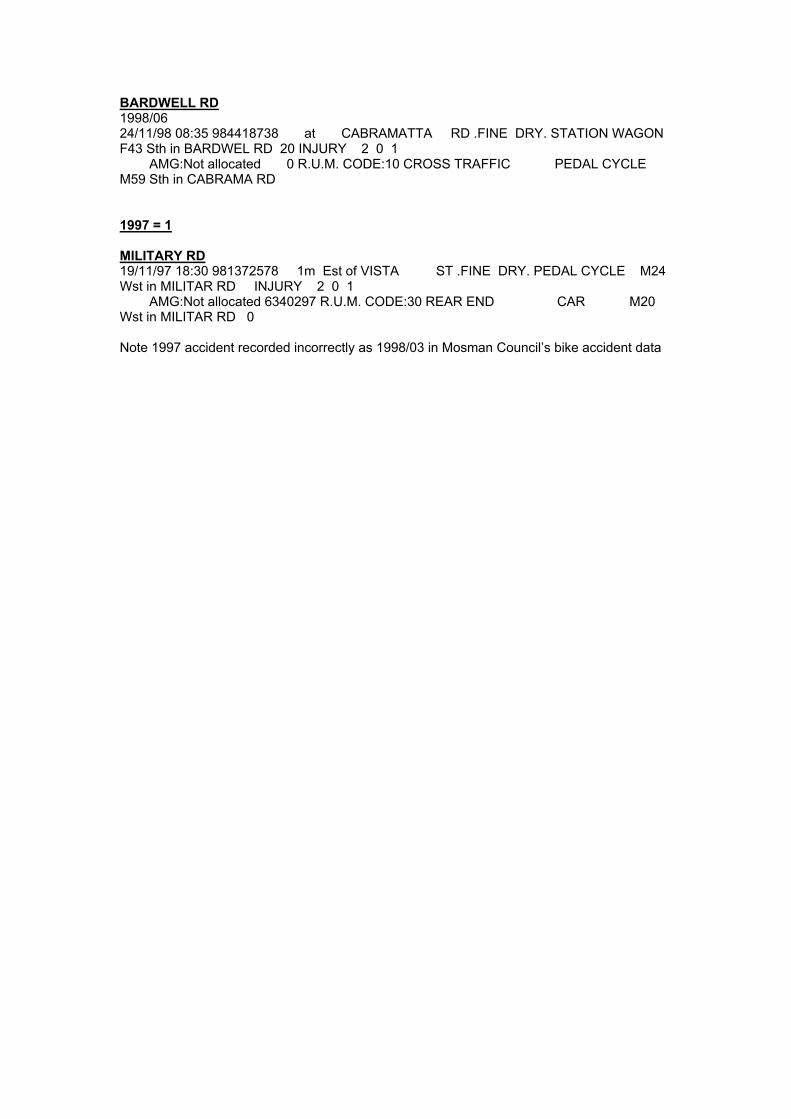
BARDWELL RD 1998/06 24/11/98 08:35 984418738 at CABRAMATTA RD .FINE DRY. STATION WAGON F43 Sth in BARDWEL RD 20 INJURY 2 0 1 AMG:Not allocated 0 R.U.M. CODE:10 CROSS TRAFFIC PEDAL CYCLE M59 Sth in CABRAMA RD 1997 = 1 MILITARY RD 19/11/97 18:30 981372578 1m Est of VISTA ST .FINE DRY. PEDAL CYCLE M24 Wst in MILITAR RD INJURY 2 0 1 AMG:Not allocated 6340297 R.U.M. CODE:30 REAR END CAR M20 Wst in MILITAR RD 0 Note 1997 accident recorded incorrectly as 1998/03 in Mosman Council’s bike accident data

Cremome Wharf
BA
Y S
T
MU
ST
ON
ST
SPIT R
D
TH
E E
SP
LA
NA
DE
SP
IT R
D
MILITARY RD
MA
CP
HE
RS
ON
ST
SP
OF
FO
RT
H S
T
AVENUE RD
RAGLAN ST
PR
INC
E A
LB
ER
T S
T
MIDDLE HEAD RD
RAGLAN ST
OURIMBAH RD
AWABA ST
AWABA ST
KILLARNEY ST
BELMONT RD
CO
WLE
S R
D
MEDUSA ST
MIL
ITA
RY
RD
Taronga Zoo
Taronga Zoo Wharf
Musgrave StWharf
PEARL BAY AV
BICKELL R D
BEAU DTY RPT
LA
NG
ST
2003/04Date: 08/05/03Time: 15:13Weather: FineSurface: DryConflict: P
BA
RD
WE
LL R
D
WINDA VARD
2003/02Date: 20/03/03Time: 07:30Weather: FineSurface: DryConflict:
PC
IDA AV
CH RDAEB
GNITI
HW
2002/02Date: 05/05/02Time: 16:15Weather: FineSurface: DryConflict:
ALMORA ST
VIS
TA
ST
CABRAMATTA RD
2003/03Date: 16/03/03Time: 08:30Weather: FineSurface: DryConflict:
2003/01Date: 16/02/03Time: 12:30Weather: FineSurface: DryConflict:
PC
2002/01Date: 06/03/02Time: 13:45Weather: FineSurface: DryConflict:
PC
PC
PC
2003/05Date: 21/05/03Time: 20:30Weather: FineSurface: DryConflict:
PC
2003/06Date: 01/06/03Time: 10:05Weather: FineSurface: DryConflict:
PC
2002/03Date: 19/06/02Time: 17:30Weather: OvercastSurface: WetConflict:
2002/08Date: 26/08/02Time: 16:50Weather: FineSurface: DryConflict:
2002/06Date: 12/09/02Time: 18:55Weather: FineSurface: DryConflict:
PC
2001/01Date: 01/10/01Time: 18:03Weather: Fine Surface: DryConflict:
2001/02Date: 25/10/01Time: 13:00Weather: OvercastSurface: DryConflict:
2000/01Date: 23/03/00Time: 12:15Weather: OvercastSurface: DryConflict:
PC
GLOVER ST
2000/01Date: 23/03/00Time: 12:15Weather: OvercastSurface: DryConflict:
PC
2000/04Date: 09/11/00Time: 18:00Weather: FineSurface: DryConflict:
PC
2000/03Date: 29/10/00Time: 11:55Weather: FineSurface: DryConflict:
2000/05Date: 27/12/00Time: 09:25Weather: FineSurface: DryConflict: PC
2002/06Date: 24/11/00Time: 17:00Weather: FineSurface: DryConflict:
2002/04Date: 09/07/02Time: 08:25Weather: FineSurface: DryConflict:
PC
PC
1999/01Date: 12/02/99Time: 10:30Weather: FineSurface: DryConflict:
1999/04Date: 31/05/99Time: 18:45Weather: FineSurface: DryConflict:
QUEEN ST
PC
1999/03Date: 20/04/99Time: 13:50Weather: FineSurface: DryConflict: PC
1999/05Date: 16/06/99Time: 10:35Weather: FineSurface: DryConflict: PC
ERITH ST
MO
RU
BE
N R
D
1998/01Date: 20/01/98Time: 08:00Weather: FineSurface: DryConflict:
PC
1998/02Date: 18/02/98Time: 08:50Weather: FineSurface: DryConflict:
1997Date: 19/11/97Time: 18:30Weather: FineSurface: DryConflict:
PC
PC
1998/05Date: 18/07/98Time: 09:00Weather: OvercastSurface: WetConflict:
2000/02Date: 02/06/00Time: 08:30Weather: FineSurface: DryConflict:
PC
1998/06Date: 24/11/98Time: 08:35Weather: FineSurface: DryConflict:
PC
2002/07Date: 06/09/02Time: 14:20Weather: FineSurface: DryConflict:
1999/02Date: 14/03/99Time: 16:15Weather: FineSurface: DryConflict:
PC
1999/06Date: 11/11/99Time: 11:30Weather: FineSurface: DryConflict:
Other Pedestrian
1998/04Date: 02/08/98Time: 15:00Weather: FineSurface: DryConflict:
PC
P
Year Number Symbol 1997 11998 61999 62000 62001 22002 72003 6
Figure A1: Bicycle Accident Locations In MosmanNovember 1997- May 2003
All accidents resulted in injury none were fatal
sSchoolLeisure Centre
Bicycle Accident Locations
DR
DA
EH
SY
EL
DA
RB
D RYA BREDWOHC
CO
RO
NA
TIO
N S
T
CAN
RO
BERT S
T
QUEEN ST
WARRINGAH RD
STANTON RD

Appendix B Post Back Questionnaire and Analysis


Mosman Cycling Questionnaire
Mosman Council is developing a Bike Plan for Mosman. As a local resident and/or a cyclist, your input into the study will be very helpful and make sure the strategy responds to local people and their needs.
Please answer the following questions...
How many bicycles are owned by you and other members of your household?
If you cycle at least occasionally, please answer Q3 - Q7, otherwise go to Q8 over page
What type of trips do you make as a cyclist? (Tick all that apply)
How often do you make a trip as a cyclist? Tick one answer only
Thinking about the trips you make as a cyclist, which streets and paths in Mosman do you use most frequently and for what types of trip?
Thinking about Mosman, please indicate which of the following issues you consider to be a problem for cyclists. Please tick BIG PROBLEM, SMALL PROBLEM, NOT A PROBLEM OF DON’T KNOW.
EverydaySeveral times a weekAt least once a week
At least once a monthLess than once a monthNever
If you answered ‘BIG PROBLEM’ to any of the issues at Q5, please expand on the problem, noting locations that are particularly bad.
What would encourage you to cycle more often in Mosman?
Q1
Q2
Q3
Trips to/from school/TAFE/UniTrips to/from workTrips to/from public transport
Trips to/from other places (please specify)
Trips to/from leisure or sports facilitiesRecreational/fitness ridesTraining ridesTrips to/from the shops
Q4
Traffic volumesTraffic speedsHillsNarrow roads & traffic lanesTraffic management devices (roundabouts, chicanes)Blocked roads, one way streets
Other (please specify)
BIG PROBLEM
SMALL PROBLEM
NOT A PROBLEM
Q5
Q6
Q7
Go to Q10
DON’TKNOW

What is your home postcode?
Q8
Q9 What do you think are the main issues facing cyclists in Mosman?
What would encourage you to cycle in Mosman?
If you do not cycle, please answer Q8 - Q9
Do you think cyclists and cycling should be given more priority by Mosman Council, less priority or is it about right at the moment?
Should be given MORE priorityShould be given LESS priorityAbout right at the moment
If you live in Mosman, which street do you live in?
Thank you for completing the questionnaire
Questions Q10 - Q14 to be answered by ALL
Q10
What age group do you fall into?
Under 12 years12-17 years18-24 years25-34 years35-49 years50-64 years65 years and over
Q12
Female Male
Q11 Are you male or female?
Q13
Q14
You can drop your completed questionnaire into Mosman Council, Civic Centre, Mosman Square, Mosman
POST it to Mosman Council, Reply Paid 211, Spit Junction, NSW 2088
Fax it to 02 9460 2477 or 02 9978 4132
Please return your completed questionnaire by 30th July 2004
If you would like to speak to someone about the Mosman Bike Plan, please call
Bryony Cooper on 02 9460 2444 or Alan Stewart on 02 9978 4174
Or email [email protected]
Mosman Cycling Questionnaire

Post Back Questionnaire Analysis This note presents results from 120 completed questionnaires distributed to inform the Mosman Bike Plan. Q1 How many bicycles are owned by you and other members of your household?
Number of bicycles No. of respondents Percentage 0 14 12% 1 23 19% 2 30 25% 3 15 13% 4 18 15% 5 11 9% 6 3 3% 7 2 2% 8 1 1% 9 3 3%
Total no. of bikes 336 Total = 120 Average number of bikes per household = 2.8 FigureB1: Q1 Number of bicycles per household
12%
19%
25%
13%
15%
9%
3%2%
1%
3%
0%
5%
10%
15%
20%
25%
30%
0 1 2 3 4 5 6 7 8 9
Number of Bikes in Household
Perc
enta
ge o
f Res
pond
ents
Q2 How often do you make a trip as a cyclist? Tick one answer only
Frequency No. of respondents Percentage Everyday 16 13% Several times a week 54 45% At least once a week 18 16% At least once a month 2 2% Less than once a month 16 13% Never 13 11% Did not answer 1 1% Total 120 100%
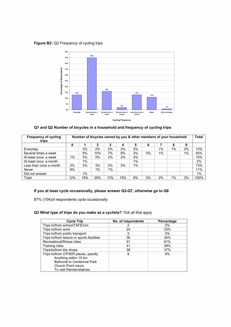
Figure B2: Q2 Frequency of cycling trips
13%
45%
16%
2%
13%11%
1%
0%
5%
10%
15%
20%
25%
30%
35%
40%
45%
50%
Everyday Several times aweek
At least once aweek
At least once amonth
Less than once amonth
Never Did not answer
Cycling Frequency
Perc
enta
ge o
f Res
pond
ents
Q1 and Q2 Number of bicycles in a household and frequency of cycling trips
Frequency of cycling trips
Number of bicycles owned by you & other members of your household
Total
0 1 2 3 4 5 6 7 8 9 Everyday 3% 2% 2% 2% 3% 1% 1% 2% 13% Several times a week 8% 15% 7% 8% 3% 3% 1% 1% 45% At least once a week 1% 3% 5% 2% 2% 2% 15% At least once a month 1% 1% 2% Less than once a month 2% 3% 3% 2% 3% 1% 13% Never 9% 1% 1% 11% Did not answer 1% 1% Total 12% 19% 25% 13% 15% 9% 3% 2% 1% 3% 100%
If you at least cycle occasionally, please answer Q3-Q7, otherwise go to Q8 87% (104)of respondents cycle occasionally Q3 What type of trips do you make as a cyclists? Tick all that apply
Cycle Trip No. of respondents Percentage Trips to/from school/TAFE/Uni 2 2% Trips to/from work 24 23% Trips to/from public transport 5 5% Trips to/from leisure or sports facilities 36 35% Recreational/fitness rides 91 81% Training rides 41 39% Trips/to/from the shops 38 37% Trips to/from OTHER places, specify
Anything within 15 km Balmoral to Centennial Park Church Point return To visit friends/relatives
8 8%

Figure B3: Q3 Type of trips made by cyclists
Trips to/from school/TAFE/Uni1%
Trips to/from work10%
Trips to/from public transport2%
Trips to/from leisure or sports facilities
15%
Recreational/fitness rides36%
Training rides17%
Trips/to/from the shops16%
Trips/to/from other places3%
Q4 Thinking about the trips you make as a cyclist, which streets and paths in Mosman do you use most frequently and for what types of trips?
Streets Used No. of respondents Percentage* Middle Head Road 46 44% Military Road 41 39% Bradleys Head Road 40 38% Spit Road 30 29% Parriwi Road 26 25% Raglan Street 26 25% Belmont Road 21 20% Moruben Road 13 13% Chowder Bay Road 12 12% Spofforth Street 11 11% Avenue Road 10 10% Coronation Avenue 8 8% Muston Street 8 8% Rangers Avenue 7 7% Awaba Street 6 6% Cabramatta Road 6 6% Prince Albert Street 6 6% Bardwell Road 4 4% Ourimbah Road 4 4% Spit Bridge 4 4% The Esplanade 4 4% Beauty Point Road 3 3% Macpherson Street 3 3% Mandolong Road 3 3% Stanton Road 3 3%
* Calculated from the 104 respondents who said they cycled occasionally, 3 of which did not answer this question.

Other comments; • Avoid main roads in Mosman - try to use back streets due to traffic (8) • No suitable streets/paths to cycle on in Mosman (2) • Do not use Military Road as it is too dangerous (2) • Cycle around Clifton Gardens (2) • Only use footpaths (1) • Bush tracks along harbour – Bradleys Head Road and Chowder Head Road (1) • North Sydney to Manly corridor (1) • Spit Junction to bays in Mosman and Cremorne (1) • Spit Junction to Darling Harbour (1) • Spit Junction to Manly (1) • Pearl Bay Track by Spit (1) • Wyong route to Spit (1)
Q5 Thinking about Mosman, please indicate which of the following issues you consider to be a problem for cyclists.
Issues Big Problem
Small Problem
Not a Problem
Don’t Know
Did Not Answer
Traffic volumes 67% 20% 6% 0% 7% Traffic speeds 43% 30% 15% 1% 11% Hills 16% 27% 45% 0% 12% Narrow roads & traffic lanes 48% 32% 10% 1% 10% Traffic management devices 21% 28% 37% 1% 13% Blocked roads, one way streets 6% 22% 57% 3% 13%
Driver attitude 10% Lack of bike lanes/cycle tracks 9% Condition of road surface 6% Buses 3% Car doors opening 2% Lack of awareness by drivers 2% Drivers too close to cyclists 2% Pedestrians not using crossing 1% Not enough cycle racks 1% Parked cars 1% Poor street lighting 1% Traffic speed and volume 1% Speed humps 1% Cat eyes 1% Safety 1%
Other Issues (specify) Note some respondents gave more than 1 answer for other problems for cyclists
Total Other 35%

Figure B4: Q5 Cycling issues in Mosman
67%
48%43%
21%16%
6% 10% 9% 6%
32%
30%
27%
6%
37%
57%
28%
20%
22%
45%
15%10%
7% 10% 11% 13% 12%13%
1% 3%1%
0
0.1
0.2
0.3
0.4
0.5
0.6
0.7
0.8
0.9
1
Trafficvolumes
Narrow roads& traffic lanes
Trafficspeeds
Trafficmanagement
devices
Hills Blockedroads, oneway streets
Other -motorist'sattitude
Other- lack ofcycle
lanes/paths
Other - poorroad surface
Cycling Issues
Perc
enta
ge
Don’t Know
Did Not Answer
Not a Problem
Small Problem
Big Problem
Q6 If you answered ‘BIG PROBLEM’ to any of the issues at Q5, please expand on the problem, noting locations that are particularly bad.
Location Issue Military Rd (30) High volume of cars (17)
Speeding traffic (7) High pedestrian activity (3) Parked cars an obstacle (3) - car doors opening (6) Vehicles unexpectedly turning left into side streets without indicating or looking for cyclists (2) Narrow lanes (8) Squeeze points where 3 lanes go into 2 (2) Difficult to negotiate (2) Long delays at intersections (1) No room off bus lanes (1) Motorists drive too close to cyclists (1) No cycle lanes (1)
Spit Rd (15) High volume of cars (9) Speeding traffic (3) Narrow lanes (1) Parked cars in left lane (1) No cycle lanes (1)
Spit Junction (4) Dangerous – only option is to use footpath Middle Head Rd (3) Traffic Speed – drivers expect cyclists to give way or use parking lanes (1)
Parked cars an obstacle (1) Speed humps (1)
Ourimbah Rd (3) Cars pulling left without indicating or looking (1) High traffic volume (2)
Macpherson Rd (2) High traffic volume (2) Belmont Rd (2) Traffic speeds in peak hours (1)
No allowances for bikes Mosman to North Sydney Route (1)
Traffic volumes (1) Narrow roads (1)
Buena Vista Av (1) Cars come too close to cyclists at roundabout (1) Bardwell Rd (1) Narrows to one lane width with 2 way traffic (1) Chowder Bay Rd (1) Bike shattering speed hump (1) North bound trip to Spit (1) Hills (1) Myaglia Rd (1) Speeding cars makes crossing difficult (1) Muston St (1) High traffic volumes (1)

Spofforth St (1) Traffic speeds in peak hours (1) Mandalong Rd (1) Too narrow should not be the main bike route from Balmoral (1) Gerrard St (1) Traffic Volume (1)
Dangerous (1) To Balmoral (1) Hills (1) Awaba St (1) Hills (1) Raglan St (1) Hills (1) Middle Head Rd Speed humps (1) Mosman Shops Need bike parking (1) Spit Bridge (1) Stanton Rd (1) Uneven road surface has caused a cycling accident (1) Mosman Junction (1) Wyong St Access for cyclist across park between Cowles Rd and Wyong Rd needs to be addressed (1) Warringah Rd Blind corner (1) Bay St (1) Contraflow for cyclists needed (1)
Location Issue Not given Traffic speeds (8)
During peak hour (1) In back streets (3)
Other – motorists attitude/behaviour and awareness (7) Motorists rude behaviour (1) Total disregard for cyclists (1) No acceptance of cyclists (2)
Traffic volumes (7) During peak hour (1) Forced to use footpaths (1)
Other – no designated cycling lanes/cycle areas (7) Traffic management devices (5)
Make it hard to pass cars when they are stopped in peak hour (1) Roundabouts and chicanes restrict ability for motorists to give proper space to cyclists (2) Too many roundabouts and speed humps (1) Break down lanes restrict space (1) Install more watch out for cyclists signs at roundabouts
Narrow roads and traffic lanes (4) Make it hard to pass cars when they are stopped in peak hour (1)
Hills (3) Unavoidable unless you use Military Road
Other – dangerous (2) Only safe to ride Sunday Mornings (1) Bikes need to be separated from car traffic eg cycle lanes and bike traffic lights (1)
Other – frequent intersections (1) Other - road condition
Uneven surfaces/potholes and runoff from building sites (1) Other – no cycle ways for fast cycling and longer distances (1) Other – no off road paths (1)
Therefore no suitable paths for families (1) Other – kiss and ride at schools makes street congested and unsafe for cyclists (1) Other – buses drive too close to cyclists even on wide roads like Middle Head Road (1)

Q7 What would encourage you to cycle more often in Mosman? Cycle lanes/designated cycle areas
• Cycle lanes (45): o Dedicated cycle lanes with no parking (17) o Cycles lanes on uphill sections on arterial routes (1) o Cycle lanes on Military Road and Spit Road (2) o Cycle lanes on Prince Albert Road, Bradleys Head Road, Avenue Road and Middle
Head Road (1). o Wider cycle lanes (1)
• Dedicated cycle paths (20) on edge of road for safety (1) • Shared bike paths (2) to shops (1) • Off road cycle paths (18):
o Dedicated for cyclists (5) o Safe for families (3) o Through the Sydney Harbour Foreshores National Park (1) o Dedicated cycling route over Spit Bridge other than small, glass covered pedestrian
access (1). o Connecting bike path from Parriwi Road so you can avoid Military Road when coming
back from Spit Bridge (1) o Around Balmoral (1) o Install cycle circuit in Middle Head Reserve, min length 3 km (1)
• Ability to ride on Military and Spit Road otherwise cyclists trapped in Mosman (1) • More signed cycle routes (4) with painted bicycle signs on roads (2) • Better signage on cycle routes (3) • Increased safety of routes (3) • Cycle ways that are linked (1) • A cycle path connecting Chowder Bay Road around and behind the former army maritime
school, into Clifton Gardens Reserve would be very useful. Carrying the bike down (or up) the steps and then wheeling it across the sand is rather inconvenient (1).
Motorist Attitude/behaviour
• Increase drivers awareness (47) and respect for cyclists (1) • Install “watch out cyclists” signs to increase awareness of motorists (6) • Need campaign to educate people on the rights if cyclists (6) may increase tolerance and
encourage others to take up cycling (1) • Less aggressive drivers (1) - driver penalty for deliberately clipping cyclists (1) • Buses (2) and trucks travelling too close to cyclist on Spit Road (1) • If Mosman was more ‘cyclist friendly’ (4)
Cycle Facilities
• Cycle parking (14) o Bike lockers (2) o Secure with lighting (1) o In car parks (1) o At shops and ferry wharfs (2)
• Better street markings for cyclists (2) especially on Military Road (1) • Better facilities (1) • More drinking fountains (1)
Traffic
• Reduced traffic volume (8) slower traffic (1) • Minimal stopping – improved crossings for cyclists especially on Military Road and Spit
Road (1) • Fewer traffic management devices (1)

Other
• Legalise riding on footpaths for people over 12 years (1) • More time (1) • More cyclists on the road (3) • Improve cyclists black spots (1) • Less hills (2) • Consultation with cyclist when planning roads and infrastructure (1) • Car free days (1) • Social cycling group (1) • Nothing (1)
Figure B5: Q7 Factors that would encourage cyclists to cycle more often in Mosman
Increase in driver awareness24%
Cycle lanes22%
Dedicated cycle path 10%
Off road cycle paths9%
Cycle parking7%
Reduced traffic volume4%
Shared bike path 1%
Other 23%
If you do not cycle please answer Q8-Q9 16 people do not cycle Q8 What would encourage you to cycle in Mosman? Cycle lanes/designated cycle areas
• Cycle paths (2) • Designated cycle lanes on quiet streets (1) • Know bike paths (1) • Safe cycle way (2)
Other • Bike hiring company as never learnt how to ride a bike • Nothing (3) • Garage to store bike • Less hills (3) around Balmoral (1) • More cyclists (1) • Being fitter (1)

Figure B6: Q8 Factors that would encourage non-cyclists to cycle in Mosman
More cycle lanes/paths38%
Nothing19%
Being fitter6%
More cyclists6%
Bike hire company in Mosman6%
Garage to store bike6%
Less Hills19%
Q9 What do you think are the main issues facing cyclists in Mosman? Cycle facilities
• Lack of secure bike parking (1)
Cycle lanes/designated cycle areas • No cycle lanes on narrow and busy roads (1) eg Military Road • No designated cycle paths (1)
Motorist attitude/behaviour
• Inconsiderate motorists (2) in particular 4WDs (2) • Road rage (1) • Low cycling awareness (1)
Traffic • Danger from traffic (9) due to high traffic volume (1) • Traffic congestion (especially at intersections and roundabouts) • Speeding traffic (1) • Narrow roads (1)
Hills (4) - discourages the casual cyclist (1) Other
• Pedestrians (1) • Cyclists need to be separated from pedestrians they should ride on the road and not on
the footpath. Footpaths are crowded enough as it is in Mosman (1) • Cyclist should observe traffic lights and give hand signals (1) • Pollution (1)

Figure B7: Q9 The main issues facing cyclists in Mosman identified by non-cyclists?
Traffic volume/speed38%
Hills14%
Motorist's attitude/behaviour14%
Other11%
Lack of cycle lanes/paths7%
Lack of bike parking4%
Narrow roads4%
Pollution4%
Pedestrians4%
Questions Q10-Q14 to be answered by ALL Q10 Do you think cyclists and cycling should be given more priority by Mosman Council, less priority or is it about right at the moment?
Response No. of respondents Percentage Should be given MORE priority 106 88% Should be given LESS priority 3 3% About right at the moment 8 7% No answer 3 3%
Total 120 100% Q11 Are you Male or Female?
Response No. of respondents Percentage Male 50 42% Female 68 57% Did not answer 2 2%
Total 120 100% Q12 What age group do you fall into?
Response No. of respondents Percentage Under 12 years 2 2% 12-17 years 3 3% 18-24 years 3 3% 25-35 years 14 12% 36-49 years 50 42% 50-64 years 41 34% 65 years and over 7 6%
Total 120 100%

Q13 What is your postcode?
Response No. of respondents Percentage 2088 - Mosman 72 60% 2089 - Neutral Bay 6 5% 2090 - Cremorne Junction 6 5% 2068 - Willoughby 3 2% 2062 - Cammeray 4 4% 2065 - Crows Nest 2 2% 2092 - Seaforth 2 2% 2010 - Darlinghurst 1 1% 2026 - Bondi 1 1% 2037 - Glebe 1 1% 2060 - North Sydney 1 1% 2064 - Artarmon 1 1% 2086 - Frenchs Forest 1 1% 2093 - North Balgowlah 1 1% 2094 - Fairlight 1 1% 2095 - Manly 1 1% 2099 - Wingala 1 1% 2100 - Allambie 1 1% 2102 - Warriewood 1 1% 2131 - Ashfield 1 1% 2206 - Clemton Park 1 1% 2602 - Watson 1 1% 2880 - Broken Hill 1 1% 2203 - Dulwich hill 1 1%
Total 112 93% Did not Answer 8 7%
Q14 If you live in Mosman, which street do you live in?
Response No. of respondents Percentage Muston Street 6 5% Avenue Road 4 3% Military Road 4 3% Raglan Street 4 3% Spofforth Street 4 3% Clanalpine Street 3 3% Glover Street 3 3% Middle Head Road 3 3% Spit Road 3 3% Awaba Street 2 2% Bay Street 2 2% Botanic Road 2 2% Bradleys Head Road 2 2% Central Avenue 2 2% Medusa Street 2 2% Myahgah Road 2 2% Shellbank Avenue 2 2% Vista Street 2 2% Almora Street 1 1% Cabban Street 1 1% Cabramatta Road 1 1% Cobbittee Lane 1 1% Earl Street 1 1%

Response No. of respondents Percentage Elfrida Street 1 1% Ellamatta Avenue 1 1% Gordon Street 1 1% Harbour Street 1 1% Julian Street 1 1% Lang Street 1 1% Milson Road 1 1% Mosman Street 1 1% Musgrave Street 1 1% Noble Street 1 1% Orlando Avenue 1 1% Oswald Street 1 1% Parriwi Road 1 1% Pindari Avenue 1 1% Prince Albert Street 1 1% Prince Street 1 1% Rangers Avenue 1 1% Rickard Avenue 1 1% Stanton Road 1 1% The Esplanade 1 1% Whiting Beach Road 1 1% Windward Avenue 1 1%
Total 81 67% Did not answer 38 32%

Appendix C Sydney Harbour Federation Trust Proposals

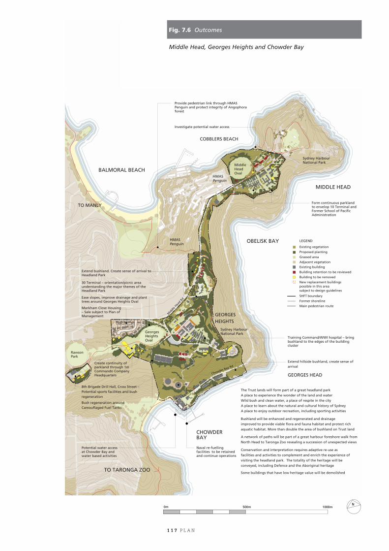
1 1 7 P L A N
Fig. 7.6 Outcomes
Middle Head, Georges Heights and Chowder Bay
The Trust lands will form part of a great headland park
A place to experience the wonder of the land and water
Wild bush and clean water, a place of respite in the city
A place to learn about the natural and cultural history of Sydney
A place to enjoy outdoor recreation, including sporting activities
Bushland will be enhanced and regenerated and drainage
improved to provide viable flora and fauna habitat and protect rich
aquatic habitat. More than double the area of bushland on Trust land
A network of paths will be part of a great harbour foreshore walk from
North Head to Taronga Zoo revealing a succession of unexpected views Conservation and interpretation requires adaptive re-use as
facilities and activities to complement and enrich the experience of
visiting the headland park. The totality of the heritage will be
conveyed, including Defence and the Aboriginal heritage
Some buildings that have low heritage value will be demolished
Bush regeneration around Camouflaged Fuel Tanks
8th Brigade Drill Hall, Cross Street –Potential sports facilities and bush regeneration
Extend hillside bushland, create sense of arrival
HMASPenguin
OBELISK BAY
BALMORAL BEACH
COBBLERS BEACH
MIDDLE HEAD
GEORGESHEIGHTS
GEORGES HEAD
Sydney Harbour National Park
Sydney Harbour National Park
CHOWDER BAY
Mid
dle H
ead R
d
Chowder Bay Rd
HMASPenguin
Georges HeightsOval
Naval re-fuelling facilities to be retained and continue operations
Investigate potential water access
Provide pedestrian link through HMAS Penguin and protect integrity of Angophora forest
Form continuous parkland to envelop 10 Terminal and Former School of Pacific Administration
Training Command/WWI hospital – bring bushland to the edges of the building cluster
Create continuity of parkland through 1st Commando Company Headquarters
Ease slopes, improve drainage and plant trees around Georges Heights Oval
Markham Close Housing – Sale subject to Plan of Management
Rawson Park
Extend bushland. Create sense of arrival to Headland Park
30 Terminal – orientation/picnic area understanding the major themes of the Headland Park
Potential water access at Chowder Bay and water based activities
Middle HeadOval
TO MANLY
TO TARONGA ZOO
Existing vegetation
Proposed planting
Grassed area
Adjacent vegetation
Existing building
Building retention to be reviewed
Building to be removed
New replacement buildings possible in this area subject to design guidelines
SHFT boundary
Former shoreline
Main pedestrian route
LEGEND
N0m 500m 1000m


Appendix D Costed Concept Proposals (Priority Items 1-5)


Existing segregated path on Spit Road/Parriwi Road
Existing pedestrian path on Spit Road between Warringah Road and Stanton Road is proposed to be upgraded to shared path
WARRINGAH ROAD
SP
IT R
OA
D
PA
RR
IWI R
OA
D
Priority Item 1: Provision of Shared Path on Eastern side of Spit Road between Parriwi Road and Stanton Road
Scheme Description:
The existing shared path on the eastern side of Spit Road extends for approximately 39 metres from Parriwi Road to Warringah Road. A leading line with bicycle symbol needs to be painted on Parriwi Road and Spit Road to direct cyclists onto the shared path. Guidance on shared paths states that the path width should be between 2.0m and 2.5m with a minimum of 0.3m clearance between the path edge andsmooth lateral obstacles such as a fence and 1m clearance between the edge of the path and obstacles such as trees or parked vehicles. Based on this guidance the existing path which has an average width of 1.3m needs to be widened by 0.7m.
This can be achieved by reducing the nature strip from 2.1m to 1.4m. The intermittent trees on the nature strip will require the application of ‘Soak Thru Porous Paving’ around their bases to allow water to penetrate whilst providing an even surface for cyclists and pedestrians.
It is proposed that the existing shared path needs to be extended from Warringah Road to Stanton Road to provide cyclists with easy access to the cycle network. To do this the current path needs to be widened from 1.6m to 2.0 by reducing the nature strip from 2m to 1.6m which will involve the removal of some of the vegetation, porous paving will be applied around surrounding shrubs and trees. Shared use path signs will need to be erected at the corner of Warringah Road and Spit Road and the corner of Stanton Road and Spit Road.
Cross Section B - Spit Road between Warringah Road and Stanton RoadExisting Situation Proposal
1.2m 0.8m 1.6m 0.4m
Spit Road Pedestrian Path
Pro
pe
rty
fen
ce
Na
ture
str
ip w
ith
inte
rmitt
en
t t
ree p
lan
tings
Ped
est
rian
Pa
th
Sp
it R
oa
d
Low
ve
ge
tatio
n -
cle
ara
nce
1.2m 0.4m 2.0m 0.4m
Spit Road Shared Path
Pro
pe
rty
fen
ce
Na
ture
str
ip w
ith
inte
rmitt
en
ttr
ee p
lan
tings
Sha
red P
ath
Sp
it R
oa
d
Low
ve
ge
tatio
n -
cle
ara
nce
1.2m 2.0m0.2m
Proposal
Cross Section A - Spit Road between Parriwi Road and Warringah Road
Na
ture
str
ip w
ith
inte
rmitt
en
t tr
ee
pla
ntin
gs
surr
ou
nd
ed
b
y g
eote
xile
mat
Sha
red p
ath
wid
ene
d
Pro
pe
rty
fen
ce
Tri
mm
ed
sh
rub
s
Sp
it R
oa
d
Spit Road Shared Path
1.2m 0.9m 1.3m
Existing Situation
Na
ture
str
ip w
ith
inte
rmitt
en
ttr
ee p
lan
tings
Sha
red p
ath
Pro
pe
rty
fen
ce
Ove
rha
ngin
g s
hru
bs
Sp
it R
oa
d
Spit Road Shared Path
BB
AA
END
Facing south
Facing south
NSTANTON ROAD
Facing north
Leading line
Attach a 'Buses and Bicycles Excepted' sign onto the existing no left turn sign

Scheme Description:Provision of access for cyclists from the southern end of Parriwi Road across Spit Road to Bickell Road will provide a vital link between the western and eastern sections of the proposed bike network.
Cyclists in Parriwi Road will access a shared use path (to be constructed) taking them across the existing planted area to Spit Road and an existing signalised crossing from which they can access Bickell Road.
The construction of a refuge to assist cyclists travelling south from Parriwi Road towards Bickell Street is difficult due to the proximity of Upper Fairfax Road. Construction of a refuge at this location will be investigated at the detailed design stage.
The existing steps will be relocated to the north, adjacent to the existing private property boundary. A new shared use ramp will be constructed between the steps and the telegraph pole. A drop kerb will facilitate cycle access from Parriwi Road and kerbside parking in this location will be prohibited to allow access for cyclists. The ramp will have a gradient of approximately 10% and be approximately 11.7m long. The ramp will be 2.5m wide to accommodate cyclists and those with strollers or mobility difficulties. Warning signs and line markings will be incorporated to slow cyclists as they approach Parriwi Road and the potential for conflict with pedestrians and vehicles.
It is proposed to construct a new path from the top of the steps to the intersection with the ramp located to the east of the existing gas main warning sign. Between the steps and the ramp this path will be 2m wide and from the intersection with the ramp to Spit Road it will be 2.5m wide. The width of the shared path is constrained by an electricity equipment box on the eastern side of Spit Road.
The existing property boundary fence is to be reduced in height or replaced with a see through material to improve sightlines for all users where the shared path meets the Spit Road footpath. It will be necessary to negotiate with the home owner to reach a suitable solution.
The eastern footpath on Spit Road is to be widened to the full extent of the nature strip between the fence line and the existing garage accesses. The path is to be designated shared use. The existing street light pole is to be relocated to the back of the existing footpath.
The existing signalised crossing is to be changed to incorporate bicycle signals. The existing crossing is 4m wide and so does not need widening.
It is proposed that the existing footpath on the western side of Spit Road between the existing signalised crossing and Bickell Road is widened to the full extent of the existing nature strip and designated shared use. The existing refuge is to be widened to accommodate cyclists and an additional drop kerb is to be installed in Bickell Road at the intersection with Spit Road to allow cyclists to turn right into Bickell Road with the assistance of a centre refuge. The drop kerb will allow cyclists from Bickell Road to reach the shared path along Spit Road.
Cycle route signs and shared path signs need to be installed as identified in diagram on the following page.
Priority Item 2: Provision of access for cyclists from southern end of Parriwi Road to the crossing on Spit Road north of Bickell Road

PA
RR
IWI R
OA
DSP
IT R
OA
D
PA
RR
IWI R
OA
DSP
IT R
OA
DRelocate street light
Bus Stop
PA
RR
IWI R
OA
DSP
IT R
OA
DRelocate street light
Bus Stop
Proposed concrete
Shared path
PA
RR
IWI R
OA
DSP
IT R
OA
DRelocate street light
Bus Stop
Proposed concrete
Shared path
Proposed pedestrian/cyclist crossing
PA
RR
IWI R
OA
DSP
IT R
OA
DRelocate street light
Bus Stop
Proposed concrete
Shared path
Proposed pedestrian/cyclist crossing
Service box
PA
RR
IWI R
OA
DSP
IT R
OA
DRelocate street light
Bus Stop
Proposed concrete
Shared path
Proposed pedestrian/cyclist crossing
Service box
Proposed ramp forcyclists and
wheelchair access
Widen refuge for cyclists
for cyclists
Gas
PA
RR
IWI R
OA
DSP
IT R
OA
DRelocate street light
Bus Stop
Proposed concrete
Shared path
Proposed pedestrian/cyclist crossing
Service box
Proposed ramp forcyclists and
wheelchair access
Widen refuge for cyclists
for cyclists
Gas
Reduce height of existing wooden property fence or replace with see
through fence
Sign post
Relocated stairs closer to
building linePA
RR
IWI R
OA
DSP
IT R
OA
DRelocate street light
Bus Stop
Proposed concrete
Shared path
Proposed pedestrian/cyclist crossing
Service box
Proposed ramp forcyclists and
wheelchair access
Widen refuge for cyclists
for cyclists
Gas
Reduce height of existing wooden property fence or replace with see
through fence
Sign post
Relocated stairs closer to
building line
Widen path and designate as
sharedPA
RR
IWI R
OA
DSP
IT R
OA
DRelocate street light
Bus Stop
Proposed concrete
Shared path
Proposed pedestrian/cyclist crossing
Service box
Proposed ramp forcyclists and
wheelchair access
Widen refuge for cyclists
for cyclists
Gas
Reduce height of existing wooden property fence or replace with see
through fence
Sign post
Relocated stairs closer to
building line
Widen path and designate as
shared
Service box
UPPER FAIRFAX ROAD
MIT
CH
EL
L R
OA
D
1.7m
22m
Bus Stop
2.5m 10m
AA Min 2m
B
B
C
C
Not to scale
Drop kerb
Sign
New path
Steps
PA
RR
IWI R
OA
DSP
IT R
OA
DRelocate street light
Bus Stop
Proposed concrete
Shared path
Proposed pedestrian/cyclist crossing
Service box
Proposed ramp forcyclists and
wheelchair access
Widen refuge for cyclists
for cyclists
Gas
Reduce height of existing wooden property fence or replace with see
through fence
Sign post
Relocated stairs closer to
building line
Widen path and designate as
shared
Service box
UPPER FAIRFAX ROAD
MIT
CH
EL
L R
OA
D
1.7m
22m
Bus Stop
2.5m 10m
AA Min 2m
B
B
C
C
Not to scale
Drop kerb
Sign
New path
Steps
Cycle turning land and traffic island
subject to detailed design
4m
Priority Item 2: Provision of access for cyclists from southern end of Parriwi Road to the crossing on Spit Road north of Bickell Road
BICKELL ROAD

Existing Situation Proposal
Proposed shared path on western side of Spit Road
1.65m 2.0m
Spit RoadS
pit
Road
Natu
re s
trip
Pedest
rian
path
3.65m
Spit Road
Spit
Road
Reduce
d w
idth
of natu
re S
trip
Path
wid
ened
and d
esi
gnate
d
as
share
d p
ath
Existing Situation Proposal
Proposed divided path leading onto Parriwi Road on eastern side of Spit Road
2.0m 2.0m
Gra
ss
Pedest
rian
path
leadin
g
to s
tairs
onto
P
arr
iwi R
oad
Pa
th le
adin
g
to r
am
p for
cyc
lists
and
wheelc
hair a
cce
ss
Fence
Gra
ss
Concr
ete
pedest
rian
path
leadin
g
to s
tairs
onto
P
arr
iwi R
oad
from
bus
stop
1.2m
Gra
ss
Informal path
Fence
Existing Situation Proposal
Proposed treatment of Spit Road and Bickell Road intersection
Share
d p
ath
le
aid
ing
into
Bic
kell
Road
Isla
nd r
efu
ge
Bic
kell
Roa
d
Pedest
rian
path
3m
Wid
en g
ap o
f is
lan
d r
efu
ge
on B
icke
ll R
oad
for
cycl
ists
Pedest
rian
path
Approx. 1m
Share
d p
ath
le
aid
ing
into
Bic
kell
Road
Approx. 8m Approx. 8m 7m 7m
Bickell Road (at intersection with Spit Road) Bickell Road (at intersection with Spit Road)
Cross section A-A Cross section B-B
Cross section C-C
Priority Item 2: Provision of access for cyclists from southern end of Parriwi Road to the crossing on Spit Road north of Bickell Road
1m1mDrop kerb Drop kerb

Proposal to facilitate turning movements for cyclists across Wyong Road/Killarney Street to provide accessalong the RTARegional Route
Wyong Road and Killarney Street are separated by an open green space. Currently cyclists approaching KillarneyStreet from Wyong Road have to negotiate poorly located shared use pathways or dismount . Cyclists turning right intoWyong Road from Killarney Street must do so on a step uphill gradient and on a blind corner which is considered veryunsafe.
It is proposed to construct a shared path across the open green space, realign the existing shared path and providedropped kerbs. This will facilitate turning movements for cyclists crossing Wyong Road/Killarney Street to provideaccess along the RTA Regional Route. The new shared path will be 2.5 metres wide and link Wyong Road via anexisting driveway to the shared path on Killarney Street. The existing wood bollards along the driveway should beremoved.
The footpath on the eastern side of Killarney Street is to be designated as shared use to allow cyclists turning right intoWyong Road from Killarney Street to cycle alongside the carriageway and then cross both lanes of traffic at a pointwhere visibility is good. Shared use signs need to be located as indicated in figure on following page.
Priority Item 3: Proposals to redirect the RTA Regional Route through Beauty Point and Pearl Bay

10.4m
4.5m4.5m
3.5m
4.5m
11.8m
12.8m
Crash barrier
2.2m
1.4m
1.2m
0.8m
50km/hr sign
Shared Use Path
A1.4m
10.4m
4.5m4.5m
3.5m
4.5m
11.8m
12.8m
Drain
Telegraph pole
Pine bollards removed
Crash barrierWooden post removed
2.2m
1.4m
1.2m
50km/hr sign
2m
Realign shared pathand drop kerb
B
Shared Use Path
1.4m
2m
Wyong Road/Killarney Street - Existing Situation
Plan View Cross Section A-A
Wyong Road/Killarney Street - Proposed Scheme
Plan View Cross Section B-B
2.2m 11.8m approx 1.2m
Footpath northernside of Wyong Road
Green open space separating WyongRoad from Killarney Street
Footpath southernside of Wyong Road
Te
leg
rap
hp
ole
with
sh
are
du
se
sig
na
tta
ch
ed
Op
en
gre
en
spa
ce
with
ma
ture
tre
es
an
dd
rive
wa
yto
priva
tep
rop
ert
y
Na
rro
wb
lind
co
rne
rd
ue
tove
ge
tatio
no
nso
uth
ern
sid
ea
nd
tele
gra
ph
po
le
Dra
in
2.2m 1.2m
Footpath northernside of Wyong Road
Green open space Footpath sothernside of Wyong Road
Te
leg
rap
hp
ole
with
sh
are
du
se
sig
na
tta
ch
ed
Pro
po
se
dsh
are
du
se
pa
thw
ide
ns
fro
m2
mb
etw
ee
nm
atu
retr
ee
sto
2.5
mw
ide
wh
ere
itco
nn
ects
with
exis
tin
gsh
are
dpa
th
Na
rro
wb
lind
co
rne
rd
ue
tove
ge
tatio
no
nso
uth
ern
sid
ea
nd
tele
gra
ph
po
le
Op
en
gre
en
spa
ce
with
ma
ture
tre
es
Dra
in
Green openspace
Shared use path
2.5m 3.6m6.1m
Key
Drop kerb
Shared use path
Sign - shared path
Sign - end of shared path
Telegraph pole
Bollard
Drain
Double sided sign
Bicycle route sign
A
Fo
otp
ath
no
rth
ern
sid
eo
fW
yo
ng
Ro
ad
Footp
ath
nort
hern
sid
eofW
yong
Road
B
Drain
Telegraph pole
KILLARNEY STREET
WYO
NG
RO
AD
WYO
NG
RO
AD
KILLARNEY STREET
Designate as shareduse footpath
2m
Priority Item 3: Proposals to redirect the RTA Regional Route through Beauty Point and Pearl Bay
N
N

Proposal - Contraflow cycle path for northbound cyclists on Bay Street
To redirect the alternative RTARegional Route through Beauty Point and Pearl Bay, the one way southbound sectionof Bay Street needs to allow access for northbound cyclists. It is proposed to install a contraflow cycle lane 1.2 metreswide through the reserve in order to bypass the one way section. Council owns the reserve and there is sufficientspace for a contraflow lane. The contraflow cycle lane would extend for approximately 73 metres. Porous paving isrequired at the base of a gum tree at the northern end of the contraflow and the path width will be reduced to 1.1metres at this point. Dropped kerbs are required at either end and ‘cycle only’ signs should be attached to existingsign posts.
Drop kerb
Pedestrianfootpath
Install ‘bicyclesonly’ sign
Drop kerb
Install ‘bicyclesonly’ sign
1.2m
1.2m
Porous paving required atbase of gum tree. Path
width reduced to1.1metres.
Existing draincover
Drive way access toReserve
Path betweenexisting trees
1.2m
Porous paving
Bay Street
Nature Strip
2.2m5m
EasternFootpath
Easte
rnF
ootp
ath
PrivateProperty
Bay
Str
eet
one-w
ay
south
bound
Pla
nthegde
Private
Pro
pert
y
Pro
pert
yfe
nce
Gum
tree
with
exposed
roots
East oftree trunk
West oftree trunk
Bay Street Contra-flow
1.1m5m
EasternFootpath
Easte
rnF
ootp
ath
PrivateProperty
South
bound
cyclis
tsto
use
Bay
Str
eet
Private
pro
pert
y
Pro
pert
yfe
nce
Pla
nthegde
Poro
us
pavin
gsurr
oundin
ggum
tree
1.1m
Porouspaving
Contr
a-f
low
for
nort
hbound
cyclis
tsonly
AA
A-A Cross Section on Bay Street
Existing Situation
A-A Cross Section on Bay Street
Proposed Scheme
Contraflow
Priority Item 3: Proposals to redirect the RTA Regional Route through Beauty Point and Pearl Bay

New shared pathlinks with
existing path
19m1.5m
1.3m
1.4m
Existing path extends110m to foreshore
4.5m betweenexposed root
and metal pole
1.5m
4.5m
Drop kerb alreadyexisting for vehicle
access
Drop kerb requiredfor existing path
Proposal to provide Pearl Bay Avenuecycle access to the Foreshore Walking Track from
Priority Item 3: Proposals to redirect the RTA Regional Route through Beauty Point and Pearl Bay
The Foreshore Walking Track provides pedestrians with an off road link between Pearl Bay Avenue and the SpitReserve. To redirect the RTA Regional Route through Pearl Bay, the Foreshore Walking Track has to be upgraded toprovide access for cyclists. It is proposed that a new section of path 1.5 metres wide and approximately 19 metres longbe constructed from the gate on Pearl Bay Avenue to the existing shared path as shown below. The gate should bereplaced with a row of highly visible removable bollards to allow cyclists safe access to the new path whilst preventingunauthorised vehicles from entering. Dropped kerbs are required on Pearl BayAvenue leading onto the existing path.Adropped kerb is already present at the beginning of the proposed path to provide access for maintenance vehicles.Shared use signs should be implemented at the beginning and end of the path.
The condition of the existing asphalt path which extends approximately 110 metres to the foreshore concrete path issubstandard for pedestrians and cyclists and requires upgrading. Sections of the path are currently less than 1 metrewide. The path edges are crumbling due a lack of edging, unstable base material of sandy soil and water erosion. Theconcrete path extends along the foreshore to the car park on Spit Road. The concrete path is generally in good conditionand it is of sufficient width to be signed as shared use.
Replace gate with row of highly visibleremovable bollards with sufficient width to
allow cyclists safe access to new path

Proposal 1 - 15m path from end of carpark to join existing shared path on westside of Spit Road
Proposal 2 - Path from end of car parkextending through the pine trees to joinexisting shared path near Spit Bridge
Proposal 2
Proposal 1
Drop kerb
Drop kerb
1 car space to beremoved or the ticketmachine relocated
Proposal to implement a shared use path between the northern end of the car park and the existing shareduse path along the west side of Spit Road.
15m
Priority Item 3: Proposals to redirect the RTA Regional Route through Beauty Point and Pearl Bay
1 car space to beremoved or the ticketmachine relocated
Existing shared path
Car park
SP
ITR
OA
D
Cyclists require a link from the Foreshore Walking Track to the existing shared path on Spit Road. It is proposed to signthe RTA Alternative Regional Route through the car park on the western side of Spit Road. There are two proposedschemes to link the end of the car park to the shared path on Spit Road.
Construct a 15 metre path from the northern end of Spit Road car park to join the existing shared path on thewest side of Spit Road.
Construct a path from the northern end of Spit Road car park extending through the Spit Reserve betweenthe two rows of pine trees to join the existing shared path near the Spit Bridge.
Both proposals will require the removal of one car space or the relocation of the ticket machine.
Proposal 1:
Proposal 2:
A dropped kerb isrequired at the southern end of the path and it is to be signed as shared use. The existing drop kerb at the northern end ofthe shared path on Spit Road requires widening and realignment as it is currently dangerous for cyclists.

Across median and Parriwi Road to buildout
Across car park entrance - keepclear area between queuing cars
Along service road
Approach from Parriwi Road,northbound
Across car park entrance
Across buildout, guttering, and newkerb
Scheme Description:
A vital link in Mosman's cycle network is that between the northern end of Parriwi Road and Spit Bridge.
It is proposed to provide a two way shared use link along the eastern side of Spit Road. This link incorporates a service road at its southern end, however, it is currently difficult for cyclists to get between the service road and Parriwi Road.
It is proposed to treat the concrete median at the intersection of Parriwi Road and Spit Road to allow northbound cyclists to turn right prior to the intersection and cross the southbound lane, giving way to vehicles. This requires drop kerbs on each side of the median, and a short section of 1m wide cycle path, marked by painted lines. The section of cycle path is angled to allow a cyclist to comfortably wait for a gap in southbound traffic before crossing. A “watch for cyclists” sign will be erected at the end of the kerbside parking bays to warn northbound motorists in Parriwi Road.
A short section of cycle path is required across the concrete build out separating Parriwi Road from the entry/egress to Middle Harbour Yacht Club car park. This will require a 2m wide drop kerb to allow the two way movement of cyclists to and from Parriwi Road. Grating across the existing storm drain gully is also required.
The existing drop kerb (providing access to the footpath on the eastern side of Parriwi Road) on the southern edge of the car park access is narrow and in poor condition. A metal bollard acts as an obstruction to pedestrians and cyclists crossing the car park entrance. It is proposed to construct a kerb buildout and replace the existing bollards around the parking ticket machine, removing all bollards and allowing the drop kerb to be extended (to 2m) and formalised. The drop kerb remains constrained by the storm drain and an existing traffic signal pole.
A 2m wide “keep clear” strip painted across the car park entrance will allow pedestrians and cyclists to cross when two or more cars are queuing to exit the car park. Given that vehicles queue to enter the car park at times it is proposed to extend the “keep clear” markings across the full width of the entry/egress.
Cyclists will be signed along the existing service road to encourage them to utilise the proposed shared use path to the north. Alternatively cyclists could dismount and cross Spit Road at the existing signalised crossing and join the existing shared use path on the west side of Spit Road or the foreshore path.
Priority Item 4: Provision of access to/from the northern end of Parriwi Road at Spit Road for cyclists
Red arrows indicate proposed movement of cyclists to and from Parriwi Road
Photographs:

SPIT ROAD
SP
IT R
OA
D
SE
RV
ICE
RO
AD
N
Natu
re S
trip
FootpathO
n Street Parking
SPIT ROAD
SP
IT R
OA
D
SE
RV
ICE
RO
AD
N
Natu
re S
trip
FootpathO
n Street Parking
SPIT ROAD
SP
IT R
OA
D
SE
RV
ICE
RO
AD
N
Natu
re S
trip
FootpathO
n Street Parking
SPIT ROAD
SP
IT R
OA
D
SE
RV
ICE
RO
AD
N
Natu
re S
trip
FootpathO
n Street Parking
SPIT ROAD
SP
IT R
OA
D
SE
RV
ICE
RO
AD
N
Natu
re S
trip
FootpathO
n Street Parking
SPIT ROAD
SP
IT R
OA
D
SE
RV
ICE
RO
AD
N
Natu
re S
trip
FootpathO
n Street Parking
SPIT ROAD
SP
IT R
OA
D
SE
RV
ICE
RO
AD
N
Natu
re S
trip
FootpathO
n Street Parking
SPIT ROAD
SP
IT R
OA
D
SE
RV
ICE
RO
AD
N
Natu
re S
trip
FootpathO
n Street Parking
Build out kerb to replace area protected by bollardsand introduce new drop kerb(2m wide)
Grate over storm drain to allow cycles to cross
New “keep clear” areabehind position offirst car (2m wide)
New section of cycle pathand drop kerb foraccess to and fromParriwi Road (2m wide)
Signing to direct cyclistson Parriwi Road to turn right at median
At grade cycle sliplane within median
Signing will guidecyclists to utilise existingservice road to continuenorthwards on easternside of Spit Road
Existing pedestriancrossing
Red arrows indicate proposedmovement of cycliststo and from Parriwi Road
Key
Existing traffic signal
Existing ticket machine
Proposed drop kerb
Existing speed hump
Not to scale
Car park
Priority Item 4: Provision of access to/from the northern end of Parriwi Road at Spit Road for cyclists - plan of proposal
1m
2m
2m
2m
Proposed sign

Priority Item 5: Provision of two way shared path along the east side of Spit Road between Parriwi Road and the Spit Bridge
AA
BB
Proposed Shared Use Boardwalk
Proposed Shared Use Path
Scheme Description:
Provide a shared use path along the eastern side of Spit Road between Parriwi Road and the Spit Bridge to facilitate movement between Parriwi Road and Spit Bridge. It is proposed that cyclists (and pedestrians) travel from the existing southern service road along a boardwalk to the boat ramp and then along a concrete path (formed by widening the existing footpath), and finally along the northern service road to the underpass beneath Spit Bridge, connecting with the existing shared path on the western side of Spit Bridge.
Signs exempting northbound cyclists from the ‘no entry’ at the northern end of the southern service road are required.
Boardwalk Section:Currently there is an informal track along the grassy dune from the southern service road to the boat ramp. It is proposed to construct a shared use boardwalk along the same alignment as the informal track. The boardwalk will extend for approximately 88m with a width of 2.5m. Boardwalk is the most appropriate path treatment for sand dunes. Parked vehicles currently encroach on the dune and it is proposed to allow kerbside parking only to maintain parking within the available width. Parking bays should be marked and signed accordingly. Given the reduced width required for kerbside bays, this arrangement will increase the clearance between parked vehicles and the edge of the boardwalk.
Concrete Section: It is proposed to widen the existing pedestrian path between the boat ramp and the northern service road from 2.0m to 2.5m and designate it as shared use. The path is approximately 70m long. This will necessitate a change in the current parking arrangement to allow 30 degree angle parking only. Vehicles should be advised to park rear to kerb, increasing visibility of Spit Road traffic on leaving the space. Wheel stops should be incorporated to ensure vehicles do not encroach on the shared use path.
It is necessary to relocate three street lights to facilitate the construction of the route and remove them as potential obstacles to cyclists and pedestrians. Appropriate signs will be erected to indicate that the path is shared between the southern and northern service roads. Signs will be erected to identify the parking areas with bays marked to encourage considerate parking behaviour.
Change to 30 degree parking with
parking signs
Change to kerbside parking
with parking signs
Existing bus stop
Drop kerb & access to northern service road
Signs to facilitate access to shared use boardwalk

Priority Item 5: Provision of two way shared path along the east side of Spit Road between Parriwi Road and the Spit Bridge
Cross Section A - Existing Situation
Spit
Road
6.7m 3m
Beach
Info
rmal p
ath
ove
r gra
ssy
dune
Spit
Road
8.3m 2m 11.5m
90 d
egre
e
park
ing w
ith n
o li
nes
or
wheel st
ops
- m
ost
cars
ove
rhang
onto
path
Sandst
one
reta
inin
g w
all
Beach
Gra
ss c
ove
red
fore
dun
e w
ithla
rge tre
es
Pedest
rian
path
Cross Section B - Existing Situation
Gutter
Gutter
Spit
Roa
d
2.5m 11.5m
Desi
gnate
d
share
d u
se
path
2.5
m w
ide
Sa
ndst
one
reta
inin
g w
all
Gra
ss c
ove
red
fore
dune w
ith
larg
e tre
es B
ea
ch
Spit
Roa
d
5.7m 0.25m
Be
ach
Share
d u
se
bo
ard
walk
over
gra
ssy
du
ne
0.25m 2.5m
Cross Section A - Proposal Cross Section B - Proposal
Gutter
Gutter
60 d
egre
e
park
ing -
no li
nes
30 d
egre
e
rear
to k
erb
park
ing w
ith
line m
ark
ing
s and
whee
lst
ops
4.6m
2.3m
2.3m
Kerb
side p
ark
ing
line
mark
ings
2.3mSpace Width
7.8m 1.0m
Additio
nal
cleara
nce

Costings for the 5 priority Items
Priority Item 1:- Parriwi Road to Stanton RoadItem Unit Rate ($) Width (m) Length (m) Quantity CostRestoration 75mm concrete footpath sqm 132.00$ 0.7 45 31.5 4,158.00$ Widen existing footpath Spit ParriwiRestoration 75mm concrete footpath sqm 132.00$ 0.6 113 67.8 8,949.60$ Wwiden existing footpath Warringah StantonRaising of service manholes no. 800.00$ 1 800.00$ *Subject to change depending on manholeShared use signs and posts no. 125.00$ 10 1,250.00$ Directional signs and posts no. 150.00$ 6 900.00$ Pram ramp adjustments no. 500.00$ 3 1,500.00$ Reduction of planter beds no. 100.00$ 6 600.00$ Total 18,157.60$ Total with Contingency (10%) 19,973.36$
Priority Item 2:- Parriwi Road to Bickell RoadItem Unit Rate ($) Width (m) Length (m) Quantity CostRestoration 75mm concrete footpath sqm 132.00$ 2 17.5 35 4,620.00$ Spit Rd west sideRestoration 75mm concrete footpath sqm 132.00$ 2 12.0 24 3,168.00$ Spit Rd east sideRestoration 75mm concrete footpath sqm 132.00$ 1 6.4 6.4 844.80$ At corner nr bus stopRestoration 75mm concrete footpath sqm 132.00$ 2.5 32.0 80 10,560.00$ New shared use path sectionRestoration 75mm concrete footpath sqm 132.00$ 2 10.0 20 2,640.00$ Pedestrian path to stepsRestoration 75mm concrete footpath sqm 132.00$ 2.5 11.7 29.25 3,861.00$ Ramp to Parriwi RdRestoration 150mm heavy duty concrete sqm 191.00$ 6 1,146.00$ Bickell Rd refugeRestoration of road base and bitumen sqm 268.00$ 2 536.00$ Bickell Rd refugeRestoration 150mm heavy duty concrete sqm 191.00$ 6 1,146.00$ Parriwi Road refugeRelocate existing steps sqm 132.00$ 2.0 2.0 528.00$ Hand rails for steps no. 1 500.00$ *Estimated costRaising of service manholes no. 800.00$ 1 800.00$ *Subject to change depending on manholePram ramp adjustments no. 500.00$ 3 1,500.00$ Relocate street light no. 5,000.00$ 1 5,000.00$ Shared use signs and posts no. 125.00$ 4 500.00$ Directional signs and posts no. 150.00$ 5 750.00$ Parking sign no. 125.00$ 2 250.00$ Convert to shared use crossing no. 15,000.00$ 1 15,000.00$ Total 53,349.80$ Total with Contingency (10%) 58,684.78$
Priority Item 3 - RTA Regional Route - Wyong Road/Killarney StreetItem Unit Rate ($) Width (m) Length (m) Quantity CostRestoration 75mm concrete footpath sqm 132.00$ 2.5 11 27.5 $3,630.00 Shared path linking Wyong Rd and Killarney StRestoration 75mm concrete footpath sqm 132.00$ 2 5 10 $1,320.00 Realignment of existing shared pathPram ramp adjustments sqm 500.00$ 1 $500.00 Realignment of existing drop kerbRemoval of wooden bollards no. 25.00$ 6 $150.00Shared use signs and posts no. 125.00$ 9 $1,125.00Total $6,725.00Total with Contingency (10%) 7,397.50$
Priority Item 3 - RTA Regional Route - Bay StreetItem Unit Rate ($) Width (m) Length (m) Quantity CostRestoration 75mm concrete footpath sqm 132.00$ 1.2 73 $9,636.00 Contraflow cycle lanePorous paving sqm 90.00$ 1.5 1.5 3 $270.00 Cost taken from Soak Thru Porous PavingDrop kerbs sqm 500.00$ 2 $1,000.00 'Cycle only' sign and post no. 125.00$ 2 $250.00Total $11,156.00Total with Contingency (10%) 12,271.60$
Priority Item 3 - RTA Regional Route - Pearl Bay Avenue Item Unit Rate ($) Width (m) Length (m) Quantity CostRestoration 75mm concrete footpath sqm 132.00$ 1.5 19 $2,508.00 New shared path Drop kerbs sqm 500.00$ 1 $500.00Removal of vehicle access gate no. 200.00$ 1 $200.00 *Cost to be confirmedRemovable bollards no. 138.00$ 3 $414.00 Cost taken from Road Management SolutionsShared use sign and post no. 125.00$ 6 $750.00 Poles will have sign either side Total $4,372.00Total with Contingency (10%) 4,809.20$

Priority Item 3 - RTA Regional Route - Spit Road Western SideProposal 1Item Unit Rate ($) Width (m) Length (m) Quantity CostRestoration 75mm concrete footpath sqm 132.00$ 2.5 15 $1,980.00 New shared path Drop kerbs sqm 500.00$ 2 $1,000.00 New drop kerb and realignment of existing drop kerbShared use sign and post no. 125.00$ 6 $750.00 Poles will have sign either side Total $3,730.00Total with Contingency (10%) 4,103.00$ Additional cost for relocating the ticket machine or removing one car parking space to be confirmed
Proposal 2Item Unit Rate ($) Width (m) Length (m) Quantity CostRestoration 75mm concrete footpath sqm 132.00$ 2.5 125 $16,500.00 New shared path Drop kerbs sqm 500.00$ 2 $1,000.00 New drop kerb and realignment of existing drop kerbShared use sign and post no. 125.00$ 4 $500.00 Poles will have sign either side Total $18,000.00Total with Contingency (10%) 19,800.00$ Additional cost for relocating the ticket machine or removing one car parking space to be confirmed
Priority Item 4:- Parriwi Road Cycle Path ConnectionItem Unit Rate ($) Width (m) Length (m) Quantity CostRestoration 75mm concrete footpath sqm 132.00$ 16 2,112.00$ Proposed kerb build outPram ramp adjustments no. 500.00$ 4 2,000.00$ Remove bollard (type) no. 7 -$ Grating over storm drain m. 200.00$ 2 1 200.00$ *Awaiting Durham quotationParriwi Road cycle slip lane. Breakout concrete island. m. 50.00$ 10 500.00$ Make good with asphalt sqm 45.00$ 20 900.00$ Widen existing traffic island (concrete) sqm 132.00$ 1.5 23 34.5 4,554.00$ Motorist warning sign no. 200.00$ 1 200.00$ Directional signs and posts no. 150.00$ 4 600.00$ Relocate ticket machine no. 1 -$ Keep clear road marking sqm 15.00$ 20 300.00$ Line marking m 2.00$ 10 20.00$ Total 11,386.00$ Total with Contingency (10%) 12,524.60$
Priority Item 5:- Parriwi Road to Spit BridgeItem Unit Rate ($) Width (m) Length (m) Quantity CostRestoration 75mm concrete footpath sqm 132.00$ 0.5 70 35 4,620.00$ Widen existing footpathBoardwalk sqm 400.00$ 2.5 88 220 88,000.00$ *Costing to be researchedReinstate nature strip/grass area sqm 55.00$ 1.0 88 88 4,840.00$ Pram ramp adjustments no. 500.00$ 3 1,500.00$ Relocate street light no. 5,000.00$ 3 15,000.00$ Reduce existing refuge with bitumen sqm 268.00$ 4 1,072.00$ Shared use signs and posts no. 125.00$ 3 375.00$ Directional signs and posts no. 150.00$ 2 300.00$ Parking sign no. 125.00$ 5 625.00$ Wheel stops no. 200.00$ 16 3,200.00$ Cyclists exempt signs no. 125.00$ 2 250.00$ Line marking m 2.00$ 129 258.00$ Total 120,040.00$ Total with Contingency (10%) 132,044.00$

Appendix E Cycle Parking Guidance

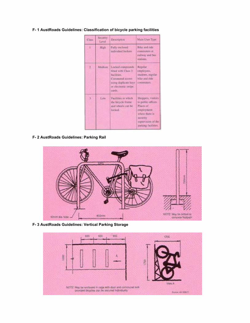
F- 1 AustRoads Guidelines: Classification of bicycle parking facilities
F- 2 AustRoads Guidelines: Parking Rail
F- 3 AustRoads Guidelines: Vertical Parking Storage

F- 4 AustRoads Guidelines: Section through bicycle cage
F- 5 AustRoads Guidelines: Bicycle locker design examples and bicycle parking aisle widths

F-6 AustRoads Guidelines: Typical open plan storage layouts suitable for schools
F- 7 AustRoads Guidelines: Typical bicycle parking modules

F- 8 AustRoads Guidelines: Typical layouts of parking rails on footpaths
F- 9 AustRoads Guidelines: Information signs for bicycle parking facilities

F- 10 Security classes for bike storage by Securabike

F – 11 Design considerations for bicycle parking by Securabike

F- 12 Guidelines on bicycle rails by Securabike

F- 13 Bicycle Rail (Hitching rail) specifications from Securabike

F- 14 Bicycle Rail (Hitching rail) specifications from Securabike
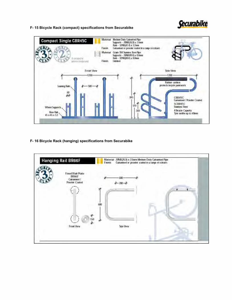
F- 15 Bicycle Rack (compact) specifications from Securabike
F- 16 Bicycle Rack (hanging) specifications from Securabike

F- 17 Bicycle locker specifications from Securabike
Appendix F Cycle Signing Guidance

Appendix F Cycle Signage Guidance


70
NSW Bicycle Guidelines
71
NSW Bicycle Guidelines
9. Signage and network information
�������� �� ��������� � ���� ��
����� ���� ����� �� ������� ��
��� ���������� �������� ������� �������� ����� ������ �������� ����� �����
���� �� �������� �������� �� ����� ��������������� ���������� ������������ ������� ��� �������� ���������� ������ ���� �������� ������������ ����������� ��� ����� ������� �������
��� ������� ����������� ��� �������
�������
������� �����������
This section covers the signing of bicycle network facilities, which provides the critical overlay of the physical pavement regulating the system and making it safe and easy to use.
9.1 Signage for bicycle networksThe three main functions of signage systems for bicycle network facilities are:� to regulate and determine the type of facility within the
context of the overall road system;� to warn users of identifiable potential hazards within the
riding environment; and,� to assist users to find their way around the network.
Regulatory signs are contained in the NSW Road Transport Legislation which includes the Australian Road Rules. The principal reference for the use of bicycle related regulatory and warning signs is Australian Standard AS1742.9 – Manual of Uniform Traffic Control Devices. Part 9, Bicycle Facilities. Part 2, Traffic Control Devices for General Use is also relevant to signage for bicycle networks.
Section 9.1.3 of these Guidelines, which covers directional and route marking signage, provides recommendations for a system of uniform directional signage for regional and local bicycle route facilities within NSW.
Signs at, or in, the vicinity of intersections should always be coordinated with other street furniture to ensure that: intersection sight distances at critical locations are not affected; the signs themselves are not obscured by other street furniture; as much as possible made of multiple supports so that unsightly clutter is kept to a minimum; signs and supports are located sufficiently clear of kerbs to avoid being struck by turning vehicles, especially cornering bicycle riders and large vehicles; and, not located so as to obstruct pedestrians and wheelchairs etc.
9.1.1 Regulatory signageIt is often the combination of regulatory signage and linemarking (see Figure 8.3) which defines the type of bicycle facility provided. Figure 9.1 shows the four principal signs and optional supplementary plates used to define some of the seven types of bicycle facilities covered in Section 4 and those elsewhere in these Guidelines.
Regulatory signage is always used to define the start of a facility. It is always best practice to carry bicycle lanes and paths right up to and through intersections to provide a complete network connection. The use of the END supplementary plate is only necessary if the facility is
������������� ����
����������� ����
���������� ����
�������������
����
��������������
�����������
������� �� ����������
����
������������������������
��������������� ������
��� ���� ������� �� ����� ����� ����� �� ������ ������ �� �������������� ������� ������� � ���� � ������� ���������� ��� ���� � ������� ����
�������������� �������
������� ���� ������ �������� �������
������� �������
������ ���� ���������� ������� ��� ������� �����������
����� �� �������� ������� ������ �������� ������� ����������
������������� ������ ��� ��� ���� ���������� �����
terminated mid-block, or at some other part of the road other than an intersection.
Some types of facilities defined in these Guidelines do not use bicycle specific regulatory signage (see: Figure 5.3, Bicycle Shoulder Lanes; Figure 5.7, Contra-Flow Bicycle Lanes: and, Figure 5.13, Mixed Traffic – Tight Profile). These facilities require linemarking and pavement symbols supported by general regulatory and warning signs at critical locations.
ApplicationAll diagrams in this manual depict the typical regulatory signage required to define bicycle network facilities.
Design notesRegulatory signs should be located so as to not conflict with other road directional signage, or create ambiguity at critical turning points or crossings. The precise location for regulatory signage should be adjusted to suit the design of the intersection/road to include the bicycle facility. The positioning of signs and the need for additional signs or
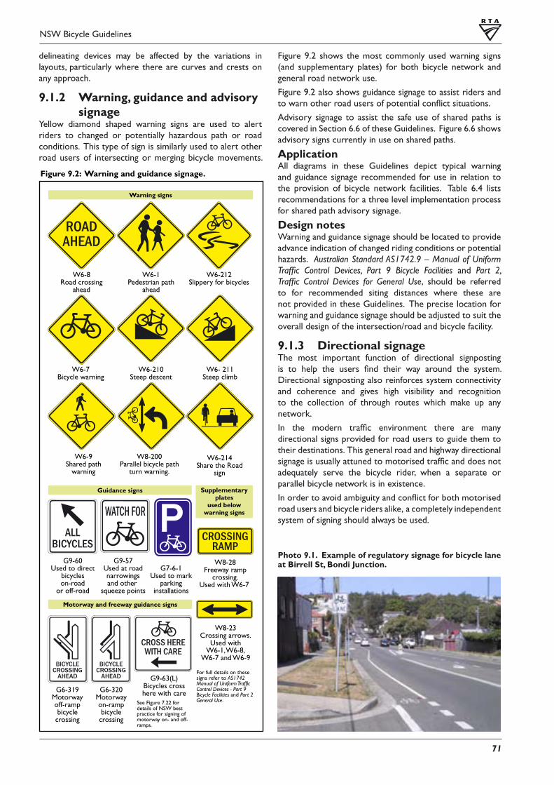
70
NSW Bicycle Guidelines
71
NSW Bicycle Guidelines
������ ���� ������� ��� �������� ��������
����������� �������
����������� �������
�������������� ��� ��������
��� �������� �����
���������� �����������
������������ ����
������������� ��������
�������� ��������
�����
�������������� ����
�����
��� ���� ������� �� ���������� ����� �� ������������ �� ��������������������� ������� � ���� �������� ���������� ��� ���� �������� ����
���������������� ��������� ���� ����
��������� �� ����������������� �����
������� ������
��������� �� ������
���������������
�� ��������
�������� �����
�������� ��� ������� �������� �����
������������� �������
���� ��������������
���� �������
������� �����
�������������������
���� ������������ �����
�������������� ������� ����
���� ��������
���������� �� ����
��������������������
����������� ��� ����
����
�������������������������������������
������������������������������������
��� ������ ���� ���������� �� ��� ������������ ��� ������� ���������� ��� ��� ����������
delineating devices may be affected by the variations in layouts, particularly where there are curves and crests on any approach.
9.1.2 Warning, guidance and advisory signage
Yellow diamond shaped warning signs are used to alert riders to changed or potentially hazardous path or road conditions. This type of sign is similarly used to alert other road users of intersecting or merging bicycle movements.
Photo 9.1. Example of regulatory signage for bicycle lane at Birrell St, Bondi Junction.
Figure 9.2 shows the most commonly used warning signs (and supplementary plates) for both bicycle network and general road network use.
Figure 9.2 also shows guidance signage to assist riders and to warn other road users of potential conflict situations.
Advisory signage to assist the safe use of shared paths is covered in Section 6.6 of these Guidelines. Figure 6.6 shows advisory signs currently in use on shared paths.
ApplicationAll diagrams in these Guidelines depict typical warning and guidance signage recommended for use in relation to the provision of bicycle network facilities. Table 6.4 lists recommendations for a three level implementation process for shared path advisory signage.
Design notesWarning and guidance signage should be located to provide advance indication of changed riding conditions or potential hazards. Australian Standard AS1742.9 – Manual of Uniform Traffic Control Devices, Part 9 Bicycle Facilities and Part 2, Traffic Control Devices for General Use, should be referred to for recommended siting distances where these are not provided in these Guidelines. The precise location for warning and guidance signage should be adjusted to suit the overall design of the intersection/road and bicycle facility.
9.1.3 Directional signageThe most important function of directional signposting is to help the users find their way around the system. Directional signposting also reinforces system connectivity and coherence and gives high visibility and recognition to the collection of through routes which make up any network.
In the modern traffic environment there are many directional signs provided for road users to guide them to their destinations. This general road and highway directional signage is usually attuned to motorised traffic and does not adequately serve the bicycle rider, when a separate or parallel bicycle network is in existence.
In order to avoid ambiguity and conflict for both motorised road users and bicycle riders alike, a completely independent system of signing should always be used.

72
NSW Bicycle Guidelines
73
NSW Bicycle Guidelines
Photo 9.2: Example bicycle route directional signage. Meadowbank Cycle/Pedestrian Bridge, Rhodes.
����
��������
����
����
����
����
����
����
����
��������
��������
����
����
����
����
���� ����
����
���������
���������
��������
����
����
��������� ��� ���� �� ������ ��� ������������� �� ����� ������� ���� ��� ����
������
�� � ����� � ���
������ ���� ������� ������������ ����������� ��� ������� ������� ����� ����������� ��������
������� ����� �� ������ ��� �� ����� ���������� ��� ������ ����������� ���� ���������� ������� ����� ����������� ����� ������ �� ������� �� �� �� ��� �������� ����
�������� ���� ����������� �������� �� ������ ��������� �� �������� ������������� �� ����������
�� ��� ������� ������ ����� ����� �� ������� ����� ������ ������� ��� ������������������� ���� ���� ��������� �� ��� ����� ������ �� ���� �������������
�� ��� ������� ������ �� �������� �������� ������ �� �������� �� ���� ��������� �� ��� ������������� ��� ����������� �� ����� ��� ��� ���� ������������� ����� �� ����������� ������� ��� �� �������� �� ��� ���������� ���������� ������������ ����� ����� ��� ������ ��� ������ �� ��� ���������
�� ����� ��� �� �� ��� �������� ��� ������������� ������ ������ �� ��������������� ����� ������ ��������� �� ������ ����� ������������ ����� ��������� ���������� ��������� ��� ��� ��������� ��� ����� ��� ��� �������� �� ����������� ���������� �� ���� �� �������� �� ���� �� �������� �������� �� ������������� ������� �� ���� �� � �������� ���� ����� ��� �������� ���������� ������������ ����� �� ����� �� ����� ����� ������ �� ������� ������������������� �������� ��� ���� ���������
ApplicationAustralian Standard AS1742.9 – Manual of Uniform Traffic Control Devices, Part 2 Traffic Control Devices for General Use (Section 2.10 Guide Signs) should be used for general directional signage principles supplemented by the recommendations provided below. Figure 9.4 shows the recommended system of directional signage for marked bicycle routes within the network. Figure 9.3 shows the layout and placement of these signs at a typical intersection. For reasons of graphical clarity, directional signage has not been shown in the figures contained in these Guidelines, though in practice this type of signage should always be included in the overall signage system for bicycle route facilities.
Design notesAt all intersections and other decision points, directional signage should be positioned so that bicycle riders can safely and comfortably follow their chosen route. The directional signage system should be closed. Once a destination has been used on a sign, it should appear on all subsequent signs, until that particular destination has been reached. Destinations mentioned on previous signs are therefore given priority and should appear in strict order with the closest appearing at the top of any sequence listing.
The advice of the RTA Bicycle Network Manager should be sought to determine suitable destinations to be used in any route signage system. Destinations which should be signposted are all cities, towns and regional centres. Within urbanised areas sub-regional or district centres and the city centre should also be indicated along with identifiable city precincts; key public transport interchanges or branch line junctions and important recreational or other destinations

72
NSW Bicycle Guidelines
73
NSW Bicycle Guidelines
����
����
����
����
����
����
����
����
����
����
�������� ��
���
������ ���� ��� �� ���� ���
����
����
����
�
����
���� �����
�����
�����
���� ����
��� ����� ����� � ������� ��������� �������� ����� ������������ ���� ����� ���������� ������ ���� ���� ������
��� ����� ���������������������������������� ������ �������� ������
��� ������� ����� � ������� �������������� ��� ������������ ���� ������� ��������� ������ ���� ���� ������
��� ������������ �� �������� ������� ������ � ����������������� ��������� ������������ ���� ��������� �������������
��� ������� ����� � ��������� ����������� ���������� ������ ���� ���� ������� ������� ���� ������ �����
��� ����� ����� � ����� ������������ ��������������� ����� ���� �������� �� ����� ������������� ������ ���� ���� ������
��� ������� ����� � ����� ������������ ��������������� ����� ���� �������� �� ����� ������������� ������ ���� ���� ������
������� ������� ����� ����������� ����� ������
�� ������� �� �� �� ��� �������� ������������ ���� ����������� �������� �������� ��������� �� �������� ������������� �� ����������
�� �� ������� ����� �� ��������� ��� ������� ���� ������� ��������� �� ������������
�� ��� ������ ��� ��� ������� ���������������� ������
�� ��� ����� ��� ���� ������� ���� �� ������������������ ���������� ���� ����������� �� ������
���� ����� ���� �� ���������� ���������� �� �� ������� �� ����� ���� �� �������� �� ��� ������ ����� ��� ��������������� ��� ������ ��� ��� ������������������� ���� ������
�������� ����� ���� ���� �������
�������� ����� ���� ���� ������
�������� ����� ���� ���� �������
�������� ����� ���� ���� ������
������ ����������������������� �������������������������
�������� ������������ ����������� ���������� ��������������
�������� ������������ ����������� ���������� ��������������
��������������������
����������� ����������� ��������������
�������� ����������� ����� ������
�������� ����������� ����� ������
������ ������� ��������� ����� ������ ������� ��������� �����
�������� ����������� ��������
������ ���� ������� ������� ����� ����������� ��������
(major parks etc). Key centres should have priority in any signage system but where space permits other relevant and important destinations for bike riders may also be indicated. These may be: universities and educational institutions; hospitals; tourist attractions; bike parking stations; bike hire depots; shopping centres; sporting and recreational centres.
Indication of destination distances is important and can be either applied to fingerboard signs located at intersections or provided on destination reassurance boards located immediately following bicycle network junctions.
This distances stated on bicycle network direction signage are given in kilometres rounded up or down. The distances

74
NSW Bicycle Guidelines
75
NSW Bicycle Guidelines
�������� ������� ����� ��������
�������� ������� ����� ���������
����� ������� ����� ��������
����� ������� ����� ���������
�������� ������ � �����
��������
����� ����� ��� ��������
�������� �����
����� �����
��������
���������
������� ��� ������������
��������� ��� ������������
������� ���� ��� �������
������� ����� ���� � ����
���� �������� ���� �������
��� ������
������� ������� ������
������ ���� ������� �� ������� ������� ��������
should be measured from the first signpost concerned to a point on the network route closest to the actual destination. For instance, a route indicating a particular town centre as a destination may not actually travel through the centre but deviate around it a short distance from it. In this instance distances should be measured to the intersection where the rider will need to leave the route to reach the actual town centre.
On proposing a system of directional signage, Council officers should consult with bicycle network officers of the RTA and adjacent councils to ensure a consistent, logical and usable set of destinations are selected for use. This is particularly important where a number of owning or operating authorities are involved.
Direction signage should be clearly visible in either day or night conditions. For this reason it is advisable to locate this signage under, or adjacent to, overhead lighting.
Street plans and network route plans can be very useful aids to navigation especially when placed at key entry and exit points to a built up area. These plans should be easily accessible from the bicycle route. If plans are located on a side path or rest area, they should be indicated with additional signs.
9.2 Network and route mappingAccurate and comprehensive information is essential for the operation of any transport system. Bicycle route maps and network maps are an important tool to aid bicycle riders find their way around the network and to assist them to get safely to their destinations. Route and network mapping is also a good means of promoting use of the system and to encourage cycling within the community.
ApplicationEven when few route facilities exist, maps can be a good way of indicating routes with low traffic volumes suitable for cycling and short cuts not easily found without local knowledge.
The scope of route and network maps can be local or regional but should always adopt a network approach and aim to present through-routes and access solutions that will enable riders to use their bicycles comprehensively within the area covered.
Network maps can be made available in a number of easily accessible formats: sign boards can be erected at key route intersections, where a number of routes converge or at a prominent destination; maps can be downloaded in electronic format from web sites; and maps can be made available from bicycle shops, cafes and other prominent points of interest located along network routes.
CommentsFigure 9.5 shows an example of a bicycle network map which illustrates the key issues which bicycle network maps should always attempt to address:� the two level bicycle network route hierarchy is depicted
(regional routes and local routes can be indicated by using different colours);
� on-road and off-road route facilities are shown using a different line type;
� a whole network is shown so that riders may make
meaningful trips around the system (incomplete sections should be clearly depicted to warn and direct users);
� the bicycle network is superimposed over a depiction of the existing road network which indicates the function of the road network (ie major roads are shown thicker than minor roads);
� all important destinations relevant to bicycle riders are shown; and,
� streets and roads used by bicycle network routes are named.
Graphical solutions for showing missing links in the system are very important to the user, as the network and its component routes are often incomplete at any one time.

G – 2 AustRoads Guidelines: Bicycle, pedestrian and arrow pavement symbols

Appendix G Draft Cycle Brochure Text


Mosman Cycle Guide…putting wheels in motion
Mosman is a large scenic harbourside suburb which offers great potential for recreational cyclists and commuting cyclists. Cyclists within Mosman are rewarded with scenic routes, wonderful views, excellent cafés and an environment which can both challenge and promote personal fitness.
Mosman Council has recently developed a Bicycle Plan to encourage more people to cycle within Mosman, by creating an urban environment which supports the safe use of bicycles for transport and recreation. The Bicycle Plan will provide the framework for improving the local cycling environment. Getting Started Buying a Bicycle When buying a bicycle make sure it’s the right one for you. By choosing the correct type of bike you improve your comfort and performance. Start by choosing the appropriate style of bicycle to match your cycling needs be it racing, commuting, off-road or leisure. The four main types of bicycles are:
• Road Bicycles – for sealed surfaces • Mountain Bicycles – all terrain • Hybrids – all purpose road and off road • BMX – for kids and stunts
It is important to get the right size. Make sure you are comfortable with the frame height, seat height and position of the handle bars. Your local bicycle shop can help with this. On a budget? If you’re on a budget cycling is the best way to travel. Bicycles can be bought second hand from retail stores as well as through the classifieds and local newspapers. Watch out for garage sales and police auctions. Accessories When riding a bicycle it is the law that you have the following; • Helmet • Bell or ringing device • Reflectors – front and rear and on the wheels If you intend riding at night or in poor light you must also have front and rear lights Optional accessories include • Locks
There are a variety of types of locks available to secure your bicycle. A good lock such as a D-lock is recommended. Cable locks are easily cut.
• Pump Ensure you buy a pump that is compatible with your tyre valve. They can be attached to your bike for convenient use.
• Water bottle

Remember always take a water bottle with so you can re-hydrate while you ride. You can purchase a water bottle and cage that can be fitted to your bicycle.
• Cycle Computer Cycle computers can be attached to your bicycle and give you information on your cycling trip including current speed, average speed, kilometres travelled. Mirrors Useful for regular cyclists in traffic.
• Trailers Specialised child carriers are a great way to involve the family in cycling. Cargo trailers enable you to shop with your bicycle.
• Bag packs/panniers Bicycles can be used for commuting and shopping by attaching a bag to your bicycle.
• Clothing Fluorescent and reflective clothing improve your visibility to motorists.
Is your bicycle as fit as you are? When your bike is in good shape it’s a lot easier and safer to ride. The following list will help you get started. Your local bike shop can help you with this.
• Your bike seat is at the right height when your leg is straight, knee very slightly bent, to reach the pedal.
• Check your tyres are pumped to the recommended pressure, too flat and you’ll have to push a lot harder. Take care on hot summer days as tyres pumped too hard may burst.
• Check your brakes are in good condition and are properly adjusted. • Gears should change smoothly, otherwise they need to be adjusted.
Bike Security These following tips will help protect your bike from being stolen:
• A good lock such as a D-lock is recommended. Cable locks are easily cut.
• Always lock as much as your bike as possible, for example lock the frame and a wheel.
• Don’t lock your bike to poles that can be lifted out of the ground. • Lock your bike in visible areas. • Remove accessories including bike lights. • Quick-release wheels are convenient if you need to put your bike in a
car, however they do make your bike less secure. Consider carrying a second lock to secure your wheel to the frame.
• Insurance is included in Bicycle NSW membership (see back cover)

Riding Tips The following tips will help you ride more safely and confidently.
In Traffic - be predictable and signal your moves – Communicate • Always look and signal before you move around a parked car,
change lanes and at intersections. Make eye contact with drivers.
• Stay visible – day and night. • It is compulsory to wear a bicycle helmet. • Riding on the road you have the same rights and responsibilities
as a driver and are bound by the same road rules. • Beware of doors being opened in parked cars. • Take extra care at intersections and always indicate. If going
straight through an intersection, never follow closely behind a large car or truck as you’ll be hidden from view. Wait your turn and don’t squeeze past a car as the driver may not see you. Be prepared as many car drivers don’t indicate.
• Use both brakes for quick, smooth stops. • When in doubt at intersections – get off your bike and use
pedestrian crossings. • Cyclists can use any part of the road. In good conditions, with
adequate space, keep to the left. Riding with friends, it is legal to ride two abreast provided that you are not more than 1.5 metres apart. If in doubt, ride in the middle of the lane to increase your visibility.
• To activate traffic lights at intersections ride over the top of the detectors (you’ll see where the shape has been cut into the road surface). If you’re alone at the intersection you may not trigger the traffic lights, in which case you need to wait or cross as a pedestrian.
• If you see a cycle hazard on route please report it to Mosman Municipal Council (see back cover).
• Mosman has a number of shared paths. On shared paths, cyclists must give way to pedestrians. It is suggested that cyclists ring their bell when approaching a pedestrian.
• When coming head on towards a cyclist or pedestrian, go to your left.
Riding at night There’s a lot less traffic on the road at night and it can be very enjoyable provided you take the following precautions:
• Bike lights are compulsory and a white light is needed for the front and a red light for the back. A light on your helmet is also a good idea. The lights can be flashing or steady. Buy lights with standard size batteries and consider rechargeable batteries as most products offer around 6 hours of light. Be prepared and carry spare batteries with you. Don’t underestimate how difficult it is for drivers to see cyclists at night, don’t skimp on illumination!
• Wear reflective tape and clothing.

• Riding through popular night spots take extra care as drunk pedestrians can stagger onto the road.
Riding in the Wet Riding in the wet can be difficult and it is not recommended for new cyclists. The following tips will make your journey safer and more comfortable:
• Brakes do not work as well in wet weather and you will take longer to stop.
• Pump your brakes regularly while riding in the wet. • Prepare your bike with mud guards. • Carry wet weather gear. • Prepare your bags and keep your books wrapped in plastic
bags. Avoiding Car Doors Parked cars can be more dangerous than moving ones. The following tips will help you avoid the dreaded car door.
• Watch for drivers heads in parked cars. • Watch for brake lights and cars that have just parked. • Don’t travel to close to parked cars, if necessary travel in the
centre of the lane. • Before you move around a car, always check what’s behind you. • If a car door opens, brake and shout, don’t waste time with a
bell.

Cycling in Mosman
Cyclists within Mosman are rewarded with scenic routes, affording wonderful views of Sydney Harbour, great cafes at which to stop and an environment that can challenge and develop personal fitness. There are many riding circuits in Mosman for different fitness levels and for recreational, commuting and training. Four of the most popular circuits are described below. Local Recreational and Fitness Rides in Mosman
1. Middle Head/Bradleys Head/Taronga Zoo Circuit
Route Number: 1 Grade: Medium-Hard Surface: On road Route Description: Starting at the northern end of Prince Albert Road head south and turn left into Beach Road. Right onto Bradleys Head Road past Taronga Zoo and follow the road right into Athol Wharf Road. Turn around at Taronga Zoo Wharf. Follow Bradleys Head Road until the second roundabout and turn right onto Middle Head Road. Continue along Middle Head Road and turn right onto Chowder Bay Road, continue to the end. Turn around and climb back along Chowder Bay Road and Middle Head Road to the roundabout at Military Road. Hazards: High speed humps along Middle Head Road, blind corner at Athol Wharf Road/Bradleys Head Road, roundabout at intersection with Military Road can be dangerous. Features: If you prefer to make a more scenic ride divert to Bradleys Head and Middle Head to take in the beautiful views.
2. The Spit Circuit – Killarney Street, Beauty Point Road, Parriwi Road Route Number: 2 Grade: Medium Surface: Mainly on road with sections of off road and shared path Route Description: The recommended route for cyclists travelling to The Spit. Starting at the intersection of Killarney Street and Glen Street head north along Glen Street and turn right into Bay Street. Continue onto Beauty Point Road and Pearl Bay Avenue. Turn left onto the Foreshore Walking Trail. Bicycles are allowed to use this track. Continue along the foreshore path through the car park on the western side of Spit Road and onto the shared path along Spit Road at the intersection with Parriwi Road. Cyclists can continue across Spit Bridge on the western side by using the shared path or to complete the circuit cyclists can continue under the Spit Bridge and head south on the eastern side of Spit Road. Turn left into Parriwi Road and climb to the intersection with Spit Road. Dismount to cross Parriwi Road and wheel bicycle to signals on Spit Road north of Bickell Road and cross to western side. From Bickell Road turn left into Bapaume Road and then right into Amiens Avenue which is one way westbound. Turn left into Bullecourt Avenue and right into Killarney Street to complete the circuit. Hazards: Bay Street south of Bickell Road is one way southbound for motorists and there is no contraflow cycle lane so cyclists must dismount.

Foreshore Walking Track is narrow in sections, beware of cars in the Spit car park, cyclists are advised to dismount under the Spit Bridge due to blind tight corners, beware of cars reversing out of parking bays along Spit Road. Features: Beautiful views of Quakers Hat Bay and Middle Harbour. Foreshore Walking Track provides off road experience. There are picnic facilities and toilets at The Spit Reserve and restaurants and cafes on the eastern side of Spit Road.
3. Raglan Street/Avenue Road Circuit Route Number: 3 Grade: Medium Surface: On road Route Description: Starting at the Intersection of Military Road and Raglan Street head south along Raglan Street. Turn right into Musgrave Street and ride to the wharf. Turn around and head back up Raglan Street. At the intersection with Military Road turn left and take the first left into Avenue Road. Head south along Avenue Road to Mosman Wharf. Turn around and wind back up Avenue Road to Military Road. Hazards: Watch out for car doors opening and pedestrians on Military Road. Beware of roundabouts on Raglan Street and Avenue Road. Features: Good medium length fitness circuit. End your cycle with a coffee or juice at one of the many cafes at Mosman Village or stop along the way at the café at Mosman Bay Wharf.
4. Balmoral Beach and cafes
Route Number: 4 Grade: Medium Surface: On road/shared path Route Description: Starting at Muston Street cycle north through the one way section and turn right onto Mandolong Road. Take your first left into Moruben Road. Turn left onto Stanton Road and then right onto the shared path along the eastern side of Spit Road. Turn right from the shared path into Warringah Road. Meander down to Stanton Avenue and into Wyargine Street. You will have to dismount and wheel your bicycle down the stairs between Wyargine Road and The Esplanade. Turn off The Esplanade at Raglan Street and head back to the intersection with Muston Street to complete the circuit. Hazards: Stairs between Wyargine Street and The Esplanade do have a wheel down but should not be attempted in cleats – as an alternative ride via Edwards Bay Road and Awaba Street to The Esplanade. Features: Riding along The Esplanade gives beautiful views of Balmoral Beach. You can stop in at one of the cafes along The Esplanade to break up the ride. Be careful to give way to turning vehicles when riding to/from the shared path along Spit Road.

Local Cycle Shops
Le Spit Cyclery 20 Spit Road Mosman, NSW
02 9968 3920 02 9968 3919
[email protected] Hours: Mon-Fri 9am-5:30pm, Thurs to 7pm
Sat 9am to 4pm Sun 11am to 3pm Closed Public Holidays
www.lespitcyclery.com.au Cycle Contacts
Bicycle New South Wales 02 9283 5200
[email protected] www.bicyclensw.org.au
Lots of Information including maps, books and advice
Bike North P 02 9872 2583
[email protected] www.bikenorth.org.au
Coordinate local rides for cyclists of all abilities
Balmoral Triathlon Cub 02 9960 4920
[email protected] www.balmoraltriclub.org.au/
Training and competitions for keen cyclists
Roads and Traffic Authority, Bicycle Unit 13 22 13
[email protected] www.rta.nsw.gov.au/bicycles Regional cycle maps available
Mosman Municipal Council
02 9978 4000 [email protected]
www.mosman.nsw.gov.au Information about local cycling events, report cycling hazards
Bike It – a guide to Sydney’s back streets
Author- Bruce Ashley Can be purchased from bike shops and Bicycle NSW
Cycling around Sydney – the complete guide to Sydney’s best rides
Author- Bruce Ashley Can be purchased from bike shops and Bicycle NSW
