multi-scale exploration of the archaeological site of puig
TRANSCRIPT
Advanced Prospection Methods for Cultural Heritage Management - Experiences and Challenges EAA-2012
Multi-scale exploration of the archaeological site of Puig Ciutat
(Oristà, Catalonia)
Robert Tamba*, Roger Sala, Ekhine Garcia, Xavi Rubio
*Sot Archaeological Prospection and University of Barcelona, [email protected]
Advanced Prospection Methods for Cultural Heritage Management - Experiences and Challenges EAA-2012
1. Introduction
1. Geographical and geomorphological situation
2. Previous works
3. Scales, Objectives and Tools
2. First explorations
1. Field walking
2. Assessment of the site
3. Geophysical prospection
4. Excavations and sections
5. Main conclusions
6. Defining new objectives
3. Adapting to the new objectives
1. Exploration of the surroundings
2. Description of the constructive structures
3. Understanding the stratigraphy
4. More excavations
5. Main conclusions
4. Data management
1. Produced data
2. Covered areas
3. Data integration
4. Perspectives

Advanced Prospection Methods for Cultural Heritage Management - Experiences and Challenges EAA-2012
Introduction
1. Geographical and geomorphological situation
2. Previous works
3. Scales, Objectives and Tools

Advanced Prospection Methods for Cultural Heritage Management - Experiences and Challenges EAA-2012
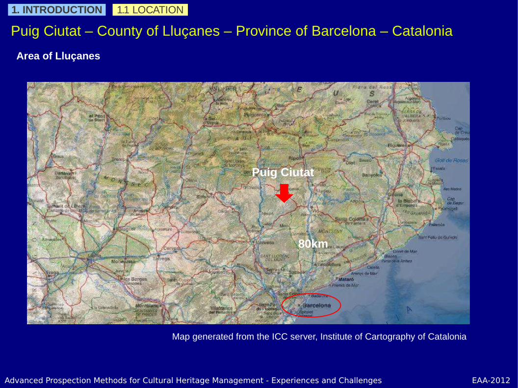
Puig Ciutat – County of Lluçanes – Province of Barcelona – Catalonia
North of Catalonia
1. INTRODUCTION 1.1 LOCATION
Advanced Prospection Methods for Cultural Heritage Management - Experiences and Challenges EAA-2012
Puig Ciutat – County of Lluçanes – Province of Barcelona – Catalonia
Area of Lluçanes
1. INTRODUCTION 1.1 LOCATION
Puig Ciutat
Map generated from the ICC server, Institute of Cartography of Catalonia
80km

Advanced Prospection Methods for Cultural Heritage Management - Experiences and Challenges EAA-2012
Puig Ciutat – County of Lluçanes – Province of Barcelona – Catalonia
Elevated platform within a meander system
Puig Ciutat
1. INTRODUCTION 1.1 LOCATION
2x2m LIDAR data delivered by the ICC, Institute of Cartography of Catalonia

Advanced Prospection Methods for Cultural Heritage Management - Experiences and Challenges EAA-2012
Puig Ciutat – County of Lluçanes – Province of Barcelona – Catalonia
5Ha 3.5 of woods and 1.5 of farming lands
1. INTRODUCTION 1.1 LOCATION
Field 1
Field 2
Field 3
Zonification of the site on the ICC 2010 aerial photography displayed with QGIS

Advanced Prospection Methods for Cultural Heritage Management - Experiences and Challenges EAA-2012
Puig Ciutat – Iberian settlement with middle-age occupation?
1. INTRODUCTION 1.2 PREVIOUS WORKS
First references in publications by M.D.Molas in 1975 and 1982 assessing the site as highly important based on pottery recollection
Earthworks in the 1980s put into evidence archaeological remains
First evaluation of the site in 2005 using gradiometer and GPR acquisitions (SOT Prospection) and additional GPR acquisition in 2007 in a wooden area
nT/m
Depth included between 0.50 and 0.70m

Advanced Prospection Methods for Cultural Heritage Management - Experiences and Challenges EAA-2012
1.3 SCALES, OJECTIVES AND TOOLS
A multi-scale approach
SCALES OBJECTIVES TOOLS
Regional ContextMain paths near Puig
CiutatSpatial analysis using
DEM: easiest paths
Local AreaWhat other locations
could be in relation with Puig Ciutat
Accessibility, Paths between points of
interest, Aerial photography, Metal
detectors, Geophysics
The SiteExtension, Occupation
and Use of the site
Geophysics, Logs, Analysis of visibility,
Control area
Excavation UnitsChronology and Use of
each unit
Excavation, Sections, Analysis (soil, coal,
fauna, pottery...)
1. INTRODUCTION
Advanced Prospection Methods for Cultural Heritage Management - Experiences and Challenges EAA-2012
First explorations
1. Field walking
2. Assessment of the site
3. Geophysical prospection
4. Excavations and sections
5. Main conclusions
6. Defining new objectives
Advanced Prospection Methods for Cultural Heritage Management - Experiences and Challenges EAA-2012
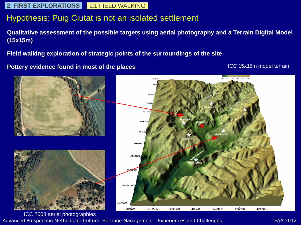
Hypothesis: Puig Ciutat is not an isolated settlement
2. FIRST EXPLORATIONS 2.1 FIELD WALKING
Qualitative assessment of the possible targets using aerial photography and a Terrain Digital Model (15x15m)
Field walking exploration of strategic points of the surroundings of the site
Pottery evidence found in most of the places
ICC 2008 aerial photographies
ICC 15x15m model terrain

Advanced Prospection Methods for Cultural Heritage Management - Experiences and Challenges EAA-2012
Extension and Occupation of the site
2.2 ASSESSEMENT OF THE SITE
OPERATIONS
Vegetation cleaning in selected wood areas
Superficial material recollection
Sections digging in points of interest
MAIN RESULTS
A part of a defensive wall is found
Pottery indicates a roman occupation
Vegetation cleaning puts in evidence possible constructive structure in the wooden areas
2. FIRST EXPLORATIONS
Zonification of the site on the ICC 2010 aerial photography displayed with QGIS

Advanced Prospection Methods for Cultural Heritage Management - Experiences and Challenges EAA-2012
Global view of the open fields of the site
ACQUISITIONS
The main field is repeated with a gradiometer of higher sensitivity
3 other fields are explored
The main building detected in field 1 is explored with 3 different GPR systems in order to compare them
A small grid in the western wooden area is acquired with GPR
An experimental resistivity system was tested on the main building in field 1
2.3 GEOPHYSICAL PROSPECTIONS2. FIRST EXPLORATION
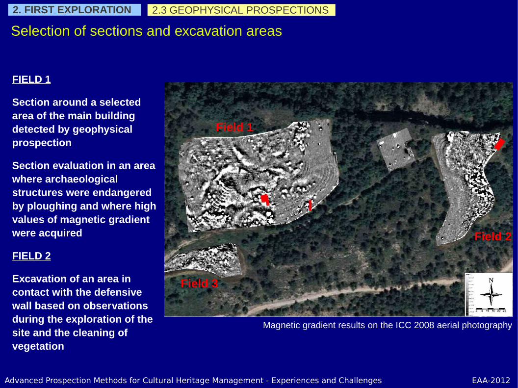
Magnetic gradient results on the ICC 2008 aerial photography
Occupation areas can be defined but with no clear geometry
Field 1
Field 2
Field 3
Advanced Prospection Methods for Cultural Heritage Management - Experiences and Challenges EAA-2012
Selection of sections and excavation areas
FIELD 1
Section around a selected area of the main building detected by geophysical prospection
Section evaluation in an area where archaeological structures were endangered by ploughing and where high values of magnetic gradient were acquired
FIELD 2
Excavation of an area in contact with the defensive wall based on observations during the exploration of the site and the cleaning of vegetation
2.3 GEOPHYSICAL PROSPECTIONS2. FIRST EXPLORATION
Magnetic gradient results on the ICC 2008 aerial photography
Field 1
Field 2
Field 3

Advanced Prospection Methods for Cultural Heritage Management - Experiences and Challenges EAA-2012
2.4 EXCAVATIONS AND SECTIONS
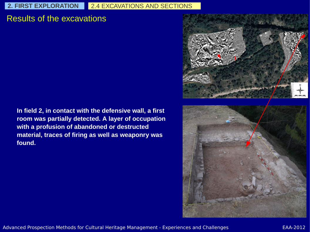
Results of the excavations
Excavation in field 1 showed fire traces and destructed pottery dated from the late Republican period.
2. FIRST EXPLORATION

Advanced Prospection Methods for Cultural Heritage Management - Experiences and Challenges EAA-2012
Section in field on confirmed the presence of constructive elements at a very shallow depth (0.30m). The values of magnetic gradient were explained by the detection of thermo-altered sediments.
2.4 EXCAVATIONS AND SECTIONS2. FIRST EXPLORATION
Results of the excavations
Advanced Prospection Methods for Cultural Heritage Management - Experiences and Challenges EAA-2012
In field 2, in contact with the defensive wall, a first room was partially detected. A layer of occupation with a profusion of abandoned or destructed material, traces of firing as well as weaponry was found.
2.4 EXCAVATIONS AND SECTIONS2. FIRST EXPLORATION
Results of the excavations
Advanced Prospection Methods for Cultural Heritage Management - Experiences and Challenges EAA-2012
2.5 MAIN CONCLUSIONS
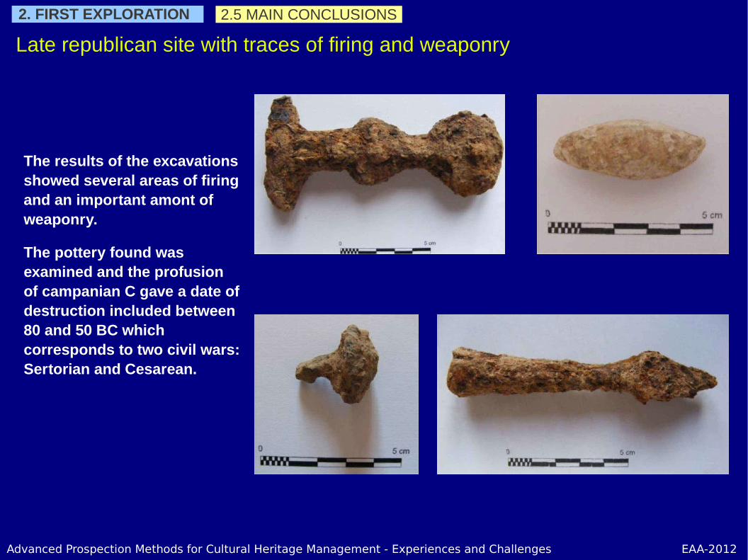
Late republican site with traces of firing and weaponry
The results of the excavations showed several areas of firing and an important amont of weaponry.
The pottery found was examined and the profusion of campanian C gave a date of destruction included between 80 and 50 BC which corresponds to two civil wars: Sertorian and Cesarean.
2. FIRST EXPLORATION

Advanced Prospection Methods for Cultural Heritage Management - Experiences and Challenges EAA-2012
With these results new objectives are defined:
The possible destruction of the site and its Roman chronology raise new questions: was the settlement under siege? If the site was attacked, from where was it attacked?where did the besiegers establish their camp?
The magnetic gradient map gave areas of interest but the thermo-alterations and the contrast do not allow having a description of the geometry of the constructive elements. Other technologies have to be applied in order to map the possible structures of interest.
The stratigraphy shows to be complex and have to be investigated.
The first results give new perspectives
2.6 DEFINING NEW OBJECTIVES2. FIRST EXPLORATION

Advanced Prospection Methods for Cultural Heritage Management - Experiences and Challenges EAA-2012
Adapting to the new objectives
1. Exploration of the surroundings
2. Description of the constructive structures
3. Understanding the stratigraphy
4. More excavations
5. Main conclusions

Advanced Prospection Methods for Cultural Heritage Management - Experiences and Challenges EAA-2012
3.ADAPTING TO THE NEW OBJECTIVES 3.1 EXPLORATION OF THE SURROUNDINGS
Was there a military camp or siege facilities around the settlement?
Way-points of collected material on the ICC 2010 aerial photography

Advanced Prospection Methods for Cultural Heritage Management - Experiences and Challenges EAA-2012
Description of the constructive structures
For the description of the constructive structures, a GPR acquisition was implemented using an IDS system with two central frequencies of 600 and 200 MHz allowing the acquisition of two vertical resolutions and depth of investigation at the same time.
3.ADAPTING TO THE NEW OBJECTIVES 3.2 DESCRIPTION OF THE CONSTRUCTIVE STRUCTURES
GPR results on the ICC 2008 aerial photography
Field 1
Field 2

Advanced Prospection Methods for Cultural Heritage Management - Experiences and Challenges EAA-2012
3.2 DESCRIPTION OF THE CONSTRUCTIVE STRUCTURES
Description of the constructive structures
The contrast between the sediment and the bedrock being very low, some areas are poorly described.
Field 2 showed a complex stratigraphy
3.ADAPTING TO THE NEW OBJECTIVES
GPR results on the ICC 2008 aerial photography
Field 1
Field 2
Advanced Prospection Methods for Cultural Heritage Management - Experiences and Challenges EAA-2012
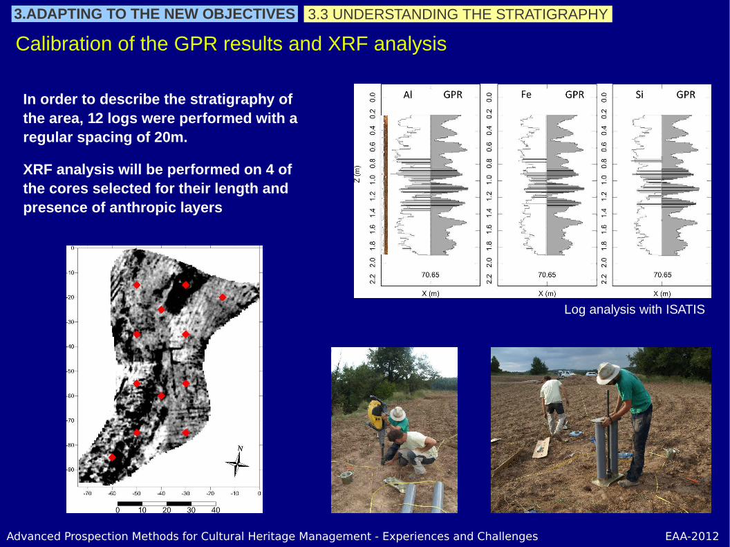
3.3 UNDERSTANDING THE STRATIGRAPHY
Calibration of the GPR results and XRF analysis
In order to describe the stratigraphy of the area, 12 logs were performed with a regular spacing of 20m.
XRF analysis will be performed on 4 of the cores selected for their length and presence of anthropic layers
3.ADAPTING TO THE NEW OBJECTIVES
Log analysis with ISATIS
Advanced Prospection Methods for Cultural Heritage Management - Experiences and Challenges EAA-2012
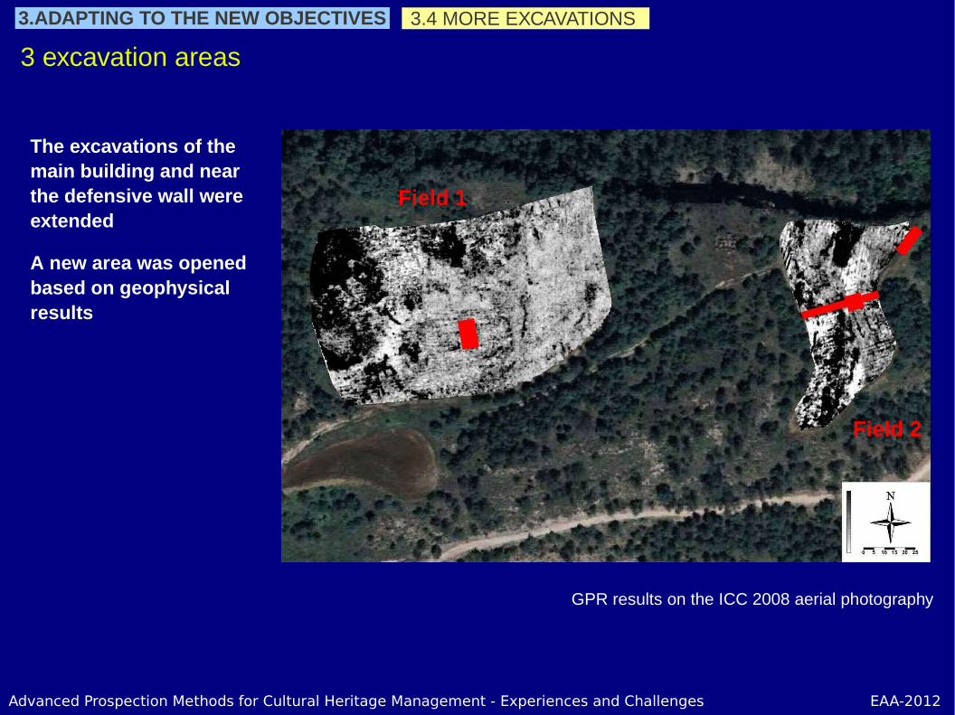
3.4 MORE EXCAVATIONS
3 excavation areas
The excavations of the main building and near the defensive wall were extended
A new area was opened based on geophysical results
3.ADAPTING TO THE NEW OBJECTIVES
GPR results on the ICC 2008 aerial photography
Field 1
Field 2

Advanced Prospection Methods for Cultural Heritage Management - Experiences and Challenges EAA-2012
3.4 MORE EXCAVATIONS
Field 1
The excavation of the main building is extended to half of its total surface.
3.ADAPTING TO THE NEW OBJECTIVES
Advanced Prospection Methods for Cultural Heritage Management - Experiences and Challenges EAA-2012
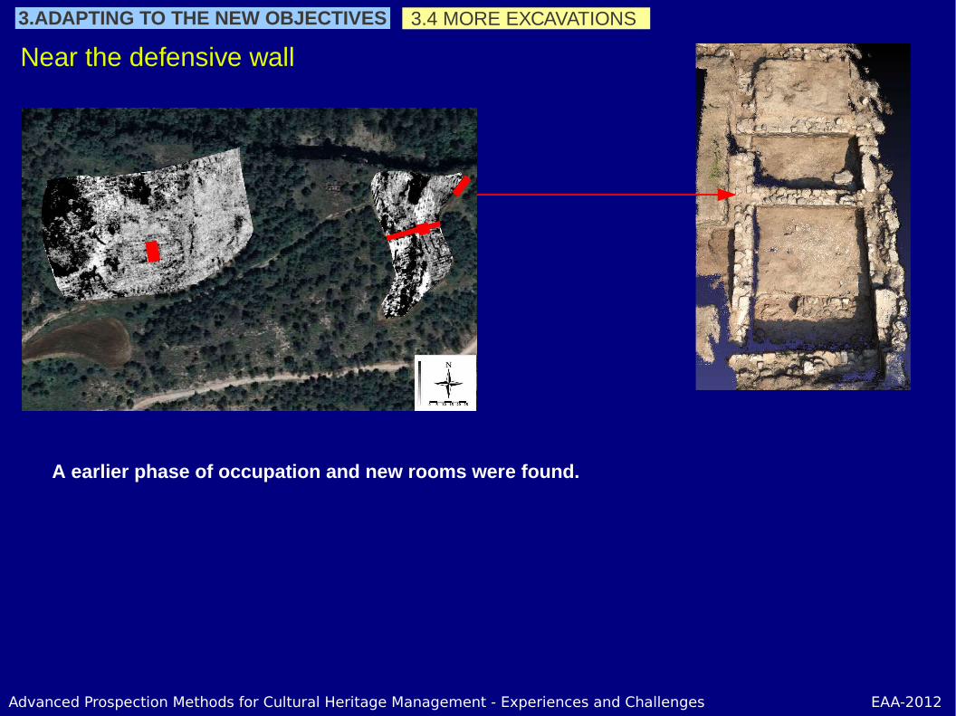
Near the defensive wall
A earlier phase of occupation and new rooms were found.
3.4 MORE EXCAVATIONS3.ADAPTING TO THE NEW OBJECTIVES
Advanced Prospection Methods for Cultural Heritage Management - Experiences and Challenges EAA-2012
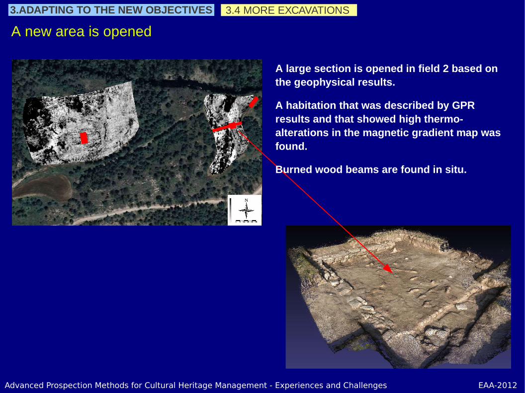
A new area is opened
A large section is opened in field 2 based on the geophysical results.
A habitation that was described by GPR results and that showed high thermo-alterations in the magnetic gradient map was found.
Burned wood beams are found in situ.
3.4 MORE EXCAVATIONS3.ADAPTING TO THE NEW OBJECTIVES

Advanced Prospection Methods for Cultural Heritage Management - Experiences and Challenges EAA-2012
3.5 MAIN CONCLUSIONS3. FOLLOWING CAMPAIGNS3.ADAPTING TO THE NEW OBJECTIVES
The potential of the site is confirmed and the usual problems management should be solved (land property, sackings, accessibility, security, stocking of material).
More traces of destruction of the settlement by fire were found
Though the exploration of the surroundings gave first results, it was not conclusive due to vegetation problems.
The constructive structures were partially described and specific processes have to be applied.
A great amount of data was collected. Research lines and priorities must be clearly defined.
Consolidation of the investigation project
Advanced Prospection Methods for Cultural Heritage Management - Experiences and Challenges EAA-2012
DATA MANAGEMENT
1. Produced data
2. Covered areas
3. Data integration
4. Perspectives

Advanced Prospection Methods for Cultural Heritage Management - Experiences and Challenges EAA-2012
4. DATA MANAGEMENT 4.1 PRODUCED DATA
Excavation was he main tool to confirm the potential of the site
Aerial PhotographyVisible and/or infrared1957, 1986, 2008, 2009, 2010,
TopographyMNT 15x15m, LIDAR 2x2m, GPS RTK 0.75x0.25m, SL 0.10x0.10m
Battlefield archaeology2 metal detecting surveys with tracks and way-points for he collected material
GeophysicsMagneticGPREMIInterpretationsExperimentationCollaborations
12 Logs
ArchaeologyReference pointsMaps and sectionsPhotogrametryMaterialMaterial databaseSediments samplesCoal samples
Colored areas approximately proportional to the produced amount of data

Advanced Prospection Methods for Cultural Heritage Management - Experiences and Challenges EAA-2012
4. DATA MANAGEMENT 4.2 COVERED AREAS
Other technologies help with the exploration in extension
Aerial PhotographyVisible and/or infrared1957, 1986, 2008, 2009, 2010,
Topography
MNT 15x15m>LIDAR 2x2m>GPS RTK 0.75x0.25m>SL 0.10x0.10m
Metal detectors2 campaigns with tracks and collected material
GeophysicsMagneticGPREMI
12 Logs
Archaeology
Colored areas approximately proportional to the covered areas
Advanced Prospection Methods for Cultural Heritage Management - Experiences and Challenges EAA-2012
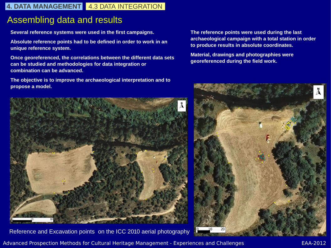
4.3 DATA INTEGRATION
Assembling data and resultsSeveral reference systems were used in the first campaigns.
Absolute reference points had to be defined in order to work in an unique reference system.
Once georeferenced, the correlations between the different data sets can be studied and methodologies for data integration or combination can be advanced.
The objective is to improve the archaeological interpretation and to propose a model.
4. DATA MANAGEMENT
The reference points were used during the last archaeological campaign with a total station in order to produce results in absolute coordinates.
Material, drawings and photographies were georeferenced during the field work.
Reference and Excavation points on the ICC 2010 aerial photography
Advanced Prospection Methods for Cultural Heritage Management - Experiences and Challenges EAA-2012
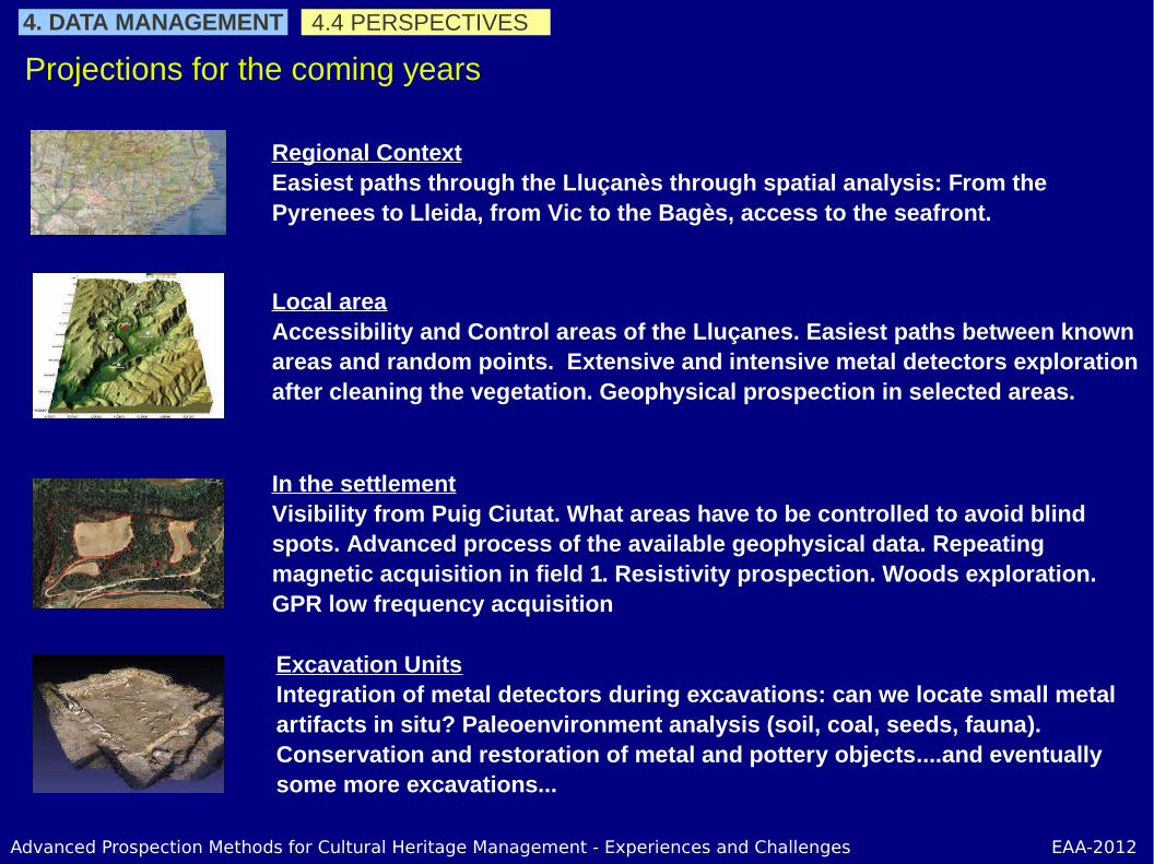
4.4 PERSPECTIVES
Projections for the coming years
Regional ContextEasiest paths through the Lluçanès through spatial analysis: From the Pyrenees to Lleida, from Vic to the Bagès, access to the seafront.
Local areaAccessibility and Control areas of the Lluçanes. Easiest paths between known areas and random points. Extensive and intensive metal detectors exploration after cleaning the vegetation. Geophysical prospection in selected areas.
In the settlementVisibility from Puig Ciutat. What areas have to be controlled to avoid blind spots. Advanced process of the available geophysical data. Repeating magnetic acquisition in field 1. Resistivity prospection. Woods exploration. GPR low frequency acquisition
Excavation UnitsIntegration of metal detectors during excavations: can we locate small metal artifacts in situ? Paleoenvironment analysis (soil, coal, seeds, fauna). Conservation and restoration of metal and pottery objects....and eventually some more excavations...
4. DATA MANAGEMENT

Advanced Prospection Methods for Cultural Heritage Management - Experiences and Challenges EAA-2012
Thank you for your attention
Robert Tamba
Sot Archaeological Prospection and University of Barcelona