multi-temporal analysis of haze problem in northern ... · kasetsart j. (nat. sci.) 47 : 768 - 780...
TRANSCRIPT

Kasetsart J. (Nat. Sci.) 47 : 768 - 780 (2013)
1 Natural Resource and Environmental Management, Mae Fah Luang University, Chiang Rai 57100, Thailand.2 Geoinformatics Center, Asian Institute of Technology, Pathum Thani 12120, Thailand.* Corresponding author, e-mail: [email protected]
Received date : 01/04/13 Accepted date : 12/07/13
Multi-Temporal Analysis of Haze Problem in Northern Thailand: A Case Study in Chiang Rai Province
Nion Sirimongkonlertkul1,*, Preecha Upayokhin1 and Vivarad Phonekeo2
ABSTRACT
Time-series data on PM10 (particulate matter less than or equal to 10 μm in size) readings obtained from 13 measurement stations belonging to the Pollution Control Department of Thailand and moderate resolution imaging spectroradiometry (MODIS) and fi re-related data (MOD14) were analyzed. The study investigated the relationships of the haze-and-smoke distribution characteristics and trends with the number of active fi res in the dry season (from January to April) in 2009, 2010 and 2012. The study was conducted at the regional and local levels to investigate smoke and haze dispersion due to burning activities in three neighboring countries and also within Chiang Rai province itself. Various techniques and tools were applied, including methods based on using a geographic information system to produce buffer zones around the Chiang Rai measurement station with an incremental radius of 10 km. The hybrid-single particle Lagrangian integrated trajectory (HYSPLIT) model was also used to investigate the long-range movement of smoke and haze from neighboring areas to the province. The results showed the smoke and haze problem in Chiang Rai was mainly caused by short-range movement from burning in the open, mostly conducted within the province, within a radius of 50 km from the Chiang Rai monitoring station. The problem was considered as a local one whose impact was enhanced by meteorological and topographical factors resulting in stagnant air conditions which in turn inhibited the vertical dispersion of smoke and pollutants. As a consequence, the accumulation of PM10 level particulate matter gradually increased. There was additional impact from long-range transport from open burning, via southwesterly winds from burning in neighboring countries and provinces as a result of which, the PM10 level in the province was substantially higher.Keywords: wildfi re, smoke and haze, active fi re, PM10, MODIS, Chiang Rai
INTRODUCTION
Northern Thailand experiences smoke and haze problems which are caused by wildfi res and open-space burning, and has resulted in environmental problems, which have negatively affected the regional climate, the environment and socio-economic development, and in particular the health of the region’s population (Pollution
Control Department, 2012). This problem with adverse socio-economic and health impacts has become an emerging new “disaster” issue over the last few years, especially in northern Thailand. The unprecedented smoke haze that has blanketed all areas in the northern highland region of Thailand is a recent problem that the local population must endure every year. The smoke haze situation directly affects the air quality in many areas,
Kasetsart J. (Nat. Sci.) 47(5) 769
including the provinces of Chiang Mai, Chiang Rai, Mae Hong Son, Lampang, Lamphun, Phrae, Nan and Phayao. In these provinces, during the smoke and haze period, the level of PM10 (particulate matter less than or equal to 10 μm in size) measured at provincial stations rises above the standard level set by the Pollution Control Department (120 μg.m-3) from February, with the highest PM10 levels being reached in March each year. The most severe period to date was in 2012 when all stations had PM10 values that exceeded the standards continuously over several days, especially at the Mae Sai and Mae Hong Son stations, with the extended duration resulting in possible direct effects on the health of the local population (Pollution Control Department, 2012), especially for at-risk groups with respiratory problems. From the above information, it is clear that the smoke and haze problem in Northern Thailand has a negative effect on socio-economic development, tourism and public health and causes a disturbance to the daily life of the population in the region. As this problem is a regular annual event from January to April, and as such can be considered as a national disaster, a high priority should be given to fi nding the appropriate solution to reduce its impact. Therefore, it was necessary to conduct this research to investigate the possible causes of this problem, which could be from
neighboring countries in the region, or from the burning activity of the local people.
Objectives of the study The purpose of the study was to investigate the possible causes of this problem; therefore the objectives of the study were: 1. To determine whether the burning activities in three neighboring countries infl uenced the increase in the PM10 level at all 13 measurement stations and 2. To determine whether the smoke and haze problem in Chiang Rai province was caused by trans-boundary smoke haze.
Data used in the study The data used in this study consisted mainly of the PM10 data and active fi re data. Other information, such as spatial data in a geographic information system (GIS) of provincial and national boundaries, was also utilized.
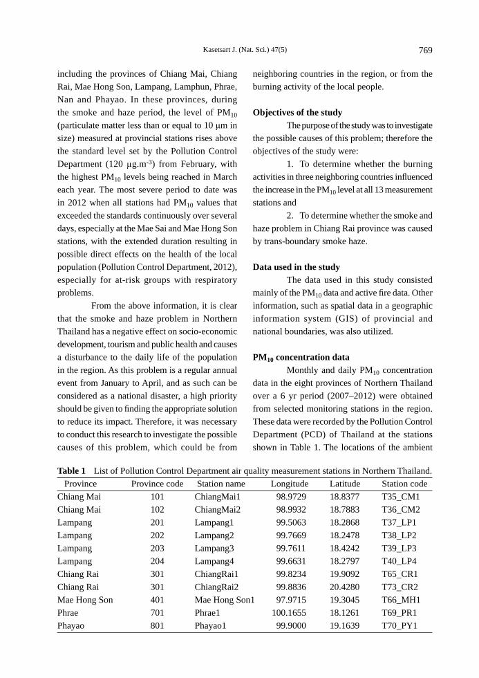
PM10 concentration data Monthly and daily PM10 concentration data in the eight provinces of Northern Thailand over a 6 yr period (2007–2012) were obtained from selected monitoring stations in the region. These data were recorded by the Pollution Control Department (PCD) of Thailand at the stations shown in Table 1. The locations of the ambient
Table 1 List of Pollution Control Department air quality measurement stations in Northern Thailand. Province Province code Station name Longitude Latitude Station codeChiang Mai 101 ChiangMai1 98.9729 18.8377 T35_CM1Chiang Mai 102 ChiangMai2 98.9932 18.7883 T36_CM2Lampang 201 Lampang1 99.5063 18.2868 T37_LP1Lampang 202 Lampang2 99.7669 18.2478 T38_LP2Lampang 203 Lampang3 99.7611 18.4242 T39_LP3Lampang 204 Lampang4 99.6631 18.2797 T40_LP4Chiang Rai 301 ChiangRai1 99.8234 19.9092 T65_CR1Chiang Rai 301 ChiangRai2 99.8836 20.4280 T73_CR2Mae Hong Son 401 Mae Hong Son1 97.9715 19.3045 T66_MH1Phrae 701 Phrae1 100.1655 18.1261 T69_PR1Phayao 801 Phayao1 99.9000 19.1639 T70_PY1

Kasetsart J. (Nat. Sci.) 47(5)770
air monitoring stations are shown in Figure 1.
Active fi re data The daily active fire data covering Thailand, the Republic of the Union of Myanmar (Myanmar) and the Lao People’s Democratic Republic (Lao) used in this study were downloaded from the Fire Information for Resource Management System (National Aeronautics and Space Administration, 2012). Each active fi re pixel represents an area of 1 × 1 km located by its latitude and longitude. The active
fi re count was based on the available satellite imagery that passed over the area and due to the coarse spatial resolution, the active fi re count may be an underestimate compared to the active fi res on the ground at the regional level. Figure 2 shows the estimated spatial distribution of active fi res in Chiang Rai province. The active fi re data included several physical parameters: latitude, longitude, detection date and time, and high fi re detection confi dence which ranged from 80–100%. Fire occurrence location information collected from fi eld survey was also utilized, which was compiled
Figure 1 Locations of the Pollution Control Department (PCD) air quality measurement stations in Northern Thailand.

Kasetsart J. (Nat. Sci.) 47(5) 771
by the Protected Area Regional Offi ce 15, Wildfi re Control Division, Department of National Parks Wildlife and Plant Conservation.
METHODOLOGY
The methodology was designed in two parts which consisted of the regional and local levels. The study at the regional level aimed to understand the burning activities at a scale that covered Thailand, Myanmar and Laos that would
have a possible impact on the increased PM10 levels measured at the 13 stations in Northern Thailand. The study at the local or provincial level mainly focused on Chiang Rai province and investigated the smoke and haze problem that might have originated in neighboring countries and thus be caused by burning activity at the regional level. At the regional level, the study focused on the impact or infl uence of burning activities from neighboring countries on the smoke and
Figure 2 Active fi re distribution in 2012 in Chiang Rai province shown by district (dark gray dots are active fi res detected by the satellite imagery; light gray dots are active fi res from fi eld survey data).

Kasetsart J. (Nat. Sci.) 47(5)772
haze in Northern Thailand by studying the trend over space and time of the PM10 data from the 13 stations in the region for the period 2007–2012. The active fi re data covering the three neighboring countries also was used to study the trend over space and time. Next, the changes in the PM10 concentration and active fi res were analyzed on a month-to-month basis over the period 2007, 2009, 2010 and 2012. Then, the simple regression analysis was applied to analyze the relationship between active fi re counts at the regional level and the PM10 concentration at every station in Northern Thailand from January to April in 2007, 2009, 2010, and 2012. For the local level study, which focused on the smoke and haze problem in Chiang Rai province, the possibility was analyzed of burning activities from neighboring countries having an impact on the increment in the PM10 levels in the province for the burning period January to April in 2009, 2010 and 2012. This part of the study also considered the possibility of air mass movements that could affect the PM10 concentration by analyzing the wind direction and daily air mass movements in March at the measurement stations located in Chiang Rai province. This included a study on the relationship between the number of regional active fi res and the PM10 level at the Chiang Rai station, and a study of the daily backward trajectories in March to Chiang Rai, using the hybrid-single particle Lagrangian integrated trajectory (HYSPLIT) model (Air Resources Laboratory, 2010). The model can be run online at http://www.ready.noaa.gov/ready/open/hysplit4.html. Daily backward trajectories in March to Chiang Rai were also investigated to analyze the possibility that the wind direction to Chiang Rai province could carry PM10 particles into the province based on the wind pattern and direction for daily air mass movements in March 2007, 2009, 2010 and 2012. The results from this modeling were overlaid with the hotspot distribution data for March in each year. Similar to the regional level, the
characteristics of the PM10 data and active fi re distribution were analyzed for the local case. Trend analysis of the PM10 levels at the Chiang Rai station over time and space was carried out using the average monthly data and trend changes during 2009, 2010 and 2012. The trend changes for active fi re occurrence and the distribution in the three neighboring countries over time and space were also studied by generating maps of the fi re occurrence distribution. Correlation analysis of the relationship between active fi re counts at the local level and the PM10 levels at the Chiang Rai station from January to April in 2007, 2009, 2010, and 2012 by linear regression was implemented in this step. In the last implementation step, the roles of the climate and landscape of the province with regard to the smoke and haze problem were investigated using meteorological and topological factors in Chiang Rai province. The meteorological data were provided by the Thailand Meteorological Department. GIS tools were used in this step to show the relationship between the topographical patterns of the province and wind speed, wind direction and fi re occurrence.
RESULTS AND DISCUSSION
PM10 and active fi re distribution at the regional level and their mutual infl uence The monthly PM10 levels were low and fairly unchanged (around 30 μg.m-3) in the rainy season (typically from May to October) in the observed years. However, the level increased sharply in the dry season (from January to April) to an average value of 93 μg.m-3, and reached a peak of about 141 μg.m-3 in March, which is beyond than the acceptable standard PM10 level of 120 μg.m-3 defi ned for Thailand (Pollution Control Department, 2012). It was found that the levels of PM10 collected in the burning season (January–April) were signifi cantly about 3 times higher than during the non-burning season. The highest PM10 level among the measurement

Kasetsart J. (Nat. Sci.) 47(5) 773
stations was recorded at the three stations of Mae Sai, Mae Hong Son and Chiang Rai near the Myanmar and Lao borders. The average PM10 levels at each measurement station were found to be very similar and in the range 90–100 μg.m-3. The regional active fi re count was high with an average of 63,795 hotspots annually, of which about 80% occurred during the burning season (from January to April) with a peak in March (70%). The highest count was recorded in Myanmar (50%), followed by Lao (36%) and Thailand (14%). The regional active fi re density in the burning season averaged over the three years was about 4 active fi res per 100 square kilometers; it was highest in Lao (10) followed by Myanmar (5) and Thailand (2). For Thailand, the majority of burning occurred in the northern region (64%) with a density of 5 active fi res per 100 square kilometers. The locations of active fi res in the burning seasons (2007, 2009, 2010 and 2012) clearly showed that the three densest active fi re clusters were in the Eastern Myanmar cluster (10 active fi res per 100 square kilometers), followed by the Western Lao cluster (14 active fi res per 100 square kilometers) and the Northern Thailand cluster (7 active fi res per 100 square kilometers). These cluster densities were clearly higher than the density in each country, which were Myanmar (5) followed by Thailand (2) and Lao (10), respectively. Within the burning season, hotspot counts increased sharply from January to February to March, and then decreased in April. The average (over the three years) increased change was 10 times from January to February, and 4 times from February to March, followed by a decreasing change of 2 times from March to April. The incremental increase in regional burning caused the PM10 values to increase at the Mae Sai, Mae Hong Son and Chiang Rai stations during the burning season each year. The correlation coeffi cient (R2) values between the month-to-month change of average daily regional hotspot counts and the month-to-month
change in the PM10 level (in the burning seasons, 2009, 2010 and 2012) was high (R2 > 0.7). The highest correlation was at the Mae Hong Son station followed by the Chiang Rai station. The sharp increase in PM10 levels from one month to the next resulted from the corresponding sharp increase in hotspot counts at the regional level, with the contribution from one unit of hotspot change to the PM10 level change being about 0.16. However, this trend did not occur at all stations. Stations that were far away from the borders were the least affected by regional burning, and therefore experienced a lower increase in PM10
levels. As a result of the study at the local level in Chiang Rai province, open burning in the three countries signifi cantly impacted on the increased PM10 levels at the monitoring stations located in Chiang Rai province; therefore, this province was chosen to investigate the smoke haze problem that was mainly caused by regional and local open burning.
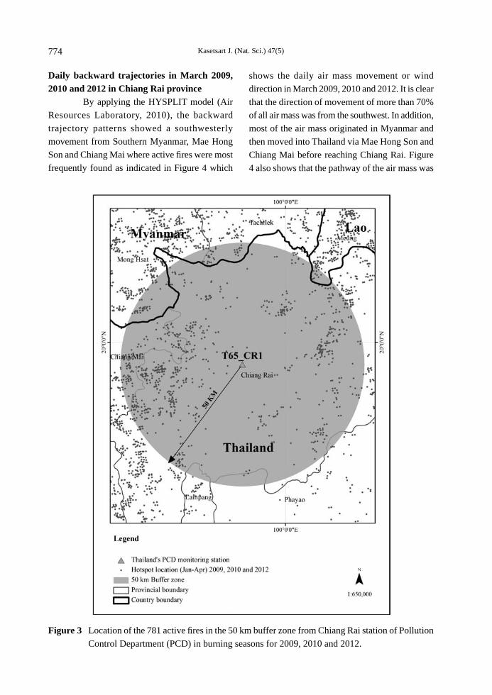
Relationship between regional active fire number and PM10 level at Chiang Rai station The results showed that for a 10 km radius interval from the monitoring station, the coeffi cient of determination started to rise noticeably (R2 ≥ 0.85) from a radius greater than 50 km. This implied that active fi res occurring in such a range could account for 85% of the variation of surface PM10 levels as shown in Figure 3. The coeffi cient of determination values at a radius of every 10 km from the Chiang Rai station are displayed in Table 2. Thus, the most effective area at a radius of 50 km from the Chiang Rai station, could be called the short range impact. There were 781 active fi res in this range of which most were in Thailand (96%) followed by Myanmar (3.7%) and Lao (0.3%). Table 2 shows that the coeffi cient of determination was quite high (R2 ≥ 0.8) at a radius of 40 km from the Chiang Rai station. Moreover, at this range, active fi res were found in Thailand only.
Kasetsart J. (Nat. Sci.) 47(5)774
Figure 3 Location of the 781 active fi res in the 50 km buffer zone from Chiang Rai station of Pollution Control Department (PCD) in burning seasons for 2009, 2010 and 2012.
Daily backward trajectories in March 2009, 2010 and 2012 in Chiang Rai province By applying the HYSPLIT model (Air Resources Laboratory, 2010), the backward trajectory patterns showed a southwesterly movement from Southern Myanmar, Mae Hong Son and Chiang Mai where active fi res were most frequently found as indicated in Figure 4 which
shows the daily air mass movement or wind direction in March 2009, 2010 and 2012. It is clear that the direction of movement of more than 70% of all air mass was from the southwest. In addition, most of the air mass originated in Myanmar and then moved into Thailand via Mae Hong Son and Chiang Mai before reaching Chiang Rai. Figure 4 also shows that the pathway of the air mass was

Kasetsart J. (Nat. Sci.) 47(5) 775
over areas which had a high density of active fi res before arriving at the Chiang Rai station. Under such conditions, this air mass probably brought PM10 emissions into Chiang Rai province. Other studies also reported that the air mass moved into Chiang Mai from the southwest having also passed over the area with high hotspot numbers (Yasanga et al, 2010; Oanh and Leelasakultum, 2011). Therefore, it could be concluded that Chiang Rai was influenced by open burning from long-range regions as well. The air mass trajectory or movement could be used to explain the long-range transport of PM10 emissions from the burning areas to Chiang Rai. Although the air mass had traveled from the location where the highest number of active fi res occurred (especially in Myanmar) before arriving at Chiang Rai, the concentration of PM10 emissions at the Chiang Rai station would have already been reduced by the long route from the haze and smoke sources (Pollution Control Department, 2012). Due to the southwestern direction of the air mass movement, Chiang Rai was likely to be most influenced
by open burning that originated in Chiang Mai province, followed by Mae Hong Son province and Myanmar, respectively. Although the smoke and haze problem in Chiang Rai might be infl uenced by open burning from the long-range upwind regions or long-range transport of air pollution, it was possible that PM10 emissions travelling in the air mass would be less concentrated when they arrived in Chiang Rai. Thus, the long-range transport of air pollution probably contributed only a small amount to the increasing PM10 emissions in Chiang Rai.
PM10 and active fi re situation in Chiang Rai Continuous observation of the PM10 levels in the period January 2009 to April 2012 at the Chiang Rai station showed that the levels tended to increase according to a certain pattern every year, except in 2011. In January to October, the PM10 levels were moderately stable, not exceeding 30 μg.m-3, after which they changed slightly from November to January, with a monthly average of 30 μg.m-3 or less. After that, the PM10
Table 2 Relationship between active fire counts in Chiang Rai province in burning seasons for 2009, 2010 and 2012.
Distance from station T65_CR1
(km)
R2 SE Sig
Equation Active Fires(number of points)y = a + b × x
a b TH MM LA Total
10 0.26 ± 40.66 0.091 84.05 1,030.58 5 0 0 520 0.55 ± 31.58 0.006 68.14 423.52 26 0 0 2630 0.75 ± 23.58 0.000* 61.81 68.50 194 0 0 19440 0.84 ± 18.91 0.000* 58.63 30.51 475 0 0 47550 0.85 ± 18.18 0.000* 56.89 19.36 749 29 3 78160 0.89 ± 15.15 0.000* 55.05 11.74 1,097 209 40 1,34670 0.91 ± 13.51 0.000* 52.45 8.67 1,408 415 109 1,93280 0.92 ± 13.27 0.000* 51.92 5.98 1,587 705 544 2,83690 0.88 ± 15.78 0.000* 51.95 3.99 1,816 1,131 1,296 4,243100 0.87 ± 16.91 0.000* 50.52 3.05 2,005 1,763 1,955 5,723
TH = Thailand, MM = Republic of the Union of Myanmar, LA = Lao People’s Democratic Republic.R2 = Coeffi cient of variation. Sig = Signifi cance level, tested at * = P < 0.05.

Kasetsart J. (Nat. Sci.) 47(5)776
Figure 4 Daily air mass movement or wind direction in March (a) 2007, (b) 2009, (c) 2010 and (d) 2012.

Kasetsart J. (Nat. Sci.) 47(5) 777
levels started to increase in February to April, with a monthly average of 80–120 μg.m-3. Moreover, it was clear that the PM10 levels peaked in March every year. Wildfi res in Chiang Rai were found to follow the same pattern from February to the end of April from 2007 to 2009, except for 2011 whereas active fi res started in November. The maximum amounts of active fi res were found in Mae Suai district, Muang district and Chiang Khong district, respectively. The majority of active fi res occurred in March being located in the highlands and forest areas at 400–600 m above sea level and generally caused by agricultural burning. Accordingly, the highest number of active fi res was found in this month each year. In 2011, only a small number of active fi res were recorded since there was increased fl uctuation in the climate caused by La Niña, resulting in increased rain, especially in March (National Park, Wildlife and Plant Conservation Department, 2010). Additional analysis showed that an average number of 218 fi res was recorded from field data and 457 active fires in total occurred annually in Chiang Rai. However, the number of active fi res in 2012 was clearly higher than those in previous years, except for 2007.
Relationship between PM10 and active fire occurrences in Chiang Rai The overall monthly pattern of PM10 levels at the Chiang Rai station was signifi cantly (P < 0.05) related with the number of active fi res from 2009 to 2012. In the burning season, there was a sharp increase in both the PM10 levels and hotspot counts with a regular peak in March of each year. Moreover, the coeffi cients of determination of the relationship between the PM10 levels and the number of fi res reported from the fi eld and also active fi res in the area were very high, being 0.9 and 0.85 respectively. This suggests that fi re reports from the fi eld and active fi res in Chiang Rai were signifi cantly (P < 0.05) related to changes in the PM10 level. Therefore, the smoke haze
problem in Chiang Rai was generally caused by open burning performed in the province itself.
Meteorological and topographical features analysis. The burning season during 2008–2012 in Chiang Rai was considered to last from January to April, which was summer time, with an average temperature of 20.16–21.69 °C, an average rainfall of 0.7–2.70 mm and an average wind speed of 14.59–15.79 km.hr–1, while the prevailing direction of winds was mostly from the northeast. The meteorological conditions in Northern Thailand involved low air pressure which covered the region with clear skies, light winds and low dew point temperatures resulting in both subsidence and temperature inversion or phenomena called “stagnant meteorological conditions” (Oanh and Leelasakultum 2011) Such an inversion could inhibit the vertical dispersion of emitted pollutants which was consistent with previous studies (Bonnet and Guieu, 2004; Pentamwa and Oanh, 2008). In the burning season, the air conditions included low humidity, high temperature and calm winds with a speed of 12.8–19.2 km.hr-1, resulting in stagnant air conditions (Thai Meteorological Department, 2013). Consequently, PM10 particles could be suspended in the air for a long time (Bonnet and Guieu, 2004). At the same time, high air pressure originating from China had also spread over the Chiang Rai area (Thai Meteorological Department, 2013), enhancing the gradually sinking air mass. Thus, gases and residues caused by burning could not readily spread out from the area, which resulted in the PM10 levels becoming higher, especially in March when active fi res were at their greatest compared with other months. Topographical features were also a factor affecting the accumulation of PM10 particles in the area. Chiang Rai is considered as the North Continental Highland, where patches of the plateau are in Mae Suai, Wiang Pa Pao, and Chiang Khong

Kasetsart J. (Nat. Sci.) 47(5)778
Figure 5 Relationship between active fi re occurrence, topographical features and wind direction, in March 2012.
districts. The mountain ranges are approximately 1,500–2,000 m above sea level, whereas the plain areas, at approximately 410–580 m above sea level are located along the rivers in many districts such as Phan, Muang, Mae Chan, Mae Sai, Chiang Saen, and Chiang Khong. Furthermore, especially in March every year, Chiang Rai was infl uenced by the northeast monsoon (Thai Meteorological Department, 2013) resulting in high air pressure prevailing over the region. The result was a subsidence inversion, which trapped smoke in the mountain valleys (Fenn et al, 2010). According to the specifi c topography of Chiang Rai, including the valleys and plain
areas, even when there was only a small amount of burning conducted in the local areas each day, smoke and air pollutants were still being gradually accumulated until they reached a critical level. The mountain-valley topography of the province is a major factor that enhances the smoke haze conditions in Chiang Rai (Protected Area Regional Offi ce 15, 2009). Another reason is the limited dispersion of air pollution, in addition to the climate in March including stagnant conditions and low-speed winds which result in a long suspension of PM10 particles in the air. Furthermore, even if there were no increase in burning activities, the PM10 accumulation level would still be higher for the whole month as indicated in Figure 5.

Kasetsart J. (Nat. Sci.) 47(5) 779
CONCLUSION
The smoke and haze problem in Northern Thailand from 2007 to 2012 at the regional and provincial levels was examined to identify and gain an understanding of the possible causes by an analysis of the behavior of smoke and haze using PM10 data and the distribution of active fi res in neighboring countries sharing national borders with Chiang Rai. Spatial and multi-temporal aspects were considered, including the relationship of these two physical parameters using correlation analysis. The results indicated that the PM10 levels in the burning season are relatively high compared to the nonburning season in Northern Thailand, which were recorded at the measurement stations of Mae Sai, Mae Hong Son and Chiang Rai. Open burning activity at the regional level, mainly from the three neighboring countries possibly infl uenced the increment in PM10 levels at the monitoring stations located in border areas, which was examined by considering the long-range transport of smoke and haze from neighboring countries and the neighboring provinces of Chiang Rai. Moreover, the study at the local level showed that the maximum amount of burning occurred in Mae Suai, Muang, and Chiang Khong districts, with the majority occurring in highland and forest areas, and that the physical characteristics of climate and landscape block the dispersion of the smoke in the province. This lead to the conclusion that there is a high possibility that the smoke haze problem in Chiang Rai is mainly caused by open burning activities in Chiang Rai and its neighboring provinces and that topographical factors provide the greatest infl uence on the haze problem at the local level.
ACKNOWLEDGEMENTS
The authors would to express their sincere thanks to anonymous reviewers for their constructive suggestions, comments and help.
Also, they would like to thank the Pollution Control Department of Thailand for providing data and the Protected Area Regional Offi ce 15, which is under the Wildfi re Control Division, Department of National Parks Wildlife and Plant Conservation for wildfi re ground truth data which were necessary and useful for this study.
LITERATURE CITED
Air Resources Laboratory. 2010. Hybrid Single Particle Lagrangian Integrated Trajectory (HYSPLIT) Model. [Available from: http://ready.arl.noaa.gov/HYSPLIT.php]. [Sourced: 9 August 2010].
Bonnet, S. and C. Guieu. 2004. Dissolution of atmospheric iron in seawater. Geophys. Res. Lett. 31(3): 1–4.
Fenn, M.E., E.B. Allen, S.B. Weiss, S. Jovan, L.H. Geiser, G.S. Tonnesen and A. Bytnerowicz. 2010. Nitrogen critical loads and management alternatives for N-impacted ecosystems in California. J. Environ. Manage. 91: 2404–242.
National Aeronautics and Space Administration. 2012. Fire Information for Resource Management System (FIRMS). [Available from: http://fi rms.modaps.eosdis.nasa.gov/fi remap/]. [Sourced: 22 June 2012].
National Park, Wildlife and Plant Conservation Department. 2010. Forest Fire Control Division. Introduction to Wildfi re. [Available from: http://www.dnp.go.th/forestfi re/Eng/indexeng.htm]. [Sourced: 5 January 2010].
Oanh, N. T. K and K. Leelasakultum. 2011. Analysis of meteorology and emission in haze episode prevalence over mountain-bounded region for early warning. The Science of the Environment 409: 2261–2271.
Pentamwa, P. and N.T.K Oanh. 2008. Air quality in southern Thailand during haze episode in relation to air mass trajectory. Songklanakarin J. Sci. Technol. 30: 539–546.

Kasetsart J. (Nat. Sci.) 47(5)780
Pollution Control Department. 2012. Air Quality Standards. [Available from: http://www.pcd.go.th/info_serv/en_reg_std_airsnd01.html]. [Sourced: 16 June 2012].
Protected Area Regional Offi ce 15. 2009. Wildfi re Statistics Report. Chiang Rai, Thailand. 55 pp.
Thai Meteorological Department. 2013. Weather. [Available from: http://www.tmd.go.th/thailand.php]. [Sourced: 23 January 23 2013].
Yasanga, N., P. Traisathit, and S. Prasitwattanaseree. 2010. Identifi cation of Backward Trajectory Air Transport Patterns to Chiang Mai and Bangkok Using Cluster Analysis. Poster presented at the 11th Statistics and Applied Statistics Conference. 27–28 May 2010. Chiang Mai, Thailand.