myall river state forest compartment 50 harvest plan · o#ther records of presence * ec olgy pi nts...
TRANSCRIPT
!(
!(
Cpt50
Jarrah Road
Harriots Creek Trail
Winns Cre ek Trail
Kelly'sMista
ke Trail
Wier Trail
50/1 Trail
KoalaGreater Glider
Stuttering FrogStuttering Frog
Stuttering Frog
Stuttering Frog
CP-ACP-B
CP-DCP-C
D-3
D-2
D-4
D-1
Myall Lakes NP
411000
411000
412000
412000
413000
413000
6417
000
6417
000
6418
000
6418
000
Threatened Species RecordsRecords requiring prescription
Other records of presence#* Ecology point site (labelled on map)
MAP FEATURESState Forest BoundaryCompartment Boundary1 Km Grid10 m Contour
h h h h
#Y Permanent Growth Plot
Private Property (cadastre)State Forest
ROADS
Not to be used for haulageRoads outside harvest area
Gravel RoadNatural Surface Road
!Y Temporary DryApproved Crossingú
General Management (FMZ 4 and 8)
HARVEST AREA & EXCLUSION ZONESBase Net Area - (IHC 1&2)Harvest Area
Exclusions
4 Bar ExclusionsRainforest - Crafti + RN17
3 Bar Limited Falling
National Park Estate
Owl Landscape ProtectionRare & Non Commercial Forest Type
Harvesting Protection (FMZ 3A)Ridge & Headwater Habitat
High Conservation Value Old GrowthSpecial Management (FMZ 2)
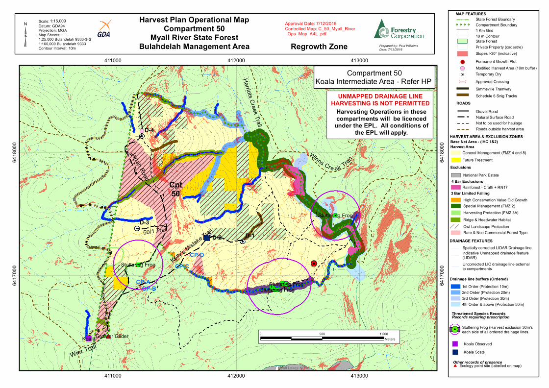
Harvest Plan Operational MapCompartment 50
Myall River State ForestBulahdelah Management Area³ Prepared by: Paul Williams
Date: 7/12/2016
Approval Date: 7/12/2016Controlled Map: C_50_Myall_River_Ops_Map_A4L .pdf
Datum: GDA94Projection: MGAMap Sheets: 1:25,000 Bulahdelah 9333-3-S1:100,000 Bulahdelah 9333Contour Interval: 10m
Scale: 1:15,000
0 500 1,000Meters
Simmsville Tramway
Drainage line buffers (Ordered)
DRAINAGE FEATURES
1st Order (Protection 10m)2nd Order (Protection 20m)3rd Order (Protection 30m)4th Order & above (Protection 50m)
Schedule 6 Snig Tracks
Stuttering Frog (Harvest exclusion 30m'seach side of all ordered drainage lines.
Future Treatment
Compartment 50Koala Intermediate Area - Refer HP
Harvesting Operations in thesecompartments will be licenced
under the EPL. All conditions ofthe EPL will apply.
UNMAPPED DRAINAGE LINEHARVESTING IS NOT PERMITTED
" Koala Observed
" Koala Scats
Spatially corrected LIDAR Drainage line Indicative Unmapped drainage feature (LIDAR) Uncorrected LIC drainage line externalto compartments
Slopes >30° (indicative)
!( Modified Harvest Area (10m buffer)
Regrowth Zone
%2

!
!
!
!
!
!
!
!
!
!
!
!
!!
!
!
!
!
!
!
!
!
!
!
!
!
!
!
!
!
!
!
!
!
!
!
!!
!
!
!
!
!
!
!
!
!
!
!
!
!
!
!
!
!
!
!
!
!
!
!
!
!
!
!
!!
!
!!
!
!
!
!
!
!
!
!
!
!
!
!
!
!
!
!
!
!
!
!
! !
!
!
!
!
!
!
!
!
!
!
!
!
!
!
!
!
!
!
!
!!
!
!
!
!
!
!
!
! !
!
!
! !
!
!
!
!
!
!
!
!
!
!
!
!
!
!
!
!
!
!
!
!
!
!
!
!
!
G®v
Strike-a-light
Back
Creek
Road WaukBlueberry ForestRoadRoad
Forest
Cabbage
Bulli
Koolonock
RoadCedars MarkwellGilberts
Road Tree Road
Road
Road
Crawford
Road
RoadRoad RoadHill RoadRoad Jarra
h
Road
Road
SamsHil
lKoolonock
Rd Road
Road
Purga
tory
Ridge
Duck
s
RdSour
Road
BendJarrah
Gooc
hs
Road
Trail
Inn
Maso
ns
Road
LakesRoad
Old
Gum
NerongBlue
Road
RoadBoundary
Road
Boundary
Nerong
RoadTaylorsNugra
RoadRoad
Cpt50
Myall Lakes NP
Bulahdelah SCA
Ghin-Doo-Ee NP
132k
V
33kV
33kV
33kV
33kV
410000
410000
415000
415000
420000
420000
425000
425000
6405
000
6405
000
6410
000
6410
000
6415
000
6415
000
6420
000
6420
000
³Location / Safety Map
Compartment 50Myall River State Forest
Bulahdelah Management Area Prepared by: Paul WilliamsDate: 8/09/2016
Helicopter Landing SiteCleared area adjacent to Cabbage Tree Forest RoadMGA 420 600E 6 417 500 NLat/Long: -32° 22' 36"S / 152° 09' 21"E
Emergency Telephone 000 / 112 Forests NSW (02) 6585 3744
Emergency Meeting PointIntersection of Cabbage Tree Forest Road & Knob Road.MGA: 420 240E 6 417 400NLat/Long:-32° 22' 39"S / 152° 09' 08"E
Datum: GDA94Map Sheets1:25,000; Markweell 9333-3-NBulahdelah 9333-3-S1:100,000; Bulahdelah 9333
1:100,000Scale
Haulage Route
0 1 2 3 4 50.5Kilometers
Legend
All Weather, Unsealed
State Forest (Legal)National Park Estate
G Emergency Meeting Point
Town!
Harvesting compartments
Sealed
Dry Weather, Unsealed
®v Helicopter Landing Place

Document title: C_50_Myall River_HP_Printed_Signitures
Version No.: 1 Page 1 of 10
Harvest Plan No: 32783 Approval Date: 7/12/2016 Expiry Date: 2025 Warning: a printed copy of this document may be uncontrolled. Please verify this is the latest version prior to use.
HARVEST AND HAUL PLAN
State Forest Myall River Compartment 50
Management Area Bulahdelah IFOA Region Lower North East
Harvest Plan No. Native: 32783 Supply Zone 4
Legal Conditions Native Forest Harvesting in accordance with IFOA conditions and all associated licenses. This is a scheduled operation therefore logging of UMDL is NOT PERMITTED. All conditions of the EPL apply in this operation.
To implement this plan you must hold a current Contractors Licence.
Standard Harvest Plan Conditions and Operating Procedures apply.
Survey expiry date for this plan is 2025.
Certification Timber products removed from the plan area are within the Defined Forest Area covered by Australian Forestry Standard and ISO14001 Certificate 13761
Prepared by Planner Paul Williams
Date: 1/12/2016 Paul Williams
Approved by Planning Supervisor Brent Bailey
Date: 7/12/2016 Brent Bailey
Abbreviations FT = Forest Technician, HC = Harvesting Coordinator, PtS= Protection Supervisor, HS = Harvesting Supervisor, RC = Roading Coordinator, Crew = Harvest Contractor/Forest Operators, IFOA = Integrated Forestry Operations Approval, TSL = Threatened Species Licence, EPL = Environment Protection Licence, FL = Fisheries Licence, CH = Cultural Heritage, SOP = Standard Operating Procedure.
1. Harvest Area Details
Cpt 50
Event ID/Job Number 44189 Gross Area (ha) 210
Total Net Harvest Area 125 Area Expected to be Harvested 100
Estimated Yield 2885
Yield/ha 28
Slope (% 0-20 degrees) 63
Slope (% 20-25 degrees) 22 Slope (% 25-30 degrees) 12

Document title: C_50_Myall River_HP_Printed_Signitures
Version No.: 1 Page 2 of 10
Harvest Plan No: 32783 Approval Date: 7/12/2016 Expiry Date: 2025 Warning: a printed copy of this document may be uncontrolled. Please verify this is the latest version prior to use.
Contractor must ensure timber removed is allocated to the correct compartment when entered into Electronic Delivery Docket.
2. Management Conditions on Boundaries Boundary Conditions
Historic Railway Line/ Simmesville Tramway - FMZ-3A
The indicative location of the Historic Railway is displayed on the Harvest Plan Operational Map. Where the historic Railway can be located by the FT on the ground, it must be managed as FMZ 3A (10m width). Crossing points must be approved by the harvesting coordinator in locations where the integrity of the site will not be compromised.
Private Property Internal forest compartment, no issues
SMZ / FMZ FMZ 2 – Special Management –Areas of Non-commercial forest type (Type 115 - Sydney Peppermint – Stringybark), Old Growth and Riparian protection
FMZ 3A – Harvesting Exclusion –Rare Non-commercial forest type (Type 115 - Sydney Peppermint – Stringybark), Rainforest and Historical Railway. Note that the thin linear FMZ 3A south west of Dump 3 and in extreme south west of compartment must be excluded from harvesting.
FMZ 4 - General Management – available for harvest.
FMZ 8 – Generally indicative of drainage lines
Cultural Heritage Surveys have been conducted. Two modified harvest area have been identified and marked in the field for protection within this compartment – i.e. Total Exclusion from harvesting – Existing road through exclusion can be used for haulage. Immediately prior to harvesting the marking must be checked by the HC.
If any potential heritage sites are identified a 20m interim buffer is to be applied and the planner notified immediately.
3. Expected Yields
Product Estimates Volume (m3) Species Species Mix (Sawlog)
HQ Large Sawlog (Quota) 770 BBT 10%
HQ Small Sawlog 180 TWD 15%
Poles and Girders 25 SBG 40%
LQ Sawlog (Salvage) 1200 BBX 5%
W’Tex/Firewood/Export chip
370 Other 30%
Fencing 340
Total 2885

Document title: C_50_Myall River_HP_Printed_Signitures
Version No.: 1 Page 3 of 10
Harvest Plan No: 32783 Approval Date: 7/12/2016 Expiry Date: 2025 Warning: a printed copy of this document may be uncontrolled. Please verify this is the latest version prior to use.
Note: The yield estimates in the table above includes export chip. Due to the uncertainty of market conditions this product may not be sourced to its full potential.
4. Haulage Haul Route Internal forest roads, Jarrah Road, Purgatory Road, Crawford River
Road, Knob Road and Cabbage Tree Road.
Traffic Control Plan Jarrah Road provides access to the Myall Lakes and Ghin-Doo-Ee National Park. It is the responsibility of the harvesting crew to provide and implement a traffic management plan that will ensure the safety of all road users whilst harvesting within 2 tree lengths of this roadway.
5. Community Issue Detail Conditions
Notifications Required Nil Internal forest compartments
6. Harvesting Conditions The net harvest area of this compartment contains dry forest types on the upper to mid slopes (Types 60 & 62) and moist forest types (Types 36 & 47) associated with the lower to mid slopes. Previous harvesting has resulted in generally good regeneration within the dry forest types, whilst the moist forest type regeneration ranges from very good to practically nil with large areas of viney scrub that will need mechanical disturbance to establish future regeneration. The Silviculture objective of this harvesting operation is to use STS to maximize the removal of merchantable timber and to regenerate the stands.
Silviculture Type Harvesting Objectives and Condition for each stand condition
Medium-Heavy STS in in moist forest types containing Blackbutt and Bluegum
Lower and mid slope areas
In stands dominated by commercial endpoint Blackbutt/Blue Gum, the objective is to implement a regeneration harvesting treatment to establish a new, vigorous stand.
Forest technician to mark for retention well-formed seed trees of preferred species at ~40 m spacing and mark growers for retention. H trees with well-formed crowns and at required spacing may be used as seed trees.
FT to ensure HC’s are made aware of patches of regeneration.
HC to instruct crew to retain patches of quality advanced regeneration where they occur.
Crews to remove all merchantable stems not marked for retention and ensure mechanical disturbance creates a suitable seed bed for regeneration especially in areas of viney scrub associated with the mesic understorey.
The crew is also responsible for avoiding damage to retained growers and retaining patches of advanced regeneration.
STS Light - Medium
Upper to mid slopes
In the mixed age dry hardwood stands the objective is to harvest the merchantable component of the mature aged crop and retain the vigorous younger age class trees for the future.
The crew is responsible for selecting retained seed trees and retaining patches of

Document title: C_50_Myall River_HP_Printed_Signitures
Version No.: 1 Page 4 of 10
Harvest Plan No: 32783 Approval Date: 7/12/2016 Expiry Date: 2025 Warning: a printed copy of this document may be uncontrolled. Please verify this is the latest version prior to use.
Silviculture Type Harvesting Objectives and Condition for each stand condition
advanced regeneration. Crew is to select trees for removal and avoid damage to retained growers.
Note. Do not confuse pre-merchantable regrowth with suppressed and defective stems that are sub-optimal to stand improvement.
STS Light
Steep Slopes
Generally, 20-30 degrees
The steeper slopes are dominated by dry hardwood forest types with a high proportion of H & R trees and non-merchantable stems. The objective is to harvest the merchantable component of these stands as access allows with H & R trees generally providing adequate seed trees for regeneration.
Crew is to select trees for removal and avoid damage to retained growers.
Monitoring Planning assumptions have been made with respect to current market availability of timber products (e.g. greatly reduced market for wood chip material) and accessibility issues (slope & fragmentation of the net harvest area). As such BA removal has only been planned to reach a maximum of 38 % when measured across the NHA of this compartment (refer IFOA limit table below).
As market conditions may change, the HC must conduct Basal Area monitoring in areas treated with STS Light.
HC is to monitor BA retention during harvesting using BA post-harvest sweeps, randomly located across different stand types to ensure average BA is maintained as per the planned assumptions made in the table below.
Evidence of BA monitoring and the approximate plot location must be documented by HC. Ideally, monitoring of BA should occur prior to leaving each dump to ensure any variance to planned outcomes can be rectified.
IFOA Limits Regen STS STS Med Inaccessible / Steep < 30/STS Light
Fragmented NHA/Basal Retention
Total
STS Tract (ha’s) 39 50 19 14 122 Pre-harvest BA (m2)
26 26 26 26 3172
Post-harvest BA (m2)
10 16 22 26 1972
Planned Removal 62 38 15 0 38%
7. Tree Retention (Native Forest) - refer to TSL booklet for full conditions
Prescription Condition/Responsibility
Mark-Up – the FT is responsible for marking up the forest ahead of harvesting operations consistent with Forest Mark Up and Tree Retention SOP
Compartment Mark-Up Survey
(5.1, 5.2, 5.13)
Compartment mark-up surveys must be conducted at least 300m in advance of operations. The survey must search for threatened and protected species features listed in conditions 5.1(h), 5.2 and 5.13 of the TSL.

Document title: C_50_Myall River_HP_Printed_Signitures
Version No.: 1 Page 5 of 10
Harvest Plan No: 32783 Approval Date: 7/12/2016 Expiry Date: 2025 Warning: a printed copy of this document may be uncontrolled. Please verify this is the latest version prior to use.
No Koala star search triggers were identified during pre- harvest surveys.
Koala Intermediate use area 6.14 (aii)
FT must select and mark 10 primary browse trees/2 ha where available
Glossy-black Cockatoo feed trees (5.6giii)
FT must search for Forest Oak with crushed cones and mark for retention.
Hollow-bearing and Recruitment tree retention (H and R)
Regrowth Zone - 5.6 (d), (e) & (f), conditions apply.
Additional H trees for Greater Glider condition does not apply.
FT must select and mark 5 H trees/ha where available and one R for each H retained.
Significant Food Resources
(5.6 f)
FT must mark for retention- 6 Eucalypt feed trees/2 ha where they occur, glider sap feed trees, stands of forest oak and forest oak feed trees.
Harvesting - crew and HC responsibilities
Protection of Retained Trees (5.6g)
Trees marked or selected for retention must not be felled.
The crew must minimise damage to H, R and E trees by using directional felling.
Harvesting debris should not accumulate within 5 m of retained trees. Where debris does accumulate the crew must remove it or flatten to < 1m high.
The HC must be notified of any badly damaged retained trees and they must assess and record if a replacement retained tree is required.
Stag Retention (Dead standing trees 5.6 (f)
The crew should retain stags where safe to do so.
The crew must record the date, DBH, risk and location of unsafe stags removed
Significant food resources The crew should avoid damaging flowering or fruiting banksias or grass trees.
Impenetrable Understory In areas mapped by the FT as Impenetrable Understory procedures for harvesting in un-marked forest must be implemented by the HC and Crew.
8. Site-Specific Flora and Fauna
Condition Boundary Type
Prescription
Riparian Habitat Protection (5.7)
2 bars Implement filter strip (hard) and protection zone (soft) around drainage features as shown on the HPOM. Refer to SOP1.
FT must mark unmapped drainage lines and 1st order

Document title: C_50_Myall River_HP_Printed_Signitures
Version No.: 1 Page 6 of 10
Harvest Plan No: 32783 Approval Date: 7/12/2016 Expiry Date: 2025 Warning: a printed copy of this document may be uncontrolled. Please verify this is the latest version prior to use.
Condition Boundary Type
Prescription
protection zone boundary with 2 bars.
The crew will locate and protect all 2nd order and above streams with GPS.
Ground Habitat (5.17)
N/A Commercial firewood collection permitted in these compartments.
Rainforest (5.4) Accidental Mapped Exclusion
High Conservation Value Old Growth (5.03)
Limited Mapped Exclusion
Rare Non-commercial Forest (5.05)
Limited Mapped Exclusion
Ridge & Headwater Habitat (5.8)
Limited Mapped Exclusion
Owl Landscapes (6.09)
Limited Mapped exclusion - South Myall river Planning Unit
Giant-barred or Stuttering Frog (6.3)
Modified Harvest
Mapped exclusion, 30 m buffer on mapped streams within 200 m of a records and no UMDL within 200m of a record. Revert to 10m UMDL EPL protection
Fish N/A No fisheries licence conditions apply.

Document title: C_50_Myall River_HP_Printed_Signitures
Version No.: 1 Page 7 of 10
Harvest Plan No: 32783 Approval Date: 7/12/2016 Expiry Date: 2025 Warning: a printed copy of this document may be uncontrolled. Please verify this is the latest version prior to use.
9. Soil & Water – Native Forest – Refer to EPL Booklet for full conditions
Issue Assessment Conditions
EPL Scheduled Activity Yes
Apply all EPL conditions – refer SOP 1 Unmapped drainage Line harvesting
Not permitted
Inherent hazard level 2 Nil
Dispersible Soils No Nil
Mass Movement / Instability No Nil
Acid Sulphate Soils No Nil
Seasonality Conditions No Nil
Historical or existing erosion No Nil
Ground cover >70% Nil
Burning conditions No Nil
Log Dumps SOP 5 HC is responsible for authorising moving the location of a log dump.
Roading management during harvesting
SOP 6 Refer to SOP 6.
HC is responsible for monitoring road and crossing drainage during haulage.
Wet Weather and Rutting SOP 6 Crew is responsible for implementing automatic closures and following notified closures.
HC is responsible for ensuring crew notified when notified closure is lifted.
Snigging SOP 8 Crew is responsible for progressive drainage of snig tracks
Snig Track Crossings SOP 8 HC is responsible to ensure snig track crossings are approved prior to use and rehabilitated upon completion.

Document title: C_50_Myall River_HP_Printed_Signitures
Version No.: 1 Page 8 of 10
Harvest Plan No: 32783 Approval Date: 7/12/2016 Expiry Date: 2025 Warning: a printed copy of this document may be uncontrolled. Please verify this is the latest version prior to use.
10. Operational Plan Briefing: A briefing of this operational plan was conducted by
Person Role Nature of Briefing Date
11. Acknowledgement of Briefing: I acknowledge that I have received a copy of the plan documents and that I have been briefed on the conditions of the Plan. I understand the operational control requirements as outlined in the plan and take responsibility for the implementation of plan conditions relevant to my responsibilities
Name Role Signature Date

Document title: C_50_Myall River_HP_Printed_Signitures
Version No.: 1 Page 9 of 10
Harvest Plan No: 32783 Approval Date: 7/12/2016 Expiry Date: 2025 Warning: a printed copy of this document may be uncontrolled. Please verify this is the latest version prior to use.
12. Standard Operating Procedures: The following SOP’s apply to this plan. FCNSW staff and the crew must hold a copy on site whilst operating and comply with the conditions set out in each SOP.
Procedure Number
Title
1 Drainage Feature Protection
2 Exclusion Zone Boundary Management
3 Forest Mark-Up
4 Operating in Inherent Hazard Level 3 Areas
5 Log Dump Operation and Use
6 Road and Crossing Management and Wet Weather Controls
7 Safety Requirements
8 Snig Track & Extraction tracks
9 Documentation and approvals
10
11
12

Document title: C_50_Myall River_HP_Printed_Signitures
Version No.: 1 Page 10 of 10
Harvest Plan No: 32783 Approval Date: 7/12/2016 Expiry Date: 2025 Warning: a printed copy of this document may be uncontrolled. Please verify this is the latest version prior to use.
Operational Diary:
Date Issue Action Required
Action Completed Initials
Record: Daily activities (eg tree marking, dump 2); Condition 5.2 of TSL items - EEC locations, rocky outcrops, koala scats, feed tree identification etc), discussions with stakeholders/neighbours/ site visitors; areas of impenetrable understorey; unviable areas not marked, non-conformances; harvesting issues identified, twice weekly road and crossing drainage checks

Document title: C_50_Myall River_HP_Printed_Signitures
Version No.: 1 Page 11 of 11
Harvest Plan No: 32783 Approval Date: 7/12/2016 Expiry Date: 2025 Warning: a printed copy of this document may be uncontrolled. Please verify this is the latest version prior to use.