touring drive 3 - love the great lakesgreatlakes.org.au/images/drives myall way dec 15.pdf ·...
TRANSCRIPT
12 2
4
5
7
14
9
13
11
8
1
10
3
6
1
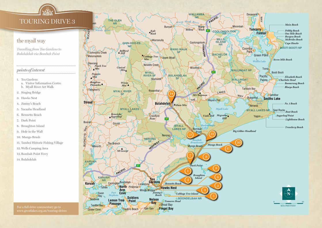
TOURING DRIVE 3
the myall way Travelling from Tea Gardens to Bulahdelah via Bombah Point
points of interest
1. Tea Gardens a. Visitor Information Centre b. Myall River Art Walk
2. Singing Bridge
3. Hawks Nest
4. Jimmy’s Beach
5. Yacaaba Headland
6. Bennetts Beach
7. Dark Point
8. Broughton Island
9. Hole in the Wall
10. Mungo Brush
11. Tamboi Historic Fishing Village
12. Wells Camping Area
13. Bombah Point Ferry
14. Bulahdelah
For a full drive commentary go to www.greatlakes.org.au/touring-drives
KILOMETRES
100
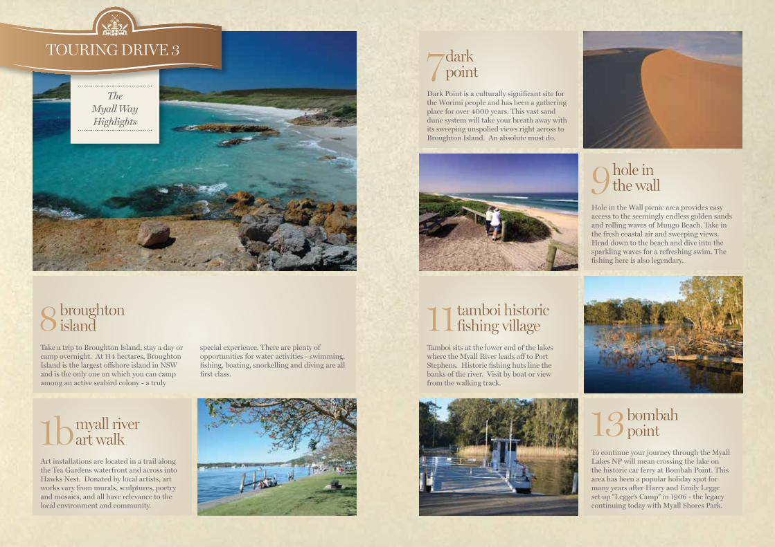
13 bombah point
To continue your journey through the Myall Lakes NP will mean crossing the lake on the historic car ferry at Bombah Point. This area has been a popular holiday spot for many years after Harry and Emily Legge set up “Legge’s Camp” in 1906 - the legacy continuing today with Myall Shores Park.
9 hole in the wall
Hole in the Wall picnic area provides easy access to the seemingly endless golden sands and rolling waves of Mungo Beach. Take in the fresh coastal air and sweeping views. Head down to the beach and dive into the sparkling waves for a refreshing swim. The fishing here is also legendary.
7 dark point
Dark Point is a culturally significant site for the Worimi people and has been a gathering place for over 4000 years. This vast sand dune system will take your breath away with its sweeping unspolied views right across to Broughton Island. An absolute must do.
1b myall river art walk
Art installations are located in a trail along the Tea Gardens waterfront and across into Hawks Nest. Donated by local artists, art works vary from murals, sculptures, poetry and mosaics, and all have relevance to the local environment and community.
11 tamboi historic fishing village
Tamboi sits at the lower end of the lakes where the Myall River leads off to Port Stephens. Historic fishing huts line the banks of the river. Visit by boat or view from the walking track.
8 broughton island
Take a trip to Broughton Island, stay a day or camp overnight. At 114 hectares, Broughton Island is the largest offshore island in NSW and is the only one on which you can camp among an active seabird colony - a truly
special experience. There are plenty of opportunities for water activities - swimming, fishing, boating, snorkelling and diving are all first class.
TOURING DRIVE 3
The Myall Way Highlights
1. Tea Gardens Tea Gardens located on the Myall river, Tea Gardens has many cafes and restaurants, boutique shopping and the Myall Community Arts and Crafts Centre situated at the rear of the Visitor Centre.
1 a.Tea Gardens Visitor Information Centre Myall St, Tea Gardens. Open 7 days 9-4
1b. The Myall River Art Walk meanders along the Tea Gardens waterfront.
Tea Gardens to Jimmy’s Beach, Hawks Nest 3.1km
2. Singing BridgeTravel across the Singing Bridge, during a strong SW the wind generates a singing sound through the bridge railings.
3. Hawks Nest Hawks Nest is the main gateway to the Myall Lakes National Park. Walk around the town and look out for a koala or two or join in the fun at one of the many festivals held in the area.
4. Jimmy’s BeachThis beach stretches from Yacaaba in the East to the Myall River mouth in a 5km arc. Facilities include picnic tables, playground and toilets. Located nearby, and off Beach Road is the access walking track to Yacaaba Headland.
5. Yacaaba Headland Walking Trail 1.5kmA more challenging walk, starting from the car park at the end of Beach Rd. Although there is no formal lookout at the top, there are views through the forest along the way.
6. Bennetts BeachStop by the Surf Club and take in the views over to Boondelbah and Cabbage Tree Island, the only nesting site of Gould’s Petrel.
Hawks Nest to Dark Point via Mungo Brush Road 12.8 km
7. Dark PointThis is a culturally significant site for the Worimi people; traverse the giant sand dunes that will lead you to scenic coastal views across to Broughton Island.
8. Broughton Island Broughton Island can be accessed via boat from Tea Gardens. It is the only place in NSW where you can camp on an island amongst an active seabird colony. Here you can go swimming, fishing, boating, snorkelling and scuba diving and you’ll find a beautiful sandy beach in Esmeralda Cove. The island itself boasts a rugged remote experience.
Dark Point to Hole in the Wall 2.5km
9. Hole in the WallThis rustic picnic area offers easy access to the beach with scenic coastal views, an ideal for swimming and fishing.
Hole in the Wall to Mungo Brush 4.2 km
White Tree Bay and Mungo Brush campgrounds include picnic tables, toilets and BBQ’s. There are two beach 4wd access points along this road - one at Mungo and the other at Lemon Tree. National Parks permits apply. Contact the National Park office on 65910300.
10. Mungo Brush Rainforest Walk - 2km loop track.An easy 30 minute walk through coastal rainforest, starting from the northern end of Mungo Brush Camping Area.
11. Tamboi Trail - 4km one wayAn easy walk, starting from the bar gate at the southern end of Mungo Brush. Wander through a stunning Cabbage Tree Palms forest to the old fishing village of Tamboi, or follow the boardwalk to Brambles Green.
Mungo Brush to Bombah Point 5.9 km
12. The Wells Camping AreaSituated midway between Mungo and Bombah Pont, this is a popular stop for kayaking on the still waters of Myall Lakes.
13. Bombah Point - Bulahdelah 12.6 km Continue driving along the Bombah Point Road towards Bulahdelah. Follow this unsealed road through Myall Lakes National Park.
Bombah Point ferry operates daily from 8am to 6pm on the half hour and hour. Fees apply contact the Booti Booti Office 6591 0300. Currently the fee is $6 per vehicle.
14. Bulahdelah Bulahdelah is situated in the heart of the Myall Lakes and has easy access to cafes, restaurants and accommodation. Bulahdelah Visitor Centre can be found on the corner of Crawford and the old Pacific Highway. Open Monday to Saturday 10-3.
Highway and travel north through the small village of Coolongolook, (feel free to stop for a snack at The Salty Dog or Andy’s Cherry Pie Café & Gallery
TOURING DRIVE 3the myall way