myall lakes booti booti wallingat
TRANSCRIPT

Wal
lis L
ake
scen
e (G
eoff
Wo
od
s /
OE
H)
Myall Lakes Booti Booti Wallingat national parks
The Great Lakes are a network of
waterways including Myall, Smiths
and Wallis Lakes between Nelson Bay
and Forster on the NSW coast north
of Newcastle.
The Great Lakes area is part of the
traditional country of the Worimi
Aboriginal people, who have lived
on and used the land and waters
for living, cultural activities and food
gathering for many thousands of
years. Today, the local Aboriginal
community retain strong spiritual links
with the Great Lakes area.
The region is renowned for its beauty
and striking landscape ranging from
sweeping ocean beaches to sheltered
waterways and surrounding stands of
coastal forest on the higher areas.
Myall Lakes, Booti Booti and Wallingat
national parks have a diversity of
landforms, wildlife and vegetation.
They conserve one of the state’s
largest networks of coastal lakes, with
the tallest tree, largest coastal island
and 80km of beaches and coastline.
The Myall Lakes are the largest
natural fresh-brackish water system
on the NSW coast covering 10,000
hectares and are listed as a wetland
of international importance under the
RAMSAR convention.
TOP SPOTS TO VISIT IN THE PARKS
Sug
arlo
af P
oin
t Li
ght
hous
e, M
yall
Lak
es N
P (O
EH
)
Cap
e H
awke
loo
kout
tow
er (O
EH
)
The Grandis (Myall Lakes NP)The inspiring coastal forests along the western edge of the park include the state’s tallest tree – The Grandis – a giant flooded gum.
Sugarloaf Point Lighthouse (Myall Lakes NP)You can stay overnight in the former lightkeepers cottages (bookings required ph 02 4997 6590), or just enjoy a short 500m stroll to this remarkable historic precinct adjacent to Seal Rocks.
The
Gra
ndis
, Mya
ll L
akes
NP
(Ian
Bro
wn)
Cape Hawke Lookout (Booti Booti NP)
A short uphill walk through coastal rainforest leads to this stunning lookout platform in the north of Booti Booti NP with its dramatic views out over the surrounding coastline and lake systems.
Wallingat scenic drives (Wallingat NP)The forest roads of Wallingat National Park make for a memorable scenic drive experience. Gu-rum-bee Picnic Area provides and ideal start to the experience.
Gu-
rum
-bee
, Wal
ling
at N
P (O
EH
)

MYALL LAKES NATIONAL PARK
This park is the ultimate place for camping and to enjoy the vast lake waters for all types of boating and water-based activities. In contrast, the park’s beaches and headlands are ideal places to explore, fish or just relax. Choose from lakeside, coastal or forested camping areas or venture out for a remote camping experience.
Experience the cultural heritage and giant sand dunes at Dark Point or enter another ancient world along the Mungo Brush Rainforest Walk.
The heritage- listed Sugarloaf Point Lighthouse at Seal Rocks is a testament to maritime navigation and now provides visitors with the chance to stay overnight below the beckoning light.
The coastal forests along the western side of the park include the state’s tallest tree – the Grandis- a giant flooded gum.
WALLINGAT NATIONAL PARK
A delightful forest drive through the park reveals elegant stands of tall flooded gum and palms, breathtaking views from Whoota Whoota Lookout and peaceful riverside day use and camping areas.
Wander the tracks around Sugar Creek or bring your mountain bike and make a more adventurous tour around the Park.
The horse trail network provides riders with the opportunity to undertake a variety of day rides including loop trails on a number of designated park roads and management trails in Wallingat National Park.
For further details riders should call the Great Lakes Area office on 6591 0300.Note – all roads are unsealed and may be closed after heavy rain.
Can
oei
ng, M
yall
Lak
es (S
hane
Cha
lker
) C
amp
ing
at M
ung
o B
rush
Mya
ll L
akes
NP
(OE
H)
Cam
pin
g b
y th
e W
allin
gat
Riv
er (O
EH
)
BOOTI BOOTI NATIONAL PARK
The park boasts a variety of expansive and secluded beaches, providing excellent surfing, swimming and fishing. The Ruins Camping Area provides ‘close to beach’ camping with a high level of facilities. A walk through the rainforest up to the Cape Hawke viewing tower provides views of the region.
The Booti Hill and lakeside walking tracks immerse visitors in the park’s varied landscapes. Complementing the park on its western boundary, Wallis Lake is ideal for boating and windsurfing.
Eliz
abet
h B
each
loo
king
acr
oss
to
Bo
oti
Bo
oti
NP
(OE
H)
Enj
oyin
g th
e b
each
ad
jace
nt t
o T
he R
uins
Cam
pin
g A
rea
(Sha
ne C
halk
er) )
/ O
EH
)
Elizabeth Beach: The imposing Booti Hill in Booti Booti NP provides a dramatic backdrop to Elizabeth Beach. The beach is seasonally patrolled and is a good swimming beach for families.
Who
ota
Whh
ota
Llo
kout
(Ont
he t
rack
to
Sug
arlo
af P
oin
t Li
ght
hous
e (O
EH
)

BROUGHTON ISLAND
Camping on Broughton Island is only permitted at the Little Poverty Beach Campground.
All campers must book & pre-pay for a campsite before leaving the mainland.
Little Poverty Beach Campground on Broughton Island offers visitors a unique camping experience, with some of the most spectacular coastal views in Australia. It is the only island in NSW where you can camp.
The campground includes 3 raised camping platforms and 2 grassed sites, providing camping for up to 30 people.
Broughton Island is a remote area and careful planning is required. Campers need to be self-sufficient and be prepared for rapidly changing weather and sea conditions.
To camp on Broughton Island you must book. Camping fees apply.To book Phone:
‘13000 PARKS’ (1300 072 757)
Email:
Visit:
www.nationalparks.nsw.gov.au/broughton
EXPLORE THE PARKS
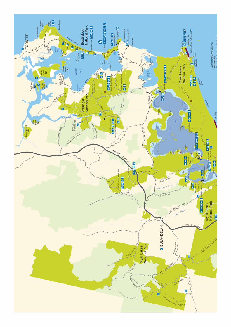
The parks have an extensive network of walking tracks designated for walkers only and management trails which are suitable for both walking and cycling (refer to coloured numbers on map)
1. Mungo Brush Rainforest Walk 2km loop track – An easy 30 minute walk through coastal rainforest, starting from the northern end of Mungo Brush Camping Area.
2. Tamboi Trail 4km one way – An easy walk starting from the bar gate at the southern end of Mungo Brush. Wander through stunning Cabbage Tree Palm forest to the old fishing village of Tamboi, or follow the boardwalk to Brambles Green.
3. The Old Gibber Trail 11km one way to Shelly Beach (or 4km one way to Johnson’s Beach) – A full day or overnight walk starting from the bar gate at the Boomeri Camping Area. Enjoy coastal forest and the “Moors”, a unique wet heathland with extensive bird life and seasonal wildflowers.
4. The Mining Road Trail. This popular ride or overnight hike takes you out along the former Mining Road for 10km until it turns off to the right and connects with the Old Gibber Fire Trail. It is a further 10km along this trail to reach the Mungo Brush Road.
5. The Mungo Track a total of 21km one way – Follow the lake edge, river and beaches to Hawks Nest or choose shorter sections from access points on Mungo Brush Rd.
6. Yacaaba Headland Walking Track. 1.5km one way – A more challenging walk, starting from the carpark at the end of Beach Rd, Hawks Nest. Although there is no formal lookout at the top, there are views through forest along the way.
7. Sugar Creek Walking Tracks. Two short loop walks (0.8km and 1.7km) wind through delightful wet eucalypt forest.
8. Booti Hill – Lakeside Walking Tracks. This popular 7km loop walk takes off from the Ruins
campground or Elizabeth Beach and takes around 2.5 hours to complete. Shorter sections possible.
FURTHER INFORMATION
NPWS Great Lakes Area, Booti Booti National Park, The Lakes Way, Pacific Palms 2428 ph (02) 6591 0300
NPWS Hunter Region, level 1, 12 Teramby Rd, Nelson Bay, 2315 ph (02) 4984 8200
Port Stephens – Great Lakes Marine Park. Locked bag 800, Nelson Bay, 2315. Ph (02) 4984 8228.
GENERAL INQUIRIES
Phone 1300 361 967 www.nswnationalparks.com.au
Published by the Office of Environment and Heritage, Department of
Premier and Cabinet
OEH Publishing number OEH 2012/0075
LOCATION
NEWCASTLE
MAITLAND
DungogBulahdelah
TAREE
Gloucester
CESSNOCK NELSON BAY
FORSTER
Woko NPBurning Mountain NR
Barrington Tops NP
Mount Royal NP
Myall Lakes NP
Wallingat NP
BootiBooti NP
N
Copeland Tops SCA
0 25 50
KILOMETRES
From the Pacific Highway north of Newcastle, a series of roads run off eastwards towards the parks and major coastal towns such as Forster, Tea Gardens and Hawks Nest.
In the north, the Lakes Way runs along the edges of both Myall Lake and Wallis Lake between Bulahdelah and Forster.
This provides ready access to Wallingat, Booti Booti and Myall Lakes national parks.
Access to the southern sections of Myall Lakes National Park is via Tea Gardens and Hawks Nest then along the Mungo Brush Road.
This road travels around the Bombah Broadwater.
At Bombah Point a car ferry (fees apply) provides a link with the Bombah Point Road connecting with Bulahdelah.
Bro
ught
on
Isla
nd (O
EH
)C
amp
ing
PL
atfo
rm, B
roug
hto
n Is
land
(OE
H)

CARING FOR THE PARKS
• PleaserespectAboriginalsitesandplaces, they are protected.
• Allnativeplantsandanimalsandrock formations are protected.
• Drivecarefully.Vehicles,includingmotorbikes, must keep to formed public roads. Unregistered vehicles, including motorbikes, are not permitted.
• Petsarenotpermittedintheparks.
PARK USE FEES
Your support in the collection of park use fees is essential for the upkeep of facilities in the parks. Vehicle entry fees (for day visitors and for campers) and camping fees apply to all areas. Current information is available from the Great Lakes Area Office or www.nationalparks.nsw.gov.au
WILDLIFE IS WILD!
• Neverfeednativeanimalsorleavefood for wildlife to scavenge. This changes their natural feeding and makes them stay around humans for their food supply.
• Feedingwildlifecanmakeananimalsick or aggressive. Aggressive animals may have to be destroyed.
• Storegarbageinasecureplace.
• Pleasesupportrecyclingprogramsand take rubbish home where facilities are not provided.
BEACH DRIVING
• Vehiclesmustremainwithinpermitted beach driving areas. Do not drive or park on dunes, headlands or any vegetated area.
• Aspeedlimitof40km/happlies.Slow down when passing people, on-coming vehicles or wildlife.
• Observeseasonalbeachclosureswhich may occur for public safety or to protect threatened species. Public road rules apply to beach driving.
• AvalidNPWSvehiclepassmustbedisplayed on all vehicles on beaches within the park (contact 6591 0300).
• Permitsarerequiredfordesignatedcouncil beaches (ph 6591 7222).
MAKING CAMP
• Camponlyindesignatedareas(seepark map) and on numbered sites where provided. All camping gear is to be contained on numbered sites.
• Fullyoccupynumberedsites(upto6people) before taking another.
• Campsitesarenottobeleftattended for more than 24 hours.
• Maximumcontinuousstayis28days(for Myall Lakes NP which includes camping on vessels) and 21 days for other parks.
• Campinginboat-basedareasisupto 14 consecutive days.
• Themaximumlengthofstayintheparks in any one calendar year is 12 weeks.
• Keepnoisetoaminimumafter10pm.
• Generatorsandfireworksarenotpermitted.
• Washatleast10mawayfromthewater’s edge and do not pollute waterways with shampoo, detergent or human waste.
• Donotdigtrenchesoranytypeofdrainage around camping sites.
• Donotattachropestotreesasthisdamages bark and can kill trees over time.
• Bookingsandpre-paymentareessential for camping on Broughton Island (visit www.nationalparks.nsw.gov.au/broughton).
• TREEWARNING:Treesintheparksmay collapse or drop limbs without warning resulting in serious injury or death.
SHARING THE WATERWAYS
• Observeboatingrestrictions(asshown on park map) such as idle speed and paddle craft only zones to prevent bank erosion.
• Nowastetobedischargedintothelake. An effluent collection vessel operates weekends and holidays. Pump out facilities are also located at Bombah Point wharf.
WHAT’S COOKING?
• Firesarepermittedinsomecamping areas in Myall Lakes National Park and Wallingat National Park and may only be lit in fireplaces provided by the NPWS (see maps). Fires are not permitted in Booti Booti National Park or on Broughton Island in Myall Lakes National Park.
• Nevergatherfirewoodorkindlingfrom the bush as this provides shelter and food for insects, lizards and the wildlife that eats them. Bring your wood with you from outside the park.
• AParkFireBanprohibitswoodfiresand solid fuel BBQs.
• ATotalFireBanprohibitsallfire,gas and cookers of any sort. It is your responsibility to know when a ban is in force.
• Note:GasBBQsinstalledbyNPWSmay be used during fire bans.
PORT STEPHENS - GREAT LAKES MARINE PARK
Most of the waters around Myall Lakes and Booti Booti National Parks form part of the Port Stephens - Great Lakes Marine Park.
For a copy of the Zoning Plan User Guide contact Marine Parks on (02) 4984 8228 or visit the website at www.mpa.nsw.gov.au.
(Dav
id H
aras
ti)
no idle speed restriction
KE
Y
4
4
4
4
4
4
4
4
4
4WD
be
ach
dr
ivin
g
perm
itted
4W
D bea
ch
driv
ing
per
mitt
ed
TWO
M
ILE
LA
KE
BOOLAMBAYTE LAKE
Cor
rigan
s H
ead
CO
RR
IGA
NS
B
AY
SE
AL
RO
CK
S R
OA
D
SE
AL
RO
CK
S
Sug
arlo
af P
oint
Trea
cher
y H
ead
Yag
on
Sub
mar
ine
Bea
ch
Fion
a B
each
Big
Gib
ber
Hea
dla
nd
KAT
AW
AYB
AY
Bur
rah
Bur
ah P
t
MAY
ER
S
BAY
MYA
LL
LAK
E
Long
Pt
She
lley
Bea
ch
McG
rath
s Is
Sw
an
Pt
McG
RAT
HS
BAY
Pat
sH
ead
John
sons
Bea
ch
Bom
bah
P
t fe
rry
V IOLET HILL RD
B o o lambayte Creek
BOMBAH POINT ROAD
MYALL R
IVER
Bro
adw
ater
Mun
go B
rush
My
all
PACIFIC HIGHWAY MU
NG
O B
RU
SH
RO
AD
TE
A G
AR
DE
NS
RO
AD
NE
RO
NG
The
Gra
ndis
STONEY CK RD
Yac
aab
a H
ead
land
Kor
sman
s La
ndin
g
HA
WK
S
NE
ST
TEA
G
AR
DE
NS
S u g a r C
k
SUG
AR C
RE
EK
RO
AD
SUGAR CREEK R
OAD
WALL INGAT RIVER
KENNEDYS GAP R
OAD
MIT
CH
EL
LS
RO
AD
FE
RN
Y
C
RE
EK
RO
AD
WATTLEY HIL
L R
OA
D
PACIF
IC H
IGHWAY
TH
E
LA
KE
S W
AY
CO
OM
BA
RO
AD
SHALLOW B
AY ROAD
B o g g y Cre
ekLIN
K RO
AD
R IVER R OA D
Bur
gess
Bea
ch
McB
rides
B
each
Seven Mile
Beach
Jani
es C
orne
r
Cap
e H
awke
Big
Isla
nd
Pip
ers
Bay
Gre
en
Poi
nt
Gre
at L
akes
Sai
ling
Clu
b
San
ta B
arb
ara
WA
LLIS
LAK
E
Boo
tiIs
land
The
Rui
ns Blu
eys
Bea
ch
Boo
mer
ang
Poi
nt
LO
OK
OU
T R
D
TH
OM
AS
RD
FOR
STE
R
WH
OO
TA
WH
OO
TA
Dar
k P
t(L
ittle
Gib
ber
)
Riv
er
Bom
bah
Litt
le B
rass
wat
er
Bra
ssw
ater
Por
t S
tep
hens
Bru
shy
Pt PA
CIF
IC
PALM
S
Coo
mb
a B
ay
SM
ITH
S
LAK
E
Yaho
o Is
land
NR
Wal
lis
Isla
ndN
R
Reg
atta
Is
land
NR
Mill
s Is
land
NR
Coo
long
oloo
kN
R
Sug
ar C
reek
Pic
nic
Are
a
Who
ota
Who
ota
Look
out
Fern
y C
reek
C
amp
ing
Are
a
Ban
dic
oot
Isla
ndN
R
O’S
ulliv
ans
Gap
Pic
nic
Are
a
MIN
ING
R
OA
D TRAIL
Boo
mer
i
Dee
s C
orne
rB
anks
ia
Gre
enTa
mb
oi
San
dy
Poi
nt
(4W
D o
nly)
Lem
on T
ree
4WD
bea
ch a
cces
s
Ner
anie
Eliz
abet
h B
each
Mya
ll S
hore
s
Hol
e In
the
Wal
l
Whi
te T
ree
Bay
The
Wel
ls
Bra
mbl
es G
reen
Eng
els
Rea
ch
Pip
ers
Cre
ek
Bla
ck O
aks
JACKS CREEK T
RAIL
(keye
d ac
cess
)
NERONG ROAD
GIRVA
N R
OA
D
Wal
ling
at C
amp
ing
Are
a
CRAWFORD RIV
ER RO
ADB
OO
RA
L R
OA
D
BU
NG
WA
HL
Ste
war
t &
Llo
yds
Riv
er M
outh
Vio
let
Hill
JARRAH ROAD
GORONG TRAIL (keyed access)
PURGATORY
RO
AD
BU
LAH
DE
LAH
Cor
rie
Isla
nd N
.R.
John
Gou
ld N
.R.
Boo
ndel
bah
N.R
.
Litt
le B
roug
hton
Is
land
N.R
Sto
rmp
etre
l N.R
.
Bro
ught
on Is
land
(pt
Mya
ll La
kes
N.P
.)
pt
Mya
ll La
kes
N.P
.
CO
OM
BA
PA
RK
Gu-
rum
-bee
Pic
nic
Are
a
NE
LSO
N
BAY
Tom
aree
NP
Fres
hwat
er
Joes
Cov
e
Two
Mile
San
ds
Mac
kaw
ay B
ay
Sun
nysi
de
Bun
gar
ie
Bay
N
Wal
ling
at R
iver
Pic
nic
Are
a
Nth
n B
road
wat
er
Cam
pin
g
Pic
nic
area
Woo
d fi
res
per
mitt
ed
in N
PW
S fi
rep
lace
s
Bar
bec
ues
Toile
ts
Wal
king
tra
ck
Acc
omm
odat
ion
Kio
sk
Car
avan
acc
ess
(unp
ower
ed)
Fuel
Par
k in
form
atio
n d
isp
lay
Look
out
4WD
acc
ess
to b
each
His
toric
site
Info
rmat
ion
cent
re
Par
king
are
a
Sho
wer
s
Lock
ed g
ate
Venu
e: N
PW
S o
ffic
e
NP
WS
rese
rve
Sta
te fo
rest
Oth
er la
nd
Hig
hway
Sea
led
road
Uns
eale
d ro
ad
Vehi
cula
r tr
ack/
4WD
/Gat
ed
Wal
king
Tra
ck
RU
SS
ELL
S
BAY
John
sons
Hill
OL
D G
IBB
ER
TR
AIL
Mun
go 4
WD
bea
ch a
cces
s
NE
RA
NIE
B
AY
OL
D PACIFIC HIGHWAY
San
db
arS
mith
sLa
ke
pt
Gir-
um-b
it N
.P.
CLARKES RD
MASONS B
END
TR
.M
ayer
s P
oint
Boo
mer
ang
Bea
ch
5
6
2
3
1
BE
AC
H D
RIV
ING
AN
D B
OAT
ING
INFO
RM
ATIO
N(P
leas
e no
te t
hat
all w
ater
way
s an
d b
each
are
as
to lo
w t
ide
mar
k ar
e in
clud
ed in
the
par
k)
Are
as o
f b
each
with
in t
he p
ark
whe
re 4
WD
veh
icle
s ar
e
per
mitt
ed. N
o d
rivin
g on
dun
es.
For
furt
her
info
rmat
ion
on o
ther
are
as c
onta
ct G
reat
Lak
es C
ounc
il on
6591
722
2.
CA
UTI
ON
: The
who
le o
f th
e M
yall
Lake
s sy
stem
has
area
s of
SH
ALL
OW
WAT
ER
. Che
ck w
ater
dep
th
BE
FOR
E u
nder
taki
ng w
ater
act
iviti
es o
f an
y ki
nd.
Sha
llow
wat
er 0
–2m
, id
le s
pee
d o
nly,
Mya
ll La
kes
Wat
er d
eep
er t
han
2m, M
yall
Lake
s
Are
as w
ith 4
kno
t sp
eed
lim
it
Sha
llow
are
as w
here
idle
sp
eed
rest
rictio
n d
oes
NO
T
app
ly
Idle
sp
eed
onl
y (v
ario
us w
ater
dep
ths)
No
irreg
ular
rid
ing
of P
erso
nal W
ater
Cra
ft p
erm
itted
with
in 2
00 m
etre
s of
sho
relin
e an
d in
any
sha
llow
wat
er
or ID
LE S
PE
ED
ON
LY Z
ON
ES
Pad
dle
cra
ft o
nly
- no
pow
ered
cra
ft p
erm
itted
Sm
all a
reas
ad
jace
nt t
o ca
mp
ing
area
s se
t as
ide
for
swim
min
g -
no p
ower
ed c
raft
per
mitt
ed
Boa
t la
unch
ing
ram
p
Cas
ual o
r vi
sito
r m
oorin
g ar
eas
(max
. 24h
r st
ay)
Pub
lic w
harf
(no
over
nigh
t st
ay)
Pub
lic p
ump
out
faci
lity
No
was
h zo
nes
are
sign
pos
ted
thr
ough
out
the
Mya
ll
Riv
er
44
4
4
Cut
lers
Cot
tage
Mya
ll La
kes
Nat
iona
l Par
k
Mya
ll La
kes
Nat
iona
l Par
k
Mya
ll La
kes
Nat
iona
l Par
k
Wal
linga
t N
atio
nal P
ark
Boo
ti B
ooti
Nat
iona
l Par
k
7
8
FOR
ES
T R
D
Ligh
thou
se B
each
4W
D a
cces
s
MA
RK
W
ELL ROAD
CABBAG
E TR
EE
RO
AD
KNO
B RO
AD
Litt
leP
over
tyB
each
4
FOR
STE
R
KE
YSTHE L
AKES WAY
0
1
2
3
4
KIL
OM
ET
RE
S
She
lley
Bea
ch
Trea
cher
y(4
WD
onl
y)
This
map
giv
es y
ou a
bas
ic o
verv
iew
of f
eatu
res
and
faci
litie
s. It
doe
s no
t pro
vide
det
aile
d in
form
atio
n on
topo
grap
hy a
nd la
ndsc
ape,
and
m
ay n
ot b
e su
itabl
e fo
r so
me
activ
ities
. We
reco
mm
end
that
you
buy
a
topo
grap
hic
map
bef
ore
you
go e
xplo
ring.
Blu
e G
um
Hil
ls
Re
gio
na
l Pa
rk
Ro
ad
Ma
na
ge
me
nt
Tra
il
Wa
lkin
g tr
ac
k
Pic
nic
are
a
Ba
rbe
cu
e
To
ile
ts
Pla
yg
rou
nd
Wa
lkin
g tr
ac
k
Ho
rse
rid
ing
Cy
cli
ng
His
tori
c s
ite
Pa
rkin
g
Bu
s p
ark
ing
4