ni 43-101 technical feasibility report copperstone …...ni 43-101 technical feasibility report...
TRANSCRIPT

NI 43-101 Technical Feasibility
Report Copperstone Project,
La Paz County, Arizona
PREPARED FOR:
AMERICAN BONANZA GOLD CORP.
Effective date of the report: February 2, 2010 Revised January 10th, 2011
Qualified Persons: Dr, Corby Anderson, Allihies, Inc, MMSA QP, C. Eng FIChemE Tom Buchholz, B.S. Eng MMSA Chris Pratt, LPG Jonathan Brown, , M.B.A., C.P.G.,

IMPORTANT NOTICE
Recognizing that American Bonanza Gold Corp. (American Bonanza) has legal and
regulatory obligations in a number of global jurisdictions and all contributors consent to the
filing of this report with any stock exchange and other regulatory authority and any
publication by American Bonanza, including electronic publication on American Bonanza’s
website accessible by the public, of this report.
This report was prepared as a National Instrument 43-101 Technical Report, in accordance
with Form 43-101F1, for American Bonanza. The quality of information, conclusions, and
estimates contained herein is consistent with the level of effort involved in the services,
based on: i) information available at the time of preparation, ii) data supplied by outside
sources, and iii) the assumptions, conditions, and qualifications set forth in this report. This
report is intended to be used by American Bonanza. That contract permits American
Bonanza to file this report as a Technical Report with Canadian Securities Regulatory
Authorities pursuant to provincial securities legislation. Except for the purposes legislated
under provincial securities laws, any other use of this report by any third party is at that
party’s sole risk.

AMERICAN BONANZA GOLD CORP. COPPERSTONE PROPERTY, LA PAZ COUNTY, ARIZONA
FEASIBILITY REPORT
Project No.: ABG-FEAS-Final TOC i January 2011
T A B L E O F C O N T E N T S ( I T E M # 2 )
1.0 SUMMARY (ITEM #3) ............................................................................................................1-1
2.0 INTRODUCTION (ITEM #4) ...................................................................................................2-1 2.1 Purpose .....................................................................................................................2-1 2.2 Source of Information ................................................................................................2-1 2.3 Terms of Reference...................................................................................................2-5
2.3.1 Common Units..............................................................................................2-6 2.3.2 Common Chemical Symbols ........................................................................2-7 2.3.3 Metric Conversion Factors (divide by)..........................................................2-8 2.3.4 Abbreviations................................................................................................2-8
3.0 RELIANCE ON OTHER EXPERTS (ITEM #5).......................................................................3-1
4.0 PROPERTY DESCRIPTION AND LOCATION (ITEM #6).....................................................4-1 4.1 Mineral Tenure and Agreements...............................................................................4-1
4.1.1 Mineral Rights...............................................................................................4-1 4.1.2 Agreements ..................................................................................................4-3 4.1.3 Royalties.......................................................................................................4-5
5.0 ACCESSIBILITY, CLIMATE, LOCAL RESOURCES, INFRASTRUCTURE, AND PHYSIOGRAPHY (ITEM #7)..................................................................................................5-1 5.1 Accessibility ...............................................................................................................5-1 5.2 Climate.......................................................................................................................5-1
5.2.1 Physiographic Setting...................................................................................5-1 5.2.2 Weather Station Data ...................................................................................5-1 5.2.3 Temperature .................................................................................................5-2 5.2.4 Precipitation..................................................................................................5-2
5.3 Hydrology...................................................................................................................5-3 5.3.1 Surface Water...............................................................................................5-3 5.3.2 Ground Water ...............................................................................................5-3 5.3.3 Groundwater Quality.....................................................................................5-5 5.3.4 Tyson Wash..................................................................................................5-6
5.4 Local Resources and In-Place Infrastructure ............................................................5-6 5.4.1 Office, Mine Shop, Warehouse/Shop and Laboratory..................................5-7 5.4.2 Other Necessary Infrastructure ..................................................................5-10 5.4.3 Explosives Storage.....................................................................................5-11 5.4.4 Power..........................................................................................................5-11 5.4.5 Water ..........................................................................................................5-12 5.4.6 Communications.........................................................................................5-13
5.5 General Sitework .....................................................................................................5-13 5.5.1 Roads .........................................................................................................5-13 5.5.2 Site Drainage..............................................................................................5-14 5.5.3 Fencing.......................................................................................................5-14
5.6 Physiography...........................................................................................................5-14 5.6.1 Seismicity ...................................................................................................5-14
5.7 Labor........................................................................................................................5-15 5.7.1 Population Demographics..........................................................................5-16

AMERICAN BONANZA GOLD CORP. COPPERSTONE PROPERTY, LA PAZ COUNTY, ARIZONA
FEASIBILITY REPORT
Project No.: ABG-FEAS-Final TOC ii January 2011
5.7.2 Significant Employers .................................................................................5-17 5.7.3 Environmental Justice ................................................................................5-18
5.8 Archeological ...........................................................................................................5-19 5.9 Waste Disposal........................................................................................................5-20
5.9.1 Hazardous Waste .......................................................................................5-20 5.9.2 Sewage.......................................................................................................5-20 5.9.3 Solid Waste ................................................................................................5-20
5.10 Transportation .........................................................................................................5-21
6.0 HISTORY (ITEM #8)...............................................................................................................6-1 6.1 Early History ..............................................................................................................6-1 6.2 Cyprus .......................................................................................................................6-1 6.3 Post Cyprus ...............................................................................................................6-2 6.4 American Bonanza ....................................................................................................6-3
6.4.1 Historical Reserve and Resource Estimates................................................6-4 6.4.2 MRDI - 1999 .................................................................................................6-6 6.4.3 AMEC – 2006 ...............................................................................................6-8
7.0 GEOLOGICAL SETTING (ITEM #9) ......................................................................................7-1 7.1 Regional Geology ......................................................................................................7-1 7.2 Local Geology............................................................................................................7-2 7.3 Copperstone Stratigraphy..........................................................................................7-4 7.4 Copperstone Structure ..............................................................................................7-7
8.0 DEPOSIT TYPES (ITEM #10) ................................................................................................8-1
9.0 MINERALIZATION (ITEM #11) ..............................................................................................9-1 9.1 Alteration and Mineralization .....................................................................................9-1 9.2 Gold Mineralization....................................................................................................9-2 9.3 Copper Mineralization................................................................................................9-3
10.0 EXPLORATION (ITEM #12) .................................................................................................10-1 10.1 American Bonanza Exploration 2003-2005.............................................................10-1 10.2 American Bonanza Exploration 2006-2008.............................................................10-1 10.3 Geophysical Targets................................................................................................10-2
10.3.1 Gravity ........................................................................................................10-2 10.3.2 Magnetics ...................................................................................................10-2 10.3.3 Induced Polarization (IP) ............................................................................10-3
10.4 Other Targets ..........................................................................................................10-3
11.0 DRILLING (ITEM #13) ..........................................................................................................11-1 11.1 DRILLING CAMPAIGNS .........................................................................................11-1
11.1.1 Newmont Drilling ........................................................................................11-2 11.1.2 Southwest Silver Drilling.............................................................................11-2 11.1.3 Cyprus Drilling ............................................................................................11-2 11.1.4 Santa Fe Drilling .........................................................................................11-2 11.1.5 Royal Oak Drilling.......................................................................................11-3 11.1.6 Asia Minerals/American Bonanza Drilling ..................................................11-3
11.2 Collar Surveying ......................................................................................................11-4 11.3 Down-Hole Surveying..............................................................................................11-4
12.0 SAMPLING METHOD AND APPROACH (ITEM #14) .........................................................12-1 12.1 Core Sampling.........................................................................................................12-1

AMERICAN BONANZA GOLD CORP. COPPERSTONE PROPERTY, LA PAZ COUNTY, ARIZONA
FEASIBILITY REPORT
Project No.: ABG-FEAS-Final TOC iii January 2011
12.2 Reverse Circulation Sampling .................................................................................12-1
13.0 SAMPLE PREPARATION, ANALYSES, AND SECURITY (ITEM #15) ...............................13-1 13.1 Sample Preparation 2003 to 2008 Drilling...............................................................13-1 13.2 Analyses ..................................................................................................................13-1 13.3 Assay QA/QC Programs..........................................................................................13-2
13.3.1 AMEC Assay Accuracy Review..................................................................13-2 13.3.2 Assay Precision ..........................................................................................13-6
13.4 Security....................................................................................................................13-7
14.0 DATA VERIFICATION (ITEM #16).......................................................................................14-1 14.1 Bonanza Drill Campaign..........................................................................................14-1 14.2 Cyprus, Santa Fe, Royal Oak, Asia Minerals Drill Campaigns ...............................14-2 14.3 Drill Hole Collar Elevations and Topography...........................................................14-4 14.4 Database Integrity ...................................................................................................14-5
15.0 ADJACENT PROPERTIES (ITEM #17) ...............................................................................15-1
16.0 MINERAL PROCESSING AND METALLURGICAL TESTING (ITEM #18).....................16-1 16.1 Introduction..............................................................................................................16-1 16.2 Metallurgical Testwork.............................................................................................16-1
16.2.1 Hazen Research (1986) – Original Open Pit Heap and Agitated Leach Test Work ...................................................................................................16-2
16.2.2 Hazen Research (1986) .............................................................................16-3 16.2.3 Resource Development Inc (1999).............................................................16-3 16.2.4 McClelland Laboratories (2000) .................................................................16-5 16.2.5 Echo Bay Minerals (2001) ..........................................................................16-6 16.2.6 McClelland Testwork (2005).......................................................................16-7 16.2.7 CAMP (Center for Advanced Mineral and Metallurgical
Processing)(2009) ....................................................................................16-12 16.3 Determination of Recoveries for Gravity/Flotation ................................................16-14
17.0 MINERAL RESOURCE AND MINERAL RESERVE ESTIMATES (ITEM #19) ...................17-1 17.1 Sources of Information ............................................................................................17-3 17.2 Evaluation of Extreme Grades ................................................................................17-5
17.2.1 Gold Assays ...............................................................................................17-5 17.3 Density.....................................................................................................................17-5
17.3.1 Measurements............................................................................................17-5 17.3.2 Densities Applied to Resource Estimates ..................................................17-6
17.4 Variography .............................................................................................................17-8 17.4.1 Rock Type Statistics ...................................................................................17-8 17.4.2 Variography ................................................................................................17-8 17.4.3 Jackknife Analysis ....................................................................................17-12 17.4.4 Graphical Display of the Derived Model ...................................................17-13
17.5 Block Model ...........................................................................................................17-14 17.5.1 Search Parameters...................................................................................17-14 17.5.2 Construction of the Electronic Geologic Model ........................................17-14 17.5.3 Sample and Block Selection Parameters .................................................17-14 17.5.4 Cutoff Grades ...........................................................................................17-15
17.6 Mineral Resource Classification ............................................................................17-17 17.6.1 Measured Resources ...............................................................................17-17

AMERICAN BONANZA GOLD CORP. COPPERSTONE PROPERTY, LA PAZ COUNTY, ARIZONA
FEASIBILITY REPORT
Project No.: ABG-FEAS-Final TOC iv January 2011
17.6.2 Indicated Resources.................................................................................17-17 17.6.3 Inferred Resources...................................................................................17-17
17.7 Resource Statement..............................................................................................17-17 17.8 Resource Interpretations and Conclusions ...........................................................17-18 17.9 Minable Mineral Reserve Estimate........................................................................17-19
18.0 OTHER RELEVANT DATA AND INFORMATION (ITEM #20) ............................................18-1 18.1 Environmental..........................................................................................................18-1
18.1.1 Permits/Plan of Operation ..........................................................................18-1 18.1.2 Mine Plan of Operations.............................................................................18-2 18.1.3 Groundwater Protection Plan .....................................................................18-3 Potentially Discharging Facilities................................................................18-3 Pollutant Management Area (PMA)............................................................18-9 18.1.4 Air Quality and Dust Control Plan.............................................................18-11
18.2 Biological Resource Plan.......................................................................................18-15 18.2.1 Vegetation and Habitat Description..........................................................18-15 18.2.2 Riparian Vegetation and Wetlands...........................................................18-16 18.2.3 Special Status Plants................................................................................18-16 18.2.4 Wildlife ......................................................................................................18-17 18.2.5 Wildlife Special Status Species/Endangered Species Act .......................18-18 18.2.6 Noxious Weeds ........................................................................................18-18
18.3 Cultural Resource Plan/Socioeconomics ..............................................................18-19 18.4 Other Permits ........................................................................................................18-20
19.0 ADDITIONAL REQUIREMENTS FOR TECHNICAL REPORTS ON DEVELOPMENT PROPERTIES AND PRODUCTION PROPERTIES (ITEM #25) .........................................19-1 19.1 Design Criteria.........................................................................................................19-1
19.1.1 General Site Conditions..............................................................................19-1 Location ......................................................................................................19-1 Elevation.....................................................................................................19-1 Climate .......................................................................................................19-1 Communications.........................................................................................19-1 Utilities ........................................................................................................19-1 19.1.2 Mining .........................................................................................................19-2 Design Basis – Underground Mine – Cut and Fill ......................................19-2 Reserves ....................................................................................................19-2 19.1.3 Processing..................................................................................................19-2 General .......................................................................................................19-2 Crushing and Conveying ............................................................................19-3 Grinding ......................................................................................................19-4 Gravity Circuit .............................................................................................19-5 Flotation......................................................................................................19-5 Concentrate Filtration .................................................................................19-5 Solution Ponds/Tanks.................................................................................19-5 Tailings .......................................................................................................19-5 Reagents ....................................................................................................19-6 19.1.4 Metal Recovery...........................................................................................19-6 Design Basis...............................................................................................19-6 19.1.5 Process Solution and Water Distribution....................................................19-7 Raw Water Storage ....................................................................................19-7

AMERICAN BONANZA GOLD CORP. COPPERSTONE PROPERTY, LA PAZ COUNTY, ARIZONA
FEASIBILITY REPORT
Project No.: ABG-FEAS-Final TOC v January 2011
Potable Water Distribution..........................................................................19-7 Process Solution System ...........................................................................19-7
19.2 Mining ......................................................................................................................19-7 19.2.1 Mining Methods ..........................................................................................19-8 19.2.2 Production Rate and Stoping Productivity................................................19-11 19.2.3 Production Sequence/Schedule ...............................................................19-11 19.2.4 Ore Haulage .............................................................................................19-12 19.2.5 Backfill ......................................................................................................19-12 19.2.6 Development Sequence/Schedules .........................................................19-13 19.2.7 Waste Haulage .........................................................................................19-15 19.2.8 Drilling.......................................................................................................19-15 19.2.9 Ventilation Fans........................................................................................19-15 19.2.10 Water Management ..................................................................................19-16 19.2.11 Power Supply ...........................................................................................19-17 19.2.12 Mine Services ...........................................................................................19-17 19.2.13 Fixed Equipment Costs ............................................................................19-18 19.2.14 Mobile Equipment Costs ..........................................................................19-19
19.3 Processing.............................................................................................................19-19 19.3.1 Process Selection.....................................................................................19-20 19.3.2 Recovery ..................................................................................................19-22 19.3.3 Construction Concept ...............................................................................19-24 19.3.4 Process Description..................................................................................19-25
19.4 Tails Management .................................................................................................19-27 19.4.1 Design Parameters...................................................................................19-27 19.4.2 Facility Layout and Design .......................................................................19-27 19.4.3 Environmental Considerations .................................................................19-30
19.5 Operating Cost Estimate .......................................................................................19-31 19.5.1 Operating Cost Summary.........................................................................19-31 19.5.2 Operating Cost Estimate Basis ................................................................19-31 Production Rate and Stoping Productivity................................................19-32 Backfill ......................................................................................................19-34 Drilling.......................................................................................................19-35 Fixed Equipment Costs ............................................................................19-35 Mobile Equipment Costs ..........................................................................19-35
19.6 Capital Cost Estimate ............................................................................................19-40 19.6.1 Summary ..................................................................................................19-40 19.6.2 Direct Costs ..............................................................................................19-41 19.6.3 Mine Costs................................................................................................19-42 19.6.4 Indirect Costs............................................................................................19-42 19.6.5 Owner’s Costs ..........................................................................................19-43 19.6.6 Contingency..............................................................................................19-43 19.6.7 Assumptions .............................................................................................19-43 19.6.8 Exclusions ................................................................................................19-43
19.7 Financial Analysis..................................................................................................19-44 19.7.1 Basis of Financial Analysis.......................................................................19-44 19.7.2 Metal Prices Considered ..........................................................................19-44 19.7.3 Principal Assumptions for Evaluation .......................................................19-45 19.7.4 Capital Costs ............................................................................................19-45 19.7.5 Operating Costs........................................................................................19-46

AMERICAN BONANZA GOLD CORP. COPPERSTONE PROPERTY, LA PAZ COUNTY, ARIZONA
FEASIBILITY REPORT
Project No.: ABG-FEAS-Final TOC vi January 2011
19.7.6 Smelter Contract.......................................................................................19-46 19.7.7 Taxation....................................................................................................19-46 19.7.8 Financial Analysis.....................................................................................19-47 19.7.9 Sensitivity Analysis ...................................................................................19-47 19.7.10 Copperstone Proforma – Base Case .......................................................19-49
19.8 PROJECT SCHEDULE .........................................................................................19-52 19.8.1 Summary ..................................................................................................19-52 19.8.2 Schedule Basis.........................................................................................19-52 19.8.3 Milestones ................................................................................................19-53 19.8.4 Engineering ..............................................................................................19-54 19.8.5 Procurement .............................................................................................19-54
19.9 Contracts ...............................................................................................................19-55 19.10 Construction ..........................................................................................................19-55 19.11 Startup ...................................................................................................................19-56
20.0 INTERPRETATION AND CONCLUSIONS (ITEM #21).......................................................20-1 20.1 Drilling and Surveying..............................................................................................20-1 20.2 Sampling Method and Approach .............................................................................20-1 20.3 Sample Preparation, Analyses, and Security ..........................................................20-1 20.4 Database .................................................................................................................20-1 20.5 Resource Model ......................................................................................................20-1 20.6 Exploration...............................................................................................................20-1 20.7 Mining ......................................................................................................................20-2 20.8 Processing...............................................................................................................20-2 20.9 Environmental..........................................................................................................20-2
21.0 RECOMMENDATIONS (ITEM #22) .....................................................................................21-1 21.1 Database .................................................................................................................21-1 21.2 QA/QC .....................................................................................................................21-1 21.3 Exploration...............................................................................................................21-1 21.4 Resources ...............................................................................................................21-1 21.5 Mining ......................................................................................................................21-2 21.6 Processing...............................................................................................................21-2 21.7 Production ...............................................................................................................21-3
22.0 REFERENCES (ITEM #23) ..................................................................................................22-1
23.0 DATE AND SIGNATURE PAGE (ITEM #24) ............................................................................ 8
T A B L E S
Table 1-1: Mineral Resource Tabulation – Model Capped at 5.0 oz Au/t with a 0.15 oz Au/t Cutoff Grade (Telesto) ..................................................................................................1-2
Table 1-2: Mineable Mineral Reserves Capped at 5.0 oz Au/t with a 0.131 oz Au/t Cutoff Grade ............................................................................................................................1-2
Table 4-1: Production Royalty Schedule........................................................................................4-5 Table 5-1: Copperstone Archaeological History ..........................................................................5-19 Table 6-1: Summary of Resource Estimates .................................................................................6-6 Table 6-2: Geologic Resource for the A and B Zones (1998)........................................................6-7

AMERICAN BONANZA GOLD CORP. COPPERSTONE PROPERTY, LA PAZ COUNTY, ARIZONA
FEASIBILITY REPORT
Project No.: ABG-FEAS-Final TOC vii January 2011
Table 6-3: Geologic Resource for the A and B Zones (1998)........................................................6-8 Table 6-4: Density Values Used in Copperstone Resource Domains, AMEC, 2006 ....................6-9 Table 6-5: Gold Resources with Gold Cutoff of 0.05 opt, AMEC, 2006.......................................6-10 Table 6-6: Gold Resources with Gold Cutoff of 0.15 opt, AMEC, 2006.......................................6-10 Table 6-7: Preliminary Minable Gold resource with Gold Cutoff of 0.20 opt, AMEC, 2006 ......6-10 Table 7-1: Principle Geological Events in the Copperstone Area..................................................7-4 Table 7-2: Detailed Stratigraphy of the Copperstone Pit Area.......................................................7-5 Table 9-1: Principle Phases of Alteration and Mineralization ........................................................9-1 Table 11-1: Summary of Copperstone Drill Campaigns ................................................................11-1 Table 13-1: Royal Oak Drill Hole Assay Duplicates.......................................................................13-4 Table 14-1: Telesto Check Assays ................................................................................................14-3 Table 14-2: Drill Hole and Assay Totals for Copperstone Database .............................................14-4 Table 14-3: Collar Elevation Difference from Topography Exceeding Contour Intervals ..............14-5 Table 16-1: Summary of Metallurgical Test Results/Historical Test work (1986-2009).................16-2 Table 16-2: Flotation Results .......................................................................................................16-11 Table 16-3: Concentrate Cyanidation Results .............................................................................16-11 Table 16-4: CAMP Testwork - Assays .........................................................................................16-13 Table 16-5: Summary of Metallurgical Test Results ....................................................................16-14 Table 17-1: Copperstone Lithology Codes (Telesto) .....................................................................17-4 Table 17-2: Block Parameters for Current Model (Telesto) ...........................................................17-4 Table 17-3: Density Measurements of Ore and Waste Units at Copperstone (AMEC 2006)........17-6 Table 17-4: American Assay Density Analyses (Telesto) ..............................................................17-7 Table 17-5: Jackknifing Results at 210’ (Telesto)........................................................................17-12 Table 17-6: Jackknifing Results at 115’ (Telesto)........................................................................17-12 Table 17-7: Jackknifing Results at ID2 (Telesto)..........................................................................17-13 Table 17-8: Jackknifing Results at ID3 (Telesto)..........................................................................17-13 Table 17-9: Mineral Resource Tabulation – Model Capped at 5.0 oz Au/t with a 0.15 oz Au/t
Cutoff Grade (Telesto) ..............................................................................................17-18 Table 17-10: Mineral Resource Tabulation – Model Capped at 5.0 oz Au/t with a 0.20 oz Au/t
Cutoff Grade (Telesto) ..............................................................................................17-18 Table 17-11: Mineable Mineral Reserves Capped at 5.0 oz Au/t with a 0.131 oz Au/t Cutoff
Grade ........................................................................................................................17-19 Table 17-12: Dilution and Extraction Parameters ..........................................................................17-20 Table 18-1: State Permit Required Matrix......................................................................................18-1 Table 18-2: Federal Permit Requirement Matrix............................................................................18-2 Table 18-3: Actual Material Mined-ABA Results ............................................................................18-5 Table 18-4: AG/NAG Test Results .................................................................................................18-6 Table 18-5: Meteoric Water Leachability Test Results...................................................................18-8 Table 18–6: Background Concentrations ......................................................................................18-12 Table 19-1: Stope Access Geometry .............................................................................................19-9 Table 19-2: Production Summary ................................................................................................19-12 Table 19-3: Fixed Equipment Ventilation Requirement ...............................................................19-15 Table 19-4: Fixed Equipment Summary ......................................................................................19-18 Table 19-5: Summary of Metallurgical Test Results ....................................................................19-22 Table 19-6: Estimated Earthwork Quantities ...............................................................................19-30

AMERICAN BONANZA GOLD CORP. COPPERSTONE PROPERTY, LA PAZ COUNTY, ARIZONA
FEASIBILITY REPORT
Project No.: ABG-FEAS-Final TOC viii January 2011
Table 19-7: Production Summary ................................................................................................19-31 Table 19-8: Operating Cost Summary .........................................................................................19-31 Table 19-9: Mine Operating Cost Summary ................................................................................19-32 Table 19-10: Operating Cost - Process Plant Cost Summary .......................................................19-36 Table 19-11: Operating Cost – Plant Salary Labor Summary .......................................................19-37 Table 19-12: Operating Cost – Plant Operating Labor Summary..................................................19-37 Table 19-13: Operating Cost – Power Summary...........................................................................19-38 Table 19-14: Operating Cost – Reagents and Supplies ................................................................19-40 Table 19-15: Capital Cost Summary, (US$000) ............................................................................19-41 Table 19-16: Metal Prices, (US$)...................................................................................................19-44 Table 19-17: Royalty Schedule......................................................................................................19-46 Table 19-18: Cash Flow Analysis ..................................................................................................19-47 Table 19-19: Project Milestones .....................................................................................................19-54 Table 19-20: Procurement Lead Times ..........................................................................................19-55
F I G U R E S
Figure 4-1: Location Map of the Copperstone Property..................................................................4-2 Figure 4-2: Claim Map of the Copperstone Property ......................................................................4-3 Figure 4-3: Centennial Development Company Lease Area ..........................................................4-6 Figure 5-1: Piezometer and Water Well Location ...........................................................................5-5 Figure 5-2: Ancillary Facilities .........................................................................................................5-8 Figure 5-3: Water Well Location....................................................................................................5-12 Figure 6-1: Copperstone Operating Chronology.............................................................................6-5 Figure 7-1: Copperstone Area – Regional Geology (Pawlowski, 2005) .........................................7-1 Figure 7-2: Copperstone Area – Local Geology (Pawlowski, 2005) ...............................................7-3 Figure 7-3: Copperstone Area – Stratagraphic Column (Pawlowski, 2005) ...................................7-7 Figure 7-4: Copperstone Area – General Geologic Map (Pawlowski, 2005) ..................................7-8 Figure 9-1: Montana Tech – MLA Micrograph ................................................................................9-3 Figure 13-1: Correlation Coefficient – Royal Oak Duplicates .........................................................13-5 Figure 13-2: Correlation Coefficient – Royal Oak Duplicates – Above 0.14 opt Cut-off .................13-5 Figure 14-1: Check Assay Graph Comparison (Telesto) ................................................................14-3 Figure 16-1: Copperstone Cyanide Consumption vs. Total Cu % ................................................16-11 Figure 16-2: Flotation Recovery at 200M......................................................................................16-15 Figure 17-1: Search Ellipsoid for the Three Block Modeling Passes............................................17-10 Figure 17-2: Regional Variograms (Search Ellipsoid 1) ...............................................................17-10 Figure 17-3: Variograms Using only the Copperstone Fault Zone (Search Ellipsoid 2) ..............17-11 Figure 17-4: Variograms for the Filtered Data from the D-Zone (Search Ellipsoid 3) ..................17-11 Figure 17-5: Grade Tonnage Curve for Gold ...............................................................................17-15 Figure 17-6: Cutoff Grade vs. Modeled Contained Ounces for Gold ...........................................17-16 Figure 17-7: Cutoff Grade vs. Average Grade for Gold ...............................................................17-16 Figure 18-1: Waste Rock Storage Areas.........................................................................................18-4 Figure 18-2: Proposed PMA Boundary .........................................................................................18-10 Figure 18-3: Point of Compliance..................................................................................................18-10

AMERICAN BONANZA GOLD CORP. COPPERSTONE PROPERTY, LA PAZ COUNTY, ARIZONA
FEASIBILITY REPORT
Project No.: ABG-FEAS-Final TOC ix January 2011
Figure 19-1: Copperstone Mine Layout – Final Build-out................................................................19-8 Figure 19-2: Cross Section through a Typical Drift and Fill Stope (AMEC) ..................................19-10 Figure 19-3: Cross Section through a Typical Blasthole Stope ....................................................19-10 Figure 19-4: Plan Section through a Typical Drift and Fill Stope ..................................................19-11 Figure 19-5: Pre-Production Development (Shaded Area) ...........................................................19-13 Figure 19-6: Gold Recovery – Flotation/Gravity Testing...............................................................19-23 Figure 19-7: Tailings MLA Micrograph (Gold as white blebs locked in calcite) ............................19-23 Figure 19-8: Copperstone 450 st/d Gold Project Simplified Process Flow Diagram ....................19-26 Figure 19-9: New Tailings Disposal Facility .................................................................................19-28 Figure 19-10: Storage Capacity......................................................................................................19-29 Figure 19-11: Typical Embankment Section ...................................................................................19-30 Figure 19-12: Sensitivity of Internal Rate of Return ........................................................................19-48 Figure 19-13: Sensitivity of Net Present Value (Discounted at 5%)................................................19-48 Figure 19-14: Sensitivity of Net Present Value at Different Discount Rates ...................................19-49 Figure 19-15: Copperstone Proforma – Base Case........................................................................19-50 Figure 19-16: Project Schedule .......................................................................................................19-57

AMERICAN BONANZA GOLD CORP. COPPERSTONE PROPERTY, LA PAZ COUNTY, ARIZONA
FEASIBILITY REPORT
Project No.: ABG-FEAS-Final TOC x January 2011
A P P E N D I C E S
Appendix A List of Claims and Leases Appendix B Property Leases and Royalties Appendix C Meteorological Data Appendix D In-Place Infrastructure Appendix E Deposit Type Description Appendix F Petrographic Examinations Appendix G Control Charts for Standard Reference Appendix H Drill Hole Data Base Appendix I Metallurgical Reports Appendix J Geotechnical Reports Appendix K Hydrogeological Reports Appendix L Mine Design Appendix M Metallurgical and Process Data Appendix N Operating Cost Estimates Appendix O Capital Cost Estimates. Appendix P Environmental Data

AMERICAN BONANZA GOLD CORP. COPPERSTONE PROPERTY, LA PAZ COUNTY, ARIZONA
FEASIBILITY REPORT
Project No.: ABG-FEAS Final Page 1-1 Janaury 2010
1.0 SUMMARY (ITEM #3)
The Copperstone property is located in La Paz County, Arizona, approximately 9.5 miles north of the town of Quartzsite. The property consists of 335 unpatented mining claims and two state mineral sections covering an area of approximately 8,821 acres that is controlled by the Patch Living Trust.
American Bonanza Gold Corp. (“American Bonanza”) holds a 100% leasehold interest that has a 10-year term starting June 12, 2005, and is renewable by American Bonanza for one or more additional 10-year terms.
The property is a ‘brown field” site previously operated by Cyprus Minerals Co (Freeport) that has a reclaimed open pit, waste storage facilities, tailings storage, and loaded heap leach pad. Cyprus Minerals produced approximately 500,000 oz Au from 1987 to 1993, when the pit reached its economic limits. Several companies have been involved in exploration and drilling campaigns since then.
The property has been reclaimed and released by the State of Arizona except for the heap leach/tailings reclaim collection pond. There is significant infrastructure remaining from the previous mining activities to include water and electrical infrastructure, buildings, laboratory, roads, and a mine decline located in the existing pit bottom. Because of the previous mining activity that occurred on the site, a number of opportunities exist to shorten the permitting schedule for a new mining operation.
The relatively recent (1987 to 1996) successful permitting and closure activities carried out by Cyprus at Copperstone provide baseline data and historic results to augment current permitting efforts. In particular Cyprus activities demonstrated the dominant oxide nature of both the ore and waste and the minimal environmental impact of continued mining efforts.
American Bonanza (formerly Asia Minerals) has been active on the Copperstone Property since 1998 including several drill campaigns, underground development and drilling from the pit bottom, and sampling for metallurgical testing.
In recent years, exploration has focused on the C- and D-Zones, which lie north of the existing pit, and down-dip of the previously mined portion of the Copperstone Fault and the “South” zone which is located south of and adjacent to the existing pit. In addition, American Bonanza has been collecting comprehensive hydrological, geotechnical, archeological, geochemical, and meteorological data to support permitting efforts.
In February 2010, Telesto estimated the total base case Mineral Resource by tabulating all mineralization within the 0.03 oz Au/t grade shell and above a cutoff

AMERICAN BONANZA GOLD CORP. COPPERSTONE PROPERTY, LA PAZ COUNTY, ARIZONA
FEASIBILITY REPORT
Project No.: ABG-FEAS Final Page 1-2 Janaury 2010
grade of 0.15 oz Au/t. This represents mineralization that has reasonable prospects for economic extraction at base case gold prices. (See Table 1-1).
Table 1-1: Mineral Resource Tabulation – Model Capped at 5.0 oz Au/t with a 0.15 oz Au/t Cutoff Grade (Telesto)
Zones Classification Tons Grade (oz Au/t) Cont. Ounces
A, B, C, and D Measured 1,029,000 0.302 311,083
A, B, C, and D Indicated 9,000 0.230 2,101
A, B, C, and D Measured + Indicated 1,038,000 0.302 313,183
A, B, C, and D Inferred 369,000 0.357 144,892 Difference in tonnage is due to rounding.
Vezer International estimated the minable mineral reserves above a cutoff grade of 0.131 oz Au/t with dilution and mining extraction parameters applied (See Table 1-2).
Table 1-2: Mineable Mineral Reserves Capped at 5.0 oz Au/t with a 0.131 oz Au/t Cutoff Grade
Zones Classification Tons Grade (oz Au/t) Cont. Ounces A, B, C, and D Proven 996,202 0.256 255,253 A, B, C, and D Probable 6,413 0.184 1,178 A, B, C, and D Proven & Probable 1,002,615 0.256 256,431
Difference in tonnage is due to rounding.
The Reserve has been identified based on the following feasibility level economics:
Resource geometry (dip and thickness) and rock mass characteristics limit the ability to support a large scale operation with highly productive stopes; however, a selective mining method such as drift and fill and minimal blasthole stoping can maximize extraction and minimize dilution. A sustainable production rate of 450 tpd is identified and developed.
Metallurgical test work supports gold recoveries of 90% utilizing a process which involves crushing, grinding, gravity gold recovery, and floating a gold concentrate followed by offsite recovery of gold from the concentrate.
Tailings are proposed to be stored in a new, lined, facility, which is constructed on the existing waste facility to the north of the existing decommissioned tails facility.
The Plan of Operations developed by Bonanza has been accepted by the Bureau of Land Management (BLM). The BLM NEPA process was completed in 2010.
Other key permits that will affect timing include the Aquifer Protection Permit and Air Quality Permit which have been started on a fast track basis. The Air

AMERICAN BONANZA GOLD CORP. COPPERSTONE PROPERTY, LA PAZ COUNTY, ARIZONA
FEASIBILITY REPORT
Project No.: ABG-FEAS Final Page 1-3 Janaury 2010
Quality permit approval is expected in January 2011. The Aquifer Protection Permit is expected in February 2011.
Current mine design production totals 1,002,615 tons with an average diluted grade of 0.256 ounces Au/ton. The mine life is approximately 6.4 years, at a nominal production rate of 450 tons per day. Project capital costs are estimated to be $17.75 Million, assuming the installation of all new or refurbished equipment and contract mining. Life-of-mine operating costs average $95.64/ton.
Financial analyses indicate the base case mine plan ($962 /ounce gold) has an after tax net present value of $64.7 million non-discounted or $51.3 million at a 5% discount rate. At an 8% discount rate, the NPV is $44.8 million. At current gold prices of $1,104 (January 25, 2010, London Morning Fix), the plan has an after tax net present value of $85.4 million non-discounted or $68.1 million at a 5% discount rate. The break even gold value at a 0% discount rate is approximately $624/troy oz.
The following areas are identified as having the greatest opportunity to add value to the Copperstone project:
Continue to increase mineable resources through down-dip and along-strike exploration of the existing resource, supplemented with additional resources yet to be delineated from nearby gold-in-drilling, geophysical, and exploration anomalies.
Maximize mill head grades by being more selective within the currently defined resources.

AMERICAN BONANZA GOLD CORP. COPPERSTONE PROPERTY, LA PAZ COUNTY, ARIZONA
FEASIBILITY REPORT
Project No.: ABG-FEAS Final Page 2-1 January 2010
2.0 INTRODUCTION (ITEM #4)
2.1 Purpose
Continental Metallurgical Services was retained by American Bonanza in May 2009 to prepare a Feasibility level document for the Copperstone Project. American Bonanza requested the following report:
A Technical Feasibility Report, the format of which conforms to Form 43-101F1, Technical Report, for publication with the Canadian Securities Administrators (CSA) on the System for Electronic Document Analysis and Retrieval (SEDAR) website.
This effort was commissioned and managed by Brian Kirwin, President, and Chief Executive Officer for American Bonanza.
The purpose of this report is to present the results of a comprehensive evaluation of the Copperstone deposit, which incorporates an updated resource model, mining, processing, and a current economic evaluation to finalize an evaluation to develop the Copperstone Underground Mine operation.
Dr. Corby Anderson was retained in December 2010 to review and subsequently sign
off on appropriate sections as the qualified person for the NI 43-101 Technical
Feasibility Report Copperstone Project, La Paz County, Arizona.
This report may be submitted to the TSX Exchange in support of filings by American Bonanza.
2.2 Source of Information
Data used to prepare this report was provided by American Bonanza, and included copies of previously published reports, certified copies of assay certificates, an electronic copy of the assay database, and site access to personnel. Consultation was also approved with metallurgical, hydrological, geotechnical, and environmental consultants currently or previously retained by American Bonanza.
Consultants used in developing the final report include:
Allihies, Inc.- Report Review, Metallurgy, Economics, Denver, Colorado, Dr. Corby G. Anderson,
Schlumberger Water Services – Environmental – Tucson, Arizona – Kent Lang, Project Manager

AMERICAN BONANZA GOLD CORP. COPPERSTONE PROPERTY, LA PAZ COUNTY, ARIZONA
FEASIBILITY REPORT
Project No.: ABG-FEAS Final Page 2-2 January 2010
Call and Nicholas, Inc. – Geotechnical – Tucson, Arizona, Dave Nicholas, Project Manager
Telesto Nevada, Inc, - Resource Development, - Reno, Nevada, John Brown, Project Manager
Continental Metallurgical Services – Metallurgy, Economics – Butte, Montana – Todd Fayram, Project Manager
Center for Advanced Mineral and Metallurgical Processing (CAMP) – Metallurgy Review – Butte, Montana – Hank Rawlins, Project Manager
Chris Pratt – Self Employed, ASBOG – Property Geology Vezer International – Mine Development – Suisun City, California, Chris
Fedora, Project Manager, Tom Buchholz – QP
Some aspects of this report, regarding summarizations of the history and geology, were derived from previous 43-101 technical reports on the Copperstone project to include:
AMEC – Preliminary Assessment Report – 2006.
Michael Pawlowski – Technical Report – Drill hole Results – January 2005.
Mine Development Associates (MDA). Technical Report - Exploration Activities and Results – 2000
Qualified Persons:
Qualified persons reviewing this report and section responsibility include the following:
Dr. Corby G. Anderson, MMSA QP, C. Eng FIChemE Feasibility Write-up, Sections 1 - 6, Section 15, 16, and Sections 18 – 23 (Except 19.2 and 19.5.2 (Mine))
Dr. Corby Anderson holds a doctorate in Metallurgical Engineering from the University of Idaho and is the Harrison Western Professor of Metallurgical and Materials Engineering at the Colorado School of Mines. Corby currently teaches and conducts research as a member of the Kroll Institute for Extractive Metallurgy. He is an expert in the fields of extractive metallurgy, mineral processing, waste minimization and recycling. Dr. Anderson also consults through his own corporation of Allihies, Inc, and has an extensive background in industrially consulting, operations, and design. and is a Qualified Professional Member of the Mining and Metallurgical Society of America. Dr. Andersons has over 31 years of diversified experience in the consulting and operating fields for various mining and milling operations across the world.

AMERICAN BONANZA GOLD CORP. COPPERSTONE PROPERTY, LA PAZ COUNTY, ARIZONA
FEASIBILITY REPORT
Project No.: ABG-FEAS Final Page 2-3 January 2010
His industrial experience includes: project and construction management; planning, design and engineering of precious and base metal heap leach and milling operations; project evaluation for pre-feasibility, feasibility and bankable documents; and metallurgical interpretation of numerous mineral deposits and projects. Dr. Anderson is also the President of a small mining company and on the board of several other companies.
Chris Pratt, P. Geol., LPG, Sections 7 through 14
Christopher L. Pratt of Wickenburg, Arizona USA, began working with American Bonanza Exploration, Inc. and the Copperstone project in 2004. Mr. Pratt was involved in the exploration and development drilling at Copperstone, and the analysis of the drill results, including assays, geology and structure. Mr. Pratt is a Licensed Professional Geologist (LPG #5362) licensed by the State of Tennessee. He is an exploration and mining geologist with 30 years experience in precious metals operations to include: Houston Minerals (Borealis, Kettle River), Consolidated Nevada Goldfields (Aurora), Western States Minerals (Northumberland), Franco Nevada (Ken Synder) among others. Mr. Pratt has significant underground experience and served as the Head Mine Geologist at the Ken Snyder (Midas) mine from 1999 to 2002.
Vezer International (Tom Buchholz. B.S. Eng. – MMSA QPM), Section 17.9, 19.2 and 19.5.2 (Mine)
Thomas F. Buchholz has been involved in underground mining and production of precious and base metals since 1967. He worked his way through college as an underground miner, shift boss and junior engineer. He graduated with a BSc in Mining Engineering from the Colorado School of Mines in May of 1979. While working at Cotter Corporation in 1982 – 1985 he completed the course work but not the thesis for a Masters Degree in Mineral Economics at the Colorado School of Mines. He is a registered Qualified Person in good standing with the Mining and Metallurgical Society of America (#01320QP). Current President and CEO of MarGeo, Inc. (Consultants to the Mining Industry) a Colorado Corporation formed in 2004. Over his forty plus year career in the industry he has been involved in every aspect of underground mine plant design, all systems required to operate a mine, all regulation and compliance issues, all required energy design criterion, mine modeling, reserve calculations, bidding projects as a contractor, overseeing projects as a General Mine Manager, ore processing operations, water treatment plant design, budget control, all site safety issues (MSHA and Health departments) and economic feasibility models.
AMERICAN BONANZA GOLD CORP. COPPERSTONE PROPERTY, LA PAZ COUNTY, ARIZONA
FEASIBILITY REPORT
Project No.: ABG-FEAS Final Page 2-4 January 2010
Jon Brown, M.B.A., C.P.G., Telesto, Section 17.0 through 17.8
Jon Brown was the qualified person for the NI 43-101 Technical report for the Copperstone Project, La Paz County, Arizona (February 2, 2010) developing the updated resource of the Copperstone Project. Jon Brown graduated with a B.A. degree in Geology from Franklin & Marshall College, Lancaster, Pennsylvania, USA in 1970 and pursued a career as a geologist for over thirty-six years in the United States, Puerto Rico, Brazil, and Venezuela. Jon belongs to the American Institute of Professional Geologists and hold a Certified Professional Geologist (CPG-06898) standing with them. John is also a Member (# 4025701) in good standing with the Society of Mining, Metallurgy and Exploration (SME), and the Association of Environmental and Engineering Geologists (AEG).
The study was initiated with a site visit in May 2009 with the following individuals:
Todd Fayram, Metallurgy and Process, Economics, Environmental
Chris Fedora, Vezer International, Mining
Chris Pratt, ASBOG, Geology
Subsequent visits were made by the following qualified personnel:
Tom Buchholz, MarGeo, Inc.(for Vezer), Reserve Development, Mining (August 4, 2009)
Jon Brown, Telesto, Resource Estimation (October 1, 2009)
Dave Nicholas, Call and Nicholas, Geotechnical Review (October 7, 2009)
Dr. Corby Anderson, Project Review (December 18, 2010)
The intent of the site visit was to familiarize personnel with site conditions, collect data, review project scope, and outline any additional data requirements. The visit included a detailed tour of existing surface facilities, the pit, the underground exploration decline, potential tails impoundment area, reclaim pond area, and an inspection of a selection of core samples.
Additional site visits were made as required by other engineers and qualified personnel to review previous documentation, layout contract work, and review issues identified in previous documents.

AMERICAN BONANZA GOLD CORP. COPPERSTONE PROPERTY, LA PAZ COUNTY, ARIZONA
FEASIBILITY REPORT
Project No.: ABG-FEAS Final Page 2-5 January 2010
Other Consultants, Engineers, and parties involved with the development of this document included:
American Bonanza, Reno, NV
o Foster Wilson, Geologist, V.P., Business Development
o Joe Fabrizio, Contract Geologist
Continental Metallurgical Services
o Todd Fayram, B.S. Eng
Telesto Nevada Inc., Reno, NV
o John Welsh, P Eng.
o Kim Drossulis, Senior Engineer
o Doug Willas, Geologist
o Christine Ballard, Geotechnical Eng.
Schlumberger Water Services, Tucson, AZ
o Yvonne Young, Hydrologist
o Alonso Vidal, P.Eng
o Jeremy Dowling, Mine Water Group Leader
Call and Nicholas, Tucson, AZ
o Matt Crawford, G. Eng
2.3 Terms of Reference
The qualified persons named in this report are not associated or affiliated with American Bonanza or any American Bonanza associated company. The fee for this document is not dependent in whole or in part on any prior or future engagement or understanding resulting from the conclusions of this report. This fee is in accordance with standard industry fees for work of this nature, and is based solely on the approximate time needed to assess the various data and reach the appropriate conclusions.
The effective date of this report is February 2, 2010 and revised January 10, 2011.
AMERICAN BONANZA GOLD CORP. COPPERSTONE PROPERTY, LA PAZ COUNTY, ARIZONA
FEASIBILITY REPORT
Project No.: ABG-FEAS Final Page 2-6 January 2010
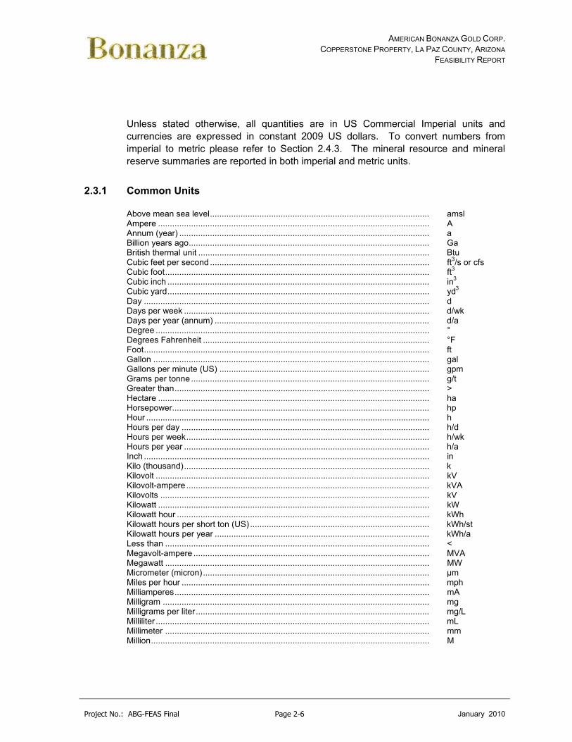
Unless stated otherwise, all quantities are in US Commercial Imperial units and currencies are expressed in constant 2009 US dollars. To convert numbers from imperial to metric please refer to Section 2.4.3. The mineral resource and mineral reserve summaries are reported in both imperial and metric units.
2.3.1 Common Units
Above mean sea level............................................................................................. amsl Ampere ................................................................................................................... A Annum (year) .......................................................................................................... a Billion years ago...................................................................................................... Ga British thermal unit .................................................................................................. Btu Cubic feet per second ............................................................................................. ft3/s or cfs Cubic foot................................................................................................................ ft3
Cubic inch ............................................................................................................... in3 Cubic yard............................................................................................................... yd3 Day ......................................................................................................................... d Days per week ........................................................................................................ d/wk Days per year (annum) ........................................................................................... d/a Degree .................................................................................................................... ° Degrees Fahrenheit ................................................................................................ °F Foot......................................................................................................................... ft Gallon ..................................................................................................................... gal Gallons per minute (US) ......................................................................................... gpm Grams per tonne ..................................................................................................... g/t Greater than............................................................................................................ > Hectare ................................................................................................................... ha Horsepower............................................................................................................. hp Hour ........................................................................................................................ h Hours per day ......................................................................................................... h/d Hours per week....................................................................................................... h/wk Hours per year ........................................................................................................ h/a Inch ......................................................................................................................... in Kilo (thousand)........................................................................................................ k Kilovolt .................................................................................................................... kV Kilovolt-ampere ....................................................................................................... kVA Kilovolts .................................................................................................................. kV Kilowatt ................................................................................................................... kW Kilowatt hour ........................................................................................................... kWh Kilowatt hours per short ton (US) ............................................................................ kWh/st Kilowatt hours per year ........................................................................................... kWh/a Less than ................................................................................................................ < Megavolt-ampere .................................................................................................... MVA Megawatt ................................................................................................................ MW Micrometer (micron)................................................................................................ µm Miles per hour ......................................................................................................... mph Milliamperes............................................................................................................ mA Milligram ................................................................................................................. mg Milligrams per liter................................................................................................... mg/L Milliliter .................................................................................................................... mL Millimeter ................................................................................................................ mm Million...................................................................................................................... M
AMERICAN BONANZA GOLD CORP. COPPERSTONE PROPERTY, LA PAZ COUNTY, ARIZONA
FEASIBILITY REPORT
Project No.: ABG-FEAS Final Page 2-7 January 2010
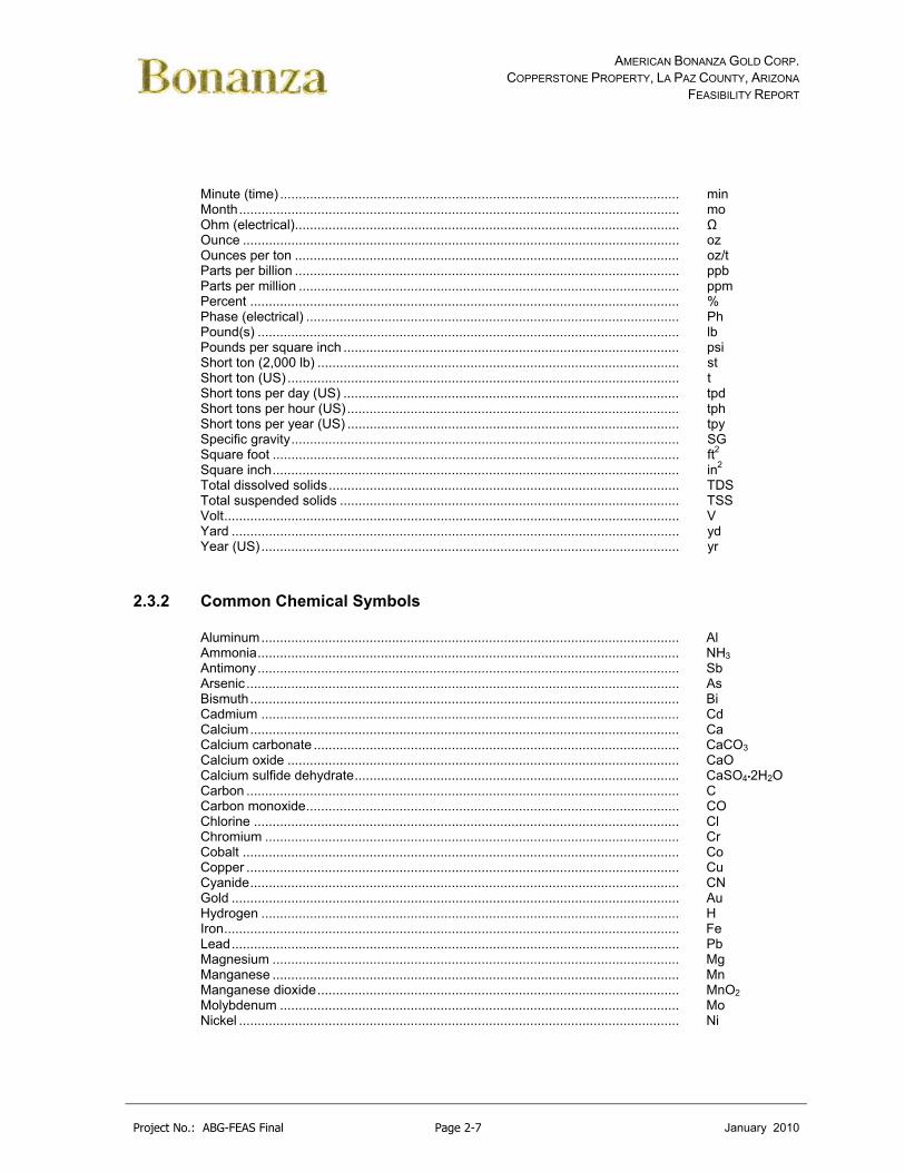
Minute (time) ........................................................................................................... min Month...................................................................................................................... mo Ohm (electrical)....................................................................................................... Ω Ounce ..................................................................................................................... oz Ounces per ton ....................................................................................................... oz/t Parts per billion ....................................................................................................... ppb Parts per million ...................................................................................................... ppm Percent ................................................................................................................... % Phase (electrical) .................................................................................................... Ph Pound(s) ................................................................................................................. lb Pounds per square inch .......................................................................................... psi Short ton (2,000 lb) ................................................................................................. st Short ton (US) ......................................................................................................... t Short tons per day (US) .......................................................................................... tpd Short tons per hour (US)......................................................................................... tph Short tons per year (US) ......................................................................................... tpy Specific gravity........................................................................................................ SG Square foot ............................................................................................................. ft2 Square inch............................................................................................................. in2 Total dissolved solids.............................................................................................. TDS Total suspended solids ........................................................................................... TSS Volt.......................................................................................................................... V Yard ........................................................................................................................ yd Year (US)................................................................................................................ yr
2.3.2 Common Chemical Symbols
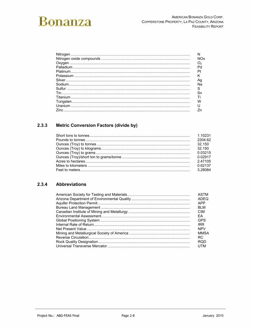
Aluminum................................................................................................................ Al Ammonia................................................................................................................. NH3 Antimony................................................................................................................. Sb Arsenic.................................................................................................................... As Bismuth................................................................................................................... Bi Cadmium ................................................................................................................ Cd Calcium................................................................................................................... Ca Calcium carbonate .................................................................................................. CaCO3 Calcium oxide ......................................................................................................... CaO Calcium sulfide dehydrate....................................................................................... CaSO4•2H2O Carbon .................................................................................................................... C Carbon monoxide.................................................................................................... CO Chlorine .................................................................................................................. Cl Chromium ............................................................................................................... Cr Cobalt ..................................................................................................................... Co Copper .................................................................................................................... Cu Cyanide................................................................................................................... CN Gold ........................................................................................................................ Au Hydrogen ................................................................................................................ H Iron.......................................................................................................................... Fe Lead........................................................................................................................ Pb Magnesium ............................................................................................................. Mg Manganese ............................................................................................................. Mn Manganese dioxide................................................................................................. MnO2 Molybdenum ........................................................................................................... Mo Nickel ...................................................................................................................... Ni
AMERICAN BONANZA GOLD CORP. COPPERSTONE PROPERTY, LA PAZ COUNTY, ARIZONA
FEASIBILITY REPORT
Project No.: ABG-FEAS Final Page 2-8 January 2010
Nitrogen .................................................................................................................. N Nitrogen oxide compounds ..................................................................................... NOx Oxygen ................................................................................................................... O2 Palladium ................................................................................................................ Pd Platinum.................................................................................................................. Pt Potassium ............................................................................................................... K Silver....................................................................................................................... Ag Sodium.................................................................................................................... Na Sulfur ...................................................................................................................... S Tin........................................................................................................................... Sn Titanium .................................................................................................................. Ti Tungsten................................................................................................................. W Uranium .................................................................................................................. U Zinc ......................................................................................................................... Zn
2.3.3 Metric Conversion Factors (divide by)
Short tons to tonnes................................................................................................ 1.10231 Pounds to tonnes .................................................................................................... 2204.62 Ounces (Troy) to tonnes ......................................................................................... 32,150 Ounces (Troy) to kilograms..................................................................................... 32.150 Ounces (Troy) to grams .......................................................................................... 0.03215 Ounces (Troy)/short ton to grams/tonne ................................................................. 0.02917 Acres to hectares .................................................................................................... 2.47105 Miles to kilometers .................................................................................................. 0.62137 Feet to meters......................................................................................................... 3.28084
2.3.4 Abbreviations
American Society for Testing and Materials............................................................ ASTM Arizona Department of Environmental Quality ........................................................ ADEQ Aquifer Protection Permit ........................................................................................ APP Bureau Land Management ..................................................................................... BLM Canadian Institute of Mining and Metallurgy ........................................................... CIM Environmental Assessment..................................................................................... EA Global Positioning System ...................................................................................... GPS Internal Rate of Return............................................................................................ IRR Net Present Value................................................................................................... NPV Mining and Metallurgical Society of America .......................................................... MMSA Reverse Circulation................................................................................................. RC Rock Quality Designation........................................................................................ RQD Universal Transverse Mercator ............................................................................... UTM
AMERICAN BONANZA GOLD CORP. COPPERSTONE PROPERTY, LA PAZ COUNTY, ARIZONA
FEASIBILITY REPORT
Project No.: ABG-FEAS Final Page 3-1 Janaury 2010
3.0 RELIANCE ON OTHER EXPERTS (ITEM #5)
The results and opinions expressed in this document are based on observations and discussions with American Bonanza personnel during site visits and the geological and technical data listed in the References. While the information has been carefully reviewed, all of the information provided by American Bonanza and their consultants are believed to be true and reliable.
The results and opinions expressed in this report are conditional upon the aforementioned technical and legal information being current, accurate, and complete as of the date of this report, and the understanding that no information has been withheld that would affect the conclusions made herein. The qualified personnel of this report reserve the right, but will not be obliged, to revise this report and conclusions if additional information becomes known subsequent to the date of this report. Areas where the opinions of other experts have been relied upon include the following:
An independent verification of the mining claim status was completed by DeConcini, McDonald, Yetwin, and Lacy. A review of the BLM LR2000 system confirmed that the American Bonanza claims were current for the Year beginning September 1, 2009. The document was reviewed along with confirmation from American Bonanza that receipts for BLM and AZ lands filing fees are available in their offices for review. There is no information to the contrary to believe that the mining claims and fee lands are not valid.
Mine resources were updated by Telesto Nevada Inc. in a report Titled - Copperstone NI 43-101 Technical Report for the Copperstone Project, La Paz County, Arizona, February 2, 2010. This report can be found on SEDAR.
Resource work contracted to Telesto, Inc. included resource update, review, and to identify any issues associated with the previous results and conclusions. Telesto’s qualified person for this project is Jonathan M. Brown.
Vezer International was contracted to develop a mine plan, mineral reserve, and identify issues associated with a new mine plan. Vezers mine plan was reviewed by Tom Buchholz of MarGeo, Inc.
Golder Associates’ (Golder, 2006) opinion for geotechnical parameters required to support mine design, such as opening geometry, orientation, and ground support requirements was reviewed and a Feasibility Level geotechnical report of the Copperstone mine plan was contracted to Call and Nicholas (CNI). Work recommendations by CNI are included in this report.
AMERICAN BONANZA GOLD CORP. COPPERSTONE PROPERTY, LA PAZ COUNTY, ARIZONA
FEASIBILITY REPORT
Project No.: ABG-FEAS Final Page 3-2 Janaury 2010
Water Management Consultants’ (WMC 2006) opinion with respect to hydrological issues such as water management philosophy and estimating ground water inflows for the mine was reviewed. Further work was contracted through Schlumberger Water Services to develop and review water quality, ARD, and support permitting.
The Center for Advanced Mineral Processing and Metallurgy of Montana Tech (CAMP) was contracted to review the metallurgy and independently test and verify the flotation and gravity recovery testwork.
A separate bat survey was commissioned through SWCA Environmental Consultants to identify potential bat issues from bats using the exploration decline.
Continental Metallurgical Services was contracted to review and identify the appropriate metallurgical requirements, identify and review the appropriate environmental considerations in conjunction with Schlumberger Water Services, and complete and exhaustive post tac economic review of the project.

AMERICAN BONANZA GOLD CORP. COPPERSTONE PROPERTY, LA PAZ COUNTY, ARIZONA
FEASIBILITY REPORT
Project No.: ABG-FEAS Final Page 4-1 Janaury 2010
4.0 PROPERTY DESCRIPTION AND LOCATION (ITEM #6)
The Copperstone Project is located in La Paz County, Arizona, approximately 9.5 miles north of the town of Quartzsite (See Figure 4.1). The property covers an area of approximately 8,239 acres located in Sections 18 to 22 of Township 6 North, Range 19 West (T6N, R19W) and Sections 1,2, 11 to 14, and 22 to 27 of Township 6 North, Range 20 West (T6N, R20W) Gila & Salt River Meridian (GSRM). American Bonanza also holds mineral leases totaling approximately 1,338 acres on state mineral lands in sections 6 and 7 of Township 7 North, Range 19 West (T7N, R19W) GSRM. The property is administered by the Bureau of Land Management.
4.1 Mineral Tenure and Agreements
4.1.1 Mineral Rights
The Copperstone property encompasses an area of approximately 8,239 acres (Figure 4-2). The property consists of 335 contiguous unpatented lode mining claims in Sections 18 to 22 of Township 6 North, Range 19 West (T6N, R19W) GSRM and Sections 1, 2, 11 to 14, and 22 to 27 of Township 6 North, Range 20 West GSRM (T6N, R20W). American Bonanza also holds 2 mineral leases (109953, 109954) totaling approximately 1,338 acres on state mineral lands in sections 6 and 7 of Township 7 North, Range 19 West (T7N, R19W) GSRM. The Department of Interior, Bureau of Land Management (“BLM”) administers public lands in the area of the Copperstone property under the Federal Land Policy and Management Act of 1976. The west side of the property borders the Colorado River Indian Tribes reservation.
Annual claim maintenance fees of $140 per claim are payable yearly by September 1st. All 335 mining claims are active with the current assessment paid though 1 September 2010. The La Paz County yearly tax has been paid on existing building and improvements on the Copperstone property.
A review of minerals claim validity completed by DeConcini, McDonald, Yetwin, and Lacy, 2006 was used regarding the validity of unpatented mining claims and title to fee lands (See Appendix A). American Bonanza reports that claims fees are up to date and receipts for BLM and Arizona lands filing fees are available at American Bonanza’s offices. The LR2000 reports for all mining claims are attached in Appendix A. Based on the review, the author of the feasibility have no reason to believe that the mining claims and fee lands are not valid.
The property was legally surveyed by Rob Berry of Land Management Services in Artesia, New Mexico.

AMERICAN BONANZA GOLD CORP. COPPERSTONE PROPERTY, LA PAZ COUNTY, ARIZONA
FEASIBILITY REPORT
Project No.: ABG-FEAS Final Page 4-2 Janaury 2010
Figure 4-1: Location Map of the Copperstone Property

AMERICAN BONANZA GOLD CORP. COPPERSTONE PROPERTY, LA PAZ COUNTY, ARIZONA
FEASIBILITY REPORT
Project No.: ABG-FEAS Final Page 4-3 Janaury 2010
Figure 4-2: Claim Map of the Copperstone Property
4.1.2 Agreements
The following section is adapted from (Pawlowski, 2005).
American Bonanza holds a 100% leasehold interest in the Copperstone Project. The landlord is the Patch Living trust and the lease is for 10-year term starting June 12, 1995 (See Appendix B). The Patch Living Trust receives an annual advance royalty payment of $30,000 over the 10-year term of the agreement. The lease is renewable by American Bonanza for one or more ten-year terms at American Bonanza’s option

AMERICAN BONANZA GOLD CORP. COPPERSTONE PROPERTY, LA PAZ COUNTY, ARIZONA
FEASIBILITY REPORT
Project No.: ABG-FEAS Final Page 4-4 Janaury 2010
under the same terms and conditions. Effective June 12, 2005, American Bonanza renewed the lease with the Patch Living Trust for an additional ten year term. American Bonanza is obligated to pay for all permitting and state lease bonding, insurance, and taxes.
The following is a chronology of American Bonanza property involvement:
In August 1998, American Bonanza entered into an agreement with Arctic Precious Metals Inc. (“Arctic”), a subsidiary of Royal Oak Mines Inc., to explore and develop the Copperstone gold property. Pursuant to this agreement, American Bonanza acquired a 25% interest in the Copperstone project for a cash payment of US$500,000 with an option to increase its interest in the property to 80% by incurring US$4,000,000 of exploration expenditures and other payments. In addition, American Bonanza continued to make the US$30,000 annual advance royalty payment to the property owner.
In November 1999, American Bonanza entered into a purchase and sale agreement with Arctic whereby American Bonanza agreed to purchase for US$1,000,000 all of Arctic’s right, title and interest in the Copperstone Project owned by Arctic who was undergoing US Bankruptcy Code Chapter 11 financial restructuring.
In June 2000, American Bonanza entered into an agreement (the D-Zone Joint Venture) with Centennial Development Corporation (“CDC”) for the underground exploration and extraction of mineralized materials from only the D-Zone of up to 50,000 tons of mineralized material at the Copperstone property. According to this agreement, American Bonanza assumed a 55% interest in the property as follows:
additional 5% interest if American Bonanza provides all funding necessary to complete Phase One as documented in the agreement (completed by American Bonanza in 2001)
a further 15% interest for a cash payment of US$500,000.
On 24 February 2002, American Bonanza entered into an agreement with CDC whereby it would acquire the remaining 40% of the D-Zone Joint Venture not already owned for the following considerations:
assumption of a total of US$325,000 of the Copperstone related liabilities and if these liabilities exceed the estimated amount then the additional amounts will be paid equally by CDC and American Bonanza
assumption of an estimated CDC payroll tax liability of up to US$180,000 and if above, then the amount to be equally paid by CDC and American Bonanza
US$345,000 payable to CDC and or its principal on or before 31 July 2002

AMERICAN BONANZA GOLD CORP. COPPERSTONE PROPERTY, LA PAZ COUNTY, ARIZONA
FEASIBILITY REPORT
Project No.: ABG-FEAS Final Page 4-5 Janaury 2010
a net smelter royalty of 3% paid to CDC from the first 50,000 tons of mineralized materials extracted from the D-Zone, following repayment of the Brascan loan agreement
US$70,000 from initial proceeds from extraction of mineralized materials from the D-Zone, following repayment of the Brascan loan agreement.
On 4 March 2002, upon approval of the US Bankruptcy court, American Bonanza completed the acquisition of the remaining 75% not already owned in the Copperstone property at the cost of US$1,000,000. This transaction was funded by loan of US$1,100,000 from Brascan Financial Corporation. On 29 October 2003, American Bonanza paid the final payment on the loan to Brascan Financial Corporation.
4.1.3 Royalties
Dan Patch Trust
The Dan Patch Trust royalty is a Production Gross Royalty based on the royalty schedule identified in Table 4-1. There is also an advanced royalty payment of $30,000 per year with the provision that such sum or sums can be recovered by the Lessee out of future production royalties that exceed the minimum payment.
During production on ground owned by the Patch Living trust, a production royalty is paid on the basis of all gold refined and/or sold from the property as follows.
Table 4-1: Production Royalty Schedule Royalty (GPR) Avg. LME Gold Price (month/oz)
1% < $350
2% $350 to $400.99
3% $401 to $450.99
4% $451 to $500.99
5% $501 to $550.99
6% >$551
The royalty shall be paid based on the Lessee’s receipts when it refines and/or sells the gold but is calculated each month and an estimated royalty will be paid to the owner within 30 days for the proceeding month’s production based on that month’s average daily gold price as published by the London Gold Exchange. See Appendix B for Dan Patch Trust Royalty Agreements.
Centennial Development Company

AMERICAN BONANZA GOLD CORP. COPPERSTONE PROPERTY, LA PAZ COUNTY, ARIZONA
FEASIBILITY REPORT
Project No.: ABG-FEAS Final Page 4-6 Janaury 2010
The Centennial Development Company royalty is a 3% Net Smelter Return royalty from the first 50,000 tons of mineralized material produced from the royalty property as identified in Figure 4.3. This shape has been digitized and identified within the mine software program to ensure proper payment during mining operations.
The net smelter return royalty is the gross revenues received from the production and sale of minerals from the royalty property less all of the charges and expenses paid by American Bonanza Gold for the processing, recovery, refining, smelting, freight, taxes and treatment of the minerals produced from the royalty property. See Appendix B for Centennial Development Company Royalty Agreements.
Figure 4-3: Centennial Development Company Lease Area
ROYALTY AREA IS CLOUDED SHAPE
1” – 250’

AMERICAN BONANZA GOLD CORP. COPPERSTONE PROPERTY, LA PAZ COUNTY, ARIZONA
FEASIBILITY REPORT
Project No.: ABG-FEAS Final Page 5-1 January 2011
5.0 ACCESSIBILITY, CLIMATE, LOCAL RESOURCES, INFRASTRUCTURE, AND PHYSIOGRAPHY (ITEM #7)
5.1 Accessibility
The Copperstone property is located on both Bureau of Land Management and State of Arizona Trust public land located approximately 9.5 miles north of Quartzsite in La Paz County, Arizona.
The site is accessed by traveling approximately 110 miles west from Phoenix, Arizona to the town of Quartzsite on Interstate 10 and approximately 9.5 miles north of Quartzsite on Arizona Highway 95. Upon reaching the mine road turn-off, the mine is located approximately 4 miles west of Highway 95. Driving time from Phoenix to the mine site is approximately two hours (See Figure 4-1).
All highways are suitable for legal load tractor/trailer transportation. The mine road is a compacted full width graveled road and is suitable for all mine transportation requirements.
The nearest town to the property is Quartzsite, Arizona with a permanent population of 3,354 (Census 2000 data).
5.2 Climate
5.2.1 Physiographic Setting
The topography of the project area is that of the American semi-desert and desert province typical of the Mojave, Colorado, and Sonoran deserts. This topography is characterized by extensive sandy desert plains, most gently undulating, from which isolated low mountains and buttes abruptly rise. At the site property, several small knolls and prominent longitudinal northeast trending sand dunes characterize the area. Surface elevations range from 725 to 900 feet above sea level with mountains to the Southwest approaching 1,300 feet above sea level.
5.2.2 Weather Station Data
The area is classified as a hot, dry desert where high wind conditions produce periods of naturally blowing sand with predominate wind conditions of north and south. Water resources in the region are derived from precipitation or from surface water recharge.

AMERICAN BONANZA GOLD CORP. COPPERSTONE PROPERTY, LA PAZ COUNTY, ARIZONA
FEASIBILITY REPORT
Project No.: ABG-FEAS Final Page 5-2 January 2011
The region is the driest area in the United States with large areas categorized as arid and semiarid.
Meteorological records for the immediate vicinity were obtained from the Quartzsite, Arizona weather station (Station Number – 026865) located approximately 9.5 miles to south of site at a latitude of 33.665 North and a longitude of 114.2272 West (See Appendix C). The elevation of this site is 898 feet above mean sea level (msl). This site is located at the same approximate elevation as the minesite and is located in the Tyson Wash water shed within a similar desert province.
A site located at Bouse, Arizona (Station Number – 020949) was also reviewed due to its location being approximately 22 miles to the east northeast. The Bouse site had similar temperature but slightly different precipitation and wind characteristics due to its near mountain location and higher elevation.
Other weather stations in the area include Ehrenberg, Ehrenberg 2, Blythe, Blythe CAA, Parker 6, and Parker Reservoir. All of these sites are further than 25 miles in distance from the Copperstone minesite.
Because of the similarities in sites to the Quartzsite station, the Quartzsite station was identified and used for climate data. Meteorological records have been kept at this station since 1908 and are complete with minimal missing data. Data identified in the following sections was taken from the Western Regional Climate Center.
5.2.3 Temperature
The region has hot summers and mild winters. The Copperstone site temperatures are estimated from 1908 to 2007 Quartzsite data with average minimum low temperatures usually occurring in December, averaging 37.6˚F with maximum daily high temperatures usually occurred in July, and averaging 108.3˚F. Approximately 176 days per year have temperatures over 90°F.
Average daily maximum temperature, April to October .........99.2°F
Extreme annual temperatures (Max) ...............................................................................124°F (Min) ................................................................................3°F
5.2.4 Precipitation
Water resources in the region are derived from precipitation or from surface water recharge. The region is the driest area in the United States and large areas are categorized as arid and semiarid. Annual precipitation generally is related to altitude of the land surface.

AMERICAN BONANZA GOLD CORP. COPPERSTONE PROPERTY, LA PAZ COUNTY, ARIZONA
FEASIBILITY REPORT
Project No.: ABG-FEAS Final Page 5-3 January 2011
Annual average precipitation for the Quartzsite area is estimated at approximately 5.1 inches (in) per year. Most of the precipitation recorded at the Quartzsite station fell relatively equally during the months of July through March with the most falling in August (0.83 inches). The months with the least recorded precipitation are April, May, and June with May recording less than 0.07 inches on average. In general, annual precipitation has been less than average for the past 10 years (1971 to 2001), resulting in drought conditions locally and regionally. Only minor snowfall, less than 0.1 inches on average, has been recorded at the Quartzsite weather station.
The 100-year 24-hour storm event for Copperstone is calculated using NOAA Point Precipitation Frequency estimates using NOAA atlas 14 and based on the Upper Bound of the 90% Confidence interval (See Appendix C). The estimated 100-year 24-hour storm event for the site is 4.32 inches.
5.3 Hydrology
5.3.1 Surface Water
The project is located in the Dome Rock Mountains. Specifically the project is northeast of Copper Mountain on the La Posa Plain. The project is located in one of the driest regions in the United States and is classified as arid and semiarid. The Colorado River which runs from North to South approximately 11 miles west of the project is the only river that flows through the area. No natural source of surface water at the site is readily available. No permanent streams or ephemeral drainages are present on the property. Surface drainage generally passes the property from the west and south in small unnamed arroyos and washes. The nearest significant surface drainage is Tyson Wash located 5 miles to the southwest. Annual average rainfall for the area is estimated at approximately 5.01 inches per year with August averaging 0.83 inches or approximately 17% of the rain for the year. No navigable waters as defined by the Army Corp of Engineers exist within the property.
5.3.2 Ground Water
The Copperstone Project is located within the La Posa Plain sub basin of the Parker groundwater basin. The La Posa Plain sub basin is an internal basin that is separated from direct impact by flow in the Colorado River (BLM 2006). Based on geological characteristics and hydrogeologic conditions, two water-bearing formations have been defined in the region, the Holocene-age Older Alluvium and the bedrock of the pediment. In the vicinity of the project, groundwater does not occur in the alluvium but rather occurs only within the underlying bedrock (CCGC 2006b).

AMERICAN BONANZA GOLD CORP. COPPERSTONE PROPERTY, LA PAZ COUNTY, ARIZONA
FEASIBILITY REPORT
Project No.: ABG-FEAS Final Page 5-4 January 2011
Groundwater underlying the site is typically found at depths that range from 550 to 870 feet MSL (Golder 1993). The ground water is typically located in bedrock, between 250 and 400 feet below the overburden-bedrock contact. At the monitoring well, which is located approximately 130 feet southeast of the southeast corner of the reclaim solution pond (See Figure 5-1), the depth to bedrock is 250 feet. Perched aquifers are not believed to be present in the project area. Groundwater level information is based on exploration drill holes in the open pit and surrounding project area.
The major water bearing units in the project area are the sand and gravel zones of the Bouse Formation. Five wells penetrate this strata 7 miles to the northeast and three project wells developed by the previous mine owner penetrate this strata approximately 4 miles east of the project. The nearest non-project wells are the 5 wells to the northeast of the site. Registered ownership indicates that they were drilled to provide water for livestock should a grazing permit be exercised.
The average depth of groundwater of three existing project wells is 514 feet MSL. Pump tests conducted on the project water supply investigation wells indicate that the water bearing units at these depths have a transmissivity of 49,000 gallons per day per foot width of aquifer.
Local groundwater flow direction at the Copperstone site is structurally and stratigraphically controlled and is projected to flow from the west to the east with some southward component. The local lateral and vertical movement of groundwater is controlled by lithologic and permeability changes that are related to depositional environment and geologic structure. Local gradients may be highly irregular (Golder 1993, CCGC 2006b).

AMERICAN BONANZA GOLD CORP. COPPERSTONE PROPERTY, LA PAZ COUNTY, ARIZONA
FEASIBILITY REPORT
Project No.: ABG-FEAS Final Page 5-5 January 2011
Figure 5-1: Piezometer and Water Well Location
5.3.3 Groundwater Quality
A monitoring well drilled by the previous owner intersects groundwater down gradient from the old reclaim solution pond. This well has been sampled quarterly since June 1998. Samples from the well have historically been analyzed for arsenic, barium, beryllium, cadmium, cyanide, chromium, fluoride, mercury, nitrite, nitrate, nickel, lead, antimony, selenium, and titanium, as required by the Aquifer Protection Permit (APP). The groundwater from the wells is sodium-sulfate type water.
All data collected from the monitoring well were compared to Arizona Water Quality Standards (AWQS) (where a standard exists) for characterization of ambient groundwater quality. Lead, cadmium, and fluoride concentrations have been detected in excess of AWQS. Lead concentrations did not exceed standards until the AWQS were recently dropped to the 0.015 mg/l action level. The lead level (0.02 to 0.04 mg/l) exceeds the action level in most sampling campaigns. The cadmium concentration exceeded AWQS once in January 2005. Fluoride concentrations, which range from 4.7 to 7.0 mg/L, although higher than the AWQS 4.0 mg/l, are considered ambient groundwater quality conditions. All other analytical results indicate constituent
ARIZONA HIGHWAY 95
MINE ROAD
N
1” – 5,000’
CYPRUS MONITORING WELL

AMERICAN BONANZA GOLD CORP. COPPERSTONE PROPERTY, LA PAZ COUNTY, ARIZONA
FEASIBILITY REPORT
Project No.: ABG-FEAS Final Page 5-6 January 2011
concentrations either lower than method detection limits (MDLs) or lower than the AWQS.
In general, the test results indicate the concentrations of constituents regulated by primary drinking water standards are less than the maximum contaminant levels for these constituents, with the exception of fluoride and lead.
5.3.4 Tyson Wash
Tyson Wash is one of several eastern-bank dry washes that enter the Colorado River in western Arizona. The Tyson Wash starts in a location approximately 20 miles south of Quartzsite and ends in a region on the eastern border of the Colorado River Indian Reservation approximately 20 miles northwest of Quartzsite along the Colorado River in the upper regions of the Imperial Reservoir Drainage. The main water course of the wash is located approximately 5 miles south of the mine site. The La Posa Plain on which the mine site is located, ultimately drains into the Tyson Wash.
The Tyson Wash is of importance in that Arizona Department of Environmental Quality (ADEQ) placed the Tyson Wash on the Water Quality Assurance Revolving Fund (WQARF) list in 2002 due to contamination to the wash by organic chemicals approximately 9.5 miles south of the project site. Several monitoring wells were placed downstream of the plume by WQARF to check for issues associated with the organic chemical contamination. The site has since been removed.
5.4 Local Resources and In-Place Infrastructure
The Copperstone deposit is favorably located across flat, sandy desert. A main line of the Santa Fe railroad passes to the north of the property.
Adjacent to the existing site access road, process water from existing site surface wells, and an existing overhead commercial power line is routed to the project site.
Existing site infrastructure includes an office building, warehouse/shop for mining surface equipment, laboratory building, change house, 10 trailer house hook-ups, septic system, and various shipping containers, a number of which act as secure storage for American Bonanza reverse circulation and diamond drill core logging boxes. Incoming commercial 69 kV overhead electrical power is delivered to a power substation located within 300 feet of the proposed processing site. Water is currently delivered from three water wells to an existing 375,000 gal storage tank located in the same area. The three water wells are covered under State of Arizona - Department of Water Resources registration numbers 55-514525, 55-514526, and 55-908563.

AMERICAN BONANZA GOLD CORP. COPPERSTONE PROPERTY, LA PAZ COUNTY, ARIZONA
FEASIBILITY REPORT
Project No.: ABG-FEAS Final Page 5-7 January 2011
Within a 35-mile radius of Copperstone, several communities including Parker and Quartzsite, Arizona and Blythe, California, are equipped to provide housing, shopping and schools for mine personnel and their families.
5.4.1 Office, Mine Shop, Warehouse/Shop and Laboratory
American Bonanza has opted to retain the office, shops, warehouse and laboratory buildings and shop support.
The complex will be located to the northwest and south of the process plant. See Figure 5.2 for the current infrastructure layout. Appendix D also contains pictures of the buildings currently on site.
This office facility will accommodate the accounting, purchasing, human resources, health and safety, and environmental personnel, as well as the general manager, the processing manager, the mine management and engineering staff. Senior mine and maintenance personnel will have offices in the mine shop. An office is included in the laboratory for the chief chemist.
New furnishings include all tables, desks, filing cabinets, etc. for the offices. Equipment includes computers and associated equipment.
The general and administrative offices will have both internal and external communication service.

AMERICAN BONANZA GOLD CORP. COPPERSTONE PROPERTY, LA PAZ COUNTY, ARIZONA
FEASIBILITY REPORT
Project No.: ABG-FEAS Final Page 5-8 January 2011
Figure 5-2: Ancillary Facilities
Office
The currently constructed administration building is approximately 1,950 sf and will house all the administrative and management personnel.
The administration building is a single story pre-engineered, prefabricated, multi-trailer building with corrugated metal roofing and siding located just north of the entrance to the plant, outside the fence line. Visitor parking will be provided outside the fence line at the office facilities. Employee parking will also be provided as necessary within the facilities area. This configuration will allow many of the site’s vendors and other visitors to access management and operating personnel without entering the process plant or mine area.
Mine Shop
The mine shop is a prefabricated steel construction butler type building with tin siding and is approximately 5,400 sf. Two-inch rolled fiberglass insulation covers the roof and walls with plywood around the base of the walls. The facility is located on the
MINE MAINTENANCE /TRUCK SHOP
ELECTRIC SUBSTATION
ADMINISTRATIVE BUILDING
WAREHOUSE LIGHT VEHICLE
REPAIR
LABORATORY CHANGE HOUSE
WATER TANK
FUEL STORAGE DISPENSING
EQUIPMENT WASH
MILL
LOCATION

AMERICAN BONANZA GOLD CORP. COPPERSTONE PROPERTY, LA PAZ COUNTY, ARIZONA
FEASIBILITY REPORT
Project No.: ABG-FEAS Final Page 5-9 January 2011
northwest side of the facilities area. Two truck bays, compressed air piping, welding equipment outlets, offices and a tool store are included. The Mine shop is a “drive- through” facility with rail placed in the floor to protect the concrete from tracked equipment. Maintenance on all heavy vehicles will be conducted in this shop.
Warehouse
The warehouse is located on the south end of the facilities area and is approximately 2,600 sf. The warehouse is a prefabricated steel construction building with tin siding. All project supplies, with the exception of process plant reagents, will be received, stored and dispersed from this facility. The facility includes inside storage for parts and supplies, an office and a tool crib/small parts area. A fenced storage yard south of the warehouse will be used to store large items or bulk materials which can withstand exposure to the elements. The outside storage areas will consist of a compacted, graveled area.
Most reagents and chemicals delivered to the project will be for use at the process plant or at the laboratory. These materials will be checked in at the main warehouse, then delivered to these facilities and will be stored there. An attached area to the new plant facility will provide storage of bulk reagents. The reagent storage and mixing area will have a truck ramp for bulk unloading.
The lubricants and oil storage will be located outside on the northeast side of the mine shop. These will be contained in lined, bermed areas that will drain to a central collection sump to contain any spills that may occur.
Light vehicles and small mobile equipment maintenance will be performed in the smaller shop attached to the warehouse. The area has reinforced concrete and an overhead crane.
Laboratory/Change House Area
The analytical laboratory is a single story pre-engineered building with corrugated roofing and siding located with the change house just east of the entrance to the plant. The laboratory is approximately 1,750 sf and consists of a sample preparation area, wet laboratory, fire assay metallurgical laboratory, environmental laboratory, offices, lunch room and restrooms. A 10-ft double door provides access at the north end of the building to receive materials into the sample preparation area.
The sample preparation area is isolated from the analytical laboratory by a wall. It will contain sample crushers, pulverizers, sample splitters, and a dust collection system to capture and contain any dust generated from this operation.

AMERICAN BONANZA GOLD CORP. COPPERSTONE PROPERTY, LA PAZ COUNTY, ARIZONA
FEASIBILITY REPORT
Project No.: ABG-FEAS Final Page 5-10 January 2011
The analytical laboratory will contain the wet laboratory, reagent storage area, balance rooms, and analytical equipment. Also included is a facility to collect and manage waste chemicals in the laboratory. Disposal of the chemical or laboratory wastes will follow appropriate regulatory requirements dependent upon the waste generated. Laboratory offices are also included in this facility.
The employee change house is a single story pre-engineered steel building with corrugated metal roofing and siding located with the laboratory building just to the east of the plant area, inside the fence line. Employees will park in the designated parking area inside the fence and walk about 50 ft to the change house. The Change House facility is approximately 1,750 sf. Separate changing rooms, with showers and bathrooms, will be provided for men and women.
The laboratory/dry area will be refurbished prior to use.
A full septic system capable of 1,500 gallons per day is in place.
Waste products from the laboratory will be generally compatible with the milling operation and will be returned to the milling circuit.
5.4.2 Other Necessary Infrastructure
Lube Oil Tank Farm
An outside area for lubricant storage will be located on the north of the Mine shop. This area will contain tanks or totes for engine oil, waste oil, hydraulic oil, gear oil and anti-freeze.
The lubricant storage area will be constructed with containment to prevent hydrocarbon contamination of the surrounding area. The storage areas will drain to a central collection sump where all spills will be collected.
Diesel Fuel/Gasoline Dispensing Area
Diesel fuel for the equipment fleet is to be located on the north of the Mine shop area outside the building on the old waste facility. Pumps and dispensers will be provided for fueling. A drive-through dispensing system will be provided for vehicles and for filling the fuel/lube truck. Two 115 m3 diesel storage tanks (30,000 gallons each) will be used to store diesel fuel.
The gasoline dispensing area is with the Diesel dispensing area.

AMERICAN BONANZA GOLD CORP. COPPERSTONE PROPERTY, LA PAZ COUNTY, ARIZONA
FEASIBILITY REPORT
Project No.: ABG-FEAS Final Page 5-11 January 2011
All fuel storage will be constructed with containment to prevent hydrocarbon contamination of the surrounding area. These storage areas will drain to a central collection sump where all spills will be collected.
Wash Bay
A contained concrete pad will be supplied for washing heavy and light vehicles. The wash station is located to the west of the mine shop and designed as a drive-through facility. Pressure washers and associated hoses/tanks will be provided. This pad will be sloped to the central collection area to prevent any contaminated solution from being discharged. A concrete sump designed to be emptied with a loader will be used to remove mud and material from the facility.
5.4.3 Explosives Storage
Separate magazines will be provided for blasting powder and detonator caps. The powder and cap magazine will be a provided by the blasting contractor and will meet all appropriate ATF requirements. The magazines will exceed code requirements and be separated by at least 200 ft with intervening separation berms.
The location of the magazines will be directly north of the current pit entrance next to the old west storage facility. This area is remote, and is shielded from the mill and admin areas to the south by a waste facility and from the pit traffic due to location near the waste dump.
One elevated ammonium nitrate silo, with 75 T capacity, will be located to the south of the mine entrance in a location that allows for easy loading and turnaround. This area is also convenient for the mine anfo trucks to fill up with ammonium nitrate and diesel before going to the mine. The ammonium nitrate and diesel are not mixed until ready to place in blast holes.
5.4.4 Power
The electrical power supply for the Project facilities is provided by Arizona Public Service Company (APS). APS is the main electric utility service provider for the entire facility.
The existing 69 kV power line was designed for a mill and heap leach facility of larger size and equipment and has sufficient line capacity for the new operation. The power line is owned by APS with a right-of-way permitted by the BLM for the power line corridor. An on-site substation is currently operational and set-up to the west of the planed mill site. Limited changes are expected to the current power supply system.
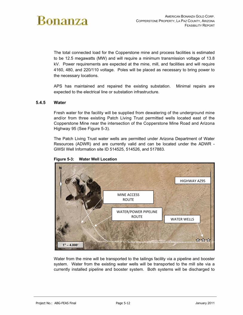
AMERICAN BONANZA GOLD CORP. COPPERSTONE PROPERTY, LA PAZ COUNTY, ARIZONA
FEASIBILITY REPORT
Project No.: ABG-FEAS Final Page 5-12 January 2011
The total connected load for the Copperstone mine and process facilities is estimated to be 12.5 megawatts (MW) and will require a minimum transmission voltage of 13.8 kV. Power requirements are expected at the mine, mill, and facilities and will require 4160, 480, and 220/110 voltage. Poles will be placed as necessary to bring power to the necessary locations.
APS has maintained and repaired the existing substation. Minimal repairs are expected to the electrical line or substation infrastructure.
5.4.5 Water
Fresh water for the facility will be supplied from dewatering of the underground mine and/or from three existing Patch Living Trust permitted wells located east of the Copperstone Mine near the intersection of the Copperstone Mine Road and Arizona Highway 95 (See Figure 5-3).
The Patch Living Trust water wells are permitted under Arizona Department of Water Resources (ADWR) and are currently valid and can be located under the ADWR - GWSI Well Information site ID 514525, 514526, and 517883.
Figure 5-3: Water Well Location
Water from the mine will be transported to the tailings facility via a pipeline and booster system. Water from the existing water wells will be transported to the mill site via a currently installed pipeline and booster system. Both systems will be discharged to
WATER/POWER PIPELINE ROUTE
HIGHWAY AZ95
1” – 4,000’
N
MINE ACCESS ROUTE
WATER WELLS

AMERICAN BONANZA GOLD CORP. COPPERSTONE PROPERTY, LA PAZ COUNTY, ARIZONA
FEASIBILITY REPORT
Project No.: ABG-FEAS Final Page 5-13 January 2011
the new reclaim water pond with the water from the pond filling the 35’ water tank located in the admin area.
Water will be supplied from the fresh/fire water tank to the facility by pump and level indicator. Fresh water will be distributed to:
gland seal water tank and by horizontal centrifugal pumps for seal water for mechanical equipment,
mill process tank for use points in the mill, and fire water distribution system in the mill site and admin areas.
Decant collected from the new reclaim pond, thickeners, and filtering circuit will be collected in the process water holding tank and recycled to the process circuit. Process water will also be pumped from the reclaim pond to the process water holding tank and will be distributed by pump and pipeline to mill usage points.
Drinking water will be set-up on a reverse osmosis system or trucked to the site using a local drinking water vendor.
5.4.6 Communications
An internal switchboard and telephone system will be provided for communications between the on-site offices in the main office, laboratory and mine shop area. Supervisors' and mechanics' vehicles and the process plant and crusher will be equipped with mobile radio units. Supervisors will be equipped with hand-held radios.
A satellite phone system will provide the project with external voice and data communications.
Cell phone communications are currently available on site using a local provider.
Hand held radio communication through FM radio communications is currently permitted.
5.5 General Sitework
5.5.1 Roads
The existing main access road to the site is Arizona Highway 95. It is a two-lane paved highway that connects the nearby towns of Parker and Quartzsite, Arizona.
The mine access road (approximately 4 miles) is an existing, well-traveled dirt road that terminates at the Copperstone mine.

AMERICAN BONANZA GOLD CORP. COPPERSTONE PROPERTY, LA PAZ COUNTY, ARIZONA
FEASIBILITY REPORT
Project No.: ABG-FEAS Final Page 5-14 January 2011
Several facility and in-pit roads will continue to be used to access all areas of the mine, plant and admin facilities.
The access road will be regularly maintained by the company and considered to be accessible year around.
5.5.2 Site Drainage
Diversion ditches are currently in place around the entire site and protect the surface facilities from damage due to rainfall runoff and to help control sediment runoff from previously disturbed areas of the project. No changes to these facilities are expected.
5.5.3 Fencing
The entire site including the mine area and waste dumps is fenced with barbed wire. A total of 45,000 feet of this fence is in place and requires minor maintenance. The main facilities are fenced using approximately 500 feet of 6-foot high chain link fence which ties into the barbed wire fence.
Standard 6-foot high chain link fence will be installed around the outside warehouse yard. A total of approximately 200 linear feet is required. Main access into the site will be through a controlled security checkpoint. There is no need for allowing through access to any other areas, so access to the project site will be restricted to those having business with the operation. Other security measures will include gates located on access roads that cross the fence boundaries.
The recovery plant building will be fenced. A 9-foot tall chain link fence will be used. A total of about 400 feet of this fence will be required.
5.6 Physiography
The project is located in the Dome Rock Mountains. Specifically the project is located northeast of Copper Mountain on the La Posa Plain. Topography in the area is flat to moderate, located on a dry, sandy terrain. Several small knolls and prominent longitudinal northeast trending sand dunes categorize the project area. Surface elevations range from 725 to 900 ft amsl.
5.6.1 Seismicity
The Arizona Department of Environmental Quality has published guidelines for mining project design criteria in the “Arizona Mining Guidance Manual, BADCT (Best Available Demonstrated Control Technology).” This manual sets forth recommendations for minimum standard design criteria with the interest of protecting the groundwater

AMERICAN BONANZA GOLD CORP. COPPERSTONE PROPERTY, LA PAZ COUNTY, ARIZONA
FEASIBILITY REPORT
Project No.: ABG-FEAS Final Page 5-15 January 2011
aquifers in the State of Arizona. Accordingly, the BADCT manual recommends design criteria for seismic hazards as follows:
The minimum design earthquake is the maximum probable earthquake (MPE). The MPE is defined as the maximum earthquake that is likely to occur during a 100-year interval (80% probability of not being exceeded in 100 years) and shall not be less than the maximum historical event. This design earthquake may apply to structures with a relatively short design life (e.g., 10 years) and minimum potential threat to human life or the environment.
Where human life is potentially threatened, the maximum credible earthquake (MCE) should be used. MCE is the maximum earthquake that appears capable of occurring under the presently known tectonic framework.
In accordance with these recommendations, two distinct levels of ground motion are defined for the Copperstone site: the MPE and the MCE. The MCE maximum ground acceleration expected at the mine site is 0.60 to 0.80g associated with a maximum credible earthquake of Intensity VIII-IX produced by a surface rupturing event along a local basin or range fault with a distance of 0 to 10 miles from the epicenter.
The MPE definition requires the larger of the maximum historical event, or one having a return period of approximately 448 years. It must correspond to the 80% probability of non-exceedance event in 100 years. The seismic hazard curve for the Copperstone site indicates that the 80% probability of a non-exceedance event in 100 years corresponds to a peak ground acceleration of 0.02 to 0.40g. This is based on a magnitude 8.0 earthquake on any fault in the San Andreas System, California with no ground rupture in La Paz County.
Being that the Copperstone project is located in northern La Paz county in an area of lower ground acceleration expectations, the MCE design peak ground acceleration (PGA) is estimated at 0.70g. The MPE design peak ground acceleration (PGA) is estimated at 0.30g. The ultimate design parameters should have a design peak ground acceleration of 0.70g.
The site seismicity study was based on work prepared by the Arizona Earthquake Information Center, Northern Arizona University, Flagstaff, Arizona – Titled – Earthquake Hazard Evaluation, La Paz County, Arizona, 1997.
5.7 Labor
The Copperstone Project is located in an unincorporated area of La Paz County, Arizona, approximately 9.5 miles north of the town of Quartzsite and 18 miles south of Parker. The project is located entirely within Bureau of Land Management or State of

AMERICAN BONANZA GOLD CORP. COPPERSTONE PROPERTY, LA PAZ COUNTY, ARIZONA
FEASIBILITY REPORT
Project No.: ABG-FEAS Final Page 5-16 January 2011
Arizona State surface lease controlled land. The Colorado River Indian Tribes Reservation is located approximately 1-2 miles to the west. The Colorado River Indian Tribes (CRIT) is located within the town of Parker.
5.7.1 Population Demographics
The area in and around the Project has limited to no population. The nearest population center is the town of Quartzsite approximately 9.5 miles to the south. Quartzsite was established in 1867 on the site of Fort Tyson. The Quartzsite area has a population as of the 2000 census of 3,354 people, 1,850 households, and 1,176 families residing in the town. The population density was 92.4 people per square mile (35.7/km²). There were 3,193 housing units at an average density of 87.8/sq mi (33.9/km²). The racial makeup of the town was 94.5% White, 0.2% Black or African American, 1.2% Native American, 0.3% Asian, 0.1% Pacific Islander, 2.6% from other races, and 1.19% from two or more races. Approximately 5.1% of the population was Hispanic or Latino of any race.
There were 1,850 households out of which 5.0% had children under the age of 18 living with them, 59.0% were married couples living together, 2.9% had a female householder with no husband present, and 36.4% were non-families. 31.5% of all households were made up of individuals and 19.1% had someone living alone who was 65 years of age or older. The average household size was 1.81 and the average family size was 2.18.
In the town of Quartzsite, the population was spread out with 5.7% under the age of 18, 1.8% from 18 to 24, 7.7% from 25 to 44, 29.9% from 45 to 64, and 54.9% who were 65 years of age or older. The median age was 66 years. For every 100 females there were 102.8 males. For every 100 females age 18 and over, there were 101.9 males.
The median income for a household in the Quartzsite was $23,053, and the median income for a family was $26,382. Males had a median income of $20,313 versus $16,080 for females. The per capita income for the town was $15,889. About 7.8% of families and 13.5% of the population were below the poverty line, including 20.3% of those under age 18 and 10.0% of those aged 65 or over.
Quartzsite has become a popular area for winter visitors with tourism being a major contributor to the Quartzsite economy. Some 1.5 million people are attracted to the area annually for various attractions associated with the winter visitors.
Other significant communities in the area include Parker, Arizona to the north and the Colorado Indian River Tribe to the west. The Colorado River Tribe currently has approximately 3,500 members of which a significant portion live in the Parker area.
AMERICAN BONANZA GOLD CORP. COPPERSTONE PROPERTY, LA PAZ COUNTY, ARIZONA
FEASIBILITY REPORT
Project No.: ABG-FEAS Final Page 5-17 January 2011
Parker was founded in 1871 on the Colorado Indian Reservation to serve the Indian Agency. As of the census of 2000, there were 3,140 people, 1,064 households, and 791 families residing in the town. The population density was 142.8 people per square mile (55.2/km²). There were 1,157 housing units at an average density of 52.6/sq mi (20.3/km²). The racial makeup of the town was 62.04% White, 1.88% Black or African American, 23.09% Native American, 0.86% Asian, 0.16% Pacific Islander, 7.45% from other races, and 4.52% from two or more races. Approximately 29.78% of the population is Hispanic or Latino of any race.
There were 1,064 households out of which 41.5% had children under the age of 18 living with them, 51.6% were married couples living together, 15.6% had a female householder with no husband present, and 25.6% were non-families. Approximately 20.6% of all households were made up of individuals and 8.4% had someone living alone who was 65 years of age or older. The average household size was 2.93 and the average family size was 3.38.
In the town of Parker, the population was spread out with 32.8% under the age of 18, 9.6% from 18 to 24, 25.4% from 25 to 44, 22.8% from 45 to 64, and 9.4% who were 65 years of age or older. The median age was 32 years. For every 100 females there were 93.9 males. For every 100 females age 18 and over, there were 88.4 males.
The median income for a household in Parker was $34,625, and the median income for a family was $37,663. Males had a median income of $26,542 versus $21,006 for females. The per capita income for Parker was $15,016. About 10.6% of families and 14.7% of the population were below the poverty line, including 18.2% of those under age 18 and 13.9% of those ages 65 or over.
In general, approximately 5,480 persons were employed in La Paz County, with an unemployment rate of 6.9 percent (Workforce.az 2008). The civilian labor force for the Town of Quartzsite was 633 persons, with an unemployment rate of 5.3 percent (Quartzsite, Arizona 2007). The median household income in 1999 was around $26,000 (BLM 2006). Low-income populations are present within La Paz County, with approximately 14 percent of households below the poverty threshold (BLM 2006), and within the Town of Quartzsite, with approximately 8 percent of families and 13 percent of individuals below the poverty threshold (BLM 2005).
5.7.2 Significant Employers
The primary economic activities and jobs in the area are provided by:
Government and government enterprises (2,362 full- and part-time workers in 2004),

AMERICAN BONANZA GOLD CORP. COPPERSTONE PROPERTY, LA PAZ COUNTY, ARIZONA
FEASIBILITY REPORT
Project No.: ABG-FEAS Final Page 5-18 January 2011
retail and services industries (retail trade; real estate, rental, and leasing services; arts, entertainment, and recreation; accommodation and food services; and other services) (about 1,700 full- and part-time workers in 2004), and
agriculture and related activities (619 full- and part-time workers in 2004) (BLM 2006).
Mining accounted for only 25 jobs in La Paz County in 1997, the last year for which employment data for mining were available (BLM 2006).
Tourism is the major contributor to the Town of Quartzsite’s economy. Retail and services sectors, in particular, benefit from visitors residing at numerous mobile home and trailer parks in the vicinity between October and March, as well as from other visitors year-round. Construction constitutes about 10 percent of employment in Quartzsite.
5.7.3 Environmental Justice
Executive Order (EO) 12898, Federal Actions to Address Environmental Justice in Minority Populations and Low-Income Populations, directs federal agencies to identify and address disproportionately high and adverse human health or environment effects of its programs, policies, and activities on minority and low-income populations. Executive Order (EO)13045, Protection of Children from Environmental Health Risks and Safety Risks, directs federal agencies to identify and address environmental health risks or safety risks that may disproportionately affect children.
Low-income populations are present within La Paz County and the Town of Quartzsite but not at levels (i.e., 10 percent over the national poverty level) that warrant their classification as such for purposes of environmental justice considerations (BLM 2006). Minorities constitute approximately 36 percent of the total population of La Paz County, which exceeds the state minority population by 10 percent, therefore meeting the standard for having a minority environmental justice population (BLM 2006).
The proposed site is located approximately 1 mile east of the eastern boundary of the CRIT Reservation. The CRIT economy is centered on agriculture, recreation, government, and light industry. In 2000, approximately 2000 people lived on the reservation. Approximately 27 percent of CRIT residents are below the poverty threshold. No children live in the vicinity of the project site. Children may occasionally approach the site during recreational excursions. The site is currently fenced with a security guard to discourage access.

AMERICAN BONANZA GOLD CORP. COPPERSTONE PROPERTY, LA PAZ COUNTY, ARIZONA
FEASIBILITY REPORT
Project No.: ABG-FEAS Final Page 5-19 January 2011
5.8 Archeological
Several archeological surveys have been conducted with the most recent being completed in 2006. The 2006 survey was initiated at the request of American Bonanza Gold Corporation as a requirement of the National Historic Preservation Act, the State Historic Preservation Act, and the land managing agencies and was conducted in anticipation of the development of the underground of the existing Copperstone Mine. The survey was completed on 934 acres surrounding the existing mine site to include areas of new drilling and potential expansion of the mine.
The survey was conducted under BLM Permit No. AZ-000114 and Arizona State Museum (ASM) permit No. 2005-012b1. The BLM was the lead agency on the project and work was conducted as BLM Cultural Resources Project Record BLM-AZ-320-2005-035. The BLM case file number associated with this project is AZA 32676. Archeological Reports will be identified and shown based on need.
In the 2006 Class III survey, 3 new archeological sites, 37 occurrences, and 6 isolated features were identified. The 3 sites were located on BLM land, 25 of the individual occurrences were located on BLM land with 12 individual occurrences located on Arizona State lands. Two sites previously reported, BLM AZ-050-1392 and 1393 lie within the project area but 1392 could not be found again due to wrong UTM coordinates and 1393 has been destroyed by previous mining activities prior to American Bonanza property control.
Based on the current project plans, the new operation is expected to operate in the currently disturbed mining and operations area with no new disturbance outside these areas expected other then potential core drilling. A review will be completed to identify if AZ R:3:5 was destroyed by previous mining activities. Care will be taken to ensure that AZ R:3:5 will be fenced and remain undisturbed by new operations if any remnants are found. A policy will also be developed outlining archaeological issues and their importance to the historical record and that collecting of antiquities by any employee within the project area will be strictly prohibited.
Table 5-1 identifies the archeological studies have been completed on the site
Table 5-1: Copperstone Archaeological History
YEAR REPORT REFERENCE SITES RECORDED
1984 Quillian, Patricia. Archaeological Survey of the Dunes
Project: Gold Field Mining, Northland Research, Flagstaff None
1986 Cyprus Metals Mining Operation Survey, BLM Project No.
103‐260‐86‐26 AZ R:3:4 (BLM AZ‐050‐1392), AZ R:3:5 (BLM AZ‐050‐1393)
1989 Rodgers, James B. An Intensive Archaeological Survey
North of Quartzsite, Arizona. Contract Archaeology Series 989‐16. Scientific Archaeological Services, Phoenix.
None

AMERICAN BONANZA GOLD CORP. COPPERSTONE PROPERTY, LA PAZ COUNTY, ARIZONA
FEASIBILITY REPORT
Project No.: ABG-FEAS Final Page 5-20 January 2011
2004
Ezzo, Joseph A., and James B. Harrison III. The Copperstone Mine Class III Cultural Resources Survey, La Paz, County, Arizona, SWCA Cultural Resources Report No. 04‐181. SWCA Environmental Consultants, Tucson.
AZ R:3:3 (ASM)
2006
Ezzo, Joseph A., and F. Michael O’Hara III. An Archaeological Survey of 934 Acres for the Bonanza Gold Mine Expansion Project, La Paz, County, Arizona, SWCA
Cultural Resources Report No. 05‐224. SWCA Environmental Consultants, Tucson.
AZ R:3:4 (ASM) AZ R:3:5 (ASM) AZ R:3:6 (ASM)
Isolated Occurrences
5.9 Waste Disposal
5.9.1 Hazardous Waste
Hazardous wastes, which will primarily involve waste oils, process reagents, and laboratory chemicals, will be disposed of in a safe and environmentally sound manner. Waste oils will be incinerated or recycled by the supplier, while most reagents and chemicals that require disposal will be used as part of flotation process.
Spills of such materials on site will be given the highest operating priority and will generally involve the excavation of contaminated soils, neutralization of the affected site, and disposal and/or neutralization of the affected soils on site or at a licensed facility off site. The mining equipment on site will be immediately available for use in such circumstances.
5.9.2 Sewage
Sewage disposal will be by means of the two currently installed septic tanks and leach fields. The septic system is installed at the main office and laboratory complex. The mine area will use portable toilet systems.
Liquid waste from the laboratory will be contaminated with various chemicals, and cannot be discharged to a drain field. It will be collected in the currently built concrete cesspool equipped with an automatic sump pump, by means of which it will be periodically pumped with the contents safely disposed of offsite in a legal and environmentally sound manner.
Floor drainage from the fueling and lube storage and pumping systems, and the wash-down area will be directed to a collection sump where an oil separator will be included to eliminate grease and oil prior to discharge of the water.
5.9.3 Solid Waste
Solid waste will be contracted to be removed on a weekly schedule to a permitted landfill.

AMERICAN BONANZA GOLD CORP. COPPERSTONE PROPERTY, LA PAZ COUNTY, ARIZONA
FEASIBILITY REPORT
Project No.: ABG-FEAS Final Page 5-21 January 2011
5.10 Transportation
Except for key management, employees (when possible) will be transported to and from the project site by company vans and/or buses to minimize any impacts from traffic to and from the project.
Employee transportation is included in General and Administrative operating costs.
Five half-ton pickups will be used for general and site transportation requirements of senior personnel. Non-mine support equipment includes a crane truck, Bobcat loader, two forklifts, a front end loader, maintenance truck and a welding truck.

AMERICAN BONANZA GOLD CORP. COPPERSTONE PROPERTY, LA PAZ COUNTY, ARIZONA
FEASIBILITY REPORT
Project No.: ABG-FEAS Final Page 6-1 January 2011
6.0 HISTORY (ITEM #8)
The history of the Copperstone project is adopted from MRDI (1999), MDA (2000), Pawlowski, (2005), AMEC (2006), and Telesto (2009).
6.1 Early History
The Copperstone property was first identified as a copper prospect in 1968. The first recorded activity on the property was from 1968 to 1980, when Charles Ellis of the Southwest Silver Company controlled the Continental Silver claim group (Salem, 1993).
In 1975, Newmont Mining leased the property, conducted a geophysical survey, and drilled a single hole in an unsuccessful attempt to outline weak porphyry copper mineralization.
In 1980, Southwest Silver Company drilled six rotary holes with unknown results and then dropped the claims.
Later in the same year, Dan Patch staked 63 Copperstone claims.
6.2 Cyprus
In 1980 Cyprus-Amoco (Salem, 1993) leased the property from Dan Patch and then purchased the Iron Reef Claim group from W. Rhea and added additional claims to expand the claim block to 284 claims. After initial field evaluation and sampling programs the Copperstone property was identified for potential gold mineralization (MDA, 2000).
Cyprus acquired a 100% working interest in the original 65 Copperstone claims, and expanded the holdings to 290 claims, and proceeded to outline broad areas of gold mineralization throughout the property. Drilling campaigns from 1980 to 1985 totaled over 400 reverse-circulation and 70 diamond drill holes and resulted in Cyprus compiling baseline economic studies, metallurgical testwork programs and financial analysis leading to mine construction in 1986.
The proposed open pit area was drilled off in 1986 and a decline was driven from the surface to a level approximately at current open pit bottom. In 1987 mine stripping and production commenced. Ore was treated at a rate of 2,500 tpd through a CIP milling operation. The Copperstone mine was designed, constructed, and operated as a zero discharge operation.

AMERICAN BONANZA GOLD CORP. COPPERSTONE PROPERTY, LA PAZ COUNTY, ARIZONA
FEASIBILITY REPORT
Project No.: ABG-FEAS Final Page 6-2 January 2011
Open pit mining continued into 1992 in accordance with original mining permits allowing mining to the groundwater table. In early 1993, mining was halted. Future underground mine plans were abandoned while the surface ore stocks were treated. Milling operations ceased in May 1993 and Cyprus removed all mine, mill equipment and most structures.
The mine was closed under the approvals from the Arizona Department of Environmental Quality Aquifer Protection Permit and the Bureau of Land Management. The mine and waste dump closure plan and reclamation study of surface disturbance associated with the mine was implemented and completed except for the reclaim pond in September 1998.
The reported production of the Copperstone mine was 447,000 oz of gold from 5,880,017 tons of ore grading 0.086 oz/t of gold (Salem, 1993). Ackerman (1998) reported production by Cyprus at Copperstone of 514,000 oz of gold from 5,600,000 Mt of ore grading 0.089 oz/t of gold.
6.3 Post Cyprus
Santa Fe Pacific Gold Corporation (Santa Fe) leased the property in 1993 and completed 12,500 ft of reverse circulation drilling on seven exploration targets. Santa Fe intersected significant gold mineralization in the footwall of the Copperstone fault with hole DCU-8 having an intercept assaying 0.646 oz/t of gold over 15 ft (Santa Fe, 1994).
In 1995, Royal Oak Mines leased the property from the Patch Living Trust and drilled 35 drill holes totaling about 25,875 ft between 1995 and 1997 (McCartney, 2000). The drill program concentrated on deep extensions of the mineralization in the Copperstone Fault to the north and down dip to the east of the open pit. Results showed several high-grade gold intersections to the north and east of the open-pit with potential for underground mining (McCartney, 2000).
In August of 1998, Asia Minerals entered into a joint venture with Royal Oak Mines to explore and develop the Copperstone property. During the summer of 1998, Asia Minerals drilled 15 holes with a total of about 10,050 ft of drilling completed. A series of drill holes within what was then termed the D-Zone showed relatively high-grade gold intersections.
In February of 1999, MRDI Canada and Golder Associates completed a scoping level evaluation of the Northwest High Grade Zone (C- and D-zones). MRDI estimated an Indicated resource of 892,200 tons averaging 0.32 oz/t gold and an Inferred resource of 1,193,700 tons averaging 0.354 oz/t gold. These historic resource estimates do not comply with CIM Definitions and Standards for Mineral Resources and

AMERICAN BONANZA GOLD CORP. COPPERSTONE PROPERTY, LA PAZ COUNTY, ARIZONA
FEASIBILITY REPORT
Project No.: ABG-FEAS Final Page 6-3 January 2011
Mineral Reserves (2005) and are provided herein for historic purposes only. MRDI also concluded that additional exploration potential existed, which might increase the resource in the B-, C-, and D-Zones, the northern strike extension of the Copperstone Fault, and in the footwall of the Copperstone Fault (MRDI, 1999).
In early 2000, Asia Minerals conducted additional diamond and reverse-circulation drilling with a total footage of 7,470 ft. The holes were designed to test the strike extension of the D-Zone with the best intercept in hole A00-10 which assayed 0.943 oz/t Au over 10.5 ft.
On 13 September 2000, Centennial Development Corp. of Salt Lake City, in joint venture with Asia Minerals, began an underground development and exploration decline from the north side of the Copperstone open-pit. The purpose of the northward decline was to test the higher-grade gold mineralization identified from drilling, provide underground drill stations for further exploration drilling, and possible extraction of bulk sample material. The planned length for the decline was 2,000 ft and permitting was obtained to remove up to 50,000 tons of material. A 64 lb high-grade sample was sent to the McClelland Labs in Sparks, Nevada for various metallurgical and milling tests. In 2000, Asia Minerals changed its name to American Bonanza Gold Mining Corp. to better reflect the geographic, metal, and grade focus of the company.
6.4 American Bonanza
On 26 October 2000, Mine Development Associates completed a report in compliance with National Instrument 43-101 on the Copperstone Property for American Bonanza. MDA visited the property, took samples, reviewed published and unpublished reports, and modified the exploration plan.
On 4 March 2002, American Bonanza announced that it had gained control of a 100% equity interest in Copperstone subject only to the royalty schedule payable to the Patch Living Trust and the agreement with Trilon Securities whereby Trilon will arrange a US$1.1 million secured credit facility for the company.
In November 2002, American Bonanza selected Merritt Construction of Kingman, Arizona to expand the underground development. The objective of extending the decline was to establish underground infrastructure for subsequent exploration and development programs.
On 5 May 2003, American Bonanza announced that significant high-grade gold exposed in the D-Zone was sampled in the decline. In June 2003, an underground drill station was completed and drilling began in July. By 17 May 2004, American Bonanza had drilled 33 underground core holes on the D-Zone with a total of 9,234 ft.

AMERICAN BONANZA GOLD CORP. COPPERSTONE PROPERTY, LA PAZ COUNTY, ARIZONA
FEASIBILITY REPORT
Project No.: ABG-FEAS Final Page 6-4 January 2011
Throughout 2004, American Bonanza conducted the D-Zone, Footwall, and High Wall drilling programs. The D-Zone drilling from underground drill bay number one was focused on estimation of measured and indicated resources in the D-Zone. The Footwall drill program targeted a fault below the main Copperstone fault. The High Wall drilling program focused on the area immediately north of the open-pit, to the southeast of the C and D-Zones.
In October 2004, American Bonanza retained certain specialized firms to assist it with collecting environmental, geotechnical, hydrological and metallurgical baseline data. The firms included Golder Associates Inc. to review geotechnical data; Water Management Consultants to assess hydrological characteristics and The Mine’s Group to provide input with overall project permitting of the Copperstone site.
In early January 2005, American Bonanza retained Michael R. Pawlowski and Thornwell Rogers to complete an updated Preliminary Assessment Report on the Copperstone Project. The report did not include an updated estimate of mineral resources since infill drilling was still ongoing.
In April 2005, American Bonanza commissioned AMEC to complete a Preliminary Assessment, including an updated resource estimate, preliminary mine plan, and preliminary economic analysis.
In 2006 and 2007, American Bonanza continued drilling the down strike and dip to further expand the deposit.
In April 2009, American Bonanza commissioned a Feasibility study including an updated resource estimate, mine plan, metallurgical review and economic analysis.
6.4.1 Historical Reserve and Resource Estimates
Resources have been periodically estimated by various operators and consultants since the discovery of mineralization at Copperstone in 1968. Mining by Cyprus at the Copperstone Mine ceased in 1993 and because of ongoing exploration, resource estimates have been generated to reflect the remaining in-situ resource. Four major reports have been written about Copperstone during post-mining exploration, three of which are NI 43-101-compliant. The first report, by MRDI Canada and Golder Associates, was written in 1999 and included a resource update that was not compliant with NI 43-101 standards and definitions. Two of the three NI 43- 101-compliant reports did not included updated resource estimates. The first NI 43-101-compliant report was completed in 2000 by MDA. It was a geological report, therefore, updating resource estimates was not within the scope of this report. The scope of the MDA report was stated as, “…a review of pertinent technical reports and data in the possession of American Bonanza relative to the general setting, geology, project
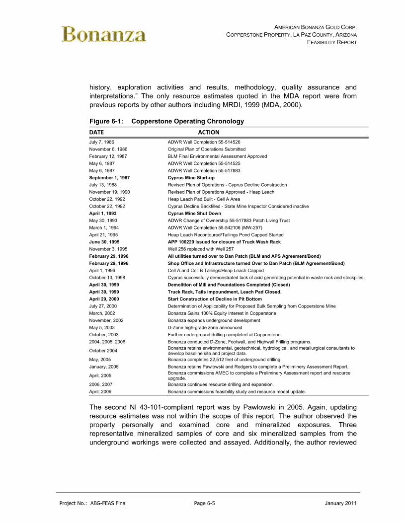
AMERICAN BONANZA GOLD CORP. COPPERSTONE PROPERTY, LA PAZ COUNTY, ARIZONA
FEASIBILITY REPORT
Project No.: ABG-FEAS Final Page 6-5 January 2011
history, exploration activities and results, methodology, quality assurance and interpretations.” The only resource estimates quoted in the MDA report were from previous reports by other authors including MRDI, 1999 (MDA, 2000).
Figure 6-1: Copperstone Operating Chronology
DATE ACTION
July 7, 1986 ADWR Well Completion 55-514526
November 6, 1986 Original Plan of Operations Submitted
February 12, 1987 BLM Final Environmental Assessment Approved
May 6, 1987 ADWR Well Completion 55-514525
May 6, 1987 ADWR Well Completion 55-517883
September 1, 1987 Cyprus Mine Start-up
July 13, 1988 Revised Plan of Operations - Cyprus Decline Construction
November 19, 1990 Revised Plan of Operations Approved - Heap Leach
October 22, 1992 Heap Leach Pad Built - Cell A Area
October 22, 1992 Cyprus Decline Backfilled - State Mine Inspector Considered inactive
April 1, 1993 Cyprus Mine Shut Down
May 30, 1993 ADWR Change of Ownership 55-517883 Patch Living Trust
March 1, 1994 ADWR Well Completion 55-542106 (MW-257)
April 21, 1995 Heap Leach Recontoured/Tailings Pond Capped Started
June 30, 1995 APP 100229 Issued for closure of Truck Wash Rack
November 3, 1995 Well 256 replaced with Well 257
February 29, 1996 All utilities turned over to Dan Patch (BLM and APS Agreement/Bond)
February 29, 1996 Shop Office and Infrastructure turned Over to Dan Patch (BLM Agreement/Bond)
April 1, 1996 Cell A and Cell B Tailings/Heap Leach Capped
October 13, 1998 Cyprus successfully demonstrated lack of acid generating potential in waste rock and stockpiles.
April 30, 1999 Demolition of Mill and Foundations Completed (Closed)
April 30, 1999 Truck Rack, Tails impoundment, Leach Pad Closed.
April 29, 2000 Start Construction of Decline in Pit Bottom
July 27, 2000 Determination of Applicability for Proposed Bulk Sampling from Copperstone Mine
March, 2002 Bonanza Gains 100% Equity Interest in Copperstone
November, 2002 Bonanza expands underground development
May 5, 2003 D-Zone high-grade zone announced
October, 2003 Further underground drilling completed at Copperstone.
2004, 2005, 2006 Bonanza conducted D-Zone, Footwall, and Highwall Frilling programs.
October 2004 Bonanza retains environmental, geotechnical, hydrological, and metallurgical consultants to develop baseline site and project data.
May, 2005 Bonanza completes 22,512 feet of underground drilling.
January, 2005 Bonanza retains Pawlowski and Rodgers to complete a Preliminery Assessment Report.
April, 2005 Bonanza commissions AMEC to complete a Preliminery Assessment report and resource upgrade.
2006, 2007 Bonanza continues resource drilling and expansion.
April, 2009 Bonanza commissions feasibility study and resource model update.
The second NI 43-101-compliant report was by Pawlowski in 2005. Again, updating resource estimates was not within the scope of this report. The author observed the property personally and examined core and mineralized exposures. Three representative mineralized samples of core and six mineralized samples from the underground workings were collected and assayed. Additionally, the author reviewed

AMERICAN BONANZA GOLD CORP. COPPERSTONE PROPERTY, LA PAZ COUNTY, ARIZONA
FEASIBILITY REPORT
Project No.: ABG-FEAS Final Page 6-6 January 2011
available technical reports. The resource estimates listed in the Pawlowski report were from the 1999 MRDI report (Pawlowski, 2005).
The most recent 43-101-compliant report prior to this current report was executed by AMEC in 2006. Of the resource estimates that have been done post-mining, only the estimate performed by AMEC is NI 43-101-compliant. Table 6.1 summarizes the post-mining resource estimates that have been done at Copperstone. Details about each estimate are given below Table 6.1.
Table 6-1: Summary of Resource Estimates
6.4.2 MRDI - 1999
Several resource estimates have been done subsequent to the end of mining at the Copperstone Mine in 1993. Drilling has been completed by several operators during this period as outlined above. However, not all operators updated resources as a result of new drilling results. The first resource update that was done post-mining was performed by MRDI Canada and Golder Associates under contract to Asia Minerals in February 1999. The MRDI resources do not comply with CIM NI 43-101 definitions and standards for mineral resources and are shown for historical purposes only.
The total resource was separated into smaller individual resources (A, B, C and D) based on “grade, style, geometry and host stratigraphy”. The MRDI estimate only updated the C and D zones, whereas the A and B zones were not. Earlier resource
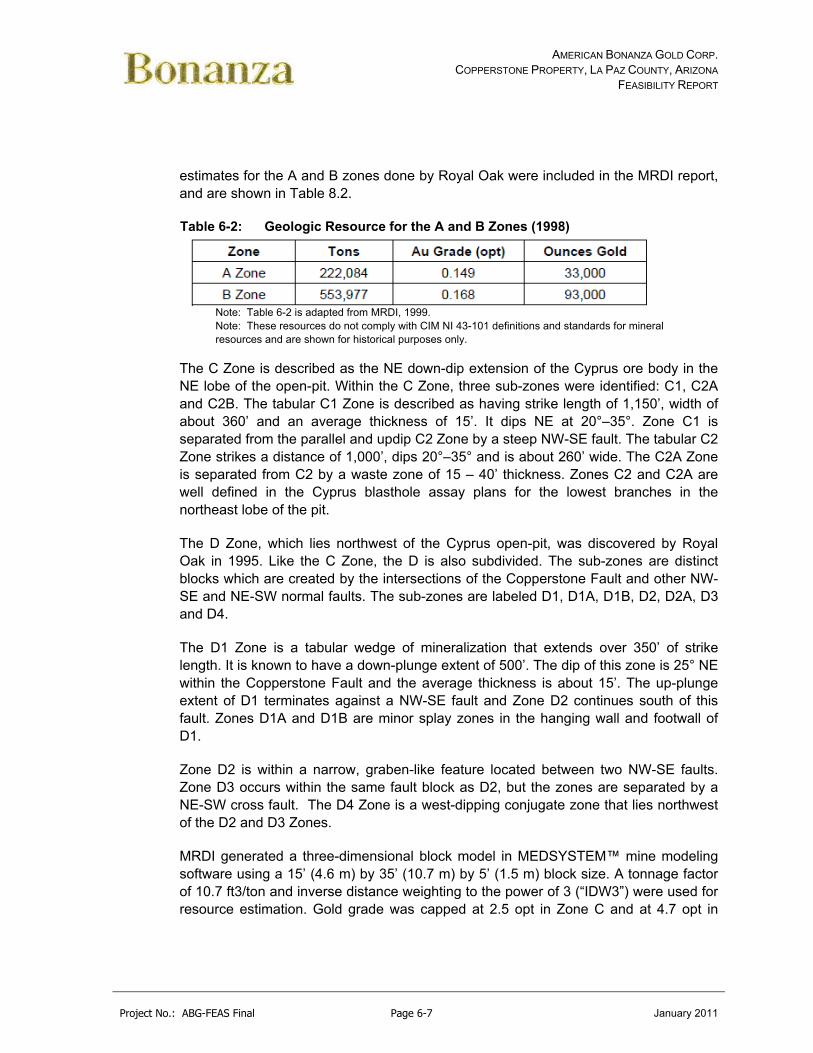
AMERICAN BONANZA GOLD CORP. COPPERSTONE PROPERTY, LA PAZ COUNTY, ARIZONA
FEASIBILITY REPORT
Project No.: ABG-FEAS Final Page 6-7 January 2011
estimates for the A and B zones done by Royal Oak were included in the MRDI report, and are shown in Table 8.2.
Table 6-2: Geologic Resource for the A and B Zones (1998)
Note: Table 6-2 is adapted from MRDI, 1999. Note: These resources do not comply with CIM NI 43-101 definitions and standards for mineral resources and are shown for historical purposes only.
The C Zone is described as the NE down-dip extension of the Cyprus ore body in the NE lobe of the open-pit. Within the C Zone, three sub-zones were identified: C1, C2A and C2B. The tabular C1 Zone is described as having strike length of 1,150’, width of about 360’ and an average thickness of 15’. It dips NE at 20°–35°. Zone C1 is separated from the parallel and updip C2 Zone by a steep NW-SE fault. The tabular C2 Zone strikes a distance of 1,000’, dips 20°–35° and is about 260’ wide. The C2A Zone is separated from C2 by a waste zone of 15 – 40’ thickness. Zones C2 and C2A are well defined in the Cyprus blasthole assay plans for the lowest branches in the northeast lobe of the pit.
The D Zone, which lies northwest of the Cyprus open-pit, was discovered by Royal Oak in 1995. Like the C Zone, the D is also subdivided. The sub-zones are distinct blocks which are created by the intersections of the Copperstone Fault and other NW-SE and NE-SW normal faults. The sub-zones are labeled D1, D1A, D1B, D2, D2A, D3 and D4.
The D1 Zone is a tabular wedge of mineralization that extends over 350’ of strike length. It is known to have a down-plunge extent of 500’. The dip of this zone is 25° NE within the Copperstone Fault and the average thickness is about 15’. The up-plunge extent of D1 terminates against a NW-SE fault and Zone D2 continues south of this fault. Zones D1A and D1B are minor splay zones in the hanging wall and footwall of D1.
Zone D2 is within a narrow, graben-like feature located between two NW-SE faults. Zone D3 occurs within the same fault block as D2, but the zones are separated by a NE-SW cross fault. The D4 Zone is a west-dipping conjugate zone that lies northwest of the D2 and D3 Zones.
MRDI generated a three-dimensional block model in MEDSYSTEM™ mine modeling software using a 15’ (4.6 m) by 35’ (10.7 m) by 5’ (1.5 m) block size. A tonnage factor of 10.7 ft3/ton and inverse distance weighting to the power of 3 (“IDW3”) were used for resource estimation. Gold grade was capped at 2.5 opt in Zone C and at 4.7 opt in

AMERICAN BONANZA GOLD CORP. COPPERSTONE PROPERTY, LA PAZ COUNTY, ARIZONA
FEASIBILITY REPORT
Project No.: ABG-FEAS Final Page 6-8 January 2011
Zone D. No cutoff grade was applied to the global geological resource estimate. Resources were reported by each sub-zone in the MRDI report, but a summary of the results of the estimation of Zones C and D are presented in Table 6.3. Only indicated and inferred resources were classified in this estimate; there were no measured resources.
Table 6-3: Geologic Resource for the A and B Zones (1998)
Drilling in the footwall of the Copperstone Fault was sparse as of the date of the MRDI report. Mineralization was encountered in three holes, but in some cases, the mineralization was up to 400’ below the pit floor. More drilling was recommended to test potential in the footwall.
6.4.3 AMEC – 2006
In April 2005, American Bonanza commissioned AMEC to prepare a NI 43-101-compliant Preliminary Assessment of the Copperstone Property. The scope of the report included updating the resource estimate with current drill data, preparing conceptual mining and processing plans, and developing preliminary economic analyses. After the MRDI report was completed in February 1999, subsequent drilling from 2003 and 2005 added 78 underground and 262 surface drillholes to the Copperstone database.
After verifying the drillhole database which was supplied by American Bonanza, AMEC capped high-grade assays prior to compositing to, “…limit undue influence of high grade assays on the resource…”. Assay histograms and probability plots were reviewed to determine the outlier population, which was determined to be 4.0 opt Au.

AMERICAN BONANZA GOLD CORP. COPPERSTONE PROPERTY, LA PAZ COUNTY, ARIZONA
FEASIBILITY REPORT
Project No.: ABG-FEAS Final Page 6-9 January 2011
Silver and copper grades were not capped prior to compositing. Bench composites of 6’ were generated for the purposes of grade interpolation.
Average density was determined for 262 samples from five American Bonanza diamond drillholes. The 262 samples represented eleven different rock types. Nine other rock types plus alluvium were not tested, but the nine untested rock units represented only 2.25% of the material. The eleven rock types were grouped into similar lithologies and a weighted average was calculated to assign densities to the various lithology groups, as shown in Table 6.4.
Table 6-4: Density Values Used in Copperstone Resource Domains, AMEC, 2006
1Average Density of packed sand as reported by www.simetric.co.uk and www.powderandbulk.com. 2 Assigned lowest measured rock group density of 2.66 g/cm3
Modeling was done using MineSight® software. Cell dimensions were 18’ (5.5 m) down-dip, 12’ (3.7 m) along-strike, and 6’ (1.8 m) high. Gold, silver and copper grades were estimated with ordinary kriging, but only gold grades were reported. Grade was only estimated in blocks which fell within a 0.03 opt Au shell which was generated from polygons on successive 70’ (21.3 m) cross sections.
Resources were calculated at two different cutoff grades, 0.05 opt Au and 0.15 opt Au. Believing that expansion of the existing open pit as the most likely scenario for resumption of mining at Copperstone, AMEC emphasized the results at 0.05 opt cutoff because it, “…represents mineralization that may have reasonable prospects for economic extraction at higher gold prices, economies of scale and the potential for extraction of mineralization from expansion of the existing open pit.” In the same report, AMEC also offered an estimate at a cutoff grade of 0.15 opt from a preliminary estimate of underground operating costs and a $425/ounce gold price. American Bonanza disclosed these resource estimates in a press release dated February 8, 2006. Results at 0.05 opt and 0.15 opt cutoffs are shown in Tables 6.5 and 6.6 respectively.

AMERICAN BONANZA GOLD CORP. COPPERSTONE PROPERTY, LA PAZ COUNTY, ARIZONA
FEASIBILITY REPORT
Project No.: ABG-FEAS Final Page 6-10 January 2011
Table 6-5: Gold Resources with Gold Cutoff of 0.05 opt, AMEC, 2006
Table 6-6: Gold Resources with Gold Cutoff of 0.15 opt, AMEC, 2006
Subsequent to the reporting of the two initial grade cutoffs (0.05 opt and 0.15 opt), a preliminary mineable resource was also reported at a 0.20 opt Au cutoff using the following preliminary estimates of mining costs applied to the resource:
Mining costs $40.52/t Processing costs $29.56/t General & administrative costs $12.95/t Recovery 90% Basis metal price $450/oz Au
Dilution and mining extraction parameters were also assumed and applied to this estimate, the results of which are shown in Table 6.7.
Table 6-7: Preliminary Minable Gold resource with Gold Cutoff of 0.20 opt, AMEC, 2006

AMERICAN BONANZA GOLD CORP. COPPERSTONE PROPERTY, LA PAZ COUNTY, ARIZONA
FEASIBILITY REPORT
Project No.: ABG-FEAS Final Page 7-1 January 2011
7.0 GEOLOGICAL SETTING (ITEM #9)
The regional and local geology is adapted from (Pawlowski, 2005) and AMEC (2006). The author has reviewed the data and concurs with the following descriptions.
7.1 Regional Geology
The Copperstone property is located in the northern Moon Mountains, regionally within the Basin and Range province of western Arizona (Figure 7-1). The Moon Mountains are located in the westernmost exposure in Arizona of the regional Whipple-Buckskin-Rawhide detachment system and centrally located within the Maria fold and thrust belt (Spencer and Reynolds).
Figure 7-1: Copperstone Area – Regional Geology (Pawlowski, 2005)

AMERICAN BONANZA GOLD CORP. COPPERSTONE PROPERTY, LA PAZ COUNTY, ARIZONA
FEASIBILITY REPORT
Project No.: ABG-FEAS Final Page 7-2 January 2011
The middle Tertiary tectonic activity in Arizona was dominated by widespread normal faulting and fault-block rotation that accommodated major northeast to southwest and east-northeast to west-southwest crustal extension (Spencer and Reynolds, 1989). Movement occurred on low to high-angle normal faults, and many high-angle normal faults are known or suspected to be truncated downward by, or to flatten downward and merge with major detachment faults (Spencer and Reynolds, 1989). Detachment faults in Arizona have several to several tens of kilometers of displacement and are the most important structural features of mid-Tertiary age in the Basin and Range Province.
In most cases, the upper-plate rocks above major detachment faults are tilted in one direction, toward the breakaway fault and opposite to the direction of upper-plate displacement. The lower-plate, mylonitic rocks are typically plutonic and high-grade metamorphic rocks exposed in domal uplifts termed “metamorphic core complexes.”
7.2 Local Geology
The Moon Mountains are comprised, from oldest to youngest, of the following rock types (Figure 7-2): Precambrian gneiss, schist, and amphibolites; Paleozoic metavolcanics and metasediments; Jurassic quartz syenite and quartz latite porphyry; Tertiary granite (Copper Peak), biotite granite, hornblende biotite granite; and Tertiary basalt (Knapp, 1989). Buising (1988) identified outcrops of the upper Miocene to lower Pliocene Bouse Formation at Moon Mountain.
The Moon Mountain detachment fault is exposed in the northern Moon Mountains about 1.5 miles south of the Copperstone property. The detachment fault strikes easterly and dips shallow to the northeast. Ductile fabrics display a consistent top-to-the-northeast sense of shear in the footwall biotite granites of early Miocene age (Knapp, 1989).
The Moon Mountain detachment fault displays upper plate Paleozoic, Mesozoic, and Tertiary age brittle rocks over lower plate, ductile deformed, granitic units.
The top of the lower plate is brecciated Copper Peak granite showing a tectonic fabric characterized by flattened, stretched quartz grains and deformed potassium feldspar (Knapp 1989). The Jurassic quartz latite porphyry host to much of the Copperstone mineralization is inferred by Knapp (1989) based on intrusive relations, to be older than the Tertiary age Copper Peak granite. The Copper Peak granite is intruded by a biotite granite dated by U-Pb zircon as early Miocene (20.8+ 3.2 million years) in age (Knapp 1989). The mylonitic biotite granites are intruded by hornblende biotite granite.

AMERICAN BONANZA GOLD CORP. COPPERSTONE PROPERTY, LA PAZ COUNTY, ARIZONA
FEASIBILITY REPORT
Project No.: ABG-FEAS Final Page 7-3 January 2011
Figure 7-2: Copperstone Area – Local Geology (Pawlowski, 2005)
The Moon Mountains show a complex history of deformation, metamorphism, and magnetism that typifies much of the Mojave-Sonoran desert (Table 7-1).

AMERICAN BONANZA GOLD CORP. COPPERSTONE PROPERTY, LA PAZ COUNTY, ARIZONA
FEASIBILITY REPORT
Project No.: ABG-FEAS Final Page 7-4 January 2011
Table 7-1: Principle Geological Events in the Copperstone Area
Age Event
mid-late Tertiary Basin and range normal extensional faulting.
mid-Tertiary Detachment faulting, mineralization, metamorphism and formation of metamorphic core complexes.
late Cretaceous Intrusion of plutons, folding and thrust faulting of Maria Belt.
Triassic-Jurassic Volcanic-plutonic rocks, thick clastic sequences.
Paleozoic Carbonate and clastic sedimentation, erosion, development of unconformity.
Precambrian Metamorphic rocks, accompanying intrusions.
The major structure in the southern Moon Mountains is the Mesozoic Valenzuela thrust fault (Figure 7-2). The Valenzuela thrust fault dips moderately southeast and movement on the thrust was multi-staged, with apparent evidence of south and north directed phases of movement (Knapp, 1989). Late Cretaceous thrusting at the Valenzuela thrust resulted in Jurassic quartz syenites and Precambrian gneisses/schists overlying deformed Paleozoic sediments metamorphosed to the lower amphibolite facies.
7.3 Copperstone Stratigraphy
The Copperstone gold mineralization lies in the hanging wall of the Moon Mountain detachment fault, which has not been penetrated in drilling to date. The stratigraphy in the pit and from drilling consists of Triassic sediments, Jurassic volcanic rocks and Miocene breccias, and basalt flows.

AMERICAN BONANZA GOLD CORP. COPPERSTONE PROPERTY, LA PAZ COUNTY, ARIZONA
FEASIBILITY REPORT
Project No.: ABG-FEAS Final Page 7-5 January 2011
Table 7-2: Detailed Stratigraphy of the Copperstone Pit Area
Age Name Description
Early Miocene
Basalt Basalt to andesite. Cut by mineralized amethyst-quartz-specularite veins to the SW of the pit where economic mineralization developed.
Early Miocene
Monolithic Breccia (MSB)
Monolithic fragments derived from Jurassic QLP. Locally developed above the Copperstone fault. Hematization and quartz-specularite mineralization. Contains economic gold mineralization. A sub-aerial sedimentary unit (Chaotic breccia?)
Jurassic Quartz Latite Porphyry (QLP)
Volcanic flows with well-developed metamorphic foliation. The principle ore host in the pit where it occurs in both the hanging wall and footwall of the Copperstone Fault. Where cut by the Copperstone Fault, a breciatted and mineralized interval about 15 m thick is developed. A minimum thickness of 275 m is postulated by drilling.
A fining upwards sedimentary cycle; quartzite, chlorite schist (siltstone) and marble (limestone). The principle host rocks for D-Zone.
Marble or limestone (LST) occurs at the top of the meta-sediments. It contains intervals of massic specular hematite ± manganese oxide and secondary Cu minerals as veins and in nodular replacements. The mineralization and brecciation observed in the unit is related to the Copperstone Fault.
Triassic Meta-sediment Unit
Quartzite (QTZ) is present in the D-Zone area at the base of the meta-sediment package. Characterized by vein and stockwork stringer mineralization.
Triassic Phyllite (PHY)
Phyllite is the oldest exposed unit in the upper plate and up to 90 m thick in drill holes. Phyllite only has only been recognized in the footwall of the Copperstone Fault in the north part of the pit and in D-Zone and C-Zone drill holes.
The Triassic age metasediments display a fining upwards cycle of quartzite, chlorite schist and marble, exposed in widths up to 100+ ft north of the pit. These meta-sediments occur as the principal mineralized host of the D-Zone (MRDI, 1999). These chloritic to calcareous phyllites show microfolds, local silicification and sercitization, local carbonate veins, and sparse quartz veinlets. These metasediments are thought to be 240 million year old metamorphosed sedimentary rocks correlative to the Triassic Buckskin Formation (Spencer, 1988).
The quartzite unit, typically at the base of the metasedimentary package, is comprised of quartz with minor biotite and chlorite. Various geologists have interpreted this unit

AMERICAN BONANZA GOLD CORP. COPPERSTONE PROPERTY, LA PAZ COUNTY, ARIZONA
FEASIBILITY REPORT
Project No.: ABG-FEAS Final Page 7-6 January 2011
as a silicified carbonate, metamorphosed siliciclastic, or a recrystallized chert (MDA, 2000).
The chlorite schist unit generally occurs at the quartzite-marble transition or interbedded within the marble unit. This epiclastic rock is composed of segregated bands formed with chlorite, quartz and minor muscovite and biotite. Associated with the chlorite schist are carbonate veinlets; quartz-specularite as replacements and open-space fillings; and earthy hematite replacing specularite.
Marble occurs at the top of the metasedimentary package associated with intervals of massive specular hematite+manganese oxides, and copper oxide veins and replacements.
In thin section, the marble is comprised of equigranular granoblastic mosaics of calcite with minor siderite-ankerite (Salem, 1993). The unit is interpreted as a sedimentary limestone unit on the basis of its weak bedding feature, interbeds of silty material, and the relationship to an underlying quartzite-siltstone sequence in a fining-upward pattern (MDA, 2000).
The Jurassic quartz latite porphyry unit is a volcanic flow with well-developed metamorphic foliation (MRDI, 1999). Microscopically, the quartz latites are holocrystalline and porphyritic with phenocrysts of quartz, k-feldspar, plagioclase, biotite, and magnetite (Salem, 1993). The quartz latite porphyry unit is the principal ore host in the pit where it occupies both the hanging wall and footwall of the Copperstone fault. Salem (1993) suggests that the Jurassic quartz latite porphyry may be correlated to the Jurassic Planet volcanics of the Rawhide-Buckskin Mountain by their lithologic similarities and consistent stratigraphic position above the Triassic Buckskin Formation equivalent. Furthermore, Reynolds (1987) reports an age of 162 to 150 million years by U-Pb analyses on zircon from the Planet Wash volcanics in the Planet Mineral Hill area, which is similar to the age of 138 to 205 million year bracket for the quartz latite porphyry by Spencer (1988).
The monolithic sedimentary breccias at Copperstone are derived from the quartz latite porphyry and similarly observed near Copper Peak by Spencer (1988). These breccias are interpreted as sub-aerial sedimentary units deposited in basins developed during the regional development of the Moon Mountain detachment fault. The breccias are interpreted as Tertiary in age from lithology and clast composition and comparison with other sediments of known Tertiary age (Spencer, 1988, Knapp, 1989). The breccias are comprised of angular to subangular, pebble to cobble sized fragments with a matrix composed of smaller crushed rock material. Strong hematite occurs in along fractures and filling open-spaces. Quartz and quartz-specularite veins cut the breccias that often host gold mineralization at Copperstone. Tertiary basalt is the youngest unit at Copperstone and is reported from drill holes to be up to 450 ft in thickness. The basalts

AMERICAN BONANZA GOLD CORP. COPPERSTONE PROPERTY, LA PAZ COUNTY, ARIZONA
FEASIBILITY REPORT
Project No.: ABG-FEAS Final Page 7-7 January 2011
are red brown to black and hypo- to holo- crystalline with phenocrysts of plagioclase, olivine, clinopyroxene, hornblende and magnetite. Calcite and high-temperature quartz often occur in amygdules in the basalts. Figure 7.3 shows the stratagraphic column as identified above.
Figure 7-3: Copperstone Area – Stratagraphic Column (Pawlowski, 2005)
7.4 Copperstone Structure
The brecciated Copperstone fault is the principal host for gold mineralization on the Copperstone property. The Copperstone fault strikes about N 30 to 60 W and dips from 20 to 50 NE. The brecciated fault zone ranges from 45 ft to 180 ft in width with

AMERICAN BONANZA GOLD CORP. COPPERSTONE PROPERTY, LA PAZ COUNTY, ARIZONA
FEASIBILITY REPORT
Project No.: ABG-FEAS Final Page 7-8 January 2011
characteristic fault gouge, multi-phase breccia textures, shear fabric, and intense fracture sets across this width (MDA, 2000) (Figure 7.4).
Figure 7-4: Copperstone Area – General Geologic Map (Pawlowski, 2005)

AMERICAN BONANZA GOLD CORP. COPPERSTONE PROPERTY, LA PAZ COUNTY, ARIZONA
FEASIBILITY REPORT
Project No.: ABG-FEAS Final Page 7-9 January 2011
Cyprus geologists interpreted the Copperstone fault as a conformable, inter-formation volcanic breccia between the contact of quartz-latite tuff and massive quartz latite footwall rocks. American Bonanza and Salem (1993) note that the volcanic breccias are not conformable and that the Copperstone fault is a listric splay of the Moon Mountain detachment. This is further supported in that the distribution of gold mineralization in the D-Zone suggests that the Copperstone Fault is gently refracting across a structurally complex sedimentary package (MDA, 2000).
Locally the upper D-Zone is localized along a siltstone-carbonate contact changing down dip as it transgresses up to follow the volcanic-carbonate contact. Mineralization associated with the upper limestone contact shows pervasive hematite/specularite, replaced limestone, often in parallel mineralized fault slivers (MDA, 2000).
Cyprus and Bonanza geologists have mapped several mineralized NW faults, sub-parallel to the Copperstone fault, in the pit area. The NW striking faults dip steeply northeast from 70 to 80 and locally control mineralization.
A dominant northeast-striking fault zone offsets the mineralized Copperstone fault zone at the south end of the pit. The mineralized Copperstone fault is offset about 270 ft with left-lateral movement having a dip-slip component as interpreted by Bonanza geologists. This northeast-striking fault dips steeply northwest and contains angular quartz-latite porphyry fragment in a poorly consolidated sandy gouge over an approximately 45 ft thickness (MDA, 2000).
A massive, cataclastic breccia zone was observed in the north end of the drill grid and throughout the length of drill holes A98-12, C97-25, and C97-31 (MDA, 2000).
A northeast striking fault extends into this area but the extensive area with cataclastic rocks cannot be explained by faulting alone. Furthermore, logging of the fragment and matrix composition show that the sediment-volcanic contact can be traced into the breccia without significant displacement.
AMERICAN BONANZA GOLD CORP. COPPERSTONE PROPERTY, LA PAZ COUNTY, ARIZONA
FEASIBILITY REPORT
Project No.: ABG-FEAS Final Page 8-1 January 2011
8.0 DEPOSIT TYPES (ITEM #10)
Gold mineralization on the Copperstone property is detachment fault related and is described by Singer and Cox (1986) model 37b, Descriptive Model of Gold on Flat Faults and by Spencer, Duncan, and Burton, The Copperstone Mine, Arizona’s New Gold Producer (See Appendix E). The Arizona Bureau of Geology and Mineral Technology also described the Copperstone Mine in Fieldnotes, Volume 18, No.2 (See Appendix E).
MDA (2000) summarized the detachment fault model as follows.
Mineral deposits related to detachment faults typically contain iron, manganese and copper oxides, and/or sulfides with quartz, calcite, barite, fluorite, and gypsum in dilatent structures resulting from fault movement. A chlorite envelope is commonly co-planar to the fault and has lesser amounts of epidote and sericite. Potassic alteration is generally present, but not necessarily associated with mineralization. Mineralization is syntectonic, as indicated by polyphase deformation of the epithermal minerals. Plunging undulations in the detachment surface may exert control on mineralization.
Detachment faulting is generally protracted and episodic in nature. The faulting creates intense brecciation, up to hundreds of meters thick, above and below the detachment surface. The brecciation provides permeability, which along which tangential listric and high angle inter-plate faults provide the locus of mineralization. Open space filling is the dominant mineralization type, with important but lesser amounts of reactive rock replacement-style mineralization. Both syn- and post-orogenic mineralization can occur at the same site. The mineralizing fluids are believed to be high-salinity brines migrating up dip from syn-orogenic basins.

AMERICAN BONANZA GOLD CORP. COPPERSTONE PROPERTY, LA PAZ COUNTY, ARIZONA
FEASIBILITY REPORT
Project No.: ABG-FEAS Final Page 9-1 January 2011
9.0 MINERALIZATION (ITEM #11)
The following discussion of mineralization is adapted from Pawlowski, (2005) and AMEC (2006).
9.1 Alteration and Mineralization
Potassic and propyllitic alteration characterize the early stages of pre-mineralization alteration (Table 9-1) (Salem, 1993). These were followed by early amethyst-quartz-chlorite-specularite-hematite-fluorite-barite-calcite-gold; late fine-grained quartz-adularia-earthy hematite+specularite+magnetite-chrysocolla-malachite-gold; and barren quartz-pale green fluorite-barite-hematite. Silicification was introduced in two stages: an early stage consisting of amethyst-quartz-iron-chlorite and a late-stage consisting of quartz-adularia-copper oxides.
Table 9-1: Principle Phases of Alteration and Mineralization Alt/Min Phase Description
Oxidation All host rocks are oxidized down to maximum depths of exploration, often producing earthy red hematite. Some oxides such as specularite and chrysocolla are primary. Sulfide phases are rarely observed.
Post mineral veins Quartz-fluorite-barite-hematite veins
Late stage mineralization
Fine grained quartz and earthy hematite with minor chalcopyrite, chrysocolla and malachite. Auriferous.
Early stage mineralization
Amethyst-quartz-chlorite-specularite veins/replacements. Auriferous. Pyrolusite is a common associate. Well developed in meta-sediments, includes massive Fe-oxide replacement of marble in D-Zone. In volcanic host rocks, characterized by thin veinlets with open space filling textures. Amethyst is not abundant in D-zone but increases to the south in the pit area.
Propylitic alteration Pre-mineralization phase
Potassic alteration Pre-mineralization phase
Potassic alteration of Tertiary volcanic and sedimentary upper plate rocks accompanied Tertiary crustal extension in many of the precious-metal mineralized detachment fault deposits in the southwest United States (Davis, 1986). At Copperstone, potassic alteration is early stage associated with potassic metasomatized basalts. Also near the Copperstone fault, sericite alters the plagioclase and biotite in the quartz latite porphyry.

AMERICAN BONANZA GOLD CORP. COPPERSTONE PROPERTY, LA PAZ COUNTY, ARIZONA
FEASIBILITY REPORT
Project No.: ABG-FEAS Final Page 9-2 January 2011
Propylitic alteration comprised of an assemblage of chlorite, epidote, and calcite is well developed in the Moon Mountain detachment fault in the Copper Peak area. Similar chloritic alteration is typical of most mineralized detachment faults in the southwest United States. At Copperstone, chlorite as a result of retrograde metamorphism is typical in the phyllite, schists, and marble units. Epidote, chlorite, and calcite after plagioclase are strongly developed in the quartz latite porphyry as a result of Fe-rich hydrothermal fluids.
In the early stage hydrothermal alteration, specularite mineralization is well developed in the metasedimentary rocks and minor in the basal phyllites as veinlets and replacement mineralization associated with earthy hematite along the Copperstone Fault. In the quartz-latite porphyry rocks, specularite-hematite-chlorite is introduced with banded amethyst-quartz veins with local cockcomb textures. Chlorite alteration, an important stage of alteration/mineralization associated with gold mineralization, occurs with fracture-controlled structures within the quartz-latite porphyry. Gold is introduced along the Copperstone fault in this early stage of quartz-chlorite-specularite-hematite alteration. Gold is associated with amethyst and white quartz.
The late-stage fine-grained quartz mineralization occurs as replacements and open-space fillings in the quartz latite porphyry and in the Tertiary sedimentary breccia along the Copperstone Fault. In thin section, quartz-adularia-hematite-magnetite veinlets cross cut the early stage amethyst-quartz-chlorite-specularite veinlets in the quartz latite porphyry. Gold mineralization in the Copperstone Fault is associated with earthy hematite, quartz, and locally calcite. Chrysocolla and malachite are associated with gold mineralization within the quartz latite porphyry and monolithic sedimentary breccias associated with the Copperstone Fault.
The last stage of mineralization were barren quartz-fluorite-barite-earthy hematite veins observed crosscutting the late stage gold-copper mineralized quartz-adularia-hematite veins. Barite occurs in fractures and open-space filling in the quartz latite porphyry and monolithic sedimentary breccias. Occasionally the rock is exclusively comprised of earthy hematite, pale green fluorite, and barite.
9.2 Gold Mineralization
Salem (1993) and Hazen Research (1995) conducted petrographic examinations and assays to study the gold mineralization at Copperstone (See Appendix J). The Center for Advanced Mineral and Metallurgical Processing (CAMP) of Montana Tech completed a Mineral Liberation Study (MLA) on the flotation tails (Figure 9.1).

AMERICAN BONANZA GOLD CORP. COPPERSTONE PROPERTY, LA PAZ COUNTY, ARIZONA
FEASIBILITY REPORT
Project No.: ABG-FEAS Final Page 9-3 January 2011
Figure 9-1: Montana Tech – MLA Micrograph
Gold encapsulated in calcite.
Gold occurs mostly as particles with about 80% as small flakes ranging between 4 µm to 40 µm. Coarse gold ranges in size from 50 µm to 150 µm. Gold typically is free and associated with early and late stage quartz/amethyst and occasionally calcite.
Coarse gold occurs in the quartz latite porphyry cut by amethyst-quartz vein fringes, as flakes in fracture, and on the wall rock associated with copper oxides. Salem (1993) concludes that much of the coarse gold is directly depositional in origin (rather than from supergene enrichment), because it occurs as discrete three-dimensional grains and aggregates apparently co-genetic with amethyst-quartz-specularite veins.
9.3 Copper Mineralization
Although copper mineralization will not be covered in this feasibility study, copper oxide minerals chrysocolla and minor malachite and local azurite are common in the mineralized Copperstone Fault. Copper sulfides are sparse with chalcopyrite observed in petrographic studies and rarely in the pit (Salem 1993). Salem (1993) observed chalcopyrite replaced by covellite along its borders in a polished section. Native copper was also observed.
Gold
Calcite

AMERICAN BONANZA GOLD CORP. COPPERSTONE PROPERTY, LA PAZ COUNTY, ARIZONA
FEASIBILITY REPORT
Project No.: ABG-FEAS Final Page 10-1 January 2011
10.0 EXPLORATION (ITEM #12)
Since 2003, American Bonanza drilling includes both surface and underground drilling and has focused on drilling the A-, B-, C-, and D-Zones. Section 11 of this report, provides detailed information on the drilling program.
American Bonanza has completed underground mapping and sampling, surface mapping and sampling and geophysical surveys. The surface and underground mapping by American Bonanza has been reviewed and found to be conducted in an industry standard manner. Surface and underground rock-chip sampling results and the geophysical survey results are not incorporated into the resource model.
10.1 American Bonanza Exploration 2003-2005
During the 2003 to 2005 drill campaign, American Bonanza completed 263 drill holes totaling 169,977 ft, of which 243 drill holes totaling 152,436 ft are included in the database used to estimate resources. Drilling includes both surface and underground drilling. A distribution of the holes drilled follows:
Highwall – 163 holes totaling 133,996 ft (143 holes in database)
Footwall – 22 holes totaling 14,259 ft (all in database)
Underground – 78 holes totaling 22,512 ft (all in database).
Surface and underground rock-chip sampling results and the geophysical survey results were not incorporated into the resource model.
10.2 American Bonanza Exploration 2006-2008
During the 2006 to 2008 drill campaign, American Bonanza completed 59 drill holes totaling 57,395 ft. This drill campaign concentrated on new targets to include the South Pit Zone, Southwest Zone, and other targets. Drilling was surface drilling only. A distribution of the holes drilled follows:
South Pit Zone – 13 holes totaling 13,217 ft
Southwest Zone – 13 holes totaling 13,816 ft
Other Targets – 33 holes totaling 30,362 ft (Includes geophysical (26 holes), footwall (4
holes), and D-Zone (3 holes)).
These holes are included in the current resource study and will be included in the new mine model.

AMERICAN BONANZA GOLD CORP. COPPERSTONE PROPERTY, LA PAZ COUNTY, ARIZONA
FEASIBILITY REPORT
Project No.: ABG-FEAS Final Page 10-2 January 2011
10.3 Geophysical Targets
Since the initial discovery of the Copperstone property, exploration for gold resources has been nearly continuous. There were few outcrops of rock on the property, so the exploration has been primarily through drilling and geophysics. Nearly the entire surface in the Copperstone area is covered with post mineral aeolian sand, colluvium, and alluvium. There were early, unsuccessful attempts to use geochemistry for exploration, including a soil gas survey and seismic in the 1980’s by Cyprus/Amoco. The post mineral cover, which has been transported to the Copperstone area, coupled with few mobile trace elements associated with the gold mineralization quickly eliminated geochemical methods available in the 1980’s and 1990’s as viable exploration tools. Seismic testing was inconclusive.
10.3.1 Gravity
Cyprus/Amoco began geophysical exploration in the early 1980’s at Copperstone. A gravity survey was performed, which with interpretation yield indications of the depth to bedrock. Even though ironstone style alteration results in a density increase, the known ironstone altered areas are too small to be apparent in the gravity survey.
10.3.2 Magnetics
Cyprus/Amoco performed ground and air magnetic surveys. The airborne survey delineated several small basaltic plugs that do not crop out to the surface. The plugs are magnetic highs. These plugs are not dated, but appear to be relatively young, and are pros Copperstone mineralization. Amethystine quartz veinlets and weak gold mineralization occurs in the outcrop plug, and in a northern unexposed plug that was drilled in 2005 by American Bonanza Gold Corp. The Cyprus/Amoco ground magnetic survey was performed early in the mine life. The survey delineated a magnetic high trending roughly NW-SE over the site of the open pit. The magnetic high was likely a result of the relatively shallow bedrock, which contains magnetic minerals, compared to the greater depth to bedrock away from the mine site. The ground magnetic survey also delineated the basaltic plugs found in the air-borne survey. There is a weaker magnetic high that continues south of the pit, and is in an area where drilling has found additional gold mineralization. There is also a broader magnetic high north of the mine area of unknown provenance. In 2007, a second ground magnetic survey was completed by Zonge geophysics for American Bonanza Gold Corp. The survey was at a higher resolution than the earlier Cyprus/Amoco survey, in the attempt to detect magnetite associated with gold mineralization. The survey failed to define known areas of magnetite, but did find some smaller magnetic anomalies missed in the earlier surveys.

AMERICAN BONANZA GOLD CORP. COPPERSTONE PROPERTY, LA PAZ COUNTY, ARIZONA
FEASIBILITY REPORT
Project No.: ABG-FEAS Final Page 10-3 January 2011
10.3.3 Induced Polarization (IP)
In the 1980’s, Cyprus/Amoco performed an IP survey over the Copperstone area. The survey determined there is a very strong conductor in the mine area, again trending NW-SE. The IP anomaly continues south for over a mile, weakening as it goes to the south. An IP anomaly occurs SW of the mine, where high angle gold mineralization was encountered in 2007 drilling. There are a number of weak IP anomalies that remain untested. In 2007 Zonge Geophysics re-interpreted the Cyprus/Amoco IP data. The strong IP anomaly in the mine area appears associated with the Copperstone fault. A few drill holes have been drilled, along strike, with mixed results. This suggests that there is still very good exploration potential along strike of the fault to the south. Other IP anomalies will be reviewed for future drilling.
10.4 Other Targets
Drilling Drilling in the Copperstone area has been going on for thirty years. Newmont drilled some early holes south of the mine area. Cyprus/Amoco drilled numerous exploration holes, and defined the original Copperstone resource. Royal Oak Mines, Asia Minerals, Santa Fe mining and American Bonanza Gold Corp. have continued drilling in and around Copperstone. Exploration drilling has found gold mineralization at a number of locales that have not been completely evaluated. Gold mineralization has been found in drilling south of the open pit, and beneath the waste dump. Gold has been encountered in drilling SW of the pit, including some high grade intercepts. Gold was encountered in drill holes several miles east of the mine, which suggests there may be some potential over a large area east of the mine. North of the mine, drillhole H5-160 encountered ironstone, and gold mineralization, as well as a fault that correlates with a fault found in the “D” zone. This suggests the “D” zone mineralization is still open to the ENE and additional drilling is warranted in the future in this area.

AMERICAN BONANZA GOLD CORP. COPPERSTONE PROPERTY, LA PAZ COUNTY, ARIZONA
FEASIBILITY REPORT
Project No.: ABG-FEAS Final Page 11-1 January 2011
11.0 DRILLING (ITEM #13)
Exploration drilling on the Copperstone property has occurred in several campaigns from 1975 to the present (Table 11-1). No information remains from drilling by Newmont and the Southwest Silver Company; therefore drill holes from these campaigns are not included in the resource database.
Table 11-1: Summary of Copperstone Drill Campaigns Company Campaign
Timeframe Drill Holes Completed
Feet Drilled Drilling Styles
Newmont 1975 1 Unknown unknown
Southwest Silver
1980 6 Unknown RC
Cyprus 1980-1986 589 225,435 Mostly RC
Santa Fe 1993 17 12,500 Mostly RC
Royal Oak 1995-1997 34 28,414 Mostly RC
Asia Minerals 1998-2000 26 19,589 RC pilot/core tail
Bonanza 2003-2005 263 169,977 RC pilot/core tail
Bonanza 2006-2008 69 57,395 RC pilot/core tail
Note: Drill hole totals and feet drilled are calculated from list of holes and their lengths in collar table in database.
11.1 DRILLING CAMPAIGNS
American Bonanza commonly drilled a RC pre-collar hole to a level above mineralization and then drilled the mineralized interval to the planned total depth by diamond drill. Diamond tools employed included HQ (63.5 mm) diameter tools for surface holes and NQ (47.6 mm) diameter tools for underground holes.
The core at site and geotech logs for American Bonanza core holes were inspected and indicate excellent core recovery at Copperstone. Bonanza geologists confirmed that core recovery is typically very high.
No information was provided regarding the tools used for drilling in previous operators drill campaigns.
Sections 11.1.1 through 11.1.6 were adapted from Telesto.

AMERICAN BONANZA GOLD CORP. COPPERSTONE PROPERTY, LA PAZ COUNTY, ARIZONA
FEASIBILITY REPORT
Project No.: ABG-FEAS Final Page 11-2 January 2011
11.1.1 Newmont Drilling
The first recorded commercial interest in the Copperstone property was as a copper prospect in 1968. Charles Ellis of the Southwest Silver controlled the Continental Silver claim group from 1968-1980.
Newmont was the first company to drill at Copperstone. After leasing the property in 1975 from Southwest Silver Company, one drillhole completed to attempt to outline porphyry copper mineralization.
11.1.2 Southwest Silver Drilling
In 1980, Southwest Silver drilled six rotary holes with unknown results and then dropped the claims.
11.1.3 Cyprus Drilling
In late 1980, Dan Patch staked 63 Copperstone claims and leased the property to Cyprus-Amoco. Cyprus then purchased the Iron Reef Claim group from W. Rhea. After that, additional claims were added, and the claim block expanded to 284 claims.
Cyprus identified the Copperstone property as a gold target and undertook a drilling campaign from 1980 to 1986, which resulted in 73 diamond drillholes and over 516 RC drillholes completed (Pawlowski, 2005). Cyprus began baseline, financial and metallurgical studies that led to mine design, initial construction and a partially completed decline in 1986.
Beginning in 1987, Cyprus constructed a mill and other mining infrastructure and began mining at Copperstone. Mining continued until 1993, when the decision was made to cease mining at the economic limit of the open pit. Drilling which had been done by Cyprus suggested that mining could continue underground, but the water table was near the pit floor at the time and Cyprus chose to begin reclamation rather than pursue Copperstone’s underground potential.
11.1.4 Santa Fe Drilling
While reclamation activities were underway, Santa Fe leased the property in 1993. Santa Fe completed 12,500’ (3,810 m) of RC drilling on seven exploration targets. Significant gold mineralization was encountered in one hole in the footwall of the Copperstone Fault. Fifteen feet (4.6 m) of hole DCU-8 assayed 0.646 opt gold.

AMERICAN BONANZA GOLD CORP. COPPERSTONE PROPERTY, LA PAZ COUNTY, ARIZONA
FEASIBILITY REPORT
Project No.: ABG-FEAS Final Page 11-3 January 2011
11.1.5 Royal Oak Drilling
Royal Oak leased the property from the Patch Living Trust in 1995. Royal Oak drilled a total of 25,875’ (7,887 m) in 35 holes between 1995 and 1997. Several high-grade gold intercepts to the north and east of the open-pit showed potential for underground mining.
11.1.6 Asia Minerals/American Bonanza Drilling
Asia Minerals entered into a joint venture with Royal Oak in August 1998. Asia Minerals drilled 15 holes (A98-1 to 15) in November 1998 for a total of about 10,050’ (3,063 m). Each hole was drilled with RC methods from the surface to a predetermined depth and then core drilled through the target interval. The drilling program was designed to explore the C- and D-Zones (MRDI, 1999).
Asia Minerals drilled 11 more holes in early 2000. Total footage was 7,470’ (2,277 m). Holes were designed to test the strike length of the D Zone, with the best intercept in hole A00-10 which assayed 0.943 opt Au over 10.5’ (3.2 m).
On July 7, 2000, the BLM approved an application from Asia Minerals to construct a 2,000-foot (610 m) decline (MDA, 2000). The purpose of the decline was to explore high-grade gold mineralization which had been discovered during surface drilling (AMEC, 2006). On July 26, 2000, the Arizona Department of Environmental Quality approved the proposed underground activity (MDA, 2000).
Asia Minerals began a joint venture with Centennial Development Corp. of Salt Lake City in September 2000 (AMEC, 2006). The permitted decline was started from the north end of the pit in a northward direction. It provided a platform for further exploration drilling and allowed for the removal of bulk sample material for metallurgical and milling tests. It was during this time that Asia Minerals changed its name to American Bonanza Gold Mining Corp. to better reflect the geographic, metal and grade focus of the company.
AMEC (2006) indicated that for the 2003-2005 drilling, contractors included Ruen Drilling (diamond) of Clark Fork, Idaho, Layne-Christensen (diamond and RC) of Chandler, Arizona, and Diversified Drilling (RC) of Missoula, Montana. For the diamond drilling portion of each hole, HQ (63.5 mm) diameter tools were used for surface holes and NQ (47.6 mm) diameter tools for the underground holes.

AMERICAN BONANZA GOLD CORP. COPPERSTONE PROPERTY, LA PAZ COUNTY, ARIZONA
FEASIBILITY REPORT
Project No.: ABG-FEAS Final Page 11-4 January 2011
11.2 Collar Surveying
American Bonanza drill hole collar locations were surveyed by American Bonanza geologists using a Trimble TSC-GPS system. Cyprus established benchmarks provide survey control. Locations were surveyed in Arizona state plane coordinates, downloaded to computer at the site, and transferred in a spreadsheet to the American Bonanza office in Reno, Nevada for loading to the project database. Underground collar locations were surveyed by transit and chain from control points established by Lemme Engineering Inc., of Phoenix, Arizona.
Drill hole collar elevations (from drill holes drilled from surface) for all drill campaigns agreed well with the digital topographic surface when checked using Gemcom® and MicroMODEL(Telesto). The collar locations are suitably accurate to support resource estimates.
11.3 Down-Hole Surveying
During the 2003 to 2008 drill campaigns, American Bonanza RC pre-collar drill holes were surveyed for dip with a single-shot camera within the drill steel at 100 ft intervals. This was done to ensure that drill holes did not droop or rise beyond acceptable limits. RC drill holes deviating more than 3° were terminated and redrilled. Upon completion of the core tail, the RC pipe was removed and the entire drill hole (pre-collar plus core tail) was surveyed by Wellbore Navigation Inc. (WELNAV) of Tustin, California, using a gyroscopic multi-shot tool, which returned azimuth and dip readings at nominal 50 ft intervals. Bonanza underground core holes during this campaign were surveyed using a single-shot camera at nominal 100 ft intervals.
The following holes were not surveyed:
Bonanza holes CDH-1 to 10, nominal 100 ft total depth
Bonanza RC holes CRD-03-01 to 13, nominal 600 ft total depth
Bonanza underground holes CUDH-03-01 to 15, nominal 300 ft total depth.
Asia Minerals RC pre-collars were not surveyed and the core tails were surveyed with a single-shot camera at irregular intervals. Eight of the 26 Asia Minerals drill holes were not surveyed. Royal Oak drill holes were surveyed with a single-shot camera at irregular intervals. Fifteen of the 35 Royal Oak drill holes in the database do not contain surveys. Santa Fe and Cyprus drill holes were not surveyed and contain a single planned collar azimuth and dip record in the database for each drill hole.

AMERICAN BONANZA GOLD CORP. COPPERSTONE PROPERTY, LA PAZ COUNTY, ARIZONA
FEASIBILITY REPORT
Project No.: ABG-FEAS Final Page 12-1 January 2011
12.0 SAMPLING METHOD AND APPROACH (ITEM #14)
The drill sampling methodology employed by American Bonanza during the 2003 to 2008 drill campaigns is detailed below. 470 holes are used to estimate resources, of which 204 were drilled by American Bonanza (including 14 by Asia Minerals); Santa Fe drill holes were not used in the resource estimate due to their location outside mineralization. 55 American Bonanza holes drilled from 2006 through 2008 are not included in the resource calculations as most are drilled outside the resource area and are purely exploration. These holes are used for planning purposes.
Individual American Bonanza geologists are assigned to each drill rig and are responsible for managing all aspects of the drill sampling.
12.1 Core Sampling
Drill core is placed into standard waxed cardboard core boxes by the drill helper at the drill site. Core run intervals are marked on wood blocks and placed at the end of each core run. Core boxes are marked with the drill hole name and drill interval.
Drill core is retrieved from the drill rigs two to three times daily by the project geologists and brought to the core shed. There, core is photographed and logged for lithology and geotechnical information. Lithology log fields for each drill hole include rock type, rock qualifier (grain size, fragment types, iron type, etc.), alteration mineralogy and intensity, structure, and reaction to hydrochloric acid.
Core is then marked for sampling by the geologist on nominal two-foot intervals in visibly mineralized material and on nominal five-foot intervals in visibly unmineralized material. American Bonanza drill holes are sampled in their entirety. Marked intervals are sawn in half by a technician at the core shed. A geologist or technician then bags one-half of the core for assay and the other one-half is retained for further study and third party review.
Samples for a drill hole are submitted to American Assay & Environmental Laboratories (AAL) in Reno, Nevada as a single batch with four standard reference materials (SRMs) inserted in the project sample stream. Select mineralized intervals are marked for the measurement of specific gravity, which is also determined by AAL in Reno.
12.2 Reverse Circulation Sampling
RC holes are drilled with water injection to stabilize the holes. RC samples are collected in five foot intervals by drill helpers at the drill site. Approximately five pounds

AMERICAN BONANZA GOLD CORP. COPPERSTONE PROPERTY, LA PAZ COUNTY, ARIZONA
FEASIBILITY REPORT
Project No.: ABG-FEAS Final Page 12-2 January 2011
of material is collected from a rotary splitter (3 of 12 sections open for ¼ split) installed below the cyclone on the drill rig. Samples are bagged in micro-pore bags, pre-numbered according to sequentially numbered sample tickets. Sample bags are then loaded into large plastic mesh bags, sealed with tamper-proof ties, and transported to the core shed.
A small portion of the cuttings are washed and placed in plastic chip trays. Chip trays are labeled with the hole name and the sample interval. RC cuttings are logged for lithology information. Lithology log fields for each drill hole include rock type, rock qualifier, alteration mineralogy and intensity, structure, and reaction to hydrochloric acid.
RC samples from a drill hole are submitted to AAL as a single batch with four SRMs inserted in the project sample stream.

AMERICAN BONANZA GOLD CORP. COPPERSTONE PROPERTY, LA PAZ COUNTY, ARIZONA
FEASIBILITY REPORT
Project No.: ABG-FEAS Final Page 13-1 January 2011
13.0 SAMPLE PREPARATION, ANALYSES, AND SECURITY (ITEM #15)
13.1 Sample Preparation 2003 to 2008 Drilling
At AAL, samples are prepared as follows:
samples are first dried at 100°C until sufficiently dry for further preparation
samples are then crushed to 75% passing a 10 mesh screen
the sample is then split until a 300 to 500 gram subsample is generated
the subsample is then pulverized to 75% passing a 150 mesh screen.
AAL conducts grind tests on 15% of the prepared samples. If a sample fails to meet grind specifications, samples around the failed sample are tested and all samples failing grind specifications are repulverized to meet specifications.
13.2 Analyses
American Bonanza employed AAL as their primary assay laboratory. AAL assayed gold and silver by standard fire assay on a 2 assay ton pulp sample with gold concentrations read on an electronic balance (gravimetric finish). Between one and three (typically two) fire assays were performed for gold and silver for each sample. Copper was assayed by digesting 0.5 grams of sample in aqua regia and determining the assay value by atomic absorption spectrometry.
Asia Minerals employed Intertek Testing Services (ITS) in Vancouver, Canada as their primary assay laboratory. ITS assayed gold by standard fire assay on a 50 gram pulp sample with gold concentrations read on an atomic absorption spectrometer following dissolution in acid. Asia Minerals submitted only select intervals for gold assay. Silver, copper and other elements were assayed by aqua regia digestion ICP-OES for select intervals based on the gold assays. .
Royal Oak, like American Bonanza, employed AAL as their primary assay laboratory. AAL assayed gold by standard fire assay on a 30 gram pulp sample with gold concentrations read on an atomic absorption spectrometer following dissolution in acid.
No information on the assaying procedures for the Santa Fe drilling program were provided. No Santa Fe assays remain in the resource database.
Cyprus used several laboratories as their primary assay laboratory for exploration drill holes. Before constructing the Copperstone mine laboratory, drill samples were sent to Cone Laboratories in Reno, Nevada, GeoMonitor in Hesperia, California, or CYMET in Tucson, Arizona for assay.

AMERICAN BONANZA GOLD CORP. COPPERSTONE PROPERTY, LA PAZ COUNTY, ARIZONA
FEASIBILITY REPORT
Project No.: ABG-FEAS Final Page 13-2 January 2011
Cone, GeoMonitor and CYMET all assayed gold and silver by the same methods. Gold and silver were assayed by digesting (amount not documented) sample in aqua regia and reading the gold concentration on an atomic absorption spectrometer. Select mineralized intervals were assayed for gold by standard fire assay on a one assay ton pulp sample with gold concentrations read on an atomic absorption spectrometer following dissolution in acid. Copper was assayed for select drill intervals by aqua regia digestion and read on an atomic absorption spectrometer.
Drill samples assayed at the Copperstone mine lab were assayed by cyanide leach and mineralized intervals (generally Au cyanide greater than 0.1 oz/t) were assayed by standard fire assay on a one assay ton (29.157 grams) pulp sample with gold concentrations read on an atomic absorption spectrometer following dissolution in acid.
Only fire assay data from the Cyprus, Santa Fe, and Royal Oak drill campaigns were entered into the assay database.
13.3 Assay QA/QC Programs
Assay QA/QC programs were carried out to verify the quality of the assays that determine the resource database. These programs are designed to determine the accuracy and precision of the assays produced by the assay laboratory.
American Bonanza regularly included four SRM samples along with blanks and duplicates with each drill hole laboratory submission to monitor and control assay quality. American Bonanza also submitted select drill intervals to an umpire laboratory for check assay. Asia Minerals employed a program of SRMs, blanks, check assays, and coarse duplicates to monitor and control assay quality.
13.3.1 AMEC Assay Accuracy Review
Accuracy is the measure of a laboratories ability to estimate the true grade of a material. Copperstone assay accuracy was demonstrated through the SRM, check assay, and metallic screen programs carried out by the various operators.
American Bonanza SRM Program
American Bonanza uses four SRMs in their SRM QA/QC program, including two Nevada Bureau of Mines (NBM) certified SRMs and two SRMs generated in-house by American Bonanza from material at Copperstone. SRM assays represent approximately 4% of the American Bonanza assays in the database.
The two in-house American Bonanza SRMs are named ‘C-Ore’ and ‘C-Waste’ and represent ore-grade and waste-grade material from the Copperstone project site. ‘C-

AMERICAN BONANZA GOLD CORP. COPPERSTONE PROPERTY, LA PAZ COUNTY, ARIZONA
FEASIBILITY REPORT
Project No.: ABG-FEAS Final Page 13-3 January 2011
Ore’ is generated from material collected from the underground muck bay in the decline at the north end of the Copperstone pit. ‘C-Waste’ is generated from barren RC cuttings from American Bonanza pre-collar drill holes. The SRM material is stored in five gallon buckets in the core shed and is submitted as nominal five pound samples in the same bags as the project samples. The SRM material is submitted to the assay laboratory unprocessed (meaning the material is not crushed, homogenized, or otherwise prepared). The ‘C-Ore’ material is run-of-mine and resembles a coarse rock-chip sample. The ‘C-Waste’ material is RC cuttings. No certification program was conducted on these materials to establish their homogeneity or recommended values for gold, silver, and copper.
Asia Minerals SRM Program
AMEC reviewed SRM data for the 1998 Asia Minerals drill program and found the accuracy of the gold analyses to be acceptable (Appendix G). All SRM gold values were within 10% of the expected value and showed no signs of significant bias. All blank samples returned values less than 0.025 ppm (five times the lower detection limit)
Typically, a SRM and blank were inserted for each batch of 40 samples. The expected gold value of the SRM (0.5 oz/t) is appropriate for the expected range of the project samples.
Asia Minerals Check Assay Program
Asia Minerals submitted select drill intervals (approximately 10% of all samples) to an umpire laboratory (lab name not provided) for check assay. AMEC plotted the check assays (Appendix G) and found there to be no significant bias in the gold assays.
Royal Oak Check Assay Program
In 2006 AMEC recommended checking the assays from the Royal Oak core holes. Thirty quartered core samples were submitted by AMEC to resample the core with only one sample from within the current resource area. The assay results from AMEC were never provided to American Bonanza and not put in the 2006 Preliminary Assessment Report.
Based on AMEC’s 2006 Preliminary Assessment Report, the correlation coefficient performed by AMEC had an R value of 0.71. Although the AMEC R-value was low, the samples collected by AMEC were outside the resource area and have no influence in American Bonanza’s resource. Also every sample collected by AMEC was significantly below the cutoff grade which also has no effect on the resource.
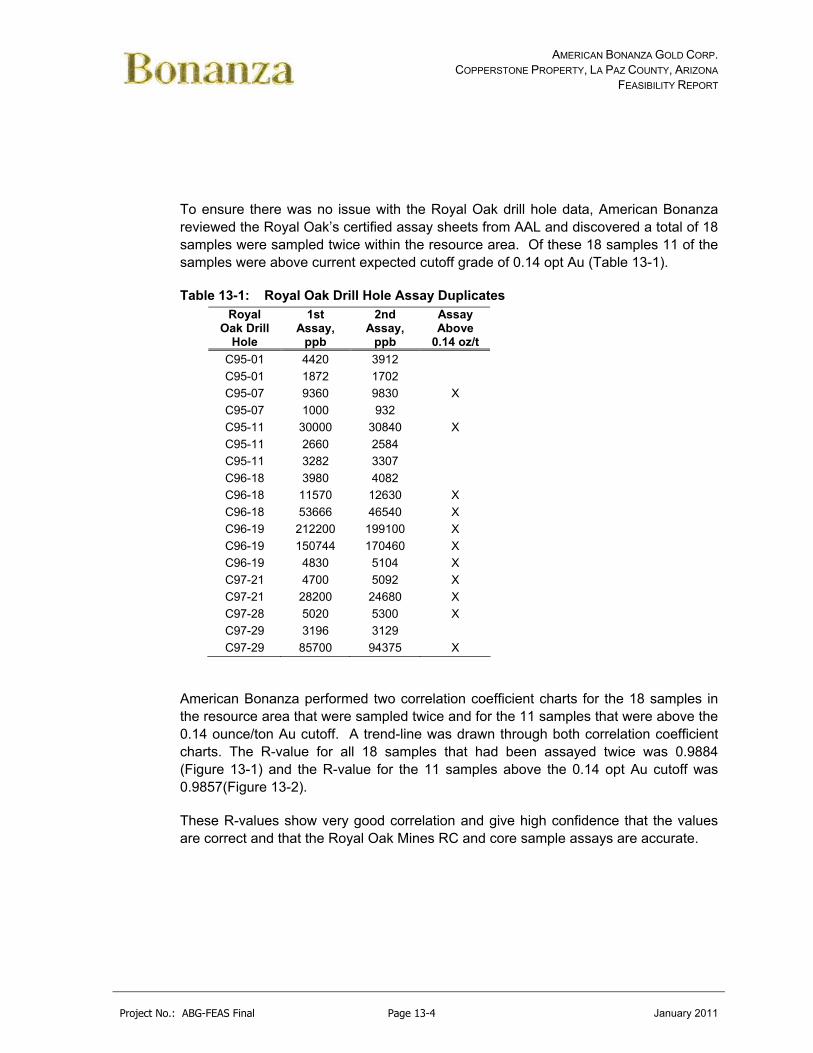
AMERICAN BONANZA GOLD CORP. COPPERSTONE PROPERTY, LA PAZ COUNTY, ARIZONA
FEASIBILITY REPORT
Project No.: ABG-FEAS Final Page 13-4 January 2011
To ensure there was no issue with the Royal Oak drill hole data, American Bonanza reviewed the Royal Oak’s certified assay sheets from AAL and discovered a total of 18 samples were sampled twice within the resource area. Of these 18 samples 11 of the samples were above current expected cutoff grade of 0.14 opt Au (Table 13-1).
Table 13-1: Royal Oak Drill Hole Assay Duplicates Royal
Oak Drill Hole
1st Assay,
ppb
2nd Assay,
ppb
Assay Above
0.14 oz/t
C95-01 4420 3912
C95-01 1872 1702
C95-07 9360 9830 X
C95-07 1000 932
C95-11 30000 30840 X
C95-11 2660 2584
C95-11 3282 3307
C96-18 3980 4082
C96-18 11570 12630 X
C96-18 53666 46540 X
C96-19 212200 199100 X
C96-19 150744 170460 X
C96-19 4830 5104 X
C97-21 4700 5092 X
C97-21 28200 24680 X
C97-28 5020 5300 X
C97-29 3196 3129
C97-29 85700 94375 X
American Bonanza performed two correlation coefficient charts for the 18 samples in the resource area that were sampled twice and for the 11 samples that were above the 0.14 ounce/ton Au cutoff. A trend-line was drawn through both correlation coefficient charts. The R-value for all 18 samples that had been assayed twice was 0.9884 (Figure 13-1) and the R-value for the 11 samples above the 0.14 opt Au cutoff was 0.9857(Figure 13-2).
These R-values show very good correlation and give high confidence that the values are correct and that the Royal Oak Mines RC and core sample assays are accurate.
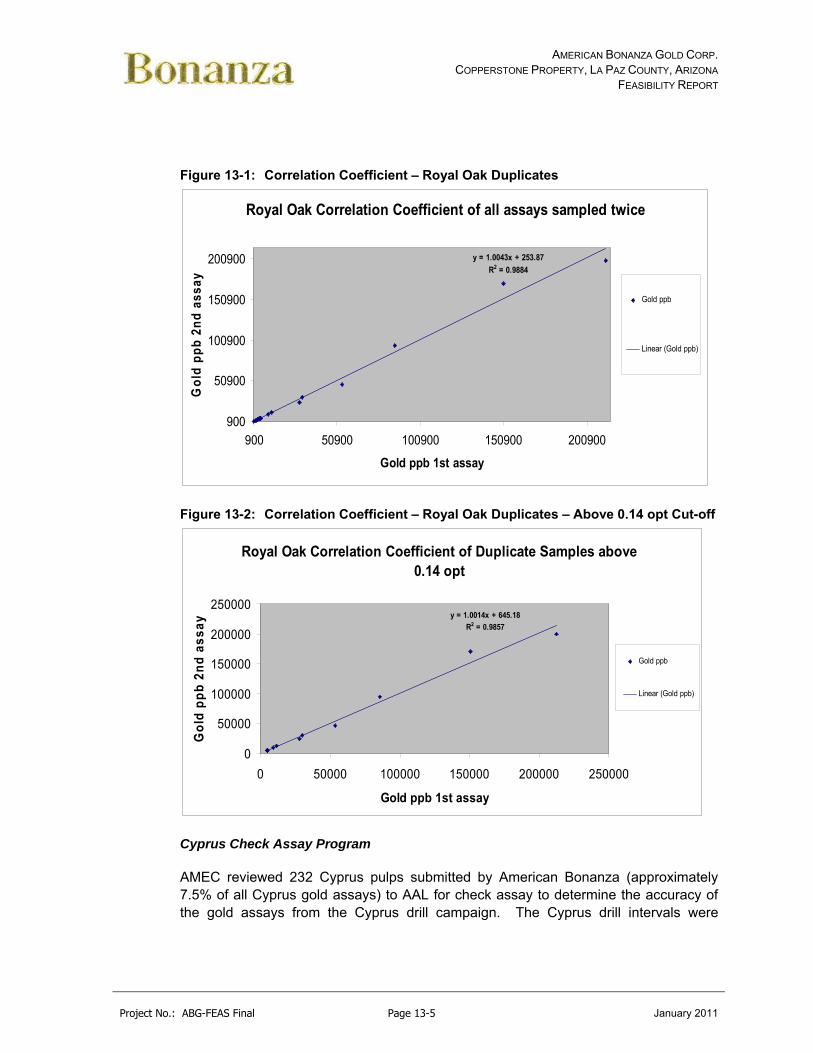
AMERICAN BONANZA GOLD CORP. COPPERSTONE PROPERTY, LA PAZ COUNTY, ARIZONA
FEASIBILITY REPORT
Project No.: ABG-FEAS Final Page 13-5 January 2011
Figure 13-1: Correlation Coefficient – Royal Oak Duplicates
Royal Oak Correlation Coefficient of all assays sampled twice
y = 1.0043x + 253.87
R2 = 0.9884
900
50900
100900
150900
200900
900 50900 100900 150900 200900
Gold ppb 1st assay
Go
ld p
pb
2n
d a
ssay
Gold ppb
Linear (Gold ppb)
Figure 13-2: Correlation Coefficient – Royal Oak Duplicates – Above 0.14 opt Cut-off
Royal Oak Correlation Coefficient of Duplicate Samples above 0.14 opt
y = 1.0014x + 645.18
R2 = 0.9857
0
50000
100000
150000
200000
250000
0 50000 100000 150000 200000 250000
Gold ppb 1st assay
Go
ld p
pb
2n
d a
ss
ay
Gold ppb
Linear (Gold ppb)
Cyprus Check Assay Program
AMEC reviewed 232 Cyprus pulps submitted by American Bonanza (approximately 7.5% of all Cyprus gold assays) to AAL for check assay to determine the accuracy of the gold assays from the Cyprus drill campaign. The Cyprus drill intervals were

AMERICAN BONANZA GOLD CORP. COPPERSTONE PROPERTY, LA PAZ COUNTY, ARIZONA
FEASIBILITY REPORT
Project No.: ABG-FEAS Final Page 13-6 January 2011
selected randomly by AMEC from the assays entered from Cyprus drill holes. Information on Cyprus’ QA/QC programs was not provided to AMEC.
AMEC plotted the results of the check assay program (Appendix G) and found the Cyprus assays to be accurate with no significant bias relative to the AAL check assays. Three of the 12 SRMs submitted with the program were outside acceptable limits. AAL reassayed project samples around the three failed SRMs and found no significant change in gold concentration. AMEC found the accuracy of the Cyprus assays was acceptable based on the results of the check assay program.
13.3.2 Assay Precision
Precision is the measure of a laboratories ability to return the same value for multiple assays of the same material. Duplicate assays of pulp samples by the same laboratory allow for the calculation of the analytical precision.
American Bonanza typically assayed gold and silver for two or three splits of each sample. AMEC’s 2006 Preliminary Assessment Report compiled this information and used it to calculate the precision of AAL’s gold and silver assays. Asia Minerals inserted coarse reject duplicates within the same batch as part of their QA/QC program.
Bonanza Pulp Duplicate Program
The duplicates were plotted using the absolute relative difference (ARD) for pulp duplicate pairs against the cumulative frequency of the distributions for gold and silver for American Bonanza drill samples (Appendix G). ARD diagrams provide a visual representation of assay precision where precise measurements (low relative difference) are shown on the left side of the diagram and imprecise measurements (high relative difference) are shown on the right side. Assay precision is considered to be adequate when greater than 90% of the pulp duplicate pairs yield absolute relative differences of less than 10%. These limits are represented by the dashed lines on the figures.
When plotting all duplicate pairs (Appendix G), the AAL precision for gold and silver assays is adequate. Approximately 89% of the gold duplicate pairs and 96% of the silver duplicate pairs yield absolute relative differences of less than 10%. However, when the duplicate pairs, whose average assay is at or below the lower detection limit, are removed from the plots (Appendix G) the precision for gold and silver degrades significantly. Approximately 62% of the gold duplicate pairs and only 7% of the silver duplicate pairs yield absolute relative differences of less than 10%. This is typical of deposits that have relatively coarse gold.

AMERICAN BONANZA GOLD CORP. COPPERSTONE PROPERTY, LA PAZ COUNTY, ARIZONA
FEASIBILITY REPORT
Project No.: ABG-FEAS Final Page 13-7 January 2011
Asia Minerals Coarse Reject Duplicate Program
Asia Minerals assayed coarse reject duplicates samples in the same batch as part of the QA/QC program. The variation (error) in assay pairs from coarse reject duplicates includes sub-sampling variation plus analytical variation.
AMEC evaluated the duplicate data and found the precision of the gold assays to be acceptable. The precision of the BSI gold assays was calculated at 17% at the 90% confidence limit. AMEC considers sub-sampling precision to be adequate when greater than 90% of the coarse reject duplicate pairs yield absolute relative differences of less than 20%.
13.4 Security
Drill samples are transported from the drill site to the core shed by American Bonanza geologists. Drill samples are stored in the secure core shed before being shipped directly from the mine site to AAL via DATS Trucking, Inc at regular intervals. Drill sample bags are closed with tamper-proof ties and AAL reports any missing or damaged sample bags upon receipt. DATS Trucking hands over custody of the samples directly to AAL.

AMERICAN BONANZA GOLD CORP. COPPERSTONE PROPERTY, LA PAZ COUNTY, ARIZONA
FEASIBILITY REPORT
Project No.: ABG-FEAS Final Page 14-1 January 2011
14.0 DATA VERIFICATION (ITEM #16)
In order to verify that the resource database accurately reflects the source documents for the project, the database was audited for accuracy. In addition, integrity checks were conducted on the entire database (See Appendix H) to ensure that the database is acceptable for resource modeling.
14.1 Bonanza Drill Campaign
Feasibility Review
An integrity check of 2006, 2007, and 2008 drill holes in the database were checked against original assay certificates. A total of 2,370 assay records were audited. Assays for gold and lithology were included in the audit. A total of one error was found in the assay values checked. This error was corrected. A spot check of 20 pre-2006 drill holes in the data base identified no errors in assaying, lithology, collar locations, and down-hole survey records.
Telesto (2009)
The database which was used for modeling the current resource was provided to Telesto in electronic form from American Bonanza. The electronic database consisted of data from 986 drillholes for a total of 99,919 assay values. American Bonanza also provided photocopies of original assay certificates for all of the holes used in the resource estimate. The majority of assay certificates are from American Assay Laboratories (“AAL”) in Sparks, Nevada. All certificates were on AAL letterhead, and approximately 80% of the certificates contained a signature.
Telesto performed a rigorous course of data verification by comparing gold values from the database to numerous assay certificates. Assays which were above approximately 0.003 opt on the certificates were compared to ensure accuracy in the database. Values which disagreed with the certificates were corrected and noted on the assay sheets.
The number of incorrect assays was very small, comprising less than 1% of the total database. In some cases, the source of the incorrect values appeared to be simple transposition of digits. Presumably, these errors were introduced during the original data entry from paper certificates into the electronic database. In other cases, incorrect values did not appear to match the certificates in any recognizable way. However, all incorrect values which were identified by Telesto during data verification activities were corrected to match the assay certificates.

AMERICAN BONANZA GOLD CORP. COPPERSTONE PROPERTY, LA PAZ COUNTY, ARIZONA
FEASIBILITY REPORT
Project No.: ABG-FEAS Final Page 14-2 January 2011
Amec
In 2006 AMEC conducted an audit of five percent of the assay records in the American Bonanza drill hole database against the original assay certificates. A total of 1,189 of the 23,787 American Bonanza assay records were audited, including all records with an average gold value (field Au_AVG) greater than 0.1 oz/t, all records with an average gold value below the AAL detection limit (0.003 oz/t), and a random selection of the remaining records. Assays for gold, silver, and copper were included in the audit. A total of 27 assay errors were found out of the 5,945 assay values checked for an error rate of 0.45%. This error rate indicates data integrity of 1% error. Most of the errors were the result of a certificate being improperly loaded into the database and were corrected.
Ten percent of the lithology records for American Bonanza drill holes were audited against the original lithology logs. A total of seven logging errors were found out of the 5,568 geology values from 25 randomly selected drill holes checked for an error rate of 0.1%. Errors observed included minor data entry errors in alteration fields and were corrected.
14.2 Cyprus, Santa Fe, Royal Oak, Asia Minerals Drill Campaigns
A spot check as part of the 20 holes checked of the Cyprus, Santa Fe, Royal Oak, and Asia drill campaigns found no errors in the fire assay data. Lithology, collar locations, and down-hole survey records were found to have no errors.
In 2009, Telesto personnel examined core which came from each of the four main exploration targets, Zones A, B, C and D. Six samples of core were collected by Telesto and assayed by AAL in Sparks, Nevada. Each sample was analyzed using fire assay (“FA”) for gold, gravimetric methods for gold and standard methods for a 36- element suite.
Descriptions of the core samples were provided by American Bonanza from the original core logging effort, but Telesto added to the descriptions based on observations of the core prior to assaying. Table 14.1 shows the results of Telesto’s check assays.
Table 14-1: Telesto Check Assays
The American Bonanza database which was used for the current resource estimate contained assays which were done using the fire assay technique. Telesto’s check assays agreed well against each other (FA vs. Gravimetric), however, the check assays did not show good overall agreement with American Bonanza’s data (See

AMERICAN BONANZA GOLD CORP. COPPERSTONE PROPERTY, LA PAZ COUNTY, ARIZONA
FEASIBILITY REPORT
Project No.: ABG-FEAS Final Page 14-3 January 2011
Figure 14.1). Five of the six samples returned values which were much higher than American Bonanza’s data.
Figure 14-1: Check Assay Graph Comparison (Telesto)
There may be several reasons why the check assays showed inconsistent agreement with American Bonanza’s original assays. One possible source of variance in the check assays is the nature of the mineralization. Gold mineralization at Copperstone is highly variable in its occurrence even within individual pieces of core. Brecciation in the Copperstone Fault created irregular conduits for upwelling gold-bearing hydrothermal fluids. This irregular distribution of gold (the “nugget” effect) may be the primary reason for the variability in check assay values.
It should be noted that the American Bonanza database for the six (6) samples is the result of multiple labs (minimum of four assays), and these results are compared in Table 14.1 against a single assay conducted by Telesto, and this fact may explain some of apparent variance. Notwithstanding the variability, the check assays generally show that gold occurs in the core in amounts which support American Bonanza’s original assays as presented to Telesto in the electronic database.
In 2006, AMEC reviewed eleven randomly selected drill holes for audit from a list of 205 non American Bonanza drill holes containing at least one interval returning greater than 0.1 oz/t gold (not including mined out sections). Issues were found with the drill hole database which included aqua regia digestion, cyanide digestion, fire assay AA
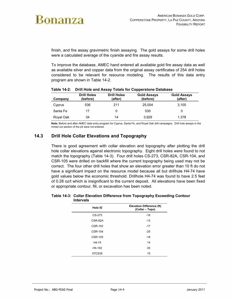
AMERICAN BONANZA GOLD CORP. COPPERSTONE PROPERTY, LA PAZ COUNTY, ARIZONA
FEASIBILITY REPORT
Project No.: ABG-FEAS Final Page 14-4 January 2011
finish, and fire assay gravimetric finish assaying. The gold assays for some drill holes were a calculated average of the cyanide and fire assay results.
To improve the database, AMEC hand entered all available gold fire assay data as well as available silver and copper data from the original assay certificates of 254 drill holes considered to be relevant for resource modeling. The results of this data entry program are shown in Table 14-2.
Table 14-2: Drill Hole and Assay Totals for Copperstone Database
Company Drill Holes
(before) Drill Holes
(after) Gold Assays
(before) Gold Assays
(after)
Cyprus 536 211 25,004 3,100
Santa Fe 17 0 530 0
Royal Oak 34 14 3,929 1,378
Note: Before and after AMEC data entry program for Cyprus, Santa Fe, and Royal Oak drill campaigns. Drill hole assays in the mined out section of the pit were not entered.
14.3 Drill Hole Collar Elevations and Topography
There is good agreement with collar elevation and topography after plotting the drill hole collar elevations against electronic topography. Eight drill holes were found to not match the topography (Table 14-3). Four drill holes CS-273, CSR-82A, CSR-104, and CSR-105 were drilled on backfill where the current topography being used may not be correct. The four other drill holes that show an elevation error greater than 10 ft do not have a significant impact on the resource model because all but drillhole H4-74 have gold values below the economic threshold. Drillhole H4-74 was found to have 2.5 feet of 0.28 oz/t which is insignificant to the current deposit. All elevations have been fixed or appropriate contour, fill, or excavation has been noted.
Table 14-3: Collar Elevation Difference from Topography Exceeding Contour Intervals
Hole ID Elevation Difference (ft)
(Collar – Topo)
CS-273 -16
CSR-82A -13
CSR-102 -17
CSR-104 -25
CSR-105 -18
H4-74 14
H5-102 25
07CS35 15

AMERICAN BONANZA GOLD CORP. COPPERSTONE PROPERTY, LA PAZ COUNTY, ARIZONA
FEASIBILITY REPORT
Project No.: ABG-FEAS Final Page 14-5 January 2011
14.4 Database Integrity
Integrity checks of the Copperstone database discovered the following inconsistencies:
No issues with data base integrity were identified.

AMERICAN BONANZA GOLD CORP. COPPERSTONE PROPERTY, LA PAZ COUNTY, ARIZONA
FEASIBILITY REPORT
Project No.: ABG-FEAS Final Page 15-1 January 2011
15.0 ADJACENT PROPERTIES (ITEM #17)
There are no adjacent properties that are material to this report.

AMERICAN BONANZA GOLD CORP. COPPERSTONE PROPERTY, LA PAZ COUNTY, ARIZONA
FEASIBILITY REPORT
Project No.: ABG-FEAS Final Page 16-1 January 2011
16.0 MINERAL PROCESSING AND METALLURGICAL TESTING (ITEM #18)
16.1 Introduction
Detailed metallurgical testing has been completed to select an appropriate processing method and to optimize process operating parameters. Samples of various ore types and grades have been prepared and sent to various laboratories and testing facilities for metallurgical testing. These laboratories include:
Hazen Research – 1986 – Cyanide Leaching
Hazen Research – 1986 – Mineralogy
Cypress Metallurgy – 1986 - Phase I to III
Resource Development Inc. – 1999 – Cyanide Leaching
McClelland Laboratories – 2000 – Cyanidation, Flotation, Gravity
Echo Bay Minerals – 2001 – Flotation
McClelland Laboratories – 2005 – Flotation, Gravity, Grinding, Rheology
CAMP – 2009 – Gravity, Flotation
The testing consisted of cyanidation studies including bottle roll and column leach tests, gravity concentration tests, flotation studies including flotation only and flotation tests followed by cyanidation, and reagent consumption tests. All metallurgical reports are attached in Appendix I.
16.2 Metallurgical Testwork
Historical metallurgical test work, dating from 1986 to 2009 and the results of the most recent program conducted by McClelland Laboratories and CAMP on underground sample composites have been reviewed and form the basis of the new project development.
A summary of historical metallurgical test results is provided in Table 16-1 and are discussed below.

AMERICAN BONANZA GOLD CORP. COPPERSTONE PROPERTY, LA PAZ COUNTY, ARIZONA
FEASIBILITY REPORT
Project No.: ABG-FEAS Final Page 16-2 January 2011
Table 16-1: Summary of Metallurgical Test Results/Historical Test work (1986-2009)
Grade Parameter Extraction/ Recovery
CN Zone
Sample ID
Date Test Wt Kg
Au oz/tAu
(Calc)
Agoz/t
Cu %
Total Grind Time Au Ag Cu g/l kg/t
Hanging Wall CS-MET
1999 Direct Cyanidation 2.6 0.33 7.42 0.04 0.05 150M 24 83 27 5 1.0 0.004
D-Zone CS-MET
1999 Direct Cyanidation 9.4 0.56 26.4 0.06 0.24 150M 24 91 49 16 1.0 1.085
Ore Composite
2000 Gravity/Cyanidation 63.7 1.03 0.82 0.60 270M 72 99 0.5 2.877
Gravity/Cyanidation 1.03 0.85 270M 72 99 1.5 3.286
Gravity/Cyanidation 1.03 1.18 100M 72 93 1.5 3.173
Direct Cyanidation 1.03 1.00 200M 72 92 1.5 3.173
Float 1.03 1.18 200M 94
Ore Composite
None 2001 Float (McCoy/Cove) 2.0 1.51 0.75 0.56 140M 88 9
D-Zone D-Zone 2005 Grav/Leach 122.5 0.51 0.53 0.06 0.57 150M 48/72 96/98 >47 3.195
Grav/Leach 200M 48/72 94/96 >47 3.354
Grav/Leach+NH4OH 200M 48/72 90/95 >47 3.559
Grav/Float 150M 89
200M 89
Hanging Wall HW 2005 Grav/Leach 103.0 0.33 0.33 0.03 0.90 150M 72/96 91/97 >32 7.422
Grav/Leach 200M 72/96 90/98 >29 7.100
Grav/Leach+NH4OH 200M 72/96 96/98 >48 7.918
Grav/Float 150M 88
Grav/Float 200M 91
D-Zone+HW Conc Cyanidation 11.23 200M 48/72 89/99 0.477
D-Zone CAMP 2009 Grav/Float 0.332 0.643 2.34 0.68 200M 28/88 47
C-Zone CAMP 2009 Grav/Float 0.341 0.408 2.74 1.03 200M 37/86 27
16.2.1 Hazen Research (1986) – Original Open Pit Heap and Agitated Leach Test
Work
In 1986, Hazen carried out test work on six inch diameter core samples of breccia and silicified rock types that formed the basis of the original project prefeasibility for open pit mining and low grade oxide heap leaching and agitation leaching. Therefore, the data and mineralogy isn’t relevant to the new high-grade underground mining and processing project.
The results of this test work are presented in the following report:
Copperstone Metallurgical Studies, Phase III – Core Samples, Hazen Research, Inc, October 10, 1986.

AMERICAN BONANZA GOLD CORP. COPPERSTONE PROPERTY, LA PAZ COUNTY, ARIZONA
FEASIBILITY REPORT
Project No.: ABG-FEAS Final Page 16-3 January 2011
The studies were conducted on three composite core samples representing the different ore type lithologies being considered in the deposit: brecciated, silicified, and mixed. The composites assayed 0.09 oz/t to 0.127 oz/t, and typically contained negligible silver and total sulfur (0.01%) and about 0.2% total copper. Cyanide consumption was about 0.16 kg/t to 0.39 kg/t. This data is mentioned here to differentiate the characterization of this material relative to Hanging Wall and D-Zone mineralization. Relatively good cyanidation (column and bottle roll) and flotation responses were obtained in this work.
16.2.2 Hazen Research (1986)
In 1995 Hazen Research conducted mineralogical investigations on three samples (zones unidentified). This is presented in the following report:
Memorandum, Hazen Research. Copperstone Project, Mineralogical Study. Mineralogy on three Copperstone ore samples (CP-01, CP-02 and CP-03), zone not identified (other than 47968-1, 47968-2 and 479968-3 respectively). August 31,1995.
The key observations were:
Based on the presence of oxide copper minerals concerns were raised for cyanidation of the ore, including higher-than-normal cyanide consumption and difficult cyanide destruction. It was recommended future process development efforts must consider these factors.
Gravity/flotation may prove to be more viable than cyanidation.
Copper extraction may prove difficult, due to the resistance of the copper minerals to flotation. As well, the calcite content raised concerns about high acid consumption, should acid leaching be considered.
Overall, the sample mineralogy and conclusions appear to be consistent with subsequent analysis and test work conducted on samples from the Hanging Wall and D-Zone mineralization.
16.2.3 Resource Development Inc (1999)
Preliminary characterization and cyanidation/leaching studies were conducted in 1999 by Resource Development Inc. on composite samples from core intervals within the Hanging Wall and D-Zone mineralization. The results and discussion of this work are presented in the following reports and memorandum:

AMERICAN BONANZA GOLD CORP. COPPERSTONE PROPERTY, LA PAZ COUNTY, ARIZONA
FEASIBILITY REPORT
Project No.: ABG-FEAS Final Page 16-4 January 2011
Bema Gold. RDI Report (Edwin Bentzen) on Pulverizing and cyanide leaching of two met samples (CS-MET-Hanging Wall and CS-MET D-Zone) as authorized by Herb Osborn. December 7,1999.
Memorandum to George Johnson Sr VP Bema Gold, Review of The Copperstone Project, H.C. Osborne and Associates. December 27, 1999.
American Bonanza, Ian D McCartney, October 28, 2000. Data on the locations and character of the two metallurgical test samples processed by Bema (HW C97-29 and D-Zone A98-5) – Refers to origin of samples in the 1999 Bema Gold Report.
This work was conducted as part of a fatal flaw review on behalf of Bema to provide a basis for a go or no go project investment decision. Bema’s interest was discontinued shortly thereafter because commercial negotiations failed. The main observations and conclusions were:
Metallurgical characterization was not considered conclusive, but provided an insight into potential high cyanide consumptions associated with copper minerals that commonly accompany the gold mineralization.
The Hanging Wall composite consumed a minor (0.004 kg/t) of cyanide, while consumption in the D-Zone composite was significantly higher (1.085 kg/t). Although both samples contained copper the D-Zone sample contained approximately five times more. Higher cyanide consumption in D-Zone was attributed to higher levels of cyanide soluble copper minerals.
AMEC noted poor accountability between assayed gold head and calculated which may be due to nugget effects. Visible gold was noted in several samples. Possibly a metallics assay would have given better assay reconciliation, as was done in subsequent test work in 2000.
Additional work was recommended to better define the relationship between cyanide consumption and copper mineralization.
The Hanging Wall sample was from intervals of C-Zone hole extension east of pit, high grade, volcanic hosted quartz late porphyry (manganese oxide and specular hematite). The D-Zone Hole was hosted by limestone replaced by silica, iron oxide and with copper oxide mineralization (visible gold, chrysocolla, specularite, hematite, chlorite, silicification).
A fatal flaw review by H C Osborne and Associates of a summary of the above work and a historical review of the original mill operations. The underlying test work reports potential differences in mineralization style to the original ore are flagged. The summary Osborne reviewed did not identify this possibility, and because cyanide consumptions were not unreasonably high, the due diligence review

AMERICAN BONANZA GOLD CORP. COPPERSTONE PROPERTY, LA PAZ COUNTY, ARIZONA
FEASIBILITY REPORT
Project No.: ABG-FEAS Final Page 16-5 January 2011
concluded that direct cyanidation, as used on the original project, still appeared viable. The due diligence correctly qualifies this conclusion to the extent that the samples were representative only to the area selected, and intended only to aid an initial decision by Bema. The review also suggests no visible gold was present in the samples but this appears to be incorrect based on previous notations, and poor accounting of gold assay head relative to test work (measured) indicated above. Subsequent work in 2000 and currently in 2005, on new Hanging Wall and D –Zone samples, appears to support the insight provided in the 1995 mineralogical and 1999 RDI reports, into potentially higher levels of copper in the mineralization, and much higher cyanide consumption and associated difficult cyanide destruction.
Although the original plant operation was successful and resulted in good gold recoveries, it is understood from its operating history that cyanide levels in the process, tailings solutions and pond were very high and resistant to breakdown. This is characteristic of an accumulation of copper cyanide in the circulating solutions, which becomes difficult and expensive to destroy. It is unlikely that cyanide in ponds at such high levels will be permittable today, and cyanide soluble copper levels in the new resource mineralization appear to be several times higher than the original open pit ore.
16.2.4 McClelland Laboratories (2000)
In 2000 McClelland Laboratories were commissioned by American Bonanza to conduct a gravity, cyanidation and flotation process evaluation on a composite sample. This work is presented in the following extract and report:
American Bonanza. Section 14.0 Extract from Geologic Report for the Copperstone Gold Property, October 26, 2000. Summarizes testing in Reference 3 and describes testing in progress at McClelland on new samples of D-Zone.
McClelland Laboratories, Inc. November 21, 2000. Report on metallurgical test work on a metallurgical composite of new sample intervals from four drill holes (A98-2, 3 5, and 13) described as testing in progress. The zone of interest is not indicated. Gravity/cyanidation, whole ore cyanidation, flotation testing. Appendix I contains Pocock report on settling and pulp rheology, and Svedala report on Bond Ball Mill Work Index test.
The key observations of this test work are:
A total of 10 drill hole intervals (from four holes A98-2, 3 5, and 13) were composited into a single test sample. The specific mineralized zone these intervals represent is not identified.

AMERICAN BONANZA GOLD CORP. COPPERSTONE PROPERTY, LA PAZ COUNTY, ARIZONA
FEASIBILITY REPORT
Project No.: ABG-FEAS Final Page 16-6 January 2011
No mineralogy was conducted.
- Gold head grade was determined by metallics assay and the reconciliation with test work calculated was good. Small free gold particles were observed in both gravity and flotation products.
- Both whole ore cyanidation and a single bulk flotation test gave good recoveries.
- Optimum cyanide concentrations were about 1.5 g/l, which is high. This was required to improve the recovery rate (at 48 h), which otherwise at 0.5 g/L would take 72 h. Cyanide consumptions were high at about 3 kg/t, it was stated because of cyanide soluble copper dissolution. No copper leach balances or speciation data were provided to support this, but it is consistent with current and past test work observations. There was about 0.6% Cu in the sample.
- The gravity work indicated high (about 50%) potential gold recovery, but this is inconclusive because the weight recoveries were also very high.
A bulk float test recovered 94% gold into a 16.7 % feed wt concentrate at 200 M. Copper flotation metallurgy, or concentrate cyanidation was not investigated.
Because of the relatively high hematite content the sample solids specific gravity is quite high 3.37.
Conventional thickening tests on leach residue indicated good flocculation and rapid settling characteristics.
A single Ball Mill Work Index of 13.7 kWh/st indicates the material is of moderate to hardness with respect to ball milling. This index corresponds well to the size of the Cyprus ball mills and the amount of material processed on a day to day average.
16.2.5 Echo Bay Minerals (2001)
In 2001 Echo Bay Minerals evaluated flotation processing Copperstone ore at their McCoy/Cove mill on behalf of American Bonanza. The results of this are reported in the following:
Echo Bay Minerals, Flotation Testing of Copperstone Ore. February 15, 2001.
The key observations were:
A flotation test was conducted on a single 2 kg high-grade sample, but its origin was not identified.
Flotation recovery was reasonable at 87% into a 4% feed wt concentrate. Possibly recovery could have been higher with an alternate frother, higher weight recovery

AMERICAN BONANZA GOLD CORP. COPPERSTONE PROPERTY, LA PAZ COUNTY, ARIZONA
FEASIBILITY REPORT
Project No.: ABG-FEAS Final Page 16-7 January 2011
and finer grind. However, the objective was to study the response of the mineralization using McCoy/Cove operating parameters.
Copper (0.56% Cu in head) recovery to the concentrate was only about 9%. This is consistent with the previous flotation/concentrate cyanidation work. The poor copper flotation recovery suggests copper is present dominantly as chrysocolla. This is important because chrysocolla is not recoverable (up to about 15%) in conventional flotation. In AMEC’s underground visit much of the mineralization was noted to be stained blue-green, typical of chrysocolla.
16.2.6 McClelland Testwork (2005)
In early 2005 McClelland Laboratories Inc. were commissioned to prepare two new D-Zone and Hanging Wall metallurgical composites, using samples provided by American Bonanza, and to conduct a new prefeasibility test work program on these. The HW zone sample consisted of 43 intervals from 7 drill holes. The D-Zone sample consisted of 51 intervals from 3 holes. The intervals consisted of half cores. McClelland crushed the samples to 10 mesh and blended each zone for a master composite. The head analyses are provided in Table 1. Separate bulk samples were taken for the Bond Work and Abrasion tests.
The metallurgical bench-scale testing work was supervised by H.C. Osborne and Associates, American Bonanza’s metallurgical consultant.
The program was originally designed to be conducted in two phases. Phase I was scoping in nature to test the effects of grind size on gravity recovery, flotation and direct cyanidation.
The Phase II tests were intended to optimize the parameters of the selected process and to provide the data necessary for mill design. Phase II tests also included Bond Work and Abrasion Tests, thickening and pulp rheology tests. The program was suspended because ongoing mining and project scale optimization resulted in uncertainty in the eventual mill head grade parameter to be tested and optimized. As well, the study objective was subsequently redefined to scoping for which the current level of metallurgical work currently completed is regarded as more than appropriate.
McClelland did not issue a formal test work report, but reported results to American Bonanza in the form of the following reports and data sheets:
Data Sheet, McClelland Laboratory, HW and D-Zone Composite Sample Analyses and Phase 1 Results. March 4, 2005.
Data Sheet, McClelland Laboratory, Gravity Tail Cyanidation test results. May 16, 2005.
AMERICAN BONANZA GOLD CORP. COPPERSTONE PROPERTY, LA PAZ COUNTY, ARIZONA
FEASIBILITY REPORT
Project No.: ABG-FEAS Final Page 16-8 January 2011
Data Sheet, McClelland Laboratory, Intensive Cyanidation of Rougher Flotation Concentrates test results. May 19, 2005.
Data Sheet, McClelland Laboratory, ICP Analysis of HW and D-Zone Composite Samples. May 23, 2005.
Data Sheet, McClelland Laboratory, Gravity Separation and Cyanidation test results. June 22, 2005.
Report, Metso Minerals Laboratories, Test Plant Report 67216, Results of BWI and Ai Testing, August, 2005.
Report, Dawson Metallurgical Laboratories, Results of Magnetic Concentration of a Flotation Tailings Sample, September, 2005.
Report, Pocock Industrial Inc., Gravity Sedimentation and Pulp Rheology Studies, July, 2005.
The data issued by McClelland was reviewed and summarized in five memorandums between July and September, 2005 by H.C Osbourne. These are presented in Appendix I. The brief summary of the test work that follows has mainly been extracted from the McClelland and Osbourne reports and memorandum listed above. The results of the McClelland program are also summarized in Table 16-1.
Phase 1
Gravity concentration, whole ore gravity/cyanidation and gravity/flotation and concentrate cyanidation investigations were conducted and reported by McCLelland. An initial Phase 1 of testing was conducted in March, but the results were inconsistent and inconclusive, and this was followed up by a similar Phase 1.5 program in June.
Gravity recoveries were relatively low in Phase 1 but improved in Phase 1.5. Phase I.5 was undertaken to test methods of reducing the cyanide consumption in direct cyanidation and to improve flotation recoveries into a lower weight concentrate. The Phase I direct cyanidation tests produced good gold recoveries but at very high cyanide consumptions and extended leach times, due to the presence of soluble copper in the ore. Flotation work was conducted to investigate the production of a smelter concentrate. During an initial data review AMEC noted the soluble copper issue and earlier work that suggested most copper reports to the flotation tail. A secondary objective of the flotation test work became to investigate the potential to separate gold and copper using flotation and produce a concentrate that could be cyanided more economically. Gold flotation recoveries were reasonable and concentrate cyanidation recoveries and cyanide consumptions were very good. The key observations are summarized below:

AMERICAN BONANZA GOLD CORP. COPPERSTONE PROPERTY, LA PAZ COUNTY, ARIZONA
FEASIBILITY REPORT
Project No.: ABG-FEAS Final Page 16-9 January 2011
Samples and Characterization. The D-Zone composite comprises seven drill hole core intervals from two drill holes. The Hanging Wall composite comprises twelve drill hole core intervals from two drill holes and twenty five intervals of coarse assay rejects from five holes, which is a reasonably wide range compared to the D-Zone composite. An assessment of the extent of metallurgical sample coverage should be made in the future. Copper is also an important issue relative to process selection. Additional work is recommended to better define the relationship between cyanide consumption, flotation and copper mineralization (speciation). This was recommended in earlier programs. Copper speciation should be done on some sample sub-composites to help identify copper mineralization trends.
Gravity. The gravity recoverable gold potential in the 2005 composite samples appears relatively low at about 8-15% at typical weight recoveries (0.02% to 0.22%) used to produce a direct smelt material. However, gravity is not considered to be the primary recovery process, more as an insurance against occasional nugget gold and other unrecoverable gold by direct cyanidation or flotation. Gravity gold recovery showed some potential to improve overall recovery in the test work. However to achieve acceptable gravity recoveries weight recoveries were high and the concentration ratios low because of the concomitant recovery of iron present as magnetite/hematite in the samples. Improved panning in Phase 1.5 in some instances successfully eliminated the magnetite, and further work on gravity is recommended because it appears to have the potential to add 1% to 2% to the overall recovery from gold that may not float well. Possibly the gravity concentrate will not be a viable direct smelt material due to its high magnetite content and a separate intensive cyanidation unit will be required. However an industrial-scale centrifugal gravity unit could be more selective in eliminating magnetite, versus the batch laboratory Knelson unit used in the test work, and further work on this concept is recommended. Previous work on other D-zone and Hanging Wall zone samples suggests visible gold is present. AMEC also recommends testing is done using an alternate stage grinding/gravity test protocol. Gravity potential may be being understated by initially grinding in a single stage to 200 M followed by testing.
Direct Leach. Extended direct leach times are required (72 h to 96 h) to achieve good gold recoveries 95-98% and cyanide and lime consumptions were very high. Cyanide consumptions were about 3 kg/t for D-Zone material and 7 kg/t for HW zone material. This is consistent with earlier work and indicative of the presence of elevated levels of soluble copper. Figure 16-1 summarizes historical test cyanide consumption and shows this is commensurate with the presence of copper. Copper levels and cyanide consumption are highest in the new Hanging Wall sample. Both 150 mesh and finer 200 mesh grinds gave good recoveries and no trends were noted.

AMERICAN BONANZA GOLD CORP. COPPERSTONE PROPERTY, LA PAZ COUNTY, ARIZONA
FEASIBILITY REPORT
Project No.: ABG-FEAS Final Page 16-10 January 2011
Flotation. (see Table 16-2) Only bulk rougher flotation concentration test work was conducted. Bulk gold flotation recoveries are reasonable and at a grind of 200 mesh direct flotation recoveries of about 89-90% are indicated and when combined with gravity 92% to 96%. Gravity appears to have the potential to add 1% to 2% to the overall recovery from gold that may not float well. However, some flotation optimization potential is indicated that may offset this. Additional kinetic tests were recommended to assess float time and grind requirements and optimize mass pulls. Finer grinding to 200 mesh appears to improve recovery but the results are inconclusive. Similar reagent suites were used in both phases but Phase 1.5 utilized different reagent addition rates and pull techniques. Some cleaner work is also recommended to investigate the potential to produce a direct smelt product, or optimize cyanidation economics. Copper and sulfur balances should also be done. Assuming copper mineralization is dominantly chrysocolla, it is expected copper recovery will be low using conventional flotation processing and this appears to be the case based on the relatively low cyanide consumption (relative to whole ore) in the concentrate cyanidation test work.
Concentrate Leaching. (see Table 16-3) The flotation concentrates from all the Phase I tests were combined in a single sample to provide sufficient material for assaying and meaningful metallurgical tests. The flotation concentrates from Phase I.5 were likewise combined. The flotation concentrates leached very well and in 72 h produced recoveries of 98.3% to 99.4% and with much lower cyanide consumptions than direct cyanidation. The results are summarized in Table 16-3. This suggests the copper mineralization did not float well, which is consistent with earlier flotation work done by Echo Bay minerals, and that it may be present predominantly as chrysocolla. However, no copper speciation or copper assays were done to be able to assess this. Copper and other base metals will accumulate in the leach solution if recycled and provision should be made in the design to bleed and destroy cyanide to remove this. Additional work will be required to assess the bleed and cyanide destruction requirements.

AMERICAN BONANZA GOLD CORP. COPPERSTONE PROPERTY, LA PAZ COUNTY, ARIZONA
FEASIBILITY REPORT
Project No.: ABG-FEAS Final Page 16-11 January 2011
Figure 16-1: Copperstone Cyanide Consumption vs. Total Cu %
0
1
2
3
4
5
6
7
8
0 0.2 0.4 0.6 0.8 1
Cu % (total)
kg/t C
yanid
e
Table 16-2: Flotation Results
Zone Phase Grind Conc. Wt.% Assay Oz/T Au Distribution
D I (whole ore) 150 2.38 18.1 85.1
I (whole ore) 200 3.57 13.2 89.2
I.5 Gravity m+t 150 2.43 17.9 88.6 (91.7)
1.5 Gravity m+t 200 1.98 19.8 89.1 (92.7)
HW I (whole ore) 150 5.76 5.18 89.1
I (whole ore) 200 12.71 (*1) 1.91 74.8
I.5 Gravity m+t 150 3.08 7.52 88.2 (94.2)
1.5 Gravity m+t 200 2.17 11.4 90.7 (96.1)
Notes: 1 Difficulty with Sliming. 2 Combined gravity and flotation recovery.
Table 16-3: Concentrate Cyanidation Results
Phase 72 hour Recovery % CN Cons Direct CN Con Ton/Ore CaO Cons Direct+
I 98.3 29.4 1.20 *25.6
I.5 99.4 43.5 1.05 11.1
Note: * NaOH
Phase 2
The following Phase II tests were completed to investigate other opportunities provide some of the data necessary for mill design. Rheology and Settling work was done to support an underground paste backfill option investigation. All plant tailings are directed to the tailings dam.

AMERICAN BONANZA GOLD CORP. COPPERSTONE PROPERTY, LA PAZ COUNTY, ARIZONA
FEASIBILITY REPORT
Project No.: ABG-FEAS Final Page 16-12 January 2011
Magnetite Recovery. Dawson investigated the production of a by-product magnetite product from tailings. Only about 5% of the iron in the feed reported to the final concentrate. The sample was highly oxidized and it was assumed that most of the iron is present as hematite. No further work was recommended.
Rheology. The rheology of a rougher tailing underflow sample was assessed by Pocock showed Bingham Plastic characteristics at all solids concentration tested. Experience shows that thickener underflow solids concentrations exhibiting a yield value in excess of 30 Pascals (Pa) are not considered practical for standard thickener design, as pumping and torque problems will likely result. This threshold occurred at slightly above 60% solids for the Flotation Rougher Tailings. In a full scale plant, underflow solids concentrations exceeding 60% solids should be avoided unless specialized equipment is employed to handle the higher viscosities.
Settling. Static thickening tests by Pocock explored the effect of variations in flocculent dose, and feed solids concentrations for conventional thickener design. Thickener unit area sizing on properly flocculated thickening tests performed on the Flotation Rougher Tailings material generally fell below the minimum range of 0.125 m2/Mtpd to 0.150 m2/Mtpd recommended by Pocock Industrial for full scale conventional thickeners. This recommended design range corresponds to underflow solids concentrations from 50% to 60% solids by weight. Dynamic (High Rate) thickening tests were also performed on the Flotation Rougher Tailings sample to determine the recommended hydraulic design basis and expected overflow suspended solids concentrations.
Bond Work Index. The recommended Four buckets (two of each) of D-Zone and HW-Zone samples were submitted by McClelland to Metso Minerals for Bond Work Index (BWI) and abrasion index (Ai) testing. The D-Zone sample BWI indicated it was softer than the HW-Zone (12.98 kWh/st and 15.04 kWh/st) but much more abrasive with an Ai of 0.4464 and 0.1508 respectively. Overall this material can be ranked as of medium hardness and abrasivity with respect to ball milling and power and wear rates should not be expected to be excessive.
16.2.7 CAMP (Center for Advanced Mineral and Metallurgical Processing)(2009)
This testing was completed to review the previous metallurgical work completed on Copperstone deposit and verify previous testing, identify gaps, and expand incomplete testing. The testing attempted to confirm grinding requirements, gravity testing expectations, and optimize flotation requirements. The results were used to optimize the final flowsheet and metallurgical balance. The following identifies the testwork:
Samples and Characterization. Composites were developed from across the C and D zones to give as representative of sample as possible for verification testing and
AMERICAN BONANZA GOLD CORP. COPPERSTONE PROPERTY, LA PAZ COUNTY, ARIZONA
FEASIBILITY REPORT
Project No.: ABG-FEAS Final Page 16-13 January 2011
review. The samples were pulled from core from both the ‘C” and “D” zone. For the “C” zone testing, 22 samples from 5 holes were used. From the “D” zone, 34 samples from 14 holes were used. Samples were picked to give a representative sample of ore across both zones. The grades identified from testing are identified in Table 16-4.
Table 16-4: CAMP Testwork - Assays
Area Au, oz/t Ag, oz/t Cu, % S% C%
C-Zone 0.341 0.875 0.92 0.24 0.22
D-Zone 0.332 0.925 0.85 0.08 0.70
Gravity. The gravity recoverable gold potential in the 2009 composite samples
appears very good at about 25-40% at typical weight recoveries (1.0% to 1.25%) used to produce a salable material with a gold content from 8 to 15 oz/t. However to achieve acceptable gravity recoveries weight recoveries were slightly higher the expected with the potential to need further processing such as Gemini Table to remove gangue prior to further processing.
Flotation. Only a single bulk rougher flotation concentration test work was conducted on each sample to verify previous testwork. Bulk gold flotation recoveries are reasonable and at a grind of 200 mesh with direct flotation recoveries of about 70 to 75% are indicated and when combined with gravity, 86 to 94% recoveries are achievable. The flotation tails were consistent with that of previous testing with much higher head grade. Recoveries approaching 90 to 95% will be attainable with a consistent grade and proper chemical scheme. Additional kinetic tests are recommended to assess float time and grind requirements and optimize mass pulls. Other reagent schemes should be reviewed to maximize final recovery.
Grinding. Grinding of the D-Zone and C-Zone samples identified a Work Index of 12.8 and 14.3 kWh/st respectively. These work indexes are in the same range as previous testing. No further bond grind testing is recommended on the D and C zones.

AMERICAN BONANZA GOLD CORP. COPPERSTONE PROPERTY, LA PAZ COUNTY, ARIZONA
FEASIBILITY REPORT
Project No.: ABG-FEAS Final Page 16-14 January 2011
16.3 Determination of Recoveries for Gravity/Flotation
Based on previous and confirmatory testwork, the expected gravity flotation recovery will most likely reach 89 to 90%. Table 16.5 isolates only the gravity and flotation test work.
Table 16-5: Summary of Metallurgical Test Results
Grade Parameter Extraction/ Recovery
Zone Sample
ID Date Test
WtKg
Au oz/tAu
(Calc)
Agoz/t
Cu %
Total Grind Time Au Ag Cu
Ore Composite
2000 Float 1.03 1.18 200M 94
Ore Composite
None 2001 Float
(McCoy/Cove) 2.0 1.51 0.75 0.56 140M 88 9
D-Zone D-Zone 2005 Grav/Float 150M 89
200M 89
Hanging Wall
HW 2005 Grav/Float 150M 88
Grav/Float 200M 91
D-Zone CAMP 2009 Grav/Float 0.332 0.643 2.34 0.68 200M 28/88 47
C-Zone CAMP 2009 Grav/Float 0.341 0.408 2.74 1.03 200M 37/86 27
As can be identified by the Table 16.5, the maximum recovery for the gravity/flotation testwork is 94% with a minimum of 86%. All testwork uses grinding that approaches near to the same parameter of a P80 of 140 to 200M. The average recovery of the 150 M testing is 88.3% with the average recovery of the 200M at 89.6% recovery. There seems to be a slight improvement of recovery with grinding but the lowest recoveries of 86% were also obtained with the finest grind of a P80 of 200 mesh.

AMERICAN BONANZA GOLD CORP. COPPERSTONE PROPERTY, LA PAZ COUNTY, ARIZONA
FEASIBILITY REPORT
Project No.: ABG-FEAS Final Page 16-15 January 2011
Figure 16-2: Flotation Recovery at 200M
Note that the general recoveries are all very close. In normal operations where the grind and chemical addition can be maintained, recoveries would be expected to be in the middle of the testing range or approximately 90%.
Recoveries were obtained with rougher flotation retention times at 20 minutes and 8.5 minutes for cleaning.

AMERICAN BONANZA GOLD CORP. COPPERSTONE PROPERTY, LA PAZ COUNTY, ARIZONA
FEASIBILITY REPORT
Project No.: ABG-FEAS Final Page 17-1 January 2011
17.0 MINERAL RESOURCE AND MINERAL RESERVE ESTIMATES (ITEM #19)
Resources
The following is adapted or taken directly from the February 2, 2010 Telesto - NI 43-101 Technical Report for the Copperstone Project, La Paz County, Arizona - Resource Report. The Appendix and Figures numbers were changed to make appropriate for this document.
The Mineral Resource information identified in Sections 17.1 through 17.8 was estimated by Telesto Solution Inc. using MicroModel®, a commercially-supplied mine planning software package, to develop a three-dimensional block model.
Modeling and estimation of gold resources demonstrate that there are measured, indicated and inferred resources at the Copperstone Project. Work was conducted by Kim Drossulis, Senior Mining Engineer and reviewed by other co-authors as well as Jonathon Brown, C.P.G. principal QP author.
The resources stated in this report for the Copperstone Project conform to the guidelines in National Instrument 43-101, and definitions adopted by the Canadian Institute of Mining, Metallurgy and Petroleum.
The following are the definitions of a mineral resource as defined by NI 43-101:
Mineral Resource – A Mineral Resource is a concentration or occurrence of diamonds, natural solid inorganic material, or natural solid fossilized organic material including base and precious metals, coal, and industrial minerals in or on the Earth’s crust in such form and quantity and of such a grade or quality that it has reasonable prospects for economic extraction. The location, quantity, grade, geological characteristics and continuity of a Mineral Resource are known, estimated or interpreted from specific geological evidence and knowledge.
Measured Mineral Resource – A ‘Measured Mineral Resource’ is that part of a Mineral Resource for which quantity, grade or quality, densities, shape, and physical characteristics are so well established that they can be estimated with confidence sufficient to allow the appropriate application of technical and economic parameters, to support production planning and evaluation of the economic viability of the deposit. The estimate is based on detailed and reliable exploration, sampling and testing information gathered through appropriate techniques from locations such as outcrops, trenches, pits, workings and drillholes that are spaced closely enough to confirm both geological and grade continuity.

AMERICAN BONANZA GOLD CORP. COPPERSTONE PROPERTY, LA PAZ COUNTY, ARIZONA
FEASIBILITY REPORT
Project No.: ABG-FEAS Final Page 17-2 January 2011
Indicated Mineral Resource – An ‘Indicated Mineral Resource’ is that part of a Mineral Resource for which quantity, grade or quality, densities, shape and physical characteristics can be estimated with a level of confidence sufficient to allow the appropriate application of technical and economic parameters, to support mine planning and evaluation of the economic viability of the deposit. The estimate is based on detailed and reliable exploration and testing information gathered through appropriate techniques from locations such as outcrops, trenches, pits, workings and drillholes that are spaced closely enough for geological and grade continuity to be reasonably assumed.
Inferred Mineral Resource – An ‘Inferred Mineral Resource’ is that part of a Mineral Resource for which quantity and grade or quality can be estimated on the basis of geological evidence and limited sampling and reasonably assumed, but not verified, geological and grade continuity. The estimate is based on limited information and sampling gathered through appropriate techniques from locations such as outcrops, trenches, pits, workings, and drillholes.
Reserves
Information identified in Section 17.9 was developed by Vezer International through Chris Fedora and Tom Buchholz. A Mineral Reserve was developed using Gemcom®, a commercially-supplied mine planning software package, to develop a three-dimensional mine plan.
The mineral reserve stated in this report for the Copperstone Project conforms to the guidelines in National Instrument 43-101, and definitions adopted by the Canadian Institute of Mining, Metallurgy and Petroleum.
The following are the definitions of a Mineral Reserve as defined by NI 43-101:
A Mineral Reserve is defined as the economically mineable part of a Measured or Indicated Mineral Resource demonstrated by at least a Preliminary Feasibility Study. This Study must include adequate information on mining, processing, metallurgical, economic and other relevant factors that demonstrate, at the time of reporting, that economic extraction can be justified. A Mineral Reserve includes diluting materials and allowances for losses that may occur when the material is mined.
A ‘Proven Mineral Reserve’ is the economically mineable part of a Measured Mineral Resource demonstrated by at least a Preliminary Feasibility Study. This Study must include adequate information on mining, processing, metallurgical, economic, and other relevant factors that demonstrate, at the time of reporting, that economic extraction is justified.

AMERICAN BONANZA GOLD CORP. COPPERSTONE PROPERTY, LA PAZ COUNTY, ARIZONA
FEASIBILITY REPORT
Project No.: ABG-FEAS Final Page 17-3 January 2011
A ‘Probable Mineral Reserve’ is the economically mineable part of an Indicated and, in some circumstances, a Measured Mineral Resource demonstrated by at least a Preliminary Feasibility Study. This Study must include adequate information on mining, processing, metallurgical, economic, and other relevant factors that demonstrate, at the time of reporting, that economic extraction can be justified.
17.1 Sources of Information
As written in the 2010 Telesto - NI 43-101 Copperstone Report:
“American Bonanza provided Telesto with two electronic representations of the topography at Copperstone. One surface represents the current topography including areas of backfill in the south lobe of the excavated pit. The other surface represents the as-mined surface that remained after mining by Cyprus. AMEC generated this as-mined surface as part of their review of the project in 2006 by electronically stripping out the areas of backfill based on their best estimate of the location of backfill. For purposes of creating this resource estimate, Telesto used the AMEC-generated as-mined surface and limited it to the boundary of the model limits.”
"Many test models were run by Telesto for estimating in-situ gold content for the resource within the project area. Of these test models, one model was selected for reporting because it best represented the mineralization."
“American Bonanza provided volumetric models in the form of Triangulated Irregular Networks (“TINs”) for five basic rock types. Each rock type was given a rock code: alluvium (10), metasediments (20), volcanic rocks (30), mineralized zone (Copperstone Fault) (40), and ironstone (50). Because of the complexity of the mineralized zone, which initially consisted of 18 individual TINs making up Rock Type 40, the mineralized zone was further subdivided by American Bonanza into ten separate rock types. Each subdivision of the mineralized zone has differing characteristics which distinguish it from the others. A graphically display the mineralized zone TINs in plan view can be found in Appendix 2 of the 2010 Telesto - NI 43-101 Copperstone report. Table 17.1 is a list of the rock types and their associated numeric codes.”

AMERICAN BONANZA GOLD CORP. COPPERSTONE PROPERTY, LA PAZ COUNTY, ARIZONA
FEASIBILITY REPORT
Project No.: ABG-FEAS Final Page 17-4 January 2011
Table 17-1: Copperstone Lithology Codes (Telesto)
“The raw data was also provided by American Bonanza. This data consisted of RC and core drilling data, and was provided in a digital database. All subsequent modeling of the project area was performed using MicroModel© mining software. The resource estimated from the modeling is reported in Imperial units (feet, troy ounces and short tons) and converted to metric units (meters, grams and tonnes) for reporting purposes.”
Deposit Geology Pertinent to Resource Modeling
“Telesto was provided with TINs which outline the limits of the previously listed geologic units as interpreted by American Bonanza staff. The TINs were used to assign rock types to the drillhole composites that were used for the resource estimates and to restrict the block model.”
Modeled Area Descriptions
“The southwest corner of the block model is located at 1,043,269 ft North, 334,421 ft East (Arizona State Plane, NAD27, West Zone) with an elevation of -430 feet. The modeled area has an orientation of 315° clockwise to the left boundary and contains 975 rows, 575 columns and 477 levels. Each block in every model has the following dimensions (x,y,z): 5 feet (1.52 m) per row, 5 feet (1.52 m) per column and a block height of 3 feet (0.91 m). See Table 17-2 for a summary of parameters used in the resource model.”
Table 17-2: Block Parameters for Current Model (Telesto)
Block Size (ft) X Y Z
Dip Rake Orientation
5 5 3 0 0 315
AMERICAN BONANZA GOLD CORP. COPPERSTONE PROPERTY, LA PAZ COUNTY, ARIZONA
FEASIBILITY REPORT
Project No.: ABG-FEAS Final Page 17-5 January 2011
“Gold values were universally carried in troy ounces per short ton. The number of drillholes used in the model totals 986 holes with 99,919 sampled intervals. Figure 6 of Telesto Report - Appendix B shows collar locations and drillhole traces of the drillholes used in the model. The average sampling interval is approximately 5 feet or 1.52 meters. The total estimated footage of drilling involved in the resource estimate is 543,665 feet.”
17.2 Evaluation of Extreme Grades
17.2.1 Gold Assays
As written in the 2010 Telesto - NI 43-101 Copperstone Report:
“A suite of statistical runs was completed on the Copperstone drill sample intervals to test the variations in the different geologic units/Rock Type. A total of ten runs were completed for the review. Five of the runs were completed on the individual TINs which were supplied by American Bonanza. The other five runs centered around the Copperstone Fault Zone. Each rock type had a distinct mean, supporting variance, standard deviation and covariance. The results showed that for the raw data, a capping grade of 1.5 opt was supported. A review of just the Copperstone Fault Zone data supported a capping grade of 5 opt. The latter was used in evaluation of the fault zone.”
“Capping of high grade values was done after compositing of drillhole data. The grade values and the geologic code assigned to each composite were based on the boundaries of the geologic TINs supplied by American Bonanza. No composites crossed the boundaries of the TINs.”
17.3 Density
17.3.1 Measurements
AMEC's specific gravity was measured for 262 samples from American Bonanza diamond drill holes by American Assay Lab (AAL) by the water immersion method (AMEC, 2006). Specific gravity was determined by AAL as follows:
a low-weight wax covered a dried core sample
core samples were suspended below a digital balance and weighed in grams to three decimal places
in a known volume of water, the core samples were completely immersed and weighed in grams to three decimal places

AMERICAN BONANZA GOLD CORP. COPPERSTONE PROPERTY, LA PAZ COUNTY, ARIZONA
FEASIBILITY REPORT
Project No.: ABG-FEAS Final Page 17-6 January 2011
the volume of water displaced was calculated by subtracting the immersed weight from the air weight
specific gravity was calculated by dividing the air weight of the core sample by the volume of water displaced by the core sample and the density (same number as specific gravity) was reported in units of g/cm3 or lb/ft3.
Average density values by rock types obtained by this method are presented in Table 17-3.
Nine untested lithologies are not within the composite database. The untested lithologies only represent 2.25% of all the material, and do not represent a significant impact on the model. These untested rock units were grouped into other major lithology domains, modeled, and assigned the average density of that respective lithology.
Table 17-3: Density Measurements of Ore and Waste Units at Copperstone (AMEC 2006)
Lithology Density (g/cm3)
Number of Measurements Rock Numeric Code
Quartz Latite Porphyry 2.738 126 1
Limestone 2.612 13 2
Siltstone 2.809 16 3
Phylite 2.610 1 4
Schist Not Tested 0 5
Marble 2.71 8 6
Volcanic Not Tested 0 7
Monolithic Breccia 2.680 8 8
Heterogenic Breccia 2.490 1 9
Vein-Quartz Not Tested 0 10
Vein-Specularite Not Tested 0 11
Vein-Hematite Not Tested 0 12
Vein-Goethite Not Tested 0 13
Jasperoid Not Tested 0 14
Quartzite Not Tested 0 15
Vein-Magnetite Not Tested 0 16
Fault 2.110 1 17
Ironstone 3.277 47 18
Ironstone Breccia 2.976 27 19
Ironstone Stockwork 2.975 13 20
QAL; Overburden Not Tested 0 63
17.3.2 Densities Applied to Resource Estimates
As written in the 2010 Telesto - NI 43-101 Copperstone Report:

AMERICAN BONANZA GOLD CORP. COPPERSTONE PROPERTY, LA PAZ COUNTY, ARIZONA
FEASIBILITY REPORT
Project No.: ABG-FEAS Final Page 17-7 January 2011
“For each of the five major rock types, the corresponding AMEC (2006) bulk density value was used. Bulk density values were assigned to each block based on the rock type of the block. AMEC’s bulk density evaluation was conducted on a large number of samples representing all the major rock types at Copperstone.”
“As part of Telesto’s check assay program, six samples were subjected to bulk density analysis to confirm AMEC’s bulk density values. Check assays and bulk density analyses were performed for Telesto by American Assay Labs in Sparks, Nevada. The six samples were representative of the mineralization at Copperstone, as discussed in Section 14. However, the samples were not representative of all five major rock types. Four of the six samples were mineralized volcanic rocks and two were ironstone breccia samples. See Table 17-4 for results of American Assay Lab’s analysis of density for the six check assay samples.”
Table 17-4: American Assay Density Analyses (Telesto)
Drillhole Interval Footage Lithology Density (g/cm3)
Density (tons/yd)
CRD 04-02 837.5-840.5 Quartz latite
porphyry breccia 3.0 2.5
CRD 04-02 848.8-851.0 Quartz latite
porphyry breccia 2.8 2.4
H4-19 837.5-840.0 Quartz latite
porphyry breccia 2.7 2.3
H4-19 843.0-845.0 Quartz latite
porphyry breccia 2.5 2.1
Average 2.8 2.3
CUDH 03-03 100.4-104.5 Ironstone breccia 3.5 3.0
CUDH 03-03 116.0-120.4 Ironstone breccias, chysocolla altered
2.4 2.0
Average 2.8 2.5
“The mean density of the first four samples agrees well with the 2.70 which AMEC calculated for volcanic rocks. Ironstone is expected to have the highest density of the five major rock types, according to AMEC’s extensive bulk density analysis. The fifth Telesto sample (CUDH 03-03, 100.4’ – 104.5’), which is ironstone breccia, is described as primarily hematite. Hematite has an average density of 5.3 and the sample’s density was a relatively high 3.5. However, the sixth Telesto sample (CUDH 03-03, 116.0’ – 120.4’) has an unexpectedly low density of 2.4. Upon review of the description of this sample, it was noted that the sample is high in chrysocolla, which has an average density of 2.15. In light of the chrysocolla alteration, the low density of the sixth sample is not unexpected.”
“Although Telesto’s density sampling was less extensive than the testing done by AMEC, the values obtained by Telesto agree well with AMEC’s numbers and expected norms. So the use of AMEC’s bulk density values is justified.”

AMERICAN BONANZA GOLD CORP. COPPERSTONE PROPERTY, LA PAZ COUNTY, ARIZONA
FEASIBILITY REPORT
Project No.: ABG-FEAS Final Page 17-8 January 2011
17.4 Variography
17.4.1 Rock Type Statistics
As written in the 2010 Telesto - NI 43-101 Copperstone Report:
“An initial set of rock type statistics was run using the composites generated by the limits of the mineralized zone TINs (Rock Type 40, before it was split into individual Rock Types). The results of this exercise led to altering the Copperstone Fault TIN to include mineralization which was outside but immediately adjacent to the provided TINs.”
“Statistics were run on the revised mineralized TIN and the unassigned rock codes. A review of the unassigned composites over 0.100 opt Au showed that there were 924 composites with an average grade of 0.226 opt Au. Additionally, between 0.050 and 0.100 opt Au, there were 1,124 composites with an average grade of 0.070 opt. The high number of composites outside of the mineralized (Copperstone Fault) TINs suggests that additional tons of inferred material can be developed with additional drilling.”
17.4.2 Variography
As written in the 2010 Telesto - NI 43-101 Copperstone Report:
“The model was generated using parameters which Telesto deemed appropriate from variography results. While American Bonanza’s lithologic TINs were applied to the model, Telesto varied the search orientations of the variograms to match the dip orientation of the mineralized TINs within Rock Types 40-49 assigned to the suite of TINs which represent the Copperstone Fault.”
“The ten different rock types (40-49) which make up the mineralized zone were modeled separately. Rock Type 40 encompasses the largest and most continuous mineralized zone at Copperstone. A number of smaller zones which had strike orientations similar to Rock Type 40 but which dipped differently were assigned to other Rock Types (41-49) (refer to Table 17-1 for dip amounts for the different rock types). The smaller zones typically contained a limited number of composites as compared to Rock Type 40. Using one set of search orientations on the entire suite of mineralized zone TINs simultaneously (Rock Types 40-49) could have led to underestimation of the smaller zones. By varying the dip of the search ellipsoid to match each rock type and estimating the rock types separately, the smaller zones were more likely to be modeled to their full potential.”

AMERICAN BONANZA GOLD CORP. COPPERSTONE PROPERTY, LA PAZ COUNTY, ARIZONA
FEASIBILITY REPORT
Project No.: ABG-FEAS Final Page 17-9 January 2011
“For Rock Type 40, Telesto selected three basic variograms which were deemed to best represent the mineralized trend within the deposit. The first variogram represents the orientation of the regional mineralization event. These orientations are 115’ (35.1 meters) in the primary axis direction, 115’ (35.1 meters) in the secondary axis direction and 30’ (9.1 meters) in the tertiary axis direction. While the potential existed to use a longer distance in the tertiary axis direction, Telesto took the approach of limiting this axis to prevent spreading grade values beyond the natural occurrences in the deposit. This approach will: 1) keep the grade estimated in the blocks comparable to the grade likely to be encountered in a given stope during mining, and 2) the grade of the blocks will more accurately reflect the values of the nearest drillhole composites.”
“The second variogram represents the orientation of the dip and rake of the Copperstone Fault based on the spatial relationship of the entire database. It represents an extended search radius down dip and along the preferential rake a distance of 210’ (64.0 meters). The secondary and tertiary axis distances (115’ and 30’ respectively) remained the same as the in the first pass so that no new blocks were filled in along those orientations. In the assignment of values in the blocks, these values were added to the block model, but did not overwrite the first pass results from the regional variography (115’ x 115’ x 30’). This methodology keeps intact the initial constrained block values such that grade is spread further down the preferential orientation.”
“After reviewing the results from the second pass, a number of blocks were unassigned in a north-south orientation within the Copperstone Fault TIN. This led to a filtering of the data in and around the D-Zone to review the spatial relationship of the data around that area. The filtering resulted in a different orientation of the primary, secondary and tertiary axes. So a third pass was implemented into the model using an extended range to the north-south (180’, 54.9 meters), a restricted east-west orientation (60’, 18.3 meters) and similar vertical constraints as the other two models (30’, 9.1 meters). Again, only blocks which were previously unfilled were populated during the third pass without overwriting values in blocks from the first and second passes.”
“The search orientations for Rock Type 40 are shown in Figure 17.1. Variograms for the three modeling runs are shown in Figures 17.2 through 17.4. Rock Types 41-49 used the same search distances as those established in Ellipsoid 2 for Rock Type 40, but the dip of the model was changed for each run to match the geometry of the TIN(s) which were being modeled.”

AMERICAN BONANZA GOLD CORP. COPPERSTONE PROPERTY, LA PAZ COUNTY, ARIZONA
FEASIBILITY REPORT
Project No.: ABG-FEAS Final Page 17-10 January 2011
Figure 17-1: Search Ellipsoid for the Three Block Modeling Passes
Figure 17-2: Regional Variograms (Search Ellipsoid 1) (Telesto)

AMERICAN BONANZA GOLD CORP. COPPERSTONE PROPERTY, LA PAZ COUNTY, ARIZONA
FEASIBILITY REPORT
Project No.: ABG-FEAS Final Page 17-11 January 2011
Figure 17-3: Variograms Using only the Copperstone Fault Zone (Search Ellipsoid 2) (Telesto)
Figure 17-4: Variograms for the Filtered Data from the D-Zone (Search Ellipsoid 3) (Telesto)

AMERICAN BONANZA GOLD CORP. COPPERSTONE PROPERTY, LA PAZ COUNTY, ARIZONA
FEASIBILITY REPORT
Project No.: ABG-FEAS Final Page 17-12 January 2011
17.4.3 Jackknife Analysis
As written in the 2010 Telesto - NI 43-101 Copperstone Report:
Vertical Anisotropy Review
“In order to evaluate the effect of the variogram range (210 feet) in the modeled areas, a process known as jackknifing was employed. Jackknifing artificially removes some data from the model and then repeats the modeling process to determine the effect of the data and its influence on the overall results.
During the process, elements of the estimation method are applied and surrounding points are used to estimate a missing data point. The process is repeated until the entire dataset is analyzed and then a comparison between the original data and the estimated data is generated. The resulting statistics are a measure of the model’s robustness.
The results of early jackknifing runs for the mineralized TIN are presented in Tables 17-5 and 17-6. They underscored the need to limit the tertiary (vertical) axis search radius. A longer search radius would have resulted in spreading grade in an upward direction, thus diluting the overall grade of the resource.”

AMERICAN BONANZA GOLD CORP. COPPERSTONE PROPERTY, LA PAZ COUNTY, ARIZONA
FEASIBILITY REPORT
Project No.: ABG-FEAS Final Page 17-12 January 2011
Table 17-5: Jackknifing Results at 210’ (Telesto)
Table 17-6: Jackknifing Results at 115’ (Telesto)
Inverse Distance Power Review (Cubed vs. Squared)
“In order to evaluate the effect of the power variable on the model, jackknifing was employed again. Using a power of two in the estimate (inverse distance squared, ID2), the resulting model shows an effect of smoothing in a linear manner to the next nearest composite of the same rock type. Using a power of three in the estimate (inverse distance cubed, ID3) provides a better regional preservation of values within the constraints of the mineralized TIN. This allows for the characteristics of grade and geometry of the isolated rock types (41-49) to be maintained even though the sample density is not as well supported as in Rock Type 40.”
“Tables 17-7 and 17-8 show the difference between the original data and the estimated data in the jackknifing runs for ID2 and ID3 in Rock Type 40. The statistical difference between the original data and the estimated data appears to be negligible when looking at ID2 vs. ID3.”
“As stated previously, Telesto used a three-run methodology to assign values to the resource for Rock Type 40. This was done because employing only one run using

AMERICAN BONANZA GOLD CORP. COPPERSTONE PROPERTY, LA PAZ COUNTY, ARIZONA
FEASIBILITY REPORT
Project No.: ABG-FEAS Final Page 17-13 January 2011
longer search distances to assign values to the blocks would not have honored the composites that were closest to the blocks being estimated. However, because of the limited number of composites in some of the TINs for Rock Types 41-49, the use of ID2 on the smaller zones (Rock Types 41-49) would have had the effect of estimating too many tons with lower grade. Telesto concluded that ID2 was not a good method of modeling Rock Types 41-49. The jackknife analysis established that the statistical difference between ID2 and ID3 is not significant for Rock Type 40. Therefore, Telesto used ID3 to estimate all of the mineralized TINs in Rock Types 40-49.”
Table 17-7: Jackknifing Results at ID2
(Telesto)
Table 17-8: Jackknifing Results at ID3 (Telesto)
17.4.4 Graphical Display of the Derived Model
As written in the 2010 Telesto - NI 43-101 Copperstone Report:
“Drillhole information in the database contains gold grade values (opt) and alpha (letters) coded lithology. Because Telesto received TINs which described the geology at the Project site, the lithology codes in the drillhole database were not used in the resource estimates which were completed for this report. The lithology codes that were

AMERICAN BONANZA GOLD CORP. COPPERSTONE PROPERTY, LA PAZ COUNTY, ARIZONA
FEASIBILITY REPORT
Project No.: ABG-FEAS Final Page 17-14 January 2011
used in the modeling were derived by compositing each drillhole by the rock type TINs rather than compositing by downhole distance. Eight cross sections perpendicular to strike and two cross-sections along-strike were selected as representative of the resource. Each of the cross sections shows details for the model. Telesto - Appendix 2 Figure 7 (Cross Section Location), 8A through 8J (Cross Sections) shows the locations of these selected cross sections along with details of these grade model cross sections. All cross sections show block gold grade and slices of the mineralized (Copperstone Fault) TIN.”
“Each of the cross sections (Figures 8A through 8J) also shows an elevation grid for reference to six selected levels (200’-449’ elevation on 50’ intervals). The elevation plans are shown in Telesto - Appendix 2 Figures 9A through 9F. Each elevation plan displays drillhole penetrations and block gold grade values.”
17.5 Block Model
17.5.1 Search Parameters
As written in the 2010 Telesto - NI 43-101 Copperstone Report:
“The inverse distance cubed method was applied in the modeling process. Figure 17.1 summarizes the search radii and orientation parameters used for the three variograms used as guides for assigning grade values to the current resource model.”
17.5.2 Construction of the Electronic Geologic Model
As written in the 2010 Telesto - NI 43-101 Copperstone Report:
“The geologic model was constructed using the three-dimensional TINs supplied by American Bonanza. Block centroids within the TINs were assigned a lithology code based on the TIN in which it resides. Likewise, the drillhole composites were assigned lithology codes based on their location within a particular TIN. The model generated on November 17, 2009, used only the revised mineralized (Copperstone Fault) TIN. All other rock codes were unassigned.”
17.5.3 Sample and Block Selection Parameters
As written in the 2010 Telesto - NI 43-101 Copperstone Report:
“In order to assign a gold value to a block in the three dimensional model, it would require a matching rock code from the composited sample interval. No composite values crossed the boundary of the geologic polygons (TINs). The assignment of

AMERICAN BONANZA GOLD CORP. COPPERSTONE PROPERTY, LA PAZ COUNTY, ARIZONA
FEASIBILITY REPORT
Project No.: ABG-FEAS Final Page 17-15 January 2011
values respected the TINs provided by American Bonanza. For example, only fault-type mineralization values were used to assign values to fault-type blocks.”
17.5.4 Cutoff Grades
Cutoff grades used to estimate the in-situ resource are based on the cutoff grades used in the AMEC report. Resources are estimated using various cutoff grades. A grade-tonnage curve is presented in Figures 17-5.
Figure 17-5: Grade Tonnage Curve for Gold (Telesto)
As written in the 2010 Telesto - NI 43-101 Copperstone Report:

AMERICAN BONANZA GOLD CORP. COPPERSTONE PROPERTY, LA PAZ COUNTY, ARIZONA
FEASIBILITY REPORT
Project No.: ABG-FEAS Final Page 17-16 January 2011
“Figures 17-6 displays cutoff grade vs. contained gold ounces in the model:”
Figure 17-6: Cutoff Grade vs. Modeled Contained Ounces for Gold (Telesto)
“Figures 17.7 shows cutoff grade vs. average grade for the resource:”
Figure 17-7: Cutoff Grade vs. Average Grade for Gold (Telesto)

AMERICAN BONANZA GOLD CORP. COPPERSTONE PROPERTY, LA PAZ COUNTY, ARIZONA
FEASIBILITY REPORT
Project No.: ABG-FEAS Final Page 17-17 January 2011
17.6 Mineral Resource Classification
As written in the 2010 Telesto - NI 43-101 Copperstone Report:
“An extensive review was undertaken to determine a standard method of classifying measured and indicated resources.”
17.6.1 Measured Resources
As written in the 2010 Telesto - NI 43-101 Copperstone Report:
“The first level of separation was a variogram range of approximately 115 feet (19.8 meters) by 115 feet (19.8 meters) by 30 feet (9.1 meters) vertical. This was interpreted from the variogram graphs shown in Figures 17.2 through 17.4 and was used for determining measured resources. A secondary containment on the measured resource is that the resource is located inside the mineralized Copperstone Fault zone (Rock Type 40).”
17.6.2 Indicated Resources
As written in the 2010 Telesto - NI 43-101 Copperstone Report:
“Secondarily, range of influence polygons were constructed using the constraint of the range of the project’s variograms. Those polygons measured 215’ (35.1 meters) by 215’ (35.1 meters) by 30’ (9.1 meters) vertical. A secondary containment on the indicated resource is that the resource is located inside the mineralized Copperstone Fault Zone (Rock Type 40).”
17.6.3 Inferred Resources
As written in the 2010 Telesto - NI 43-101 Copperstone Report:
“Inferred resources are outside the mineralized (Copperstone Fault) TIN. The same modeling parameters were applied to the areas of unassigned blocks but because there was no geologic definition, the resulting mineralization is assigned to the inferred category.”
17.7 Resource Statement
As written in the 2010 Telesto - NI 43-101 Copperstone Report:

AMERICAN BONANZA GOLD CORP. COPPERSTONE PROPERTY, LA PAZ COUNTY, ARIZONA
FEASIBILITY REPORT
Project No.: ABG-FEAS Final Page 17-18 January 2011
“Telesto has used gold cutoff grades established by AMEC (2006) of 0.200 opt (6.86 g/tonne) Au and0.150 opt (5.14 g/tonne) Au to estimate resource quantities for all of the currently known resources at Copperstone. Tables 17.9 and17.10 show the results of the block model the two respective cutoffs for gold by classification for Copperstone.”
Table 17-9: Mineral Resource Tabulation – Model Capped at 5.0 oz Au/t with a 0.15 oz Au/t Cutoff Grade (Telesto)
Zones Classification Tons Grade (oz Au/t) Cont. Ounces
A, B, C, and D Measured 1,029,000 0.302 311,083
A, B, C, and D Indicated 9,000 0.230 2,101
A, B, C, and D Measured + Indicated 1,038,000 0.302 313,183
A, B, C, and D Inferred 369,000 0.357 144,892 Note: Tables 17-9, 17-10, and 17-11 are modified from Section 19-8 of the 2010 Telesto NI 43-101 Copperstone report. Difference in tonnage is due to rounding.
Table 17-10: Mineral Resource Tabulation – Model Capped at 5.0 oz Au/t with a 0.20 oz Au/t Cutoff Grade (Telesto)
Zones Classification Tons Grade (oz Au/t) Cont. Ounces
A, B, C, and D Measured 589,000 0.400 235,501
A, B, C, and D Indicated 3,000 0.350 1,070
A, B, C, and D Measured + Indicated 592,000 0.400 236,572
A, B, C, and D Inferred 265,000 0.455 120,575 Note: Tables 17-9, 17-10, and 17-11 are modified from Section 19-8 of the 2010 Telesto NI 43-101 Copperstone report. Difference in tonnage is due to rounding.
17.8 Resource Interpretations and Conclusions
As written in the 2010 Telesto - NI 43-101 Copperstone Report:
“Telesto is not aware of any unusual environmental, permitting, legal, title, taxation, marketing, socioeconomic, or political factors that may materially affect the Copperstone mineral resources as of the date of this report.”
Mineralization and Structural Controls
“As of the November 17, 2009 model, all adjacent mineralized areas were incorporated into the mineralized TIN, which effectively upgraded the material to the indicated category. There still exists additional mineralized material outside of the established Copperstone Fault TIN (South Pit Extension) and will be classified for the purposes of this report in the inferred category.”

AMERICAN BONANZA GOLD CORP. COPPERSTONE PROPERTY, LA PAZ COUNTY, ARIZONA
FEASIBILITY REPORT
Project No.: ABG-FEAS Final Page 17-19 January 2011
Measured Resources
“The first level of separation was a variogram range of approximately 115 feet (19.8 meters) by 115 feet (19.8 meters) by 30 feet (9.1 meters) vertical. This was interpreted from the variogram graphs shown in Figures 17.2 through 17.4 and was used to determine measured and indicated resources. A secondary containment on the measured resource is that the resource is located inside the mineralized Copperstone Fault Zone (Rock Type 40).”
Indicated Resources
“Secondarily, range of influence polygons were constructed using the constraint of the range of the project’s variograms. Those polygons measured 215 feet (35.1 meters) by 215 feet (35.1 meters) by 30 feet (9.1 meters) vertical. A secondary containment on the indicated resource is that the resource is located inside the mineralized Copperstone Fault Zone (Rock Type 40).”
Inferred Resources
“Inferred resources are outside the mineralized (Copperstone Fault) TIN. The same modeling parameters were applied to the areas of unassigned blocks but because there was no geologic definition, the resulting mineralization is assigned to the inferred category.”
17.9 Minable Mineral Reserve Estimate
The Mineable Mineral Reserve (Table 17-11) was calculated by Chris Fedora of Vezer Industrial and reviewed by Tom Buchholz, QP. This feasibility study is applying detailed economic studies to the Copperstone project. This report will use the Mineable Mineral Reserve study calculated by Vezer to report the economic viability of the Copperstone Project.
Table 17-11: Mineable Mineral Reserves Capped at 5.0 oz Au/t with a 0.131 oz Au/t Cutoff Grade
Zones Classification Tons Grade (oz Au/t) Cont. Ounces A, B, C, and D Proven 966,200 0.256 255,253 A, B, C, and D Probable 6,413 0.184 1,178 A, B, C, and D Proven & Probable 1,002,615 0.256 256,431
Difference in tonnage is due to rounding.
Subsequent to the disclosure of the resource estimate, mineable reserves were estimated using Gemcom® software using a revised economic cutoff of 0.131 oz Au/t,

AMERICAN BONANZA GOLD CORP. COPPERSTONE PROPERTY, LA PAZ COUNTY, ARIZONA
FEASIBILITY REPORT
Project No.: ABG-FEAS Final Page 17-20 January 2011
which in turn was derived from zero based estimates (Section 19.2 and 19.5) of mining costs ($60.64/t), processing costs ($21.75/t), general and administrative costs ($13.25), recovery (90%), and a basis metal price of $962.23/oz Au.
Drift and Fill stope outlines were prepared on a 12 ft vertical interval throughout the deposit, using the 0.15 oz Au/t resource grade shell as a guideline (Section 17). Outlines were extruded to 12 ft high, and the contents measured and recorded in tabular format. Measured attributes included tons, gold grade, density, and planned or internal dilution for each classification
The cutoff grade was calculated using the following formula:
Cutoff Grade = (Mining Cost + Milling Cost + G&A)/((Gold Basis Price-Refining Cost)*(Recovery-Royalty))
= (60.64+21.75+13.25)/((962.23-3.00)*(.90-.06))
= 0.119 (0.12) oz Au/t
After the cutoff grade was calculated, stopes were removed that were not economically viable. The cutoff grade was optimized by reviewing minable ounces available in minable stopes versus cutoff grade. A natural break in the number of ounces minable occurred at approximately 0.131 oz Au/t thus the cutoff grade was increased to the higher cutoff grade.
Dilution and extraction parameters were developed for the respective mining methods and applied by Gemcom during stope query development in the reserve calculation to develop diluted tons and grade estimates. The dilution and extraction estimates are summarized in Table 17-12.
Table 17-12: Dilution and Extraction Parameters
Area/Item Drift and Fill Stopes Blasthole Stopes
Internal Dilution Included in shape query Included in shape query
External Dilution 10% of in situ tons
at nil grade 10% of in situ tons
At nil grade
Backfill Dilution 5% of in situ tons
at nil grade 2.5% of in situ tons
at nil grade
This section develops a Mineral Reserve based on the positive mining economics developed in Chapter 19 of this report. Section 19 reports the financial analyses and economic viability of the mineral deposit.

AMERICAN BONANZA GOLD CORP. COPPERSTONE PROPERTY, LA PAZ COUNTY, ARIZONA
FEASIBILITY REPORT
Project No.: ABG-FEAS Final Page 17-21 January 2011
American Bonanza or the author is not aware of any environmental, permitting, legal, title, taxation, socio-economic, marketing, political, or other relevant issues that would affect the estimate of mineral reserves.

AMERICAN BONANZA GOLD CORP. COPPERSTONE PROPERTY, LA PAZ COUNTY, ARIZONA
FEASIBILITY REPORT
Project No.: ABG-FEAS Final Page 18-1 January 2011
18.0 OTHER RELEVANT DATA AND INFORMATION (ITEM #20)
18.1 Environmental
18.1.1 Permits/Plan of Operation
The following Table 18-1 and 18-2 is a summary of the major permits and their current disposition required to construct and begin to operate the Copperstone mine.
Table 18-1: State Permit Required Matrix
STATE AGENCY
Agency Item Description Term Conditions Permit
Disposition
Arizona Department of Environmental Quality
Air Quality - Individual
Permit
Terms for air emissions
control. Mobile and stationary
emission sources
5 years
Inspections, monitoring,
maintenance, and reporting;
Final Permit In Public Comment
Expected: Jan 2011
Arizona Department of Environmental Quality
Aquifer Protection
Permit APP
Dumps, tailings, leaching facilities,
processing plant for
ground water protection
Life
Inspections, monitoring,
maintenance, and reporting;
Application Completed Completing Financial
Assurance In Process
Expected: Feb 2011
Arizona Department of Environmental Quality
AZPDES General
Storm Water Permit
Discharge of storm water
5 years
Delineated in storm water
management plan
Application In Process
Expected: Jan 2011
Arizona Department of Environmental Quality
Section 404 (Dredge & Fill) Clean Water Act
Discharge of fill material to onsite washes
3 years Variety Not Required
Arizona Department of Water Resources
Groundwater Withdrawal
Permits
Groundwater withdrawal
rights 20 years
Groundwater withdrawal
All well permits obtained from
previous owner.
Arizona Department of Water Resources
Safety of Dams Permit
Requirements for dam
construction
Requirements for dam
construction Life
Not required on BLM property.
Arizona State Mine Inspector
Reclamation Plan
Post-mining land uses and
plans for regrading
Life Annual updates
Completed

AMERICAN BONANZA GOLD CORP. COPPERSTONE PROPERTY, LA PAZ COUNTY, ARIZONA
FEASIBILITY REPORT
Project No.: ABG-FEAS Final Page 18-2 January 2011
Table 18-2: Federal Permit Requirement Matrix
FEDERAL AGENCY
Agency Item Description Term Conditions Permit
Disposition
Environmental Protection Agency
NPDES General Storm Water Permit
Discharge of storm water
5 years
Delineated in storm water
management plan
Application In Process Expected: Jan 2011
Mine Safety and Health Administration
MSHA Number
Miner registration
number Life
Operate following
MSHA rules Obtained
BLM Closure Plan Bonding Life of Mine
Manage according to
plan and update as required
Plan of Operations – Accepted Dec, 2009
BLM NEPA Review
Review of federal agency
actions with CEQ
oversight
Life of Mine Follow the Record of Decision
FONSI and ROD obtained December 2010
BLM Plan of
Operations
Plan for mining
operations Life of Mine
Manage according to
plan and update as required
FONSI and ROD obtained December 2010
Bureau of Alcohol, Tobacco, and Firearms
Blasting Operator
Registration
Registration of all
personnel that may handle blasting
materials
As needed
Background and
fingerprint checks of all persons with
access, update as
required by Federal
Agencies
Application Started by Projected Contractor
Federal CommunicationCommission
Radio Licenses
Equipment must be licensed
10 years Follow license
requirements Obtained
18.1.2 Mine Plan of Operations
A Mine Plan of Operations and subsequent environmental review is required by the BLM before mine operations can begin. The Mine Plan of Operations consists of the basic mine plan, infrastructure, and operational aspects of the mine. The Environmental review consists of reviewing the Plan of Operations for environmental issues, historical concerns, and cultural issues.
Submittal of a Mine Plan of Operation to the Bureau of Land Management has been completed, accepted by the BLM. The Decision Record and Finding of No Significant Impact (FONSI) for National Environmental Policy Act (NEPA) was obtained in December 2010.

AMERICAN BONANZA GOLD CORP. COPPERSTONE PROPERTY, LA PAZ COUNTY, ARIZONA
FEASIBILITY REPORT
Project No.: ABG-FEAS Final Page 18-3 January 2011
18.1.3 Groundwater Protection Plan
Groundwater quality in Arizona is regulated under ADEQ’s Aquifer Protection Permit or APP program. Bonanza Gold has initiated the APP permitting process. The APP process section describes, in general, the groundwater protection components of the potentially discharging units of the permit that will be implemented at the Project.
The following components will be incorporated into the Project design to ensure compliance with APP’s BADCT requirements:
Isolation and containment of process waters Primary and secondary containment structures, such as double liners in
process impoundments and elevated, double-walled, or contained tanks Management of stormwater runoff to reduce sediment loads in stormwater
discharges to pre-mining conditions Management of process water for zero discharge
The groundwater protection design is enhanced with significant and ongoing geochemical analysis of the waste rock and tailings material, and the planned development of a groundwater monitoring program in compliance with APP requirements.
The permit has been completed and the financial assurance portion of the APP is under review. The permit will go to public comment upon completion of the financial assurance section and is expected to be issued in the first quarter of 2011.
Potentially Discharging Facilities
Reclaim Ponds
Due to the lack of rainfall in the area, typical rainfall events occur as thunderstorms. These storms, although ominous looking are short lived with minimal rain fall potential. As the administrative and process facilities are currently bounded on the uphill side, the amount of stormwater or storm water drainage will be limited to what falls in the general vicinity. Most of this water is expected to infiltrate in the area fallen within a relatively short time. To control possible sediment issues from the access road, hay bales and sediment traps may be used to minimize sediment movement.
Tailings Facility
The tailings will be wet emplaced (to maximize evaporation and water re-use) to the north of the original tailings facility. The new design will allow for fully contained emplacement with decant of solution into a new reclaim pond.
The advantages of tailings disposal in this area is as follows:

AMERICAN BONANZA GOLD CORP. COPPERSTONE PROPERTY, LA PAZ COUNTY, ARIZONA
FEASIBILITY REPORT
Project No.: ABG-FEAS Final Page 18-4 January 2011
The use of previously disturbed areas for tailings. The ability to utilize and maximize water use or in times of excess,
evaporation. The ability to use a cleaner make-up water source with limited fines. The ability to trap and hold any potential acid formed solutions.
Tailings characterization was performed on previous tailings material available from the site. Acid-base accounting (ABA), leachate analysis, whole rock analysis, and kinetic testing all strongly suggest that the tailings material will have a very limited potential for leaching metals and will have no significant risk of producing acid.
Waste Rock Storage
Waste rock will be managed within the boundaries of the existing pit as shown in Figure 19-1. The placement of waste rock will be by end dumping in the pit bottom at site “A” until the area is filled to the level of the current underground decline. Further waste, if necessary, will fill in an area to the southeast of the decline at “Site B”. No waste disposal outside the open pit will occur for this project. If further areas of waste disposal are required, areas within the current pit will be outlined and used. The waste rock management plans will partially backfill the bottom of the existing pit.
Figure 18-1: Waste Rock Storage Areas
WASTE ROCK STORAGE
A
B
1” – 750’
N
DECLINE ENTRANCE

AMERICAN BONANZA GOLD CORP. COPPERSTONE PROPERTY, LA PAZ COUNTY, ARIZONA
FEASIBILITY REPORT
Project No.: ABG-FEAS Final Page 18-5 January 2011
Initial development of the waste rock storage area will begin with end dumping to fill in the pit bottom directly to the north of the current decline (Area A). This area will hold approximately 440,000 tons to the level of the current decline. For safety reasons (due to the weak highwall), the decline entrance may be moved to the south approximately 500 feet. If this occurs, an additional 487,000 tons can be stored in the area. The low point to the south east can hold an additional 222,000 tons of waste. These two areas will hold over 1,000,000 tons of waste and should hold all of the currently projected waste for the life of mine of the project.
Geochemical testing (see below) completed to date indicates that only 5% of the waste rock samples show characteristics of being potentially acid generating (PAG). In addition to the material characterized as PAG, approximately 10% of the samples tested resulted in an “uncertain” acid generating potential.
However, based on currently available data, it appears the PAG material will be managed through proper placement within the waste rock storage area. With all the PAG material being inter-dispersed through the waste facility, the limited amount of rain in the area, and a review of the current waste facility, there is minimal or no acid producing potential from the mine waste.
A mine waste management plan will be developed so that any materials that may be acid generating or could cause an impact to groundwater or surface water will be inter-dispersed with high neutralizing potential material to limit any acid production under all conditions.
As the waste facilities are contained within the existing pit stormwater stormwater run-on and runoff are eliminated and will not require sedimentation basins or structures (berms) or other sedimentation control structures.
Waste Rock Characterization (Appendix P) Both of the waste management areas, as noted in Figure 18-1, will receive mine-run waste rock consisting largely of unaltered, sericitically altered, and chloritically altered quartz latite similar to the waste facilities that are already in place. As this is an underground mine, the will be no alluvium mined. The unaltered quartz latite will typically consist of approximately 70% of the waste material with the chloritically and sericitically altered material consisting of the other 30%. Table 18-3 identifies the expected ratios of material to be mined from the underground mine:
Table 18-3: Actual Material Mined-ABA Results
Material As Mined By Cyprus
To Be Mined by Bonanza
Net Neutralizing Potential (Total
Sulfur) TCaCO3/Kt
Net Neutralizing Potential (Total Pyritic Sulfur) TCaCO3/Kt
Alluvium 25% 0% 69.3 82.7

AMERICAN BONANZA GOLD CORP. COPPERSTONE PROPERTY, LA PAZ COUNTY, ARIZONA
FEASIBILITY REPORT
Project No.: ABG-FEAS Final Page 18-6 January 2011
Unaltered Quartz Latite 53% 71% 9.3 15.5
Altered Latite 22% 29%
Sericitically Altered Latite 11% 14.5% 11.3 13.7
Chloritically Altered Latite 11% 14.5% 10.3 13.0
Chloritically altered Latite w/sulfides
<3% <4.8% ‐1
The currently existing waste facilities show no signs of acid drainage or sulfate leaching. All meteoric water tests have shown pH levels above 7.0 and show no signs of sulfate or other metal leaching. The material being mined from the underground mine will be the same material that was previously mined and contained with the existing waste facilities.
The unmineralized quartz latite is generally considered chemically inert. The chloritically and sericitically altered materials typically do not contain sulfide material, but do contain trace amounts of barites, iron oxides, and clay minerals. This type of material is also considered chemically inert.
Samples of unmineralized, chloritically altered, and sericitically altered materials have been extensively ABA tested with the sample results identifying the predominate form of sulfur occurring in the form barite (BaSO4) or Barium Sulfate. Pyritic sulfur values averages 0.018 percent while sulfate values averaged 0.110%. The vast majority of samples contained no pyritic sulfur. See Table 18-4 for actual rock characterization types and averages.
A letter written by ADEQ to Cyprus on October 13, 1998, concluded that the waste facilities were non-acid forming and as a result dropped all future issues and testing requirements relating to acid drainage testing and requirements.
Table 18-4: AG/NAG Test Results
SAMPLE ID
ROCK TYPE ACID NEUTRAILZATION
POTENTIAL (TCaCO3/kt)
TOTAL SULFUR (%)
PYRITIC SULFUR (%)
TOTAL SULFUR ABA (TCaCO3/kt)
PYRITIC SULFUR ABA (TCaCO3/kt)
NP:AP TOTAL SULFUR
NP:AP PYRITIC SULFUR
QLM‐Q MASSIVE QUARTZ
LATITE 13 0.37 0.02 1 12 1.12 20.8
QLM‐2 MASSIVE QUARTZ
LATITE 5 0.46 0.01 ‐9 5 0.35 16
QLM‐3 MASSIVE QUARTZ
LATITE 36 0.01 <0.01 36 36 115.2
QLL‐1 LAMINATED QUARTZ
LATITE 9 <0.01 <0.01 9 9
QLS‐1 SERICITICALLY ALTERED
LATITE 3 0.01 <0.01 3 3 9.6
QLS‐2 SERICITICALLY ALTERED
LATITE 3 0.4 <0.01 2 3 0.29
QLS‐3 SERICITICALLY ALTERED 35 0.19 <0.01 29 35 5.89

AMERICAN BONANZA GOLD CORP. COPPERSTONE PROPERTY, LA PAZ COUNTY, ARIZONA
FEASIBILITY REPORT
Project No.: ABG-FEAS Final Page 18-7 January 2011
LATITE
QLC‐1 CHLORITICALLY ALTERED LATITE
6 0.03 <0.01 5 6 6.4
QLC‐2 CHLORITICALLY ALTERED LATITE
0 0.02 0.02 ‐1 ‐1 0 0
QLC‐3 CHLORITICALLY ALTERED LATITE
34 0.22 <0.01 27 34 4.94
QAL‐1 ALLUVIUM 96 <0.01 <0.01 96 96
QAL‐2 ALLUVIUM 141 <0.01 <0.01 141 141
QAL‐3 ALLUVIUM 12 1.31 0.03 ‐29 11 12.8
The unaltered latite has a net acid neutralization potential of 9.25 TCaCO3/kt using a conservative total sulfur value and a net acid neutralization potential of 15.5 TCACO3/kt using the pyritic content. Both of these results indicate that the rock has excess neutralization capacity. The results for the unaltered quartz latite indicate this material has no potential for acid generation due to the net neutralizing capability and the low pyritic sulfur content.
The altered latite has a net acid neutralization potential of 10.3 TCaCO3/kt using a conservative total sulfur value and a net acid neutralization potential of 13.7 TCACO3/kt using the pyritic content. None of the sericitically altered samples had any identifiable pyritic sulfur content and the test results indicate that the rock has excess neutralization capacity and no potential for acid generation. The chloritically altered latite did have one sample with a pyrite content of 0.2% and zero neutralizing potential. This indicates that potentially a small portion of the chloritically altered latite may have the potential for acid generation. The sample that contained the 0.2% sulfide material is very uncommon and represents a very small portion of the ore body, less than 5% or a maximum of 48,000 tons out 1,000,000 tons of material. In that the ABA accounting of the material was a negative -1, and the other 95% of material averages above 13.0 TCaCO3/Kt (sulfide material), there is sufficient neutralization potential in the chloritically altered and other latite material that the minor amount of sulfide containing chloritically altered latite is insignificant. As Proposed, to ensure no longterm ARD issues, the chloritically altered latite material will be thoroughly mixed with the other latite waste. Based on the current state of the waste facilities and pit, and that over 95% of the material has good acid neutralizing potential, there is no potential for acid generation.
Meteoric water leachability tests were also completed on the previous processed waste material, see Table 18-5. Of the compounds or elements analyzed, 30 of 36 samples were below detection limits. The elements that were detected were non-toxic and at very low concentrations. The detected elements include:

AMERICAN BONANZA GOLD CORP. COPPERSTONE PROPERTY, LA PAZ COUNTY, ARIZONA
FEASIBILITY REPORT
Project No.: ABG-FEAS Final Page 18-8 January 2011
Table 18-5: Meteoric Water Leachability Test Results
ELEMENT MINIMIUM, MG/L MAXIMUM, MG/L
CALCIUM 0.66 3.9
CHLORIDE 5.1 6.5
FLORIDE 0.13 0.38
IRON 0.17 0.25
NITRATE 0.16 0.23
SODIUM 3.8 9.5
In these tests: the alkalinity was also found to be between 14-33 mg/l, the pH between 7.20 and 7.86, and the Total Dissolved Solid between 40 and 82 mg/l.
Due to the majority of the hazardous elements being below the detection limits, the meteoric tests indicate that heavy metal leaching is highly unlikely to occur from infiltrating and percolating through the waste rock. The results of the testing indicate that only common elements, that are well below the contaminant level (MCL) established for drinking water, will be mobilized.
Open Pit
No expansion of the current pit is expected. The pit will be used as access to and from the current underground mine. Sediment traps and diversion ditches will be used to minimize road wash-out and route water to low spots within the current pit facility to maximize infiltration or evaporation.
Underground Mine
The underground mine is estimated to make between 75 and 300 gallons per minute of excess water. The excess water will be pumped from sumps located in the mine to a central discharge sump with the water being pumped from the facility and used for make-up water in the mill. Any excess water will be used in the mill as make-up water or evaporated.
The underground sumps will be built large enough to allow settling and collection of sediment prior to pumping to the surface. The main sump will be maintained with an oil skimmer to remove and potential oil contamination prior to pumping and discharge from the mine.
Sediment traps, diversion ditches, and concrete walls will be used to minimize stormwater from entering any of the mine facilities through adits, declines, or vent raises.
Mill and Maintenance Facilities
As most of these facilities other then the mill are in place, current diversions and water diversions will be used. Typical design criteria for tanks, concrete-floored

AMERICAN BONANZA GOLD CORP. COPPERSTONE PROPERTY, LA PAZ COUNTY, ARIZONA
FEASIBILITY REPORT
Project No.: ABG-FEAS Final Page 18-9 January 2011
buildings with curbs, and concrete sumps will be used to ensure the facilities are non-discharging. The tailings pipelines will be regularly inspected for holes and leaks. Finally, as needed, secondary containment (1.25 to1 containment capacity) will be added to ensure full containment of items such as fuel tanks, lubricant storage tanks, and chemicals.
Material Stockpiles
The process related stockpiles will be temporary storage and be managed inside the process areas.
The stockpile will not meet the definition of a discharging facility as defined by the APP program.
Pollutant Management Area (PMA)
PMA
As described in the ARS §49-244.1 and the APP program, the Pollutant Management Area (PMA) is the limit projected in the horizontal plane on which pollutants are or will be placed. The PMA is an imaginary line circumscribing potentially discharging facilities or activities at the site. Figure 18.1 depicts the currently proposed PMA in relation to the facilities currently under evaluation. It is anticipated that the PMA boundary depicted may be modified as plans become better defined. The PMA boundary defined herein corresponds to the currently planned facilities and activities.
Point of Compliance (RP) Wells
Based on the current proposed PMA, the proposed point of compliance monitor (CM) wells, as described in ARS §49-244.2, are shown in Figure 18.2. The CM well is installed down gradient to the old heap leach facility and is currently used for monitoring.

AMERICAN BONANZA GOLD CORP. COPPERSTONE PROPERTY, LA PAZ COUNTY, ARIZONA
FEASIBILITY REPORT
Project No.: ABG-FEAS Final Page 18-10 January 2011
Figure 18-2: Proposed PMA Boundary
Figure 18-3: Point of Compliance
PMA BOUNDARYN
POINT OF COMPLIANCE
N
1” – 1000’

AMERICAN BONANZA GOLD CORP. COPPERSTONE PROPERTY, LA PAZ COUNTY, ARIZONA
FEASIBILITY REPORT
Project No.: ABG-FEAS Final Page 18-11 January 2011
Monitoring Plan
Water quality at the facility will be monitored as required by groundwater and stormwater permits and conditions of the approved Plan of Operations. Ambient groundwater quality has been determined using a suite of chemical analyses, as required by the APP program. Following the ambient groundwater quality assessment and selection of Aquifer Quality Limits and Alert Levels, subsequent monitoring of selected indicator constituents and parameters will be conducted per the permit requirements.
The APP program states that discharge from a facility may not degrade the water below background levels. The installed RP wells have established ambient groundwater quality baseline and characterized groundwater quality.
Groundwater monitoring procedures will be consistent with established ADEQ protocol. Laboratory chemical analyses will be conducted by state-certified laboratories. Results of groundwater monitoring will be reported to ADEQ as required by the APP.
In the event that an Alert Level or Aquifer Quality Limit is exceeded at an RP monitor well, contingency plans, including verification sampling, will be implemented as required by the APP. If an exceedance is confirmed, additional contingency plans and corrective actions will be developed with ADEQ and implemented according to an ADEQ-approved schedule.
18.1.4 Air Quality and Dust Control Plan
Overview
Class II Air Quality Permit Application and preliminary technical support documentation was submitted to the ADEQ in September 2009 and is currently in public comment. The final permit is expected in January 2011. Bonanza’s proposed operation includes an underground mine with a non-cyanide flotation metal concentrating process, tailings facility (TSF) and process solution pond.
The main operations at the Copperstone Mine include the mining process and ore processing. Mining process includes blasting operations, ore hauling operations, and disposal of waste rock. Ore processing includes gold recovery operations and disposal of reject material.
Emission sources from the proposed facility include the following sources:
Stockpiles: Including Mine Stockpile, Crusher Stockpile, and Tailing Stockpile
Crushers: Including Primary Crusher, and Secondary Crusher Roads: Including Haul Road, and Access Road Explosive gas through the Vent Shaft

AMERICAN BONANZA GOLD CORP. COPPERSTONE PROPERTY, LA PAZ COUNTY, ARIZONA
FEASIBILITY REPORT
Project No.: ABG-FEAS Final Page 18-12 January 2011
Emergency Generator
PM10 (particulate matter less than 10 micron) will be emitted from stockpiles, crushers, roads, and the Emergency Generator. SO2, NOx, and CO will be emitted from the Vent Shaft and the Emergency Generator.
Pre-Application Monitoring Program Description
Ambient background concentrations are required in the modeling analysis to determine the total ambient concentration of each constituent in the area. Background concentrations are obtained from ambient air monitoring data recorded at monitoring sites in the area. Background concentrations include emissions from industrial emission sources (e.g., area and mobile sources, distant point sources, etc.) and non-industrial emission sources (e.g., vehicles, recreational watercraft, etc.), which are not included in the model.
Per ADEQ modeling guidelines, the average of the highest monitored values from the most recent three years of available monitoring data will be used for background concentrations in the National Ambient Air Quality Standards (NAAQS) modeling analyses for PM10. For other criteria pollutants (such as CO, SO2, and NO2), the highest monitored values from the most recent three years of available monitoring data will be used for background concentrations in NAAQS modeling analyses.
The background concentration for use in the modeling analyses are summarized in 6. In general, the concentrations were selected based on the proximity of the monitoring site to the proposed location of the Copperstone Mine, as well as the age and completeness of the available monitoring data.
Table 18–6: Background Concentrations
Pollutant Averaging
Period Selected Monitor Site
Distance Between
Monitor Site & Facility
Selected Background
Concentration
EPA ID County ADEQ ID (mile) (μg/m3)
3-hour 040278011 Yuma Yuma Supersite 84 39.3
24-hour 040133002 Maricopa Central Phoenix 132 13.1 SO2
Annual 040139997 Maricopa JLG Supersite 129 6.6
NO2 Annual 040133010 Maricopa Greenwood 128 53.2
1-hour 040130016 Maricopa West Indian
School 127 6,928
CO 8-hour 040130016 Maricopa
West Indian School
127 5,587
PM10 24-hour 040151003 Mohave Bullhead City 89 56.7

AMERICAN BONANZA GOLD CORP. COPPERSTONE PROPERTY, LA PAZ COUNTY, ARIZONA
FEASIBILITY REPORT
Project No.: ABG-FEAS Final Page 18-13 January 2011
Performance of Air Impact Analyses
Demonstrations of protection of air quality related standards and parameters require the development of short-term (hourly and daily) and long-term (annual) emission rates of regulated pollutants; application of regulatory approved models to quantify predicted concentrations; and, a comparison of predicted impacts plus background concentrations with applicable standards. The air impact analyses will be conducted as follows:
Emission Inventory: The emission inventory was developed based upon the maximum planned short-term and long-term process rates for the various operations, applicable emission factors as provided by the equipment manufacturers or Environmental Protection Agency (EPA) AP-42 documents, and the planned pollution controls. The emission inventory addresses all regulated pollutants (criteria and hazardous air pollutants).
Air Quality Impacts: Air quality impacts were evaluated using EPA’s AERMOD Model. The air quality analysis included development and submittal of a Modeling Protocol which was approved by the permitting agency. The Modeling Protocol described the facility, the method used to characterize the emission sources, the facility surroundings and topography, the meteorological data to be used in the modeling analyses, the data used represented background concentrations, and all related modeling assumptions. Agency approval of the modeling protocol eliminates potential subsequent disputes on the modeling methodology and results.
Visibility Modeling: Visibility modeling will be conducted in accordance with guidance provided by the federal agency with jurisdiction over the area. Copperstone is located with a Zone III visibility corridor. No special considerations are expected to be required for visibility issues.
Per site review, there are no Class 1 areas within 100 kilometers of the Project site in either California or Arizona. The site is not with any non-attainment zone or area.
Once the air impact analysis has been completed, the information will be used to facilitate the completion of the NEPA process and the air quality permitting documentation.
Tailings Dust Control Measures
The Project will require engineering and physical controls to manage dust. The engineering controls will play an important role as good design and proper implementation will provide the primary control mechanism for dust. The physical controls will provide an additional protection and ensure that dust is managed in accordance with regulatory requirements.

AMERICAN BONANZA GOLD CORP. COPPERSTONE PROPERTY, LA PAZ COUNTY, ARIZONA
FEASIBILITY REPORT
Project No.: ABG-FEAS Final Page 18-14 January 2011
Operational and engineering controls at this facility will consist of:
Buttresses constructed of waste rock material that will break up air flow and reduce exposure of large areas of tailings to windy conditions. In this manner, dust is less likely to become airborne.
Ensure that the tailings disposal is properly moved to different spigots to ensure that all areas of the tailings facility are kept wet. Moving the tailing also tends to bind and lock the particles smaller silt and sediment particles with larger particles thus minimizing dust.
Grind sizing will be such that 80% of the material will pass 200 mesh (0.0029 in) rather than the more conventional tailings sizing of 80% passing 250 to 325 mesh (0.0025 to 0.0017 in). This larger grain size will reduce the likelihood for dust to become airborne.
Physical controls for this facility are currently under investigation; however, anticipated controls include:
Application of a binder material such as EnviroTac. This material binds particles on the surface of the tailings so that they the particles do not become airborne.
Application of an agglomeration chemical that would be used to bind smaller particles together to make a larger overall grain size in the placed tailings.
Applications of further recycle water to suppress dust.
Mill Site Dust Control Measures
Water sprays will be used as necessary for dust control at the primary crusher ore storage and dump pocket. Wet scrubbers will be used in the primary crushing and secondary crushing area as needed. The ore is expected come from the underground with a moisture content of approximately 3 to 5%. This moisture content will make the outside of the rock look wet. The moisture will effectively bind and hold small particulate from becoming airborne. All other areas will be enclosed.
The fine ore stockpile will have a small mister within the bin to ensure that dust does not become a problem. All areas are that contain a material within a slurry and will not create a problem.
Ore Haulage and Waste Dumping Dust Control
Waste dumping is not expected to create dust as the material will be have a moisture content of 3 to 5% coming out of the mine. The material will generally be damp or look wet to the touch. The moisture will not come out of the rock until after the material has been dumped into the facility located in the bottom of the current pit structure.

AMERICAN BONANZA GOLD CORP. COPPERSTONE PROPERTY, LA PAZ COUNTY, ARIZONA
FEASIBILITY REPORT
Project No.: ABG-FEAS Final Page 18-15 January 2011
Ore haulage out of the pit is expected to cause minimal or no dust. A maximum of 20 to 25 loads of ore per day are expected to be brought out of the mine to the crusher. The current road is made of very coarse material and does not create a dust issue. If dust becomes a problem, a water truck will be used to wet the road down prior to haulage to the crusher.
Access Road Dust Control
The main access road into the project from SR 95 is of gravel construction. A binder such as calcium or magnesium chloride will be placed on the road to minimize dust and dust issues due to mine travel.
18.2 Biological Resource Plan
A summary of the biological resources occurring on the Property, as well as anticipated mitigation for impacts to these resources, are summarized below.
18.2.1 Vegetation and Habitat Description
The topography of the project area is that of the American semi-desert and desert province typical of the Mojave, Colorado, and Sonoran deserts. This topography is characterized by extensive sandy desert plains, most gently undulating, from which isolated low mountains and buttes rise abruptly. At the site property, several small knolls and prominent longitudinal northeast trending sand dunes characterize the area. Surface elevations range from 725 to 900 feet above sea level with mountains to the Southwest approaching 1,300 feet above sea level.
The Project is located in the Lower Sonoran Desert Scrub Major Land Resource Unit, whose upland plant communities are dominated by desert shrubs and cacti and where sand dunes may also be common (NRCS 2005, BLM 2006).
The project site supports a creosotebush-bursage community (BLM 2006), which is the most common plant community in the Yuma Field Office (YFO) planning area (BLM 1986). This community is characterized by sparse cover of shrubs dominated by creosotebush (Larrea tridentata), white bursage (Ambrosia dumosa), triangle-leaf bursage (Ambrosia deltoidea), ocotillo (Fouquieria splendens), white ratany (Krameria grayi), and jumping cholla (Opuntia fulgida). The understory is typically sparse but may be seasonally abundant with ephemerals (BLM 2006). In 1986, the then-proposed Project site was described specifically as being dominated by creosotebush and white bursage, with an understory of false yarrow (Chaenactis sp.), sand verbena (Abronia villosa), and evening primrose (Oenothera sp.) (BLM 1986).
Sand dunes occupy some areas in the vicinity of the proposed project site. The dune complex is characterized by sparsely vegetated or unvegetated active dune

AMERICAN BONANZA GOLD CORP. COPPERSTONE PROPERTY, LA PAZ COUNTY, ARIZONA
FEASIBILITY REPORT
Project No.: ABG-FEAS Final Page 18-16 January 2011
fields, stabilized dunes with more dense vegetation cover that serves to anchor sand in place, and windblown sand sheets that overlie other soil substrates. Sand dunes support specialized plant communities and provide specialized wildlife habitat. In 1986, the large, stabilized sand dunes north of the project site were described as supporting big galleta and Wiggin’s croton (Croton wigginsii) (BLM 1986). No sand dunes are present on the proposed Project site.
The Project is not located in any YFO Vegetation Management Area or other area where vegetation use is restricted (BLM 2006). The Project is located in the Sonoran Desert Scrub Fire Management Unit in an area classified as YFO Fire Regime Group “barren” and YFO Fire Risk Condition Class “non-vegetation” (BLM 2006). At least one fire occurred within approximately 3 miles of the project site between 1980 and 2003 (BLM 2006).
18.2.2 Riparian Vegetation and Wetlands
Surface water flows in the vicinity of the Copperstone are restricted to dry washes that only flow following sufficient precipitation events. Creosotebush, bursage (Ambrosia spp.), and brittlebush (Encelia spp.) are common to all desert washes. Trees such as paloverde (Parkinsonia spp.), ironwood, catclaw acacia (Acacia greggii), and mesquite (Prosopis spp.) are confined primarily to major washes (BLM 2006). No desert washes are present in the immediate vicinity of the Copperstone or the proposed nearby Passive Wetland Treatment System site. The closest typical riparian vegetation, i.e., streamside communities supporting native obligate riparian trees such as cottonwoods (Populus spp.) and willows (Salix spp.), occurs along the Colorado River, approximately 11 miles to the west (BLM 2006). There are no wetlands in the vicinity of the Copperstone, and no wetland vegetation has become established around the existing reclaim solution pond.
18.2.3 Special Status Plants
Special status plants are those species listed by the USFWS, the BLM, or the State of Arizona. No plant species listed by the USFWS as threatened, endangered, or candidate species are known to occur in the YFO planning area (BLM 2006) or in La Paz County (USFWS 2006). One BLM-sensitive species, the scaly sandplant (Pholisma arenarium), is known to occur in La Paz County (SEINet 2007). This species is endemic to sand dunes and may be present on sand dunes in the vicinity of the Project area. Because the proposed project is completely contained within a previously disturbed area, this species would not be expected to occur there. Many plant species on the Arizona Native Plant Law list are widely distributed throughout the YFO planning area.
A complete list of BLM-sensitive and Arizona state-protected plant species may be found in Table 4 of Appendix 2-B of the YFO Draft RMP (BLM 2006). The list also includes nine plant species that are considered priority species due to their ecological importance, rarity, or human interest.
AMERICAN BONANZA GOLD CORP. COPPERSTONE PROPERTY, LA PAZ COUNTY, ARIZONA
FEASIBILITY REPORT
Project No.: ABG-FEAS Final Page 18-17 January 2011
18.2.4 Wildlife
Habitats in the vicinity of the Project are used by a variety of desert wildlife common to the widespread creosotebush-bursage communities of the desert Southwest. The most common mammals include the kangaroo rat (Dipodomys spp.), pocket mouse (Perognathus spp.), blacktail jackrabbit (Lepus californicus), desert cottontail (Sylvilagus auduboni), and coyote (Canis latrans) (BLM 1986). Mule deer (Odocoileus hemionus) and desert bighorn sheep (Ovis canadensis mexicanus) occupy the nearby mountain ranges and associated washes. These big game species make use of desert habitats such as those in the vicinity of the Project only during cooler months and after seasonal rainstorms (BLM 2006). Special habitat features used by bighorn sheep, including lambing grounds and migration corridors, are not present in the vicinity of the Project (BLM 2006).
The most common birds include the black-throated sparrow (Amphispiza bilineata), sage sparrow (Amphispiza belli), red-tailed hawk (Buteo jamaicensis), and turkey vulture (Cathartes aura) (BLM 1986). Other birds that may frequent the area include the black-tailed gnatcatcher (Piloptila melanura), verdin (Auriparus flaviceps), and yellow-rumped warbler (Dendroica dominica). Common reptile species include the sidewinder (Crotalus crastes), western diamondback rattlesnake (Crotalus atrox), and side-blotched lizard (Uta stansburiana) (BLM 1986).
Of the special habitat features (cliffs, sand dunes, snags, springs, reservoirs, rivers, marshes, lakes, and islands) and key habitat features (riparian habitats, sand dunes, mountain ranges, wildlife watering sites, braided-channel floodplains, and valley desert wash woodlands, abandoned mines, and natural caves) that are present in the YFO planning area, only sand dunes and the former Project underground mine occur in the vicinity of the proposed Project site. Sand dunes, a sensitive and unusual habitat in the low deserts of the planning area, host a variety of wildlife species, many of which, including Cowle’s fringe-toed lizard (Uma notata rufopunctata), and flat-tailed horned lizard (Phrynosoma mcallii), occur in no other habitat (BLM 2006).
Abandoned mines and natural caves are particularly important to bats for roosts and maternity colonies, and many of the bat species occurring in the YFO planning area use abandoned mines at least part of the year. Horizontal mine shafts and natural caves also provide shelter for other wildlife, such as ringtail (Bassariscus astutus) and fox (Vulpes spp.) (U.S. Army 1998, BLM 2006).
Neither sand dunes nor caves occur on the proposed project site . No riparian, wetland, or aquatic wildlife habitats are present in the vicinity of the proposed project site, and, therefore, no wildlife species that are restricted to these habitats occur there.
A review of the underground decline to be used for mining has identified a small number of roosting Bats. The bats are considered common and are expected to
AMERICAN BONANZA GOLD CORP. COPPERSTONE PROPERTY, LA PAZ COUNTY, ARIZONA
FEASIBILITY REPORT
Project No.: ABG-FEAS Final Page 18-18 January 2011
move to a new roost upon start-up of the operation. An exclusion plan was developed to allow for easy removal of the bats with a door closure minimizing return.
The only surface water in the vicinity of the Project is that contained in the existing reclaim solution pond with most of this water covered by plastic bird balls.
The project site is not located in any YFO Wildlife Habitat Management Area or in any YFO Wild Horse and Burro Herd Area or Herd Management Area (BLM 2006).
18.2.5 Wildlife Special Status Species/Endangered Species Act
Eight of the nine federally protected animal species listed by the USFWS as occurring in La Paz County are restricted to riparian or aquatic habitat, none of which occurs at the proposed project site or in the immediate vicinity. Only the federally threatened bald eagle may occasionally visit the project area as a transient.
Of the two additional federal species of concern and the other special status animal species (BLM-sensitive and/or state-listed) that occur within the YFO planning area, the flat-tailed lizard and the Colorado Desert fringe-toed lizard are not likely to occupy the proposed site due to the absence of suitable sand dune habitat. The banded Gila monster may occur within the project area, and the peregrine falcon may visit the area at times. None of these species is known to use the proposed site specifically.
Construction and operation of the Project on previously disturbed land are not likely to adversely impact federally listed or BLM-sensitive animal species. There would be no further disturbance of undisturbed land thus there is no expected loss of potential habitat.
All the special status animal species that might occur at the site are capable of moving rapidly enough to avoid construction activities and would leave the immediate area. To avoid potential impacts to banded Gila monsters, construction workers would be advised of appropriate procedures to follow should a Gila monster be encountered at the site.
If a banded Gila monster is found in a project area, activities would be modified to avoid injuring or harming it or disturbing it in any way if at all possible. If activities cannot be modified, it would be carefully transported a few hundred yards away and released unharmed. It would be moved in the direction it was originally traveling or facing and would be handled only as long as it takes to move it.
18.2.6 Noxious Weeds
Sahara mustard (Brassica tornefortii) is an invasive non-native annual weed that is common in the Sonoran Desert. It is most common in wind-blown sand deposits and in disturbed sites such as roadsides and abandoned fields. In the YFO

AMERICAN BONANZA GOLD CORP. COPPERSTONE PROPERTY, LA PAZ COUNTY, ARIZONA
FEASIBILITY REPORT
Project No.: ABG-FEAS Final Page 18-19 January 2011
planning area, Sahara mustard is common within the dune complex (Weinstein et al. 2003). Flowering stalks have been observed in the immediate vicinity of the Project area.
As necessary, Bonanza Gold will initiate and maintain a program to control noxious weeds occurring within the boundary of the Project. Any reseeding activity will use exclusively certified seed, weed-free straw, and any equipment from outside the area will be cleaned prior to use.
BLM approval will be obtained prior to initiating any weed control program on federal land. Weed control will be limited to chemicals and procedures approved by the BLM. The purpose of the program will be to control the growth and dissemination of noxious weeds on disturbed sites and soil stockpiles. A written annual report summarizing the noxious weed control program for the previous year will be submitted to the BLM as necessary.
18.3 Cultural Resource Plan/Socioeconomics
Cultural Resources
The area has a ranching and mining past, and many relics of these enterprises remain. In addition, evidence from past archaeological surveys indicates that prehistoric sites are present as well. Several archeological surveys have been conducted on or near the Project area.
Due to the previously disturbed nature of the project site, no new disturbance of any archeological site is projected or expected other then what has already been disturbed.
Socioeconomics
A detailed review of the socioeconomics has been completed for the NEPA process. See Sections 5.7 and 5.8 for further demographic details. The three paragraphs detailed below give brief socioeconomic data in the towns of Quartzsite and Parker.
The Copperstone Project is located in an unincorporated area of La Paz County, Arizona, approximately 9.5 miles north of the town of Quartzsite and 18 miles south of Parker. The project is located entirely within Bureau of Land Management controlled land. The Colorado River Indian Tribes Reservation is located approximately 1 mile to the west. The Colorado River Indian Tribes (CRIT) is located within the town of Parker.
The area in and around the Project has limited to no population. The nearest population center is the town of Quartzsite approximately 9.5 miles to the south. Quartzsite was established in 1867 on the site of Fort Tyson. The Quartzsite area has a population as of the 2000 census of 3,354 people, 1,850 households, and 1,176 families residing in the town. The population density was 92.4 people per

AMERICAN BONANZA GOLD CORP. COPPERSTONE PROPERTY, LA PAZ COUNTY, ARIZONA
FEASIBILITY REPORT
Project No.: ABG-FEAS Final Page 18-20 January 2011
square mile (35.7/km²). There were 3,186 housing units at an average density of 87.8/sq mi (33.9/km²). The racial makeup of the town was 94.48% White, 0.24% Black or African American, 1.16% Native American, 0.27% Asian, 0.06% Pacific Islander, 2.59% from other races, and 1.19% from two or more races. Approximately 5.04% of the population was Hispanic or Latino of any race.
The other significant community in the area includes Parker, Arizona, to the north, where the Colorado River Indian Tribe (CRIT) is principally located. The CRIT currently has approximately 3,500 members of which a significant portion live in the Parker area. Parker was founded in 1871 on the CRIT Reservation to serve the Indian Agency. As of the census of 2000, there were 3,140 people, 1,064 households, and 791 families residing in the town. The population density was 142.8 people per square mile (55.2/km²). There were 1,157 housing units at an average density of 52.6/sq mi (20.3/km²). The racial makeup of the town was 62.04% White, 1.88% Black or African American, 23.09% Native American, 0.86% Asian, 0.16% Pacific Islander, 7.45% from other races, and 4.52% from two or more races. Approximately 29.78% of the population is Hispanic or Latino of any race.
18.4 Other Permits
All other necessary permits as identified in the permit matrices have either been applied for, already permitted (and the name changed), or will be applied for when appropriate. No permitting issues for the minor permits have been identified.

AMERICAN BONANZA GOLD CORP. COPPERSTONE PROPERTY, LA PAZ COUNTY, ARIZONA
FEASIBILITY REPORT
Project No.: ABG-FEAS Final Page 19-1 January 2011
19.0 ADDITIONAL REQUIREMENTS FOR TECHNICAL REPORTS ON DEVELOPMENT PROPERTIES AND PRODUCTION PROPERTIES (ITEM #25)
19.1 Design Criteria
The Mine and Mill design criteria are based on processing 450 st/d with a flowsheet and mass balance provided in Appendix M. The design criteria are summarized below:
19.1.1 General Site Conditions
Location Country United States A State Arizona A Nearest town Quartzsite A Nearest metropolitan area Phoenix A
Elevation Mine/Process Plant 725 to 900 ft amsl A
Climate Temperature Maximum 121º F G Minimum 20º F G Average Temperature (Apr. – Oct.) 115º F G Precipitation Average Annual 4.06 - in I 100-yr, 24-hr Event 3.65 - in J Wet Season (>50mm per month) Dec through Feb, Aug. I Dry Season (<50 mm per month) Mar through June I
Communications External Telephone/Cell Phone A Internal Radio A
Utilities Electric Power Line Power – 69 kV L Distribution 13,200 volt, 3 ph, 60 Hz B Medium Voltage 4,160 volt, 3 ph, 60 Hz B Low Voltage 460 V, 3 ph, 60 Hz B 220/120 V, 1 ph, 60 Hz B Control Voltage 110 V, 1 ph, 60 Hz B

AMERICAN BONANZA GOLD CORP. COPPERSTONE PROPERTY, LA PAZ COUNTY, ARIZONA
FEASIBILITY REPORT
Project No.: ABG-FEAS Final Page 19-2 January 2011
Motors > 375 kW 4,160 volt B Motors < 375 kW 460 Volt B Water, Process Primary Source Mine, Water Well A Quality Good, Non-Potable G Max. Quantity Required 155 gal/min E
19.1.2 Mining
Design Basis – Underground Mine – Cut and Fill Ore Capacity, t/year 157,500 A Operation, days/week 7 A Operation, days/year 350 A Operation, shifts/day 2 A Operation, hours/shift 12 A
Reserves Total, tons 1.002 million E Ore Grade, oz/t - Au 0.256 A Average In-Situ Density, g/cm3 Volcanics 2.70 L Metasedimentary 2.66 L Ironstone 3.08 L QAL,:Overburden 1.72 L Undefined 2.66 L 19.1.3 Processing
General Total Ore to be Processed, Total 1.002 million tons A Crushed Ore Types Oxide A Distribution A Oxide 99.75% Sulfide 0.25% Annual Ore Feed Rate, average 0.157 million tons A

AMERICAN BONANZA GOLD CORP. COPPERSTONE PROPERTY, LA PAZ COUNTY, ARIZONA
FEASIBILITY REPORT
Project No.: ABG-FEAS Final Page 19-3 January 2011
Overall Average Ore Grade Gold 0.256 opt J Overall Average Gold Recovery 90.0 % H Total Recoverable Gold 0.256 million oz E Average Annual Production Rate (7-year Project Life) Gold 44,227 oz E
Crushing and Conveying Crushing Circuit Location Semi – Portable facility A adjacent to mine Operating Schedule 12 hours per shift A
1 shifts per day 7 days per week 360 days per year
Availability 75% A Crushing Rate 0.157 million tons/yr A 1,200 tons/day E 50 tons/hr (dry), nominal E ROM Size Distribution Max. Crusher Feed Top Size +/- 800 mm G % Passing 150 mm +/- 55% G % Passing 50 mm +/- 33% G % Passing 10 mm +/- 11% G Bulk Density of ROM Ore 1.6 ton/yd3 G ROM Ore Moisture Content Range (min/max) 2% to 5% G Average 3% G Crusher Design Primary Feed Hopper Capacity 50 tons (2 truckloads) B Method of Feeding Direct Truck (Cat 20 tn) Dump B Reclaim from Stockpile by Front-End Loader

AMERICAN BONANZA GOLD CORP. COPPERSTONE PROPERTY, LA PAZ COUNTY, ARIZONA
FEASIBILITY REPORT
Project No.: ABG-FEAS Final Page 19-4 January 2011
Oversize Protection Grizzly, 800 mm opening B Vibrating Feeder Bar Spacing 150 mm C Number of Crushing Stages 2 C Primary Crusher Jaw C Secondary Crushing Cone Crusher in Closed Circuit w/screen C Number of crushers/screens 3 C Final Crushed Product Size 100% -0.5 in C Abrasion Index Latite Oxide Ore 0.4464 D Crushed Ore Stockpile Number 1 A Type Bin A Total Capacity 500 tons E Live Capacity 450 tons E Method of Reclaim Belt Feeders C Number of Feeders 2 E
Grinding
Daily Tonnage 450 ton/day A No of Shifts 2 A Design Capacity 20.8 dry tons per hour E
Availability 90% B Ball Mill Feed Rate 20.8 tons/hr E Ball Mill Feed 3/8” E Ball Mill Work Index (kW/ton) 15 K Ball Mill Product 74µm K Ball Mill Power Draw kWh/st 17.05 E 461 HP E Motor Power 500 HP E Ball Mill Size Diameter 10 ft E Length – Minimum 10 ft E Cyclone Classification 12 inch E

AMERICAN BONANZA GOLD CORP. COPPERSTONE PROPERTY, LA PAZ COUNTY, ARIZONA
FEASIBILITY REPORT
Project No.: ABG-FEAS Final Page 19-5 January 2011
Gravity Circuit
Type Knelson XD-30 C Screen – Integrated 10 mesh H Gravity Collection Location Cyclone Underflow B Gravity Tails Ball Mill Feed B Gravity Concentrate To Gemini Table B
Flotation Flotation Feed 20.8 tn/hr E
Flotation Feed 27.3 ft3/min E Retention Time Conditioner 8.5 mins H Float Cells 20 mins H Aeration Factor 0.85 B Flotation Volume 819 ft3 B No. Conditioning Tanks 2 C No. Flotation Cells 8 H No. Cleaner Cells 2 H Concentrate 8.5% H
Concentrate Filtration Concentrate Filter Feed 0.85 tn/hr E
Concentrate Filtration Rate 0.035 tph/ft3 C Concentrate Filtration Area 25 ft3 E
Solution Ponds/Tanks Number of Solution Ponds Process 1 A Process Water Tanks 1 A
Tailings Type Wet Placement B
Location New Tailings Disposal C Dam Type Berm – Centerline C Construction Collection Decant - Pond C Freeboard 2 ft C Solution Decent recycled to mill C

AMERICAN BONANZA GOLD CORP. COPPERSTONE PROPERTY, LA PAZ COUNTY, ARIZONA
FEASIBILITY REPORT
Project No.: ABG-FEAS Final Page 19-6 January 2011
Reagents Potassium Amyl Xanthate (PAX)
Type Liquid B Containers 55 gallon drums B Consumption, lbs/tn ore 0.05 H Concentration 25% B Storage Tank Two Batches C
Aerofloat 208 Type Liquid B Containers 55 gallon drums B Consumption, lbs/tn ore 0.05 H Concentration 25% B Storage Tank Two Batches C
Aerofloat 3477 Type Liquid B Containers 55 gallon drums B Consumption, lbs/tn ore 0.05 H Concentration 25% B Storage Tank Two Batches C Methyl Isobutyl Carbinal (MIBC) Type Liquid B Containers 55 gallon drums B Consumption, lbs/tn ore 0.05 H Concentration 100% B Storage Tank Two Batches C Copper Sulfate Type Liquid B Containers 55 gallon drums B Consumption, lbs/tn ore 0.05 H Concentration 10% B Storage Tank Two Batches C
19.1.4 Metal Recovery
Design Basis All metal recovery offsite Secondary A
Party Quantity 34 tns/day E Grade oz/t 6 to 9 H

AMERICAN BONANZA GOLD CORP. COPPERSTONE PROPERTY, LA PAZ COUNTY, ARIZONA
FEASIBILITY REPORT
Project No.: ABG-FEAS Final Page 19-7 January 2011
19.1.5 Process Solution and Water Distribution
Raw Water Storage Type Steel Tank B Storage Capacity, hours 24 A
Potable Water Distribution Type Off Site A Site Capacity, hours 24 A
Process Solution System Type Pond B Storage Capacity, gals 150,000 E
Code Summary
Code Description A Criteria Provided by Copperstone B Standard Industry Practice C Consultant Recommendations D Criteria Provided by Vendor E Criteria from Process Calculations F Engineering Handbook Data G Assumed Data H Criteria from Metallurgical Testing I Criteria from Western Regional Climate Center J Criteria from NOAA – Precipitation Frequency Data Server K Assumed Data Based on Test Results and Files on Similar
Ore Types L Criteria from Cyprus studies
19.2 Mining
Development of the mining and mining methods were completed by Chris Fedora of Vezer International and reviewed by Thomas Buchholz. Information was identified and used as necessary from the Telesto Resource Model (2009) and AMEC Preliminary Assessment (2006). Figure 19-1 identifies total mine build-out through Year 7.
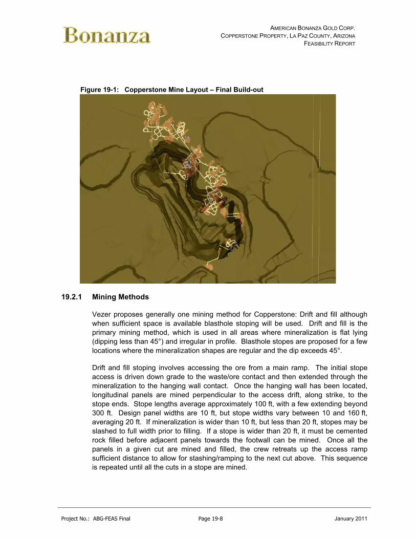
AMERICAN BONANZA GOLD CORP. COPPERSTONE PROPERTY, LA PAZ COUNTY, ARIZONA
FEASIBILITY REPORT
Project No.: ABG-FEAS Final Page 19-8 January 2011
Figure 19-1: Copperstone Mine Layout – Final Build-out
19.2.1 Mining Methods
Vezer proposes generally one mining method for Copperstone: Drift and fill although when sufficient space is available blasthole stoping will be used. Drift and fill is the primary mining method, which is used in all areas where mineralization is flat lying (dipping less than 45°) and irregular in profile. Blasthole stopes are proposed for a few locations where the mineralization shapes are regular and the dip exceeds 45°.
Drift and fill stoping involves accessing the ore from a main ramp. The initial stope access is driven down grade to the waste/ore contact and then extended through the mineralization to the hanging wall contact. Once the hanging wall has been located, longitudinal panels are mined perpendicular to the access drift, along strike, to the stope ends. Stope lengths average approximately 100 ft, with a few extending beyond 300 ft. Design panel widths are 10 ft, but stope widths vary between 10 and 160 ft, averaging 20 ft. If mineralization is wider than 10 ft, but less than 20 ft, stopes may be slashed to full width prior to filling. If a stope is wider than 20 ft, it must be cemented rock filled before adjacent panels towards the footwall can be mined. Once all the panels in a given cut are mined and filled, the crew retreats up the access ramp sufficient distance to allow for stashing/ramping to the next cut above. This sequence is repeated until all the cuts in a stope are mined.

AMERICAN BONANZA GOLD CORP. COPPERSTONE PROPERTY, LA PAZ COUNTY, ARIZONA
FEASIBILITY REPORT
Project No.: ABG-FEAS Final Page 19-9 January 2011
A nominal level spacing of 60 ft was selected, providing access to five 12 ft high drift and fill cuts from a single access point. The resolution provided by the 12 ft high cuts reduces dilution along the hanging and footwall compared to higher cuts, while still providing sufficient access height for highly-productive mining equipment.
The number of cuts per stope varies between two and five. Stope access gradients are selected to minimize stope access length. This approach does, however, result in a number of down grade accesses, which are susceptible to water pooling near the face. Pump allowances are included in the development and production costs to mitigate this issue. Typical stope access drift gradients are summarized in Table 19-1.
Table 19-1: Stope Access Geometry
Stope Access Drifts Stope Access Gradients
2 Flat and -15%
3 +15%, Flat, and -7.5%
4 +15%, Flat, -7.5%, and -15%
5 +15%, +7.5%, 0%, -7.5%, and -15%
Initial stope access drifts are rather lengthy due to the relatively flat gradient of the mineralization. Access points will be maximized to minimize associated development access. Reducing the number of cuts per access point would reduce the average stope access drift length, but it would increase the number of stope access points and the associated access development.
In a typical cut and fill operation, several stopes would be accessed from a common footwall drift extending across each level. In this case, insufficient access points exist to justify excavating such footwall drifts. A series of ramps are proposed that provide access to the optimum access points for each stope.
Blasthole stopes are accessed from the top and bottom. Blastholes are drilled from the top and/or bottom accesses to blast muck into a slot, which would be excavated from bottom to top towards one end of the stope. Muck is retrieved from the stope bottom with LHD.
Cross sections through typical drift and fill and blasthole stopes are presented in Figures 19-2 and 19-3, respectively. A typical plan view is identified in Figure 19-4.
Key opportunities to improve mining costs include optimizing ramp and stope access designs, and incorporating additional blasthole stopes.

AMERICAN BONANZA GOLD CORP. COPPERSTONE PROPERTY, LA PAZ COUNTY, ARIZONA
FEASIBILITY REPORT
Project No.: ABG-FEAS Final Page 19-10 January 2011
Figure 19-2: Cross Section through a Typical Drift and Fill Stope (AMEC)
Access Ramp
Initial Stope Access Drift
Initial Cut
Subsequent Stope Access Drifts
Subsequent Cuts
Access Ramp
Initial Stope Access Drift
Initial Cut
Subsequent Stope Access Drifts
Subsequent Cuts
Figure 19-3: Cross Section through a Typical Blasthole Stope
Stope – No Upper Drill Level
Access Drift
Access Ramp
Stope – No Upper Drill Level
Access Drift
Access Ramp
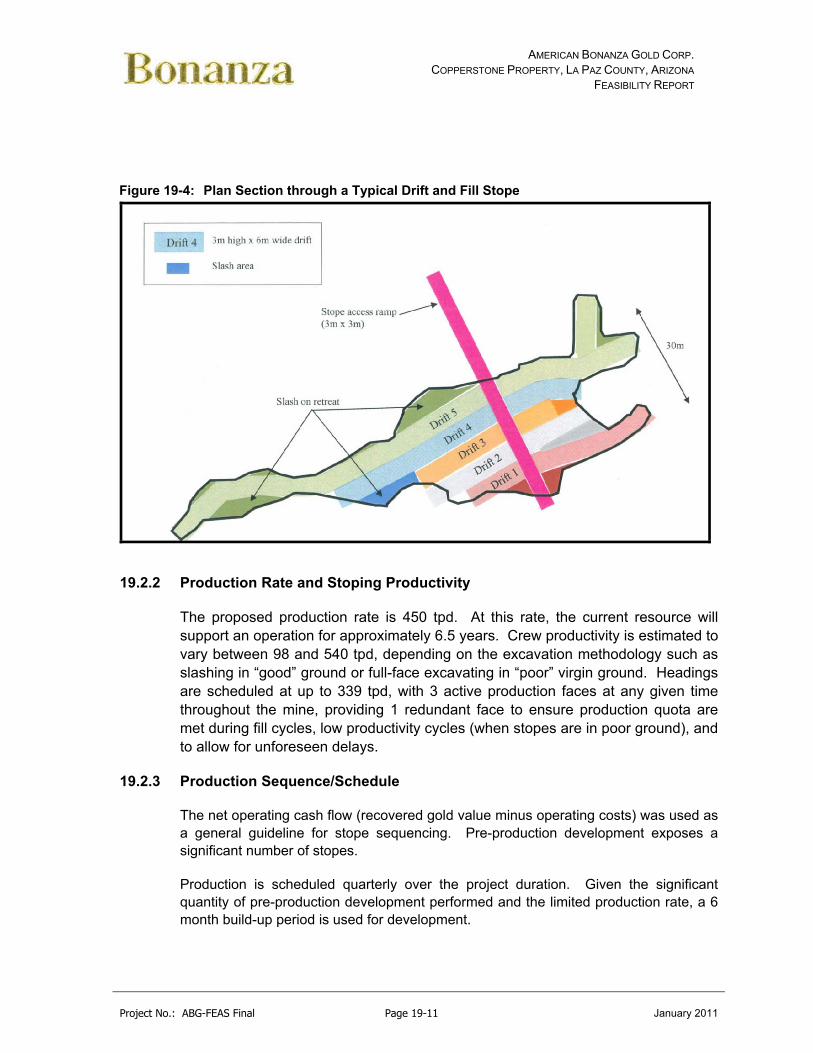
AMERICAN BONANZA GOLD CORP. COPPERSTONE PROPERTY, LA PAZ COUNTY, ARIZONA
FEASIBILITY REPORT
Project No.: ABG-FEAS Final Page 19-11 January 2011
Figure 19-4: Plan Section through a Typical Drift and Fill Stope
19.2.2 Production Rate and Stoping Productivity
The proposed production rate is 450 tpd. At this rate, the current resource will support an operation for approximately 6.5 years. Crew productivity is estimated to vary between 98 and 540 tpd, depending on the excavation methodology such as slashing in “good” ground or full-face excavating in “poor” virgin ground. Headings are scheduled at up to 339 tpd, with 3 active production faces at any given time throughout the mine, providing 1 redundant face to ensure production quota are met during fill cycles, low productivity cycles (when stopes are in poor ground), and to allow for unforeseen delays.
19.2.3 Production Sequence/Schedule
The net operating cash flow (recovered gold value minus operating costs) was used as a general guideline for stope sequencing. Pre-production development exposes a significant number of stopes.
Production is scheduled quarterly over the project duration. Given the significant quantity of pre-production development performed and the limited production rate, a 6 month build-up period is used for development.

AMERICAN BONANZA GOLD CORP. COPPERSTONE PROPERTY, LA PAZ COUNTY, ARIZONA
FEASIBILITY REPORT
Project No.: ABG-FEAS Final Page 19-12 January 2011
The production schedule is summarized in Table 19-2.
Table 19-2: Production Summary
Activity Unit Year ‐1 Year 1 Year 2 Year 3 Year 4 Year 5 Year 6 Year 7 Totals
Haulage Development
ft 2,183 3,330 3,929 3,551 2,787 1,116 0 0 16,894
Access Development
ft 1,375 1,833 3,262 4,190 3,685 3,848 2,414 589 21,196
Ventilation ft 696 146 0 0 0 179 180 0 1,201
Production t 0 160,053 158,074 160,194 156,921 160,737 160,635 46,001 1,002,615
Stope Fill t 0 145,865 155,749 152,900 145,545 170,801 154,964 52,320 978,144
Gold oz 0 40,100 61,400 51,471 33,793 28,770 32,106 8,790 256,431
Grade oz/t 0.251 0.388 0.321 0.215 0.179 0.200 0.191 0.256
Note: Totals may not balance due to rounding.
19.2.4 Ore Haulage
Drift and fill production costs only include the transport of ore from the stope to a transfer point. Separate haulage crews transport ore from a transfer point to surface and from the surface dump to the plant crusher at additional cost.
19.2.5 Backfill
Both mining methods utilize 5% cemented rock fill. The fill limits an exposed span while mining successive adjacent panels in a cut, and supports the stope hanging wall providing access to successive cuts. The proposed plan includes allowances to fill all stopes except the last cut in the drift and fill stopes (provided the cut is independent of subsequent stopes) and the top 20% in top/bottom access blasthole stopes. The remaining void is used for waste rock disposal. Blasthole stopes with a single bottom access are not filled. A total of approximately 85% of the stopes are filled.
Backfill is truck-hauled from a crushing/screening/slurry plant to a transfer point near the stope. An LHD transports the fill into the stope. A second LHD with a rammer pushes the fill tight to the back, where necessary.
Further opportunity exists to reduce the amount fill required, but this will require detailed stope geometry and sequencing analysis, and additional fill strength and stope stability evaluations.
The backfill schedule is presented in Appendix L.

AMERICAN BONANZA GOLD CORP. COPPERSTONE PROPERTY, LA PAZ COUNTY, ARIZONA
FEASIBILITY REPORT
Project No.: ABG-FEAS Final Page 19-13 January 2011
19.2.6 Development Sequence/Schedules
Mine development is classified into four categories:
Main Ramp – 14 ft height x 14 ft width – Includes miscellaneous excavations such as remuck bays, sumps, and electrical cutouts. A complete loop on both the top and bottom of the ore body is developed during the pre-production period by excavating from a point along the existing decline, to a location approximately 580 ft east, where a 10 ft diameter vent raise will be drilled. This loop provides flow through ventilation, and a secondary means of egress. Pre-production development is performed by a Contractor. During the development of the vent raise access, other development work will be undertaken, with approximately 2 additional development headings in process while the vent raise work is being carried out. Remaining ramp development is performed by the Contractor at a rate of 750 ft/qtr. Beyond the pre-production period, ramp development is sequenced to accommodate the production schedule (Figure 19-5).
Stope Access Drift – 12 ft height x 10 ft width – This is the initial access to each stope and is driven in virgin ground. All stope access drifts are scheduled: at the latest, during the quarter before stoping commences.
Inter-stope Access Drift – 12 ft height x 10 ft width – Development needed to access nearby isolated resource pods. Inter-stope access development is scheduled simultaneous with production.
Stope Access Slash – 12 ft height x 10 ft width – All access drifts subsequent to the initial access are excavated by slashing. These accesses are “pulled in” to the resource to minimize length. Stope access slashing is scheduled simultaneous with production and will be optimized based on actual equipment size and stope need.
All mine equipment will be provided by a competent mine contractor.
The development schedules discussed above are presented in Appendix L.
Figure 19-5: Pre-Production Development (Shaded Area)

AMERICAN BONANZA GOLD CORP. COPPERSTONE PROPERTY, LA PAZ COUNTY, ARIZONA
FEASIBILITY REPORT
Project No.: ABG-FEAS Final Page 19-14 January 2011
CURRENT DECLINE
ACTUAL YEAR 1 DEVELOPMENT (LESS STOPES)
1” - 1,000’
N
VENT RAISE

AMERICAN BONANZA GOLD CORP. COPPERSTONE PROPERTY, LA PAZ COUNTY, ARIZONA
FEASIBILITY REPORT
Project No.: ABG-FEAS Final Page 19-15 January 2011
19.2.7 Waste Haulage
Waste rock is generated by excavating ramps, stope accesses, inter-stope accesses, and stope access slashing. Waste is hauled to the surface during the pre-production period. During normal operation, 65% of the waste generated during operations is hauled to surface. The other 35% is stored in the tops of mined-out, backfilled, stopes. The waste haulage schedule is presented in Appendix L.
19.2.8 Drilling
Delineation drilling requirements are calculated from an average hole length and the assumption that four pierce points are needed per five-cut stope (AMEC). The average hole length is the sum of the stope access length (131 ft), the average stope width (24 ft), and a 5 ft overdrill allowance, for a total of 160 ft. The pierce point assumption equates to 0.8 pierce points or holes per cut. The drilling summary is presented in Appendix L.
19.2.9 Ventilation Fans
A flow-through ventilation circuit is envisioned for Copperstone. The fans draw fresh air down the existing ramp and past the accesses for all stopes and exit out the newly drilled vent raise.
The total ventilation requirement is based on the mobile equipment fleet motor sizes, an operating factor, and an allowance of 125 cfm/bhp (see Table 19-3). The resulting ventilation load is approximately 160,000 cfm. This air will be delivered by a pair of 100 hp fans.
Auxiliary fans force fresh air from the ramp to the working faces using ventilation duct.
Table 19-3: Fixed Equipment Ventilation Requirement
ITEM/DESCRIPTION OPERATING QUANITITY
(EA)
MOTOR SIZE (hp)
OPERATING FACTOR
VENTILATION REQ. (cfm)
MOTOR
DEVELOPMENT/PRODUCTION EQUIPMENT
JUMBO 2 75 67% 12563
DUETZ F4L‐912
LHD ‐ 3 CU/M 3 182 75% 51188
DUETZ F8L‐413
TRUCK 20 T 2 182 40% 18200
DUETZ F8L‐413
SUPPORT EQUIPMENT AND FACILITIES
SUPPORT VEHICLES 3 75 40% 11250 DUETZ F4L‐912

AMERICAN BONANZA GOLD CORP. COPPERSTONE PROPERTY, LA PAZ COUNTY, ARIZONA
FEASIBILITY REPORT
Project No.: ABG-FEAS Final Page 19-16 January 2011
LUBE/FUEL TRUCK 1 174 40% 8700 DUETZ F8L‐413
BOOM TRUCK 1 174 25% 5438 DUETZ F8L‐413
SERVICE TRUCK 1 174 60% 13050 DUETZ F8L‐413
ROAD GRADER 1 174 65% 14138 DUETZ F8L‐413
SHOP 10000
MISC. EQUIPMENT 10% 14452.5
TOTAL 158978
VENTILATION REQUIREMENT 125 CFM/BHP
19.2.10 Water Management
Schlumberger Water Services (SWS) (January 2010) completed a detailed dewatering review and suggested using underground wells and sumps to intercept flows that might otherwise report to the mine. The following is adapted from the SWS final report:
The following is estimated potential water volumes:
Based on site performance in the past and hydrogeologic understanding of the bedrock system and operating practices, the initial dewatering pumping rate required during Year 1 is estimated to be of the order of 150 to 300 gpm, but preparing for 300 gpm, including contingency, would be prudent.
The longer term flow rate will depend largely on the extent to which the system is bounded, but is estimated to range from 50 to 300 gpm.
The key uncertainty is the extent to which the structural system communicates to areas outside of the mine footprint.
The extent of drawdown will extend principally to the SW and NE. The cone of drawdown will develop to the SE direction.
The structural regime will limit the extent of drawdown to the NW and SE.
The depth to the water table is between 530 and 575 ft below ground level. The final depth of the mine is approximately 900 ft below ground level. Between 60 and 70% of any dewatering well drilled from surface will be through dry sediments and rock. The movement of ground water through the mine area is most likely restricted to permeable high angle structural features. Drilling into these features from the surface to encounter a water bearing structure will be difficult.

AMERICAN BONANZA GOLD CORP. COPPERSTONE PROPERTY, LA PAZ COUNTY, ARIZONA
FEASIBILITY REPORT
Project No.: ABG-FEAS Final Page 19-17 January 2011
It is the opinion of SWS that drilling from the surface will be expensive and with a high risk of drilling low productivity zones. The underground exploration drilling program had a 46% success rate of drilling a hole that encountered water. The average yield was 117 gpm. Underground drill holes are subhorizontal and across strike. Such drill holes have a high probability of drilling through a water bearing fracture.
Underground dewatering wells will be able to drill across strike and dewater adjacent hydrogeological domains. Vertical surface wells would not be able to do this. Therefore SWS would recommend that the dewatering approach is to develop a robust program of underground measures that would include:
A booster pumping system carried along with the face and containing contingency capacity with flow pumped to the current underground pumping station.
Upgrade to the current underground pumping station to accommodate the addition of flow.
Long drain holes drilled ahead of the face. Cover holes drilled with each round to assess and manage the potential for
high permeability features. One or more underground dewatering pumping wells drilled close to the
decline spiral Contingency grouting capability.
Pump calculations are included in Appendix L.
19.2.11 Power Supply
An overland power line will provide power from the existing substation to a new substation near the existing portal. The line will extend across the surface to the pit wall above the portal, and down the pit wall to a termination point.
The mine operating load is estimated to be 1,200 kVA @ 460 volts (AMEC). However, the usage points are spread over an extensive area. A power line will be installed in the adit, which terminates at a skid-mounted 1,500 kVA transformer near the ramp midpoint. All mine loads will be serviced from this location, as well as power boxes located at a 1,000 ft interval along the ramp system.
The load list and power supply cost estimate are included in Appendix L.
19.2.12 Mine Services
Most indirect operating costs such as maintenance, supervision, and electrical power are included in other cost items. The mine services area includes costs for operating
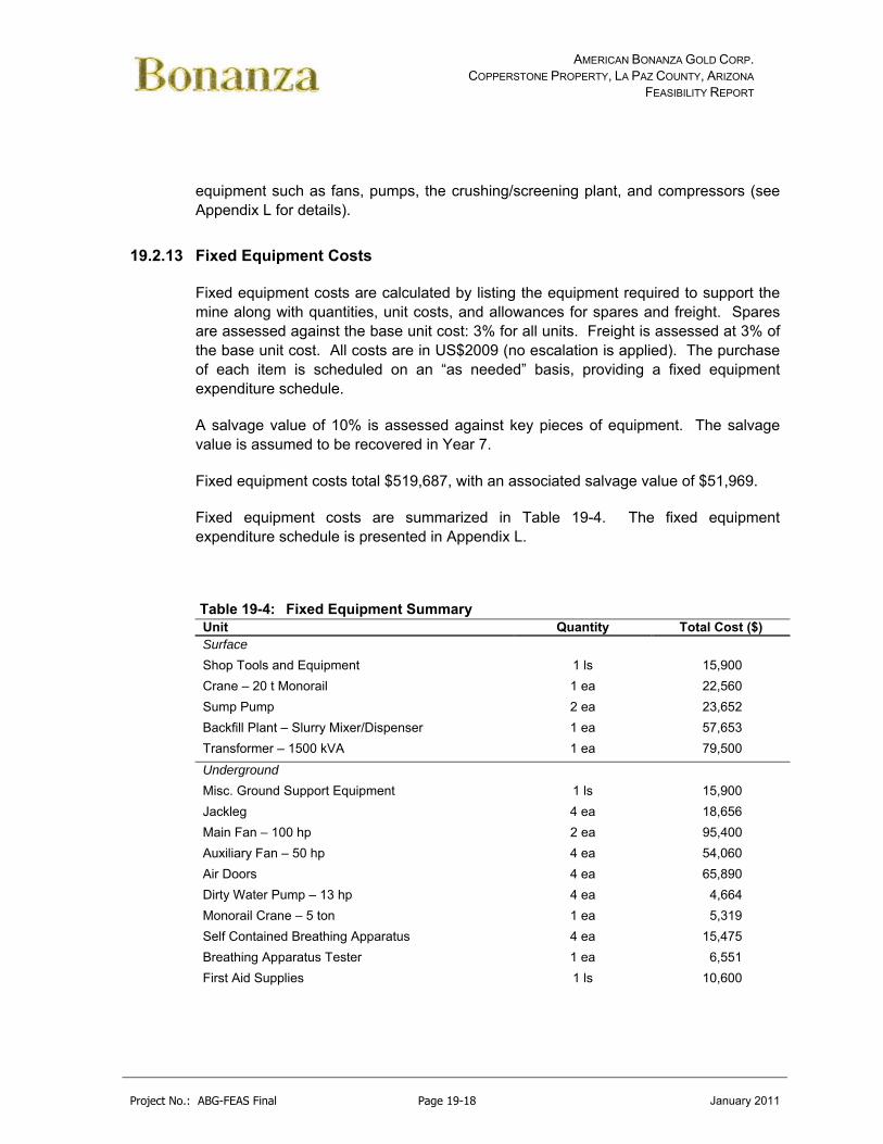
AMERICAN BONANZA GOLD CORP. COPPERSTONE PROPERTY, LA PAZ COUNTY, ARIZONA
FEASIBILITY REPORT
Project No.: ABG-FEAS Final Page 19-18 January 2011
equipment such as fans, pumps, the crushing/screening plant, and compressors (see Appendix L for details).
19.2.13 Fixed Equipment Costs
Fixed equipment costs are calculated by listing the equipment required to support the mine along with quantities, unit costs, and allowances for spares and freight. Spares are assessed against the base unit cost: 3% for all units. Freight is assessed at 3% of the base unit cost. All costs are in US$2009 (no escalation is applied). The purchase of each item is scheduled on an “as needed” basis, providing a fixed equipment expenditure schedule.
A salvage value of 10% is assessed against key pieces of equipment. The salvage value is assumed to be recovered in Year 7.
Fixed equipment costs total $519,687, with an associated salvage value of $51,969.
Fixed equipment costs are summarized in Table 19-4. The fixed equipment expenditure schedule is presented in Appendix L.
Table 19-4: Fixed Equipment Summary Unit Quantity Total Cost ($) Surface
Shop Tools and Equipment 1 ls 15,900
Crane – 20 t Monorail 1 ea 22,560
Sump Pump 2 ea 23,652
Backfill Plant – Slurry Mixer/Dispenser 1 ea 57,653
Transformer – 1500 kVA 1 ea 79,500
Underground
Misc. Ground Support Equipment 1 ls 15,900
Jackleg 4 ea 18,656
Main Fan – 100 hp 2 ea 95,400
Auxiliary Fan – 50 hp 4 ea 54,060
Air Doors 4 ea 65,890
Dirty Water Pump – 13 hp 4 ea 4,664
Monorail Crane – 5 ton 1 ea 5,319
Self Contained Breathing Apparatus 4 ea 15,475
Breathing Apparatus Tester 1 ea 6,551
First Aid Supplies 1 ls 10,600

AMERICAN BONANZA GOLD CORP. COPPERSTONE PROPERTY, LA PAZ COUNTY, ARIZONA
FEASIBILITY REPORT
Project No.: ABG-FEAS Final Page 19-19 January 2011
Unit Quantity Total Cost ($) Cap Lamps and Chargers 10 ea 3,393
Self Rescuers – W65 10 ea 3,604
Communications Equipment 1 ls 15,900
Total (plus 6% spares and freight) 519,687
19.2.14 Mobile Equipment Costs
Production and development fleet requirements are calculated from quantity take-offs and productivity rates for each activity based on contractor rates and mark-ups. All quantities include spare units, based on assumed mechanical availability of 85%. Required units are summed, and then rounded to the nearest whole number. Auxiliary units are assessed manually. Details related to the mobile equipment quantities are presented in Appendix L.
Mobile equipment costs are calculated by listing the equipment required to support the mine along with quantities, unit costs, and allowances for development (first fills and commissioning), spares, and freight. Spares are assessed against the base unit cost (of select items) using a rate of 3%. Freight is assessed at 3% of the base unit cost. All costs are in US$ 2009 (no escalation is applied). The purchase of each item is scheduled on an “as needed” basis, providing a mobile equipment expenditure schedule.
A mobile equipment will provided by a contractor.
19.3 Processing
Because of environmental concerns and potential permitting issues when using cyanide, a relatively standard crush-grind-gravity/flotation process has been selected to process the ore at the Copperstone operation. The current plan of operations consists of standard 2-stage crushing followed by closed circuit ball mill grinding with a gravity circuit placed in the cyclone underflow. The grinding circuit is then followed by rougher flotation and standard wet tailings deposition. Process flowsheets and general arrangement drawings are included in the Appendix M.
The plant will process ore at an average rate of 450 tons per day for 360 days per year, or 157,500 tonnes per annum and produce approximately 25 tons of concentrate (20 tons flotation concentrate @ 4 to 8 oz/tn, 5 tons per day of gravity concentrate @ 15 to 20) or 155 to 260 gold ounces per day depending on head grade. Ore will be delivered to the jaw crusher feed hopper either directly from the mine, or by loader from stockpiles located in close proximity to the crushing plant. The Jaw crusher discharge will report to the crusher screen which operates in closed circuit with a

AMERICAN BONANZA GOLD CORP. COPPERSTONE PROPERTY, LA PAZ COUNTY, ARIZONA
FEASIBILITY REPORT
Project No.: ABG-FEAS Final Page 19-20 January 2011
secondary cone crusher. Crushed to a 100% passing 0.5 inch, material will be conveyed to a crushed ore bin where a conveyor belt will deliver ore to a 10’ x 10’ primary ball mill with a 525 horsepower motor. The ball mill, in closed circuit with the primary cyclone, will reduce the ore to a nominal 74 μm or 200 mesh.
The underflow from the primary cyclones will be feed a screen with the screen underflow feeding a 30D Knelson Concentrator. The underflow from the Knelson concentrator will be recombined with the screen overflow and sent back to the ball mill for further grinding.
The overflow from the cyclones will be fed to a conditioning tank and into a rougher only flotation circuit. The tails from the flotation circuit will be pumped to the tailing facility.
The concentrate from the flotation roughers and Knelson concentrator will be sent off-site to a third party processor for toll processing and recovery of the gold.
19.3.1 Process Selection
Crushing
The crusher will be designed to crush all material in one-shift with a crushing rate of approximately 50 tons per hour. At this rate the crusher should be able to crush the one day of production in approximately 1 shift.
Run of mine ore will be dumped into a crusher dump pocket that will hold 50 tons or approximately 2 dump truck loads. The dump pocket will have a 30 in grizzly to minimize oversize into the dump pocket. A small rock breaker will be installed to break run of mine oversize.
The ore will fed to the crusher through a 32 in x 16 ft vibrating grizzly feeder. The oversize from the grizzly feeder will feed a Nordberg C80 Jaw Crusher or equivalent set with a 3 in closed side set. The vibrating grizzly feeder undersize and jaw crusher crushed product will be combined and sent to the secondary crushing circuit by conveyor.
The secondary crushing circuit will consist of a Nordberg HP 200 cone crusher or equivalent in closed circuit with a 6 ft x 12 ft double deck screen. The jaw crusher discharge conveyor will feed the screen with the oversize passing being sent to a Nordberg HP 200 cone crusher or equivalent with a 7/16 in closed side setting. The crushed product will be recirculated to the screen. The ½ in screen underflow will be

AMERICAN BONANZA GOLD CORP. COPPERSTONE PROPERTY, LA PAZ COUNTY, ARIZONA
FEASIBILITY REPORT
Project No.: ABG-FEAS Final Page 19-21 January 2011
sent via 24 in wide by approximately 100 ft long with an 18 ft lift conveyor belt to a live 500 ton ore bin for storage.
Grinding
The 1/2 in crushed ore will feed the primary ball mill feed chute via a vibratory feeder feeding the crushed ore belt conveyor. The Primary Ball Mill is 10 foot Ø x 10 foot, 525 hp mill and will reduce the size of the mill feed to a P80 of 74 microns in size. The mill will use rubber liners and is furnished with a trommel screen. The trommel screen undersize pulp will gravitate into a pump-box and will be pumped to one of two 12 in primary ball mill cyclones (one operating/one stand-by). The primary ball mill cyclone underflow will be feed to a screen where the plus 10 mesh material will be separated from the underflow with the minus 10 mesh material being feed to a 30 inch Knelson Concentrator. The underflow from the Knelson concentrator will recombine with the plus 10 mesh cyclone underflow and will gravitate to the primary ball mill feed box as a recirculating load joining the crushed ore mill feed. The cyclone overflow will feed the flotation circuit. Both copper sulfate and the collectors will be added into the grinding circuit to optimize retention time. Collectors to be used include potassium amyl xanthate (PAX), Aerofloat 208, and Aerofloat 3477 or equivalent.
Flotation
The cyclone overflow will be feed into a 7 foot Ø x 7 foot agitated conditioning tank that has approximately 8.5 minutes of retention time. Further collector will be added into the conditioning tank as required. Frother will be added to the conditioning tank discharge as required to maintain a proper froth bed. The frother used will be either MIBC or glycol based.
The conditioning tank will have a peripheral overflow that will be split into one of two rougher flotation banks. Each flotation bank will consist of 8 – 100 ft3 flotation cells allowing for 30 minutes of flotation time. A rougher concentrate will be formed that consists of approximately 4 to 8% of the total feed volume and contain approximately 4 to 8 ounces of gold per ton depending on concentrate volume.
The rougher concentrate will be pumped to a small 6 foot diameter thickener with the overflow water pumped back to the process water tank. The thickened concentrate or underflow will be pumped to a plate and frame filter or filter press to minimize loss. The concentrate will then be bagged and sent to an outside refiner for processing and final gold recovery. Provisions for a cleaner circuit will be designed into the system.
Tailings

AMERICAN BONANZA GOLD CORP. COPPERSTONE PROPERTY, LA PAZ COUNTY, ARIZONA
FEASIBILITY REPORT
Project No.: ABG-FEAS Final Page 19-22 January 2011
The rougher circuit tailings will be discharged from the last flotation tank into the rougher tails tank and to a 30 foot diameter thickener. The tails will be thickened to approximately 50% solids by weight so the tails can be pumped approximately 2,000 feet to the tailings facility. The tailings pond will be designed to all for radial wet placement of the tailings.
The new tailings facility will be placed to the north of the existing tailings disposal area and heap leach pad. The tailings disposal area is designed by Schlumberger Water Services for deposition of the proposed 1,090,000 dry tons of whole slurry tailings. Deposition is anticipated to consist of rotationally spigotted tailings from the perimeter of the embankment crest. Drainage from the tailings facility will be collected in the in a newly lined reclaim collection system. Pumps will be added to either pump recycle solution back to the process tank or to pump process solution back to the tailings facility for evaporation.
19.3.2 Recovery
At a P80 of 150 to 200 mesh grind, flotation/gravity recoveries of about 86% to 94% are indicated depending on location or area (Table 19-5).
Table 19-5: Summary of Metallurgical Test Results
Grade Parameter Extraction/ Recovery
Zone Sample
ID Date Test
WtKg
Au oz/tAu
(Calc)
Agoz/t
Cu %
Total Grind Time Au Ag Cu
Ore Composite
2000 Float 1.03 1.18 200M 94
Ore Composite
None 2001 Float
(McCoy/Cove) 2.0 1.51 0.75 0.56 140M 88 9
D-Zone D-Zone 2005 Grav/Float 150M 89
200M 89
Hanging Wall
HW 2005 Grav/Float 150M 88
Grav/Float 200M 91
D-Zone CAMP 2009 Grav/Float 0.332 0.643 2.34 0.68 200M 28/88 47
C-Zone CAMP 2009 Grav/Float 0.341 0.408 2.74 1.03 200M 37/86 27
There has been significant assay scatter as the back calculated head grades show low precision to the initial assayed head grade. The CAMP testing showed that using back calculated head grade that would have pushed overall recoveries into the low to mid 90% range.

AMERICAN BONANZA GOLD CORP. COPPERSTONE PROPERTY, LA PAZ COUNTY, ARIZONA
FEASIBILITY REPORT
Project No.: ABG-FEAS Final Page 19-23 January 2011
Based on the testing, a recovery of approximately 88 to 92% is indicated (Figure 19-6).
Figure 19-6: Gold Recovery – Flotation/Gravity Testing
A review of the tails using an MLA micrograph identified most of the gold was typically locked within the gangue material at sizes approaching 10 micron (Figure 19-7). No large free pieces of gold were found in any of the micrographs.
Figure 19-7: Tailings MLA Micrograph (Gold as white blebs locked in calcite)
The indication of Figure 18.6 is that finer grinding may only create a nominal increase in recovery that will not offset the higher cost of fine grinding.
Significant gravity gold recovery has been obtained with the potential of the 35% of the gold being recovered in the C-Zone and 25% recovery in the D-Zone using a Knelson type concentrator. Being able to recover the coarse gold in a gravity circuit may
GOLD

AMERICAN BONANZA GOLD CORP. COPPERSTONE PROPERTY, LA PAZ COUNTY, ARIZONA
FEASIBILITY REPORT
Project No.: ABG-FEAS Final Page 19-24 January 2011
decrease the initial working capital requirement in that the free gold can be readily processed and sold whereas the concentrate will require significant further processing. Based on previous testwork, gravity appears to have the potential to add 1% to 2% to the overall recovery from gold that may not float well. Because of the high gravity recovery, the use of gravity is recommended for this project.
Recoveries of approximately 90% are reasonable and used for the basis of this study.
A review of leaching the flotation concentrate identified the flotation concentrates leached very well and in 72 hours produced recoveries of 98.3% to 99.4%, offsite processing of the concentrate is recommended to eliminate the use of cyanide on site.
19.3.3 Construction Concept
An equipment list is provided in the estimate in Appendix M and a layout based on major equipment sizing is provided in Appendix M.
The crushing plant design is based on an open portable crushing arrangement, operating one shift per day. Ore will be trucked from the mine ROM stockpile, direct dumped and crushed on a single shift. Labor costs are a very significant component of operating costs and the design objective is to minimize labor cost and the cost to rehandle ore. A mill feed bin and automatic bin reclaim feeder are provided for this reason in lieu of an open stockpile and a two shift reclaim operation. All conveyors and the mill feed bin will be open.
The ball mill is sized to grind an oversized secondary crusher product to 200 mesh, based on the hardest zone (HW Zone) bond work index of 15 kWh/st.
The flotation circuit cell sizing is based on 38.5 minute retention time.
The gravity/concentrate quantity is based on a total concentrate weight recovery of 7.5% (about 34 short tons/day) which is an average flotation concentrate weight recovery of approximately 6.5% and a gravity concentrate weight recovery of less than 1%. Average flotation weight recoveries of 3% to 7% were experienced in test work. The rougher flotation should be pulled as hard as reasonably possible to maximize recovery thereby the flotation concentrate is projected to have a weight recovery on the upper end of the test work.
Gold recovery will be completed off-site at a third party processor or by American Bonanza at a different facility.

AMERICAN BONANZA GOLD CORP. COPPERSTONE PROPERTY, LA PAZ COUNTY, ARIZONA
FEASIBILITY REPORT
Project No.: ABG-FEAS Final Page 19-25 January 2011
All control will be local start/stop and by programmable logic controller in the field. No central control system is provided.
The mill area will be fabricated without a roof and will not be required to support overhead cranes or internal structures. Internal hoist frames, jibs, or external cranes will be provided over the mill and flotation areas for maintenance. A covered maintenance area is provided. The mill office, operations rooms, and MC building will be completely enclosed and air conditioned for operator comfort. The concentrate filtration discharge area will be isolated for security reasons.
19.3.4 Process Description
A simplified depiction of the overall process flowsheet is shown in Figure 19-8.
Ore will be trucked from the mine ROM stockpile, direct dumped and crushed on a single shift. The crushing plant is an open portable crushing arrangement, crushing 450 short tons/day of -200 mm ore to a P80 of ½ inch, on a single shift. This crusher consists of three mobile units; a feeder plant including receiving hopper, grizzly, vibrating feeder, belt conveyor, a primary crusher and a combined secondary crusher and screening unit. Crushed ore will be stored in a 500 t (live) mill feed bin providing one day of storage.
A vibrating grizzly feeder will be used to reclaim ore from the ore bin and it will be fed to a 24 inch conveyor belt that will feed a single 10 foot diameter by 10 foot (500 hp) ball mill for grinding.
Ground slurry will be pumped to one of two 12 inch cyclones. The cyclone underflow will be feed to a sizing screen to remove the plus 10 mesh material. The minus 10 mesh material will be feed to a 30” Knelson Concentrator, The discharge from the Knelson Concentrator will be recombined with the plus 10 mesh material from the screen and returned to the ball mill. The cyclone overflow will flow by gravity to the flotation circuit consisting of 10 100 cubic foot cells. Reagents will be added to the slurry to promote the flotation process. The gold will be collected in the flotation concentrate, which will be processed further in order to recover the precious metals. The combined gravity/flotation concentrate will account for approximately 7.5% weight of the feed to the plant, i.e., 34 st/d. The flotation tailings will be pumped to the surface tailings impoundment.
The flotation concentrate will be thickened in a concentrate thickener, dewatered in a plate filter and sent offsite for final gold recovery.

AMERICAN BONANZA GOLD CORP. COPPERSTONE PROPERTY, LA PAZ COUNTY, ARIZONA
FEASIBILITY REPORT
Project No.: ABG-FEAS Final Page 19-26 January 2011
Figure 19-8: Copperstone 450 st/d Gold Project Simplified Process Flow Diagram
GOLD CONCENTRATION FLOTATION CIRCUIT
GOLD ORE PRODUCTION FLOWSHEET
Cleaner Flotation
ORE STORAGE AND CRUSHING CIRCUIT
Scavenger Flotation Rougher Flotation
Ball Mill
COMMINUTION CIRCUIT
50 TON STORAGE BIN
JAWCRUSHER
APRONFEEDERW/GRIZZLY
VIBRATING SCREEN 6' X 12'
500 TN LIVE STORAGE
CLASSIFYINGCYCLONES
RECIRCULATINGLOAD
OVERSIZESCREEN
CONDITIONINGTANK
TAILINGS IMPOUNDMENT
KNELSONCONCENTRATOR
WATER TANK
MAKE‐UP
WATER
MAKE‐UP
WATER
MAKE‐UPWATER ‐MINE/WELL
DISCHARGEPOND
EVAPORATION WATER
PROCESS WATER
TAILINGS
TAILINGS
TAILINGS THICKENER(IF NEEDED)
TAILINGSPUMP
GRAVITYGOLD
GOLDCONCENTRATE
CONCENTRATE THICKENER
CONCENTRATE FILTER
AMERICAN BONANZA GOLD CORP. COPPERSTONE PROPERTY, LA PAZ COUNTY, ARIZONA
FEASIBILITY REPORT
Project No.: ABG-FEAS Final Page 19-27 January 2011
19.4 Tails Management
Following is a description of the tailings disposal facility.
19.4.1 Design Parameters
site the facility to the north of the existing facility in the old waste dump. production is 450 tpd for 6.5 years total required storage capacity is 1,003,000 tons tailings delivered to the storage facility as a slurry of whole tailings tailings dry, in place density assumed to be equal to 80 lb/ft3 provide two feet of freeboard in impoundment centerline construction supernatant solution will be decanted from a decant structure underdrainage from the tailings is collected in the new underdrain system underdrainage reports to the new reclaim solution pond fluid containment is provided by a new 80 mil HDPE liner system decant solution and underdrainage recycled to the mill or tailings pond for
processing or evaporation respectively.
The existing tailings disposal area and heap leach pad were reclaimed and the surface has been covered (leveled) with approximately 6 inches to 2 foot of fill and crushed surfacing material. The resulting top surface of the reclaimed tailings disposal area, the heap leach pad, and the surrounding waste rock disposal area is relatively flat and at an elevation of approximately 940 feet and will not be used due to comingling of solution.
The tailings disposal area embankments assessed for this report assumed centerline construction using the approximate centerline from new 2009 topography.
The top of the old waste dump facility has been chosen due to its ability for full containment. In the event of a dam breach, the top of the waste facility is sufficiently large enough that no material will escape the top of the area and potentially contaminate an undisturbed area.
19.4.2 Facility Layout and Design
The tailings disposal area is designed by Schlumberger Water Services for deposition of the proposed 1,003,000 dry tons of whole slurry tailings is depicted in Figure 19-9. Deposition is anticipated to consist of rotationally spigotted tailings from the perimeter of the embankment crest. With the geometry shown, the disposal facility can store the required tailings tonnage at an approximate embankment height of 28 ft with an

AMERICAN BONANZA GOLD CORP. COPPERSTONE PROPERTY, LA PAZ COUNTY, ARIZONA
FEASIBILITY REPORT
Project No.: ABG-FEAS Final Page 19-28 January 2011
assumed conservative tailings in-place dry density of 80 lb/ft3. An additional 2 ft was added to the embankments to provide nominal freeboard for storm event storage. With the assumed base elevation of 940 ft, the embankment crest will be ultimately established at an elevation of 968 ft.
In order to defer costs, the embankment will be constructed in multiple phases, each approximately 14ft in height.
Figure 19-9: New Tailings Disposal Facility
The surface area, storage capacity, elevation relationship is presented in Figure 19.10. Assuming a base elevation of 940 feet, the facility will store the required tailings at an elevation of approximately 968 feet with the assumption that the deposited tailings surface is horizontal. The remaining storage above elevation 955 feet to the crest elevation of 968 ft is to provide 2+ ft of freeboard for decant pool storage, storm event storage and to account for the fact that the tailings surface will be relatively flat, but will not be horizontal.

AMERICAN BONANZA GOLD CORP. COPPERSTONE PROPERTY, LA PAZ COUNTY, ARIZONA
FEASIBILITY REPORT
Project No.: ABG-FEAS Final Page 19-29 January 2011
A typical embankment cross section is shown in Figure 19-11. The embankment geometry has been established with a 17 ft wide crest and 2:1 (horizontal:vertical) interior and exterior slopes. Twenty-five feet was selected for the nominal crest width to provide for pickup truck and maintenance vehicle traffic, the tailings slurry discharge line, and safety berms (as needed). Embankment materials are expected to consist of waste rock and/or spent heap leach materials borrowed from the surrounding area. The embankment materials should consist of generally well-graded rockfill with sand, gravel, and fines. The maximum particle size of the rockfill should be on the order of 12 inches. The rockfill should be compacted in lifts to form a dense, stable mass. Two to one (2:1) interior and exterior slopes were selected to provide a generous factor of safety for slope stability.
Computed earthwork material quantities for the facility are summarized in Table 19-6.
Figure 19-10: Storage Capacity

AMERICAN BONANZA GOLD CORP. COPPERSTONE PROPERTY, LA PAZ COUNTY, ARIZONA
FEASIBILITY REPORT
Project No.: ABG-FEAS Final Page 19-30 January 2011
Figure 19-11: Typical Embankment Section
Table 19-6: Estimated Earthwork Quantities
Item Estimated In-Place Quantity (yd3)
Embankment Fill 165,000
Note: Quantities should be considered accurate to ±10%.
19.4.3 Environmental Considerations
Placement of the tailings disposal facility on top of the existing facility was selected for the following reasons:
the projected storage requirement is relatively small at 1,003,000 tons the facility is fully-geomembrane-lined with 60-mil PVC to provide containment
a collection system is placed to capture under-drainage and route it to a lined reclaim pond
the current facility design will result in a drained tailings mass at closure
additional disturbance to construct the facility is negligible site infrastructure (power line corridors, roads, etc.) is in place

AMERICAN BONANZA GOLD CORP. COPPERSTONE PROPERTY, LA PAZ COUNTY, ARIZONA
FEASIBILITY REPORT
Project No.: ABG-FEAS Final Page 19-31 January 2011
19.5 Operating Cost Estimate
19.5.1 Operating Cost Summary
The current production schedule is summarized in Table 19-7.
Table 19-7: Production Summary
Item Year 1 Year 2 Year 3 Year 4 Year 5 Year 6 Year 7 Total
Tons 160,053 158,074 160,194 156,921 160,737 160,635 46,001 1,002,615
Gold (oz/t) 0.251 0.388 0.321 0.215 0.179 0.200 0.191 0.256
Difference in tonnage is due to rounding.
The overall average operating cost is estimated to be $95.64/t processed. The total operating cost is comprised of $60.64/t in mine costs, $21.75/t in processing costs, and $13.25/t in General and Administrative costs. Details related to each of these major cost categories are presented in Table 19-8.
Table 19-8: Operating Cost Summary
Area Total Cost ($/t)
Mine
Development 14.15
Drill, Blast, and Muck 35.99
Dilution Waste 3.40
Backfill 4.25
Delineation Drilling 2.84
Plant
Labor 10.90
Consumables 4.61
Electrical Power – Process/HVAC/Lighting 6.24
General and Administrative 13.25
Total 95.64
Operating costs are presented in 2009 US$.
19.5.2 Operating Cost Estimate Basis
Mine
Underground mining operating costs were determined using first principle engineering, known consumption rates from previous mining experience, and a review of local vendor supply bids. All costs were escalated assuming contractor mining.

AMERICAN BONANZA GOLD CORP. COPPERSTONE PROPERTY, LA PAZ COUNTY, ARIZONA
FEASIBILITY REPORT
Project No.: ABG-FEAS Final Page 19-32 January 2011
The overall mining operating costs are summarized in Table 19-9.
Table 19-9: Mine Operating Cost Summary
Area Total Cost ($/t)
Mine
Haulage Drift Development/Waste Removal 5.80
Access Drift Development/Waste Removal 8.04
Ventilation Development 0.32
Development 14.15
Production 35.99
Dilution Waste Removal 3.40
Back Fill 4.25
Delineation Drilling 2.84
Total 60.64
Production is scheduled quarterly over the project duration. Mine operating cost estimates are developed from quantity take-off (measured from the three-dimensional mine model) and unit costs developed specifically for this project. Key contributions to the mine operating costs are described in Section 19.1.
The net operating cash flow (recovered gold value minus operating costs) was used as a general guideline for stope sequencing. Pre-production development exposes a significant number of stopes.
Production Rate and Stoping Productivity
The proposed production rate is 450 tpd. At this rate, the current resource will support an operation for approximately 6.5 years. Crew productivity is estimated to vary between 108 and 540 tpd, depending on the excavation methodology such as slashing in “good” ground or full-face excavating in “poor” virgin ground. Headings are scheduled at up to 339 tpd, with 3 active production faces at any given time throughout the mine, providing 1 redundant face to ensure production quota are met during fill cycles, low productivity cycles (when stopes are in poor ground), and to allow for unforeseen delays.
Stoping productivity calculations incorporate the following parameters:
2 shift/d, 11 effective h/shift, 50 effective min/h
use 2, 2-boom jumbo, 3 4.0 yd3 (3 m3) LHD, and bolt with Jacklegs
drill 11 ft, break 10 ft

AMERICAN BONANZA GOLD CORP. COPPERSTONE PROPERTY, LA PAZ COUNTY, ARIZONA
FEASIBILITY REPORT
Project No.: ABG-FEAS Final Page 19-33 January 2011
powder factor is 2.3 lb/t
support with 6 ft (2 m) split sets (and screen) on a 6 ft x 20 ft (2.0 m x 6.0 m) pattern
muck to transfer at 150 ft
2.5 miner crew plus 1 mechanic/electrician per crew
slashing productivity has reduced drilling, powder factor, and ground support.
Based on the parameters above, a standard 12 ft height x 10 ft width heading in “moderate” ground is developed at a rate of 26.7 ft/d and a unit cost of $381/ft. These basis values are prorated to determine productivities and costs for “good” and “poor” ground conditions, which are in turn weighted to determine average rates for scheduling and cost estimating purposes. Excavation in good ground is assumed to be done at 75% of the standard cost and at 133% of the productivity. Excavation in poor ground is assumed to be done at 300% of the standard cost and at 33% of the productivity. The overall average rate for a 12 ft height x 10 ft width drift is 32.3 ft/d at a cost of $364/ft ($33.02/t). The assumed ground type distribution is 7.5% poor, 15% moderate, and 77.5% good. This is based on a review of the existing decline.
Average slashing for a 12 ft height x 10 ft width heading is estimated to cost $294/ft or $25.62/t.
Drift and fill costs are assessed under the assumption that 70% of the production is done in virgin ground and 30% is done by slashing, reducing the average unit cost to $31.10/t.
Because of the limited blasthole stoping, blasthole stoping costs are calculated at the same rate as drift and fill costs noted above.
Details related to productivity calculations are presented in Appendix L.
Underground Haulage
Drift and fill production costs only include the transport of ore from the stope to a transfer point. Separate haulage crews transport ore from the transfer point to surface. A contractor will transport ore from the surface dump to the plant at additional cost.
Key parameters associated with ore haulage follow:
ore is scheduled to be hauled in the same quarter that each stope is mined
load truck with 3.0 yd3 LHD
haul ore with 20 ton truck

AMERICAN BONANZA GOLD CORP. COPPERSTONE PROPERTY, LA PAZ COUNTY, ARIZONA
FEASIBILITY REPORT
Project No.: ABG-FEAS Final Page 19-34 January 2011
average fill haul distance is 3,000 ft from stope to pit bottom
average unit cost for underground ore haulage is $2.88/t
average haul distance from pit bottom to plant is 6,700 ft
potentially tip into a bin and self load
haul with 20 ton truck unit cost for surface ore haulage is $2.01/t.
Backfill
Both mining methods utilize cemented rock fill. The fill limits exposed span while mining successive adjacent panels in a cut, and supports the stope hanging wall providing access to successive cuts. The proposed plan includes allowances to fill all stopes except the last cut in the drift and fill stopes (provided the cut is independent of subsequent stopes) and the top 20% in top/bottom access blasthole stopes. The remaining void is used for waste rock disposal. Blasthole stopes with a single bottom access are not filled. A total of 85% of the stopes are filled.
Backfill is truck-hauled from a crushing/screening/slurry plant in the pit bottom to a transfer point near the stope. An LHD transports the fill into the stope. A second LHD with a rammer pushes the fill tight to the back, where necessary.
Following are key backfill haulage and scheduling parameters:
backfill is scheduled to be placed during the same quarter that each stope is mined
backfill requirements are calculated from the stope volumes and an in-place fill density of 14.4 ft3/t fill
haul fill with 20 ton truck
average fill haul distance is 3,000 ft
average unit cost is $2.88/t hauled
transfer fill with 3.0 yd3 LHD
average fill transfer distance is 100 ft
average cement content is 5%
average unit cost is $4.36/t placed.
Waste Haulage
Waste rock is generated by excavating ramps, stope accesses, inter-stope accesses, and stope access slashing. A Contractor hauls waste to surface during the pre-production period. During normal operation, 50% of the waste generated during

AMERICAN BONANZA GOLD CORP. COPPERSTONE PROPERTY, LA PAZ COUNTY, ARIZONA
FEASIBILITY REPORT
Project No.: ABG-FEAS Final Page 19-35 January 2011
operations to surface. The other 50% is stored in the tops of mined-out, backfilled, stopes. The waste haulage schedule is presented in Appendix L.
Following are the waste haulage cost parameters.
haul to surface by Contractor at $2.88/t (same as ore haul cost)
haul to crusher fro surface stockpile by Contractor at $2.01/t.
Drilling
Delineation drilling requirements are calculated from an average hole length and the assumption that four pierce points are needed per five-cut stope. The average hole length is the sum of the stope access length (131 ft), the average stope width (24 ft), and a 5 ft overdrill allowance, for a total of 160 ft. The pierce point assumption equates to 0.8 pierce points or holes per cut. The drilling per stope is calculated for each stope from the number of cuts per stope. A total of 48,853 ft of drilling are required over the mine life. Costs are assessed at $65/ft (including assays). Drilling costs are spread evenly over the mine life.
Fixed Equipment Costs
Fixed equipment costs are calculated by listing the equipment required to support the mine along with quantities, unit costs, and allowances for spares and freight. Spares are assessed against the base unit cost (of select items) of 3%. Freight is assessed at 3% of the base unit cost. All costs are in US$2009 (no escalation is applied). The purchase of each item is scheduled on an “as needed” basis, providing a fixed equipment expenditure schedule.
A salvage value of 10% is assessed against key pieces of equipment. The salvage value is assumed to be recovered in Year 7.
Fixed equipment costs total $519,687, with an associated salvage value of $51,969.
Fixed equipment costs are summarized in Table 19-4.
Mobile Equipment Costs
Production and development fleet requirements are calculated from quantity take-offs and productivity rates for each activity based on contractor rates and mark-ups. All quantities include spare units, based on assumed mechanical availability of 85%. Required units are summed, and then rounded to the nearest whole number. Auxiliary

AMERICAN BONANZA GOLD CORP. COPPERSTONE PROPERTY, LA PAZ COUNTY, ARIZONA
FEASIBILITY REPORT
Project No.: ABG-FEAS Final Page 19-36 January 2011
units are assessed manually. Details related to the mobile equipment quantities are presented in N.
All mobile equipment will provided by a contractor.
Process
The process plant operating costs were determined and are summarized by the cost elements of labor, power, reagents, maintenance parts, and supplies and services. The process plant operating costs are shown by cost center in Table 19-10 below.
Table 19-10: Operating Cost - Process Plant Cost Summary
Item Cost/Ton Total $
Safety $ 0.15 $23,625
Salary Labor $ 2.36 $371,480
Operations labor $ 8.54 $1,344,583
Electrical $ 6.24 $983,105
Reagents and Supplies $ 3.12 $490,760
Misc. Consumables $ 0.71 $111,825
Assay Lab Consumables $ 0.20 $31,500
Outside Services $ 0.35 $55,125
Security $ 0.10 $15,750
Total Cost $ 21.76 $3,427,753
Labor Total $10.90 $1,716,063
Labor
Process labor costs were derived from a staffing plan developed jointly with American Bonanza and based on prevailing daily or annual labor rates in Arizona. Labor rates and fringe benefits for local employees were based on prevailing rates in the area and include all applicable social security benefits as well as all applicable payroll taxes. The staffing plan for the process plant operations includes 18 plant operators and 4 maintenance personnel. Labor rates include a bonus or overtime. Detail process labor costs for operations and maintenance are shown in Tables 19-11 and 19-12 at the end of this section. Total labor cost/tn is $10.90.

AMERICAN BONANZA GOLD CORP. COPPERSTONE PROPERTY, LA PAZ COUNTY, ARIZONA
FEASIBILITY REPORT
Project No.: ABG-FEAS Final Page 19-37 January 2011
Table 19-11: Operating Cost – Plant Salary Labor Summary
Title No. Yearly Salary
Total Salary Total
Burden
Mill Superintendent 1 $ 110,000 $ 154,494 40%
Chief Assayer 1 $ 88,000 $ 123,992 41%
Assayer/Technician 1 $ 66,000 $ 92,994 41%
Total 3 $ 371,480 41%
Table 19-12: Operating Cost – Plant Operating Labor Summary
Title No Yearly Salary
Total Paid Salary
Total Salary Total
Burden
Millrights 3 $ 48,574 $ 145,723 $ 209,695 44%
Tailings Operator 1 $ 41,074 $ 41,074 $ 59,106 44%
Equipment Operator
2 $ 41,074 $ 82,148 $ 118,211 44%
Electrician 1 $ 48,574 $ 48,574 $ 69,898 44%
Shift Foreman 1 $ 52,853 $ 52,853 $ 76,055 44%
Mill Operator 4 $ 41,074 $ 164,297 $ 236,423 44%
Crusher Operator 4 $ 41,074 $ 164,297 $ 236,423 44%
Laborer 4 $ 39,237 $ 156,948 $ 225,848 44%
Sample Prep 2 $ 39,237 $ 78,474 $ 112,924 44%
TOTAL 22 $ 392,772 $ 934,387 $ 1,344,583 44%
Power
Power costs were based on the rates as identified by Arizona Public Service Company. Power consumption was based on the equipment list connected kW, discounted for operating time per day and anticipated operating load level. The overall power rate for the project averages about $0.11/kWh. A summary of the power cost and consumption is shown in Table 19-13.

AMERICAN BONANZA GOLD CORP. COPPERSTONE PROPERTY, LA PAZ COUNTY, ARIZONA
FEASIBILITY REPORT
Project No.: ABG-FEAS Final Page 19-38 January 2011
Table 19-13: Operating Cost – Power Summary
Area Connected Load, HP
Normal Load,
HP
Average Load
Usage
Used Load,
HP
Used Load,
kW
Crusher 332 269 60% 162 121
Grinding 715 636 91% 579 432
Flotation 550 414 90% 374 279
Water System 200 200 50% 100 75
Building/Maintenance 100 100 75% 75 75
Met Lab 50 50 76% 38 28
Assay Lab 75 75 68% 51 38
Total 2022 1744 79% 1379 1047
Cost/kW-hr RATE: 0.111 $ 116
Cost/Day $ 2,809
Cost/Tn $ 6.24
Reagents/Consumables
Reagents for the process plant include flotation chemicals, frother, and flocculent.
Consumption rates were determined from the metallurgical test data. Budget quotations were received for reagents supplied from local sources where available with allowance for freight to site.
The flotation chemicals identified for this project include Aerofloat 3477, Aerofloat 208, Aerofloat 6205, and copper sulfate. Flotation chemicals are added to the grinding circuit as a flotation reagent and are received as a liquid delivered in 55 gallon drums or 250 gallon totes. The annual consumption of flotation chemicals is approximately 40,000 pounds/year based on specific consumption rates of 0.05 lbs/tn for Aerofloat 3477, Aerofloat 208, and copper sulfate. The cost of flotation chemicals was provided by budget quotation from Cytec with an allowance for freight to the plant site.
Frother identified for the project is Glycol based. The annual consumption of frother is approximately 8,000 pounds/year based on specific consumption rates of 0.05 lbs/tn. The cost of frother was provided by budget quotation from Cytec with an allowance for freight to the plant site.
Flocculent identified for the project is a medium weight polyacrylate. The annual consumption of frother is approximately 8,000 pounds/year based on specific consumption rates of 0.05 lbs/tn. The cost of frother was provided by budget quotation from Cytec with an allowance for freight to the plant site.

AMERICAN BONANZA GOLD CORP. COPPERSTONE PROPERTY, LA PAZ COUNTY, ARIZONA
FEASIBILITY REPORT
Project No.: ABG-FEAS Final Page 19-39 January 2011
A summary of process reagent consumption and costs are included in Table 19-14 at the end of this section.
Maintenance Wear Parts and Consumables
Wear part consumption (liners) for the crushers was estimated based on a weighted average abrasion index (0.102) obtained from test work. Sales price quotations and part weights were obtained from manufacturers to arrive at a cost per unit of weight for liner and liner materials. The consumption rate and unit costs were used to calculate annual costs as a function of production rate.
Wear part consumption for the crushing plant screens and miscellaneous was estimated from replacement cycle time information supplied by manufacturers and previous experience at the facility. The consumption rate and replacement cycle costs were used to calculate annual costs and cost per unit of production.
An allowance was made to cover the cost of maintenance of all items not specifically identified and the cost of maintenance of the facilities. The allowance made was 35% of the direct operating cost of equipment, material, and labor used in the installation of the plant and crusher.
Process Supplies & Services
There are no specific water charges but the cost to pump water was estimated based on electrical charge and estimated supply requirements.
Fuel consumption for miscellaneous needs was identified based on the number of pieces of equipment. The cost was developed based on a quote from McNess Oil. The consumption rate and unit costs were used to calculate annual costs as a function of production rate. Sales price quotations were obtained from manufacturers to arrive at a cost per unit of weight for liner and liner materials.
Allowances were provided safety items and security. The allowances were factored from historical information from other operations and projects. The process supplies and services are summarized in Table 19-14 at the end of this section.
SUPPORTING FACILITIES
Laboratory
The laboratory costs are included in the base process costs. Only the assay lab consumables were estimated based historical data and estimates assay count.

AMERICAN BONANZA GOLD CORP. COPPERSTONE PROPERTY, LA PAZ COUNTY, ARIZONA
FEASIBILITY REPORT
Project No.: ABG-FEAS Final Page 19-40 January 2011
Table 19-14: Operating Cost – Reagents and Supplies
Item #/T #/Day Delivered Price, $/#
Cost/Day Cost/Year
Aerofloat 3477 0.05 22.5 $ 1.09 $ 25 $ 8,584
Aerofloat 208 0.05 22.5 $ 1.37 $ 31 $ 10,789
Aerofloat 6205 0.1 45 $ 2.48 $ 112 $ 39,060
Copper Sulfate 0.05 22.5 $ 1.60 $ 36 $ 12,561
Frother ‐ OrePrep F 549 0.05 22.5 $ 1.49 $ 34 $ 11,734
Flocculent 0.05 22.5 $ 3.34 $ 75 $ 26,303
76 mm Balls‐ large 0.203 91.3 $ 0.49 $ 44 $ 15,500
Diesel Fuel. Plant Use 0.5 225 $ 1.90 $ 427 $ 149,412
Liners, Ball Mill $ 50,103 $ 100,206
Jaw Crusher Liners 0.05075 45.675 $ 0.91 $ 42 $ 58,422
Cone Liners 0.1015 91.35 $ 0.91 $ 83 $ 58,190
Total Consumable Costs $ 490,760
Cost/Tn $ 3.12
Misc. Consumables Cost/Tn $ 0.71
Assay lab Consumables Cost/Tn $ 0.20
Safety Cost/Tn $ 0.15
Security Cost/Tn $ 0.10
Total Consumable Costs Cost/Tn $ 4.08
19.6 Capital Cost Estimate
19.6.1 Summary
The total estimated preproduction cost to design, procure, construct, and commission the various facilities described in this study is summarized in Table 19-15. The estimate is categorized as feasibility level with an expected accuracy range of ±7.5% at the bottom line. All costs are expressed in first quarter 2009 US dollars, with no allowance for escalation or interest during construction. The estimate covers the direct field costs of executing the project, plus the indirect costs associated with design, construction and commissioning of the facilities. The details of the capital cost estimate are in Appendix O.

AMERICAN BONANZA GOLD CORP. COPPERSTONE PROPERTY, LA PAZ COUNTY, ARIZONA
FEASIBILITY REPORT
Project No.: ABG-FEAS Final Page 19-41 January 2011
Table 19-15: Capital Cost Summary, (US$000)
Major Area Total Mining 2,682 Process Facilities 5,226 Tailings Management & Reclaim Systems 1,719 Subtotal Direct Costs 9,627 Owner’s Costs 597 Indirect Costs 2,290 Contingency 1,252 Working Capital 2,870 Reclamation and Bond 1,100 Total Capital Costs $17,736
Ongoing capital requirements for further pond expansion, bonding, reclamation, and demobilization of the contractor are estimated $1.628 million. These costs will be taken out of cash flow.
19.6.2 Direct Costs
Civil and Structural
An allowance was made for site preparation. It is assumed that little disturbance of the plant site area has occurred since the Cyprus mine closure in 1993. An allowance was also made for site fencing and basic mine infrastructure.
In the crushing area, an allowance was made for the foundations to support the portable crushing plant. In the bin storage and conveying area, the costs for concrete and structural components were based on the mechanical equipment values.
The process plant can be divided into two main areas: grinding and flotation. The grinding, flotation, and reagents areas were priced on a plan area basis, which includes foundations, structural steel, and lighting. There will be no roof over the mill building. Items that were included in this unit cost was an allowances for offices and control room.
Based on a site review, existing ancillary buildings and facilities such as the maintenance shop, change house, sewage system, administration building, and warehouse are in good condition and were deemed suitable to be re-used. An allowance was made to cover the clean-up for these existing facilities.
Mechanical (Equipment)
Equipment was itemized and priced as new except where noted as per the project equipment list. Motors were identified and are included with equipment cost unless otherwise noted. Vendor quote data were used for costing of equipment. Tank

AMERICAN BONANZA GOLD CORP. COPPERSTONE PROPERTY, LA PAZ COUNTY, ARIZONA
FEASIBILITY REPORT
Project No.: ABG-FEAS Final Page 19-42 January 2011
weights and platework weights were calculated and estimated by actual unit costs from recent project costs. The unit prices include steel purchase, detailing, fabrication, and installation. Installation hours were estimated from previous projects, in-house data, and vendor guidelines where appropriate.
Piping
Tailings and raw water supply and distribution piping were based on drawing take-offs. Vendor pricing data were used for costing of pipelines. An allowance was made for valves and fittings with no allowance for trenching or backfill as all new pipe will be placed on the surface.
Process pipe was based on a percentage of mechanical equipment within the battery limits of each area.
Electrical and Instrumentation
Power supply is from an existing substation on site. Allowances were included for refurbishing or upgrading this facility as necessary.
Power distribution to the mine was estimated based on takeoffs for electrical equipment and medium voltage cabling. Equipment pricing was based on budget pricing from suppliers and cable pricing was based on recent actual costs from other projects. An allowance was made for power distribution to facilities within the process plant site. Low voltage process electrical was factored based on the value of the mechanical equipment and allowances were included for lighting and grounding.
Instrumentation costs were factored based on the value of the process equipment.
19.6.3 Mine Costs
Mine capital costs are based on the use of a contractor and include all direct costs associated with contractor mobilization, mine development and construction, and contractor demobilization.
19.6.4 Indirect Costs
Included in this area are costs for engineering, procurement and construction management, construction equipment, temporary construction facilities and services, freight, start-up and commissioning, and first fills and capital spares. These costs were factored based on the total direct costs.

AMERICAN BONANZA GOLD CORP. COPPERSTONE PROPERTY, LA PAZ COUNTY, ARIZONA
FEASIBILITY REPORT
Project No.: ABG-FEAS Final Page 19-43 January 2011
19.6.5 Owner’s Costs
Owners costs were based on a percentage of direct cost. These costs cover Owner’s project staff personnel, time/travel, recruitment, relocation, and training of operating personnel, insurance, and expenses related to project implementation.
19.6.6 Contingency
A contingency of 10% of all costs has been included, reflecting the feasibility nature of this estimate. The contingency is not intended to account for scope changes, currency fluctuation, escalation, or force majeure items.
19.6.7 Assumptions
The following assumptions have been made in the preparation of this estimate:
all material and equipment purchases and installation subcontracts will be competitively tendered on a lump sum basis
the project will proceed on an EPCM basis
site work is continuous and is not constrained by factors outside of the EPCM contractor’s control such as weather, political unrest, or Owner’s requirements
there is a 50 hour work week for the construction phase of the project
all material and equipment will be sourced from Continental United States
skilled tradespersons, supervisors, contractors, and construction equipment will be sourced from the local area of the jobsite.
19.6.8 Exclusions
The following are not included in this cost estimate:
escalation
scope changes
cost of schedule delays such as those caused by:
- scope changes
- unidentified ground conditions
- labor disputes
- environmental permitting activities.
cost of financing including interest during construction
cost of land acquisition

AMERICAN BONANZA GOLD CORP. COPPERSTONE PROPERTY, LA PAZ COUNTY, ARIZONA
FEASIBILITY REPORT
Project No.: ABG-FEAS Final Page 19-44 January 2011
import duties and taxes
cost of this or any further studies prior to the beginning of the EPCM phase of the project
cost of exploration
labor and material bonds
19.7 Financial Analysis
The Copperstone Scoping Study was evaluated on a 100% equity financed basis as per instruction from American Bonanza.
19.7.1 Basis of Financial Analysis
The project was evaluated using an after tax discounted cash flow (DCF) analysis. Cash inflows consist of annual revenue projections for the mine for the 6 plus years of production. Cash outflows such as capital, operating costs and royalties are subtracted from the inflows to arrive at the annual cash flow projections.
To reflect the time value of money, the annual net cash flow projections are discounted back to the project valuation date at various discount rates (interest rates). The discount rate appropriate to a specific project will depend on many factors, including the risk-free rate of return on capital, the type of commodity; and the level of project risks, such as market risk, technical risk and political risk. The discounted, present values of the cash flows are summed to arrive at the project’s net present value (NPV).
In addition to NPV, discounted cash flow rate of return (DCFROR), or internal rate of return (IRR), and payback period are also calculated. The IRR is defined as the discount rate that results in an NPV equal to zero.
19.7.2 Metal Prices Considered
Only gold was considered for this economic model. A base case gold price of 60% of the average of 36 six months prior and 40% of the 24 month forward price was used to project gold price. Base case mineral prices used in this study are based on historical, long-term values, and futures and do not necessarily reflect current market prices.
Table 19-16: Metal Prices, (US$) Base Case Case 2 Case 3 Case 4 Case 5
Gold 962 770 866 1058 1155

AMERICAN BONANZA GOLD CORP. COPPERSTONE PROPERTY, LA PAZ COUNTY, ARIZONA
FEASIBILITY REPORT
Project No.: ABG-FEAS Final Page 19-45 January 2011
19.7.3 Principal Assumptions for Evaluation
100% equity financing was assumed for the project
all monetary figures are reported in 4th quarter (Q1) 2009 US dollars
there are no penalty charges for deleterious metals
no year to year stockpiling occurs; all ore mined in a particular year is processed in that same year
closure and reclamation costs were calculated based on previous experience.
value of salvage was roughly estimated at $0.695 million, which equates to approximately 10% of the total direct material and equipment cost
working capital requirements have been set at 3 months site operating costs
no inflation rate has been applied to prices and costs
cash flows occur at the end of each period
payback period excludes the one year period of pre-production development. tax carry forwards were provided and calculated by Bonanza accountants.
19.7.4 Capital Costs
Fixed Capital
Capital costs are detailed in Section 19.5 of this report and included in the project cash flow analysis. Initial capital costs are estimated at $17.7 million.
Working Capital Allowance
Working capital is a temporary use of funds incurred at the start-up of operations to fund mining and production operations until the receipt of first revenues. As revenues and costs typically vary from year to year, the ongoing working capital will also change each year. However, all working capital is recovered at the end of the project. For the Copperstone project, a working capital allowance was estimated at three months of total site operating costs (accounts payable, salaries, etc).
Sustaining Capital
Sustaining capital is the capital required during operations to replace or add to the existing equipment inventory to maintain or expand production. Mine sustaining capital of $1,628,000 is reflected in the cash flow. It is assumed that there are no additional sustaining capital costs.

AMERICAN BONANZA GOLD CORP. COPPERSTONE PROPERTY, LA PAZ COUNTY, ARIZONA
FEASIBILITY REPORT
Project No.: ABG-FEAS Final Page 19-46 January 2011
Salvage Value and Reclamation
Reclamation costs were calculated based on first principles closing the entire facility. The value of any equipment salvaged after termination of operation has been roughly estimated at $0.7 million which is equivalent to approximately 10% of the total direct material and equipment cost.
19.7.5 Operating Costs
Royalties
As per instructions from American Bonanza, royalties have been applied as shown in Table 19-17.
Table 19-17: Royalty Schedule Gold Price
Lower Limit Upper Limit Royalty Payable
(%)
0.00 349.99 1
350.00 400.99 2
401.00 450.99 3
451.00 500.99 4
501.00 550.99 5
551.00 >551.00 6
Operations
Annual operating costs are detailed in Section 19.4 of this report and included in the project cash flow analysis.
19.7.6 Smelter Contract
Based on a verbal review of several smelters and previous smelter contracts, a current treatment charge of $270/ton of concentrate plus a charge of $6.00/oz was identified and used for this type of concentrate. Upon final engineering and design completion, a final treatment scheme will be developed and final changes identified.
A review of developing a simple concentrate leach system will be undertaken in the first quarter of 2010 to review the economics of Bonanza permitting and operating a concentrate leach system at an off-site location.
19.7.7 Taxation
The feasibility study cash flows include municipal, state, and federal income taxes. Consequently, capital expenditures have been amortized and depleted accordingly using United States and Arizona State taxation laws. The United States taxation rate

AMERICAN BONANZA GOLD CORP. COPPERSTONE PROPERTY, LA PAZ COUNTY, ARIZONA
FEASIBILITY REPORT
Project No.: ABG-FEAS Final Page 19-47 January 2011
used for this evaluation was 35%. The Arizona State taxation rate used for this evaluation is 6.968%.
Arizona property tax was assessed at 25% of the total tangible capital value less working capital and depreciated yearly in value using MACRs. The current La Paz county tax rate at the mine area is 4.36 mils ($4.36/$100 of assessed value).
An Arizona Severance Tax of 1.81% of Metal Value less operating costs was included for this model.
Tax carry forwards were calculated based on the current law allowing for the recovery of the previous seven years of recoverable losses. The carry-forward was identified by Bonanza accountants with all carry forwards being used from the oldest to newest with all carry forwards being used by the end of life of the project.
19.7.8 Financial Analysis
Results of the after tax financial analysis is summarized in Table 19-18.
Table 19-18: Cash Flow Analysis
Base Case Case 2 Case 3 Case 4 Case 5 Commodity Gold US$/oz 962 770 866 1058 1155 Post-Tax 1 2 3 4 5 IRR % 96.3% 55.2% 77.5% 112.8% 129.0% NPV 0% US$000 64,763 33,050 49,889 78,915 92,688 NPV 5% US$000 51,291 23,314 39,181 62,784 73,992 Payback Years 1.06 1.25 1.14 1.01 0.44
19.7.9 Sensitivity Analysis
Sensitivity analysis was performed by varying operating cost, metal price, and capital expenditure across a range of minus 20% to plus 20%. The cash flow model is most sensitive to changes in metal price, slightly less so to operating cost, and least sensitive to changes in capital expenditure (see Figures 19-12 and 19-13).
Changes in NPV with a discount rate change from 0 to 8% are identified in Figure 19-14.

AMERICAN BONANZA GOLD CORP. COPPERSTONE PROPERTY, LA PAZ COUNTY, ARIZONA
FEASIBILITY REPORT
Project No.: ABG-FEAS Final Page 19-48 January 2011
Figure 19-12: Sensitivity of Internal Rate of Return
Figure 19-13: Sensitivity of Net Present Value (Discounted at 5%)
‐20% ‐10% 0% 10% 20%
Gold Price $25,314,801 $39,181,137 $51,291,204 $62,784,069 $73,992,030
Capital $54,669,434 $52,980,319 $51,291,204 $49,602,089 $47,912,974
Operating $66,075,020 $59,815,173 $51,291,204 $38,964,086 $21,596,264
$0
$10,000,000
$20,000,000
$30,000,000
$40,000,000
$50,000,000
$60,000,000
$70,000,000
$80,000,000
NPV, U
S$
NPV @ +/‐ 20% Variance (5% Discount)

AMERICAN BONANZA GOLD CORP. COPPERSTONE PROPERTY, LA PAZ COUNTY, ARIZONA
FEASIBILITY REPORT
Project No.: ABG-FEAS Final Page 19-49 January 2011
Figure 19-14: Sensitivity of Net Present Value at Different Discount Rates
19.7.10 Copperstone Proforma – Base Case
The Copperstone proforma at the base case and is presented below in Figure 19-15.

AMERICAN BONANZA GOLD CORP. COPPERSTONE PROPERTY, LA PAZ COUNTY, ARIZONA
FEASIBILITY REPORT
Project No.: ABG-FEAS Final Page 19-50 January 2011
Figure 19-15: Copperstone Proforma – Base Case
COPPERSTONE PERFO
RMA
2/2/2010
Inflation Rate
100.00%
Canadian Dollar Rate
0.93%
‐10
12
34
56
78
Total
Waste Mined
tns
‐
‐
‐
‐
‐
‐
‐
‐
‐
‐
Ore Mined
tns
‐
160,053
158,074
160,194
156,921
160,737
160,635
46,001
‐
‐
1,002,615
Ore Grade
oz/tn
1.0
0.0000
0.251
0.388
0.321
0.215
0.179
0.200
0.191
0.000
00.256
Gold Contained in
Ore
tns
‐
40,100
61,400
51,471
33,793
28,770
32,106
8,790
‐
‐
256,430
Gold Recovered from Processing
tns
‐
36,090
55,260
46,324
30,414
25,893
28,895
7,911
‐
‐
230,787
Average
Recovery
%90%
90.0%
90.0%
90.0%
90.0%
90.0%
90.0%
90.0%
90.0%
90.0%
90.0%
Gold Sold
oz
36,090
55,260
46,324
30,414
25,893
28,895
7,911
‐
230,787
TOTA
L SA
LABLE OZS
‐
36,090
55,260
46,324
30,414
25,893
28,895
7,911
‐
‐
230,787
Metal Price
$/tn
962
$
962
962
962
962
962
962
962
962
962
962
Metal Revenue
$‐
$
34,726,881
$
53,172,830
$
44,574,246
$
29,264,975
$
24,915,021
$
27,804,021
$
7,612,202
$
‐$
‐$
222,070,175
$
Concentrate Produced/Year
8.5%
‐$
13,605
13,436
13,616
13,338
13,663
13,654
3,910
‐
‐
85,222
Concentrate (Marketing/Ins/Trans) Charge
270.00
/tn conc
3,673,216
$
3,627,798
$
3,676,452
$
3,601,337
$
3,688,914
$
3,686,573
$
1,055,723
$
‐$
‐$
23,010,014
$
Processing Charge
5.00
‐$
180,450
$
276,300
$
231,620
$
152,069
$
129,465
$
144,477
$
39,555
$
‐$
‐$
1,153,935
NET IN
COME FROM SALES
‐$
31,053,664
$
49,545,032
$
40,897,794
$
25,663,638
$
21,226,107
$
24,117,447
$
6,556,479
$
‐$
‐$
199,060,161
$
OPERATING COSTS
Escalator
Cost
Mining Waste
100.0%
$0.00
‐$
‐$
‐$
‐$
‐$
‐$
‐$
‐$
‐$
‐$
‐$
Mining Ore including Development
100.0%
$0.00
‐$
59.44
$
64.33
$
65.27
$
62.38
$
59.58
$
55.37
$
52.14
$
‐$
60.64
$
Processing Ore
100.0%
$21.75
21.75
$
21.75
$
21.75
$
21.75
$
21.75
$
21.75
$
21.75
$
21.75
$
21.75
$
21.75
$
G & A
100.0%
$13.25
13.25
$
13.25
$
13.25
$
13.25
$
13.25
$
13.25
$
13.25
$
13.25
$
13.25
$
13.25
$
Mining Waste
‐$
‐$
‐$
‐$
‐$
‐$
‐$
‐$
‐$
‐$
‐$
Mining Ore
‐$
9,513,152
$
10,169,198
$
10,456,035
$
9,788,491
$
9,576,724
$
8,895,149
$
2,398,688
$
‐$
‐$
60,797,437
$
Processing
‐$
3,481,153
$
3,438,110
$
3,484,220
$
3,413,032
$
3,496,030
$
3,493,811
$
1,000,522
$
‐$
‐$
21,806,876
$
G&A
‐$
2,120,702
$
2,094,481
$
2,122,571
$
2,079,203
$
2,129,765
$
2,128,414
$
609,513
$
‐$
‐$
13,284,649
$
TOTA
L DIRECT OPERATING COSTS
‐$
15,115,007
$
15,701,788
$
16,062,825
$
15,280,726
$
15,202,519
$
14,517,374
$
4,008,723
$
‐$
‐$
95,888,962
$
TAXES/DEPRECIATION Arizona Severance Tax
1.81%
Ad Royalty
‐$
152,895
$
338,631
$
245,435
$
84,367
$
39,104
$
81,736
$
4,839
$
‐$
‐$
947,005
$
ROYA
LTY MAIN
6%420,000
$
1,443,220
$
2,972,702
$
2,453,868
$
1,539,818
$
1,273,566
$
1,447,047
$
393,389
$
‐$
‐$
11,523,610
$
ROYA
LTY DECLINE
3%$0
303,810
$
303,810
$
Property Tax
‐$
139,541
$
139,541
$
132,039
$
127,466
$
116,585
$
104,149
$
92,846
$
‐$
‐$
852,166
$
Depreciation
‐$
2,124,279
$
3,640,559
$
2,614,265
$
1,966,307
$
1,505,141
$
1,510,030
$
1,674,411
$
‐$
‐$
15,034,992
$
NET IN
COME BEFORE TA
XES
‐$
11,774,913
$
26,751,810
$
19,389,363
$
6,664,954
$
3,089,192
$
6,457,113
$
382,272
$
‐$
‐$
74,509,616
$
DEPLETION/N
ET IN
COME
Cost Depletion Basis, begin period
9,627,528
$
9,627,528
$
4,969,478
$
‐$
‐$
‐$
‐$
‐$
‐$
‐$
Depletion Taken
4,658,050
$
7,431,755
$
6,134,669
$
3,332,477
$
1,544,596
$
3,228,556
$
191,136
$
‐$
‐$
Cost Depletion, End Period
9,627,528
$
4,969,478
$
‐$
‐$
‐$
‐$
‐$
‐$
‐$
‐$
Ore Tons Available
1,002,615
1,002,615
842,562
684,488
524,294
367,373
206,636
46,001
‐
‐
Tons Processes
160,053
158,074
160,194
156,921
160,737
160,635
46,001
‐
‐
Tons Remaining
842,562
684,488
524,294
367,373
206,636
46,001
‐
‐
‐
Cost Depletion Method
1,536,896
$
932,329
$
‐$
‐$
‐$
‐$
‐$
‐$
‐$
Percentage
Depletion Method
4,658,050
$
7,431,755
$
6,134,669
$
3,849,546
$
3,183,916
$
3,617,617
$
983,472
$
‐$
‐$
50% Of Net Method
5,887,456
$
13,375,905
$
9,694,681
$
3,332,477
$
1,544,596
$
3,228,556
$
191,136
$
‐$
‐$
Depletion Taken
4,658,050
$
7,431,755
$
6,134,669
$
3,332,477
$
1,544,596
$
3,228,556
$
191,136
$
‐$
‐$
26,521,239
$
Net Taxable Income
‐$
7,116,863
$
19,320,056
$
13,254,694
$
3,332,477
$
1,544,596
$
3,228,556
$
191,136
$
‐$
‐$
47,988,378
$
Loss Carried Forw
ard
25575000
(25,575,000)
$
7,116,863
$
18,458,137
$
‐$
‐$
‐$
‐$
‐$
‐$
‐$
25,575,000
$
Carry Forw
ard
(25,575,000)
$
(18,458,137)
$
‐$
‐$
‐$
‐$
‐$
‐$
‐$
‐$
TAXABLE IN
COME
‐$
‐$
861,919
$
13,254,694
$
3,332,477
$
1,544,596
$
3,228,556
$
191,136
$
‐$
‐$
22,413,378
$
State Income Tax
0.06968
‐$
‐$
60,059
$
923,587
$
232,207
$
107,627
$
224,966
$
13,318
$
‐$
‐$
1,561,764
$
Federal Income Tax
0.35
‐$
301,672
$
4,639,143
$
1,166,367
$
540,609
$
1,129,995
$
66,898
$
‐$
‐$
7,844,682
$
NET IN
COME AFTER
TAXES
‐$
7,116,863
$
18,958,325
$
7,691,964
$
1,933,903
$
896,360
$
1,873,596
$
110,920
$
‐$
‐$
38,581,931
$
Addback Depreciation, D
epletion
‐$
6,782,329
$
11,072,314
$
8,748,934
$
5,298,784
$
3,049,737
$
4,738,586
$
1,865,547
$
‐$
‐$
41,556,231
$
NET CASH
FLO
W FROM OPERATIONS
‐$
13,899,192
$
30,030,640
$
16,440,898
$
7,232,687
$
3,946,097
$
6,612,182
$
1,976,467
$
‐$
‐$
80,138,162
$
PRODUCTION
INCOME FROM SALES
OPERATING COSTS

AMERICAN BONANZA GOLD CORP. COPPERSTONE PROPERTY, LA PAZ COUNTY, ARIZONA
FEASIBILITY REPORT
Project No.: ABG-FEAS Final Page 19-51 January 2011
CAPITAL INVESTM
ENTS
Escalator
Purchase
‐$
‐$
Contractor
2,682,213
$
176,047
$
‐$
2,858,260
$
Owners Mine Equipment
‐$
‐$
Mine Equipemnt
‐$
‐$
Mill Equipment/Power Line
6,945,315
$
495,640
$
7,440,955
$
Regional Exploration Costs
‐$
G&A Startup
2,886,387
$
2,886,387
$
Reclam
ation Bond
1,100,000
$
282,049
$
250,000
$
(1,632,049)
$
‐$
Reclam
ation and Closure
100,000
$
100,000
$
100,000
$
300,000
$
1,032,049
$
1,632,049
$
Salvage
(694,532)
$
(694,532)
$
W
orking Capital
2,870,213
$
‐$
(717,553)
$
(2,152,660)
$
‐$
Sub‐Total
16,484,128
$
‐$
‐$
382,049
$
845,640
$
100,000
$
(417,553)
$
(3,271,144)
$
‐$
‐$
14,123,120
$
Contingency
10%
1,251,579
$
‐$
‐$
‐$
‐$
‐$
‐$
‐$
1,251,579
$
TOTA
L INVESTM
ENT
1.0
17,735,707
$
‐$
‐$
382,049
$
845,640
$
100,000
$
(417,553)
$
(3,271,144)
$
‐$
‐$
15,374,699
$
NET IN
COME
(17,735,707)
$
13,899,192
$
30,030,640
$
16,058,849
$
6,387,047
$
3,846,097
$
7,029,735
$
5,247,611
$
‐$
‐$
64,763,463
$
NET CUMULATIVE AFTER
TAX CASH
FLO
W(17,735,707)
$
(3,836,515)
$
26,194,125
$
42,252,973
$
48,640,021
$
52,486,118
$
59,515,852
$
64,763,463
$
64,763,463
$
64,763,463
$
PAYBACK
1.06
1.06
NPV AFTER
TAX
5%51,291,204
$
IRR AFTER
TAX
96.3%
PAYBACK
YEA
RS
1.06
DEPRECIATION (ASSUMES ALL PROPERTY
7 YEA
R DEPRECIATION)
DEPRECIATION
PRECAP
YEAR 1
YEAR 2
YEAR 3
YEAR 4
YEAR 5
YEAR 6
YEAR 7
YEAR 8
YEAR 9
DEPRECIATION VALUE
14,865,494
$
‐$
‐$
100,000
$
595,640
$
100,000
$
300,000
$
1,208,096
$
‐$
‐$
FED DEPRECIATION
DEP
AMOUNT
YEAR 1
YEAR 2
YEAR 3
YEAR 4
YEAR 5
YEAR 6
YEAR 7
YEAR 8
YEAR 9
PRE/YEAR 1
14,865,494
$
2,124,279
$
3,640,559
$
2,599,975
$
1,856,700
$
1,327,489
$
1,326,002
$
1,327,489
$
663,001
$
‐$
YEAR 2
‐$
‐$
‐$
‐$
‐$
‐$
‐$
‐$
‐$
YEAR 3
100,000
$
14,290
$
24,490
$
17,490
$
12,490
$
8,930
$
8,920
$
8,930
$
YEAR 4
595,640
$
85,117
$
145,872
$
104,177
$
74,395
$
53,191
$
53,131
$
YEAR 5
100,000
$
14,290
$
24,490
$
17,490
$
12,490
$
8,930
$
YEAR 6
300,000
$
42,870
$
73,470
$
52,470
$
37,470
$
YEAR 7
1,208,096
$
172,637
$
295,863
$
211,296
$
YEAR 8
‐$
‐$
‐$
YEAR 9
‐$
‐$
TOTA
L2,124,279
$
3,640,559
$
2,614,265
$
1,966,307
$
1,505,141
$
1,510,030
$
1,674,411
$
1,085,934
$
319,757
$
STATE DEPRECIATION (Straight Line)
DEP
AMOUNT
YEAR 1
YEAR 2
YEAR 3
YEAR 4
YEAR 5
YEAR 6
YEAR 7
YEAR 8
YEAR 9
PRE/YEAR 1
14,865,494
$
1,486,549
$
1,486,549
$
1,486,549
$
1,486,549
$
1,486,549
$
1,486,549
$
1,486,549
$
1,486,549
$
1,486,549
$
YEAR 2
‐$
‐$
‐$
‐$
‐$
‐$
‐$
‐$
‐$
YEAR 3
100,000
$
10,000
$
10,000
$
10,000
$
10,000
$
10,000
$
10,000
$
10,000
$
YEAR 4
595,640
$
59,564
$
59,564
$
59,564
$
59,564
$
59,564
$
59,564
$
YEAR 5
100,000
$
10,000
$
10,000
$
10,000
$
10,000
$
10,000
$
YEAR 6
300,000
$
30,000
$
30,000
$
30,000
$
30,000
$
YEAR 7
1,208,096
$
120,810
$
120,810
$
120,810
$
YEAR 8
‐$
‐$
‐$
YEAR 9
‐$
‐$
TOTA
L1,486,549
$
1,486,549
$
1,496,549
$
1,556,113
$
1,566,113
$
1,596,113
$
1,716,923
$
1,716,923
$
1,716,923
$
PROPERTY
TAX
CUMULATIVE INVESTM
ENT
13,765,494
$
13,765,494
$
13,765,494
$
13,765,494
$
14,261,134
$
14,261,134
$
14,261,134
$
14,437,181
$
14,437,181
$
14,437,181
$
PERCEN
T GOOD FACTO
RS MILLING/REFINING
93%
93%
88%
82%
75%
67%
59%
51%
43%
CUMULATIVE VALUE
012,801,909
$
12,801,909
$
12,113,635
$
11,694,130
$
10,695,851
$
9,554,960
$
8,517,937
$
7,362,962
$
6,207,988
$
ASSESSM
ENT
25.0%
3,200,477
$
3,200,477
$
3,028,409
$
2,923,532
$
2,673,963
$
2,388,740
$
2,129,484
$
1,840,741
$
1,551,997
$
PROPERTY
TAX (CLASS 3 & 4 & 8)
4.36
MILL RATE
‐$
139,541
$
139,541
$
132,039
$
127,466
$
116,585
$
104,149
$
92,846
$
80,256
$
67,667
$
TOTA
L PROPERTY
TAX
139,541
$
139,541
$
132,039
$
127,466
$
116,585
$
104,149
$
92,846
$
80,256
$
67,667
$
CAPITAL INVESTM
ENTS
AMERICAN BONANZA GOLD CORP. COPPERSTONE PROPERTY, LA PAZ COUNTY, ARIZONA
FEASIBILITY REPORT
Project No.: ABG-FEAS Final Page 19-52 January 2011
19.8 PROJECT SCHEDULE
19.8.1 Summary
With significant infrastructure available already on-site, the Project Schedule/Construction can be accelerated. American Bonanza began to initiate limited design of the project in late July 2009 with the goal of commissioning the project beginning in mid 2011. To accomplish this, the project has been scheduled for slightly more than ten months of engineering, procurement, construction management, and commissioning activities (EPCM) from the time engineering begins until the first concentrate is produced. Attached at the end of this section is the abbreviated projected schedule produced for the development of the project (Figure 19-16) which has been revised as of January 6, 2011.
The important aspects of the project development schedule include the underground development and the ordering of the flotation plant. The underground development using a contract miner will start as soon as the permits are approved. Approximately 6 months of development work will be required for the project. A plant will be purchased with major field construction work starting upon receipt of permits in first quarter 2011.
A semi-portable crusher system is to be purchased and brought on to the site relatively early in the construction phase. The crusher throughput will be ramped up over approximately one month with a significant amount of crushed underground backfill material being crushed prior to the plant start-up. Processing will be ramped up over a period of approximately two months.
The present schedule, with the beginning of the project in January 2011 would have crusher mobilization on-site completed by mid-April 2011 with start of crushing by early May 2011. The mine contractor will be expected to mobilize in mid-January 2011 and be starting development work by mid February upon a January 2011 detailed engineering start date. Current scheduling projects the first gold concentrate produced in mid 2011.
19.8.2 Schedule Basis
The individual EPCM activities, that will form the major portions of the work to be completed, are:
Engineering and Equipment Selection Contractor Selection Equipment Procurement and Lead Time Site Construction

AMERICAN BONANZA GOLD CORP. COPPERSTONE PROPERTY, LA PAZ COUNTY, ARIZONA
FEASIBILITY REPORT
Project No.: ABG-FEAS Final Page 19-53 January 2011
Commissioning
Project permitting is under way and, according to information Schlumberger WMC, there are no delays expected due to permitting issues.
The cash flow included in Section 19 is based on the schedule included here.
19.8.3 Milestones
The schedule for the project has been created using the start of the process pond construction at the end of March 2011 as the critical constraint, given that none of the major earthworks can begin earlier than this month.
This study is based upon the general schedule milestones shown in the following Table 19-19:

AMERICAN BONANZA GOLD CORP. COPPERSTONE PROPERTY, LA PAZ COUNTY, ARIZONA
FEASIBILITY REPORT
Project No.: ABG-FEAS Final Page 19-54 January 2011
Table 19-19: Project Milestones Start End
Project Start/Initial Permitting July 2009 February 2011
Engineering, Design, and Equipment Selection January 2011 February 2011
Detailed Engineering February 2011 July 2011
Purchasing March 2011 August 2011
Crusher Plant January 2011
Flotation Plant March 2010
Buildings Refurbish January 2011 August 2011
Laboratory January 2011 February 2011
Tailings Pond Plastic February 2011 March 2011
Tailings Pond Equipment February 2011 March 2011
Tailings Pipe/Pumps March 2011 March 2011
Water Tanks January 2011 March 2011
Mine Water Pipe/Pumps January 2011 February 2011
Mine Fans January 2011 January 2011
Mine Electrical January 2011 February 2011
Sub-Contracts Mid February 2011 End May 2011
Construction
Permitting July 2009 January 2011
Development Work January 2011 May 2011
Crushing Mid April 2011
Plant January 2011 May 2011
Tailings January 2011 May 2011
Ancillaries January 2011 March 2011
Laboratory January 2011 March 2011
Explosives February 2011 March 2011
Mining May 2011
Roads January 2011 February 2011
First Gold Produced June 2011
19.8.4 Engineering
Detailed design engineering will require about 2 months of intensive effort. During this period the design for the project facilities will be finalized. Equipment selection and material take-offs will be made and construction drawings finished to the point where equipment and materials orders are able to be placed and contractors can be selected.
19.8.5 Procurement
Most of the required equipment for the project will be sourced within United States or Canada. The project is in a relatively remote location, although access is not expected to be difficult as a paved road is located within 5 miles of the site and a full width all-

AMERICAN BONANZA GOLD CORP. COPPERSTONE PROPERTY, LA PAZ COUNTY, ARIZONA
FEASIBILITY REPORT
Project No.: ABG-FEAS Final Page 19-55 January 2011
weather access road is already in-place. Shipping times for most of the locally supplied equipment are expected to be 1–3 days.
Table 19-20: Procurement Lead Times Facility/Equipment Procurement Lead Time
Crushers One Months
Conveyors Two Months
Fabricated Tanks Two Months
TSF/Pond Liners Two Months
Pumps & Solution Application One Months
Recovery Plant Purchased
Recovery Plant, Pumps Purchased
Power Distribution Two Months
Water Supply Two Months
19.9 Contracts
A number of contractors will be required for the project, most of which are expected to be either local or regional. Two months are included in the schedule for contract negotiations and contractor selection.
19.10 Construction
It is anticipated that all construction and erection will be done using local or regional contractors, and that concrete, aggregate, steel, tankage, building materials and supplies, and pipe can be acquired through local sources. Lining installation will be done by the liner supplier, using his own personnel for installation supervision and quality control.
All the construction contractors will need to be relatively self-sufficient on site as the nearest services in close proximity to the project are approximately 11.5 miles away. An important part of construction management will be to ensure there is maximum coordination between the contractors and American Bonanza to minimize duplication of support equipment and facilities, such as construction power, temporary fuel supply, construction water, etc.
It is expected that American Bonanza, through a third party, will provide most of the construction management services utilizing their own personnel. Design will be accomplished largely using various local and regional engineering firms. Procurement will be handled mostly by American Bonanza, through a third party, with some support

AMERICAN BONANZA GOLD CORP. COPPERSTONE PROPERTY, LA PAZ COUNTY, ARIZONA
FEASIBILITY REPORT
Project No.: ABG-FEAS Final Page 19-56 January 2011
from the engineering firm(s). A third party group will be contracted to provide quality control services, particularly for tailings pond earthworks, as well as for the installation of the pond liners.
American Bonanza will assign a project manager who will lead the engineering, procurement and construction management for the project. This person will provide management continuity for the project from the beginning of engineering through commissioning and first production. Project engineering, a construction supervisor, an electrical supervisor, a mining engineer, and a liner QA/QC technician will support the project manager. Each of the field supervisory personnel will be on site only during the critical portions of the construction period, except for the electrical supervisor, who will be present throughout nearly all of the site construction effort.
During construction, American Bonanza will have individuals on the Construction Management team to monitor environmental and safety issues. This will ensure that the contractors and all other site personnel adhere to the project environmental and safety standards.
Specialist contractors or suppliers representatives will be contracted as appropriate to assist with installation and commissioning of major or specialized equipment. In addition, outside specialist consultants may be utilized during commissioning and the early operating period to fine tune operations and recoveries.
As the project progresses, staff personnel will be hired. It is expected that by the first of August 2010, virtually all of the project staff will have been hired and mobilized to the site. At this point the project will depend upon project personnel for all accounting, security, and purchasing and warehousing support.
19.11 Startup
Commissioning of the project will be done in phases as portions of the project become ready for operation. Experienced project management personnel and certain equipment vendors will provide training for the project.
Mine development and crusher work will be the first operational activities on site. During this period it will be possible to train the core contingent of mine operating and maintenance personnel before plant operation begins. As the crushing plant starts and begins ramp-up operation, the core operating and maintenance contingent for crushing will be trained.
When sufficient ore is available plant operations will begin training in the operation of the process recovery plant with the first production of gold concentrate and continuing operations for the following seven years.

AMERICAN BONANZA GOLD CORP. COPPERSTONE PROPERTY, LA PAZ COUNTY, ARIZONA
FEASIBILITY REPORT
Project No.: ABG-FEAS Final Page 19-57 January 2011
Figure 19-16: Project Schedule

AMERICAN BONANZA GOLD CORP. COPPERSTONE PROPERTY, LA PAZ COUNTY, ARIZONA
FEASIBILITY REPORT
Project No.: ABG-FEAS Final Page 19-58 January 2011
Figure 19-16 (cont): Project Schedule

AMERICAN BONANZA GOLD CORP. COPPERSTONE PROPERTY, LA PAZ COUNTY, ARIZONA
FEASIBILITY REPORT
Project No.: ABG-FEAS Final Page 20-1 January 2011
20.0 INTERPRETATION AND CONCLUSIONS (ITEM #21)
20.1 Drilling and Surveying
The core and RC drilling and surveying methods employed by American Bonanza are determined to be acceptable and consistent with industry standards.
20.2 Sampling Method and Approach
The sampling methodology is acceptable for providing representative samples of the Copperstone deposit.
20.3 Sample Preparation, Analyses, and Security
Gold assays from the various drill campaigns are acceptably accurate.
Assay precision for the Bonanza and Asia Minerals drilling campaigns is found to be acceptable.
American Bonanza sample security conforms to industry standard practices.
20.4 Database
The author finds the Copperstone project database to be adequate to support resource modeling and estimation.
20.5 Resource Model
The number and quality of the water immersion density measurements in the Copperstone database are adequate to assign block densities according to lithologic and alteration types for the Copperstone deposit.
The variograms show a high nugget but gold grades show acceptable spatial comparisons without any large grade differences within the deposit.
20.6 Exploration
The potential exists to expand Copperstone resources through further exploration of down-dip and along-strike extensions, offset zones, areas with low drill density, parallel structures, perpendicular structures, and feeder zones.

AMERICAN BONANZA GOLD CORP. COPPERSTONE PROPERTY, LA PAZ COUNTY, ARIZONA
FEASIBILITY REPORT
Project No.: ABG-FEAS Final Page 20-2 January 2011
American Bonanza has identified and is currently exploring several nearby geophysical anomalies, which provide the opportunity to increase resources and improve project economics.
20.7 Mining
Resource geometry (dip and thickness), rock mass characteristics, and continuity are such that the Copperstone deposit will not support a large scale operation with highly productive stopes. Using selective mining methods such as drift and fill, a sustainable production rate of 450 tpd is suitable for the currently defined resource.
Ramps driven from the pit bottom to stoping blocks provide the lowest cost means accessing, mining, and ore transfer. Limited mine depth and resources would not likely support alternate access means such as shafts.
Contract mine development is assumed for the life of mine. Discussions with contractors indicate that the preproduction development costs used in this study are similar when compared to what Contractors are currently receiving for similar projects.
Mine production totals 1.0 million t with an average grade of 0.256 oz Au/t. This reserve will support a 450 tpd, mine for 6.4 years.
20.8 Processing
Metallurgical test work supports a process, which involves crushing, grinding, gravity concentration, floating a gold concentrate followed by off-site gold recovery.
Tailings are proposed to be stored in a new, lined, facility, which is constructed to the north of the existing tails facility. The new facility will eliminate the comingling of solutions from the previous projects The ultimate embankment height is 25 ft, providing 2 ft of freeboard.
20.9 Environmental
A significant portion of the environmental permits have been applied for with no significant issues identified in the current permitting process.

AMERICAN BONANZA GOLD CORP. COPPERSTONE PROPERTY, LA PAZ COUNTY, ARIZONA
FEASIBILITY REPORT
Project No.: ABG-FEAS Final Page 21-1 January 2011
21.0 RECOMMENDATIONS (ITEM #22)
21.1 Database
Based on a review of the resource database, the following is recommendations:
Ensure that all database issues such as collar elevations, lithology, hole bottom depths are reviewed and fixed even if they are outside of the current mining shell.
Estimated cost - $7,500
21.2 QA/QC
The following are recommendations regarding assaying and QA/QC procedures:
Closely monitor the results of the QA/QC programs and undertake corrective actions when warranted.
Improve sample preparation protocols in future programs to accommodate high-grade gold (such as crushing to 95% passing 10 mesh, split 500 to 1,000 grams, pulverize to 95% passing 150 mesh) or consider employing metallic screen assays for visibly mineralized intervals.
Estimated Cost - $10,000
21.3 Exploration
American Bonanza should continue to evaluate additional exploration opportunities to fill in gaps, explore down dip extensions, southern targets, and targets along strike.
Estimated Cost - $475,000
21.4 Resources
An effort should be made to apply the lithologic and alteration codes to the mineralized TIN that defines the Copperstone Fault as well as the potential for better definition of the South Pit Extension. The initial application of rock codes to this resource will allow a general review of the relationship between gold occurrences and rock type. A secondary coding of alteration will allow a tighter window of recognition of the relationship of alteration and lithology to the gold mineralization. This knowledge has very practical applications to the upcoming underground mining. Drifts and adits can be turned on favorable occurrences of alteration and lithology that may lead to adjacent, unrecognized mineralization. This dual coding may lead to refining the model to minimize the spreading of grade inside the mineralized TIN area.

AMERICAN BONANZA GOLD CORP. COPPERSTONE PROPERTY, LA PAZ COUNTY, ARIZONA
FEASIBILITY REPORT
Project No.: ABG-FEAS Final Page 21-2 January 2011
Estimated Cost - $25,000
21.5 Mining
The following opportunities with respect to mine planning and design are recommended:
Incorporate additional bulk mining techniques such as blasthole stoping, where possible under the current geotechnical understanding.
Extend the geotechnical information to the different mine areas as these areas are opened to mining including the following work performed during construction and production:
Map the drift faces for rock type, alteration, and faults.
Map the drift faces using the Q system to characterize the ground conditions and determine ground support.
Cell map in the ore zone and footwall access in areas where the rock is highly fractured to better define the ground support system required.
Map where water is coming out of the back or rib and note the quantity.
Collect both fracture and intact rock samples for strength testing.
Determine the compressive strength of placed backfill.
Evaluate the potential of open stoping large areas in the A, B, and C deposits.
All development costs are based on single heading productivity rates. The opportunity exists to reduce development and production costs by incorporating multiple heading productivity rates.
More information will be needed to understand the scale of necessary underground dewatering as stoping begins and water flow from the stopes begins.
Estimated Cost - $50,000
21.6 Processing
The following recommendations are identified for process and tails management:
Complete additional settling and filtration tests on concentrate alone.
All equipment costs are assessed as new equipment purchases except as noted. The opportunity exists to reduce capital expenditures by purchasing used equipment; although, there could be an associated minor increase in maintenance costs and reduction in availability.
During startup work should be completed on optimizing the flotation reagents. Reagents such as as Aero Promoter 6205, Maxgold 900 and MX 950 should be

AMERICAN BONANZA GOLD CORP. COPPERSTONE PROPERTY, LA PAZ COUNTY, ARIZONA
FEASIBILITY REPORT
Project No.: ABG-FEAS Final Page 21-3 January 2011
reviewed to replace Aero Promoter 3477 and PAX. These promoters are slightly more expensive but the dosage would be less and tend to optimize gold recovery.
A review of OPF 549 frother should be completed during start-up as this frother is a glycol based frother and is more environmental benign than MIBC.
Bonanza should review the possibility of an off-site installation of a cyanide leach system to recover gold from their own concentrates. The 99% plus recovery shown in the test work shows very good recoveries and may justify the construction of the facility over selling the concentrates to a smelter of secondary processor.
Significant work on the comparison of Falcon Concentrators to Knelson Concentrators has been recently completed. After start-up, Bonanza should lease a Falcon concentrator and test the concentrator in the final tails circuit to collect fine gold. Falcon Concentrators have be shown to collect a significant amount of fine gold due to the increased centrifugal force applied by the concentrator allowing it to collect finer particles then a Knelson and potential increase recovery with a low operating cost.
Estimated Cost – $20,000
21.7 Production
The authors of this feasibility study see no issues associated with American Bonanza bringing this project into production as identified in Section19.
Estimated Cost to Production - $17.75 Million.
Based on Bonanza's desire for contract mining, Bonanza will need to obtain some Arizona CPA or legal advice on how to structure the production operations contract to avoid applicability of the state transaction tax. This tax is intended to apply to construction of permanent structures but may have some application to this project.
A review of the severance tax should be undertaken to ensure that all possible production costs are identified to lessen the tax.
The project schedule should be updated after the first of the year identifying all appropriate construction and environmental tasks.
The following Table is a breakdown of the expected capital required for constructing the Copperstone project as developed in Section 19.
Major Area Total Mining 2,682 Process Facilities 5,226 Tailings Management & Reclaim Systems 1,719 Subtotal Direct Costs 9,627

AMERICAN BONANZA GOLD CORP. COPPERSTONE PROPERTY, LA PAZ COUNTY, ARIZONA
FEASIBILITY REPORT
Project No.: ABG-FEAS Final Page 21-4 January 2011
Owner’s Costs 597 Indirect Costs 2,290 Contingency 1,252 Working Capital 2,870 Reclamation and Bond 1,100 Total Capital Costs $17,736
.

AMERICAN BONANZA GOLD CORP. COPPERSTONE PROPERTY, LA PAZ COUNTY, ARIZONA
FEASIBILITY REPORT
Project No.: ABG-FEAS Final Page 22-1 January 2011
22.0 REFERENCES (ITEM #23)
o Ackermann Engineering Services, 1998, Reference Notes - SME Meeting Talk – 19 November 1998; unpublished document.
o ADEQ (Arizona Department of Environmental Quality) 2009. All data relating to
App permits. 2009
o ADEQ (Arizona Department of Environmental Quality) 2007. State of Arizona Aquifer Protection Permit No. P- 100229, PLACE ID #0756, LTF #42308 and #42953, Significant Amendment. Draft Permit for Public Notice dated June 7, 2007a.
o ADEQ (Arizona Department of Environmental Quality) 2007b. Intent to Issue a
Significant Amendment to Aquifer Protection Permit Number P- 100229, Cyprus Copperstone Gold Corporation, Aquifer Protection Permit P- 100229, LTF Numbers 42308 and 42953, Fact Sheet, and Amended Permit. August 29, 2007b.
o AMEC, Preliminary Assessment Report, March 2006
o American Bonanza Gold Corp., 08 February 2006, News Release – American
Bonanza Reports Mineral Resource at Copperstone.
o American Bonanza, Various, Internal Correspondence
o Arizona Workforce 2009. Arizona Workforce Informer. Http://www.workforce.az.gov., Accessed July 3, 2009.
o Asia Minerals Corp. (now renamed American Bonanza Gold Mining Corp.), 18
September 2000, New Release, Copperstone Development Activity and Corporate Development.
o Asia Minerals Corp., Various, Internal Correspondence
o Bailey, Robert G. 1995. Description of the Ecoregions of the United States. http://www.fs.fed.us/land/ecosysmgmt/, Accessed June 25, 2009.
o Bausch, Douglas B., Brumbaugh, David S., 1997, Earthquake Hazard Evaluation
La Paz County, Arizona, Northern Arizona University, Flagstaff, Arizona.

AMERICAN BONANZA GOLD CORP. COPPERSTONE PROPERTY, LA PAZ COUNTY, ARIZONA
FEASIBILITY REPORT
Project No.: ABG-FEAS Final Page 22-2 January 2011
o Belnap, J., J. Kaltenecker, R. Hilty, W. Roger, S. L. John, and D. Eldridge 2001. Biological Soil Crusts: Ecology and Management. Technical Reference 1730-2, U.S. Department of Interior Bureau of Land Management, Denver Colorado.
o BLM (U.S. Bureau of Land Management) 1986. Draft Environmental Assessment
AZ-050-7-14 for Plan of Operations for the Cyprus Copperstone Project. Bureau of Land Management, Yuma District Office. December.
o BLM (U.S. Bureau of Land Management) 1987a. Final Environmental
Assessment AZ-050-7-14 and Finding of No Significant Impact for Plan of Operations for the Cyprus Copperstone Project. Bureau of Land Management, Yuma District Office. February11.
o BLM (U.S. Bureau of Land Management) 1987b. Yuma District Resource
Management Plan and Environmental Impact Statement.
o BLM (U.S. Bureau of Land Management) 1988. Environmental Assessment AZ-050-7-14 Amendment No. 1 for Plan of Operations for the Cyprus Copperstone Project. U.S. Bureau of Land Management, Yuma Resource Area. August 18.
o BLM (U.S. Bureau of Land Management) 2005. Yuma Field Office Environmental
Assessment EA AZ-050-2004-0056 for Arizona Western College Proposed Quartzsite Educational Site Development (AZA 32644). Prepared by Riverside Environmental Services, Inc., Yuma, Arizona. July.
o BLM (U.S. Bureau of Land Management) 2006. Yuma Field Office Draft
Resource Management Plan and Draft Environmental Impact Statement. U.S. Bureau of Land Management, Yuma Field Office. December.
o BLM (U.S. Bureau of Land Management) 2009. Standardized Reclamation Cost
Estimator (SRCE) U.S. Bureau of Land Management, Nevada.
o Buising, A.V., 1988, Contrasting subsidence histories, northern and southern proto-Gulf tectonic models (abs.): Geol. Soc. Amer. Abs. Progs., v.20, #3. p. 146-147.
o Call and Nicholas, 2010, Geomechanical Analysis of Mining the D Deposit,
Copperstone Mine, March 2010
o CAMP, Metallurgical Testing of the Copperstone Ore Project, February 2009
o CCGC (Cyprus Copperstone Gold Corporation) 1986. Mining Plan of Operations for the Copperstone Project. November 6.

AMERICAN BONANZA GOLD CORP. COPPERSTONE PROPERTY, LA PAZ COUNTY, ARIZONA
FEASIBILITY REPORT
Project No.: ABG-FEAS Final Page 22-3 January 2011
o CCGC (Cyprus Copperstone Gold Corporation) 1988. Plan of Operation for the
Cyprus Copperstone Corporation Underground Project. Submitted July 13, 1988, Amended August 9, 1988.
o CCGC (Cyprus Copperstone Gold Corporation) 1990. Revised Plan of
Operations for the Cyprus Copperstone Gold Project. Prepared by Engineering Department, Cyprus Copperstone Gold Mine. November 19.
o CCGC (Cyprus Copperstone Gold Corporation) 2006a. Copperstone APP
Project; Basis of Design – Passive Wetlands Treatment System. Draft Technical Memorandum prepared by CH2M HILL. June 30.
o CCGC (Cyprus Copperstone Gold Corporation) 2006b. Cyprus Copperstone
Gold Mine Aquifer Protection Permit Amendment Application. Prepared by CH2M HILL. December.
o CCGC (Cyprus Copperstone Gold Corporation) 2007. Responses to Arizona
Department of Environmental Quality Review Comments on Cyprus Copperstone Gold Corporation Aquifer Protection Permit P-100229 Amendment Application and Supporting Documents. Letter from Ray Lazuk, Project Manager, Phelps Dodge Corporation, to Jeff Emde, Project Manager, Arizona Department of Environmental Quality, Technical Support Unit, Groundwater Section. March 7.
o CCGC (Cyprus Copperstone Gold Corporation) 2007. Environmental
Assessment AZ-320-2008-022, Cyprus Copperstone Gold Mine Passive Wetland Treatment System, CH2MHILL, June 2008
o Cox, D.P., and Singer, D.A., 1986, Mineral Deposit Models, U.S. Geological
Survey Bulletin 1693.
o Cymet, 1985, Metallurgical Correspondence
o Cyprus Metallurgical Processes Corporation, 1982, Flotation and Cyanidation Testing of Two Copperstone Gold Samples, File Number 823-50-5001
o Cyprus Metallurgical Studies, 1986, Phases I, II, III
o Cyprus Metallurgical Processes Corporation - Various Internal Correspondence
o Echo Bay, 2001, Metallurgical Correspondence
o Golder and Associates, 1983 - Laboratory Testing of Core Samples

AMERICAN BONANZA GOLD CORP. COPPERSTONE PROPERTY, LA PAZ COUNTY, ARIZONA
FEASIBILITY REPORT
Project No.: ABG-FEAS Final Page 22-4 January 2011
o Golder Associates Inc. April, 1993. Cyprus Copperstone Gold Mine Closure Plan.
o Golder Associates Inc., 21 March 2006, Scoping Level Study, Geotechnical
Characterization, and Recommendations, Copperstone Project, La Paz County, Arizona.
o Hazen Research, Inc., 1986, Cyprus Copperstone Gold Project – Summary of
Metallurgical Testwork, HRI Project # 6300-01 Phase III, 6254, Phase II
o Hazen Research, Inc., 1995, Copperstone Project-Ore Mineralogical Study; unpublished report for Royal Oak Mines, August 1995.
o Hendricks, David M. 1985. Arizona Soils, A Centennial Publication of the College
of Agriculture, University of Arizona, Tucson, Arizona. http://southwest.library.Arizona.edu/azso/front.1_div.1.html.
o Huch and Won, 1984, Copperstone Heap Leach Testing
o Infomine, 2007-2008, Mine and Mill Equipment Costs
o Kerly, 1985, Metallurgical Correspondence
o Knight Piesold & Co, Tailings Storage Facility, June 1989
o Knapp, H. J., 1989, Structural Development, Thermal Evolution, and Tectonic Significance of a Cordilleran Basement Thrust Terrain, Maria Fold and Thrust Belt, West-Central Arizona, unpublished Ph.D. dissertation. Cambridge, MIT.
o Laplante, A.R., 1993, A Comparative Study of Two Centrifugal Concentrators, McGill University,
o L. Dudas, 1984, Mineralogical Report - Copperstone
o McCartney, Ian D., 1999, Draft Report - Copperstone Geology; unpublished report for Asia Minerals Corp.
o McCartney, Ian D., 2000, Preliminary Drilling Report-2000; unpublished report for
Asia Minerals Corp.
o McCartney, Ian D., Various, Internal Correspondence
o McClelland Laboratories, 2000, 2006, Metallurgical Correspondence

AMERICAN BONANZA GOLD CORP. COPPERSTONE PROPERTY, LA PAZ COUNTY, ARIZONA
FEASIBILITY REPORT
Project No.: ABG-FEAS Final Page 22-5 January 2011
o McClelland Laboratories, 2001, Report on Materials Characterization and
Hazardous Waste Categorization Testwork and Analysis – Copperstone Cyanided Tailings Composite, Job # 2790
o McClelland Laboratories, 2006, Job # 3042, Multiphase Metallurgical Testing
Program - Copperstone
o MDA, 2000, Geological Report for the Copperstone Gold Property, La Paz County, Arizona, U.S.A., Report prepared for American Bonanza Gold Corp., October 2000.
o Michael R. Pawlowski, 2005, Technical Report on the Copperstone Gold
Property, Report prepared for American Bonanza Gold Corp.
o Mineral Development Associates (MDA), 2000, Geological Report for the Copperstone Gold Property, La Paz County, Arizona, U.S.A., Report prepared for American Bonanza Gold Corp., October 2000.
o MRDI Canada, Scoping Study Report; unpublished report for Asia Minerals
Corp., February 1999.
o Mular, Halbe, Barratt, 2002, Mineral Processing Plant Design, Practice, and Control, Vol. 1 and 2
o Mular, Jergensen II, 1982, Design and Installation of Comminution Circuits
o NRCS (Natural Resources Conservation Service) 2005. Arizona Ecological Site Descriptions. U.S. Department of Agriculture. Available online at: http://efotg.nrcs.usda.gov.
o Nordberg, 1992, Reference Manual
o O’Hara Michael, III and Joseph A. Ezzo 2006. An Archaeological Survey of 934 Acres for the Bonanza Gold Mine Expansion Project, La Paz County, Arizona. SWCA Environmental Consultants, Tucson, Arizona
o Osborne, 2005, Metallurgical Correspondence
o Pawlowski, 2005, Technical Report on the Copperstone Gold Property
o Pocock, 2000, Rheology Testwork Correspondance

AMERICAN BONANZA GOLD CORP. COPPERSTONE PROPERTY, LA PAZ COUNTY, ARIZONA
FEASIBILITY REPORT
Project No.: ABG-FEAS Final Page 22-6 January 2011
o Reynolds, S. J., and Lister, G.S., 1987, Structural aspects of fluid-rock interactions in detachments zones: Geology, v. 15, p. 362-366.
o Quartzsite, Arizona 2007. Town of Quartzsite website:
http://www.ci.quartzsite.az.us/community_profile.htm. Accessed April 19, 2007.
o Salem, H. M., Geochemistry, Mineralogy and Genesis of the Copperstone Gold Deposit, La Paz Co., Arizona, unpublished Ph.D. Thesis, University of Arizona, 1993
o Santa Fe Pacific Gold Corporation, 1994, Copperstone Final Report; unpublished
report, August 1994.
o Schlumberger Water Services, 2010, Construction Plans for a Tailings Storage Facility at the Copperstone Mine for American Bonanza Gold.
o Singer and Cox (1986) model 37b, Descriptive Model of Gold on Flat Faults and
by Spencer, Duncan, and Burton, The Copperstone Mine, Arizona’s New Gold Producer
o SHB, 1987, Geotechnical Design Development Report - Final Design Studies
o Spencer, J.E., Duncan, J.T., and Burton, W.D., 1988, The Copperstone Mine: Arizona’s new gold producer: Arizona Bureau of Geology and Mineral Technology Fieldnotes, v. 18, #2, p. 1-3.
o Spencer, Jon E. and Reynolds, Stephen J., 1989, Geology and Mineral
Resources of the Buckskin and Rawhide Mountains, West-Central Arizona, US National Report to IUGG, 1991-1994, Rev. Geophysics, vol. 33 supplement, American Geophysical Union.
o SWCA, 2009, Bat Survey Results of the Copperstone Mine near Quartzsite,
Arizona, Yuma County, Arizona. Report No. 15672
o Telesto Nevada Inc., NI 43-101 Technical Report for the Copperstone Project, La Paz County, Arizona, February 2, 2010.
o The Mines Group Inc., October 2004, Copperstone Project – Strategic Overview
of Environmental, Permitting, and Community Relations.
o U.S. Army (U.S. Army Yuma Proving Ground) 1998. Draft Range Wide Environmental Impact Statement. August.

AMERICAN BONANZA GOLD CORP. COPPERSTONE PROPERTY, LA PAZ COUNTY, ARIZONA
FEASIBILITY REPORT
Project No.: ABG-FEAS Final Page 22-7 January 2011
o USFWS (U.S. Fish and Wildlife Service) 2009. Endangered Species List for La PazCounty,Arizona. http://www.fws.gov/southwest/es/arizona/Documents/CountyLists/LaPaz.pdf
o Water Management Consultants, 21 March 2006, Technical Memorandum –
Copperstone Hydrologic Scoping Study Summary.
o Weinstein, S., A. Gondor, and J.A. Hall 2004. Preliminary Assessment of Biodiversity Values and Management Framework Adaptation for the Expanded Kofa Complex and Yuma Resource Management Area in Southern Arizona. Originally released August 2003, Revised February 2004.

AMERICAN BONANZA GOLD CORP. COPPERSTONE PROPERTY, LA PAZ COUNTY, ARIZONA
FEASIBILITY REPORT
Project No.: ABG-FEAS Final Appendices January 2011
23.0 DATE AND SIGNATURE PAGE (ITEM #24)
CERTIFICATE OF AUTHOR

AMERICAN BONANZA GOLD CORP. COPPERSTONE PROPERTY, LA PAZ COUNTY, ARIZONA
FEASIBILITY REPORT
Project No.: ABG-FEAS Final Appendices January 2011

AMERICAN BONANZA GOLD CORP. COPPERSTONE PROPERTY, LA PAZ COUNTY, ARIZONA
FEASIBILITY REPORT
Project No.: ABG-FEAS Final Appendices January 2011
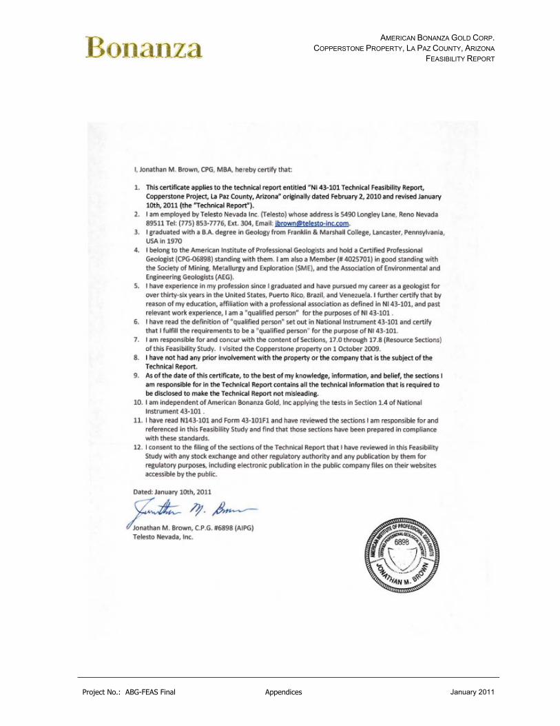
AMERICAN BONANZA GOLD CORP. COPPERSTONE PROPERTY, LA PAZ COUNTY, ARIZONA
FEASIBILITY REPORT
Project No.: ABG-FEAS Final Appendices January 2011