noaa: hurricane basics
TRANSCRIPT
HurricaneBasics
For More Information
Websites:NOAA - www.noaa.gov
National Hurricane Center - www.nhc.noaa.gov
National Hurricane Center Public Affairs(305) 229-4404
National Weather Service Public Affairs(301) 713-0622
May 1999
What is a Hurricane?
A "hurricane" is the most severe category of the meteorological phenomenon known as the "tropical cyclone."
Tropical cyclones are low pressure systems that have thunderstorm activity and rotate counterclockwise. A tropical cyclone that has winds of 38 mph (33 kt) or less is called a tropical depression. When the tropical cyclone's winds reach 39-73 mph (34-63 kt), it is called a tropical storm. When the winds exceed 74 mph (64 kt), the storm is consideredto be a hurricane.
The Saffir-Simpson Hurricane Scale defines hurricane strength by categories. A Category 1 storm is the weakest hurricane (winds 74-95 mph or 64-82 kt); a Category 5 hurricane is the strongest (winds greater than 155 mph or 135 kt).
The category of the storm does not necessarily relate directly to the damage it will inflict. Lower category storms (and even tropical storms) can cause substantial damage depending on what other weather features they interact with, where they strike, and how slow they move.
Anatomy of a HurricaneTypical hurricanes are about 300 miles wide although they can vary considerably in size.
The eye at a hurricane's center is a relatively calm, clear area approximately 20-40 miles across.
The eyewall surrounding the eye is composed of dense clouds that contain the highest winds in the storm.
The storm's outer rainbands (often with hurricane or tropical storm-force winds) are made up of dense bands of thunderstorms ranging from a few miles to tens of miles wide and 50 to 300 miles long.
Hurricane-force winds can extend outward to about 25 miles in a small hurricane and to more than 150 miles for a largeone. Tropical storm-force winds can stretch out as far as 300 miles from the center of a large hurricane.
Frequently, the right side of a hurricane is the most dangerous in terms of storm surge, winds, and tornadoes.
A hurricane's speed and path depend on complex ocean and atmospheric interactions, including the presence or absence of other weather patterns. This complexity of the flow makes it very difficult to predict the speed and direction of a hurricane.
Do not focus on the eye or the track–hurricanes are immense systems that can move in complex patterns that are difficult to predict. Be prepared for changes in size, intensity, speed, and direction.
How Tropical Cyclones are Observed
http://hurricanes.noaa.govwww.nws.noaa.gov
www.noaa.gov
Direct measurements of tropical storm and hurricane dimensions and wind speeds are taken primarily by reconnaissance aircraft, although ships and buoys also take important measurements. Once a hurricane is near and/or on land, Automated Surface Observation Systems (ASOS) provide surface conditions, and radio sondes take upper air measurements.
Indirect observational methods include satellite imagery and Doppler radar. In particular, satellites have greatly improved our ability to monitor and understand hurricanes. Radar data are important once the storm comes close to shoreand after landfall for forecasting hurricane-related weather.
Hurricane Fast Facts
Hurricane Basics
There is nothing like them in the atmosphere. Born in warm tropical waters, these spiraling masses require a complex combination of atmospheric processes to grow, mature, and then die. They are not the largest storm systems in our atmosphere or the most violent, but they combine these qualitiesas no other phenomenon does.
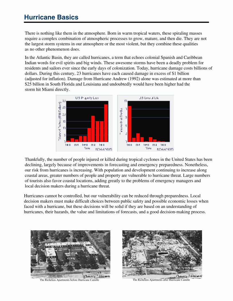
In the Atlantic Basin, they are called hurricanes, a term that echoes colonial Spanish and Caribbean Indian words for evil spirits and big winds. These awesome storms have been a deadly problem forresidents and sailors ever since the early days of colonization. Today, hurricane damage costs billions ofdollars. During this century, 23 hurricanes have each caused damage in excess of $1 billion (adjusted for inflation). Damage from Hurricane Andrew (1992) alone was estimated at more than $25 billion in South Florida and Louisiana and undoubtedly would have been higher had thestorm hit Miami directly.
Thankfully, the number of people injured or killed during tropical cyclones in the United States has beendeclining, largely because of improvements in forecasting and emergency preparedness. Nonetheless,our risk from hurricanes is increasing. With population and development continuing to increase alongcoastal areas, greater numbers of people and property are vulnerable to hurricane threat. Large numbersof tourists also favor coastal locations, adding greatly to the problems of emergency managers andlocal decision makers during a hurricane threat.
Hurricanes cannot be controlled, but our vulnerability can be reduced through preparedness. Local decision makers must make difficult choices between public safety and possible economic losses whenfaced with a hurricane, but these decisions will be solid if they are based on an understanding ofhurricanes, their hazards, the value and limitations of forecasts, and a good decision-making process.
The Richelieu Apartments before Hurricane Camille
The Richelieu Apartments after Hurricane Camille
Hurricane Basics
The ingredients for a hurricane include a pre-existing weather disturbance, warm tropical oceans, moisture, and relatively light winds aloft. If the right conditionspersist long enough, they can combine to produce the violent winds, incredible waves, torrential rains, and floods we associate with this phenomenon.
Each year, an average of ten tropical storms develop over the Atlantic Ocean, Caribbean Sea, and Gulf of Mexico. Many of these remain over the ocean. Six of these storms become hurricanes each year. In an average 3-yearperiod, roughly five hurricanes strike the United States coastline, killing approximately 50 to 100 people anywhere from Texas to Maine. Of these, two are typically major hurricanes (winds greater than 110 mph).
What is a Hurricane?
A hurricane is a type of tropical cyclone, which is a generic term for a low pressure system that generallyforms in the tropics. The cyclone is accompanied by thunderstorms and, in the Northern Hemisphere, acounterclockwise circulation of winds near the earth's surface. Tropical cyclones are classified as follows:
TropicalDepression
An organized system of clouds and thunderstorms witha defined surface circulation and maximum sustainedwinds* of 38 mph (33 kt**) or less
Tropical Storm An organized system of strong thunderstorms with adefined surface circulation and maximum sustainedwinds of 39-73 mph (34-63 kt)
Hurricane An intense tropical weather system of strongthunderstorms with a well-defined surface circulationand maximum sustained winds of 74 mph (64 kt) orhigher
* Sustained winds are defined as a 1-minute average wind measured at about 33 ft (10meters) above the surface.** 1 knot = 1 nautical mile per hour or 1.15 statute miles per hour. Abbreviated as "kt".
Hurricanes are categorized according to the strength of their winds using the Saffir-Simpson Hurricane Scale
.
A Category 1 storm has the lowest wind speeds, while a Category 5 hurricane has the strongest. These arerelative terms, because lower category storms can sometimes inflict greater damage than highercategory storms, depending on where they strike and the particular hazards they bring. In fact,tropical storms can also produce significant damage and loss of life, mainly due to flooding.
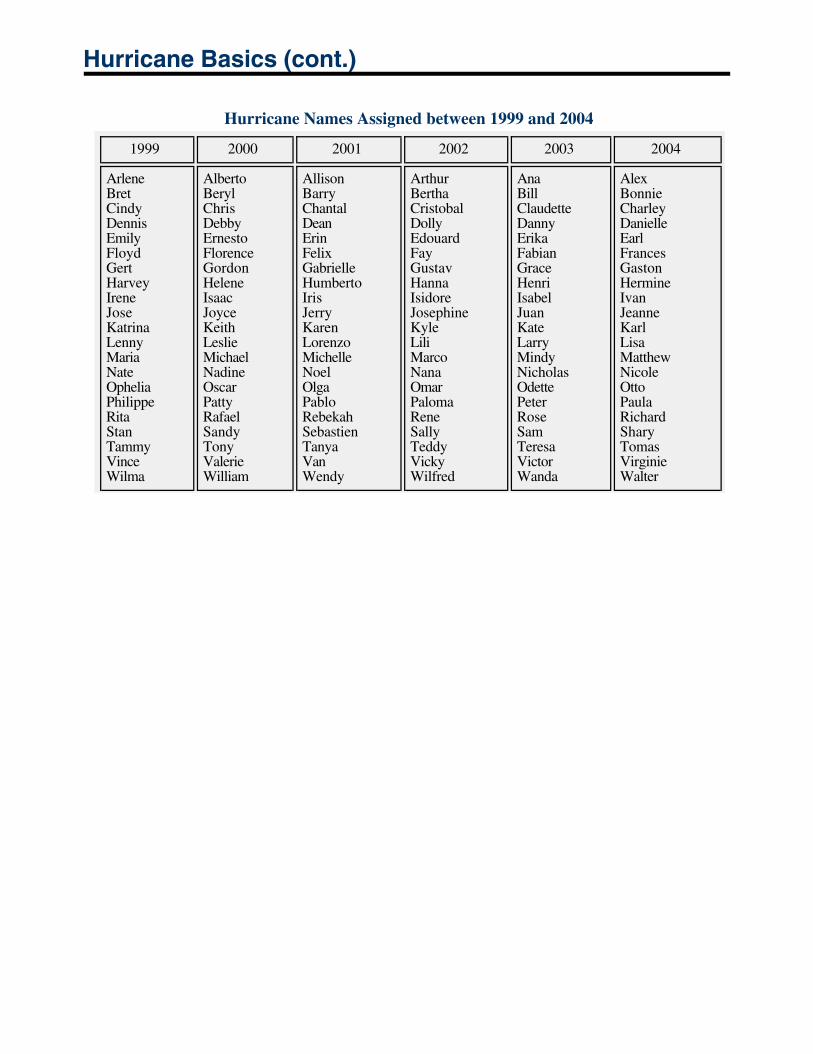
Hurricane Names
When the winds from these storms reach 39 mph (34 kt), the cyclone is given a name. Years ago, an international committee developed six separate lists of names for these storms . Each list alternates between male and female names. The use of these easily remembered names greatly reduces confusion when two or more tropical cyclones occur at the same time. Each list is reused every six years, although hurricane names that have resulted in substantialdamage or death are retired.
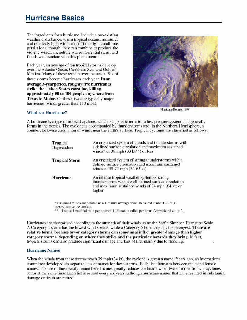
Hurricane Bonnie, 1998
Hurricane Basics (cont.)
Hurricane Names Assigned between 1999 and 2004
1999 2000 2001 2002 2003 2004
ArleneBretCindyDennisEmilyFloydGertHarveyIreneJoseKatrinaLennyMariaNateOpheliaPhilippeRitaStanTammyVinceWilma
AlbertoBerylChrisDebbyErnestoFlorenceGordonHeleneIsaacJoyceKeithLeslieMichaelNadineOscarPattyRafaelSandyTonyValerieWilliam
AllisonBarryChantalDeanErinFelixGabrielleHumbertoIrisJerryKarenLorenzoMichelleNoelOlgaPabloRebekahSebastienTanyaVanWendy
ArthurBerthaCristobalDollyEdouardFayGustavHannaIsidoreJosephineKyleLiliMarcoNanaOmarPalomaReneSallyTeddyVickyWilfred
AnaBillClaudetteDannyErikaFabianGraceHenriIsabelJuanKateLarryMindyNicholasOdettePeterRoseSamTeresaVictorWanda
Alex Bonnie Charley Danielle EarlFrancesGastonHermineIvan Jeanne Karl LisaMatthewNicole Otto PaulaRichardShary TomasVirginieWalter
Origin and Life Cycle
The Birth of a Tropical Cyclone
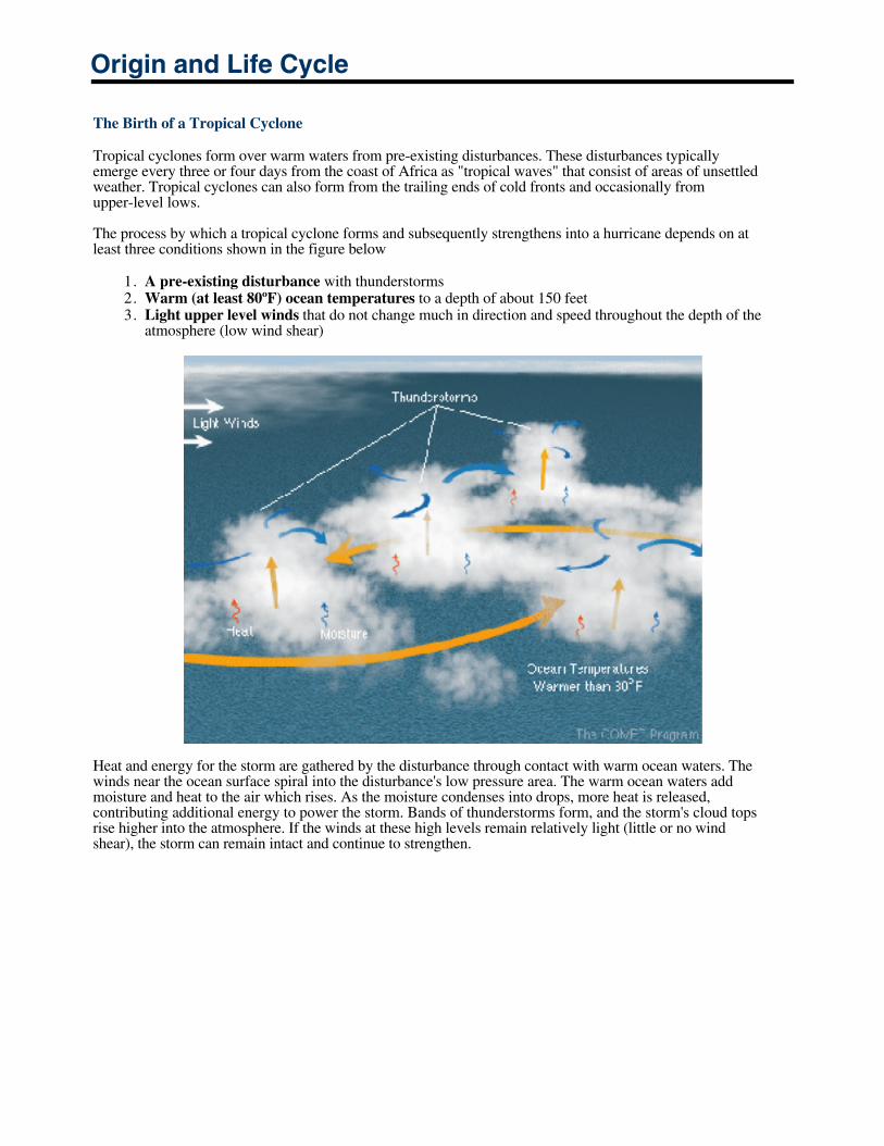
Tropical cyclones form over warm waters from pre-existing disturbances. These disturbances typicallyemerge every three or four days from the coast of Africa as "tropical waves" that consist of areas of unsettledweather. Tropical cyclones can also form from the trailing ends of cold fronts and occasionally fromupper-level lows.
The process by which a tropical cyclone forms and subsequently strengthens into a hurricane depends on atleast three conditions shown in the figure below
1. A pre-existing disturbance with thunderstorms 2. Warm (at least 80ºF) ocean temperatures to a depth of about 150 feet 3. Light upper level winds that do not change much in direction and speed throughout the depth of the
atmosphere (low wind shear)
Heat and energy for the storm are gathered by the disturbance through contact with warm ocean waters. Thewinds near the ocean surface spiral into the disturbance's low pressure area. The warm ocean waters addmoisture and heat to the air which rises. As the moisture condenses into drops, more heat is released,contributing additional energy to power the storm. Bands of thunderstorms form, and the storm's cloud topsrise higher into the atmosphere. If the winds at these high levels remain relatively light (little or no windshear), the storm can remain intact and continue to strengthen.
Origin and Life Cycle (cont.)
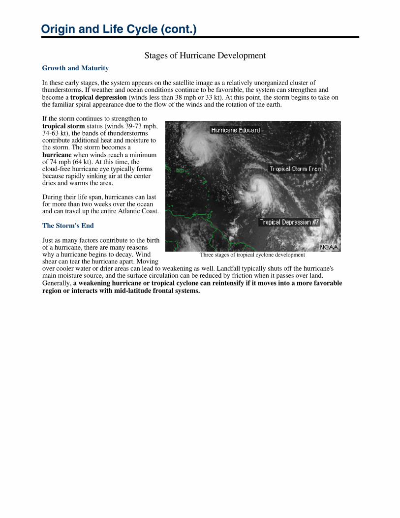
Stages of Hurricane DevelopmentGrowth and Maturity
In these early stages, the system appears on the satellite image as a relatively unorganized cluster ofthunderstorms. If weather and ocean conditions continue to be favorable, the system can strengthen andbecome a tropical depression (winds less than 38 mph or 33 kt). At this point, the storm begins to take onthe familiar spiral appearance due to the flow of the winds and the rotation of the earth.
If the storm continues to strengthen totropical storm status (winds 39-73 mph,34-63 kt), the bands of thunderstormscontribute additional heat and moisture tothe storm. The storm becomes ahurricane when winds reach a minimumof 74 mph (64 kt). At this time, thecloud-free hurricane eye typically formsbecause rapidly sinking air at the centerdries and warms the area.
During their life span, hurricanes can lastfor more than two weeks over the oceanand can travel up the entire Atlantic Coast.
The Storm's End
Just as many factors contribute to the birthof a hurricane, there are many reasonswhy a hurricane begins to decay. Windshear can tear the hurricane apart. Movingover cooler water or drier areas can lead to weakening as well. Landfall typically shuts off the hurricane'smain moisture source, and the surface circulation can be reduced by friction when it passes over land.Generally, a weakening hurricane or tropical cyclone can reintensify if it moves into a more favorableregion or interacts with mid-latitude frontal systems.
Three stages of tropical cyclone development
Structure
Contrary to how many weather maps appear, a hurricane is more than a point on a weather map, and its pathis more than a line. It is a large system that can affect a wide area, requiring that precautions be takenfar from where the eye is predicted to come ashore.
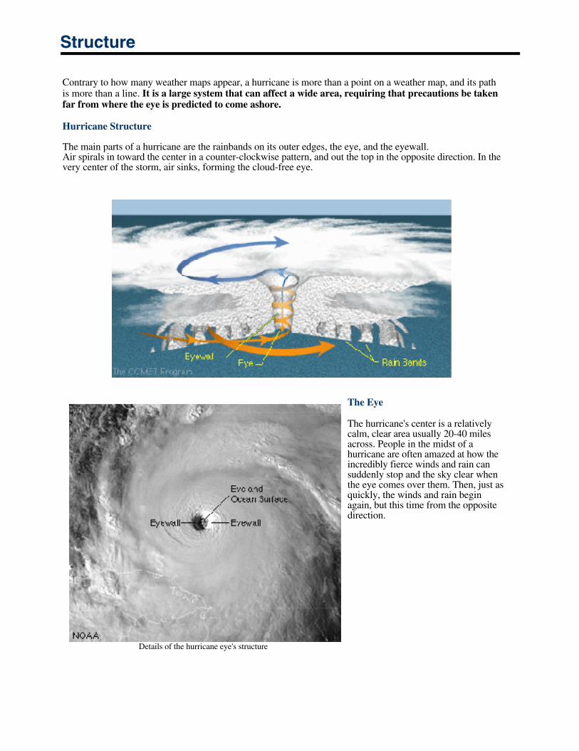
Hurricane Structure
The main parts of a hurricane are the rainbands on its outer edges, the eye, and the eyewall.Air spirals in toward the center in a counter-clockwise pattern, and out the top in the opposite direction. In thevery center of the storm, air sinks, forming the cloud-free eye.
The Eye
The hurricane's center is a relativelycalm, clear area usually 20-40 milesacross. People in the midst of ahurricane are often amazed at how theincredibly fierce winds and rain cansuddenly stop and the sky clear whenthe eye comes over them. Then, just asquickly, the winds and rain beginagain, but this time from the oppositedirection.
Details of the hurricane eye's structure
Structure (cont.)
The Eyewall
The dense wall of thunderstorms surrounding the eye has the strongest winds within the storm. Changes in thestructure of the eye and eyewall can cause changes in the wind speed, which is an indicator of the storm's intensity.The eye can grow or shrink in size, and double (concentric) eyewalls can form.
The Spiral Rainbands
The storm's outer rainbands (often with hurricane or tropical storm-force winds) can extend a few hundred milesfrom the center. Hurricane Andrew's (1992) rainbands reached only 100 miles out from the eye, while those in Hurricane Gilbert (1988) stretched over 500 miles. These dense bands of thunderstorms, which spiral slowlycounterclockwise, range in width from a few miles to tens of miles and are 50 to 300 miles long. Sometimes the bands and the eye are obscured by higher level clouds, making it difficult for forecasters to use satellite imageryto monitor the storm.
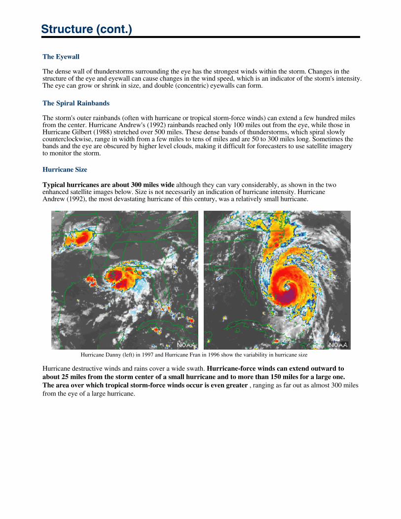
Hurricane Size
Typical hurricanes are about 300 miles wide although they can vary considerably, as shown in the twoenhanced satellite images below. Size is not necessarily an indication of hurricane intensity. HurricaneAndrew (1992), the most devastating hurricane of this century, was a relatively small hurricane.
Hurricane Danny (left) in 1997 and Hurricane Fran in 1996 show the variability in hurricane size
Hurricane destructive winds and rains cover a wide swath. Hurricane-force winds can extend outward to about 25 miles from the storm center of a small hurricane and to more than 150 miles for a large one. The area over which tropical storm-force winds occur is even greater , ranging as far out as almost 300 miles from the eye of a large hurricane.
Structure (cont.)
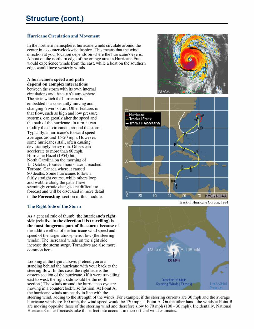
Hurricane Circulation and Movement
In the northern hemisphere, hurricane winds circulate around the center in a counter-clockwise fashion. This means that the wind direction at your location depends on where the hurricane's eye is. A boat on the northern edge of the orange area in Hurricane Franwould experience winds from the east, while a boat on the southern edge would have westerly winds.
A hurricane's speed and pathdepend on complex interactionsbetween the storm with its own internalcirculations and the earth's atmosphere.The air in which the hurricane is embedded is a constantly moving and changing "river" of air. Other features in that flow, such as high and low pressure systems, can greatly alter the speed and the path of the hurricane. In turn, it can modify the environment around the storm.Typically, a hurricane's forward speed averages around 15-20 mph. However, some hurricanes stall, often causing devastatingly heavy rain. Others can accelerate to more than 60 mph. Hurricane Hazel (1954) hitNorth Carolina on the morning of 15 October; fourteen hours later it reached Toronto, Canada where it caused80 deaths. Some hurricanes follow a fairly straight course, while others loop and wobble along the path These seemingly erratic changes are difficult to forecast and will be discussed in more detail in the Forecasting section of this module.
Track of Hurricane Gordon, 1994
The Right Side of the Storm
As a general rule of thumb, the hurricane's rightside (relative to the direction it is travelling) is the most dangerous part of the storm because ofthe additive effect of the hurricane wind speed and speed of the larger atmospheric flow (the steering winds). The increased winds on the right side increase the storm surge. Tornadoes are also morecommon here.
Looking at the figure above, pretend you are standing behind the hurricane with your back to the steering flow. In this case, the right side is the eastern section of the hurricane. (If it were travellingeast to west, the right side would be the northsection.) The winds around the hurricane's eye aremoving in a counterclockwise fashion. At Point A, the hurricane winds are nearly in line with the steering wind, adding to the strength of the winds. For example, if the steering currents are 30 mph and the average hurricane winds are 100 mph, the wind speed would be 130 mph at Point A. On the other hand, the winds at Point Bare moving opposite those of the steering wind and therefore slow to 70 mph (100 - 30 mph). Incidentally, NationalHuricane Center forecasts take this effect into account in their official wind estimates.
Observation
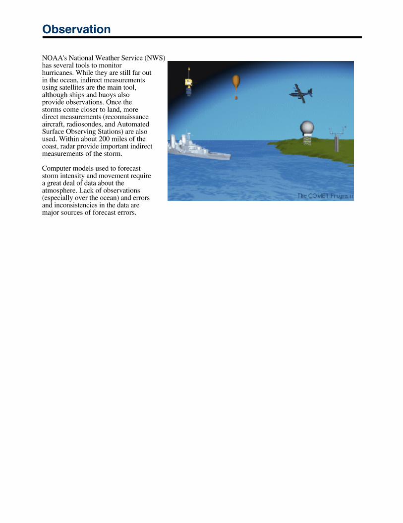
NOAA's National Weather Service (NWS)has several tools to monitorhurricanes. While they are still far outin the ocean, indirect measurementsusing satellites are the main tool,although ships and buoys alsoprovide observations. Once thestorms come closer to land, moredirect measurements (reconnaissanceaircraft, radiosondes, and AutomatedSurface Observing Stations) are alsoused. Within about 200 miles of thecoast, radar provide important indirectmeasurements of the storm.
Computer models used to forecaststorm intensity and movement requirea great deal of data about theatmosphere. Lack of observations(especially over the ocean) and errorsand inconsistencies in the data aremajor sources of forecast errors.
Hurricane Hazards
The main hazards associated with tropical cyclones and especially hurricanes are storm surge, high winds, heavy rain, and flooding, as well as tornadoes. The intensity of a hurricane is an indicator of damage potential. However, impacts are a function of where and when the storm strikes. Hurricane Diane (1955) hit the northeastern U.S. andcaused 184 deaths. It was only a Category 1 hurricane but the thirteenth deadliest since 1900. Hurricane Agnes (1972), also a Category 1 hurricane, ranks fifth with damages estimated at 6.9 billion when adjusted for inflation1.
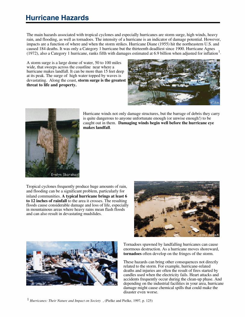
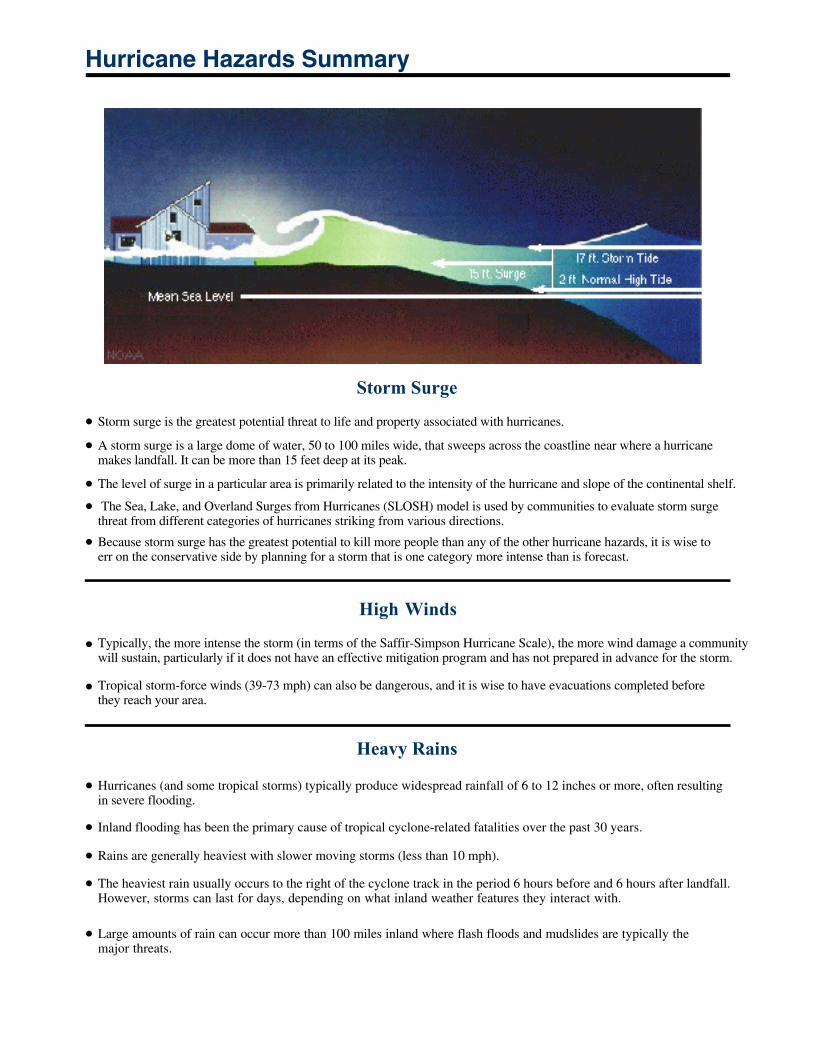
A storm surge is a large dome of water, 50 to 100 miles wide, that sweeps across the coastline near where ahurricane makes landfall. It can be more than 15 feet deepat its peak. The surge of high water topped by waves isdevastating. Along the coast, storm surge is the greatest threat to life and property.
Hurricane winds not only damage structures, but the barrage of debris they carry is quite dangerous to anyone unfortunate enough (or unwise enough!) to be caught out in them. Damaging winds begin well before the hurricane eye makes landfall.
Tropical cyclones frequently produce huge amounts of rain, and flooding can be a significant problem, particularly for inland communities. A typical hurricane brings at least 6 to 12 inches of rainfall to the area it crosses. The resultingfloods cause considerable damage and loss of life, especiallyin mountainous areas where heavy rains mean flash floods and can also result in devastating mudslides.
Tornadoes spawned by landfalling hurricanes can cause enormous destruction. As a hurricane moves shoreward,tornadoes often develop on the fringes of the storm.
These hazards can bring other consequences not directlyrelated to the storm. For example, hurricane-relateddeaths and injuries are often the result of fires started bycandles used when the electricity fails. Heart attacks and accidents frequently occur during the clean-up phase. And depending on the industrial facilities in your area, hurricane damage might cause chemical spills that could make the disaster even worse.
1 Hurricanes: Their Nature and Impact on Society , (Pielke and Pielke, 1997, p. 125)
Hurricane Hazards Summary
Storm Surge
Storm surge is the greatest potential threat to life and property associated with hurricanes.
A storm surge is a large dome of water, 50 to 100 miles wide, that sweeps across the coastline near where a hurricane makes landfall. It can be more than 15 feet deep at its peak.
The level of surge in a particular area is primarily related to the intensity of the hurricane and slope of the continental shelf.
The Sea, Lake, and Overland Surges from Hurricanes (SLOSH) model is used by communities to evaluate storm surge threat from different categories of hurricanes striking from various directions.
Because storm surge has the greatest potential to kill more people than any of the other hurricane hazards, it is wise to err on the conservative side by planning for a storm that is one category more intense than is forecast.
High Winds
Typically, the more intense the storm (in terms of the Saffir-Simpson Hurricane Scale), the more wind damage a community will sustain, particularly if it does not have an effective mitigation program and has not prepared in advance for the storm.
Tropical storm-force winds (39-73 mph) can also be dangerous, and it is wise to have evacuations completed before they reach your area.
Heavy Rains
Hurricanes (and some tropical storms) typically produce widespread rainfall of 6 to 12 inches or more, often resultingin severe flooding.
Inland flooding has been the primary cause of tropical cyclone-related fatalities over the past 30 years.
Rains are generally heaviest with slower moving storms (less than 10 mph).
The heaviest rain usually occurs to the right of the cyclone track in the period 6 hours before and 6 hours after landfall. However, storms can last for days, depending on what inland weather features they interact with.
Large amounts of rain can occur more than 100 miles inland where flash floods and mudslides are typically the major threats.
Hurricane Hazards Summary (cont.)
Tornadoes
Tornadoes are most likely to occur in the right-front quadrant of the hurricane. However, they are also often found elsewhere in the rainbands.
Typically, the more intense a hurricane is, the greater the tornado threat.
Tornado production can occur for days after landfall.
Most tornadoes occur within 150 miles of the coast.
The National Weather Service's Doppler radar systems can provide indications of tornados from a few minutes to about 30 minutes in advance. Consequently, preparedness is critical.
Hurricane Forecasting
Over the past 20 years, improvements in hurricane computer modeling, observational instrumentation, and better training for forecasters have greatly increased forecast accuracy. New data systems give forecasters a greater understanding of tropical cyclones and provide better and more timely input for computer models used to predicthurricane behavior.
Despite these advances, the many complex interactions that occur within the atmosphere are not fully understood or adequately modeled, limiting the accuracy of forecasts. When all is said and done, hurricane forecasting is still a very difficult job.
The forecasting process that is the joint responsibility of NOAA's Tropical Prediction Center’s National HurricaneCenter (NHC) and the local Weather Forecast Offices (WFOs). The forecasting process contributes to a significant reduction in the number of deaths attributed to tropical cyclones and their related hazards.
Part of the mission of the National Weather Service (NWS) Tropical Prediction Center (TPC) is to save lives andprotect property by issuing watches, warnings, forecasts, and analyses of hazardous weather conditions inthe tropics.
The TPC is comprised of the National Hurricane Center (NHC), the Tropical Analysis and ForecastBranch (TAFB), and the Technical Support Branch (TSB). During hurricane season, the latter twoprovide support to the NHC.
A Hurricane Liaison Team (HLT) is activiated during hurricanes to provide a link between the NHC and emergency managers and decision makers.
The local NWS Weather Forecast Offices (WFOs) in hurricane-prone areas are also importantparticipants in the forecast process.
The NHC and your local WFO have various roles in the forecast process that are closely coordinated.
In general, the NHC provides products that have a broad view of the hurricane and its potential impacts, while the local forecast office (the WFO) takes the information from NHC and tailors it to their specific locale, providing local emergency managers with additional information about the hazards expected in their area. The NHC issueshurricane advisories, watches and warinings. Information includes strike probability and wind speeds.
ObservationObservations are the basis for all forecast and warning products issued by the NHC. Quality, timeliness, and quantity of remote sensing observations are critical for accurate and timely forecasts and warnings.
AnalysisThe various observations are checked for quality, analyzed, and put into a suite of computer models
Central Model Guidance/InterpretationThe computer models take in the observations and perform millions of calculations to generatepredictions of hurricane behavior and the general conditions of the atmosphere in which the hurricaneis embedded. The model results are packaged as guidance for the appropriate national centers and localoffices and for evaluation and use in the NWS’s forecast and warning process.
Coordination within the NWS
Product Dissemination
Model results are coordinated between the national centers and local forecast offices to provideconsistency, which is critical during severe weather episodes.
Once the coordination and collaboration process reaches group consensus, the issuing offices generateforecast and warning products for release to the public.
Product DisseminationTimely and reliable dissemination of forecasts and warnings is critical to the protection of life andproperty.
Coordination with CustomersThe NHC and the local WFO work with customers to determine the level of satisfaction with theservice provided and, in particular, whether the forecast and warning products issued were useful.
Local Level: The Weather Forecast Office (WFO)
All of the National Weather Service Forecast Offices are staffed 24 hours a day and produce:
Watches and warnings for severe local storms, floods, flash floods, as well as local and zonepublic forecasts Local aviation forecasts, watches, and warnings Marine warnings and forecasts for coastal areas Hydrologic services such as support for flood and run-off forecasts
Offices affected by hurricanes analyze the products created by the NHC and fine tune them for their ownlocale in order to provide local officials with the necessary information to make timely and efficient decisions.The WFOs produce local weather statements to inform the public about current and anticipated storm effects intheir area and to augment NHC advisories and releases. The local statements are highly specific and aredesigned to keep the media, local decision makers, and the public current on present and anticipated stormeffects.
Local forecasters initiate or participate in inter-site coordination between NHC and other local WFOs to ensureforecast and warning consistency. Following product delivery, the local office coordinates with local officials,the media, and the emergency management community. These coordination calls focus on the pendingweather threat and what implications the forecast or warning has for the local area. Following the storm, thelocal Warning Coordination Meteorologist evaluates the service with the forecast users.
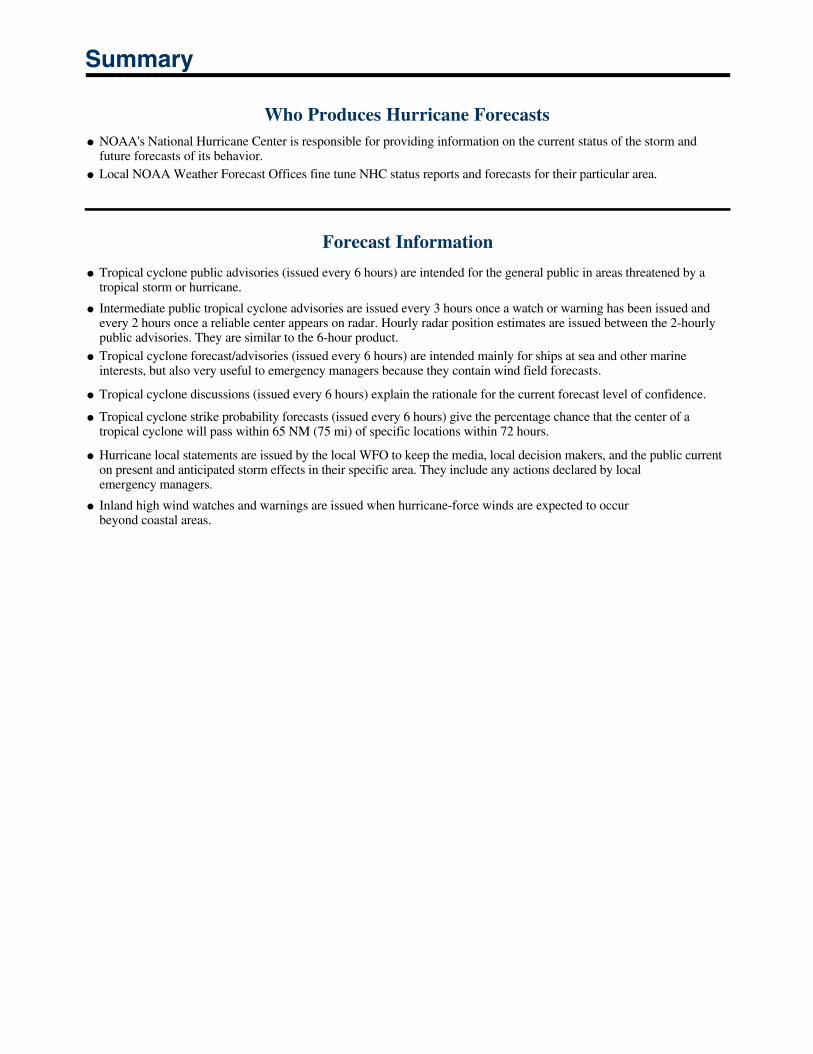
Summary
Who Produces Hurricane ForecastsNOAA's National Hurricane Center is responsible for providing information on the current status of the storm and future forecasts of its behavior.Local NOAA Weather Forecast Offices fine tune NHC status reports and forecasts for their particular area.
Forecast Information
Tropical cyclone public advisories (issued every 6 hours) are intended for the general public in areas threatened by atropical storm or hurricane.
Intermediate public tropical cyclone advisories are issued every 3 hours once a watch or warning has been issued andevery 2 hours once a reliable center appears on radar. Hourly radar position estimates are issued between the 2-hourly public advisories. They are similar to the 6-hour product.Tropical cyclone forecast/advisories (issued every 6 hours) are intended mainly for ships at sea and other marine interests, but also very useful to emergency managers because they contain wind field forecasts.
Tropical cyclone discussions (issued every 6 hours) explain the rationale for the current forecast level of confidence.
Tropical cyclone strike probability forecasts (issued every 6 hours) give the percentage chance that the center of a tropical cyclone will pass within 65 NM (75 mi) of specific locations within 72 hours.
Hurricane local statements are issued by the local WFO to keep the media, local decision makers, and the public currenton present and anticipated storm effects in their specific area. They include any actions declared by localemergency managers.
Inland high wind watches and warnings are issued when hurricane-force winds are expected to occurbeyond coastal areas.
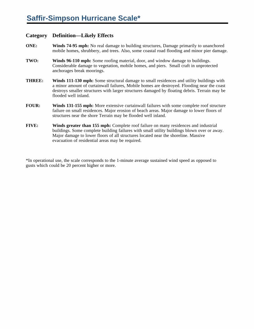
Saffir-Simpson Hurricane Scale*
Category Definition—Likely Effects
ONE: Winds 74-95 mph: No real damage to building structures, Damage primarily to unanchored mobile homes, shrubbery, and trees. Also, some coastal road flooding and minor pier damage.
TWO: Winds 96-110 mph: Some roofing material, door, and window damage to buildings. Considerable damage to vegetation, mobile homes, and piers. Small craft in unprotected anchorages break moorings.
THREE: Winds 111-130 mph: Some structural damage to small residences and utility buildings with a minor amount of curtainwall failures, Mobile homes are destroyed. Flooding near the coast destroys smaller structures with larger structures damaged by floating debris. Terrain may be flooded well inland.
FOUR: Winds 131-155 mph: More extensive curtainwall failures with some complete roof structure failure on small residences. Major erosion of beach areas. Major damage to lower floors of structures near the shore Terrain may be flooded well inland.
FIVE: Winds greater than 155 mph: Complete roof failure on many residences and industrial buildings. Some complete building failures with small utility buildings blown over or away. Major damage to lower floors of all structures located near the shoreline. Massive evacuation of residential areas may be required.
*In operational use, the scale corresponds to the 1-minute average sustained wind speed as opposed to gusts which could be 20 percent higher or more.

Credits:
The COMET ProgramUniversity Corporation for Atmospheric Research
National Oceanic and Atmospheric Administration (NOAA)Federal Emergency Management Agency (FEMA)