north fire unmanned aircraft systems testing & evaluation ... · north fire unmanned aircraft...
TRANSCRIPT

North Fire Unmanned Aircraft Systems
Testing & Evaluation After Action Review
June, 2016
Cibola National Forest
Table of Contents
Contents Table of Contents .............................................................................................................................................. 2
Executive Summary ........................................................................................................................................... 3
Stakeholder Discussion ..................................................................................................................................... 4
Planning ......................................................................................................................................................... 4
Ordering and Dispatching ............................................................................................................................. 4
In-Briefing – Forest and Incident ................................................................................................................... 5
Flight Operations ........................................................................................................................................... 5
Debrief and Demob ....................................................................................................................................... 7
Data Management and Products .................................................................................................................. 7
Key considerations for unmanned aircraft ................................................................................................... 7
Future utilization ........................................................................................................................................... 8
Open Bin ........................................................................................................................................................ 8
Take Away Lessons ........................................................................................................................................ 8
Project Aviation Safety Plan .............................................................................................................................. 9
North Fire UAS project proposal form ............................................................................................................ 21
Emergency Certificate of Authorization (eCOA) ............................................................................................. 23
Cibola N.F. UAS In-Brief ................................................................................................................................... 26
North Fire UAS tentative timeline ................................................................................................................... 27
North Fire UAS Assignment Lessons Learned ................................................................................................. 28

Executive Summary In late 2014, an interagency agreement to work towards integrating Unmanned Aircraft Systems
(UAS) into the wildland fire mission was signed by the Forest Service and Department of Interior
(DOI). The 2015 fire season saw three different testing and evaluation (T&E) missions using a
demonstration contract with commercial service providers.
In June 2016, the North Fire on the Cibola National Forest was being managed for long term
resource benefits. Both the Forest and Incident Management Team, saw a T&E opportunity for
UAS in a lower risk fire setting. Discussions began with the UAS Program Managers for the Forest
Service and Bureau of Land Management (BLM).
The BLM provided three of the four module members and several fleet aircraft. The fourth
module member was provided by the DOI UAS Branch. The aircraft flown were a fixed-wing Falcon
and a 3DR Solo quadcopter.
The Incident Management team (IMT) worked with the module for several days in two main
configurations. The Falcon flew infrared imagery where the data was sent off overnight to an
agency data processor. Maps and data products were developed and provided the next day. The
Solo was used directly with ground crews to provide real time situational awareness.
The North Fire T&E mission was the first time the Forest Service hosted small UAS on fires flown
by government fire agencies using fleet aircraft. It was also the first time the BLM module had
flown UAS in the fire mission. The North Fire T&E helped identify gaps in the way aviation
resources are dispatched, mobilized, utilized and operated in regards to unmanned aircraft and
wildland fire management.
The Falcon demonstrated strengths which are more suited towards projects where time
constraints are not limiting as with fire activity. Agency data processing capability will need to be
expanded to accommodate the volume of workload associated with fire data products. The Solo
showed value in the real time situational awareness model working with ground crews.
In general, the T&E progressed as expected with time spent becoming familiar with the
capabilities of a new aircraft type and figuring out how to work it into fire management
operations. Specifically, the T&E mission on the North Fire highlighted a strong need for an
operational guide, standard operating procedures and more T&E opportunities.
The IMT, Cibola and Region 3 should be commended for their willingness to host the T&E mission
on the North Fire.
Stakeholder Discussion After the operational flights ended on site at the North Fire, two conference calls to gather
feedback from stakeholders were held. Participants included personnel from the North Fire IMT,
Cibola National Forest, Southwestern Regional Office, UAS module and the Forest Service Acting
National UAS Program Manager.
The discussion flow followed a general format for after action reviews:
Four main ideas were focused on- ~ What went well? ~ What could have gone better? ~ What surprised you? ~ What changes would you suggest for the future?
The complete fire assignment process with those four ideas in mind was discussed-
o Planning o Ordering and dispatching o In briefing- Forest and Incident o Flight Operations o Debriefing and demob
Additionally, if it hadn’t already been discussed, o Data management and products delivered o Key considerations for unmanned aircraft o Ideas of future UAS utilization in fire management o How PASP and UAS Project Request form fit actual operations. o Open Bin items
The following bullet items are taken directly from the discussion. Some items may conflict as everyone had
a chance to provide input and all perspectives are noted.
Planning The Project Aviation Safety Plan (PASP) was written and approved within 24 hours. A National
standard template will be developed using the North Fire PASP as a basis.
Building a PASP for fire use is inefficient and could be mitigated by an Interagency UAS Fire
Operations Guide.
The UAS Project Request Form was useful to begin the discussion and ordering decision, but the
form information was not used after the initial decision to place the order.
The FAO had good communication about the process. It took two weeks, but the forest and fire
understood the process.
The fire understood the intent for testing and evaluation and was willing to be exploratory in what
the UAS module could provide.
The Regional Office was not clear on the intended outcome and would have liked more specifics.
Ordering and Dispatching Having THSP on the UAS module personnel’s redcard would be a benefit to rapid ordering. It took
some effort to get the four UAS module members set up in ROSS. They are now set up for future
dispatches.

The original order was for the three field personnel. The crucial fourth person to process data had
to be approved by the fire separately. Establishing the module as four persons with the potential
for one or more to remain off site will be beneficial in the future.
Consider mobilization times and incident need. Shipping equipment to the incident and
commercial air travel for the personnel to mobilize quicker.
The ROSS ordering system is not set up for UAS resources as there is currently no way to account
for the aircraft itself. The personnel were ordered and the UAS were noted in special
needs/equipment.
It was identified that IQCS qualifications and NWCG training as well as how to account for the
aircraft in ROSS will need to be developed as UAS fire integration proceeds.
In-Briefing – Forest and Incident The Forest aviation resource in-briefing was well organized and thorough. The Forest Aviation
Officer created an outline that could be used as a standard for future briefings.
The FAO set up a time for the Regional Office and Forest personnel to interact with the UAS
module, receive a briefing and ask questions. Personnel in attendance appreciated the extra effort
at interfacing with the UAS and module.
The Incident provided a good briefing of fire area specifics. The Module felt they received the
information they needed to begin operations safely.
One item to ensure is clear to all involved is who the UAS Module works for. There was no issues
for the North Fire, but the larger interagency community will need guidance to set the standard, so
it isn’t different every time.
The UAS Module attended an IMT planning meeting early on which was valuable from their
perspective.
UAS Module attendance and discussion at the evening briefing was also identified by the incident
as positive.
The UAS Module attended the helibase briefings which facilitated communication between
aviation resources.
The need to brief with aerial supervisors was identified although it was not applicable for the North
Fire.
The fire in-brief really started the discussion on how best to integrate the UAS with the incident
resources. Which is different from established resources.
As the fire was active and resources were engaged, the Incident Commander (IC) and Operations
Section Chief (OSC3) did not have much time to fully brief the UAS module.
The Regional Office had expected an in-brief prior to the UAS module going out to the fire as this is
a new resource, but one did not occur.
It was identified that as UAS is just now beginning to integrate a more extensive in-briefing and
wider opportunity for awareness should be provided.
Flight Operations There was good coordination with the helicopter pilots and OSC3 to establish separation
procedures and mission priorities.
There was good direct communication with the helicopter crew to coordinate missions in the Fire
Traffic Area (FTA).
The protocol established in the PASP held that either manned or unmanned were airborne at the
same time when no aerial supervisor was present. This led to inefficiencies which should be looked
at for future operations. National standards for situations where manned and unmanned could
both be airborne at the same time depending on risk, should be a goal. *NOTE- The PASP
addresses adequate separation and does not state one aircraft type or the other. The need for
understanding of how the UAS and manned aircraft would operate is highlighted by this statement.

The UAS Module worked for the OSC3 who at times was busy. An Aerial Supervisor coordinating
aviation resources might have alleviated delays. A National standard or protocol should be
evaluated as mentioned above.
The ground control station monitors were extremely difficult to see in direct sunlight.
The UAS Module integrated will into the traditional Incident Command System (ICS) structure via
the Planning and Operations Section Chiefs.
Familiarizing IMT personnel with the capabilities and limitations of the aircraft and data product
types took time and could be seen as a distraction.
Finding safe launch and recovery areas for the fixed wing system was a challenge.
The current work/rest policy for UAS flight crews was difficult to manage and may not be
appropriate since most of the crew’s time was spent performing normal and expected incident
duties (driving, briefings, hiking etc.)
Working directly with crews to demonstrate and provide situational awareness worked very well.
Firefighters would watch live video directly on a tablet as the aircraft flew over points of interest as
directed.
Hand flying the micro UAS for situational awareness takes a high degree of skill and training a
broader pool of pilots will need to occur.
The aircraft were negatively affected by GPS satellite testing conducted by the military. Two flights
were delayed due to this vulnerability.
The FAA Emergency Certificate of Authorization (eCOA) process was not implemented as
advertised. There was confusion between Albuquerque ARTCC and the eCOA Office, which created
a substantial workload for the DOI staff.
The National Interagency Fire Center photographer was a distraction in the beginning. It might
have been better to let the UAS module integrate with the incident a few days before trying to
document the process.
There was a bit of a challenge to figure out how to integrate the UAS into the incident operation. It
took a few days to get it really going.
The North Fire utilized the UAS under the OSC3, but could see where Planning might also be a
place. As UAS integrates into the fire mission, it will have to be determined the best fit in the ICS
structure.
The Division Supervisor really liked the application of real time imagery for situational awareness.
Once the UAS was tied in with crews, the benefit of the resource hit its stride.
It was observed the UAS module had been familiar with project missions and more in line with the
Planning function with no real time constraints. There were times the IMT wished the module
could implement faster with the operational pace. It was also identified that the pace of UAS will
get faster with familiarity and broader integration.
The manned aircraft was not as comfortable in the beginning with the unmanned operation, but
then became comfortable. It almost seemed the UAS folks flipped and became more
uncomfortable working with the helicopter airborne. Airspace coordination was identified as a
huge factor and needing to be developed as UAS integration continues.
There was a communication event where the helicopter ferrying into the helibase from the airport
in the early morning was not informed of the UAS being airborne. This was a courtesy
communication as the UAS was flight following locally at the incident. The need for a solid radio
communication plan in advance of operations was identified.
Communication in general was an issue on the fire.
The UAS Module was sometimes flight following locally on the fire and sometimes contacting the
Forest Dispatch Office. This led to confusion on what the communication expectations were. As
with any aviation resource, local flight following should be the norm.

Although this was managed by a Type 3 Incident Team, having a dedicated person for air
operations might have provided benefit as a liaison between the aviation resources and OSC3.
The IMT was surprised by the visual line of sight limitation and short duration of flight based on
battery life. They had expected more a high altitude, long duration aircraft. Understanding the
limitations of the aircraft being offered is important in the future.
It was identified a UAS Operations Plan with platform specific information would be of benefit to
reducing confusion.
The weather limitations were also a surprise to fire managers.
The BLM was able to offer some infrared (IR) imagery, but with a time delay for data processing.
Incident personnel were expecting real time information. Understanding what is being offered by
each platform in the future would be beneficial.
The ortho map scouted ahead of the burn area sounded good and was nice, but not totally useful.
With a little tweaking, it could be very useful, especially if it could be real time.
A before and after ortho map was created for documentation. That was seen as useful.
The real benefit to the UAS testing was seeing what the micro (3DR Solo) UAS was able to produce
as far as data. The ground crews found the real time imagery very useful.
There was discussion on staying within the provisions of the eCOA and how easy it might be to go
outside of what is authorized. (e.g. over private land when mapping).
Debrief and Demob There was a daily pre shift and post-shift phone call between the UAS Module and the OSC3. One
the last operational day, the pre-shift call occurred, but there was no formal out-brief due to
activity.
The demob process went well with the IMT organization.
Travel limitations for the UAS personnel were a surprise and needed to be taken into account. As
pilots, they have more restrictive duty limitations. This should be discussed in a UAS Operations
Plan so the incident understands what to expect.
Although not a factor in the North Fire, there needs to be discussion on how to replace and
damaged equipment or components. Identifying the appropriate system in the event of damage
should be an emphasis as UAS become more prevalent in the fire mission.
The Regional Office expected a debrief after the assignment, but one did not occur.
Data Management and Products There was good communication between the on-site module members and the fourth person
processing data off-site. Wi-Fi connection to send data was not the most time effective method. Future operations might
need to look at a SatCom contract to provide consistent, fast data connectivity. The offset schedule for the data processor was effective in getting the data processed for products. Training data processors will be a workload for the interagency community. Not a common skill
set. The Falcon IR sensor was not as good as the Scan Eagle from last year. The module will send a hard drive with information after cleaning up unnecessary raw data. From the incident perspective, there were interagency limitations, such as needing a BLM
computer to upload to the BLM servers. These will need to be worked out for full interagency integration.
Key considerations for unmanned aircraft The longer duration higher altitude UAS would seem more appropriate to incident support with
real time data products. The micro UAS seem highly beneficial when imbedded with ground crews for real time situational
awareness.

Future utilization Developing IQCS qualifications, NWCG training, ROSS protocols along with a UAS Operations Plan
would provide benefit to a smother integration, reduce confusion and provide better utilization of UAS in the fire mission.
Open Bin Under normal operations, the Falcon lands using a parachute to reduce damage to the belly
mounted sensors. On the North Fire, the Falcon landed harder than normal. The BLM module will work with the manufacturer to access the telemetry data. The BLM Module believes the elevation at the launch and recovery site affected the parachute’s efficiency. A SAFECOM will be filed for documentation purposes.
Take Away Lessons For the first time the interagency UAS Module has been used on fire, it went as well as expected.
The fire managers began to get familiar with what the platforms had to offer, and the UAS module began to get familiar with operating small UAS in the fire mission.
The micro UAS was hugely successful in providing ground crews with real time situational awareness information.
The duration and time lag for data processing with the Falcon was not as conducive to fire missions as it is for project mission.
Effort needs to continue in regards to developing a Fire UAS Operations Guide; training and certification standards; ROSS updates, standard operating protocols and an understanding by fire stakeholders on the capability and limitations of UAS in the fire mission.
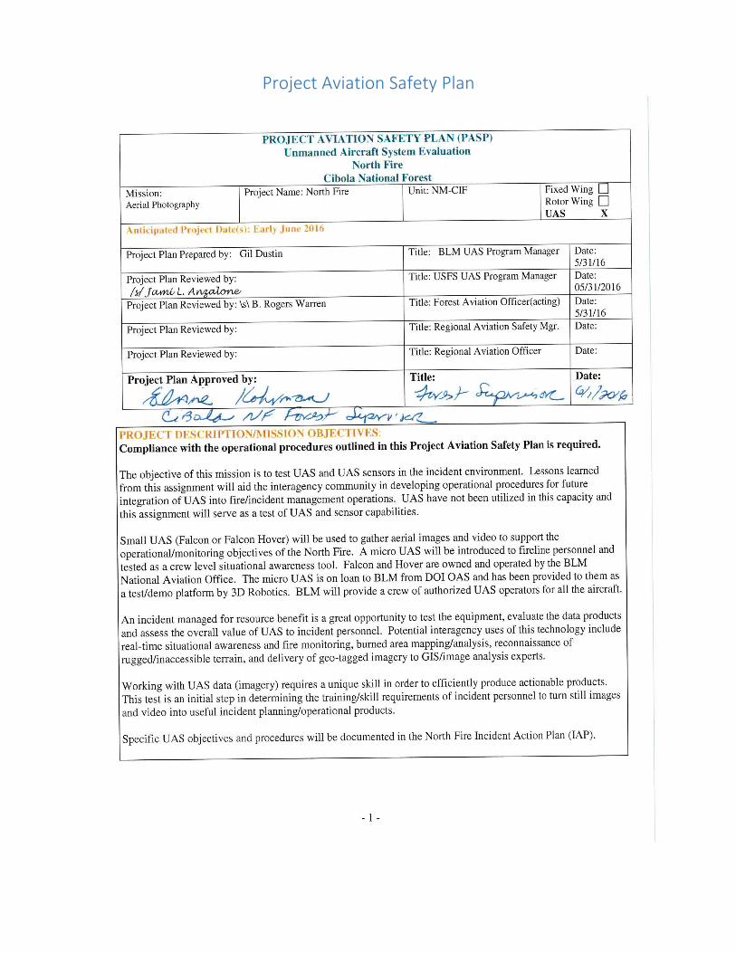
Project Aviation Safety Plan


North Fire UAS project proposal form
U.S. Forest Service Unmanned Aircraft System (UAS) Project Proposal
This form documents essential information to be considered for review and approval of planned UAS
missions conducted and/or contracted by the Forest Service. Note: A completed project aviation safety
plan (PASP) and risk assessment are required to accompany this form.
Administrative Information
Requestor Name: B. Rogers Warren Cibola Santa Fe Zone UAO (acting)
Title: North Fire NM-CIF
District/Forest/Region or Research Station:
Southwestern Region, Cibola National Forest, Magdalena R.D.
Email: [email protected]
Phone number(s):
Forest Aviation Officer Name: Rogers Warren Forest Supervisor Name or Research Station Director Name:
Elaine Kohrman
Regional Aviation Officer Name: Kris Damsgaard
Initial Mission Information
Yes No
Will the mission be flown within 5 nautical miles of an airport? X
Will the mission be flown over an urban or relatively dense populated area? X
Will a manned aircraft be flown at the same time as the UAS as part of this mission? X
Will the mission be flown beyond the line of sight (BVLOS) of the UAS operator? X
Does the UAS weigh more than 55 lbs.? X
If the answer to any of the above is “yes”, then a manned aircraft will be required to conduct this
mission. Please coordinate with your Regional Aviation Officer.
Project Area Information
Note: Other relevant technical information regarding the project and mission will be documented in the
PASP.
Project Location: (i.e. Horse Creek drainage, Jackson District, Smoky National Forest)
North Fire, San Mateo Mountains,Magdalena R.D. Cibola NF
Identify Military Training Routes (MTRs) and Military Operational Areas (MOAs) within 5 miles of the
project area (include route numbers). VR-1233, VR-176, SR-211

Sensor Requirements
Yes No Comments (fixed or gimbal mounted, nadir or off-nadir imagery, near real-time
availability requirements, etc.)
Electro-optical (EO)/Infrared (IR) Video
X Gimbal mounted camera on Falcon and Hover. Gimbal mounted GoPro H4 on Solo.
Visible/RGB Camera (visible)
X Fixed mapping payload (Ricoh GR1) on Falcon and Hover. Gimbal mounted on Solo (GoPro H4).
Multispectral Camera (visible and near infrared)
Hyperspectral Camera (visible, near infrared and shortwave infrared)
Thermal Infrared Camera
Lidar
Synthetic Aperture Radar
Meteorology Sensors (temperature, humidity, barometric pressure, wind)
Chemical/Air Quality Sensors (CO, CO2, O3, NO2,
VOCs, etc.)
Other
Records Management
Imagery/data collected using UAS and derived products are legally considered agency records. Please specify the planned method to be used to retain these records:
Any digital information will be given to the situation unit on a hard drive for storage with the fire
documentation package.
Signatures and Concurrence \s\ B. Rogers Warren 5/31/16
Signature of Preparer Date
Will the mission take place in or near a Wilderness Area or other type of Special Designated Area
(SDA)? A portion of the fire borders the Withington Wilderness Area.
Project Description: Small UAS (Falcon, Falcon Hover, and 3DR Solo) will be used to gather aerial
images and video to support the operational/monitoring objectives of the North Fire. These aircraft
are owned and operated by the BLM National Aviation Office.

Emergency Certificate of Authorization (eCOA)


Cibola N.F. UAS In-Brief (Based on Current Aircrew Briefing Packet)
Local conditions, Forest Layout, current fires/incidents, other air resources, local hazards and fire weather.
Explain Forest/Zone aviation resource location and availability.
Dispatch office location, phone #’s. Explain Forest maps, layout of Districts, and other cooperating agencies.
Communications, flight following, and dispatch procedures.
Flight Hazards Map
Special use airspace; MOA, Flight Routes, and Restricted Areas - discussed over the Sectional.
North Fire Airspace Deconfliction procedures for VR-1233, VR-176, SR-211
Forest Frequencies; air-ground, IA victor, admin, fire, and repeaters. Give frequency lists and repeater map.
Wilderness Flight/Landing policy – proximity to Withington Wilderness Area
UAS Specifics o Review PASP o Review BLM UAS Plan and ECOA o Flight Follow local? o UAS pilot radio communication with dispatch o UAS pilot monitoring Air to Air frequency o Public Affairs and NIFC photographer IMT PIO handler? o Post incident assignment follow up and AAR
Local Concerns o Integration into IMT (Ops? Plans? helibase? ICS-220) o Impact to local unit and T3 IMT o Clearly defined outcome (product? service?) o Measuring success? And to whom? BLM? WO? RO? Incident? o North Fire UAS Operational Risk Management (anything besides PASP RA? DORA,
GAR, Mission briefing?)
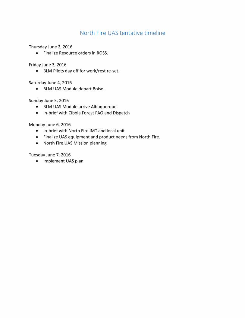
North Fire UAS tentative timeline
Thursday June 2, 2016
Finalize Resource orders in ROSS. Friday June 3, 2016
BLM Pilots day off for work/rest re-set. Saturday June 4, 2016
BLM UAS Module depart Boise. Sunday June 5, 2016
BLM UAS Module arrive Albuquerque.
In-brief with Cibola Forest FAO and Dispatch Monday June 6, 2016
In-brief with North Fire IMT and local unit
Finalize UAS equipment and product needs from North Fire.
North Fire UAS Mission planning Tuesday June 7, 2016
Implement UAS plan

North Fire UAS Assignment Lessons Learned
Overview and Lessons Learned – June 15, 2016
Overview – USFS and BLM collaborated to mobilize a four-person UAS crew to the North Fire on the Cibola National Forrest on June 1, 2016. The objective of the assignment was to test UAS and UAS sensors in the incident (wildfire) environment and develop operational procedures for future missions based on lessons learned and practical applications of the aircraft/sensors based on feedback provided by operations/planning personnel. The lessons learned from this assignment will be shared with the interagency community and the Interagency Fire UAS Subcommittee (IFUAS) as an initial step in developing a strategy to safely and effectively integrate UAS into incident operations. Crew Composition Gil Dustin, UAS Crew Leader, UAS Operator (BLM) Steve Stroud, UAS Operator (BLM) Steve Ramaekers, UAS Operator (DOI/OAS) Jeff Safran, Data Specialist (BLM) UAS Aircraft Falcon (fixed wing) sUAS 3DR Solo (quad copter) micro UAS Sensors Falcon - 2 axis stabilized gimbal video payload (Sony Block and Tao 2 640 IR) Falcon - Sony A-5100 with Voightlander lens (mapping/photogrammetry) Solo - Gimbaled GoPro Hero 4 (mapping/video) Flight Times Falcon – 2 missions for 56 minutes Solo – 23 missions for 5.73 hours Operations Summary UAS were flown in two Divisions on the incident and provided live infrared video, performed mapping missions, and provided real-time intelligence and situational awareness to firefighters. Data (still and video imagery) was collected and sent to a processing specialist every evening over a Wi-Fi network.

Data Processing Summary Each evening the flight crew uploaded that day’s imagery, video and telemetry logs to a shared drive that the UAS Data specialist could download the data from. Any data in the form of video files was multiplexed using the ArcGIS Full Motion Video AddIn for ArcGIS 10.4. The flight path and video framed could then be placed on a map for spatial awareness. Any aerial photography datasets were processes using Agisoft Photoscan, and resulting Ortho mosaics and Digital Elevation Models (DEMs) were delivered back to the shared drive, along with a map of the products. The maps were generated as GeoPDF for use on tablets and phones. Assignment Chronology 6/5 Crew mobilizes from Boise, ID with Govt. vehicle. 6/7 Crew receives briefing from USFS UAS Program Manager, Jami Anzalone and the
local dispatch/aviation staff and provides demonstration of aircraft at Cibola Forest Headquarters. Crew meets with SWICC staff to discuss operations. Crew checks in at the incident and develops an operational plan with the Operations Chief.
6/8 Crew provides and aircraft demonstration to fireline personnel in Division B. 6/9 Crew performs Infrared mission to support burnout operation in Division B
Crew attempts to provide an aircraft demonstration in Division A, but scrubs the mission due to thunderstorm activity.
6/10 Crew flies a mapping mission in Division B (Cooney Gap) 6/11 Crew works in Division A and demonstrates the capability of the micro system to
provide real-time situational awareness and intelligence gathering. 6/12 Crew flies mapping mission in Division A (Big Rosa canyon area). 6/13 Crew attempted flights to support a burnout in Division A. The burnout and
flights were postponed due to high winds. 6/14 Crew works on the fireline with Division A and Kings Peak Fire Wildfire Module
and provides real-time intelligence to ignition/holding crews. Crew demobilizes from the incident.
What Worked Well
Resource orders were processed efficiently once the crew was statused in ROSS as THSP.
The PASP was written and approved within 24 hours.
Coordination between agency Public Information Officers.
Treating the UAS/Crew as a normal aviation asset and including them in operational briefings.
Working with helicopter pilots and OSC3 to establish aircraft separation procedures and mission priorities.

Direct communication with the helicopter to coordinate missions in the same geographic area (Fire Traffic Area protocol).
Integrating into the traditional ICS structure via the Planning and Operations Section Chiefs.
Working directly with crews to demonstrate and provide situational awareness. Firefighters would watch live video on a tablet (IOS device) as the aircraft flew over points of interest as directed.
Developing high resolution mapping products for pre and post burn analysis.
Having a Data Specialist work a night shift to develop planning products (maps).
Using established technologies to view map products. Most of the firefighters carried IOS devices to view geo-referenced maps with the Avenza app.
Flight crew coordination with the Data Specialist, primarily by texting and evening phone conversation.
Aerial photography flights with GeoTagged photos were easy to process.
The ESRI Full Motion Video (FMV) extension worked as designed, and allowed the video to be displayed spatially.
The shift offset between the Data Specialist and flight crew was good. The UAS Data Specialist is a cross between a GISS and an IRIN, working afternoons into the night.
Challenges
Incidents don’t typically require a PASP. Building a PASP for fire use is inefficient.
Familiarizing IMT personnel with the capabilities and limitations of the aircraft.
Familiarizing IMT personnel with final data product types.
Uploading data over a WiFi network.
Finding safe launch and recovery areas for the fixed wing system.
Lack of aerial supervision caused delays for some UAS flights. Our protocol for this assignment was to obtain flight clearance from the OSC who was extremely busy coordinating incident operations.
The ground control station monitors were extremely difficult to see in direct sunlight.
Hand flying the micro UAS for situational awareness. A high degree of skill is required.
DOD GPS testing caused two flight delays.
FAA Emergency Certificate of Authorization (ECOA) process was not implemented as advertised. There was confusion between Albuquerque ARTCC and the ECOA office, which created a substantial workload for the DOI staff.
Current work/rest policy for UAS flight crews was difficult to manage and may not be appropriate since most of the crew’s time was spent performing normal and expected incident duties (driving, briefings, hiking, etc.).
Data Management was the single biggest time hit for the Data Specialist. It was very time consuming to match up the logs with videos, especially having not been on site.
Data transfer rates between the BLM NOC EGIS servers over VPN was very slow.

Items to Work on
Design a standard UAS ordering process.
Mobilization times. Consider shipping equipment to the incident and flying the crew to it.
Establishing a high trust climate between UAS and assigned flight crews.through face-to-face communication prior to mission implementation.
Developing UAS briefing products for end users.
Establishing NWCG training and positions for incident UAS personnel.
Increasing the efficiency of data sharing processes.
Developing terrain following features for UAS flight planning.
Developing altitude limit failsafe’s future micro UAS flights.
Shared folder location on the NIFC FTP server, similar to GIS and IR would be very helpful for data transfers.
We need to define what the final geospatial products are so that the data specialist knows exactly what to put together. Even having some MXD templates would be very helpful.
The ESRI FMV software needs to be on the BLM Software baseline for ArcGIS 10.4 so other people can view the videos with their spatial components. Alternatively we could put this software on Fire laptops
UAS Data Specialist should have a Fire Laptop for data processing.
DOI and FAA must be lockstep in the ECOA process. Applying Lessons Learned – Action Items
Develop an Interagency UAS Operations Guide, which captures all the requirements of a PASP. This will mitigate the need to write a PASP for every incident response.
Build a UAS briefing packet for incident use.
Research SATCOM for data upload, download, and live video feeds to incident decision makers.
Conduct debriefs focusing on data and products, particularly on the final deliverables.
Training for the GISS personnel on what data we can provide.
Work with UAS vendors and ESRI on simplifying the data processing workflows. Kudos
Thanks to Jami Anzalone for her work coordinating this assignment with the Forest, IMT, and Public Information Officers.
The Command and General Staff were accommodating and receptive to testing this technology.
The Division Supervisors (Chris Brashears and Ben Sanders) were easy to work with and excited to develop uses for UAS on the fireline.
The Kings Peak Wildfire Module was receptive to testing this technology to provide situational awareness, scout line, and monitor fire activity.
The Albuquerque Dispatch staff was easy to work with for flight planning and resource tracking.

Brad Koeckeritz and Colin Milone at DOI/OAS did a great job coordinating with the COA Office.
FAA did a great job efficiently managing the confusion regarding the ECOA process and authorizing flight on this incident.
The Forest Supervisor, Rogers Warren, Riva Duncan and management staff did a great job authorizing this assignment and approving mission-planning documents.
Conclusions
Micro UAS are a powerful tool on the fireline. The crew we worked with (Kings Peak) found immediate utility. UAS program strategies must be developed to safely integrate this technology into established fire/aviation incident management/operations procedures.
UAS capable of 16-24 hr. flights, loitering above all incident aircraft, and delivering high resolution images/video in multiple spectrums will be more effective than flying smaller systems to gather imagery to develop planning products.
Micro UAS used for crew level situational awareness and large UAS used for strategic planning may be a consideration for UAS program development within incident management.
It’s critical to maintain an interagency approach regarding UAS operational procedures, qualifications, and data support/management.
National UAS procedures and guidelines will ensure a safe approach to incident UAS operations.
Submitted by: Jeff Safran Steve Ramaekers Steve Stroud Gil Dustin