notice of an application for planning permit€¦ · • certificate of title and instrument at...
TRANSCRIPT

NOTICE OF AN APPLICATION FOR PLANNING PERMIT
PLANNING AND ENVIRONMENT REGULATIONS 2005 Form 2
Section 52 (Planning & Environment Act 1987)
The land affected by the application is located at:
17 Smith Street DAYLESFORD VIC 3460 Lot 5 LP 90304 PSH PWO
The application is for a permit for:
Multi lot subdivision - 53 lots, native vegetation removal
The applicant for the permit is: Niche Planning Studio
The application reference number is: PA 2504
You may look at the application and any documents that support the application at the office of the responsible authority:
Municipal Offices: Hepburn Shire Council Customer Services Building Corner Duke and Albert Streets, Daylesford Planning Department - Ph: 03 5348 1577
Planning applications may also be viewed on Council's web site under tab 'Statutory Planning'.
Follow the link to 'Applications on Advertising'.
This can be done during office hours and is free of charge. Any person who may be affected by the granting of the permit may object or make other submissions to the responsible authority. An objection must * be sent to the Responsible Authority in writing, * include the reasons for the objection, and * state how the objector would be affected.
The Responsible Authority will not decide on the application before:
15 / 10 / 2019
If you object, the Responsible Authority will tell you of its decision.

ABN 80 518 867 063
14 August 2019
Planning Department
Hepburn Shire Council
PO Box 21
Daylesford VIC 3460
Delivered via email to: [email protected]
Dear Sir/Madam,
PLANNING PERMIT APPLICATION – MULTI-LOT SUBDIVISION AND REMOVAL OF
NATIVE VEGETATION – 17 SMITH STREET, DAYLESFORD 3460
Please find enclosed all relevant documentation to support Council’s assessment of a
planning application for a multi-lot subdivision and removal of native vegetation at 17 Smith
Street, Daylesford 3460 (Lot 5 on LP90304).
The following is attached to this letter:
• Completed Application Form;
• Planning Permit Application Report;
• Certificate of Title and Instrument at Appendix A
• Subdivision Layout Plan at Appendix B
• Flora and Fauna Report at Appendix C
• Arborist Report at Appendix D
• Clause 56 Assessment at Appendix E:
• Stormwater Strategy Report at Appendix F
• Entrance Access layout at Appendix G
• Typical Cross-Section Layout at Appendix H
• Servicing Strategy Report at Appendix I
It would be greatly appreciated if Council could issue an invoice addressed to the
applicant for the payment of the application fee and we will organise payment. We have
calculated the fee to be $1977.15, based on subdivision (Class 20), and 50% of the fee for
removal of native vegetation (Class 22).
Should you have any queries, or wish to discuss information contained within this letter,
please contact Ursula van Dyk on 0428 117 558 or via email at
Kind Regards,
Nicola Smith
Director
Niche Planning Studio Pty Ltd
PLANNIN
G &ENVIR
ONMENT ACT 1987
HEPBURN PLANNIN
G SCHEME
Thisdo
cumen
t is m
ade av
ailab
le
for th
e sole
purpo
seof
enab
ling
its co
nside
ration
and r
eview
as
part o
f the p
lannin
g proc
ess u
nder
the Plan
ning &
Enviro
nmen
t Act
1987
.
This do
cumen
t mus
t not
be us
ed
for an
y purp
ose w
hich m
ay
break
any c
opyri
ght.

PLANNIN
G & ENVIRONMENT ACT 19
87
HEPBURN PLANNIN
G SCHEME
This do
cumen
t is m
ade a
vaila
ble
for th
e sole
purpo
se of
enab
ling
its co
nside
ration
and r
eview
as
part o
f the p
lannin
g proc
ess u
nder
the Plan
ning &
Enviro
nmen
t Act
1987
.
This do
cumen
t mus
t not
be us
ed
for an
y purp
ose w
hich m
ay
break
any c
opyri
ght.
Suite 2 Parry Village, 188 Parry AvenueBULLCREEK, WA 6146
Level 1, The Mezz, 286 Ferrars StreetSOUTH MELBOURNE, VIC 3207
Level 1, 14 Molle StreetHOBART, TAS 7000
PERMIT APPLICATION
17 SMITH ST, DAYLESFORD
PLANNIN
G & ENVIRONMENT ACT 19
87
HEPBURN PLANNIN
G SCHEME
This do
cumen
t is m
ade a
vaila
ble
for th
e sole
purpo
se of
enab
ling
its co
nside
ration
and r
eview
as
part o
f the p
lannin
g proc
ess u
nder
the Plan
ning &
Enviro
nmen
t Act
1987
.
This do
cumen
t mus
t not
be us
ed
for an
y purp
ose w
hich m
ay
break
any c
opyri
ght.

V_Smith Hygge
PLANNING PERMIT REPORT
Application in support of a multi-lot subdivision and removal of native vegetation, at 17 Smith Street, Daylesford
3460 (Lot 5 on LP90304).
PLANNIN
G & ENVIRONMENT ACT 19
87
HEPBURN PLANNIN
G SCHEME
This do
cumen
t is m
ade a
vaila
ble
for th
e sole
purpo
se of
enab
ling
its co
nside
ration
and r
eview
as
part o
f the p
lannin
g proc
ess u
nder
the Plan
ning &
Enviro
nmen
t Act
1987
.
This do
cumen
t mus
t not
be us
ed
for an
y purp
ose w
hich m
ay
break
any c
opyri
ght.

ROSE
LLA
LAN
E
PARK
ER S
T
SMIT
H S
T
MIDLAND HWY
0 20 40 60 80 100 120m
Scale: 1:2,000 @A3
N I C H E
S T U D I OP L A N N I N G
SITE AERIAL17 SMITH ST, DAYLESFORD
Aerial supplied by: NearmapAerial Date Stamp: 01.12.18Survey supplied by: VICMAPPlan Number: NPS739_004Revision Number: ADrawn By: Kim DelbridgeClient: Hygge Property
DISCLAIMER: This Concept Plan has been prepared based on the High Level Planning Advice.All Dimensions, Areas and Calculations are subject to Detailed Survey and Design before Town Planning Permit application.Built Form is illustrative only and subject to Architectural Design and approval from an RAIA qualified architect. This plan has been preparedfor illustrative purposes only and should not be used as a means to judge any properties value or yield potential.
©Niche Planning StudioDate Issued: 31.07.2019
LEGEND Site boundary Parcel Cadastre
PLANNIN
G & ENVIRONMENT ACT 19
87
HEPBURN PLANNIN
G SCHEME
This do
cumen
t is m
ade a
vaila
ble
for th
e sole
purpo
se of
enab
ling
its co
nside
ration
and r
eview
as
part o
f the p
lannin
g proc
ess u
nder
the Plan
ning &
Enviro
nmen
t Act
1987
.
This do
cumen
t mus
t not
be us
ed
for an
y purp
ose w
hich m
ay
break
any c
opyri
ght.
V_Smith Hygge
Table of Contents
1. SUMMARY .................................................................................................................................. 1
2. INTRODUCTION .......................................................................................................................... 2
3. SITE CONTEXT ............................................................................................................................. 3
3.1 Strategic Context – Daylesford’s Role in Hepburn Shire .................................................... 3
3.2 Local Context ..................................................................................................................... 5
3.2.1 Planning Context ............................................................................................................ 5
3.2.1 Surrounding Development and Character ..................................................................... 8
3.2.2 Existing Conditions and Site Analysis ........................................................................... 11
4. PROPOSAL................................................................................................................................. 13
4.1 The Subdivision ................................................................................................................ 13
4.2 Land Use Budget .............................................................................................................. 13
5. PLANNING POLICY FRAMEWORK .............................................................................................. 15
5.1 State and Regional Planning Policy Framework ............................................................... 15
5.2 Local Planning Policy Framework ..................................................................................... 17
5.2.1 Settlement and Housing (Clause 21.05) ....................................................................... 17
5.2.2 Environment and Heritage (Clause 21.09) ................................................................... 17
5.2.3 Catchment and Land Protection (Clause 22.01) .......................................................... 17
5.2.4 Daylesford Neighbourhood Character (Clause 22.08) ................................................. 17
6. ZONES ....................................................................................................................................... 19
7. OVERLAYS ................................................................................................................................. 21
7.1 Environmental Significance Overlay (Clause 42.01) ......................................................... 21
7.1.1 Schedule 1 to the ESO (ESO1) ...................................................................................... 21
7.1.2 Schedule 2 to the ESO (ESO2) ...................................................................................... 24
8. PARTICULAR PROVISIONS ......................................................................................................... 25
8.1 Clause 52.01 – Public Open Space Contribution and Subdivision .................................... 25
8.2 clause 52.17 – Removal of Native Vegetation ................................................................. 25
8.3 Clause 56 – Subdivision .................................................................................................... 26
9. GENERAL PROVISIONS .............................................................................................................. 27
9.1 CLAUSE - 65 DECISION GUIDELINES ................................................................................. 27
9.1.1 Clause 65.01 Approval of an Application or Plan: ........................................................ 27
9.1.1 Clause 65.02 Approval of an Application to subdivide land: ........................................ 28
9.2 Clause 66 Referral & Notice Provisions ............................................................................ 28
10. DESIGN ASSESSMENT ............................................................................................................... 29
10.1 Image, Character and housing ......................................................................................... 29
10.2 Roads and Access ............................................................................................................. 31
10.3 Staging & Servicing .......................................................................................................... 33
11. CONCLUSION ............................................................................................................................ 36
Appendices Appendix A – Certificate of Title and Instrument ............................................................................. 37
Appendix B – Subdivision Layout Plan .............................................................................................. 38
Appendix C – Flora And Fauna Report .............................................................................................. 39
Appendix D – Arborist report ........................................................................................................... 40
Appendix E – Clause 56 Assessment ................................................................................................ 41
Appendix F – Stormwater Strategy Report ....................................................................................... 42
Appendix G – Entrance Road FLP ..................................................................................................... 43
Appendix H – Typical Cross-Section Of 11m Accessway ................................................................... 44
Appendix I – Servicing Strategy Report ............................................................................................ 45
Prepared – Ursula van Dyk
Reviewed – Celia Konstas
Date – 14 August 2019
Version – 1.0
This report is subject to copyright the owner of which is Niche Planning Studio. All unauthorised copying or reproduction of this report or any part of it is
forbidden by law and is subject to civil and criminal penalties as set out in the Copyright Act 1968. All requests for permission to reproduce this report or
its contents must be directed to Niche Planning Studio.
PLANNIN
G & ENVIRONMENT ACT 19
87
HEPBURN PLANNIN
G SCHEME
This do
cumen
t is m
ade a
vaila
ble
for th
e sole
purpo
se of
enab
ling
its co
nside
ration
and r
eview
as
part o
f the p
lannin
g proc
ess u
nder
the Plan
ning &
Enviro
nmen
t Act
1987
.
This do
cumen
t mus
t not
be us
ed
for an
y purp
ose w
hich m
ay
break
any c
opyri
ght.

Page 1 of 36
V_Smith Hygge
1. SUMMARY
Table 1 Summary of Proposal
Site Address: 17 Smith Street, Daylesford 3460
Title Details: Lot 5 LP90304
Zoning: General Residential Zone – Schedule 1 (GRZ1)
Overlays: Environmental Significance Overlay – Schedule 1 (ESO1) Environmental Significance Overlay – Schedule 2 (ESO2)
Proposal: Multi-lot residential subdivision and removal of native vegetation.
Permit Triggers:
Clause 32.08-3 (General Residential Zone)
• A permit is required to subdivide land. Clause 42.01-2 (Environmental Significance Overlay):
• A permit is required to subdivide land • Remove, destroy or lop any vegetation, including dead vegetation.
Clause 57.17 (Native Vegetation) • A permit is required to remove, destroy or lop native vegetation,
including dead native vegetation
Attachments included within report:
Appendix A: Certificate of Title and Instrument Appendix B: Subdivision Layout Plan Appendix C: Flora and Fauna Report Appendix D: Arborist Report Appendix E: Clause 56 Assessment Appendix F: Stormwater Strategy Report Appendix G: Entrance Access layout Appendix H: Typical Cross-Section Layout Appendix I: Servicing Strategy Report
PLANNIN
G & ENVIRONMENT ACT 19
87
HEPBURN PLANNIN
G SCHEME
This do
cumen
t is m
ade a
vaila
ble
for th
e sole
purpo
se of
enab
ling
its co
nside
ration
and r
eview
as
part o
f the p
lannin
g proc
ess u
nder
the Plan
ning &
Enviro
nmen
t Act
1987
.
This do
cumen
t mus
t not
be us
ed
for an
y purp
ose w
hich m
ay
break
any c
opyri
ght.

Page 2 of 36
V_Smith Hygge
2. INTRODUCTION
This report has been prepared by Niche Planning Studio on behalf of the owner, Irene Pearl Henderson, and the
Development Manager, Smith Development Partnership Pty Ltd.
This application is made in support of a multi-lot subdivision at 17 Smith Street, Daylesford (Lot 5 on LP90304)
(Appendix A Title and Certificate).
Council’s assessment and approval of this application will result in the transformation of the site from a small
hobby farm to residential development, generally in accordance with the Daylesford Structure Plan and the
applicable planning controls.
This report will detail how the subdivision has been designed and will be developed to reflect the strategic
direction of Hepburn Shire, specifically Daylesford as a ‘regional town’, having regard to the site’s context and
site-specific opportunities. This report will also discuss how the design has responded to the vision of Hepburn
Shire, which is to ‘build a Shire based on the strength and character of the individual and valued lifestyle aspects
of the towns, small communities and rural areas of the Shire’.
This application has had regard to the following documents and background discussions:
- Hepburn Planning Scheme as at August 2019
- A site visit and preliminary meeting at Hepburn Shire undertaken by the development managers (Hygge
Property c/o Smith Development Partnership Pty Ltd)
- Daylesford Structure Plan (at Clause 21.05) and Daylesford Character Precincts plan (at Clause 22.08)
- Additional site-specific background studies and reports supporting this application
This submission should be read in conjunction with the Subdivision Layout Plan (Appendix B) prepared by Niche
Planning Studio and the various consultant reports and information, which will be referred to throughout this
report.
PLANNIN
G & ENVIRONMENT ACT 19
87
HEPBURN PLANNIN
G SCHEME
This do
cumen
t is m
ade a
vaila
ble
for th
e sole
purpo
se of
enab
ling
its co
nside
ration
and r
eview
as
part o
f the p
lannin
g proc
ess u
nder
the Plan
ning &
Enviro
nmen
t Act
1987
.
This do
cumen
t mus
t not
be us
ed
for an
y purp
ose w
hich m
ay
break
any c
opyri
ght.
Page 3 of 36
V_Smith Hygge
3. SITE CONTEXT
3.1 STRATEGIC CONTEXT – DAYLESFORD’S ROLE IN HEPBURN SHIRE
Hepburn Shire’s Municipal Profile identifies Daylesford as a ‘regional town’, having the following role: ‘Providing
district retail, business, employment and cultural facilities, higher order shopping and some regional level
services’.
Daylesford has good access to Ballarat, Bendigo and Melbourne, being connected by various major highways
and freeways.
The Daylesford Structure Plan (refer to next page) identifies an ‘urban growth boundary’, in which township
development is to be contained. The Structure Pan also identifies five main town entrance points from varying
directions, which connect to major freeways and highways. The town of Daylesford is nestled directly to the east
of various regional parks and conservation areas.
PLANNIN
G & ENVIRONMENT ACT 19
87
HEPBURN PLANNIN
G SCHEME
This do
cumen
t is m
ade a
vaila
ble
for th
e sole
purpo
se of
enab
ling
its co
nside
ration
and r
eview
as
part o
f the p
lannin
g proc
ess u
nder
the Plan
ning &
Enviro
nmen
t Act
1987
.
This do
cumen
t mus
t not
be us
ed
for an
y purp
ose w
hich m
ay
break
any c
opyri
ght.

Daylesford Structure PlanHepburn Planning Scheme
PLANNIN
G & ENVIRONMENT ACT 19
87
HEPBURN PLANNIN
G SCHEME
This do
cumen
t is m
ade a
vaila
ble
for th
e sole
purpo
se of
enab
ling
its co
nside
ration
and r
eview
as
part o
f the p
lannin
g proc
ess u
nder
the Plan
ning &
Enviro
nmen
t Act
1987
.
This do
cumen
t mus
t not
be us
ed
for an
y purp
ose w
hich m
ay
break
any c
opyri
ght.

Page 5 of 36
V_Smith Hygge
3.2 LOCAL CONTEXT
3.2.1 Planning Context
The subject site is located within the township (urban growth) boundary, in the north-east of the town (refer to
plan on next page). The subject site is identified within an area in which residential design is to reflect and
address the town entrance character.
Entrance 1 (‘E1’ on plan), via the Midland Highway, and 2 (‘E2’ on plan), via Daylesford-Trentham Road, are
located to the east of the subject site. These entrances are to protect the avenue planting and rural character of
the entry.
The site is provided with good access to proposed amenities and services, in close proximity to the following
land uses:
- Commercial: Daylesford Town Centre is within walking distance (approx. 400m to the south-east) from
the subject site. The town centre supplies the local retail, services, and other needs of residents. It is
also a tourist hub for the wider area.
- Education: St Michael’s catholic school, and Daylesford Secondary College are both located directly to
the north of the subjects site.
- Recreation: Wombat Hill is located directly to the south of the subject site, which is identified as an area
of natural beauty. It includes a prominent ridgeline, and a high point for views towards various points of
the town and beyond.
- Employment/Industrial: land to the south-east of the subject site is zoned Industrial 1.
This diversity of services, land uses, and major highway and freeway connections provides a high amenity
context and high level of connectivity for future residents.
PLANNIN
G & ENVIRONMENT ACT 19
87
HEPBURN PLANNIN
G SCHEME
This do
cumen
t is m
ade a
vaila
ble
for th
e sole
purpo
se of
enab
ling
its co
nside
ration
and r
eview
as
part o
f the p
lannin
g proc
ess u
nder
the Plan
ning &
Enviro
nmen
t Act
1987
.
This do
cumen
t mus
t not
be us
ed
for an
y purp
ose w
hich m
ay
break
any c
opyri
ght.

MIDLAND HWY
DAYLESFORD - TRENTHAM RD
WOMBAT HILL
CENTRAL SPRINGS RD
VIN
CEN
T ST
NO
RTH
VIN
CEN
T ST
NO
RTH
QU
EEN
SBER
RY S
T
SETTLEMENT RD
TREW
HELL
A AV
WESTWOOD ST
WESTWOOD ST
MIDLA
ND HWY
GARIBALDI DR
GRE
NVI
LLE
ST
GARDEN LANE
STAN
HO
PE S
T
BRID
PORT
ST
JAM
IESO
N S
T
CROCKETT ST
HOSPITAL ST
VICTORIA ST
RAILWAY CR
WO
MBA
T ST
TRIMBLE ST
STAN
LEY
ST
ELSBETH CT
ORF
ORD
ST
RAGLAN ST
PARK
ER S
T
BARK
AS S
T
FRAZ
ER S
T
ALBERT ST
HODGE ST
NO
RTH
ST
LYM
AN S
T
BURKE SQ
LITT
LE S
T
SMIT
H S
T
HOWE ST
CAM
P ST
KNOX ST
DAL
Y ST
DAL
Y ST
EAST
ST
EAST
ST
HILL ST
VUE CT
MIDLAND HWY
SECONDARYCOLLEGE
CATHOLICSCHOOL
E1
E2
0 50 100 150 200 250 300m
Scale: 1:5,000 @A3
N I C H E
S T U D I OP L A N N I N G
DAYLESFORD STRUCTURE PLAN17 SMITH ST, DAYLESFORD
Aerial supplied by: NearmapAerial Date Stamp: 01.12.18Survey supplied by: VICMAPPlan Number: NPS739_001Revision Number: ADrawn By: Kim DelbridgeClient: Hygge Property
DISCLAIMER: This Concept Plan has been prepared based on the High Level Planning Advice.All Dimensions, Areas and Calculations are subject to Detailed Survey and Design before Town Planning Permit application.Built Form is illustrative only and subject to Architectural Design and approval from an RAIA qualified architect. This plan has been preparedfor illustrative purposes only and should not be used as a means to judge any properties value or yield potential.
©Niche Planning StudioDate Issued: 31.07.2019
LEGEND Site boundary Parcel Cadastre Contours (Vicmaps) Prominent Ridgeline Urban Growth Boundary Green Wedges Town Centre Residential design to address town entrance character Existing Industrial Zone High Point / Area of Natural Beauty Waterway Prominant Viewlines Key entrance character to townE#
PLANNIN
G & ENVIRONMENT ACT 19
87
HEPBURN PLANNIN
G SCHEME
This do
cumen
t is m
ade a
vaila
ble
for th
e sole
purpo
se of
enab
ling
its co
nside
ration
and r
eview
as
part o
f the p
lannin
g proc
ess u
nder
the Plan
ning &
Enviro
nmen
t Act
1987
.
This do
cumen
t mus
t not
be us
ed
for an
y purp
ose w
hich m
ay
break
any c
opyri
ght.

Page 8 of 36
V_Smith Hygge
3.2.1 Surrounding Development and Character
The surrounding character of the area is diverse: undulating topography, informal street tree planting, large road reserves, bush views, and larger lots with modest houses and generous setbacks. Combined together, all of these features contribute to the unique character of Daylesford.
An analysis of this character has been undertaken, to ultimately inform the final subdivision layout and ensure it incorporates the preferred character features for the area (refer to plan to the right, and photos on subsequent two pages, to be read in conjunction with Table 2 below).
Table 2 Description of Character Areas and Features
ARE A AND CORRES PONDING CHARACTE R
DES CRIPT ION OF CHARACTER
Smith Street character
(Neighbourhood Character Precinct 7)
The majority of Smith Street is located within Character Precinct 7, which abuts the subject site’s western boundary. Housing along Smith generally reflects modern architecture (dating from the 1960s to 1980s), and is situated in a higher point of the town. The setbacks and lot sizes are uniform, and create a rhythmised look along the street. Houses are of diverse materials, including both brick and weatherboard, and rooves are mixed but predominantly iron. The street features grassed nature strips, and on-street planting is minimal. Front setbacks of houses are very treed, contributing to a leafy and green streetscape. These characteristics are shown in photos 1 – 4 on the next two pages.
Views to Wombat Hill
Given the topography of the subject site and immediate surrounds, there are view lines to Wombat Hill (to the south of the subject site) which are important to protect. This is demonstrated within photos 5 and 6 on the next two pages.
Midland Highway Town Entrance
(Neighbourhood Character Precinct 11)
The Midland Highway is one of Daylesford’s main entrances to town. It is a wide, avenue-like road lined with Pinoaks. The subject site is located to the right of the road as driving into town, and is visible in the distance. This character precinct is distinct for its flat topography and predominantly post-war to recent housing, with some heritage listed buildings. The housing comprises large setbacks, low front fences and create an ‘open feel’. The character of this area is shown in photos 7 and 8 on the next two pages.
Entrance to town
(Neighbourhood Character Precinct 10)
This character precinct is located to the south-west of the subject site, and is one of the most important entrances to the town. It is known for the mix of residential and commercial land uses, incorporating timber as a predominant material. Please refer photos 9 and 10 on the next two pages.
Surrounding farming land to the east
The east of the subject site is used for farming purposes, and features scattered trees and hilly land. Please refer photo 11 on the next two pages.
PLANNIN
G & ENVIRONMENT ACT 19
87
HEPBURN PLANNIN
G SCHEME
This do
cumen
t is m
ade a
vaila
ble
for th
e sole
purpo
se of
enab
ling
its co
nside
ration
and r
eview
as
part o
f the p
lannin
g proc
ess u
nder
the Plan
ning &
Enviro
nmen
t Act
1987
.
This do
cumen
t mus
t not
be us
ed
for an
y purp
ose w
hich m
ay
break
any c
opyri
ght.

Page 11 of 36
V_Smith Hygge
3.2.2 Existing Conditions and Site Analysis
This section describes the existing site conditions. The table should be read in conjunction with the Site Analysis plan on the next page.
Table 3 Site Features Explanation
EXIST ING SITE FEATUR ES DESCRIPTION OF S ITE FEATURES
High Point
The high point of the site is located within the middle of the subject site
Drainage Catchment Fall As a result of the site’s highpoint, there are three drainage catchments, which each have a differing fall direction.
Topography
The site’s topography is complex, with fall across three areas as follows:
- To the north-east - To the south-west - To the north-west
Residential interface
The subject site is bound by residential lots to the west and south.
School interface
Catholic primary school, and a secondary school, located to the north of the subject site.
Farming Interface
The subject site is bound by farming use to the eastern boundary of the subject site. There is a prevalent downhill fall to the north-east of the subject site, across the farming land.
Road Zone Interface
The subject site is accessed via Smith Street. There is an existing large oak tree at this entrance, which is proposed for removal this is the only point of access into the site.
Views towards the site Given the hilly topography of the area, there are great views to and from the subject site.
Contours
The contours demonstrate the naturally hilly nature of the subject area.
PLANNIN
G & ENVIRONMENT ACT 19
87
HEPBURN PLANNIN
G SCHEME
This do
cumen
t is m
ade a
vaila
ble
for th
e sole
purpo
se of
enab
ling
its co
nside
ration
and r
eview
as
part o
f the p
lannin
g proc
ess u
nder
the Plan
ning &
Enviro
nmen
t Act
1987
.
This do
cumen
t mus
t not
be us
ed
for an
y purp
ose w
hich m
ay
break
any c
opyri
ght.

NORTHWEST CATCHMENT
SOUTHWESTCATCHMENT
NORTHEASTCATCHMENTFALL
FALLFALL
EXISTINGBUILDING
EXISTINGBUILDING
ST MICHAELS CATHOLICPRIMARY SCHOOL
POTENTIALFUTURE DEVELOPMENT
(BY OTHERS)
POTENTIALFUTURE DEVELOPMENT
(BY OTHERS)POTENTIAL
FUTURE DEVELOPMENT(BY OTHERS)
VIEWS TO BALLARAT CENTRAL
RESIDENTIAL DWELLING
SLIGHT FALL MO
RE P
REVA
LEN
TDO
WN
HIL
L FA
LL
SLIGHT FALL
SLIGHT FALL
EXISTING SEASONALDRAINAGE LINE
EXISTING SEASONALDRAINAGE LINE
POTENTIALFUTURE
DEVELOPMENT(BY OTHERS)
FARMING ZONED LAND
EXIS
TIN
G R
ESID
ENTI
ALD
EVEL
OPM
ENT
BACK
ING
-ON
EXIS
TIN
G R
ESID
ENTI
ALD
EVEL
OPM
ENT
BACK
ING
-ON
EXISTING SITE ACCESS
600M
610M
590M
610M
ROSE
LLA
LAN
E
PARK
ER S
T
SMIT
H S
T
MIDLAND HWY
0 20 40 60 80 100 120m
Scale: 1:2,000 @A3
N I C H E
S T U D I OP L A N N I N G
SITE ANALYSIS & FEATURES17 SMITH ST, DAYLESFORD
Aerial supplied by: NearmapAerial Date Stamp: 01.12.18Survey supplied by: VICMAPPlan Number: NPS739_102Revision Number: ADrawn By: Kim DelbridgeClient: Hygge Property
DISCLAIMER: This Concept Plan has been prepared based on the High Level Planning Advice.All Dimensions, Areas and Calculations are subject to Detailed Survey and Design before Town Planning Permit application.Built Form is illustrative only and subject to Architectural Design and approval from an RAIA qualified architect. This plan has been preparedfor illustrative purposes only and should not be used as a means to judge any properties value or yield potential.
©Niche Planning StudioDate Issued: 13.08.2019
LEGEND Site boundary Contours (10m) Site topography Local highpoint Drainage catchment edge Drainage catchment fall Residential interface School interface Farming interface Road zone interface Views towards site Natural drainage line Adjacent roads
FALL
PLANNIN
G & ENVIRONMENT ACT 19
87
HEPBURN PLANNIN
G SCHEME
This do
cumen
t is m
ade a
vaila
ble
for th
e sole
purpo
se of
enab
ling
its co
nside
ration
and r
eview
as
part o
f the p
lannin
g proc
ess u
nder
the Plan
ning &
Enviro
nmen
t Act
1987
.
This do
cumen
t mus
t not
be us
ed
for an
y purp
ose w
hich m
ay
break
any c
opyri
ght.

Page 13 of 36
V_Smith Hygge
4. PROPOSAL
4.1 THE SUBDIVISION
The proposed subdivision and development of the site seeks to create a high-quality neighbourhood, located in
close proximity to the Daylesford Town Centre. The residential subdivision incorporates a range of larger lot
sizes reflective of the subdivision pattern of the area. A connected network of roads and path facilities are
proposed to connect to the established areas, and will be provided for the ultimate use of future residents.
The application seeks planning permission for:
- Multi-lot Residential Subdivision (fifty-three residential lots);
- Removal of native vegetation pursuant to Clauses 42.01 (ESO) and 52.17 of the Hepburn Planning
Scheme.
Please refer Appendix B for the proposed Subdivision Layout Plan (this plan is provided on the next page). Details
and descriptions of the existing vegetation on the subject site is provide at Appendix C Flora and Fauna Report
and Appendix D Arborist report.
A more detailed explanation of the design response which underpins the proposed subdivision layout plan has
been provided in Chapter 10 of this report.
The subdivision design has been informed by a range of background technical documents (refer to Appendices)
as well as the site analysis (see Chapter 3).
4.2 LAND USE BUDGET
The proposed subdivision layout has resulted in the following land use allocations:
Table 4 Land Use Budget table
TOTAL LAND AREA 4.88 HA
NON-RESIDENTIAL LAND USES
Drainage Reserve 0.15 HA
Total Non-Residential Land Uses 0.15 HA
NET LAND AREA (NLA) 4.72 HA
NET RESIDENTIAL AREA (NRA) 4.72 HA
DEVELOPMENT AREAS
Local Road 25.1% 1.19 HA (% of NRA)
Residential Land 74.9% 3.54 HA (% of NRA)
PLANNIN
G & ENVIRONMENT ACT 19
87
HEPBURN PLANNIN
G SCHEME
This do
cumen
t is m
ade a
vaila
ble
for th
e sole
purpo
se of
enab
ling
its co
nside
ration
and r
eview
as
part o
f the p
lannin
g proc
ess u
nder
the Plan
ning &
Enviro
nmen
t Act
1987
.
This do
cumen
t mus
t not
be us
ed
for an
y purp
ose w
hich m
ay
break
any c
opyri
ght.

17
5 642 3 7 9 10811 12 1513
1720
14 1621
22
23
25
2627
28
2930
31
3233
34
35
3637
3839
4041
42
434445
4647
24
18 19
19.71
50
19.44
50
18
34
18
34
18
34
18
18
34
18
18
34
18
34
18
18
18
34
18
20.43
24.4
1.92
17.5
8
21.92
42
32
21.7
294.2
2
19.0
3
4.24
29
21
18
20
32
4.26
17
35
20
20
35
24
214.2
2
32
321
8
32
18
32
18
32
32
18
32
18
18
4.26
29
19.9
3
16.9
5
294.22
16.9
1
32
18
294.2
4
15
32
18
18
32
18
18
32
18.9
5
32
18.6
4
16
16
20
29
4.26
17
32
20
20
32
20
20
32
20
20
32
20
20
32
20
20
32
20
20
32
18
18
32
18
18
32
18
18
32
18
18
32
18
18
32
28.27
15.8 4.79
30.2
8
32.1
31.0
4
10.9
40.86
40.3
4
20
40.83
20
20
40.79
20
20
40.76
20.4
8
45
17
2.2
42.8
17.1
9
45
17
17
4.26
42
18.6
2
15.5
2
424.22
15.7
2
45
17
45
17
45
34
20
34
20
4.26
14
17
29.7
5
17
17
32.7
9
17
17
32.8
3
144.2
2
29.9
1
17
32.8
7
34
20.1
9
25.838.17
34.8
6
4.26
22.22
38.1
2
979m²
612m²612m²
612m²
612m²612m²
612m²
883m²
695m²
667m²
696m²700m²
836m²
576m²
576m²
576m²
576m²
634m²
633m²
571m²
576m²
576m²
601m²
512m²
636m²640m²
640m²640m²
640m²640m²
640m²576m²
576m²576m²
576m²576m²
749m²
817m²
816m²
825m²
769m²
765m²
831m²
836m²
765m²
765m²
680m²
553m²558m²
558m²555m²
682m²
965m²
15
1413
12
1011
9
8
7
6
1918
17
25
20
21
24
23
22
5
4
3
1
253
5251
5049
4847
4645
4443
4241
40
39
3837
36
35
34
33
32
31
3029
2827
26
16
LOT MIX TABLE - SUBJECT SITETOTAL NUMBER OF LOTS : 53 AVERAGE: 667.5m²LOTS 599m² AND LESS 17 AVERAGE: 567.2m² 32.1%LOTS 600m² TO 699m² 21 AVERAGE: 639.8m² 39.6%LOTS 700m² TO 799m² 6 AVERAGE: 752.2m² 11.3%LOTS 800m² AND GREATER 9 AVERAGE: 865.3m² 17%
ST MICHAELS CATHOLIC PRIMARY SCHOOL
POTENTIALFUTURE DEVELOPMENT
(BY OTHERS)
POTENTIALFUTURE DEVELOPMENT
(BY OTHERS)
POTENTIAL FUTURE ROAD CONNECTION
12M SHARED DRIVE WITH VISITOR PARKING AND SEWER AND DRAINAGE OUTFALL IF PERMITTED THROUGH NEIGHBOURING LOT(IF REQUIRED)
ENTRY ROAD LAYOUT AND DIMENSIONSAS PER ENGINEERING ADVICE
16M ROAD RESERVE
16M
RO
AD R
ESER
VE14
M R
OAD
RES.
16M ROAD RESERVE
11M
SH
ARED
ACC
ESS-
WAY
11M
SH
ARED
ACC
ESS-
WAY
15.2M ENTRY ROAD
TEMPORARY TURN AROUND AREA/FUTURE CONNECTIONTO BE NEGOTIATED WITH ADJACENT LAND OWNER
TURN AROUND T-HEAD AS PER VPA STANDARD(SUBJECT TO DETAILED ENGINEERING DESIGN)
8.0M ACCESSWAY
LANDSCAPED ACCESS WAYWITH FOOTPATH
WATERWAY/DRAINAGE
1526m²
SMIT
H S
T
HOSPITAL ST
LEGEND Site Boundary Waterway/Drainage Potential Drainage Basin Potential Shared Path Connection 1.0m Contours Trees To Be Offset (With ID No.)41
0 10 20 30 40 50 60m
Scale: 1:1,000 @A2
N I C H E
S T U D I OP L A N N I N G
SUBDIVISION PLAN FOR PERMIT APPLICATION17 SMITH ST, DAYLESFORD
Aerial supplied by: NEARMAPAerial Date Stamp: 01.12.18Survey supplied by: VICMAPPlan Number: V_18-016-004Revision Number: DDrawn By: Matthew PatullockClient: HYGGE PROPERTY
DISCLAIMER: This Concept Plan has been prepared based on the High Level Planning Advice.All Dimensions, Areas and Calculations are subject to Detailed Survey and Design before Town Planning Permit application. Built Form is illustrative only and subject to Architectural Design and approval from an RAIA qualified architect. This plan has been prepared for illustrative purposes only and should not be used as a means to judge any properties value or yield potential.
©Niche Planning StudioDate Issued: 12.08.2019
PLANNIN
G & ENVIRONMENT ACT 19
87
HEPBURN PLANNIN
G SCHEME
This do
cumen
t is m
ade a
vaila
ble
for th
e sole
purpo
se of
enab
ling
its co
nside
ration
and r
eview
as
part o
f the p
lannin
g proc
ess u
nder
the Plan
ning &
Enviro
nmen
t Act
1987
.
This do
cumen
t mus
t not
be us
ed
for an
y purp
ose w
hich m
ay
break
any c
opyri
ght.

Page 15 of 36
V_Smith Hygge
5. PLANNING POLICY FRAMEWORK
5.1 STATE AND REGIONAL PLANNING POLICY FRAMEWORK
The State Planning Policy Framework sets the high order strategic guidance for planning and land-use outcomes
across Victoria.
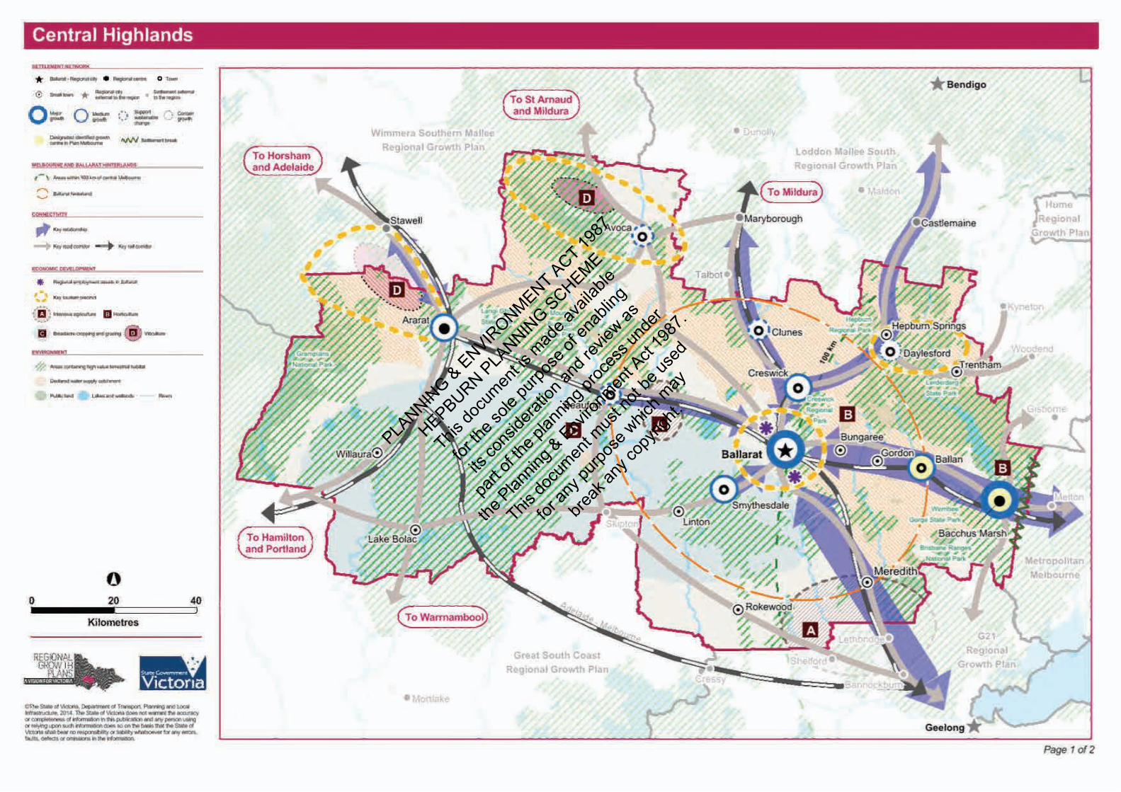
The proposed subdivision is consistent with what is set out within the Central Highlands Regional Growth Plan
(refer plan on next page). Daylesford is highlighted as a key tourism precinct, and an area which should ‘contain
growth’. The proposed residential subdivision allows for growth to be contained within the area, as it is within
the township urban growth boundary.
The regional Planning Policy Framework sets out strategic guidance for planning and land-use outcomes across
the regional context of Hepburn Shire, and the wider Central Highlands area. Relevant to the subject site, these
regional policies aim to ensure that services and sub-services be provided at regional towns, including
Daylesford. Additionally, it seeks to ensure that Daylesford’s growth is maintained in the township boundary.
The proposed residential subdivision is consistent with policy framework for the Central Highlands area,
providing housing at an appropriate density within a dedicated area identified for future residential land use.
PLANNIN
G & ENVIRONMENT ACT 19
87
HEPBURN PLANNIN
G SCHEME
This do
cumen
t is m
ade a
vaila
ble
for th
e sole
purpo
se of
enab
ling
its co
nside
ration
and r
eview
as
part o
f the p
lannin
g proc
ess u
nder
the Plan
ning &
Enviro
nmen
t Act
1987
.
This do
cumen
t mus
t not
be us
ed
for an
y purp
ose w
hich m
ay
break
any c
opyri
ght.

Page 17 of 36
V_Smith Hygge
5.2 LOCAL PLANNING POLICY FRAMEWORK
Hepburn Shire’s Municipal Strategic Statement is set out at Clauses 21.02 (Municipal Profile), 21.02 (Key
Influences) and 21.03 (Vision and Strategic Framework). The Shire is strategically located, and should aim to
‘take advantage of its location to the outer metropolitan growth area of Melbourne and the regional centres of
Ballarat and Bendigo, which are commutable distances for many townships within the Shire.’
The proposed subdivision will provide for increased residential opportunities within Daylesford, which enjoys
good access to surrounding regional and metropolitan cities. It also ensures that development of Daylesford is
contained within the confines of the township boundary, and it occurs at an appropriate scale.
5.2.1 Settlement and Housing (Clause 21.05)
The proposed subdivision achieves the objectives of this clause in the Hepburn Planning Scheme. It “achieves a
sustainable urban form” for Daylesford being located in an area identified for future residential development,
within the township boundary. The large lots (average lot size: 655.7sqm) ensure that township character is
retained, and enhanced. The street network presents an appropriate scale of road connections which will allow
for further planting within the development.
The proposal is considered to be in accordance with the Daylesford Structure Plan. The subject site is identified
on the Structure Plan as “Future residential design is to address town entrance character”; this is identified
within Chapter 10 of this report.
5.2.2 Environment and Heritage (Clause 21.09)
The proposed residential subdivision has been designed to ensure that it allows for the continued protection of
cultural heritage of Hepburn, and provides a development within an appropriate location and at an appropriate
scale. Through generous road reserves, street tree plantings and large lot sizes allowing for generous setbacks,
the proposal positively integrates with the surrounding character, landscape and natural features, and aims to
enhance these through large blocks which provide for additional planting to complement this character of
Daylesford.
5.2.3 Catchment and Land Protection (Clause 22.01)
This clause recognises the need to have “long-term sustainable management of the environment and natural
resource base”, in order to ensure the “protection of environment assets within its proclaimed water catchments
and the ongoing economic development of the Shire and the region”.
The proposal has considered the existing natural resources and environmental systems within the area, and has
designed a subdivision which responds appropriately to this, and will not have a detrimental impact thereupon.
Please refer to Chapter 10 of this report, and the accompanying Servicing Strategy report (Appendix I) for an
explanation on how drainage will be treated for the development to best-practice standards.
5.2.4 Daylesford Neighbourhood Character (Clause 22.08)
There is a strong need and desire within Daylesford to protect the distinctive character of the town, and ensure
that development responds to, and enhances this as the town develops and changes over time. This clause
specifies objectives which will assist in maintaining and enhancing character and amenity of residential areas in
Daylesford, through the retention and planting of local native plants, appropriate siting of new development,
protection of views and vistas, provide a sense of entrance to the town, and maintain the spacious, low-scale
nature of neighbourhoods.
The proposed subdivision has undergone a design review process which involved an analysis on the surrounding
character of the area, and has produced an outcome which responds to and enhances the important
characteristics of Daylesford. The subdivision design responds to the complex topography of the land, and
provides large blocks, particularly in steep areas. The layout will be able to accommodate the planting of locally
native and significant trees, to reflect the existing natural character of the streetscapes in the surrounding
neighbourhood.
The Daylesford Neighbourhood Character Plan (see plan on next page) shows the different character areas of
the town. The subject site is not located within a specific character area, however it is bounded by character
area 7 to the west, 10 to the south, and 11 to the south-east. The Daylesford Structure Plan stipulates that the
subject site’s residential design is to address the town entrance character.
It is considered the proposed design appropriately responds to the abutting character precincts as follows:
- Larger road reserves to accommodate street tree planting that will contribute to the “green” character
established in the public realm
- Subdivision pattern proposes lot sizes typical of the surrounding area
PLANNIN
G & ENVIRONMENT ACT 19
87
HEPBURN PLANNIN
G SCHEME
This do
cumen
t is m
ade a
vaila
ble
for th
e sole
purpo
se of
enab
ling
its co
nside
ration
and r
eview
as
part o
f the p
lannin
g proc
ess u
nder
the Plan
ning &
Enviro
nmen
t Act
1987
.
This do
cumen
t mus
t not
be us
ed
for an
y purp
ose w
hich m
ay
break
any c
opyri
ght.

CHARACTERPRECINCT
7
CHARACTERPRECINCT
11CHARACTERPRECINCT
10
CHARACTERPRECINCT
14CHARACTERPRECINCT
15
CHARACTERPRECINCT
6
CHARACTERPRECINCT
NOTNUMBERED
CHARACTERPRECINCT
5
0 50 100 150 200 250 300m
Scale: 1:5,000 @A3
N I C H E
S T U D I OP L A N N I N G
DAYLESFORD CHARACTER PRECINCTS17 SMITH ST, DAYLESFORD
Aerial supplied by: NearmapAerial Date Stamp: 01.12.18Survey supplied by: VICMAPPlan Number: NPS739_001Revision Number: ADrawn By: Kim DelbridgeClient: Hygge Property
DISCLAIMER: This Concept Plan has been prepared based on the High Level Planning Advice.All Dimensions, Areas and Calculations are subject to Detailed Survey and Design before Town Planning Permit application.Built Form is illustrative only and subject to Architectural Design and approval from an RAIA qualified architect. This plan has been preparedfor illustrative purposes only and should not be used as a means to judge any properties value or yield potential.
©Niche Planning StudioDate Issued: 31.07.2019
LEGEND Site boundary Parcel Cadastre Precinct Boundary
PLANNIN
G & ENVIRONMENT ACT 19
87
HEPBURN PLANNIN
G SCHEME
This do
cumen
t is m
ade a
vaila
ble
for th
e sole
purpo
se of
enab
ling
its co
nside
ration
and r
eview
as
part o
f the p
lannin
g proc
ess u
nder
the Plan
ning &
Enviro
nmen
t Act
1987
.
This do
cumen
t mus
t not
be us
ed
for an
y purp
ose w
hich m
ay
break
any c
opyri
ght.

Page 19 of 36
V_Smith Hygge
6. ZONES
The site is subject to the following zone (refer Zoning plan on next page):
• General Residential Zone – Schedule 1 (GRZ 1)
The purposes of the GRZ is as follows:
• To implement the Municipal Planning Strategy and the Planning Policy Framework.
• To encourage development that respects the neighbourhood character of the area.
• To encourage a diversity of housing types and housing growth particularly in locations offering good
access to services and transport.
• To allow educational, recreational, religious, community and a limited range of other non-residential
uses to serve local community needs in appropriate locations.
The proposed planning permit application responds the purposes of the GRZ by providing a subdivision layout
with a diverse range of lot sizes and orientations, in an area which enjoys good access to various services and
amenities within Daylesford.
Pursuant to Clause 32.08-3 of the GRZ, a planning permit is triggered for subdivision. This clause stipulates that
the application must take into consideration the requirements of Clause 56. A full assessment of this Clause has
been provided in Appendix E.
The application requirements set out at Clause 32.08-11 of the GRZ have been provided within this application
package.
Please find below a response to the relevant Decision Guidelines at Clause of this clause:
Table 5: Clause 32.08-13 Decision Guidelines
DEP ARTMENT C OUNCIL R ES P ONSE
G ENERAL
The Municipal Planning Strategy and the Planning
Policy Framework Refer Chapter 5 of this report.
The purpose of this zone. Refer Chapter 6 of this report.
The objectives set out in a schedule to this zone. Refer Chapter 6 of this report.
SUBD I V I S ION
The pattern of subdivision and its effect on the spacing
of buildings. The proposal has incorporated a subdivision layout which integrates well
with the surrounding existing pattern of subdivision. See Chapter 10 for
more information.
For subdivision of land for residential development, the
objectives and standards of Clause 56. Refer to Clause 56 Assessment at Appendix E.
PLANNIN
G & ENVIRONMENT ACT 19
87
HEPBURN PLANNIN
G SCHEME
This do
cumen
t is m
ade a
vaila
ble
for th
e sole
purpo
se of
enab
ling
its co
nside
ration
and r
eview
as
part o
f the p
lannin
g proc
ess u
nder
the Plan
ning &
Enviro
nmen
t Act
1987
.
This do
cumen
t mus
t not
be us
ed
for an
y purp
ose w
hich m
ay
break
any c
opyri
ght.

WOMBAT HILL SCENIC DR
MIDLAND HWY
MIDLAND HWY
TREW
HELL
A AV
ROSE
LLA
LANE
CROCKETT ST
WOM
BAT
ST
PARK
ER S
T
BARK
AS S
T
UNNAMED
SMIT
H ST
DALY
ST
0 25 50 75 100 125 150m
Scale: 1:2,500 @A3
N I C H E
S T U D I OP L A N N I N G
ZONING PLAN17 SMITH ST, DAYLESFORD
Aerial supplied by: NearmapAerial Date Stamp: 01.12.18Survey supplied by: VICMAPPlan Number: NPS739_002Revision Number: ADrawn By: Kim DelbridgeClient: Hygge Property
DISCLAIMER: This Concept Plan has been prepared based on the High Level Planning Advice.All Dimensions, Areas and Calculations are subject to Detailed Survey and Design before Town Planning Permit application.Built Form is illustrative only and subject to Architectural Design and approval from an RAIA qualified architect. This plan has been preparedfor illustrative purposes only and should not be used as a means to judge any properties value or yield potential.
©Niche Planning StudioDate Issued: 31.07.2019
LEGEND Site boundary Parcel Cadastre GRZ - General Residential Zone PUZ2 - Public Use Zone (Education) FZ - Farming Zone RDZ1 - Road Zone-Category 1 RDZ2 - Road Zone-Category 2 PUZ4 - Public Use Zone (Transport) IN1Z - Industrial 1 Zone
PLANNIN
G & ENVIRONMENT ACT 19
87
HEPBURN PLANNIN
G SCHEME
This do
cumen
t is m
ade a
vaila
ble
for th
e sole
purpo
se of
enab
ling
its co
nside
ration
and r
eview
as
part o
f the p
lannin
g proc
ess u
nder
the Plan
ning &
Enviro
nmen
t Act
1987
.
This do
cumen
t mus
t not
be us
ed
for an
y purp
ose w
hich m
ay
break
any c
opyri
ght.

Page 21 of 36
V_Smith Hygge
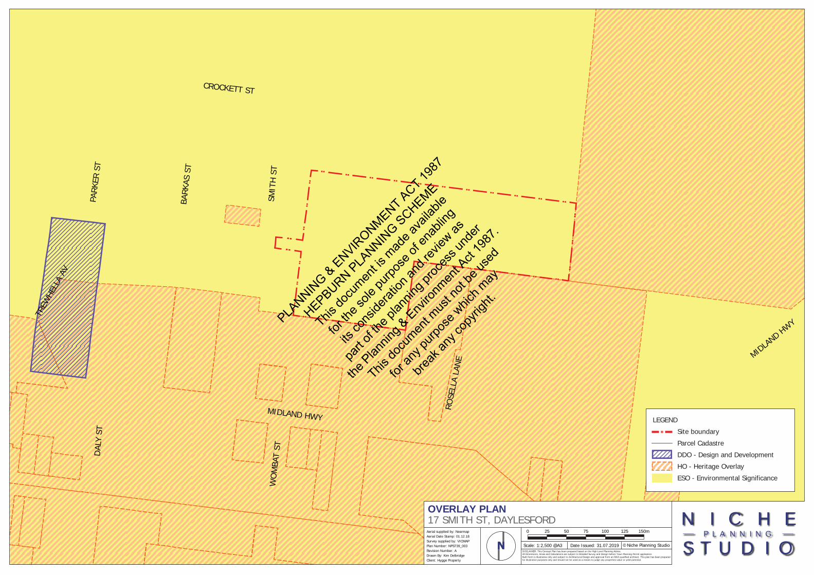
7. OVERLAYS
The site is subject to the following overlay (and associated schedules):
• Environmental Significance Overlay – Schedule 1 (ESO1)
• Environmental Significance Overlay – Schedule 2 (ESO2)
These overlays and schedules will be outlined below in further detail (refer Overlay Plan on next page).
7.1 ENVIRONMENTAL SIGNIFICANCE OVERLAY (CLAUSE 42.01)
This overlay seeks to ensure that development is compatible with the identified environmental values and
achieve environmental objectives.
Clause 42.01-2 states that a planning permit is required to:
• Subdivide land.
• Remove, destroy or lop any vegetation, including dead vegetation. This does not apply: If a schedule to
this overlay specifically states that a permit is not required.
A planning permit is triggered for both of the above.
7.1.1 Schedule 1 to the ESO (ESO1)
The ESO1 relates to the proclaimed catchment protection, and seeks to ensure that the region’s water quality is
protected. ESO1 specifies the following mandatory requirements:
• All on-site wastewater must be treated and disposed of in accordance with the relevant EPA Code of
Practice – On Site Wastewater Management.
• All stormwater must be managed and discharged to the satisfaction of the responsible Authority and
generally in accordance with the principles described in Urban Stormwater: Best Practice Environmental
Management Guidelines (Victorian Stormwater Committee 1999).
The proposal has been designed to ensure compliance with the above. For more information please refer
Appendix F for the Stormwater Strategy report.
The ESO1 states that a permit is not required not required to remove, destroy, or lop vegetation, including dead
vegetation unless the removal, destruction or lopping involves:
• Any vegetation on site area greater than 1 ha.
• Vegetation within 30 metres of a waterway.
As the subject site is greater than 1ha, a planning permit is triggered for the removal of vegetation under this
overlay.
The ESO1 also states that a permit is not required to subdivide land if:
• The subdivision is for existing buildings that are connected to reticulated water and reticulated sewerage
system.
• The subdivision is a two lot subdivision and each lot is connected to reticulated water and reticulated
sewerage system.
As the proposed subdivision is not for both of the above, a planning permit is triggered under this overlay.
PLANNIN
G & ENVIRONMENT ACT 19
87
HEPBURN PLANNIN
G SCHEME
This do
cumen
t is m
ade a
vaila
ble
for th
e sole
purpo
se of
enab
ling
its co
nside
ration
and r
eview
as
part o
f the p
lannin
g proc
ess u
nder
the Plan
ning &
Enviro
nmen
t Act
1987
.
This do
cumen
t mus
t not
be us
ed
for an
y purp
ose w
hich m
ay
break
any c
opyri
ght.
WOMBAT HILL SCENIC DR
MIDLAND HWY
MIDLAND HWY
TREW
HELL
A AV
ROSE
LLA
LANE
CROCKETT ST
WOM
BAT
ST
PARK
ER S
T
BARK
AS S
T
UNNAMED
SMIT
H ST
DALY
ST
0 25 50 75 100 125 150m
Scale: 1:2,500 @A3
N I C H E
S T U D I OP L A N N I N G
OVERLAY PLAN17 SMITH ST, DAYLESFORD
Aerial supplied by: NearmapAerial Date Stamp: 01.12.18Survey supplied by: VICMAPPlan Number: NPS739_003Revision Number: ADrawn By: Kim DelbridgeClient: Hygge Property
DISCLAIMER: This Concept Plan has been prepared based on the High Level Planning Advice.All Dimensions, Areas and Calculations are subject to Detailed Survey and Design before Town Planning Permit application.Built Form is illustrative only and subject to Architectural Design and approval from an RAIA qualified architect. This plan has been preparedfor illustrative purposes only and should not be used as a means to judge any properties value or yield potential.
©Niche Planning StudioDate Issued: 31.07.2019
LEGEND Site boundary Parcel Cadastre DDO - Design and Development HO - Heritage Overlay ESO - Environmental Significance
PLANNIN
G & ENVIRONMENT ACT 19
87
HEPBURN PLANNIN
G SCHEME
This do
cumen
t is m
ade a
vaila
ble
for th
e sole
purpo
se of
enab
ling
its co
nside
ration
and r
eview
as
part o
f the p
lannin
g proc
ess u
nder
the Plan
ning &
Enviro
nmen
t Act
1987
.
This do
cumen
t mus
t not
be us
ed
for an
y purp
ose w
hich m
ay
break
any c
opyri
ght.
Page 24 of 36
V_Smith Hygge
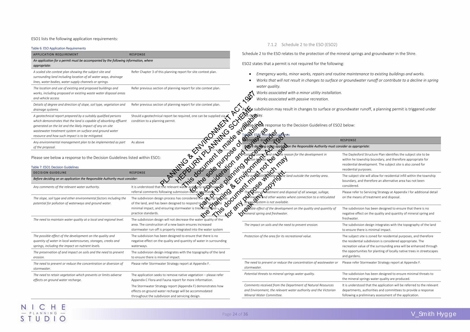
ESO1 lists the following application requirements:
Table 6: ESO Application Requirements
AP P L I CAT I ON REQUIR EM ENT RESP ONS E
An application for a permit must be accompanied by the following information, where
appropriate:
A scaled site context plan showing the subject site and
surrounding land including location of all water ways, drainage
lines, water bodies, water supply channels or springs.
Refer Chapter 3 of this planning report for site context plan.
The location and use of existing and proposed buildings and
works, including proposed or existing waste water disposal areas
and vehicle access
Refer previous section of planning report for site context plan.
Details of degree and direction of slope, soil type, vegetation and
drainage systems
Refer previous section of planning report for site context plan.
A geotechnical report prepared by a suitably qualified persons
which demonstrates that the land is capable of absorbing effluent
generated on the lot and the likely impact of any on-site
wastewater treatment system on surface and ground water
resource and how such impact is to be mitigated.
Should a geotechnical report be required, one can be supplied via a
condition to a planning permit.
Any environmental management plan to be implemented as part
of the proposal.
As above
Please see below a response to the Decision Guidelines listed within ESO1:
Table 7: ESO1 Decision Guidelines
DE CI S IO N GUI D EL I NE RES P ONSE
Before deciding on an application the Responsible Authority must consider:
Any comments of the relevant water authority. It is understood that the relevant water authority will provide
referral comments following submission of the application.
The slope, soil type and other environmental factors including the
potential for pollution of waterways and ground water.
The subdivision design process has considered the existing features
of the land, and has been designed to respond to this to ensure
minimal impact, and ensuring stormwater is treated to best-
practice standards.
The need to maintain water quality at a local and regional level. The subdivision design will not decrease the water quality of the
area. The construction of a new basin ensures increased
stormwater run-off is property integrated into the water system
The possible effect of the development on the quality and
quantity of water in local watercourses, storages, creeks and
springs, including the impact on nutrient levels.
The subdivision has been designed to ensure that there is no
negative effect on the quality and quantity of water in surrounding
waterways.
The preservation of and impact on soils and the need to prevent
erosion.
The subdivision design integrates with the topography of the land
to ensure there is minimal impact.
The need to prevent or reduce the concentration or diversion of
stormwater.
Please refer Stormwater Strategy report at Appendix F.
The need to retain vegetation which prevents or limits adverse
effects on ground water recharge.
The application seeks to remove native vegetation – please refer
Appendix C Flora and Fauna report for more information.
The Stormwater Strategy report (Appendix F) demonstrates how
effects on ground water recharge will be accommodated
throughout the subdivision and servicing design.
7.1.2 Schedule 2 to the ESO (ESO2)
Schedule 2 to the ESO relates to the protection of the mineral springs and groundwater in the Shire.
ESO2 states that a permit is not required for the following:
• Emergency works, minor works, repairs and routine maintenance to existing buildings and works.
• Works that will not result in changes to surface or groundwater runoff or contribute to a decline in spring
water quality.
• Works associated with a minor utility installation.
• Works associated with passive recreation.
As the subdivision may result in changes to surface or groundwater runoff, a planning permit is triggered under
this overlay.
Please find a response to the Decision Guidelines of ESO2 below:
Table 8: ESO2 Decision Guidelines
DE CI S IO N GUI D EL I NE RES P ONSE
Before deciding on an application the Responsible Authority must consider as appropriate:
Existing use of land and the reason for the development in
relation to that use.
The Daylesford Structure Plan identifies the subject site to be
within he township boundary, and therefore appropriate for
residential development. The subject site is also zoned for
residential purposes.
The availability of alternative land outside the overlay area. The subject site will allow for residential infill within the township
boundary, and therefore an alternative area has not been
considered.
The means of treatment and disposal of all sewage, sullage,
stormwater and other wastes where connection to a reticulated
sewage system is not available.
Please refer to Servicing Strategy at Appendix I for additional detail
on the means of treatment and disposal.
Possible effect of the development on the quality and quantity of
mineral spring and freshwater.
The subdivision has been designed to ensure that there is no
negative effect on the quality and quantity of mineral spring and
freshwater.
The impact on soils and the need to prevent erosion. The subdivision design integrates with the topography of the land
to ensure there is minimal impact.
Protection of the area for its recreational value. The subject site is zoned for residential purposes, and therefore
the residential subdivision is considered appropriate. The
recreation value of the surrounding area will be enhanced through
the opportunities for planting of locally native trees in streetscapes
and gardens.
The need to prevent or reduce the concentration of wastewater or
stormwater.
Please refer Stormwater Strategy report at Appendix F.
Potential threats to mineral springs water quality. The subdivision has been designed to ensure minimal threats to
the mineral springs water quality are produced.
Comments received from the Department of Natural Resources
and Environment, the relevant water authority and the Victorian
Mineral Water Committee.
It is understood that the application will be referred to the relevant
departments, authorities and committees to provide a response
following a preliminary assessment of the application.
PLANNIN
G & ENVIRONMENT ACT 19
87
HEPBURN PLANNIN
G SCHEME
This do
cumen
t is m
ade a
vaila
ble
for th
e sole
purpo
se of
enab
ling
its co
nside
ration
and r
eview
as
part o
f the p
lannin
g proc
ess u
nder
the Plan
ning &
Enviro
nmen
t Act
1987
.
This do
cumen
t mus
t not
be us
ed
for an
y purp
ose w
hich m
ay
break
any c
opyri
ght.

Page 25 of 36
V_Smith Hygge
8. PARTICULAR PROVISIONS
The following Particular Provisions of the Hepburn Planning Scheme are relevant to the proposed development.
8.1 CLAUSE 52.01 – PUBLIC OPEN SPACE CONTRIBUTION AND SUBDIVISION
Pursuant to Clause 52.01, the subdivision proposal is required to make a contribution to Council for public open
space. The Schedule to the Clause stipulates that all residential, industrial and commercial subdivision within the
Shire of Hepburn is subject to 5% of the value of land intended to be developed for residential purposes.
As the lot is subject to a residential Net Developable Area of 3.54ha, a total of 0.177ha is required to be
contributed to Council, or the value of land to 0.177ha.
Our client would like to negotiate with Council to provide this contribution as cash contribution at statement of
compliance of the final stage. This contribution will be dealt with as a condition to any planning permit issued.
8.2 CLAUSE 52.17 – REMOVAL OF NATIVE VEGETATION
Pursuant to Clause 52.17, the application proposes the removal of native vegetation. This Clause seeks to ensure
that there is “no net loss to biodiversity as a result of the removal, destruction or lopping of native vegetation”.
This is achieved through the application of the following three step approach:
1. Avoid the removal, destruction or lopping of native vegetation.
2. Minimise impacts from the removal, destruction or lopping of native vegetation that cannot be avoided.
3. Provide an offset to compensate for the biodiversity impact if a permit is granted to remove, destroy or
lop native vegetation.
Please find below an ‘avoid and minimise’ statement, as required, in response to the above:
The subject land is zoned for residential purposes and is located within the Daylesford
Structure Plan’s identified township boundary, earmarked for future residential development.
The subdivision layout has created lot sizes which align with Council’s preferred density of the
area, with an effort to avoid any detrimental impact upon the manna gums. However, given
the large size of these trees and the layout of the lots, the formal protection area required for
these trees is very large and their ‘loss’ of value is considered inevitable. Thus, the Manna
gums will be required to be removed, and will be offset accordingly. The patches of
vegetation along the existing driveway may be able to be retained within the proposed lots,
and this will be determined upon more detailed design phase.
Pursuant to Clause 52.17-1 of this clause, a permit is required to remove, destroy or lop any native vegetation,
including dead vegetation. As native vegetation is proposed to be removed as part of this application, a planning
permit is triggered under this Clause.
A Flora and Fauna Report (Appendix C), and an Arborist Report (Appendix D) have been prepared, which outline
the vegetation found on the subject site. The report also includes the ‘avoid and minimise statement’, and the
offset requirements.
Clause 52.17-2 of this Clause states that an application under this Clause must comply with the application
requirements within the Guidelines. Please find below a response to each application requirement of these
Guidelines:
Table 9: Application Requirements for Removal of Native Vegetation
AP P L I CAT I ON REQUIR EM ENT S * RES P ONSE
Information about the native vegetation to be removed, including:
- The assessment pathway and reason for the assessment pathway. This
includes the location category of the native vegetation to be removed.
- A description of the native vegetation to be removed that includes:
• whether it is a patch or a scattered tree (or both)
• the extent (in hectares)
• the number and circumference (in centimetres measured at 1.3
metres above ground level) of any large trees within a patch
• the number and circumference (in centimetres measured at 1.3
metres above ground level) of any scattered trees, and whether each
tree is small or large
• the strategic biodiversity value score
• the condition score
• if it includes endangered Ecological Vegetation Classes
• if it includes sensitive wetland or coastal areas.
- Maps showing the native vegetation and property in context and containing:
• scale, north point and property boundaries
• location of any patches of native vegetation and the number of large
trees within the patch proposed to be removed
• location of scattered trees proposed to be removed, including their
size
- The offset requirement, determined in accordance with section 5 of the
Guidelines, that will apply if the native vegetation is approved to be removed.
Provided – please refer Appendix C for Flora
and Fauna report which provide these details.
Topographic and land information relating to the native vegetation to be removed,
showing ridges, crests and hilltops, wetlands and waterways, slopes of more than 20
percent, drainage lines, low lying areas, saline discharge areas, and areas of existing
erosion, as appropriate. This may be represented in a map or plan.
Provided - please refer Planning Permit
Report for Site Context plan.
Recent, dated photographs of the native vegetation to be removed. Provided – please refer Appendix D for
Arborist Report.
PLANNIN
G & ENVIRONMENT ACT 19
87
HEPBURN PLANNIN
G SCHEME
This do
cumen
t is m
ade a
vaila
ble
for th
e sole
purpo
se of
enab
ling
its co
nside
ration
and r
eview
as
part o
f the p
lannin
g proc
ess u
nder
the Plan
ning &
Enviro
nmen
t Act
1987
.
This do
cumen
t mus
t not
be us
ed
for an
y purp
ose w
hich m
ay
break
any c
opyri
ght.

Page 26 of 36
V_Smith Hygge
Details of any other native vegetation approved to be removed, or that was removed
without the required approvals, on the same property or on contiguous land in the
same ownership as the applicant, in the five year period before the application for a
permit is lodged.
Not applicable – there has not been any other
native vegetation approved to be removed to
the applicant’s knowledge.
An avoid and minimise statement. The statement describes any efforts to avoid the
removal of, and minimise the impacts on the biodiversity and other values of native
vegetation, and how these efforts focussed on areas of native vegetation that have the
most value. The statement should include a description of the following:
- Strategic level planning – any regional or landscape scale strategic planning
process that the site has been subject to that avoided and minimised impacts
on native vegetation across a region or landscape
- Site level planning – how the proposed use or development has been sited or
designed to avoid and minimise impacts on native vegetation.
- That no feasible opportunities exist to further avoid and minimise impacts on
native vegetation without undermining the key objectives of the proposal.
Provided – please refer Appendix C for Flora
and Fauna Assessment report.
A copy of any Property Vegetation Plan contained within an agreement made pursuant
to section 69 of the Conservation, Forests and Lands Act 1987 that applies to the native
vegetation to be removed.
Not applicable – there is no Property
Vegetation Plan which applies to this
application.
Where the removal of native vegetation is to create defendable space, a written
statement explaining why the removal of native vegetation is necessary. This statement
must have regard to other available bushfire risk mitigation measures. This statement
is not required when the creation of defendable space is in conjunction with an
application under the Bushfire Management Overlay
Not applicable – the removal of this
vegetation is not to create defendable space.
If the application is under Clause 52.16, a statement that explains how the proposal
responds to the Native Vegetation Precinct Plan considerations at decision guideline 8.
Not applicable – this application is not under
Clause 52.16.
An offset statement providing evidence that an offset that meets the offset
requirements for the native vegetation to be removed has been identified, and can be
secured in accordance with the Guidelines.
A suitable statement includes evidence that the required offset:
- is available to purchase from a third party, or
- will be established as a new offset and has the agreement of the proposed
offset provider, or
- can be met by a first party offset.
It is understood that the application will be
referred to the relevant departments,
authorities and committees to provide a
response following a preliminary assessment
of the application.
*NOTE: the application is considered to be considered an ‘intermediate assessment pathway’, and therefore is not required to comply
with the application requirements for those subject to ‘detailed assessment pathways’.
Clause 52.17-4 stipulates that an application under this provision will be assessed against the Decision
Guidelines within the Guidelines. This application has taken these Decision Guidelines into account – please refer
Appendix C for Flora and Fauna report for further details on the proposed removal of native vegetation.
Clause 52.17-5 of this Clause sets out the following regarding offset requirements:
If a permit is required to remove, destroy or lop native vegetation, the biodiversity impacts from the
removal, destruction or lopping of native vegetation must be offset, in accordance with the
Guidelines. The conditions on the permit for the removal, destruction or lopping of native vegetation
must specify the offset requirement and the timing to secure the offset.
Please refer Appendix C for Flora and Fauna report, which provides evidence that the offsets can be achieved.
8.3 CLAUSE 56 – SUBDIVISION
A detailed assessment of the proposed subdivision against Clause 56 has been undertaken. The proposed
subdivision complies with the requirements of Clause 56 and this is attached at Appendix E.
PLANNIN
G & ENVIRONMENT ACT 19
87
HEPBURN PLANNIN
G SCHEME
This do
cumen
t is m
ade a
vaila
ble
for th
e sole
purpo
se of
enab
ling
its co
nside
ration
and r
eview
as
part o
f the p
lannin
g proc
ess u
nder
the Plan
ning &
Enviro
nmen
t Act
1987
.
This do
cumen
t mus
t not
be us
ed
for an
y purp
ose w
hich m
ay
break
any c
opyri
ght.

Page 27 of 36
V_Smith Hygge
9. GENERAL PROVISIONS
The following General Provisions of the Hepburn Planning Scheme are relevant to the proposed development.
9.1 CLAUSE - 65 DECISION GUIDELINES
This Clause of the Planning Scheme states the following: ‘Because a permit can be granted does not imply that a
permit should or will be granted. The responsible authority must decide whether the proposal will produce
acceptable outcomes in terms of the decision guidelines of this clause’.
This application has considered the Decision Guidelines of the Hepburn Planning Scheme – please find more
details in Table 10 to the right.
9.1.1 Clause 65.01 Approval of an Application or Plan:
Please find a response to Clause 65.01 below:
Table 10: Clause 65.01 Approval of an Application or Plan
DE CI S IO N GUI D EL I NE RES P ONSE
Before deciding on an application or approval of a plan, the responsible authority must consider, as appropriate:
The matters set out in section 60 of the Act. Considered – the application has considered maters within
Section 60 of the Act.
The Municipal Planning Strategy and the Planning Policy
Framework.
Considered – please refer to Chapter 5 of this Planning Permit
Application report.
The purpose of the zone, overlay or other provision. Considered – please refer to Chapter 6 this Planning Permit
Application report.
Any matter required to be considered in the zone, overlay or other
provision.
Considered – please refer to Chapter 6 of this Planning Permit
Application report.
The orderly planning of the area Considered – the proposed subdivision is in line with the
Daylesford Structure Plan, and is located within the identified
township boundary.
The effect on the amenity of the area Considered – a site analysis of the surrounding area was
undertaken, which determined that the proposed subdivision will
not have a detrimental impact on the existing area.
The proximity of the land to any public land. Considered – the subject site will complement the existing public
land area within the vicinity, such as the school to the north, and
local parks to the south.
Factors likely to cause or contribute to land degradation, salinity
or reduce water quality.
Considered – please refer to Stormwater Strategy Report at
Appendix F and Servicing Strategy Report at Appendix I.
Whether the proposed development is designed to maintain or
improve the quality of stormwater within and exiting the site.
Considered – please refer to Stormwater Strategy Report at
Appendix F.
The extent and character of native vegetation and the likelihood
of its destruction.
Considered – please refer to Flora and Fauna Report at Appendix
C.
Whether native vegetation is to be or can be protected, planted
or allowed to regenerate.
Considered – please refer to Flora and Fauna Report at Appendix
C.
The degree of flood, erosion or fire hazard associated with the
location of the land and the use, development or management of
the land so as to minimise any such hazard.
Considered – the proposed subdivision has been designed to
ensure that such hazards can be avoided.
The adequacy of loading and unloading facilities and any
associated amenity, traffic flow and road safety impacts.
Considered – it is considered that the proposed subdivision will
not have a detrimental impact on the current function of Smith
Street.
PLANNIN
G & ENVIRONMENT ACT 19
87
HEPBURN PLANNIN
G SCHEME
This do
cumen
t is m
ade a
vaila
ble
for th
e sole
purpo
se of
enab
ling
its co
nside
ration
and r
eview
as
part o
f the p
lannin
g proc
ess u
nder
the Plan
ning &
Enviro
nmen
t Act
1987
.
This do
cumen
t mus
t not
be us
ed
for an
y purp
ose w
hich m
ay
break
any c
opyri
ght.

Page 28 of 36
V_Smith Hygge
9.1.1 Clause 65.02 Approval of an Application to subdivide land:
Please find a response to Clause 65.02 below:
Table 11: Clause 65.02 Approval of an Application to subdivide land
DE CI S IO N GUI D EL INE RES P ONSE
Before deciding on an application or approval of a plan, the responsible authority must consider, as appropriate:
The suitability of the land for subdivision. Considered – the subject land is zoned for residential purposes,
and is located within the Daylesford Structure Plan township
boundary, and is therefore considered to be appropriate for
residential subdivision.
The existing use and possible future development of the land and
nearby land.
Considered – as above.
The availability of subdivided land in the locality, and the need for
the creation of further lots.
Considered – as above.
The effect of development on the use or development of other
land which has a common means of drainage.
Considered – please refer to Appendix F for Stormwater Strategy
report.
The subdivision pattern having regard to the physical
characteristics of the land including existing vegetation.
Considered – please refer Appendix C Flora and Fauna Report.
The density of the proposed development Considered – the proposed subdivision layout is reflective of
surrounding lot sizes and densities.
The area and dimensions of each lot in the subdivision. Considered – the proposed subdivision layout is reflective of
surrounding lot sizes and densities.
The layout of roads having regard to their function and
relationship to existing roads.
Considered – please refer to following section of this report for
details on road network.
The movement of pedestrians and vehicles throughout the
subdivision and the ease of access to all lots.
Considered – please refer to Clause 56 Assessment at Appendix E.
The provision and location of reserves for public open space and
other community facilities.
Not applicable – this application does not include the provision of
any public facilities.
The staging of the subdivision Considered – the subdivision staging plan can be provided upon
the request of Council, should this be required. Staging will follow
the services provided.
The design and siting of buildings having regard to safety and the
risk of spread of fire.
Not applicable – there are no buildings a part of this application.
The provision of off-street parking. Considered – off-street car parking will be provided to the
satisfaction of the responsible Authority.
The provision and location of common property Not applicable – no common property is created as part of this
application.
The functions of any body corporate. Not applicable – as above.
The availability and provision of utility services, including water,
sewerage, drainage, electricity and gas.
Considered – please refer to Servicing Strategy report at
Appendix I.
If the land is not sewered and no provision has been made for the
land to be sewered, the capacity of the land to treat and retain all
sewage and sullage within the boundaries of each lot.
Considered – please refer to Servicing Strategy report at
Appendix I.
Whether, in relation to subdivision plans, native vegetation can be
protected through subdivision and siting of open space areas.
Considered – please refer Appendix C Flora and Fauna Report.
9.2 CLAUSE 66 REFERRAL & NOTICE PROVISIONS
It is understood that this application will be referred to the relevant state government departments and
authorities for comment – any comments on this application will be welcomed and considered throughout the
process of the application.
PLANNIN
G & ENVIRONMENT ACT 19
87
HEPBURN PLANNIN
G SCHEME
This do
cumen
t is m
ade a
vaila
ble
for th
e sole
purpo
se of
enab
ling
its co
nside
ration
and r
eview
as
part o
f the p
lannin
g proc
ess u
nder
the Plan
ning &
Enviro
nmen
t Act
1987
.
This do
cumen
t mus
t not
be us
ed
for an
y purp
ose w
hich m
ay
break
any c
opyri
ght.

Page 29 of 36
V_Smith Hygge
10. DESIGN ASSESSMENT
10.1 IMAGE, CHARACTER AND HOUSING
The proposed subdivision has been designed with the intent to create a functional, safe and aesthetically
pleasing built environment which establishes a sense of place upon entry into the subdivision. To achieve this,
the proposed subdivision has ensured that all proposed lots have a street frontage to maximise a sense of
address and a linear road configuration to maximise visual permeability. Please refer to Image, Character and
Housing Plan on next page, to be read in conjunction with Table 12.
With regards to vegetation removal, the application proposes the removal of two (2) manna gums, which are
identified as trees 40 and 41 on the subdivision layout plan (refer Appendix B). There are also two patches of
native vegetation along the existing driveway of the subject site, and it will be determined throughout the design
phase whether the retention of these trees will be possible. Please refer to Appendix C for the Flora and Fauna
report, which describes the location and ecological class of the native vegetation.
The other trees located on the subject site are not native vegetation and are annotated on the plan. Pease refer
to the Arborist Report at Appendix D which describes each of these trees.
The proposed subdivision was prepared following a detailed site and surrounds analysis, to understand the
existing character of the surrounding residential area. The design has been prepared to ensure that it is
appropriate for the own entrance area, in line with the Daylesford Structure Plan. The details of housing design
can be determined at a later date, to ensure that the preferred character comes through in final house designs,
and to the satisfaction of Council. Specifically, we request that this be done through Design Guidelines as a
condition to any Planning Permit issued.
In addition, the proposal has been assessed against the requirements of Clause 56 (ResCode) of the Hepburn
Planning Scheme (please refer Appendix E).
Table 12: Image, Character and Housing Design Response
Image & Character
Character of proposed subdivision Explanation
A Pedestrian Link Pedestrian connection will provide for high amenity and walkability to future residents.
B Larger lots where site falls Larger lots have been proposed in the eastern portion of the site, to be integrated with the natural fall of the land.
C Tree-lined streets The cross-sections of streets provide opportunities for canopy tree planting and incorporating of both on-street parking and share pathways.
D Avenue entrance The entrance provides opportunities for street tree planting to integrate well within the existing streetscape of Smith Street
E Post and Wire/rural style fencing This will provide for a smooth transition to the abutting farming use of the land to the east of the site. This will also soften the views between the residential and farming uses of the land.
PLANNIN
G & ENVIRONMENT ACT 19
87
HEPBURN PLANNIN
G SCHEME
This do
cumen
t is m
ade a
vaila
ble
for th
e sole
purpo
se of
enab
ling
its co
nside
ration
and r
eview
as
part o
f the p
lannin
g proc
ess u
nder
the Plan
ning &
Enviro
nmen
t Act
1987
.
This do
cumen
t mus
t not
be us
ed
for an
y purp
ose w
hich m
ay
break
any c
opyri
ght.

15
1413
12
1011
9
8
7
6
1918
17
25
20
21
24
23
22
5
4
3
1
253
5251
5049
4847
4645
4443
4241
40
39
3837
36
35
34
33
32
31
3029
2827
26
16
A
16M ROAD RESERVE
16M
RO
AD R
ESER
VE14
M R
OAD
RES.
16M ROAD RESERVE
ENTRY ROAD
B
C
D
E
SMIT
H S
T
HOSPITAL ST
LEGEND Site Boundary Potential Drainage Basin 1.0m Contours Potential Shared Path Connection Lot Cadastre / Lot Number Area containing larger lots Entrance to estate Internal pedestrian connection Potential future connection Refer to written explanation
38
B
0 10 20 30 40 50 60m
Scale: 1:1,000 @A2
N I C H E
S T U D I OP L A N N I N G
IMAGE, CHARACTER AND HOUSING17 SMITH ST, DAYLESFORD
Aerial supplied by: NEARMAPAerial Date Stamp: 01.12.18Survey supplied by: VICMAPPlan Number: NPS739_101Revision Number: ADrawn By: K. Delbridge & M. PatullockClient: HYGGE PROPERTY
DISCLAIMER: This Concept Plan has been prepared based on the High Level Planning Advice.All Dimensions, Areas and Calculations are subject to Detailed Survey and Design before Town Planning Permit application. Built Form is illustrative only and subject to Architectural Design and approval from an RAIA qualified architect. This plan has been prepared for illustrative purposes only and should not be used as a means to judge any properties value or yield potential.
©Niche Planning StudioDate Issued: 14.08.2019
PLANNIN
G & ENVIRONMENT ACT 19
87
HEPBURN PLANNIN
G SCHEME
This do
cumen
t is m
ade a
vaila
ble
for th
e sole
purpo
se of
enab
ling
its co
nside
ration
and r
eview
as
part o
f the p
lannin
g proc
ess u
nder
the Plan
ning &
Enviro
nmen
t Act
1987
.
This do
cumen
t mus
t not
be us
ed
for an
y purp
ose w
hich m
ay
break
any c
opyri
ght.

Page 31 of 36
V_Smith Hygge
10.2 ROADS AND ACCESS
The proposed subdivision is accessed via the existing Smith Street. Please refer to the Movement Network on
the next page, to be read in conjunction with Table 13, which highlights the key aspects for roads and access.
Table 13 Road Descriptions & Functionality
ROADS DESCRIPTION OF S ITE FEATURES
A Entry road
Entrance via Smith Street has been designed to ensure minimal impact on the
existing functionality of the street, and of the streetscape is retained. Please
refer Appendix H for a typical cross-section of this type of street.
The entry road has been designed to activate the entrance to the subject site.
The entrance area currently features an old oak tree, which is to be removed
to allow for efficient movement of vehicles, and because of the effect it will
have on the tree. It was determined that there would be too much ’cut’
required to create the entrance around this tree
B 16m road
One main east-west 16m road is proposed within the northern portion of the
development, which will serve as the main connection throughout the site. It is
envisaged that the road will allow for the planting of various locally significant
and native trees, and allow for pedestrian movement around the
development. This type of road will also be able to accommodate on-street
parking which is reflective of similar streets in the surrounding area of
Daylesford.
There are three other shorter 16m road reserves throughout the
development, two north-south, and one east-west. These roads will allow for
access to other, smaller roads throughout the development and are designed
to ultimately extend into adjoining properties
C 14m road
The development has incorporated a north-south 14m road in the north-
eastern corner of the subject site, which abuts the proposed drainage area.
This road has the potential to connect to the northern abutting lot in the
future.
D 11m shared
accessways
The proposed subdivision includes the provision of two 11m shared
accessways. This is to reflect and enhance the existing quiet and low density
character of the surrounding area. The accessways will allow for the
streetscapes to incorporate additional planting to make for an aesthetic path
for pedestrians to use.
E Future road
connections
The future road connections are provided at boundaries to reserve potential
for future development of these sites.
PLANNIN
G & ENVIRONMENT ACT 19
87
HEPBURN PLANNIN
G SCHEME
This do
cumen
t is m
ade a
vaila
ble
for th
e sole
purpo
se of
enab
ling
its co
nside
ration
and r
eview
as
part o
f the p
lannin
g proc
ess u
nder
the Plan
ning &
Enviro
nmen
t Act
1987
.
This do
cumen
t mus
t not
be us
ed
for an
y purp
ose w
hich m
ay
break
any c
opyri
ght.

15
1413
12
1011
9
8
7
6
1918
17
25
20
21
24
23
22
5
4
3
1
253
5251
5049
4847
4645
4443
4241
40
39
3837
36
35
34
33
32
31
3029
2827
26
16
ST MICHAELS CATHOLIC PRIMARY SCHOOL
POTENTIALFUTURE DEVELOPMENT
(BY OTHERS)
POTENTIALFUTURE DEVELOPMENT
(BY OTHERS)
POTENTIAL SEWER AND DRAINAGE OUTFALL IF PERMITTED THROUGH NEIGHBOURING LOT(IF REQUIRED)
POTENTIAL FUTURE ROAD CONNECTION
ENTRY ROAD LAYOUT AND DIMENSIONSAS PER ENGINEERING ADVICE
16M ROAD RESERVE
16M
RO
AD R
ESER
VE14
M R
OAD
RES.
16M ROAD RESERVE
11M
SH
ARED
ACC
ESS-
WAY
11M
SH
ARED
ACC
ESS-
WAY
ENTRY ROAD
TEMPORARY TURN AROUND AREA/FUTURE CONNECTIONTO BE NEGOTIATED WITH ADJACENT LAND OWNER
TURN AROUND T-HEAD AS PER VPA STANDARD(SUBJECT TO DETAILED ENGINEERING DESIGN)
LANDSCAPED ACCESS WAYWITH FOOTPATH
WATERWAY/DRAINAGE
1526m²
SMIT
H S
T
HOSPITAL ST
LEGEND Site Boundary Waterway/Drainage Potential Drainage Basin 1.0m Contours Potential Shared Path Connection 16M Local Road Reserve 15M (Approx) Entrance Rd Reserve 14M Local Road Reserve 12M Shared Access-way 11M Shared Access-way 8M Extended Driveway Pedestrian through access Future Road Connections to adjacent properties
0 10 20 30 40 50 60m
Scale: 1:1,000 @A2
N I C H E
S T U D I OP L A N N I N G
MOVEMENT NETWORK17 SMITH ST, DAYLESFORD
Aerial supplied by: NEARMAPAerial Date Stamp: 01.12.18Survey supplied by: VICMAPPlan Number: NPS739_100Revision Number: ADrawn By: K. Delbridge & M. PatullockClient: HYGGE PROPERTY
DISCLAIMER: This Concept Plan has been prepared based on the High Level Planning Advice.All Dimensions, Areas and Calculations are subject to Detailed Survey and Design before Town Planning Permit application. Built Form is illustrative only and subject to Architectural Design and approval from an RAIA qualified architect. This plan has been prepared for illustrative purposes only and should not be used as a means to judge any properties value or yield potential.
©Niche Planning StudioDate Issued: 12.08.2019
PLANNIN
G & ENVIRONMENT ACT 19
87
HEPBURN PLANNIN
G SCHEME
This do
cumen
t is m
ade a
vaila
ble
for th
e sole
purpo
se of
enab
ling
its co
nside
ration
and r
eview
as
part o
f the p
lannin
g proc
ess u
nder
the Plan
ning &
Enviro
nmen
t Act
1987
.
This do
cumen
t mus
t not
be us
ed
for an
y purp
ose w
hich m
ay
break
any c
opyri
ght.

Page 33 of 36
V_Smith Hygge
10.3 STAGING & SERVICING
Servicing of the land (sewer and water) is informed by the topography of the land, and the existing highpoint of
the subject site. Please refer to Appendix I for Servicing Strategy Report for additional detail.
The development will be staged and will align with the servicing of the proposed subdivision. Staging will be
forwarded to Council in due course.
Please see proposed servicing features in Table 14 below, to be read in conjunction with the Servicing Plan
provided on the next page.
Table 14 Servicing Descriptions and Functionality
SERVICING FEATURES DESCRIPTION OF S ITE FEATURES
A Sewer catchment areas
There are three catchment areas contained within the subject
site, which align with the topography of the site.
• North-east catchment (2.01ha)
• North-west Catchment 1.6Ha
• South-west Catchment 1.21Ha
B Highpoint
The natural highpoint of the site is close to the middle of the
subject site, and there are three catchment areas which fall from
this highpoint.
C Drainage Reserve
The drainage reserve basin is proposed in the north-eastern
corner of the subject site, and is 1526sqm in size.
Note: should development extend north into the rear of the
adjoining school site, the basin can be readily extended into the
property to the north.
D Indicative Sewer Line & Pump
Station:
A pump station is proposed to be located in the north-east of
the subject site, the plan overleaf shows an indicative sewer line
throughout the development which ends at this pump station
(please note that this indicative sewer line may be subject to
change). .
- The pump station will be located in the north-eastern corner of
the subject site, near the drainage basin.
PLANNIN
G & ENVIRONMENT ACT 19
87
HEPBURN PLANNIN
G SCHEME
This do
cumen
t is m
ade a
vaila
ble
for th
e sole
purpo
se of
enab
ling
its co
nside
ration
and r
eview
as
part o
f the p
lannin
g proc
ess u
nder
the Plan
ning &
Enviro
nmen
t Act
1987
.
This do
cumen
t mus
t not
be us
ed
for an
y purp
ose w
hich m
ay
break
any c
opyri
ght.

NORTHWEST CATCHMENT
SOUTHWESTCATCHMENT
NORTHEASTCATCHMENT
FALL
FALLFALL
19.71
50
19.44
50
18
34
18
34
18
34
18
18
34
18
18
34
18
34
18
18
18
34
18
20.43
24.4
1.92
17.5
8
21.92
42
32
21.7
294.2
2
19.0
3
4.24
29
21
18
20
32
4.26
17
35
20
20
35
24
214.2
2
32
321
8
32
18
32
18
32
32
18
32
18
18
4.26
29
19.9
3
16.9
5
294.22
16.9
1
32
18
294.2
4
15
32
18
18
32
18
18
32
18.9
5
32
18.6
4
16
16
20
29
4.26
17
32
20
20
32
20
20
32
20
20
32
20
20
32
20
20
32
20
20
32
18
18
32
18
18
32
18
18
32
18
18
32
18
18
32
28.27
15.8 4.79
30.2
8
32.1
31.0
4
10.9
40.86
40.3
4
20
40.83
20
20
40.79
20
20
40.76
20.4
8
45
17
2.2
42.8
17.1
9
45
17
17
4.26
42
18.6
2
15.5
2
424.22
15.7
2
45
17
45
17
45
34
20
34
20
4.26
14
17
29.7
5
17
17
32.7
9
17
17
32.8
3
144.2
2
29.9
1
17
32.8
7
34
20.1
9
25.838.17
34.8
6
4.26
22.22
38.1
2
15
1413
12
1011
9
8
7
6
1918
17
25
20
21
24
23
22
5
4
3
1
253
5251
5049
4847
4645
4443
4241
40
39
3837
36
35
34
33
32
31
3029
2827
26
16
ST MICHAELS CATHOLIC PRIMARY SCHOOL
POTENTIALFUTURE DEVELOPMENT
(BY OTHERS)
POTENTIALFUTURE DEVELOPMENT
(BY OTHERS)
POTENTIAL SEWER AND DRAINAGE OUTFALL IF PERMITTED THROUGH NEIGHBOURING LOT(IF REQUIRED)
POTENTIAL FUTURE ROAD CONNECTION
ENTRY ROAD LAYOUT AND DIMENSIONSAS PER ENGINEERING ADVICE
11M
SH
ARED
ACC
ESS-
WAY
11M
SH
ARED
ACC
ESS-
WAY
TEMPORARY TURN AROUND AREA/FUTURE CONNECTIONTO BE NEGOTIATED WITH ADJACENT LAND OWNER
TURN AROUND T-HEAD AS PER VPA STANDARD(SUBJECT TO DETAILED ENGINEERING DESIGN)
LANDSCAPED ACCESS WAYWITH FOOTPATH
WATERWAY/DRAINAGE
1526m²
16M ROAD RESERVE
16M
RO
AD R
ESER
VE14
M R
OAD
RES.
16M ROAD RESERVE
ENTRY ROAD
SMIT
H S
T
HOSPITAL ST
LEGEND Site Boundary Waterway/Drainage Potential Drainage Basin 1.0m Contours Local high point Catchment Boundary Drainage Direction Lot Cadastre / Lot Number Sewer pumping station Indicative sewer line Indicative 2.5M shared path Drainage catchment fall Waterway / Drainage Basin
38
FALL
0 10 20 30 40 50 60m
Scale: 1:1,000 @A2
N I C H E
S T U D I OP L A N N I N G
SERVICING17 SMITH ST, DAYLESFORD
Aerial supplied by: NEARMAPAerial Date Stamp: 01.12.18Survey supplied by: VICMAPPlan Number: NPS739_104Revision Number: ADrawn By: K. Delbridge & M. PatullockClient: HYGGE PROPERTY
DISCLAIMER: This Concept Plan has been prepared based on the High Level Planning Advice.All Dimensions, Areas and Calculations are subject to Detailed Survey and Design before Town Planning Permit application. Built Form is illustrative only and subject to Architectural Design and approval from an RAIA qualified architect. This plan has been prepared for illustrative purposes only and should not be used as a means to judge any properties value or yield potential.
©Niche Planning StudioDate Issued: 13.08.2019
PLANNIN
G & ENVIRONMENT ACT 19
87
HEPBURN PLANNIN
G SCHEME
This do
cumen
t is m
ade a
vaila
ble
for th
e sole
purpo
se of
enab
ling
its co
nside
ration
and r
eview
as
part o
f the p
lannin
g proc
ess u
nder
the Plan
ning &
Enviro
nmen
t Act
1987
.
This do
cumen
t mus
t not
be us
ed
for an
y purp
ose w
hich m
ay
break
any c
opyri
ght.

Page 36 of 36
V_Smith Hygge
11. CONCLUSION
As detailed within this report, this application is considered to be generally in accordance with the direction,
visions and objectives of the Hepburn Planning Scheme and the Daylesford Structure Plan.
From a design response perspective, the subdivision layout maximised the opportunity to implement features
which are characteristic to Daylesford, such as large lot sizes, and the opportunities for tree planting along
streetscapes. Overall, this which will provide a high amenity for the development. From a broader perspective,
the east-west road and its connection to the entry road which accesses Smith Street, will provide linkages
throughout the site towards the future local town centre and the neighbourhood. There is also the opportunity
for a future shared path connection throughout the development.
Ultimately, the construction of the local road network and shared path facilities will make driving walking and
cycling accessibility to the town centre and adjacent school facilities as a key feature of the site, by virtue of its
close proximity to these important non-residential land uses.
The proposed subdivision provides the opportunity for the future housing stock to reflect the features of the
surrounding character precincts, It will ensure that views towards Wombat Hill can be protected, and the
character of the main entrance to town (via Midland Highway) is reinforced throughout the subject site.
We look forward to working with Council during their assessment of the permit application.
PLANNIN
G & ENVIRONMENT ACT 19
87
HEPBURN PLANNIN
G SCHEME
This do
cumen
t is m
ade a
vaila
ble
for th
e sole
purpo
se of
enab
ling
its co
nside
ration
and r
eview
as
part o
f the p
lannin
g proc
ess u
nder
the Plan
ning &
Enviro
nmen
t Act
1987
.
This do
cumen
t mus
t not
be us
ed
for an
y purp
ose w
hich m
ay
break
any c
opyri
ght.

VOLUME 08894 FOLIO 961 Security no : 124078746095W Produced 08/08/2019 03:18 PM
LAND DESCRIPTION
Lot 5 on Plan of Subdivision 090304.PARENT TITLE Volume 08782 Folio 384Created by instrument LP090304 06/09/1971
REGISTERED PROPRIETOR
Estate Fee SimpleSole Proprietor IRENE PEARL HENDERSON of 17 SMITH STREET DAYLESFORD VIC 3460 AM190071K 17/09/2015
ENCUMBRANCES, CAVEATS AND NOTICES
Any encumbrances created by Section 98 Transfer of Land Act 1958 or Section 24 Subdivision Act 1988 and any other encumbrances shown or entered on the plan or imaged folio set out under DIAGRAM LOCATION below.
DIAGRAM LOCATION
SEE LP090304 FOR FURTHER DETAILS AND BOUNDARIES
ACTIVITY IN THE LAST 125 DAYS
NIL
------------------------END OF REGISTER SEARCH STATEMENT------------------------
Additional information: (not part of the Register Search Statement)
Street Address: 17 SMITH STREET DAYLESFORD VIC 3460
DOCUMENT END
Copyright State of Victoria. This publication is copyright. No part may be reproduced by any process except in accordance with the provisions of the CopyrightAct 1968 (Cth) and for the purposes of Section 32 of the Sale of Land Act 1962 (Vic) or pursuant to a written agreement. The information is only valid at the timeand in the form obtained from the LANDATA REGD TM System. The State of Victoria accepts no responsibility for any subsequent release, publication orreproduction of the information.
REGISTER SEARCH STATEMENT (Title Search) Transfer of Land Act 1958
Page 1 of 1
Title 8894/961 Page 1 of 1
PLANNIN
G & ENVIRONMENT ACT 19
87
HEPBURN PLANNIN
G SCHEME
This do
cumen
t is m
ade a
vaila
ble
for th
e sole
purpo
se of
enab
ling
its co
nside
ration
and r
eview
as
part o
f the p
lannin
g proc
ess u
nder
the Plan
ning &
Enviro
nmen
t Act
1987
.
This do
cumen
t mus
t not
be us
ed
for an
y purp
ose w
hich m
ay
break
any c
opyri
ght.

Imaged Document Cover Sheet
The document following this cover sheet is an imaged document supplied by LANDATA®, Land Use Victoria.
Document Type Plan
Document Identification LP090304
Number of Pages
(excluding this cover sheet)
1
Document Assembled 08/08/2019 15:23
Copyright and disclaimer notice:© State of Victoria. This publication is copyright. No part may be reproduced by any process exceptin accordance with the provisions of the Copyright Act and for the purposes of Section 32 of the Saleof Land Act 1962 or pursuant to a written agreement. The information is only valid at the time and inthe form obtained from the LANDATA® System. The State of Victoria accepts no responsibility forany subsequent release, publication or reproduction of the information.
The document is invalid if this cover sheet is removed or altered.
PLANNIN
G & ENVIRONMENT ACT 19
87
HEPBURN PLANNIN
G SCHEME
This do
cumen
t is m
ade a
vaila
ble
for th
e sole
purpo
se of
enab
ling
its co
nside
ration
and r
eview
as
part o
f the p
lannin
g proc
ess u
nder
the Plan
ning &
Enviro
nmen
t Act
1987
.
This do
cumen
t mus
t not
be us
ed
for an
y purp
ose w
hich m
ay
break
any c
opyri
ght.

Imaged Document Cover Sheet
The document following this cover sheet is an imaged document supplied by LANDATA®, Land Use Victoria.
Document Type Instrument
Document Identification AM190071K
Number of Pages
(excluding this cover sheet)
1
Document Assembled 08/08/2019 15:23
Copyright and disclaimer notice:© State of Victoria. This publication is copyright. No part may be reproduced by any process exceptin accordance with the provisions of the Copyright Act and for the purposes of Section 32 of the Saleof Land Act 1962 or pursuant to a written agreement. The information is only valid at the time and inthe form obtained from the LANDATA® System. The State of Victoria accepts no responsibility forany subsequent release, publication or reproduction of the information.
The document is invalid if this cover sheet is removed or altered.
PLANNIN
G & ENVIRONMENT ACT 19
87
HEPBURN PLANNIN
G SCHEME
This do
cumen
t is m
ade a
vaila
ble
for th
e sole
purpo
se of
enab
ling
its co
nside
ration
and r
eview
as
part o
f the p
lannin
g proc
ess u
nder
the Plan
ning &
Enviro
nmen
t Act
1987
.
This do
cumen
t mus
t not
be us
ed
for an
y purp
ose w
hich m
ay
break
any c
opyri
ght.

PLANNIN
G & ENVIRONMENT ACT 19
87
HEPBURN PLANNIN
G SCHEME
This do
cumen
t is m
ade a
vaila
ble
for th
e sole
purpo
se of
enab
ling
its co
nside
ration
and r
eview
as
part o
f the p
lannin
g proc
ess u
nder
the Plan
ning &
Enviro
nmen
t Act
1987
.
This do
cumen
t mus
t not
be us
ed
for an
y purp
ose w
hich m
ay
break
any c
opyri
ght.

APPENDIX B – SUBDIVISION LAYOUT PLAN
PLANNIN
G & ENVIRONMENT ACT 19
87
HEPBURN PLANNIN
G SCHEME
This do
cumen
t is m
ade a
vaila
ble
for th
e sole
purpo
se of
enab
ling
its co
nside
ration
and r
eview
as
part o
f the p
lannin
g proc
ess u
nder
the Plan
ning &
Enviro
nmen
t Act
1987
.
This do
cumen
t mus
t not
be us
ed
for an
y purp
ose w
hich m
ay
break
any c
opyri
ght.

17
5 642 3 7 9 10811 12 1513
1720
14 1621
22
23
25
2627
28
2930
31
3233
34
35
3637
3839
4041
42
434445
4647
24
18 19
19.71
50
19.44
50
18
34
18
34
18
34
18
18
34
18
18
34
18
34
18
18
18
34
18
20.43
24.4
1.92
17.5
8
21.92
42
32
21.7
294.2
2
19.0
3
4.24
29
21
18
20
32
4.26
17
35
20
20
35
24
214.2
2
32
321
8
32
18
32
18
32
32
18
32
18
18
4.26
29
19.9
3
16.9
5
294.22
16.9
1
32
18
294.2
4
15
32
18
18
32
18
18
32
18.9
5
32
18.6
4
16
16
20
29
4.26
17
32
20
20
32
20
20
32
20
20
32
20
20
32
20
20
32
20
20
32
18
18
32
18
18
32
18
18
32
18
18
32
18
18
32
28.27
15.8 4.79
30.2
8
32.1
31.0
4
10.9
40.86
40.3
4
20
40.83
20
20
40.79
20
20
40.76
20.4
8
45
17
2.2
42.8
17.1
9
45
17
17
4.26
42
18.6
2
15.5
2
424.22
15.7
2
45
17
45
17
45
34
20
34
20
4.26
14
17
29.7
5
17
17
32.7
9
17
17
32.8
3
144.2
2
29.9
1
17
32.8
7
34
20.1
9
25.838.17
34.8
6
4.26
22.22
38.1
2
979m²
612m²612m²
612m²
612m²612m²
612m²
883m²
695m²
667m²
696m²700m²
836m²
576m²
576m²
576m²
576m²
634m²
633m²
571m²
576m²
576m²
601m²
512m²
636m²640m²
640m²640m²
640m²640m²
640m²576m²
576m²576m²
576m²576m²
749m²
817m²
816m²
825m²
769m²
765m²
831m²
836m²
765m²
765m²
680m²
553m²558m²
558m²555m²
682m²
965m²
15
1413
12
1011
9
8
7
6
1918
17
25
20
21
24
23
22
5
4
3
1
253
5251
5049
4847
4645
4443
4241
40
39
3837
36
35
34
33
32
31
3029
2827
26
16
LOT MIX TABLE - SUBJECT SITETOTAL NUMBER OF LOTS : 53 AVERAGE: 667.5m²LOTS 599m² AND LESS 17 AVERAGE: 567.2m² 32.1%LOTS 600m² TO 699m² 21 AVERAGE: 639.8m² 39.6%LOTS 700m² TO 799m² 6 AVERAGE: 752.2m² 11.3%LOTS 800m² AND GREATER 9 AVERAGE: 865.3m² 17%
ST MICHAELS CATHOLIC PRIMARY SCHOOL
POTENTIALFUTURE DEVELOPMENT
(BY OTHERS)
POTENTIALFUTURE DEVELOPMENT
(BY OTHERS)
POTENTIAL FUTURE ROAD CONNECTION
12M SHARED DRIVE WITH VISITOR PARKING AND SEWER AND DRAINAGE OUTFALL IF PERMITTED THROUGH NEIGHBOURING LOT(IF REQUIRED)
ENTRY ROAD LAYOUT AND DIMENSIONSAS PER ENGINEERING ADVICE
16M ROAD RESERVE
16M
RO
AD R
ESER
VE14
M R
OAD
RES.
16M ROAD RESERVE
11M
SH
ARED
ACC
ESS-
WAY
11M
SH
ARED
ACC
ESS-
WAY
15.2M ENTRY ROAD
TEMPORARY TURN AROUND AREA/FUTURE CONNECTIONTO BE NEGOTIATED WITH ADJACENT LAND OWNER
TURN AROUND T-HEAD AS PER VPA STANDARD(SUBJECT TO DETAILED ENGINEERING DESIGN)
8.0M ACCESSWAY
LANDSCAPED ACCESS WAYWITH FOOTPATH
WATERWAY/DRAINAGE
1526m²
SMIT
H S
T
HOSPITAL ST
LEGEND Site Boundary Waterway/Drainage Potential Drainage Basin Potential Shared Path Connection 1.0m Contours Trees To Be Offset (With ID No.)41
0 10 20 30 40 50 60m
Scale: 1:1,000 @A2
N I C H E
S T U D I OP L A N N I N G
SUBDIVISION PLAN FOR PERMIT APPLICATION17 SMITH ST, DAYLESFORD
Aerial supplied by: NEARMAPAerial Date Stamp: 01.12.18Survey supplied by: VICMAPPlan Number: V_18-016-004Revision Number: DDrawn By: Matthew PatullockClient: HYGGE PROPERTY
DISCLAIMER: This Concept Plan has been prepared based on the High Level Planning Advice.All Dimensions, Areas and Calculations are subject to Detailed Survey and Design before Town Planning Permit application. Built Form is illustrative only and subject to Architectural Design and approval from an RAIA qualified architect. This plan has been prepared for illustrative purposes only and should not be used as a means to judge any properties value or yield potential.
©Niche Planning StudioDate Issued: 12.08.2019
PLANNIN
G & ENVIRONMENT ACT 19
87
HEPBURN PLANNIN
G SCHEME
This do
cumen
t is m
ade a
vaila
ble
for th
e sole
purpo
se of
enab
ling
its co
nside
ration
and r
eview
as
part o
f the p
lannin
g proc
ess u
nder
the Plan
ning &
Enviro
nmen
t Act
1987
.
This do
cumen
t mus
t not
be us
ed
for an
y purp
ose w
hich m
ay
break
any c
opyri
ght.

APPENDIX C – FLORA AND FAUNA REPORT
PLANNIN
G & ENVIRONMENT ACT 19
87
HEPBURN PLANNIN
G SCHEME
This do
cumen
t is m
ade a
vaila
ble
for th
e sole
purpo
se of
enab
ling
its co
nside
ration
and r
eview
as
part o
f the p
lannin
g proc
ess u
nder
the Plan
ning &
Enviro
nmen
t Act
1987
.
This do
cumen
t mus
t not
be us
ed
for an
y purp
ose w
hich m
ay
break
any c
opyri
ght.

V_Smith Hygge
APPENDIX E – CLAUSE 56 ASSESSMENT
1.1 RESIDENTIAL SUBDIVISION (CLAUSE 56 – RESCODE)
Clause 32.08-3 of the General Residential Zone states that an application to subdivide land, other
than an application to subdivide land into lots each containing an existing dwelling or car parking
space, must meet the requirements of Clause 56 and:
• Must meet all of the objectives included in the clauses specified in the following table.
• Should meet all of the standards included in the clauses specified in the following table.
As the subdivision is to create 53 lots, the following additional objectives and standards are to be
met:
All except Clauses 56.03-1 to 56.03-3, 56.03-5, 56.06-1 and 56.06-3.
Subdivision Site and Context Description and Design Response (Clause 56.01)
Please refer to planning permit application report for Subdivision Site and Context Description
and the Design Response.
PLANNIN
G & ENVIRONMENT ACT 19
87
HEPBURN PLANNIN
G SCHEME
This do
cumen
t is m
ade a
vaila
ble
for th
e sole
purpo
se of
enab
ling
its co
nside
ration
and r
eview
as
part o
f the p
lannin
g proc
ess u
nder
the Plan
ning &
Enviro
nmen
t Act
1987
.
This do
cumen
t mus
t not
be us
ed
for an
y purp
ose w
hich m
ay
break
any c
opyri
ght.

V_Smith Hygge
Policy Imp lementat ion (Clause 56.02 – 1 )
Object ives Response
To ensure that the layout and design of
a subdivision is consistent with and
implements any objective, policy,
strategy or plan for the area set out in
this scheme
Complies – The proposal is designed and laid out to be generally consistent
with the objectives, policies, strategies and plans for the Daylesford area,
as set out within the local planning policy framework of the Hepburn
Planning Scheme. For more information, refer to Niche Planning Studio’s
Planning Permit Application Report.
Stan dard C1 Response
An application must be accompanied by
a written statement that describes how
the subdivision is consistent with and
implements any relevant growth area,
activity centre, housing, access and
mobility, community facilities, open
space and recreation, landscape
(including any native vegetation
precinct plan) and urban design
objective, policy, strategy or plan for the
area set out in this scheme.
Complies – Refer to Niche Planning Studio’s Planning Permit Application
report.
Bui lt En vironmen t Object ive (C lause 56.03 – 4 )
Object ives Response
To create urban places with identity and
character.
Complies - The proposed subdivision responds to and complements the
existing character of the Daylesford township.
This is outlined further in the detailed Planning Permit Application Report.
Stan dard C5 Response
The built environment should:
Implement any relevant urban design
strategy, plan or policy for the area set
out in this scheme
Complies – The proposal will implement the neighbourhood character
objectives set out within the local planning policy framework. This is
summarised further within the Planning Permit Application Report.
Provide living and working
environments that are functional, safe
and attractive.
Complies – The proposal will seek to ensure that the future community will
reside in an area that is attractive through improved street planting and
attractive streetscapes.
Provide an integrated layout, built form
and urban landscape.
Complies – During the construction stage, dwelling design/articulation,
setbacks, landscaping, fencing will be guided by Council requirements
Contribute to a sense of place and
cultural identity
Complies – As above
An application should describe the
identity and character to be achieved
and the elements that contribute to that
identity and character.
Complies – The application seeks to comply with the preferred character of
the Daylesford township – refer to planning report for additional detail.
Lot Divers ity and Distr ibution Object ives (C lause 56.04 – 1)
Object ives Response
To achieve housing densities that
support compact and walkable
neighbourhoods and the efficient
provision of public transport services.
Complies – The subdivision provides an average lot size of 667.5sqm, which
is reflective of the existing surrounding character of the town.
PLANNIN
G & ENVIRONMENT ACT 19
87
HEPBURN PLANNIN
G SCHEME
This do
cumen
t is m
ade a
vaila
ble
for th
e sole
purpo
se of
enab
ling
its co
nside
ration
and r
eview
as
part o
f the p
lannin
g proc
ess u
nder
the Plan
ning &
Enviro
nmen
t Act
1987
.
This do
cumen
t mus
t not
be us
ed
for an
y purp
ose w
hich m
ay
break
any c
opyri
ght.

V_Smith Hygge
To provide higher housing densities
within walking distance of activity
centres.
Complies – The subdivision lot sizes are consistent with the surrounding
area, and provide an appropriate density for a small regional town where
most residential areas are located within close proximity to the town centre
area.
To achieve increased housing densities
in designated growth areas.
Complies – as above.
To provide a range of lot sizes to suit a
variety of dwelling and household types.
Complies – the proposal provides for a range of lot sizes, ranging from
571sqm to 883sqm.
Stan dard C7 Response
A subdivision should implement any
relevant housing strategy, plan or policy
for the area set out in this scheme.
Complies – The proposal responds to Clause 21.05 Settlement and Housing
which includes the Daylesford Structure plan. This is detailed more within
the Planning Permit Application Report.
Lot sizes and mix should achieve the
average net residential density specified
in any zone or overlay that applies to the
land or in any relevant policy for the
area set out in this scheme.
Complies – The local planning policy related to Settlement and Housing includes a strategy which outlines that residential infill incorporating more diverse lot sizes is encouraged within 400m walking distance to the town centre. The proposal is located within 400m walking distance of the town centre. .
A range and mix of lot sizes should be
provided including lots suitable for the
development of:
- Single dwellings.
- Two dwellings or more.
- Higher density housing.
- Residential buildings and
Retirement villages.
Complies – The proposed subdivision will allow for the construction of
single dwellings on each lot and provides a range of lot sizes from 571sqm
to 883sqm.
Unless the site is constrained by
topography or other site conditions, lot
distribution should provide for 95 per
cent of dwellings to be located no more
than 400 metre street walking distance
from the nearest existing or proposed
bus stop, 600 metres street walking
distance from the nearest existing or
proposed tram stop and 800 metres
street walking distance from the nearest
existing or proposed railway station.
Not applicable – Daylesford is a small regional town with limited public transport options, however it is a very walkable town given its compact size and structure. The subject site is located within walking distance (approx. 400m) to the town centre, in addition to various other services and amenities. Daylesford also has regional connections to other regional and metropolitan cities.
Lots of 300 square metres or less in area,
lots suitable for the development of two
dwellings or more, lots suitable for
higher density housing and lots suitable
for Residential buildings and Retirement
villages should be located in and within
400 metres street walking distance of an
activity centre.
Not applicable – The application does not include lots less than 300sqm.
Lot Area and Bu ild in g Envelope Object ives (C lause 56.04 – 2)
Object ives Response
To provide lots with areas and
dimensions that enable the appropriate
siting and construction of a dwelling,
Complies – The proposed subdivision maximizes solar access on all lots
where possible and ensures that each lot is sited to enable easy access to a
roadway.
PLANNIN
G & ENVIRONMENT ACT 19
87
HEPBURN PLANNIN
G SCHEME
This do
cumen
t is m
ade a
vaila
ble
for th
e sole
purpo
se of
enab
ling
its co
nside
ration
and r
eview
as
part o
f the p
lannin
g proc
ess u
nder
the Plan
ning &
Enviro
nmen
t Act
1987
.
This do
cumen
t mus
t not
be us
ed
for an
y purp
ose w
hich m
ay
break
any c
opyri
ght.

V_Smith Hygge
solar access, private open space, vehicle
access and parking, water
management, easements and the
retention of significant vegetation and
site features.
Stan dard C8 Response
An application to subdivide land that creates lots of less than 300 square metres should be accompanied by information
that shows:
That the lots are consistent or contain
building envelope that is consistent with
a development approved under this
scheme, or If no development of the lot
has been approved under this scheme,
contain a building envelope and be able
to contain a rectangle measuring 10
metres by 15 metres, or 9 metres by 15
metres if a boundary wall is nominated
as part of the building envelope.
Not applicable – The application does not include lots between 300sqm and 500sqm (all lots are greater than 500sqm).
That a dwelling may be constructed on
each lot in accordance with the
requirements of this scheme.
Complies – Lots have been designed to accommodate a dwelling on each
lot.
Lots of between 300 square metres and 500 square metres should:
Contain a building envelope that is
consistent with a development of the lot
approved under this scheme, or
Not applicable – The application does not include lots between 300sqm and 500sqm (all lots are greater than 500sqm).
If no development of the lot has been
approved under this scheme, contain a
building envelope and be able to contain
a rectangle measuring 10 metres by 15
metres, or 9 metres by 15 metres if a
boundary wall is nominated as part of
the building envelope
Not applicable – The application does not include lots between 300sqm
and 500sqm (all lots are greater than 500sqm).
If lots of between 300 square metres
and 500 square metres are proposed to
contain dwellings that are built to the
boundary, the long axis of the lots
should be within 30 degrees east and 20
degrees west of north unless there are
significant physical constraints that
make this difficult to achieve.
Not applicable – The application does not include lots between 300sqm
and 500sqm (all lots are greater than 500sqm).
Lots greater than 500 square metres
should be able to contain a rectangle
measuring 10 metres by 15 metres, and
may contain a building envelope.
Complies – The proposed subdivision layout shows that all lots will be able
to contain a rectangle measuring 10 metres by 15 metres.
A building envelope may specify or incorporate any relevant siting and design requirement. Any requirement should
meet the relevant standards of Clause 54, unless:
The objectives of the relevant standards
are met, and
Not Applicable – Building envelopes have not been included on the
subdivision layout plan – future development of dwellings will respond to
Council’s preferred character and design for housing within the area, in
addition to the objectives . Building envelopes can be proposed and
implemented at the certification stage of development if required.
PLANNIN
G & ENVIRONMENT ACT 19
87
HEPBURN PLANNIN
G SCHEME
This do
cumen
t is m
ade a
vaila
ble
for th
e sole
purpo
se of
enab
ling
its co
nside
ration
and r
eview
as
part o
f the p
lannin
g proc
ess u
nder
the Plan
ning &
Enviro
nmen
t Act
1987
.
This do
cumen
t mus
t not
be us
ed
for an
y purp
ose w
hich m
ay
break
any c
opyri
ght.

V_Smith Hygge
The building envelope is shown as a
restriction on a plan of subdivision
registered under the Subdivision Act
1988, or is specified as a covenant in an
agreement under Section 173 of the Act.
Not Applicable – as above.
Where a lot with a building envelope
adjoins a lot that is not on the same plan
of subdivision or is not subject to the
same agreement relating to the relevant
building
envelope:
- The building envelope must meet
Standards A10 and A11 of Clause
54 in relation to the
- adjoining lot, and
- The building envelope must not
regulate siting matters covered
by Standards A12 to
- A15 (inclusive) of Clause 54 in
relation to the adjoining lot. This
should be specified in the relevant
plan of subdivision or agreement.
Not Applicable – as above.
Lot dimensions and building envelopes
should protect:
- Solar access for future dwellings
and support the siting and design
of dwellings that achieve the
energy rating requirements of the
Building Regulations.
- Existing or proposed easements
on lots.
- Significant vegetation and site
features
Not Applicable – as above.
Solar Or ientat ion of Lots Object ive (Clause 56.04 – 3 )
Object ives Response
To provide good solar orientation of lots
and solar access for future dwellings.
Complies – All lots are subdivided in a manner which will ensure good solar access. These lots will have ample room to allow a dwelling have good solar access.
Stan dard C9 Response
Unless the site is constrained by
topography or other site conditions, at
least 70 percent of lots should have
appropriate solar orientation.
Complies - The orientation of lots is in accordance with this Objective. The
subdivision design responds to the topography of the site, the constraints
of surrounding development and allows for dwellings to be appropriately
oriented to facilitate solar access where possible.
Lots have appropriate solar orientation when:
The long axis of lots are within the range
north 20 degrees west to north 30
degrees east, or east 20 degrees north
to east 30 degrees south.
Complies – Where appropriate and not hindered by topography, lots have
long axis within a range of 20 degrees west to north, 30 degrees east or 20
degrees north to east 30 degrees south.
PLANNIN
G & ENVIRONMENT ACT 19
87
HEPBURN PLANNIN
G SCHEME
This do
cumen
t is m
ade a
vaila
ble
for th
e sole
purpo
se of
enab
ling
its co
nside
ration
and r
eview
as
part o
f the p
lannin
g proc
ess u
nder
the Plan
ning &
Enviro
nmen
t Act
1987
.
This do
cumen
t mus
t not
be us
ed
for an
y purp
ose w
hich m
ay
break
any c
opyri
ght.

V_Smith Hygge
Lots between 300 square metres and
500 square metres are proposed to
contain dwellings that are built to the
boundary, the long axis of the lots
should be within 30 degrees east and 20
degrees west of north.
Complies – Generally, where appropriate and not hindered by topography,
the lots are within 30 degrees east and 20 degrees west of north to allow
for buildings to be built up to the boundary.
Street Or ientat ion Object ive (C lause 56.04 – 4 )
Object ives Response
To provide a lot layout that contributes
to community social interaction,
personal safety and property security.
Complies – The lot layout ensures that all lots have direct access to streets.
This ensures that dwellings will have frontage to these streets and
therefore improve overall safety and community social interaction.
Stan dard C10 Response
Subdivision should increase visibility and surveillance by::
Ensuring lots front all roads and streets
and avoid the side or rear of lots being
oriented to connector streets and
arterial roads.
Complies – Due to the grid layout of the subdivision, all lots front roads and
streets.
Providing lots of 300 square metres or
less in area and lots for 2 or more
dwellings around activity centres and
public open space.
Not applicable – The application does not include lots less than 300sqm.
Ensuring streets and houses look onto
public open space and avoiding sides
and rears of lots along public open space
boundaries.
Not applicable – The proposed subdivision does not include open space
areas. It enjoys good walking access to Wombat Hill Botanic Gardens, to the
south of the subject site.
Providing roads and streets along public
open space boundaries.
Not applicable – as above.
Common Areas Ob ject ive (C lause 56.04 – 5 )
Object ives Response
To identify common areas and the
purpose for which the area is commonly
held.
Not Applicable – No common areas will be created as part of this proposal.
To ensure the provision of common area
is appropriate and that necessary
management arrangements are in
place.
Not Applicable – No common areas will be created as part of this proposal.
To maintain direct public access
throughout the neighbourhood street
network.
Not Applicable – No common areas will be created as part of this proposal.
Stan dard C11 Response
An application to subdivide land that creates common land must be accompanied by a plan and a report identifying:
The common area to be owned by the
body corporate, including any streets
and open space.
Not Applicable – No common areas will be created as part of this proposal.
The reasons why the area should be
commonly held.
Not Applicable – No common areas will be created as part of this proposal.
Lots participating in the body corporate Not Applicable – No common areas will be created as part of this proposal.
PLANNIN
G & ENVIRONMENT ACT 19
87
HEPBURN PLANNIN
G SCHEME
This do
cumen
t is m
ade a
vaila
ble
for th
e sole
purpo
se of
enab
ling
its co
nside
ration
and r
eview
as
part o
f the p
lannin
g proc
ess u
nder
the Plan
ning &
Enviro
nmen
t Act
1987
.
This do
cumen
t mus
t not
be us
ed
for an
y purp
ose w
hich m
ay
break
any c
opyri
ght.

V_Smith Hygge
The proposed management
arrangements including maintenance
standards for streets and open spaces to
be commonly held
Not Applicable – No common areas will be created as part of this proposal.
Integrated Urban Landscape Ob ject ives (Clause 56.05 – 1)
Object ives Response
To provide attractive and continuous
landscaping in streets and public open
spaces that contribute to the character
and identity of new neighbourhoods and
urban places or to existing or preferred
neighbourhood character in existing
urban areas.
Complies – All landscaping will be designed in accordance with this
objective.
A landscape plan for the subdivision can be prepared on request, however
we respectfully request that this be provided as a condition on the planning
permit.
To incorporate natural and cultural
features in the design of streets and
public open space where appropriate.
Not applicable – As above
To protect and enhance native habitat
and discourage the planting and spread
of noxious weeds.
Not applicable – As above
To provide for integrated water
management systems and contribute to
drinking water conservation
Not applicable – As above
Stan dard C12 Response
An application for subdivision that
creates streets or public open space
should be accompanied by a landscape
design.
Complies – All landscaping will be designed in accordance with this
standard.
A landscape plan for the subdivision can be prepared on request, however
we respectfully request that this be provided as a condition on the planning
permit.
The landscape design should:
- Implement any relevant
streetscape, landscape, urban
design or NVPP, strategy or policy
for the area set out in this
scheme.
- Create attractive landscapes that
visually emphasise streets and
public open spaces.
- Respond to the site and context
description for the site and
surrounding area.
- Maintain significant vegetation
where possible within an urban
context.
- Take account of the physical
features of the land including
landform, soil and climate.
- Protect and enhance any
significant natural and cultural
features.
Not applicable – As above PLANNIN
G & ENVIRONMENT ACT 19
87
HEPBURN PLANNIN
G SCHEME
This do
cumen
t is m
ade a
vaila
ble
for th
e sole
purpo
se of
enab
ling
its co
nside
ration
and r
eview
as
part o
f the p
lannin
g proc
ess u
nder
the Plan
ning &
Enviro
nmen
t Act
1987
.
This do
cumen
t mus
t not
be us
ed
for an
y purp
ose w
hich m
ay
break
any c
opyri
ght.

V_Smith Hygge
- Protect and link areas of
significant local habitat where
appropriate.
- Support integrated water
management systems with
appropriate landscape design
techniques for managing urban
run-off including wetlands and
other water sensitive urban
design features in streets and
public open space.
- Promote the use of drought
tolerant and low maintenance
plants and avoid species that are
likely to spread into the
surrounding environment.
- Ensure landscaping supports
surveillance and provides shade in
streets, parks and public open
space.
- Develop appropriate landscapes
for the intended use of public
open space including areas for
passive and active recreation, the
exercising of pets, playgrounds
and shaded areas.
- Provide for walking and cycling
networks that link with
community facilities.
- Provide appropriate pathways,
signage, fencing, public lighting
and street furniture.
- Create low maintenance, durable
landscapes that are capable of a
long life.
Pub lic Open Space Provis ion Ob ject ives (C lause 56.05 – 2)
Object ives Response
To provide a network of quality, well-
distributed, multi-functional and cost-
effective public open space that includes
local parks, active open space, linear
parks and trails, and links to regional
open space.
Not applicable – The proposed subdivision does not include open space
areas. It enjoys good walking access to Wombat Hill Botanic Gardens, to the
south of the subject site.
To provide a network of public open
space that caters for a broad range of
users.
Not applicable – as above.
To encourage healthy and active
communities.
Not applicable – as above.
To provide adequate unencumbered
land for public open space and integrate
any encumbered land with the open
space network.
Not applicable – as above.
PLANNIN
G & ENVIRONMENT ACT 19
87
HEPBURN PLANNIN
G SCHEME
This do
cumen
t is m
ade a
vaila
ble
for th
e sole
purpo
se of
enab
ling
its co
nside
ration
and r
eview
as
part o
f the p
lannin
g proc
ess u
nder
the Plan
ning &
Enviro
nmen
t Act
1987
.
This do
cumen
t mus
t not
be us
ed
for an
y purp
ose w
hich m
ay
break
any c
opyri
ght.

V_Smith Hygge
To ensure land provided for public open
space can be managed in an
environmentally sustainable way and
contributes to the development of
sustainable neighbourhoods.
Not applicable – as above.
Stan dard C13 Response
The provision of public open space should:
Implement any relevant objective,
policy, strategy or plan (including any
growth area precinct structure plan) for
open space set out in this scheme.
Not applicable – as above.
Provide a network of well-distributed neighbourhood public open space that includes:
Local parks within 400 metres safe
walking distance of at least 95 percent
of all dwellings. Where not designed to
include active open space, local parks
should be generally 1 hectare in area
and suitably dimensioned and designed
to provide for their intended use and to
allow easy adaptation in response to
changing community preferences
Not applicable – The proposal does not provide local parks.
Additional small local parks or public
squares in activity centres and higher
density residential areas.
Not applicable – The proposal does not include local parks or public
squares.
Active open space of a least 8 hectares
in area within 1 kilometre of 95 percent
of all dwellings that is:
- Suitably dimensioned and
designed to provide for the
intended use, buffer areas around
sporting fields and passive open
space
- Sufficient to incorporate two
football/cricket ovals
- Appropriate for the intended use
in terms of quality and
orientation
- Located on flat land (which can be
cost effectively graded)
- Located with access to, or making
provision for, a recycled or
sustainable water supply
- Adjoin schools and other
community facilities where
practical
- Designed to achieve sharing of
space between sports
Not applicable – The proposal does not include active open space.
Linear parks and trails along waterways,
vegetation corridors and road reserves
within 1 kilometre of 95 percent of all
dwellings.
Complies – The proposal includes linear parks which provide for easy
access to parks and activity centres located within close proximity.
PLANNIN
G & ENVIRONMENT ACT 19
87
HEPBURN PLANNIN
G SCHEME
This do
cumen
t is m
ade a
vaila
ble
for th
e sole
purpo
se of
enab
ling
its co
nside
ration
and r
eview
as
part o
f the p
lannin
g proc
ess u
nder
the Plan
ning &
Enviro
nmen
t Act
1987
.
This do
cumen
t mus
t not
be us
ed
for an
y purp
ose w
hich m
ay
break
any c
opyri
ght.

V_Smith Hygge
Walk in g And Cyc l ing Network Object ives (C lause 56.06 – 2)
Object ives Response
To contribute to community health and
well being by encouraging walking and
cycling as part of the daily lives of
residents, employees and visitors.
Complies – Pedestrian and cycling paths will be included on roads where
appropriate.
To provide safe and direct movement
through and between neighbourhoods
by pedestrians and cyclists.
Complies – as above.
To reduce car use, greenhouse gas
emissions and air pollution.
Complies – the proposed subdivision is located in close proximity (within
walking distance) to the town centre, and the streets will be designed to be
attractive spaces to encourage walking as a mode of transport. This will
assist in reducing car use within the subdivision and the wider township
area.
Stan dard C15 Response
The walking and cycling network should be designed to:
Implement any relevant regional and
local walking and cycling strategy, plan
or policy for the area set out in this
scheme.
Complies - All streets will incorporate footpaths in accordance with
Council’s preferred outcomes.
Link to any existing pedestrian and
cycling networks Complies – The proposed application will link into any existing and
approved pedestrian and cycling networks.
Provide safe walkable distances to
activity centres, community facilities,
public transport stops and public open
spaces
Complies – The proposed subdivision will provide for safe walking to the
town centre area.
Provide an interconnected and
continuous network of safe, efficient
and convenient footpaths, shared
paths, cycle paths and cycle lanes
based primarily on the network of
arterial roads, neighbourhood streets
and regional public open spaces.
Complies - Internally, the street pattern allows for easy access around the
development.
Ensure safe street and road crossings
including the provision of traffic
controls where required.
Complies – Will be provided to the satisfaction of the Responsible
Authority.
Have natural surveillance along streets
and from abutting dwellings and be
designed for personal safety and
security particularly at night.
Complies – All lots have been designed to front streets, allowing future
dwellings to improve passive surveillance, particularly at night.
Neighbourh ood Street Networ k Object ive (Clause 56.06 – 4)
Object ives Response
To provide for direct, safe and easy
movement through and between
neighbourhoods for pedestrians,
cyclists, public transport and other
motor vehicles using the
neighbourhood street network.
Complies - The proposed street network largely comprises local access
streets, ensuring that it provides for an appropriate level of local traffic
dispersal.
PLANNIN
G & ENVIRONMENT ACT 19
87
HEPBURN PLANNIN
G SCHEME
This do
cumen
t is m
ade a
vaila
ble
for th
e sole
purpo
se of
enab
ling
its co
nside
ration
and r
eview
as
part o
f the p
lannin
g proc
ess u
nder
the Plan
ning &
Enviro
nmen
t Act
1987
.
This do
cumen
t mus
t not
be us
ed
for an
y purp
ose w
hich m
ay
break
any c
opyri
ght.

V_Smith Hygge
Stan dard C17 Response
The neighbourhood street network must:
Take account of the existing mobility
network of arterial roads,
neighbourhood streets, cycle paths,
shared paths, footpaths and public
transport routes.
Complies – The existing mobility network is based on the existing Smith
Street to the west of the development. The current proposal has taken the
possible effect on this into account and ensures connections are sufficient,
functional and safe.
Provide clear physical distinctions
between arterial roads and
neighbourhood street types.
Complies – Each road type is clearly distinct as they are designed at
different widths, with varying on-street parking treatments and integration
between cycling and pedestrian areas.
Comply with the Roads Corporation’s
arterial road access management
policies.
Not applicable – the proposal does not include any arterial roads as part of
the subdivision layout.
Provide an appropriate speed
environment and movement priority for
the safe and easy movement of
pedestrians and cyclists and for
accessing public transport.
Complies – Speed requirements on each road hierarchy will be provided
based on the Responsible Authority’s requirements.
Provide safe and efficient access to
activity centres for commercial and
freight vehicles.
Not applicable – the proposed application is for a residential subdivision
will not cater for freight or large commercial vehicles.
Provide safe and efficient access to all
lots for service and emergency vehicles. Complies – Roads will be constructed to ensure safe access to emergency
vehicles.
Provide safe movement for all vehicles. Complies - Streets align between neighbourhoods for direct and efficient
permeability in addition to safe movements for all vehicles.
Walk in g And Cyc l ing Network Deta i l Object ives (C lause 56.06 – 5)
Object ives Response
To design and construct footpaths,
shared path and cycle path networks
that are safe, comfortable, well-
constructed and accessible for people
with disabilities.
Complies – Safe, comfortable, well-constructed and accessible footpaths,
shared path will be constructed in accordance with this objective.
To design footpaths to accommodate
wheelchairs, prams, scooters and other
footpath bound vehicles.
Complies – Footpaths will be designed at an appropriate width to
accommodate wheelchairs, prams, scooters and other footpath bound
vehicles.
Stan dard C18 Response
Footpaths, shared paths, cycle paths and cycle lanes should be designed to:
Be part of a comprehensive design of
the road or street reservation.
Complies – The street layout proposed has been designed to be part of a
comprehensive design, well-connected to surround networks.
Be continuous and connect. Complies – See above
Provide for public transport stops,
street crossings for pedestrians and
cyclists and kerb crossovers for access
to lots.
Not applicable – the application does not include public transport stops.
Accommodate projected user volumes
and mix.
Complies – The road layout has been designed to respond to and reflect
the existing street network and therefore is it assumed that it will
accommodate the anticipated use volumes and mix.
Provide pavement edge, kerb, channel
and crossover details that support safe
travel for pedestrians, footpath bound
Complies – All pavement road construction will be designed and
constructed to be structurally sound.
PLANNIN
G & ENVIRONMENT ACT 19
87
HEPBURN PLANNIN
G SCHEME
This do
cumen
t is m
ade a
vaila
ble
for th
e sole
purpo
se of
enab
ling
its co
nside
ration
and r
eview
as
part o
f the p
lannin
g proc
ess u
nder
the Plan
ning &
Enviro
nmen
t Act
1987
.
This do
cumen
t mus
t not
be us
ed
for an
y purp
ose w
hich m
ay
break
any c
opyri
ght.

V_Smith Hygge
vehicles and cyclists, perform required
drainage functions and are structurally
sound.
Provide appropriate signage. Complies – Appropriate signage (if required) will be utilised to Council’s
satisfaction
Be constructed to allow access to lots
without damage to the footpath or
shared path surfaces.
Complies – Access to lots will be provided without damaging the footpath
of shared path surfaces.
Be constructed with a durable, non-skid
surface.
Complies – Appropriate surface materials will be utilised.
Be of a quality and durability to ensure:
- Safe passage for pedestrians,
cyclists, footpath bound
vehicles and vehicles.
- Discharge of urban run-off.
- Preservation of all-weather
access.
- Maintenance of a reasonable,
comfortable riding quality.
- A minimum 20 year life span.
Complies – Footpaths, shared paths, cycle paths and cycle lanes will be
designed in accordance with this standard. Further details can be provided
during construction stage.
Be accessible to people with disabilities
and include tactile ground surface
indicators, audible signals and kerb
ramps required for the movement of
people with disabilities.
Complies – Footpaths and share paths will be designed to allow for
movement of people with disabilities.
Pub lic Tr ansport Network Deta i l Object ives (Clause 56.06 – 6 )
Object ives Response
To provide for the safe, efficient
operation of public transport and the
comfort and convenience of public
transport users.
Not applicable – The application does not propose public transport and
will rely on integrated road connections to established routes through the
town.
To provide public transport stops that
are accessible to people with
disabilities.
Not applicable - As above
Stan dard C19 Response
Bus priority measures must be provided
along arterial roads forming part of the
existing or proposed Principal Public
Transport Network in Metropolitan
Melbourne and the regional public
transport network outside
Metropolitan Melbourne to the
requirements of the relevant roads
authority.
Not applicable – There are no arterial roads located within this
development.
Road alignment and geometry along
bus routes should provide for the
efficient, unimpeded movement of
buses and the safety and comfort of
passengers.
Not applicable – The application does not/is not required to include bus
routes
The design of public transport stops
should not impede the movement of
pedestrians.
Not applicable – As above
PLANNIN
G & ENVIRONMENT ACT 19
87
HEPBURN PLANNIN
G SCHEME
This do
cumen
t is m
ade a
vaila
ble
for th
e sole
purpo
se of
enab
ling
its co
nside
ration
and r
eview
as
part o
f the p
lannin
g proc
ess u
nder
the Plan
ning &
Enviro
nmen
t Act
1987
.
This do
cumen
t mus
t not
be us
ed
for an
y purp
ose w
hich m
ay
break
any c
opyri
ght.

V_Smith Hygge
Bus and tram stops should have:
- Surveillance from streets and
adjacent lots.
- Safe street crossing
conditions for pedestrians
and cyclists.
- Safe pedestrian crossing on
arterial roads and at schools
including the provision of
traffic controls as required by
the roads authority.
- Continuous hard pavement
from the footpath to the
kerb.
- Sufficient lighting and paved,
sheltered waiting areas for
forecast volume at
neighbourhood centres,
schools and other locations
with expected high
patronage.
- Appropriate signage.
Not applicable – As above
Public transport stops and associated
waiting areas should be accessible to
people with disabilities and include
tactile ground surface indicators,
audible signals and kerb ramps
required for the movement of people
with physical disabilities.
Not applicable – As above
Neighbourh ood Street Networ k Detai l Object ive (C lause 56.06 – 7)
Object ives Response
To design and construct street
carriageways and verges so that the
street geometry and traffic speeds
provide an accessible and safe
neighbourhood street system for all
users.
Complies – Street carriageways and verges will be constructed to provide
an accessible and safe neighbourhood street system, whilst balancing
urban character objectives that are important to the township.
Stan dard C20 Response
The design of streets and roads should:
Meet the requirements of Table C1.
Where the widths of access lanes,
access places, and access streets do not
comply with the requirements of Table
C1, the requirements of the relevant
fire authority and roads authority must
be met.
Complies – Design of streets and roads are in accordance with the
requirements of Council.
Provide street blocks that are generally
between 120 metres and 240 metres in
length and generally between 60
metres to 120 metres in width to
facilitate pedestrian movement and
control traffic speed.
Complies – The proposed street blocks comply with this standard.
PLANNIN
G & ENVIRONMENT ACT 19
87
HEPBURN PLANNIN
G SCHEME
This do
cumen
t is m
ade a
vaila
ble
for th
e sole
purpo
se of
enab
ling
its co
nside
ration
and r
eview
as
part o
f the p
lannin
g proc
ess u
nder
the Plan
ning &
Enviro
nmen
t Act
1987
.
This do
cumen
t mus
t not
be us
ed
for an
y purp
ose w
hich m
ay
break
any c
opyri
ght.

V_Smith Hygge
Have verges of sufficient width to
accommodate footpaths, shared paths,
cycle paths, integrated water
management, street tree planting,
lighting and utility needs.
Complies – Verges have been provided at an appropriate width to
accommodate footpaths, shared paths, integrated water management,
street tree planting, lighting and utility needs.
Have street geometry appropriate to
the street type and function, the
physical land characteristics and
achieve a safe environment for all
users.
Complies – Street geometry is appropriate in type and function, the
physical land characteristics and provides a safe environment. It allows for
visual permeability as well as ease in movement due to its gridded layout.
Provide a low-speed environment while
allowing all road users to proceed
without unreasonable inconvenience or
delay.
Complies – Appropriate road speeds will be allocated to maintain a safe
environment and to allow traffic flows.
Provide a safe environment for all
street users applying speed control
measures where appropriate.
Complies – Appropriate speed control measures will be utilised to
maintain a safe environment, where appropriate.
Ensure intersection layouts clearly
indicate the travel path and priority of
movement for pedestrians, cyclists and
vehicles.
Complies – Intersection layouts will clearly indicate travel paths and
priority of movement.
Provide a minimum 5 metre by 5 metre
corner splay at junctions with arterial
roads and a minimum 3 metre by 3
metre corner splay at other junctions
unless site conditions justify a variation
to achieve safe sight lines across
corners.
Complies – Appropriate splays are to be provided at intersections to
ensure sight lines to traffic on intersection roads are achieved.
Ensure streets are of sufficient strength
to:
- Enable the carriage of
vehicles.
- Avoid damage by
construction vehicles and
equipment.
Complies – The safe and efficient collection of waste and recycling
materials has been allowed for in the design of all streets.
Ensure street pavements are of
sufficient quality and durability for the:
- Safe passage of pedestrians,
cyclists and vehicles.
- Discharge of urban run-off.
- Preservation of all-weather
access and maintenance of a
reasonable, comfortable
riding quality.
Complies – Street pavements are of sufficient quality and durability to
ensure safety, discharge urban run-off and allow for the preservation of
all-weather access.
Ensure carriageways of planned arterial
roads are designed to the requirements
of the relevant road authority.
Not applicable – There are no planned arterial roads located within the
development.
Ensure carriageways of neighbourhood
streets are designed for a minimum 20
year life span.
Complies – Neighbourhood streets have been designed to meet this
standard.
Provide pavement edges, kerbs,
channel and crossover details designed
to:
Complies – Pavement edges, kerbs, channel and crossover details have
been designed to meet this standard.
PLANNIN
G & ENVIRONMENT ACT 19
87
HEPBURN PLANNIN
G SCHEME
This do
cumen
t is m
ade a
vaila
ble
for th
e sole
purpo
se of
enab
ling
its co
nside
ration
and r
eview
as
part o
f the p
lannin
g proc
ess u
nder
the Plan
ning &
Enviro
nmen
t Act
1987
.
This do
cumen
t mus
t not
be us
ed
for an
y purp
ose w
hich m
ay
break
any c
opyri
ght.

V_Smith Hygge
- Perform the required
integrated water
management functions.
- Delineate the edge of the
carriageway for all street
users.
- Provide efficient and
comfortable access to
abutting lots at appropriate
locations.
- Contribute to streetscape
design.
Provide for the safe and efficient
collection of waste and recycling
materials from lots.
Complies – Safe and efficient collection of waste and recycling materials
for lots have been allowed for in the design of all streets.
Be accessible to people with disabilities. Complies – Streets and roads will be accessible to people with disabilities.
Meet the requirements of Table C1.
Where the widths of access lanes,
access places, and access streets do not
comply with the requirements of Table
C1, the requirements of the relevant
fire authority and roads authority must
be met. Where the widths of connector
streets do not comply with the
requirements
Complies – The requirements of Table C1 will be met to Council’s
satisfaction.
A street detail plan should be prepared that shows, as appropriate:
The street hierarchy and typical cross-
sections for all street types.
Complies - A street hierarchy has been supplied as part of this application,
in addition to typical cross-sections for the local access streets.
Location of carriageway pavement,
parking, bus stops, kerbs, crossovers,
footpaths, tactile surface indicators,
cycle paths and speed control and
traffic management devices.
Not applicable – To be provided as a condition of the Planning Permit.
Water sensitive urban design features. Not applicable – To be provided as a condition of the Planning Permit.
Location and species of proposed street
trees and other vegetation.
Not applicable – To be provided as a condition of the Planning Permit.
Location of existing vegetation to be
retained and proposed treatment to
ensure its health.
Complies – Existing trees are proposed to be offset – please refer to Flora
and Fauna report for additional detail.
Any relevant details for the design and
location of street furniture, lighting,
seats, bus stops, telephone boxes and
mailboxes.
Complies – Details of design and location of street furniture, lighting,
seats, bus stops, telephone boxes and mailboxes can be shown in the final
Landscape Plan through a condition on the planning permit.
Lot Access Object ive (C lause 56.06 – 8 )
Object ives Response
To provide for safe vehicle access
between roads and lots.
Complies – Safe vehicle access between roads and lots will be provided
for. Garages/carports will be required to be setback from the front
boundary and the proposed local street-cross-sections are designed such
that vehicles and pedestrians can safely ingress/egress lots and the street.
PLANNIN
G & ENVIRONMENT ACT 19
87
HEPBURN PLANNIN
G SCHEME
This do
cumen
t is m
ade a
vaila
ble
for th
e sole
purpo
se of
enab
ling
its co
nside
ration
and r
eview
as
part o
f the p
lannin
g proc
ess u
nder
the Plan
ning &
Enviro
nmen
t Act
1987
.
This do
cumen
t mus
t not
be us
ed
for an
y purp
ose w
hich m
ay
break
any c
opyri
ght.

V_Smith Hygge
Stan dard C21 Response
Vehicle access to lots abutting arterial
roads should be provided from service
roads, sire or rear access lanes, access
places or access streets where
appropriate and in accordance with the
access management requirements of
the relevant roads authority.
Not applicable – There are no lots abutting arterial roads within the
development.
Vehicle access to lots of 300 square
metres or less in area and lots with a
frontage of 7.5 metres or less should be
provided via rear or side access lanes,
places or streets.
Not applicable – the proposed subdivision layout does not include lots of
300sqm or less.
The design and construction of a
crossover should meet the
requirements of the relevant road
authority.
Complies – Crossovers will be constructed to the appropriate standard
and this will be detailed within the construction plans, to Council’s
satisfaction.
Dr ink ing Water Supp ly Object ives (C lause 56.07 – 1 )
Object ives Response
To reduce the use of drinking water. Complies – The use of drinking water will be minimised.
To provide an adequate, cost-effective
supply of drinking water
Complies – Adequate, cost-effective supply of drinking water will be
provided.
Stan dard C22 Response
The supply of drinking water must be:
Designed and constructed in
accordance with the requirements and
to the satisfaction of the relevant water
authority.
Complies – The supply of drinking water will be designed in accordance
with the requirements and to the satisfaction of the relevant water
authority.
Provided to the boundary of all lots in
the subdivision to the satisfaction of
the relevant water authority.
Complies – The supply of drinking water will be provided to the boundary
of lots to the satisfaction of the relevant water authority.
Reused and Recyc led Water Object ive (C lause 56.07 – 2)
Object ives Response
To provide for the substitution of
drinking water for non-drinking
purposes with reused and recycled
water.
Not applicable – third pipe infrastructure is not available to the
townships.
Stan dard C23 Response
Reused and recycled water supply systems must be:
Designed, constructed and managed in
accordance with the requirements and
to the satisfaction of the relevant water
authority, Environment Protection
Authority and Department of Health
and Human Services.
Complies – Where appropriate, reused and recycled water supply systems
will be provided in accordance with the requirements and to the
satisfaction of the relevant water authority, Environment Protection
Authority and Department of Health and Human Services.
Provided to the boundary of all lots in
the subdivision where required by the
relevant water authority.
Complies – Lots are large enough to cater for rainwater tanks, should
purchasers choose to install tanks.
PLANNIN
G & ENVIRONMENT ACT 19
87
HEPBURN PLANNIN
G SCHEME
This do
cumen
t is m
ade a
vaila
ble
for th
e sole
purpo
se of
enab
ling
its co
nside
ration
and r
eview
as
part o
f the p
lannin
g proc
ess u
nder
the Plan
ning &
Enviro
nmen
t Act
1987
.
This do
cumen
t mus
t not
be us
ed
for an
y purp
ose w
hich m
ay
break
any c
opyri
ght.

V_Smith Hygge
Waste Water Managem ent Ob ject ive (Clause 56.07 – 3)
Object ives Response
To provide a waste water system that is
adequate for the maintenance of public
health and the management of effluent
in an environmentally friendly manner.
Complies – The waste water system that is to be provided will be
adequate for the maintenance of public health.
Stan dard C24 Response
Waste water systems must be:
Designed, constructed and managed in
accordance with the requirements and
to the satisfaction of the relevant water
authority and the Environment
Protection Authority.
Complies – The proposed development will be connected to reticulated
sewerage services in accordance with authority requirements.
Consistent with any relevant approved
domestic waste water management
plan.
Complies – Sewerage services will be in accordance with any relevant
approved domestic waste water management plan.
Urban Run -Off M anagement Object ives (C lause 56.07 – 4)
Object ives Response
To minimise damage to properties and
inconvenience to residents from urban
run-off.
Complies – The development will ensure storm water run off is retarded
and treated in accordance with relevant storm water management
standards. This includes the construction of a new basin in the north-east
corner of the site. The holistic response to drainage will ensure damage to
properties from urban run off is limited.
To ensure that the street operates
adequately during major storm events
and provides for public safety.
Complies – The street network has been purposely designed to allow for
overland flows to the proposed Drainage Reserve and will operate
adequately during major storm events.
To minimise increases in stormwater
run-off and protect the environmental
values and physical characteristics of
receiving waters from degradation by
urban run-off.
Complies – Stormwater run-off will be minimised. Environmental values
and physical characteristics will be protected from degradation by urban
run-off.
Stan dard C25 Response
The urban stormwater management system must be:
Designed and managed in accordance
with the requirements and to the
satisfaction of the relevant drainage
authority.
Complies – The urban stormwater management system will be designed to
the requirements and satisfaction of the relevant drainage authority.
Please see the Stormwater Management Strategy provided at Appendix F
for further information.
Designed and managed in accordance
with the requirements and to the
satisfaction of the water authority
where reuse of urban run-off is
proposed.
Complies – The urban stormwater management system will be designed to
the requirements and satisfaction of the relevant drainage authority where
reuse of urban run-off is proposed.
Please see the Stormwater Management Strategy provided at Appendix F
for further information.
Designed to meet the current best
practice performance objectives for
stormwater quality as contained in the
Urban Stormwater – Best Practice
Environmental Management Guidelines
Complies – The urban stormwater management system has been designed
to the requirements and satisfaction of the relevant drainage authority.
Please see the Stormwater Management Strategy provided at Appendix F
for further information.
PLANNIN
G & ENVIRONMENT ACT 19
87
HEPBURN PLANNIN
G SCHEME
This do
cumen
t is m
ade a
vaila
ble
for th
e sole
purpo
se of
enab
ling
its co
nside
ration
and r
eview
as
part o
f the p
lannin
g proc
ess u
nder
the Plan
ning &
Enviro
nmen
t Act
1987
.
This do
cumen
t mus
t not
be us
ed
for an
y purp
ose w
hich m
ay
break
any c
opyri
ght.

V_Smith Hygge
(Victorian Stormwater Committee
1999) as amended.
Designed to ensure that flows
downstream of the subdivision site are
restricted to predevelopment levels
unless increased flows are approved by
the relevant drainage authority and
there are no detrimental downstream
impacts.
Complies – The urban stormwater management system has been designed
to ensure that flows downstream of the subdivision site are restricted
unless increased flows are approved by the relevant drainage authority.
Please see the Stormwater Management Strategy provided at Appendix F
for further information.
The stormwater management system should be integrated with the overall development plan including the street and
public open space networks and landscape design.
For all storm events up to and including the 20% Average Exceedance Probability (AEP) standard:
Stormwater flows should be contained
within the drainage system to the
requirements of the relevant authority.
Complies – Stormwater flows will be in compliance with the requirements
of the relevant drainage authority.
Please see the Stormwater Management Strategy provided at Appendix F
for further information.
Ponding on roads should not occur for
longer than 1 hour after the cessation
of rainfall.
Complies – The duration of ponding on roads after the cessation of rainfall
will be at a minimum.
Please see the Stormwater Management Strategy provided at Appendix F
for further information.
For storm events greater than 20% AEP and up to and including 1% AEP standard:
Provision must be made for the safe
and effective passage of stormwater
flows.
Complies – Safe and effective passage of stormwater flows will be provided
for.
Please see the Stormwater Management Strategy provided at Appendix F
for further information.
All new lots should be free from
inundation or to a lesser standard of
flood protection where agreed by the
relevant floodplain management
authority.
Complies – Lots will be free from inundation or to a lesser standard of flood
protection where agreed by the relevant floodplain management authority.
Please see the Stormwater Management Strategy provided at Appendix F
for further information.
Ensure that streets, footpaths and cycle
paths that are subject to flooding meet
the safety criteria da Vave < 0.35 m2 /s
(where, da = average depth in metres
and Vave = average velocity in metres
per second).
Complies – Streets, footpaths and cycle paths that are subject to flooding
will be compliant in terms of safety.
Please see the Stormwater Management Strategy provided at Appendix F
for further information.
The design of the local drainage network should:
Ensure run-off is retarded to a standard
required by the responsible drainage
authority.
Complies – Run-off will be retarded in the drainage retention area in the
north-eastern corner of the subject site.
Please see the Stormwater Management Strategy provided at Appendix F
for further information.
Ensure every lot is provided with
drainage to a standard acceptable to
the relevant drainage authority.
Wherever possible, run-off should be
directed to the front of the lot and
discharged into the street drainage
system or legal point of discharge.
Complies – Lots will be provided with drainage that meets the required
standards.
Please see the Stormwater Management Strategy provided at Appendix F
for further information.
Ensure that inlet and outlet structures
take into account the effects of Complies – Inlet and outlet structures will take into account the effects of
obstructions and debris build up.
PLANNIN
G & ENVIRONMENT ACT 19
87
HEPBURN PLANNIN
G SCHEME
This do
cumen
t is m
ade a
vaila
ble
for th
e sole
purpo
se of
enab
ling
its co
nside
ration
and r
eview
as
part o
f the p
lannin
g proc
ess u
nder
the Plan
ning &
Enviro
nmen
t Act
1987
.
This do
cumen
t mus
t not
be us
ed
for an
y purp
ose w
hich m
ay
break
any c
opyri
ght.

V_Smith Hygge
obstructions and debris build up. Any
surcharge drainage pit should
discharge into an overland flow in a
safe and predetermined manner.
Please see the Stormwater Management Strategy provided at Appendix F
for further information.
Include water sensitive urban design
features to manage run-off in streets
and public open space. Where such
features are provided, an application
must describe maintenance
responsibilities, requirements and
costs.
Complies – Water sensitive urban design features will be provided to
manage run-off in streets where practicably possible.
Please see the Stormwater Management Strategy provided at Appendix F
for further information.
Any flood mitigation works must be designed and constructed in accordance with the requirements of the relevant
floodplain management authority.
Site M anagement Ob ject ives (Clause 56.08 – 1)
Object ives Response
To protect drainage infrastructure and
receiving waters from sedimentation
and contamination.
Complies – The site falls toward an existing low point/drainage line to the
east of the site. As part of development of the land which will see its
transition from vacant to urban development, the increased storm water
run-off will be retarded/treated in a new drainage basin to the east of the
site.
To protect the site and surrounding
area from environmental degradation
or nuisance prior to and during
construction of subdivision works.
Complies – The site and surrounding area will be protected from
environmental degradation. Further information can be provided prior to
construction e.g. construction management plan.
To encourage the re-use of materials
from the site and recycled materials in
the construction of subdivisions where
practicable.
Complies – Where applicable, materials from site will be re-used.
Stan dard C26 Response
A subdivision application must describe how the site will be managed prior to and during the construction period and
may set out requirements for managing:
Erosion and sediment. Complies – The management of erosion and sediment can be addressed by
conditions on the permit e.g. construction management plan.
Dust. Complies – The management of dust can be addressed by conditions on the
permit e.g. construction management plan.
Run-off. Complies – The management of run-off can be addressed by conditions on
the permit e.g. construction management plan.
Litter, concrete and other construction
wastes. Complies – The management of litter, concrete and other construction
wastes can be addressed by conditions on the permit e.g. construction
management plan.
Chemical contamination. Complies – The management of chemical contamination can be addressed
by conditions on the permit e.g. construction management plan.
Vegetation and natural features
planned for retention. Complies – The management of vegetation and natural features planning
for retention can be addressed by conditions on the permit e.g.
construction management plan.
Recycled material should be used for the construction of streets, shared paths and other infrastructure where
practicable.
PLANNIN
G & ENVIRONMENT ACT 19
87
HEPBURN PLANNIN
G SCHEME
This do
cumen
t is m
ade a
vaila
ble
for th
e sole
purpo
se of
enab
ling
its co
nside
ration
and r
eview
as
part o
f the p
lannin
g proc
ess u
nder
the Plan
ning &
Enviro
nmen
t Act
1987
.
This do
cumen
t mus
t not
be us
ed
for an
y purp
ose w
hich m
ay
break
any c
opyri
ght.

V_Smith Hygge
Shar ed Tr ench in g Object ives (Clause 56.09 – 1)
Object ives Response
To maximise the opportunities for
shared trenching. Complies – Where applicable, shared trenching will be provided for.
To minimise constraints on landscaping
within street reserves. Complies – Shared trenching will be provided to minimise landscaping
constraints.
Stan dard C27 Response
Reticulated services for water, gas,
electricity and telecommunications
should be provided in shared trenching
to minimise construction costs and land
allocation for underground services.
Complies – Reticulated services for water, gas, electricity and
telecommunications will be provided for in shared trenching.
Electr ic i ty , Te lecommun icat ions and Gas Object ives (C lause 56.09 – 2 )
Object ives Response
To provide public utilities to each lot in
a timely, efficient and cost effective
manner.
Complies – All lots will be provided with public utilities as part of the
development.
To reduce greenhouse gas emissions by
supporting generation and use of
electricity from renewable sources.
Complies – Electricity will be generated from renewable sources where
appropriate.
Stan dard C28 Response
The electricity supply system must be
designed in accordance with the
requirements of the relevant electricity
supply agency and be provided to the
boundary of all lots in the subdivision to
the satisfaction of the relevant
electricity authority.
Complies – Electricity supply systems will be designed to the satisfaction of
the Responsible Authority and the relevant supply agency. This will be
discussed and approved through the more detailed construction stage.
Arrangements that support the
generation or use of renewable energy
at a lot or neighbourhood level are
encouraged.
Complies – Lots have been designed to maximise solar access where
possible, allowing for the generation and use of some renewable energy
types.
The telecommunication system must be
designed in accordance with the
requirements of the relevant
telecommunications servicing agency
and should be consistent with any
approved strategy, policy or plan for
the provision of advanced
telecommunications infrastructure,
including fibre optic technology.
Complies – Telecommunication systems will be designed in accordance
with the requirement of the relevant servicing agency and any relevant
strategy, policy or plan.
Where available, the reticulated gas
supply system must be designed in
accordance with the requirements of
the relevant gas supply agency and be
provided to the boundary of all lots in
the subdivision to the satisfaction of
the relevant gas supply agency.
Complies – Where applicable, reticulated gas supply system will be
designed in accordance with the requirements of the relevant agency.
PLANNIN
G & ENVIRONMENT ACT 19
87
HEPBURN PLANNIN
G SCHEME
This do
cumen
t is m
ade a
vaila
ble
for th
e sole
purpo
se of
enab
ling
its co
nside
ration
and r
eview
as
part o
f the p
lannin
g proc
ess u
nder
the Plan
ning &
Enviro
nmen
t Act
1987
.
This do
cumen
t mus
t not
be us
ed
for an
y purp
ose w
hich m
ay
break
any c
opyri
ght.

V_Smith Hygge
Fir e Hydrants Object ive (C lau se 56.09 – 3)
Object ives Response
To provide fire hydrants and fire plugs
in positions that enable fire fighters to
access water safely, effectively and
efficiently.
Complies – Fire hydrants and fire plugs will be provided in appropriate
locations. Further information will be available at construction plan stages
to the satisfaction of the Responsible Authority and CFA as appropriate.
Stan dard C29 Response
Fire hydrants should be provided:
A maximum distance of 120 metres
from the rear of the each lot.
Complies – Fire hydrants will be provided for in compliance with the
standard.
No more than 200 metres apart. Complies – Fire hydrants will be provided for in compliance with the
standard.
Hydrants and fire plugs must be compatible with the relevant fire service equipment. Where the provision of fire
hydrants and fire plugs does not comply with the requirements of standard C29, fire hydrants must be provided to the
satisfaction of the relevant fire authority.
Pub lic L ight in g Ob ject ive (C lause 56.09 – 4 )
Object ives Response
To provide public lighting to ensure the
safety of pedestrians, cyclists and
vehicles.
Complies – Public street lighting will be incorporated as part of
development works. The applicant can provide a detailed lighting plan on
request, preferably through a condition on the planning permit e.g. as
part of construction plans.
To provide pedestrians with a sense of
personal safety at night.
Complies – Public lighting provided in all streets and will increase personal
safety. Dwellings will be orientated to the street and together with
windows will contribute to passive surveillance to the public realm.
To contribute to reducing greenhouse
gas emissions and to saving energy.
Complies – The design of the subdivision ensures integration with the
existing road network and pre-empts future connections through
adjoining properties. In this respect, the development will create a
permeable road network that ensures efficient movement of vehicles,
reducing greenhouse gas emissions.
Stan dard C30 Response
Public lighting should be provided to
streets, footpaths, public telephones,
public transport stops and to major
pedestrian and cycle paths including
public open spaces that are likely to be
well used at night to assist in providing
safe passage for pedestrians, cyclists
and vehicles.
Complies – Public lighting will be appropriately provided to allow for
increased safety. Location will be to the satisfaction of the Responsible
Authority, which further details available at construction plan stage.
Public lighting should be designed in
accordance with the relevant
Australian Standards.
Complies – Public lighting will be designed in accordance to Australian
Standards.
Public lighting should be consistent
with any strategy, policy or plan for the
use of renewable energy and energy
efficient fittings.
Complies – Public lighting will be consistence with relevant strategies,
policy or plans.
PLANNIN
G & ENVIRONMENT ACT 19
87
HEPBURN PLANNIN
G SCHEME
This do
cumen
t is m
ade a
vaila
ble
for th
e sole
purpo
se of
enab
ling
its co
nside
ration
and r
eview
as
part o
f the p
lannin
g proc
ess u
nder
the Plan
ning &
Enviro
nmen
t Act
1987
.
This do
cumen
t mus
t not
be us
ed
for an
y purp
ose w
hich m
ay
break
any c
opyri
ght.