now if you'l look to your left: a tour guide's manual for knysna, south africa
DESCRIPTION
Introduction to tourism and KnysnaTourism and culture: an overview of Knysna’s historyChronological history of KnysnaChronological history of Plettenberg BayThe vegetation of the Garden Route Checklist of trees of the Garden RouteChecklist of mammals of the Garden RouteChecklist of birds of the Garden RouteChecklist of reptiles of the Garden RouteThe marine environmentKnysna’s natural environmentPlettenberg Bay’s natural environmentGuiding techniquesSelect bibliographyTRANSCRIPT

Now, If You’ll Look To Your Left...A Handbook for Tourist & Community Guides
In Knysna and Plettenberg Bay
Martin Hatchuel

Now, If You’ll Look To Your Left...A Handbook for Tourist & Community Guides In Knysna and Plettenberg Bay
ISBN 0-620-28541-9
© Martin Hatchuel 1998 (Revised 2001)Martin Hatchuel,P O Box 2690 Knysna [email protected] Cell 084 951 0574
Published by The Garden Route & Klein Karoo Regional Tourism OrganisationP O Box 1514 George 653054 York Street, GeorgeTelephone 044 - 873 6314/55 Fax 044 – 884 0688E-mail [email protected]
Disclaimer: Whilst every care has been taken in the production of this book, the publishers and author accept no responsibility for errors that might occur. Please verify addresses, hyperlinks, telephone numbers, opening times, etc. with your local tourism bureaux, the individual attractions or the Phone Book & Yellow Pages Southern Cape and Karoo (pub. Telkom Directory Services [Pty] Ltd.).
Special Thanks to Prof. Brian Allanson of the Knysna Basin Project for proof reading material on the marine environment; Keith Burton for providing material on guiding techniques; Nicholas Cage of the South Cape Herbarium for material on the fynbos; Cobri Vermeulen of DWAF for material on the forests of the Southern Cape; all the staff of the George and Knysna Museums and all the librarians at Knysna and Plettenberg Bay.
Electronic copies of this Handbook are available free of charge on the Internet.Request your copy from [email protected]

Contents
CONTENTS............................................................................................................................................... 3
PART 1: LECTURE 1.............................................................................................................................. 5
INTRODUCTION TO TOURISM AND KNYSNA.................................................................................5
PART 1: LECTURE 2............................................................................................................................. 12
TOURISM AND CULTURE: AN OVERVIEW OF..............................................................................12
KNYSNA’S HISTORY........................................................................................................................... 12
PART 2.................................................................................................................................................... 27
CHRONOLOGICAL HISTORY OF KNYSNA....................................................................................27
PART 3................................................................................................................................................... 38
CHRONOLOGICAL HISTORY OF PLETTENBERG BAY...............................................................38
PART 4.................................................................................................................................................... 53
THE VEGETATION OF THE GARDEN ROUTE...............................................................................53
PART 5.................................................................................................................................................... 63
CHECKLIST OF TREES OF THE GARDEN ROUTE........................................................................63
PART 6.................................................................................................................................................... 75
CHECKLIST OF MAMMALS OF THE GARDEN ROUTE...............................................................75
PART 7.................................................................................................................................................... 89
CHECKLIST OF BIRDS OF THE GARDEN ROUTE.........................................................................89
PART 8.................................................................................................................................................. 136
CHECKLIST OF REPTILES OF THE GARDEN ROUTE...............................................................136
PART 9.................................................................................................................................................. 147
THE MARINE ENVIRONMENT........................................................................................................147
PART 10................................................................................................................................................ 198
KNYSNA’S NATURAL ENVIRONMENT..........................................................................................198
PART 11................................................................................................................................................ 215
© Martin Hatchuel 1998 Now, If You’ll Look To Your Left...Page 3

PLETTENBERG BAY’S NATURAL ENVIRONMENT.......................................................................215
PART 12................................................................................................................................................ 239
GUIDING TECHNIQUES.................................................................................................................... 239
SELECT BIBLIOGRAPHY................................................................................................................. 250
USEFUL ADDRESSES......................................................................................................................... 250
Index....................................................................................................................................................... 250
© Martin Hatchuel 1998 Now, If You’ll Look To Your Left...Page 4

Part 1: Lecture 1
Introduction to Tourism and Knysna
© Martin Hatchuel 1998 Now, If You’ll Look To Your Left...Page 5
Introduction to Tourism and Knysna
Tourism is the World’s biggest earner of foreign exchange: 592 million people traveled as tourists during 1995, and 100 million people found work in tourism. During that same year global tourism generated 1903.5 billion rands worth of foreign exchange: that is 10% of the combined Gross National Product of all the nations of the world.
During 1995, tourism brought 13 billion rands worth of business - and, therefore, 13 billion rands worth of foreign exchange - to South Africa. The average foreign visitor spent 19 nights in the country, of which 12.3 nights were spent in the Western Cape Province (8.8 nights in Cape Town, 1.7 nights in the Garden Route and 1.8 nights elsewhere in the Province).
It is significant that the majority of foreign visitors spent the largest part of their holiday in our Province!
Knysna‘s Geographical LocationKnysna is one of the most important towns on South Africa’s Garden Route. It lies on the banks of the Knysna River Estuary. The national road route N2 runs through the town.
Knysna is 490 km east of Cape Town and 260 km west of Port Elizabeth.The Garden Route is a narrow coastal strip within the Western Cape. It lies between
Albertinia in the west and Storms River in the east. Its northern border is formed by the Tsitsikamma and Outeniqua Mountains. It is the only part of Africa that receives all-year rainfall.
The name Garden Route was given to the area because of its natural beauty. The unique combination of mountains, rivers, beaches and ocean combined with a patchwork of fynbos, forest, lakes and small towns is what draws the visitor to this area. Satour, South Africa’s national tourism authority, has published results of surveys that show that 30% of all tourists rate scenic beauty and 30% rate wildlife as their most important reasons for coming to the country . It can be concluded that the Garden Route draws the majority of its visitors for the same reasons1.
The Satour statistics show that the five most important attractions in South Africa are in the Cape Peninsula. They are:
1 The V&A Waterfront,2 Table Mountain, 3 Kirstenbosch, 4 The Wine lands and 5 Cape Town itself. It is significant, therefore, that the next two most popular attractions for foreign
visitors are: 6 The Garden Route and
1 It is important to examine why environmentalists and pressure groups fight so hard to preserve the scenic beauty of the Garden Route: It is often done to protect tourism, because the scenic beauty that we have here is so important to the tourist, and because tourism is an industry that directly and indirectly provides many of the jobs in the area.
© Martin Hatchuel 1998 Now, If You’ll Look To Your Left...Page 6
7 Oudtshoorn
Getting to Knysna Knysna is easily accessible to tourists because of:
its position on the national road route N2 its close proximity to George airport (60 km to the west) and Plettenberg Bay
airport (30 km to the east) the regular, scheduled inter-city bus services that pass through the regular, scheduled train service provided by the Outeniqua Tjoe- Choo.
The Tourist’s Perception of KnysnaFrom Satour‘s figures, we can conclude that the tourist is most probably drawn to Knysna
by its natural beauty. But once here, what is his perception likely to be?To say that Knysna‘s visitors chose to spend time here only because of the town’s
natural beauty, would be to ignore its many other attractions. The Knysna Tourism Bureau
has identified these attractions as being (in no special order): The natural beauty The town’s potential as a host for sports events and conferences Investment opportunities (property and business opportunities) The village-like atmosphere of the town centre Our endangered wildlife: The Knysna elephant The Brenton-Blue butterfly The Knysna sea-horse Indigenous forests & fynbos The safety (lack of violent crime) and tranquillity of the Garden Route Easy access Pleasant weather Unusual agricultural enterprises (such as oyster farming) The entertainment offered (night-clubs, bars, theatre, music, fine art) The mystique of the town: that almost undefinable sense of atmosphere
created by its unusual history, its natural position and the mix of cultures found here.
Knysna is the centre of forestry in the Western Cape, and an entire culture has been built up around both the indigenous forests and the exotic plantations. This includes
Hiking,Mountain biking,Camping,Scenic drives,Furniture factory tours,Furniture sales, andCurio manufacture and sale .
Many nature reserves, includingThe Knysna LagoonThe Wilderness National Park,Featherbed Nature Reserve,Goukamma Nature Reserve, and
© Martin Hatchuel 1998 Now, If You’ll Look To Your Left...Page 7

The smaller (often private) nature reserves Water sports (diving, surfing, water skiing, bathing, sailing, etc) The wide range of places offering holiday accommodation in the area (from
inexpensive backpackers lodges, through moderately priced self-catering and bed-and-breakfasts, to expensive and exclusive hotels and guest houses)
Adventure tourism (canoeing, hiking, abseiling, etc) The Outeniqua Choo-Choo (steam train services have become very rare around
the world. In 1996, the Outeniqua Choo Tjoe carried 96 000 passengers - most of whom traveled simply for the experience of being on an old train)
Many attractions are within walking distance of the town centre The shopping and wide range of related services offered (interesting and
unusual shops and markets, good restaurants, banks, etc) The variety of cultures represented here.These facilities are important to the visitor. This makes them vitally important to
those people (including tourist guides) who wish to market the town as a tourist destination.
The above points should be borne in mind because research has shown that these are the things that people want to see and do when they come here.
Unfortunately there are also very real problems which the tourist must face when he comes to South Africa (such as the crime rate). These, however, are sometimes beyond the control of Knysna‘s community. The weaknesses that we as a community can address (and many people in Knysna are trying to address) have been identified by the Tourism Bureau as being:
The poor level of service and customer relations (friendliness is lacking! This is something every person in Knysna can work to improve)
A lack of infrastructure (bus parking bays, motor car parking, public toilets, an adequate bypass road, adequate accommodation for tour groups, etc. These are, of course, problems which must be addressed by the municipality and by big business)
A lack of adequate legislation to prevent inappropriate and insensitive property development, and the destruction of the scenic beauty of the area as a result. (It is ironic that the natural beauty of the area is its greatest strength, but also its greatest weakness: if we destroy the beauty that draws tourists here, they will no longer come here!)
Destruction of the environment through vandalism and littering (this is a problem caused by both residents and visitors)
A negative attitude amongst many local residents and some authorities towards tourism (people who do not share the vision of the benefits of tourism will not support the efforts of those who do).
High property prices deter the middle-income group from settling here. This means that Knysna is not attracting an educated and experienced sector of the work force (the `middle managers’) who would normally assist in the upliftment and training of local unskilled workers.
The tourist’s perception of Knysna, therefore, can be summed up as being of a small town that is beautifully situated, and that offers a fairly wide variety of places to stay and things to do. There is, however, the very real problem of poor service and unfriendliness
© Martin Hatchuel 1998 Now, If You’ll Look To Your Left...Page 8
that is definitely noticed by visitors. This is a problem that needs to be addressed by every single citizen who lives in
Knysna! It is crucial to the sustainability of tourism in Knysna.
The Role of the Tourism BureauThe Knysna Tourism Bureau is an accredited bureau in terms of the Western Cape Tourism Act (Act 3 of 1997). The Bureau’s aims are summarised in its Mission Statement:
The Knysna Tourism Bureau’s mission is to market Knysna as a tourist destination that is committed to service excellence and eco-tourism; to market the town to South African visitors, foreign tourists and the tourism trade; to act as a tourism information service to visitors and the townsfolk; and to create an enabling environment for the development of human resources within a sustainable and appropriate tourism infrastructure.Mindful of the needs of visitors, our members, the townsfolk of Knysna and the natural environment, the Knysna Tourism Bureaustrives to be the first ambassador for
Knysna: The Place of People, Beauty and Mystery
The Western Cape Tourism Act requires the Bureau to fulfill certain roles in the community. These are:
To formulate tourism policy and strategy: To market Knysna as a tourist destination To provide an information and assistance service for tourists To develop and promote tourism skills and awareness within the local
community To promote the development of an appropriate tourism infrastructure To elect the town’s representative at the Regional Tourism Authority To protect and advance people from previously disadvantaged communities
within the tourism industry To identify and promote the cultural assets of Knysna To produce and distribute appropriate tourism literature To establish and maintain a database of information required for the
formulation and implementation of tourism policies and strategies.
The Tourism Bureau is made up of: 1 an executive committee and chairperson who are elected from the membership at
theannual general meeting. The committee is assisted by task groups (which are effectively sub-committees) that attend to specific areas of responsibility. These include: Financial Administration (known as the coal-face task group)
© Martin Hatchuel 1998 Now, If You’ll Look To Your Left...Page 9
Marketing Development (i.e. community development)
2 a director of tourism who manages the day-to-day workings of the 3 secretariat which in turn is made up of:
The information (or front) office, which deals directly with inquiries for information
The marketing section, A financial control and administration office. The accommodation and adventure tourism booking service, which is
attached to the Bureau, has recently been privatised.
The Marketing of KnysnaYou have already come across the Knysna Tourism Bureau’s slogan:
Knysna. The Place of People, Beauty and Mystery
This slogan was adopted by the Bureau because it was felt that it best described Knysna as:The Place of People: many cultures thrive in this small community, and Knysna
can boast that it has perhaps the largest artist’s community in the country.The Place of Beauty: no other town on the South African coast is as well placed to
take advantage of its natural beauty as Knysna. Importantly, this natural beauty is easily accessible to visitors through a good network of roads, hiking paths and accommodation establishments.
The Place of Mystery: Knysna has a certain something that is impossible to define. It is this sense of mystery about the town that is the biggest strength in Knysna’s marketing campaign. It is also the link between Knysna’s people and its beauty.
These ideas are put across to the visitor and potential visitor by the bureau, through a series of marketing initiatives, including:
An advertising campaign The production and distribution of pamphlets and fliers Distribution of information to wholesale and retail tour operators, travel agents
and other big businesses who might have an interest in bringing people to Knysna
Creating awareness of special events (such as the Knysna Oyster Festival, Youth Day promotions, etc.)
Targeting the media in order to get as much free publicity for the town in newspapers and magazines and on television and radio.
The StatisticsWesgro (The Western Cape Investment and Trade Promotion Agency) have provided the following statistics about Knysna:
The 1991 census showed a population of 50 416 people living in 13 132 households (9 987 in urban areas and 3 145 in non-urban areas). The 1996 estimate was 56 000 people (based on a 2.1% growth per annum), and the 1997 estimate was that there were 57 120 people living in Knysna.
The 1996 figure was made up as follows:Coloured 26 000
© Martin Hatchuel 1998 Now, If You’ll Look To Your Left...Page 10
White 16 200Black 13 800
The age-groups profile was:0 - 5 years 7 330 13.1%6 - 15 years 11 212 20.1%16 - 25 years 10 420 18.6%26 - 64 years 22 918 40.9%65 + years 4 120 7.4%
The estimated employable population was 23 500 (excluding people who have retired early or those involved in education and training). Approximately 2 500 are completely unemployed. The balance were employed as follows:
Farming & horticulture 2 000 9.5%Fishing, aquaculture & boat transport 700 3.5%Quarrying 200 0.9%Forestry and furniture industries 3 000 14.3%Construction 2 750 13.1%Electricity & water supply 100 0.5%Trade - Formal retail 1 000 4.8%
- Informal trading 1 100 5.2%Processing & repair-related services
(butcheries, bakeries, metal processing,home industries, clothing, security, etc) 1 250 6.0%
Arts & crafts 400 1.9%Tourist accommodation 1 000 4.8%Travel, transport & deliveries 700 3.3%Motor services (petrol, repairs, etc) 900 4.3%Financial services 1 150 5.4%Professional services (doctors, architects, etc) 500 2.4%Community services (churches, clubs, etc) 500 2.4%Social services (health, education, etc) 600 2.9%Local authority 2 600 12.4%
21 000 100%
The Gross Regional Product estimates are:1991 R286.6 million1994 R383.5 million1996 R545.3 million1997 R616.2 million
at an inflation rate of 6% per annum, and with a growth rate of 5.2%, the estimate for the year 2002 is R1047.7 million
The 1996 figure was made up as follows:Agriculture, fishing & forestry R49.1 million 9%Mining and quarrying R5.5 million 1%Manufacturing R98.1 million 4.8%
© Martin Hatchuel 1998 Now, If You’ll Look To Your Left...Page 11

Electricity and water R10.9 million 2%Construction R65.4 million 12%Trade R70.9 million 13%Accommodation and catering R76.3 million 14%Transport and communication R27.3 million 5%Financial and business services R49.1 million 9%Social and personal services R38.2 million 7%Local government and community services R54.5 million 10%
R545.3 million 100%
© Martin Hatchuel 1998 Now, If You’ll Look To Your Left...Page 12
Part 1: Lecture 2Tourism and Culture: an Overview of
Knysna’s History
© Martin Hatchuel 1998 Now, If You’ll Look To Your Left...Page 13

Tourism and Culture: an Overview of Knysna’s History
Many people travel because they want to experience cultures other than their own. Not only are foreign visitors interested to know about where we live: they also want to know about how we live. What we do for work, how we entertain ourselves, how we worship, the art that we produce and the many other things that go into creating our unique culture, are usually influenced deeply by our history. This is as true here in Knysna as it is anywhere else.
SATOUR, the government agency that markets South Africa overseas, has chosen culture as a marketing theme for the country as a whole. The Knysna Tourism Bureau has adopted the same approach, and this is reflected in the towns’ marketing slogan: Knysna. The Place of People, Beauty and Mystery.
The word people is significant because it represents the many diverse cultures that exist in this small town. These cultures are to a certain extent influenced by our environment (the beauty around us). And it is the combination of the town’s history with its special beauty that creates the mystery (that certain something about Knysna which makes the town so special).
Pre-Colonial HistoryVery little is known about the people who inhabited the Knysna Area before about 1760, when the first European explorers passed through here. That part of Outeniqualand (as the Garden Route was then known) that lay to the east of the area that is now George was almost inaccessible. The deep gorges and high mountains that are today so easy to cross, were then almost impassable for European travelers. The little knowledge that we have of those early days comes mainly from the records of those travelers who were able to penetrate the area. It would seem, however, that there were very few people - and certainly there were no permanent settlements - in Knysna before 1770.
According to the CSIR’s Grindley Report2, the only archeological site in Knysna that has been recognised by the South African Museum is the cave on the Western Head (at Featherbed Nature Reserve). There is also evidence of a strandloper burial site in the area. These sites would probably have been used by wandering bands or families of Khoi
(Hottentot) or San (Bushman) people.
The Name KnysnaJames Callander who drew the first map of the Knysna Lagoon, is thought to have been the first European who made his home at the Knysna Heads. In an early letter to the Governor at the Cape Lord Charles Somerset), he mentions the Nysna River3 (the modern
2 JR Grindley Report No. 30: Knysna (CMS13) (Estuaries of the Cape: Synopsis of Available Information on Individual Systems). ECRU, National Research Institute For Oceanology: Council for Scientific and Industrial Research. Stellenbosch 19853 Early references to this area all mention The Knysna. This is a shortening of The Knysna River. Because it was named after the river, the town became known as Knysna (no the) after 1883, when the Municipal Council held its first meeting.
© Martin Hatchuel 1998 Now, If You’ll Look To Your Left...Page 14
spelling Knysna seems to have been adopted some time in the late 1700’s or early 1800’s). The origin of the name is not known. It might have come from the Khoi xthys xna
(meaning the `place of timber’). It is worth noting that similar place names (which are generally associated with water) exist in other parts of Africa. A good example would be the old name for Lake Malawi: it used to be known as Lake Nyasa. Interestingly, Webster’s Universal Dictionary defines the word nyanza as a noun `(African): An expanse of water, as a lake or wide river’4.
Early Colonial SettlementIn 1770, the Colonial Government proclaimed the farm Melkhoutkraal (on the eastern shore of the lagoon - between the Eastern Head and what is today the Industrial Area). Its first occupant was one Stephanus Terblans, who was granted a loan permit for a period of one year5. Similar farms existed at Belvidere and Brenton (which was then called Uitzicht). At that time, the north shore of the lagoon (where the town is today) was uninhabited.
The population of the district grew very slowly in the late 1700’s. In 1802, however, the area was invaded by Khoikhoi warriors during the third frontier war (1799 - 1802). Some of the settlers were evacuated to Mossel Bay, and most of the farms between Plettenberg Bay and the Keurbooms River, as well as some at The Knysna (including Melkhoutkraal), were burned to the ground.
In 1804, George Rex bought Melkhoutkral and came to live here. He saw great commercial potential in the enormous forests of the area, and he immediately began lobbying the Colonial Government to establish a harbour at the Knysna for the export of timber. In 1817, the river was declared a port (although harbour facilities would only be built much later), and the first ship to try to cross the bar6 was the Emu. She floundered on a submerged rock (now Emu Rock), and was wrecked at the mouth. Two months later, HMS Podargus arrived to conduct salvage operations on the Emu, and became the first ship to safely enter the Knysna harbour.
In the following year (1819), John Gough was appointed as the first permanent pilot at The Heads (he was responsible for the safety of craft crossing the bar, and would row out to ships at sea to guide them in to the lagoon).
George Rex has grown into something of a legend in Knysna because of the confusion surrounding his circumstances. It is thought that he might have been the eldest son of King George III and the commoner Hanna Lightfoot. If this King and commoner were married, the marriage was done away with in favour of the King’s second alliance (to a Princess Charlotte von Mecklenburg-Strelitz)
It is also possible that George Rex was sent out to the Cape to `hide’ him away from the Royal court in England7.
4 Webster’s Universal Unabridged Dictionary and Atlas of the World: The World Publishing Company, Cleveland Ohio 19405 Terblans eventually lived at Melkhoutkraal for twenty years. His widow ran the farm after his death, and sold it in 1798. 6 There is a submerged sand bar across the mouth of the Knysna River at The Heads: a ship that is entering or leaving the lagoon is, therefore, said to be “crossing the bar”.7 George Rex never confirmed nor denied the story of his `royal’ birth. There are those who believe that he must have been of Royal birth partly because of his association with Dr James Barry. Barry was a woman who masqueraded as a man in order to be able to study and practice as a doctor (a profession denied to women in England in the 1700’s). She was the niece of George III, and daughter of the Duke of York, and, if the legend about George Rex is true, would have been his cousin. She spent much of her time at the Cape in the company of George Rex.
© Martin Hatchuel 1998 Now, If You’ll Look To Your Left...Page 15

Whether the stories about his background are true or not, George Rex definitely did live and farm at Melkhoutkraal until his death 1839.
By the time he died, Rex owned almost all of the land surrounding the lagoon, had been credited with being “the proprietor and founder of Knysna”8, had donated land for the construction of a church, had initiated a project to lay out the first village at the Knysna (it was called
Melville, and stood in the area west of the present Long Street), and had been a driving force behind the establishment of the timber industry which
is still important to the town of Knysna.
The Port of KnysnaThe Knysna River had a checkered career as a port, partly because of the dangers of The Heads, and partly because of changes in the economic climate of the Cape Colony.
We have already seen that the Knysna was first declared a port in 1817; that the first ship that attempted to enter the mouth (the Emu) was wrecked; and that a permanent pilot was appointed in 1818.
In 1820, the British Navy established a dockyard on the banks of the lagoon. It seemed like a good idea because of the huge timber resources that were available locally. Its buildings were burned down twice, however, and it was closed down after only five years.
In 1827 the port was de-proclaimed for economic reasons, and the pilot was sent away. John Rex, son of George, then acted as a voluntary pilot for the next thirty years. Only in 1858, three days before he died, was he finally, officially, appointed to the post.
Many large ships were wrecked trying to enter or leave The Heads (often against pi-lot’s orders, but, unfortunately sometimes because of pilot error), and the harbour mouth gained the reputation of being one of the most treacherous in the country. Still, until the completion of the railway line in 1928, shipping was the only economically viable con-nection with the outside world.
In the first half of the nineteenth century, loading and unloading of ships had been extremely difficult at the Knysna. Cargo was loaded onto rafts or smaller boats and rowed to shore, or, if larger items had to be unloaded, the ship was hauled onto a sand bank at high tide, and, when the ship settled onto the mud at low tide, the cargo was put off directly onto the mud.
In 1867 `Skipper Horn’, a local businessman, completed the construction of a jetty (he built it at his own expense because he was unable to get assistance from the Colonial Government). This stone jetty (upon which the Knysna Yacht Club was later built) served the needs of the shipping community until 1883, when the Government Jetty on Thesen’s Island was completed.
The first ship that loaded cargo from the Government’s wharf was the Thesen’s brig Ambulant - she took on 3000 yellowwood railway sleepers bound for Cape Town.
In 1869, the Thesen family made their first visit to Knysna. They were en route for New Zealand, when their ship, the Albatross, was damaged off Cape Agulhas. They returned to Cape Town for repairs, and were offered a charter to bring goods to Knysna. In 1870, after a number of trips to Knysna, they decided to abandon their plans for New
8 The inscription on Rex’s grave, which stands in Lower Old Place, near the N2, reads: “ In Memory of George Rex, Esq., Proprietor and Founder of Knysna. Died 30 April 1839"
© Martin Hatchuel 1998 Now, If You’ll Look To Your Left...Page 16

Zealand, and to settle here. They eventually built up a business that included timber (forestry and saw milling) as well as a ship yard and a shipping line (their fleet flew the same red triangular flag with a white star that can be seen flying outside the sawmill offices on Thesen’s Island today). The shipyard was known as The Knysna Boatyard, and occupied the building that is today used as Thesen’s wood store.
The Knysna Boatyard saw service during the Second World War: 640 craft were built there for the Allied Forces. The largest were ten ships of the Fairmile class - wooden submarine hunting boats - and the smallest were the long boats that were used as life rafts. After the War, the yard built fishing vessels and pleasure craft, including yachts and houseboats. It was eventually sold off to independent investors, but it was bankrupted and closed during the 1980’s.
The most famous of the Pilots at The Heads were the Benns: John, John II, Conning and Reuben. John Benn was a shipwright in Mossel Bay who was employed by Skipper Horn to come to Knysna to direct the salvage on the wreck of the Musquash, which had gone down at Coney Glenn in 1855. By the time he arrived in Knysna, the ship had broken up, but Benn decided to stay on anyway, to build a new ship - the Rover - for Horn. He went on to become, in 1868, the first of a dynasty of Pilots that would `rule’ the mouth until the closure of the harbour in 1954.
No lives were lost as a result of pilot error in all the time that the Benns worked the River mouth. It is fitting, then, that Knysna‘s pleasure cruiser - which is so popular with visitors and locals alike - should be named in honour of the first of these brave men: the mv John Benn.
In 1954 the harbour was officially closed. The railway line and improved roads and fast vehicles had made communication by land cheaper, more efficient and much safer than by sea. Today the lagoon is used mainly by pleasure craft, and a fleet of about 11 small commercial fishing boats.
A Mysterious Ghost Ship!In April, 1881, John Benn and his crew discovered and abandoned three- masted
schooner at the mouth of the Noetzie River. No valuables or signs of life were found on board, and the masts and rigging were bleached white from the sun. It was obvious that she had been adrift and without crew for some time. The ship’s log was missing, but her cargo log was intact (the last entry showed that the ship had carried guano in 1876). A scrap of paper dated 1880 was found, but no clues were left behind to explain what had happened to the crew.
The ship was identified as the Phoenix previously known as the Ville Pierre out of Point Pierre on the island of Réunion. It is an old sailors’ superstition that renaming a ship brings bad luck. Could this have been the cause of the mysterious disappearance of the crew? We may never know!
The Phoenix was attached by the customs officer, and sold at auction for £15.
Millwood’s GoldIn 1876 a farmer named Hooper discovered a gold nugget in the river at Karawater. He took it to the village chemist, who analysed it, confirmed the find, and passed it on to the government roads engineer, CF Osborne. Osborne in turn sent it off to the Colonial Government, who granted 100 for further exploration.
It was not until 1885 that Osborne returned to Karawater to continue prospecting for gold. He found a gold-bearing reef on a tributary of the Karatara River, and recommended
© Martin Hatchuel 1998 Now, If You’ll Look To Your Left...Page 17

that the area be opened for pegging. Although the Rand was proclaimed a goldfield in the same year, diggers came to Knysna anyway, in the hope that Millwood (as the new town became known) would become a successful mining area.
In 1886 Millwood‘s first newspaper, the Millwood Sluice Box was published for the first time (and was soon followed by both the Millwood Eaglet and the Millwood Critic). Formal buildings began to appear where only tents had existed before: these included four hotels, six shops, a committee room and an agent’s office. The goldfields had, however, still not been recognised by the Government, and the diggers and businessmen were officially considered to be trespassers.
In January 1887 the government finally acceded to the diggers demands, and Millwood was proclaimed a goldfield, with Patrick Fletcher as the Inspector of Mines. That year’s (official) production of gold was 655 ounces.
1888 was the high point in Millwood‘s history, with over 1000 permanent residents living there. At mid-year, however, the gold began to run out and the businesses to feel the economic pinch.
By May of 1889, the total recorded yield from Millwood was 2360 ounces, but very little gold was discovered after this. At the end of 1890, CF Osborne wrote that only one company - manned by only one manager and one digger - was working the goldfields. He noted that, to service their needs, there were three shops, five officials, three constables, an inspector and a registrar. Soon, even these people were gone. It was not until 1924 that the Government finally, officially, abandoned the Millwood Goldfields.
The Knysna MunicipalityThe first village laid out at the Knysna was Melville, and the second was Newhaven, which was laid out by John Sutherland9 in 1845. It lay to the east of the present day Long Street, with Melville to the west. These twin villages existed side by side until 1881, when it was decided that they should merge. In November of that year, a meeting was held at which a chairman and 4 commissioners were elected to act as councilors pending proclamation of the new municipality by the government.
The Governor at the Cape recognised the new Municipality of Knysna under Proclamation No 217 of 1882. Thomas Horn was elected chairman of the first official Council, which held its first meeting on 14 March 1883.
Municipal matters moved slowly in the early days: the decision to install a water system for the town was taken in 1898, but it was not until 1926 that the water actually flowed! And it was not until 1924 that street lighting was installed (27 electric, and 27 paraffin lanterns).
In May 1927 a public meeting was held to discuss the idea of starting a `Publicity Bureau’, and in October 1929 the Knysna Publicity Association was formed. It was housed in an old school building (now demolished) in the church grounds. 736 visitors came to its office in its first year of operation (compare this with the 54 471 visitors to the Bureau in the year ended July 1997).
In 1996, the Publicity Association changed its name to the Knysna Tourism Bureau
to fall in line with the requirements for accreditation under the new Western Cape Tourism Act (Act 3 of 1997).
Throughout most of the twentieth century, the make - up of the council largely reflected the political climate of the country.
9 Sutherland was the son of Lieutenant Colonel John Sutherland, who had bought many of George Rex’s Properties form his deceased estate.
© Martin Hatchuel 1998 Now, If You’ll Look To Your Left...Page 18
Apartheid and Forced Removals in Knysna In 1948 the National Party was swept into power in Union-wide elections. Their
racially-based policies had profound effects on all the peoples of Southern Africa, both within, and beyond our borders. Knysna was not excluded from their experiments in social engineering.
In 1956, the Group Areas Act was created. It divided the country into areas where the different race groups would be forced to live apart from one another. This act was frequently used to remove entire communities from their established homes to new - often remote - areas which were considered `appropriate’ for those communities. These forced removals continued well into the 1980’s.
In Knysna, it was decided that coloured people should be moved to the area that is now known as Hornlee, on the east side of town. The decision was not popular with the community. Besides being faced with the horror of forced removal from their homes in places such as Salt River and Old Place, the people were reluctant to accept Hornlee as their new home. Amongst other things, the high water table in Hornlee was expected to create engineering problems that would increase building costs.
The people of Salt River were mostly poor and often badly educated (or uneducated). None of them owned their homes, and eviction orders were easily obtained. Resistance here was sporadic, isolated and mostly passive.
A group called the Waaksames (the Vigilant Society) was formed to fight the decision to move to Hornlee. They petitioned the Government to make land at Eastford available to the community, but their efforts were unsuccessful.
By 1970, the first houses had been built in Hornlee, and by 1973, most of the coloured people in the Knysna area had been moved there.
In the Grand Apartheid Plan, few black people were recognised in the Western Cape, and consequently no official black residential areas were proclaimed in Knysna. It was only in 1987 that Kayalethu was established (with only 150 houses).
Nor did Knysna escape the effects of the struggle for democracy. In one of the more visible events of the 1976 student uprising, the Percy Mdala School buildings, which were housed in the Full Gospel Church complex, were burned down, although the church itself was spared (the school was at that time known as Thembelitsha Primary).
On April 27, 1994 South Africa began her first ever democratic elections in what the world’s press hailed as a miraculous moment in our history. Nelson Mandela was installed as the country’s first democratically elected president, and a Government of National Unity was formed.
Knysna‘s first democratic council elections were held on November 1, 1995, and a 68 percentage poll was recorded. The first democratically elected mayor was Councilor Thembe Mfene. The other elected councilors were Alan Kock, Henry Avontuur, N Siyona, Ralph Stander, Enrico Campher, F Dixon, Paul Thesen, M Peyi, B Pienaar, N du Plessis, T Holmes and W Best. They took office on the day of the election, and operated in terms of the Municipal Ordinance (20 of 1974), as well as the Transitional Local Government Act.
The effects - and damage - of the policies of Apartheid are still visible in Knysnaand, although members of the community have embraced the new democracy with gusto, it is expected that reconstruction will take many years.
Percy Mdala: One of Knysna’s Outstanding CitizensIn all of Knysna‘s history, few people can have served their community with the devotion
© Martin Hatchuel 1998 Now, If You’ll Look To Your Left...Page 19
that Percy Mdala did. Percy Mdala came here in 1956 to work for Bishop Stainton, who was then Rector of
St George‘s. He taught at St. Paul’s Caradoc, which was housed in the church hall at Salt River. When Mdala arrived there, the school had about 25 pupils, and was supported financially by the Anglican Church. It received no funding from the Government’s Education Department. Mdala and his colleague, a Mr Ganga, started a programme of house visits in the area to encourage children to attend the school. They were so successful that two more assistant teachers were appointed to serve the growing numbers of pupils.
On rainy days, the Salt River flowed so strongly that children could not cross it to come to school. Percy Mdala would go down to the river and carry the pupils across, one or two at a time. At the end of the school day, he would carry them back again so that they could make their way safely home.
The school received much support from Mr & Mrs. JDM Philip, and became known as “Philips Lower Primary School’. It was finally recognised for a subsidy from the Government. The sad irony was, however, that forced removals soon affected the population of Salt River to the extent that the school had to be closed down because all of its pupils had been taken away from the area.
A new school was started in Thembelitsha in 1971. Mdala was its first principal, but he resigned within the first year of its opening (he had, for many years, been the only properly trained black educationalist in Knysna). After his retirement, Mdala remained active in the fight for black education.
His memory been honoured by naming the new high school, which opened in 1992, Percy Mdala High School.
© Martin Hatchuel 1998 Now, If You’ll Look To Your Left...Page 20
Part 1: Lecture 3
Tourism and Knysna’s Natural Environment
© Martin Hatchuel 1998 Now, If You’ll Look To Your Left...Page 21

Knysna’s Natural Environment
Have you ever thought about why so many people are continually harping on about preserving the environment, when so many other people are starving and can’t find work? And have you thought: Why don’t they do something for other people, rather than for the environment?
And: What is the environment anyway? I don’t live in it - why should it affect me?And: Why is this whole thing so important that even the Constitution of the Country
guarantees me the right to a clean environment? What’s all this got to do with Knysna, Tourism and Me?
The answer to all these questions is so simple that it sometimes seems to escape even the most highly educated people who spend their lives studying the environment: human existence depends on a healthy environment. So, by defending the environment against degradation, we are defending the human race.
Importantly for us here in Knysna is that lesson we learned about in Lecture 1: the environmental beauty of this area is its biggest tourist attraction.
Tourism is one of Knysna‘s most important industries - which means it is one of Knysna‘s most important employers;
- And we know that if we want more employment, industry must grow:- That means tourism - which depends on a the environment -must grow; - Tourists come here to see the environment. Therefore, we must look after the environment because it is Knysna‘s biggest asset.It’s simple. Think of it this way: a mechanic looks after his tools so that he can
service his client’s cars properly, and in that way make sure that he makes money and that his clients keep coming back to his garage regularly - so that he can keep on making money. In other words: the people of Knysna (the mechanic) must look after the environment (the tools) so that we can service the tourists’ (our clients’) needs properly (please remember that you need more than just tools to keep your clients happy - you also need to offer good and friendly service!)
This lecture will introduce you to the natural environment in this part of the world, so that you have an understanding of this tool that draws visitors to Knysna.
The Natural Environment is a Jigsaw Puzzle!You will recall that we said in Lecture 1 that The Garden Route ‘s name came from the natural beauty of the area, and its unique combination of mountains, rivers, beaches and ocean combined with a patchwork of fynbos, forests, lakes and small towns.
The amazing thing is that if you took any one of these elements away, you would spoil all the other elements - because each is dependant on the all the others in some way! Think of it as a bicycle wheel with, say, only five spokes. If you take one spoke away, the wheel will wobble when you try to ride the bicycle. Take away two, and you’ll have a bigger problem. Take away three, and you might not even be able to ride the bike! But if you take away four - the whole thing will collapse!
© Martin Hatchuel 1998 Now, If You’ll Look To Your Left...Page 22

Each of the elements that go to make up the environment is a spoke in the greater wheel that makes up the Garden Route - and, ultimately, the entire world. Each is just as important as the other. Let’s take a closer look at them:
The AirThe air that we breath in Knysna is relatively pollution-free. In larger cities in the world (such as Tokyo in Japan, New York in the United States, London in England, and even in our own city of Johannesburg), air pollution has become so bad that people (even those who don’t smoke!) may get sick with lung diseases like asthma - just from breathing! (Adult-onset asthma has become one of the largest causes of hospital admissions in southern England today).
The reason that our air is relatively clean is partly because we have very little heavy industry in this area, partly because we do not have heavy traffic congestion, and partly because of the general cleanliness of the environment as a whole in the Garden Route.
You might find this strange, but many tourists that you meet will comment on how much they enjoy just breathing here - because the air is so fresh!
The MountainsThe Garden Route‘s northern border is formed by the mountains that divide this area from the Langkloof and the Little Karoo. These are the:
Langeberg Mountains north of Albertinia Outeniqua Mountains north of George and Knysna, and the Tsitsikamma Mountains north of Nature’s Valley.These high mountain ranges were the barriers that prevented early exploration, and
kept this area remote from the rest of the country for long periods before roads and rail made communication cheap and efficient.
Today most of them are under the protection of those state departments concerned with water affairs, forestry and the environment.
The mountains are largely inaccessible to visitors except along designated roads and passes, and via the formally laid-out hiking trails. This protects the rich diversity of plant and wildlife that they shelter, as well as protecting the all-important catchment areas for the rivers that feed the lakes and dams of the Garden Route with clear, fresh water10.
The mountain passes are also popular with visitors because of the spectacular scenery and wide range of plants (and especially flowers) that can be seen.
Some passes important to the visitor are the: Outeniqua Pass - now the main road between George and Oudtshoorn Montagu Pass - used mainly as a scenic drive between George and
Oudtshoorn Robinson’s Pass - between Mossel Bay and Oudtshoorn Prince Alfred’s Pass - which links Knysna with Uniondale Homtini and Phantom Passes which form part of the Seven Passes Road - the
old, historic road between George and Knysna that is a favourite scenic drive for visitors today.
The ForestsThe forests of the Southern Cape are made up of indigenous forest and exotic plantations.
10 A catchment area is all the land upstream of a river which catches the rainfall that runs into it.
© Martin Hatchuel 1998 Now, If You’ll Look To Your Left...Page 23

The exotic plantations are the forest `farms’ where pine and eucalyptus trees are planted specifically for harvesting for the timber industry (an `exotic’ tree is one that came originally form another country: the pine trees that are planted in this area were imported from the northern hemisphere, and the eucalyptus came from Australia)
There are about 65 000 hectares of indigenous forests (43 000 of which belong to the state) in the Garden Route. This is South Africa’s largest natural forest complex.
The extraordinary beauty and tranquillity of the forests are perhaps their main attraction for the visitor. There is also a certain mystery attached to the forests as a result of their history, and this is no doubt also an important part of their allure.
There are many ways that the visitor can see and enjoy the Knysna Forests: Hiking trails and forest walks range from short walks of less than 30 minutes
(such as at The Garden Of Eden) to hikes that take 7 days to complete (such as the Outeniqua Hiking Trail - where the hikers have to carry all their own food and clothing with them, and sleep in huts provided by the Forestry Department). There is also an 800m long trail that has been specially laid out for wheel-chairs at The Garden Of Eden.
Mountain bike trails are becoming very important tourist attractions. Recreational cycling has grown enormously in the past few years, and riding in the forests is a growing attraction. More and more visitors are bringing their bicycles with them on holiday, and there are now cycle hire shops in Knysna
that cater for those who do not have their machines with them (some of the shops will take the riders into the forests and lead them along the trails).
Forest drives are an easy option, and many of the bigger forests are open to vehicular access along the passes and forestry roads. The old `7 Passes Road’ runs from Knysna to George along a historic route through the forests and mountains. It is an important attraction, and many visitors like to follow it to view the forests, the passes themselves and the spectacular scenery.
Camping and other accommodation is provided at camping sites (such as the one at Diepwalle), at the youth centre in Harkerville (where dormitories provide budget accommodation for travelling youth groups), as well as at more expensive venues such as the self-catering chalet at Harkerville and at numerous privately-owned establishments situated close to or in the forests.
Picnic and braai facilities are provided in most of the State Forests, and these are generally easily accessible from the roads. Remember the Golden Rule: only make fires in designated braai areas!
Historical exploration. The story of the Millwood Gold Rush is exciting for those who are interested in history. The Millwood Goldfield Society has undertaken the restoration of parts of the Bendigo Gold Mine. Much of the old mining equipment was left in the forests when the Goldfields ran out, and the Society plans to restore the coco pans, crushers, stamp mills, washing pans and recovery tables so that the visitor can see a historically accurate reconstruction of the old workings.
As we have already discovered, many of the passes that go through the Forests (Homtini Pass, Prince Alfred’s Pass, etc) are also of historical importance.
The FynbosBotanists have divided the world into 6 main areas - the floral kingdoms:
The Boreal Kingdom covers about 42% of the land on earth. It includes most
© Martin Hatchuel 1998 Now, If You’ll Look To Your Left...Page 24
of the Northern Hemisphere; The Palaeotropical Kingdom covers 35% of the land, and includes most of
Africa, India, South China, Indonesia and the South Sea Islands; The Neotropical Kingdom covers 14% of the land, and includes Central
America and most of South America; The Australian Kingdom covers about 8% of the land, and includes Australia
and Tasmania; The Antarctic Kingdom covers about 1% of the land, and includes Chile,
Patagonia, New Zealand and the Antarctic itself: and The Cape Floral Kingdom, which covers only about 0,04% of the earth’s land
surface, and includes only a narrow coastal strip on the southern tip of Africa - in the Western and Eastern Cape Provinces.
The Cape Floral Kingdom is sometimes referred to as the Fynbos Biome11. It stretches along the Cape Coast from Vanrhynsdorp on the West Coast to Port Elizabeth
and Grahamstown, and is nowhere more than 200 kilometres from the sea.Fynbos is a word we use to describe over 8 500 plants that grow in this winter
rainfall area. In other parts of the world, similar plant communities (which also grow in winter rainfall areas) are referred to as macchia (in Mediterranean countries), chaparral (in California), matorral (in Chile) or heath (in Australia). The fynbos is unique, however, because it has a much larger number of different species than any of these other, similar communities. In fact, the tiny Cape Floral Kingdom is said to have more species than the entire Boreal Kingdom. That means more different types of plants grow here in this small part of the Cape (0.04% of the world’s surface area), than in the entire Northern Hemisphere (42% of the worlds’ surface area)! This makes the fynbos a vital tourist attraction, and plant and nature lovers often travel from all over the world to see it.
The fynbos as a group is especially adapted to fire, and relies on the periodic fires that occur for their re-generation (the seeds of many of these plants are very small and light, so that they can rise on the up-draft in front of the fire, remain in the air as it passes, and settle on the burnt land behind it to begin the germination process).
Some of the more important plants that define the fynbos are: The Protea-like group: the Proteas (suikerbos, Protea spp.), pincushions
(luisiesbos, Leucospermum spp.) and conebushes (vaalstompie or kreupelboom, Mimetes spp);
The Ericas: the heathers (heide, Erica spp.) The bush teas: rooibos (Aspalathus spp.) and honey tea (Cyclopia spp.) The reeds (i.e. those that are specifically associated with the fynbos): restios
(besemriete, family Restionaceae) The buchus (Agathosma spp.) The gonnas (Passerina spp.) The everlastings (Helichrysum spp. and Helipterum spp.) And blombos
(Metalasia) and Certain bulbous, rhizomatous and corm plants and ground orchids such as
kanolpypies (Watsonia spp.), red-hot-pokers (vuurpyl, Kniphofia spp.) and disas (disablom, Disa spp.)
The Fynbos is further divided into Mountain Fynbos, Coastal Fynbos, Renosterveld
and Strandveld. Each has its own, characteristic vegetation type. For a full description of
11 Biome is a word we use to describe a large area of the natural environment that is characterised by vegetation types that have broadly similar characteristics.
© Martin Hatchuel 1998 Now, If You’ll Look To Your Left...Page 25

each, refer to An Introduction to Fynbos by TFJ van Rensburg.For the visitor, some of the best and most easily recognised fynbos in this area is to
be seen along the mountain passes. The Montagu, Robinson’s and Outeniqua Passes all traverse good stands of fynbos.
Recreation in the fynbos is somewhat limited. Much of the pristine fynbos is under state department control because it is so rare and badly threatened. Fire - which is its greatest ally - is also the fynbos’ greatest enemy (if the fynbos is burned too often, its seeds do not have a chance to form properly, which reduces its chances of regeneration). However, there are opportunities for
Walking and hiking: the Goukamma and Groenvlei Trail (in Sedgefield) and the Kranshoek Walk pass through good stands of fynbos
Scenic drives: as mentioned, the Passes are good places for viewing fynbos.
The WaterThe Garden Route is unique in South Africa partly because of its abundance of water. There is no other place in the land where you can see as many fresh water and salt water lakes, mountain streams, and rivers. And it’s all so close to the sea, with its beautiful and unspoilt beaches! (because of its unusual situation, the Knysna-Sedgefield-Wilderness
area has been nicknamed South Africa’s `Lake District’).The attraction of all this water - and the fact that so much of it is easily accessible to
the public - is an important tool in the marketing campaign for all the towns in the district. Fresh, clear water to swim and play in, and to relax by, is becoming more and more scarce in all the big cities of the world (another reason why its availability in this area has to be carefully preserved for future generations).
The water types in the Garden Route (and the opportunities that they offer visitors) are: the ocean, the salt water lakes, fresh water lakes and rivers.
The Indian Ocean and its beaches: although the Cape Coast is notorious for its strong currents and heavy seas12, there are many safe swimming beaches and recreational diving spots near Knysna. Our long beaches are often quite remote from the main stream (e.g. at Goukamma and Buffalo Bay-Brenton-on-Sea), and visitors love to walk along them and explore the coast in relative solitude. They are therefore a hugely important asset.
Other ocean-based recreation facilities offered in Knysna are surfing
(mainly at Buffalo Bay), rock and surf fishing, deep-sea fishing, sailing and sight-seeing by boat.
Whale-watching has become an enormous tourist industry of its own, and visitors will often make a special effort to try and spot whales whilst they are here. It has often been said that the Southern Cape Coast has some of the best land-based whale watching in the world. The importance of this cannot be over-emphasised. Much of the world’s whale-watching is done from boats (which is expensive, and sometimes uncomfortable and dangerous), but here in the Garden Route, you can often see whales by just sitting and watching the sea from a comfortable view point. And it doesn’t cost you a cent!
The Lagoons and Estuaries are the salt water lakes of the area. They are: In Wilderness, the Touw River Lagoon, Island Lake, Langvlei and
12 Heavy Seas refers to the size of the swell that picks up as a result of such factors as off-shore storms and the ocean currents.
© Martin Hatchuel 1998 Now, If You’ll Look To Your Left...Page 26

Rondevlei - which are all joined together via The Serpentine. Here there are facilities for swimming, canoeing, sailing, power-boating (including water-skiing), fishing and bird-watching;
In Sedgefield, the Swartvlei Lagoon has similar facilities; In Buffalo Bay, the Goukamma River lagoon has facilities for canoeing; In Knysna, the Knysna Lagoon (also known as the Knysna River or
Knysna Estuary13) has the widest range of facilities for the tourist of any body of water in the Garden Route. Beside swimming, canoeing, sailing, power-boating, water-skiing, fishing and bird-watching, visitors can go diving or snorkeling, take a pleasure boat for a short cruise (John Benn, Rivercats, Knysna Ferries), or rent a house boat and live on the lagoon during their holidays (Lightleys).
The Knysna Lagoon requires slightly closer examination because it is one of the most important attractions in our town. An extensive description of the lagoon is given in Part 6 of Now, If You’ll Look To Your Left.... Further information can also be obtained from the National Parks Board office on Thesen’s Jetty;
In Plettenberg Bay, the Keurbooms River, which has facilities for swimming, canoeing, sailing, power-boating (including water-skiing), fishing and bird-watching, as well as pleasure cruises.
The fresh water lakes. In the Garden Route, the only large, natural fresh water lake is the Groenvlei, near Sedgefield. It forms part of the Goukamma Nature Reserve, and its use is restricted to fishing, canoeing, and bird-watching. It is a very unusual body of water, as it is not fed from any river.
The Garden Route Dam, in George, also offers fishing, canoeing and bird-watching. Both bodies of water are closed to petrol-powered boats.
The Mountain Streams in this area are too numerous to mention. They are an important attraction because of their beauty, the tranquility that is associated with them and, as we noted before, their cleanliness. Many of the hiking trails, scenic drives and short walks cross or follow these rivers, and they are therefore easily accessible to visitors14.
Remember that the main draw card for visitors to Knysna is the beauty of our natural environment. It is most important, therefore, that a good tourist guide knows as much as possible about our local natural history - and about how the visitor can experience nature.
13 Some confusion exists about the name. The body of water here in Knysna should correctly be called an estuary. An estuary is, by definition, a river mouth that is permanently open to the sea. A lagoon is a river mouth that closes itself off from the sea from time to time by means of a sand bar that forms and disappears within its own natural cycle. The name Knysna Lagoon has, however, become common usage. 14 It’s interesting to note that the black colour of the water in many of our rivers is said to be caused by a stain called humic acid. This is a natural substance. It is a by-product of the slow filtration of water through the humus (rotting vegetation) in the forests and catchment areas.
© Martin Hatchuel 1998 Now, If You’ll Look To Your Left...Page 27

© Martin Hatchuel 1998 Now, If You’ll Look To Your Left...Page 28

Part 2Chronological History of Knysna
© Martin Hatchuel 1998 Now, If You’ll Look To Your Left...Page 29

Chronological History of Knysna
Knysna‘s recorded history goes back only as far as about 1760, when the first European explorer’s came to the area. It is believed that at that time the only inhabitants were wandering bands of Khoi (Hottentot) and San (Bushman) people. Strandloper and stone age mittens have survived which give a fair indication of how these wandering peoples existed.
The origin of the town’s name is uncertain. It might have come from the Khoi xthys xna (meaning the ‘place of timber’), but there is no consensus in this regard. James Callander, who drew the first map of the Knysna Lagoon, is thought to have been the first European to make his home at the Knysna Heads. In an early letter to the Governor at the Cape (Lord Charles Somerset), he mentions the Nysna River15. The modern spelling Knysna seems to have been adopted some time in the late 1700’s or early 1800’s). It is worth noting that similar place names (which are generally associated with water) exist in other parts of Africa. A good example would be the old name for Lake Malawi (Lake Nyasa). Webster’s Universal Dictionary defines the word nyanza as a noun `(African): An expanse of water, as a lake or wide river’16.
1770 The farm Melkhoutkraal was proclaimed by the colonial government. It was granted on loan permit to Stephanus Terblans, who thus became one of the earliest permanent European residents in the Knysna area.
1798 The Knysna Lagoon was charted for the first time (by James Callander, who also lent his name to an indigenous yellowwood - the kalander or Podocarpus falcatus)
1804 George Rex (correctly or incorrectly believed to be the illegitimate son of the English King George III; the true story remains a mystery) bought Melkhoutkraal
and settled here. The farm was in ruins. It had been burned down in 1802 during the frontier wars, and was again plundered by marauders during 1804. The enormous commercial potential that he saw in the local forests, however, was sufficient incentive for Rex to stay, and he soon began lobbying the Government to declare the Knysna river estuary a regular port.
1817 Sir Jahleel Brenton, the Naval Commissioner at Simonstown, strongly urged the government to establish families at the Knysna to ‘make experiments in the cultivation of hemp....’ and for the exploitation of the forests where there was ‘a sufficient quantity of fine timber to build a whole navy’. Consequently, the Knysna River was declared a port. The first ship to attempt the entrance was the Emu, but she floundered in the mouth on the large rock that is now known as Emu Rock. Two months later, the HMS Podargus entered safely to try and salvage what was left of the Emu.
15 Early references to this area all mention The Knysna. This is a shortening of The Knysna River. The town itself only became known as Knysna (no the) after 1883, when the Municipal Council held its first meeting.16 Webster’s Universal Unabridged Dictionary and Atlas of the World: The World Publishing Company, Cleveland Ohio 1940
© Martin Hatchuel 1998 Now, If You’ll Look To Your Left...Page 30

In September of this year, Capt. Robert Wauchope, who commanded HMS Eurydice, completed a survey of the Knysna River. He submitted it to Sir Jahleel together with suggestions for the positions of beacons, buoys and a pilot’s house.
1818 John Gough was appointed the first permanent pilot at the Knysna. He was responsible (amongst other things) for the safe passage of shipping in the Heads.
1819 The Adolphus floundered because Gough was not at his post: his inexperienced assistant had hoisted the signal to enter, instead of the signal to stand off (i.e. remain at sea and wait for the conditions in The Heads to improve).
1820 A naval dockyard was established (it was built largely of wood, and would burn down twice. It was finally closed after only five years).
John Gough was fired from his post as Pilot at the Heads because he was so often absent from his post. Thomas Flinn took over for five months, and was replaced at the end of the year by Cornelius Nielson.
1821 Edward Wallace was appointed PilotIn March, Sir Jahleel Brenton secured a government grant of 80 acres of land
at the Knysna, which would be used for laying out a village on the banks of the river. George Rex was strongly opposed to the plan, and only agreed to it in after the government offered to remove the lien of 20 acres which it had on each of his farms.
1825 Plans were drawn up for the establishment of the village of Melville (title deeds would only, finally, be drawn up in 1862, when the Admiralty transferred the land to the Colonial Government). The village lay to the west of what is today Long Street. It was named in honour of Henry Dundas, the 1st Viscount Melville (1742 - 1811), who was at that time Treasurer of the Navy in Britain.
Edward Wallace retired as pilot, and was replaced by John McKenzie Johnson.
1826 George Rex began building his ship Knysna. She was a brig that was built entirely of stinkwood (The slipway on which she was built was also made of stinkwood. In time, this timber became hidden in undergrowth. When it was re-discovered, the slipway was dismantled and its timber was used to make chairs for the Divisional Council Chambers in Knysna). A model of the ship can be seen in the Knysna Municipal offices.
1827 The port establishment at the Knysna River was de-proclaimed, and the pilot Johnson left Knysna (for the next 30 years, John Rex acted as unofficial and voluntary pilot).
1830 On the 27th June the Luna was wrecked at the Heads (on the bar).
1839 George Rex died. His grave stone (which can still be seen today in lower Old Place, just south of the N2) is inscribed `In memory of George Rex Esq., Proprietor and Founder of Knysna. Died 30 April 1839’.
© Martin Hatchuel 1998 Now, If You’ll Look To Your Left...Page 31

1841 The ship Sovereign was wrecked while trying to leave the Knysna.
1845 John Sutherland (son of Lieutenant Colonel John Sutherland, who had bought many of George Rex’s properties from the deceased estate) began laying out the village of Newhaven on a portion of the original Rex farm - Melkhoutkraal. The village lay east of Long Street, and between Long Street and the Rectory (now the Main Street and Waterside Road junction).
1849 Dr William Andrews came to the Knysna to take up the post of first chaplain to this new parish (which had just recently been established by Robert Gray, first Anglican Bishop of Cape Town). Before this time, travelling preachers (most of whom were from the Dutch churches) had attended to the spiritual needs of local Christians.
1855 St George’s Church was completed. It had been built on ground donated by George Rex, and was consecrated by Bishop Gray on the 3rd of October.
The ketch Musquash (a trading ship which belonged to Thomas `Skipper’ Horn, owner of St George’s Tavern - now the Royal Hotel) was wrecked at Coney Glenn. Horn employed John Benn, who was then a shipwright living at Mossel Bay, to direct the salvage operation. Although Benn arrived too late (the ship broke up in heavy seas before he got to Knysna), he decided to settle here and accept a contract to build a 60 ton schooner, the Rover, for Horn.
1856 The Widow Wentworth opened a `school’. Although it provided only rudimentary education, it was described as admitting `middle and upper class girls’. By the end of 1857, there were 8 pupils - three of whom were boarders.
1857 The first formal school was built and opened behind St George‘s Church.
1858 With an increase in shipping, and at the request of the local people, magistrate James Fichat wrote to the colonial secretary requesting the re-establishment of the post of pilot at the Heads. He recommended John Rex (son of George). This request was granted, but John died only three days after news of his appointment reached him. William Jackson was appointed in his place.
In August, the 189 ton Zulu became the first steam ship to enter the harbour. The brig Helen was wrecked at the Heads.
The Public Library was officially opened on the 4th of June (its hours were 9:00 am to 10:00 p.m. every day, including Sundays).
1859 The Magnolia was wrecked on the Western Head. The master of the ship blamed the pilot (Jackson) for the accident, but a board of inquiry found this to be untrue (in the end the board ruled that the skipper himself had been negligent). Jackson was exonerated, and remained in his post at Knysna until 1865, when he left become assistant harbour master at Table Bay.
The Gaol (today the Old Gaol Museum) was opened. It was the first public building in Knysna that was built by the Colonial Government.
1863 In April, the 30 ton schooner Munster Lass went down at the Heads.
© Martin Hatchuel 1998 Now, If You’ll Look To Your Left...Page 32
1867 John Benn completed his second ship, the 50 ton schooner Annie Benn. Only the third ship to be built at the Knysna, her launch attracted a party of between 400 and 500 people (she was wrecked three years later at Mossel Bay).
George Bruce took over the pilot’s post from James William Miller (who had been appointed on Jackson’s departure in 1865, and who was later to settle at, and give his name to Miller’s Point in False Bay). Bruce was paid a salary of 40 per annum, and although he remained in the position of pilot, the harbour master’s office was abolished.
Prince Alfred, the Duke of Edinburgh (son of Queen Victoria) arrived by ship (HM sloop Petrel) in September for an elephant hunt. He spent one night of his week-long visit at the St George’s Tavern. Because of this, the tavern’s name was changed to the Royal Hotel.
Loading and unloading of ships had (until now) been extremely difficult at the Knysna. Smaller cargo was loaded onto rafts or small boats and rowed to shore. When heavier cargo had to be manhandled, the ships were beached on the sand banks at high tide, and loading or off-loading was done at low tide. Unable to get assistance from the Colonial Government, Skipper Horn undertook to build a stone jetty at his own expense (with help from other local businessmen). This jetty was completed in 1867, and served Knysna until 1883 when the New Jetty (the Government Jetty) was built on Thesen’s Island (the Knysna Yacht Club would eventually be built on Skipper Horn’s jetty).
1868 John Benn was appointed Pilot.
1869 The Thesen family made their first visit to Knysna aboard their schooner Albatross
(they had been en route for New Zealand, via Cape Town, when their ship was damaged in a storm off Cape Agulhas. They returned to Cape Town for repairs, and were offered a charter to bring goods to Knysna. There were, at that time, very few ships available on the South African coast. Most had been recalled to Europe because of the threat of war between Germany and France. The Thesens undertook a number of charters to Knysna, and finally decided to abandon their plans for New Zealand. They settled here in 1870).
On the 7th of February The Hon. Henry Barrington (owner of the Portland Farm, which he had bought from Thomas Duthie) decided to burn his lands after a month of unrelenting drought and heat. The fire quickly raged out of control, and the devastation that it caused was immense. By the 9th it had spread as far as George and Humansdorp (where 20 homesteads were gutted, and 27 people lost their lives). Much wildlife and live stock was destroyed, as were many hectares of forest and farmland. Portland itself was burnt to the ground, and the town of Knysna was only saved when the wind shifted to the west at the last moment. This became known as the Great Fire.
1874 The Thesens had by now established themselves as shippers and traders at Knysna. Blanca Thesen, daughter of Arnt, married Frank Reitz (who would later become President of the Free State Republic. One of their sons, Deneys, would become a lawyer and author, and Minister of Native Affairs in the Smuts Government. It was he who ordered a limited suspension of the influx control legislation in 1942
© Martin Hatchuel 1998 Now, If You’ll Look To Your Left...Page 33

when South Africa was under threat of Japanese invasion).
1876 The farmer Hooper, of Ruigtevlei, discovered a gold nugget while out searching for pebbles (to feed to his ostriches) on a river at Karawater. He took it to the village where the chemist William Groom analysed it and confirmed the find, and he showed it to CF Osborne, the Government Road Engineer. Osborne sent the nugget to the Government, and 100 was granted for further exploration.
1877 During May, John Benn died and was replaced as pilot by his son, John II (who had been his father’s assistant for nine years). He would serve in this post for the next or 35 years.
1880 In order to control the gold diggings, John Barrington (of Portland, and the son of Henry) was appointed Government Mining Commissioner.
Maxwell Jackson was appointed magistrate at Knysna. His stern, authoritarian style would cause him to be known as `that imperious magistrate’, but he would eventually `rule’ Knysna for 21 years.
1881 In April, John Benn and his men discovered an abandoned three-masted schooner at the mouth of the Noetzie River. No valuables or signs of life were found on board, and the masts and rigging were bleached white from the sun. It was obvious that the ship had been adrift for a long time. The only written records on board were the cargo log (the last entry showed that the ship had carried guano in 1876), and a scrap of paper dated 1880. She was identified as the Phoenix (previously known as the Ville Pierre) out of Point Pierre on the Island of Réunion. No further clues were ever found, and the mystery of the wreck remains unsolved. She was attached by the Customs Officer, and sold at auction for £15.
By now there were 1 000 permanent residents in the twin villages of Melville
and Newhaven, and it was decided that the villages should be united. On the 4th of November, a meeting was held at which a chairman and 4 commissioners were elected to act as councilors pending proclamation of the new municipality by the government.
In May a group of Italian silk spinners disembarked at the Town Jetty. They had with them the Englishman, William Christie, who took charge of them and acted as interpreter. Henry Barrington, of Portland, had persuaded the Colonial Government to arrange for their immigration, and they had come here in the belief that they were going to work for the Government, and that all the amenities, and the infrastructure that they needed, were to be provided for them. In fact, when they got here, all they received was a Government ration subsidy for six months, and each family was allotted about 20 acres of unimproved land at Gouna. Only Christie championed their cause. Magistrate Jackson and the people of Knysna(including Barrington, who had initiated the plan to bring them here) were singularly unheeding of their plight. Christie, who fought unfailingly and often fanatically on their behalf, could stand it for only one year, and returned to England. In 1882 he wrote to the Colonial Secretary, The Earl of Kimberley, telling the whole story of the Italian settlement at Gouna. This final attempt on his part had no effect, and no further help was offered to the immigrants, who eventually (and with great difficulty, as they were a non-English speaking group of
© Martin Hatchuel 1998 Now, If You’ll Look To Your Left...Page 34
Catholics in an English speaking Protestant colony) integrated themselves into Knysna’s community17
1882 The commissioners of the municipality petitioned the Governor at the Cape (Sir Hercules Robinson) to recognise the Municipality of Knysna. This he did under Proclamation No 217 of 1882.
On the 9th of June, John Benn II and his boat crew (Donald Benn, James Nelson and Book Platsie) saved four fishermen whose boat had capsized while trying to enter the Heads. Benn and his crew were awarded the Humane Society Medal for their bravery.
1883 The New Jetty was completed, and the steamship Venice, a regular visitor to the harbour, became the first ship to tie up alongside. The first ship to take on cargo from the wharf was the Thesen’s brig Ambulant - 3 000 yellowwood railway sleepers bound for Cape Town.
On 14 March, the Knysna Municipality held its first official meeting. Nine councilors were elected, with Thomas Horn as chairman. GWB Steytler was the first town clerk.
1885 CF Osborne returned to gold prospecting at Karatara, where he found a gold-bearing reef on a tributary of the Karatara River. This increased the optimism of the diggers, and he recommended that the area be opened for pegging. Although the Rand was proclaimed a goldfield in the same year, diggers were still coming in to Knysna (many on board the regular sailings of the Venice). A Digger’s Committee was elected to keep law and order.
Magistrate Jackson, worried about the threat of war between Britain and Russia, called a meeting at which a volunteer corps was formed to defend the Knysna harbour against invasion. The corps, which was named the Knysna Rangers, had 92 recruits. Russia, however, never did declare war on England.
1886 In November, the first issue of Millwood‘s first newspaper (the Millwood Sluice Box) appeared. Soon, two more papers (the Millwood Eaglet and the Millwood Critic) would be published as well. The tent town was now being replaced by more formal buildings - including four hotels, six shops, a committee room, and an agent’s office.
The Millwood Goldfields had, however, still not been proclaimed by the Government, and diggers were warned that they were trespassing by being there. On the 13th of December, a meeting was held at Millwood’s Central Hotel under the chairmanship of Maxwell Jackson. About 350 miners and other interested people attended to discuss the situation.
1887 On the 6th of January the Government consented to the demands of the diggers: the Millwood area was finally proclaimed, and an inspector of mines appointed (Patrick Fletcher). The year’s (official) production of gold at Millwood was 655 ounces.
Queen Victoria’s Jubilee was celebrated on the 24th of May. The municipality declared the day Arbour Day, and Knysna‘s first street trees were planted by the
17 The story is told in Dalene Matthee’s novel Moerbeibos (translated as Mulberry Forest).
© Martin Hatchuel 1998 Now, If You’ll Look To Your Left...Page 35
town’s school children - these were the oaks for which the Main Street was at one time famous.
1888 In January there were around 1 000 permanent residents at Millwood. By mid-year, however, gold fever began to wane, and the hotels began to feel the economic pinch.
The tyrannical Magistrate Jackson took overseas leave. He had by now so infuriated the people of the town, that, in his absence, a petition to have him removed was compiled and sent to the Colonial Secretary. Over 200 signatures were collected, including those of the mayor and of divisional and municipal councilors. The petition was refused: the Secretary considered Jackson to be a `zealous, efficient officer’. On his return, however, the people seem to have suffered a change of heart, and Maxwell Jackson was warmly met by a reception committee at the jetty. 85 people had signed an address (which was read out by the Rev. BC Mortimer) assuring him of their `greatest esteem’, and hoping that he would be spared to live a long life among them as magistrate and citizen.
1889 By May of this year, the total recorded yield of gold from Millwood was 2360 ounces. After this, however, very little gold was found.
1890 The Norseman tied up at the wharf in November. She was equipped with the first electric lighting seen in Knysna.
The economic situation was bleak at Millwood. At the end of the year, CF Osborne wrote that only one company - manned by only one manager and one digger - was working the goldfields (to service their needs there were three shops, five officials, three constables, an inspector and a registrar).
1895 The first ship of the Thesen Line, the Agnar, arrived in Knysna to begin trading on the coast. Amongst other cargoes, she regularly took schoolchildren from Knysna to boarding school in Cape Town. Because of the stormy seas (and boarding school!), the children nicknamed her the Agony (she plied these waters until 1934, when she was sold off to French owners who put her to work in Madagascar. She was lost at sea four years later).
1897 A Rocket Path was built on the Western Head. It ran from the stone jetty (now Smith’s Jetty) to the top of Needle’s Point. The idea was that it could be used for carrying distress rockets up the hill so that ropes could be shot out to ships in trouble in the Heads.
In June, the Fredheim, a 440 ton 3-masted barque, was wrecked at the Heads. She had been carrying creosote, and, impatient because the pilot had delayed her entry to the lagoon (because of the sea conditions) for over a week, she tried unsuccessfully to cross the bar. The Rocket Crew fired rockets out to her, and John Benn and his pilot’s crew rowed out to help save the sailors on board. Only one life was lost, but the creosote pollution affected the marine life for 18 months afterward.
1898 In this year, the Council adopted a motion to install a water scheme for the town (it would only be opened in 1926).
© Martin Hatchuel 1998 Now, If You’ll Look To Your Left...Page 36
1900 The Nautilis, carrying the first of Knysna‘s recruits bound for the South African War, sailed for Cape Town. The Knysna Rangers held their last annual camp.
1901 On the 17th of January, Martial Law was declared in the Cape Colony as a consequence of the South African War. A meeting was called in Knysna at which 200 volunteers area formed a Town Guard under acting-commandant (Magistrate) Maxwell Jackson. At the next Nachtmaal, when many of the farmers from the surrounding districts came to town, a mounted corps was formed with about 70 volunteers.
On the 1st of March Major William Anstruther Thomson arrived to take over as commandant of the Town Guard (he was from the Royal Horse Guards regiment, and stayed in Knysna until the end of the year when he left to take up the post of Inspector of Refugee Camps). Under Thomson’s command, the Guard built a stone fort on Verdompskop, the hill just west of the present day hospital. It was created to repel any Boer attack, and came to be known as `Thomson’s Folly’.
1902 Major Thomson was replaced by Major (later Colonel) James Meredith Maurice(who met and married a Knysna girl - Katherine Newdigate - and settled here after the war). The Town Guard was stood down with the war coming to an end, and some of its members were transferred to other regiments (the District Mounted Troop, Robert’s Horse, and Gorringes Scouts).
1903 Three ship’s masters attempted `suicide’ during 1903 (deliberately wrecking their vessels in order to claim the insurance money). The Anna was unsuccessful: she sailed between two rocks in the Heads, but escaped danger (possibly by a surge in the tide?). John Benn eventually brought her safely into the harbour, and she left some time later carrying only ballast. She was finally wrecked off Singapore. The Louise was wrecked on a rock halfway between Noetzie and Robberg. And the Paquita (the 460 ton, three-masted German barque that became perhaps the most famous wreck at Knysna) went aground on the rocks at the Eastern Head on the 18th of October. It was her second attempt at suicide (what remains of the wreck lie in the water in front of Paquita’s Restaurant at the Heads. It is now a popular spot for recreational divers. An interpretative signboard has been put up near the White Beacon and shows what the wreck looks like today).
1905 The first motor car seen in Knysna came from George in the record time of 3 hours.
1910 The 458 ton barque Seier was wrecked (a possible suicide) at Buffalo Bay. She was carrying 2 528 barrels of creosote and 40 tons of coal. The resultant trail of pollution stretched from Ruigtevlei to the Heads, with considerable damage to marine and shore life.
1912 Knysna‘s first garage was opened.
1913 In November, the Agnar crashed into the old wooden wharf (now 38 years old). Although damage to the ship was minimal, the wharf had to be replaced. The concrete structure which is today known as Thesen’s Jetty was built in its place..
© Martin Hatchuel 1998 Now, If You’ll Look To Your Left...Page 37
1914 The Pisang, a 40 ton Norwegian whaling ship operating from the whaling station at Beacon Island in Plettenberg Bay, was swamped whilst entering the Heads. She settled on the sandy bottom, blocking the shipping channel (the government would spend 1000 on bringing a tug from Durban to blast away the wreck and clear the channel). Five of the crew were drowned. She was the last ship wrecked at the Knysna harbour.
On the 20th of October, the first of Knysna‘s volunteers departed for the Great (First World) War.
1924 Knysna‘s first street lamps were installed (27 were electric, and 27 were paraffin).The Millwood Goldfields were officially abandoned by Government
Proclamation No 294/124.
1928 The railway line between George and Knysna was opened.
1929 The Knysna Publicity Association was founded. It had offices in an old school building (which has since been demolished) in the church yard. In the first year, 736 people visited its offices.
1930 The first tourist train to visit Knysna arrived on the 7th of January.
1935 The first tarred road was built in Knysna. It ran from the Imperial Hotel (now the Knysna Protea Hotel) to the old Magistrate’s office (the building across the street from the present-day Post Office).
1939 On the 3rd of January, Professor of Ichthyology JLB Smith, who was on holiday at his home in Knysna, received a letter from Marjorie Courtney-Latimer informing him of the capture of a strange looking fish, and asking him to help with its identification. It proved to be a coelacanth. It was considered to be one of the great discoveries of the 20th Century because scientists had thought that this group of fishes (the crossopterygians) had been extinct for over 60 million years.18
The first of Knysna Recruits left for World War II.During the War, Thesen’s Knysna Boatyard was used to construct 640 vessels
for the Allied forces. The largest of these were ten Fairmile class submarine hunters (which were built entirely of wood in order to escape the submariners’ tracking devices), and the smallest were the long boats that were used as life rafts.
1944 Rocket drill was carried out for the last time along the Rocket Path.
1948 The Knysna Oyster Company was formed as a joint venture between Thesen & Co. And the Fisheries Development Corporation. The success of the operation was very limited, and it only became economically viable in the ‘seventies, when it was decided to import a species of oyster called Crassostrea gigas (the Pacific Oyster). Today there are two competing companies producing oysters (the Knysna Oyster
18 The JLB Smith Institute of Ichthyology at Rhodes University in Grahamstown have installed a preserved specimen of a coelacanth in the Old Gaol Museum, together with a display which illustrates the capture of the first specimens. The story is told in Smith’s autobiographical book Old Four Legs.
© Martin Hatchuel 1998 Now, If You’ll Look To Your Left...Page 38
Company and the South Cape Oyster Company) in the Knysna lagoon. The oyster industry is an important employer and source of revenue for Knysna, as well as being a major tourist attraction.
In Union-wide elections, The National Party was brought to power.
1951 The National Road from Cape Town to Port Elizabeth was built through Knysna, and made the town more accessible and open for trade and tourism.
1953 The naval vessel SAS Pietermaritzburg visited Knysna in September. She was to be the last ship to enter the Knysna Harbour.
1954 The Government closed down the harbour establishment in Knysna. The economic situation was such that the expense could no longer be justified (one of the contributing factors was the railway line which sped up - and made it cheaper - to transport goods and passengers to and from the town). Reuben Benn, the last of the Pilots at the Knysna Heads was transferred away.
1956 The Group Areas Act was created. Proclamations and forced removals under this legislation would continue into the 1980’s .
Percy Mdala, who was to become one of the town’s best known educationalists, came to Knysna to work for Bishop Stainton (then Rector at St George‘s Church). He started teaching in the church school at Salt River. Mdala
was, for many years, the only fully trained black educationalist in Knysna.
1970 The first houses began to go up in Hornlee, the coloured area proclaimed East of Knysna.
1971 A new school (for black pupils) was started in Thembelitsha (north of Knysna) under the principalship of Percy Mdala (although he resigned later that same year).
1973 Most of the residents of Salt River had by now been moved to Hornlee.
1976 Country-wide dissatisfaction with the education system culminated in the Soweto Uprising on the 16th of June. In Knysna, the Thembelitsha Primary School (later renamed Percy Mdala School) was burned down on the 21st of August.
1984 Featherbed Nature Reserve was opened to the public for the first time (it has since become one of Knysna‘s biggest tourist attractions).
1992 The Percy Mdala High School was opened.
1994 The country held its first democratic elections, which began on April 27. Nelson Mandela was installed as the country’s first democratically elected president, and the Government of National Unity was formed.
1995 Knysna‘s first democratic council elections were held on November 1. There was a 68 percentage poll. The first democratically elected mayor was Councilor Thembe Mfene. The other elected councilors were Alan Kock, Henry Avontuur, N Siyona,
© Martin Hatchuel 1998 Now, If You’ll Look To Your Left...Page 39

Ralph Stander, Enrico Campher, F Dixon, Paul Thesen, M Peyi, B Pienaar, N du Plessis, T Holmes and W Best. They took office on the day of the election, and operated in terms of the Municipal Ordinance (20 of 1974), as well as the Transitional Local Government Act
© Martin Hatchuel 1998 Now, If You’ll Look To Your Left...Page 40

Part 3Chronological History of Plettenberg Bay
© Martin Hatchuel 1998 Now, If You’ll Look To Your Left...Page 41

Chronological History of Plettenberg Bay
The recorded history of Plettenberg Bay goes back only as far as about five hundred years, when the first European explorer’s came to the area. In the past, the erroneous perception was that the country was at that time almost uninhabited, and was only occasionally visited by wandering bands of Khoi (Hottentot) and San (Bushman) people. The real picture is, of course, much more complicated than that. Archaeological sites along the Southern Cape Coast prove that this area was home to many peoples for thousands of years. In the Plettenberg Bay area, important sites have been recorded at Robberg and at Hangklip on the Keurbooms River Estuary.19
The excavation of the Nelson’s Bay Cave (1964 - 1971) by archaeologists from the University of Cape Town showed that it had first been inhabited about 70 000 years ago. Other sites (such as at Ladywood in the Piesang Valley) have revealed artefacts that are between 120 000 and 500 000 years old. It is significant that the first season of digging at the Nelson’s Bay site revealed evidence that the people in this area were herding sheep and making pottery about 1 900 years ago. A child’s skeleton from this site was carbon-dated and found to be 2 700 years old, and was (in 1982) considered to be “ the first accurately dated human skeleton to be recovered from South Africa” 20.
The town itself was named after the Bay on which it lies - Plettenberg Bay, which the Governor of the Cape - Joachim Ammema van Plettenberg - may have named after himself when he briefly visited here in 177821 (the settlement at the Bay was known as the Village of Formosa until 1935, when the Plettenberg Bay Local Area was proclaimed).
1488 The Portuguese navigator Bartholomew Diaz and his ships crews passed what is now Plettenberg Bay, on their voyage to discover the passage to India. Diaz’ ship’s log was lost at sea, and it is therefore not known whether he and his men actually landed here. It is clear, however, that he named the Bay Bahia das Alagoas - the Bay of Lagoons, and the Outeniqua Mountains Sierra del Estrella - the Mountains of the Star.
1576 Manuel de Mesquita de Perestrello, another Portuguese navigator, put in at the Bay, renaming it Bahia Formosa - the Beautiful Bay. The south-easterly wind that he encountered put him off, and he quickly made sail for the Cape.
1630 On her journey from India to Portugal the Sao Gonzales anchored in the Bay for repairs to her leaking hull. She arrived in June and for at least seven weeks the crew argued about it, but made no attempt at repairs, nor to leave the ship and go ashore. In August, about 100 men finally did go ashore, but a further 133 remained on board. A storm
19 ?Heydoorn, AEF & Grindley JR (eds.): Estuaries of the Cape: Part II: Report No 31: Keurbooms/Bitou System. Estuarine and Coastal Research Unit - National Research Institute for Oceanology, CSIR. Stellenbosch 198420 ?Storrar, P: Portrait of Plettenberg Bay: Centaur Publishers, Cape Town 198221 ?van Plettenberg was accompanied on this visit by one Captain Robert Jacob Gordon, who claimed to have named the Bay after the Governor in the year before van Plettenberg’s visit.
© Martin Hatchuel 1998 Now, If You’ll Look To Your Left...Page 42

came up that wrecked the ship, and all 133 were lost. The survivors built shelters and salvaged what they could of the wreck and, using the natural timber of the area, built two new vessels. They also built a church - there were five priest in the group, including Friar Francisco dos Santos, who kept a careful and detailed record of the shipwreck (his original manuscript is preserved in the British Museum). They bartered with the indigenous people of the area - who were almost certainly San tribesmen - for cattle and sheep which were paid for with pieces of iron salvaged from the ship. After about eight months, the two new vessels were completed, and the men were divided into two groups. One sailed back towards India, and the other made for Portugal. The first arrived safely in Mozambique, where they waited for help. The second were taken aboard the St Ignatius Loyola, which was bound for Portugal. The Loyola, however, was wrecked at the mouth of the Tagus River, and was lost with all hands within site of Lisbon.
In the mid 1800’s, a stone block was discovered near Robberg. It had been inscribed with a cross and, in Portuguese, the words “Here was lost the Ship Sao Gonzales in the year 1630. They built two vessels.” And in 1979, the actual place of the settlement was discovered at the point where the Robberg joins the mainland. Many pieces of porcelain, many beads, a religious medal and incense were found at the site22.
1772 Carl Peter Thunberg23 arrived at the Cape to begin his journey into the interior. He was the first European to record having crossed the Outeniqua Mountains from south to north, following much the same route along which the Prince Alfred’s Pass would be built almost 100 years later. He was the first scientist to make a thorough study of Plettenberg Bay.
The authorities at the Cape had become interested in the timber resources of the area, and they established the first woodcutter’s post (on the Swart River near George).
The first navigational beacon was erected at Beacon Island. It was a block of stinkwood and was inscribed with the latitude and longitude of the Island as well as the magnetic variation so that visiting navigators could set their chronometers by it. The original beacon was replaced with two more stinkwood beacons in 1864 and in 1881, before the present stone block was erected.
1777 An unknown cartographer drew a map of the Bay showing a farm belonging to one Cornelis Botha. It is not known precisely when Botha arrived here, but the evidence of this map proves that he was the first permanent white settler here. The building which would later become known as the Old Rectory was shown on the map as a ‘residence for the people.’
1778 Governor of the Cape, Joachim van Plettenberg, arrived at the bay by land as part of his journey of inspection of the Colony. van Plettenberg had decided to see for himself whether the demands of the people living on the frontier had any foundation. According to Storrar, he was “an enlightened Hollander ... critical of the behaviour of frontiersmen towards the Blacks, and deplored their tendency to treat all ‘heathens’ as rogues and semi-human beings. He wished to size up the situation for himself.”{ Whilst he was here he met with Cornelis Botha, who told him that this was the bay
22 ?These finds are preserved in the display cases in the entrance hall of the Municipal offices.23 ?Thunberg is known as the Father of Modern Botany. He was Swedish and was a Doctor of Physic at the University of Uppsala.
© Martin Hatchuel 1998 Now, If You’ll Look To Your Left...Page 43

named Bahia das Alagoas by Bartholomew Diaz. On November 6, van Plettenberg erected a ‘posessional stone’ - a slate column
bearing his coat of arms and the ‘VOC’ monogram of the Dutch East India Company
which indicated that the Company had now laid claim to the district - that they ‘owned’ it. After this brief visit, the Bay was known as Plettenberg’s Bay (the `s was later dropped)24.
1782 Francois le Vaillant, the French explorer, spent about six months in the district, and is said to have been the first white person to hunt an elephant here - at Die Poort, between Plettenberg Bay and Knysna. le Vaillant published a five-volume work on his travels, in which he recorded that there were Dutch people in the area of the Bay who were exploiting the timber in the forest and planting crops. He also made suggestions for the establishment of the forestry industry in the area.
1786 By now the Lords Seventeen (the ‘directors’ of the Dutch East India Company who were based in the Netherlands) had become aware of the value of the timber in the indigenous forests, and they ordered the Cape Government to appoint a commission to investigate exporting it from the Bay. The Colony was desperately short of wood: by the middle of the eighteenth century, the forests around Cape Town had been completely denuded. A commission, led by Francois Duminy, was sent to inspect the Bay and its forests.
1787 As a result of the findings of the commission, the Company entered into a contract with two men who were working the timber here: Cornelis Botha and Johan Jacob Kritzinger. A Company’s Post was established, and Jacob Jerling was contracted to build a timber store. The contract stipulated that all the structural timber should be of yellowwood, which does not stand up well to the weather. As a result, by 1803 the store was reported to be in ruins. Although at least one traveller (the German scientist Henry Lichtenstein, in 1803) recorded in his writings that the Governor had ordered a new store to be built, there is no evidence to suggest that this happened, and the ruins, which have been partly restored and are now a national monument, are those of the original structure.
Johan Frederick Meeding was promoted from superintendent of the woodcutter’s post in George, and took over the position of Postholder at the Bay where he was responsible for the woodcutters, the timber store, and for all the Company’s local financial interests. He was also responsible for maintaining law and order in the district. Meeding remained in this post through the successive occupations of the Cape by the Dutch, the British and the Batavian Republic. In 1806 he was promoted to Superintendent when the British became the final occupiers of the Cape Colony.
1788 The first load of timber was taken from the new store and loaded aboard de Meermin, under command of Francois Duminy, for delivery to Cape Town. There were no harbour facilities, and the landing place was on the present-day Beacon Island beach. The timber industry at Plettenberg Bay did not get off to a good start because
24 ?One of the people who accompanied van Plettenberg was Capt. Robert Jacob Gordon, then commander of the Garrison at the Cape. Although it is generally thought that van Plettenberg named the Bay after himself during his visit, Gordon claims to have named it in the Governor’s honour during a visit that he (Gordon) had made in the year before he came here with van Plettenberg.
© Martin Hatchuel 1998 Now, If You’ll Look To Your Left...Page 44
harvesting and loading were enormously difficult. Trees that had been chosen for the length of their trunks were felled, and the crown and branches cut off and left to rot. The trunks were cut up by hand over saw-pits dug into the forest floor, and the logs and beams were loaded onto wooden sleds and hauled manually along rough tracks known as “slip paths,” before being loaded onto ox wagons and brought to the store at the Bay. Beams that had been cut along the Bitou or Keurbooms Rivers were floated downstream to the lagoon, from where it was relatively easy to move them into the store (at that time the mouth flowed into the sea much closer to the Lookout Rocks
than it does today).Because of the problems of supply, the timber was not delivered in the quantities
that the Government desired, so that by 1795 the Board of Revenue at the Cape had recommended the closing of the timber store.
1799 By now the indigenous population of the country had become frustrated at the rate of European colonisation, and alliances were being formed between black and Khoitribesmen to try and stem the tide - the result was the many Frontier Wars (or the “Hundred Year War” 25). In this year, one such group travelled through the Langkloof
and over the Outeniqua Mountains, attacking European settlements and burning them down. They killed 11 men and four women, and took a number of women and children prisoner (although these they later released). They attacked many farms in the Plettenberg Bay/Knysna district.
During this time James Callander26 wrote to the authorities saying that the inhabitants needed gunpowder (amongst other things) to defend themselves. All he received in reply from the Cape Government was a letter ordering him to stand firm and, “as an Englishman” to set an example for the other people at Plettenberg Bay. Somehow the attackers were repelled, but the uneasy peace in this area prevailed for only three years.
1802 Renewed attacks began against the colonists - in one, the farm Melkhoutkraal at Knysna was pillaged (this was the farm that would later become the home of George Rex). The farm Stofpad on the Bitou River belonged to one Cornelis van der Watt, and held a strategic position on the rough road that ran over the mountains to Avontuur. It was decided that this should become the place where local colonists could gather with their families, servants and livestock and protect themselves against the raiders. It was laid out in a kind of lager, with a thick screen of branches around the perimeter. Not everybody wanted to shelter there, however, and one party tried to trek to the safety of Mossel Bay. They were ambushed in the forests at Die Poort (near the Garden of Eden), and four people were killed - three farmers from Plettenberg Bay and a Khoi servant. One man and one woman managed to escape and get to Stofpad for help, but the other women and the children were taken hostage. On the following day a ransom note was delivered to the people at Stofpad, but the farmers suspected a trap. A commando was formed which tracked the ambushers to a hide-out near the present day Fisanthoek. Eight black and three Khoi men were killed, and 200 cattle were recovered. The hostages were not there - they had been lead away to Gansvlei, where they were released.
25 ?Mostert, Noël: Frontiers - the Epic of South Africa’s Creation and the Tragedy of the Xhosa People Jonathan Cape, London 199226 ?Callander had drawn the first map of the Knysna Lagoon - in 1798
© Martin Hatchuel 1998 Now, If You’ll Look To Your Left...Page 45
As a result of the attack, the government finally sent ammunition to the Bay aboard the Lady Anne Barnard. Meeding, however, had had enough, and requested permission to move, with his family, to Cape Town. The Lieutenant-Governor replied in a strongly worded letter that he disapproved of Meeding’s request as it would set an example which would “certainly be followed by others and the country most probably deserted.” A number of other families - not in the employ of the Government - did however leave the district, although the marauders were eventually subdued.
1811 Royal Navy Capt. AF Jones came to the Bay to draw up the first detailed report on its forests and timber. He stated that the forest were smaller than had originally been thought, that harvesting the timber was too difficult because of the problems of accessibility, and that neither Plettenberg Bay nor the Knysna Lagoon were suitable for shipping. Because of this report, with all the problems that Meeding and the other lumbermen had experienced, and with the opening of the Knysna Harbour27 in 1817, Plettenberg Bay eventually lost its importance as a timber supply point, although small quantities of timber were still harvested here for many years.
1813 Meeding died of an asthma attack, and was succeeded as Resident by John Squier. His duties were to be superintendent of the Government Forests, and to help any ships that might enter the Bay in distress. He had a staff of two - a signalman and a labourer - to help him. He served until 1824, when he was replaced by Capt. William Walter Harding.
1826 Capt. Robert Harker took up the post of Resident (as well as postmaster, postholder and Justice of the Peace) at Plettenberg Bay.
1827 The ship Berwick was wrecked at Tsitsikamma, with the loss of the captain and 14 men. 46 survivors of the shipwreck were taken by one Petrus Stroebel, a scout, to Marthinus Jerling’s home on the Keurbooms River, where they were fed and housed. Stroebel also salvaged the mail from the wreck - 88 letters posted at Bengal.
1831 John Archibald Sinclair (who had visited the Bay in 1829 as captain of the Calypso - carrying produce from Algoa Bay to Cape Town) arrived to set up a whaling station at Plettenberg Bay. It is thought that he caught his first whale - a southern right - in 1832. He married Julia Maria Harker, eldest daughter of Resident Harker (family legend has it that the Resident only gave permission for the marriage after the capture of this first whale - i.e. once his future son-in-law had proved himself capable of providing for his daughter).
1834 Slavery was officially abolished in South Africa. In an article in the Cape of Good Hope Almanac, resident Harker showed that the
main means of livelihood for the people at the Bay was still the exploitation of the indigenous forests.
1843 The Prince Albert was wrecked in the Bay. She was driven ashore by a south-easterly
27 ?George Rex of Knysna had for many years insisted that the Knysna mouth was navigable, and this was finally demonstrated by the successful entrance of the Podargus in 1817. After this, the Knysna River was declared a port for the first time.
© Martin Hatchuel 1998 Now, If You’ll Look To Your Left...Page 46

gale.
1845 The Active was wrecked in the Bay. She had sprung a leak and was driven ashore in a south-easterly gale.William Henry Newdigate and his younger brother George arrived in South Africa from England.
1846 William Newdigate bought 1512 ha of the farm Roodefontein on the Bitou River. He renamed his portion Redbourne. Many of the English families that settled at the Bay in the mid 1800’s came to work for Newdigate. The men were selected for their much-needed skills, and Storrar records that “among the men working for William in 1850 were William Derbyshire, farmer and millwright, ... William Page, carpenter and cabinet maker...James Thompson, builder..” and in the following year that they were joined by “... James Noble, blacksmith and builder, ... and at varying stages throughout the 1850’s by Robert Cowley, farmer, Aaron Toplis, miller, John Noble, builder...”
1847 Harker28 was pensioned off (he was 67) and the post of Resident was abolished. He was offered the use of the Residency (the Resident’s official home) for the rest of his lifetime.The Swiftsure, John Fisher Sewell’s 121 ton schooner, was wrecked in the Bay. With this, he decided to settle here, and would later become harbourmaster (in 1874) and also the customs officer (in 1881). He kept a regular diary, which has survived as an invaluable record of life at the Bay in the 1800’s. 29
1848 Bishop Gray, the first Bishop to be appointed at the Cape, made the first of many tours of his diocese, and visited the George, Knysna and Plettenberg Bay area during September (in April, shortly after his arrival at Cape. Town, he had been visited by William Newdigate and Thomas Duthie - of Knysna - who had discussed the building of churches at Plettenberg Bay and Knysna with him).
1850 The Nepaul was wrecked off the mouth of the Swart River, with the loss of three members of the crew (survivors were taken to the Meeding house at Ruigtevlei)
Bishop Gray made his second visit to Plettenberg Bay. He found that William Newdigate was building a wooden church at Redbourne (St Andrews, Redbourne). It became the first of the Anglican churches to be completed in the district of George. After its completion, Newdigate lent some of his own men to help Duthie complete the stone church of the Holy Trinity at Belvidere, outside Knysna (the churches at Belvidere and Newhaven [later Knysna], and the Churchyard at Redbourne were consecrated by Bishop Gray on his third visit here - in 1855).
1851 William Newdigate married Caroline Duthie of Belvidere at the newly built St George’s Church in Knysna. They were the first couple whose marriage was
28 ?Harkerville was settled by one of Robert’s sons - Charles, who gave it the family name. Robert himself died there on 22 April 1859. He was buried in the same graveyard as his wife and other members of his family (including his eldest son, who pre-deceased him).29 ?Sewell, John F (edited by CD Storrar) The Private Diary of the Village Harbourmaster 1875 - 1897 The Ladywood Publisher Plettenberg Bay 1983
© Martin Hatchuel 1998 Now, If You’ll Look To Your Left...Page 47
solemnised at the Church. 1855 On his third visit to the Bay, Bishop Gray licensed the small, temporary, wooden St
Andrew’s Chapel for ecclesiastical purposes.
1860 Thomas Bain30 arrived at Knysna to begin construction of a series of roads that would open up the Garden Route by making it more accessible from the land. Most travellers had, up to this time, found it easier to approach Knysna and Plettenberg Bay by sea, as the few tracks that did exist were treacherously steep and often muddy, and crossing many of the rivers became impossible after rain. Storrar quotes the Cape Argus as writing in 1858 that “Plettenberg Bay is only reached by toiling over a road unparalleled in the Colonies for difficulties.”
William Newdigate built the first pontoon across the Keurbooms River at his own expense.
1863 With the death of his father (and on receiving his inheritance) William Newdigate began building Forest Hall on 1 620 hectares of land that he had recently bought at The Crags.
1867 Thomas Bain’s road linking the Garden Route with the Langkloof - Prince Alfred’s Pass - was completed.
1869 The first six weeks of the year brought intensely hot berg winds and sporadic fires31. On 9 February, the fire (it later became known as The Great Fire) swept through The Crags. Many of the Newdigates, their family, neighbours and servants took refuge in Forest Hall, which had a tin roof. A fire-break had by chance been burnt between the house and the surrounding forest a few weeks before, and they felt that the house would be relatively safe from burning. In fact the house was saved when, in the late afternoon, the wind changed and pushed the fire back.
Bishop Gray (on behalf of the Church) bought about 7.2 ha of land on the foreshore from the deceased estate of Capt. John Sinclair. The improvements included Sinclair’s house (the building is now known as the Old Rectory) which had first appeared as a ‘residence for the people’ on the unknown cartographer’s 1777 map of the Bay.
1875 The wooden chapel which stood on the site of the present St Peter’s Church was destroyed in a gale, and for the next few years services were held in the schoolroom at the Rectory. The planning of a permanent stone church was, however, already well under way. Sophia Gray (Wife of the Bishop) had drawn up the original plans in 1849,
30 ? Thomas Bain (1830 - 1839) was perhaps South Africa’s most famous roads engineer. He was responsible for building many of the passes which are today important tourist attractions - especially here in the Garden Route. These included the Prince Alfred’s, Homtini, Robinson and Swartberg Passes and the Meiring’s Poort, as well as the Tsitsikamma road. 31 ?On the 7th of February The Hon. Henry Barrington (owner of Portland Farm, outside Knysna) had decided to burn his lands. The fire quickly raged out of control, and the devastation that it caused was immense. By the 9th, when it passed through The Crags, the fire was spread as far as George and Humansdorp (where 20 homesteads were gutted, and 27 people lost their lives). Much wildlife and live stock was destroyed, as were many hectares of forest and farmland. Portland itself was burnt to the ground, and, like Forest Hall, the town of Knysna was only saved when the wind shifted to the west at the last moment.
© Martin Hatchuel 1998 Now, If You’ll Look To Your Left...Page 48

but it was not until 1872 that the Church Building Committee held its first meeting. Tenders for the construction of the church were finally called for in 1874.
In July the Louis Alfred arrived in the Bay on her maiden voyage. She had come from Wales and spent some two months here, intermittently loading timber and standing off in the Bay. In October, she dragged and then slipped her anchor during a gale, and was washed onto the rocks. She was twice surveyed by the harbourmaster, and finally declared wrecked. She was stripped and sold at auction (her hull fetched only £16) to a Mr Roberts, who tried, unsuccessfully to re-float her. Roberts sold her to a Capt. Jeary, who also failed to refloat her, and sold her to a salvage expert from Cape Town, a Mr Keeve, who managed to refloat her after three months work, re- rig her, and begin trading with her (mostly between Cape Town and Walvis Bay - although she did re-visit Plettenberg Bay at least once).
1880 Thomas Bain began building the first road through the Tsitsikamma, to link Plettenberg Bay with Humansdorp. When completed (in 1884) it was 160km long, and included the Passes at the Bloukrans, Groot and Storms Rivers. Today’s bypass road - the scenic route that avoids the Toll road - follows much the same route that Bain laid out.
1881 Bishop West Jones (who succeeded Bishop Gray) consecrated St Peter’s Church on 14 August.
1884 The exact date of the construction of the old Welcome Hotel (later The Formosa Hotel) is uncertain, but in this year, the first advertisements for accommodation were put out by one IWO Read. In 1885, the Hotel was taken over by Jack and Bessie Rex (whose grandfather had been George Rex of Knysna).
As a result of the recommendations of the Comte M de Vasselot de Régné, the township of Covie was laid out on Crown Lands (near the present-day Nature’s Valley
Township), and 30 stands of about 1.8 ha each were made available to the woodcutters. A commonage of about 730 ha stretched from the township to the high water mark, thus ensuring the people access to the sea.
1895 The exact date of the establishment of a whaling station on Beacon Island is unsure. John Archibald Sinclair, who was the first person to hunt whales in the Bay, had died in 1859, and the industry was continued by men such Capt. Jeffries and Cornelis Watson (Watson entered into partnership with one Percy Toplis, who owned the whaling lease on Beacon Island). In 1895 Toplis wrote to his son Cuthbert that two whales had been caught, and that they had yielded about 1000 gallons of whale oil and 1200 lbs. of whalebone (baleen). The whales were hunted from rowing boats, and Watson owned two - he usually went out in one, with Angus McCullam as the harpooner in the other. Each boat was about nine metres long, and was manned by four oarsmen and a coxswain (steerer). They would row out to the whale and the lead man would throw the harpoon by hand into a vulnerable spot on the whale’s body (the harpoon’s line was tied to the boat so that the prey should not be lost). If they could, they would then try to get close enough to throw a lance or use a bomb-gun to kill the whale. If not, they would wait for it to die from loss of blood. The carcass was then hauled onto the beach, where it was stripped of its useful parts (particularly the blubber and baleen plates), and the rest was left to rot.
© Martin Hatchuel 1998 Now, If You’ll Look To Your Left...Page 49

1899 During a whale hunt, Watson was lost at sea. The whale washed up at Cape Town a week later (with the harpoon still in it), and a single plank - bearing Watson’s boat’s name - was found on the beach three months later.
During July, all the saw milling equipment belonging to Forest Hall was sold off at auction. William Newdigate had died in 1884, and his family had found it more and more difficult to survive off the income from the estate - especially from timber (transport was expensive and timber was not selling at a price that warranted these costs).
1908 In August the House of Assembly granted a lease on the Beacon Island to the Southern Whaling Company. Percy Toplis sold his whaling rights for £125. However, it seems the company folded before it made use of the Island.
1909 Aaron Toplis died at the age of 80, and left about 3.6 hectares of his property to the church. The land became known as Plettenberg Bay Central Township, and was for about 50 years the home of some of the local coloured families who would later (under the Apartheid laws) be moved to New Horizons. The church eventually sold the land to property developers for R139 000.00.
.1912 The Norwegian company Hvalfangerseskabet Harald Haarfagre began setting up a
whaling station on Beacon Island. Thesen & Co. of Knysna were appointed the local agents. Seven new whaling ships (named Bitou, Formosa, Goukama, Knysna, Piesang, Plettenberg and Tzitzikama), a factory ship (the Haugerland), and two supply ships (the Lesseps and the Sigrun) were ordered from Norway. The Plettenberg was the first to arrive in the Bay - on 26 December 1912.
1913 A number of boilers for rendering blubber had been erected on Beacon Island, and the Company’s catch for this, their first season, amounted to 21 whales.A meeting was held in March under the chairmanship of the Rev. WG Sharples, to discuss the construction of a church ‘for Europeans only’ on a piece of land donated by the Toplis family. The Bishop in Cape Town was in favour of the project, and pledged £600 towards it. Many of the better-known Knysna families also contributed, and Sharples himself donated £5 (this was quite a sacrifice as he himself was poorly paid). It seems that only William Jones, the Church Warden who had built St Peter’s Church, objected to this new, segregated church, (St Thomas’s) saying that it was not needed. The project was delayed by the First World War, and the church was only finally completed in 1934. It had originally been decided that the two back pews would be reserved for coloured people, but, according to Storrar “Jim Cuthbert and his wife, who had both been notable benefactors of the scheme throughout the long, drawn-out process of parturition, later withdrew even this concession.” 32
1914 In June a fire destroyed much of the whaling station on the Island, and on 1 September the whaler Piesang was wrecked on trying to enter the Knysna Lagoon. Five of here crew were lost, and, although her captain was rescued, he died shortly afterwards.
With the outbreak of the First World War, the demand for - and the price of -
32 ?Over the following 30 years, the rectors of the Parish all disapproved of the segregation of the church, and Storrar quotes the Rev. Wurts as writing in 1964 that “St Thomas’s Church is not needed, never has been needed, and will not be needed in the future.”
© Martin Hatchuel 1998 Now, If You’ll Look To Your Left...Page 50

whale oil increased. Light-house keepers at Cape Recife, Cape St Francis and Mossel Bay assisted the whalers by reporting whale sitings, and this helped to contribute to the success of the 1915 whaling season.
1916 By now there was a glut of whale oil at Plettenberg Bay: 9000 barrels were left over from 1915, and a 16000 barrels-worth was held in storage tanks. By the first of December the factory had stopped working. Without a steady market for its products (the war had seriously interfered with the lines of transport to Europe), and with whaling only possible during the winter months, the company could not be made to pay. The equipment on Beacon Island was sold to the Union Whaling Company in Durban, and the remaining whaling ships were sold to various new owners33.
1918 The first holiday house - a shack belonging to a geologist named von Bonde - was erected on the Barnardo farm at Groot River. This was the beginning of what would become the Nature’s Valley township.
1928 The Griqua Community made their third (and last) trek - from the Touws River in the Karoo to Harkerville, where they settled. In 1860 they had, as a community, left their traditional home near Philippolis in the Cape, and made their first trek into the ‘no-man’s land’ between the Cape Colony and the Natal, where they founded their capital - Kokstad (named after Adam Kok III, their leader at that time), and where they hoped they could live independently. The land that they occupied, however, had been ceded to the British by the Mpondo, and the Griqua were forced to accept Joseph Orpen as British Resident to East Griqualand. Without Kok’s knowledge - or consent - Orpen lobbied for complete annexation by the British, which finally happened in 1874. The Griqua were angry at the deception. “It was not so much that take-over the Griqua resented, but the fact that they had not been consulted and had been ‘taken over’ like so many cattle or sheep. They had great pride in their identity which, in the face of advancing white colonisation, they had so far preserved.” (Oakes34 page 190). Adam Kok was an astute politician, and was largely responsible for the continuing independence of the Griqua. After Kok’s death in 1875, however, Orpen lifted the bans on the sale of Griqua land and of liquor (which Kok had strictly enforced). Many members of the community quickly sold off portions of their lands and “with the community on the verge of breaking up, and still resentful of the high-handed treatment it had received, many individuals turned for solace to the liquor shops that now flourished in various part of their territory” 35 Governor of the Cape, Sir Henry Barkly, sent Capt. William Blyth to help control the Griqua at Kokstad as he considered any public discussions that they (the Griqua) might hold to be a threat to law and order. Blyth was a stern disciplinarian, and his methods caused much resentment. The community soon formed an alliance with the Mpondo, and persuaded them to join in a rebellion. About 500 of the rebels, who had gathered near Mount Currie, were attacked by British Forces. 12 Griqua were killed, and the rest fled to Mount Ingeli, where they were again caught, and where 20 more were killed. The balance were
33 ?The Union Whaling Company operated until 1976. For further information on whales and whaling, see The Marine Environment below34 ?Oakes, Dougie (Editor): Illustrated History of South Africa: The Real Story Reader’s Digest, Cape Town 199235 ?ibid.
© Martin Hatchuel 1998 Now, If You’ll Look To Your Left...Page 51

captured and sent to prison in Cape Town, but were released (after a long period) because it was decided that their imprisonment was illegal. As a result of the affair, however, the Griqua’s land was formally annexed to the Cape in 1879.
The second trek of the Griqua occurred in 1917 under Andries Stockenström Le Fleur, who had married a daughter of Adam Kock III, and who was to become known as ‘The Reformer.’ For this second trek, he persuaded the community to sell their lands, and chartered a train to take everyone to Touws River in the Karoo, where he planned to settle. The trek was made but the plans for settlement failed, and the people were soon imploring the Government as well as the Council in Kokstad to help them to return. Although the official position was strongly unsympathetic, many of the people managed to make the journey to their former home.
In the mid 1920’s, The Reformer again addressed the community in Kokstad, urging them to follow him to a new country. None agreed, and he was arrested, declared an undesirable person, and given until 8 April, 1927 to leave the Transkeian Territories. But a belief arose among the people that God had appeared to le Fleur and had told him to go and build a new nation. So, in 1928, many of the Griqua made this third and last trek with The Reformer. They travelled on donkeys and in carts, and the original Kokstad party were joined by other parties from other towns along the way. They were desperately poor, and the men took work wherever they could to earn a little money for food. le Fleur’s deep belief in his Revelation, and his daily prayers, were the people’s inspiration to continue. The community settled on a farm at Kranshoek, which they leased at first, and finally bought in 1957. The Reformer had died in 1941 (before the lease was negotiated), and is buried near Robberg, on the airport road.
In 1982, Storrar reported that there were approximately 200 Griqua families (1 000 people) living on 244 ha of land at Harkerville, with a further 90 families living at The Crags. These Crags-based families, in fact, represented a fourth trek - they had been brought to the Crags in 1971 from Vredendal in the Northern Cape, where a series of droughts had decimated the land. Most of the men who came here found work at the Kurland Timber Estates, where the owner of Kurland (Nicolas Behr) was able to convince the Divisional Council to build housing for them.
1935 The settlement at the Bay was proclaimed the Plettenberg Bay Local Area, and would no longer be known as the Village of Formosa.
1939 The woodcutters’ rights to fell trees in the indigenous forest was cancelled. By now, the new exotic timber plantations had reached a useable size, and the authorities were becoming alarmed at the rapid deterioration in the condition and size of the indigenous forests. Many of the woodcutters had found work in the Department of Forestry, and by 1934 there were only 341 registered woodcutters left. Parliament pensioned off those woodcutters who were still working in this year through its Act on Annuities for Woodcutters. The forests remained closed until 1967, during which time management consisted of maintenance and filling-in with new trees.
With the rapid dwindling of the forest resource, the community at Covie were seriously affected. Some members found work in the Departments of Fisheries and Forestry, some took to share-cropping with neighbours, and some found work with local land-owners.
The Beacon Island was sold by the Government to Hugh Owen Bruce Grant. The
© Martin Hatchuel 1998 Now, If You’ll Look To Your Left...Page 52
old Whaling Station Manager’s House had been used as a kind of boarding house since the mid 1920’s (the exact date of establishment is unclear). In terms of the agreement between Grant and the Government, the existing buildings had to be demolished within 8 months of transfer, and a hotel and access cause way were to be built within 5 years. In fact, Grant completed the first Beacon Island Hotel in 1940. It subsequently changed hands at least six times, before the Southern Suns Hotels Group bought it and erected the present hotel in 1971.
1945 Robberg was officially declared a nature reserve (although it had always been reserved as ‘public ground’).
1950 The lighthouse at Robberg was completed. For more than 70 years officials had debated where (between Mossel Bay and Cape St Francis) a light house should be situated.
1954 The Signal Station (which had, for most of the first part of the twentieth century, been manned and maintained by the local priest, and which stood on Signal Hill) was finally closed - radio had made the use of visual signals all but redundant.
1956 The Group Areas Act was created. It divided the country into areas where the different race groups would be forced to live apart from one another, and was frequently used to remove entire communities from their established homes to new - often remote - areas which were considered ‘appropriate’ for those communities. These forced removals continued well into the 1980’s.
1961 The Village Management Board was upgraded to a Town Council under its first Mayor, Councillor ‘Rowlie’ Roderick
The Viking was wrecked on Lookout Rocks.
1962 A scheduled air service was introduced from the Plettenberg Bay airport on the gravel runway (that had been laid out in the 1940’s by Owen Grant). By the early 1980’s these facilities were to prove inadequate, and the runway was extended and paved, and the airport buildings were completed.
1963 The Chapel of St Andrew was proclaimed a National Monument. Storrar wrote in the 1982 edition of her Portrait of Plettenberg Bay that “the chapel has been in use for a century and a quarter. Its future - as a church - is bleak, as all the [coloured] families who have in the main supported it, have been moved out of the Piesang Valley in terms of the Group Areas Act.”
1964 The first scientific exploration of the ancient middens at Robberg began (it was undertaken by the Department of Archaeology at the University of Cape Town working with the Universities of Louvain, in Belgium, and Chicago in the USA, and lasted until 1971). The site chosen was the Nelson’s Bay Cave. Up to now, the investigation into archaeological sites in the area had been haphazard, and often undertaken for commercial gain. Storrar wrote in 1982 that ‘the Museum in Cape Town alone has nearly 50 skeletons from the Robberg area and a mass of other archaeological material, but unfortunately the crude methods of excavation ...
© Martin Hatchuel 1998 Now, If You’ll Look To Your Left...Page 53

employed [prior to this first excavation}, and the lack of important details of context and chronology, seriously detract from its scientific value.’
The Tsitsikamma National Park was proclaimed on the 4th of December, 1964. It thus became the first maritime national park to be proclaimed on the Southern African sub-continent. At that time, it included 1 960 ha of land and 34 300 ha of ocean. In 1987, the de Vasselot Section (2 560 ha) of the Park was transferred to the National Parks Board (it had been proclaimed a Nature Reserve in 1974, and was originally managed by the Department of Environment Affairs). The Soetkraal Section was leased from Rand Mines in 1991 for a period of thirty years. It covers 24 372 ha of land, including some 20 000 ha in the Langkloof Mountains.
1965 St Peter’s Church was sold to the Methodist Church for 7 000 pounds. They had first tried to buy it in 1961, with an offer of 3 860 pounds. The Roman Catholic Church had also made an offer during this time, but the ban on coloured worshippers remained a contentious issue, and they eventually withdrew their offer (the Catholic Bishop Hippel had written to say that the church could be consecrated immediately - if Cuthbert’s widow, Alice, would make a concession towards desegregation. It seems that this might not have happened, as the Catholics withdrew their offer two years later).
1966 Construction began on the Roman Catholic Church of St. Christopher in the middle of the year, and it was opened in time for Christmas.
1967 The Athina was wrecked on the beach where Robberg meets the mainland (her hull is still discernible today).
1968 150 semi-detached houses were built for coloured housing in the New Horizons
Township. There were no roads, and no electricity or running water (the Municipality installed a number of tanks which were filled daily by their water carts), and only a bucket-system for toilets. The name New Horizons was given by Plettenberg Bay‘s Town Clerk. It was chosen without consultation with the people, and was seen as an insult because many coloured families had been living under better circumstances before they were forced to give up their homes and move there. The community soon set about fighting for improvements such as the provision of sewerage through a Management Committee (its first chairman was Michael Harker). Despite the Committee’s perception that the Town Clerk was opposed to the improvements, the Formosa Primary School was built in 1969, the Theodora Educare Building in 1970 , and the Fiske Hall and St Mary’s Church were built in 1974.
1973 The Save The Garden Route Committee was formed in Plettenberg Bay under the chairmanship of a Dr Roberts. The group were opposed to the proposal that the highway from Port Elizabeth to Cape Town should pass close by Plettenberg Bay. They would have preferred the road to be built further back - or possibly even through the Langkloof. They reasoned that the road would have an adverse effect on the estuaries that it would cross, as well as on the last of the Knysna elephants (at that time there were still 11 or 12 of the original herd remaining). Although the committee was well supported by environmentalist, scientists, landowners and the press, the Divisional Councils of Plettenberg Bay and Knysna supported the plan, and the government went
© Martin Hatchuel 1998 Now, If You’ll Look To Your Left...Page 54
ahead with the construction of the road that is now known as the N2.
1976 Country-wide dissatisfaction with the education system culminated in the Soweto Uprising on the 16th of June.
1978 The community at Covie had always been non-racial until, on 29 September 1978, it was proclaimed a coloured group area. As a result of the increasingly difficult Apartheid legislation of the 1960’s and 1970’s, the Covie Steering Committee (founded through the efforts of a Mr Brown of the Republican Party)had applied for the proclamation in order to protect the coloured people living there. Although they protested, 17 white land owners were served with expropriation orders, compensation was paid, and the land was passed on to the Community Development Council, who rented some of the plots to coloured people.
1980 The residents of Covie received notice that they would have to give up their rights and title to their communal ground, and a request for negotiations was made with the Community Development Council. The request was denied, and each land-owner was given a cheque for R50.0036 and ordered to hand over their deeds of transfer, which their attorney advised them not to do. In 1974, the Tsitsikamma National Park
boundaries had been proclaimed, which included a portion of the Covie Commonage. It had effectively cut the community off from the sea, which resulted in a running argument between the community and Parks Board officials. Shortly thereafter (in about 1976), the Department of Forestry had begun forcibly removing its workers to Coldstream (those who did not wish to move were threatened with their jobs, and there was a strong police presence at the removals)37. The Department said that it wanted the Covie communal land for plantations, but it was not until 1995 that it advertised its intentions to go ahead with planting. The people who had been affected by the removals, signed a petition against the plan, which was sent to SAFCOL.
1994 The country held its first democratic elections, which began on April 27. Nelson Mandela was installed as the country’s first democratically elected president, and the Government of National Unity was formed.
36 ?People who were affected claim that these cheques were never cashed.37 ?By 1995, the Covie Township was home to only about 68 people, and had only the most basic of services - there was no electricity, running-water, sewerage or telephone.
© Martin Hatchuel 1998 Now, If You’ll Look To Your Left...Page 55

Part 4The Vegetation of The Garden Route
© Martin Hatchuel 1998 Now, If You’ll Look To Your Left...Page 56

The Vegetation of The Garden Route
Portions of the following discussion are based on facts sheets supplied by the South Cape Herbarium 044 - 874 1558; e-mail [email protected]
Flowers and Tourism?Norman Myers, Visiting Fellow of the Green College, Oxford (in England) wrote in his foreword to the book Fynbos - South Africa’s Unique Floral Kingdom38 that
“The Cape Fynbos is a wonder of the world. It makes up four-fifths of the Cape Floral Kingdom, which covers an area of less than 90 000 square kilometres - comparable with Malawi or Portugal - and hosts 8 600 plant species, 5 800 of which are endemic39. To put this in perspective, the British Isles - three and a half times larger, have only 1 500 plants, fewer than 20 of which are endemic. The whole of tropical Africa harbours 30 000 plant species in almost 20 million square kilometres - or only 3.5 times as many species in an area 235 times as large. Still more remarkable is the Cape Peninsula with its 2 285 plant species in an expanse smaller than that of London. Table Mountain alone has more than 1500 species in 57 square kilometres. So super-special is the Cape Floral Kingdom that it has been designated one of the earth’s six plant kingdoms, putting it on a par with the Boreal Kingdom, which covers 50 million square kilometres.
“Yet this extravagance of life’s diversity is little known outside South Africa...”
In the introduction to its Business Plan for 1997/840, the Knysna Tourism Bureau quoted SATOUR figures which show that 30% of all visitors to this country are attracted by its scenic beauty, and 30% by its wildlife. They also showed that foreign visitors to this country spent the largest part of their visit in the Western Cape41. What is the attraction to this area that causes them to do this? Undoubtedly the scenic beauty of the Cape. You may say - “So what? There is scenic beauty all over South Africa.” True, but the beauty of the Western Cape is unique - and the flora - the plant life of the area - is largely what makes this so.
Although the beauty of the Cape Flora is one of our greatest assets42, it is still a
38 Cowling, R & Richardson, D: Fynbos - South Africa’s Unique Floral Kingdom. Fernwood Press, Vlaeberg (Cape Town), 199539 Plants Endemic to the Cape are found in their natural state only in the Cape, and no-where else in the wold.40 Executive Committee of the Knysna Tourism Bureau: Knysna Tourism Bureau Business Plan 1997/98 - Towards a Tourism Strategy For Knysna; Knysna Tourism Bureau, Knysna, 199741 In 1995, foreign visitors stayed an average of 19 days in South Africa, of which 12.3 nights were spent in the Western Cape - 8.8 nights in Cape Town, 1.7 nights in the Garden Route, and 1.8 nights elsewhere in the Province.42 The Cape’s flora is not only an asset for tourism. Other industries - such as horticulture - benefit from it as well. It has been said that, around the world, the flowers of the Cape earn more for other countries than gold has ever earned for South Africa. This is a quirk of history: the beauty and value of many of our endemic plants (such as geraniums, nerines, gladiolus and even proteas) was recognised by early horticulturists and botanists. The plants were sent back to Europe (largely to Holland, France and
© Martin Hatchuel 1998 Now, If You’ll Look To Your Left...Page 57

largely untapped resource. It has therefore become vitally important that this “extravagance of life’s diversity” should be preserved not only for its self, but also as an asset to the country’s economy as a whole. If it is well managed, there can be no doubt that the presence of the Cape Floral Kingdom can provide sustainable opportunities for community development in tourism and in other industries as well.
The Six Floral Kingdoms of the WorldBotanists have divided the world’s terrestrial fauna (i.e. plants that grow on the land - as opposed to those in the sea) into six broad regions, which they have termed plant - or floral - kingdoms. Many factors (such as climate and geology) go towards making each one unique in it own way, and these have had a marked influence on the development of the unique flora of each kingdom.These are the six floral kingdoms of the world:
[1] the Boreal Kingdom (also sometimes called the Holarctic or Northern Kingdom), which includes most of the northern hemisphere - North America, Eurasia, Greenland, and the northernmost parts of Africa. The Boreal Kingdom covers about 42% of the Earth’s land surface.;
[2] the Palaeotropical Kingdom, which includes India, Southern China, Indonesia and the South Sea Islands and almost all of sub-Saharan Africa. This Kingdom covers about 35% of the Earth’s land surface
[3] the Neotropical Kingdom, which includes Central America and most of South America. The Neotropical Kingdom covers about 14% of the Earth’s land surface;
[4] the Australian Kingdom, which includes all of Australia and Tasmania. The Australian Kingdom covers about 8% of the Earth’s land surface;
[5] the Patagonian Kingdom (also sometimes called the Antarctic Kingdom), which includes Antarctica, New Zealand, and, on the South American continent, Chile and Patagonia. The Patagonian Kingdom covers about 1% of the Earth’s land surface; and
[6] the Cape Floral Kingdom (also sometimes called the South African Kingdom or the Fynbos Biome), which includes only a clearly defined geographical region within the southern part of South Africa. The Cape Floral Kingdom covers only about 0.4% of the Earth’s land surface.
The Cape Floral KingdomThe Cape Floral Kingdom covers an area of about 90 000 km2 around the Southern tip of Africa. It stretches along the Cape Coast from Vanrhynsdorp in the west, round the Cape Peninsula, and eastwards to Port Elizabeth and Grahamstown. The inland boundaries are the Cape Fold Mountains: the Witteberg, Swartberg and Baviaansberg along the Indian Ocean Seaboard, and the Hex River Mountains, Cederberg and Koue Bokkeveld on the Atlantic Ocean Seaboard. It is not only the world’s smallest floral kingdom - it is also the only floral kingdom that is entirely contained within the borders of one country.
Like the other plant kingdoms, the Cape Floral Kingdom is made up of a collection of biomes - or plant communities. The plants that grow in each biome are closely linked to its soil type and climate. In the Cape Floral Kingdom, these communities include the
Britain), where they became - and still are - a mainstay of the enormous international horticultural industry. They are extensively cultivated for cut flowers, and for the gardening, cosmetics and other industries.
© Martin Hatchuel 1998 Now, If You’ll Look To Your Left...Page 58

fynbos, the strandveld (or fynbos/ thicket mosaic) and the renosterveld. Patches of Afromontane forest and Succulent Karoo fall within the geographical area of the Cape Floral Kingdom.
Of the 8 600 plant species found in the Cape Floral Kingdom, Cole43 states that 68% are endemic (found growing naturally here and nowhere else).
ClimateThe climate of the area is predominantly Mediterranean - much of the area has most of its rain during the Winter months, except for the small portion between George and Tsitsikamma, which receives rain throughout the year. The rainfall pattern within the region (like that of the soils) is a determining factor in the character of the plant communities.
Geology and SoilsThe sandy soils which predominate in the area are derived largely from the Table Mountain Sandstones that are its main geological formations. These soils are generally poor in nutrients, and it is generally well known that the soils that are linked to the fynbos
offer poor grazing and have limited value to traditional, western agricultural pursuits.The soils in the valleys are typically less sandy, with a higher clay content, and
confined patches of shale, granite and limestone have a definite influence on the make-up of the soils in localise areas within the region.
As we have seen, the soil-type is a determining factor for the character of the plant community that grows on it.
The Fynbos Biome
FynbosIt is important to understand that the word fynbos44 refers to a broad collection of different plants (a vegetation type or plant community ) and not to any one species or family of plants. The plants referred to as fynbos make up about 80% of the species in the Cape Floral Kingdom, and a great variety of plants may grow within a small space (up to 121 species of plants have been counted in an area of 100 square metres). The general appearance of fynbos is of a shrubby, fine-leaved plant community - there are usually no trees to be seen in a pure stand of fynbos and, if trees are present, they can be considered as invaders.
The four forms of vegetation that scientists consider to be the characteristic plants of the fynbos are:
the proteoids - which are often the taller plants of the fynbos - are generally between 1 and 3 metres in height and have large, leathery leaves. They include all members of the Protea family, such as Protea (suikerbos), Leucadendron (geelbos) and Leucospermum (pincushion);
43 Cole, N: The Cape Floral Kingdom (Fact Sheet 4/1998/1); South Cape Herbarium, George, 198844 Fynbos - The term probably came from the Dutch “fijnbosch”, and has been used for centuries to describe the vegetation of the Cape. It could have one of two derivations:
[a] it may originally have referred to the predominance of fine-leaved (fijn) shrubs in the area, or [b] it may originally have referred to the small, thin-stemmed trees of the few forests that were
found on Table Mountain when the Dutch first colonised the Cape. The thin-stemmed trees of those forests - “fijnbosch” - were too slender to be suitable for harvesting as timber.
© Martin Hatchuel 1998 Now, If You’ll Look To Your Left...Page 59

the ericoids - which are the heath-like plants, and include about 3 000 species, such as the family Ericaceae (the heaths), and Agathosma (buchu);
the restioids - which resemble reeds, and include all 310 members of the family Restionaceae. This family is a closely linked to the grasses, and includes the thatching reeds - dekriete; and
the geophytes - which are the bulbous plants, and include the Gladiolus
(afrikaners) or aandblomme), and the ground orchids Disa
(moederkappies). With about 1400 species of geophytes recognised, the fynbos has the largest concentration of indigenous geophytes of any area in the entire world. Many of these plants are not seen during the summer months because their leaves die back after flowering, and the bulbs are dormant during these drier periods of the year.
Three major physical factors define the areas in which fynbos can grow: [a] where summer is dryer and windier than winter. Although this is truer in the
western part of the region than in the east, the highest rainfall remains confined to the winter months. Fynbos grows where there is a minimum average annual rainfall of 600 mm;
[b] where the soils are poor in nutrients45
[c] where fire is a regular occurrence. Fires, like the large mammals of the veld or destructive hurricanes of the tropics, are the ‘cleaners’ that ensure that the natural cycle of growth, degeneration and decay can continue. Without the influence of man, fynbos will burn once every 5 to 40 years, with an average of 12 to 14 years between fires (these ‘natural’ fires are usually started by lightening or rock falls). The evolution of many of the species of the fynbos has been a response to the regular fires that sweep through the area. The proteas, for instance, will only release their seeds once their cones have been subjected to fire.
In his description of the veld types of Southern Africa, Acocks46 shows that the fynbos
can be further divided into three distinct types:[a] Mountain fynbos or false fynbos (veld type 70)47;[b] Fynbos (veld type 69); and[c] Coastal fynbos (veld type 47).
Fynbos and Mountain FynbosThe fynbos and mountain fynbos is found from the foothills at sea-level to the peaks at 2 250 metres. It grows on grey, sandy soils that are sour and leached of nutrients by the predominantly high rainfall (in places as much as 3 300 mm per year).
Coastal FynbosThe coastal fynbos is found from sea-level to about 150 metres above sea-level. Many of
45 Much of the fynbos probably survived because agriculturists could not utilise the poor quality soil. Technology has only recently made fertilisation - and thus the use - of these areas viable for agriculture.46 Acocks, JPH: Veld Types Of South Africa - Memoirs of the Botanical Survey of South Africa No. 57: Botanical Research Institute of the Department of Agriculture and Water Supply , Pretoria, 1988.47 Acocks states that most of the mountain fynbos “is today indistinguishable from the true fynbos”, and so, for the purposes of this discussion, the fynbos and mountain fynbos will be considered together.
© Martin Hatchuel 1998 Now, If You’ll Look To Your Left...Page 60
the characteristics of this area can be attributed to changes in the coastline during the ice ages (the level of the coast is now some 120 metres below its former level). The soil is a deep, greyish sand that is slightly alkaline to sour.
The Economic Importance of Fynbosvan Rensburg48 states that “The most important economic assets of the fynbos areas are without doubt the provision of water and fynbos products such as tea, flowers and buchu, the opportunities they offer for outdoor recreation, and their value as reserves for scientific research.”
In our water-poor country, the fact that fynbos grows in areas of high rainfall and on poor soils should be sufficient reason for its conservation. Studies have shown that, in a well-managed fynbos area, water run-off after rainfall can be as high as 63% to 85%, whereas only about 9% of the water that falls on grassveld (or savannah) reaches the streams. The Fynbos also uses less water than exotic tree plantations and agricultural crops under irrigation. Where the fynbos is well managed, with adequate intervals between fires, the quality of run-off water is better (clearer, with less sediment) than in areas where fires are more frequent.
The fynbos provides a large, modern and growing industry with many species of plants that can be used in the fresh and dried cut-flower markets. These include the proteas, ericas, restios and everlastings (Helichrysum spp.), many of which are now cultivated rather than collected in the wild (this practice has saved a number of species from extinction).
Rooibos tea (from the rooibos - Aspalathus linearis) and honey tea (Cyclopia spp.) are typically South African products, which come from plants that are endemic to the fynbos. The species are now cultivated commercially.
Buchu (Agathosma spp.) and other fynbos plants are harvested for their essential oils, which are used in the cosmetics and medicines industries. The buchu oil is used as a base for perfumes, and its use in traditional medicine (for example in buchu brandy) is well known. Many of these plants are also now cultivated commercially.
The great variety of plants, and the beauty and variety of the areas in which they grow, makes the fynbos an ideal destination for local and foreign visitors alike. Some of the recreation opportunities that van Rensburg lists include camping, hiking, picnicking, rock-climbing, swimming, quiet contemplation, nature studies, painting, photography, hang-gliding and rallying. Many of these pursuits could - and have - become business opportunities: people who can combine knowledge of the fynbos with experience of the pastime could be in an ideal position to set up tours and create tourism products in many parts of the Southern Cape.
These sustainable industries, which are all closely linked to the fynbos, provide many jobs, and create many more employment opportunities for the communities of the Southern Cape.
RenosterveldThe renosterveld (which Acocks called coastal renosterbosveld - veld-type 46) is a component of the fynbos biome, but, while it resembles the fynbos in some ways, it has many different characteristics.
Renosterveld grows in lowland areas of the region which have these important
48 van Rensburg, TFJ: An Introduction to Fynbos; Bulletin No. 61: The Department of Environment Affairs (undated).
© Martin Hatchuel 1998 Now, If You’ll Look To Your Left...Page 61
physical characteristics: [a] the annual rainfall is higher than 250mm, but less than 600 mm per year, and;[b] the soil is richer, more fertile, and with a higher clay content than those
characteristic of the fynbos.Characteristically, the Renosterveld lacks the restioids found in the fynbos, and the
occurrence of the proteoids is rare. The name comes from that of the renosterbos (Elytropappus rhinocerotis) which is a fine-leaved evergreen, dull, greyish blue in colour, that is characteristic. Also common are the grasses (Poaceae), the daisies (Asteraceae), and the geophytes. As with the fynbos, trees are rare in the renosterveld, and fire is a frequent - and necessary - occurrence.
The variety of species growing in one area is not usually as great as in the fynbos: in Riversdale, 110 species were found within 6 822 m2 of renosterveld (compared with 121 species within 100 m2 in the fynbos).
Because it grows on the richer soils of the area, much of the renosterveld has been destroyed to make way for farming - particularly of wheat. Between 60 and 70% of the original 20 000 square kilometres of renosterveld has disappeared.
StrandveldThe strandveld (veld-type 34) is called fynbos/thicket mosaic by some authors, because it resembles a mosaic - or patchwork - of fynbos interspersed with thickets - or forests- of low-growing sub-tropical trees and shrubs. Where fynbos is present, it is dominated by the dekriette (Restionaceae), and daisies (Asteraceae). The predominantly evergreen shrubs and trees of the sub-tropical thicket include Rhus glauca (taaibos) Sideroxylon inerme(white milkwood), Pterocelastrus tricuspidatus (candlewood),etc. Other typical plants of the strandveld include Metalasia muricata (gonna) Passerina spp. (Blombos), and a large variety of succulents and vygies.
Strandveld usually grows on soils that are sandy, reddish in colour, and neutral to alkaline, which are associated with sandy plains and dunes, and low-lying limestone and granite ridges. It is generally confined to altitudes below 150 metres, and receives between 200 and 300 mm of rain annually.
The thicket species of the strandveld are not specially adapted to fire, and will generally only burn if the weather has been particularly hot and dry for a long period before the fire. Only mature plants of the thicket species are resistant to fire, and the seedlings quickly succumb (it is because the seedlings must mature before they can resist fires, that the thicket prefers to grow in nutrient-rich, fire free areas). Unlike fynbos plants, their seeds are usually dispersed by birds.
Importantly, the foliage of the thicket species is relatively nutritious for grazing. The larger mammals that once inhabited the Southern Cape - such as elephant and black rhinoceros - would have browsed heavily on this group of plants.
The Afromontane Forests49
The Afromontane (meaning African mountain) forest is a plant community (biome) that does not strictly fall within the description of the Cape Floral Kingdom. It is, however, included in this discussion not only because it is an important part of the vegetation of the Southern Cape - and particularly of the Garden Route - but also because of its importance for tourism. 49 For an extensive checklist of the trees of the Afromontane forests, see Section 5 of this Handbook.
© Martin Hatchuel 1998 Now, If You’ll Look To Your Left...Page 62
The forest is characterised by trees such as the yellowwoods (Podocarpus spp.) - which can often be seen growing well above the other species - stinkwood (Occotea bullata), white pear (Appodytes dimidiata subsp. dimidiata), terblans beech (Faurea macnaughtonii), and assegai (Curtisia dentata). The forest can be further divided into different types, which follow the general rule-of-thumb that there is a greater diversity of species in the lower altitude forests than in those of the higher altitudes (this is also true for younger stands of forest, which generally have more species than the older forests).
The Afromontane forests are usually found at altitudes below 1 000 metres, in areas that are protected from wind and fire, and in soils that are deeper, more fertile, and more able to retain their moisture, than those characteristic of the fynbos. Annual rainfall in these areas is more than 625mm. These forests are generally not damaged by the periodic fires - partly because of the higher rainfall, but also because their leaves and woody parts are more resilient than those of the fynbos plants.
These forests occur in most of the mountains along Africa’s Indian Ocean seaboard, in a patchwork of small, relatively isolated areas, or “forest islands”. The important tree species are common to all of these “islands” throughout the range (there are only about 0.5 million hectares of indigenous forest in the whole of South Africa - covering about 0.5% of the total land mass).
The largest continuous example of afromontane forest in South Africa - and therefore the most important within the Cape Floral Kingdom - is the Knysna Forest, which covers an area of just less than 60 000 hectares between George and Tsitsikamma.
There is a common misconception that the forests of the Garden Route once covered most of the landscape in this area. This is incorrect. Before man began to have an impact on this area, the Afromontane forests, fynbos and strandveld would have formed a patchwork across the region that would have been influenced only by the suitability of any one area to support a particular vegetation type.
Forests and the EconomyThe forests of the Garden Route provide employment for many people in the region, and are therefore an important part of its economy.
The forests and their management and exploitation provide employment to, amongst others, the following people:
Management and conservation personnel: the scientists, forest officers and labourers who are responsible for the well-being and maintenance of the forests, as well as for harvesting the small quantities of wood that are made available to the furniture and curios industries;
Furniture and curio industry personnel who manufacture and sell curios: cabinet makers, saw millers, sculptors, and salespeople who bring the finished product to the public;
Equipment and tool manufacturers, suppliers and maintainers, who provide their goods and services to the timber and furniture industries;
Tourism trade personnel: tour guides, hotel staff, transport industry personnel and others who are involved in bringing visitors to the forests, etc.
The knock-on effect of this trickles down throughout the economy to, for example, the shops that supply goods and services to people who earn their money n the above mentioned industries.
Recreation in the Forests
© Martin Hatchuel 1998 Now, If You’ll Look To Your Left...Page 63

The state-managed indigenous forests of the Garden Route offer facilities for a wide range of pursuits such as camping, walking hiking, mountain biking, horse riding, picnicking, angling, scenic drives, bird-watching, and quiet contemplation. In addition, the Forestry department offers education facilities at a youth centre at Harkerville forest. As with the fynbos, the presence of the forests could provide opportunities for knowledgeable people to create employment for themselves - and others - by creating tourism products that will enhance the tourist’s visit to this area, without placing undue strain on the resource.
The Succulent KarooLike the Afromontane forest, the geographical boundaries of the succulent Karoo extend beyond those of the Cape Floral Kingdom. It is nevertheless an important veld type of the Southern Cape, although it is not well represented in the Garden Route.
About 5 000 plant species live within this broken, crescent-shaped area of 100 251 square kilometres that lies just behind the mountains on our western and southern seaboards between Numees in the north-west and Steytlerville to the east.
The typical vegetation of this area reflects the dry conditions that prevail: average rainfall is between 20 and 290 mm per year, 40% of which falls in winter. The vegetation is typically sparse and low-growing, and is dominated by a family of plants which have succulent leaves called the Mesembryanthemaceae - the vygies. This is the largest single family of plants in South Africa, with a total of over 2 000 species.
The soils of the succulent Karoo are richer than the fynbos, and are derived from fine-grained sedimentary rocks. The typical geology of the area is dominated by volcanic (igneous) rock.
In terms of its diversity and importance as a floral resource, the succulent Karoo is matched only by the fynbos. It has the highest number of plant species (and the highest number of succulent species) of any semi-arid area in the world. Like the fynbos, it has many geophytes (bulbous plants), which contributes to the spectacular annual displays of flowers during spring in the Namaqualand area.
Of a total of 5000 species, over 1 000 plants of the succulent Karoo are classified as rare or endangered. This can largely be attributed to poor farming practices, including over-grazing. Like the fynbos, the succulent Karoo can, and does, provide many sustainable employment opportunities in the tourism sector. The conservation of its unique flora, both for its own sake and for the sake of sustainable community development, should thus be seen as a priority
Plantation Forestry.Because South Africa is poor in natural forest, it has become necessary to farm with
trees in order to supply our timber, pulp and paper needs. The South African Forestry industry claims to plant 90 million trees a year, in a plantation area of nearly 1.5 million hectares - or 1.2% of the country’s total land mass. In the Western Cape, forest plantations account for about 83 280 hectares, or 5.6% of the country’s total50.
The principle species of plantation forests are exotic trees (those which came originally from other countries). In the Southern Cape, the following are cultivated:
The softwoods (used for timber and pulp)Pinus radiata - the Monterey pine
50 The largest timber production provinces are Mpumalanga Province - which has the country’s largest plantations - about 614 880 hectares(41.4% of the total), and KwaZulu-Natal has 557 375 hectares (37.5%)
© Martin Hatchuel 1998 Now, If You’ll Look To Your Left...Page 64

Pinus pinasater The hardwoods (used for pulp, telegraph poles and mining timber)
Eucalyptus spp. - the gum trees. Forest plantations can only be created once a permit has been issued by the Minister.
Also, forest plantations may not utilise more than 70% of their sites - the balance of the ground must be set aside for preservation of the environment. These are legal safe-guards to prevent the creation of plantations in areas which might be environmentally sensitive.
The forest plantation industry provides employment for many thousands of people throughout the country, and the industry is actively involved in community development programmes.
Invader PlantsSome plants which are foreign to this country have become pests which are threatening our indigenous vegetation, and our water supply. The consequences of not controlling these weeds could create enormous problems such as a dwindling water supply, the danger of run-away fires, and the destruction of natural habitat that is of value to tourism.
In the introduction to his book, Bromilow51 says that a weed is “a plant that is in the wrong place at the wrong time... Plants that become weeds are usually vigorous growers, making them compete for water, light, space and nutrients ... they are adaptable ... most of them are exotic or foreign in origin ... they are easily spread... The most frustrating characteristic is that ... they are difficult to control”
The weeds that are perhaps best known in the Southern Cape are the hakeas and Australian wattles, which have invaded large tracts of land in this area:
Hakea spp. (hakea or naaldbos)- these shrubs or small trees have thin, hairy, lance-like leaves and woody, egg-shaped fruits. They pose a threat to the natural vegetation - particularly the fynbos. Fires in stands of hakea tend to burn at higher temperatures than is favourable for fynbos;
Acacia mearnsii (black wattle or swartwattel) - this tree is well-known for its thick bunches of sweet-smelling yellow flowers. It was originally imported - and is still grown - for use in the tannin industry. It has, however, thickly infested much of the country, and is a serious threat to our water resources. The Working for Water Project aims to eradicate the wattle from areas where this is the case;
Acacia saligna (Port Jackson willow or goudwilger) - this long-leaved wattle is a particular problem on sand dunes and along the river banks of the South-Western Cape. No indigenous vegetation can survive amongst the thick, impenetrable stands of Port Jackson;
Acacia cyclops (rooikrans) - this tree quickly forms impenetrable stands which prevent the growth of indigenous flora. It is an invader in the fynbos as well as the succulent Karroo and even the forests of this area.
Only constant vigilance on the part of all the citizens of the country will prevent these plants from destroying our natural heritage.
51 Bromilow, C: Problem Plants of South Africa: Briza Publications, Arcadia (Pretoria) 1995
© Martin Hatchuel 1998 Now, If You’ll Look To Your Left...Page 65
Part 5Checklist of Trees of The Garden Route
© Martin Hatchuel 1998 Now, If You’ll Look To Your Left...Page 66

Checklist of Trees of The Garden Route
Listed below are some of the more important trees that grow in the indigenous forests around Knysna, together with a description of some of their uses. The numbers on the list refer to the National List of Trees, and are a useful identification aid. Numbers have been placed on many trees along the forest walks.
Do not be frightened by the (mostly Latin) botanical names: they are given to plants (and animals) in order to prevent confusion created when the common (i.e. not Latin) names are translated from one language into another. If you would like a full description of the botanical names of trees on this list, see F von Breitenbach‘s book Southern Cape Forest and Trees.
2 Cyathea capensisTree fernBosboomvaringisiHihi
Although this plant is classified as a tree, it does not produce useable wood.
16 Podocarpus falcatusOuteniqua YellowwoodKalanderumKhoba
The `big tree’ in the forests.The timber was used in the past for shipbuilding (for masts), and is still sought
after in the building trade (for beams and floors - especially in restoration of old buildings) and for furniture making.
18 Podocarpus latifoliusReal YellowwoodOpregtegeelhoutumCheya
This was the first yellowwood discovered at the Cape by the early colonists. Its timber was used more often than that of the kalander (it was only after the discovery of the Kalander that the word `real’ was added to the common name of this species).
The timber was, and still is, sought after for beams and floors in building (many of the old Cape Dutch houses had yellowwood floors), and for furniture. It was also used for railway sleepers.
Telling the difference between the two yellowwood species in the forests is easy: look at the bark for your first clue. The kalander’s peels off in ragged blocks, while that of the real yellowwood peels off in narrow vertical strips. The real yellowwood also has longer, broader leaves (the word latifolius in the botanical name means `broad-leaved’).
32 Strelitzia alba
© Martin Hatchuel 1998 Now, If You’ll Look To Your Left...Page 67
Wild bananaWildepiesang
This large, white-flowered relative of the common crane flower gave its name to the Piesang River near Plettenberg Bay (this species is not related to the banana plant - the name comes from its superficial resemblance to the banana plant).
38 Myrica serrataMountain WaxberryBergwasbessieuMakhuthula
The leaves, stems and bark produce an oil when they are boiled in water. In earlier times this used to be skimmed off and used as wax.
39 Celtis africanaWhite StinkwoodWitstinkhoutumVumvu
The white stinkwood is not botanically related to the real stinkwood in any way. The name of both trees, however, comes from the unpleasant smell that both give off when they are cut.
The white stinkwood has white to yellowish coloured wood. Although it takes a good finish, it is hard and difficult to work. It is suitable for making tool handles, bentwood furniture, etc.
50 Ficus capensisWild figWildevyeboomumKhiwane
The light, soft wood is used for making drums, and was used for making break shoes on ox wagons. The figs can be used for jam, although they have a very light taste.
In traditional medicine the milky sap is used for treating burns and conjunctivitis, and an infusion of the leaves and bark is fed to cows that produce too little milk.
74 Faurea macnaughtoniiTerblansumKhubane
The hard, brown or dark red wood is beautifully grained but it is in very scarce supply.
118 Occotea bullataStinkwoodStinkhoutumNukani
The hard, heavy (but easily worked) wood ranges in colour from golden through brown to almost black. It is one of the most expensive and highly prized timbers in the world, and has become a symbol of old Cape culture and Voortrekker tradition.
Stinkwood was in such great demand in the Cape Colony that the Knysna
© Martin Hatchuel 1998 Now, If You’ll Look To Your Left...Page 68

forests had become seriously depleted of accessible specimens by 1812. This was one of the reasons for the complete removal (in 1939) of woodcutters rights to fell timber. From 1939 until 1967 no indigenous woods were cut in state-owned forests. Because of the encouraging regeneration of the species that was brought about by this rest period, very strictly controlled cutting is now allowed. The small quantities of timber available are used in the fine furniture and curio industries.
139 Pittosporum viridiflorumWhite Cape BeechWitboekenhoutumKhwenkwe
The wood is of little commercial value. The bark is used in traditional medicine for treating stomach complaints and for red water in cattle.
140 Cunonia capensisRed AlderRooi-elsumQashube
The wood is a rich red to light brown in colour, with white flecks. It is a good furniture wood, is straight grained, even-textured and easy to work.
141 Platylophus trifoliatusWhite AlderWitels
The wood is sought after for boat-building, furniture and fine veneers. It is generally a pinkish-brown colour, although it can vary from yellowish to dark brown, and gnarled trunks may produce a bird’s-eye grain. It is even textured and medium-hard.
A very important honey tree when in flower.
142 Trichocladus crinitus Witch-hazelOnderbosiThambo
This tree is the dominant under-growth species in the forests. The wood is hard and white (the Xhosa name means `a bone’) but the tree is too small to produce useable-sized timber.
147 Prunus africanaRed StinkwoodRooistinkhoutiNyazangoma
This tree has a strong smell of cyanide when cut. The cured timber is a rich red to mahogany colour, strong and very hard and heavy. It is used for cabinet making and face veneers. Its use is limited, however, because it tends to split and twist.
221 Virgilia oroboidesKeurboom
This pretty, delicate-looking small tree gave its name to the Keurbooms river. The
© Martin Hatchuel 1998 Now, If You’ll Look To Your Left...Page 69

soft, whitish timber has no real commercial value.
254 Fagara davyiKnobwoodPerdepramumLungamabele
The hard, heavy, straight grained wood is strong and elastic and is suitable for tool handles, walking sticks and fishing rods.
256 Calodendrum capenseCape chestnutWildekastaiingumBhaba
The trees are unmistakable when they are in full bloom because of their large bunches of pink flowers which often cover the whole crown.
The wood is light yellow, strong and tough. It is used for furniture and tool handles.
261 Vepris undulataWhite ironwoodWitysterhoutumZane
The white, hard, strong and elastic wood has been used for making tool handles, for turning and for masts and spars on sailing ships.
Powder made from the roots is used in the treatment of influenza.
298 Ekebergia capensisCape ashEssenhoutumGwenya-wezinja
The wood is light and even-textured. It is used for furniture. The bark is used as an emetic, in treating dyssentry and in tanning. The roots are used for treating headaches, and the leaves for the treatment of intestinal worms.
380 Rhus chirindensisRed currantBostaaibosumHlakothi
The wood is fine-textured, strong and heavy. The sapwood is yellow and the heartwood is red. In earlier times it was used for wagon building, flooring and furniture. It is suitable for making veneers.
397 Ilex mitis Cape HollyWithoutumDuma
The medium-hard, medium heavy wood used to be used for heels for ladies’ shoes. It is whitish and close-grained and can be used for furniture.
© Martin Hatchuel 1998 Now, If You’ll Look To Your Left...Page 70

The fresh leaves can be rubbed together in water to produce a lather, which the early woodcutters may have used for bathing. The bark is used as a purgative and for treatment of colic in children.
398 Maytenus acuminataSilky barkSybasumNama
This tree has a hard, heavy, close-grained pinkish wood that is suitable for cabinet making and turning.
399 Maytenus heterophyllaSpike thornPendoringumQaqoba
This small tree was the `kamanassi’ of the old Khoisan people and gave its name to the Kamanassi Mountains and Kamanassi River.
401 Maytenus peduncularisIndigenous blackwoodInheemseswarthoutumNqai
This species is not related to the Australian blackwood (Acacia melanoxylon) which was imported as a plantation timber in earlier times (and has, to some extent, invaded the forests). The indigenous blackwood has tough, elastic, very hard and very heavy, grey to black heartwood which is suitable for heavy tool handles.
409 Pterocelastrus tricuspidatusCandlewoodKershoutuGobandlovu
This tree has been known in English as `cherry wood’. This was based on a mistranslation from the Afrikaans. Kershout means candlewood: kersiehout would be cherry wood. Nevertheless it makes good fuel, and the early colonists used the branches and roots, which contain an inflammable resin, as torches.
The dark red to mahogany brown wood has a fine grain and is very hard and heavy. It is used for flooring, tool handles and veneers.
410 Cassine aethiopicaCape CherryKooboebessieumBovane
The sweet fruits of this tree are edible. The wood is occasionally used for knobkerries, tool handles and fuel.
414 Cassine peraguaBastard saffronBastersaffraan
© Martin Hatchuel 1998 Now, If You’ll Look To Your Left...Page 71

iKhukhuziThe leaves of this tree are said to be poisonous. The hard, reddish-brown wood is only used for fuel (although it was used in the late seventeenth century for making ladles)
415 Cassine papillosaSaffronSaffraanumBovane
The brown wood is strong, hard and heavy, and is used in turning and cabinet making. This species is said (by von Breitenbach) to produce the best wood for braai fires.
422 Apodytes dimidiataWhite PearWitpeerumDakane
The wood is white to yellow, pale brown or pink. It is strong, elastic, hard and heavy, and was at one time highly sought after for wagon-making. Today it is used for fine furniture, turning, tool handles and rifle butts.
452 Rhamnus prinoidesDogwoodBlinkblaarumGlindi
A small tree which many people used as a protective charm against lightening, and to safeguard homes and the courts of the chiefs. The root is used to purify the blood and to treat pneumonia, and the leaves to relieve sprains and to bring luck to members of hunting parties.
457 Sparrmannia africanaStock roseStokroos
This tall shrub was once grown commercially for its fibre, which was sold as African Hemp. The experiment ended because of the indifferent quality of the product.
463 Grewia occidentalisDewberryKruisbessieumNqabaza
The wood is used by the Xhosa for making assegais and by the San for bows. In traditional medicine the bark is used in wound dressings. The plant is also used to help ease childbirth, and to cure impotence and barrenness.
479 Ochna arboreaCape PlaneRooihoutumThentsema
© Martin Hatchuel 1998 Now, If You’ll Look To Your Left...Page 72

The hard and strong wood is reddish-brown in colour and has been used for tool handles and walking sticks. The wood is used to drive away evil spirits from homes and cattle kraals and the bark is used in tanning and for treating headaches.
494 Kiggelaria africanaWild PeachWildeperskeIdungamuzi
The pink wood is fine and even-textured, medium-hard and medium-heavy. It was once in demand for wagon-wheel spokes. Used in traditional medicine to protect the kraal, and in industry for extracting a pink dye and hydrocyanic acid.
496 Scolopia mundiiRed PearRooipeeriQumza
The wood is pale brown but somewhat darker in colour than that of the white pear (Apodytes dimidiata), and is hard and heavy. It was once in such demand for wagon making that very few large specimens are left today.
498 Scolopia zeyheriThorn PearWolwedoringiQumza elinameva
The wood is very heavy and hard to work, and is seldom used. The name Wolwedoring refers to the strong thorny branches, and their usefulness in making fences to keep hyenas out of cattle kraals.
503 Trimeria grandifloraWild MulberryWildemoerbeiumNqabane
The wood, which was formerly used in wagon-building, is very rarely available in log size today. The leaf of this tree looks a little like that of the edible mulberry (Morus alba), but the fruit (which occurs only on the female plant) is a small, brown, dry capsule. This is probably the tree which excited Henry Barrington to initiate the immigration of the Italian silk spinners (see 1881 in the History of Knysna).
513 Olinia ventosaHard PearHardepeeriNqudu
The wood is yellow to pale greyish-brown, close-grained, strong, hard, heavy and durable. It has been used for fencing and telegraph poles, in wagon building, and is suitable for flooring and paneling.
520 Passerina falcifoliaGonna Bush
© Martin Hatchuel 1998 Now, If You’ll Look To Your Left...Page 73

GonnabosThis tall shrub is named after the `Gonna Bushmen’: small, wandering tribes or families of impoverished Khoi people who made rope from the fibrous bark of the Gonna bush for sale to the early colonists.
570 Curtisia dentataAssegaiAssegaaiumGxina
The wood is hard and heavy, dull red to pink and straight grained. Although it tends to split when it is seasoned, assegai wood was found to be ideal for making spokes and other parts for wagons. Because of this, large specimens are now rare.
The common name is a reference to the spear-like shape of the leaves: the wood has not been recorded as having been used for making assegais.
578 Rapanea melanophloeosCape BeechBoekenhoutisiQwane sehlathi
The common name comes from the strong resemblance between the timber of this species and that of the European Beech (Fagus sylvatica). It is light brown with a silky grain, quite hard and heavy and very durable, but easy to work. It is used in construction, furniture, paneling, flooring and violin-making, and was formerly used in wagon building.
In traditional medicine, the bark was used as an expectorant and emetic.
579 Sideroxylon inermeMilkwoodMelkhoutumQwashu
The wood is yellow, strong, very hard and very durable. It was formerly used in boat building, but the species is now protected and cutting is not allowed.
Three specimens of the Milkwood have been declared national monuments in South Africa: the `Treaty Tree’ in Woodstock, near Cape Town (where the Cape was handed over to the British after the Battle of Blaauberg in 1806); the `Fingo
Milkwood Tree’, near Pedie in the Eastern Cape (where the Fingo People swore allegiance to the British king after English soldiers led them to safety from attack by Chief Hintza); and the `Post Office Tree’ in Mossel Bay. This most famous of Milkwood trees is said to have been used as a `letter box’ by the old Portuguese mariners who rounded the Cape en route for India. In 1500, Captain Pedro d’Ataide
addressed a letter to Commander Jao da Nova and left it in an old shoe attached to the tree. It told how the famous explorer Bartholomew Dias and his ship had been lost at sea. d’Ataide’s ship had been part of the fleet which had sailed with Pedro Alvares Cabral (who, on his way to India in 1499, become lost and accidentally discovered South America). The letter was discovered on the 7th of July 1501 by sailors of da Nova’s fleet - the third Portuguese fleet that sailed for India.
In traditional medicine the bark is used in treating broken limbs and to dispel nightmares.
© Martin Hatchuel 1998 Now, If You’ll Look To Your Left...Page 74

603 Diospyros dichrophyllaMonkey PlumTolbosumBongisa
The hard, black wood is seldom used except as fuel. The fruits are said to be poisonous.
611 Diospyros whyteanaForest Monkey PlumBostolbos
The wood is quite variable in colour - from white through pale yellow to grey and dark brown. It is medium-hard, and close-grained, and is suitable for turning and cabinet-making, but logs of useable size are scarce.
615 Chionanthus foveolataOrnate-Leaved IronwoodFynblaarysterhoutumNqumaswele
The brown, strong, hard and heavy wood is seldom used.
617 Olea capensisWild OliveSwartolienhoutumNquma
The heartwood of the wild olive is dark reddish-brown and beautifully figured. It is strong, hard and heavy, and takes a fine finish. It is used for expensive furniture and turning. Its durability makes it suitable for fencing posts.
In traditional medicine, the bark is used for relieving colic, and the leaves for sore throats and eye infections in both animals and humans. The fruit is edible (although it is not as big - nor as popular - as the commercial olive).
618 Olea capensis subsp. capensisBastard IronwoodBasterysterhout
The wood of this subspecies is greyish, hard and heavy, but it is seldom used.
618.2 Olea capensis subsp. macrocarpa Ironwood (or Black Ironwood)Ysterhout (of Swartysterhout)Ugqwangxe
The wood of this subspecies is attractively figured, fine-grained, hard and heavy. It is difficult to work, but it was used for flooring blocks, for railway sleepers and in bridge construction. It makes beautiful furniture, and is suitable for veneers.
634 Nuxia floribundaWild Elder Vlier
© Martin Hatchuel 1998 Now, If You’ll Look To Your Left...Page 75
isiKhaliThe light yellowish wood is hard and heavy and was once used in wagon building. It is also suitable for tool handles and inlay work, but is seldom used.
636 Buddleia salignaFalse OliveWitolienhoutumGqeba
The wood is brown, tough, hard and heavy. It is suitable for fencing poles and turning but is seldom used today.
In traditional medicine the leaf was used for treating coughs and colds and the root for inducing vomiting.
637 Buddleia salviifoliaWild SageWildesalieiGqange
The wood is brown, close-grained, hard and heavy and was once used for making the shafts of assegais. It makes good fishing rods.
In traditional medicine the root was used in the treatment of coughs and colic and the leaves were used to ease eye infections.
639 Acokanthera oppositifoliaPoison BushGifboomiNtlungunyembe
All parts of the bush are poisonous. It was used to make arrow poison, which could kill a human within 30 minutes to two hours. Meat cooked over fires made from Poison Bush becomes poisonous, and has proved fatal.
Parts of the plants are used by many African tribes in the treatment of snakebite.
641 Gonioma kamassiKamassiKamassieiGala-gala
The wood is a uniform yellow colour with an exceptionally fine grain and texture. It was once an important export for use as weaving shuttles.
670 Halleria lucidaTree fuchsiaNotsungumBinza
The leaves is used in traditional medicine to relieve earaches and the plant is used as a charm against evil spirits. Although the fruit is edible, it tends to dry the mouth and has a sickly sweet taste.
The wood is hard and heavy and seldom used.
© Martin Hatchuel 1998 Now, If You’ll Look To Your Left...Page 76

688 Burchellia bubalinaWild PomegranateWildegranaatunFincane
The dense and close-grained wood was once used in hut-building and for agricultural tools.
The root of the wild pomegranate is used in traditional medicine as an emetic and body-wash.
693 Rothmannia capensisWild GardeniaWildekatjiepieringiBolo
The wood is yellow, close-grained, strong and heavy. It was formerly much in demand for wagon-making, and is suitable for tool handles and as fuel.
Juice from the fruit is used in traditional medicine for healing burns. The roots are used for treating rheumatism and leprosy.
708 Canthium inerme Turkey-berryBokdrolumNyushulube
The wood is hard and heavy, pale brown with a marbled grain. It is not available in large sizes, and is only used for small fancy items.
The leaves are used to treat stomach problems. 710 Canthium mundianum
Rock AlderKlipelsumSantulane
The wood is yellowish-white, close-grained, hard and strong. It is said to be resistant to termites and borers, and is suitable for furniture, fencing poles, tool handles and turning.
711 Psydrax obovata (Canthium obovatum)QuarKwarumGupe
The wood is very hard and heavy and durable. It is suitable for turning, but is rarely used.
733 Tarconanthus camphoratusCamphor BushSaliehout
The greyish-brown wood is hard and heavy and polishes well. It has been used for musical instruments, cabinet making and boat building.
Splinters are poisonous and cause septic wounds which heal with difficulty.
© Martin Hatchuel 1998 Now, If You’ll Look To Your Left...Page 77

736.2 Chrysanthemoides moniliferaBush-tick BerryBietouulwAmfithi
This plant gave its name to the Bietou River near Plettenerg Bay. Its fruits are edible, and its leaves used in traditional medicine in preparing enemas and to cure fevers.
© Martin Hatchuel 1998 Now, If You’ll Look To Your Left...Page 78
Part 6Checklist of Mammals of The Garden Route
© Martin Hatchuel 1998 Now, If You’ll Look To Your Left...Page 79

Checklist of Mammals of The Garden Route
The Garden Route, with its rich diversity of habitats, has an abundantly wide variety of mammals. Many of them are shy of human contact, and many are nocturnal, which makes them difficult to observe.
The mammals on this checklist are all land-based animals recorded for the area by von Breitenbach (Southern Cape Forests and Trees) and Smithers (The Mammals of the Southern African Sub-Region). The brief notes describe the habitats and diet of each species. The names are given in English and Afrikaans, with scientific names in italics. An appendix lists the mammals that have been exterminated from this area by hunting.
Insectivora Shrews, Elephant Shrews, Hedgehogs and Golden Moles
Family SORICIDAE - The Shrews
Long-Tailed Forest ShrewLangstertbosskeerbekMyosorex longicaudatusFound in the forests of the Southern Cape (and nowhere else). They usually live under dense clumps of ferns. Feed on seeds and insects
Forest ShrewBosskeerbekMyosorex variusFound in the Southern Cape under thick mats of succulent vegetation in areas where mist is common. Feed on insects and other small mammals.
Least Dwarf ShrewKleinste DwergskeerbekSuncus infinitesimusA forest species that feeds on insects.
Reddish-Grey Musk ShrewRooigrysskeerbek Crocidura cyaneaA fynbos species that feeds on insects.
© Martin Hatchuel 1998 Now, If You’ll Look To Your Left...Page 80
Greater Musk ShrewGroter SkeerbekCrocidura flavescensThis species prefers a moist habitat with good vegetative cover. Feed on insects and occasionally on other small rodents.
Family CHRYSOCHLORIDAE - The Golden Moles
Duthie’s Golden MoleDuthiese GouemolChlorotalpa duthiaeThis species is found in alluvial sand and sandy loam. Nothing is known about their habits or diet.
Zulu Golden Mole or Knysna Golden Mole Zoeloelandsegouemol of KnysnagouemolAmblysomus irisLittle is known about the species. They appear to prefer light sandy soils, and to feed on insects and earthworms (as do the other golden moles).
Hottentot Golden MoleHottentotgouemolAmblysomus hottentotusOften occur in forest soils. They eat insects and earthworms as well as snails and vegetable matter.
Family MACROSCELIDIDAE - The Elephant Shrews
Round-Eared Elephant ShrewRonde-oorklaasneusMacroscelides proboscideusFound in open veld where there is some bush cover. Feed on insects
Order ChiropteraBats
Sub-Order MegachiropteraFruit-eating BatsFamily PTEROPODIDAE
Egyptian Fruit Bat or Cape Fruit BatEgiptiese Vrugtevlermuis of Kaapse VrugtevlermuisRousettus aegyptiacusThis species is a cave dweller. As its name implies it feeds on fruit, and von Breitenbach records that, while it disperses the seeds of some trees, it also destroys the seeds of other trees - especially of the yellowwoods, stinkwood and assegai
© Martin Hatchuel 1998 Now, If You’ll Look To Your Left...Page 81

Sub-Order MicrochiropteraInsect-eating Bats
Family EMBALLONURIDAE - The Sheath-Tailed Bats
Tomb BatWitlyfvlermuisTaphozous mauritianusTomb bats are associated with open savanna woodland and may occur on the edges of forests. It is thought that they eat flying insects.
Family MOLOSSIDAE - The Free-Tailed Bats
Egyptian Free-Tailed BatEgiptiese LosstertvlermuisTadarida aegyptiacaOccur in most vegetated areas except deep forests. They feed on insects.
Family VESPERTILIONIDAE - The Vesper Bats
Lesser Long-Fingered Bat or Black Clinging BatSwartvlermuis of Klein grotvlermuisMiniopterus fraterculusLive in caves and feed on insects.
Schreiber’s Long-Fingered BatSchreibersse GrotvlermuisMiniopterus schreibersiiLive in caves and feed on insects
Temminck’s Hairy Bat or Cape Hairy BatTemminckse Langhaarvlermuis of Kaapse LanghaarvlermuisMyotis tricolorLive in caves and feed on insects
Kuhl’s BatKuhlse VlermuisPipistrellus kuhliiIn the Southern Cape this species rests in trees, although in other parts of Africa they have a wide diversity of habitats. They feed on insects
Long-Tailed House Bat or Long-Tailed Serotine BatLangstertdakvlermuisEptesicus hottentotusThis species is not well known. They have been recorded in both mountainous countryside and riverine forest. They feed on insects.
© Martin Hatchuel 1998 Now, If You’ll Look To Your Left...Page 82

Melck’s Serotine BatMelckse DakvlermuisEptesicus melckorumThis bat is associated with the fynbos. They feed on insects.
Cape Serotine BatKaapse DakvlermuisEptesicus capensisThis species lives in both forest and grasslands. They feed on insects.
Family NYCTERIDAE - The Slit-Faced BatsCommon Slit-Faced Bat or Long-Eared BatGewone-spleutneusvlermuis of LangoorvlermuisNycteris thebaicaUsually found in open savanna woodland, but also occasionally in the forests. They feed on insects.
Family RHINOLOPHIDAE - The Horseshoe Bats
Geoffroy’s Horseshoe Bat Geoffroyse SaalneusvlermuisRhinolophus clivosusUsually found in open savanna woodland, but also occasionally in the edges of the forests. They feed on insects.
Cape Horseshoe BatKaapse SaalneusvlermuisRhinolophus capensisThis species is a cave dweller, and they are very common in coastal caves. They feed on insects.
Order PrimatesBushbabies, Baboons and Monkeys
Sub-Order Anthropoidea
Family CERCOPITHECIDAE - Monkeys & Baboons
Chacma BaboonBobbejaan of Kaapse bobbejaanPapio ursinusFound in many different habitats, but largely associated with forests and krantzes. The baboon is omnivorous and will eat almost anything .
Vervet Monkey Blou-aap
© Martin Hatchuel 1998 Now, If You’ll Look To Your Left...Page 83

Cercopethicus pygerythrusMost often associated with forests. They are predominantly vegetarians, but will also eat insects as well as the chicks and eggs of some bird species (such as cattle egret and weaver birds).
Order LAGOMORPHA Hares and Rabbits
Family LEPORIDAE - Hares, Rock Rabbits and Rabbits
Scrub Hare or Southern Bush HareKolhaas of RibbokhaasLepus saxatilisFound in savanna woodland and farmland (often in fallow fields where scrub vegetation has begun to regenerate). They feed on grass.
Order RODENTIAThe Rodents
Family BATHYERGIDAE - The Molerats
Cape Dune Molerat Kaapse DuinmolBathyergus suillusFound on coastal sand dunes. They feed on roots and bulbs, and receive all the moisture they need from their food.
Common MoleratVaalmolCryptomys hottentotusFound in almost any area that has sandy soil. They feed on roots, bulbs, tubers and underground stolons of grasses. Their mounds are commonly seen - and are considered a nuisance on - lawns in gardens and on golf courses.
Family HYSTRICIDAE - The PorcupinesPorcupineYstervarkHystrix africaeaustralisFound in most habitats (except deep forest) where good cover is available to rest in during the day. They are largely vegetarian, but will feed off carcasses and, more especially, will gnaw on bones when their diet is lacking in phosphorous. They are destructive feeders, and are often considered a problem in areas where cash crops are grown.
Family GLIRIDAE - The Dormice
Cape Dormouse or Spectacled Dormouse
© Martin Hatchuel 1998 Now, If You’ll Look To Your Left...Page 84
Gemsbokmuis Graphiurus ocularisThis species is associated with krantzes and rocky outcrops, as well as old buildings. They feed on insects.
Forest Dormouse or Woodland DormouseBoswaaierstertmuisGraphiurus murinusThis species lives in trees and feeds on insects.
Families CRICETIDAE - The Rats and MURIDAE - The MiceVlei Rat VleirotOtomys irroratusThis species is associated with damp soils alongside vleis and streams. They eat almost any plant species found where they live.
Cape Spiny MouseKaapse StekelmuisAcomys subspinosusThis species is associated with the rocky parts of mountain slopes. Their feeding habits are unknown.
Striped MouseStreepmuisRhabdomys pumilioThis species is found in almost any habitat where there is grass cover. They feed on grains, insects and parts of the Protea flower (when these are concealed deep in the bush).
Water RatWaterrotDasymys incomtusThis species is found in reed-beds and semi-aquatic grasses alongside vleis and streams. They eat the stems and fruiting heads of grasses and reeds.
House MouseHuismuisMus musculusThis is an introduced species. The house mouse is found in many buildings and almost wherever man is present. They will feed on almost anything, including vegetable matter, seeds and even bird carcasses.
Pygmy MouseDwergmuisMus minutoidesThis mouse is usually found in the fynbos in the Southern Cape. They feed on insects, termites and grass seeds.
© Martin Hatchuel 1998 Now, If You’ll Look To Your Left...Page 85

Verreaux’s Mouse Verreauxse MuisPraomys verrauxiiThis mouse is most commonly found sheltering under fallen trees in the forest. They feed on insects and plant material.
Namaqua Rock MouseNamakwalandse KlipmuisAethomys namaquensisThis species is found in most habitats, but it favours rocky outcrops. They feed on grass seeds
House RatHuisrotRattus rattusThis is an introduced species.The house rat is closely associated with man, and can be found in buildings and under vegetative cover close by. They will eat almost anything.
White-Tailed MouseWitstertmuisMystromys albicaudatusThis species is found in the fynbos. They feed on insects, seeds and green vegetable matter.
Pouched MouseWangsakmuisSaccostomus campestrisFound in most habitats where there is vegetative cover. They feed on seeds of bushes and trees and occasionally on grass seed.
Grey Climbing MouseGrysklimmuisDendromus melanotisThis species is associated with stands of tall grass and riverine conditions. They feed mainly on insects, but will eat seeds as well.
Brant’s Climbing Mouse Brantsse Klimmuis Dendromus mesomelasThis species is associated with tall grass, particularly where this is mixed with scrub. They feed on insects and occasionally on grass seeds.
Krebs’ Fat MouseKrebsse VetmuisSteatomys krebsiiThey are found in dry, sand grassland. It is thought that they feed on insects and seeds.
© Martin Hatchuel 1998 Now, If You’ll Look To Your Left...Page 86

Order CarnivoraThe Carnivores
Family FELIDAE - The Cats
LeopardLuiperdPanthera pardusThe leopard is associated with rocky mountain ranges and forests. It feeds on any mammals, and will take prey that is up to twice its own size.
CaracalRooikatFelis caracalThe caracal is associated with open country. They feed on birds, mammals and reptiles.
African Wild Cat VaalboskatFelis lybicaThis species is found in most habitats where there is some vegetative cover. They eat mice, rats and occasionally birds and reptiles.
ServalTierboskatFelis servalLives in riverine vegetation. Feeds on small mammals and ground birds.
Family CANIDAE - The Foxes, Wild Dogs and Jackals
Cape FoxSilwervosValpes chamaThe Cape Fox lives in grassland, in open woodland and in the fynbos. They feed mainly on insects and mice, but will also take other small mammals as well as birds, eggs and reptiles.
Family MUSTELIDAE - The Otters, Polecats, Weasels and Honey Badger
Cape Clawless OtterGroototterAonyx capensisThese otters live wherever there is fresh water and food supplies of crabs, frogs or fish. They also eat small mammals, insects and birds, and can wander some way from the water in search of food. They are often also seen in the sea.
Spotted-Necked OtterKleinotter
© Martin Hatchuel 1998 Now, If You’ll Look To Your Left...Page 87
Lutra maculicollisThis species is confined to larger rivers, lakes and swamps where there is extensive open water. They are not often seen on land (they are not as agile as clawless otters). They feed on crabs, fish, frogs and occasionally on insects.
Honey BadgerRatelMellivora capensisThis species will live in almost any habitat. They eat insects, wild berries and fruit, and von Breitenbach records that they follow the Honeyguide bird to bees’ nests, where they eat both the honey and the bee larvae.
Striped PolecatStinkmuishond Ictonyx striatusFound in open grassland, savanna woodland and forest. Feeds on insects, rodents, birds, eggs and reptiles.
Family VIVERRIDAE - The Mongoose, Civets, Genets and Suricate
Large-Spotted GenetRooikolmuskejaatkatGenetta tigrinaThis species is associated with the Fynbos in the Southern Cape. They feed on insects, rodents, birds and reptiles.
Large Grey Mongoose or Cape IchneumonGrootgrysmuishondHerpestes ichneumonThis mongoose is associated with rivers, irrespective of the vegetation type. They feed on rodents, birds, reptiles, snakes, frogs and insects.
Cape Grey Mongoose KleingrysmuishondGalerella pulverulentaThis species is common in the fynbos and forests. They feed on insects, small mammals, bids and their eggs and chicks.
Water MongooseKommetjiegatmuishondAtilax paludinosusThis mongoose lives near water in areas where there is thick, long grass or reed cover. They are associated with both fresh and salt water. They feed on frogs, crabs, small rodents, insects and fish.
Order Proboscidae The Elephants
© Martin Hatchuel 1998 Now, If You’ll Look To Your Left...Page 88

Family ELEPHANTIDAE - The Elephant
African Elephant OlifantLoxodonta africanaThe elephant was reported by Vasco da Gama to be living at Mossel Bay when he landed there in 1497. Numerous reports from the Cape Colony indicate that there were large numbers living in the area that now includes the Western, Eastern and Northern Cape until well into the last century. In 1876 Captain Harrison (the Forestry Officer) reported that there were between 400 and 600 elephants in the area between Knysna and Tsitsikamma52. Today, however, the elephant occurs in the Eastern Cape only at Addo, and in the Western Cape the last members of the Knysna herd are still wandering the Fisanthoek area (between Knysna and Plettenberg Bay). Smithers states that `elephants are not a forest species, and their occurrence in the Knysna Forest appears to be due to their being forced into this unnatural environment by man’.
Elephants browse and graze off a wide variety of plant material, eating leaves, small branches, bark and grass
Order Hyracoidae The Dassies.
Family PROCAVIIDAE
Rock Dassie Klipdas Procavia capensisLive on rocky outcrops, krantzes and mountains. They feed on many varieties of plant material.
Order Perissodactyla
Family EQUIDAE - The Zebras
Cape Mountain ZebraKaapsebergsebra of KaapsebergquaggaEquus zebraSmithers records that a small herd still occurs in this area in the Kammanassie Mountains. He also states that a herd recorded earlier in the Outeniqua Mountains may now be extinct. Zebras feed mostly on grasses.
Order Artiodactyla Even-Toed Ungulates
Family SUIDAE - The Pigs
52 See The History of Knysna above
© Martin Hatchuel 1998 Now, If You’ll Look To Your Left...Page 89

BushpigBosvarkPotamochoerus porcusThis species requires dense cover close to water. They are particularly associated with the forests. They feed on roots and tubers, fruit and most agricultural crops, as well as earthworms and insects. They have also been recorded eating chickens, small mammals and carrion.
Family BOVIDAE - The Antelopes
© Martin Hatchuel 1998 Now, If You’ll Look To Your Left...Page 90

Blue DuikerBlouduikerCephalophus monticolaLives in forests and thick coastal bush. The Blue Duiker feeds on fine shoots and leaves in the undergrowth, and on fallen fruits.
Common DuikerGewone DuikerSylvicapra grimmiaThis species is associated with the forest edges and with woodland where there is plenty of undergrowth. They feed on the leaves, twigs, flowers and fruits of low-growing shrubs, and on roots and tubers.
KlipspringerKlipspringerOreotragus oreotragusThis species is always associated with rocky areas - krantzes, boulder-strewn mountains, rocky outcrops, etc. Their main foods are leaves, berries, flowers and fruits.
SteenbokSteenbokRaphicerus campestrisThe steenbok prefer open grassland where some cover is supplied by tall thickets of grass or shrubs. They eat a mixture of grasses and other vegetative matter.
Grey RhebokVaalribbokPelea capreolusThis species prefers rocky hills and mountain slopes where there is good grass cover. They feed on grasses.
BushbuckBosbokTragelaphus scriptusThis species is found in underbush close to rivers and other permanent water supplies. They eat mostly leaves and the fine twigs attached to them, as well as the flowers and fruits of many varieties of plants. They may eat grasses from time to time.
© Martin Hatchuel 1998 Now, If You’ll Look To Your Left...Page 91

Mammal Species Hunted to Extinction on The Garden RouteThe following animals are known to have occurred in the Garden Route in the last two hundred years, but are now either completely extinct, or have been hunted to extinction in the region. Some have, however, been re-introduced by private landowners
Cape Eland or ElandElandTaurotragus oryxThis species was at one time common throughout sub-Saharan Africa. (the earliest settlers at the Cape recorded them on the Peninsula). Today they occur only in the northern parts of this country and in countries north of ours. (Reintroduced at Buffalo Hills)
Red HartebeestRooihartbeesAlcelaphus buselaphusThere is evidence to show that this species was once present across the entire Cape Colony. Today they occur in the sub-Saharan region only in parts of the Northern Cape Province and in Botswana and Namibia.
BontebokBontebokDamalsicus dorcasThis species was historically distributed across a fairly wide area of the fynbos biome, but today they are restricted to a small area between Bredasdorp and Cape Agulhas. Reintroduced at Buffalo Hills, Rein’s, Mossgas)
Blue AntelopeBloubokHippotragus leucophaeus
This species is entirely extinct. Early travelers reported them as being rare, and occurring in the Bredasdorp-Swellendam-Caledon area.
LionLeeuPanthera leoThe lion was once widespread throughout Africa and Europe, and was reported to be living at the Cape by early explorers. Most lion populations in South Africa today have been re-introduced
Spotted HyenaGevlekte HiënaCrocuta crocutaOnce common throughout South Africa. They are now confined to our northern borders, and countries north of ours.
BuffaloBuffel
© Martin Hatchuel 1998 Now, If You’ll Look To Your Left...Page 92

Syncerus cafferThe buffalo once occurred over most of the Cape Colony, but now only a small herd survives at Addo. The modern distribution of buffalo is confined largely to the north-eastern parts of this country, northern Botswana and Zimbabwe, and countries north of the Zambezi.(Reintroduced at Buffalo Hills)
HippopotamusSeekoeiHippopotamus amphibiusThis species was once abundant across the whole of Africa. Van Riebeeck recorded them at the Cape (in the area that is now Cape Town‘s Church Square). Today they are restricted to the extreme north east of this country, to Zimbabwe, northern Botswana and countries north of the Zambezi.
© Martin Hatchuel 1998 Now, If You’ll Look To Your Left...Page 93

Part 7Checklist of Birds of The Garden Route
© Martin Hatchuel 1998 Now, If You’ll Look To Your Left...Page 94

Checklist of Birds of The Garden Route
IntroductionThe Checklist of Birds of the Garden Route is a comprehensive list of the birds that are known to occur on the Cape’s coast between Heidelberg and Tsitsikamma. Each recorded species is listed by its Robert’s number, with its names in English, Afrikaans and German, and, where available, in Xhosa. There is a key to the bird’s residence and breeding status, and a short description of the habitats in which the bird is likely to be found. Cross references are also given to descriptions in Robert’s Birds of Southern Africa, and to two of the popular field guides to the region’s birds: Sasol and Newman’s. Space is given for recording the date and location of one’s first sighting of each bird.
There are addresses of interest to birders, and an index to the English names at the end of the list.
The Checklist was compiled from lists made by knowledgeable birders in the Garden Route during the past few years, without relying primarily on the locality maps in the field guides.
Cross ReferencesCross-references in the list are made to the following publications:
"Roberts" = G L Maclean: Robert’s Birds of Southern Africa Sixth Edition. The John Voelcker Bird Book Fund, Cape Town, 1993.
"Sasol" = JC Sinclair, PAR Hockey & WR Tarboton: Sasol Birds of Southern Africa. Struik, Cape Town, 1993
"Newman" = KB Newman: Birds of Southern Africa (1990 Update). Southern Book Publishers, Johannesburg, 1990
Breeding HabitsSpecies will often confine themselves to one or two habitats. These are indicated in the list together with a symbol which refers to the bird’s breeding status:
*BM = Breeding migrant (comes to this country/this part of the country to breed during a fixed period each year: usually our summer)
*N-BM = Non-breeding migrant (comes to this country/this part of the coun-try during a fixed period each year: usually our summer, but does not breed while here)
*BR = Breeding resident (lives and breeds here all year round)
© Martin Hatchuel 1998 Now, If You’ll Look To Your Left...Page 95

1 Ostrich Grassland *BR(A) Volstruis (X) Inciniba (G) StraußRoberts page 1; Sasol page138; Newman page 150
Date: ____________ Location: _______________________________
3 Jackass penguin Marine *BR(A) Brilpikkewyn (X) Unombombiya (G) BrillenpinguinRoberts 3; Sasol 32; Newman 28
Date: ____________ Location: _______________________________
6 Great Crested Grebe Vleis; estuaries *BR(A) Kuifkopdobbertjie (G) HaubentaucherRoberts 5; Sasol 32; Newman 96
Date: ____________ Location: _______________________________:
7 Blacknecked Grebe Pans& vleis *BR(A) Swartnekdobbertjie (G) SchwarzhalstaucherRoberts 6; Sasol 32; Newman 96
Date: ____________ Location: _______________________________:
8 Dabchick Dams; slow-flowing streams *BR(A) Kleindobbertjie (X) Unolwilwilwi (G) ZwergtaucherRoberts 6; Sasol 32; Newman 96
Date: ____________ Location: _______________________________:
53 Cape Gannet Marine *BR(A) Witmalgas (X) Umkholonjane (G) KaptölpelRoberts 37; Sasol 50; Newman 48
Date: ____________ Location: _______________________________:
55 Whitebreasted Cormorant Marine; inland waters *BR(A) Witborsduiker (X) Ugwidi (G) WeißbrustkormoranRoberts 38; Sasol 52; Newman 64
Date: ____________ Location: _______________________________:
56 Cape Cormorant Coast; estuaries *BR(A) Trekduiker (X) Ugwidi (G) Kapkormoran Roberts 39; Sasol 52; Newman 64
Date: ____________ Location: _______________________________:
Key: *BR = Breeding resident *BM = Breeding migrant *N-BM = Non-breeding migrant (A) Afrikaans name (X) Xhosa name (G) German name
© Martin Hatchuel 1998 Now, If You’ll Look To Your Left...Page 96
58 Reed Cormorant Inland waters *BR(A) Rietduiker (X) Ugwidi (G) RiedscharbeRoberts 41; Sasol 52; Newman 64
Date: ____________ Location: _______________________________
60 Darter Inland waters; estuaries *BR(A) Slanghalsvoël (X) Ivuzi (G) SchlangenhalsvogelRoberts 43; Sasol 52; Newman 64Date: ____________ Location: _______________________________
62 Grey Heron Shallow inland waters *BR(A) Bloureier (X) Isikhawalimanzi (G) GraureiherRoberts 45; Sasol 56; Newman 74Date: ____________ Location: _______________________________:
63 Blackheaded Heron Grassland *BR(A) Swartkopreier (X) Isikhawalimanzi (G) SchwarzkopfreiherRoberts 46; Sasol 56; Newman 74
Date: ____________ Location: _______________________________
65 Purple Heron Inland waters; estuaries *BR(A) Rooireier (X) Undofu (G) PurpurreiherRoberts 47; Sasol 56; Newman 74
Date: ____________ Location: _______________________________
66 Great White Egret Inland waters *BR(A) Grootwitreier (G) SilberreiherRoberts 48; Sasol 58; Newman 72
Date: ____________ Location: _______________________________:
67 Little Egret Inland & marine shorelines *BR(A) Kleinwitreier (G) SeidenreiherRoberts 49; Sasol 58; Newman 72
Date: ____________ Location: _______________________________
68 Yellowbilled Egret Inland waters *BR(A) Geelbekwitreier (G) EdelreiherRoberts 50; Sasol 58; Newman 72
Date: ____________ Location: _______________________________
Key: *BR = Breeding resident *BM = Breeding migrant *N-BM = Non-breeding migrant (A) Afrikaans name (X) Xhosa name (G) German name
© Martin Hatchuel 1998 Now, If You’ll Look To Your Left...Page 97

71 Cattle Egret Open grassland *BR(A) Bosluisvoël (X) Ilanda (G) KuhreiherRoberts 53; Sasol 58; Newman 72
Date: ____________ Location: _______________________________
76 Blackcrowned Night Heron Vleis; river banks *BR(A) Gewone Nagreier (G) NachtreiherRoberts 57; Sasol 62; Newman 70
Date: ____________ Location: _______________________________:
78 Little Bittern Reed beds *BR(A) Woudapie (X) Ihashe (g) ZwergrohrdommelRoberts 59; Sasol 62; Newman 66
Date: ____________ Location: _______________________________:
81 Hamerkop Inland waters *BR(A) Hamerkop (X) Uthekwane (G) HammerkopfRoberts 62; Sasol 68; Newman 80
Date: ____________ Location: _______________________________:
83 White Stork Grasslands; marshlands *N-BM(A) Witooievaar (X) Ingwamza (G) WeißstorchRoberts 65; Sasol 64; Newman 78
Date: ____________ Location: _______________________________:
84 Black Stork Vleis; rivers; estuaries *BR(A) Grootswartooievaar (X) Unocofu (G) SchwarzstorchRoberts 66; Sasol 64; Newman 78
Date: ____________ Location: _______________________________:
91 Sacred Ibis Inland waters; fields; tidal flats *BR(A) Skoorsteenveër (G) Heiliger IbisRoberts 72; Sasol 70; Newman 84
Date: ____________ Location: _______________________________:
94 Hadeda Ibis Fields; forest edge; marshes *BR(A) Hadeda (X) Ing’ang’ane (G) Hagedasch-IbisRoberts 75; Sasol 70; Newman 84
Date: ____________ Location: _______________________________
Key: *BR = Breeding resident *BM = Breeding migrant *N-BM = Non-breeding migrant (A) Afrikaans name (X) Xhosa name (G) German name
© Martin Hatchuel 1998 Now, If You’ll Look To Your Left...Page 98
95 African Spoonbill Shallow inland waters; lagoons *BR(A) Lepelaar (G) Afrikanischer LöfflerRoberts 76; Sasol 68; Newman 82
Date: ____________ Location: _______________________________:
96 Greater Flamingo Saline & brackish pans *BR(A) Grootflamink (G) FlamingoRoberts 77; Sasol 68; Newman 82
Date: ____________ Location: _______________________________
97 Lesser Flamingo Saline & brackish pans *BR(A) Kleinflamink (G) ZwergflamingoRoberts 78; Sasol 68; Newman 82
Date: ____________ Location: _______________________________:
99 Whitefaced Duck Inland waters *BR(A) Nonnetjie-eend (G) Witwenente Roberts 81; Sasol 74; Newman 86
Date: ____________ Location: _______________________________:
100 Fulvous Duck Large inland waters *BR(A) Fluiteend (G) Gelbe BaumenteRoberts 82; Sasol 74; Newman 86
Date: ____________ Location: _______________________________:
101 Whitebacked Duck Clear; deep inland waters *BR(A) Witrugeend (G) WeißbrückenenteRoberts 82; Sasol 74; Newman 86
Date: ____________ Location: _______________________________:
102 Egyptian Goose Inland waters; fields *BR(A) Kolgans (X) Ilowe (G) NilgansRoberts 83; Sasol 72; Newman 88
Date: ____________ Location: _______________________________
103 South African Shelduck Inland waters & estuaries *BR(A) Kopereend (G) Graukopf-RostgansRoberts 84; Sasol 72; Newman 88
Date: ____________ Location: _______________________________:
Key: *BR = Breeding resident *BM = Breeding migrant *N-BM = Non-breeding migrant (A) Afrikaans name (X) Xhosa name (G) German name
© Martin Hatchuel 1998 Now, If You’ll Look To Your Left...Page 99
104 Yellowbilled Duck Inland waters *BR(A) Geelbekeend (X) Idada (G) GelbschnabelenteRoberts 85; Sasol 76; Newman 94
Date: ____________ Location: _______________________________
105 African Black Duck Shallow rivers *BR(A) Swarteend (X) Idada (G) SchwarzenteRoberts 86; Sasol 76; Newman 94
Date: ____________ Location: _______________________________:
106 Cape Teal Brackish inland waters & estuaries *BR(A) Teeleend (G) KapenteRoberts 87; Sasol 78; Newman 92
Date: ____________ Location: _______________________________:
107 Hottentot Teal Inland waters *BR(A) Gevlekte Eend (G) HottentottenenteRoberts 88; Sasol 78; Newman 90
Date: ____________ Location: _______________________________:
108 Redbilled Teal Inland waters *BR(A) Rooibekeend (G) RotschnabelenteRoberts 89; Sasol 78; Newman 90
Date: ____________ Location: _______________________________:
112 Cape Shoveller Vleis; temporary pans; estuaries *BR(A) Kaapse Slopeend (G) KaplöffelenteRoberts 92; Sasol 76; Newman 92
Date: ____________ Location: _______________________________:
113 Southern Pochard Deeper; clear inland waters *BR(A) Bruineend (G) RotaugenenteRoberts 93; Sasol 74; Newman 90
Date: ____________ Location: _______________________________:
116 Spurwinged Goose Inland waters *BR(A) Wildemakou (X) Ihoye (G) SporengansRoberts 96; Sasol 72; Newman 88
Date: ____________ Location: _______________________________
Key: *BR = Breeding resident *BM = Breeding migrant *N-BM = Non-breeding migrant (A) Afrikaans name (X) Xhosa name (G) German name
© Martin Hatchuel 1998 Now, If You’ll Look To Your Left...Page 100

117 Maccoa Duck Inland waters *BR(A) Bloubekeend (G) Maccoa-EnteRoberts 97; Sasol 74; Newman 90
Date: ____________ Location: _______________________________
118 Secretary Bird Open woodland; farmland; mountain slopes *BR(A) Sekretarisvoël (X) Ingxangxosi (G) SekretärRoberts 100; Sasol 150; Newman 150
Date: ____________ Location: _______________________________:
122 Cape Vulture Mountains & surrounding open country *BR(A) Kransaasvoël (X) Ixhalanga (G) Kapgeier Roberts 104; Sasol 82; Newman 152
Date: ____________ Location: _______________________________:
126 Yellowbilled Kite Woodland *BM & *N-BM(A) Geelbekwou (X) Untloyiya (G) Schmarotzermilan Roberts 107; Sasol 108; Newman 158
Date: ____________ Location: _______________________________:
127 Blackshouldered Kite Grassland & farmland *BR(A) Blouvalk (X) Umdlampuku (G) GleitaarRoberts 109; Sasol 106; Newman 174
Date: ____________ Location: _______________________________:
128 Cuckoo Hawk Forest *BR(A) Koekoekvalk (G) Kuckucksweih Roberts 110; Sasol 110; Newman 186
Date: ____________ Location: _______________________________:
131 Black Eagle Mountains & gorges *BR(A) Witkruisarend (X) Untsho (G) FelsenadlerRoberts 112; Sasol 96; Newman 168
Date: ____________ Location: _______________________________:
136 Booted Eagle Woodland to semi-desert *BR(A) Dwergarend (G) ZwergadlerRoberts 117; Sasol 98; Newman 162
Date: ____________ Location: _______________________________:
Key: *BR = Breeding resident *BM = Breeding migrant *N-BM = Non-breeding migrant (A) Afrikaans name (X) Xhosa name (G) German name
© Martin Hatchuel 1998 Now, If You’ll Look To Your Left...Page 101

139 Longcrested Eagle Woodland & grassland *BR(A) Langkuifarend (X) Uphungu-phungu (G) Schopfadler Roberts 120; Sasol 98; Newman 164
Date: ____________ Location: _______________________________:
140 Martial Eagle Woodland & grassland *BR(A) Breëkoparend (X) Ukhozi (G) KampfadlerRoberts 121; Sasol 96; Newman 168
Date: ____________ Location: _______________________________:
141 Crowned Eagle Forest *BR(A) Kroonarend (X) Ukhozi (G) KronenadlerRoberts 122; Sasol 96; Newman 166
Date: ____________ Location: _______________________________
148 African Fish Eagle Larger inland waters & estuaries *BR(A) Visarend (X) Ingqolane (G) SchreiseeadlerRoberts 128; Sasol 88; Newman 168
Date: ____________ Location: _______________________________:
149 Steppe Buzzard Grassland *N-BM(A) Bruinjakkalsvoël (X) Isangxa (G) MäusebussardRoberts 129; Sasol 102; Newman 170
Date: ____________ Location: _______________________________:
150 Forest Buzzard Edges of forests *BR(A) Bosjakkalsvoël (G) BergbussardRoberts 130; Sasol 102; Newman 170
Date: ____________ Location: _______________________________:
152 Jackal Buzzard Mountains *BR(A) Rooiborsjakkalsvoël (X) Indlandlokazi (G) FelsenbussardRoberts 132; Sasol 100; Newman 172
Date: ____________ Location: _______________________________:
155 Redbreasted Sparrowhawk Forests & grassland *BR(A) Rooiborssperwer (X) Ukhetshana (G) RotbauchsperberRoberts 135; Sasol 114; Newman 174
Date: ____________ Location: _______________________________
Key: *BR = Breeding resident *BM = Breeding migrant *N-BM = Non-breeding migrant (A) Afrikaans name (X) Xhosa name (G) German name
© Martin Hatchuel 1998 Now, If You’ll Look To Your Left...Page 102

157 Little Sparrowhawk Forests *BR(A) Kleinsperwer (X) Ukhetshana (G) ZwergsperberRoberts 137; Sasol 112; Newman 176
Date: ____________ Location: _______________________________:
158 Black Sparrowhawk Forests *BR(A) Swartsperwer (G) MohrenhabichtRoberts 138; Sasol 114; Newman 180
Date: ____________ Location: _______________________________:
160 African Goshawk Forests *BR(A) Afrikaanse Sperwer (G) Afrikanischer SperberRoberts 140; Sasol 114; Newman 178
Date: ____________ Location: _______________________________
162 Pale Chanting Goshawk Tree-lined rivers *BR(A) Bleeksingvalk (G) Weißbürzel-Singhabicht Roberts 142; Sasol 108; Newman 178
Date: ____________ Location: _______________________________
165 African Marsh Harrier Marshes *BR(A) Afrikaanse Paddavreter (G) Afrikanische RohrweiheRoberts 144; Sasol 104; Newman 182
Date: ____________ Location: _______________________________
168 Black Harrier Grass veld; mountain fynbos *BR(A) Witkruispaddavreter (G) MohrenweiheRoberts 147; Sasol 104; Newman 180
Date: ____________ Location: _______________________________
169 Gymnogene Forests *BR(A) Kaalwangvalk (G) SchlangensperberRoberts 148; Sasol 102; Newman 184
Date: ____________ Location: _______________________________
170 Osprey Inland & coastal waters *N-BM(A) Visvalk (G) FischadlerRoberts 149; Sasol 88; Newman 184
Date: ____________ Location: _______________________________
Key: *BR = Breeding resident *BM = Breeding migrant *N-BM = Non-breeding migrant (A) Afrikaans name (X) Xhosa name (G) German name
© Martin Hatchuel 1998 Now, If You’ll Look To Your Left...Page 103

171 Peregrine Falcon Mountains; grassland *BR(A) Swerfvalk (X) Ukhetshe (G) WanderfalkeRoberts 150; Sasol 116; Newman 188
Date: ____________ Location: _______________________________:
172 Lanner Falcon Mountains *BR(A) Edelvalk (X) Ukhetshe (G) LannerfalkeRoberts 151; Sasol 116; Newman 188
Date: ____________ Location: _______________________________
173 Hobby Falcon Woodlands *N-BM(A) Europese Boomvalk (G) BaumfalkeRoberts 154; Sasol 118; Newman 188
Date: ____________ Location: _______________________________
181 Rock Kestrel Mountains *BR(A) Rooivalk (X) Intambanane (G) TurmfalkeRoberts 159; Sasol 122; Newman 192
Date: ____________ Location: _______________________________:
183 Lesser Kestrel Open grasslands *N-BM(A) Kleinrooivalk (G) RötelfalkeRoberts 161; Sasol 122; Newman 192
Date: ____________ Location: _______________________________:
190 Greywing Francolin Montane scrub & stunted fynbos *BR(A) Bergpatrys (X) Isakhwatsha (G) GrauflügelfrankolinRoberts 167; Sasol 134; Newman 144
Date: ____________ Location: _______________________________:
192 Redwing Francolin Grasslands *BR(A) Rooivlerkpatrys (X) Isakhwatsha (G) RotflügelfrankolinRoberts 168; Sasol 134; Newman 146
Date: ____________ Location: _______________________________
195 Cape Francolin Coastal & montane fynbos *BR(A) Kaapse Fisant (G) KapfrankolinRoberts 171; Sasol 132; Newman 142
Date: ____________ Location: _______________________________:
Key: *BR = Breeding resident *BM = Breeding migrant *N-BM = Non-breeding migrant (A) Afrikaans name (X) Xhosa name (G) German name
© Martin Hatchuel 1998 Now, If You’ll Look To Your Left...Page 104

198 Rednecked Francolin Wooded gorges; riverine scrub *BR(A) Rooikeelfisant (X) Inkwali (G) RotkehlfrancolinRoberts 173; Sasol 132; Newman 144
Date: ____________ Location: _______________________________
200 Common Quail Grassland *BR(A) Afrikaanse Kwartel (X) Isagwityi (G) WachtelRoberts 175; Sasol 140; Newman 140
Date: ____________ Location: _______________________________
203 Helmeted Guineafowl Grassland *BR(A) Gewone Tarentaal (X) Impangele (G) Helmperlhuhn Roberts 178; Sasol 138; Newman 148
Date: ____________ Location: _______________________________
206 Blackrumped Buttonquail Grassland *BR(A) Kaapse Kwarteltjie (G) HottentotottenlaufhühnchenRoberts 182; Sasol 140; Newman 148
Date: ____________ Location: _______________________________
208 Blue Crane Grassland *BR(A) Bloukraanvoël (X) Indwe (G) ParadieskranichRoberts 184; Sasol 150; Newman 138
Date: ____________ Location: _______________________________
210 African Rail Reed beds & marshes *BR(A) Grootriethaan (G) KapralleRoberts 186; Sasol 146; Newman 104
Date: ____________ Location: _______________________________
213 Black Crake Reed beds & marshes *BR(A) Swartriethaan (G) MohrenralleRoberts 188; Sasol 144; Newman 102
Date: ____________ Location: _______________________________
215 Baillon’s Crake Reed beds & marshes *BR(A) Kleinriethaan (X) Isizinzi (G) ZwergsumpfhuhnRoberts 190; Sasol 146; Newman 102
Date: ____________ Location: _______________________________
Key: *BR = Breeding resident *BM = Breeding migrant *N-BM = Non-breeding migrant (A) Afrikaans name (X) Xhosa name (G) German name
© Martin Hatchuel 1998 Now, If You’ll Look To Your Left...Page 105

217 Redchested Flufftail Marshes *BR(A) Rooiborsvleikuiken (G) Rotbrust-ZwergralleRoberts 192; Sasol 148; Newman 102Date: ____________ Location: _______________________________
218 Buffspotted Flufftail Forests; gardens *BR(A) Gevlekte Vleikuiken (G) SchmuckzwergralleRoberts 193; Sasol 148; Newman 102
Date: ____________ Location: _______________________________:
221 Striped Flufftail Edges of forests & marshlands *BR(A) Gestreepte Vleikuiken (G) StreifenzwergralleRoberts 195; Sasol 148; Newman 100
Date: ____________ Location: _______________________________
223 Purple Gallinule Reed beds *BR(A) Grootkoningriethaan (G) PurpurhuhnRoberts 196; Sasol 144; Newman 98
Date: ____________ Location: _______________________________
226 Moorhen Reed beds *BR(A) Waterhoender (G) TeichhuhnRoberts 198; Sasol 142; Newman 98
Date: ____________ Location: _______________________________
228 Redknobbed Coot Inland waters *BR(A) Bleshoender (X) Unomkqayi (G) KammbleßhuhnRoberts 200; Sasol 142; Newman 96
Date: ____________ Location: _______________________________
231 Stanley’s Bustard Mountains *BR(A) Veldpou (G) Stanleytrappe Roberts 204; Sasol 152; Newman 134
Date: ____________ Location: _______________________________
239 Black Korhaan Coastal Dunes *BR(A) Swartkorhaan (X) Ikhalu-khalu (G) GackeltrappeRoberts 210; Sasol 156; Newman 132
Date: ____________ Location: _______________________________
Key: *BR = Breeding resident *BM = Breeding migrant *N-BM = Non-breeding migrant (A) Afrikaans name (X) Xhosa name (G) German name
© Martin Hatchuel 1998 Now, If You’ll Look To Your Left...Page 106

240 African Jacana Lagoons & Inland waters *BR(A) Grootlangtoon (G) Jacana Roberts 212; Sasol 144; Newman 118
Date: ____________ Location: _______________________________
244 African Black Oystercatcher Shoreline *BR(A) Swarttobie (G) Schwarzer AusternfischerRoberts 216; Sasol 158; Newman 124
Date: ____________ Location: _______________________________
245 Ringed Plover Marine & inland shorelines *N-BM(A) Ringnekstrandkiewiet (X) Unokrekre (G) SandregenpfeiferRoberts 217; Sasol 160; Newman 106
Date: ____________ Location: _______________________________
246 Whitefronted Plover Marine & inland shorelines *BR(A) Vaalstrandkiewiet (X) Unocegceya (G) Weißstirn-RegenpfeiferRoberts 218; Sasol 162; Newman 108
Date: ____________ Location: _______________________________
247 Chestnutbanded Plover Lagoons *BR(A) Rooibandstrandkiewiet (G) FahlregenpfeiferRoberts 219; Sasol 162; Newman 106
Date: ____________ Location: _______________________________
248 Kittlitz’s Plover Shallow saline pans *BR(A) Geelborsstrandkiewiet (G) HirtenregenpfeiferRoberts 220; Sasol 160; Newman 106
Date: ____________ Location: _______________________________
249 Threebanded Plover Gravelly shorelines of inland waters *BR(A) Driebandstrandkiewiet (X) Unokrekre (G) Dreiband-RegenpfeiferRoberts 221; Sasol 160; Newman 106
Date: ____________ Location: _______________________________
254 Grey Plover Tidal flats *N-BM(A) Grysstrandkiewiet (G) KiebitzregenpfeiferRoberts 225; Sasol 172; Newman 120
Date: ____________ Location: _______________________________
Key: *BR = Breeding resident *BM = Breeding migrant *N-BM = Non-breeding migrant (A) Afrikaans name (X) Xhosa name (G) German name
© Martin Hatchuel 1998 Now, If You’ll Look To Your Left...Page 107

255 Crowned Plover Grassland *BR(A) Kroonkiewiet (X) Igxiya (G) KronenkiebitzRoberts 226; Sasol 164; Newman 122
Date: ____________ Location: _______________________________
257 Blackwinged Plover Grassland *BR(A) Grootswartvlerkkiewiet (X) Igxiya (G) SchwarzflügelkiebitzRoberts 228; Sasol 164; Newman 120
Date: ____________ Location: _______________________________
258 Blacksmith Plover Inland shorelines *BR(A) Bontkiewiet (G) WaffenkiebitzRoberts 229; Sasol 166; Newman 122
Date: ____________ Location: _______________________________
262 Turnstone Rocky shores *N-BM(A) Steenloper (G) SteinwälzerRoberts 232; Sasol 174; Newman 114
Date: ____________ Location: _______________________________
263 Terek Sandpiper Estuaries *N-BM(A) Terekruiter (G) TerekwasserläuferRoberts 233; Sasol 176; Newman 114
Date: ____________ Location: _______________________________
264 Common Sandpiper Freshwater & marine shorelines *N-BM(A) Gewone Ruiter (X) Uthuthula (G) FlußuferläuferRoberts 234; Sasol 176; Newman 112
Date: ____________ Location: _______________________________
266 Wood Sandpiper Marshy shorelines *N-BM(A) Bosruiter (X) Uthuthula (G) BruchwasserläuferRoberts 236; Sasol 176; Newman 112
Date: ____________ Location: _______________________________
269 Marsh Sandpiper Shallow waters *N-BM(A) Moerasruiter (G) TeichwasserläuferRoberts 238; Sasol 178; Newman 108
Date: ____________ Location: _______________________________
Key: *BR = Breeding resident *BM = Breeding migrant *N-BM = Non-breeding migrant (A) Afrikaans name (X) Xhosa name (G) German name
© Martin Hatchuel 1998 Now, If You’ll Look To Your Left...Page 108
270 Greenshank Fresh & salt water *N-BM(A) Groenpootruiter (X) Uphendu (G) GrünschenkelRoberts 239; Sasol 178; Newman 108
Date: ____________ Location: _______________________________
272 Curlew Sandpiper Fresh & saltwater shorelines *N-BM(A) Krombekstrandloper (G) SichelstrandläuferRoberts 240; Sasol 168; Newman 112
Date: ____________ Location: _______________________________
274 Little Stint Fresh & saltwater shorelines *N-BM(A) Kleinstrandloper (G) ZwergstrandläuferRoberts 242; Sasol 170; Newman 110
Date: ____________ Location: _______________________________
281 Sanderling Marine shoreline *N-BM(A) Drietoonstrandloper (G) SanderlingRoberts 246; Sasol 168; Newman 114
Date: ____________ Location: _______________________________
284 Ruff Estuaries & fresh water *N-BM(A) Kemphaan (G) KampfläuferRoberts 248; Sasol 172; Newman 108
Date: ____________ Location: _______________________________
286 Ethiopian Snipe Shallow fresh or salt water *BR(A) Afrikaanse Snip (X) Umnquduluthi (G) Afrikanische BekassineRoberts 249; Sasol 174; Newman 104
Date: ____________ Location: _______________________________
288 Bartailed Godwit Shallow fresh or salt water *N-BM(A) Bandstertgriet (G) PfuhlschnepfeRoberts 251; Sasol 180; Newman 118
Date: ____________ Location: _______________________________
289 Curlew Seashore; shallow fresh or salt water N-BM(A) Grootwulp (G) Großer BrachvogelRoberts 252; Sasol 180; Newman 124
Date: ____________ Location: _______________________________:
Key: *BR = Breeding resident *BM = Breeding migrant *N-BM = Non-breeding migrant (A) Afrikaans name (X) Xhosa name (G) German name
© Martin Hatchuel 1998 Now, If You’ll Look To Your Left...Page 109

290 Whimbrel Coastal shoreline *N-BM(A) Kleinwulp (X) Ingoyi-ngoyi (G) RegenbrachvogelRoberts 253; Sasol 180; Newman 124
Date: ____________ Location: _______________________________
294 Avocet Shallow fresh or salt water *BR(A) Bontelsie (G) SäbelschnäblerRoberts 256; Sasol 158; Newman 126
Date: ____________ Location: _______________________________
295 Blackwinged Stilt Shallow fresh or salt water *BR(A) Rooipootelsie (G) StelzenläuferRoberts 257; Sasol 158; Newman 126
Date: ____________ Location: _______________________________
297 Spotted Dikkop Grassland; gardens *BR(A) Dikkop (X) Ingqangqolo (G) KaptrielRoberts 258; Sasol 196; Newman 128
Date: ____________ Location: _______________________________
298 Water Dikkop Fresh & saltwater *BR(A) Waterdikkop (X) Ingqangqolo (G) WassertrielRoberts 259; Sasol 196; Newman 128
Date: ____________ Location: _______________________________
312 Kelp Gull Marine shore *BR(A) Swartrugmeeu (X) Ingaba-ngaba (G) DominikanermöweRoberts 272; Sasol 200; Newman 54
Date: ____________ Location: _______________________________
315 Greyheaded Gull Larger inland waters & marine shores *BR(A) Gryskopmeeu (G) GraukopfmöweRoberts 274; Sasol 202; Newman 52
Date: ____________ Location: _______________________________
322 Caspian Tern Marine & larger inland waters *N-BM(A) Reuseseeswael (G) RaubseeschwalbeRoberts 279; Sasol 200; Newman 54
Date: ____________ Location: _______________________________
Key: *BR = Breeding resident *BM = Breeding migrant *N-BM = Non-breeding migrant (A) Afrikaans name (X) Xhosa name (G) German name
© Martin Hatchuel 1998 Now, If You’ll Look To Your Left...Page 110

324 Swift Tern Marine shore *BR(A) Geelbekseeswael (G) EilseeschwalbeRoberts 280; Sasol 204; Newman 56
Date: ____________ Location: _______________________________
326 Sandwich Tern Marine shore *N-BM(A) Grootseeswael (G) BrandseeschwalbeRoberts 281; Sasol 204; Newman 56
Date: ____________ Location: _______________________________
327 Common Tern Marine shore *N-BM(A) Gewone Seeswael (X) Unothenteza (G) FlußseeschwalbeRoberts 282; Sasol 206; Newman 58
Date: ____________ Location: _______________________________
335 Little Tern Estuaries *N-BM(A) Kleinseeswael (G) ZwergseeschwalbeRoberts 288; Sasol 208; Newman 56
Date: ____________ Location: _______________________________
338 Whiskered Tern Inland waters *BR(A) Witbaardmeerswael (G) Weißbart-SeeschwalbeRoberts 290; Sasol 210; Newman 60
Date: ____________ Location: _______________________________
339 Whitewinged Tern Inland waters & estuaries *N-BM(A) Witvlerkmeerswael (G) Weißflügel-SeeschwalbeRoberts 290; Sasol 210; Newman 60
Date: ____________ Location: _______________________________
349 Rock Pigeon Mountains & open country *BR(A) Kransduif (X) Ivukuthu (G) GuineataubeRoberts 299; Sasol 214; Newman 198
Date: ____________ Location: _______________________________
350 Rameron Pigeon Forests *BR(A) Geelbekbosduif (X) Izuba (G) OliventaubeRoberts 300; Sasol 214; Newman 200
Date: ____________ Location: _______________________________
Key: *BR = Breeding resident *BM = Breeding migrant *N-BM = Non-breeding migrant (A) Afrikaans name (X) Xhosa name (G) German name
© Martin Hatchuel 1998 Now, If You’ll Look To Your Left...Page 111
352 Redeyed Dove Woodland; gardens *BR(A) Grootringduif (X) Indlasidudu (G) HalbmondtaubeRoberts 302; Sasol 216; Newman 196
Date: ____________ Location: _______________________________
354 Cape Turtle Dove Woodland; gardens *BR(A) Gewone Tortelduif (X) Ihobe (G) KapturteltaubeRoberts 304; Sasol 216; Newman 196
Date: ____________ Location: _______________________________
355 Laughing Dove Woodland; gardens *BR(A) Rooiborsduifie (X) Icelekwane (G) SenegaltaubeRoberts 305; Sasol 216; Newman 196
Date: ____________ Location: _______________________________
356 Namaqua Dove Riverine bush & gardens *BR(A) Namakwaduifie (X) Ihotyazana (G) Kaptäubchen Roberts 306; Sasol 218; Newman 196
Date: ____________ Location: _______________________________
358 Greenspotted Dove Woodlands & gardens *BR(A) Groenvlekduifie (X) Ivukazana (G) BronzeflecktaubeRoberts 307; Sasol 218; Newman 200
Date: ____________ Location: _______________________________
359 Tambourine Dove Forest *BR(A) Witborsduifie (X) Isavu (G) TamburintaubeRoberts 308; Sasol 218; Newman 198
Date: ____________ Location: _______________________________
360 Cinnamon Dove Forest *BR(A) Kaneelduifie (X) Indenge (G) ZimttaubeRoberts 309; Sasol 214; Newman 198
Date: ____________ Location: _______________________________
370 Knysna Lourie Forest *BR(A) Knysnaloerie (X) Igolomi (G) HelmturakoRoberts 318; Sasol p.224; Newman p.206
Date: ____________ Location: _______________________________
Key: *BR = Breeding resident *BM = Breeding migrant *N-BM = Non-breeding migrant (A) Afrikaans name (X) Xhosa name (G) German name
© Martin Hatchuel 1998 Now, If You’ll Look To Your Left...Page 112
374 European Cuckoo Woodland *N-BM(A) Europese Koekoek (G) KuckuckRoberts 322; Sasol 226; Newman 210
Date: ____________ Location: _______________________________
377 Redchested Cuckoo Forests; gardens *BM(A) Piet-my-vrou (X) Uphezukomkhono (G) EinsiedlerkuckuckRoberts 324; Sasol 226; Newman 210
Date: ____________ Location: _______________________________
378 Black Cuckoo Woodland *BM(A) Swartkoekoek (X) Unomntanofayo (G) SchwarzkuckuckRoberts 325; Sasol 228; Newman 212
Date: ____________ Location: _______________________________
382 Jacobin Cuckoo Woodland *BM(A) Bontnuwerjaarsvoël (X) Ilunga Legwaba (G) Jakobinerkuckuck
Roberts 328; Sasol 228; Newman 208
Date: ____________ Location: _______________________________
384 Emerald Cuckoo Forest *BM(A) Mooimeisie (X) Intananja (G) SmaragdkuckuckRoberts 330; Sasol 230; Newman 208
Date: ____________ Location: _______________________________
385 Klaas’s Cuckoo Woodland *BR & *BM(A) Meitjie (G) KlaaskuckuckRoberts 331; Sasol 230; Newman 208
Date: ____________ Location: _______________________________
386 Diederik Cuckoo Woodland; gardens *BM(A) Diederikkie (X) Umgcibilitshane (G) DiderikkuckuckRoberts 332; Sasol 230; Newman 208
Date: ____________ Location: _______________________________
391 Burchell’s Coucall Riverine forest; gardens *BR(A) Gewone Vleiloerie (X) Ubikhwe (G) TiputipRoberts 337; Sasol 232; Newman 214
Date: ____________ Location: _______________________________
Key: *BR = Breeding resident *BM = Breeding migrant *N-BM = Non-breeding migrant (A) Afrikaans name (X) Xhosa name (G) German name
© Martin Hatchuel 1998 Now, If You’ll Look To Your Left...Page 113

392 Barn Owl Varied, but not in forests *BR(A) Nonnetjie-uil (X) Isikhova (G) SchleiereuleRoberts 338; Sasol 234; Newman 216
Date: ____________ Location: _______________________________
393 Grass Owl Grassland *BR(A) Grasuil (X) Isikhova (G) GraseuleRoberts 339; Sasol 234; Newman 216
Date: ____________ Location: _______________________________
394 Wood Owl Forests *BR(A) Bosuil (X) Ibengwana (G) WoodfordkauzRoberts 340; Sasol 236; Newman 216
Date: ____________ Location: _______________________________
395 Marsh Owl Grassland; marshes *BR(A) Vlei-uil (G) KapohreuleRoberts 341; Sasol 236; Newman 216
Date: ____________ Location: _______________________________:
400 Cape Eagle Owl Mountain fynbos *BR(A) Kaapse Ooruil (G) KapuhuRoberts 346; Sasol 234; Newman 220
Date: ____________ Location: _______________________________
401 Spotted Eagle Owl Woodland & grassland *BR(A) Gevlekte Ooruil (X) Ifubesi (G) FleckenuhuRoberts 347; Sasol 234; Newman 220
Date: ____________ Location: _______________________________
402 Giant Eagle Owl Woodland *BR(A) Reuse Ooruil (X) Ifubesi (G) MilchuhuRoberts 348; Sasol 234; Newman 220
Date: ____________ Location: _______________________________
405 Fierynecked Nightjar Woodland; gardens *BR(A) Afrkaanse Naguil (X) Udebeza (G) Rotnacken-NachtschwalbeRoberts 351; Sasol 238; Newman 224
Date: ____________ Location: _______________________________
Key: *BR = Breeding resident *BM = Breeding migrant *N-BM = Non-breeding migrant (A) Afrikaans name (X) Xhosa name (G) German name
© Martin Hatchuel 1998 Now, If You’ll Look To Your Left...Page 114

411 European Swift Most areas *N-BM(A) Europese Windswael (X) Ihlabankomo (G) MauerseglerRoberts 356; Sasol 242; Newman 242
Date: ____________ Location: _______________________________
412 Black Swift Most areas *BR & *BM(A) Swartwindswael (X) Ihlabankomo (G) KapseglerRoberts 356; Sasol 242; Newman 240
Date: ____________ Location: _______________________________
415 Whiterumped Swift Urban & grassland *BM(A) Witkruiswindswael (X) Ihlabankomo (G) WeißbürzelseglerRoberts 358; Sasol 244; Newman 240
Date: ____________ Location: _______________________________
416 Horus Swift River banks *BM(A) Horuswindswael (G) HorusseglerRoberts 359; Sasol 244; Newman 240
Date: ____________ Location: _______________________________
417 Little Swift Cliffs & gorges; urban *BR & *BM(A) Kleinwindsweael (G) HausseglerRoberts 360; Sasol 244; Newman 240
Date: ____________ Location: _______________________________
418 Alpine Swift Most areas *BM(A) Witpenswindswael (X) Ubhantom (G) AlpenseglerRoberts 361; Sasol 242; Newman 240
Date: ____________ Location: _______________________________
424 Speckled Mousebird Thickets; gardens *BR(A) Gevlekte Muisvoël (X) Indlazi (G) Braunflügel-MausvogelRoberts 365; Sasol 246; Newman 244
Date: ____________ Location: _______________________________
425 Whitebacked Mousebird Thickets; gardens *BR(A) Witkruismuisvoël (G) Weißrücken-MausvogelRoberts 366; Sasol 246; Newman 244
Date: ____________ Location: _______________________________
Key: *BR = Breeding resident *BM = Breeding migrant *N-BM = Non-breeding migrant (A) Afrikaans name (X) Xhosa name (G) German name
© Martin Hatchuel 1998 Now, If You’ll Look To Your Left...Page 115
426 Redfaced Mousebird Thickets; gardens *BR(A) Rooiwangmuisvoël (X) Intshili (G) Rotzügel-MausvogelRoberts 367; Sasol 246; Newman 244
Date: ____________ Location: _______________________________
427 Narina Trogon Forests *BR(A) Bosloerie (X) Intshatshongo (G) ZügeltrogonRoberts 368; Sasol 246; Newman 204
Date: ____________ Location: _______________________________
428 Pied Kingfisher Most waters *BR(A) Bontvisvanger (X) Isaxwila (G) GraufischerRoberts 369; Sasol 248; Newman 248
Date: ____________ Location: _______________________________
429 Giant Kingfisher Most waters *BR(A) Reuse Visvanger (X) Uxomoyi (G) RiesenfischerRoberts 370; Sasol 248; Newman 248
Date: ____________ Location: _______________________________
430 Halfcollared Kingfisher Rivers *BR(A) Blouvisvanger (X) Isaxwila (G) KobalteisvogelRoberts 371; Sasol 248; Newman 252
Date: ____________ Location: _______________________________
431 Malachite Kingfisher Fresh water *BR(A) Kuifkopvisvanger (X) Isaxwila (G) MalachiteisvogelRoberts 372; Sasol 248; Newman 252
Date: ____________ Location: _______________________________
435 Brownhooded Kingfisher Woodland; gardens *BR(A) Bruinkopvisvanger (X) Undozela (G) BraunkopfliestRoberts 375; Sasol 250; Newman 252
Date: ____________ Location: _______________________________
451 Hoopoe Grassland; gardens *BR(A) Hoephoep (X) Ubhobhoyi (G) WiedehopfRoberts 388; Sasol 260; Newman 256
Date: ____________ Location: _______________________________
Key: *BR = Breeding resident *BM = Breeding migrant *N-BM = Non-breeding migrant (A) Afrikaans name (X) Xhosa name (G) German name
© Martin Hatchuel 1998 Now, If You’ll Look To Your Left...Page 116
452 Redbilled Woodhoopoe Forests; gardens *BR(A) Gewone Kakelaar (X) Intlekibafazi (G) SteppenbaumhopfRoberts 389; Sasol 260; Newman 256
Date: ____________ Location: _______________________________
474 Greater Honeyguide Woodland *BR(A) Grootheuningwyser (X) Intakobusi (G) Großer HoniganzeigerRoberts 408; Sasol 262; Newman 272
Date: ____________ Location: _______________________________
475 Scalythroated Honeyguide Forests *BR(A) Gevlekteheuningwyser (X) Intakobusi (G) Gefleckter HoniganzeigerRoberts 410; Sasol 262; Newman 272
Date: ____________ Location: _______________________________
476 Lesser Honeyguide Woodland; gardens *BR(A) Kleinheuningwyser (X) Intakobusi (G) Kleiner HoniganzeigerRoberts 410; Sasol 262; Newman 272
Date: ____________ Location: _______________________________
480 Ground Woodpecker Mountains *BR(A) Grondspeg (X) Ungximde (G) ErdspechtRoberts 414; Sasol 268; Newman 266
Date: ____________ Location: _______________________________
484 KnysnaWoodpecker Forest *BR(A) Knysnaspeg (X) Isinqolamthi (G) NatalspechtRoberts 4127; Sasol 270; Newman 270
Date: ____________ Location: _______________________________
486 Cardinal Woodpecker Woodland; gardens *BR(A) Kardinaalspeg (X) Isinqolamthi (G) KardinalspechtRoberts 418; Sasol 268; Newman 268
Date: ____________ Location: _______________________________
488 Olive Woodpecker Forest *BR(A) Gryskopspeg (G) GoldrückenspechtRoberts 420; Sasol 268; Newman 266
Date: ____________ Location: _______________________________
Key: *BR = Breeding resident *BM = Breeding migrant *N-BM = Non-breeding migrant (A) Afrikaans name (X) Xhosa name (G) German name
© Martin Hatchuel 1998 Now, If You’ll Look To Your Left...Page 117
495 Clapper Lark Grassland *BR(A) Hoëveldklappertjie (G) Grasklapperlerche Roberts 428; Sasol 272; Newman 278
Date: ____________ Location: _______________________________
500 Longbilled Lark Grassland *BR(A) Langbeklewerik (G) LangschnabellercheRoberts 432; Sasol 274; Newman 282
Date: ____________ Location: _______________________________
507 Redcapped Lark Grassland *BR(A) Rooikoplewerik (X) Intibane (G) RotscheitellercheRoberts 438; Sasol 276; Newman 280
Date: ____________ Location: _______________________________
512 Thickbilled Lark Grassland *BR(A) Dikbeklewerik (G) DickschnabellercheRoberts 443; Sasol 274; Newman 282
Date: ____________ Location: _______________________________
518 European Swallow Most areas except forest *N-BM(A) Europese Swael (X) Inkonjane (G) RauchschwalbeRoberts 448; Sasol 282; Newman 232
Date: ____________ Location: _______________________________
520 Whitethroated Swallow Grassland near water *BM(A) Witkeelswael (X) Inkonjane (G) WeißkehlschwalbeRoberts 449; Sasol 284; Newman 230
Date: ____________ Location: _______________________________
523 Pearlbreasted Swallow Woodland *BM(A) P relborsswael (G) PerlbrustschwalbeRoberts 452; Sasol 284; Newman 232
Date: ____________ Location: _______________________________
526 Greater Striped Swallow Grassland *BM(A) Grootstreepswael (X) Inkonjane (G) Große StreifenschwalbeRoberts 455; Sasol 282; Newman 228
Date: ____________ Location: _______________________________
Key: *BR = Breeding resident *BM = Breeding migrant *N-BM = Non-breeding migrant (A) Afrikaans name (X) Xhosa name (G) German name
© Martin Hatchuel 1998 Now, If You’ll Look To Your Left...Page 118

527 Lesser Striped Swallow Most areas *BM(A) Kleinstreepswael (X) Inkonjane (G) Kleine StreifenschwalbeRoberts 456; Sasol 282; Newman 228
Date: ____________ Location: _______________________________
529 Rock Martin Mountains *BR(A) Kransswael (X) Inkonjane (G) FelsenschwalbeRoberts 458; Sasol 286; Newman 236
Date: ____________ Location: _______________________________
530 House Martin Mountains & tall structures *N-BM(A) Huisswael (G) MehlschwalbeRoberts 459; Sasol 286; Newman 236
Date: ____________ Location: _______________________________
533 Brownthroated Martin Inland waters *BR(A) Afrikaanse Oewerswael (G) Braunkehl-UferschwalbeRoberts 461; Sasol 286; Newman 236
Date: ____________ Location: _______________________________
534 Banded Martin Grassland near water *BM(A) Gebande Oewerswael (G) BindenschwalbeRoberts 462; Sasol 286; Newman 236
Date: ____________ Location: _______________________________
536 Black Sawwing Swallow Forests near water *BM(A) Swartsaagvlerkswael (X) Unomalahlana (G) SägeflügelschwalbeRoberts 464; Sasol 284; Newman 234
Date: ____________ Location: _______________________________
538 Black Cuckooshrike Woodland *BR(A) Swartkatakoeroe (X) Umthethi (G) KuckuckswürgerRoberts 465; Sasol 288; Newman 298
Date: ____________ Location: _______________________________
540 Grey Cuckooshrike Forests *BR(A) Bloukatakoeroe (X) Usinga (G) Grauer RaupenfängerRoberts 467; Sasol 288; Newman 298
Date: ____________ Location: _______________________________
Key: *BR = Breeding resident *BM = Breeding migrant *N-BM = Non-breeding migrant (A) Afrikaans name (X) Xhosa name (G) German name
© Martin Hatchuel 1998 Now, If You’ll Look To Your Left...Page 119
541 Forktailed Drongo Most areas *BR(A) Mikstertbyvanger (X) Intengu (G) TrauerdrongoRoberts 468; Sasol 288; Newman 296
Date: ____________ Location: _______________________________
543 European Golden Oriole Woodland *N-BM(A) Europese Wielewaal (G) Europäischer PirolRoberts 470; Sasol 290; Newman 302
Date: ____________ Location: _______________________________
545 Blackheaded Oriole Woodland; gardens *BR(A) Swartkopwielewaal (X) Umkro (G) MaskenpirolRoberts 472; Sasol 290; Newman 302
Date: ____________ Location: _______________________________
547 Black Crow Grassland *BR(A) Swartkraai (X) Unomyayi (G) KapkräheRoberts 474; Sasol 292; Newman 300
Date: ____________ Location: _______________________________
548 Pied Crow Most areas *BR(A) Witborskraai (X) Igwangwa (G) SchildrabeRoberts 474; Sasol 292; Newman 300
Date: ____________ Location: _______________________________
550 Whitenecked Raven Mountains *BR(A) Withalskraai (X) Ihlungule (G) GeierrabeRoberts 476; Sasol 292; Newman 300
Date: ____________ Location: _______________________________
566 Cape Bulbul Fynbos & riverine scrub *BR(A) Kaapse Tiptol (G) KapbülbülRoberts 491; Sasol 298; Newman 306
Date: ____________ Location: _______________________________
569 Terrestrial Bulbul Forest *BR(A) Boskrapper (X) Ikhalakandla (G) LaubbülbülRoberts 494; Sasol 298; Newman 304
Date: ____________ Location: _______________________________
Key: *BR = Breeding resident *BM = Breeding migrant *N-BM = Non-breeding migrant (A) Afrikaans name (X) Xhosa name (G) German name
© Martin Hatchuel 1998 Now, If You’ll Look To Your Left...Page 120

572 Sombre Bulbul Forest *BR(A) Gewone Willie (X) Inkwili (G) Kap-GrünbülbülRoberts 496; Sasol 300; Newman 304
Date: ____________ Location: _______________________________
577 Olive Thrush Forests *BR(A) Olyflyster (X) Umswi (G) KapdrosselRoberts 501; Sasol 302; Newman 312
Date: ____________ Location: _______________________________
581 Cape Rock Thrush Rocky mountainsides *BR(A) Kaapse Kliplyster (X) Igwagwa (G) KlippenrötelRoberts 504; Sasol 304; Newman 314
Date: ____________ Location: _______________________________
587 Capped Wheatear Grassland *BM(A) Hoëveldskaapwagter (X) Isixaxabesha (G) ErdschmätzerRoberts 509; Sasol 308; Newman 318
Date: ____________ Location: _______________________________
589 Familiar Chat Most areas *BR(A) Gewone Spekvreter (X) Isikretyane (G) RostschwanzschmätzerRoberts 511; Sasol 306; Newman 320
Date: ____________ Location: _______________________________
596 Stonechat Grassland *BR(A) Gewone Bontrokkie (X) Isangcaphe (G) SchwarzkehlchenRoberts 517; Sasol 308; Newman 324
Date: ____________ Location: _______________________________
598 Chorister Robin Forest *BR(A) Lawaaimakerjanfrederik (X) Ugagasisi (G) LärmrötelRoberts 519; Sasol 312; Newman 326
Date: ____________ Location: _______________________________
601 Cape Robin Woodland; gardens *BR(A) Gewone Janfrederik (X) Ugaga (G) KaprötelRoberts 522; Sasol 312; Newman 324
Date: ____________ Location: _______________________________
Key: *BR = Breeding resident *BM = Breeding migrant *N-BM = Non-breeding migrant (A) Afrikaans name (X) Xhosa name (G) German name
© Martin Hatchuel 1998 Now, If You’ll Look To Your Left...Page 121

606 Starred Robin Forest *BR(A) Witkoljanfrederik (G) SternrötelRoberts 525; Sasol 316; Newman 326
Date: ____________ Location: _______________________________
611 Cape Rockjumper Rocky mountainsides *BR(A) Kaapse Berglyster (G) Kap-FelsenspringerRoberts 529; Sasol 304; Newman 316
Date: ____________ Location: _______________________________
614 Karoo Robin Fynbos *BR(A) Slangverklikker (G) KarruheckensängerRoberts 532; Sasol 314; Newman 330
Date: ____________ Location: _______________________________
631 African Marsh Warbler Reed beds & exotic wattles *BM(A) Kleinrietsanger (G) GartenrohrsängerRoberts 546; Sasol 324; Newman 336
Date: ____________ Location: _______________________________
633 European Marsh Warbler Reed beds & woodland *N-BM(A) Europese Rietsanger (G) SumpfrohrsängerRoberts 547; Sasol 324; Newman 336
Date: ____________ Location: _______________________________
635 Cape Reed Warbler Reed beds *BR(A) Kaapse Rietsanger (G) KaprohrsängerRoberts 549; Sasol 324; Newman 336
Date: ____________ Location: _______________________________
638 African Sedge Warbler Reed beds *BR(A) Kaapse Vleisanger (X) Unomakhwane (G) SumpfbuschsängerRoberts 551; Sasol 322; Newman 336
Date: ____________ Location: _______________________________
640 KnysnaWarbler Forests *BR(A) Knysnaruigtesanger (G) Sundevalls BuschsängerRoberts 553; Sasol 322; Newman 334
Date: ____________ Location: _______________________________
Key: *BR = Breeding resident *BM = Breeding migrant *N-BM = Non-breeding migrant (A) Afrikaans name (X) Xhosa name (G) German name
© Martin Hatchuel 1998 Now, If You’ll Look To Your Left...Page 122

641 Victorin’s Warbler Forest edges *BR(A) Rooiborsruigtersanger (G) Rostbrust-BuschsängerRoberts 554; Sasol 322; Newman 334
Date: ____________ Location: _______________________________
643 Willow Warbler Woodland; gardens *N-BM(A) Hofsanger (X) Unothoyi (G) FitisRoberts 556; Sasol 318; Newman 332
Date: ____________ Location: _______________________________
644 Yellow Throated Warbler Forests *BR(A) Geelkeelsanger (X) Umbese (G) Rotkopf-LaubsängerRoberts 557; Sasol 318; Newman 344
Date: ____________ Location: _______________________________
645 Barthroated Apalis Forest edges; gardens *BR(A) Bandkeelkleinjantjie (X) Ugxakhweni (G) Halsband-FeinsängerRoberts 557; Sasol 332; Newman 340
Date: ____________ Location: _______________________________
651 Longbilled Crombec Woodland *BR(A) Bosveldstompstert (G) Langschnabel-SylviettaRoberts 562; Sasol 330; Newman 342
Date: ____________ Location: _______________________________
657 Bleating Warbler Woodland; gardens *BR(A) Kwe-kwe voël (X) Unomanyuku (G) Grünrücken-CamaropteraRoberts 567; Sasol 328; Newman 346
Date: ____________ Location: _______________________________
661 Grassbird Stream-side vegetation & fynbos *BR(A) Grasvoël (X) Itshitshi (G) Kap-GrassängerRoberts 571; Sasol 328; Newman 348
Date: ____________ Location: _______________________________
664 Fantailed Cisticola Grassland *BR(A) Landeryklopkloppie (X) Unoqandilana (G) ZistensängerRoberts 574; Sasol 334; Newman 350
Date: ____________ Location: _______________________________
Key: *BR = Breeding resident *BM = Breeding migrant *N-BM = Non-breeding migrant (A) Afrikaans name (X) Xhosa name (G) German name
© Martin Hatchuel 1998 Now, If You’ll Look To Your Left...Page 123
666 Cloud Cisticola Grassland & estuarine flats *BR(A) Gevlekte Klopkloppie (X) Igqaza (G) PinkpinkRoberts 577; Sasol 334; Newman 350
Date: ____________ Location: _______________________________
669 Greybacked Cisticola Fynbos & montane grassland *BR(A) Grysrugtinktinkie (G) BergzistensängerRoberts 581; Sasol 336; Newman 352
Date: ____________ Location: _______________________________
677 Levaillant’s Cisticola Marshes & reed beds *BR(A) Vleitinktinkie (X) Umvila (G) UferzistensängerRoberts 588; Sasol 338; Newman 354
Date: ____________ Location: _______________________________
681 Neddicky Woodland; gardens *BR(A) Neddikkie (X) Incede (G) Brauner ZistensängerRoberts 592; Sasol 334; Newman 352
Date: ____________ Location: _______________________________
686 Spotted Prinia Coastal scrub & forest edges *BR(A) Geelpenslangstertjie (X) Ujiza (G) GelbbauchprinieRoberts 597; Sasol 340; Newman 358
Date: ____________ Location: _______________________________
689 Spotted Flycatcher Grassland; gardens *N-BM(A) Europese Vlieëvanger (G) GrauschnäpperRoberts 600; Sasol 342; Newman 362
Date: ____________ Location: _______________________________
690 Dusky Flycatcher Forest & gardens *BR(A) Donkervlieëvanger (X) Unomaphelana (G) DunkelschnäpperRoberts 601; Sasol 342; Newman 362
Date: ____________ Location: _______________________________
698 Fiscal Flycatcher Riverine bush; grassland; gardens *BR(A) Fiskaalvlieëvanger (X) Icola (G) WürgerschnäpperRoberts 607; Sasol 342; Newman 364
Date: ____________ Location: _______________________________
Key: *BR = Breeding resident *BM = Breeding migrant *N-BM = Non-breeding migrant (A) Afrikaans name (X) Xhosa name (G) German name
© Martin Hatchuel 1998 Now, If You’ll Look To Your Left...Page 124
700 Cape Batis Forest (woodland in winter) *BR(A) Kaapse Bosbontrokkie (X) Ingedle (G) KapschnäpperRoberts 609; Sasol 348; Newman 366
Date: ____________ Location: _______________________________
708 Bluemantled Flycatcher Forest *BR(A) Bloukuifvlieëvanger (X) Igotyi (G) Blaumantel-SchopfschnäpperRoberts 616; Sasol 344; Newman 368
Date: ____________ Location: _______________________________
710 Paradise Flycatcher Forest & woodland; gardens *BM(A) Paradysvlieëvanger (X) Ujejane (G) ParadiesschnäpperRoberts 618; Sasol 344; Newman 368
Date: ____________ Location: _______________________________
711 African Pied Wagtail Sandbanks of inland waters *BR(A) Bontkwikkie (X) Umcelu (G) WitwenstelzeRoberts 620; Sasol 350; Newman 294
Date: ____________ Location: _______________________________
713 Cape Wagtail Inland waters; grassland; gardens *BR(A) Gewone Kwikkie (X) Umcelu (G) KapstelzeRoberts 622; Sasol 350; Newman 294
Date: ____________ Location: _______________________________
716 Grassveld Pipit Grassland *BR(A) Gewone Koester (X) Icelu (G) WiedelandpieperRoberts 625; Sasol 352; Newman 288
Date: ____________ Location: _______________________________
717 Longbilled Pipit Montane grassland *BR(A) Nicholsonse Koester (X) Icelu (G) LangschnabelpieperRoberts 626; Sasol 352; Newman 288
Date: ____________ Location: _______________________________
718 Plainbacked Pipit Grassland *BR(A) Donkerkoester (X) Icelu (G) BraunrückenpieperRoberts 627; Sasol 352; Newman 288
Date: ____________ Location: _______________________________
Key: *BR = Breeding resident *BM = Breeding migrant *N-BM = Non-breeding migrant (A) Afrikaans name (X) Xhosa name (G) German name
© Martin Hatchuel 1998 Now, If You’ll Look To Your Left...Page 125

727 Orangethroated Longclaw Moist grassland & vleis *BR(A) Oranjekeelkalkoentjie (X) Inqilo (G) KapgroßspornRoberts 635; Sasol 356; Newman 290
Date: ____________ Location: _______________________________
732 Fiscal Shrike Grassland; gardens *BR(A) Fiskaallaksman (X) Inxanxadi (G) FiskalwürgerRoberts 639; Sasol 358; Newman 372
Date: ____________ Location: _______________________________:
736 Southern Boubou Forest edges; scrub thickets; gardens *BR(A) Suidelike Waterfiskaal (X) Igqubusha (G) FlötenwürgerRoberts 643; Sasol 360; Newman 374
Date: ____________ Location: _______________________________
740 Puffback Forest *BR(A) Sneeubal (X) Unomaswana (G) SchneeballwürgerRoberts 647; Sasol 364; Newman 372
Date: ____________ Location: _______________________________
742 Southern Tchagra Coastal dune forest *BR(A) Grysborstjagra (X) Umguphane (G) KaptschagraRoberts 649; Sasol 360; Newman 376
Date: ____________ Location: _______________________________
746 Bokmakierie Most areas *BR(A) Bokmakierie (X) Ingqwangi (G) BokmakiriRoberts 653; Sasol 362; Newman 380
Date: ____________ Location: _______________________________
750 Olive Bush Shrike Forest *BR(A) Olyfboslaksman (X) Umthethi (G) OlivwürgerRoberts 657; Sasol 362; Newman 378
Date: ____________ Location: _______________________________
757 European Starling Urban *BR(A) Europese Spreeu (G) StarRoberts 664; Sasol 370; Newman 384
Date: ____________ Location: _______________________________
Key: *BR = Breeding resident *BM = Breeding migrant *N-BM = Non-breeding migrant (A) Afrikaans name (X) Xhosa name (G) German name
© Martin Hatchuel 1998 Now, If You’ll Look To Your Left...Page 126

759 Pied Starling Grassland *BR(A) Witgatspreeu (X) Igiyo-giyo (G) ZweifarbenstarRoberts 666; Sasol 370; Newman 382
Date: ____________ Location: _______________________________
760 Wattled Starling Woodland *BR(A) Lelspreeu (X) Uwambu (G) LappenstarRoberts 667; Sasol 370; Newman 382
Date: ____________ Location: _______________________________
768 Blackbellied Starling Forest *BR(A) Swartpensglansspreeu (X) Intenengu (G) Schwarzbauch GlanzstarRoberts 674; Sasol 366; Newman 386
Date: ____________ Location: _______________________________
769 Redwinged Starling Mountains & urban *BR(A) Rooivlerkspreeu (X) Isomi (G) RotschwingenstarRoberts 675; Sasol 368; Newman 382
Date: ____________ Location: _______________________________
773 Cape Sugarbird Fynbos *BR(A) Kaapse Suikervoël (G) Kap-HonigfresserRoberts 679; Sasol 372; Newman 388
Date: ____________ Location: _______________________________
775 Malachite Sunbird Most areas *BR(A) Jangroentjie (X) Ingcungcu (G) MalachitnektarvogelRoberts 682; Sasol 372; Newman 390
Date: ____________ Location: _______________________________
777 Orangebreasted Sunbird Fynbos *BR(A) Oranjeborssuikerbekkie (G) Goldbrust-NektarvogelRoberts 684; Sasol 372; Newman 400
Date: ____________ Location: _______________________________
783 Lesser Doublecollared Sunbird Forest; gardens *BR(A) Kleinrooibandsuikerbekkie (X) Ingcungcu (G) HalsbandnektarvogelRoberts 690; Sasol 378; Newman 392
Date: ____________ Location: _______________________________
Key: *BR = Breeding resident *BM = Breeding migrant *N-BM = Non-breeding migrant (A) Afrikaans name (X) Xhosa name (G) German name
© Martin Hatchuel 1998 Now, If You’ll Look To Your Left...Page 127

785 Greater Doublecollared Sunbird Woodland; forest edges; gardens *BR(A) Rooibandsuikerbekkie (X) Ingcungcu (G) Großer HalsbandnektarvogelRoberts 690; Sasol 378; Newman 392
Date: ____________ Location: _______________________________
792 Black Sunbird Woodland; gardens *BR(A) Swartsuikerbekkie (X) Ingcungcu (G) Amethyst-GlanzköpfchenRoberts 699; Sasol 374; Newman 396
Date: ____________ Location: _______________________________
796 Cape White-eye Forest & woodland *BR(A) Kaapse Glasogie (X) Intukwane (G) OranjebrillenvogelRoberts 703; Sasol 346; Newman 402
Date: ____________ Location: _______________________________
801 House Sparrow Human settlements *BR(A) Huismossie (G) HaussperlingRoberts 709; Sasol 380; Newman 404
Date: ____________ Location: _______________________________
803 Cape Sparrow Grassland near water; gardens *BR(A) Gewone Mossie (X) Undlunkulu (G) KapsperlingRoberts 710; Sasol 380; Newman 406
Date: ____________ Location: _______________________________
804 Greyheaded Sparrow Woodland *BR(A) Gryskopmossie (G) GraukopfsperlingRoberts 711; Sasol 380; Newman 404
Date: ____________ Location: _______________________________
813 Cape Weaver Woodland; reed beds; gardens *BR(A) Kaapse Wewer (X) Ihobo-hobo (G) KapweberRoberts 721; Sasol 386; Newman 408
Date: ____________ Location: _______________________________
814 Masked Weaver Most areas except forest *BR(A) Swartkeelgeelvink (X) Ihobo-hobo (G) MaskenweberRoberts 722; Sasol 384; Newman 412
Date: ____________ Location: _______________________________
Key: *BR = Breeding resident *BM = Breeding migrant *N-BM = Non-breeding migrant (A) Afrikaans name (X) Xhosa name (G) German name
© Martin Hatchuel 1998 Now, If You’ll Look To Your Left...Page 128

824 Red Bishop Reed beds; grassland; gardens *BR(A) Rooivink (X) Umlilo (G) OryxweberRoberts 732; Sasol 388; Newman 416
Date: ____________ Location: _______________________________
827 Yellowrumped Widow Woodland; forest edges; reed beds *BR(A) Kaapse Flap (X) Isahomba (G) SamtweberRoberts 735; Sasol 390; Newman 418
Date: ____________ Location: _______________________________
846 Common Waxbill Reed beds & grass near water *BR(A) Rooibeksysie (X) Intshiyane (G) WellenastrildRoberts 754; Sasol 400; Newman 426
Date: ____________ Location: _______________________________
850 Swee Waxbill Forest edges *BR(A) Suidelike Swie (G) GelbbauchastrildRoberts 757; Sasol 396; Newman 428
Date: ____________ Location: _______________________________
852 Quail Finch Grassland & vleis *BR(A) Gewone Kwartelvinkie (X) Unonkxwe (G) WachtelastrildRoberts 759; Sasol 402; Newman 424
Date: ____________ Location: _______________________________
860 Pintailed Wydah Grassland; gardens *BR(A) Koningroibekkie (X) Ujobela (G) DominikanerwitweRoberts 766; Sasol 392; Newman 432
Date: ____________ Location: _______________________________
872 Cape Canary Grassland; gardens *BR(A) Kaapse Kanarie (X) Umlonji (G) GelbscheitelgirlitzRoberts 777; Sasol 406; Newman 436
Date: ____________ Location: _______________________________
873 Forest Canary Forest; fynbos; gardens *BR(A) Gestreepte Kanarie (X) Unotswitswitswi (G) SchwarzkinngirlitzRoberts 778; Sasol 406; Newman 436
Date: ____________ Location: _______________________________
Key: *BR = Breeding resident *BM = Breeding migrant *N-BM = Non-breeding migrant (A) Afrikaans name (X) Xhosa name (G) German name
© Martin Hatchuel 1998 Now, If You’ll Look To Your Left...Page 129
874 Cape Siskin Fynbos *BR(A) Kaapse Pietjiekanarie (G) HottentottengirlitzRoberts 779; Sasol 408; Newman 440
Date: ____________ Location: _______________________________
877 Bully Canary Stream-side bush; woodland; & gardens *BR(A) Dikbekkanarie (X) Indweza Eluhlaza (G) SchwefelgirlitzRoberts 782; Sasol 406; Newman 436
Date: ____________ Location: _______________________________
878 Yellow Canary Montane grassland; fynbos gardens *BR(A) Geelkanarie (G) GelbbauchgirlitzRoberts 783; Sasol 406; Newman 436
Date: ____________ Location: _______________________________
881 Streakyheaded Canary Woodland & gardens *BR(A) Streepkopkanarie (X) Indweza (G) BrauengirlitzRoberts 785; Sasol 408; Newman 438
Date: ____________ Location: _______________________________
885 Cape Bunting Rocky slopes near water *BR(A) Rooivlerkstreepkoppie (G) KapammerRoberts 789; Sasol 410; Newman 442
Date: ____________ Location: _______________________________
Other Species
Date: ____________ Location: _______________________________
Date: ____________ Location: _______________________________:
Pelagic Species
The following species are considered to be pelagic. That is they live almost exclusively at sea, although they may be seen on rare occasions when a large storm has driven them ashore.
10 Wandering Albatross Offshore *N-BM(A) Grootmalmok (G) WanderalbatroßRoberts 8; Sasol 34; Newman 30
Date: ____________ Location: _______________________________11 Shy Albatross Offshore *N-BM
Key: *BR = Breeding resident *BM = Breeding migrant *N-BM = Non-breeding migrant (A) Afrikaans name (X) Xhosa name (G) German name
© Martin Hatchuel 1998 Now, If You’ll Look To Your Left...Page 130

(A) Bloubekmalmok (G) Scheuer AlbatroßRoberts 9; Sasol 36; Newman 30
Date: ____________ Location: _______________________________
12 Blackbrowed Albatross Offshore *N-BM(A) Swartrugmalmok (G) SchwarzbrauenalbatroßRoberts 10; Sasol 36; Newman 32
Date: ____________ Location: _______________________________
14 Yellownosed Albatross Offshore *N-BM(A) Geelneusmalmok (G) GelbnasenalbatroßRoberts 11; Sasol 36; Newman 32
Date: ____________ Location: _______________________________
17 Southern Giant Petrel Offshore *N-BM(A) Reuse Nellie (G) ReisensturmvogelRoberts 13; Sasol 38; Newman 34
Date: ____________ Location: _______________________________
18 Northern Giant Petrel Offshore *N-BM(A) Grootnellie (G) Nördlicher RiesensturmvogelRoberts 14; Sasol 38; Newman 34
Date: ____________ Location: _______________________________
21 Pintado Petrel Offshore *N-BM(A) Seeduifstormvoël (G) KapsturmvogelRoberts 15; Sasol 42; Newman 38
Date: ____________ Location: _______________________________
23 Greatwinged Petrel Offshore *N-BM(A) Langvlerkstormvoël (G) Langflügel-SturmvogelRoberts 16; Sasol 40; Newman 34
Date: ____________ Location: _______________________________
24 Softplumaged Petrel Offshore *N-BM(A) Donsveerstormvoël (G) Weichfeder-SturmvogelRoberts 17; Sasol 42; Newman 38
Date: ____________ Location: _______________________________
Key: *BR = Breeding resident *BM = Breeding migrant *N-BM = Non-breeding migrant (A) Afrikaans name (X) Xhosa name (G) German name
© Martin Hatchuel 1998 Now, If You’ll Look To Your Left...Page 131

29 Broadbilled Prion Offshore *N-BM(A) Breëbekwalvisvoël (G) Entensturmvogel und TaubensturmvogelRoberts 20; Sasol 44; Newman 40
Date: ____________ Location: _______________________________
30 Slenderbilled Prion Offshore *N-BM(A) Dunbekwalvisvoël (G) Dünnschnabel-Sturmvogel Roberts 21; Sasol 44; Newman 40
Date: ____________ Location: _______________________________
32 Whitechinned Petrel Offshore *N-BM(A) Bassiaan (G) Weißkinn-SturmvogelRoberts 22; Sasol 40; Newman 34
Date: ____________ Location: _______________________________
34 Cory’s Shearwater Offshore *N-BM(A) Geelbekpylstormvoël (G) Gelbschnabel-SturmtaucherRoberts 24; Sasol 46; Newman 42
Date: ____________ Location: _______________________________
35 Great Shearwater Offshore *N-BM(A) Grootpylstormvoël (G) Großer SturmtaucherRoberts 24; Sasol 46; Newman 42
Date: ____________ Location: _______________________________
37 Sooty Shearwater Offshore *N-BM(A) Malbaatjie (G) Dunkler SturmtaucherRoberts 26; Sasol 40; Newman 44
Date: ____________ Location: _______________________________
42 European Storm Petrel Marine *N-BM(A) Swartpootstormswael (G) SturmschwalbeRoberts 29; Sasol 48; Newman 46
Date: ____________ Location: _______________________________
44 Wilson’s Storm Petrel Offshore *N-BM(A) Geelpootstormswael (G) Buntfuß-SturmschwalbeRoberts 30; Sasol 48; Newman 46
Date: ____________ Location: _______________________________
Key: *BR = Breeding resident *BM = Breeding migrant *N-BM = Non-breeding migrant (A) Afrikaans name (X) Xhosa name (G) German name
© Martin Hatchuel 1998 Now, If You’ll Look To Your Left...Page 132

307 Arctic Skua Marine *N-BM(A) Arktiese Roofmeeu (G) SchmarotzerraubmöweRoberts 268; Sasol 198; Newman 50
Date: ____________ Location: _______________________________
308 Longtailed Skua Marine *N-BM(A) Langstertroofmeeu (G) FalkenraubmöweRoberts 269; Sasol 198; Newman 50
Date: ____________ Location: _______________________________
310 Subantarctic Skua Marine *N-BM(A) Knopstertroofmeeu (G) SpatelraubmöweRoberts 270; Sasol 198; Newman 50
Date: ____________ Location: _______________________________
Birding in The Garden Route
The following people or organisations can help you to find the best birding sites in each town. They are listed together with some of the attractions and accommodation establishments where birding is a recognised activity. All the people on the Garden Route are friendly and helpful - especially to visitors - and most tourism people have at least a passing interest in bird-watching. The locals will tell you about the best birding spots in their own immediate area, and you should always ask their advice. All of them take pride in their knowledge of their own areas.
The information given here was correct at time of going to press; if you struggle to contact any anyone on the list, please contact the local tourism bureau.
Regional Services Council, Tourism DepartmentP O Box 1514 George 653054 York Street, George044 - 873 6314/55 Fax 044 – 884 0688E-mail [email protected]
Marketing organisation for the Garden Route as a whole.
Heidelberg Tourism BureauPrivate Bag X12 Heidelberg 6665028 - 722 1917 Fax 028 - 722 1157E-mail [email protected]
Grootvadersbosch Nature Reserve (Hiking trails; bird hide)Bosbok Hiking Trail (2 - 10 km circular routes)Boosmansbos Wilderness Area (27 - 64 km circular routes)
Stilbaai Tourism Bureau
Key: *BR = Breeding resident *BM = Breeding migrant *N-BM = Non-breeding migrant (A) Afrikaans name (X) Xhosa name (G) German name
© Martin Hatchuel 1998 Now, If You’ll Look To Your Left...Page 133
P O Box 245 Stilbaai 6674028 - 754 2602 Fax 028 - 754 2549e-mail [email protected]
Pauline Bohnen Nature Reserve Jongensfontein Trail (11 km walk; coastline)Westbank Walk (5 km walk; river & estuary)
Riversdale Tourism BureauP O Box 29 Riversdale 6770028 - 713 2418 Fax 028 - 713 3146
Sleeping Beauty Hiking Trail (13 km walk; forest & fynbosKristalkloof Hiking Trail (20 km circular route; fynbos
Albertinia Tourism BureauP O Box 59 Albertinia 6695028 - 735 1000 Fax 028 - 735 2055
Gouriqua Hiking Trail (20 km circular route; fynbos)Rein’s Coastal Nature Reserve (accommodation; coastal)Fynbos Hiking Trail (15 km circular route; fynbos)Witblits Hiking Trail (7 km circular route)Die Poort Hiking Trail (fynbos; river, waterfall, bushman paintings)Gouritz River Mouth (accommodation; beaches)Dwarsberg Hiking & Horse Trail (fynbos)
Mossel Bay Tourism BureauP O Box 1556 Mossel Bay 6500044 - 691 2202 Fax 044 - 691 3077www.gardenroute.net/mby/
Cape St Blaize Hiking Trail (15 km walk; coastal)Ruiterbos Hiking Trail (5 km circular route; indigenous forest & plantations)Attaquaskloof Hiking Trail (38 km circular route; fynbos, rock pools, mountains)Koumashoek Hiking Trail (16 km circular route; fynbos)Romonza Cruises 044 – 690 3101 (Seal Island penguin colonies; other sea birds)Eight Bells Mountain Inn 044 – 631 0000 (accommodation, walking & bridle trails on a private estate)
Great Brak River Tourism BureauP O Box 20 Great Brak River 6525044 - 620 3338 Fax 044 - 620 3176
Wolwedans Hiking Trail (6 km circular route; river)Great Brak River Village Walk (8 km circular route; beach, estuary & river)
Key: *BR = Breeding resident *BM = Breeding migrant *N-BM = Non-breeding migrant (A) Afrikaans name (X) Xhosa name (G) German name
© Martin Hatchuel 1998 Now, If You’ll Look To Your Left...Page 134
George Tourism BureauP O Box 1109 George 6530044 - 810 9295 Fax 044 - 873 5228www.georgetourism.co.za
Wildlife Society (George) 044 - 874 6719Outeniqua Nature Reserve 044 – 870 8323 (Cape Nature Conservation; fynbos)Glentana Beach Walk, Glentana (6 km circular route; beaches, caves)Steve Landman Trail, Glentana (4 km circular route; beach)Dutton’s Cove Walk, Herold’s Bay (4 km circular route)Rooikransies Walk, Herold’s Bay (4 km circular route)Doring River Trail (15 km circular route; fynbos, mountains, river)Pass-to-Pass Trail (4.7 km walk; mountains & fynbos)Keur River Bridge Nature Trail (1 km circular route; mountain & fynbos)Outeniqua Hiking Trail (108 km, 7 day hike; forests)Tonnelbos/Fern Kloof Hiking Trail (12 km circular route; Forest, plantations, fynbos)George Peak Trail (17.2 km circular route; mountains & fynbos)Cradock’s Peak Trail (19.1 km circular route; mountains & fynbos)Cradock’s Pass Trail (12.5 km walk; mountains & fynbos)Witfontein Hiking Trail (various circular routes; pine plantation) Dikkop Trail (5 km circular route; forest & plantation) Garden Route Dam (5 km circular route; forest & plantation. Canoeing)Groeneweide Forest Trail (3 circular routes of 15, 11 & 7 km; forests)Seven Passes Road (self-drive George to Hoekwil scenic route; forests)van Kervel Gardens (municipal park)
Wilderness Tourism BureauP O Box 188 Wilderness 6560Leila’s Lane, Wilderness behind Karos Hotel)044 - 877 0045 Fax 044 - 877 0045www.weta.co.za
Woodville Picnic Walk (2 km circular route; forest)Pirate’s Creek Holiday Resort 044 - 877 1101 (waterside accommodation on the Touw River)Fairy Knowe Hotel 044 - 877 1100 (waterside accommodation on the Touw River)Wilderness National Park Rest Camp & Ebb and Flow Rest Camp 044 - 877 1197 (waterside accommodation on the Touw River)Perdepoort Riding Farm 044 - 887 70174 (horse trails & outrides)Hotel Services 044 - 877 1104 (guided tours)
Wilderness National Park PO Box 35 Wilderness 6560Rondevlei, District Sedgefield044- 343 1302 Fax 044 - 3432331
Key: *BR = Breeding resident *BM = Breeding migrant *N-BM = Non-breeding migrant (A) Afrikaans name (X) Xhosa name (G) German name
© Martin Hatchuel 1998 Now, If You’ll Look To Your Left...Page 135

Wilderness National Park Rest Camp & Ebb and Flow Rest Camp 044 - 877 1197 (waterside accommodation on the Touw River in Wilderness)Pied Kingfisher Trail (11 km circular route; Wilderness National Park: beach, board walk & wetlands)Giant Kingfisher Trail (7 km circular route; Wilderness National Park: river, forest & waterfall) Brownhooded Kingfisher Trail (7 km circular route; Wilderness National Park: river, waterfall) Half-Collared Kingfisher Trail (4 km circular route; Wilderness National Park: river, forest)Malachite Bird Hide (Langvlei, Wilderness National Park: wetlands)Rondevlei Bird Hide (Rondevlei, Wilderness National Park: wetlands)
Sedgefield Tourism BureauP O Box 882, Sedgefield 6573Railway Station, Sedgefield Behind Forest Lodge)044 - 343 2658 Fax 044 - 343 2658www.sedgebiz.co.za
Wildlife Society (Sedgefield) 044 - 343 1737The Lakes Bird Club 044 - 343 2164Cape Dune Molerat Trail (8 km circular route; Wilderness National Park: wetlands, fynbos, dunes)Goukamma Trail (8 km circular route; coastal forest & dunes)Goukamma Beach Walk (14 km circular route; coastal forest, dunes tidal pools & river mouth)Swartvlei (Wilderness National Park; salt water lake)Lake Pleasant Hotel 044 - 343 1313 (waterside accommodation at Groenvlei)Groenvlei 044 - 874 2160 (Goukamma Nature Reserve; fresh water lake)
Knysna Tourism Bureau P O Box 87, Knysna 6570Main Street, Knysna044 - 382 5510 Fax 044 - 382 1646E-mail [email protected] www.knysna-info.co.za
Brenton-on-Sea/ Buffalo Bay Beach Walk (7 km beach walk)Jubilee Creek (3.6 km circular route; forest & stream)Millwood Gold Mine Trail (5.6 km circular route; plantations, fynbos & forest)Harkerville/ Knysna Trail (26.6 km; coast, forest & fynbos)Terblans Trail (6.5 km circular route; forest)Elephant Trail (3 circular routes of 7, 8 & 9 km; forest)Garden of Eden (1 km circular route; forest & stream)Witels Forest Walk (2 km circular route; forest)Buffalo Valley Game Reserve (3 km circular drive; 1 km circular walk; fynbos)
Key: *BR = Breeding resident *BM = Breeding migrant *N-BM = Non-breeding migrant (A) Afrikaans name (X) Xhosa name (G) German name
© Martin Hatchuel 1998 Now, If You’ll Look To Your Left...Page 136

Featherbed Nature Reserve 044 – 382 1693 (scheduled lagoon cruises, 2 km interpretative hiking trails & game drives; coastal forest)The Knysna Heads (lagoon mouth)Pledge Nature Reserve (nature reserve in the town centre) Brackenhill Falls (waterfalls on the Knoetzie river; forest)Old Drift Forest Lodge 044 382 1994 (riverside accommodation)Forest Edge Cottages 044 – 388 4704 (forest-side accommodation)
Plettenberg Bay Tourism BureauP O Box 894 Plettenberg Bay 6600044 - 5333 4065 Fax 044 - 533 4066E-mail [email protected]
Robberg Nature Reserve (3 circular routes of 2.2, 5.6 & 9.2 km; forest, plantation, fynbos & coast)Wittedrift High School Trails 044 – 535 9731 (circular routes of 1.5 - 10 km; wetlands & fynbos)Outeniqua Biking Trails 044 – 532 7644 (mountain bike trails; forest)Kranshoek (two circular routes of 3 & 9 km; forest, plantation, fynbos & coast)
Tsitsikamma AreaTsitsikamma Lodge 042 – 750 3802 (accommodation) Tsitsikamma Trail 042 - 391 0393 (64 km, 5 day trail; forest, fynbos, rivers)
Tsitsikamma National ParkP O Storms River 6308Storms River Mouth042 - 541 1629
Stinkhoutkloof Nature Trail (8.4 km circular route; forest & plantations)Rugbos Trail (2 circular routes of 0.1 & 1.3 km; forest)Storm’s River Mouth (5.6 km circular route; forest, fynbos, caves & coast)Storm’s River Mouth Restcamp (seaside accommodation)De Vasselot Rest Camp (accommodation)Big Tree & Ratel Trail (4.2 km circular route; forest)Otter Trail 021 - 222 810 (42 km, 5 day trail; coastal
Key: *BR = Breeding resident *BM = Breeding migrant *N-BM = Non-breeding migrant (A) Afrikaans name (X) Xhosa name (G) German name
© Martin Hatchuel 1998 Now, If You’ll Look To Your Left...Page 137
Birds Of The Garden Route - A Quick-Reference List This list will help you narrow down your search for – it tells you if the bird exists on the Garden Route. Refer to the checklist and field guides for more information.Albatross
BlackbrowedShyWanderingYellownosed
ApalisBarthroated
AvocetAfrican
BatisCape
BishopRed
BitternLittle
BokmakierieBoubou
SouthernBulbul
CapeSombreTerrestrial
BuntingCape
BustardStanley’s
ButtonquailBlackrumped
BuzzardForestJackalSteppe
CanaryBullyCapeForestStreakyheaded
YellowChat
FamiliarCisticola
CloudFantailedGreybacked Levaillant’s
CootRedknobbed
CormorantCapeReedWhitebreasted
CoucallBurchell’s
CrakeBaillon’sBlack
CraneBlue
CrombecLongbilled
CrowBlackPied
CuckooBlackDiederikEmeraldEuropeanJacobinKlaas’sRedchested
CuckooshrikeBlackGrey
CurlewDabchickDarterDikkop Spotted
WaterDove
Cape TurtleCinnamonGreenspottedLaughingNamaquaRedeyedTambourine
Drongo
ForktailedDuck
African BlackFulvousMaccoaWhitebackedWhitefacedYellowbilled
EagleAfrican FishBlackBootedCrownedLongcrestedMartial
EgretCattleGreat WhiteLittleYellowbilled
FalconHobbyLannerPeregrine
FinchQuail
FlamingoGreaterLesser
FlufftailBuffspottedRedchestedStriped
FlycatcherBluemantledDuskyFiscalParadiseSpotted
FrancolinCapeGreywingRedneckedRedwing
GallinulePurple
GannetCapeGodwit
BartailedGoose
Egyptian
SpurwingedGoshawk
AfricanPale Chanting
GrassbirdGrebe
BlackneckedGreat Crested
GreenshankGuineafowl
Helmeted
GullGreyheadedKelp
GymnogeneHadedaHamerkopHarrier
African MarshBlack
HawkCuckoo
HeronBlackcrowned
NightBlackheadedGreyPurple
HoneyguideGreaterLesserScalythroated
HoopoeIbis
HadedaSacred
JacanaAfrican
KestrelLesserRock
KingfisherBrownhoodedGiantHalfcollaredMalachitePied
KiteBlackshoulderedYellowbilled
Korhaan
Key: *BR = Breeding resident *BM = Breeding migrant *N-BM = Non-breeding migrant (A) Afrikaans name (X) Xhosa name (G) German name
© Martin Hatchuel 1998 Now, If You’ll Look To Your Left...Page 138

BlackLark
ClapperLongbilledRedcappedThickbilled
LongclawOrangethroated
LourieKnysna
MartinBandedBrownthroatedHouseRock
MoorhenMousebird
RedfacedSpeckledWhitebacked
NeddickyNightjar
FieryneckedOriole
BlackheadedEuropean Golden
OspreyOstrichOwl
BarnCape EagleGiant EagleGrassMarshSpotted EagleWood
OystercatcherAfrican Black
PenguinJackass
PetrelEuropean StormGreatwingedNorthern GiantPintadoSoftplumagedSouthern GiantWhitechinnedWilson’s Storm
PigeonRameronRock
Pipit
GrassveldLongbilledPlainbacked
PloverBlacksmithBlackwingedChestnutbandedCrownedGreyKittlitz’sRingedThreebandedWhitefronted
PochardSouthern
PriniaSpotted
PrionBroadbilledSlenderbilled
PuffbackQuail
CommonRail
AfricanRaven
WhiteneckedRobin
CapeChoristerKarooStarred
RockjumperCape
RuffSanderlingSandpiper
CommonCurlewMarshTerekWood
Secretary BirdShearwater
Cory’sGreatSooty
ShellduckSouth African
ShovellerCape
ShrikeFiscalOlive Bush
SiskinCape
SkuaArcticLongtailedSubantarctic
SnipeEthiopian
SparrowCapeGreyheadedHouse
SparrowhawkBlackLittleRedbreasted
SpoonbillAfrican
StarlingBlackbelliedEuropeanPiedRedwingedWattled
StiltBlackwinged
StintLittle
StonechatStork
BlackWhite
SugarbirdCape
SunbirdBlackGreater Double-
collaredLesser Double-
collaredMalachiteOrangebreasted
SwallowBlack SawwingEuropeanGreater StripedLesser StripedPearlbreastedWhitethroated
SwiftAlpineBlackEuropeanHorus
LittleWhiterumped
TchagraSouthern
TealCapeHottentotRedbilled
TernCaspianCommonLittleSandwichSwiftWhiskeredWhitewinged
ThrushCape RockOlive
TrogonNarina
TurnstoneVulture
CapeWagtail
African PiedCape
WarblerAfrican MarshAfrican SedgeBleatingCape ReedEuropean MarshKnysnaVictorin’sWillowYellow Throated
WaxbillCommonSwee
WeaverCapeMasked
WheatearCapped
WhimbrelWhite-eye
CapeWidow
YellowrumpedWoodhoopoe
RedbilledWoodpecker
Cardinal
Key: *BR = Breeding resident *BM = Breeding migrant *N-BM = Non-breeding migrant (A) Afrikaans name (X) Xhosa name (G) German name
© Martin Hatchuel 1998 Now, If You’ll Look To Your Left...Page 139
GroundKnysna
OliveWydah
Pintailed
Key: *BR = Breeding resident *BM = Breeding migrant *N-BM = Non-breeding migrant (A) Afrikaans name (X) Xhosa name (G) German name
© Martin Hatchuel 1998 Now, If You’ll Look To Your Left...Page 140

Part 8Checklist of Reptiles of The Garden Route
Key: *BR = Breeding resident *BM = Breeding migrant *N-BM = Non-breeding migrant (A) Afrikaans name (X) Xhosa name (G) German name
© Martin Hatchuel 1998 Now, If You’ll Look To Your Left...Page 141
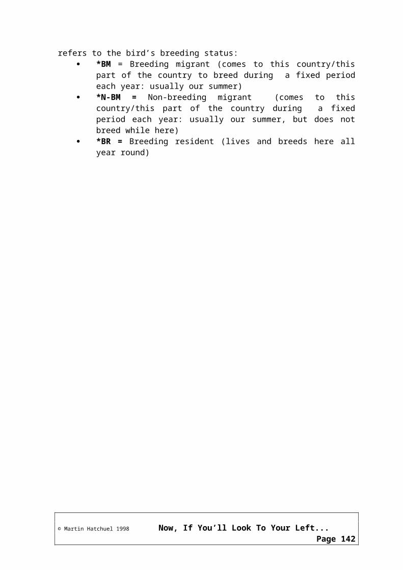
Checklist of Reptiles of The Garden Route
Like all other groups of living things (animals, plants, insects, etc), the reptiles have an important part to play in the complex web of life that makes up the world as we know it. However, because of the rapid increase in human population (and the impact that has had on the Earth) in the past century, and because so many people kill reptiles simply because they are scared of them, a distressing number of them are threatened with extinction.
Learning about the reptiles of the Garden Route will increase your awareness and decrease any fears that you may have: you may even come to love them!
The reptiles on this checklist have all been listed for this area by Branch (Veldgids tot die Slange en Ander Reptiele van Suider Afrika); Branch (South African Red Data Book - Reptiles and Amphibians) and Broadley (FitzSimons’ Snakes Of Southern Africa). The brief notes describe the habitats and diet of each species. Names are listed in English, Afrikaans, and, where available, in Xhosa. Scientific names are given in italics.
Order CheloniiTortoises, Terrapins & Turtles
Sub-Order CryptodiraTortoises, Terrapins & Turtles
Family - TESTUDINIDAE - The Land Tortoises
Parrot-Beaked TortoiseGewone PadlopertjieHomopus areolatusThis tortoise is mostly found in the coastal fynbos in our area, often on the edges of thick vegetative cover.
Leopard Tortoise (Mountain Tortoise)BergskilpadGeochelone pardalisThis species is fairly widespread, but is generally not found in mountainous areas! The name probably refers to the shape and size of the shell. Feeds on a variety of plants and fruit.
Angulate TortoisePloegskaarskilpadChersina angulataThis tortoise prefers sandy habitats such as coastal fynbos Feed on grasses, succulents and annual plants.
Key: *BR = Breeding resident *BM = Breeding migrant *N-BM = Non-breeding migrant (A) Afrikaans name (X) Xhosa name (G) German name
© Martin Hatchuel 1998 Now, If You’ll Look To Your Left...Page 142
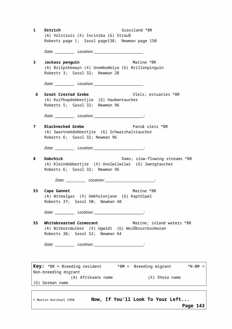
Family - DERMOCHELYIDAE - The Leatherback Turtles
Leatherback TurtleLeerrugseeskilpadDermochelys coriaceaThe leatherback lives at sea where it feeds mainly on jellyfish. It generally only comes to our beaches to lay its eggs.
Green TurtleGroenseeskilpadChelonia mydasLives exclusively at sea in our area, and prefers warm shallow waters. Feeds on jellyfish during its first year, and there after feeds almost exclusively on sea grasses
Loggerhead TurtleGrootkopseeskilpadCaretta carettaThe loggerhead lives at sea where it feeds mainly on jellyfish. It prefers to nest further north, and rarely comes to our beaches to lay its eggs.
Sub-Order PleurodiraSide-Necked Terrapins
Family - PELOMEDUSIDAE - The Side-Necked Terrapins
Cape TerrapinGewone WaterskilpadPelomedusa subrufaCape Terrapins generally live in seasonal pans and ponds. They hibernate during the dry season, and come out when the rains begin. Feed on almost anything - snails, tadpoles, fish, crabs, carrion, water plants, etc.
Order SquamataReptiles with Scales
Sub-Order SerpentesSnakes
Family TYPHLOPIDAE - The Blind Snakes
Deleland’s Blind SnakeDeleland se BlindeslangTyphlops leylandii
Key: *BR = Breeding resident *BM = Breeding migrant *N-BM = Non-breeding migrant (A) Afrikaans name (X) Xhosa name (G) German name
© Martin Hatchuel 1998 Now, If You’ll Look To Your Left...Page 143

iNyoka-yomhlabaBlind snakes generally live underground (often near termite mounds), in humus rich soil, in compost heaps, under rocks and decaying logs, etc. Feed on insects - especially termites and termite larvae.
Family LEPTOTYPHLOPIDAE - The Thread Snakes
Black Thread SnakeSwart DraadslangLeptotyphlops nigricansThread snakes live underground, generally near termite nests. Feed on termites and other small insects.
Family COLUBRIDAE - The Typical SnakesSub-Family BOAEDONTINAE - The Old World Snakes
Common Brown Water SnakeBruin WaterslangLycodonomorphous rufulusiZilenziThis species is nocturnal, and is usually found in perennial streams and dams. Eats frogs and fish, and has been recorded raiding doves’ nests.
Aurora House SnakeAurora-huisslangLamprophis auroraA secretive species that is found in the fynbos and grasslands. Feeds on small rodents.
Olive House SnakeOlyfkleurige HuisslangLamprophis inornatusOlive House Snakes prefer moist coastal bush and fynbos. Feed on small rodents and occasionally on other snakes.
Brown House SnakeGewone HuisslangLamprophis fulginosusinKwakhwaFound throughout Southern Africa. Feeds on small rodents, and occasionally on lizards and other snakes.
Cape Wolf SnakeKaapse Wolfslang
Key: *BR = Breeding resident *BM = Breeding migrant *N-BM = Non-breeding migrant (A) Afrikaans name (X) Xhosa name (G) German name
© Martin Hatchuel 1998 Now, If You’ll Look To Your Left...Page 144

Lycophidion capens capensePrefers damp conditions, such as under stones or compost. Feeds on small skinks.
Common Slug EaterTabakrolletjieDuberria lutrixPrefers damp conditions, such as under stones or compost. Feeds on slugs and soft-shelled snails, and is therefore considered to be of economic importance to farmers and gardeners.
Mole SnakeMolslangPseudaspis canainKwakhwaDistributed throughout most of Southern Africa. Common in sandy scrub in the Southern Cape. Lives in burrows made by other animals. The young mole snakes feed mainly on small lizards. Adults feed on rodents and other small mammals.
Many-Spotted SnakeKaapse RietslangAmplorhinus multimaculatusOften found in reed beds in vleis and mountain streams . Feeds on frogs and lizards.
Sundevall’s Shovel SnoutGraafneusslangProsymna sundevalliiFound in drier parts of the fynbos. Feed on the eggs of snakes, lizards and geckos.
Sub-Family PSAMMOPHINAE - The Sand Snakes
Spotted Skaapsteker SkaapstekerPsammophylax rhombeatusFound in the fynbos and karroid scrub. Feeds on lizards, frogs, small rodents and other snakes.
Cross-Marked Grass SnakeKruisslangPsammophis cruciferinTlanguFound in scrub on sandy soils. Feeds on geckos, lizards and occasionally on frogs.
Spotted Harlequin SnakeKousbandslangetjieHomoroselaps lacteus
Key: *BR = Breeding resident *BM = Breeding migrant *N-BM = Non-breeding migrant (A) Afrikaans name (X) Xhosa name (G) German name
© Martin Hatchuel 1998 Now, If You’ll Look To Your Left...Page 145

Found throughout the Southern Cape in old termite nests, under stones, etc. Feeds on small snakes and skinks.
Sub-Family COLUBRINAE - The Colubrine Snakes
Green Water SnakeGroen WaterslangPhilothamnus hoplogasterFound near water in coastal bush and fynbos. Feeds on frogs, fish and lizards.
Natal Green SnakeNatalse GroenslangPhilothamnus natalensisFound near water in both wet and dry forests. Feeds on frogs, fish and lizards.
Common Egg EaterGewone EiervreterDasypeltis scabraFound throughout the region, except in the closed-canopy forests. Often within cracks in rocks or in old termite nests. Feeds exclusively on birds’ eggs.
Red-Lipped Herald RooilipslangChrotaphopeltus hotamboeiaFound throughout the region, the Herald has a preference for damp places under rocks or any other suitable shelter. Often found in suburban gardens. Feeds mainly on frogs and toads, but will also take lizards and mice.
Boomslang or Back-Fanged Tree SnakeBoomslangDyspholidus typusiNyushuFound throughout the Western and Southern Cape, as well as in other parts of the country. Lives mostly in trees, where it preys on chameleons, lizards, small birds, mammals and frogs
This species is highly poisonous to man, but is unlikely to bite as it is usually quite shy. It is a back-fanged snake, and finds it awkward to bite into large surfaces - such as the human arm or leg.
Family ELAPIDAE - The Cobras and Mambas
Cape CobraKaapse GeelslangNaja niveaUmDlezinye
Key: *BR = Breeding resident *BM = Breeding migrant *N-BM = Non-breeding migrant (A) Afrikaans name (X) Xhosa name (G) German name
© Martin Hatchuel 1998 Now, If You’ll Look To Your Left...Page 146
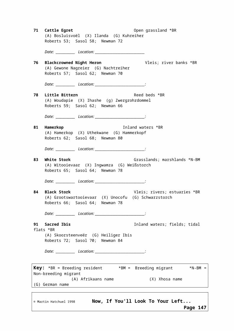
In the Southern Cape, found on sandy river banks and in other well-drained areas. Likes to hide in holes made by rodents and other animals. Feeds mainly on rats, mice and other rodents, but will take lizards, frogs, toads and other snakes - even other cobras - as well as birds and their eggs.
This is a highly poisonous species, which accounts for more fatal bites than any other snake in the Cape. Its toxin causes death by suffocation, and Broadley states that ‘it is ... often possible to keep a victim alive by artificial respiration, until anti-venom can be injected’.53
Rinkhals or Ring-Necked Spitting CobraRinkhalsHemachatus haemachatusuNobhiyaUsually found in grasslands. Preys on most small animals, but prefers rodents, toads and other snakes.
Of all snakes, the rinkhals is best adapted to spitting, and it can propel its venom over a distance of 2 metres. The snake will instinctively aim for the eyes of the victim. Broadley states that ‘if immediate action is not taken to wash the venom out with water or preferably a weak solution of antivenin, milk or other bland solution, the destruction of the eye tissues is rapid and can end in partial or even complete blindness’.54 The rinkhals has the ability to ‘play dead’ when under threat, and should therefore be treated with extreme caution - even when it appears to be completely lifeless.
Sub-Family HYDROPHIIDAE - The Sea Snakes
Yellow-Bellied Sea SnakeSwart-en-geel seeslangPelamis platurusThis species is an ocean-dweller, and is occasionally washed ashore where it becomes helpless and unable to move. Preys on small fish.
Family VIPERIDAE - The Adders and Vipers
Sub-Family CAUSINAE - The Night Adders
Rhombic Night AdderNagadderCausus rhombeatusiNyoka yasebusukuFound in most areas outside the forests. Preys mostly on toads, frogs and small rodents.
This adder is generally docile, and its bite, while poisonous, is seldom fatal.
53 ? DG Broadley: FitzSimons Snakes of Southern Africa: Delta Books, Johannesburg 198354 ? DG Broadley: FitzSimons Snakes of Southern Africa: Delta Books, Johannesburg 1983
Key: *BR = Breeding resident *BM = Breeding migrant *N-BM = Non-breeding migrant (A) Afrikaans name (X) Xhosa name (G) German name
© Martin Hatchuel 1998 Now, If You’ll Look To Your Left...Page 147

Sub-Family VIPERINAE - The True Vipers
Puff AdderPofadderBitis arietansiRambaFound throughout the region. This is a terrestrial adder, although it is sometimes found in bushes and low shrubs. Feeds on rodents, birds and other snakes.
The puff adder’s venom is dangerous to humans, although it takes effect relatively slowly (it can take 24 hours to kill a man). Only about 5% of reported puff adder bites prove fatal.
The puff adder feeds voraciously during the summer, building up its fat reserves for its winter hibernation. This fat is much sought after by traditional herbalists for the treatment of rheumatism.
Cape Mountain Adder or Berg AdderBergadderBitis atroposiRamba lamatyeFound in grassland and fynbos, and frequently on rocky krantzes - not only in the mountains, but right down to sea level. Preys on small rodents, frogs, toads, lizards, small birds and other snakes.
The berg adder is bad tempered and quick to strike. The bite has never been known to kill, however, and the effects of the venom (loss of sight, smell and taste) usually wear off after one or two days.
Sub-Order SauriaLizards
Family SCINCIDAE - The Skinks
Sub-Family ACONTIINAE - The African Legless Skinks
Cape Legless SkinkKaapse Pootlose SkinkAcontias meliagrisFound in dry soils in fynbos areas and in soils associated with dry river courses. Feed on small insects.
Sub-Family SCINCINAE - The Old World Skinks
Silvery Dwarf Burrowing SkinkSilwergrys Dwerg-Grawende Skink
Key: *BR = Breeding resident *BM = Breeding migrant *N-BM = Non-breeding migrant (A) Afrikaans name (X) Xhosa name (G) German name
© Martin Hatchuel 1998 Now, If You’ll Look To Your Left...Page 148

Scelotes bipesFound burrowing in sandy soils in coastal strandveld. Feed on small insects.
Sub-Family LYGOSOMATIINAE - The Advanced Skinks
Cape SkinkKaapse SkinkMabuya capensisFound throughout the region. Preys on large insects.
Red-Sided SkinkRooiflankskinkMabuya homalocpehalaUsually found foraging in leaf-litter in our area. Inland, they can be seen basking in the sun on rocks in dry river beds. Feed on insects.
Family LACERTIDAE - The Old World Lizards
Deleland’s Sandveld LizardDeleland se SandveldakkedisNucras lalandiiPrefers to hide under stones in open grassland. Feed on spiders, beetles and larvae.Striped Sandveld LizardStreep-SandveldakkedisNucras tessellataFound in the drier areas of the region. Favourite prey is scorpions. But will also take beetles and spiders.
Spotted Sand LizardGevlekte SandakkedisPedioplanus lineoocellataFound in drier areas of open fynbos/grassland. Prefer flat, open, rocky areas. Feed on beetles and locusts in summer, but almost exclusively on termites during winter.
Cape Mountain LizardKaapse BergakkedisTropidosaura gularisFound on fynbos-covered mountain peaks. Feed on flies and bees that come to the flowers.
Common Mountain LizardGewone BergakkedisTropidosaura montanaLive on the vegetation in the fynbos and mountain grasslands. Feed on small insects.
Key: *BR = Breeding resident *BM = Breeding migrant *N-BM = Non-breeding migrant (A) Afrikaans name (X) Xhosa name (G) German name
© Martin Hatchuel 1998 Now, If You’ll Look To Your Left...Page 149
Family CORDYLIDAE - The Plated and Girdled Lizards
Yellow-Throated Plated LizardGeelkeel-pantserakkedisGerrhosaurus flavigularisFound in scrubby grassland and open forest throughout the region. Common in urban areas, where it can be found under rubbish. Feeds on grasshoppers, termites and millipedes.
African Long-Tailed SepsAfrika-LangstertsepsTetradactylus africanusA snake-like lizard found in montane grassland. Feeds on grasshoppers and other insects.
Short-Legged SepsKortbeen-SepsTetradactylus sepsThis lizard has very small, but perfectly formed limbs, and is found in coastal forests. Feeds on bees and grasshoppers.
Key: *BR = Breeding resident *BM = Breeding migrant *N-BM = Non-breeding migrant (A) Afrikaans name (X) Xhosa name (G) German name
© Martin Hatchuel 1998 Now, If You’ll Look To Your Left...Page 150

Common Long-Tailed SepsGewone Langstert SepsTetradactylus tetradactylusA snake-like lizard found in the fynbos and in montane grassland. Feeds on grasshoppers and other insects.
Sub-Family CORDYLINAE - The Girdled Lizards
Cape Grass LizardKaapse GrasakkedisChamaesaura anguinaFound in montane fynbos and grassland. Feed mainly on grasshoppers.
Blue-Spotted Girdled LizardBloukol-GordelakkedisCordylus coeruleopunctatusFound only in the Garden Route, and only in the fynbos and on the edges of the forests. Feeds on small insects.
Cape Girdled LizardKaapse GordelakkedisCordylus cordylusFound in many rocky habitats in our area. Often densely populated (up to 300 specimens per hectare). Feed on insects.
Cape Crag LizardKaapse KransakkedisPseudocordylus microlepidotusFound on the upper slopes of montane fynbos and grassland. Feeds on large insects and other lizards.
Family AGAMIDAE - The Agamas
Southern Rock Agama Suidelikke RotskoggelmanderAgama atraFound in the fynbos at all altitudes from sea level upwards. Can also be found foraging amongst driftwood on the beach. Feeds on ants and termites.
Key: *BR = Breeding resident *BM = Breeding migrant *N-BM = Non-breeding migrant (A) Afrikaans name (X) Xhosa name (G) German name
© Martin Hatchuel 1998 Now, If You’ll Look To Your Left...Page 151
Family CHAMAELEONIDAE - The Chameleons
Knysna Dwarf Chameleon Knysna DwergverkleurmannetjieBradypodion damaranumFound exclusively in the Garden Route, between George and Tsitsikamma. Lives in the forests and gardens, and favours the centres of tree ferns, where it camouflages itself by coiling up its tail to look like a new fern frond. Preys on small insects.
Family GEKKONIDAE - The Typical Geckos
Ocellated GeckoGeoogde GeitjiePachydactylus geitjeFound in coastal fynbos, and appear to prefer damp conditions. Feed on small insects.
Spotted GeckoKolgeitjiePachydactylus maculatusFound in fynbos, coastal bush and the drier parts of the region, usually under rubbish, rotting logs or the loose bark of dead trees. They also like to hide in the empty shells of the giant land snail (up to 10 spotted geckos will inhabit a single shell). Feed on small insects
Marbled Leaf-Toed GeckoGemarmerde BlaartoongeitjiePhyllodactylus porphyreusFound in the forests and in urban gardens, and may enter houses throughout the region. They feed on insects, and can often be seen hunting at night wherever outdoor lights attract their prey.
Key: *BR = Breeding resident *BM = Breeding migrant *N-BM = Non-breeding migrant (A) Afrikaans name (X) Xhosa name (G) German name
© Martin Hatchuel 1998 Now, If You’ll Look To Your Left...Page 152

Key: *BR = Breeding resident *BM = Breeding migrant *N-BM = Non-breeding migrant (A) Afrikaans name (X) Xhosa name (G) German name
© Martin Hatchuel 1998 Now, If You’ll Look To Your Left...Page 153
Part 9The Marine Environment
Key: *BR = Breeding resident *BM = Breeding migrant *N-BM = Non-breeding migrant (A) Afrikaans name (X) Xhosa name (G) German name
© Martin Hatchuel 1998 Now, If You’ll Look To Your Left...Page 154

The Marine Environment
The attraction that man feels for the sea is one of our most basic instincts. In his introduction to his book ‘A Guide to the Common Sea Fishes of Southern Africa’, Rudy van der Elst55
writes:‘Oceans probably represent the most important life support system on earth. Their influence on climate, oxygen levels and the cycling of nutrients is critical to the survival of life as we know it. In addition to these physical processes, man himself is becoming increasingly dependent on the sea’s natural resources, its animal, vegetable and mineral wealth, to secure his future on this planet.’ The ocean has been a source of both food and inspiration for many thousands of years,
yet it may well prove to be the next ‘unknown’ that man will need to explore for his survival in the coming century. In this modern age of vast scientific understanding, the sea still sometimes reveals new and amazing mysteries. The story of the discovery and identification of the Coelacanth56 - a story that has close links to the Garden Route - is a perfect example of this. Here was a fish that people had believed to have been extinct for over 70 million years - and yet a living specimen was caught in 1938, and more have been caught since then.
Most people love to spend time at the beach relaxing or exploring the coast, which makes the ocean an invaluable tourist attraction - especially in a country such as ours where many millions of people live inland and away from easy access to the sea.
It is important, therefore, to have a basic knowledge of the ocean to understand the attraction that it holds for visitors to our area, as well as to appreciate the need for its conservation.
Tourism and The SeaThe number of ways in which we use the sea for our recreation needs is almost as great as the number of people who use it. It is difficult, therefore, to overestimate the importance of the ocean as an attraction in the Garden Route. The great beauty of our Southern Cape Coastline, our proximity to the Southernmost tip of Africa (at Agulhas), and the clean and relatively unspoiled and uncrowded condition of our beaches are all important factors in this attraction. As a result, an entire section of the tourism industry is devoted to servicing the needs of visitors who want to experience the ocean. This includes:
hotels and other tourist accommodations that have been built close to the beaches or in positions where they can take advantage of particularly good views of the ocean;
restaurants that provide sea-foods and/or a view of the sea so as to take full advantage of its appeal
55Rudi van der Elst: ‘A Guide to the Common Sea Fishes of Southern Africa’ Published by Struik. Cape Town 1981.56See ‘The Coelacanth’ below.
Key: *BR = Breeding resident *BM = Breeding migrant *N-BM = Non-breeding migrant (A) Afrikaans name (X) Xhosa name (G) German name
© Martin Hatchuel 1998 Now, If You’ll Look To Your Left...Page 155

‘unstructured’ leisure and recreational activities (which don’t usually require special skills or equipment) such as
Quiet contemplationSwimmingSunbathingWalkingScenic drivesBird watchingWhale watching, etc
competitive and non-competitive sporting activities such asSurfingSailingPower-boat racingRock and surf fishingFly fishing, etc
structured adventure tours (often - but not always - non-competitive sports which require specialist equipment and guides)
Fishing and deep sea fishing chartersBoat-based whale and bird watchingSea kayaking, etc
The tourism industry’s marketing experts have recognised the importance of the ocean to tourism, and have structured entire marketing plans around it so as to attract visitors to the area. In this regard, the MTN Whale Route is a highly visible and successful exercise in the Garden Route57
The Sea Never Rests! - Currents, Tides & Waves
CurrentsCurrents are vast bodies of water largely driven by the prevailing winds to move around the main oceans of the world, and which have a great influence on weather patterns. Southern Africa, and particularly the Western Cape, lying as it does between the Indian Ocean on our Eastern and Southern Shores and the Atlantic on our Western Shore, is particularly vulnerable to these influences because of two main ocean currents:
the Benguela Current in the Atlantic pushes cold, Antarctic water northwards against the West coast, where desert conditions occur because the cold, moist air which is a product of the Benguela current does not release its moisture when it meets the warm African land mass, and
the Agulhas Current in the Indian Ocean. This current is formed from the confluence of the waters of the Mozambique Current and the South Equatorial Current near Maputo, and brings warm, equatorial waters to the East coast of Southern Africa. As it drifts closer and further away from the shore (in summer and winter), the Agulhas current will bring a greater or lesser amount of rain to
57The Southern Cape Coast is considered to have the world’s best land-based whale watching. See ‘The MTN Cape Whale Route’ below.
Key: *BR = Breeding resident *BM = Breeding migrant *N-BM = Non-breeding migrant (A) Afrikaans name (X) Xhosa name (G) German name
© Martin Hatchuel 1998 Now, If You’ll Look To Your Left...Page 156
the Garden Route because of the meeting of its warm, equatorial air with the warm African land mass (in addition to the effects of the Agulhas current, the rainfall pattern is strongly influenced by atmospheric low pressure troughs that regularly move in an Easterly direction along the Southern Coast).
In terms of its influence on the Garden Route, the Agulhas Current is notable, too, because it has a direct bearing on the life cycles of many of our more important fishes: sardines, soles, elf, shad, sharks, etc, all make use of the strength of the current at different times in their lives58.
The TidesTwice a day the level of the ocean on the beaches rises and falls - often quite considerably. These changes in level are referred to as tides, and are caused by the movement of the Moon around the rotating Earth.
It is easy to understand why the gravitational pull of the moon on the Earth’s waters will cause a high59 tide on the side of the Earth facing the moon - but why is there a corresponding high tide on the very opposite side of the Earth - which faces away from the moon? And why don’t the tides always rise and fall to the same height each day? Or at the same time?
High and Low TidesThe Moon and the Earth spin around each other in a fixed pattern called an orbit. At the
same time, they (the Moon-and-Earth in combination) orbit the Sun;The Sun, Earth and Moon all exert a gravitational pull on one another;The Moon’s gravitational pull causes the ocean’s waters to ‘bulge out’ - towards the Moon.
The result is a high tide on the side of the Earth facing the Moon;The Earth and the Moon are held together by gravitational forces that cause them to spin
around one another as a single unit with a common axis (i.e. the imaginary straight line around which they revolve). Because the Earth is 100 times larger than the Moon, this axis lies somewhere within the radius of the Earth. The spinning of the Earth around the Moon thus causes a centrifugal force, which counteracts the Moon’s gravitational force, and causes the waters on the side of the Earth opposite to the Moon to bulge. The result is a high tide on the side of the Earth that faces away from the Moon;
Low tides occur in areas of the Earth where the gravitational and centrifugal forces are least felt, and where the water has been ‘sucked away’ to create the ‘bulges’ that make up the high tides.
Two Tides Every DayBecause the Earth spins on its own axis once every 24 hours, there are two high tides on our coast (and every coast) every day: once when our side of the Earth is pointing towards the
58M&G Bannister: ‘The Living Shores of Southern Africa’ Published by Struik. Cape Town 198159Some publications may use different words for the tides: A rising tide may sometimes be called a flood tide, and a falling tide may be called an ebb tide.
Key: *BR = Breeding resident *BM = Breeding migrant *N-BM = Non-breeding migrant (A) Afrikaans name (X) Xhosa name (G) German name
© Martin Hatchuel 1998 Now, If You’ll Look To Your Left...Page 157

Moon, and once when we are pointing away from the Moon.
Changes in the Times of the TidesThe Moon takes 28 days to complete one orbit of the Earth (this is why it appears to rise and set at different times every night). It follows, therefore, that the tides will occur slightly later each day, according to the times at which the Moon’s pull is greatest on our portion of the coast. As a result, each day’s high tide occurs up to 50 minutes later than the similar tide on the previous day (in Knysna, high tides occur about 40 minutes later each day).
Changes in the Heights of the TidesThe Sun is so far away from the Earth that it’s effect on the sea is very much less than the Moon’s effect;
Because the Earth-Moon complex also revolves around the Sun, all three bodies will lie in line with one another about once every fourteen days (at the time of the Full Moon [when you can see the whole of the Moon at night] and New Moon [when you cannot see the Moon at all at night]);
At Full Moon and New Moon, the Sun re-enforces the Moon’s pull on the water, and this combination cause the ‘bulge’ of the ocean’s waters to be greatest. The effect is that the difference in height between high tide and low tide is correspondingly large.
When the difference in height between high tide and low tide is at its greatest, it is called a spring tide
Seven days after every New Moon, the Moon will lie at right angles to the line between the Earth and the Sun. This is called First Quarter;
This same effect is felt seven days after every Full Moon. This is called Last Quarter;Because the Sun and Moon are at right angles to one another during First Quarter and
Last Quarter, they act to cancel out each other’s effect on the ocean. This means that the ‘bulging’ effect on the ocean will be at its smallest, and the difference in height between high tide and low tide is correspondingly small.
When the difference in height between high tide and low tide is least, it is called a neap tide.
Tide TablesScientists can predict where the Moon will be in relation to the Earth and the Sun on any day of the year, and thus at what times the tide will rise and fall. Using these predictions, the Naval Hydrographer at Simonstown publishes Tide Tables for our coast. This official publication contains the expected times for high and low water at all the main points along the coast, as well as the phases of the Moon for each day of the year. These tables are then often re-printed as local tide tables (often containing only the dates and times of the tides) by newspapers and print companies.
A tide table is a useful and important tool. If you plan to use the sea in any way - to fish, sail, surf or even just walk along the beach, - know the times of the tides so that you are not caught unawares. If they are not printed in your local paper, tide tables are usually available from sports shops and Nature Conservation Offices.
Key: *BR = Breeding resident *BM = Breeding migrant *N-BM = Non-breeding migrant (A) Afrikaans name (X) Xhosa name (G) German name
© Martin Hatchuel 1998 Now, If You’ll Look To Your Left...Page 158

The WavesThe ocean’s waves are caused by the action of the wind blowing across the water.
When the wind moves over the surface of the ocean, it causes the water underneath it to eddy and roll in a vertical pattern of circles, each of which remains in almost the same spot as the wave moves on. The wave itself does not drive the water forwards (think of a boat without a motor or sails at sea: it does not go forward, but stays in one place and rises and falls as the waves pass. This is because it has nothing to propel it - the water in the wave is not advancing). When the waves approach the shore the shallow bottom interrupts the circular motion of the water, which causes the crest of the wave to fall forward and break, forming the familiar white water breakers that you see on the beach and against the rocks.
The ceaseless pounding of the waves is one of the main factors that shape the coastlines of the world.60
The combined action of the waves and the wind slowly erode ( break up) rocks and shells along the shore, creating sediment which is easily moved around by the water. When the waves reach the shore at an angle, they cause a phenomenon called a longshore current. These longshore currents have the effect of moving the sediment along the coast and thus continually replenishing the beach sand.
When the waves hit against hard objects which are resistant to erosion (such as the Table Mountain Sandstone that makes up much of the rock in our area), they - and the longshore currents that they cause - are deflected. This is typically what happens on the Southern Cape Coast, where the prevailing longshore currents are eastwards. The result is the characteristic series of rounded bays called ‘half-heart’ bays, such as those at Mossel Bay, Buffalo Bay, Plettenberg Bay and Algoa Bay. These half-heart bays are characterised by a rocky promontory (or peninsula) on the western side, and a rounded, protected beach with deep beach sand to the eastern side.
Property developments on the shoreline - such as housing schemes and break-waters - can have a profound effect on their surroundings if they interrupt these patterns of wave and sand movement. An often cited example of the problems that can be caused in this way is Algoa Bay, where moving sand dunes on Cape Recife were reclaimed by stabilisation, and a breakwater was built for the Port Elizabeth harbour. The result has been that there is no longer any sediment with which to replace the sand that is eroded (by wave action) from the beaches along the Bay (well-engineered man-made structures can have the effect of interrupting the erosion of sand from the beaches - as in the case at Shark Pier in Algoa Bay).
Properties of Sea WaterThe way life-forms have developed in the sea is largely due to the nature of its water, which affects buoyancy, pressure, oxygen and light availability.
60 Other factors that have influenced the shaping of the coast include: [a] continental drift: Africa was once joined to South America, India, and Australia, to form one giant continent called Gondwanaland. Over millions of years, the continents (much as we know them today) broke away from one another and drifted off; and [b] the rise and fall of sea levels during periods of global warming and cooling (- the Ice Ages).
These phenomena continue today at an almost imperceptible rate. The continents move about 16 cm per year, and the sea level has risen about 120 metres since the last ice age - 20 000 years ago.
Key: *BR = Breeding resident *BM = Breeding migrant *N-BM = Non-breeding migrant (A) Afrikaans name (X) Xhosa name (G) German name
© Martin Hatchuel 1998 Now, If You’ll Look To Your Left...Page 159

BuoyancyBecause water physically supports the organism, animals and plants living in the sea use less energy in supporting their own body-weights than do their land-living counterparts. This means that they need to produce less supportive tissue, and is perfectly illustrated by the sea-weeds which are soft and floppy compared to land plants (because they have no need of woody tissue for physical support). They are therefore able to produce more chlorophyll-bearing tissue, which increases the rate at which they can photosynthesise61. The result is that these algae can grow much quicker than the land plants.
PressureIn the aquatic environment, pressure increases by one atmosphere with each 10 metres in depth. Organisms that live at great depths are usually not affected by this, because the pressure inside and outside of their bodies is the same. Gas expands and contracts as pressure changes, and animals that have gas spaces (such as lungs or swim bladders) inside their bodies need to compensate for this in order to survive any pressure change. This is why many fish die in trawl nets before they are hauled aboard the trawlers (their swim bladders rupture with the increase in the volume of gas as the pressure decreases with decreasing depth).
For man to dive in the ocean (without a submarine) for any length of time, he has to take his own air supply with him - SCUBA62 gear. The ‘bends’ - perhaps the diver’s greatest risk - is related to the pressure gradient in the sea. The air that we breath - and which most divers use in their SCUBA tanks - contains about 80% nitrogen, which dissolves in the blood under increased pressure. If the diver returns to the surface too quickly after a dive, this nitrogen will be released as bubbles which can expand with painful and sometimes fateful results. This is known as ‘ the bends’ (at its worst the effect is somewhat similar to the rupturing of the swim bladders in deep-water fish). Divers must therefore be extremely cautious when ascending. They will usually rest at various depths during the return to the surface in order to allow the nitrogen to escape from the bloodstream.
Whales can descend to depths of 1 500 metres, but, like other mammals that live in the sea (such as dolphins and seals), they do not have to worry about the bends: nitrogen is not dissolved in their blood because they do not breath under water.
Saltiness Land-living organisms must continually replenish water that is lost to the air as part of their temperature-control mechanisms (in man, for instance, perspiration is one way in which we continually lose water). Fresh-water organisms, on the other hand, have to guard against gaining too much water because their bodily fluids have a higher salt content than that of their watery habitat. Sea-living organisms, however, live in a medium that has a similar salt content to that of their own bodies. They therefore have no problems of water loss or gain, and the sea water becomes a comfortable environment for them.
Oxygen
61Photosynthesis is the conversion of chemicals into the ‘food’ that a plant needs for its energy. The process can only take place in the presence of sunlight.62SCUBA = Self Contained Underwater Breathing Apparatus
Key: *BR = Breeding resident *BM = Breeding migrant *N-BM = Non-breeding migrant (A) Afrikaans name (X) Xhosa name (G) German name
© Martin Hatchuel 1998 Now, If You’ll Look To Your Left...Page 160

Oxygen is not as readily available in the water as it is on land, and many marine animals have therefore developed a complex system of external gills which extract the oxygen that they need out of the water. Life forms in the sea that lack this specialised adaptation are thus often sluggish and slow moving.
LightAnimal life-forms depend heavily on the plant world to produce useable energy. Only the thin, upper layer of the sea can support plants that photosynthesise, because light is quickly absorbed by water and cannot travel as freely through it as it can through the air. This upper layer - the euphotic layer63 - is usually only about 50 to 100 metres deep. Most animals who live below the euphotic layer depend on food that sinks down from it. At one time it was thought that all animal life in the sea depended in one way or another on the plants in the upper layer for their energy requirements. It has recently been discovered, however, that certain bacteria which live around volcanic vents in the deepest parts of the oceans can synthesise sulphurous chemicals to produce energy, and that an entire community of deep-sea dwellers use these bacteria as their food source.
Water PollutionOnce you understand that these properties of sea water were the main factors that influenced the way marine organisms evolved, you can easily understand why man has to guard against polluting the seas. The threats of pollution include:
solid pollutants which may decrease the depth of the euphotic layer, by decreasing the depth to which sunlight can penetrate, and so limit the potential for photosynthesis. This decreases the production of plant material, which causes the food supply to drop off; and
chemical pollutants which may be directly toxic, or which may decrease the supply of oxygen that all organisms require for breathing (whether they live under water or not).
63The euphotic layer may vary in depth: it is considered to be that portion of the water that receives 1% or more of the sunlight that enters the sea .
Key: *BR = Breeding resident *BM = Breeding migrant *N-BM = Non-breeding migrant (A) Afrikaans name (X) Xhosa name (G) German name
© Martin Hatchuel 1998 Now, If You’ll Look To Your Left...Page 161

The Sea Shore Rocky and Sandy Shores and The Tidal ZonesThe place where the sea meets the shore is a fascinating world of its own. Many organisms live only in this narrow strip between the deep sea and the land, and are often specially adapted to their harsh environment. Man’s continuing encroachment on the delicate intertidal, infratidal and supratidal zones (which are sometimes collectively called the littoral) is a threat which must not be ignored.
Our shores are a major tourist attraction, and, in order to protect this resource, it is important to have some understanding of the life forms that the they support.
Rocky ShoresThe rocky shores of the South Cape Coast can be divided into five zones. Each has its own, often unique, fauna and flora:
Rocky Shores: The Infratidal Zone The infratidal zone is the lowest zone of the rocky shore. Because it is only exposed to the air at very low tide, it is characterised by algae which can tolerate only brief periods of exposure. The South Cape Coast infratidal zone supports species that are quite different to those found on the West Coast (cold water species) and East Coast (warm water, sub-tropical species).
When the infratidal zone is exposed at low tide, you have a perfect opportunity to examine marine creatures which would quickly die if they were exposed to the air, but which can survive because they are trapped in the infratidal rock pools. These include:
Sponges - primitive animals composed of colonies of cells which feed by filtering food particles out of the water. Their bright colours are thought to warn other animals against eating them. The bodies are supported by spicules which are highly irritant;
Sea anemones - simple, solitary animals that are characterised by having tentacles and hollow bodies;
Nudibranchs and sea slugs - which are perhaps the most brightly coloured of the sea’s creatures. The sea slugs feed on the anemones, and are not only immune to their stinging cells, but will, in fact, take them up and incorporate them into their own bodies as a defence mechanism against other predators;
Red bait grows in thick colonies in the infratidal zone (their siphons can often be seen spouting water at low tide). Mussels also grow here in thick colonies and, like the red bait, they are filter feeders which process vast amounts of water.
Rocky Shores: The Cochlear ZoneThe Cochlear zone is unique to the rocky shores of the South Cape Coast. It is named for the limpet Patella cochlear. They grow in tightly packed colonies of up to 2 600 per square metre - more densely than any other limpet of their size anywhere in the world. Each limpet cultivates its own ‘garden’ of red algae around its shell. It feeds off this garden, and jealously protects it against intruders. Because of the density of the colonies, most other algae cannot find place to grow on the rocks in the Cochlear zone, and the zone appears to be barren
Key: *BR = Breeding resident *BM = Breeding migrant *N-BM = Non-breeding migrant (A) Afrikaans name (X) Xhosa name (G) German name
© Martin Hatchuel 1998 Now, If You’ll Look To Your Left...Page 162

compared to the lower Balanoid and infratidal zones that it separates.
Rocky Shores: The Lower Balanoid ZoneThe lower Balanoid zone (the word balanoid refers to the barnacles that grow here) on the rocky shores of our coast is typified by thick beds of algae which are home to a small number of animals such as limpets and winkles. Whelks (Burnupena spp.) and sea anemones can be seen in the rock pools of this zone.
Rocky Shores: The Upper Balanoid ZoneThe upper Balanoid zone is relatively dry during much of the tidal cycle. It is dominated by many of the animals that are so familiar to anyone who has walked along our rocky shores: Limpets (Patella spp.), Barnacles (Octomeris and Tetraclita spp.) and Winkles (Oxystele spp.).
The barnacles are crustaceans that are related to the crabs and shrimps (and not to the limpets which they appear to resemble). They rely on the movement of the waves to bring food within reach of their tentacle-like filtering bodies. These filters - or ‘legs’ - are extended outward and upward from the shell to trap the fine particles on which the barnacles feed. Where the barnacles grow in dense colonies, they tend to grow tall and relatively thin so that their ‘legs’ can reach above those of their neighbours in order to trap their food more efficiently. Where they grow in relative isolation from one another, the barnacles will tend to be shorter.
With the exception of the sea lettuce (Ulva sp.), few algae can survive in the upper balanoid zone because it is so often exposed to the air.
Rocky Shores: The Littorina ZoneThis is the zone that is only covered by water at high tide. It is a harsh environment in which very few organisms survive, but it is home to the Littorinids (the group of periwinkles or tiny snails which give the zone its name). Only one species occurs on the South Cape Coast - Nodolittorina africana. The red algae Porphyra, and shore crabs (which can often be found sheltering under the rocks) are typical of this zone.
Sandy Shores Unlike the rocky shores, sandy beaches are unstable and have no hard substratum onto which plants and animals can attach themselves. The waves are continually changing the shape of the beaches, and great quantities of sand may be moved about in very short periods. Animals that live here have had to adapt to this constantly changing environment. They have done so by learning to burrow into the sand, or by learning to swim off into the water during part of the tidal cycle.
Most organisms that live in the tidal zones of sandy beaches rely on organic matter that is carried by the water for their food supply. When a wave of water rushes up the beach and recedes, it deposits a scum of particles which are broken down by bacteria living in the sand. A certain amount of the this water filters through the sand, and the filtering and cleaning action of the beach and its attendant organisms is so efficient that about 95% of the organic matter present in each wave is broken down in every single flush-through. Because they can
Key: *BR = Breeding resident *BM = Breeding migrant *N-BM = Non-breeding migrant (A) Afrikaans name (X) Xhosa name (G) German name
© Martin Hatchuel 1998 Now, If You’ll Look To Your Left...Page 163

clean huge volumes of water in this way, the beaches are vitally important to the marine environment.
Many of the animals that live on sandy beaches are able to burrow through the sand. This protects them from the effects of wave action, and allows them to remain in the moist layers, and so escape the effects of drying and heat.
The smooth plough snail (Bullia rhodostoma) is one of the more familiar animals seen on the sandy beaches of the South and East Coasts. It is a scavenger that will feed on almost any animal matter: especially rotten red bait. It will also eat rotten fish and mussels, as well as jellyfish and bluebottles. It lives in that part of the beach that lies between the low-tide and mid-tide levels. Large numbers of plough snails can sometimes be seen washing up towards the mid-tide level with the incoming waves. By going with the flow in this way, they are allowing the water to carry them to their food. After they have eaten, they bury themselves in the sand again, and wait for the next low tide; and by hiding in the lower reaches of the sand below the mid-tide level, they prevent damage that might be caused to themselves when the sand dries out.
Besides the plough snail, our beaches are home to many small animals that are easily overlooked because so many of them hide in the sand - especially during the day. These include the white mussel (Donax serra) and the sand hoppers (Talorchestia capensis). The sand hoppers only appear at night. Where kelp is plentiful, there are enormous numbers of this species (up to 25 000 per square metre). They are an important link in the food chain because they help to break up the kelp and so make it available to the particle feeders and the bacteria in the water.
Between the particles of sand there exists a group of animals known as the meiofauna, none of which is bigger than 0.5 mm in size. There are two broad groups of meiofauna - the nematode worms, which are slender and wiry, and the harpacticoid copepods, which are tiny crustaceans. Between them, they can account for between 20 and 45 % of the biomass64 on the sandy shores.
Predators of The Sandy ShoresThe most important predators on the animals that live on sandy beaches are the birds - especially the
Kelp gull, which is a scavenger; African black oystercatcher65, which feeds on the white mussels; White-fronted plover, which feeds on the sand hoppers; and the Sanderling, which also feeds on the sand hoppers, and may catch as many as 300
per hour.The plough snail is not eaten by any of the birds, possibly because it concentrates the
poison cadmium, and would therefore probably taste unpleasant to these predators.Fish swimming over the beaches at high tide also feed on the animals that live in the
sand. Many fish will take white mussels. Other predators include Galjoen - which feeds on crustaceans and sand hoppers
White steenbras - which can spew out a jet of water to dislodge sand prawns from
64Biomass is the total mass of wet (living) tissue in a given area.65See ‘The African Black Oystercatcher’ below
Key: *BR = Breeding resident *BM = Breeding migrant *N-BM = Non-breeding migrant (A) Afrikaans name (X) Xhosa name (G) German name
© Martin Hatchuel 1998 Now, If You’ll Look To Your Left...Page 164

their burrows; and Rays and skates - which eat the plough snails.
Man’s Impact on the Intertidal ZoneYou will by now have realised that the intertidal zone is a sensitive but very narrow and important part of the marine environment. Because it is so beautiful and fascinating, it holds a major attraction for man, and has thus become seriously threatened by our activities. We have already seen how property development can affect the movement of sand around the half-heart bays (see the example of Algoa Bay/Port Elizabeth under the section on Waves above). Other activities which affect the intertidal zone are pollution, the use of vehicles on the beach, commercial exploitation of the intertidal species, bait collecting and subsistence exploitation.
PollutionThe main sources of pollution are oil spills, factory effluent discharges into the sea, sewage, polluted water running off the land and littering of the beaches. Other, less obvious pollutants are siltation caused by soil erosion (often as a result of injudicious land use - both in farming and urban areas, but also caused by strip mining), and wind-blown chemicals such as pesticides and fertilizers.
The extent of the damage that pollutants cause is somewhat dependent on the type of coastal feature: a quiet estuary will take much longer to recover from an oil spill, for instance, than will a rocky coast that is battered by high seas and scoured by strong currents.
The South Cape Coast is relatively unpolluted at the present time, because it has not been subjected to as many environmental threats as, say, parts of the European coast. Still, towns such as Mossel Bay are areas of some concern to environmentalists because of the levels of heavy industry and shipping (when a sheltered bay receives pollutants, the intertidal zone is affected because the pollutants are not quickly broken down by high seas or taken away by strong currents).
Constant vigilance on the part of both the authorities and the individual will ensure that the South Cape Coast remains as clean as possible for as long as possible. With the dwindling number of clean beaches around the world, the state of our own beaches will have a serious impact on the tourism industry - and, therefore on employment - in our area.
Vehicles (and Dogs) on the BeachesMany people think that, because the beaches are washed clean of vehicle tracks by high tides, the use of motor vehicles on the beaches cause no permanent harm. We have seen how most animal life on the beaches lives below the sand, and the deep tracks left by off-road vehicles may damage large numbers of these organisms.
On the Southern Cape Coast, the African black oystercatcher requires special mention here: their nestlings are often hatched in unprotected parts of the beach just above the high water mark. During the season (mainly high summer) these nestlings are extremely vulnerable, and can easily be overlooked and killed by drivers, or caught and killed by dogs. Because this is considered to be one of Southern Africa’s most endangered coastal birds, the authorities have mounted and awareness campaign to save the African black oyster catcher (see below).
Key: *BR = Breeding resident *BM = Breeding migrant *N-BM = Non-breeding migrant (A) Afrikaans name (X) Xhosa name (G) German name
© Martin Hatchuel 1998 Now, If You’ll Look To Your Left...Page 165

Commercial Exploitation of Intertidal SpeciesCommercial harvesting of plants and animals in the intertidal zone is limited in the South Cape. The large oyster farms in Knysna and the importation of mussels from other areas have, to a certain extent, taken the pressure off this section of the Coast. Wild oysters are, however, still collected commercially, but this is controlled by the National Parks Board to ensure sustainability.
Bait CollectingBait collecting regulations have been introduced to protect the intertidal species. These regulations apply to private individuals who are generally recreational fishermen66.
Subsistence ExploitationThe unfortunate fact that some communities are now forced to harvest limpets and mussels for their basic subsistence has adverse effects on the intertidal environment67. In areas where subsistence exploitation takes place, the tendency is to harvest the chosen species almost to the exclusion of anything else. This drastically reduces the number of sexually mature adult organisms, and has two effects: the obvious one is a reduction in the number of young; the second is that unexploited species (algae, barnacles, etc) encroach on the territory that was previously held by the exploited species, thus reducing the space available for re-introduction of the exploitable species.
The Estuarine EnvironmentThe estuarine environment is the meeting place between fresh and salt water. Because of the tendency of rivers to change quickly from placid streams to raging torrents, the estuarine environment is characterised by a fauna and flora that have a remarkable ability to adapt. Unlike the sea, where salinity is fairly constant, estuaries have a greater or lesser salinity depending on the inflow of fresh water from the rivers that feed them. Because of their adaptability, the organisms that live in estuaries thrive on the food resource that is brought to them by both the fresh and slat waters. This places estuaries among the most productive eco-systems in the world.
Properties of Estuarine WaterBecause of the nature of the estuary (fed at one end by fresh water, and at the other by the sea), all estuaries will have a gradient of salinity. In general, the water will be saltier at the mouth than upstream. This has lead to the definition of estuaries as68 ‘those parts of a river that experience variations in salinity69 due to the effects of sea water’.
66See ‘General Regulations Governing Our Coast’ below.67Coastal communities have always harvested limpets and mussels. The intensity of harvesting has, however, increased in recent years as a result of the decrease in food supplies from other sources.68M&G Bannister: ‘The Living Shores of Southern Africa’ Published by Struik. Cape Town 198169Salinity is the measure of how much salt is present in the water. It is usually expressed as parts per thousand (abbreviated as o/oo). Sea water generally has a salinity of 35 o/oo - i.e. there are 35 grams of salt in every kilogram of sea water.
Key: *BR = Breeding resident *BM = Breeding migrant *N-BM = Non-breeding migrant (A) Afrikaans name (X) Xhosa name (G) German name
© Martin Hatchuel 1998 Now, If You’ll Look To Your Left...Page 166

In the normal course of events, the wedge of salt water pushes deeper into the estuary as the tide rises. When it falls, it allows the fresh water to flow towards the mouth. The salt water (which is heavier than fresh water) will tend to sink, and the fresh water flows over it This causes layering - or stratification - which protects the organisms that live on the bottom of the estuary and are intolerant of low salinity. This constant change in salinity will affect which species can - or do - utilise the estuarine environment.
When the land that forms the catchment for the rivers feeding the estuary experiences drought or floods, the changes in the estuarine environment are often equally calamitous. Floods will drastically reduce the salinity, and droughts may cause the salinity to rise (only water evaporates; the salt remains behind).
Estuarine species are classified according to how they respond to these changes: Euryhaline species will tolerate wide changes in salinity (some of them live only
in the estuarine environment); Stenohaline species will not tolerate much change in salinity, and will confine
themselves to the lower reaches of the estuary, where the fresh water effect is minimal;
Migratory species may enter the estuary - but only when conditions are favourable for them.
Many estuarine organisms have developed special methods of coping with these radical changes in their environment:
Certain estuarine bivalves (especially Dosinia hepatica) will clamp shut when the salinity begins to drop, trapping the water in their shells and so maintaining a preferred salinity level for long periods (in a laboratory experiment, one specimen stayed alive for 23 days in distilled water. At the end of the period, the water inside the shell was still saline: 22o/oo, although the water in the jar contained no salt);
Many crustaceans can regulate the salinity of their tissue independent of the salinity of the surrounding water;
Migratory fish and prawn species leave when the salinity drops too low as a result of flooding.
Water Temperature in EstuariesOcean temperatures change relatively slowly because they contain vast volumes of water. River waters, which are smaller in volume, tend to warm more quickly than the ocean in summer, and cool faster in winter. Because both feed water into the estuarine environment, and because estuarine waters are usually relatively shallow (and therefore easily warmed by the sun), the estuarine water temperature is generally less stable than sea water.
In the Knysna Estuary, temperature fluctuations of up to 15 oC have been measured during a single tidal period. This was due to a cold water up welling from the ocean’s depths, and occurs during summer.
Such quick changes in temperature can be stressful to many of the organisms that live in our estuaries. Once again, however, those organisms that are most likely to be affected by temperature fluctuations have developed methods of coping with them. The mud prawn (Upogebia africana), for example, can tolerate temperatures as high as 32 oC. When the
Key: *BR = Breeding resident *BM = Breeding migrant *N-BM = Non-breeding migrant (A) Afrikaans name (X) Xhosa name (G) German name
© Martin Hatchuel 1998 Now, If You’ll Look To Your Left...Page 167

water temperature rises above this, they will retreat into their burrows in the mud - which is an excellent insulator against heat - and cease their normal habit of pumping water through the burrows. This slows the penetration of warm water into the cool sediment in which they live.
It is important to remember that everything in every eco-system70 is connected in some way to everything else in the system. We should therefore not look at the effects of salinity and temperature individually. Naturally the one has an effect on the other, and, in combination, they have an effect on the organisms living in the estuary. Young Stumpnose fishes, for example, can withstand salinities of 20o/oo to 65o/oo at a temperature of 20 oC, but at 12 oC they can only tolerate a salinity of 20o/oo to 35o/oo.
The Effects of Estuarine Water MovementThe Nature of the Estuarine FloorMost estuaries have a narrow mouth to the sea, which shelters a broad, shallow area that again narrows at the head of the estuary, where the fresh water flows into the salt. The physical shape of the estuary thus has an effect on the speed of flow of the water, which in turn has an effect on where silt and other solids will be deposited in the estuary.
At the narrow mouth and head the water flow is rapid, and solids tend to be swept along with the current. The sediments at the bottom in these swift flowing areas are generally coarse and heavy. In the broad, shallower areas of the estuary, the rate of flow slows down, and solid particles that were suspended in the fast moving water will now settle to the bottom (this explains why estuarine mud is generally fine and light). The slow rate of flow also allows the very light weight organic particles to settle, and, where beach sand will usually contain only 1% organic matter, estuarine mud can contain up to 10% organics. This is an important source of food which contributes to the wide variety of life in our estuaries.
The mixture of salt and fresh waters also adds to the deposition of organics onto the estuarine floor. Fresh river water carries many tiny, negatively-charged particles of organic matter which cannot settle out71. When they enter the salt water, however, the charge is neutralised, and they can then settle to the bottom.
The Dangers of SiltationIt will have become obvious by now that estuaries exist as part of a chain - they are the link between the sea and the fresh water. This means that events that affect the rivers or the sea will often have a profound effect on the estuary. In South Africa, which is subject to periods of drought followed by periods of heavy rains and flooding, siltation is the biggest threat to the estuarine environment.
In an undisturbed state, the river will bring small amounts of silt into the estuary. This is desirable because it brings fresh organic matter to the estuary, and so replenishes the food resource. When the land in the river catchment becomes disturbed, however, soil erosion has
70An eco-system can be defined as a complete community of organisms (plants and animals) and the given environment in which they live.71The negative charges on the particles cause them to repel one another, and they remain held in suspension as colloids. Once the charge is neutralised by the salt in the sea water, the particles can flocculate (join together) and become heavy enough to settle out due to the force of gravity.
Key: *BR = Breeding resident *BM = Breeding migrant *N-BM = Non-breeding migrant (A) Afrikaans name (X) Xhosa name (G) German name
© Martin Hatchuel 1998 Now, If You’ll Look To Your Left...Page 168

the effect of increasing the rate of siltation in the estuary. This can have disastrous effects: the silt can literally smother the estuary floor. Studies by Professor Margaret Marker of the University of Cape Town have graphically illustrated the effects of siltation on the Knysna
Lagoon72 (one example cited was the considerable changes that have occurred in the shape and size of sand banks above the railway bridge in the period from 1973 - 1997).
The problem of siltation in estuaries whose mouths are prone to closing is somewhat different than in those whose mouths never close: in the drier months, when the flow of fresh water is minimal, the river cannot keep the mouth open through the scouring action of its water. The combined action of waves and currents will then cause a sand bar to build up across the estuary’s mouth, and so close it off to the sea (when this happens, the salinity level may rise with increased evaporation - particularly if there is a drought and the fresh water supply cannot be replenished). When the rains do come, the river’s water will build up behind the sand bar, and flood the adjoining land (called the flood plain). Eventually the pressure on the sand bar becomes too great, and the water finally breaks through to the sea with considerable force. The scouring action so caused will clear the estuary bottom of unwanted silt, and the cycle can begin again.
If land adjoining the estuary has been developed for housing or farms, the estuary mouth is sometimes artificially opened prematurely. The resultant outflow is often too weak to scour out the excess silt. If this continues, the mouth will close more regularly than it should, and the estuary behind it may become progressively shallower, until it finally closes almost permanently.
Estuarine FishesWhy Are Estuaries Important to Fish?We can see from the above that estuaries are relatively calm and shallow bodies of water which provide a remarkable contrast to the turbulent seas along our coastline. Combined with their rich food resources, this makes the estuarine environment unique.
Continually changing factors such as salinity and temperature will naturally limit the number of species that can make use of estuaries. Still, there are about 80 species of fish that do utilise the estuaries during part, if not all, of their lives. Typically, fishes that fall into this group will spawn at sea - often close to the estuary mouth. Their eggs and larvae develop at sea, but once the juveniles reach about 15mm in length, they migrate en mass into the estuary (usually during spring and early summer). The warmer waters, rich food resource and relative protection from marine predators in the estuary provides a perfect environment for the quick growth of these juveniles. Most species will return to the sea at the age of about one year.
It has often been said that one of the most important role of estuaries is the provision of nursery grounds for these juvenile fishes. Recent research, however, has found that fishes associated with estuaries have differing levels of dependence on them. These fish have been categorised as follows73:
Category 1 species that breed in estuaries;
72Reported in the Knysna Basin Project Final Report Back Meeting: Executive Summaries, Royal Society of South Africa, Thesen & Co & The Foundation for Research Development. Knysna 199873Whitfield, A: Biology and Ecology of Fishes in South African Estuaries Ichthyology Monograph Number 2: JLB Smith Institute of Ichthyology, Grahamstown 1988
Key: *BR = Breeding resident *BM = Breeding migrant *N-BM = Non-breeding migrant (A) Afrikaans name (X) Xhosa name (G) German name
© Martin Hatchuel 1998 Now, If You’ll Look To Your Left...Page 169
Category 2 marine species that usually breed at sea, and whose juveniles show varying degrees of dependence on estuaries;
Category 3 marine species that occur in small numbers in estuaries, but are not dependent upon them;
Category 4 fresh water species whose penetration into estuaries is determined by salinity;
Category 5 species that use estuaries as transit routes between the marine and fresh water environments.
There are believed to be about 1 500 species of fish on the Southern African Coast. Why, then, is it so important to preserve the estuaries of the Garden Route? They are, after all, really only utilised by about 81 species?
Of the 81 estuarine-dependent fishes, 29 are considered to be sport-angling fish, and a further 21 can be utilised by man as food. The sport-angling fish have a particular interest for us here in the Garden Route. These fish are a definite tourist attraction. Their presence means that fishermen will be attracted to the area for the angling. These fishermen can be expected to boost the local economy through:
The purchase of boats, rods, reels, and other equipment; Spending on accommodation; Spending on fuel and vehicle maintenance; Spending on restaurants, food and groceries ; Spending on non-fishing entertainment whilst they are here; etc, etcThe knock-on effect of having these fish present in our estuaries is therefore enormous.
When you consider that angling is only one of the attractions that estuaries provide for the holiday maker (others include swimming, diving, sailing, skiing, canoeing, bird-watching, etc, etc.), it becomes apparent that the presence of these estuaries has a profound effect on the local economy.
Checklist of Estuarine-Dependent Fishes of The Garden Route The Knysna Lagoon is the largest estuary in the South Cape Coast, and has therefore been more intensively studied than an other estuary in our area. The following list of fishes (which was drawn up for the Knysna Lagoon) can therefore be taken to represent some of the important fishes present in all the estuaries in the Garden Route. Notes in brackets (...) denote species useful to man.
Category 1 Species that breed in estuaries;
Cape Silverside - Kaapse Spierinkie - Atherina breviceps
Barehead Goby - Caffragobius nudiceps
Super Klipfish- Clinus superciliosus
Estuarine Round Herring - Rivier-rondeharing- Gilchristella aestuaria
Key: *BR = Breeding resident *BM = Breeding migrant *N-BM = Non-breeding migrant (A) Afrikaans name (X) Xhosa name (G) German name
© Martin Hatchuel 1998 Now, If You’ll Look To Your Left...Page 170

Knysna Seahorse – Knysna seeperdjie - Hippocampus capensis
Knysna Halfbeak – Knysna halfbek - Hyporhamphus knysnaensis
Kappie Blenny - Omobranchus woodi
Knysna Sand Goby- Knysna sanddikkop - Psammogobius knysnaensis
Checked Goby - Redigobius dewaali
Longnose Pipefish - Langneus pypvis Syngnathus acus
Bellybarred Pipefish - Syngnathus sp..
Category 2 Marine species that usually breed at sea, and whose juveniles show varying degrees of dependence on estuaries;
Kob – Kabeljou - Argyrosomus japonicus (Angling & Food)
Blacktail – Dassie - Diplodus sargus (Angling & Food)
Ten Pounder - Tien-ponder, Springer - Elops machnata – (Angling & Food)
Sea Barbel – Seebarber - Galeichthus feliceps – (Angling & Food)
Spotted Halfbeak - Gevlekde Halfbek - Hemiramphus far
Cape Sole - Kaapse Tongvis - Heteromycteris capensis
Garrick – Leervis - Lichia amia (Angling & Food)
White Steenbras – Witsteenbras - Lithognathus lithognathus (Angling & Food)
Southern Mullet - Suidelike Harder - Liza richardsoni (Food)
Striped Mullet - Streep harder - Liza tricuspidens – (Angling & Food)
Cape Moony - Kaapse Maanvis - Monodactylus falciformis (Food)
Flathead Mullet – Platkopharder - Mugil cephalus (Food)
Baretail Flathead - Balkstert Platkop - Platycephalus indicus (Angling & Food)
Spotted Grunter - Spikkel knorder - Pomadasys commersonni (Angling & Food)
Key: *BR = Breeding resident *BM = Breeding migrant *N-BM = Non-breeding migrant (A) Afrikaans name (X) Xhosa name (G) German name
© Martin Hatchuel 1998 Now, If You’ll Look To Your Left...Page 171
Shad – Elf - Pomatomus saltatrix – (Angling & Food)
Cape Stumpnose - Kaapse Stompneus - Rhabdosargus holubi (Angling & Food)
Natal Stumpnose - Natalse Stompneus - Rhabdosargus sarba (Angling & Food)
White Stumpnose – Witstompneus - Rhabdosargus globiceps (Angling & Food)
Strepie – Strepie - Sarpa salpa (Angling & Food)
Sand Sole - Swarthand tongvis - Solea bleekeri
Thornfish – Doringvis - Terapon jarbua (Angling)
Black Spotted Electric Ray – Drilvis - Torpedo fuscomaculata
Category 3 Marine species that occur in small numbers in estuaries, but are not dependent upon them;
Blaasop – Blaasop - Amblyrhynchotes honckenii
Blue Stingray - Blou Pylstert - Dasyatis chrysonata
Zebra - Wildeperd of Bontrok - Diplodus cervinus (Angling)
Cape Anchovy - Kaapse Ansjovis - Engraulis capensis (Food)
Knysna Rockcod - Epinephalus sp..
Backwater Butterfly Ray - Rem-Vlinderrog - Gymnura natalensis
Sand Steenbras – Sandsteenbras - Lithognathus mormyrus (Angling & Food)
Eagle Ray – Arendrog - Myliobatis aquila
Serpent Eel – Sandslangetjie - Ophisurus serpens
Piggie – Varkie - Pomadasys olivaceum
Lesser Guitarfish - Kleiner Sandkruiper - Rhinobatus annulatus (Angling)
Steentjie – Steentjie - Spondyliosoma emarginatum ( Angling & Food)
Key: *BR = Breeding resident *BM = Breeding migrant *N-BM = Non-breeding migrant (A) Afrikaans name (X) Xhosa name (G) German name
© Martin Hatchuel 1998 Now, If You’ll Look To Your Left...Page 172
Category 5 Species that use estuaries as transit routes between the marine and fresh water environments.
Eel – Paling - Anguilla mossambica
Conger Eel – Paling - Anguilla sp.
Freshwater Mullet – Varswaterharder - Myxus capensis (Food)
Human Activities That Threaten Our EstuariesWe have already seen that estuaries form a link between our rivers and the sea, and how soil erosion can have an effect on estuaries through siltation. We have thus become aware that the estuarine system is a very delicately balanced one - and that this makes it very vulnerable - even to what might appear to be small changes.
Pollution of estuarine water can, of course, have the same effect on the estuaries that pollution of sea water has on the shore. At the same time, there are other human activities that pose serious and direct threats to the health of estuaries: these include construction in the estuaries themselves, construction of dams up-stream from the estuaries, and agriculture.
Construction Within Estuaries Where bridges, causeways and harbours are built in estuaries, changes can occur that affect the entire estuary - not just the area around which the construction takes place. In the Southern Cape, where the main arteries of communication - roads and railways - often lie close to the shore, they must inevitably cross some of our estuaries. The danger of building bridges and causeways across the estuaries is that the rate of flow of the water can be affected. This can radically alter the deposition of silt, and may even affect the levels of water in the estuary.
For reasons of economy, most bridges across estuaries are built with as short a span as possible. This means that solid berms (or embankments) must be built across the estuary - often across the mud flats or reed beds - from both sides. The (often narrow) bridge itself is then built in the middle, to link the two berms. This limits the amount of sea water that can push up into the estuary, which reduces the size of the salt marshes.
Where estuarine vegetation is severely affected as a result of changes to the pattern of water movement, one of two things can happen: either the vegetation dies off and exposes the banks to a serious threat of erosion, or weeds encroach onto the salt marshes, and so choke them.
In Wilderness, changes to the water flow in the Touw River Flood Plain as a result of the construction of bridges and causeways for roads and railway lines, combined with the artificial opening of the mouth (a danger already described) have resulted in an increased growth of the reeds (Phragmites sp.) surrounding the lagoon. The casual observer will have noticed that the surface area of the water in this system has been drastically reduced over the last fifteen or twenty years.
In Plettenberg Bay, where a bridge (with a short span and long, connecting berms) was built across the Bitou River, surveys have found that there is a richer fauna and flora below
Key: *BR = Breeding resident *BM = Breeding migrant *N-BM = Non-breeding migrant (A) Afrikaans name (X) Xhosa name (G) German name
© Martin Hatchuel 1998 Now, If You’ll Look To Your Left...Page 173

the bridge than above it.Bridges and causeways also have the effect of slowing down flood waters that
periodically rush down our rivers74. The obvious way to prevent these problems from occurring, is to build bridges with
long spans on narrow pylons - they have the least effect on water movement patterns.
Construction of Dams Upstream From EstuariesThe construction of dams upstream from estuaries can considerably reduce the amount of fresh water that runs into the estuaries. In 1981 it was reported that 40% of all river water in South Africa was dammed. This is necessary because our fresh water supply is so limited. However, it does have the effect of reducing inflows and flooding intensity into the estuaries. The results are (a) that the fresh water flow is insufficient to counteract the flow of sea-water, and so cannot scour out the sea sand that is brought into the system (the effects of this have already been described), and (b) that salinity levels in estuaries whose mouths have a natural tendency to close may rise beyond safe levels. In the South Cape, where we have relatively few dams, this may not become a problem for our estuaries. However, it is as well to take note of what could happen if we are not very cautions: the St Lucia Estuary in KwaZulu-Natal (whose fresh-water inflow has been reduced by diversion of its waters for irrigation schemes, the damming of its rivers, and the creation of plantations of exotic timbers) has been extensively studied. When its mouth closes, salinity can rise to 120o/oo - a toxic level that will kill most estuarine organisms. Studies have shown, however, that if fresh water inflow had not been reduced, salinity would probably rise to only 55o/oo, which is within the tolerance level of most estuarine species.
Agricultural and Horticultural Threats To The Estuarine Environment Three aspects of agriculture today are of concern to those wishing to conserve or estuaries: soil erosion, fertilisation and the use of pesticides.
The effects of soil erosion on our estuaries have already been discussed. It has been suggested that cutting down of natural riparian vegetation75 along riverbanks is the major cause of soil erosion in South Africa. This marginal vegetation binds the river banks, and so prevents them from washing away. The presence of healthy, indigenous, marginal vegetation along the riverbanks would drastically reduce the siltation of our estuaries. Unfortunately, some farmers have chosen to ignore this, and have cleared the marginal vegetation to make way for cultivated fields (although this practice is illegal in South Africa, prosecutions in this regard are rare). Two estuaries of KwaZulu-Natal (the Umzimvubu at Port St Johns and Umzimkulu at Port Shepstone) - which were once both deep enough to be used as ports by coastal shipping - have now silted up to the point where it is possible to wade across them.
Silt can cloud the water so that sunlight cannot penetrate into the estuary and provide the vital ingredient in the photosynthesis process: this reduces the food supply.
74Although it was not built on an estuary, the town of Laingsburg is a famous - and tragic - example of how bridges across a river can prevent floodwaters from flowing as quickly as they should. During the 1981 floods, the bridges on the Buffels River slowed down the water to the extent that the town was flooded. Many lives were lost, and Laingsburg was left in ruins.
75Riparian vegetation is that which grows in the vicinity of the river banks.
Key: *BR = Breeding resident *BM = Breeding migrant *N-BM = Non-breeding migrant (A) Afrikaans name (X) Xhosa name (G) German name
© Martin Hatchuel 1998 Now, If You’ll Look To Your Left...Page 174
In the Knysna Lagoon, siltation as a result of soil erosion during the 1996 floods may have been a significant contributing factor to the damage that the Oyster industry suffered in that year.
Fertilisation of agricultural fields, home gardens and sports fields can also have an effect on our estuaries. Excess fertiliser that washes away is carried into the rivers and eventually into the estuaries that they feed. While small amounts of fertiliser increases plant production in these waters, larger amounts could cause eutrophication - an excessive growth of plants or phytoplankton in the water that can choke the system (this has rarely, if ever happened in South African estuaries, although there is evidence of enrichment in the Hartenbos Estuary due to growth of the phytoplankton).
Pesticides are a threat to the estuarine environment because they have a cumulative effect: when a predator feeds on prey that has been infected by a pesticide, it absorbs the pesticide into its own tissues. The organisms in the higher branches of the food chain are therefore at greatest risk. Whilst this has not yet become a problem for us, it is necessary that we in the Southern Cape guard against it happening here. The results of not caring could be disastrous. In one well-known example, an entire, multi-million dollar prawn-producing industry in Texas in the USA collapsed because the concentration of pesticides in the prawns became so high that they became unfit - indeed, unsafe - for humans to eat.
Lessons Learned From The Knysna Basin ProjectIt has already been mentioned that the Knysna Estuary, which is the largest in the Southern Cape, has been the subject of intensive study for many years. The most recent - and perhaps most comprehensive - has been the study undertaken by the Knysna Basin Project. Because of its size, position and importance, the Knysna Estuary can be taken as representative of all the estuaries in the Garden Route. The lessons learned will be invaluable in the future, and can easily be applied to all these estuaries.
In his discussion guidelines for the concluding session of the final report-back meeting on the Knysna Basin Project76, Dr Allan Heydorn noted that the Knysna Estuary has
“..exceptional scenic beauty and biological diversity, an abundance of water by South African standards, commercially viable natural resources, e.g. timber, estuarine and marine environments and life forms, high-quality residential areas, vast recreation and tourism potential and a great ‘sense of place’..”
These features, he said, have attracted vast numbers of people to the area both to live and to visit here. Aquatic systems such as the Knysna Estuary and its floodplain tend to be resilient to a certain amount of stress put upon them by our increasing use of them. This is particularly so where there is a healthy, daily exchange of sea water, which is what happens in the Knysna Lagoon. We should be aware, however, that these stresses are beginning to tell on the lagoon, and that it is beginning to reach its carrying capacity (the system’s ability to withstand the stresses created by encroachment). This will become a greater problem for Knysna, especially where there is excessive competition for the natural resources (through factors such as a human population density that is too great), and “when environmental
76Reported in the Knysna Basin Project Final Report Back Meeting: Executive Summaries, Royal Society of South Africa, Thesen & Co., & The Foundation for Research Development. Knysna 1998
Key: *BR = Breeding resident *BM = Breeding migrant *N-BM = Non-breeding migrant (A) Afrikaans name (X) Xhosa name (G) German name
© Martin Hatchuel 1998 Now, If You’ll Look To Your Left...Page 175
utilization takes place in an uncoordinated manner”77. Knysna is now in the fortunate position of having a large base of information about its
natural environment, and how human activity affects it. What is important now is that this information should not be ‘lost’: it must be used by the local authorities to the benefit of both the environment and our people. In order to best do this, the authorities must provide for communication between themselves and an independent advisory body which would be able to assist them in making their - often difficult - decisions.
In general, the estuaries of the Southern Cape can be said to be in a relatively good state of health. If we follow and apply the learning acquired through initiatives such as The Knysna Basin Project, we can be assured not only of a safe and healthy place in which to live, but that the attractions of our environment will continue to create sustainable employment opportunities.
The Pelagic EnvironmentSo far, we have looked at the sea shore and the estuaries, which both have a direct and immediately recognisable affect on the tourism industry. We have also seen that the sea provides us with innumerable opportunities in tourism, and so it is as well to know a little about that part of the deep sea that has perhaps the most direct influence on our daily lives - the Pelagic Environment.
The PhytoplanktonOnly the top 100 to 200 metres of the sea can support water-borne plants that have the ability to photosynthesise. This ‘surface skin’, in which many marine organisms float with the currents or swim freely, is known as the pelagic zone. Importantly, it is in this zone that the phytoplankton - or algae - can be found. These are microscopic vegetative organisms, which are thought to account for as much as 90% of the world’s plant production. They live only in the euphotic layer of the pelagic zone. It is in here that the phytoplankton are able to find and combine the two ingredients that they need for photosynthesis: sunlight filtering through the water from above, and nutrients welling up from below.
Differing conditions in the world’s oceans means that they will produce differing amounts of phytoplankton at differing times. In the cool winter months, the temperate oceans - especially those near the Poles - receive only limited amounts of sunlight. They are therefore able to sustain only a small rate of photosynthesis. In the tropics, the upper (warm) layer of water is separated from the lower (cold) layers by a phenomenon known as the thermocline. This thermocline layer - in which there is a rapid change in temperature - prevents the cool and warm waters from mixing together. The nutrients held in the cold water can therefore not pass into the warm water, and photosynthesis cannot take place (it must always be remembered that without both nutrients and sunlight, the process can never begin).
In general, it is the seas above the continental shelves to the west of the African and American continents, as well as those around Japan and Newfoundland, that produce the greatest amounts of phytoplankton. These areas are subject to massive upwellings of cold, nutrient-rich water from the deepest parts of the ocean, which are largely a result of the
77ibid.
Key: *BR = Breeding resident *BM = Breeding migrant *N-BM = Non-breeding migrant (A) Afrikaans name (X) Xhosa name (G) German name
© Martin Hatchuel 1998 Now, If You’ll Look To Your Left...Page 176

prevailing off-shore winds78. Once these nutrients reach the sunlit pelagic zone, the process of photosynthesis - or primary production - can begin.
In addition to the important continental shelf region of the Atlantic Ocean on our West Coast, South Africa has the Agulhas Bank, which is a broad, shallow area that lies in the Indian Ocean to the south of the Cape Coast (it stretches 200 km south of Cape Agulhas, and is no more than 200 metres deep). This bank is also an important area where primary production can occur, because it, too, is influenced by winds which create upwellings of nutrient-rich water.
The rate of primary production on both the West Coast and the Agulhas Bank will naturally depend largely on the force of the wind: without strong winds, upwellings would generally not take place.
In general, the zooplankton and fish that feed on the phytoplankton will be drawn to areas of high primary production, and the mammals and birds that prey on them will follow in turn. However, the pattern is made much more complex because of the life-cycles of the animals themselves, as well as the effects of the ocean’s currents.
The Pelagic Food ChainThe presence of the phytoplankton in the pelagic zone is the key to understanding its food chain. All animals in this zone are ultimately dependent on them for food because, even if they do not feed directly off them, they will probably prey on something that does!
The pelagic zone provides no camouflage for its inhabitants to hide behind, and most of its inhabitants must therefore remain small and transparent in order to survive. This, together with the lack of a solid base on which to settle, means that the reproductive processes must be very fast in order to ensure the continuation of the species. The phytoplankton have adapted to this and can reproduce quickly (if they have the required nutrients and sunlight) to form algal blooms79. These are eagerly sought out by the animals of the Pelagic zone, and, where they occur with regularity (such as on our West Coast and Agulhas Bank), will form the basis of productive commercial fisheries.
Most of the animals higher up in the food chain do not feed directly on the phytoplankton. They prefer to prey on the zooplankton. This enormous group of animals includes the krill (Euphausiids) - the tiny crustaceans that form the staple diet of many whales, fish and birds.
Not all zooplankton are herbivores - many prey on other zooplankton. And not all are
78For an explanation of how wind affects the sea, see Currents, Tides & Waves above.79The poisonous Red Tides which periodically occur - especially on the West Coast - are algal blooms caused by phytoplankton. The red colour is caused by a spot of red pigment on each individual organism, and is used to shield its light sensor. Most red tides are caused by dense concentrations of the plankton Noctiluca miliaris. After a bloom, when they have consumed all the available nutrients in the water, they die. The decaying process that ensues depletes the surrounding water of its Oxygen, causing the death of fish and other marine life in the area.
Another species that is important in red tides - particularly on our West Coast - is Gonyaulax catenella. This plankton has the ability to concentrate toxic substances in its tissues, and these poisons are passed on to any organism that prey on them. This is particularly dangerous when the Gonyaulax is consumed by mussels (especially to humans: eating just two or three poisoned mussels will kill a grown man).
Key: *BR = Breeding resident *BM = Breeding migrant *N-BM = Non-breeding migrant (A) Afrikaans name (X) Xhosa name (G) German name
© Martin Hatchuel 1998 Now, If You’ll Look To Your Left...Page 177

tiny - bluebottles and jellyfish fall into the zooplankton category.Smaller fish such as the commercially important anchovy, sardines and round herrings,
feed on the plankton. In order to protect themselves by confusing their predators, these fish congregate in large shoals. However, these shoals show up clearly on fish finders carried by commercial fishermen, and are easily caught in the trawl nets80.
The smaller fish are preyed upon by larger fish - snoek, yellowtail, hake, etc., as well as by certain mammals (such as seals) and birds (such as penguins).
The cycle is a never-ending one, and, in order to prevent it from coming to a grinding halt, it is most important that man’s impact on the pelagic environment is kept to a minimum. We have seen how pollutants such as oil spills, poisons, fertilisers, human waste and factory effluent can interrupt the estuarine environment and the sea shores. It follows that they can have a similar effect on the pelagic food chain. Because we as a species rely so heavily on this zone, its pollution could have dire consequences not only for the animals that live in the sea, but also for the human race.
80Because fishing on this scale is a relatively new development, the fish have not been able to evolve to the point where they can replenish their numbers as fast as they are removed. It is very important, therefore, that the fishing industry is regulated (or regulates itself) in order to ensure (a) sustainability, and (b) that enough fish are left behind for the survival of other predators.
Key: *BR = Breeding resident *BM = Breeding migrant *N-BM = Non-breeding migrant (A) Afrikaans name (X) Xhosa name (G) German name
© Martin Hatchuel 1998 Now, If You’ll Look To Your Left...Page 178
Checklist of Important Pelagic Fishes of The Garden Route It has already been noted that there are about 1500 species of fish on the Southern African Coast. Few of them, however, are important as a food resource or as tourist attractions to the Southern Cape. The list below is therefore intended only as a broad outline of the wide variety present in our seas.
Fish utilised by commercial fishermen for the food industry, sought after by sports anglers, or having poisonous flesh have been annotated.
THE CARTILAGINOUS FISHES
Family CALLORHYNCHIDAE - The Elephant FishesElephant FishJosefCallorhynchus capensis (Sports angling)
Family CARCHARHINIDAE - The Grey SharksCopper SharkKoperhaaiCarcharhinus brachyurus (Sports angling)
Blacktip SharkSwarttiphaaiCarcharhinus limbatus (Sports angling)
Dusky SharkDonkerhaai Carcharhinus obscurus
Soupfin SharkVaalhaaiGaleorhinus galeus (Food)
Hound SharkHondhaaiMustelus canis
Gully SharkSloephaaiTriacus megalopterus
Key: *BR = Breeding resident *BM = Breeding migrant *N-BM = Non-breeding migrant (A) Afrikaans name (X) Xhosa name (G) German name
© Martin Hatchuel 1998 Now, If You’ll Look To Your Left...Page 179
Family DASYATIDAE The StingraysBlue StingrayBlou PylstertDasyatis pastinacus
Honeycomb StingrayHeuningkoek PylstertHimantura uarnak
Family LAMINADAE - The Mackerel SharksGreat White SharkWitdoodshaai of BlouhaaiCarcharodon carcharias (Sports angling)
Family MYLIOBATIDAE - The Eagle RaysEagle RayArendrog Myliobatus aquila
Bull RayBulrogPteromylaeus bovinus
Family ODONTASPIDIDAE - The Ragged-Tooth SharksSpotted Ragged-Tooth SharkGespikkelde Skeurtandhaai of VaalpenshaaiOdontaspis tauris (Sports angling)
Family RHINOBATIDAE - The SandsharksLesser SandsharkKleiner SandkruiperRhinobatus annulatus (Sports angling)
Family SCYLIORHINIDAE - The CatsharksStriped Cat SharkStreephaaiPoroderma africanum
Family SPHYRINIDAE - The HammerheadsHammerhead SharkGladde HammerkophaaiSphyrna zygaena (Sports angling)
Key: *BR = Breeding resident *BM = Breeding migrant *N-BM = Non-breeding migrant (A) Afrikaans name (X) Xhosa name (G) German name
© Martin Hatchuel 1998 Now, If You’ll Look To Your Left...Page 180

Family SQUALIDAE - The DogfishSpotted Spiny DogfishDoringhaai of PenhaaiSqualus acanthias (Food)
Bluntnose Spiny DogfishGrootoog PenhaaiSqualus megalops (Food)
THE BONY FISHES
Family CARANGIDAE - The Kingfishes and YellowtailsGarrickLeervisLichia amia (Sports angling)
Cape YellowtailReuse GeelstertSeriola lalandi (Sports angling and food)
Horse MackerelMaasbankerTrachurus capensis (Food)
Family CHELIODACTYLIDAE - The FingerfinsButterfishSteenklipvisChirodactylus brachydactylus
Bank SteenbrasChirodactylus grandis (Sports angling and food)
Family CLIUPEIDAE - The Herrings and SardinesSouth African PilchardSuid-Afrikaanse PelserSardinops ocellatus (Food)
Family CORACINIDAE - The GaljoensGaljoenGaljoenCoracinus capensis (Sports angling)
Key: *BR = Breeding resident *BM = Breeding migrant *N-BM = Non-breeding migrant (A) Afrikaans name (X) Xhosa name (G) German name
© Martin Hatchuel 1998 Now, If You’ll Look To Your Left...Page 181

Family CORYPHAENIDAE - The DolphinfishesDolphinfishDoradeCoryphaena hippurus (Sports angling)
Family ECHENEIDAE - The SuckerfishesShark Sucker or RemoraHaai-Remora of PlatkoploodsvisEcheneis naucrates
Family ELOPIDAE - The SpringersTenpounderSpringerElops machnata (Sports angling)
Family ENGRAULIDAE - The AnchoviesAnchovyAnsjovisEngraulis capensis (Food)
Family GEMPYLIDAE - The SnoekSnoekSnoekThyrsites atun (Sports angling and food)
Family ISTIOPHORIDAE - The BillfishesSailfishSeilvisIstiophorus platypterus (Sports angling)
Black MarlinSwart MarlynMakaira indica (Sports angling and food)
Blue MarlinBlou MarlynMakaira nigricans (Sports angling and food)
Striped MarlinGestreepte MarlynTetrapturus audax (Sports angling and food)
Key: *BR = Breeding resident *BM = Breeding migrant *N-BM = Non-breeding migrant (A) Afrikaans name (X) Xhosa name (G) German name
© Martin Hatchuel 1998 Now, If You’ll Look To Your Left...Page 182

Family MERLUCCIDAE - The HakesHakeStokvisMerluccius capensis (Food)
Family MUGILIDAE - The MulletsSouthern MulletSuidelike HarderLiza richardsonii (Food)
Flathead MulletPlatkopharderMugil cephalus (Food)
Family OPHIDIIDAE - The CuskeelsKingklipKoningklipXiphiurus capensis (Food)
Family PERCICHTHYIDAE - The False RockcodsWreckfishPolyprion americanus (Food)
Family POMODASYIDAE - The GruntersSpotted GrunterGespikkelde KnorderPomadasys commersonni (Sports angling)
Striped GrunterGestreepte KnorderRhonciscus striatus
Family POMATOMIDAE - The ElfElf or ShadElfPomatomus saltatrix (Sports angling)
Family SCIAENIDAE - The KobsKobKabeljouArgyrosomus hololepidotus (Sports angling and food)
Key: *BR = Breeding resident *BM = Breeding migrant *N-BM = Non-breeding migrant (A) Afrikaans name (X) Xhosa name (G) German name
© Martin Hatchuel 1998 Now, If You’ll Look To Your Left...Page 183

GeelbekGeelbekAtractoscion aequidens (Sports angling and food)
TasselfishBaardmanUmbrina ronchus (Food)
Family SCOMBRIDAE - The MackerelsFrigate TunaKoeël-TunaAuxis thazara (Sports angling)
SkipjackStreeppens-TunaKatsuwonis pelamis (Sports angling and food)
MackerelMakrielScomber japonicus (Food)
Longfin TunaLangvin-TunaThunnus alalunga (Sports angling and food)
Yellowfin TunaGeelvin-TunaThunnus albacares (Food)
Family SCORPAENIDAE - The ScorpionfishesBlackbelly RosefishJacopeverHelicolenus dactylopterus (Food)
Family SERRANIDAE - The RockcodsSpotted RockcodKatgesig-KlipkabeljouEpinephelus andersoni (Sports angling)
Yellowbelly RockcodGeelpens-KlipkabeljouEpinephelus guaza (Sports angling)
Key: *BR = Breeding resident *BM = Breeding migrant *N-BM = Non-breeding migrant (A) Afrikaans name (X) Xhosa name (G) German name
© Martin Hatchuel 1998 Now, If You’ll Look To Your Left...Page 184

Family SILLAGINIDAE - The SmeltsSilver SillagoSilwer SillagoSillago sihama (Food)
Family SOLEIDAE - The SolesEast Coast SoleOoskus-TongvisAustroglossus pectoralis (Food)
Family SPARIDAE - The Sea Breams and StumpnosesSilverfish or CarpenterSilwervis of KapenaarArgyrozona argyrozona (Food)
Frans MadamKarel GrootoogBoopsoidea inornata (Food)
DageraadDageraadChrysoblephus cristiceps (Sports angling)
Red StumpnoseMighel or Bont DageraadChrysoblephus gibbiceps (Sports angling and food)
RomanRomanChrysoblephus laticeps (Food)
MusselcrackerPoenskopCymatoceps nasutus (Sports angling)
ZebraWildeperdDiplodus cervinus (Sports angling)
BlacktailDassieDiplodus sargus (Sports angling)
Key: *BR = Breeding resident *BM = Breeding migrant *N-BM = Non-breeding migrant (A) Afrikaans name (X) Xhosa name (G) German name
© Martin Hatchuel 1998 Now, If You’ll Look To Your Left...Page 185

White SteenbrasWitsteenbrasLithognathus lithognathus (Sports angling)
Sand SteenbrasSandsteenbrasLithognathus mormyrus
Blue HottentotBaster Hottentot of Blou-HottentotPachymetapon aeneum (Sports angling)
Red Steenbras RooisteenbrasPetrus rupestris ( Sports angling)
SeventyfourVier-en-SewentigPolysteganus undulosus (Sports angling)
PangaPangaPterogymnus laniarius (Food)
White StumpnoseWitstompneusRhabdosargus globiceps (Sports angling and food)
Cape StumpnoseKaapse StompneusRhabdosargus holubi (Sports angling)
StrepieStrepieSarpa salpa
Silver Steenbras Wit BiskopSparodon durbanensis (Sports angling)
SteentjieSteentjieSpondyliosoma emarginatum (Sports angling and food)
Key: *BR = Breeding resident *BM = Breeding migrant *N-BM = Non-breeding migrant (A) Afrikaans name (X) Xhosa name (G) German name
© Martin Hatchuel 1998 Now, If You’ll Look To Your Left...Page 186

Family TACHYSURIDAE - The Sea CatfishesSea BarbelArius feliceps
Family TETRAODONTIDAE - The PuffersEvileyed PufferBoosoog-BlaasopAmblyrhynchotes honckeniiPoisonous - the flesh of the puffers should never be eaten or fed to animals.
Family TRIGLIDAE - The GurnardsCape GurnardKaapse KnorhaanTrigla capensis (Food)
Family TRICHIURIDAE - The Cutlass FishesCutlassfishHaarstertTrichiurus lepturus (Food)
Family ZEIDAE - The John DoriesTarget John DoryJandorieZeus faber (Sports angling and food )
Key: *BR = Breeding resident *BM = Breeding migrant *N-BM = Non-breeding migrant (A) Afrikaans name (X) Xhosa name (G) German name
© Martin Hatchuel 1998 Now, If You’ll Look To Your Left...Page 187

Checklist of Marine Mammals of The Garden RouteThe checklist below contains those mammals that are recorded for the Southern Cape by Smithers81. They are all mammals that live all their lives in the oceans.
Order CetaceaWhales and Dolphins
Sub-Order OdontocetiToothed Whales
Family ZIPHIIDAE - The Beaked WhalesTrue’s Beaked WhaleTrue se SnoetwalvisMesoplodon mirus
Before 1959, this whale was known only from 14 specimens that had washed ashore on the coasts of Scotland, the Outer Hebrides, and Florida in the USA. In 1959, an adult male was stranded at Wilderness, in 1969 a pregnant female with calf washed up at Mossel Bay, and two more strandings have occurred on this coast since then. The presence of the female with calf has lead scientists to believe that these whales may breed in the warm waters of the Southern Indian Ocean. Length 4.8 to 5.3 metres.
Layard’s Beaked WhaleLayard se SnoetwalvisMesoplodon layardii
Very little is known of this whale, which appears to be confined to the southern oceans of the world. Length about 6 metres.
Blainville’s Beaked WhaleBlainville se SnoetwalvisMesoplodon densirostris
This whale is considered to be non-migratory, and appears to be confined to the warm oceans. It is not often sited, and what little knowledge we have of it comes from stranded specimens. Strandings in South Africa have been concentrated between Mossel Bay and East London. Length about 4.7 metres.
Gray’s Beaked WhaleGray se SnoetwalvisMesoplodon grayi
Thought to inhabit most of the southern oceans. 85% of strandings in South Africa have occurred between December and April, which has lead scientists to believe that this is a migratory species. Most South African strandings have occurred between Mossel Bay and Port Elizabeth. Length about 5.6 metres.
81Smithers, RHN The Mammals of The Southern African Sub-Region; University of Pretoria, Pretoria 1983
Key: *BR = Breeding resident *BM = Breeding migrant *N-BM = Non-breeding migrant (A) Afrikaans name (X) Xhosa name (G) German name
© Martin Hatchuel 1998 Now, If You’ll Look To Your Left...Page 188

Cuvier’s Beaked WhaleCuvier se SnoetwalvisZiphius cavirostris
Found throughout the world’s deeper, warmer oceans. The largest specimen recorded in South Africa was 5.97 metres.
Family PHYSETERIDAE - The Sperm Whales
Sub-Family KOGIINAE Pygmy Sperm Whale
DwergpotvisKogia breviceps
Found throughout the world, but not well-known. Most of the available knowledge comes from standings as these whales are very rarely sighted at sea. It is thought that this species is not migratory. The largest South African Specimen was 3.25 metres long.
Dwarf Sperm WhaleMiniatuurpotvisKogia simus
This species is not well known. Most strandings on our coast occur between Saldanha Bay and East London, and it appears that they are not migratory. They may be associated with the region of mixed waters between the Benguela and Agulhas Currents. Reach 2.6 metres in length.
Sub-Family PHYSETERINAE Sperm Whale
PotvisPhyseter macrocephalus
The common name for this whale refers to a glistening, white, waxy substance (contained in a complex organ in the animal’s brain) called spermaceti which becomes a clear, viscous fluid at body temperature, and is used extensively in the cosmetics industry.
The sperm whale is easily recognised at sea because it has no dorsal fin. It is a deepwater species that largely confines itself to the edges of the continental shelf, and to areas in which currents flow in opposite directions to one another - particularly near the equator. Calving occurs in South African waters between November and June. The new-born calf is about 4 metres long, and suckles for about 24 months. The young may reach sexual maturity at about 9 years, but will only reach complete physical maturity at 29 years (males) and 24 to 25 years (females). The life span is estimated to be 50 years.
This species performs the longest dive of all the whales: they can remain submerged for up to 90 minutes, with 60 minute dives often being recorded. The initial
Key: *BR = Breeding resident *BM = Breeding migrant *N-BM = Non-breeding migrant (A) Afrikaans name (X) Xhosa name (G) German name
© Martin Hatchuel 1998 Now, If You’ll Look To Your Left...Page 189

blow that they emit when they surface can attain an estimated height of 7 metres. The single blow-hole produces a jet of water at an angle of about 45o. They have been recorded diving to a depth of 1 145 metres, and it is thought that they swim along the ocean floor with their mouths open to collect food (they feed on squid). They usually swim at speeds of about 3 knots (6 km per hour), but can attain 20 knots (about 40 km per hour).
Sperm whales are aggressive, and have been known to attack whaling ships by ramming them with their heads, tails and even their teeth. They are very sensitive to the slightest noise, and the old whale hunters were well aware that even the clink of an oar in a rowlock could frighten them away. Groups will help a wounded member to the surface, and will encircle an endangered member, splashing their tails to frighten predators.
The largest sperm whales on record were 19 metres (male) and 17 metres (female).
Family DELPHINIDAEDolphins, Pilot Whales, Killer Whales & False Killer Whales Risso’s Dolphin
Risso se DolfynGrampus griseus
These dolphins are generally only seen well off-shore in schools of about 14 specimens
Long-Finned Pilot WhaleLangvinloodswalvisGlobicephala melaena
This whale is largely confined to cold currents (such as the Benguela), but isolated strandings have occurred on the South Cape Coast. Males may reach 6 metres: females, 5 metres.
Killer WhaleMoordvisOrcinus orca
Killer whales are found in all the oceans of the world, although the largest concentrations are in the cold Arctic and Antarctic waters. At least 8 strandings have been recorded during this century on the South Cape Coast.
The killer whale feeds on fish, birds and marine mammals, including seals, dolphins and other whales. They hunt in well organised packs, particularly when they attack larger whales and schools of dolphins. There have been no records of attacks on man, and, although they are curious of divers who enter their territory, they do not disturb them. They are generally well known because they appear to accept captivity reasonably well. They can be taught to perform in oceanaria, where they are known to bond with their trainers.
In South Africa, male killer whales reach about 7.6 metres, and the females 5.8
Key: *BR = Breeding resident *BM = Breeding migrant *N-BM = Non-breeding migrant (A) Afrikaans name (X) Xhosa name (G) German name
© Martin Hatchuel 1998 Now, If You’ll Look To Your Left...Page 190
metres.
Common DolphinGewone DolfynDelphinus delphis
The common dolphin is found throughout the warmer oceans, and are usually associated with temperatures above about 14o C. They feed on fish (hey appear to have a preference for pilchard and herring)and squid. They are gregarious, and have a well defined social hierarchy. They often swim together in large groups (of up to 5000 individuals). They cannot dive very deep, and their longest dives usually last no longer than four minutes.
Common dolphins are well known for their acrobatic leaps. They can jump about 3 metres out of the water, and will usually do so when the water is calm before rain. They appear to jump for sheer joy.
Males reach about 2.5 metres, and females about 2.4 metres in length. Adults can weigh up to 163 kg.
Long-Snouted Dolphin or Spinner DolphinLangsnoetdolfyn of ToldolfynStenella longirostris
This dolphin is common in the warmer oceans of the Southern Hemisphere. The common name ‘spinner’ comes from their habit of jumping out of the water and spinning in mid air. They feed on squid, and can attain a length of 2.1 metres.
Striped DolphinStreepdolfynStenella coeruleoalba
The striped dolphin is found in most warm waters (in tropical seas as well as in the warmer waters of temperate oceans). They swim in schools of up to several hundred individuals. They prey on fish and squid, and are known to take species of fish that live at depths of about 200 metres.
They comprise about half of all dolphins caught by the Japanese dolphin fishery.
Humpback DolphinBoggelrugdolfynSousa plumbea
These dolphins live in the tropical and sub-tropical waters of the Indian Ocean. Observations at Plettenberg Bay and Algoa Bay suggest that they are not migratory. It is thought that they confine themselves to a narrow coastal strip about 1 kilometre from the shore, and that they rarely enter water that is more than 20 metres deep. They feed on fish that are associated with rocky reefs.
Males can reach 2.8 metres in length, with a weight of 284 kg.
Atlantic Ocean Bottle-Nosed Dolphin
Key: *BR = Breeding resident *BM = Breeding migrant *N-BM = Non-breeding migrant (A) Afrikaans name (X) Xhosa name (G) German name
© Martin Hatchuel 1998 Now, If You’ll Look To Your Left...Page 191
Atlantiese Oseaan-StompneusdolfynTursiops truncatus
These dolphins are widely distributed in the Atlantic as well as in other oceans of the world, and have been well recorded on our coast. They move in schools of up to 500 individuals, (although the average size of the groups is 22 to 30), and have a well-defined social hierarchy. They feed on squid and fish, and can attain a length of about 3 to 3.2 metres.
This species is known for its intelligence and, because it takes training easily, it is very popular with oceanaria.
Indian Ocean Bottle-nosed DolphinIndiese Oseaan StompneusdolfynTursiops aduncus
Some authorities believe that these two species (Atlantic and Indian Ocean Bottle-Nosed Dolphins) are in fact different races of the same species, with different geographical distributions. The main difference in appearance is in the length of the snout, which is somewhat shorter in the Indian Ocean species. There are, however, differences in internal anatomy, and in the arrangement of teeth, etc.
This dolphin lives in the coastal waters of much of the Indian Ocean, as well as in the Red Sea, the China Sea, and other warm-water seas. They swim in groups of about 50 individuals, with at least one record (in Algoa Bay) of a school of about 2 000 individuals. The groups have a well-defined social hierarchy. They often swim at right angles to the breakers, in water that may be as shallow as 1 metre. They feed on fish and squid, and will hunt in a pack which drives and traps schools of pelagic fish. They can reach a length of about 2.5 metres, and weight of 188 kg.
Sub-order MysticetiBaleen Whales
Family BALAENIDAE - The Right Whales
Pygmy Right WhaleDwergnoordkaperCaparea marginata
Although they are found in most of the southern oceans, all the South African records of the Pygmy Right Whale come from the area between False Bay and Algoa Bay. They are considered to be rare, and only about 40 have been recorded in the (world-wide) scientific literature as being captured or stranded. They feed on plankton, and can attain a length of about 6 metres.
Southern Right WhaleSuidelike noordkaperBalaena glacialis
The common name comes from the early days of whaling: these were the ‘right’
Key: *BR = Breeding resident *BM = Breeding migrant *N-BM = Non-breeding migrant (A) Afrikaans name (X) Xhosa name (G) German name
© Martin Hatchuel 1998 Now, If You’ll Look To Your Left...Page 192

whales to catch because they floated after being killed, which made the removal of their long baleen plates and collection of their oil relatively easy. The baleen was used to make stiffeners for products such as ladies’ corsets and parasols, and the oil, which was obtained from the whales’ blubber, was used in the cosmetics industry and for fine lubricants, etc.
From the late 1700’s to about 1805, an estimated 12 000 Southern Right Whales (usually mothers and their calves) were killed off the South African coast - mostly by ships flying the American, British and French flags. Throughout the 19th Century, and until the early years of the 20th Century, shore-based whaling stations were maintained in places such as Plettenberg Bay and Mossel Bay. During this entire period, however, only about 1 580 whales were killed by South Africans. In 1908 steam-powered whalers hunting with cannon-fired harpoons took over from rowing boats and hand-held harpoons. But from then until 1938, the average catch was only about 3 per year. Despite the advent of this modern technology, it had become obvious that the number of right whales that had survived was critically low. Although South Africa had signed the League of Nations’ 1931 Convention for the Regulation of Whaling (which banned all hunting of right whales), seven right whales (including 4 cows with calf) were killed at Saldanha Bay in 1937. The situation was only rectified with the passing of the Sea Fisheries Act in 1940, which finally gave complete protection to the right whale82. Studies have shown that, since the 1970’s, the right whale population has been growing steadily at a rate of about 7% per year (which translates to a doubling of the population every ten years).
The right whale is a migratory species. Pregnant females come northwards to our shores to calve in early winter (May to July), and males and females which are not pregnant arrive later in the season (August to October) to mate. They then move back to their feeding grounds in the Antarctic where they spend summer and early autumn.
During both the calving and the mating periods, right whales prefer water that is 12 to 15 metres deep, with a sandy bottom. They are known for leaping out of the water, lob-tailing (lifting the tail completely out of the water, and then slapping it onto the surface), sailing (the whale stands on the its head with its flukes out of the water), and spy-hopping (lifting its head vertically out of the water). They are often easy to observe from the shore along the Southern Cape Coast - which is said, as a result, to have the world’s best land-based whale watching.
Individual right whales can be told from one another by the pattern and shape of callosities which are borne on their heads. The largest of these light brown spots is usually on the tip of the upper jaw, and is known as the bonnet. The callosities are made up of parasites and barnacles that are specific to the southern right whales. These parasites or ‘whale lice’ are small crustaceans known as amphipods. They feed on the dead skin of the whales.
Right whales can reach a length of 17 metres, and a weight of about 67 tonnes.
82 Best reports that, despite the ban placed on hunting by the League of Nations Convention and the South African Sea Fisheries Act, the Soviet Union is thought to have killed some 3200 right whales in the period to 1971, and South Africa herself is said to have made a number of undeclared catches in the 1950’s (Best, P: Whale Watching in South Africa - The Southern Right Whale: Mammal Research Institute of the University of Pretoria. Pretoria, 1995)
Key: *BR = Breeding resident *BM = Breeding migrant *N-BM = Non-breeding migrant (A) Afrikaans name (X) Xhosa name (G) German name
© Martin Hatchuel 1998 Now, If You’ll Look To Your Left...Page 193
They feed exclusively on the copepods - a group of tiny crustaceans that are classed with the zooplankton.
Family BALAENOPTERIDAE - The Rorquals
Humpback WhaleBoggelwalvisMegaptera novaeangliae
The humpback is a migratory species that move north to calve in the warm equatorial waters during winter, and south to feed in the Antarctic waters during summer. They are known for their enormous size (the largest male on record was 17.5 metres, and the largest female 19 metres). Their flippers are long (up to a third as long as their bodies), with serrated leading edges that have conspicuous, dark nodules. They feed exclusively on krill, and take most of their food during their stay in the Antarctic.
This species was hunted almost to the point of extinction, and it is only recently that they have been afforded protection. Replenishment can be expected to take years.
Bryde’s WhaleBryde se walvisBalaenoptera edeni
This species may be migratory, but not much is known about its habits in this regard. Unlike other whales with baleen plates, some of the whales of the rorqual family feed primarily on schooling fish (including pilchards). The Bryde’s whale is one of these. They can reach a length of 14 metres.
Blue WhaleBlou walvisBalaenoptera musculus
As far as we know, the blue whale is the biggest mammal that has ever lived. A female caught off South Georgia (USA) measured 33.58 metres, and another, which was caught in the Antarctic, measured 27.6 metres and weighed 172.4 metric tonnes. They feed exclusively on krill, and eat only during the summer. In order to satisfy their needs, it is estimated that they need to take between 3.5 and 4 tonnes of krill per day. In the Southern Hemisphere they migrate to the Antarctic in summer, and north towards the tropics in winter.
There may once have been as many as 200 000 Blue whales, but they were fiercely hunted, to the point where there are only about 6 000 left today. They were afforded complete protection in 1965, and their numbers now appear to be on the increase.
Key: *BR = Breeding resident *BM = Breeding migrant *N-BM = Non-breeding migrant (A) Afrikaans name (X) Xhosa name (G) German name
© Martin Hatchuel 1998 Now, If You’ll Look To Your Left...Page 194

The Story of The CoelacanthThe story of the Coelacanth concerns one of South Africa’s most famous scientific discoveries, and as such it is important to tourism as one of our many cultural and environmental attractions. And yet, until recently, and ironically, it was believed that the coelacanth was not even a South African Fish!
In December 1938, Captain Hendrik Goosen of the Nerine, a trawler belonging to the I&J fishing fleet, decided to shoot his trawl off the mouth of the Chalumna River, near East London. A cold water up welling had occurred, and this often brought unusual fishes to the surface. Amongst his catch were a number of unusual sharks, and a huge, bright blue fish that he had never seen before. It was still alive when it came on board, and, because it was too big to fit into the on-board aquarium, it was left on deck, where it survived for several hours. It was 150 cm long, and weighed 57.5 kg. Goosen was in the habit of keeping curious specimens for the East London Museum, and, when he got into port at East London, he immediately sent for the curatrix of the museum, Marjorie Courtney-Latimer. She realised that this was an unusual find, and sent a letter, together with a sketch of the fish, to the ichthyologist83 Professor JLB Smith, who was holidaying at his home in Knysna. The letter only reached him on the 3rd of January, 1939, and, due to rains and other delays, it would be six weeks before Smith could finally get to East London to examine the fish. In the meantime, and despite Courtney-Latimer’s best efforts, the soft (inner) parts of the fish had rotted and had to be discarded.
Before he even saw the fish, Smith was convinced that it must belong to a group known as the crossopterygians - primitive fishes that were thought to have become extinct more that 70 million years ago. When he was finally able to examine it and announce to the world that it was, in fact, a Coelacanth, the scientific community was stunned. He named his find Latimeria chalumnae after Marjorie Courtney-Latimer and the Chalumna River.
Smith became obsessed with finding a second specimen. The loss of the soft inner parts meant that he was unable to make a complete zoological description, and he wanted to know where these strange fish lived. He theorised that the East London fish was a stray, and that they usually lived further north. In his search he traveled widely along Africa’s Eastern Coast, and in 1948, he distributed a leaflet offering a reward of £100 for the capture of a coelacanth. Some of these leaflets were eventually taken to the Comores by a Captain Eric Hunt. On the 20th of December, 1952, a second specimen was caught by a fisherman named Ahmed Houssein, about 200 metres off the island of Anjouan in the Comores. It was brought to Hunt, who knew from earlier discussions with the Smiths that preservation of the fish was of paramount importance. Hunt did what he could for the fish, and sent a telegram to Smith‘s faculty at the University of Grahamstown. But Smith was away - he was, in fact, sailing home aboard the Dunnottar Castle after completing his latest fish-collecting safari. It was only when he landed in Durban on December 24th that the news finally reached him.
Communications were slow in those days, and there were no scheduled flights between South Africa and the Comores, nor were any charter airplanes available. On Christmas Day, therefore, desperate not to lose the opportunity, Smith phoned the Prime Minister of South Africa - DF Malan - and convinced him to put a military Dakota at his disposal to fly to the Comores, collect the fish, and bring it to South Africa where he could work on it. 83Ichthyology is the study of fishes.
Key: *BR = Breeding resident *BM = Breeding migrant *N-BM = Non-breeding migrant (A) Afrikaans name (X) Xhosa name (G) German name
© Martin Hatchuel 1998 Now, If You’ll Look To Your Left...Page 195

Smith finally landed in the Comores on December the 28th. On first inspection, this second specimen appeared to be different to the first, and it was
given a different zoological name: Malania anjounae. It did not have two dorsal fins, like Latimeria did. On closer investigation, however, it was found that the front fin had been lost (possibly due to injury when the specimen was quite young) and, in the end, this, second fish was placed in the same species as Latimeria.
During the flight back to Cape Town to show the fish to the Prime Minister, Smith
convinced the pilot to fly low over Knysna where they ‘dropped a bomb’ on the Smith‘s house. The ‘bomb’ contained a letter to his son in which he described his experiences during the past few days. Once Malan had seen the fish, Smith returned to Grahamstown, where he spent months working on his complete description of the Coelacanth.
In her book A Fish Caught in Time84, Samantha Weinberg relates an amusing incident relating to the flight of the Dakota.: the South African Airforce needed permission from the Mozambican authorities to mount a military flight across their air space and to refuel in Lourenço Marques. At 2 a.m. on the day of the flight, one of the officers in Durban called a government official in Lourenço Marques to make the request. Weinberg relates:
‘“Roger,” said the LM man. “And what is the mission of this flight?”‘Durban “To get a fish.”‘L.M.: “Have I heard you right? A F.I.S.H.?‘Durban “Yes, a fish.”‘L.M.: “You mean a thing with scales?”‘Durban “Roger.”‘L.M.: “Do you really think our Government is going to believe that? You must think our guys are stupid – can’t you think of a better story for why you want to cross our territory in a military plane?”’150 Coelacanths were caught of the Comoros during the following 15 years, but only
French scientists were allowed to search for them. This restriction was lifted after the country gained its independence, and, in 1986 and again 1987, Professor Hans Fricke of Germany’s Max Planck Institute, mounted diving expeditions using a self-built built submersible to film the Coelacanth in its natural habitat. Success came on the 41st dive of the second expedition, and it is one of the many ironies of the Coelacanth story that Ficke had already left for Germany when his colleague, Jürgen Schauer, took the vessel down without him and finally caught the fish on film85.
Coelacanths Around the WorldCoelacanths have since been discovered in Mozambique, Madagascar and Indonesia, and, like the Comoran fish, all have a story to tell.
Although the first Mozambican coelacanth was caught in 1972, it was the second catch, in 1991, that was of major importance to our knowledge of the fish’s natural history.
Important coelacanths have an uncanny habit of turning up around Christmas time. The 1.79-metre, 98 kg fish had been caught by a Japanese fishing trawler and frozen on board
84 Weinberg, S.: A Fish Caught in Time, Fourth Estate, London, 199985 This and subsequent expeditions taught us that coelacanths feed at night but prefer to hide in caves during the day
Key: *BR = Breeding resident *BM = Breeding migrant *N-BM = Non-breeding migrant (A) Afrikaans name (X) Xhosa name (G) German name
© Martin Hatchuel 1998 Now, If You’ll Look To Your Left...Page 196
before being handed over to Dr Augusto Cabral of the Museum of Natural History in Lourenço Marques. On Christmas Eve, the JLB Smith Institute of Ichthyology received a fax telling of the Coelacanth’s capture and the director, Prof. Bruton, quickly arranged to visit the museum in the company of Prof. Fricke.
Weinberg relates that ‘Cabral assured them that it was definitely a coelacanth – only the second to have been trawled and, indeed, to have been found anywhere but the Comores. The bad news was that – in another uncanny mirror to the events of 1938 – lacking the facilities to keep it frozen, Dr Cabral had been forced to dissect the fish and discard its internal organs. The good news, however, was that he had found twenty-six perfectly preserved coelacanth pups inside, which he had managed to preserve.
‘The Mozambique fish threw a slew of series and assumptions into the air. Not only did the place and method of its capture revive former conjectures that the coelacanth inhabited a much wider area – and that the East London specimen was not necessarily a stray – but it also threw oil into the simmering debate about the coelacanth’s reproductive processes.
‘Until that point, all coelacanth estimates of coelacanth population dynamics had been based on the American Museum’s specimen86, with its five embryos . Then along came the Mozambican fish, quintupling the potential birth rate; if coelacanths could produce up to twenty six young, then perhaps they weren’t as endangered as we thought? It also destroyed, once and for all, Eugene Balon’s theory of inter-uterine cannibalism87.
‘To the sceptics and pessimists of the coelacanth world, the Mozambique specimen wasn’t such a big deal. Any live bearer – even one that produces twenty-six offspring – is a slow producer, and it was entirely possible, they argued, that, like the East London Fish, this coelacanth had also got caught in the southerly current and drifted from the Comoros to the waters off Pebane where it was caught.’
But the sceptics were wrong. In August 1993, a 32 kg specimen was caught in a shark net off the village of Anakaó on the south-west coast of Madagascar – 1 300 km south of Grand Comore, and another one was caught in the same place, and under similar circumstances, in 1997. The co-incidence was too great, and the fact that coelacanth’s occurred over a greater geographical area than was originally believed, was now becoming commonly accepted.
On the 18th of September of that year – 1997 – Mark Erdmann, an American marine biologist based in Indonesia, saw a coelacanth on the cart of an old fisherman at the fish market in Bali. The old man was unable to give him accurate details as to where it had been caught, and, because he was obviously uncomfortable with all the attention that he and his find were attracting, Erdmann reluctantly stopped his line of questioning.
To his subsequent regret, Erdmann did not buy the specimen from the old man, and, like Smith before him, eventually put out a reward for the capture of a second specimen, which was caught off the island of Manado Tua by one Om Lameh, and brought – still alive – to Erdmann. Before it died, Erdmann placed it in the waters of the bay in front of his house
86 Caught in 1962 in the Comores and known as Specimen Twenty Six87 Specimen Twenty-Six was dissected in 1975, and was found to contain five pups that were still attached to their yolk-sacs. However, as coelacanths were known to produce up to 200 eggs, Balon, of Guelph University in Canada, proposed the theory that they displayed the same habit of oophagy (inter-uterine cannibalism) as do the sharks. If this was the case, it would have seriously limited the coelacanth’s reproductive capacity.
Key: *BR = Breeding resident *BM = Breeding migrant *N-BM = Non-breeding migrant (A) Afrikaans name (X) Xhosa name (G) German name
© Martin Hatchuel 1998 Now, If You’ll Look To Your Left...Page 197

and filmed it as it swam. Although the decision to kill the specimen and dissect it could not have been an easy one, Erdmann was secure in the knowledge that no coelacanth that has been caught alive has ever survived its ascent from the great depths at which it lives for more than a few hours88.
South African CoelacanthsOn 27 November 2000, a group of divers discovered and photographed coelacanths off Sodwana Bay, in South Africa’s Greater St Lucia Wetland Park (northern KwaZulu-Natal) whilst diving to a depth of 104 metres: the specimens in the photographs were positively identified by Dr Phil Heemstra of the JLB Smith Institute of Ichthyology.
The discovery finally confirmed that the coelacanth was as South African a fish as any other on this coast. Importantly for its continued survival, however, the colony lives in a protected area – the Greater St Lucia Wetland Park was declared a World Heritage Site in December 1999. The country’s Minister of Environment Affairs and Tourism, Mr. Valli Moosa, quickly reacted to the find by publishing emergency regulations to further protect the coelacanth: in South Africa, coelacanths may now not be disturbed or caught, and no attempt may be made to locate and/ or film them without a permit issued by the Minister.
Natural History of The Coelacanth89
The nickname for the Coelacanth - Old Four Legs - refers to its four unique limb-like fins (2 in the pectoral and 2 in the pelvic regions). These fins are not attached to the body in the way that we are used to seeing in fish, but are placed on well-developed basal lobes, which are muscular protrusions that are similar to limbs in mammals. These basal lobes can bend and rotate, allowing the Coelacanth to ‘paddle’ with its fins - in much the same way that we might paddle with oars!
The Coelacanth feeds mainly on fish, eels, skates, shark, squid and octopus. There is no obvious difference in appearance between the male and female, except
perhaps that the female is slightly more robust. The foetuses develop inside the mother and remain there until they are large enough to fend for themselves. One female that was caught contained 26 babies that were about to be born. They were between 308 and 358 mm long, and weighed between 410 and 502g.
Coelacanths live at depths of between 100 and 700 metres. Their habit of hiding in caves during the day may be a defense against their main predators - sharks. They are sociable, and will congregate together in their caves, possibly returning to the same ‘home’ cave day after day. They show no evidence of any aggressive behaviour.
Conservation of The Coelacanth
88 This is the greatest limitation to holding a coelacanth in an aquarium. Even if it were possible, conservationists are reluctant to see this happen as the number of aquaria acquiring live specimens could pose a threat to the species’ survival. 89 The word coelacanth means ‘hollow space’ (from the Greek coel - space, and acanthus - spine). The first Coelacanth to be described was a fossil - named Coelacanthus. It was described by the French scientist Louis Agassiz in his book Poissons Fossiles (The Fossil Fish). He gave it the name because of the characteristic, hollow spines that project from its vertebrae.
Key: *BR = Breeding resident *BM = Breeding migrant *N-BM = Non-breeding migrant (A) Afrikaans name (X) Xhosa name (G) German name
© Martin Hatchuel 1998 Now, If You’ll Look To Your Left...Page 198

In 1987 Professor Mike Bruton90 and three other Ichthyologists founded the Coelacanth
Conservation Council, whose headquarters are in the Comoran capital of Moroni. Trade in the Coelacanth has been banned - it is now listed in Appendix 1 of the Convention on International Trade in Endangered Species (CITES).
The Garden Route’s CoelacanthThe JLB Smith Institute of Ichthyology has developed a unique angling museum at the Old Gaol complex in Knysna. A part of the museum is devoted to the Coelacanth, where you can see a preserved specimen and learn more about the history and natural history of this fascinating fish - a link between our modern world and the age of Dinosaurs.
The African Black OystercatcherThe African Black Oystercatcher91 is the third rarest oyster catcher in the world92, and
the second rarest of South Africa’s coastal breeding birds93. There are less than 5 000 individuals, of which just more than half live on the Cape Coast between the Oliphants River and Mossel Bay (many on off-shore islands), and about 1000 live to the east of Mossel Bay.
Why Should Oystercatchers Be Conserved?The African Black Oystercatcher is Africa’s only breeding species of Oystercatcher.Because they are so sensitive to any disturbance in their environment, their presence in - or absence from - a given area is a barometer of that area’s general state of health. Conserving the Oystercatcher, then, will ultimately benefit the coastal environment as a whole.
With the growing number of bird-watchers that are attracted to the Garden Route, these rare and unusual birds have become an important tourist attraction. And whilst it is vital to conserve them for the role they play in the coastal ecosystem, their value to the tourism industry should not be overlooked. Natural HistoryOystercatchers are usually found in pairs or small groups on sandy or rocky shores, and occasionally on estuaries. They feed mainly on mussels and limpets, but will also take whelks, small crustaceans and various worms. They nest in summer on rocky or sandy beaches, often near the high water mark, and lay one or two eggs in a shallow scrape - there is no proper nest, although they do try to lay the eggs in a camouflaged position or in a raised place where they can see an approaching predator.
90Then Professor of Ichthyology at the JLB Smith Institute in Grahamstown91The zoological name of the Oystercatcher is Haematopus moquini. It was first described to science in the mid 1800’s by Bonaparte, who named it after the director of the botanical gardens in Toulouse (France) - one Horace Benedict Alfred Moquin Tandon.92The world’s rarest oystercatcher - and one of its rarest wading birds - is the Chatham Island Oystercatcher, - only about 150 individuals exist. The second rarest is the Variable Oystercatcher, of which only about 2 000 to 3 000 are left.93The Damara Tern - Sterna balaenarum is another coastal breeding bird endemic to South Africa and Namibia. In South Africa it is considerably rarer than the oystercatcher, but the reverse is true in Namibia. Overall, however, the oystercatcher is the rarer of the two.
Key: *BR = Breeding resident *BM = Breeding migrant *N-BM = Non-breeding migrant (A) Afrikaans name (X) Xhosa name (G) German name
© Martin Hatchuel 1998 Now, If You’ll Look To Your Left...Page 199

Unlike the juveniles of birds such as the plovers, young oystercatchers are not able to feed themselves when they hatch, and must be fed by their parents until well after fledging. In order to maintain the population size, each breeding pair would need to raise only one chick every three years. Under the present circumstances - especially on mainland beaches and rocky shores - this ‘target’ may be difficult to attain.
Oystercatchers are territorial and faithful to their mates, and some pairs have been recorded as using the same nesting sites for up to 20 years.
Threats to the Oystercatcher’s Breeding SuccessBecause they nest in areas which are popular with man - and in summer when the beaches are most popular - the oystercatchers’ young are placed at great risk. Many human activities contribute to this. Beach-goers walking their dogs, anglers, drivers of 4X4’s and coastal development are all to blame for the high mortality rate.
When the Oystercatcher is disturbed, it may abandon the nest long enough for the eggs or chicks to die in the heat of the sun, or to be preyed upon by other birds (particularly by Kelp Gulls). The eggs and chicks are easily crushed by vehicles on the beach, and the helpless chick is no match for curious and uncontrolled dogs.
Hockey94 says that ‘there is an interesting and alarming correlation between a decrease in the breeding success of oystercatchers and an increase in the sales of 4X4 vehicles in South Africa”
The Oystercatcher Conservation ProgrammeThe Oystercatcher Conservation Programme is run by the Percy FitzPatrick Institute of African Ornithology, at the University of Cape Town. Participants in the Programme in the Southern Cape include Cape Nature Conservation (the Province’s conservation authority), local authorities, non-government organisations (such as BirdLife Africa), private landowners and concerned individuals.
Besides scientific study of the birds, the Programme is involved in producing and distributing educational material, running an ongoing awareness programme in the media, and developing the eco-tourism potential of the African Black Oystercatcher. The success of the Oystercatcher Conservation Programme depends heavily on the involvement of the public - especially for gathering information. If you would like to contribute to the programme, contact Prof. Phil Hockey by fax on (021) 650 3295, or e-mail [email protected]
The MTN Cape Whale RouteWe have seen that the presence of whales in our waters is an important tourist attraction for the Garden Route. The cell-phone company MTN are sponsoring a major drive to increase the awareness of the Region as an important whale- watching destination.
The Whale Watching Industry
94Hockey, P: African Black Oystercatcher - Between the Tides in Africa Birds and Birding Volume 2 Number 5; Black Eagle Publishing, Cape Town 1997
Key: *BR = Breeding resident *BM = Breeding migrant *N-BM = Non-breeding migrant (A) Afrikaans name (X) Xhosa name (G) German name
© Martin Hatchuel 1998 Now, If You’ll Look To Your Left...Page 200

It is estimated that US 500 million is spent annually on whale watching throughout the world. In 1996, South Africa’s share of this amounted to only 0.5% of the total. The MTN Cape Whale Route aims to use the massive potential of this to provide meaningful community development in our area. Recognition of the Whale Route initiative has come from the Ministry of Industry, Agriculture, Planning and Tourism, as well as Regional Tourism Bodies and local fishing communities. This has pave the way for the whale watching industry in South Africa to grow into one of the country’s most important tourism attractions. With superb land-based whale watching around our relatively protected bays (which are ideal calving and mating grounds - particularly for Southern Right Whales) the benefits for us in the Garden Route could be enormous.
The MTN Cape Whale Route includes 26 towns in the 900 kilometre stretch between Doring Bay on the West Coast, and Tsitsikamma on the South Cape Coast.
Benefits for Local CommunitiesThe Whale Route aims to promote economic empowerment and sustained financial independence among local communities through reconstruction and development. This includes several innovative, community-based eco-tourism initiatives. Local fishermen have been trained as seasonal whale guides, and entire fishing communities, which were previously dependent on seasonal fishing quotas, have been encouraged to become involved. Several small businesses and home industries have sprung to life in this way. At the Masimphulele Sewing Project in Noordhoek, a group of women who had been unemployed were trained in fabric painting, fabric printing and basic sewing techniques, and are now manufacturing whale curios on a commercial scale. The Melkhoutfontein community at Stilbaai have begun manufacturing hand-painted table cloths, whale curios and garments which have been enthusiastically received in the international market.
The committee of the MTN Cape Whale Route places great emphasis on education, and local communities are being taught about the value and opportunities that Whale Tourism can provide for them. During the 1996 season, researchers from the World Nature Fund counted 146 Southern Right whales (cows and calves) on our coast - against 100 the previous season. This increase will definitely have an impact on the number of whale tourist that will come to our area, and the effect should be strongly felt in the small coastal towns along the route.
An important part of the education initiative is the erection of information signs at popular whale-spotting sites along the 900 kilometres of the Route. They display vital information about Southern Right Whales for the information of tourists and locals alike.
Local and International MarketingThe MTN Cape Whale Route is running a powerful local and international marketing campaign. Through constant exposure in the media (including on the Internet), the supply of whale posters, maps and guides, and its Whale Host Programme, the MTN Whale Route is quickly becoming known as the world’s best land-based whale watching.
For many years Satour marketed the presence of The Big Five95 as one of South Africa’s main tourist attractions. Through the efforts of the Whale Route they have recently included the whales, and visitors are now encouraged to come and see The Big Six.
95The Big Five are the elephants, lion, buffalo, cheetah and
Key: *BR = Breeding resident *BM = Breeding migrant *N-BM = Non-breeding migrant (A) Afrikaans name (X) Xhosa name (G) German name
© Martin Hatchuel 1998 Now, If You’ll Look To Your Left...Page 201

The Whale SeasonThe wonderful thing about the South Cape Coast is that we have the opportunity of seeing whales and dolphins throughout the year! Importantly, however, the big attraction on the Whale Route - the Southern Right Whale - comes to the South Cape Coast during winter. This is important for the economy of this area, because tourism has traditionally been a summertime activity. With an increase in Whale Tourism, we can hope to see an increase in business in the (traditionally) quiet months. The knock-on effect should be to increase the number of employment opportunities in the region, and to increase their sustainability.
Information about where to spot whales can be obtained from Whale Route Hotline, (083 910 1028) which operates from June to December. This number can also be used for reporting whale sightings.
In Hermanus, which is said to be one of the best places for whale-watching, they have the world’s only whale crier - Pieter Claasen. He, too is sponsored by MTN, and can be contacted on 083 212 1074 from June to November.
Key: *BR = Breeding resident *BM = Breeding migrant *N-BM = Non-breeding migrant (A) Afrikaans name (X) Xhosa name (G) German name
© Martin Hatchuel 1998 Now, If You’ll Look To Your Left...Page 202

General Regulations Governing Our Coast
Marine ReservesOnly a few areas of the Garden Route‘s Coast are directly conserved by the authorities. These include
the Goukamma Marine Reserve between Sedgefield and Buffalo Bay, parts of the Knysna Lagoon (the invertebrate reserve), the Robberg Marine Reserve at Plettenberg Bay, and the Tsitsikamma National Park.These general marine reserves are proclaimed by the Minister for the Environment,
and, except where a species of marine life is specifically excluded, no marine organism may be disturbed, caught or killed in these areas.
General Regulations That Cover the Entire CoastThe following regulations, taken from the Sea Fisheries Act, 1988 (Act No. 12 of 1988) apply to all areas of the coast - even those not within the marine reserves:
No-one may use any artificial breathing gear (except a snorkel) while spear-fishing; catch any fish with a gaff, spear, club, stick, stone (or other similar weapon): except in
the case of sole - which may be caught with a spear in quantities of no more than five per day;
catch any fish by jerking a hook (which is intended to impale the fish) in the sea - except in the case of octopus, cuttlefish and squid;
use a cast-net in the hours between sunset and sunrise; disturb, catch or kill a dolphin, or be in possession of a dolphin, or any part of one, or
any product derived from a dolphin. This rule may be ignored only when you are involved in a genuine attempt to save a stranded or beached dolphin;
go within 300 metres of a whale, or disturb, catch or kill a whale (and if a whale surfaces within 300 metres of your boat, you are required to move away from the animal in order to comply with this law). This rule may be ignored only when you are involved in a genuine attempt to save a stranded or beached whale;
disturb, catch or kill a great white shark, or buy or sell (or offer for sale) any product derived from the great white shark;
damage, uproot or collect any live corral, sea fan or pansy (although you are allowed to collect them if they are washed up on the shore);
remove more than 10kg of aquatic plants, 1kg of shells, or 50kg of shell-grit from the sea or sea-shore on any one day (you may only collect these for your personal use);
grow (culture) any marine organism unless you are have a permit issued by the director-general of Sea Fisheries;
catch any fish or collect any plants or other marine organisms for commercial use (i.e. for re-sale) unless you have a permit issued by the director-general of Sea Fisheries.
Restrictions on Popular Fish, Shellfish and Bait Organisms
Key: *BR = Breeding resident *BM = Breeding migrant *N-BM = Non-breeding migrant (A) Afrikaans name (X) Xhosa name (G) German name
© Martin Hatchuel 1998 Now, If You’ll Look To Your Left...Page 203

Fish SpeciesLine Fish have been divided into categories according to their vulnerability and their stock status (i.e. the number of fishes of that species though to exist on our coast). Fishes are measured in a straight line from the tip of the snout to the very end of the tail or caudal fin. Fishes smaller than the sizes on the list must be returned to the sea.
Critical List: No one may be in possession of more than two of each of the following species:Poenskop 50 cmSeventy-four 40 cm (closed season from 1 September to 30 November)Red Steenbras 40 cm (closed season from 1 September to 30 November)
Restricted List: No one may be in possession of more than five of each of the following species:Elf / Shad 30 cm ( closed season from 1 September to 30 November)Zebra 30 cm
Exploitable ListNo one may be in possession of more than ten of each of the following species:White Stumpnose25 cmCarpenter 25 cmHottentot 22 cmKob 40 cmSanter / Soldier 30 cmSand SteenbrasCape MoonyRed Tjor-Tjor
Recreational List No one may be in possession of a total of more than ten fish (including five of any one species) from the following list:Blacktail/ Dassie 20 cmCape Stumpnose 20 cmLeervis / Garrick 70 cmSpotted Grunter 40 cmWhite Steenbras 60 cmGaljoen 35 cm (closed season from 15 October to 28 February)Musselcracker 60 cmSharks and Rays
Bait ListYou may keep as many of the following species as you catch:
Key: *BR = Breeding resident *BM = Breeding migrant *N-BM = Non-breeding migrant (A) Afrikaans name (X) Xhosa name (G) German name
© Martin Hatchuel 1998 Now, If You’ll Look To Your Left...Page 204

Strepie Minimum size 15 cmMulletPinkySteentjieHalfbeakCutlass Fish
Shellfish and Bait OrganismsEach person may collect the following on any one day:Species Minimum Size Bag LimitAlikreukel 6.35 cm 5Oyster 5.10 cm 12White Mussel 3.50 cm 50Black Mussel - 25Clam - 8Periwinkle - 50Limpet - 15Octopus - 2Sea Crab - 15Mud Crab 114 mm measured across the broadest part of the back
2Mole Crab - 30Bloodworm - 5Mud Prawn - 50Razor Clam / Pencil Bait
- 20Red Bait - 2 kg (without shell)Polychaete worms: any sea worms, including coral, wonder, shingle, moonlight, pot, rock or flatworm - 10
The breeding season for mud prawns is from November to January, and the exploitation of this species should be handled with care during this period.
You are not allowed to collect any crab that is in berry.
Key: *BR = Breeding resident *BM = Breeding migrant *N-BM = Non-breeding migrant (A) Afrikaans name (X) Xhosa name (G) German name
© Martin Hatchuel 1998 Now, If You’ll Look To Your Left...Page 205

Key: *BR = Breeding resident *BM = Breeding migrant *N-BM = Non-breeding migrant (A) Afrikaans name (X) Xhosa name (G) German name
© Martin Hatchuel 1998 Now, If You’ll Look To Your Left...Page 206

Part 10Knysna’s Natural Environment
Key: *BR = Breeding resident *BM = Breeding migrant *N-BM = Non-breeding migrant (A) Afrikaans name (X) Xhosa name (G) German name
© Martin Hatchuel 1998 Now, If You’ll Look To Your Left...Page 207
Knysna’s Natural Environment
From the tourism industry’s point of view, Knysna‘s biggest asset is surely the Knysna Lagoon. It is spectacularly beautiful96, and it offers more opportunities for water sports than any other body of water in the Garden Route. It is one of the largest estuaries on South Africa’s coast, and the CSIR’s 1985 report on the lagoon states that:
“Knysna lagoon is biologically the richest estuary in the Cape Province97 and one of the largest. Since it is permanently open, and the volume of influent fresh water relatively small, salinities are stable and near to that of sea water. This stable environment accounts for the remarkable diversity of species recorded here, the highest of any South African estuary. As a result, residential and recreational developments are spreading rapidly and changing the natural and rural character of the area. This rapid development must not be allowed to affect the natural ecological processes that maintain the functioning of the lagoon, while the rural character and features which are so attractive should be maintained by carefully controlling any future development.”98 The Knysna Lagoon was proclaimed a National Lake Area on the 31st of December
1985, and is now managed by the National Parks Board of Trustees on behalf of the nation.This section of the Handbook discusses some of the more important facts about the
Lagoon.
The Geography of the Knysna Lagoon
Geology of The Knysna AreaKnysna lies in what geologists refer to as a drowned valley.
Most of the underlying rock in this area is classified as belonging to The Table Mountain Group - mostly quartz sandstones which are believed to have formed due to enormous pressure under the sea. The cliffs and rocks at the Knysna Heads are a good example of these Table Mountain Rocks.
Geologists have noticed traces of ancient shorelines in this area at between 5 and 60 metres above the present sea level. The rise and fall of the shorelines would have been influenced by the warming and cooling of the earth (ice-ages). The soils of the area strongly reflect this past history, as well as the history of climatic and vegetative changes:
On the coastal belt, soils tend to be of fine to medium sand which originated from the quartzites and sandstones of the Table Mountain Group, with additional aeolian (wind-blown) deposits originating from the old shore-lines;
96 ?Remember that scenic beauty is the biggest attraction for visitors to the Garden Route. 97 ? i.e. The Cape Province as it was known prior to 1994.98 ? JR Grindley Report No. 30: Knysna (CMS 13) (Estuaries of The Cape: Synopsis of Available Information on Individual Systems). ECRU, National Research Institute For Oceanology: Council For Scientific and Industrial Research. Stellenbosch, 1985
Key: *BR = Breeding resident *BM = Breeding migrant *N-BM = Non-breeding migrant (A) Afrikaans name (X) Xhosa name (G) German name
© Martin Hatchuel 1998 Now, If You’ll Look To Your Left...Page 208

On the coastal platform (the relatively flat area that exists between the coast and the foothills), soils are largely formed by clay deposits, and
In the foothills of the mountains north of Knysna, the soil reflects the gravel and sand deposits that would have been laid down by ancient alluvial fans (formations created by heavy particles precipitating out of water).
The Catchment Area of the Knysna LagoonThe Catchment area of the Knysna Lagoon is approximately 350 km2
The Knysna River is the main source of fresh water running into the lagoon. From the Knysna Heads to its source, the river is about 64 kilometres in length. The river itself is fed by a number of tributaries:
The Swartkops RiverThe Steenbras RiverThe Gouna RiverThe Rooiels RiverThe Lelievlei RiverThe Witels RiverThe Palmiet RiverThe Dwars RiverThe Kruis RiverThe Oubos River andThe Lawnwood River.
The flow of the Knysna River into the lagoon is generally quite slow, and measurements taken during October 1974 show an average influx of 0.5 cubic metres per second at the Charlesford Weir (i.e. just above the level of influence of the tides).
The smaller rivers and streams that feed the Knysna Lagoon are:The Bigeye (Hornlee) StreamThe Hunter’s Home StreamThe Ouplaas StreamThe Salt RiverThe Eastford StreamThe Westford Stream, andThe Brenton Stream
The Knysna River Estuary
SizeThe Knysna River Estuary is 1633 ha in size. It stretches from the mouth at The Knysna Heads99 to just downstream of the rapids at Charlesford, on the Knysna River.Navigability and Channel DepthsThe Estuary has a navigable channel that is about 19 km long, and 2 km at its widest. The first 5 km (measured from the Heads) are navigable for deep-keel yachts and small ships.
99 ? The word Heads in the name Knysna Heads refers to the two headlands - or peninsulas - that enclose the river mouth and form the estuary.
Key: *BR = Breeding resident *BM = Breeding migrant *N-BM = Non-breeding migrant (A) Afrikaans name (X) Xhosa name (G) German name
© Martin Hatchuel 1998 Now, If You’ll Look To Your Left...Page 209

Above the railway bridge, small craft can travel for about a further 14km.The average depth of the channels is between 1.2 and 1.5 metres below mean sea level,
with a maximum depth of about 16 metres below mean sea level.
Tidal InfluenceThe tidal influence (tidal reach) stretches 17 km upstream from The Heads. The time-lag between low tide at The Heads and at Old Drift is about two hours at spring tide.
Islands in The EstuaryThe Knysna Estuary has three main islands:
Thesen’s Island (84 ha in size) where Thesen’s Timber Factory, Tapas and the National Parks Board offices are situated;
Leisure Island (82 hectares) which is today a residential suburb; Rex Island (Braamekraal) is largely a swampy, marshy area. It was the site of the
old air strip. Dykes were constructed to prevent it from flooding, and parts of the salt marshes were filled in to increase its size.
Bridges and CausewaysThe Estuary is crossed by the following main bridges and causeways:
the White Bridge and its causeway, which form part of the N2 near Belvedere; the Railway Bridges with their causeways, which run from the railway station
across to Belvedere; the Thesen’s Island Causeway, and the Leisure Island Causeway.The causeways have had a marked influence on the lagoon. They tend to slow down the
natural speed of the tides, which leads to siltation (when the speed of flow of a body of water is slowed down, the silt particles that it carries settle to the bottom).
The Knysna River MouthThe Knysna River mouth is commonly known as The Heads.
The mouth is about 230 metres wide. The tidal rise and fall at spring tide is about 1.8 metres (this rise and fall is maintained as high up stream as Belvedere). The average tidal flow at the mouth is 1 000 cubic metres of water per second, with a maximum flow of 2 000 m3/s. This means that the current runs at a speed of up to 1.27 metres per second.
How Man Uses The Knysna Lagoon
Tourism-Related UsesFor management purposes, the National Parks Board have divided the lagoon into different zones of use. The following recreational and tourism-related activities are recognised: Zone 1: The Heads to the Railway Bridge
Ferries (commercial passenger boats)Private houseboats (that are not hired out to visitors)
Key: *BR = Breeding resident *BM = Breeding migrant *N-BM = Non-breeding migrant (A) Afrikaans name (X) Xhosa name (G) German name
© Martin Hatchuel 1998 Now, If You’ll Look To Your Left...Page 210
Commercial houseboatsPower boats (speed boats with or without water skis)Large yachtsRowing boatsCanoesSmall sailing dinghiesAnglingSwimming (but not in the navigable channels)Snorkeling (at the Pilot’s Jetty and wrecks at the Heads)Scuba Diving (at Thesen’s Jetty and The Heads)Commercial fishing charters (which are lagoon-based but fish out at sea)
Zone 2: The Ashmead ChannelPower boating (power boats are allowed to travel at idling speed only in this area)Rowing CanoeingWindsurfingSmall sailing dinghiesAnglingSwimmingSnorkeling
Zone 3: The Railway Bridge to The PointCommercial house boatsPrivate house boatsPower boating (water skiing is, however, prohibited in this area)Rowing CanoeingWindsurfingSmall sailing dinghiesAngling (except around the oyster beds)SwimmingSnorkeling
Zone 4: The Point to the White BridgeWater skiing
Zone 5: Upstream of The White Bridge CanoeingRowing
Commercial (Non-Tourism) UsesThe only commercial activities that are not directly related to tourism but which are allowed on the lagoon are the oyster industry and small-scale commercial fishing (where the boats are lagoon-based, but fish out at sea).
Fishes of The Knysna Lagoon
Key: *BR = Breeding resident *BM = Breeding migrant *N-BM = Non-breeding migrant (A) Afrikaans name (X) Xhosa name (G) German name
© Martin Hatchuel 1998 Now, If You’ll Look To Your Left...Page 211

The CSIR stated in their March 1985 report that more than 200 species of fish can be found in the Knysna Lagoon.
Fishes have differing levels of dependence on estuaries during their life cycles. These levels of dependency have been categorised as follows:
Category 1 fishes that live their entire lives in estuaries; Category 2 fishes that depend on estuaries during the juvenile phase of their life-
cycles; Category 3 fishes that usually spend the juvenile phase in estuaries, although they
may be found at sea; Category 4 fishes that usually spend their juvenile phases at sea, although they
may be found in estuaries; Category 5 fishes that do not depend on estuaries at all: their juveniles will only
occasionally stray into estuaries; Category 6 fishes that are usually fresh water species whose juveniles only rarely
stray into the estuarine environment.The list of fishes given here represents only the more common species found in the
Knysna Lagoon.
Category 1 fishes that live their entire lives in estuariesEstuarine Round Herring
Rivier-rondeharingGilchristella aestuaria
Knysna Seahorse Knysna seeperdjie
Hippocampus capensis
Knysna Sand Goby Knysna sanddikkop
Psammogobius knysnaensis
Barehead Goby Gobius nudiceps
Category 2 fishes that depend on estuaries during the juvenile phase of their life-cycles;EelAnguilla mossambica
Ten Pounder Tien-ponder, Springer
Elops machnata
Knysna Halfbeak Knysna halfbek
Key: *BR = Breeding resident *BM = Breeding migrant *N-BM = Non-breeding migrant (A) Afrikaans name (X) Xhosa name (G) German name
© Martin Hatchuel 1998 Now, If You’ll Look To Your Left...Page 212
Hyporhamphus knysnaensis
Garrick Leervis
Lichia amia
White Steenbras Witsteenbras
Lithognathus lithognathus
Cape Moony Kaapse Maanvis
Monodactylus falciformis
Flathead Mullet Platkopharder
Mugil cephalus
Freshwater Mullet Varswaterharder
Myxus capensis
Spotted Grunter Spikkel knorder
Pomadasys commersonni
Cape Stumpnose Kaapse Stompneus
Rhabdosargus holubi
Natal Stumpnose Natalse Stompneus
Rhabdosargus sarba
Checked GobyStigmatogobius dewaali
Thornfish Doringvis
Terapon jarbua
Category 3 fishes that usually spend their juvenile phases in estuaries, although they may be found at sea;
Key: *BR = Breeding resident *BM = Breeding migrant *N-BM = Non-breeding migrant (A) Afrikaans name (X) Xhosa name (G) German name
© Martin Hatchuel 1998 Now, If You’ll Look To Your Left...Page 213

Cape Sole Kaapse Tongvis
Heteromycteris capensis
Cape Silverside Kaapse Spierinkie
Hepsetia breviceps
Striped Mullet Streep-harder
Liza tricuspidens
Serpent Eel Sandslangetjie
Ophisurus serpens
Sand Sole Swarthand tongvis
Solea bleekeri
Category 4 fishes that usually spend their juvenile phases at sea, although they may be found in estuaries;
Blaasop Blaasop
Amblyrhynchotes honckenii
Kob Kabeljou
Argyrosomus hololepidotus
Blacktail Dassie
Diplodus sargus
Sea Barbel Seebarber
Galeichthus feliceps
Spotted Halfbeak Gevlekde Halfbek
Hemiramphus far
Southern Mullet Suidelike Harder
Key: *BR = Breeding resident *BM = Breeding migrant *N-BM = Non-breeding migrant (A) Afrikaans name (X) Xhosa name (G) German name
© Martin Hatchuel 1998 Now, If You’ll Look To Your Left...Page 214

Liza richardsoni
Baretail Flathead Balkstert Platkop
Platycephalus indicus
Shad Elf
Pomatomus saltatrix
White Stumpnose Witstompneus
Rhabdosargus globiceps
Strepie Strepie
Sarpa salpa
Knysna Rockcod Serranus knysnaensis
Longnose Pipefish Langneus pypvis
Syngnathus acus
Bellybarred PipefishSyngnathus spicifer
Category 5 fishes that do not depend on estuaries at all: their juveniles will only occasionally stray into estuaries;
Chubby ClingfishApletodon pellegrini
Butterfly FishChaetodon marleyi
Super Klipfish Clinus sperciliosus
Conger EelConger wilsoni
Galjoen Coracinus capensis
Key: *BR = Breeding resident *BM = Breeding migrant *N-BM = Non-breeding migrant (A) Afrikaans name (X) Xhosa name (G) German name
© Martin Hatchuel 1998 Now, If You’ll Look To Your Left...Page 215
Blue StingrayDasyatis pastinacus
ZebraDiplodus cervinus
Porcupine FishDiodon hystrix
Cape AnchovyEngraulis capensis
Backwater Butterfly RayGymnura natalensis
Sand Steenbras Lithognathus mormyrus
Eagle Ray Myliobatis aquila
Ragged Tooth Shark Odontaspis taurus
Kappie BlennyOmobranchus woodi
VarkiePomadasys olivaceum
Striped CatsharkPoroderma africanum
Lesser GuitarfishRhinobatus annulatus
South African PilchardSardinops ocellatus
Hammerhead Shark Hamerkop
Sphyrna zygaena
Key: *BR = Breeding resident *BM = Breeding migrant *N-BM = Non-breeding migrant (A) Afrikaans name (X) Xhosa name (G) German name
© Martin Hatchuel 1998 Now, If You’ll Look To Your Left...Page 216

SteentjieSpondyliosoma emarginatum
Lace Sole Synaptura kleini
Black Spotted Electric Ray Torpedo fuscomaculata
Painted Lizard Fish Trachinocephalus myops
Bluefin GurnardTrigla kumu
BaardmanUmbrina capensis
Fishing Regulations on The Knysna LagoonBecause of the limited resources in the sea, and the great demands that are made on them by man, it has become necessary to limit the amount of fishes that each person catches. These limits are laid down in the Sea Fisheries Act (Act 12 of 1988), and apply to all surf anglers and spear fishermen and fishermen (excluding people fishing on registered fishing boats - they have different quotas).
The quantities (bag limits) indicated on the list below are allowed quantities per person per day.
Minimum sizes have been specified for certain species in order to ensure that sufficient adults of that species are left in the sea to continue the breeding process. Some species may not be taken during certain times of the year (usually coinciding with their breeding seasons). Where these minimum sizes and closed periods have been specified, they are also indicated on the list.
Fish SpeciesThe Line Fish have been divided into categories according to their vulnerability and their stock status (i.e. the number of fishes of that species though to exist on our coast).
Fishes are measured in a straight line from the tip of the snout to the very end of the tail or caudal fin.
The Lake Areas Development Act (Act 39 of 1975) requires that fishing lines must be attended at all times, and that no more than two lines, with no more than two hooks on each line, are allowed per fisherman.
Spear fishing is prohibited in the area around the wreck of the Paquita on The Eastern Head.
Key: *BR = Breeding resident *BM = Breeding migrant *N-BM = Non-breeding migrant (A) Afrikaans name (X) Xhosa name (G) German name
© Martin Hatchuel 1998 Now, If You’ll Look To Your Left...Page 217
Prohibited SpeciesNo person may disturb or catch any
Knysna seahorsePipefish
Critical List: No person may be in possession of any
Great White SharkNo person may be in possession of more than two of each of the following species:
Poenskop Minimum size 50 cmSeventy-four 40 cm (closed season 1 September to 30 November)Red Steenbras 40 cm (closed season 1 September to 30 November)
Restricted List: No person may be in possession of more than five of each of the following species:
Elf / Shad Minimum size 30 cm (closed season 1 September to 30 November)
Zebra 30 cm
Exploitable ListNo person may be in possession of more than ten of each of the following species:
White Stumpnose Minimum size 25 cmCarpenter 25 cmHottentot 22 cmKob 40 cmSanter / Soldier 30 cmSand SteenbrasCape MoonyRed Tjor-Tjor
Recreational List No person may be in possession of a total of more than ten fish (including five of any one species) from the following list:
Blacktail/ Dassie Minimum size 20 cmCape Stumpnose 20 cmLeervis / Garrick 70 cmSpotted Grunter 40 cmWhite Steenbras 60 cmGaljoen 35 cm (closed season 15 October to 28 February)Musselcracker 60 cmSharks and Rays
Bait ListYou may keep as many of the following species as you catch:
Key: *BR = Breeding resident *BM = Breeding migrant *N-BM = Non-breeding migrant (A) Afrikaans name (X) Xhosa name (G) German name
© Martin Hatchuel 1998 Now, If You’ll Look To Your Left...Page 218

Strepie Minimum size 15 cmMulletPinkySteentjieHalfbeakCutlass Fish
Shellfish and Bait OrganismsAn invertebrate reserve has been declared in the area between Thesen’s Island and Leisure Island, and between Leisure Island and the main channel. No one is allowed to collect any bait in this area. In addition, no one is allowed to:
use a spade or fork for collecting bait; use a trap or gaff for collecting crabs; disturb or catch any live Pansy shell; uproot, pick or collect any aquatic vegetation in the lagoon; or offer any bait or fish for sale.The breeding season for prawns is from November to January, and the exploitation of
this species should be handled with care during this period.Each person may collect the following on any one day:
Species Minimum Size Bag LimitAlikreukel 6.35 cm 5Oyster 5.10 cm 12White Mussel 3.50 cm 50Black Mussel - 25Clam - 8Periwinkle - 50Limpet - 15Octopus - 2Sea Crab - 15Mud Crab 114 mm measured across the broadest part of the back
2Mole Crab - 30Bloodworm - 5Prawn - 50Razor Clam / Pencil Bait - 20Red Bait - 2 kg (without shell)Polychaete worms: any sea worms, including coral, wonder, shingle, moonlight, pot, rock or flatworm - 10
The Knysna Sea Horse Hippocampus capensisLike the Garden Route itself, the sea horse’s greatest asset - its unusual beauty - is, sadly, its greatest weakness. The Knysna Sea Horse, which is one of the strangest fishes of the Knysna Lagoon, is a favourite with visitors and locals alike. An understanding of its uniqueness may help to ensure its continued existence.
Key: *BR = Breeding resident *BM = Breeding migrant *N-BM = Non-breeding migrant (A) Afrikaans name (X) Xhosa name (G) German name
© Martin Hatchuel 1998 Now, If You’ll Look To Your Left...Page 219
From our earliest history, men and women have been fascinated by the sea horse. It features in the myths and legends of many cultures, and has been depicted in art, crafts and jewelry. During this century, however, fascination has lead to the threat of extinction: no longer content with the depiction of the animal, man has found it necessary to collect and keep it in captivity. This has been made possible by the invention (and increased safety and popularity) of scuba diving, as well as by the invention of the marine aquarium. Sea horses are in demand as aphrodisiacs in the east, and have been collected for the curio industry (where they have been dried and encased in resin to serve as key holders, paper weights, etc.).
The Genus Hippocampus - The Sea HorsesThere are between thirty and forty known species of sea horse. All belong to the genus Hippocampus, and all have very similar breeding habits. The largest is the Eastern Pacific Sea Horse (Hippocampus ingens), which measures up to 40 cm, and the smallest is the New Caledonian Sea Horse (Hippocampus bargibanti), which is only 15 mm long. They are found in most of the shallow seas of the world, from Tasmania in the south to the English Channel in the north.
In South Africa, six species are recognised:Hippocampus capensis - Knysna Sea Horse
Restricted to Knysna, Keurbooms River, Swartvlei and Mossel BayH. histrix - Thorny Sea HorseH. camelopardalis - Giraffe Sea HorseH. trimaculatus - Longnose Sea HorseH. kuduH. whitei - Crowned Sea Horse
Unique Characteristics of the Genus Hippocampus - the Sea HorsesSea horses are known as the chameleons of the sea because they are able to change colour to blend in with their surroundings in much the same way as chameleons do (and, like the chameleon, their eyes can move independently).
In all sea horses, the coronet-shaped formation on top of the head is distinctive and, like thumb prints in humans, can be used to identify individual specimens. The tail is strong and prehensile (specially adapted to seize and grasp), and a sea horse that has wound its tail around a holdfast (usually plant material, but also sponges, ropes, pilings or similar) can be almost impossible to dislodge. The dorsal fin (back fin) is used for propulsion through the water. The two pectoral fins look like ears, and are used to stabilize and steer. This unusual arrangement of their fins makes them slow swimmers, and sea horses rely on their ability to camouflage themselves so that they can escape detection by predators. Their skins are made up of hard, bony, spined plates (rather than scales) which provide added protection.
Enemies of the sea horses include crabs, larger fishes and man, and they are also susceptible to fungal, parasitic and bacterial ailments in the wild. Because sea horses tend to live at shallow depths, storms can contribute to their mortality rate by dislodging them from their holdfasts and throwing them up on the shore.
The Reproductive Process
Key: *BR = Breeding resident *BM = Breeding migrant *N-BM = Non-breeding migrant (A) Afrikaans name (X) Xhosa name (G) German name
© Martin Hatchuel 1998 Now, If You’ll Look To Your Left...Page 220

Sea horses mate for life, and their reproductive habits are quite unusual: pregnancy occurs in the male! He has a brood pouch in his belly, and can easily be distinguished from the female because her belly is much slimmer than his (he looks like he has a beer boep!).
Sea horses become sexually mature at about 9 months old. When they are ready to mate, they perform a ritual that typically takes three days to complete. During the mating, the couple begin each morning by gripping onto the same holdfast and dancing around it in graceful display. They frequently leave the holdfast and swim in a tight parallel formation to another one, where they begin the dance again. On the third morning of the ritual, the female’s ovipositor (the organ that she uses for placing her eggs in the male’s pouch) begins to protrude from her body. The male indicates that he is ready to mate by arching and jack-knifing his body vigorously, thus compressing his pouch and pumping water in and out of it.
When both male and female are finally ready, they let go of their hold fast and swim slowly upwards as she places her ovipositor into his brood pouch to transfer her eggs. The entire clutch of eggs is transferred in one action, which typically takes about six seconds. After this, the ovipositor is withdrawn and the brood pouch is closed. The male sways gently for a short while to settle the eggs, and both he and the female settle to the bottom again and take up their positions with their tails wrapped around their hold fasts.
After this the female has no further contact with the young.The male fertilises the eggs in the pouch, and the embryos develop there for (in the case
of the Knysna Sea Horse) about 100 days100. The male goes though a difficult birth process that resembles labour, and may last up to two days. Between 30 and 120 babies are delivered. They are between 9 and 10 mm in length, almost black101 in colour and well developed when they are born. They receive no further care from the parents.
The adults usually begin mating again just hours after birthing is complete.
Feeding HabitsSea horses feed on tiny crustaceans (zooplankton). Their mouths are toothless, and are used to suck in the prey, which can be up to 12 mm long and 2 mm wide. They usually feed from their positions on the holdfasts, but may swim after their prey if the need arises.
The Knysna Sea HorseThe largest Knysna sea horse on record was 100 mm long, and weighed 4.0 grams. In the Knysna Lagoon, sea horses can be found wherever the lagoon grass is present. They have been recorded at depths of up to 15 metres.
Sea horses are entirely protected in the Knysna Lagoon, and it is an offence in the law to catch them or disturb them in any way.
The Oyster Industry in KnysnaOysters have been a favourite of man’s for thousands of years. The ancient Chinese are
100 ? The pregnancy is considered a true one because of the intimate association between the eggs and the lining of the males’ pouch (its epithelium), as well as the presence of hormones in the male which stimulate the production of marsupial fluid which nourishes the embryos. in the pouch.101 ? The ability to change colour with the surroundings is developed only later, when the young are about 20 mm long.
Key: *BR = Breeding resident *BM = Breeding migrant *N-BM = Non-breeding migrant (A) Afrikaans name (X) Xhosa name (G) German name
© Martin Hatchuel 1998 Now, If You’ll Look To Your Left...Page 221
credited with being the first to cultivate them, and the Greeks were doing it 6 000 years ago. We know that the Romans were crazy about them - they were required eating at every reputable Roman orgy!
Today oysters are more popular than ever, and their cultivation in the Knysna Lagoon is both an important source of employment, and a major tourist attraction.
The Oysters of Southern AfricaOysters are classed by zoologists as bivalves (each half of their double shells is known
as a valve). They usually live in `colonies’ on rocks along the sea shore, where many specimens are closely packed together. During the tidal period when they are under water, their shells open and they feed by filtering the water through their gills. When the tide ebbs again, the shells close. This traps enough water to prevent the oysters from drying out.
The oysters indigenous to the Southern Cape include: Red Oyster (Ostrea atherstonii), which is edible, but is usually eaten cooked, is
found along the coast between Algoa Bay and False Bay; Weed Oyster (Ostrea algoensis), also found between Algoa Bay and False Bay; Pearl Oyster (Pinctada capensis), which produces true pearls, and is found
between Algoa Bay and False Bay; Common Rock Oyster (Crassostrea margaritacea), which is edible, is usually
eaten raw, and is found between the Transkei and False Bay; Saccostrea cuccullata, which is similar in taste to the imported Pacific Oyster;
and
Reproductive CycleOysters reproduce by releasing eggs and sperm into the sea in a process known as `spawning’. This occurs in the summer months. The average female oyster can produce up to 150 million eggs per season. After fertilization, the eggs develop to become larvae that can swim within about 20 hours. These larvae swim freely for about three weeks, feeding on plankton, bacteria and decaying organic matter. In the later stages of the larval period, a light- and gravity-sensitive `eyespot’ (which is made up of fine hairs called cilia) develops, This eyespot is used to select a suitable place to settle. They develop a `foot’ that they use to attach themselves to the substrate. When this happens, they become known as `spats’, and begin to manufacture shell by binding calcium and carbonate which they get from the sea water.
History of Oyster Farming in KnysnaFirst experiments with cultivated oysters began in Knysna in 1946, and in 1948 the Knysna Oyster Company was formed as a joint venture between Thesen & Co. and the Fisheries Development Corporation. A Dutch oyster farmer was employed. He began by using the same methods as those developed in Holland, with oysters imported from Britain, Australia
and Portugal. The octopuses, mussel crackers, oyster drills, starfishes, flatworms and blister worms that live in the Knysna Lagoon and prey on oysters doomed the experiment to failure. The Company then tried many different rack designs, different sites in the lagoon, and different species of oyster. All were equally unsuccessful until, during the 1970’s, the Pacific Oyster (Crassostrea gigas) was found to be the perfect species for production in this lagoon.
Key: *BR = Breeding resident *BM = Breeding migrant *N-BM = Non-breeding migrant (A) Afrikaans name (X) Xhosa name (G) German name
© Martin Hatchuel 1998 Now, If You’ll Look To Your Left...Page 222

Their growth rate (they reach harvestable size at 18 months) and taste were found to be perfect for this market. Oyster beds were established in the area between Belvedere and The Point, and between Brenton-on-Lake and the railway bridge, and production began in earnest.
Modern Oyster ProductionThe Oyster industry in Knysna now employs about 120 people. It is served by two companies:
The Knysna Oyster Company, with offices on Thesen’s Island, farms about 12 hectares of oysters in the lagoon, and
The South Cape Oyster Company, with offices in the Industrial Area, farms about 4 hectares.
Both companies use the intertidal rack system of oyster farming.Spats are imported from hatcheries in Chile, the United Kingdom and Cape Town.
They are about three months old when they arrive in Knysna, and are immediately placed in fine plastic mesh bags which are stacked on racks in the Lagoon. As they grow in size, they are thinned out and placed in bigger bags. The bags lie on the racks in the intertidal zone, where they are dry at low tide and submerged at high tide102.
When the oysters are ready for harvesting, they are brought to the companies’ factories, where they are kept in holding tanks. Here they are cleaned of mud and sediment with high pressure hoses, sorted and packed for transport.
Knysna‘s produces about 4 million oysters (300 tonnes) annually: The Knysna Oyster Company sells about 42% of its production in Johannesburg,
14.8% in Cape Town, and 3% in Durban. The balance is sold at the factory here in Knysna; This company also has a concession to collect and sell the indigenous common rock oyster (Crassostrea margaritacea), which is marketed as the coastal oyster;
The South Cape Oyster Company concentrates on sales to the local market, which includes many of the restaurants and hotels in the Garden Route.
The National Parks Board has limited the area of lagoon available to the oyster companies to the present 16 hectares. Any future increase in production, therefore, will depend entirely on improved methods of farming.
It goes without saying that the continued health of the Knysna Lagoon is vital to the sustainability of this important industry.
Oysters and TourismMost restaurants and many bars in the Garden Route offer oysters on their menus, and the fact that they are harvested fresh each day from the lagoon is an important attraction for oyster lovers.
The Knysna Oyster Festival is a celebration of the `good life’, and the oyster stands as a symbol of the pleasure that people gain from being on holiday and being able to treat themselves to something special and unusual. The idea behind the Festival is to use the oyster to market the town and bring visitors here during the winter months: traditionally the
102 ? One benefit of the intertidal rack system is that exposure to the air at low tide prevents the oysters and racks from becoming fouled with marine growth.
Key: *BR = Breeding resident *BM = Breeding migrant *N-BM = Non-breeding migrant (A) Afrikaans name (X) Xhosa name (G) German name
© Martin Hatchuel 1998 Now, If You’ll Look To Your Left...Page 223
quieter months in the business calendar.The Knysna Oyster Company has an oyster tasting tavern on Thesen’s Island, where
visitors can learn about the industry, and eat (or buy) its product. This is a popular attraction for tourists who are travelling individually, as well as with those on organised bus tours
The South Cape Oyster Company’s waterfront oyster bar, the Oystercatcher, stands alongside the new town jetty at the Knysna Quays. It is used both as a tourist facility and for the loading and off-loading of oysters.
Key: *BR = Breeding resident *BM = Breeding migrant *N-BM = Non-breeding migrant (A) Afrikaans name (X) Xhosa name (G) German name
© Martin Hatchuel 1998 Now, If You’ll Look To Your Left...Page 224
Part 11Plettenberg Bay’s Natural Environment
Key: *BR = Breeding resident *BM = Breeding migrant *N-BM = Non-breeding migrant (A) Afrikaans name (X) Xhosa name (G) German name
© Martin Hatchuel 1998 Now, If You’ll Look To Your Left...Page 225

Plettenberg Bay‘s Natural Environment
From the tourism industry’s point of view, Plettenberg Bays biggest asset is surely its natural beauty103. This section of the Handbook will examine some of those aspects of the environment that are unique to the Bay, and how they are used in tourism.
Climate of The Plettenberg Bay AreaThe Garden Route between George and Tsitsikamma is unique in Africa, in that it is the only part of the Continent that receives all year rainfall. This is due as much to our position relative to the cold fronts that encircle the earth from west to east between about the 40th and 50th parallels, as it is to the existence of the mountains to the North of us.
The Tsitsikamma/Outeniqua Mountains are an important factor in the formation of orographic rainfall104 on their seaward-side, and the rain-shadow on their inland side. The annual rainfall often exceeds 1 100mm per year (measured in the Mountains), with an average of between 8 and 12 rain days per month. Characteristically, the highest rainfall is recorded in March and November (early autumn and late spring)
Hail is rare in the immediate area of the Bay, but snow may be seen on the mountain peaks in late winter and early spring.
The prevailing winds are south-westerly in winter, and south-easterly in summer. Sea breezes in summer usually have the effect of tempering the heat, but occasional hot, dry winds (berg winds) may blow down from the continent, raising temperatures to as high as 380C.
Geology of The Plettenberg Bay AreaThe area has three important formations which contributed towards its unique structure:
the Outeniqua and Tsitsikamma mountains, the coastal plateau (the wavecut platform), and the erosion resistant rocks of the Robberg PeninsulaThe Outeniqua and Tsitsikamma Mountain ranges were created during the Pre-
Cretaceous Period (160 - 140 million years ago)105. They form part of the Cape Fold Belt, which tends to run west to east along the Southern African Coast. The position of these mountains affects the rainfall in the area, so that there are wetter conditions on the seaward side (the Garden Route has all-year round rainfall) than on the landward side (the Karroo’s rainfall is so low that it is considered to be semi-desert).
103 ?Remember that scenic beauty is the biggest attraction for visitors to the Garden Route. 104 ?Orographic rain is created when moist, maritime (sea) air moves in over the land (usually at night), meets the mountains and is forced to rise. In doing so, the moisture condenses and becomes heavier than the air, and must precipitate out (fall as rain onto the mountains themselves and onto the coastal plateau). The side of the mountains that is on the landward side does not benefit from this rainfall pattern, and is said to be in the rain shadow.105 ?Sciacca, PM pers .comm.
Key: *BR = Breeding resident *BM = Breeding migrant *N-BM = Non-breeding migrant (A) Afrikaans name (X) Xhosa name (G) German name
© Martin Hatchuel 1998 Now, If You’ll Look To Your Left...Page 226

The wave-cut platform is the plateau that runs between the mountains and the sea, at an average height of 100m above mean sea level. This platform was formed during the Tertiary period, when the sea washed up against the Outeniqua mountains106. As the sea level dropped, the rivers that were formed to remove surface run-off cut steadily into the platform, and in turn created the characteristic deep river gorges of the area (such as at Kaaimans, Storms River, etc).
The hard, erosion resistant rocks of the Robberg Peninsula shield the bay from the prevailing westerly swell direction, and the presence of the Peninsula has, therefore, contributed to creating the characteristic crenulated (jagged-edged) shape of the Bay 107.
Soils of the AreaThe soils of the area are influenced by the underlying rock structure, and strongly reflect the history of rising and falling shorelines, together with the history of climatic and vegetative changes.
On the coastal belt, soils tend to be of fine to medium sand which originated from the quartzites and sandstones of the Table Mountain Group, with additional aeolian (wind-blown) deposits originating from the old shore-lines;
On the coastal platform (the relatively flat area that exists between the coast and the foothills), soils are largely formed by clay deposits, and
In the foothills of the mountains north of Plettenberg Bay, the soil reflects the gravel and sand deposits that would have been laid down by ancient alluvial fans (formations created by heavy particles precipitating out of water).
The Keurbooms/ Bitou River SystemThe Keurbooms/Bitou River System is an important feature in the landscape of Plettenberg Bay, and has been the subject of a number of in-depth studies108. Because of its potential to tourism, the Keurbooms/Bitou River Estuary is of particular importance.
Characteristics of the Keurbooms/ Bitou River Estuary Duvenage describes the Estuary as being made up of three main components:
The Keurbooms River Estuary (7 km long, and running from the head of the Estuary at Whiskey Creek, to its confluence with the Bitou Estuary)
The Bitou River Estuary (6.7 km long, and running from the head of the Estuary
106 ?Constant rising and falling of the sea levels is a natural phenomenon. At the end of the last ice age (about 16 000 years ago), Robberg was an isolated hill on a coastal plain, many kilometres from the sea. It was only with the melting of the polar ice caps that the sea began moving toward its present position.107 ?See also - Introduction to the Marine Environment above108 ? Duvenage, IR & Morant PD Report No. 31: Keurbooms/Bitou System (CMS 19) (Estuaries of The Cape: Synopsis of Available Information on Individual Systems). ECRU, National Research Institute For Oceanology: Council For Scientific and Industrial Research. Stellenbosch, 1985
Brownlie, S et al. The Potential of Plettenberg Bay for Nature Conservation School of Environmental Studies, University of Cape Town, Cape Town, 1982
Fromme, GAW The Dynamics of the Keurbooms-Bitou Estuary Sediment Dynamics Division - Coastal Engineering and Hydraulics - National Research Institute for Oceanology - Council for Scientific and Industrial Research Stellenbosch, 1985
Key: *BR = Breeding resident *BM = Breeding migrant *N-BM = Non-breeding migrant (A) Afrikaans name (X) Xhosa name (G) German name
© Martin Hatchuel 1998 Now, If You’ll Look To Your Left...Page 227
at Wittedrift, to its confluence with the Keurbooms Estuary) The Lagoon (3.5 km long, and running from the confluence of the Keurbooms
and Bitou River Estuaries, towards the Lookout Rocks and parallel to the shore).The lagoon is formed by a barrier of sand dunes, and is permanently connected to the
sea by a tidal inlet (the mouth of the lagoon) that is about 200 metres wide, and 4.5 metres deep at spring high tide. The mouth is migratory (its position changes), usually in the following pattern:
during one of the regular major floods the mouth pushes through (breaches) the sand spit at the north-eastern end of the lagoon;
after breaching, the mouth gradually (and erratically) erodes on its south-western side and builds up on its north-eastern side, resulting in a migration towards the south-west. As the mouth approaches the south-western end of the lagoon, it travels more and more slowly, due to the size of the dunes and the increased amount of vegetation in that area;
in time, the cycle begins again when another major flood causes a new breach at the north-eastern end of the lagoon.
At the time that the Dutch East India Company built its timber store (1787), the mouth lay almost at the Lookout Rocks, which was a deciding factor in positioning the store: to the Company, it meant that timber cut upstream could be floated down to the store - and so, it was hoped, create a considerable saving on transport and labour.
Siltation is particularly noticeable in the Keurbooms River Estuary. According to Duvenage, the Keurbooms Estuary is dominated by the flood tides, which cause marine sediments to move into the estuary. This is compounded by the lack of wave movement in the Estuary, which means that sediment that has been brought in on the flood tide is not picked up and removed by the water during the ebb-tides (the incoming tide moves at a higher velocity than the out-going tide).
Duvenage stated that at the time of writing his report (1984) siltation as a result of sediment brought down from the catchment area was almost insignificant (i.e. that there was minimal soil erosion upstream).
The Catchment Area of the Keurbooms/ Bitou SystemThe catchment area of the Keurbooms/Bitou System is given by Duvenage as being between 1 085 km2 and 1 188 km2.
The Keurbooms River‘s catchment area is estimated at around 859 km2, and the Bitou at around 237 km2
The Keurbooms River arises at Spitskop in the Outeniqua Mountains, and is about 70 km long. Its main tributary is the Palmiet River (which is 35 km long and joins the Keurbooms about 15 km from the Keurbooms River Mouth). Other tributaries include:
The Hartbees RiverThe Duiwelsgat RiverThe Klein RiverThe Diep RiverThe Witels RiverThe Kwai River
Key: *BR = Breeding resident *BM = Breeding migrant *N-BM = Non-breeding migrant (A) Afrikaans name (X) Xhosa name (G) German name
© Martin Hatchuel 1998 Now, If You’ll Look To Your Left...Page 228

The Peters RiverThe Bos River andThe Kykoerie River.
The Bitou River arises at Buffelsnek and is about 23 km long. Its tributaries include:The Kleineiland RiverThe Petrus Brand River andThe Rondebos River
How Man Uses The Keurbooms/ Bitou SystemMost of the Keurbooms River catchment is made up of privately owned farms. Many of the farms in the upper reaches of the catchment area consist of natural vegetation (mostly mountain fynbos109) that is used for cattle and goat farming. In the middle reaches there are a certain amount of cultivated land and some orchards. Privately-owned indigenous forest is found in the lower reaches.
Most of the upper reaches of the Bitou River‘s catchment area is covered by indigenous forest managed by the state. The rest of the catchment is covered by private farms with indigenous forest, fynbos and cultivated lands.
Tourism-Related Uses of The Keurbooms/ Bitou SystemThe Cape Nature Conservation‘s Keurbooms River Nature Reserve (128.5 ha, established 1967) lies upstream of the N2 road bridge, and this authority is responsible for the control of recreational boating both above and below the bridge.
The Reserve offers accommodation and hiking, and water sports (including water skiing, angling and bait collecting110) are allowed.
Canoeing is a popular sport on the Keurbooms, and it is possible to paddle as high as Whiskey Creek. A Cape Nature Conservation overnight hut is available to canoeists by prior arrangement.
The Keurbooms River Ferries offer daily, scheduled sight-seeing trips upstream.
109 ?See also Part 3 of this Handbook - Introduction to the Vegetation of the Garden Route110 ?For angling and bait collecting regulations, See Part 8 of this Handbook - Introduction to the Marine Environment
Key: *BR = Breeding resident *BM = Breeding migrant *N-BM = Non-breeding migrant (A) Afrikaans name (X) Xhosa name (G) German name
© Martin Hatchuel 1998 Now, If You’ll Look To Your Left...Page 229

Fishes of The Keurbooms/ Bitou SystemDuvenage lists the following fishes as being commonly found in the Keurbooms/Bitou System111:
Fresh Water FishesEastern Cape redfin Barbus afer
Slender redfinBarbus tenuis
Cape kurperSandelia capensis
Cape galaxiusGalaxius zebratus
Brown troutSalmo trutta
Longfin eelAnguilla mossambica
Estuarine FishesGroovy mulletLiza dumerili
Largescale mulletLiza microlepis
Cape stumpnoseRhabdosargus holubi
White steenbrasLithognathus lithognathus
Southern mulletLiza richardsonii
111 ?For a fuller list of estuarine fishes of the Southern Cape, see - Introduction to the Marine
Environment above
Key: *BR = Breeding resident *BM = Breeding migrant *N-BM = Non-breeding migrant (A) Afrikaans name (X) Xhosa name (G) German name
© Martin Hatchuel 1998 Now, If You’ll Look To Your Left...Page 230

The Piesang River System
Characteristics of the Piesang River EstuaryThe Piesang River Estuary is about 2 km long, with the head of the estuary lying at the road bridge just below the golf club. A small lagoon is formed behind the sand bar at the Beacon Island, with a shallow channel running along the landward side of the rocks of the island. This channel closes during the drier months (usually in summer), and its shallowness makes the tidal exchange (the in- and out-flow of sea water as a result of rising and falling tides) very weak.
Like the Keurbooms/Bitou Estuary, the Piesang is subject to siltation as a result of marine deposits (sediment brought in to the lagoon by the flood tide is deposited, but cannot be picked up again and removed by the ebb tide because of its relatively slower velocity). The construction of the causeway to the Beacon Island Hotel has stabilised the sand dune on the southern side of the Piesang River Lagoon. This has been to the benefit of the estuary, because it has prevented any chance of wash-over of marine sand from the south.
In the Duvenage report (1984), siltation in the upper reaches of the Piesang River (i.e. from soil erosion) was considered to be minimal.
The Catchment Area of the Piesang RiverThe catchment are of the Piesang River is given by Duvenage as being between 35 km2
and 40 km2.
The Piesang River arises at Harkerville, and it is about 15 km long. It is served by several small tributaries.
How Man Uses The Piesang River Most of the upper reaches of the Piesang River’s catchment area is covered by the Harkerville
State Forest. The rest of the catchment is covered by private farms with indigenous forest, plantations, fynbos and cultivated lands.
According to the Guide Plan112, both banks of the river are set aside as nature reserve (except in the area at the River Club - immediately upstream of the bridge at Beau Rivage - which was originally zoned for recreation).
In the middle reaches, the river runs through wetland vegetation at the golf course, where the water is utilised for irrigation. In the lower reaches, the river runs through farmland and township development.
Tourism-Related Uses of The Piesang RiverBecause of its size, use of the Piesang River is limited mostly to canoeing.
112 ? Knysna, Wilderness, Plettenberg Bay Guide Plan Department of Constitutional Development and Planning, South Africa, 1983
Key: *BR = Breeding resident *BM = Breeding migrant *N-BM = Non-breeding migrant (A) Afrikaans name (X) Xhosa name (G) German name
© Martin Hatchuel 1998 Now, If You’ll Look To Your Left...Page 231
Fishes of The Piesang RiverDuvenage lists the following fishes as being commonly found in the Piesang River Estuary:
Sea barbelGaleichthys feliceps
Groovy mulletLiza dumerili
Cape stumpnoseRhabdosargus holubi
Southern mulletLiza richardsonii
Sand SoleSolea bleekeri
Prison GobyCaffrogobius multifasciatus
The Robberg Nature ReserveThe Robberg Peninsula is perhaps one of the most important natural features of the Plettenberg Bay area. It is highly visible from most vantage points along the Bay, and stands out as one of the biggest landmarks when the Bay is seen from the air. In 1997, Schneider113
reported that over 80 000 people per year visit Robberg to walk its trails. This places it in a league with other important day-visitor attractions in the Garden Route such as Knysna’s Featherbed Nature Reserve - with 140 000 visitors per year - and the Outeniqua Choo-Choo, with 96 000.
The Size and Management of Robberg Nature ReserveThe Robberg peninsula is 243 hectares in size114. It was declared a nature reserve in 1945 (although it had always been reserved as ‘public ground’), and is today managed by Cape Nature Conservation.
The full name is Robberg Nature and Marine Reserve. The Peninsula’s first recorded name - Cabo Delgado (the Steep Cape) was given by Bartholomew Diaz when he made his voyage to discover the passage to India in 1488. Some time after the Cape was colonised by the Dutch, the Peninsula became known as Robbe Berg - Seal Mountain - obviously because of the resident seal population. This name was eventually shortened to the present, popular Robberg. In formal English usage (such as on navigational charts), it is known as Cape Seal (this is why the lighthouse at Robberg is known as the Cape Seal Lighthouse).
113 ?Schneider, WL Robberg Peninsula (with special reference to the Nelson’s Bay Cave) - a Tourist’s Guide - unpublished paper for Satour Tourist Guides’ Training, 1997114 ?McLay, George Reader’s Digest Illustrated Guide to Southern Africa (4th Edition) The Reader’s Digest Association South Africa (Pty) Ltd. In association with TV Bulpin Cape Town, 1985
Key: *BR = Breeding resident *BM = Breeding migrant *N-BM = Non-breeding migrant (A) Afrikaans name (X) Xhosa name (G) German name
© Martin Hatchuel 1998 Now, If You’ll Look To Your Left...Page 232

The Geology of RobbergThe lowest visible layer of rock on Robberg is Table Mountain Sandstone, which is easily seen on the first part of the path (between the information centre and The Gap). Weathered sandstone of this type is hard, even-grained and whitish grey (unweathered it is blueish-grey). This is also the oldest rock on the Peninsula, and, as part of the Cape System115, is estimated to be about 350 million years old.
Above the sandstone is the Enon Conglomerate, which was laid down about 120 million years ago. A broad band of it is visible on the North Side of the peninsula, near The Gap. It looks like somewhat like concrete - rounded and irregularly shaped pebbles cemented together. Rounded pebbles116 were laid down in this area by fast-flowing rivers. As the strength of the streams was reduced, sand was deposited over the pebbles, filling the gaps between them. Later, silica permeated through the sand, cementing the particles together (silica is the mineral most commonly found in these rocks). As subsequent layers were laid down, the pressure placed on the lower layers compacted them.
The rocks of The Island were formed most recently of all. The are calcerous sandstones that were laid down within the last one million years. They were formed when the sea deposited sand on the rising land mass. Because they have not been subjected to the consolidating effect of factors such as pressure, these rocks are not very hard and are easily weathered. The honeycomb patterns that are visible in even the harder parts of these calcerous sandstones are caused by erosion as a result of wind-borne spay and sand.
The hard, erosion-resistant rocks of the Robberg Peninsula have had a formative influence on the shape of the Bay itself.117
It is important to remember that Robberg was not always surrounded by the sea. In the Tertiary Period, when the sea washed up against the Outeniqua Mountains, it would have been submerged. And in a period up to about 9 000 to 12 000 years ago, when the sea was more than 50 km away from the present shoreline and before it rose to its present level, Robberg was surrounded by grasslands.
The highest point on Robberg is the top of the hill about 800 metres west of the lighthouse - 148.5 metres above sea level.
The Vegetation of RobbergIn keeping with its exposed position, the plant life found on Robberg is typically coastal thicket and fynbos118.
Birds and Mammals
115 ?The Cape System was formed 450 - 300 million years ago, and includes rocks such as sandstone and quartzite with occasional shale and tillite.116 ?Because of the way in which the water moves them, rounded pebbles are formed in rivers, and flattened pebbles are formed in the sea.117 ?For a description of the formation of half-heart bays (such as the one at Plett), see Part 8 of the Handbook - Introduction to the Marine Environment.118 ?For a more detailed discussion on the plant life of the area, see Part 3 of the Handbook - Introduction to the Vegetation of the Garden Route.
Key: *BR = Breeding resident *BM = Breeding migrant *N-BM = Non-breeding migrant (A) Afrikaans name (X) Xhosa name (G) German name
© Martin Hatchuel 1998 Now, If You’ll Look To Your Left...Page 233
Over 100 species of birds have been recorded at Robberg. Of special importance is the African Black Oystercatcher (there are a number of resident pairs).119
Land MammalsThe most commonly seen land mammals are dassies. Other species include
grysbok duiker bushbuck Cape clawless otter mongoose
Marine Mammals Robberg is one of the best places on our coast for land-based whale- and dolphin-watching. There is a small breeding colony of seals on the Peninsula.
The Robberg TrailOnly a very small portion of the Robberg Peninsula is accessible to vehicles. To appreciate the Reserve fully, it is necessary to walk the Robberg Trail.Distance 11 kilometres (there is a short cut from Witsand to The Island which cuts the entire trail down by about two thirds) Duration 4 hours120
Difficulty Moderately strenuousThe trail is well indicated with seal marks green perspex signs and with yellow
footprints painted on the rocks. Portions of the trail are dangerous because of the sheer cliffs. These are well marked on the maps that are issued to trailists when they enter the Reserve. Where necessary, the Reserves management has erected board walks and fixed chains to make the walk safer.
Archaeological Sites at RobbergThere are about 19 caves on Robberg, many of which have some signs of habitation by primitive and ancient peoples. The most important of these is the Nelson’s Bay Cave (which is described in full below - see Archaeological Sites Around Plett). It is accessible to the visitor, and has been marked with interpretative signs.
Although it is not within the borders of the Reserve, the nearby Jerling property was the site of a temporary settlement in 1630, when survivors of the wreck of the Sao Gonzales
spent about 8 months at the Bay. The exact position of the site was unknown until the Jerling family began excavating for the construction of a new house in 1979, and so uncovered the existence of the earlier settlement. Artefacts from the wreck were recovered from the site, and many have been preserved in the showcases in the entrance to the Plettenberg Bay Municipal Offices.121
Tsitsikamma National Park119 ?See Part 8 of the Handbook - Introduction to the Marine Environment.120 ?Paterson-Jones, C Garden Route Walks Struik, Cape Town, 1992121 ?See Part 2 of the Handbook - Chronological History of Plettenberg Bay
Key: *BR = Breeding resident *BM = Breeding migrant *N-BM = Non-breeding migrant (A) Afrikaans name (X) Xhosa name (G) German name
© Martin Hatchuel 1998 Now, If You’ll Look To Your Left...Page 234
One of the many things that makes the Garden Route unique in South Africa is the presence of two National Parks (Wilderness and Tsitsikamma) and a National Lake Area (Knysna) within a small geographical area. The Tsitsikamma National Park is an important asset for Plettenberg Bay: in 1997, it attracted 180 000 visitors, 25% of whom were international tourists, and many of whom would have had to pass through the Plettenberg Bay area on their way to the Park. The trickle-down effect will have injected millions into the local economy.
The Historical Background to the Tsitsikamma National ParkThe Tsitsikamma National Park was established as a direct result of the First World Conference on National Parks. During the Conference, which was held in Seattle in the USA in 1962, the maritime nations of the world were called upon to establish marine conservation areas.
The Tsitsikamma National Park was proclaimed on the 4th of December, 1964. It was the first maritime national park to be proclaimed on the Southern African sub-continent. At that time, it included 1 960 ha of land and 34 300 ha of ocean (the narrow coastal strip [about 500 metres] along an 80 km section of sea-shore stretching from west of Nature’s Valley to east of the Storms River Mouth, and the area stretching 3 nautical miles [5.5 km] out to sea).
The de Vasselot Section of the National Park was proclaimed a Nature Reserve in 1974, and was managed by the Department of Environment Affairs. In 1987 it was transferred to the National Parks Board and incorporated into the Tsitsikamma National Park. This section comprises 2 560 ha.
The Soetkraal Section was leased from Rand Mines in 1991 for a period of thirty years. It covers 24 372 ha of land, including some 20 000 ha in the Langkloof Mountains.
With the incorporation of the 750 ha of the Perdevlakte Section, the Tsitsikamma
National Park covers a total of 63 942 ha in size.Marine Section 34 300 haSoetkraal Section 24 372 hade Vasselot Section 2 560 haTsitsikamma Section 1 960 haPerdevlakte Section 750 haTotal 63 942 ha
The Tsitsikamma’s Unique Marine ResourceThe marine environment of the Tsitsikamma National Park is of particular interest because it is an area where warmer and cooler waters meet. The warm Agulhas Current that runs generally southwards along the eastern seaboard of Southern Africa, swings away from the continent at Tsitsikamma. This has the effect of allowing patches of cooler water to penetrate closer to the shore, and creates an intermediate temperature zone in which species of fish and invertebrates associated with both tropical and cold waters can be found in one area. Besides being of environmental importance, this provides the park with an important tourist attraction, and underwater trails and scuba diving are provided for.Vegetation of the Tsitsikamma National ParkThe topography of the Tsitsikamma National Park includes many different features (mountains, coastal plateau, deep river gorges, etc) which contribute to the diversity of
Key: *BR = Breeding resident *BM = Breeding migrant *N-BM = Non-breeding migrant (A) Afrikaans name (X) Xhosa name (G) German name
© Martin Hatchuel 1998 Now, If You’ll Look To Your Left...Page 235
vegetation in the Park. The original Tsitsikamma Section is mostly covered with indigenous forests (the Afro-Montane Forests), but with the introduction of the de Vasselot and Soetkraal Sections, large tracts of fynbos have been included in the Park.
Mammals of the Tsitsikamma National ParkThe Park is particularly well known for its resident population of Cape clawless otters, which have often been seen in the streams and pools surrounding the rest camp. Other terrestrial mammals which occur in the park include:
leopard caracal honey badger large-spotted genet Cape clawless otter water mongoose Cape grey mongoose bushpig vervet monkey bushbuck blue duiker, and dassies122
The Otter TrailAlthough it is considered to be strenuous, the Otter Trail is one of the country’s best-loved hiking trails.
It is in the nature of hiking trails that number of trailists is limited in order to protect the environment and to make the experience of it most meaningful. A maximum of 12 people are allowed to start the Trail on any one day. The current occupancy rate on the Otter Trail is 97%, which translates to about 4 000 trailists per year.Distance 41 kilometres : Day I 4.6 km
Day 2 7.9 kmDay 3 7.7 kmDay 4 13.8 kmDay 5 6.8 km
Duration 5 days (including 4 nights in huts along the way)Difficulty Strenuous
The Otter Trail begins at the Storms River Mouth Rest Camp, and ends at Nature’s Valley. Hikers follow orange otter signs painted on the rocks. The Trail follows the coast at times close to the sea, and at others inland. It crosses rivers and streams, and the crossing of the Bloukrans River on the fourth - and perhaps most difficult - day is considered one of the trickiest parts of the trail. It is necessary to plan the day’s walking so that the Bloukrans is crossed at low tide. An escape route onto the National Road N2 has been provided if the River is impassable, but once the escape route is taken, there is no way back onto the trail.
122 ?Wagner, P Die Otter-wandelpad en die Tsitsikammaseekus Nasionale Park Struik, Kaapstad, 1988
Key: *BR = Breeding resident *BM = Breeding migrant *N-BM = Non-breeding migrant (A) Afrikaans name (X) Xhosa name (G) German name
© Martin Hatchuel 1998 Now, If You’ll Look To Your Left...Page 236

Accommodation along the way is in log cabins, where beds, toilets and fire wood are provided. Hikers must carry all their own bedding and provisions with them.
Day Walks in the Tsitsikamma National ParkStorms River Mouth Trail
Begin At the restaurant in the Rest Camp at Storms River MouthDifficulty Moderate
This is the Park’s most popular trail. I km from the start it crosses the river itself via a breath-taking swing bridge. There are a number of bays along the way where trailists may swim,. The trail passes a strandloper cave on the western bank of the Storms River Gorge.
Loerie Trail Begin Storms River Rest CampDistance 1 kilometreDuration ½ hourDifficulty Moderate
A forest walk that is particularly popular with birders.
Blue Duiker TrailBegin Storms River Rest CampDistance 3 kilometreDuration 1 ½ hourDifficulty Moderately strenuous
A forest walk that is popular with birders (Wagner recommends that it is only for the adventuresome)
Waterfall TrailBegin Storms River Rest Camp at the Oceanettes parking area.Distance 6 kilometresDuration 2 - 3 hoursDifficulty Moderately strenuous
The trail follows the first 3 km of the Otter Trail. Day walkers are required to turn back at the waterfall.
Kalanderkloof TrailBegin Entrance to de Vasselot Camping Site Duration 2 - 3 hoursDifficulty Moderate
This circular trail follows the Kalanderkloof to a look out point.
Groot River TrailBegin Entrance to de Vasselot Camping Site Duration 2 hours
Key: *BR = Breeding resident *BM = Breeding migrant *N-BM = Non-breeding migrant (A) Afrikaans name (X) Xhosa name (G) German name
© Martin Hatchuel 1998 Now, If You’ll Look To Your Left...Page 237
Difficulty ModerateThis circular trail follows the Groot River to the Groot River Bridge and the
River Mouth. The route follows the final part of the Otter Trail to a gate, where trailists must turn back and follow a road back to the camp.
Salt River Keurpad WalkBegin Entrance to de Vasselot Camping Site Duration 5 - 6 hoursDifficulty Strenuous. May be dangerous over rocks, and is only recommended for people who are fit.
This circular trail follows the Kalanderkloof path, but forks off to the Salt River
Mouth and Nature’s Valley.
The Crags via Forest Hall WalkBegin de Vasselot Camping Site Duration 4 hours
This is not a circular route. The trail follows the route to the Salt River Mouth, and continues via a coastal path to the Brak River, Forest Hall, and the Post Office at The Crags.
Forest Hall/ the Forest Hall Route and BackBegin Picnic area at the beginning of the Groot River Pass (R102) Duration 6 hours
This circular trail follows the Keurpad Path and the Forest Hall Road to Forest Hall itself, then follows the Brak River and a Coastal Route to the Salt River Mouth.
Rest Camps & Tourist Facilities in the Tsitsikamma National ParkThere are two rest camps offering various levels of accommodation in the Park:
de Vasselot Camp SiteOn the banks of the Groot River, 1 km from Nature’s Valley and 30 km from Plett.
Cabins 10 two-bed forest cabins with communal ablution facilities. The cabins are serviced daily, and each is equipped with a canoeCamping 45 unserviced camp sites which are so positioned in the forest that each one is private There is also a larger area for groups who wish to camp.Facilities A lapa is provided. There is no shop or restaurant at de Vasselot. Board sailing, canoeing and rowing are allowed on the river.
Storms River Mouth Rest Camp On the Tsitsikamma Shore at the Storms River Mouth. 68 km from Plett.
Cabins All cottages, Oceanettes and huts are serviced daily:Two-bed roomed family cottages with 4, 7 or 8 beds, bathroom and kitchen;One-bed roomed cottages with 4 beds, bathroom and kitchen ;
Key: *BR = Breeding resident *BM = Breeding migrant *N-BM = Non-breeding migrant (A) Afrikaans name (X) Xhosa name (G) German name
© Martin Hatchuel 1998 Now, If You’ll Look To Your Left...Page 238

Two-bed roomed Oceanettes with 4 beds, bathroom and kitchen;One two-bed roomed Oceanette with 4 beds, bathroom and kitchen adapted for handicapped people.Huts with two beds and communal ablution facilities
Camping Unserviced camp sites with communal ablution facilities. Facilities Curio shop (which also sells basic commodities), a la carte restaurant and information centre. Residents’ swimming pool, guided tours and film shows (in season). Angling is allowed in designated areas within the Park.
Archaeological Sites in PlettThe Southern Cape Coast is rich in caves and middens123 that prove the existence of people in this area over the last 120 000 years. The two most important excavated sites in the Bay area are the Nelson’s Bay Cave at Robberg, and the Matjes River Rock Shelter at Keurboomstrand.
Before 1964, investigation into archaeological sites in the area had often been haphazard, and many were undertaken for commercial gain. Storrar124 wrote in 1982 that “the Museum in Cape Town alone has nearly 50 skeletons from the Robberg area and a mass of other archaeological material, but unfortunately the crude methods of excavation ... employed [prior to the first scientific excavation], and the lack of important details of context and chronology, seriously detract from its scientific value.”
Today, deposits in caves and rock shelters are protected by the National Monuments Act (Act 28 of 1969). It is illegal to destroy, damage, excavate, alter or remove any material from cave or rock shelter deposits without written permission from the National Monuments Council, and anyone found guilty of doing so can be fined up to R10 000, and/or imprisoned for up to two years. These stringent measures are necessary because once anything at all is removed or disturbed, its scientific value is destroyed forever.
Nelson’s Bay CaveThe first scientific exploration of the middens at Robberg began in 1964 and lasted until 1971. It was undertaken by the Department of Archaeology at the University of Cape Town, working with the Universities of Louvain in Belgium, and Chicago in the USA. The site “lies very close to the present sea shore and about 60 feet above the present sea level. The latter feature plus the indications of extensive and perhaps deep human occupation within the cave were primary factors in the selection of this site.”125
Six main periods were identified at the Cave (naturally the oldest period was excavated last as it was buried deepest in the cave):
123 ?A midden or kitchen midden is described in Webster’s Universal Unabridged Dictionary as “In Archaeology, a heap of refuse supposed to have accumulated around the dwelling of early man, consisting of shells, bones, bits of rude crockery, etc.”124 ?Storrar, P: Portrait of Plettenberg Bay Centaur Publishers, Cape Town 1982125 ?Inskeep, RR: University of Cape Town Excavations at Plettenberg Bay in Scientific South Africa, Volume 2 Number 12, October 1965
Key: *BR = Breeding resident *BM = Breeding migrant *N-BM = Non-breeding migrant (A) Afrikaans name (X) Xhosa name (G) German name
© Martin Hatchuel 1998 Now, If You’ll Look To Your Left...Page 239

From About 120 000 to About 50 000 Years Ago The Middle Stone Age Occupation
The people who occupied the Cave during this period were Homo sapiens with physical features much the same as modern man. Seepage of water from a spring created damp conditions in this deep portion of the cave, causing the softer components of the midden - bone and shell - to decompose. Little is therefore known about the diet of these middle stone age inhabitants (although it is known from other sites that they would have collected shellfish and hunted animals). A number of crude quartzite and silcrete tools were recovered (older stone tools are cruder and larger than later examples).
From About 50 000 to About 18 000 Years AgoThe cave was uninhabited.
From About 18 000 to About 12 000 Years AgoThe change in sea level about 16 000 years ago is well demonstrated in this level. During this period, the area below the Cave was mostly grassland, and the inhabitants ate the flesh of springbok, and the (now extinct) giant buffalo, giant hartebeest and quagga.
The Nelson’s Bay Cave was the first site where a particular type of small stone bladelet was found. The collection was classified as the Robberg Industry, and the term is now used to describe similar collections from other sites.
From About 12 000 to About 8 000 Years AgoDuring this period the sea continued to rise and came closer to the Cave. Deposits made at this time are therefore characterised by an increase in the amount of shellfish and marine birds and mammals. The change in the vegetation surrounding the cave is also reflected in the faunal (animal) remains as plains animals are replaced by those preferring bushier habitats. The most common tool found at this level was a flat-bladed, stone scraper. Tools of polished bone (such as ‘fish gorges’ - bone fragments pointed at both ends) were also found.
From About 8 000 to About 2 000 Years AgoThis period is characterised by sophisticated stone tools and polished bone tools, and by beads and pendants made from ostrich eggs and sea shells. The people lived on a mixed diet of fish, shellfish and mammals (bushbuck, oribi and buffalo).
During their first season of excavation, the archaeologists recovered the remains of an 11 year-old child, who had been buried in a near-foetal position, with a grinding stone placed over the left pelvis and a well-made, double-ended bone-point placed under the right pelvis. Radio-carbon tests on the ribs done at the University of Louvain
dated the bones to 2700 years ago Inskeep said of the result that “this is the first accurately-dated human burial to be recovered from South Africa.”
The inhabitants of the Cave at this time were direct ancestors of the San hunter-
Key: *BR = Breeding resident *BM = Breeding migrant *N-BM = Non-breeding migrant (A) Afrikaans name (X) Xhosa name (G) German name
© Martin Hatchuel 1998 Now, If You’ll Look To Your Left...Page 240

gatherers.
From About 2 000 to About 500 Years AgoIn the early part of this period, the Khoikoin peoples who inhabited the Cave began herding sheep and cattle and making and using pottery, which represented a major shift in their lifestyle. They used pottery for storing their milk, butter and fat, and also ate fish, shellfish and game animals as well as plant foods.
There is no indication from the excavations that the people in this cave had any contact with the first Europeans at the Bay (the survivors of the wreck of the Sao Gonzales in 1630). Artefacts (broken pieces of pottery - potsherds) from the wreck were found in another cave at Robberg, indicating that there might have been interaction between the groups (this is confirmed in the written record kept by one of the survivors - Friar Francisco dos Santos - whose original manuscript is preserved in the British Museum).
The public may visit Nelson’s Bay Cave during Reserve opening times. Interpretative signs have been erected, and solar-powered lighting has been fitted in the first ‘room.’
The Matjes River Rock ShelterThe Matjes River Rock Shelter lies on the western bank of the mouth of the Matjes River near Keurboomstrand. It was declared a National Monument in 1960.
The first excavations at the Shelter took place in 1928 and 1929, and were conducted by Prof. TF Dreyer of the Department of Zoology at the University of the Orange Free State. This was followed by excavations from 1952 to 1957 conducted by Dr AC Hoffman of the National Museum in Bloemfontein and Dr AJD Meiring of the State Museum in Windhoek. More recent work has been undertaken by Prof. HJ Deacon of the Department of Archaeology at the University of Stellenbosch.
The Matjes River Shelter was first inhabited some 12 000 years ago, and is important for a number of reasons:
The midden is about 10 metres deep and covers about 800 m2. This makes it one of the largest in the world;
It was used as a burial site, and the remains of about 100 people (children as well as adults) have been found;
By examining the artefacts found in the shelter, scientists can learn about how middle stone age peoples lived and what they ate, and even how the climate, animal life and vegetation of the area has changed over the ages.
Archaeologists have recognised five distinct layers in the Shelter: Layer E - the lowest layer - contained only a limited number of shell fragments
and other food remains. Layer D - contained many bone and stone tools and ornaments made of shells
and ostrich eggs. Fish and game bones were found among the food remains. There were also a number of burials in this layer.
Layer C - a painted burial stone found in this layer was dated at between 5 400 and 7 750 years old. This places it amongst the oldest dated rock paintings in
Key: *BR = Breeding resident *BM = Breeding migrant *N-BM = Non-breeding migrant (A) Afrikaans name (X) Xhosa name (G) German name
© Martin Hatchuel 1998 Now, If You’ll Look To Your Left...Page 241

Southern Africa. This relatively thin layer revealed many well-made tools, including stone arrow inserts, polished bone artefacts and tools made from ivory. Ornaments included buttons and pendants made from shells, and beads made from ostrich eggs. Burials in this layer were covered with a red ochre. Most of the shells found in this layer came from white mussels.
Layer B - the presence of black mussel shells in this layer indicates that the shore close to the cave at that time was rocky (as opposed to sandy shores, where white mussels would have been collected). Amongst the tools found in this layer were polished bone needles, and a number of shell buttons were found. Human remains found in this layer were not as carefully buried as in Layer C.
Layer A - the most recent - has been badly eroded. Beads, pendants and stone tools as well as potsherds and bone tools have, however, been recovered from this layer.
The Matjes River Rock Shelter may be visited, but is not always accessible at high tide.
Outdoor Sports and Adventure Tourism in PlettThere are many ways to enjoy the great beauty of Plettenberg Bay, and many business and associations that offer sports and adventure tourism to locals and visitors alike. The following list gives a broad overview of the options available. For detailed information, contact Plettenberg Bay Tourism – telephone 533 4065 - or the individual organisations.
AnglingDeep Sea fishing chartersLaunching is from Central Beach and is controlled by the Ski Boat Association Telephone 533 2941Light tackle: Keurbooms /Bitou River Estuary
Angling Club (information and boat hire), at Keurbooms Lagoon 535 9740Aventura Eco, on the Keurbooms lagoon (boat hire) 535 9309Plett Sports, Yellowwood Centre, Main Street 533 1230
BirdingBitou Bird Adventures (Pieter Coetzee) 082 569 6274
Black Water TubingStorms River Adventures, Tsitsikamma 042 - 541 1836
BowlsPlettenberg Bay Bowling Club, Challenge Road 533 31060
Bungi JumpingKiwi Extreme, Storms River Bridge, Tsitsikamma 083 264 5221
CanoeingAventura Eco, on the Keurbooms lagoon (canoe hire) 535 9309Tsitsikamma National Park, at de Vasselot Rest Camp 042 - 541 1836
Deep-Sea CruisesDolphin Discovery Cruises 533 4963Ocean Adventures 533 5083
Key: *BR = Breeding resident *BM = Breeding migrant *N-BM = Non-breeding migrant (A) Afrikaans name (X) Xhosa name (G) German name
© Martin Hatchuel 1998 Now, If You’ll Look To Your Left...Page 242
Elephant ParkKnysna Elephant Park, near Kranshoek 532 7732
Forest ToursStorms River Adventures (Woodcutter’ Journey) at Tsitsikamma 042 - 541 1836
Golf Goose Valley, on the N2Plettenberg Bay Country Club, Piesang Valley RoadRietvlei Mashie Course & golf driving range, on the N2 near Goose Valley
Hiking GuidesDolphin Adventures (on most hiking trails) 083 590 3405
Hiking TrailsBlue Duiker Trail (Tsitsikamma National Park)
Begin Storms River Rest Camp (circular route)Distance 3 kilometreDuration 1 ½ hourDifficulty Moderately strenuousA forest walk that is popular with birders (Wagner recommends that it is only for the adventuresome)
Elephant Walk (Diepwalle State Forest)Begin Diepwalle Forest Station (circular route)Distance 18.2 km (can be divided into three shorter routes of 9 km, 8 km or 7kmDuration 7 hours or 2 - 3 hoursDifficulty ModerateThe trail passes through tall indigenous forests and follows the route that the elephants would have used during their seasonal migrations.
Forest Hall/the Forest Hall Route and Back (Tsitsikamma National Park;042 - 541 1607)
Begin Picnic area at the beginning of the Groot River Pass on the R102 (circular route)Distance 18 kilometresDuration 6 hoursDifficulty StrenuousThis trail follows the Keurpad Path and the Forest Hall Road to Forest Hall itself, then follows the Brak River and a Coastal Route to the Salt River Mouth.
Garden of Eden (near Harkerville) 382 5466Begin Alongside the N2 near Harkerville (circular route)Distance 1 km Duration ½ hours
Key: *BR = Breeding resident *BM = Breeding migrant *N-BM = Non-breeding migrant (A) Afrikaans name (X) Xhosa name (G) German name
© Martin Hatchuel 1998 Now, If You’ll Look To Your Left...Page 243

Difficulty Easy About 600 metres of this trail has been decked over to make it accessible for wheel chairs. The trail passes through tall indigenous forests.
Groot River Trail (Tsitsikamma National Park 042 - 541 1607)Begin Entrance to de Vasselot Camping Site (circular route)Duration 2 hoursThis trail follows the Groot River to the Groot River Bridge and the River Mouth. The route follows the final part of the Otter Trail to a gate, where trailists must turn back and follow a road back to the camp.
Kalanderkloof Trail (Tsitsikamma National Park 042 - 541 1607)Begin Entrance to de Vasselot Camping Site (circular route)Duration 2 - 3 hoursThis trail follows the Kalanderkloof to a look out point.
Kranshoek (Harkerville 382 5466) Begin Kranshoek picnic site (circular route) Distance 3 km or 9 km Duration 2 hours or 5 hoursDifficulty Strenuous The trail passes through fynbos, moist and dry forests and plantations. It is a coastal walk and is known for its particularly spectacular scenery.
Key: *BR = Breeding resident *BM = Breeding migrant *N-BM = Non-breeding migrant (A) Afrikaans name (X) Xhosa name (G) German name
© Martin Hatchuel 1998 Now, If You’ll Look To Your Left...Page 244

Loerie Trail (Tsitsikamma National Park 042 - 541 1607)Begin Storms River Rest Camp (circular route)Distance 1 kilometreDuration ½ hourDifficulty Moderate
A forest walk that is particularly popular with birders.
Milkwood Trail (Plettenberg Bay) 533 4065Begin Municipal Nursery (circular route)Distance 5 kilometresDuration 2 hoursDifficulty ModerateA trail through the town that passes through forest and crosses wetlands and beaches. Also visits historic sites and viewpoints (such as Signal Hill)
Otter Trail (South African National Parks 021 - 22 2810)Distance 41 kilometres
Day I 4.6 kmDay 2 7.9 kmDay 3 7.7 kmDay 4 13.8 kmDay 5 6.8 km
Duration 5 days (including 4 nights in huts along the way)Difficulty StrenuousThe Otter Trail begins at the Storms River Mouth Rest Camp, and ends at Nature’s Valley. Hikers follow orange otter signs painted on the rocks. Accommodation along the way is in log cabins. , where beds, toilets and fire wood are provided.
Robberg Trail (Robberg Nature Reserve) 533 3424Distance 11 kilometres. There is a short cut from Witsand to The Island which cuts the entire trail down by about two thirds (circular route)Duration 4 hoursDifficulty Moderately strenuousThe trail is well indicated with seal marks green perspex signs and with yellow footprints painted on the rocks. Portions of the trail are dangerous because of the sheer cliffs. These are well marked on the maps that are issued to trailists when they enter the Reserve. Where necessary, the Reserve’s management has erected board walks and fixed chains to make the walk safer.
Key: *BR = Breeding resident *BM = Breeding migrant *N-BM = Non-breeding migrant (A) Afrikaans name (X) Xhosa name (G) German name
© Martin Hatchuel 1998 Now, If You’ll Look To Your Left...Page 245
Salt River/ Keurpad Walk (Tsitsikamma National Park 042 - 541 1607)Begin Entrance to de Vasselot Camping Site (circular route)Distance 15 kilometresDuration 5 - 6 hoursDifficulty Strenuous. May be dangerous over rocks, and is only recommended for people who are fit.
This trail follows the Kalanderkloof path, but forks off to the Salt River
Mouth and Nature’s Valley.
Storms River Mouth Trail (Tsitsikamma National Park 042 - 541 1607)Begin At the restaurant in the Rest Camp at Storms River Mouth (circular route)Distance 1 kilometreDuration ½ hourDifficulty ModerateThis is the Park’s most popular short trail. I km from the start it crosses the river itself via a breath-taking swing bridge. There are a number of bays along the way where trailists may swim,. The trail passes a strandloper cave on the western bank of the Storms River Gorge.
Tsitsikamma Hiking Trail (on Safcol land at Tsitsikamma 042 - 910 393)Begin Nature’s Valley Distance 63.5 km
Day 1 15 kmDay 2 14 kmDay 3 13 kmDay 4 14 kmDay 5 7.5 km
Duration 5 days Difficulty StrenuousTrailists usually spend the first night at the Kalander hut, and begin walking on the following morning. The route passes through forest and fynbos and ends at the Storms River Bridge. Overnight accommodation is in Forestry huts.
Waterfall Trail (Tsitsikamma National Park 042 - 541 1607)Begin Storms River Rest Camp at the Oceanettes parking area (circular route)Distance 6 kilometresDuration 2 - 3 hoursDifficulty Moderately strenuousThe trail follows the first 3 km of the Otter Trail. Day walkers are required to turn back at the water
Key: *BR = Breeding resident *BM = Breeding migrant *N-BM = Non-breeding migrant (A) Afrikaans name (X) Xhosa name (G) German name
© Martin Hatchuel 1998 Now, If You’ll Look To Your Left...Page 246
Wittedrift High School Nature Trail (Wittedrift 533 9731)Begin Wittedrift High School (circular route)Distance From 1 to 20 kmDuration 1 - 8 hoursDifficulty Varies from easy to strenuous depending on the chosen route.This is one of the few trails in the area where horses and dogs are welcome. An overnight hut is available and can be booked at the Wittedrift Butchery 9760.
Horse RidingEquitrailing, at the Avontuur, Wittedrift turnoffSouthern Comfort, near Fisanthoek
MonkeylandMonkeyland, near Forest Hall at the Crags 534 8906
Mountain BikingGuided Mountain Bike Tours
Outeniqua Biking Trails, at Harkerville 532 7644Mountain Bike Hire
Outeniqua Biking Trails, at Harkerville 532 7644Mountain Bike Trails
Harkerville Blue Route (Garden of Eden; DWAF, Knysna 382 5466)Begin Garden of Eden (circular route)Distance 12 kilometresDuration 1 ½ hoursPasses through fynbos, indigenous forest and plantation, as well as a small stand of coast redwoods that were planted as an experiment in 1927.
Harkerville Green Route (Garden of Eden; DWAF, Knysna 382 5466)Begin Garden of Eden (circular route)
Distance 15 kilometresDuration 2m ½ hoursPasses through fynbos, indigenous forest and plantation. There is a swimming hole on the route at Waterpad.
Harkerville Red Route (Garden of Eden; DWAF, Knysna 382 5466)Begin Garden of Eden (circular route)
Distance 24 kilometresDuration 3 - 5 hoursThis is a strenuous route designed for fitter cyclists. It is a scenically magnificent route, and is known for its long stretches off-road track. Passes through fynbos, indigenous forest and plantation.
Key: *BR = Breeding resident *BM = Breeding migrant *N-BM = Non-breeding migrant (A) Afrikaans name (X) Xhosa name (G) German name
© Martin Hatchuel 1998 Now, If You’ll Look To Your Left...Page 247

Harkerville Yellow Route (Garden of Eden; DWAF, Knysna 382 5466)Begin Garden of Eden (circular route)
Distance 14 kilometresDuration 1 ½ hoursFollows gravelled service roads through fynbos, indigenous forest and plantation. The only route at Harkerville that remains open when the conditions are wet.
Petrus-se-Brand Cycle Route (Diepwalle; DWAF, Knysna 382 5466) Begin Diepwalle or Garden of Eden (this is not a circular route)Distance 24 kilometresDuration 1 ½ to 3 hoursMost riders follow the south-bound route (from Diepwalle to Garden of Eden) which is somewhat easier due to the fall in elevation. Fitter riders may wish to ride northwards. Passes through indigenous forest and fynbos. Drinking water is provided, and swimming is allowed in the Kleineiland River
Storms River Cycle Route (Tsitsikamma; DWAF, Knysna 382 5466) Begin Storms River Village (circular route)Distance 22 kilometresDuration 3 to 4 hoursThis is classified as an easy-grade route. Follows the old gravel road through the Storms River Gorge. Passes through indigenous forest and plantation.
River CruisesAventura Eco, on the Keurbooms lagoon (champagne cruises) 535 9309Keurbooms River Ferries, on the Keurbooms River 083 254 3551
Sea KayakingDolphin Adventures (from Hobie Beach) 083 590 3405
Scenic FlightsAfrican Ramble Air Safaris, Plett Airport 083 375 6514
Scuba DivingDiving International , Milkwood Centre, Hopwood Street 533 0381Beyond the Beach Divers, Beacon Island Hotel, 533 1158
SnorkellingTsitsikamma Underwater Trail. Tsitsikamma National Park 042 - 541 1607
SurfingSurf Reports, info & board hire
Ocean Life, Lookout Centre, Main Street 533 3253Tennis
Plettenberg Bay Country Club, Piesang Valley Road 533 0527Tours, Safaris and Photographic Safaris
Kingfisher Eco-Tours and Safaris 533 9719Touchtree Images 083 260 2537
Water Skiing
Key: *BR = Breeding resident *BM = Breeding migrant *N-BM = Non-breeding migrant (A) Afrikaans name (X) Xhosa name (G) German name
© Martin Hatchuel 1998 Now, If You’ll Look To Your Left...Page 248
Allowed on the Keurbooms River: Aventura Eco, 535 9309Whale Watching
InformationMTN Cape Whale Route Hotline 083 910 1028The Whale Shop, Piesang Valley Road 533 3743Local Whale Hotline: Dennis 533 3743
Land-based Whale Watching Sites Beachy Head Drive: there are two good sites on this road - the parking area
next to No1 Beachy Head Drive, and the park between Robberg 4 and 5 Beacon Island Keurbooms Strand Kranshoek picnic site Lookout Rocks Lookout view site, Formosa Street (with interpretative sign) Nature’s Valley Robberg Nature Reserve Robberg Beach Signal Hill Tsitsikamma National Park
Restaurant-based Whale WatchingIf you want to eat or drink while you’re watching the whales, visit restaurants such as these:
Beacon Island Hotel Moby Dick’s Seafood Bistro The Crows Nest Deck The Lookout Deck The Singing Kettle, Keurbooms Strand
Key: *BR = Breeding resident *BM = Breeding migrant *N-BM = Non-breeding migrant (A) Afrikaans name (X) Xhosa name (G) German name
© Martin Hatchuel 1998 Now, If You’ll Look To Your Left...Page 249

Part 12Guiding Techniques
Key: *BR = Breeding resident *BM = Breeding migrant *N-BM = Non-breeding migrant (A) Afrikaans name (X) Xhosa name (G) German name
© Martin Hatchuel 1998 Now, If You’ll Look To Your Left...Page 250
Guiding Techniques126
This section of the manual outlines the basic skills required by specialist guides, driver-guides and on-bus guides.
In recent years, various experienced Tourist Guides and officials of South African Tourism have established formalised guide training courses that provide accreditation and ensure a high standard of professionalism amongst guides. The following notes are based on these courses.
The Role of The Tourist GuideTourist guides are expected to promote South Africa, and the region, local area and specialties of the area in which they work.
The tourist or guest expects the guide to be a source of information, entertainment and assistance who will interpret the significance of what they see in both the human and natural environment.
In general, the tourist guide must: provide a professional service; present South Africa, and his or her specific area of the tourism industry; recognise guest interests and ensure that they enjoy themselves; provide interesting and factual information in a friendly and entertaining
manner; enjoy what he or she does (whilst at the same time earning an income) so that
this enjoyment is reflected in his or her work; behave with integrity; and handle people and situations objectively, with tact and in a friendly but
efficient manner.
CommunicationOn the surface this appears to be an easy topic because we can all speak, and we therefore believe that we can communicate. But communication is in fact a far more complex process that is made up of two parts: verbal and non-verbal communication.
Verbal Communication:Good speech conveys exactly what the speaker intends to convey, without attracting too much attention to the speaker. It involves all levels of being: physical, mental, emotional and spiritual - and it is something that can be learned. Training in speech, drama, etc. is to be recommended as speech is the principal instrument of communication and the major tool of the guiding trade.The following guide-lines will assist in your speech training:
126 Material for this section supplied by and used with the kind permission of Keith Burton of Plettenberg Bay, who is a guide trainer accredited by South African Tourism.
Key: *BR = Breeding resident *BM = Breeding migrant *N-BM = Non-breeding migrant (A) Afrikaans name (X) Xhosa name (G) German name
© Martin Hatchuel 1998 Now, If You’ll Look To Your Left...Page 251

BreathingProper breath control will prevent the voice from sounding weak, thin and strained.
Be sure to sit or stand up straight so that the diaphragm and ribs have enough room to expand (it is impossible to breathe properly from a hunched-up position).
Keep your shoulders and neck relaxed and remember that strain or tension are conveyed through your voice (consistent strain can also lead to complications that range from losing your voice to developing nodules on your vocal cords).
Practice breath control exercises such as this: breathe in for a slow count of four, hold for a count of two, breathe out slowly while intoning ‘one, two, three...’ etc., until you begin to
feel the strain of running out of breath. It is the sustained control of the outgoing breath that is important.
ResonanceHere are two exercises for developing resonance (a strong, but not necessarily loud, ringing tone to the voice):
hum as you breathe in and out. Be sure to feel that your lips are tingling, but that there is no strain at all on your vocal cords. Stop when you begin to feel strain, as you will do more harm than good.
relax your jaw and let the mouth fall open as you intone ‘maaam-maaam-maaam...’ Again, you should stop once you begin to feel any strain.
ArticulationClear speech that is easily understood by the listener is described as being ‘well articulated.’ To achieve this, you need to learn to control your tongue. Tongue twisters involving the tongue tip (she sells sea shells...,Twister Twistle was trying to whistle...,etc) are excellent. Remember that the lips help to shape the words. Work on exercise to develop flexibility of the lips.
It is importance that all these exercises should be done when you are in a relaxed state. They should be practised every day and continued even after you think you have mastered good speech.
Remember that as a tourist guide you have a captive audience. Your guests should not be submitted to a constant barrage of unpleasant sound because you have not taken the trouble to listen to what you sound like and to undergo thorough training in speech.
Non-Verbal CommunicationOften referred to as ‘body language,’ non-verbal communication is a complex subject that affects the way we relate on a one-to-one basis, and can profoundly influence the way people from different cultures relate to one another. This is why really professional tourist guides study this subject in greater depth.
Each of us has our own movement patterns which are peculiar to ourselves and can
Key: *BR = Breeding resident *BM = Breeding migrant *N-BM = Non-breeding migrant (A) Afrikaans name (X) Xhosa name (G) German name
© Martin Hatchuel 1998 Now, If You’ll Look To Your Left...Page 252
reveal a great deal about our personality. These are often influenced by cultural characteristics such as spatial awareness. For example, Mediterranean people (who may stand quite close to you) have a different spatial awareness from Nordic people (who would generally stand further away).
Be aware of this and learn to view your guests with this greater awareness. Look at their overall bearing - are the shoulders drooping? Is there something special in the way they walk? This will lead to a greater understanding of why a person moves in a particular way and could well help to avoid a conflict situation.
Understand national characteristics and behaviour and learn about cultural differences in greeting: for example, whether to shake hands - and how to do so (with a firm grip or loosely? – some people will assume that too hard a handshake is arrogant or even threatening). With some cultures a handshake may be inappropriate, and you may be required to bow, or simply to keep your distance etc. By observing these courtesies you will avoid giving offence.
If you are unsure of any of these protocols, it is acceptable (desirable) to ask what to do. Overseas tour groups will often be accompanied by a guide who will advise on how to proceed if you ask - politely – “how am I expected to greet your guests, please?”
Try to observe yourself in action - ideally with the help of a video camera so that you can study your own habits and idiosyncrasies. From this you can learn, for example, whether you fiddle with your pen or your hair, or whether you twitch your shoulders or mouth. Do you have any irritating little shadow gesture which could become a focal point and so detract from what you are trying to say? Do you have a repetitive manner of speaking (listen to your commentary on tape)? What do you look like? Do you have a pleasant countenance even at the end of a long day or are you inclined to show the strains and irritations? Work at overcoming this and always giving the appearance of being relaxed and in control.
Microphone TechniqueDon’t be frightened of public address systems – it’s really quite simple to make the ‘mike’ an extension of yourself.
If possible, test the microphone and adjust the volume level before your guests take their seats in the room or on the vehicle. Tap the mike with your finger to check if it is turned on. Never blow into a microphone! It creates a dreadful noise for your listeners and the humidity of your breath could damage the microphone.
Hold the mike so that it rests on your chin. In this way the mike will move with you when you turn your head and your voice will pass over the sensitive area without exaggerating any plosive sounds (‘p’ - ‘b’ etc.);
Switch off the microphone when you are not using it or when you are speaking privately to someone – your guests won’t want to hear these conversations!
Repeat questions that individual guests ask before you answer them over the mike. People seated at the back of the coach may not have heard the question and it is very frustrating to be told ‘yes, but not very much now’ when you have no idea what the speaker is referring to!
Key: *BR = Breeding resident *BM = Breeding migrant *N-BM = Non-breeding migrant (A) Afrikaans name (X) Xhosa name (G) German name
© Martin Hatchuel 1998 Now, If You’ll Look To Your Left...Page 253

Suggestions For Improving Your Speech And Voice127:
Think Clearly And Purposefully Before You Speak This helps you know what you want to say and the way you want to say it. It is disturbing to have a guide who keeps tripping over words and sentences. Knowing what you want to say enables you to avoid bad speech habits as ‘um’s,’ ‘er’s’ and ‘ah’s’.
Build A Good Vocabulary This enables you to present what you have to say interestingly. Clear, colourful, concise speech is not boring. Avoid phrases such as ‘sort of,’ ‘kind of’ and ‘you know.’ When speaking to foreigners, speak more slowly and use clear, simple language.
Develop A Flexible Range Of Vocal Tone Your voice is affected by your attitudes, emotions and feelings, the voice becomes dull; when you re bored it lacks modulation and range; and when you become anxious it is strained, hard and incorrectly pitched.
You hold a group’s attention by the tone of your voice and the manner in which you present what is to be said. Keep a smile in your voice as it helps you avoid harshness and mechanical drone. Keep your voice strong and audible - do not let it die away. However, do not boom at the people as they will withdraw mentally.
If you feel your voice is dull or too soft, practice saying the alphabet, or counting loudly in front of a mirror in different ways, e.g. sadly, happily, in a high pitch and a low pitch, softly and loudly. Imagine you are talking to people in a small room or in a large room. This will help you gain control of voice volume and tone. Humming also helps to develop voice volume. The lips should tingle if it is done correctly.
Develop An Awareness And Feeling For The Rhythm Of Speech. Good speech has a rhythm which makes the meaning clear and listening easy. Develop an easy flow of language. Remember to complete sentences. Vary your pace from time to time. Use pauses for effect, to draw attention to a point or to give people an opportunity to ask questions. Change your pitch with a change of thought.
Watch Your Pronunciation. Most people have an accent, but try to make yours not too noticeable. Try to pronounce the words of the language that you are using correctly.
Important Guiding Techniques.Before Meeting Your Guests ensure that you arrive at your starting point early enough for last minute reparations such as checking your P.A. system or, if you are to give printed hand-outs to the group, that you have sufficient stock, etc. If you are using a vehicle, make sure that it is clean and fuelled up and that the passengers doors are open and, at night, that interior lights are turned on before your
127 In the sub-section Suggestions For Improving Your Speech And Voice, Burton quotes B L Grant, author of A Tour-guide Manual for South Africa
Key: *BR = Breeding resident *BM = Breeding migrant *N-BM = Non-breeding migrant (A) Afrikaans name (X) Xhosa name (G) German name
© Martin Hatchuel 1998 Now, If You’ll Look To Your Left...Page 254
guests arrive.
When Your Guest Arrive: ask for the Tour Manager (tour guide, teacher, group leader, etc.) and introduce yourself. Ask how many guests there are, and greet them as soon as possible
Relax Your Guests by giving them a brief summary of the activities that are planned for them, and that that you will be looking after them for the duration of their stay. Be cheerful and reassuring.
Recognise interests: Try to establish if any members of the group have special interests. If you are sensitive about it, it’s often possible to give these interests special attention without boring the rest of the group. In fact, they can add a new dimension to your tour.
As a driver/guide in a micro-bus: Learn to project your voice to that it bounces off the windscreen. Never turn around to speak to your passengers whilst you are driving. Besides being very dangerous, this tends to terrify your guests! Be sure that those seated in the back can hear what you are saying. Use a clip-on microphone if possible. Always see that your passengers are seated and the doors closed before taking your driving seat.
As a step-on guide in a coach or micro-bus: when you step on to a coach you become part of a team: there may be a tour leader (tour manager or teacher) as well as a tour guide and a driver. Your job is to work together with these people in order to present your specialty to their group.
Accompany your tour: except during periods when the itinerary indicates an ‘at leisure,’ you should always accompany your group. At attractions that provide them, ensure that that the group is in the capable hands of a specialist guide.
Briefing and debriefing: Make sure that your tour programme will work - if not discuss it with the tour coordinator. At a museum, for instance, you may realise that the plan allows a long time for serving refreshments but too short a time for viewing exhibits. Resolving such things beforehand will prevent them from becoming problems during the tour. Report any compliments, incidents or problems to your manager immediately after each tour
Be flexible: Tour programmes should always be followed strictly because detours or major alterations can affect the time that your guests arrive at their next stop, but you should remain as flexible as you can within the time allowed. If your tour is unavoidably delayed or extended, make sure that those whom the change will affect (such as the people at the guests’ next destination) know what time to expect the group. If possible, offer the tour manager the use of a phone or offer to makes the
Key: *BR = Breeding resident *BM = Breeding migrant *N-BM = Non-breeding migrant (A) Afrikaans name (X) Xhosa name (G) German name
© Martin Hatchuel 1998 Now, If You’ll Look To Your Left...Page 255

calls yourself.
Relationships.As a guide you should build friendly and co-operative relationships with your guests, with other guides, and with the drivers and tour manager that you meet. This is essential for a smooth and enjoyable tour. Remember, too, that you will deal with many of these people over and over again.
You should also make friends with managers and staff at local hotels, guest houses, restaurants and special attractions. They can be very important in convincing their guests to come on your tours. This will increase both your company’s turnover and your earning potential.
Handling Problems Complaints should be handled sensitively, remembering at all times that you should never become defensive. Never say “it’s not my fault” or “it’s not my job.” Complaints must never be taken as personal attacks on yourself or on your employers: they show that your guest is not happy with the goods or services that have been provided, and your job is to make your guest happy.
It’s best to view a complaint as an opportunity to improve your level of service.Unhappy guests will leave and may influence their friends to stay away from your
company (town, nature reserve, entertainment centre, etc.). Happy guests, on the other hand, will definitely recommend you to their friends, which will increase the Park’s visitor numbers and therefore your earning capacity.
This is the simple secret to good guiding, good service and good business!Remember that adversity often draws people together, and, if you use your initiative,
you can use a potentially damaging situation to create real friendships with your guests. The ‘bottom line’ is that friendships serve to increase visitor numbers– and, as a
result, your own earning capacity. Complaints Regarding Another Member of Staff: Listen to the complaint - do not take sides. If the complaint requires further action, convey the facts to your manager.
Complaints Regarding Your Attraction: If you feel that you wish to complain about service, food or any other problems, do so discreetly so as not to run down the establishment in front of your guests. They are often unaware that anything is out of the ordinary.
It is important to satisfy all reasonable requests or complaints to the best of your ability, or to call for assistance from your manager as soon as possible.
Use tact and imagination to give your client the best possible service.
Sickness or Accidents: Do whatever you can to make the victim comfortable but remember that, unless you have done an accredited First Aid course, you should not move or attempt revival techniques on people who have collapsed or have been seriously injured
Key: *BR = Breeding resident *BM = Breeding migrant *N-BM = Non-breeding migrant (A) Afrikaans name (X) Xhosa name (G) German name
© Martin Hatchuel 1998 Now, If You’ll Look To Your Left...Page 256

(this is especially true for neck and back injury victims). Call for help from your safety officer or your manager as soon as possible. If
necessary, call for an ambulance or paramedics.
Disabled Guests: remember that disabled people can usually do everything you can do – they often just do things differently. Treat disabled people with the same courtesy that you would everybody else, whilst offering help with access, to lift a wheel chair over steps, etc.
Here are some guidelines that may be useful: The blind ‘look’ with their hands, so, within reason, you may encourage
blind guests to feel exhibits that sighted people may be barred from touching. Guide dogs are highly trained working animals, and should not be petted
whilst they are working (i.e. when the owner is holding the dog’s harness). Unless you are asked to do so, you should not shout at people who are hard
of hearing. Many deaf people can ‘lip read’ and your shouting won’t get through their deafness: all it does is to distort your mouth and make you even more difficult to understand!
Senior citizens and the infirm: be patient with older people and the infirm, as they may take longer to move around than the rest of your group. Remember that they have visited you in order to enjoy themselves - just like everybody else - and that it is your job to make their visit a happy one.
In The Event Of An Accident Involving Vehicles: Stop your vehicle immediately: Ascertain the nature and extent of any injury sustained by anyone. If people or animals have been injured, call for help immediately.
Ascertain the damage to vehicles, make notes of the time and date the accident has occurred.
Take details - name and address, telephone numbers, registration numbers, and details of the other party’s insurer
Collect names and addresses of witnesses. You have twenty four hours to report the accident to the Police station and
render any additional information that may be required. You may not, except on the instructions of a Medical Practitioner, consume
any intoxicating liquor before reporting the accident. You may move your vehicle if no passengers have been injured. If anyone
has been injured you must not move the vehicle until the Police give you permission to do so. If the vehicle is obstructing the free flow of traffic you may move it providing you mark the exact place where the vehicle came to a stop.
If you are involved in an accident, you should never admit that you are at fault.
Call your manager as soon as possible.
Client Aggression: You may occasionally have to deal with aggression associated with
Key: *BR = Breeding resident *BM = Breeding migrant *N-BM = Non-breeding migrant (A) Afrikaans name (X) Xhosa name (G) German name
© Martin Hatchuel 1998 Now, If You’ll Look To Your Left...Page 257
drunkenness. This must be handled firmly – especially if there is a threat to yourself, other guests or property.
Warn the offending party that you intend to ask them to leave the tour unless they behave correctly. This should be done quietly and firmly, and without causing embarrassment (which will happen if you make loud comments in earshot of other people).
If the problem persists, call for assistance from a security officer, your manager or the police.
Never place yourself in any danger, and always call for help if you are unsure of whether danger exists.
Intruders or ‘hangers on’: Be polite and tactful when advising outsiders that you are conducting a private tour for a group of visitors.
Breakdowns: if your vehicle breaks down, and if you are unable to effect immediate repairs, call for assistance from your manager so that the tour can get underway again as quickly as possible. Never swear at the vehicle and don’t make a fuss – these things happen and, if you are calm and accepting whilst being efficient about resolving the situation, your guests will usually be calm and accepting, too.
Emergency Action In Case Of A Death On Tour: The sudden death of a passenger could be a guide’s worst nightmare.
The first things to do are to advise your manager, a doctor and the police. You may also need to call for an ambulance.
If the deceased is a foreign visitor, you manager will need to contact his or her embassy or consulate.
If you feel there is a threat of theft, remove any jewelry from the deceased and place them in safe custody. If you do this, make a list of the items you remove in front of a witness, and record the witnesses name and address.
Once the body has been taken to a hospital, a doctor will declare the person dead (remember that this is not a death certificate, which will be issued at the mortuary, after a state pathologist has examined body).
As the guide, you may be required to identify the deceased at the mortuary. If the body has to be removed to another country the Department of National
Health will issue a permit for its removal.Whilst this is not a pleasant subject, it is vital for guides to know what should be
done so that you won’t panic if the situation arises.
Code Of Guiding PracticeGuests interests are paramount: Whilst on tour, the tourist guide is always on duty. Therefore, everything you do must be in the interest of your guests.
Gratuities: (Tips) are a bonus and not a right. They should be accepted with dignity and thanks. When working with a driver, ensure that he or she receives 50% of joint gratuities,
Key: *BR = Breeding resident *BM = Breeding migrant *N-BM = Non-breeding migrant (A) Afrikaans name (X) Xhosa name (G) German name
© Martin Hatchuel 1998 Now, If You’ll Look To Your Left...Page 258

and if you are responsible for paying gratuities, don’t forget to do so: and don’t short pay!. Drinking, Smoking, ‘Off’ Jokes and Bad Language: no tourist guide may consume any intoxicating liquor or narcotic whilst on duty. Smoking should be confined to rest stops and you should never smoke when driving or guiding.
Beware of ‘off’ jokes, bad taste, or religious, ethnic or cross-cultural jokes.
The professional tourist guide is serious about his or her commitment to tourism, is a person who cares and who accepts that the guest is paramount and entitled to the very best attention and service.
A professional tourist guide will be: careful thoughtful courteous enthusiastic knowledgeable an on-going learner a leader a problem solver respectful happily remembered
Some Tips For Running A Successful TourYour tourist guide’s badge is only the first step to becoming a good and respected guide. Here are some useful tips to help you on your way:
Review your notes before each tour and always be on the alert for new and interesting information.
Your guests want facts that are presented in an interesting and entertaining way. Ensure, therefore, that you speak clearly and without haste so that every word can be understood.
Be friendly and patient – this is what your guests have paid for!Check for any items left behind by your guests at the end of each leg of the tour, and
return them as quickly as you can.Drive with consideration for your passengers, the vehicle, and other road users.
Respect speed limits and other laws of the road.
Key: *BR = Breeding resident *BM = Breeding migrant *N-BM = Non-breeding migrant (A) Afrikaans name (X) Xhosa name (G) German name
© Martin Hatchuel 1998 Now, If You’ll Look To Your Left...Page 259

A tourist guide must Wear the current South African Tourism tourist guides’ badge. Be suitably dressed while on duty. Not solicit gratuities or commissions. Be punctual and reliable. Act in a responsible way. Represent the country objectively. Be diplomatic at all times. Be loyal to the community or organisation that he or she represents. Carry out the programme to the best of his or her ability. Consume no alcohol or drugs whilst on duty. Act in a professional manner at all times.
First AidTourist guides registered with South African Tourism are required to attend a basic first aid course offered by recognised training organisations such as Red Cross, St Johns, SA Noodhulpliga, etc. You should ask your manager if you wish to attend such a course.
Key: *BR = Breeding resident *BM = Breeding migrant *N-BM = Non-breeding migrant (A) Afrikaans name (X) Xhosa name (G) German name
© Martin Hatchuel 1998 Now, If You’ll Look To Your Left...Page 260

Key: *BR = Breeding resident *BM = Breeding migrant *N-BM = Non-breeding migrant (A) Afrikaans name (X) Xhosa name (G) German name
© Martin Hatchuel 1998 Now, If You’ll Look To Your Left...Page 261

Select BibliographyUseful Addresses
Index
Select Bibliography128
-- The Knysna Basin Project: Executive Summaries - Final Report-Back Meeting 5 - 6 May 1998
Royal Society of Southern Africa, Thesen & Co & The Foundation for Research Development, Knysna 1998
Acocks JPH: Veld Types of South AfricaBotanical Research Institute, Department of Agriculture and Water Supply, Pretoria, 1988
Best, P: Whale Watching in South Africa - The Southern Right Whale Mammal Research Institute, University of Pretoria, Pretoria, 1995
Branch, B: Veldgids Tot die Slange en Ander Reptiele van Suider AfrikaStruik, Kaapstad 1988
Branch M&G & Bannister: The Living Shores of Southern AfricaStruik, Cape Town 1981
Broadley, DG; FitzSimons’ Snakes of Southern AfricaDelta Books, Cape Town 1983
Bromilow, C: Problem Plants of South Africa Briza Publications, Arcadia (Pretoria) 1995
Cole, N: Various Facts Sheets Prepared for the Southern Cape HerbariumSouthern Cape Herbarium, George 1998
128 ? This bibliography should be read as follows:Author’s Name/s: Book’s (Or Magazine Article’s) Title Publisher’s Name, Place of
Publication & Date of PublicationWhere individual articles have been sourced from magazines, the publication’s name has been
underlined.
Key: *BR = Breeding resident *BM = Breeding migrant *N-BM = Non-breeding migrant (A) Afrikaans name (X) Xhosa name (G) German name
© Martin Hatchuel 1998 Now, If You’ll Look To Your Left...Page 262
Cowling, R & Richardson, D: Fynbos - South Africa’s Unique Floral KingdomFernwood Press, Vlaeberg 1995
Executive Committee of the Knysna Tourism Bureau: Knysna Tourism Bureau Business Plan 1997/8
The Knysna Tourism Bureau, Knysna, 1997
Genade, AB en Hirst, AL: ‘n Perdjie van ‘n Ander Kleur Custos (Tydskrif van die Nasionale Parke Raad) Vol. 15 No 9Desember 1986
Gledhill, Eily: Eastern Cape Wild FlowersThe Department of Nature and Environmental Conservation of the Cape Provincial Administration, Cape Town 1981
Grindley, JR: Estuaries of the Cape. Part II: Synopsis of Available Information on Individual Systems. Report No. 30: Knysna (CMS13)
Council for Scientific and Industrial Research, National Institute for Oceanography: Estuarine and Coastal Research Unit (ECRU), Stellenbosch 1985
Harding, Pauline: Marine Life Along Our ShoresTafelberg, Cape Town 1987
Heydoorn, AEF & Grindley JR (eds.): Estuaries of the Cape: Part II: Report No 31: Keurbooms/Bitou System.
Estuarine and Coastal Research Unit - National Research Institute for Oceanology, CSIR. Stellenbosch 1984
Hockey, P: African Black Oystercatcher - Between the Tides in Africa Birds and Birding, Volume 2 Number 5;
Black Eagle Publishing, Cape Town 1997
Jackson, WPU: Wild Flowers of the Fairest CapeHoward Timmins, Cape Town 1980
Lighton, Conrad: Cape Floral Kingdom (Classic Story of South Africa’s Wild FlowersJuta, Cape Town 1973
Lubbe, RA, Gess & Bruton: A Field Guide to the Eastern Cape CoastGrahamstown Centre of the Wildlife Society of Southern Africa, Grahamstown 1988
Maclean, GL: Robert’s Birds of Southern Africa Sixth Edition. The John Voelcker Bird Book Fund, Cape Town, 1993.
Key: *BR = Breeding resident *BM = Breeding migrant *N-BM = Non-breeding migrant (A) Afrikaans name (X) Xhosa name (G) German name
© Martin Hatchuel 1998 Now, If You’ll Look To Your Left...Page 263

Moriarty, Audrey: Outeniqua, Tsitsikamma & Eastern Little Karoo: South African Wild Flower Guide 2
Botanical Society of South Africa, Cape Town 1982
Mostert, Noël: Frontiers - the Epic of South Africa’s Creation and the Tragedy of the Xhosa People
Jonathan Cape, London 1992
Newman, KB: Birds of Southern Africa (1990 Update). Southern Book Publishers, Johannesburg, 1990
Nimmo, Arthur: The Knysna Story Juta, Cape Town, 1976
Oakes, Dougie (Editor): Illustrated History of South Africa: The Real Story Reader’s Digest, Cape Town, 1992
Palgrave, Keith Coates: Trees of Southern AfricaStruik, Cape Tow, 1977
Patterson, R & Bannister, A: Snakes and Other Reptiles of Southern Africa
Struik, Cape Town 1991
Pooley, Elsa: The Complete Field Guide to Trees of Natal, Zululand and TranskeiNatal Flora Publications Trust, Durban 1993
Reynierse, C: AA Illustrated Guide to the Southern African CoastAA Motorist Publications, Cape Town 1988
Sinclair, JC, Hockey, PAR & Tarboton, WR: Sasol Birds of Southern AfricaStruik, Cape Town 1993
Smith, JLB: The Sea Fishes Of Southern AfricaCentral News Agency, South Africa 1949
Smithers Reay HN: The Mammals of the Southern African SubregionUniversity of Pretoria, Pretoria 1983
Spawls, S & Branch, B: The Dangerous Snakes of AfricaSouthern Book Publishers, Halfway House 1995
Tapson, Winifred: Timber and Tides - The Story of Knysna and Plettenberg Bay Juta, Cape Town 1961
Key: *BR = Breeding resident *BM = Breeding migrant *N-BM = Non-breeding migrant (A) Afrikaans name (X) Xhosa name (G) German name
© Martin Hatchuel 1998 Now, If You’ll Look To Your Left...Page 264

Teitz, RM & Robinson, Dr G Tsitsikamma ShoreNational Parks Board of Trustees, Pretoria 1974
van der Elst, R: A Guide to the Common Sea Fishes of Southern AfricaStruik, Cape Town 1981
van der Elst, R: ‘n Gids tot Die Algemene Seevisse van Suider AfrikaStruik, Kaapstad 1988
van der Walt, PT et al: Knysna National Lake Area Master PlanUnpublished draft report prepared by the National Parks Board Knysna December 1994
van Graan, Riena (Editor in Chief): Lantern (Journal of Knowledge and Culture) Volume 39 Number 2
Foundation for Education, Science and Technology, Pretoria, May 1990
van Rensburg, TFJ: An Introduction to Fynbos Department of Environmental Affairs (Undated)
von Breitenbach F: Southern Cape Forests and TreesThe Government Printer, Pretoria, 1974
von Breitenbach F: Southern Cape Tree GuideDepartment of Environment Affairs Forestry Branch, Pretoria, 1985
Whitfield, AK: Biology and Ecology of Fishes in South African Estuaries Ichthyology Monograph Number 2
JLB Smith Institute of Ichthyology, Grahamstown 1988
Key: *BR = Breeding resident *BM = Breeding migrant *N-BM = Non-breeding migrant (A) Afrikaans name (X) Xhosa name (G) German name
© Martin Hatchuel 1998 Now, If You’ll Look To Your Left...Page 265

Useful Addresses
Regional Tourism Organisation
Regional Services Council, Tourism DepartmentP O Box 1514 George 653054 York Street, George044 - 873 6314/55 Fax 044 – 884 0688E-mail [email protected]
Municipal Tourism Bureaux in the Garden Route
Heidelberg Tourism BureauPrivate Bag X12 Heidelberg 6665028 - 722 1917 Fax 028 - 722 1157E-mail [email protected]
Riversdale Tourism BureauP O Box 29 Riversdale 6770028 - 713 2418 Fax 028 - 713 3146
Stilbaai Tourism BureauP O Box 245 Stilbaai 6674028 - 754 2602 Fax 028 - 754 2549E-mail [email protected]
Albertinia Tourism BureauP O Box 59 Albertinia 6695028 - 735 1000 Fax 028 - 735 2055
Mossel Bay Tourism BureauP O Box 1556 Mossel Bay 6500044 - 691 2202 Fax 044 - 691 3077www.gardenroute.net/mby/
Great Brak River Tourism BureauP O Box 20 Great Brak River 6525044 - 620 3338 Fax 044 - 620 3176
Key: *BR = Breeding resident *BM = Breeding migrant *N-BM = Non-breeding migrant (A) Afrikaans name (X) Xhosa name (G) German name
© Martin Hatchuel 1998 Now, If You’ll Look To Your Left...Page 266

George Tourism BureauP O Box 1109 George 6530044 - 810 9295 Fax 044 - 873 5228www.georgetourism.co.za
Wilderness Tourism BureauP O Box 188 Wilderness 6560Leila’s Lane, Wilderness behind Karos Hotel)044 - 877 0045 Fax 044 - 877 0045www.weta.co.za
Sedgefield Tourism BureauP O Box 882, Sedgefield 6573Railway Station, Sedgefield Behind Forest Lodge)044 - 343 2658 Fax 044 - 343 2658www.sedgebiz.co.za
Knysna Tourism Bureau P O Box 87, Knysna 6570Main Street, Knysna044 - 382 5510 Fax 044 - 382 1646E-mail [email protected] www.knysna-info.co.za
Plettenberg Bay Tourism BureauP O Box 894 Plettenberg Bay 6600044 - 5333 4065 Fax 044 - 533 4066E-mail [email protected]
Non-Government Organisations
MTN Cape Whale RouteP O Box 797 Howard Place 7450082 401 7347 Fax 021 - 401 7303http://www.mtn.co.za/whaleroute/
MTN Whale Hotline for info on whale sightings & reporting whale sightings)083 910 1028
Key: *BR = Breeding resident *BM = Breeding migrant *N-BM = Non-breeding migrant (A) Afrikaans name (X) Xhosa name (G) German name
© Martin Hatchuel 1998 Now, If You’ll Look To Your Left...Page 267
National Parks, Nature Reserves & Conservation Organisations
Wilderness National Park P O Box 35 Wilderness 6560Rondevlei, District SedgefieldFax 044 - 343 1302 Fax 044 - 343 2331
Knysna National Lake AreaThesen’s Jetty, Thesen’s Island044 - 382 095 Fax 044 - 382 5801
Tsitsikamma National ParkP O Storms River 6308Storms River Mouth042 - 541 1629
Cape Nature ConservationPrivate Bag X6546 George 6530York Park Building, York Street044 - 874 2160 Fax 044 - 874 1567E-mail [email protected] www.capenature.org.za
Goukamma Nature Reserve Private Bag X646 George 6530Groenvlei 044 - 343 2160
Robberg Nature Reserve Private Bag X6546 George 6530044 - 533 3424
Wildlife Society, Bird Clubs, etc.George Branch 044 - 874 6719Sedgefield Branch 044 - 343 1737The Lakes Bird Club 044 - 343 2164
Oystercatcher Conservation ProgrammePercy FitzPatrick Institute of African OrnithologyUniversity of Cape Town, Rondebosch 7701021 - 650 3293 Fax 021 - 650 3295E-mail [email protected]
Private Nature Reserves That Are Open to the Public
Key: *BR = Breeding resident *BM = Breeding migrant *N-BM = Non-breeding migrant (A) Afrikaans name (X) Xhosa name (G) German name
© Martin Hatchuel 1998 Now, If You’ll Look To Your Left...Page 268

these reserves charge entrance fees)
KnysnaBuffalo Valley Game Farm 044 - 382 2481Featherbed Nature Reserve 044 - 382 1693Pledge Nature Reserve 044 - 382 1610
Plettenberg BayMonkeyland Primate Sanctuary 044 – 534 8906Buffalo Hills Game Reserve & Private Lodge 044 - 535 9739
Key: *BR = Breeding resident *BM = Breeding migrant *N-BM = Non-breeding migrant (A) Afrikaans name (X) Xhosa name (G) German name
© Martin Hatchuel 1998 Now, If You’ll Look To Your Left...Page 269

Index
Including English, Afrikaans, Xhosa & Scientific namesScientific names in Italics; Ships’ names underlined
aandblomme, 61Acacia cyclops, 67Acacia mearnsii, 66Acacia saligna, 67Acocks
JPH, 61, 63Acokanthera oppositifolia, 78Acomys subspinosus, 87Acontias meliagris, 151ACONTIINAE, 150Act on Annuities for
Woodcutters, 53Active
SS, 47Adder
Berg, 150Cape Mountain, 150Puff, 150Rhombic Night, 150
Addo, 91, 95Adolphus
SS, 31Afrika-Langstertseps, 152Afromontane forest, 60, 64Afromontane forests, 64Agama
Southern Rock, 153Agama atra, 153AGAMIDAE, 153Agathosma, 26, 61Agathosma spp, 26, 62Agnar
SS, 36, 37Agulhas
Cape, 156Agulhas Bank, 178, 179Air
quality of, 23airport
Plett., 54Albatross
Blackbrowed, 133Shy, 133
SS, 17, 33Wandering, 132Yellownosed, 133
Albertinia, 6, 23, 137, 267Alcelaphus buselaphus, 94algal blooms, 179Algoa Bay, 46, 160, 166, 192,
193, 223Alikreukel, 207, 220Amblyrhynchotes honckenii,
173, 188, 215Amblysomus hottentotus, 83Amblysomus iris, 83Ambulant
SS, 17, 35American Museum of Natural
History, 199Amplorhinus multimaculatus,
147Anchovy, 183
Cape, 173, 217Andrews
Dr William, 32Angling, 212, 240, 243Anguilla mossambica, 174,
213, 231Anguilla sp., 174Anjouan, 197Anna
SS, 37Annie Benn
SS, 33Ansjovis, 183
Kaapse, 173Antelope
Blue, 94Anthropoidea, 85Aonyx capensis, 90Apalis
Barthroated, 125Apartheid, 19, 20, 50, 55Apletodon pellegrini, 216Apodytes dimidiata, 74
Appodytes dimidiata subsp. dimidiata, 64
Arbour Day, 35Archaeological Sites
in Plettenberg Bay, 240Archaeology, 42, 54, 240, 241,
242Archeological sites
in Knysna, 14Arendrog, 174, 181Argyrosomus hololepidotus,
184, 215Argyrosomus japonicus, 172Argyrozona argyrozona, 186Arius feliceps, 188Artiodactyla, 92Aspalathus linearis, 62Assegaai, 76Assegai, 64ASTERACEAE, 63Atherina breviceps, 172Athina
SS, 54Atilax paludinosus, 91Atlantic Ocean, 60, 178Atractoscion aequidens, 185Aurora-huisslang, 146Australia, 24, 25, 59, 160, 224Australian Kingdom, 25, 59Austroglossus pectoralis, 186Auxis thazara, 185Avocet, 112Avontuur, 45
Henry, 20, 40Baardman, 185, 218Baboon
Chacma, 86Bain
Thomas, 48, 49Bait Collecting, 167Balaena glacialis, 194BALAENIDAE, 193Balaenoptera edeni, 195
Key: *BR = Breeding resident *BM = Breeding migrant *N-BM = Non-breeding migrant (A) Afrikaans name (X) Xhosa name (G) German name
© Martin Hatchuel 1998 Now, If You’ll Look To Your Left...Page 270
Balaenoptera musculus, 195BALAENOPTERIDAE, 195Balanoid Zone
Lower, 164Upper, 164
baleen, 50, 194, 195Bali, 200Balon
Eugene, 199Bandkeelkleinjantjie, 125Bandstertgriet, 111Barbel
Sea, 172, 188, 215, 233Barbus afer, 231Barbus tenuis, 231Barkly
Sir Henry, 52Barrington
Henry, 33, 34John, 34
Bassiaan, 134Bastard Ironwood, 78Bastard saffron, 74Bastersaffraan, 74Basterysterhout, 78Bat
Egyptian Fruit, 83Bat
Black Clinging, 84Cape Fruit, 83Cape Hairy, 84Cape Horseshoe, 85Cape Serotine, 85Common Slit-Faced, 85Egyptian Free-Tailed, 84Geoffroy’s Horseshoe, 85Kuhl’s, 84Lesser Long-Fingered, 84Long-Eared, 85Long-Tailed House, 85Long-Tailed Serotine, 85Melck’s Serotine, 85Schreiber’s Long-
Fingered, 84Temminck’s Hairy, 84Tomb, 84
BATHYERGIDAE, 86Bathyergus suillus, 86Batis
Cape, 127Battle of Blaauberg, 77Baviaansberg, 60bays
half-heart, 160
BeachesVehicles and Dogs on, 166
Beacon Island, 38, 43, 45, 49, 50, 51, 53, 232, 249, 250first navigational beacon
at, 43Beacon Island Hotel
construction of the first, 53Behr
Nicolas, 53Belvidere, 15, 48Benn
Donald, 35John, 17, 32, 33, 34, 36, 37John II, 34, 35Reuben, 39
Benn Family, 17berg wind, 48, 227Bergadder, 150Bergakkedis
Gewone, 152Kaapse, 152
BerglysterKaapse, 124
Bergskilpad, 144Bergwasbessie, 70Berwick
SS, 46Best
W, 20Bietou, 80Bird Hide
Malachite, 138Rondevlei, 138
Birding, 136, 244, 264BirdLife Africa, 202Birds
Checklist of, 96List of Common Names,
141Birds, Pelagic
Checklist of, 132Bishop
Red, 131Biskop
Wit (vis), 187Bitis arietans, 150Bitis atropos, 150Bitou
SS, 50Bitou River, 45, 47, 175, 228,
230Bittern
Little, 100
BlaartoongeitjieGemarmerde, 154
Blaasop, 173, 215Black Ironwood. See
IronwoodBlack Water Tubing, 244black wattle, 66Blacktail, 172, 186, 206, 215,
219Bleeksingvalk, 105Bleshoender, 108Blindeslang
Deleland se, 145Blinkblaar, 74Blombos, 63Bloodworm, 207, 220Blou-aap, 86Bloubekeend, 103Bloubekmalmok, 133Bloubok, 94Blouduiker, 93Blouhaai, 181Blou-Hottentot, 187Bloukatakoeroe, 121Bloukol-Gordelakkedis, 153Bloukraanvoël, 107Bloukrans
Pass, 49Bloukuifvlieëvanger, 127Bloureier, 99Blouvalk, 103Blouvisvanger, 118Blyth
Capt. William, 52BOAEDONTINAE, 146Bobbejaan, 86Boekenhout, 76Boggelrugdolfyn, 192Boggelwalvis, 195Bokdrol, 79Bokmakierie, 128Bontebok, 94Bontelsie, 112Bontkiewiet, 110Bontkwikkie, 127Bontnuwerjaarsvoël, 115Bontrok, 173Bontrokkie
Gewone, 123Bontvisvanger, 118Boomslang, 148Boopsoidea inornata, 186Boosmansbos Wilderness
Area, 136
Key: *BR = Breeding resident *BM = Breeding migrant *N-BM = Non-breeding migrant (A) Afrikaans name (X) Xhosa name (G) German name
© Martin Hatchuel 1998 Now, If You’ll Look To Your Left...Page 271

Boosoog-Blaasop, 188Boreal Kingdom, 25, 58, 59Bosbok, 93Bosbontrokkie
Kaapse, 127Bosboomvaring, 69Bosjakkalsvoël, 104Boskrapper, 122Bosloerie, 118Bosluisvoël, 100Bosruiter, 110Bosskeerbek, 82Bostaaibos, 72Bostolbos, 77Bosuil, 116Bosvark, 92Bosveldstompstert, 125Boswaaierstertmuis, 87Botha
Cornelis, 43, 44Boubou
Southern, 128BOVIDAE, 92Bowls, 244Braamekraal, 211Brackenhill Falls, 139Bradypodion damaranum, 154Breëbekwalvisvoël, 134Breëkoparend, 104Brenton
Sir Jahleel, 30Brenton-on-Sea, 26, 139Brilpikkewyn, 98British Isles, 58British Museum, 43, 242Bromilow
C, 66Bruce
George, 33Bruineend, 102Bruinjakkalsvoël, 104Bruinkopvisvanger, 118Bruton
Prof. M, 199, 201buchu, 26, 61, 62Buddleia saligna, 78Buddleia salviifolia, 78Buffalo, 95Buffalo Bay, 26, 27, 37, 139,
160, 205Buffalo Hills, 94, 95, 270Buffalo Valley Game Reserve,
139Buffel, 95
BulbulCape, 122Sombre, 123Terrestrial, 122
Bulrog, 181Bungi Jumping, 244Bunting
Cape, 132Burchellia bubalina, 79Burton
Keith, 2, 252bush teas, 25bushbuck, 93, 235, 237, 242bushpig, 92, 237Bush-tick Berry, 80Bustard
Stanley’s, 108Butterfish, 182Butterfly Fish, 216Buttonquail
Blackrumped, 107Buzzard
Forest, 104Jackal, 104Steppe, 104
CabralDr Augusto, 199Pedro Alvares, 77
Caffragobius nudiceps, 172Caffrogobius multifasciatus,
233Callander
James, 14, 30, 45CALLORHYNCHIDAE, 180Callorhynchus capensis, 180callosities, 195Calodendrum capense, 72Calypso
SS, 46Camp Site
de Vasselot, 239Campher
Enrico, 20, 40Camphor Bush, 80Camping, 7, 24, 239, 240, 245,
247Canary
Bully, 132Cape, 131Forest, 131Streakyheaded, 132Yellow, 132
candlewood, 63, 73CANIDAE, 89
Canoeing, 138, 212, 230, 244Canthium inerme, 79Canthium mundianum, 79Canthium obovatum. See
Psydrax obovataCaparea marginata, 193Cape Agulhas, 17, 33, 94, 178Cape Argus, 48Cape ash, 72Cape Beech, 76Cape Cherry, 73Cape chestnut, 72Cape Floral Kingdom, 25, 58,
59, 60, 64, 65Cape Holly, 73Cape Nature Conservation,
137, 202, 230, 233, 269Cape of Good Hope Almanac,
47Cape Plane, 75Cape Recife, 51Cape Seal. See RobbergCape St Francis, 51Cape Town, 6, 17, 32, 33, 35,
36, 39, 42, 44, 45, 46, 49, 50, 52, 55, 58, 76, 95, 97, 156, 198, 202, 224, 233, 240, 241, 269
Caracal, 89, 237CARANGIDAE, 182CARCHARHINIDAE, 180Carcharhinus brachyurus, 180Carcharhinus limbatus, 180Carcharhinus obscurus, 180Carcharodon carcharias, 181Caretta caretta, 145Carnivora, 89Carpenter
(fish), 186, 206, 219Cartilaginous Fishes, 180Cassine aethiopica, 73Cassine papillosa, 74Cassine peragua, 74Cat
African Wild, 89catchment areas, 23, 28Catshark
Striped, 217CAUSINAE, 149Causus rhombeatus, 150Cave
Nelson’s Bay, 233, 235, 240, 241, 242
Cedarberg, 60
Key: *BR = Breeding resident *BM = Breeding migrant *N-BM = Non-breeding migrant (A) Afrikaans name (X) Xhosa name (G) German name
© Martin Hatchuel 1998 Now, If You’ll Look To Your Left...Page 272

Celtis africana, 70census, 10Cephalophus monticola, 93Cercopethicus pygerythrus, 86CERCOPITHECIDAE, 85Cetacea, 189Chaetodon marleyi, 216Chalumna River, 197CHAMAELEONIDAE, 154Chamaesaura anguina, 153Chameleon
Knysna Dwarf, 154Chapel of St Andrew, 54Chat
Familiar, 123CHELIODACTYLIDAE, 182Chelonia mydas, 145Chelonii, 144Chersina angulata, 144Chionanthus foveolata, 77Chirodactylus brachydactylus,
182Chirodactylus grandis, 182Chiroptera, 83Chlorotalpa duthiae, 83Christie
William, 34Chrotaphopeltus hotamboeia,
148Chrysanthemoides monilifera,
80Chrysoblephus cristiceps, 186Chrysoblephus gibbiceps, 186Chrysoblephus laticeps, 186CHRYSOCHLORIDAE, 83Church of St. Christopher, 54Cisticola
Cloud, 126Fantailed, 125Greybacked, 126Levaillant’s, 126
CITESConvention on
International Trade in Endangered Species, 201
ClaasenPieter, 204
Clam, 207, 220Razor, 207
ClingfishChubby, 216
Clinus sperciliosus, 216Clinus superciliosus, 172
CLIUPEIDAE, 182Coast
General Regulations Governing, 205
Coastal fynbos, 26, 61Coastal Fynbos, 62Cobra
Cape, 149Ring-Necked Spitting, 149
Cochlear Zone, 163Coelacanth, 156, 197, 198,
200, 201Conservation of, 201First found, 197First.found, 38hunt for the second
specimen, 197Natural History of, 200
Coelacanth Conservation Council, 201
Coelacanths Around the World, 198
CoetzeePieter, 244
Coldstream, 56Cole
N, 60COLUBRIDAE, 146COLUBRINAE, 148commercial fishing, 17, 213Communication
& the Tourist Guide, 252Non-Verbal (for the tourist
guide), 253Verbal (for the tourist
guide), 252Community Development
Council, 55Comoros, 197, 198Company’s Post
establishment of at Plett, 44
Coney Glenn, 17, 32Conger wilsoni, 217Coot
Redknobbed, 108CORACINIDAE, 182Coracinus capensis, 182, 217CORDYLIDAE, 152CORDYLINAE, 153Cordylus coeruleopunctatus,
153Cordylus cordylus, 153Cormorant
Cape, 98Reed, 99Whitebreasted, 98
Coryphaena hippurus, 183CORYPHAENIDAE, 183Coucall
Burchell’s, 115Courtney-Latimer
Marjorie, 38, 197Covie, 49, 53, 55, 56Cowley
Robert, 47Crab
Mole, 207, 220Mud, 207, 220Sea, 207, 220
CrakeBaillon’s, 107Black, 107
CraneBlue, 107
Crassostrea gigas, 38, 224CRICETIDAE, 87Crocidura cyanea, 82Crocidura flavescens, 83Crocuta crocuta, 94Crombec
Longbilled, 125crossopterygians, 38Crow
Black, 122Pied, 122
Cryptodira, 144Cryptomys hottentotus, 86Cuckoo
Black, 115Diederik, 115Emerald, 115European, 115Jacobin, 115Klaas’s, 115Redchested, 115
CuckooshrikeBlack, 121Grey, 121
Cunonia capensis, 71Curlew, 111Current
Agulhas, 157Benguela, 157longshore, 160Mozambique, 157South Equatorial, 158
Currents
Key: *BR = Breeding resident *BM = Breeding migrant *N-BM = Non-breeding migrant (A) Afrikaans name (X) Xhosa name (G) German name
© Martin Hatchuel 1998 Now, If You’ll Look To Your Left...Page 273

Ocean, 157Curtisia dentata, 64, 76Cuthbert
Alice, 54Jim, 51
Cutlass Fish, 207, 220Cutlassfish, 188Cyathea capensis, 69Cyclopia spp, 25, 62Cymatoceps nasutus, 186d’Ataide
Captain Pedro, 77da Gama
Vasco, 91da Nova
Commander Jao, 77Dabchick, 98Dageraad, 186
Bont, 186daisies, 63Dakvlermuis
Kaapse, 85Melckse, 85
Damalsicus dorcas, 94Darter, 99Dassie, 215
(fish), 172, 186, 206, 219Rock, 92, 237
DASYATIDAE, 181Dasyatis chrysonata, 173Dasyatis pastinacus, 181, 217Dasymys incomtus, 87Dasypeltis scabra, 148de Meermin
SS, 45de Perestrello
Manuel de Mesquita, 42de Vasselot de Régné
Comte M, 49Deacon
Prof. HJ, 242Deep-Sea Cruises, 244dekriete, 61DELPHINIDAE, 191Delphinus delphis, 192democracy
struggle for, 19democratic council elections,
19, 39democratic elections
SA’s first, 19, 39, 56Dendromus melanotis, 89Department of Environment
Affairs, 54, 236
Department of Fisheries, 53Department of Forestry, 53, 56Derbyshire
William, 47DERMOCHELYIDAE, 145Dermochelys coriacea, 145Dewberry, 74Diaz
Bartholomew, 42, 44, 77, 233
Die Poort, 44, 45attack at, 45
Diederikkie, 115Dikbekkanarie, 132Dikbeklewerik, 120Dikkop, 112
Spotted, 112Water, 112
Dinosaurs, 201Diodon hystrix, 217Diospyros dichrophylla, 77Diospyros whyteana, 77Diplodus cervinus, 173, 186,
217Diplodus sargus, 172, 186,
215Disa, 26, 61District Mounted Troop
regiment, 37diving
recreational, 37Dixon
F, 20, 40Dogfish
Bluntnose Spiny, 182Spotted Spiny, 182
Dogwood, 74Dolfyn
Gewone, 192Risso se, 191
DolphinAtlantic Ocean Bottle-
Nosed, 193Common, 192Humpback, 192Indian Ocean Bottle-nosed,
193Long-Snouted, 192Risso’s, 191Spinner, 192Striped, 192
Dolphinfish, 183Donkerhaai, 180Donkerkoester, 127
Donkervlieëvanger, 126Donsveerstormvoël, 133Dorade, 183Doring Bay, 203Doringhaai, 182Doringvis, 173, 215Dormouse
Cape, 87Forest, 87Spectacled, 87Woodland, 87
dos SantosFriar Francisco, 43, 242
DoveCape Turtle, 114Cinnamon, 114Greenspotted, 114Laughing, 114Namaqua, 114Redeyed, 114Tambourine, 114
DraadslangSwart, 146
DreyerProf. TF, 242
Driebandstrandkiewiet, 109Drietoonstrandloper, 111Drilvis, 173Drongo
Forktailed, 122du Plessis
N, 20, 40Duberria lutrix, 147Duck
African Black, 102Fulvous, 101Maccoa, 103Whitebacked, 101Whitefaced, 101Yellowbilled, 102
duiker, 235Duiker
Blue, 93Common, 93Gewone, 93
duiker,blue, 237
DuinmolKaapse, 86
DuminyFrancois, 44, 45
Dunbekwalvisvoël, 134Dundas
Henry, 31
Key: *BR = Breeding resident *BM = Breeding migrant *N-BM = Non-breeding migrant (A) Afrikaans name (X) Xhosa name (G) German name
© Martin Hatchuel 1998 Now, If You’ll Look To Your Left...Page 274

Dunnottar Castle, 197Durban, 38, 51, 197, 198, 224Dutch East India Company,
44, 229Duthie
Caroline, 48Thomas, 47
Duthiese Gouemol, 83Dwergarend, 103Dwergmuis, 88Dwergnoordkaper, 193Dwergpotvis, 190Dwergverkleurmannetjie
Knysna, 154Dyspholidus typus, 148Eagle
African Fish, 104Black, 103Booted, 103Crowned, 104Longcrested, 104Martial, 104
East Griqualand, 51East London, 189, 190, 197,
199East London Museum, 197Eastern Cape, 25, 77, 91Eastern Head, 15, 37, 219ECHENEIDAE, 183Echeneis naucrates, 183Edelvalk, 106Eel, 174, 213
Conger, 174, 217Longfin, 231Serpent, 174, 215
Egg EaterCommon, 148
EgretCattle, 100Great White, 99Little, 99Yellowbilled, 99
EiervreterGewone, 148
Eight Bells Mountain Inn, 137Ekebergia capensis, 72Eland
Cape, 94ELAPIDAE, 149Elephant
African, 91last of the Knysna, 55
Elephant Fish, 180Elephant Shrew
Round-Eared, 83ELEPHANTIDAE, 91Elf, 173, 184, 206, 216, 219ELOPIDAE, 183Elops machnata, 172, 183,
214EMBALLONURIDAE, 84Emu
SS, 16, 30England, 16, 34, 35, 47, 58ENGRAULIDAE, 183Engraulis capensis, 173, 183,
217Environment
importance to tourism, 22Epinephalus sp., 173Epinephelus andersoni, 185Epinephelus guaza, 185Eptesicus capensis, 85Eptesicus hottentotus, 85Eptesicus melckorum, 85EQUIDAE, 92Equus zebra, 92Erdmann
Mark, 199, 200ERICACEAE, 61Ericas, 25ericoids, 61Essenhout, 72Estuaries
Construction within, 174Human threats to, 174Importance to Fish, 170Water Temperature in, 168
Estuarine Environment, 167Estuarine Fishes, 170Estuarine Floor
Nature of, 169Estuarine Water
Properties of, 167Estuarine Water Movement
Effects of, 169Estuarine-Dependent Fishes
Checklist of, 171Estuary
Knysna, 27, 176, 177Eucalyptus spp, 24, 66Euphausiids, 179euphotic layer, 162Europese Boomvalk, 106Eurydice
HMS, 31everlastings, 26exotic timber plantations, 53
ExploitationSubsistence, 167
Fagara davyi, 72Fairmiles
built at Knysna, 17submarine hunters built at
Knysna, 38Falcon
Hobby, 106Lanner, 106Peregrine, 106
False Bay, 33, 193, 223false fynbos, 61False Olive, 78Faurea macnaughtonii, 64, 70Featherbed Nature Reserve, 8,
14, 39, 139, 233, 270FELIDAE, 89Felis caracal, 89Felis lybica, 89Felis serval, 89Ficus capensis, 70Finch
Quail, 131Fingo, 77Fingo Milkwood Tree, 77fire
great f. of 1869, 33in fynbos, 63
First Aid, 258, 261First World War, 38, 51Fisant
Kaapse, 106Fisanthoek, 46, 91Fisheries Development
Corporation., 38, 224Fiskaallaksman, 128Fiskaalvlieëvanger, 126Fiske Hall, 55Flamingo
Greater, 101Lesser, 101
FlapKaapse, 131
FlatheadBaretail, 173, 216
FletcherPatrick, 35
FlinnThomas, 31
floral kingdoms, 25, 59Flowers and Tourism, 58Flufftail
Buffspotted, 108
Key: *BR = Breeding resident *BM = Breeding migrant *N-BM = Non-breeding migrant (A) Afrikaans name (X) Xhosa name (G) German name
© Martin Hatchuel 1998 Now, If You’ll Look To Your Left...Page 275
Redchested, 108Striped, 108
Fluiteend, 101Flycatcher
Bluemantled, 127Dusky, 126Fiscal, 126Paradise, 127Spotted, 126
Forced Removals, 19Forest drives, 24Forest Edge Cottages, 139Forest Hall, 48, 50, 239, 245,
248Forest Monkey Plum, 77forests
closure of, 53exploitation of for naval
ships, 30Southern Cape, 24
ForestsRecreation in, 65
Forests and the Economy, 64Formosa
SS, 50Village of, 42
Formosa Hotel, 49Formosa Primary School, 55Fox
Cape, 90Francolin
Cape, 106Greywing, 106Rednecked, 107Redwing, 106
Frans Madam, 186Fredheim
SS, 36Free State Republic, 33Fricke
Prof. Hans, 198, 199Frontier Wars, 45Furniture factory tours, 7Furniture sales, 7Fynblaarysterhout, 77fynbos, 6, 7, 22, 25, 26, 58,
60, 61, 62, 63, 64, 65, 66, 67, 82, 85, 88, 90, 91, 94, 139, 140, 153, 230, 232, 234, 237, 245, 247, 248, 249
Fynbos Biome, 59, 60galaxius
Cape, 231
Galaxius zebratus, 231Galeichthus feliceps, 172, 215Galeichthys feliceps, 233Galeorhinus galeus, 180Galerella pulverulenta, 91Galjoen, 165, 182, 206, 217,
220Gallinule
Purple, 108Gannet
Cape, 98Gansvlei, 46Garden of Eden, 45, 139, 245,
248, 249Garden Route, 6, 7, 14, 23, 24,
26, 27, 48, 58, 64, 65, 82, 94, 97, 136, 144, 156, 157, 158, 171, 176, 201, 203, 205, 209, 221, 225, 227, 230, 233, 236Birding in the, 136Origin of Name, 6Vegetation of, 58
Garden Route Dam, 27, 138Gardens
van Kervel, 138Garrick, 172, 182, 206, 214,
219Gecko
Marbled Leaf-Toed, 154Ocellated, 154Spotted, 154
Geelbek, 185Geelbekbosduif, 113Geelbekeend, 102Geelbekpylstormvoël, 134Geelbekseeswael, 113Geelbekwitreier, 99Geelbekwou, 103Geelborsstrandkiewiet, 109geelbos, 61Geelkanarie, 132Geelkeel-pantserakkedis, 152Geelkeelsanger, 125Geelneusmalmok, 133Geelpens-Klipkabeljou, 185Geelpenslangstertjie, 126Geelpootstormswael, 134Geelslang
Kaapse, 149Geelstert
Reuse, 182Geelvin-Tuna, 185Geitjie
Geoogde, 154GEKKONIDAE, 154GEMPYLIDAE, 183Gemsbokmuis, 87genet
large-spotted, 90, 237Genetta tigrina, 90Geochelone pardalis, 144Geoffroyse Saalneusvlermuis,
85Geology, 60geophytes, 61, 63, 65George, 7, 14, 16, 20, 23, 24,
27, 32, 33, 37, 38, 39, 43, 44, 47, 48, 60, 64, 137, 138, 227, 233, 268, 269
Gerrhosaurus flavigularis, 152Gevlekte Eend, 102Gevlekteheuningwyser, 119Gewone-spleutneusvlermuis,
85Ghost Ship, 17, 34Gifboom, 78Gilchristella aestuaria, 172,
213Gladiolus, 61Glasogie
Kaapse, 130GLIRIDAE, 87Globicephala melaena, 191Gobius nudiceps, 213Goby
Barehead, 172, 213Checked, 172, 214Knysna Sand, 172, 213Prison, 233
GodwitBartailed, 111
Goldat Millwood, 17discovery of, 34
Golden MoleKnysna, 83
Golden MoleHottentot, 83Zulu, 83
Golf, 244Gonioma kamassi, 79gonna, 26, 63, 76gonnabos, 76Goose
Egyptian, 101Spurwinged, 102
Goosen
Key: *BR = Breeding resident *BM = Breeding migrant *N-BM = Non-breeding migrant (A) Afrikaans name (X) Xhosa name (G) German name
© Martin Hatchuel 1998 Now, If You’ll Look To Your Left...Page 276
Capt. Hendrik, 197Gordelakkedis
Kaapse, 153Gorringes Scouts, 37Goshawk
African, 105Pale Chanting, 105
goudwilger, 67Gough
John, 31Goukama
SS, 50Goukamma, 8, 26, 27, 139,
205, 269Goukamma Nature Reserve, 8,
27, 139, 269Goukamma River, 27Gouna, 34Gouritz River Mouth, 137Government of National
Unity, 19, 39, 56Graafneusslang, 147Grahamstown, 25, 38, 59, 171,
198, 201Grampus griseus, 191Grant
Hugh Owen Bruce, 53Graphiurus murinus, 87Graphiurus ocularis, 87Grasakkedis
Kaapse, 153Grassbird, 125grasses, 61, 63, 86, 87, 92, 93Grasuil, 116Grasvoël, 125Gray
Bishop, 47, 48, 49Bishop Robert, 32Sophia, 49
Great Brak River, 137, 267Great Fire
of 1869, 33, 48Greater St Lucia Wetland
Park, 200Grebe
Blacknecked, 98Great Crested, 98
Greenshank, 111Grewia occidentalis, 74Griqua, 51, 52Groenpootruiter, 111Groenseeskilpad, 145Groenslang
Natalse, 148
Groenvlei, 26, 27, 139, 269Grondspeg, 119Groom
William, 34Groot River Pass, 49Grootflamink, 101Grootheuningwyser, 119Grootkoningriethaan, 108Grootkopseeskilpad, 145Grootlangtoon, 109Grootmalmok, 132Grootnellie, 133Groototter, 90Grootpylstormvoël, 134Grootriethaan, 107Grootringduif, 114Grootseeswael, 113Grootstreepswael, 120Grootswartooievaar, 100Grootswartvlerkkiewiet, 110Grootvadersbosch Nature
Reserve, 136Grootwitreier, 99Grootwulp, 111Gross Regional Product, 11Groter Skeerbek, 83grotvlermuis
Klein, 84Group Areas Act, 19, 39, 53,
54Grunter
Spotted, 173, 184, 206, 214, 219
Striped, 184grysbok, 235Grysborstjagra, 128Grysklimmuis, 89Gryskopmeeu, 112Gryskopmossie, 130Gryskopspeg, 119Grysrugtinktinkie, 126Grysstrandkiewiet, 109Guiding Practice
Code Of, 260Guiding Techniques, 251, 255Guineafowl
Helmeted, 107Guitarfish
Lesser, 174, 217Gull
Greyheaded, 112Kelp, 112
GurnardBluefin, 218
Cape, 188Gymnogene, 105Gymnura natalensis, 173, 217Haai-Remora, 183Haarstert, 188Hadeda, 100Hake, 184Hakea spp, 66Halfbeak, 207, 220
Knysna, 172, 214Spotted, 172, 216
halfbekgevlekde, 172, 216Knysna, 172, 214
Halleria lucida, 79Hamerkop, 100
(haai), 218Hammerkophaai
Gladde, 181Hangklip, 42Hard Pear, 76Hardepeer, 76Harder
Streep, 173, 215Suidelike, 173, 184, 216
Harding.Capt. William Walter, 46
HareScrub, 86Southern Bush, 86
HarkerCapt. Robert, 46Julia Maria, 46Michael, 55Robert, 47
Harkerville, 24, 47, 51, 52, 65, 139, 232, 245, 248, 249
HarrierAfrican Marsh, 105Black, 105
HarrisonCaptain, 91
HartebeestRed, 94
Haugerland SS, 50
HawkCuckoo, 103
heaths, 61Heemstra
Dr Phil, 200Heidelberg, 97, 136, 267Helen
SS, 32
Key: *BR = Breeding resident *BM = Breeding migrant *N-BM = Non-breeding migrant (A) Afrikaans name (X) Xhosa name (G) German name
© Martin Hatchuel 1998 Now, If You’ll Look To Your Left...Page 277

Helichrysum spp, 26, 62Helicolenus dactylopterus,
185Helipterum spp., 26Hemachatus haemachatus,
149Hemiramphus far, 172, 216hemp, 30Hepsetia breviceps, 215Herald
Red-Lipped, 148Heron
Blackcrowned Night, 100Blackheaded, 99Grey, 99Purple, 99
Herpestes ichneumon, 91Herring
Estuarine Round, 172, 213Heteromycteris capensis, 172,
215Hex River Mountains, 60Heydorn
Dr Allan, 177Hiëna
Gevlekte, 94Hiking, 7, 24, 136, 244Hiking & Horse Trail
Dwarsberg, 137Hiking Guides, 244Hiking Trail
Attaquaskloof, 137Bosbok, 136Cape St Blaize, 137Die Poort, 137Fynbos, 137Gouriqua, 137Koumashoek, 137Kristalkloof, 136Outeniqua, 137Ruiterbos, 137Sleeping Beauty, 136Tonnelbos/Fern Kloof, 138Witblits, 137Witfontein, 138Wolwedans, 137
Himantura uarnak, 181Hintza
Chief, 77Hippel
Bishop, 54Hippocampus
The Genus, 221
Unique Characteristics of the Genus, 221
Hippocampus bargibanti,, 221Hippocampus camelopardalis,
221Hippocampus capensis, 172,
213, 221Hippocampus histrix, 221Hippocampus ingens, 221Hippocampus kudu, 221Hippocampus trimaculatus,
221Hippocampus whitei, 221Hippopotamus, 95Hippopotamus amphibius, 95Hippotragus leucophaeus, 94Hockey
Prof. Phil, 97, 203Hoekwil, 138Hoephoep, 118Hoëveldklappertjie, 120Hoëveldskaapwagter, 123Hoffman
Dr AC, 242Hofsanger, 125Holiday Resort
Pirate’s Creek, 138Holmes
T, 20, 40Holy Trinity
church of, at Belvidere, 48Homopus areolatus, 144Homoroselaps lacteus, 148Homtini Pass, 23Hondhaai, 180Honey Badger, 90, 237honey tea, 25, 62Honeyguide
Greater, 119Lesser, 119Scalythroated, 119
HooperFarmer, 34
Hoopoe, 118Horn
Thomas, 32, 35Hornlee, 19, 39Horse Riding, 248Horuswindswael, 117Hotel
Fairy Knowe, 138Hotel Services, 138Hottentot
(fish), 206, 219
Baster, 187Blue, 187
Hottentotgouemol, 83Houssein
Ahmed, 197Huismossie, 130Huismuis, 88Huisrot, 88Huisslang
Gewone, 146Olyfkleurige, 146
Huisswael, 121Humane Society Medal, 35Humansdorp, 33, 48, 49Hundred Year War, 45Hunt
Capt. Eric, 197Hvalfangerseskabet Harald
Haarfagre(Norwegian Whaling Co.),
50HYDROPHIIDAE, 149Hyena
Spotted, 94Hyporhamphus knysnaensis,
172, 214Hyracoidae, 91HYSTRICIDAE, 86Hystrix africaeaustralis, 87Ibengwana, 116Ibis
Hadeda, 100Sacred, 100
iBolo, 79Icelekwane, 114Icelu, 127Ichneumon
Cape, 91Icola, 126Ictonyx striatus, 90Idada, 102Idungamuzi, 75Ifubesi, 116iGala-gala, 79Igiyo-giyo, 129Igolomi, 114Igotyi, 127iGqange, 78Igqaza, 126Igqubusha, 128Igwagwa, 123Igwangwa, 122Igxiya, 110Ihashe, 100
Key: *BR = Breeding resident *BM = Breeding migrant *N-BM = Non-breeding migrant (A) Afrikaans name (X) Xhosa name (G) German name
© Martin Hatchuel 1998 Now, If You’ll Look To Your Left...Page 278

Ihlabankomo, 117Ihlungule, 122Ihobe, 114Ihobo-hobo, 130Ihoye, 102Ikhalakandla, 122Ikhalu-khalu, 108iKhukhuzi, 74Ilanda, 100Ilex mitis, 72Ilowe, 101Ilunga Legwaba, 115Impangele, 107Incede, 126Inciniba, 98Indenge, 114India, 25, 42, 59, 77, 160, 233Indian Ocean, 26, 60, 64, 157,
178, 189, 192, 193Indigenous blackwood, 73Indlandlokazi, 104Indlasidudu, 114Indlazi, 117Indwe, 107Indweza, 132Indweza Eluhlaza, 132Infratidal Zone, 163Ing’ang’ane, 100Ingaba-ngaba, 112Ingcungcu, 129, 130Ingedle, 127Ingoyi-ngoyi, 112Ingqangqolo, 112Ingqolane, 104Ingqwangi, 128Ingwamza, 100Ingxangxosi, 103Inheemseswarthout, 73Inkonjane, 120, 121inKwakhwa, 146, 147Inkwali, 107Inkwili, 123Inqilo, 128iNqudu, 76Insectivora, 82Intakobusi, 119Intananja, 115Intenengu, 129Intengu, 122Intertidal Species
Commercial Exploitation of, 167
Intertidal ZoneMan’s Impact on, 166
Intibane, 120Intlekibafazi, 119iNtlungunyembe, 78Intshatshongo, 118Intshili, 118Intshiyane, 131Intukwane, 130Invader Plants, 66Inxanxadi, 128iNyazangoma, 71iNyoka yasebusuku, 150iNyushu, 148iQumza, 75iQumza elinameva, 75iRamba, 150iRamba lamatye, 150Ironwood, 78Isagwityi, 107Isahomba, 131Isakhwatsha, 106Isangcaphe, 123Isangxa, 104Isavu, 114Isaxwila, 118isiHihi, 69isiKhali, 78Isikhawalimanzi, 99Isikhova, 116Isikretyane, 123Isinqolamthi, 119isiQwane sehlathi, 76Isixaxabesha, 123Isizinzi, 107Island Lake, 27Isomi, 129ISTIOPHORIDAE, 183Istiophorus platypterus, 183iThambo, 71Itshitshi, 125Ivukazana, 114Ivukuthu, 113Ivuzi, 99Ixhalanga, 103iZilenzi, 146Izuba, 113Jacana
African, 109Jackson
Maxwell, 34, 35, 36, 37William, 32
Jacopever, 185Jandorie, 188Janfrederik
Gewone, 123
Jangroentjie, 129Jeary
Capt., 49Jeffries
Capt., 49Jerling
Jacob, 44Marthinus, 46
jettySkipper Horn’s, 33
Jettynew, 33
JLB Smith Institute of Ichthyology, 199, 200, 201
John Benn mv, 17
John DoryTarget, 188
Johnson.John McKenzie, 31
JonesBishop West, 49Capt. AF, 46William, 50
Josef(fish), 180
Jubilee Creek, 139Kaalwangvalk, 105Kaapse Saalneusvlermuis. SeeKaapsebergquagga, 92Kaapsebergsebra, 92Kabeljou, 172, 184, 215Kakelaar
Gewone, 119Kalander, 69, 247Kamassi, 79Kamassie, 79Kanarie
Gestreepte, 131Kaapse, 131
Kaneelduifie, 114Kapenaar
(vis), 186Kapohreule, 116Kappie Blenny, 172, 217Karatara River, 18, 35Karawater, 18, 34Kardinaalspeg, 119Karel Grootoog, 186Katgesig-Klipkabeljou, 185Katsuwonis pelamis, 185Kayalethu, 19Kemphaan, 111Kershout, 73
Key: *BR = Breeding resident *BM = Breeding migrant *N-BM = Non-breeding migrant (A) Afrikaans name (X) Xhosa name (G) German name
© Martin Hatchuel 1998 Now, If You’ll Look To Your Left...Page 279
KestrelLesser, 106Rock, 106
Keurboom, 72Keurbooms River, 15, 27, 42,
45, 46, 48, 221, 229, 230, 249, 250
Keurbooms River Ferries, 230Keurbooms River Nature
Reserve, 230Keurbooms/ Bitou River
Estuary, 228Catchment Area of, 229Characteristics of, 228Fishes of, 231Tourism-Related Uses of,
230Uses of, 230
Khoi, 14, 15, 30, 42, 45, 46, 76
Khoikhoi, 15Kiggelaria africana, 75Kingfisher
Brownhooded, 118Giant, 118Halfcollared, 118Malachite, 118Pied, 118
Kingklip, 184Kirstenbosch, 6Kite
Blackshouldered, 103Yellowbilled, 103
Kleindobbertjie, 98Kleinflamink, 101Kleingrysmuishond, 91Kleinheuningwyser, 119Kleinotter, 90Kleinriethaan, 107Kleinrietsanger, 124Kleinrooibandsuikerbekkie,
129Kleinrooivalk, 106Kleinseeswael, 113Kleinsperwer, 105Kleinste Dwergskeerbek, 82Kleinstrandloper, 111Kleinstreepswael, 121Kleinwindsweael, 117Kleinwitreier, 99Kleinwulp, 112Klimmuis
Brantsse, 89Klipdas, 92
Klipels, 79Klipfish
Super, 172, 216Kliplyster
Kaapse, 123Klipspringer, 93Klopkloppie
Gevlekte, 126Kniphofia spp, 26Knobwood, 72Knopstertroofmeeu, 135knorder
gespikkelde, 184gestreepte, 184Spikkel, 173, 214
KnorhaanKaapse, 188
Knysna, 6, 7, 8, 9, 10, 13, 14, 15, 16, 17, 18, 19, 20, 22, 23, 24, 26, 27, 28, 30, 31, 32, 33, 34, 35, 36, 37, 38, 39, 44, 45, 46, 47, 48, 49, 50, 51, 69, 71, 91, 139, 141, 142, 167, 168, 170, 176, 177, 197, 198, 201, 205, 209, 210, 211, 213, 221, 222, 223, 224, 225, 233, 236, 248, 249, 268, 269, 270Brig (built John Benn), 31Chronological Histroy, 30Municipality, 18Natural Environment of,
208naval dockyard at, 31origin of name, 14Oyster Industry in, 223Pre-Colonial history of, 14SS (whaler), 50The port of, 16
Knysna AreaGeology of, 209
Knysna Basin Project, 2, 176, 177
Knysna Boatyard, 17Knysna Elephant Park, 244Knysna Harbour
closure of, 17, 39Knysna Heads, 14, 30, 39, 210Knysna Lagoon, 27, 171, 177,
209, 221, 224Catchment Area of, 210Fishes of, 213
Fishing Regulations on, 218
Geography of, 209invertebrate reserve, 205,
220Uses of, 211
Knysna MunicipalityFirst Meeting, 35
Knysna Oyster Festival, 225Knysna Oyster Company, 38,
39, 224Knysna Publicity Association
founding of, 19, 38Knysna Rangers, 35
Last camp of, 36Knysna River Estuary
Bridges and Causeways, 211
Islands in, 211Navigability and Channel
Depths, 211Size of, 210Tidal Influence on, 211
Knysna River Mouth, 211Knysna Sea Horse, 221
Feeding Habits, 222largest specimen, 223Reproduction, 222
Knysna seahorse, 219Knysna Tourism, 7, 9, 19, 58,
263Knysna Tourism Bureau, 7, 9,
19Knysnagouemol, 83Knysnaloerie, 114Knysnaruigtesanger, 124Knysnaspeg, 119Kob, 172, 184, 206, 215, 219Kock
Adam III, ‘The Reformer’, 52
Alan, 20, 40Koeël-Tuna, 185Koekoek
Europese, 115Koekoekvalk, 103Koester
Gewone, 127Nicholsonse, 127
Kogia breviceps, 190Kogia simus, 190KOGIINAE, 190Kok
Adam, 52
Key: *BR = Breeding resident *BM = Breeding migrant *N-BM = Non-breeding migrant (A) Afrikaans name (X) Xhosa name (G) German name
© Martin Hatchuel 1998 Now, If You’ll Look To Your Left...Page 280

Adam III, 51Kokstad, 51, 52Kolgans, 101Kolgeitjie, 154Kolhaas. SeeKommetjiegatmuishond, 91Koningklip, 184Koningroibekkie, 131Kooboebessie, 74Kopereend, 101Koperhaai, 180Korhaan
Black, 108Kortbeen-Seps, 152Koue Bokkeveld, 60Kousbandslangetjie, 148Kransaasvoël, 103Kransakkedis
Kaapse, 153Kransduif, 113Kranshoek, 26, 52, 139, 244,
245, 250Kransswael, 121krill, 179, 195Kritzinger
Johan Jacob, 44Krombekstrandloper, 111Kroonarend, 104Kroonkiewiet, 110Kruisbessie, 74Kruisslang, 147Kuifkopdobbertjie, 98Kuifkopvisvanger, 118Kurland Timber Estates, 53kurper
Cape, 231Kwar, 80Kwartel
Afrikaanse, 107Kwarteltjie
Kaapse, 107Kwartelvinkie
Gewone, 131KwaZulu-Natal, 200Kwe-kwe voël, 125Kwikkie
Gewone, 127LACERTIDAE, 151Lady Anne Barnard
SS, 46Ladywood
archaeological site, 42LAGOMORPHA, 86Lagoons and Estuaries
of the Southern Cape, 27Lake Areas Development Act,
219Lake Pleasant Hotel, 139Lakes Bird Club
The, 139, 269Lameh
Om, 200LAMINADAE, 181Lamprophis aurora, 146Lamprophis fulginosus, 146Lamprophis inornatus, 146Landeryklopkloppie, 125Langbeklewerik, 120Langeberg Mountains, 23Langhaarvlermuis
Kaapse, 84Temminckse, 84
Langkloof, 23, 45, 48, 54, 55, 236
Langkuifarend, 104Langoorvlermuis, 85Langsnoetdolfyn, 192Langstertbosskeerbek, 82Langstertdakvlermuis, 85Langstertroofmeeu, 135Langvinloodswalvis, 191Langvin-Tuna, 185Langvlei, 27, 138Langvlerkstormvoël, 133Lark
Clapper, 120Longbilled, 120Redcapped, 120Thickbilled, 120
Latimeria chalumnae, 197Lawaaimakerjanfrederik, 123le Vaillant
Francois, 44Leerrugseeskilpad, 145Leervis, 172, 182, 206, 214,
219Leeu, 94Leisure Island, 211, 220Lelspreeu, 129Leopard, 89, 237Lepelaar, 101LEPORIDAE, 86LEPTOTYPHLOPIDAE, 146Leptotyphlops nigricans, 146Lepus saxatilis, 86Lesseps
SS, 50Leucadendron, 61
Leucospermum, 25, 61Lichia amia, 172, 182, 214Lichtenstein
Henry, 44Lightfoot
Hanna, 15Lighthouse
Cape Seal, 234Limpet, 207, 220Lion, 94Lithognathus lithognathus,
173, 187, 214, 231Lithognathus mormyrus, 174,
187, 217Little Karoo, 23littoral, 163Littorina Zone, 164Liza dumerili, 231, 233Liza microlepis, 231Liza richardsoni, 173, 216Liza richardsonii, 184, 231,
233Liza tricuspidens, 173, 215Lizard
Blue-Spotted Girdled, 153Cape Crag, 153Cape Girdled, 153Cape Grass, 153Cape Mountain, 151Common Mountain, 152Deleland’s Sandveld, 151Spotted Sand, 151Striped Sandveld, 151Yellow-Throated Plated,
152Lizard Fish
Painted, 218Longclaw
Orangethroated, 128Lookout Rocks, 45, 54Lord Charles Somerset, 15, 30Losstertvlermuis
Egiptiese, 84Louis Alfred
SS, 49Louise
SS, 37Lourenço Marques, 198Lourie
Knysna, 114Loxodonta africana, 91Luiperd, 89Luna
SS, 31
Key: *BR = Breeding resident *BM = Breeding migrant *N-BM = Non-breeding migrant (A) Afrikaans name (X) Xhosa name (G) German name
© Martin Hatchuel 1998 Now, If You’ll Look To Your Left...Page 281

Lutra maculicollis, 90Lycodonomorphous rufulus,
146Lycophidion capens capense,
147LYGOSOMATIINAE, 151Maanvis
Kaapse, 173, 214Maasbanker, 182Mabuya capensis, 151Mabuya homalocpehala, 151Mackerel, 185
Horse, 182Maclean
G L, 97Macroscelides proboscideus,
83MACROSCELIDIDAE, 83Madagascar, 36, 198, 199Magnolia
SS, 32Makaira indica, 183Makaira nigricans, 183Makriel, 185Malan
DF, 198Malania anjounae, 198Malbaatjie, 134Mammals
Checklist of, 81hunted to extinction, 94
Manado Tua, 200Mandela
Nelson, 19, 39, 56Marine Environment
The, 155Marine Mammals
Checklist of, 189Marine Reserves, 205Marker
Professor Margaret, 170Marlin
Black, 183Blue, 183Striped, 183
MarlynBlou, 183Gestreepte, 183Swart, 183
Martial Law, 37Martin
Banded, 121Brownthroated, 121House, 121
Rock, 121Matjes River Rock Shelter,
240, 242, 243Maurice
James Meredith, 37Max Planck Institute, 198Maytenus acuminata, 73Maytenus heterophylla, 73Maytenus peduncularis, 73McCullam
Angus, 50Mdala
Percy, 19, 20, 39Meeding
Johan Frederick, 44Megachiroptera, 83Megaptera novaeangliae, 195Meiring
Dr AJD, 242Meitjie, 115Melkhout, 76Melkhoutkraal, 15, 16, 30, 32,
45Mellivora capensis, 90Melville, 16, 18, 34
Establishment of, 31MERLUCCIDAE, 184Merluccius capensis, 184MESEMBRYANTHEMACE
AE, 65Mesoplodon densirostris, 189Mesoplodon grayi, 189Mesoplodon layardii, 189Mesoplodon mirus, 189Metalasia muricata, 63Mfene
Thembe, 20, 40Microchiroptera, 84Microphone Technique, 254Mighel, 186Mikstertbyvanger, 122Milkwood, 76, 249Miller
James William, 33Millwood, 18, 24, 35, 36, 38,
139Newspapers at, 35
Millwood Goldfields, 35declaration of, 35official abandonment of,
38Miniatuurpotvis, 190Miniopterus fraterculus, 84Miniopterus schreibersii, 84
moederkappies, 61Moerasruiter, 110Molerat
Cape Dune, 86Common, 86
MOLOSSIDAE, 84Molslang, 147Mongoose, 235
Cape grey, 237Cape Grey, 91Large Grey, 91water, 237Water, 91
Monkeyvervet, 237Vervet, 86
Monkey Plum, 77Monkeyland, 248, 270Monodactylus falciformis,
173, 214Montagu Pass, 23Monterey pine, 66Mooimeisie, 115Moony
Cape, 173, 206, 214, 219Moordvis, 191Moorhen, 108Moosa
Minister Valli, 200Moroni, 201Mossel Bay, 15, 17, 23, 32,
33, 45, 51, 53, 77, 91, 137, 160, 189, 190, 194, 201, 221, 267
Mossgas, 94Mossie
Gewone, 130motor car
first in Knysna, 37Mount Currie, 52Mount Ingeli, 52Mountain bike trails, 24Mountain Biking, 7, 248Mountain Fynbos, 26, 61, 62mountain passes, 23, 26Mountain Waxberry, 70Mouse
Brant’s Climbing, 89Cape Spiny, 87Grey Climbing, 88House, 88Krebs’ Fat, 89Namaqua Rock, 88Pouched, 88
Key: *BR = Breeding resident *BM = Breeding migrant *N-BM = Non-breeding migrant (A) Afrikaans name (X) Xhosa name (G) German name
© Martin Hatchuel 1998 Now, If You’ll Look To Your Left...Page 282

Pygmy, 88Striped, 87Verreaux’s, 88White-Tailed, 88
MousebirdRedfaced, 118Speckled, 117Whitebacked, 117
Mozambique, 198Mpondo, 51Mugil cephalus, 173, 184, 214MUGILIDAE, 184Muis
Verreauxse, 88Muisvoël
Gevlekte, 117mullet
Groovy, 231, 233Largescale, 231Southern, 231, 233
Mullet, 207, 220Flathead, 173, 184, 214Freshwater, 174, 214Southern, 173, 184, 216Striped, 173, 215
Municipal Ordinance (20 of 1974), 40
Municipality of KnysnaFormation of, 35
Munster Lass SS, 33
MURIDAE, 87Mus minutoides, 88Mus musculus, 88Museum of Natural History
Lourenço Marques., 199Musquash
SS, 17, 32Mussel
Black, 207, 220White, 207, 220
Musselcracker, 186, 206, 220MUSTELIDAE, 90Mustelus canis, 180MYLIOBATIDAE, 181Myliobatis aquila, 174, 217Myliobatus aquila, 181Myosorex longicaudatus, 82Myosorex varius, 82Myotis tricolor, 84Myrica serrata, 70Mysticeti, 193Mystromys albicaudatus, 88Myxus capensis, 174, 214
naaldbos, 66Nagadder, 150Nagreier
Gewone, 100Naguil
Afrkaanse, 116Naja nivea, 149Namakwaduifie, 114National Monuments Act, 240National Monuments Council,
240National Museum
Bloemfontein, 242National Parks Board, 27, 54,
167, 209, 211, 225, 236, 246
National Party, 19, 39National Road
construction of, 39Nature’s Valley, 23, 49, 51,
236, 238, 239, 246, 247, 250
Nature’s Valley Township, 49Nature’s Valley Township.
beginnings of, 51Nautilis
SS, 36Naval Hydrographer, 159Neddicky, 126Neddikkie, 126Nellie
Reuse, 133Nelson
James, 35Nelson’s Bay Cave, 42, 54,
240Neotropical Kingdom, 25, 59Nepaul
SS, 47Nerine
SS, 197Netherlands
the, 44New Horizons, 50, 55New Jetty
Completion of, 35New Zealand, 33Newdigate
George, 47Katherine, 37William, 47, 48, 50William Henry, 47
Newhaven, 18, 32, 34, 48Newman, 100
KB, 97Nielson
Cornelius, 31Nightjar
Fierynecked, 116Noble
James, 47John, 47
Noetzie, 17, 37Noetzie River, 34Nonnetjie-eend, 101Nonnetjie-uil, 116noordkaper
Suidelike, 194Norseman
SS, 36Northern Cape, 52, 91, 94Norwegian Whaling Co. at
Plett, 50Notsung, 79Nucras lalandii, 151Nucras tessellata, 151Nuxia floribunda, 78NYCTERIDAE, 85Nycteris thebaica, 85Occotea bullata, 64, 70Ochna arborea, 75Octopus, 207, 220ODONTASPIDIDAE, 181Odontaspis tauris, 181Odontaspis taurus, 217Odontoceti, 189Oewerswael
Afrikaanse, 121Gebande, 121
Old Drift Forest Lodge, 139Old Four Legs, 200Old Gaol Museum, 32, 38, 201Old Place
forced removals from, 19Olea capensis, 77Olea capensis subsp. capensis,
77Olea capensis subsp.
macrocarpa, 78Olifant, 91Olinia ventosa, 76Olyfboslaksman, 128Olyflyster, 123Omobranchus woodi, 172, 217Onderbos, 71Ooruil
Gevlekte, 116Kaapse, 116
Key: *BR = Breeding resident *BM = Breeding migrant *N-BM = Non-breeding migrant (A) Afrikaans name (X) Xhosa name (G) German name
© Martin Hatchuel 1998 Now, If You’ll Look To Your Left...Page 283

Reuse, 116Ooskus-Tongvis, 186OPHIDIIDAE, 184Ophisurus serpens, 174, 215Opregtegeelhout, 69Oranjeborssuikerbekkie, 129Oranjekeelkalkoentjie, 128Orcinus orca, 191Oreotragus oreotragus, 93Oriole
Blackheaded, 122European Golden, 122
Ornate-Leaved Ironwood, 77Orpen
Joseph, 51Osborne
CF, 18, 34, 35, 36Osprey, 105Ostrea algoensis, 223Ostrea atherstonii, 223Ostrich, 98Otomys irroratus, 87otter
Cape clawless, 235, 237Otter
Cape Clawless, 90Spotted-Necked, 90
Otter Trail, 237, 238, 239, 245, 246, 247
Oudtshoorn, 7, 23Outeniqua Biking Trails, 139Outeniqua Choo-Choo, 8, 233Outeniqua Hiking Trail, 24Outeniqua Mountains, 6, 23,
42, 43, 45, 92, 227, 229, 234
Outeniqua Nature Reserve, 137
Outeniqua Pass, 23Outeniqua Yellowwood, 69Outeniqualand, 14Owl
Barn, 116Cape Eagle, 116Giant Eagle, 116Grass, 116Marsh, 116Spotted Eagle, 116Wood, 116
Oyster, 10, 176, 207, 220, 223, 224Common Rock, 223Pacific, 224Pearl, 223
Red, 223Reproductive Cycle of, 223Weed, 223
Oyster CompanyKnysna, 224South Cape, 224
Oyster Farming in KnysnaHistory of, 224
OystercatcherAfrican Black, 109, 165,
166, 201Natural History of, 202Need for conservation, 201Threats to breeding
success of, 202Oystercatcher Conservation
Programme, 202Oysters and Tourism, 225Oysters of Southern Africa,
223Pachydactylus geitje, 154Pachydactylus maculatus, 154Pachymetapon aeneum, 187Pacific Oyster. See Cassostrea
gigasPaddavreter
Afrikaanse, 105Padlopertjie
Gewone, 144Page
William, 47Paleotropical Kingdom, 25, 59Paling, 174Panga
(fish), 187Panthera leo, 94Panthera pardus, 89Papio ursinus, 86Paquita
SS, 37Paquita’s Restaurant, 37Paradysvlieëvanger, 127Passerina, 26, 63Passerina falcifolia, 76Patagonian Kingdom, 59Pauline Bohnen Nature
Reserve, 136Pebane, 199Pedie, 77Pedioplanus lineoocellata,
151Pelagic Environment, 177Pelagic Fishes
Checklist of, 180
Pelagic Food Chain, 178Pelamis platurus, 149Pelea capreolus, 93Pelomedusa subrufa, 145PELOMEDUSIDAE, 145Pelser
Suid-Afrikaanse, 182Pencil Bait, 207Pendoring, 73Penguin
Jackass, 98Penhaai, 182
Grootoog, 182PERCICHTHYIDAE, 184Percy Mdala High School, 39Percy Mdala School, 19, 39Perdepram, 72Perissodactyla, 92Periwinkle, 207, 220Pesticides, 176Petrel
European Storm, 134Greatwinged, 133HM sloop, 33Northern Giant, 133Pintado, 133Softplumaged, 133Southern Giant, 133Whitechinned, 134Wilson’s Storm, 134
Petrus rupestris, 187Peyi
M, 20, 40Phantom Pass, 23Philip
JDM, 20Philippolis, 51Philothamnus hoplogaster,
148Philothamnus natalensis, 148Phoenix. See Ghost ShipPhyllodactylus porphyreus,
154Physeter macrocephalus, 190PHYSETERIDAE, 190PHYSETERINAE, 190Phytoplankton, 177Picnic and braai facilities, 24Pienaar
B, 20, 40Piesang
SS, 50, 51Piesang River
Uses of, 232
Key: *BR = Breeding resident *BM = Breeding migrant *N-BM = Non-breeding migrant (A) Afrikaans name (X) Xhosa name (G) German name
© Martin Hatchuel 1998 Now, If You’ll Look To Your Left...Page 284
Piesang RiverCatchment Area of, 232
Piesang River Estuary, 232Characteristics of, 232Fishes of, 233
Piesang Valley, 54Pietermaritzburg
SAS - last ship to enter Knysna harbour, 39
PietjiekanarieKaapse, 132
Piet-my-vrou, 115Pigeon
Rameron, 113Rock, 113
Piggie, 174Pilchard
South African, 182, 218Pinctada capensis, 223pincushion, 61Pinky, 207, 220Pinus pinasater, 66Pinus radiata, 66Pipefish
Bellybarred, 172, 216Longnose, 172, 216
Pipistrellus kuhlii, 84Pipit
Grassveld, 127Longbilled, 127Plainbacked, 127
Pisang SS, 37
Pittosporum viridiflorum, 71Plantation Forestry, 66plantations
exotic, 24Platkop
Balkstert, 173Platkopharder, 173, 184, 214Platkoploodsvis, 183Platsie
Book, 35Platycephalus indicus, 173,
216Platylophus trifoliatus, 71Pledge Nature Reserve, 139,
270Plettenberg
SS, 50Plettenberg Bay, 7, 15, 27, 38,
42, 43, 44, 45, 46, 47, 48, 49, 51, 54, 55, 70, 91, 139, 160, 175, 192, 194, 205,
227, 228, 233, 236, 240, 243, 244, 246, 249, 252, 265, 268, 270Chronological History of,
41Climate, 227Geology, 227Natural Environment of,
226Outdoor Sports and
Adventure Tourism in, 243
Soils of, 228Plettenberg Bay Central
Township, 50Plettenberg Bay Local Area
proclomation of, 42, 53Plettenberg Bay Town Council
formation of, 53Pleurodira, 145Ploegskaarskilpad, 144Plover
Blacksmith, 110Blackwinged, 110Chestnutbanded, 109Crowned, 110Grey, 109Kittlitz’s, 109Ringed, 109Threebanded, 109Whitefronted, 109
POACEAE, 63Pochard
Southern, 102Podargus
HMS, 15, 30Podocarpus falcatus, 30, 69Podocarpus latifolius, 69Podocarpus spp, 64Poenskop, 186, 206, 219Pofadder, 150Poison Bush, 78Polecat
Striped, 90Pollution, 166, 174Polychaete worms, 220Polyprion americanus, 184Polysteganus undulosus, 187Pomadasys commersonni, 173,
184, 214Pomadasys olivaceum, 174,
217Pomatomus saltatrix, 173,
184, 216
POMODASYIDAE, 184Porcupine, 87Porcupine Fish, 217Poroderma africanum, 181,
217Port Elizabeth, 6, 25, 39, 55,
59, 160, 166, 190Port Jackson willow, 67Portland, 34Portland Farm, 33Portugal, 42, 58, 224Portuguese mariners, 77Post Office Tree, 77Potamochoerus porcus, 92Potvis, 190Praomys verrauxii, 88Prawn, 220
Mud, 207Primates, 85Prince Albert
SS, 47Prince Alfred,
Duke of Edinburgh, 33Prince Alfred’s Pass, 23, 25,
43, 48Prinia
Spotted, 126Prion
Broadbilled, 134Slenderbilled, 134
Proboscidae, 91Procavia capensis, 92PROCAVIIDAE, 92Prosymna sundevallii, 147Protea, 25, 61, 87proteoids, 61, 63Prunus africana, 71Psammogobius knysnaensis,
172, 213PSAMMOPHINAE, 147Psammophis crucifer, 147Psammophylax rhombeatus,
147Pseudaspis cana, 147Pseudocordylus
microlepidotus, 153Psydrax obovata, 80Pterocelastrus tricuspidatus,
63, 73Pterogymnus laniarius, 187Pteromylaeus bovinus, 181PTEROPODIDAE, 83Public Library
Opening in Knysna, 32
Key: *BR = Breeding resident *BM = Breeding migrant *N-BM = Non-breeding migrant (A) Afrikaans name (X) Xhosa name (G) German name
© Martin Hatchuel 1998 Now, If You’ll Look To Your Left...Page 285

Puffback, 128Puffer
Evileyed, 188Pylstert
Blou, 173, 181Heuningkoek, 181
pypvisLangneus, 172, 216
QuailCommon, 107
Quar, 80Rail
African, 107railway line
George-Knysnaopening of, 38
rainfall, 6, 23, 25, 60, 61, 62, 63, 64, 65, 158, 227orographic, 227
Rapanea melanophloeos, 76Raphicerus campestris, 93Rat
House, 88Vlei, 87Water, 87
Ratel, 90Rattus rattus, 88Raven
Whitenecked, 122Ray
Backwater Butterfly, 173, 217
Black Spotted Electric, 173, 218
Bull, 181Eagle, 174, 181, 217
ReadIWO, 49
Real Yellowwood, 69Red Alder, 71Red Bait, 207, 220Red currant, 72Red Pear, 75Red Stinkwood, 71Redbourne, 47, 48redfin
Eastern Cape, 231Slender, 231
red-hot-pokers, 26Redigobius dewaali, 172Regional Tourism, 9, 203, 267Regulations Governing Our
Coast, 205
Rein’s Coastal Nature Reserve, 94, 137
ReitzDenys, 33Frank, 33
relborsswael, 120Remora, 183Rem-Vlinderrog, 173renosterveld, 60, 63Renosterveld, 26, 63Reptiles
Checklist of, 143Republican Party, 55Rest Camp
De Vasselot, 140Ebb and Flow, 138Storm’s River Mouth, 140Storms River Mouth, 240Wilderness National Park,
138restioids, 61, 63RESTIONACEAE, 25, 61, 63Reuseseeswael, 112Rex
George, 15, 16, 18, 30, 31, 45, 46, 49
George - Legend of his birth, 15
George, death of, 31Jack and Bessie, 49John, 16, 32
Rex Island, 211Rhabdomys pumilio, 87Rhabdosargus globiceps, 173,
187, 216Rhabdosargus holubi, 173,
187, 214, 231, 233Rhabdosargus sarba, 173, 214Rhamnus prinoides, 74Rhebok
Grey, 93RHINOBATIDAE, 181Rhinobatus annulatus, 174,
181, 217RHINOLOPHIDAE, 85Rhinolophus capensis, 85Rhinolophus clivosus, 85Rhonciscus striatus, 184Rhus chirindensis, 72Rhus glauca, 63Ribbokhaas, 86Riding Farm
Perdepoort, 138Rietduiker, 99
RietsangerEuropese, 124Kaapse, 124
RietslangKaapse, 147
Ringnekstrandkiewiet, 109Rinkhals, 149River
Bietou, 80Bitou, 228, 229, 230Bos, 230Diep, 230Duiwelsgat, 229Dwars, 210Gouna, 210Hartbees, 229Keurbooms, 228Klein, 229Kleineiland, 230Knysna, 210Kruis, 210Kwai, 230Kykoerie, 230Lawnwood, 210Lelievlei, 210Oubos, 210Palmiet, 210, 229Petrus Brand, 230Piesang, 70, 232Rondebos, 230Rooiels, 210Salt, 210Steenbras, 210Swartkops, 210Witels, 210, 230
River Cruises, 249Riversdale, 63, 136, 267Rivier-rondeharing, 172, 213Robberg, 37, 42, 43, 52, 53,
54, 205, 227, 228, 233, 234, 235, 240, 241, 242, 250, 269Archaeological Sites at,
235Birds and Mammals of,
235Geology of, 234Vegetation of, 234
Robberg Nature Reserve, 139, 233, 246Size and Management of,
233Robert’s Horse
regiment, 37
Key: *BR = Breeding resident *BM = Breeding migrant *N-BM = Non-breeding migrant (A) Afrikaans name (X) Xhosa name (G) German name
© Martin Hatchuel 1998 Now, If You’ll Look To Your Left...Page 286

RobinCape, 123Chorister, 123Karoo, 124Starred, 124
RobinsonSir Hercules, 35
Robinson’s Pass, 23Rock Alder, 79Rockcod
Knysna, 173, 216Spotted, 185Yellowbelly, 185
Rocket drilllast, 38
Rocket Path, 36, 38Rockjumper
Cape, 124RODENTIA, 86Roderick
Rowlie, 54Roman
(fish), 186Romonza Cruises, 137Ronde-oorklaasneus, 83Rondevlei, 27, 138, 269Roodefontein, 47Roofmeeu
Arktiese, 135Rooibandstrandkiewiet, 109Rooibekeend, 102Rooibeksysie, 131Rooiborsduifie, 114Rooiborsjakkalsvoël, 104Rooiborsruigtersanger, 125Rooiborssperwer, 104Rooiborsvleikuiken, 108Rooibos tea, 25, 62Rooi-els, 71Rooiflankskink, 151Rooigrysskeerbek, 82Rooihartbees, 94Rooihout, 75Rooikat, 89Rooikeelfisant, 107Rooikolmuskejaatkat, 90Rooikoplewerik, 120rooikrans, 67Rooilipslang, 148Rooipeer, 75Rooipootelsie, 112Rooireier, 99Rooisteenbras, 187Rooistinkhout, 71
Rooivink, 131Rooivlerkpatrys, 106Rooivlerkspreeu, 129Rooivlerkstreepkoppie, 132Rooiwangmuisvoël, 118Rosefish
Blackbelly, 185Rothmannia capensis, 79Rotskoggelmander
Suidelikke, 153Rousettus aegyptiacus, 83Rover
SS, 17, 32Royal Hotel, 32, 33Ruff, 111Ruigtevlei, 34, 37, 47Ruiter
Gewone, 110Saccostomus campestris, 88Saccostrea cuccullata, 223SAFCOL, 56Saffraan, 74Saffron, 74Sailfish, 183Saldanha Bay, 190, 194Saliehout, 80Salmo trutta, 231Salt River, 19, 20, 39, 239,
245, 247forced removals from, 19
San, 14, 30, 42, 43, 75, 242Sandakkedis
Gevlekte, 151sanddikkop
Knysna, 172, 213Sandelia capensis, 231Sanderling, 111Sandkruiper
Kleiner, 174, 181Sandpiper
Common, 110Curlew, 111Marsh, 110Terek, 110Wood, 110
SandsharkLesser, 181
Sandslangetjie, 174, 215Sandsteenbras, 174, 187Sandveldakkedis
Deleland se, 151Sandy Shores, 164Santer, 206, 219Sao Gonzales
SS, 235, 242wreck of, 42
Sardinops ocellatus, 182, 218Sarpa salpa, 173, 187, 216Satour, 6, 7, 58, 204, 233Sauria, 150Save The Garden Route
Committee, 55Scenic drives, 7, 26Scenic Flights, 249Schauer
Jurgen, 198school
first in Knysna, 32Schreibersse Grotvlermuis, 84Schwarzkehlchen, 123SCIAENIDAE, 184SCINCIDAE, 150SCINCINAE, 151Scolopia mundii, 75Scolopia zeyheri, 75Scomber japonicus, 185SCOMBRIDAE, 185SCORPAENIDAE, 185SCUBA, 161Scuba Diving, 212, 249SCYLIORHINIDAE, 181Sea Fisheries Act, 194, 205,
218Sea Kayaking, 249Sea Shore, 163Sea water - properties of
buoyancy, 161light, 162oxygen, 162pressure, 161saltiness, 162
SeahorseKnysna, 172, 213
Seal Island, 137Secretary Bird, 103Sedgefield, 26, 27, 138, 205,
268, 269Seebarber, 172, 215Seeduifstormvoël, 133Seekoei, 95seeperdjie
Knysna, 172, 213seeslang
Swart-en-geel, 149Seeswael
Gewone, 113Seier
SS, 37
Key: *BR = Breeding resident *BM = Breeding migrant *N-BM = Non-breeding migrant (A) Afrikaans name (X) Xhosa name (G) German name
© Martin Hatchuel 1998 Now, If You’ll Look To Your Left...Page 287

Seilvis, 183Sekretarisvoël, 103Seps
African Long-Tailed, 152Common Long-Tailed, 153Gewone Langstert, 153Short-Legged, 152
Seriola lalandi, 182Serpentes, 145SERRANIDAE, 185Serranus knysnaensis, 216Serval, 89Seven Passes Road, 23, 138Seventyfour
(fish), 187Seventy-four
(fish), 206, 219Sewell
John Fisher, 47Shad, 173, 184, 206, 216, 219Shark
Blacktip, 180Copper, 180Dusky, 180Great White, 181, 219Gully, 180Hammerhead, 181, 218Hound, 180Ragged Tooth, 217Soupfin, 180Spotted Ragged-Tooth, 181Striped Cat, 181
SharplesRev. WG, 50
ShearwaterCory’s, 134Great, 134Sooty, 134
ShellduckSouth African, 101
Shipwrecks at Knysna, 15Shores
Rocky, 163Shovel Snout
Sundevall’s, 147Shoveller
Cape, 102Shrew
Forest, 82Greater Musk, 83Least Dwarf, 82Long-Tailed Forest, 82Reddish-Grey Musk, 82
Shrike
Fiscal, 128Olive Bush, 128
Sideroxylon inerme, 63, 76Sigrun
ss, 50silk spinners
Italian, 34, 76Silky bark, 73SILLAGINIDAE, 186Sillago
Silver, 186Sillago sihama, 186siltation, 211
in estuaries - dangers of, 169
Silverfish, 186Silverside
Cape, 172, 215Silwervis, 186Silwervos, 90Simonstown, 159Sinclair
Capt. John, 49JC, 97John Archibald, 46, 49
SiskinCape, 132
Six Floral Kingdomsof the World, 59
SiyonaN, 20, 40
Skaapsteker, 147Spotted, 147
SkeurtandhaaiGespikkelde, 181
SkinkCape, 151Cape Legless, 150Kaapse, 151Kaapse Pootlose, 150Red-Sided, 151Silvery Dwarf Burrowing,
151Silwergrys Dwerg-
Grawende, 151Skipjack, 185Skoorsteenveër, 100Skua
Arctic, 135Longtailed, 135Subantarctic, 135
Slanghalsvoël, 99Slangverklikker, 124Slavery
SA’s abolition of, 47Sloephaai, 180Slopeend
Kaapse, 102Slug Eater
Common, 147Smith
Prof. JLB, 38, 197, 198, 201
Smith’s Jetty, 36Smithers
RHN, 82, 91, 92, 189Snake
Aurora House, 146Back-Fanged Tree, 148Black Thread, 146Brown House, 146Cape Wolf, 147Common Brown Water,
146Cross-Marked Grass, 147Deleland’s Blind, 145Green Water, 148Many-Spotted, 147Mole, 147Natal Green, 148Olive House, 146Spotted Harlequin, 148Yellow-Bellied Sea, 149
Sneeubal, 128Snip
Afrikaanse, 111Snipe
Ethiopian, 111Snoek, 183Snoetwalvis
Blainville se, 189Cuvier se, 190Gray se, 189Layard se, 189True se, 189
Snorkelling, 249Soldier
(fish), 206, 219Sole
Cape, 172, 215East Coast, 186Lace, 218Sand, 173, 215, 233
Solea bleekeri, 173, 215, 233SOLEIDAE, 186SORICIDAE, 82Sousa plumbea, 192South African Airforce, 198
Key: *BR = Breeding resident *BM = Breeding migrant *N-BM = Non-breeding migrant (A) Afrikaans name (X) Xhosa name (G) German name
© Martin Hatchuel 1998 Now, If You’ll Look To Your Left...Page 288

South African Coelacanths, 200
South African Museum, 14South African War, 36, 37South Cape Herbarium, 2, 58,
60South Cape Oyster Company,
39, 224Southern Suns Hotels Group,
53Southern Whaling Company,
50Sovereign
SS, 31Soweto Uprising, 39, 55SPARIDAE, 186Sparodon durbanensis, 187Sparrmannia africana, 74Sparrow
Cape, 130Greyheaded, 130House, 130
SparrowhawkBlack, 105Little, 105Redbreasted, 104
Speech And VoiceImproving, 255
SpekvreterGewone, 123
spermaceti, 190Sperwer
Afrikaanse, 105SPHYRINIDAE, 181Sphyrna zygaena, 181, 218Spierinkie
Kaapse, 172, 215Spike thorn, 73Spondyliosoma emarginatum,
174, 187, 218Spoonbill
African, 101Spreeu
Europese, 128Springer, 172, 183, 214SQUALIDAE, 182Squalus acanthias, 182Squalus megalops, 182Squamata, 145Squier
John, 46St Andrew’s Chapel, 48St Andrews, Redbourne
Church, 48
St George’s Tavern, 33St Georges Church, 32St Ignatius Loyola
SS, 43St Lucia Wetland Park. See
Greater St Lucia Wetland Park
St Mary’s Church, 55St Peter’s Church, 49, 50, 54St Thomas’s
segregated church, 51Stainton
Bishop, 20, 39Stander
Ralph, 20, 40Starling
Blackbellied, 129European, 128Pied, 129Redwinged, 129Wattled, 129
State MuseumWindhoek, 242
Steatomys krebsii, 89Steenbok, 93Steenbras
Bank, 182Red, 187, 206, 219Sand, 174, 187, 206, 217,
219Silver, 187White, 166, 173, 187, 206,
214, 219, 231Steenklipvis, 182Steenloper, 110Steentjie, 174, 187, 207, 218,
220Stekelmuis
Kaapse, 87Stenella coeruleoalba, 192Stenella longirostris, 192Steytler
GWB, 35Stigmatogobius dewaali, 214Stilbaai, 136, 203, 267Stilt
Blackwinged, 112Stingray
Blue, 173, 181, 217Honeycomb, 181
Stinkhout, 70Stinkmuishond, 90stinkwood, 31, 43, 64, 70, 84Stinkwood, 70, 71
StintLittle, 111
Stock rose, 74Stockenström Le Fleur
Andries, 52Stokroos, 74Stokvis, 184Stompneus
Kaapse, 173, 187, 214Natalse, 173, 214
StompneusdolfynAtlantiese Oseaan, 193Indiese Oseaan, 193
Stonechat, 123Stork
Black, 100White, 100
Storm’s River Mouth, 140Storms River Pass, 49Storrar
Patricia, 42, 44, 47, 48, 51, 52, 54, 240
strandloper, 14, 238, 247strandveld, 26, 60, 63Strandveld, 63, 64Stream
Bigeye (Hornlee), 210Brenton, 210Eastford, 210Hunter’s Home, 210Ouplaas, 210Westford, 210
Streepdolfyn, 192Streephaai, 181Streepkopkanarie, 132Streepmuis, 87Streeppens-Tuna, 185Streep-Sandveldakkedis, 151Strelitzia alba, 69Strepie, 173, 187, 207, 216,
220Stroebel
Petrus, 46Stumpnose
Cape, 173, 187, 206, 214, 219, 231, 233
Natal, 173, 214Red, 186White, 173, 187, 206, 216,
219submersibles
used in hunting coelacanths, 198
Succulent Karoo, 60, 65
Key: *BR = Breeding resident *BM = Breeding migrant *N-BM = Non-breeding migrant (A) Afrikaans name (X) Xhosa name (G) German name
© Martin Hatchuel 1998 Now, If You’ll Look To Your Left...Page 289

succulents, 63Sucker
Shark, 183Sugarbird
Cape, 129SUIDAE, 92suikerbos, 25, 61Suikervoël
Kaapse, 129Sunbird
Black, 130Greater Doublecollared,
130Lesser Doublecollared,
129Malachite, 129Orangebreasted, 129
Suncus infinitesimus, 82Surfing, 8, 26, 249Sutherland
John (jr.), 32Lieutenant Colonel John
(sr.), 32Swael
Europese, 120Swallow
Black Sawwing, 121European, 120Greater Striped, 120Lesser Striped, 121Pearlbreasted, 120Whitethroated, 120
Swart River, 43, 47Swartberg, 48, 60Swarteend, 102Swartkatakoeroe, 121Swartkeelgeelvink, 130Swartkoekoek, 115Swartkopreier, 99Swartkopwielewaal, 122Swartkorhaan, 108Swartkraai, 122Swartolienhout, 77Swartpensglansspreeu, 129Swartpootstormswael, 134Swartriethaan, 107Swartrugmalmok, 133Swartrugmeeu, 112Swartsaagvlerkswael, 121Swartsperwer, 105Swartsuikerbekkie, 130Swarttiphaai, 180Swarttobie, 109Swartvlei, 27, 139, 221
Swartvlei Lagoon, 27Swartvlermuis, 84swartwattel, 66Swartwindswael, 117Swartysterhout. See YsterhoutSwerfvalk, 106Swie
Suidelike, 131Swift
Alpine, 117Black, 117European, 117Horus, 117Little, 117Whiterumped, 117
Swiftsure SS, 47
Sybas, 73Sylvicapra grimmia, 93Synaptura kleini, 218Syncerus caffer, 95Syngnathus acus, 172, 216Syngnathus sp., 172Syngnathus spicifer, 216taaibos, 63Tabakrolletjie, 147Table Bay, 32Table Mountain, 6, 58, 60,
209, 210, 228, 234Table Mountain Sandstone,
60, 160TACHYSURIDAE, 188Tadarida aegyptiaca, 84Taphozous mauritianus, 84Tarboton
WR, 97Tarconanthus camphoratus,
80Tarentaal
Gewone, 107Tasselfish, 185Taurotragus oryx, 94Tchagra
Southern, 128Teal
Cape, 102Hottentot, 102Redbilled, 102
Teeleend, 102Ten Pounder, 172, 214Tennis, 249Tenpounder, 183Terapon jarbua, 173, 215Terblans, 70
terblans beech, 64Terekruiter, 110Tern
Caspian, 112Common, 113Little, 113Sandwich, 113Swift, 113Whiskered, 113Whitewinged, 113
TerrapinCape, 145
TESTUDINIDAE, 144Tetradactylus africanus, 152Tetradactylus seps, 152Tetradactylus tetradactylus,
153TETRAODONTIDAE, 188Tetrapturus audax, 183thatching reeds, 61The Crags, 48, 52, 239Thembelitsha, 19, 20, 39Theodora Educare Building,
55thermocline, 178Thesen
Arnt, 33Blanca, 33Paul, 20, 40
Thesen & Co, 38, 50, 224Thesen family, 17, 33Thesen Line, 36Thesen’s Island, 16, 17, 33,
211, 220, 224, 225, 269Thesen’s Jetty
construction of, 37Thesen’s Knysna Boatyard
builds vessels for allied troops, 38
ThompsonJames, 47
ThomsonMajor William Anstruther,
37Thomson’s Folly, 37Thorn Pear, 75Thornfish, 173, 215Thrush
Cape Rock, 123Olive, 123
ThunbergCarl Peter, 43
Thunnus alalunga, 185Thunnus albacares, 185
Key: *BR = Breeding resident *BM = Breeding migrant *N-BM = Non-breeding migrant (A) Afrikaans name (X) Xhosa name (G) German name
© Martin Hatchuel 1998 Now, If You’ll Look To Your Left...Page 290
Thyrsites atun, 183Tide Tables, 159Tides, 158Tien-ponder, 172, 214Tierboskat, 89timber
export of, 15timber industry, 16, 24
at Plettenberg Bay, 45timber store
at Plett, 45Tiptol
Kaapse, 122Tjor-Tjor
Red, 206, 219Tolbos, 77Toldolfyn, 192Tongvis
Kaapse, 172, 215Swarthand, 173, 215
ToplisAaron, 47, 50Cuthbert, 50Percy, 49, 50
Torpedo fuscomaculata, 173, 218
TortelduifGewone, 114
TortoiseAngulate, 144Leopard, 144Parrot-Beaked, 144
Tourism, 6Tourism and The Sea, 156Tourist Guide
Role of, 252Tours, Safaris and
Photographic Safaris, 249Touw River, 27, 138, 175Touw River Lagoon, 27Touws River
(Karoo), 51, 52Town Guard
Knysna, 37Trachinocephalus myops, 218Trachurus capensis, 182Tragelaphus scriptus, 93Trail
Big Tree & Ratel, 140Blue Duiker, 238, 244Brownhooded Kingfisher,
138Cape Dune Molerat, 139Cradock’s Pass, 138
Cradock’s Peak, 138Dikkop, 138Doring River, 137Elephant, 139George Peak, 138Giant Kingfisher, 138Goukamma, 139Groeneweide Forest, 138Groot River, 239, 245Half-Collared Kingfisher,
138Jongensfontein, 136Kalanderkloof, 238, 245Keur River Bridge Nature,
137Loerie, 238, 246Milkwood, 246Millwood Gold Mine, 139Otter, 140, 237, 246Pass-to-Pass, 137Pied Kingfisher, 138Robberg, 235, 246Rugbos, 140Steve Landman, 137Stinkhoutkloof Nature, 140Storms River Mouth, 238,
247Terblans, 139Tsitsikamma, 140, 247Waterfall, 238, 247Wittedrift High School,
139, 248Trails
Mountain Bike, 248Transitional Local
Government Act, 20, 40trawl nets, 161, 179Treaty Tree, 76Tree fern, 69Tree fuchsia, 79Trees
Checklist of, 69Trekduiker, 98Triacus megalopterus, 180TRICHIURIDAE, 188Trichiurus lepturus, 188Trichocladus crinitus, 71Trigla capensis, 188Trigla kumu, 218TRIGLIDAE, 188Trimeria grandiflora, 75Trogon
Narina, 118Tropidosaura gularis, 152
Tropidosaura montana, 152trout
Brown, 231Tsitsikamma, 23, 46, 48, 49,
55, 60, 64, 91, 97, 140, 203, 205, 227, 236, 237, 238, 239, 240, 244, 245, 246, 247, 249, 250, 269Unique Marine Resource
of, 236Tsitsikamma Lodge, 140Tsitsikamma Mountains, 6, 23Tsitsikamma National Park,
54, 55, 140, 205, 236, 237, 238, 239, 244, 245, 246, 247, 249, 250, 269Historical Background to,
236Mammals of, 237Rest Camps & Tourist
Facilities in, 239Vegetation of, 237
TunaFrigate, 185Longfin, 185Yellowfin, 185
Turkey-berry, 79Turnstone, 110Tursiops aduncus, 193Tursiops truncatus, 193Turtle
Green, 145Leatherback, 145Loggerhead, 145
TYPHLOPIDAE, 145Typhlops leylandii, 146Tzitzikama
SS, 50Ubhantom, 117Ubhobhoyi, 118Udebeza, 116Ugaga, 123Ugagasisi, 123uGobandlovu, 73Ugqwangxe, 78Ugwidi, 98, 99Ugxakhweni, 125Ujejane, 127Ujiza, 126Ujobela, 131Ukhetshana, 104, 105Ukhetshe, 106Ukhozi, 104ulwAmfithi, 80
Key: *BR = Breeding resident *BM = Breeding migrant *N-BM = Non-breeding migrant (A) Afrikaans name (X) Xhosa name (G) German name
© Martin Hatchuel 1998 Now, If You’ll Look To Your Left...Page 291

uMakhuthula, 70Umbese, 125umBhaba, 72umBinza, 79umBongisa, 77umBovane, 74Umbrina capensis, 218Umbrina ronchus, 185Umcelu, 127umCheya, 69umDakane, 74Umdlampuku, 103UmDlezinye, 149umDuma, 73Umgcibilitshane, 115umGlindi, 74umGqeba, 78umGupe, 80Umguphane, 128umGwenya-wezinja, 72umGxina, 76umHlakothi, 72umKhiwane, 70umKhoba, 69Umkholonjane, 98umKhubane, 70umKhwenkwe, 71Umkro, 122Umlilo, 131Umlonji, 131umLungamabele, 72umNama, 73umNqabane, 75umNqabaza, 75umNqai, 73Umnquduluthi, 111umNquma, 77umNqumaswele, 77umNukani, 70umNyushulube, 79umQaqoba, 73umQashube, 71umQwashu, 76umSantulane, 80Umswi, 123umThentsema, 75Umthethi, 121, 128Umvila, 126umVumvu, 70umZane, 72Undlunkulu, 130Undofu, 99Undozela, 118unFincane, 79
Ungximde, 119Union Whaling Company, 51Uniondale, 23University of Chicago, 54University of Louvain, 241,
242University of Cape Town, 42,
54, 170, 241University of Chicago, 241University of Grahamstown,
197University of Louvain, 54University of Stellenbosch,
242University of the Orange Free
State, 242uNobhiya, 149Unocegceya, 109Unocofu, 100Unokrekre, 109Unolwilwilwi, 98Unomakhwane, 124Unomalahlana, 121Unomanyuku, 125Unomaphelana, 126Unomaswana, 128Unombombiya, 98Unomkqayi, 108Unomntanofayo, 115Unomyayi, 122Unonkxwe, 131Unoqandilana, 125Unothoyi, 125Unotswitswitswi, 131Untloyiya, 103Untsho, 103Uphendu, 111Uphezukomkhono, 115Uphungu-phungu, 104Usinga, 121Uthuthula, 110Uwambu, 129Uxomoyi, 118V&A Waterfront, 6Vaalboskat, 89Vaalhaai, 180Vaalmol, 86Vaalpenshaai, 181Vaalribbok, 93Vaalstrandkiewiet, 109Valpes chama, 90van der Elst
Rudy, 156van der Watt
Cornelis, 45van Plettenberg
Joachim, 43Joachim, 42
van RensburgTFJ, 26, 62
Vanrhynsdorp, 25, 59Varkie, 174, 217Varswaterharder, 174, 214Veldpou, 108Venice
SS, 35Vepris undulata, 72Verdompskop, 37VESPERTILIONIDAE, 84Vetmuis
Krebsse, 89Victoria
Queen of England, 35Vier-en-Sewentig
(vis), 187Viking
SS, 54Village of Formosa, 53Ville Pierre. See Ghost Ship.
See Ghost ShipVIPERIDAE, 149VIPERINAE, 150Virgilia oroboides, 72Visarend, 104Visvalk, 105Visvanger
Reuse, 118VIVERRIDAE, 90Vleikuiken
Gestreepte, 108Gevlekte, 108
VleiloerieGewone, 115
Vleirot, 87Vleisanger
Kaapse, 124Vleitinktinkie, 126Vlei-uil, 116Vlermuis
Kuhlse, 84Vlieëvanger
Europese, 126Vlier, 78Volstruis, 98von Breitenbach
F, 69, 74, 82, 83, 90Vredendal, 52Vrugtevlermuis
Key: *BR = Breeding resident *BM = Breeding migrant *N-BM = Non-breeding migrant (A) Afrikaans name (X) Xhosa name (G) German name
© Martin Hatchuel 1998 Now, If You’ll Look To Your Left...Page 292

Egiptiese, 83Kaapse, 83
VultureCape, 103
vygies, 63, 65Waaksames
the, 19Wagtail
African Pied, 127Cape, 127
Wales, 49Walk
Brenton-on-Sea/ Buffalo Bay Beach, 139
Dutton’s Cove, 137Elephant, 244Glentana Beach, 137Goukamma Beach, 139Great Brak River Village,
137Rooikransies, 137Salt River Keurpad, 239Salt River/ Keurpad, 247The Crags via Forest Hall,
239Westbank, 136Witels Forest, 139Woodville Picnic, 138
WallaceEdward, 31
walvisBlou, 195Bryde se, 195
Walvis Bay, 49Wangsakmuis, 88Warbler
African Marsh, 124African Sedge, 124Bleating, 125Cape Reed, 124European Marsh, 124Knysna, 124Victorin’s, 125Willow, 125Yellow Throated, 125
Waterconservation of, 26
Water Pollutionin our oceans, 162
Water Skiing, 250Water sports, 8Waterdikkop, 112Waterfiskaal
Suidelike, 128
Waterhoender, 108Waterrot, 87Waterskilpad
Gewone, 145Waterslang
Bruin, 146Groen, 148
WatsonCornelis, 49
WauchopeCapt. Robert, 30
wavecut platform, 227Waves, 160Waxbill
Common, 131Swee, 131
WeaverCape, 130Masked, 130
Webster’s Universal Dictionary, 30
weeddefinition of, 66
WeinbergSamantha, 198
Welcome Hotel, 49Wentworth
Widow, 32Wesgro, 10West Coast, 25, 163, 178, 179,
203Western Cape Tourism Act, 9,
19Western Head, 14, 32, 36wetlands, 138, 246Wewer
Kaapse, 130Whale
Blainville’s Beaked, 189Blue, 195Bryde’s, 195Cuvier’s Beaked, 190Dwarf Sperm, 190Gray’s Beaked, 189Humpback, 195Killer, 191Layard’s Beaked, 189Long-Finned Pilot, 191Pygmy Right, 193Pygmy Sperm, 190southern right, 194, 204Southern Right, 194Sperm, 190True’s Beaked, 189
whale crier, 204whale oil at Plettenberg Bay
stocks of, 51Whale Route, 157, 203, 204,
250, 268Benefits for Local
Communities, 203MTN, 157
Whale Season, 204Whale Tourism, 203Whale Watching, 194, 203,
250Land-based, 250
Whale Watching Industry, 203whalers, 51, 194Whale-watching, 27whaling
at Plett, 49Whaling
Convention for the Regulation of, 194
whaling season, 51whaling station
at Plett.destroyed by fire, 51
on Beacon Island, 49, 50Wheatear
Capped, 123Whimbrel, 112White Alder, 71White Cape Beech, 71White ironwood, 72white milkwood, 63White Pear, 64, 74White Stinkwood, 70White-eye
Cape, 130Widow
Yellowrumped, 131Wielewaal
Europese, 122Wild banana, 70Wild Elder, 78Wild fig, 70Wild Gardenia, 79Wild Mulberry, 75Wild Olive, 77Wild Peach, 75Wild Pomegranate, 79Wild Sage, 78Wildegranaat, 79Wildekastaiing, 72Wildekatjiepiering, 79Wildemakou, 102
Key: *BR = Breeding resident *BM = Breeding migrant *N-BM = Non-breeding migrant (A) Afrikaans name (X) Xhosa name (G) German name
© Martin Hatchuel 1998 Now, If You’ll Look To Your Left...Page 293

Wildemoerbei, 75Wildeperd, 173
(vis), 186Wildeperske, 75Wildepiesang, 70Wilderness, 8, 26, 27, 138,
139, 175, 189, 236, 268, 269
Wilderness National Park, 8, 138, 139, 269
Wildesalie, 78Wildevyeboom, 70Wildlife Society (George), 137Wildlife Society (Sedgefield),
138Willie
Gewone, 123Windswael
Europese, 117Wine lands, 6Witbaardmeerswael, 113Witboekenhout, 71Witborsduifie, 114Witborsduiker, 98Witborskraai, 122Witch-hazel, 71Witdoodshaai, 181Witels, 71Witgatspreeu, 129Withalskraai, 122Without, 73Witkeelswael, 120
Witkoljanfrederik, 124Witkruisarend, 103Witkruismuisvoël, 117Witkruispaddavreter, 105Witkruiswindswael, 117Witlyfvlermuis, 84Witmalgas, 98Witolienhout, 78Witooievaar, 100Witpeer, 74Witpenswindswael, 117Witrugeend, 101Witsteenbras, 173, 187, 214Witstertmuis, 88Witstinkhout, 70Witstompneus, 173, 187, 216Witteberg, 60Wittedrift High School, 139,
248Witvlerkmeerswael, 113Witysterhout, 72Wolfslang
Kaapse, 147Wolwedoring, 75woodcutters’ rights to fell trees
cancellation of, 53Woodhoopoe
Redbilled, 119Woodpecker
Cardinal, 119Ground, 119Knysna, 119
Olive, 119Woodstock, 76Working for Water Project, 67World Nature Fund, 203World War II, 17worms
Polychaete, 207Woudapie, 100Wreckfish, 184Wydah
Pintailed, 131Xiphiurus capensis, 184Yellowtail
Cape, 182yellowwood, 17, 30, 35, 44,
64, 69Ysterhout, 78Ystervark, 87Zebra
(fish), 173, 186, 206, 217, 219
Cape Mountain, 92ZEIDAE, 188Zeus faber, 188ZIPHIIDAE, 189Ziphius cavirostris, 190Zoeloelandsegouemol, 83zooplankton, 178, 179, 195,
222Zulu
SS, 32
Key: *BR = Breeding resident *BM = Breeding migrant *N-BM = Non-breeding migrant (A) Afrikaans name (X) Xhosa name (G) German name
© Martin Hatchuel 1998 Now, If You’ll Look To Your Left...Page 294