npp siting in western part of java island indonesia ... siting in western part of java island...
TRANSCRIPT

NPP SITING IN WESTERN PART OF NPP SITING IN WESTERN PART OF JAVA ISLAND INDONESIA: JAVA ISLAND INDONESIA: REGIONAL ANALYSIS STAGEREGIONAL ANALYSIS STAGE
NATIONAL NUCLEAR ENERGY AGENCY OF INDONESIA (BATAN)
A. Sarwiyana Sastratenaya Yuliastuti
Presented at OECD NEA
CNRA International Workshop on “New Reactor Siting, Licensing and Construction Experience”
September 14-17, 2010 , Prague, Czech Republic

Content
1. General Information of Indonesia
2. Site Selection Process
3. Regional Analysis
A. Coverage area
B. Methodology
C. Topical & Integrated Regional Analysis
4. Summary & Recommendation

1. GENERAL INFORMATION
An archipelago with 17,508 islands
1.9 million square miles total
Fourth most populous country in the world, 223 million people (2006), 1.49% growth rate
59% of population reside in Java, in a 7% total area
400 volcanoes, 100 active, 112 in Java island
Air temperature : 27.6° to 36.8° C (day) and 14.6° to 24.6° C (night)
Humidity: 63% to 83%
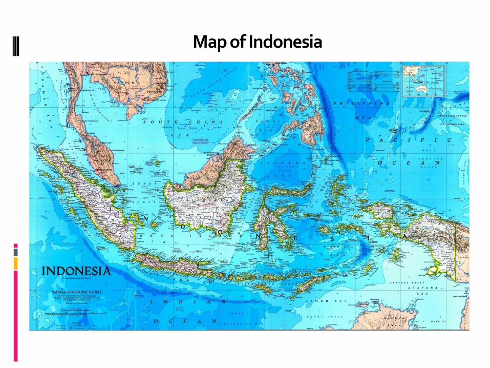
Map of Indonesia

2. SITE SELECTION PROCESS
R&D / Government OWNER
SDR SER Site Permit
Site Survey
Regional Analysis
Screening
Comparison & Ranking
Site Evaluation Pre-Operational Pre-Survey
Interest Regions
Potential Sites
Selected Candidate Sites
Preferred
Candidate Sites
Design Basis
Parameter
Readiness of the site
for Construction
2 thn
Scope of the paper

Coverage Area on Site Selection Process
Site area (~1 km2)
(Map scale 1: 100,000-50,000)
150 km (Map scale 1/250,000 -100,000)
(Map scale 1:25,000-5,000)
Regional Near regional
Site vicinity
25 – 50 km
5 km

Aspect of Study
SITE SITE SELECTIONSELECTION
Safety Related Aspect
Non Safety
Related
Aspect
Public Education
Extern. Events
Impact of NPP to
Envrmnt.
• Surface Faulting
• Seismicity
• Subsurface material
• Volcanism
• River Flooding
• Coastal Flooding (incl. tsunami)
• Other External Hazard
• Human Induced Events
• Dispersion • Demography
• Infrastructure • Spatial Planning • Ecology, Social, Economy, Culture
• Dissemination of nuclear energy and technology information (socialization, art performance), etc.
Scope of the paper
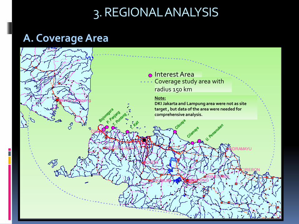
3. REGIONAL ANALYSIS
U
Bojoneg
ara
P. Pan
jang
T. KaitT. P
ontang
Daerah Interes
Cibuay
a
Cilam
aya
Batas Survei Regional
U. Pemanuka
n
0
Bandar Lampung
SUMEDANGBANDUNGSUKABUMI
BOGOR
PANDEGLANG
CIREBON
Cilegon
INDRAMAYU
139
141
Interest Area
Note: DKI Jakarta and Lampung area were not as site target , but data of the area were needed for comprehensive analysis.
Coverage study area with radius 150 km
A. Coverage Area
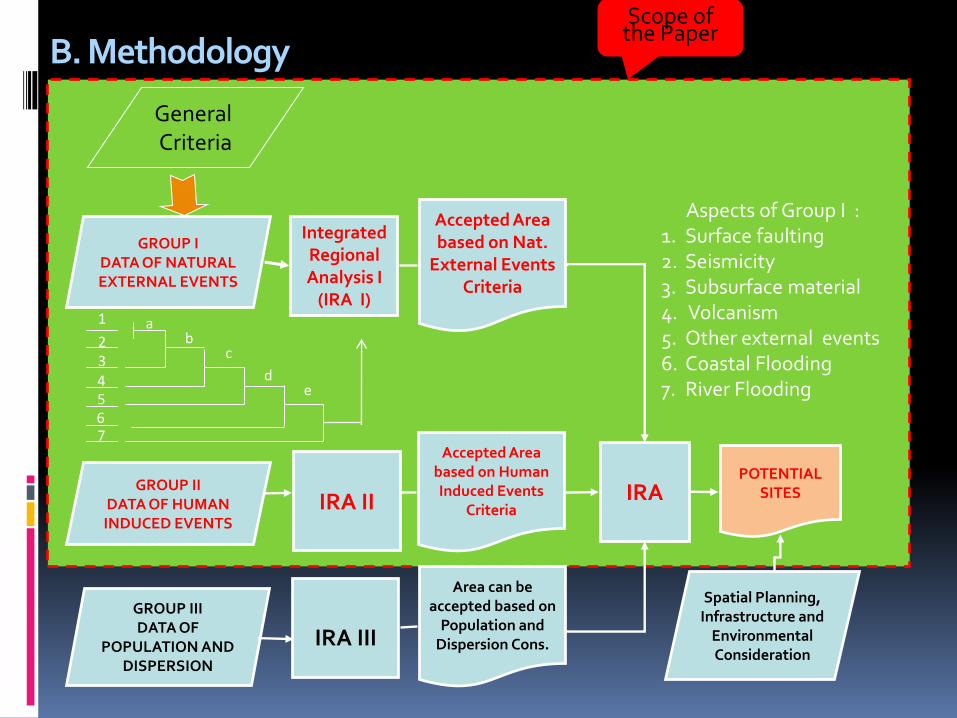
B. Methodology
Integrated Regional Analysis I
(IRA I)
GROUP I DATA OF NATURAL EXTERNAL EVENTS
Accepted Area based on Nat.
External Events Criteria
IRA II
IRA III
GROUP II DATA OF HUMAN INDUCED EVENTS
Accepted Area based on Human Induced Events
Criteria
GROUP III DATA OF
POPULATION AND DISPERSION
Area can be accepted based on
Population and Dispersion Cons.
IRA
POTENTIAL SITES
Spatial Planning, Infrastructure and
Environmental Consideration
Aspects of Group I : 1. Surface faulting 2. Seismicity 3. Subsurface material 4. Volcanism 5. Other external events 6. Coastal Flooding 7. River Flooding
General Criteria
1
2 3 4 5 6 7
a b
c
d e
Scope of the Paper

1) Surface Faulting
Acceptance criteria:
Distance of active fault (considered as supposed capable fault) to potential site should be ≥ 5 km
Capable faults is not toward to the site
Note :
Fault is considered to be capable if younger than 120,000 years old or younger than Middle Pleistocene.
C. Topical & Integrated Regional Analysis
a. Natural External Events
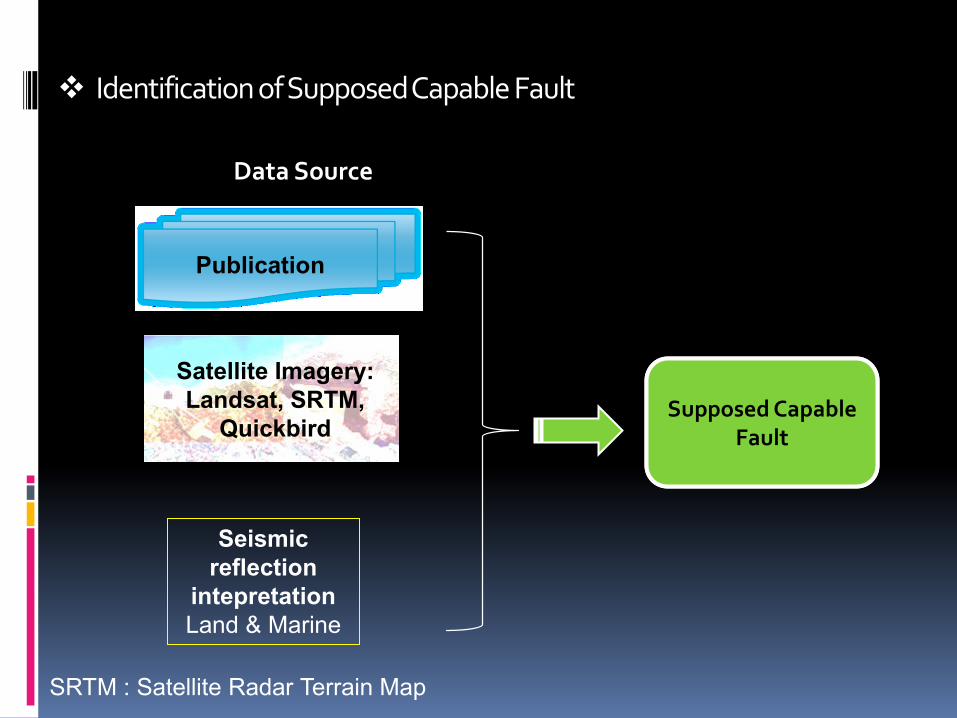
Identification of Supposed Capable Fault
SRTM : Satellite Radar Terrain Map
Publication
Satellite Imagery:
Landsat, SRTM,
Quickbird
Seismic
reflection
intepretation
Land & Marine
Supposed Capable Fault
Data Source

Supposed Capable Faults Hazard Zone

2) Seismicity
Acceptance criterion:
Peak Ground Acceleration (PGA) is defined to be ≤ 0.4 g, in order to minimize the NPP construction cost
The data used in the seismicity analysis are obtained from the earthquake catalog data in Indonesia. The data has been tabulated by the Incorporated Research Institute for Seismology (IRIS) since 1964 to 2008 from various sources, such as the USGS / NEIC, ISC, Harvard, and other databases. Other data obtained from the Novosibirsk Tsunami Laboratory of the year 1770 to 2001, and from the damage earthquake catalog of Geology Board from 1833 to 2006, and the calculated data of focal mechanism solutions from Harvard CMT catalog.

Seismic Zone For Area of Study
Earthquake distribution
Geodynamics setting
Faults Pattern completed with
its focal mechanism
Zone 1: Subduction Zona 2: Fore Arc Zona 3: Sumatera Fault Zona 4: Lampung Fault Zona 5: Panaitan Fault Zona 6 :Banten Fault
Zona 7: Bayah Fault Zona 8: Citarik Fault Zona 9: Baribis–Bumiayu Fault Zona 10: Cimandiri – Citanduy Ft Zona 11: Pegunungan Selatan Ft Zona 12: Java north fault

PGA Map of 250 Years of Exceedance Using Uncertainty of 0.15
Bojonegara : 0.3 g P. Panjang : 0.28 g Tj. Pontang : 0.26 g Pamanukan : 0.135 g
Tj. Kait : 0.2 g Cibuaya : 0.131 g Cilamaya :0.140 g

3) Subsurface Material
The purpose of subsurface material investigation is to acquire the geotechnical characteristics and the soil profile of the site
Based on the secondary data available, it can be concluded that:
North coast of Banten and West Java Province is lying on alluvial deposits which are defined as from unconsolidated to semi consolidated material. Meanwhile, the land of Pulau Panjang, a small island in the northern Banten Province, is lying on the coral reefs which are regarded as relatively hard material
Sediment on the north coast of Banten and West Java Province is more than 200 m thick. Quarternary rocks compose of clay with sand intercalation are at depth 0-230 m.
The whole interest area are not in danger of ground movement events
Bojonegara, Pulau Panjang, Tanjung Pontang and Cibuaya area are not lie in liquefaction zone.
Liquefaction events on the north coast of Banten and West Java Province have never been reported.

Bedrock and Quaternary Rocks Distribution Map

4) Volcanism
Definition of Capable Volcano:
Historical volcanic activity (volcanic activity 1600 a.d., Indonesia type A)
Manifestation of magmatic activity at present (Indonesia: Type B and C). Type B is characterized by its cone morphology, while type C is characterized by fumarolic activity but unclear cone morphology
Last activity time < maximum repose interval
Quaternary Composite Type, Pliocene Caldera Type
Criteria
Potential site is not laid in the SDV radius of capable volcano such as phyroclastic flow, phyroclastic fall, lava flow

Flowchart of Volcanic Hazard Analysis
Initial
scoping
Characterize
sources
of volcanic activity
as initiating events
Hazards
screening
Evaluate
hazards at site
Volcanism <10Myr
In appropriate
region?
Is there current
volcanic activity?
Is there Holocene
volcanic activity?
Site suitability
decision,
inputs for
design basisNot a design basis event:
no further investigation needed
Yes
Yes
Yes
No
No
No
Potential for any
volcanic hazard
at the site?
Develop site-
specific Volcanic
Hazard Model
STAGE 1 STAGE 2 STAGE 3 STAGE 4
Yes
No
Yes
If not,
(i.e. 10 Myr to 0.01 Myr),
is future volcanic activity
credible?
Increasing need for substantiation
Volcano(s)
capable
No

Volcanic Hazard Zone
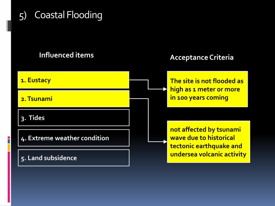
5) Coastal Flooding
1. Eustacy
2. Tsunami
3. Tides
4. Extreme weather condition
5. Land subsidence
The site is not flooded as high as 1 meter or more in 100 years coming
not affected by tsunami wave due to historical tectonic earthquake and undersea volcanic activity
Influenced items Acceptance Criteria

Eustacy Eustacy of sea-level rise is caused by the addition of the water volume due to ice melting as well as thermal expansion due to increased water temperature

Coastal Flooding Modelling in Area of Study Caused by Eustacy
The modelling was based on worst scenario of global sea level rising of 1cm/year
after 100 years
* The red color presents the flooded area

Tsunami Tsunami attributable to volcanic which was caused by the collapse of
Krakatoa caldera in year 1883 occurred in Sunda Strait. Tsunami attributable to tectonic was caused by tectonics related to
subduction zone happened in the far south. Tectonic tsunami which is not related to subduction zone occurred in
Sunda Strait such as the Panaitan tsunami.
Flooded Area Affected by Krakatoa Tsunami

6) River Flooding
Acceptance criterion: The site is not flooded by river flooding as high as 1 meter or more with return period of 100 year.
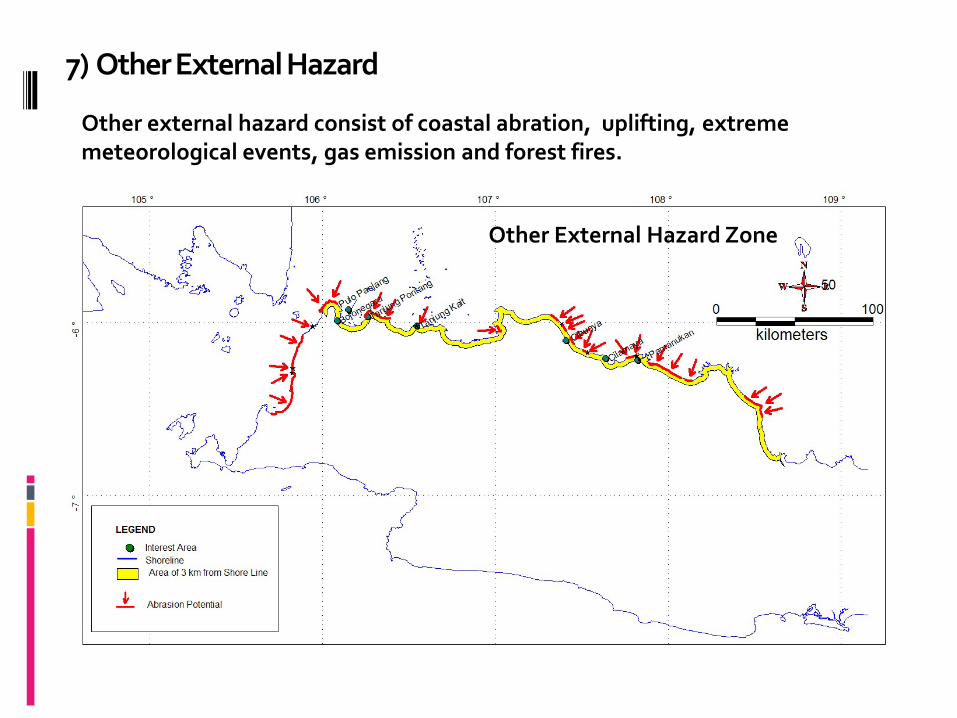
7) Other External Hazard
Other External Hazard Zone
Other external hazard consist of coastal abration, uplifting, extreme meteorological events, gas emission and forest fires.

Hazard zone for seven natural external event aspects
b. Integrated Regional Analysis of Natural External Events (IRA – I)

c. Human Induced External Events
Item Screening Distance value (SDV) radius
Stationary Source
• Large & busy airport 16 km
• Small-medium airport 10-20 km
• Permanent & large military facility 30 km
• Small-medium military facility 10-20 km
• Oil/gas refinery, power generation and petrochemical industries
3 - 5 km
• Large harbor 3 - 5 km
Mobile Source
• Toll/Artery road and railway 0,5 -1 km
• Gas or oil pipe line 1 km
• Cruise line 4 km

Stationary Source Hazard Zone

Mobile Source Hazard Zone

d. Integrated Regional Analysis of Natural & Human Induced External Events (IRA- I & II)
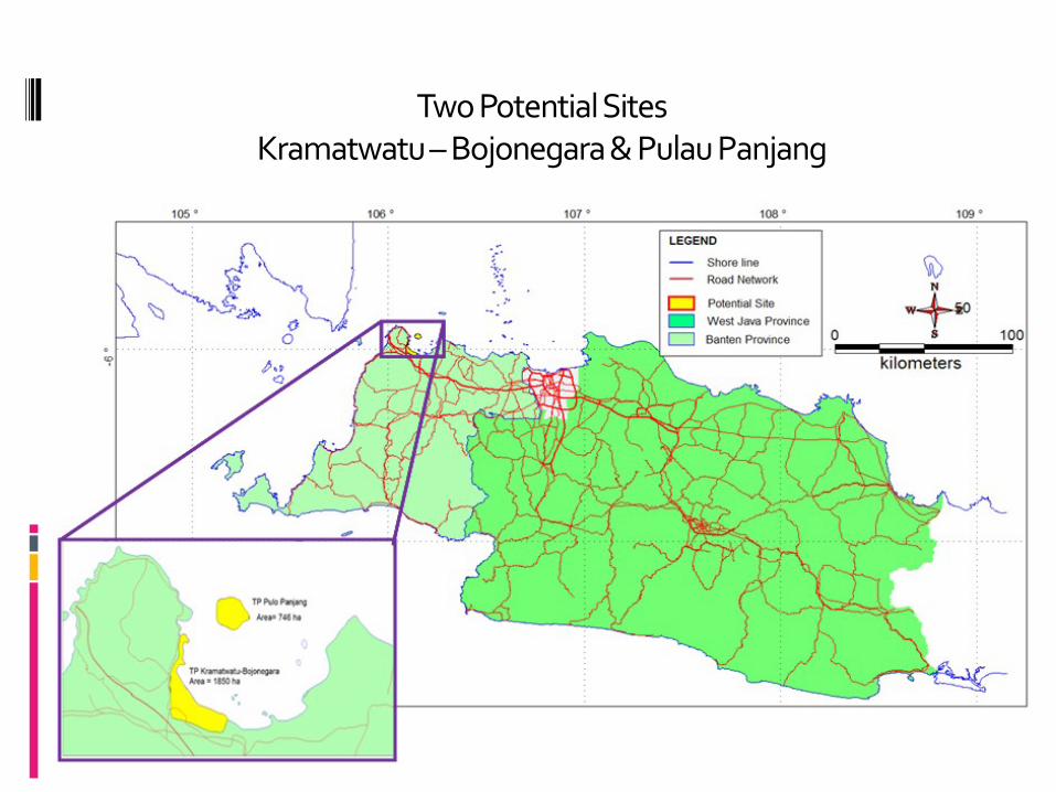
Two Potential Sites Kramatwatu – Bojonegara & Pulau Panjang

4. SUMMARY & RECOMMENDATION
Combining the hazard zone of natural and human induced external event would produce a free-hazard zone. Furthermore, it can be defined and delineated to 2 (two) potential sites namely Kramatwatu-Bojonegara and Pulau Panjang.
However, those potential sites to become a selected candidate site as the results of near regional analysis stage, need further investigation and some field works in order to achieve appropriate data, especially on verification of supposed capable faults and deep investigation of capable volcanoes in the radius of 50 km from the site.

Thank You