ofr sheet 2 - usgs nederland grays peak eldorado springs mount richthofen buckhorn mountain...
TRANSCRIPT
WARD
NEDERLAND
GRAYS PEAK
ELDORADO SPRINGS
MOUNT RICHTHOFEN
BUCKHORN MOUNTAIN HORSETOOTH RESERVOIR
MASONVILLE
PANORAMA PEAK
DW-105
DW-107 DW-111
DW-094
DW-114DW-113
DW-106
DW-093DW-110
DW-112 DW-098
DW-109DW-099
DW-108
DW-097
DW-092
DW-119 DW-189
DW-115
EP-066
EP-067EP-015
DW-104
DW-101
DW-103
DW-102
DW-172DW-067
DW-089
DW-100
DW-116
DW-118 EP-004DW-090DW-096
DW-117
DW-095EP-005
EP-012EP-011
EP-009 EP-080
EP-055
EP-029EP-028
EP-082
EP-010
EP-081EP-079
DW-030
DW-085
DW-213
FC-039FC-036
DW-137-141,148-171, 226-228
DW-136
DW-135DW-126
DW-131
DW-129,130,132-134
DW-142, 147
DW-143
DW-125DW-121
DW-128
DW-127
DW-144DW-145
DW-146
DW-120DW-010 DW-004 DW-122 DW-124
DW-001
DW-003DW-009
DW-211
DW-203
DW-195
DW-205
DW-191
DW-194
DW-201
DW-192
DW-204
DW-015DW-183
DW-076
DW-006
DW-074DW-005
DW-008DW-002 DW-179DW-007
DW-178
FC-005
FC-012
FC-004FC-007
FC-006
FC-011FC-010
FC-013
FC-052FC-053
FC-032FC-017
FC-046
FC-054FC-057
FC-056
FC-037
FC-038
FC-043FC-040FC-041
FC-035FC-034
EP-054
EP-053EP-069
EP-068
EP-110
EP-107EP-108
EP-047
EP-098
EP-102
EP-099
EP-101
EP-100
EP-044
DW-071
DW-069
DW-070DW-068
DW-066
EP-042
DW-084
EP-060
EP-019
EP-092EP-095
EP-018
EP-089
EP-057
EP-058EP-059
EP-076EP-077
EP-078
EP-093
EP-056EP-074
EP-094
EP-017
EP-070
BA-028BA-027
BA-017BA-020
BA-019
BA-013
BA-016
BA-040
BA-048BA-049
BA-050
BA-029
BA-009
BA-030
BA-005
BA-006
BA-007
DW-206DW-034DW-020
DW-019DW-207DW-198
DW-196 DW-193 DW-031DW-202
DW-197DW-199
DW-200
DW-190
DW-029
DW-086
DW-036
DW-032
DW-042DW-021
DW-033DW-061
DW-079
DW-210
DW-225
DW-057DW-224DW-028
DW-082
DW-081
DW-209DW-087DW-088
DW-023 DW-022DW-083
DW-026
DW-188DW-182
DW-175 DW-072
DW-018
DW-075
DW-051DW-043DW-216
DW-045DW-046
DW-044DW-039
DW-052DW-062DW-035
DW-040 DW-218
DW-219
DW-078
DW-048DW-049 DW-223DW-217DW-050
DW-047DW-058
DW-027DW-024 DW-215
DW-025
DW-222DW-221DW-038
DW-041DW-037
DW-080
FC-019
FC-027
FC-020FC-021
FC-018FC-001
FC-024
FC-022
FC-025FC-002
FC-028
EP-065EP-064
EP-002
EP-023
EP-020
EP-028, 036, 037EP-038
EP-032
EP-039
EP-086
EP-087
EP-033
EP-034EP-035
EP-003
EP-001EP-030
EP-031
BA-068
BA-067
BA-072
FC-042
EP-104
EP-106
EP-096
EP-103
EP-043
EP-097
EP-105
EP-026
EP-083
EP-025
EP-084EP-007
EP-088
EP-040
EP-041
EP-085
EP-008
FC-023
FC-059
FC-029
BA-018
BA-022BA-023
BA-031BA-035BA-032
BA-024
BA-036BA-037
BA-021
BA-034
BA-033
BA-015
DW-053DW-054
DW-186
DW-181
DW-180DW-176
DW-055
DW-056
BA-026
BA-079BA-083
BA-084BA-082BA-081
BA-046
BA-078
BA-045
DW-012
DW-173
DW-187
CRAZY MOUNTAIN
GLENDEVEY
RAWAH LAKES
CLARK PEAK
BOWEN MOUNTAIN
TRAIL MOUNTAIN
GRANBY
BOTTLE PASS
BYERS PEAK
LOVELAND PASS
KEYSTONE
BOREAS PASS
COMO
FAIRPLAY EAST
GARO
SAND CREEK PASS
DEADMAN
BOSTON PEAK
CHAMBERS LAKE
FALL RIVER PASS
GRAND LAKE
SHADOW MOUNTAIN
STRAWBERRY LAKE
FRASER
BERTHOUD PASS
MONTEZUMA
JEFFERSON
MILLIGAN LAKES
ELKHORN
HARTSEL
EATON RESERVOIR
SOUTH BALD MOUNTAIN
KINIKINIK
COMANCHE PEAK
TRAIL RIDGE
MCHENRYS PEAK
ISOLATION PEAK
MONARCH LAKE
EAST PORTAL
EMPIRE
GEORGETOWN
MOUNT EVANS
MOUNT LOGAN
OBSERVATORY ROCK
EAGLE ROCK
SULPHUR MOUNTAIN
DIAMOND PEAK
RED FEATHER LAKES
RUSTIC
PINGREE PARK
ESTES PARK
LONGS PEAK
ALLENS PARK
CENTRAL CITY
IDAHO SPRINGS
HARRIS PARK
SHAWNEE
TOPAZ MOUNTAIN
FARNUM PEAK
GLENTIVAR
CHEROKEE PARK
HAYSTACK GULCH
BIG NARROWS
CRYSTAL MOUNTAIN
GLEN HAVEN
RAYMOND
GOLD HILL
TUNGSTEN
BLACK HAWK
SQUAW PASS
MERIDIAN HILL
BAILEY
WINDY PEAK
MCCURDY MOUNTAIN
TARRYALL
VIRGINIA DALE
LIVERMORE MOUNTAIN
POUDRE PARK
DRAKE
PINEWOOD LAKE
LYONS
BOULDER
RALSTON BUTTES
EVERGREEN
CONIFER
PINE
GREEN MOUNTAIN
CHEESMAN LAKE
HACKETT MOUNTAIN
TABLE MOUNTAIN
LIVERMORE
LAPORTE
CARTER LAKE RESERVOIR
HYGIENE
NIWOT
LOUISVILLE
GOLDEN
MORRISON
INDIAN HILLS
PLATTE CANYON
DECKERS
WESTCREEK
SIGNAL BUTTE
ROUND BUTTE
BUCKEYE
WELLINGTON
FORT COLLINS
LOVELAND
BERTHOUD
LONGMONT
ERIE
LAFAYETTE
ARVADA
FORT LOGAN
LITTLETON
KASSLER
DEVILS HEAD
DAKAN MOUNTAIN
MOUNT DECEPTION
FC-003
FC-008
FC-009
FC-014
FC-015FC-016
FC-026
FC-030
FC-031
FC-033
FC-044
FC-045
FC-047FC-048
FC-049
FC-050FC-051
FC-055
FC-058
FC-060
EP-006
EP-013
EP-014
EP-016
EP-021
EP-022
EP-024
EP-027
EP-045
EP-046
EP-048
EP-049
EP-050
EP-051EP-052
EP-061
EP-062
EP-063
EP-071
EP-072
EP-073
EP-075 EP-090
EP-091
EP-109
DW-011
DW-013
DW-014DW-016
DW-017
DW-059
DW-060
DW-063
DW-064DW-065
DW-073
DW-077
DW-091
DW-174
DW-177
DW-184
DW-185
DW-208
DW-212
DW-214
DW-220
BA-001BA-002
BA-003BA-004
BA-008
BA-010
BA-011
BA-012
BA-014
BA-025
BA-038
BA-039
BA-041
BA-042
BA-043BA-044
BA-047
BA-051
BA-052
BA-053
BA-054
BA-055
BA-056
BA-057
BA-058
BA-059
BA-060
BA-061
BA-062
BA-063
BA-064
BA-069
BA-070
BA-071
BA-073
BA-074
BA-075
BA-076
BA-077
BA-080
EP-112
FC-061
EP-111
BA-065
BA-066
DW-123
OPEN-FILE REPORT 2006-1051SHEET 2 of 2
Version 1.0
105°00'
SAMPLE LOCATIONS
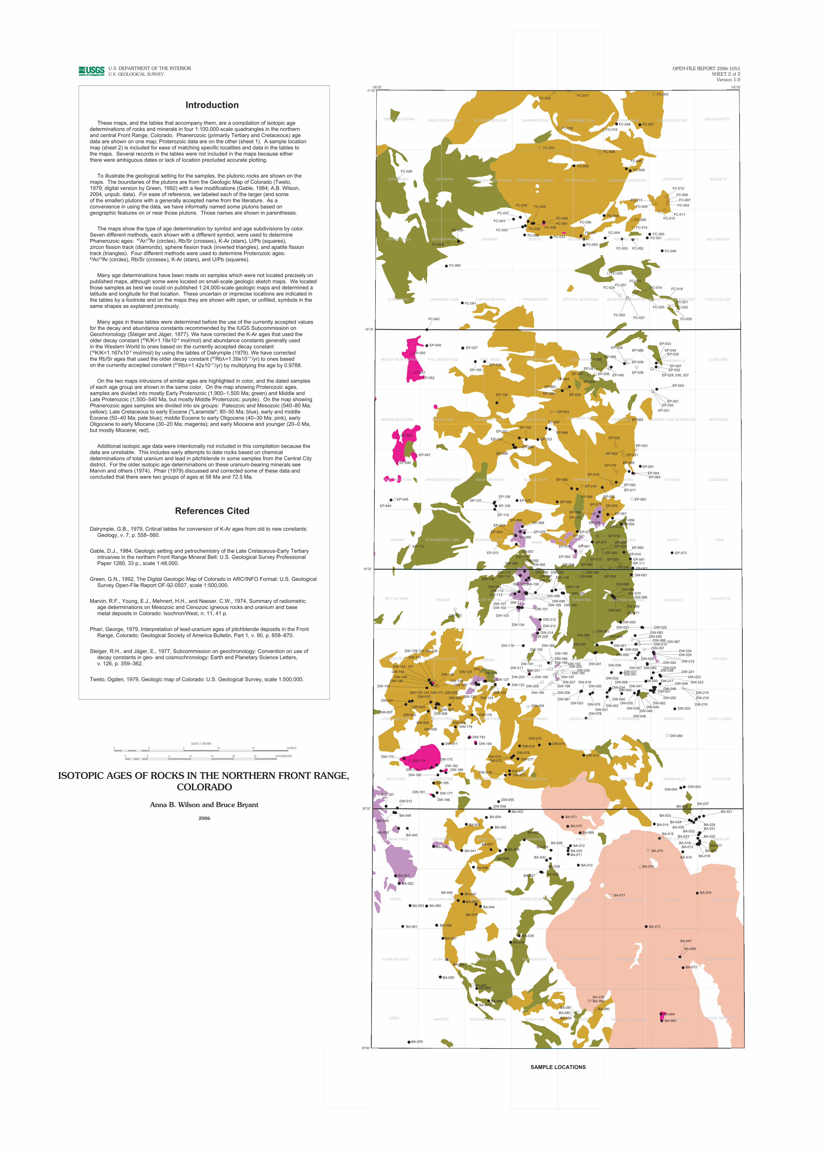
These maps, and the tables that accompany them, are a compilation of isotopic age determinations of rocks and minerals in four 1:100,000-scale quadrangles in the northern and central Front Range, Colorado. Phanerozoic (primarily Tertiary and Cretaceous) agedata are shown on one map; Proterozoic data are on the other (sheet 1). A sample locationmap (sheet 2) is included for ease of matching specific localities and data in the tables to the maps. Several records in the tables were not included in the maps because either there were ambiguous dates or lack of location precluded accurate plotting.
Introduction
To illustrate the geological setting for the samples, the plutonic rocks are shown on the maps. The boundaries of the plutons are from the Geologic Map of Colorado (Tweto, 1979; digital version by Green, 1992) with a few modifications (Gable, 1984; A.B. Wilson, 2004, unpub. data). For ease of reference, we labeled each of the larger (and some of the smaller) plutons with a generally accepted name from the literature. As a convenience in using the data, we have informally named some plutons based on geographic features on or near those plutons. Those names are shown in parentheses.
The maps show the type of age determination by symbol and age subdivisions by color. Seven different methods, each shown with a different symbol, were used to determine Phanerozoic ages: Ar/ Ar (circles), Rb/Sr (crosses), K-Ar (stars), U/Pb (squares), zircon fission track (diamonds), sphene fission track (inverted triangles), and apatite fission track (triangles). Four different methods were used to determine Proterozoic ages: Ar/ Ar (circles), Rb/Sr (crosses), K-Ar (stars), and U/Pb (squares).
Many age determinations have been made on samples which were not located precisely on published maps, although some were located on small-scale geologic sketch maps. We located those samples as best we could on published 1:24,000-scale geologic maps and determined a latitude and longitude for that location. These uncertain or imprecise locations are indicated in the tables by a footnote and on the maps they are shown with open, or unfilled, symbols in the same shapes as explained previously.
Many ages in these tables were determined before the use of the currently accepted values for the decay and abundance constants recommended by the IUGS Subcommission on Geochronology (Steiger and Jäger, 1977). We have corrected the K-Ar ages that used the older decay constant (40K/K=1.19x10-4 mol/mol) and abundance constants generally used in the Western World to ones based on the currently accepted decay constant (40K/K=1.167x10-4 mol/mol) by using the tables of Dalrymple (1979). We have corrected the Rb/Sr ages that used the older decay constant (87Rbλ=1.39x10⁻¹¹/yr) to ones based on the currently accepted constant ( 87Rbλ=1.42x10⁻¹¹/yr) by multiplying the age by 0.9788.
On the two maps intrusions of similar ages are highlighted in color, and the dated samples of each age group are shown in the same color. On the map showing Proterozoic ages, samples are divided into mostly Early Proterozoic (1,900–1,500 Ma; green) and Middle and Late Proterozoic (1,500–540 Ma, but mostly Middle Proterozoic; purple). On the map showing Phanerozoic ages samples are divided into six groups: Paleozoic and Mesozoic (540–80 Ma; yellow); Late Cretaceous to early Eocene ("Laramide"; 80–50 Ma; blue), early and middle Eocene (50–40 Ma; pale blue); middle Eocene to early Oligocene (40–30 Ma; pink), early Oligocene to early Miocene (30–20 Ma; magenta); and early Miocene and younger (20–0 Ma, but mostly Miocene; red).
Additional isotopic age data were intentionally not included in this compilation because the data are unreliable. This includes early attempts to date rocks based on chemical determinations of total uranium and lead in pitchblende in some samples from the Central City district. For the older isotopic age determinations on these uranium-bearing minerals see Marvin and others (1974). Phair (1979) discussed and corrected some of these data and concluded that there were two groups of ages at 58 Ma and 72.5 Ma.
References Cited
Dalrymple, G.B., 1979, Critical tables for conversion of K-Ar ages from old to new constants: Geology, v. 7, p. 558–560.
Gable, D.J., 1984, Geologic setting and petrochemistry of the Late Cretaceous-Early Tertiary intrusives in the northern Front Range Mineral Belt: U.S. Geological Survey Professional Paper 1280, 33 p., scale 1:48,000.
Green, G.N., 1992, The Digital Geologic Map of Colorado in ARC/INFO Format: U.S. Geological Survey Open-File Report OF-92-0507, scale 1:500,000.
Marvin, R.F., Young, E.J., Mehnert, H.H., and Naeser, C.W., 1974, Summary of radiometric age determinations on Mesozoic and Cenozoic igneous rocks and uranium and base metal deposits in Colorado: Isochron/West, n. 11, 41 p.
Phair, George, 1979, Interpretation of lead-uranium ages of pitchblende deposits in the Front Range, Colorado: Geological Society of America Bulletin, Part 1, v. 90, p. 858–870.
Steiger, R.H., and Jäger, E., 1977, Subcommission on geochronology: Convention on use of decay constants in geo- and cosmochronology: Earth and Planetary Science Letters, v. 126, p. 359–362.
Tweto, Ogden, 1979, Geologic map of Colorado: U.S. Geological Survey, scale 1:500,000.
40 39
40 39
106°00'41°00'
40°30'
40°00'
39°30'
39°00'
U.S. DEPARTMENT OF THE INTERIORU.S. GEOLOGICAL SURVEY
5 0 10 15 20 25 30 KILOMETERS
SCALE 1: 250 000105 0 5 15 20 MILES
e Bryant
ISOTOPIC AGES OF ROCKS IN THE NORTHERN FRONT RANGE,
Anna B. Wilson and Bruc
2006
COLORADO
5