old town san diego€¦ · old town san diego community plan update urban design & land use...
TRANSCRIPT

Urban Design & Land Use Existing Conditions Report
1
OLD TOWN SAN DIEGO
Community Plan Update - Urban Design & Land Use Existing Conditions Report
March 2012

Old Town San Diego Community Plan Update
Urban Design & Land Use Existing Conditions Report
2
This page intentionally left blank
CREDITS:
Winter & Company
AECOM
City of San Diego
On the cover: An aerial photograph of the Old Town San Diego Community Plan Area.
Old Town San Diego Community Plan Update
Urban Design & Land Use Existing Conditions Report
3
TABLE OF CONTENTS
PART 1. INTRODUCTION AND BACKGROUND
A. Old Town Background Maps 5
B. Population and Housing 9
C. Environmental Setting 10
PART 2. LAND USE AND ZONING
A. Old Town San Diego Community Plan Land Use 11
B. Existing Land Use 14
C. Old Town San Diego Planned District Ordinance 17
D. Overlay Zones 23
E. Historic Resources 23
F. North Bay Redevelopment Project Area 24
G. Draft San Diego River Park Master Plan 25
PART 3. URBAN DESIGN ANALYSIS
A. Development Patterns, Community Character, and The Urban Realm 26
B. Public Spaces 41
C Community Facilities and Services 46
D. Mobility Systems 47
E. Streetscape and Wayfinding 51

Old Town San Diego Community Plan Update
Urban Design & Land Use Existing Conditions Report
4
This page intentionally left blank

Old Town San Diego Community Plan Update
Urban Design & Land Use Existing Conditions Report
5
PART 1. INTRODUCTION AND BACKGROUND
A. OLD TOWN BACKGROUND MAPS This section provides a series of background maps that illustrate the historic and current conditions of Old Town.
Location
Old Town San Diego contains approximately 230 acres and is a community framed on the west by Interstate 5 and by Interstate 8 on the north. The Mission Hills neighborhood lies to the east within the Uptown community. Presidio Park forms a substantial part of the northeastern edge of the neighborhood. The southern boundary varies, with its southernmost limit lying south of Hortensia Street.
Old Town San Diego is recognized as the birthplace of California. The State Historic Park and Presidio Park serve as both historical resource and tourist attraction, drawing visitors from the San Diego region and beyond. Additionally, the Old Town Transit Center functions as a major regional intermodal transit station with train, trolley and bus service.
Historical Maps of Old Town
Historical maps from the early twentieth century show Old Town framed by Atchison, Topeka and Santa Fe Railway and major streets. The San Diego River is also a prominent feature along the northern edge of the neighborhood.
1910 Map
The grid of parcels for Old Town lies at an approximate 45 degree angle to the north-south axis of the city to the south. The Old Town grid extends across the San Diego River.

Old Town San Diego Community Plan Update
Urban Design & Land Use Existing Conditions Report
6
1937 Map
San Diego Avenue leads through Old Town, connecting to Taylor, which then leads east to a river crossing. Highway 101, which connected San Diego to Los Angeles prior to Interstate 5, frames the western edge of the community.
1938 Map
San Diego Avenue is identified as a major street, with a series of streets to its west. These terminate near the Atchison, Topeka and Santa Fe Railway, which generally parallels Highway 101.

Old Town San Diego Community Plan Update
Urban Design & Land Use Existing Conditions Report
7
Aerial Photo (2010)

Old Town San Diego Community Plan Update
Urban Design & Land Use Existing Conditions Report
8
Aerial Photo (2010) and Parcels (2011)

Old Town San Diego Community Plan Update
Urban Design & Land Use Existing Conditions Report
9
B. POPULATION AND HOUSING
In 2000, the total residential population of Old Town was 750 people. By 2010, the total population was estimated at 673 people, representing a decline of approximately 8 percent between 2000 and 2010.
Population and Housing
2000 2010 2000-2010 Percent Change
Population 750 673 -8.0% Housing Units 464 440 -5.2%
Source: SANDAG, 2010 Estimate; US Census, 2000
Old Town has an older population when compared to the rest of the City of San Diego. For 2010, the median age of a resident in Old Town is 38.8 years old which is greater than the median for the City as a whole, as shown in table below. There is a high proportion of people aged 65 and over, comprising 19 percent of the total population.
Age
Old Town City of San Diego
Numeric Percent Numeric Percent 19 and Under 175 26% 357,386 26% 20 to 44 228 34% 531,481 39% 45 to 64 143 21% 332,250 24%
65 and Older 127 19% 155119 11%
Total 673 100% 1,376,173 100%
Median Age 38.8 35.6 Source: SANDAG, 2010 Estimate

Old Town San Diego Community Plan Update
Urban Design & Land Use Existing Conditions Report
10
C. ENVIRONMENTAL SETTING
The following is a very general description of the environmental setting. A more detailed assessment will be provided in the environmental document for the community plan update.
Natural Features
Topography in Old Town ranges from steep hillsides of Presidio Park to more gently sloping canyon space, to relatively flat areas in the northwest and west. Steep slopes (25% or greater grade) are present in multiple areas. Elevation ranges from approximately 300 feet to just above sea level.
Sensitive Biological Resources
The Sensitive Biological Resource Areas exist in the undevelopable canyon areas. Much of the open canyon space is designated Multiple-Habitat Planning Area with sensitive vegetation and sage scrub.
Earthquake
Several faults, including the Rose Canyon fault, underlay the community. According to the U.S. Geological Survey, the community has a low to moderate relative geologic risk and the northwestern portion of the community, along I-5 and roughly northwest of Wallace Street may be subject to liquefaction. The USGS California Geotechnical Survey has designated a majority of the Old Town Community as being subject to ‘Low to Moderate’ geotechnical risk.
Fire Hazard
The California Department of Forestry and Fire Protection has established Fire Hazard Severity Zones which indicate areas that may have significant fire hazards due to fuel, terrain, weather or other relevant factors. A northeastern portion of the Old Town Community has been designated as a Fire Hazard Severity Zone. Due to the topography and presence of vegetated hillsides, this area has a higher risk of fires. The City’s Brush Management Guide advises clearance or pruning of a zone extending 100 feet from any structure, regardless of fire hazard zone.
Flood
The majority of the community is located outside of any floodplains. Only a small portion of landscaped land between Taylor Street and the I-5, and the Park-and-Ride lot are within floodplain area.

Old Town San Diego Community Plan Update
Urban Design & Land Use Existing Conditions Report
11
PART 2. LAND USE AND ZONING
A. OLD TOWN SAN DIEGO COMMUNITY PLAN LAND USE
The Old Town San Diego community plan was first adopted in 1968. A comprehensive update was adopted on July 7, 1987. The 1987 community plan update provided comprehensive development standards and implementation recommendations to promote the physical and economic wellbeing of Old Town and to ensure that the community is properly developed as the historic heart of the City of San Diego as well as the State of California. On May 4, 1998, the community plan was amended to change the land use designation for property north of Taylor Street to hotel, office and/or retail use as part of the North Bay Revitalization Program. On November 27, 2001, the community plan was amended to change the land use designation for a 3.52 acre site from multifamily to hotel/office to reflect the existing hotel use on the west side of Juan Street.
During the last Community Plan Update, efforts were made to identify and address key community issues. From the priority issues identified at that time, there were certain themes that appeared across multiple elements. These themes were taken into consideration when formulating a preferred land use alternative. The strongest issues among these themes were incompatible land uses, insensitivity to historical significance, lack of stakeholder coordination, and lack of proper community identity. To address these issues, a preferred alternative was selected that emphasized a combination of tourist and residential development in order to “Maintain a balance between regional-visitor-oriented facilities…, with the community-residential-oriented needs of the local residents…”
The Old Town San Diego Community Plan land use from the Community Plan that was adopted in 1987 is shown on page 12 and the currently adopted community plan land use map that reflects the 1998 and 2001 amendments is shown on page 13.

Old Town San Diego Community Plan Update
Urban Design & Land Use Existing Conditions Report
12
Old Town Community Plan Land Use (Adopted in 1987)

Old Town San Diego Community Plan Update
Urban Design & Land Use Existing Conditions Report
13
Old Town Community Plan Land Use (Amended 1998 and 2001)

Old Town San Diego Community Plan Update
Urban Design & Land Use Existing Conditions Report
14
The acreage that reflects the currently adopted community plan is shown below.
Community Plan Land Use
Designation Acres
Single Family Residential 3.1
Multi-Family Residential 14.2
Core/Commercial 27.2
Hotel/Office/Retail 33.3
Hotel/Office 3.4
Residential/Commercial 3.9
Residential/Hotel 10.4
Historic Parks 83.0
Parking/Parks 4.6
Parking/School 4.4
Surface Parking 7.0
Transit Center 0.9
Transportation* 73.3
Grand Total 274.3
*Includes road, freeway, and rail right-of-ways.

Old Town San Diego Community Plan Update
Urban Design & Land Use Existing Conditions Report
15
B. EXISTING LAND USE
The acreage that reflects the existing land uses (as of 2011) is shown below and the map that shows the location of these uses is shown in page 16.
Summary of Existing Land Uses (2011)
Existing Land Use Acres
Single Family 8.8
Multi-Family 11.5
Retail 15.3
Hotel 9.7
Office 27.8
Industrial 3.3
Tourist Attraction 21.9
Institutional 6.8
Parks, Open Space 60.6
Parking Lot 5.6
Transit Center 4.8
Utility 0.9
Undeveloped 2.5
Transportation* 94.6
Grand Total 274.3
*Includes road, freeway, and rail right-of-ways.

Old Town San Diego Community Plan Update
Urban Design & Land Use Existing Conditions Report
16
Old Town Community Existing Land Use (2011)

Old Town San Diego Community Plan Update
Urban Design & Land Use Existing Conditions Report
17
C. OLD TOWN SAN DIEGO PLANNED DISTRICT ORDINANCE
The Citywide Base zones regulate all City owned property and privately owned property, specifying which uses are allowed on a given property, and the applicable development regulations except for Federal, State, County, and other government agency owned property. Within certain areas of the City, planned districts provide zoning and development regulations in lieu of the standard Citywide base zones. The intent of the planned districts is to preserve and enhance the cultural, aesthetic or economic value of neighborhoods having special importance due to their historical significance or because of their being part of older, established communities and neighborhoods. Property within the Old Town Community Plan Area is regulated by the Old Town Planned District. In 1971, the City Council adopted the Old Town San Diego Planned District Ordinance which is found in the City's Land Development Code, Chapter 15, Article 16. The purpose of the Old Town San Diego Planned District Ordinance is to replicate, retain and enhance the distinctive character of the Old Town San Diego historical area that existed prior to 1871. The intent is to create an exciting and viable community capitalizing on the area's proud heritage and importance as California's birthplace and first European settlement. The Old Town San Diego Planned District Design Review Board (Board) was created to provide advice on architectural design for development projects in compliance with the regulations and procedures contained within the Planned District Ordinance. The Board is composed of seven members who are appointed by the Mayor and confirmed by the City Council. Development of land in Old Town San Diego is controlled in this manner in order to develop the unique village character and atmosphere of Old Town San Diego prior to 1871. Recognizing the physical and functional differences between areas in Old Town, the following seven subareas within the Planned District have been devised: Core, Hortensia, Jefferson, Rosecrans, Public Property - Parking, Public Property - Park, as well as Single Family and Multi-Family residential uses. The Old Town San Diego plan area includes 266 acres of zoned land, of which approximately 36% is zoned for public uses. The Planned District subareas map is shown on page 18. A summary of the development regulations that apply to Old Town’s subareas are provided in the following pages. In addition to these, are design standards that address the following topics: • Architectural Styles/Historic Period
• Forms, Materials, Textures & Colors
• Courtyards
• Fences and Walls
• Transparency
• Landscaping
• Parking
• Signs Streetscape/Encroachments Permits Special Regulations

Old Town San Diego Community Plan Update
Urban Design & Land Use Existing Conditions Report
18
Old Town Community Planned District Ordinance

Old Town San Diego Community Plan Update
Urban Design & Land Use Existing Conditions Report
19
Old Town San Diego Planned District Land Use Designations
Each of the subareas identified in the Planned District Ordinance Map on page 18 contain building regulations addressing parameters such as overall density, floor area ratios, lot coverage, structure height, structure size, and minimum/maximum lot area. When combined, the regulations influence the overall building forms.
The following terms and definitions, as well as definitions for other building regulations, may be found in the Land Development Code.
Density describes the relationship between the number of dwelling units existing or permitted on a premise, and the area of the premises. For instance, in a multifamily residential area, density may be limited to one dwelling unit per 1,750 square feet of net lot area. Density can also apply to hotel/motel area and office use. Examples include “not more than two lodgers per unit,” or “not more than one office establishment per 2,000 square feet.”
Floor Area Ratio (FAR) is the numerical value obtained by dividing the gross floor area of all buildings on a premises by the total area of the premises on which the buildings are located. For example, a 1,000 square foot building on a 2,000 square foot lot has an FAR of 0.5. Another example is a 3-story building on a 3,000 square foot lot. If each story of the building is 500 square feet, this would also represent an FAR of 0.5. In Old Town, buildings are limited to an FAR of 0.60, except in the Rosecrans subarea.
Lot coverage is the portion of a lot that is occupied by buildings or structures that are roofed or otherwise covered, or that are unroofed and have a finished floor that extends more than 3 feet above grade. Lot coverage is expressed as a percentage. In Old Town, buildings are limited to a lot coverage of 60%, except in the single-family subarea. For example, a lot of 3,000 square feet means that the structure’s footprint may not exceed 1,800 square feet.
Structure height is the vertical distance between all points on top of a structure or any of its appurtenances, and the grade directly below. In Old Town, maximum structure heights vary. However, all buildings within 150 feet of Taylor Street are limited to 24 feet in height, regardless of the subarea.
Structure size provides parameters for the maximum and minimum horizontal dimensions of any structure on a lot. A structure is considered an edifice or building of any kind or any construction built up or composed of parts joined together in some definite manner including a wall, fence, pier, post, sign, or shelter. In the subareas of Old Town, structure sizes are limited to 6,000 square feet for 1-story buildings, 8,000 square feet for 2-story buildings, and 10,000 square feet for 3-story buildings.

Old Town San Diego Community Plan Update
Urban Design & Land Use Existing Conditions Report
20
Minimum/maximum lot areas establish guidelines for the size of the lot, also known as a parcel, tract, or area of land established by plan, subdivision, or other legal means to be owned, used, or developed. In Old Town, minimum/maximum lots areas are restricted to 3,000/5,000 square feet, except in the Rosecrans subarea.
In addition to other regulations contained in the Old Town Planned District, there are a number of specific regulations to help retain the distinctive character and atmosphere present in Old Town San Diego prior to 1871. These are related to architectural style and history period; forms, materials, textures and colors; courtyards; fences and walls; and a percentage of transparency in the building walls abutting a dedicated public street.
Further details about the regulations applicable to each Old Town subarea may be found in the Land Development Code, Chapter 15, Article 16. Below are a number of the key regulations in each subarea.
Single-Family Residential Subarea
Residential buildings are primarily located in Old Town's single-family and multi-family subareas. The single-family residential subarea is intended to preserve existing single family homes and low scale development adjacent to Presidio Park. Here, maximum density is one dwelling unit per 5,000 square feet, or roughly nine units per acre. Also, maximum structure height is 30 feet. This subarea, like most single-family residential zones citywide, does not have coverage regulations. However, compliance with building height, FAR and setbacks are still required.
Multifamily Subarea
The multi-family residential subarea is intended for low to medium density development at a small neighborhood scale, along the southeastern hillsides of the community, providing a link to the adjacent Mission Hills residential community. In order to preserve the hillside area, the development standards must prevail over total density for any one site. In the multifamily subarea, the maximum residential density allowable is one dwelling unit per 1,750 square feet, or roughly 25 units per acre. Here also, maximum structure height is 30 feet.
Rosecrans Subarea
The Rosecrans subarea is intended for commercial and visitor-oriented uses, allowing medium- to large- scale buildings and large open space areas, designed to recreate the original river environment. Residential use is not allowable in this area. Maximum density for hotels and motels is 80 guest rooms per net acre, and 4,000 square feet of office space per establishment. Maximum FAR is limited to 1.0. In the Rosecrans

Old Town San Diego Community Plan Update
Urban Design & Land Use Existing Conditions Report
21
subarea however, enclosed parking may be excluded in FAR and coverage calculations.
Also, maximum structure height is limited to 45 feet. An additional 6 feet may be permitted for architectural appurtenances, if certain conditions are met. In the Rosecrans subarea, the ground floor of any one establishment may not exceed 6,000 square feet. Minimum lot area is 3,000 square feet. This subarea does not have a maximum lot area.
Hortensia Subarea
Hortensia is a commercial visitor-oriented subarea, which allows residential development of a medium scale identical to the Jefferson subarea. Maximum residential density is limited to 1 unit per 1,750 square feet of net lot area, or approximately 25 units per acre. Hotel and motel maximum density is limited to 80 guest rooms per net acre, and maximum density for office is limited to 4,000 square feet per establishment.
The Hortensia subarea's maximum structure height is limited to 30 feet. Similar to the Rosecrans area, an additional 6 feet may be permitted for architectural appurtenances, if certain conditions are met. Also in regards to structure heights, no more than 25 percent of a site in the Hortensia subarea may be covered by buildings which exceed 26 feet in height.
Jefferson Subarea
Jefferson is a mixed-use residential and commercial subarea intended to support the core with medium-scale building and provide for residential development, while limiting specific commercial use and location. Maximum residential density is limited to 1 unit per 1,750 square feet of net lot area, or approximately 25 units per acre. Boarding and lodging houses are permitted, provided that there are not more than two lodgers per dwelling unit. Offices are also permitted, provided that each establishment does not exceed 2,000 square feet. Commercial or office uses may only be located on the ground floor and their operations are restricted between the hours of 6:00 am and midnight. General density is restricted to 6,000 square feet per establishment.
In the Jefferson subarea, building heights are restricted to 30 feet. Like Rosecrans and the Hortensia subareas, an additional 6 feet may be permitted for architectural appurtenances, if certain conditions are met. Also in regards to structure heights, no more than 25 percent of a site in the Jefferson subarea may be covered by buildings which exceed 26 feet in height.

Old Town San Diego Community Plan Update
Urban Design & Land Use Existing Conditions Report
22
Core Subarea
The Core is a pedestrian commercial subarea intended to compliment the Historic Park with small scale buildings and a wide range of pedestrian oriented commercial uses.
Residential, hotel/motel and office uses are permitted provided that they do not occupy ground floor frontage. Maximum residential density is limited to 1 dwelling unit per 1,750 square feet in multifamily residential structures, or roughly 25 multifamily units per acre. Hotel and motel maximum density are restricted to boarding and lodging with not more than two lodgers per dwelling unit. Maximum density for office use is 2,000 square feet per establishment and office uses are not permitted at grade. The subarea's general density is restricted to 6,000 square feet per establishment.
Structure heights are restricted to 24 feet. Again here, an additional 6 feet may be permitted for architectural appurtenances, if certain conditions are met.
Public Properties Subarea
The Public Properties subarea are all lands held in the public/government agency ownership, within the Old Town San Diego Planned District, defined as (a) State Historic Park, (b) Presidio Park Area, (c) County Heritage Park, and (d) Public Parking. This subarea generally allows for parks and parking.
D. OVERLAY ZONES
In addition to the Plan District Ordinance base zones, there are two overlay zones that apply to portions of the Old Town community plan area. The purpose of overlay zones is to provide supplemental regulations that have been tailored to specific geographic areas of the City. Overlay zones are applied in conjunction with a base zone and modify or add to the regulations of the base zone to address specific issues such as parking requirements, or supplemental processing requirements.

Old Town San Diego Community Plan Update
Urban Design & Land Use Existing Conditions Report
23
Transit Area Overlay Zone
The Transit Area Overlay Zone provides supplemental parking regulations for areas receiving a high level of transit service. The intent of the overlay zone is to identify areas with reduced parking demand and to lower off-street parking requirements accordingly. Reductions for multi-family residential uses are specified in the Municipal Code Section 142.0525, and are generally .25 spaces per unit.
Residential Tandem Parking Overlay Zone
Within the Residential Tandem Parking Overlay Zone, tandem parking may be utilized in single or multi-family housing, and may be counted as two parking spaces in the calculation of required parking. At least one of the spaces must be completely enclosed and both spaces should be assigned to the same unit.
E. HISTORIC RESOURCES
The Old Town Historic Context and Survey Report addresses the existing historic resources of Old Town San Diego. The potential archaeological resources are addressed in a separate archaeological report.

Old Town San Diego Community Plan Update
Urban Design & Land Use Existing Conditions Report
24
F. NORTH BAY REDEVELOPMENT PROJECT AREA
The Redevelopment Agency of the City of San Diego was dissolved as of February 1, 2012, per Assembly Bill 1X 26 (AB 26). The City of San Diego, serving as the successor agency per Resolution No. R-307238 (January 12, 2012), has assumed the former Agency's assets, rights, and obligations under the California Community Redevelopment Law, subject to some limitations, and is winding down the former Agency's affairs and taking other actions in accordance with the dissolution provisions in Part 1.85 of AB 26. References to the North Bay Redevelopment Project Area are for information only.
The North Bay Redevelopment Project Area is approximately 1,360 acres and encompasses a portion of the Old Town San Diego community plan area. The North Bay Redevelopment Plan, which was adopted in May 1998, presents a process and basic framework for specific redevelopment activities and priorities. As part of the adoption of the North Bay Redevelopment Plan, the community plan was amended to change the area on the north side of Taylor Street from Core to Hotel/Office/Retail and rezoned from the Core PDO sub district to Rosecrans PDO sub district.
Development within the redevelopment project area is still required to comply with PDO regulations and community plan policies. The North Bay Redevelopment Plan identifies objectives that address preventing blight, improving positive neighborhood characteristics, promoting varied housing opportunities, improving the business environment, encouraging the expansion of commercial activities, enhancing the quality of non-vehicular and vehicular mobility, enhancing infrastructure facilities, and providing assistance in the permitting process.

Old Town San Diego Community Plan Update
Urban Design & Land Use Existing Conditions Report
25
G. DRAFT SAN DIEGO RIVER PARK MASTER PLAN
The Draft San Diego River Park Master Plan provides the vision and guidance to restore a symbiotic relationship between the river and surrounding communities by creating a river-long park, stretching from the San Diego River headwaters near Julian, to the Pacific Ocean to Ocean Beach. The Master Plan's vision for the San Diego River is: “Reclaim the valley as a common, a synergy of water, wildlife and people.”
This vision is supported by five principles that are the guiding ideas against which future design and implementation decisions will be measured. The five principles are:
1. Restore and maintain a healthy river system.
2. Unify fragmented lands and habitats.
3. Create a connected continuum, with a sequence of unique places and experiences.
4. Reveal the river valley history.
5. Reorient development toward the river to create value and opportunities for people to embrace the river.
Old Town is located in the Lower Valley Specific Reach of the Master Plan. The recommendations for Old Town are to provide a connection between the San Diego River pathway and Presidio Park and a kiosk at Presidio Park to identify the river pathway.

Old Town San Diego Community Plan Update
Urban Design & Land Use Existing Conditions Report
26
PART 3. URBAN DESIGN ANALYSIS
A. DEVELOPMENT PATTERNS, COMMUNITY CHARACTER, AND THE URBAN
REALM
Old Town reflects an eclectic collection of development patterns with blocks that are generally 300 by 300 foot squares. These include storefront buildings at the street edge on smaller sized commercial parcels within the Core sub area, single-family homes set back from the street on parcels that range between 5,000 to 7,000 square feet within the single family sub area, and multifamily buildings with a variety of block and parcel sizes. Large-scale multifamily, office, and, hotel developments on larger parcels also occur.
This area is home to many historic resources of local and national renown, including the Mission San Diego de Alcala (1769) and the Presidio, the birthplace of California and the first European settlement. To enhance the distinctive character of this area, current regulations require the built environment to be compatible with its historic past. Therefore, site and architectural design review criteria are established for new development that focus on the design themes of the historic period of significance.
Old Town contains the following noteworthy state, county and city parks and open space areas:
Old Town San Diego State Historic Park (State) Presidio Park (City) Heritage Park (County) Presidio Community Park (City) El Campo Santo Pocket Park (City)
The report uses the PDO subdistricts for the purpose of discussing the existing character within the community.
Old Town San Diego Community Plan Update
Urban Design & Land Use Existing Conditions Report
27
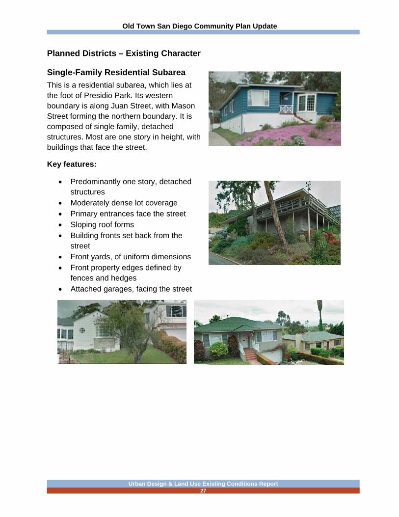
Planned Districts – Existing Character
Single-Family Residential Subarea
This is a residential subarea, which lies at the foot of Presidio Park. Its western boundary is along Juan Street, with Mason Street forming the northern boundary. It is composed of single family, detached structures. Most are one story in height, with buildings that face the street.
Key features:
Predominantly one story, detached structures
Moderately dense lot coverage Primary entrances face the street Sloping roof forms Building fronts set back from the
street Front yards, of uniform dimensions Front property edges defined by
fences and hedges Attached garages, facing the street
Old Town San Diego Community Plan Update
Urban Design & Land Use Existing Conditions Report
28
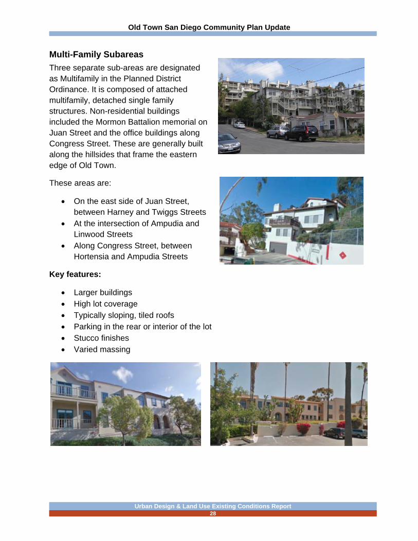
Multi-Family Subareas
Three separate sub-areas are designated as Multifamily in the Planned District Ordinance. It is composed of attached multifamily, detached single family structures. Non-residential buildings included the Mormon Battalion memorial on Juan Street and the office buildings along Congress Street. These are generally built along the hillsides that frame the eastern edge of Old Town.
These areas are:
On the east side of Juan Street, between Harney and Twiggs Streets
At the intersection of Ampudia and Linwood Streets
Along Congress Street, between Hortensia and Ampudia Streets
Key features:
Larger buildings High lot coverage Typically sloping, tiled roofs Parking in the rear or interior of the lot Stucco finishes Varied massing

Old Town San Diego Community Plan Update
Urban Design & Land Use Existing Conditions Report
29
Public Properties/Parks
This category is a collection of properties that are distributed around Old Town. It includes all the lands owned by public or governmental agencies.
These properties include:
Old Town San Diego State Historic Park Presidio Park County Heritage Park Whaley House Presidio Community Park and Recreation Center El Campo Santo Park California Department of Transportation, District 11
Office Fremont Elementary School/Ballard Parent Center Navy Facility on Pacific Highway
Old Town San Diego Community Plan Update
Urban Design & Land Use Existing Conditions Report
30
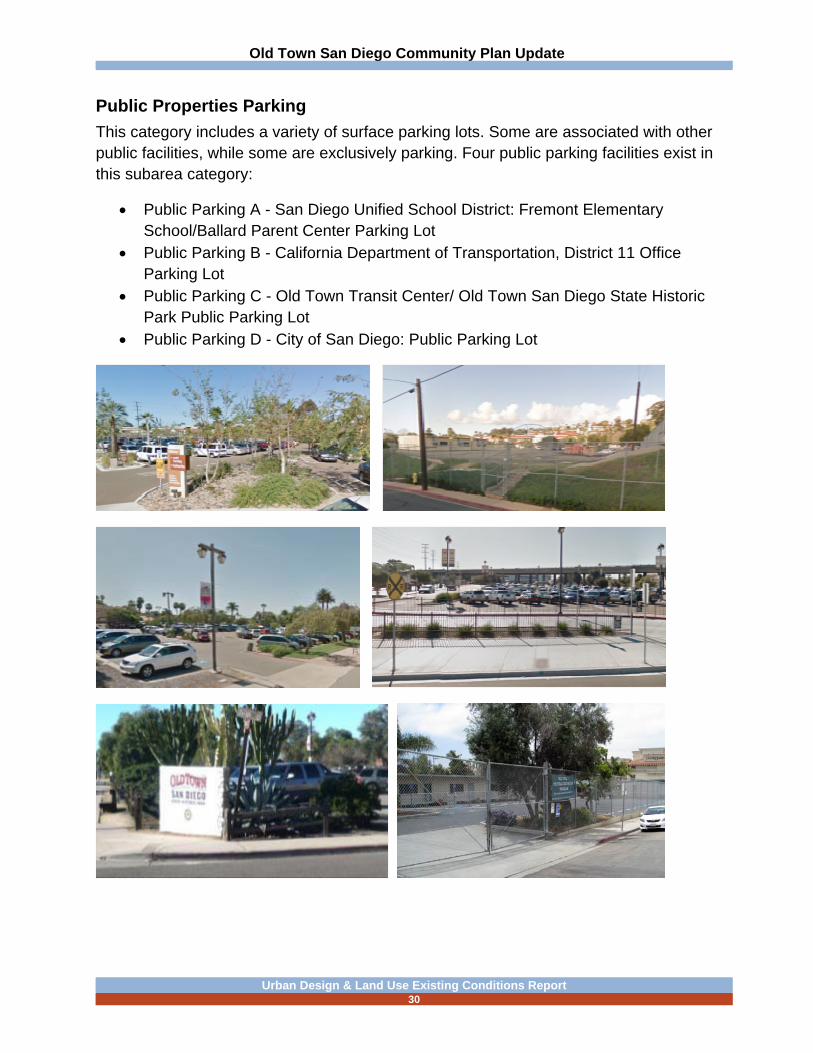
Public Properties Parking
This category includes a variety of surface parking lots. Some are associated with other public facilities, while some are exclusively parking. Four public parking facilities exist in this subarea category:
Public Parking A - San Diego Unified School District: Fremont Elementary School/Ballard Parent Center Parking Lot
Public Parking B - California Department of Transportation, District 11 Office Parking Lot
Public Parking C - Old Town Transit Center/ Old Town San Diego State Historic Park Public Parking Lot
Public Parking D - City of San Diego: Public Parking Lot

Old Town San Diego Community Plan Update
Urban Design & Land Use Existing Conditions Report
31
Core Subarea
The bulk of the Core Subarea focuses on San Diego Avenue, south of the State Park, with a portion extending west along Congress Street. Another, smaller, portion is located at Taylor and Juan Streets. This subarea abuts the Old Town San Diego State Historic Park. It contains a mix of small-scale buildings, many with commercial uses. It is the focus of commercial activities and of pedestrian activity. Most building designs are variations on the three historic themes that are established for building in Old Town. Several properties in this area may have historic significance.
Key features:
Many buildings have storefronts, which align at the inside edge of the sidewalk Moderate lot coverage Some small courtyards, framed with commercial activities Setbacks: Building fronts align at the inside sidewalk edge. Building form: Many buildings have flat roof profiles Pedestrian orientation Varied building forms and materials Occasional small courtyards and plazas

Old Town San Diego Community Plan Update
Urban Design & Land Use Existing Conditions Report
32
Jefferson Subarea
This is a small enclave of residential and commercial buildings facing Jefferson Street. This subarea is intended to support the core with medium scale buildings and provide for residential development, while limiting specific commercial use and location. Some older single family structures remain in this area.
Key features:
Larger multifamily and hotel structures Sloped roofs, with tile Parking interior to the property Irregular yards and varied setbacks
Old Town San Diego Community Plan Update
Urban Design & Land Use Existing Conditions Report
33
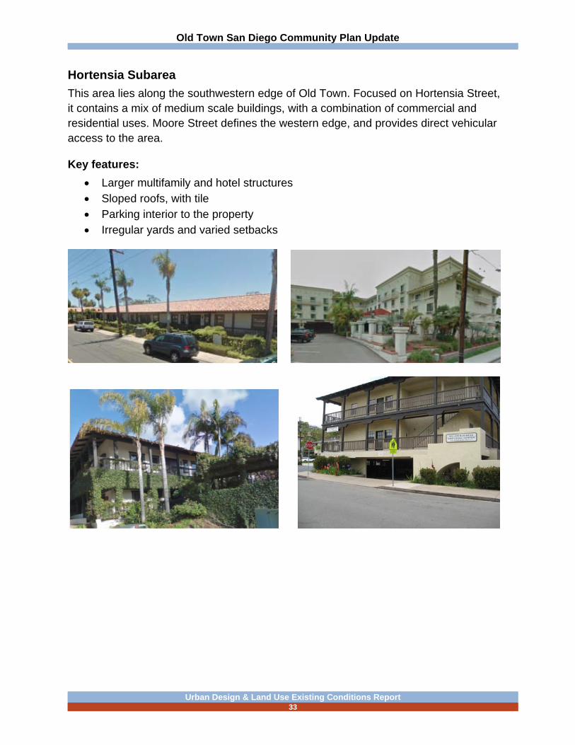
Hortensia Subarea
This area lies along the southwestern edge of Old Town. Focused on Hortensia Street, it contains a mix of medium scale buildings, with a combination of commercial and residential uses. Moore Street defines the western edge, and provides direct vehicular access to the area.
Key features:
Larger multifamily and hotel structures Sloped roofs, with tile Parking interior to the property Irregular yards and varied setbacks

Old Town San Diego Community Plan Update
Urban Design & Land Use Existing Conditions Report
34
Rosecrans Subarea
This subarea is a corridor, with Rosecrans Street (which becomes Taylor Street east of Pacific Highway) and Pacific Highway as the major corridor streets connecting Old Town to the adjacent communities. The rail corridor that parallels Pacific Highway crosses Taylor Street and divides the subarea. It contains a mix of comparatively larger buildings, in terms of building footprints and also relative heights (two and three stories). The Caltrans District 11 office building (completed in 2006) is the most noticeable building in the subarea. The subarea also has motel and commercial uses, a US Navy facility, and the former Caltrans District 11 office building.

Old Town San Diego Community Plan Update
Urban Design & Land Use Existing Conditions Report
35
Block Configuration
Old Town consists of a grid of streets that lie at a forty-five degree angle to the predominant north-south layout that exists to the south in Uptown and Downtown. This grid is interrupted by San Diego Avenue, which cuts diagonally across the grid. This yields a variety of triangular parcels and eccentric intersections. The rising topography along the eastern edge of Old Town also interrupts the grid.
Some larger parcels depart from the grid pattern:
Presidio Park Old Town State Historic
Park Caltrans Transit-Center U.S. Navy
Development Patterns
The development patterns in Old Town reflect early parcel and street layouts. In the core, along San Diego Avenue, buildings often align at the sidewalk edge. Along Taylor Street, larger buildings sit free-standing on their lots, with a landscaped foreground.

Old Town San Diego Community Plan Update
Urban Design & Land Use Existing Conditions Report
36
Figure Ground

Old Town San Diego Community Plan Update
Urban Design & Land Use Existing Conditions Report
37
Architectural Character & Details
Within all three of the architectural periods established for Old Town, the use of decorative details contributes to the overall character and visual interest of the area. These details also convey high quality craftsmanship in many cases.

Old Town San Diego Community Plan Update
Urban Design & Land Use Existing Conditions Report
38
Institutional Facilities
Institutional facilities serve the community in a variety of ways. These include public and private organizations and agencies. Architecturally, many public facilities stand out as landmarks, or as key reference points.

Old Town San Diego Community Plan Update
Urban Design & Land Use Existing Conditions Report
39
Small Plazas
Small plazas and courtyards provide places for active and passive activities throughout Old Town. These include gardens, dining patios, display areas and sculpture settings.

Old Town San Diego Community Plan Update
Urban Design & Land Use Existing Conditions Report
40
Street Furniture
A variety of street furnishings exists in Old Town. Near the core, these convey a more historical reference.

Old Town San Diego Community Plan Update
Urban Design & Land Use Existing Conditions Report
41
B. PUBLIC SPACES
Public spaces create opportunities for passive and active recreation, leisure, and entertainment, and help promote a sense of place and community identity. Old Town includes three distinctive public spaces that are owned by governmental entities. There are also a variety of privately owned, small plazas and courtyards, which are associated with commercial uses in the area.
County Heritage Park
Heritage Park, owned by the County of San Diego, is located along the eastern edge of Old Town, at the intersection of Juan Street and Harney Street. This park contains a collection of historic structures relocated from other sites in the county. Heritage Park was created in 1969.
El Campo Santo Pocket Park
El Campo Santo Pocket Park, owned by the City of San Diego (.28 acres), is located in the center of Old Town on San Diego Avenue. This pocket park features the historic El Campo Santo Cemetery.

Old Town San Diego Community Plan Update
Urban Design & Land Use Existing Conditions Report
42
Presidio Regional Park
Presidio Regional Park, owned by the City of San Diego (49 acres), is located on the northeast boundary of the Old Town community. This park is a resource-based park for the City of San Diego based on the historic sites for the Mission San Diego de Alcala and Fort Stockton. It also contains the Serra Museum, which houses many artifacts of early San Diego and the Southwest. The museum sits on a prominent site in the upper portion of the park.

Old Town San Diego Community Plan Update
Urban Design & Land Use Existing Conditions Report
43
Presidio Community Park and Recreation Center
Presidio Community Park and Recreation Center, owned by the City of San Diego (11.55 acres), is located west of Presidio Park, on Jackson Street. This park serves Old Town as a community park featuring a Recreation Center, picnic areas, multi-use fields, basketball courts, and a golf course.

Old Town San Diego Community Plan Update
Urban Design & Land Use Existing Conditions Report
44
Old Town San Diego State Historic Park
At the core of the Old Town neighborhood is the State Historic Park. It is centered at the terminus of San Diego Avenue and Twiggs Street. Visitors are offered a glimpse into yesteryear, as converging cultures transformed San Diego from a Mexican pueblo to an American settlement. The core of restored original historic buildings from the interpretive period are complemented by reconstructed sites, along with early twentieth century buildings designed in the same mode. The Historic Plaza remains a gathering place for community events and historic activity. Five original adobe buildings are part of the historic park, which includes museums, unique retail shops, and several restaurants.

Old Town San Diego Community Plan Update
Urban Design & Land Use Existing Conditions Report
45
Parks and Open Space

Old Town San Diego Community Plan Update
Urban Design & Land Use Existing Conditions Report
46
C COMMUNITY FACILITIES AND SERVICES
Public facilities provide important support functions to community life in Old Town. These include governmental agencies and services. There are also private organizations, such as religious institutions, that serve the public. Some facilities include schools and family support.
Police and Fire Rescue
The San Diego Police Department Western Division serves Old Town, which is located in Linda Vista. In addition, the Peninsula Police Storefront is in Midway. Old Town is serviced primarily by Fire Station Number 8, located just east of the community in Uptown at 3974 Goldfinch Street. Fire Stations 25, 20, and 3 are located in Bay Park, Midway, and Uptown, respectively and provide additional coverage to the community.
Libraries
The closest library to the community is the Mission Hills Public Library on West Washington Street. In addition, the Point Loma Library is a few miles to the west as well as the San Diego Central Library.
Schools
The San Diego Unified School District has designated the Old Town Community as an optional area. Parents have a choice of two or more schools for their children to attend for elementary, middle, and high schools (grades): Grant Elementary (K-8), Dewey Elementary (K-4), Roosevelt International Middle School (6-8), Dana Middle School (5-6), Correria Middle School (6-8), San Diego Complex High School (9-12), and Point Loma High School (9-12). The School District uses the Ballard Parent Center (Fremont School) located at 2375 Congress Street for parent outreach and engagement programs and educational and community programs.

Old Town San Diego Community Plan Update
Urban Design & Land Use Existing Conditions Report
47
D. MOBILITY SYSTEMS
This section addresses circulation and mobility from the standpoint of urban design. The mobility systems for Old Town include a variety of modes. A more detailed assessment will be provided a separate mobility existing conditions report.
Gateways & Key Intersections
A variety of gateways and key intersections exist in the Old Town community. Many of these gateways and intersections function as part of pedestrian and bicycle circulation systems, while others relate to automobiles. Taylor Street is an access point to Old Town at Congress and Juan Streets. Old Town Avenue serves as a gateway from Interstate 5 into Old Town. San Diego Avenue and Juan Street both connect the Old Town community to the adjacent Uptown community.
Some key auto gateways and intersections are:
Old Town Avenue and Moore Street Taylor and Juan Streets
Some key pedestrian gateways and crossings are:
Northwest Old Town State Historic Park Entry at the intersection of Congress and Rosecrans Street /Taylor Street, near the transit center
San Diego Avenue and Twiggs Street
Old Town Avenue and Moore Streets

Old Town San Diego Community Plan Update
Urban Design & Land Use Existing Conditions Report
48
Taylor and Juan Streets
Northwest Old Town State Historic Park Entry at the intersection of Congress and Rosecrans (Taylor), near the transit center
Intersection of Congress and San Diego Avenue

Old Town San Diego Community Plan Update
Urban Design & Land Use Existing Conditions Report
49
San Diego Avenue and Twiggs Street
Bicycle Systems
In the core of Old Town, bicycles share travel lanes with motorized vehicles as indicated by the shared lane roadway markings.
Key bicycle circulation is along Congress and Twiggs Streets, and Old Town and San Diego Avenues. Other notable use is along Juan Street, as an access to the Presidio Park.
Pedestrian Environment
The pedestrian environment consists of a network of sidewalks that frame virtually all developed blocks in the community. These are typically concrete, although in some locations, decorative paving materials are used that can create a sense of place for pedestrians. These are then linked with crosswalks at most intersections. Some pedestrian routes are not paved sidewalks, but are instead packed earth trails, specifically some of these pedestrian entries into Old Town State Historic Park.
From an urban design standpoint, the greatest level of pedestrian activity flanks the Old Town State Historical Park. The greatest level of activity is along San Diego Avenue, in the first two blocks south of the park entrance, but it also extends out from there for two blocks in either direction. This includes portions of Congress Street, from Taylor to Conde Streets, where visitors are accessing the transit center, as well
Old Town San Diego Community Plan Update
Urban Design & Land Use Existing Conditions Report
50
as portions of Twiggs and Harney Streets. This is an area with the greatest concentration of dining, retail and entertainment facilities. Pedestrian activity is also substantial farther south on San Diego Avenue and the streets that cross it. This is stimulated by several accommodations facilities, as well as other commercial uses.
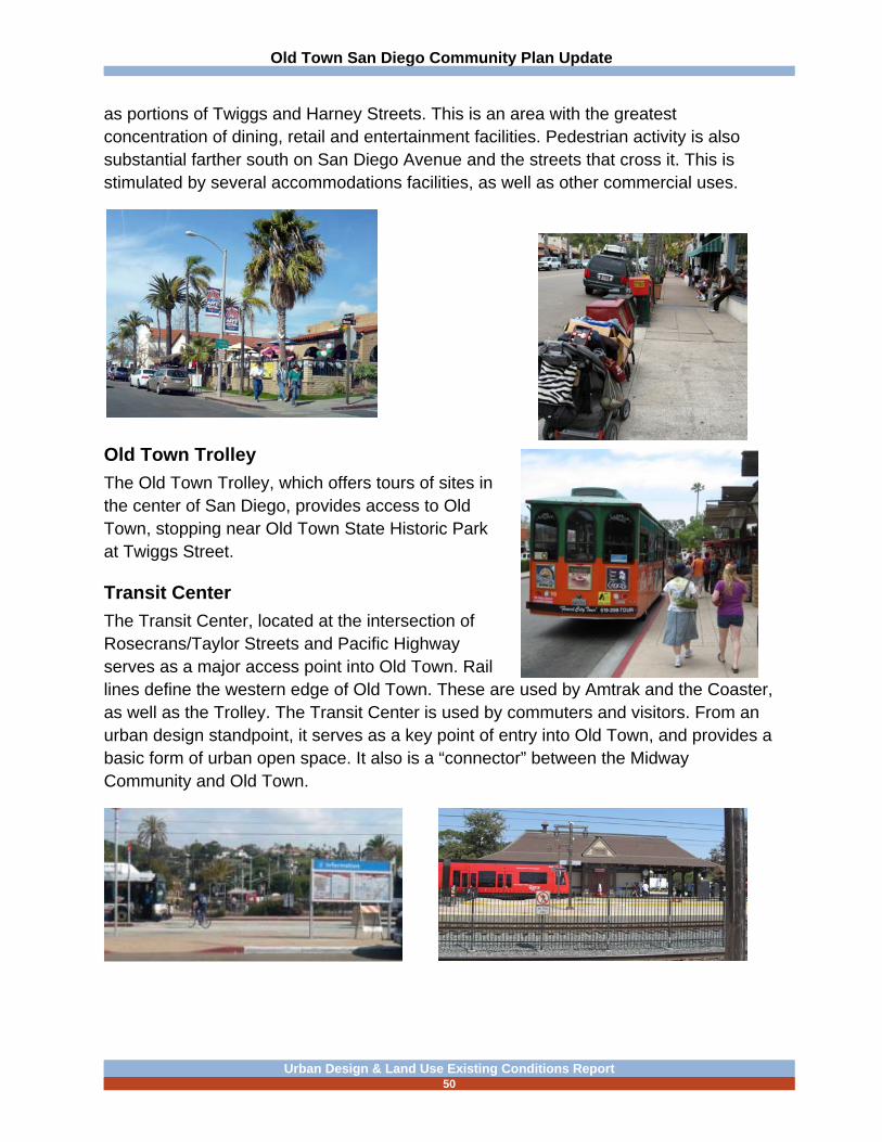
Old Town Trolley
The Old Town Trolley, which offers tours of sites in the center of San Diego, provides access to Old Town, stopping near Old Town State Historic Park at Twiggs Street.
Transit Center
The Transit Center, located at the intersection of Rosecrans/Taylor Streets and Pacific Highway serves as a major access point into Old Town. Rail lines define the western edge of Old Town. These are used by Amtrak and the Coaster, as well as the Trolley. The Transit Center is used by commuters and visitors. From an urban design standpoint, it serves as a key point of entry into Old Town, and provides a basic form of urban open space. It also is a “connector” between the Midway Community and Old Town.

Old Town San Diego Community Plan Update
Urban Design & Land Use Existing Conditions Report
51
E. STREETSCAPE AND WAYFINDING
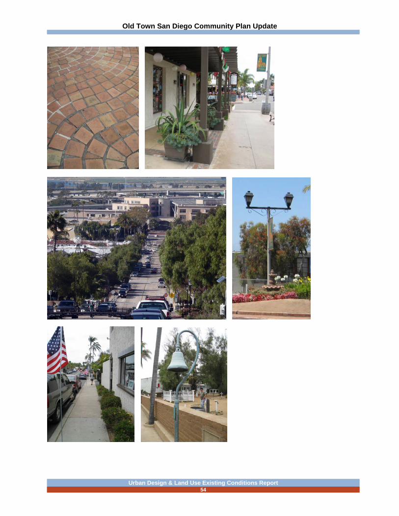
Plain concrete sidewalks frame the streets. In a few locations, decorative paving has been installed, usually a tile or brick paver. Most sidewalks are relatively narrow. Within the core are, where are utility boxes, sign poles, and newspaper racks constrain pedestrian movement on sidewalks. The sidewalk system is connected with painted crosswalks at signalized street intersections.
Few street trees or other plantings exist along the sidewalk areas. There are limited places where the right-of-way provides landscape space along the sidewalk. In some areas there are mature trees, planted on private property, that provide some limited shade along the public sidewalks. In a few settings, a landscape strip separates the sidewalk from the curb, but these spaces are not well planted.
Inside property lines, however, there are many locations where decorative paving occurs in patios and courtyards, and more intensive plantings also are found there. In a few locations, decorative paving extends to the curb.
Street lights are installed on all streets. Many are antique fixtures, using a coach light style. Others are standard City streetlights. In some private locations, more decorative fixtures appear. Waste receptacles vary in design; some are standard City exposed aggregate concrete, while others are rustic wooden barrels.
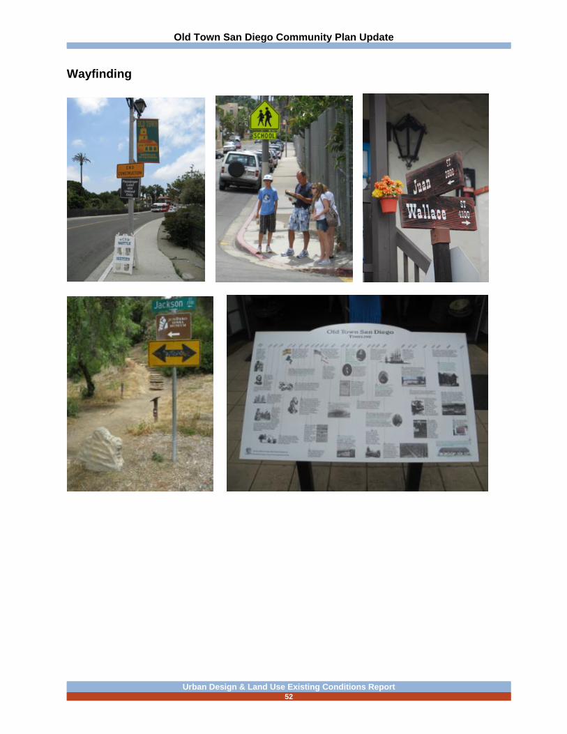
In terms of wayfinding signs and distinctive identifiers for Old Town, banners on utility poles are used extensively in the Core. At key entry points, monument signs are used to denote the boundaries of Old Town, but these are relatively subordinate to the overall street scene.
Overall, the visual interest of the streetscape is intermittent. Some areas, particularly in the core, have a sense of variety and diversity that may support a sense of exploration and surprise. In the outlying portions of the community, there is less of a distinction, and in some places, it is difficult to discern where the boundaries of Old Town are.
Old Town San Diego Community Plan Update
Urban Design & Land Use Existing Conditions Report
52
Wayfinding

Old Town San Diego Community Plan Update
Urban Design & Land Use Existing Conditions Report
53
Streetscape Character
Streetscape Character (continued)
Old Town San Diego Community Plan Update
Urban Design & Land Use Existing Conditions Report
54

Old Town San Diego Community Plan Update
Urban Design & Land Use Existing Conditions Report
55
Signs Character