on the formations of the pampas in the footsteps … · resumen: sobre las ... on the formations of...
TRANSCRIPT

124 Revista de la Asociación Geológica Argentina 64 (1): 124 - 136 (2009)
INTRODUCTION
In the course of the winter of 1833,Charles Darwin travelled across the Bue-nos Aires Pampas. His observations, aswell as those by Alcide d´Orbigny (1842),the French naturalist who explored theregion some years before Darwin, werepart of the initial expansion stage ofgeology as a science. The explorations ofboth naturalists are framed within the
creation of a universal scheme of theEarth history in which all the regions ofthe world would be incorporated (Pod-gorny et al. 2008).In early August of 1833, Darwin disem-barked from the Beagle at Patagones, atown by the Rio Negro, in northern Pa-tagonia and began his journey headingnorth towards Bahía Blanca. From therehe travelled across the southern Pampasto the Rio Salado area and Buenos Aires,
continuing later to Santa Fe. Logistics forthe trip was provided by Juan Manuel deRosas - the Argentine administrator atthe time - in the form of a passport totravel, horses, and a group of soldiersand gauchos to escort him. In his diary,Darwin took notes on the Pampean sce-nery, referring to the dominant vegeta-tion, the available water sources, the to-pographic features and the sedimentsand rocks he found along the journey. He
ON THE FORMATIONS OF THE PAMPAS IN THE FOOTSTEPS OF DARWIN: SOUTH OF THE SALADO
Marcelo ZÁRATE1 and Alicia FOLGUERA2
1 CONICET- Facultad de Ciencias Exactas y Naturales, Universidad Nacional de La Pampa, Santa Rosa, La Pampa.E-mail: [email protected] Servicio Geológico Minero Argentino (SEGEMAR), Buenos Aires. Email: [email protected]
ABSTRACTIn 1833 during his journey across the Buenos Aires Pampas, Charles Darwin made observations that reflected his thoughtson two major landscape units, Pampa interserrana and Pampa deprimida, later identified by other authors. Darwin grouped thePampean sediments into a single unit, the Pampean Formation, based upon the lithological homogeneity and the large extensionof the deposits; the unit was thought to be of estuarine-marine origin and attributed to the Recent Epoch considering thepaleontological content (vertebrates and mollusks). At present, the Pampean sedimentary succession, which accumulatedapproximately during the last 11-12 Ma, is interpreted as a pedosedimentary sequence due to the ubiquity of pedogenetic fea-tures throughout the deposits. Four main subcycles of sedimentation are identified related to reactivations of the Pampeanlandscape. At a regional scale, the outcrop distribution of Pampean sediments of different ages suggests the dominance ofmore stable conditions since the late Miocene-Pliocene in a vast area of Pampa interserrana, documented by the formation ofcalcretes. However, sedimentation during the late Pliocene-Pleistocene was active within the domain of the Salado tectonicbasin and Sierras de Tandil. The regional disparity shown by the Pampean stratigraphic record reveals the major morphos-tructural differences of its basement.
Keywords: Charles Darwin, Pampean sediments, Calcrete, Geomorphology, Buenos Aires.
RESUMEN: Sobre las formaciones de las Pampas en los pasos de Darwin: al sur del Salado. Durante su viaje por la Pampa bonaerense en 1833 Charles Darwin efectuó observaciones que reflejaban las dos grandes unidades de paisaje posteriormente reconocidasen la región, la Pampa interserrana y la Pampa deprimida. La homogeneidad litológica y la vasta extensión de los depósitosfueron los criterios básicos empleados para agruparlos en una única unidad, la Formación Pampeano; basado en criterios pale-ontológicos le atribuyó origen estuárico-marino y la asignó a la época Reciente. Si bien han existido otras propuestas estrati-gráficas, Formación Pampeano o simplemente Pampeano, son denominaciones empleadas informalmente y con un significa-do algo vago. Actualmente, sobre la base de la ubicuidad de los rasgos pedológicos de la sucesión sedimentaria se la interpre-ta como una secuencia pedosedimentaria acumulada durante los últimos 11-12 millones de años, se han reconocido 4 ciclosde sedimentación principales relacionados con reactivaciones del paisaje pampeano. Regionalmente, la distribución areal deniveles aflorantes de distintas edades sugiere una mayor estabilidad relativa en el sur, marcada por la formación de calcretosen la Pampa interserrana a partir del Mioceno tardío-Plioceno y mayor continuidad del proceso sedimentario en el ámbito dela cuenca tectónica del Salado y de las sierras de Tandil. Las variaciones regionales exhibidas por el registro estratigráfico delCenozoico tardío constituyen una manifestación del comportamiento diferencial de las unidades morfoestructurales que inte-gran el basamento de la sucesión sedimentaria.
Palabras clave: Charles Darwin, Sedimentos pampeanos, Tosca, Geomorfología, Buenos Aires.

also provided a historical picture of Ar-gentina with descriptions and his ownviewpoints on the people and the on-going war with the aboriginal groups toexpand the frontier of the southern terri-tories westward. The information gathe-red during the field trip was the raw ma-terial to write On the Formations of the Pam-pas, the fourth chapter of his GeologicalObservations on South America (1846).The vast extent, the disputed origin andthe abundance of fossil mammal remainswere the three main aspects underlinedby Charles Darwin when he summarizedthe characteristics of the Pampean sedi-ments. What was the meaning of thePampean Formation as used by Darwin?;what is the meaning of this term at pre-sent?; what is our present understandingof the late Cenozoic Pampean geology?.This paper is particularly focused on theBuenos Aires Pampas, south of the RioSalado, the region that Darwin exploredduring the winter of 1833; it includescomments on specific observations hemade elsewhere to understand better hisinterpretations and inferences. Conse-quently, the main goal is to analyze anddiscuss his observations on the landscapeand the sediments within the frameworkof our present understanding of the lateCenozoic geology of the southern Pam-pean plain. With this purpose in mind,the present contribution brings in Dar-win´s comments and interpretations onthe landscape along with the nature,composition and areal distribution of thePampean sediments (terms, descriptions,and special comments are quoted in ita-lics and referred to his diary and thechapter on the Formations of the Pam-pas). These particular issues are then ana-lyzed from our present geological pers-pective, providing an updated geologicalreview.
DARWIN´S ITINERARY ANDHIS PERCEPTION OF THEPAMPEAN LANDSCAPE
Charles Darwin travelled around 650 km(400 geographical miles) from Rio Colora-
do to Buenos Aires following the roadthat connected the military outposts(Postas) set up along the western frontierin 1833 during the ongoing war with theaboriginal groups (Fig. 1).On the way to Bahía Blanca, once hecrossed the Río Colorado, Darwin noti-ced a major change between the Patago-nian and the Pampean environments"...The country had a different appearance fromthat South of the Colorado: there were manydifferent plants and grasses and not nearly somany spiny bushes and these gradually becameless frequent; until a little to the North there isnot a bush..."(Darwin's Beagle Diary 1831-1836). In southern Buenos Aires provin-ce he examined the neighboring areas ofBahia Blanca and Punta Alta where hespent around a week. On August 27th
Darwin continued to the next militaryoutpost, "Sauce Posta", situated by the RioSauce Grande, "…the distance was about 6leagues from Sierra de la Ventana…" (Dar-win's Beagle Diary 1831-1836). It is likelythat this Posta was situated in the vicinityof the present village of Saldungaray.From the Sauce Posta, Darwin headed toSierra de la Ventana (Ventania range).There he stayed for around 3 days explo-ring the ranges which were described as"…a desert mountain of pure quartz rock.Itsheight is between 3 and 4000 feet …" (Dar-win's Beagle Diary (1831-1836). Fromthe notes reported in his diary he pro-bably examined the rock outcrops andthe landscape of the upper basin of RioSauce Grande and its surroundings, rea-ching the area of the highest peaks
On the formations of the Pampas in the footsteps of Darwin: ... 125
Figure 1: Darwin´s itinerary across the Pampean plain of Buenos Aires province. S: Sauce Posta, T:Tapalqué, G: Guardia del Monte; 1833 frontier adapted from Rolleri et al. (2005)
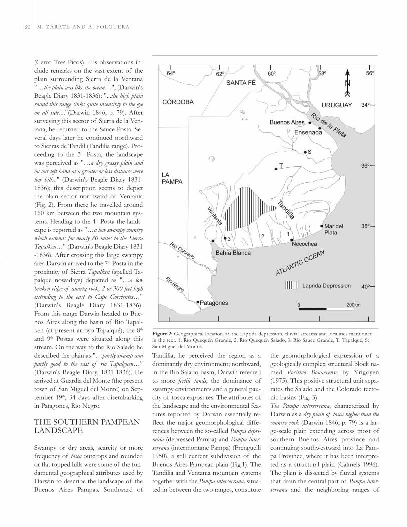
(Cerro Tres Picos). His observations in-clude remarks on the vast extent of theplain surrounding Sierra de la Ventana"…the plain was like the ocean…", (Darwin'sBeagle Diary 1831-1836); "...the high plainround this range sinks quite insensibly to the eyeon all sides..."(Darwin 1846, p. 79). Aftersurveying this sector of Sierra de la Ven-tana, he returned to the Sauce Posta. Se-veral days later he continued northwardto Sierras de Tandil (Tandilia range). Pro-ceeding to the 3rd Posta, the landscapewas perceived as "…a dry grassy plain andon our left hand at a greater or less distance werelow hills.." (Darwin's Beagle Diary 1831-1836); this description seems to depictthe plain sector northward of Ventania(Fig. 2). From there he travelled around160 km between the two mountain sys-tems. Heading to the 4th Posta the lands-cape is reported as "…a low swampy countrywhich extends for nearly 80 miles to the SierraTapalken…" (Darwin's Beagle Diary 1831-1836). After crossing this large swampyarea Darwin arrived to the 7th Posta in theproximity of Sierra Tapalken (spelled Ta-palqué nowadays) depicted as "…a lowbroken ridge of quartz rock, 2 or 300 feet highextending to the east to Cape Corrientes…"(Darwin's Beagle Diary 1831-1836).From this range Darwin headed to Bue-nos Aires along the basin of Rio Tapal-ken (at present arroyo Tapalqué); the 8th
and 9th Postas were situated along thisstream. On the way to the Rio Salado hedescribed the plain as "…partly swamp andpartly good to the east of rio Tapalguen…"(Darwin's Beagle Diary, 1831-1836). Hearrived at Guardia del Monte (the presenttown of San Miguel del Monte) on Sep-tember 19th, 34 days after disembarkingin Patagones, Rio Negro.
THE SOUTHERN PAMPEANLANDSCAPE
Swampy or dry areas, scarcity or morefrequency of tosca outcrops and roundedor flat topped hills were some of the fun-damental geographical attributes used byDarwin to describe the landscape of theBuenos Aires Pampas. Southward of
Tandilia, he perceived the region as adominantly dry environment; northward,in the Rio Salado basin, Darwin referredto more fertile lands, the dominance ofswampy environments and a general pau-city of tosca exposures. The attributes ofthe landscape and the environmental fea-tures reported by Darwin essentially re-flect the major geomorphological diffe-rences between the so-called Pampa depri-mida (depressed Pampa) and Pampa inter-serrana (intermontane Pampa) (Frenguelli1950), a still current subdivision of theBuenos Aires Pampean plain (Fig.1). TheTandilia and Ventania mountain systemstogether with the Pampa interserrana, situa-ted in between the two ranges, constitute
the geomorphological expression of ageologically complex structural block na-med Positivo Bonaerense by Yrigoyen(1975). This positive structural unit sepa-rates the Salado and the Colorado tecto-nic basins (Fig. 3).The Pampa interserrana, characterized byDarwin as a dry plain of tosca higher than thecountry rock (Darwin 1846, p. 79) is a lar-ge-scale plain extending across most ofsouthern Buenos Aires province andcontinuing southwestward into La Pam-pa Province, where it has been interpre-ted as a structural plain (Calmels 1996).The plain is dissected by fluvial systemsthat drain the central part of Pampa inter-serrana and the neighboring ranges of
M. ZÁRATE AND A. FOLGUERA126
Figure 2: Geographical location of the Laprida depression, fluvial streams and localities mentionedin the text. 1: Río Quequén Grande, 2: Río Quequén Salado, 3: Río Sauce Grande, T: Tapalqué, S:San Miguel del Monte.

Tandilia and Ventania. Fluvial terracesare present along the main river valleysgenerating a stepped topography. In theupper basins of some of the main rivers(Quequén Grande, Quequén Salado, Sau-ce Grande), as well as other streams drai-ning the Ventania range, the erosionalretreat of the plain surface during theexcavation of river valleys gave rise to ahilly and moderately undulating landsca-pe composed of flat-topped and smo-oth-shaped isolated hills (Fig.4a).The plain is capped by a calcareous duri-crust (Fig. 4b) or calcrete (Darwin´s toscarock, see below), in turn covered by a lar-ge apron of eolian sandy silts and siltysands, around 1.5- 2 meters thick, makingup the parent material of the presentlycultivated Pampean soils. North-north-westward the landscape grades into a low-gradient area characterized by very poordrainage conditions with numerous sha-llow lakes and flooded environments,known as Laprida depression (Fig. 2), anendorheic sector (Dangavs 2005) still po-
orly known. The environmental featuresof this area fit Darwin´s description of alarge swampy environment before hereached Sierras de Guitru Gueyú (the pre-sent group of low ranges at the north-western part of Tandilia).Since Darwin´s observations on somegeneral morphological characteristics ofthe southern ranges of Buenos Aires, thegeomorphology of Tandilia and Venta-nia has been the focus of only a few stu-dies, although these have documentedsignificant stages of landscape develop-ment, some not yet fully understood. InSierra de la Ventana, Keidel (1916) poin-ted out the presence of old erosion sur-faces at different altitudes in the area ofthe upper basin of Rio Sauce Grande. Inturn, Teruggi and Kilmurray (1980) men-tioned the presence of monadnocks andold peneplain surfaces in the Sierras deTandil. Recently, a stepped topographycomposed of erosion surfaces at diffe-rent elevations was recognized and geo-morphologically correlated at both
mountain ranges (Demoulin et al. 2005).A model of landscape evolution hasbeen proposed hypothesizing that thehighest erosion surfaces of both rangesformed prior to the break-up of Gond-wana and the rifting process which led tothe opening of the South AtlanticOcean. This long-lasting history ofdenudation included intervals of lands-cape stability and reactivation which arethought to be related to the evolution ofthe Colorado and Salado tectonic basins(Demoulin et al. 2005). In this context,one of Darwin´s observations in Sierrade la Ventana, becomes particularly reve-aling. He reported a rock outcrop, "…afew small patches of conglomerate and brecciafirmly cemented by ferruginous matter at a heightof 300 to 400 m…" (Darwin 1846, p. 79).This description is in agreement with thegeomorphic setting and the general litho-logical characteristics of Brecha Cerro Co-lorado (Andreis et al. 1971) or ConglomeradoRojo (Harrington 1936), a deposit asso-ciated with one of the regional erosionsurfaces identified in Sierra de la Ventana(Keidel, 1916, Demoulin et al. 2005).Northward of Tandilia range, in the do-main of the Salado tectonic basin, thelandscape can be subdivided into twomain geomorphic settings. Along the Sie-rras de Tandil, Tricart (1973) pointed outthe occurrence of extensive areas of flu-vial discharge interpreted as alluvial fansthat reached the Río Salado. Later, Fi-dalgo (1983) described a 20-km widepiedmont region and also identified allu-vial fan-like landforms exhibiting a distri-butary drainage pattern. The area ofarroyo Tapalqué visited by Darwin is lo-cated in this piedmont setting, characteri-zed by a progressive altitudinal decreasenorthward, reflecting a gradual change toimperfect drainage conditions. A veryflat topography with gradients rangingfrom 0.1% to 0.01% typifies the centralpart of the Salado tectonic basin; nume-rous shallow lakes (lagunas) and swampyenvironments are present. The Río Sa-lado floodplain, several kilometers widein some areas, and including shallow la-kes interconnected during flooding
On the formations of the Pampas in the footsteps of Darwin: ... 127
Figure 3: Morphostructural units of Buenos Aires province, modified after Yrigoyen (1975).

events, was crossed by Darwin who poin-ted out: "…12th to 13th to 14th posta: we hadto ride for a long distance in water above thehorse knees..." (Darwin's Beagle Diary,1831-1836). After passing the Río Saladoand before arriving to Guardia del Mon-te, he stayed at a large estancia owned byJuan Manuel de Rosas. Several isolatedhills (Los Cerrillos), occur in this sector.These features are around 10 meters abo-ve the surrounding plain and are locatedon the eastern side of shallow lakes (Fig.
6). The hills represent lunettes generatedby eolian deflation of the topographicdepressions, presently occupied by sha-llow water bodies, under drier conditions(Tricart 1973, Dangavs 2005).
Stratigraphy and lithology of Pam-pean sediments: the meaning of thePampean Formation
Darwin typified the sediments of thePampean Formation as "...a dull reddish,
slightly indurated argillaceous earth or mud,often but not always, including in horizontallines concretions of marl, and frequently passinginto a compact marly rock..." (Darwin 1846,p. 89). The reddish argillaceous earth wasnamed "Pampean mud". Darwin emphasi-zed the great extent of the Pampean For-mation as one of its most striking featu-res. According to his own observationsand the reports from d´Orbigny andother travelers he considered that theunit extended from the vicinity of RioColorado in the south to beyond SantaFe in the north "…M. d´Orbigny traced itfor 250 miles further north…"(Darwin 1846,p. 97); and from Banda Oriental (Uru-guay) in the east to Cordoba to perhapsMendoza in the west. Finally he stated"… the area of the Pampean Formation, as re-marked by d´Orbigny is at least equal to that ofFrance and perhaps twice or three as great…"(Darwin 1846, p. 97). Thus Darwin co-rrectly perceived what we now know tobe the great geographic extent of thePampean Formation.Darwin also stressed the lithological ho-mogeneity of the sediments that hegrouped into a single unit, the PampeanFormation. The concept of Formation(gebirgsformation), as a geological unit, wascoined by Abraham Gottlob Werner(1749-1817), a German geologist fromthe School of Mines at Freiberg, with thepurpose of defining a historical entitythat included rock bodies formed duringthe same time interval; at a higher hierar-chical rank, the term terrain grouped se-veral formations. Both terms, formationand terrain, although representing unitsof different stratigraphic hierarchy, werelater used as synonyms by other authors.Nevertheless, during the decade of the1840s, the term formation took root in theAnglo-Saxon community, while terrain,as a synonym of formation, was adoptedin the French geology literature (Pod-gorny et al. 2008).Since Darwin´s visit, several other resear-chers have stressed the apparent litholo-gical homogeneity of the Pampean sedi-ments. At a regional scale of analysis thedeposits look rather alike, dominantly
M. ZÁRATE AND A. FOLGUERA128
Figure 4: Plain capped by the tosca rock (calcrete). a) Isolated hill formed by fluvial erosion of theRío Sauce Grande, south of Saldungaray; Sierra de la Ventana at the background; b) Calcrete crustand resulting tableland aspect of the plain by the Río Sauce Chico valley, west of Bahia Blanca.

composed of sandy silt and silts of lightbrown to reddish brown colors, commonpresence of calcareous accumulations ofvarious morphologies and a general mas-sive appearance. This perception of li-thological homogeneity was accentuatedby the nature of the exposures, scatteredand discontinuous outcrops of relativelyreduced thickness and mostly situatedalong river banks, which constrain thedetailed analysis of the spatial and tem-poral relationships of the sediments. Ex-ceptions were the exposures along theRío Paraná and the Monte Hermoso sea-cliff, where Darwin was able to examinethe deposits and their paleontologicalcontent in better exposures. To examinethe Pampean subsurface he described thelithology of some wells in the vicinity ofBuenos Aires and south of Bahia Blan-ca:"… in a well at the depth of seventy feet, ac-cording to Ignatio Nunez, much tosca-rock wasmet with, and at several points, at 100 feet deep,beds of sand have been found..." (Darwin1846, p. 77). Also, 50 km SE Buenos Ai-res, along the coast of Rio de la Plata atEnsenada (Fig. 2), Darwin examined theexposures of a quarry "…specimens fromnear Ensenada, given me by Sir W. Parish,where the rock is quarried just beneath the sur-face of the plain..." (Darwin 1846, p. 78).Since the mid-XIX century, many contri-butions have been focused on the strati-graphy and several different classifica-tions were proposed. The purpose hereinis not to make a review of the differentstratigraphic classifications, but to stressthe concepts and ideas on which the sub-division of the Pampean sediments isbased. Up to the present, however, Pam-pean stratigraphy has remained a contro-versial and debatable issue; various diffe-rent schemes are still used simultaneously(Table 1).The homogeneity of the deposits toge-ther with the discontinuity of the expo-sures forced the search of a criteria otherthan the lithology to separate the Pam-pean sediments. Eventually this led to theutilization of the fossil vertebrate con-tent to separate the deposits into diffe-rent stratigraphic units. Therefore, those
localities with exposures laterally conti-nuous for several km as the Mar del Platasea-cliffs, the Río Paraná bank exposu-res and the sea-cliff at Monte Hermosowere subdivided on the basis of their pa-leontological content (among othersAmeghino 1908, Frenguelli 1957, Krag-lievich 1952). At the end of the 19th cen-tury, the stratigraphic analysis of thePampean deposits was benefited signifi-cantly by deep excavations during theconstruction of the harbours at BuenosAires and La Plata. These temporary ex-posures provided sections several metersthick that became type localities, not lateravailable, to characterize the uppermostinterval of the Pampean deposits (Ame-ghino 1908). The resulting schemes beca-me the groundwork that guided subse-quent stratigraphic studies.Much later, the identification of units onthe basis of the vertebrate fossil contentevolved into the concept of land-mam-mal ages (Pascual et al. 1965), a funda-mental stratigraphic tool still widelyaccepted and used. In recent years, thesebiostratigraphic units have been redefi-ned and updated (Cione et al. 2007 andreferences therein). The relative degreeof evolution inferred from the fossil as-semblages was used in the stratigraphicarrangement of the Pampean deposits.Accordingly, and considering their pale-ontological content, several units wereidentified, and classified as lithostratigra-phic units (formations) receiving their
names after the locality where they weredescribed (among others, Epecuén For-mation, Saldungaray Formation, IreneFormation, Arroyo Chasicó Formation;Fidalgo et al. 1975 and references the-rein).As time passed, in spite of the numerousschemes proposed, Pampean Formation orsimply Pampeano developed into termsthat became deeply rooted in the Argen-tine geological literature; both becamesynonyms to refer to the Pampean depo-sits. At present, the term Pampeano is stillused informally with a rather loose sig-nificance. However, general agreementexists to separate the surficial LatePleistocene-Holocene sedimentary coverfrom the underlying Pampean deposits.Following this line of reasoning, the pre-late Pleistocene deposits exposed in thePampa interserrana and the Salado Basinwere grouped again into a single unit, theFormación Pampeano (Pampean Formation)identified exclusively on the basis of li-thological attributes (Fidalgo et al. 1973).This proposal is somewhat close to theoriginal meaning given by Darwin to theterm Pampean Formation. Regardless of itsvertebrate fossil content, the unit definedis nevertheless useful for mapping pur-poses and well descriptions. More recentschemes tend to divide the upper part ofthe Pampean deposits into two units(Ensenada and Buenos Aires Forma-tions) distinguished on the basis of theirpaleontological content (Table 1). In
On the formations of the Pampas in the footsteps of Darwin: ... 129
Ameghino Kraglievich Frenguelli Fidalgo et al. Riggi et al.(1908) (1952) (1957) (1973) (1986)
TABLE 1: Some of the best known stratigraphic schemes of the Pampean sediments.Those by Fidalgo et al. (1973) and Riggi et al. (1986) are currently used.
Postpampeano
FmPampeano
FmAraucano
PlatenseLujanenseBoanerense
Ensenadense
ChapalmalenseMonte-hermosense
Fm de Lobería
Fm de Arroyo Seco
Fm de MiramarFm de San Andrés
Fm de VorohuéFm de Barrancade los LobosFm de Chapadmalal
Serie postpam-peanoBonaerense
Ensenadense
Chapadmalense
Fm La Postrera/Fm Luján
Fm Pampiano
Fm Buenos Aires
Fm Ensenada

turn, the uppermost sedimentary mantlewas subdivided into several lithostratigra-phic units that represent lithofacies ofdifferent geomorphic processes and en-vironmental settings such as eolian, flu-vial and littoral deposits (among othersFidalgo et al. 1973 a,b).
The Pampean sediments today: cu-rrent ideas and interpretations
At present the Pampean sediments arelithologically characterized as light brownto reddish brown sandy silts or siltysands, moderately indurated with a gene-ral massive appearance. Darwin´s inter-pretation was that the "...deposits were accu-mulated in the former estuary of Rio de la Plataand in the sea adjoining it…" (Darwin 1846,p. 99); the source area of the Pampeanmud was thought to come from the wea-thering of igneous and metamorphicrocks of Brazil and Uruguay (Darwin1846, p. 100).The mineral composition of the Pam-pean sediments reflects their derivationfrom volcaniclastic material in turn mos-tly derived from Andean rocks, with mi-nor contributions (Precambrian graniticand metamorphic rocks and Paleozoicquartzites) from the Tandilia and Venta-nia ranges in the southern part. North-ward, the Pampean ranges of Córdobaand San Luis and the Brazilian shield we-re secondary source areas (Teruggi 1957,González Bonorino 1965, Zárate 2003and references therein). A detailed analy-sis of the deposits reveals grain sizechanges and variations in the density, co-lor, and mineralogical composition ac-cording to the sediment age and the geo-graphic setting considered within thePampean plain.The massive appearance and the ratheruniform lithology, among other attribu-tes, were usually taken as evidence of aneolian origin and the sediments havebeen interpreted as loess. Nervertheless,Teruggi (1957) pointed out that the dis-tribution of primary loess was quite limi-ted, a statement reconfirmed by more re-cent studies (Zárate 2003 and references
therein). Across the Pampean environ-ment, primary loess facies have a lowpreservation potential. The deposits arelocally reworked either by aqueous trans-port agents (loess-like or loessoid depo-sits) or modified by pedogenesis (weathe-red loess). Loess-like deposits exhibit aweak and poorly expressed sedimentarystructure consisting either of horizontalbedding or cross bedding. Along thepiedmont areas, channelized lithofaciesrepresenting fluvial paleoenvironmentsinclude rock fragments from bedrock ofthe Tandilia and Ventania ranges. At dis-tal settings from the ranges, the coarsefluvial facies are made up of bones andtosca fragments embedded in a sandymatrix.Paleosols are a very common featurewith pedogenic traits (pedogenic structu-re, textural changes resulting from eluvia-tion, carbonate leaching, evidences ofbioturbation features from soil microfau-na and vegetation) distributed throug-hout the Pampean sediments. Welded pa-leosols resulting from the superpositionof pedogenetic process have been repor-ted in both Pliocene and Pleistocene stra-tigraphic sections of the Pampean suc-cession. Micromorphological studies al-so point to the occurrence of intervalswhen sediments accumulated progressi-vely on the surface while soil formationwas active, resulting in accretionary soilsurfaces. From a sedimentological pers-pective, the occurrence of numerouspaleosol levels throughout the depositsdocuments an episodic sedimentationprocess. Due to the ubiquity of pedoge-nic features, the Pampean succession isinterpreted as a pedosedimentary se-quence (i.e. Kemp and Zárate 2000,Zárate et al. 2002). The presence of wel-ded paleosols and intervals of accretio-nary pedogenesis suggest a variablebalance of pedogenesis and sedimenta-tion through time. At some sections, theoccurrence of discrete paleosol levels,stratigraphically superposed, allow infe-rring some sort of cyclicity in soil forma-tion that has been related to climaticchanges (among others Nabel et al. 2000,
Kemp and Zárate 2000).Yet not assessed, bioturbation structuresare an outstanding feature of the Pam-pean sediments. Not only are there tra-ces of invertebrates in the sediments,particularly those beds more intenselymodified by pedogenesis, but also bur-rows, caves and galleries (krotovinas) ex-cavated by small rodents and larger mam-mals, mainly xenarthrans (Vizcaino et al.2001). The resulting structures are filledin by diamicton-like deposits, includingfragments of tosca, paleosol aggregatesand bones redeposited by water. Also,some burrows and caves are filled witheolian and/or fine grained laminated se-diments.In the Pampean sediments, minor erosiveepisodes are recorded by both the partialtruncation of paleosol surfaces and thelocal incision of fluvial paleochannels(Ruocco 1989, Zárate and Fasano 1989).Three major episodes of landscape reac-tivation, inferred from stratigraphicanalysis and gemorphological evidence,are documented by cycles of fluvial inci-sion. These generated erosional uncon-formities in the sedimentary record aswell as terrace formations and differentaggradational surfaces in the Sierra de laVentana piedmont (Zárate 2005).
Carbonate accumulations of the Pam-pean sediments: the TToossccaa-rock
Darwin gave special attention to the cal-careous accumulations in his general cha-racterization of the Pampean Formation.The duricrust (calcrete) that caps the se-diments in the Pampa interserrana area, andconstitutes massive accumulations in so-me other locations, was described as amarly rock and named tosca-rock, after thepopular term given to the carbonate de-posits by the local Pampean inhabitants(Darwin 1846). He reported the mor-phology (nodular and stalactiform concretions,compact stratified tosca rock), the relationwith the Pampean mud, as well as thegeographical distribution and relative oc-currence (more frequent outcrops oftosca in the area of the ranges and the
M. ZÁRATE AND A. FOLGUERA130

Pampa interserrana, general scarcity of toscaexposures in the Rio Salado basin, al-most no tosca-rock in northeastern Bue-nos Aires province:"… At Arroyo del Me-dio the bright red Pampean mud contains scar-cely any tosca-rock…", "… At Rosario there isbut little tosca-rock..." (Darwin 1846, p. 87).He also made comparisons of tosca sam-ples collected throughout the Pampas,referring to their similar characteristics(the absolute identity in his own words) ofspecimens collected in the northernPampas, Tandilia (Tapalqué) and south ofBahia Blanca. In addition, thin sectionsof tosca were petrologically analyzed by acolleague "...Dr Carpenter has kindly exami-ned under the microscope, sliced and polishedspecimens of these concretions and of the solidmarl-rock collected in various places between theColorado and Sta Fe Bajada…." (Darwin1846, p. 77).Despite the economic importance of cal-careous crusts as a source of road buil-ding material and in agricultural develop-ment across most of the southern Bue-nos Aires Pampean plain, no detailed andsystematic studies of these materials ha-ve been carried out. In the Positivo Bona-erense area, the morphology and thicknessof calcretes vary according to the relativeage of the geomorphic surfaces that theycover. The oldest crust capping late Mio-cene-Pliocene deposits is up to 1.5-2 mthick. The general morphology of calcre-tes suggests a high degree of relative de-velopment close to morphological stages5 and 6 as defined by Machette (1995).Thus, a typical calcrete section is usuallycomposed of three main parts from topto bottom. The uppermost part is madeup of platy calcrete consisting of 5-10cm thick indurated layers, showing anirregular horizontal fracturing (Fig 5B).Lamination, brecciation, and dissolutionare very common features suggesting avery complex history of multiple episo-des of carbonate precipitation and wea-thering on the surface. The middle partconsists of powdery and massive carbo-nate grading downward into the hostPampean sediments or showing a verysharp lower contact (erosional surface)
on those deposits. Carbonate nodules,concretions and massive accumulation oftosca are also very frequently found. Stu-dies on specific accumulations suggestdifferent mechanisms of formation, suchas precipitation from phreatic waters,capillary rise, and pedogenic carbonateleaching (Bk horizons) (Tricart 1973,Imbellone and Teruggi 1986).
Age and origin of the Pampean sedi-ments
On the basis of its lithological homoge-neity (similar composition) and "...the ap-parent absolute specific identity of some of itsmammiferous remains..." (Darwin 1846, p.100), Darwin inferred that all over itslarge area the Pampean Formation be-longed to the same geological epoch.This age interpretation followed CharlesLyell´s ideas, where the percentages ofliving and extinct mollusks was a funda-mental tool for assigning relative ages tothe Tertiary strata. He collected some ofthe mollusk shells from late Pleistocene-Holocene marine deposits exposed alongthe Pampean coastal fringe. At PuntaAlta Darwin considered that the propor-tion and specimens of shells found in thesediments was comparable to those spe-cies living today in the bay. Therefore,taking into account the paleontologicalcontent including living species of mo-llusks that he considered contemporane-ous with the mammiferous remains found inthe sediments, Darwin attributed thePampean Formation to the Recent Pe-riod or what is now called the Holocene.From a stratigraphic viewpoint, Darwinrecognized stages in the PampeanFormation on the basis of both the dif-ferent altitudes shown by the outcropsof Monte Hermoso, Punta Alta andSierra de la Ventana, and an observationnow regarded as a taphonomic attributeof a fossil remnant: "...From the rolled frag-ment of black bone and from the plain of PuntaAlta being lower than that of Monte Hermoso,I conclude that the course sub-littoral deposits ofPunta Alta are of subsequent origin to thePampean mud of Monte Hermoso; and the beds
at this latter place… are probably of subsequentorigin to the high tosca-plain round the SierraVentana..." (Darwin 1846, p. 87).The Pampean succession is now inter-preted as the late Cenozoic (approxima-tely the last 12 Ma) continental record ofcentral Argentina. Sediments of the Pam-pean succession accumulated after aMiocene regression of the Paranense sea(Folguera and Zárate, submitted). Majordifferences are evident with regard to theregional distribution of the deposits. Fi-dalgo et al. (1975) mapped the exposuresbearing Late Miocene and Pliocene ver-tebrate fossil assemblages, showing a dis-tribution restricted to the Positivo Bona-erense area. Darwin examined an outcropon the bank of the Río Sauce Grandenoting that "...there is an imperfect sectionabout 200 feet high displaying in the upper parttosca rock and in the lower part red pampeanmud...". This likely corresponds to lateMiocene?-early Pliocene sandy siltstones.Several other outcrops are disconti-nuously exposed along other neighboringriver systems as well as some railroadcuts. Northward, in the Río Salado valley,the relatively oldest exposures of Pam-pean sediments are much younger (Pleis-tocene sensu lato, see below). These depo-sits consist of compacted clayish siltsand sandy silts, showing evidence of hy-dromorphic conditions (mottles, gree-nish colors, manganese nodules, massivecarbonate accumulations).Considering the stratigraphic relations,numerical ages and relative ages inferredfrom the vertebrate fossil assemblages,the Pampean succession of sedimenta-tion has been recently subdivided intofour stratigraphic intervals, interpreted assubcycles of sedimentation (Zárate 2005)(Table 2).The oldest sedimentary subcycle, is ex-posed in the Positivo Bonaerense and thenorthern part of the Colorado tectonicbasin. It is composed of Late Miocenedeposits (11-12 Ma to circa ?7-6 Ma) bea-ring Chasicoan and Huayquerian fossilremains. These deposits have an averagethickness of 150-200 m, and overlie thePrecambrian and Paleozoic bedrock of
On the formations of the Pampas in the footsteps of Darwin: ... 131

Pampa interserrana. The geographical dis-tribution of this unit is broad, extending
southwestward into La Pampa province(Folguera and Zárate, submitted). Geo-
morphologically, these late Miocenedeposits, capped by the thickest calcrete
M. ZÁRATE AND A. FOLGUERA132
Figure 5: Plain edge in thearea of Bahía Blanca. a)Plain surface with a thineolian cover and fragmentsof calcrete, Atlantic Oceanin the background; b)Calcrete section at a quarryshowing typical platy struc-ture in upper part, gradingdownward into Pliocenesediments. Note hammerfor scale.

crust form the very extensive plain with-in which the present river valleys wereexcavated.The second sedimentary subcycle, repre-sented by late Miocene?-early to late Plio-cene deposits (?7-6-3.2 Ma) is disconti-nuously exposed along the river banks ofthe drainage system. The deposits inclu-de Huayquerian, Montehermosan andChapadmalalan fossil remains. The out-crops are located in the Positivo Bonaerenseand distributed throughout the Sierra dela Ventana piedmont, the valleys of Que-quén Salado, Quequén Grande as well asof minor streams of the southern part ofPampa interserrana, and along the lowersection of the Mar del Plata-Chapad-malal sea-cliffs. The Monte Hermosostratigraphic section (Quattrocchio et al.2009) is included in this cycle of sedimen-tation. Farther southward, deposits ofcomparable age crop out in the Coloradotectonic basin. Exposures up to 15 me-ter thick and 200-300 m long can befound at various quarries in the surroun-dings of Bahia Blanca. The sedimentsconsist of fluvial facies, including rockfragments from Sierra de la Ventana, cap-ped by a 1-1-5 meter thick calcrete (Fol-guera and Zárate, submitted). Darwinexplored the very top part of the exposu-res (Fig. 5a) "…At the settlement of BahiaBlanca, the uppermost plain is composed of verycompact, stratified tosca rock containing roundedgrains of quartz distinguishable by the nakedeye...". Further eastward, deposits of thiscycle still poorly known, crop out alongthe lower reaches of the Quequén Saladoand the Quequén Grande rivers; Huay-querian, Montehermosan and Chapad-malalan fossil remains have been exhu-med (among others Verzi et al. 2008).Along the Mar del Plata-Chapadmalal seacliffs, this stratigraphic interval is compo-sed of early to late Pliocene (3.2 to 4.5-5Ma), massive siltstones with well develo-ped paleosols bearing Chapadmalalanfossil remains.The third subcycle of sedimentation (latePliocene-late Pleistocene circa 3.2 Ma-0.040/0.030 Ma) includes deposits bea-ring Marplatan, Ensenadan and Bonae-
rian fossil remains. They are distributedin the Salado tectonic basin, forming thebedrock in which fluvial valleys are exca-vated. The lower sections of deep qua-rries sometimes penetrate levels contai-ning Ensenadan fossil mammal remains.Rabassa (1973) reported sediments bea-ring Ensenadan fossil remains in the cen-tral part of Tandilia range. These depo-sits are also discontinuously exposedalong the SW piedmont of Tandilia,along the Atlantic coast between Mar delPlata and Miramar. The late Pliocene-latePleistocene subcycle unconformably over-lies Pliocene siltstones along the Mar delPlata sea cliff. Included in this subcycleare the Sauce Grande fluvial terrace sedi-ments with Bonaerian fossil remains re-ported by Deschamps (2005).Along the Atlantic coast, between Mira-mar and west of Necochea, the sea cliffsare composed of fine sandy facies inclu-ding diamicton layers with a high contentof calcareous nodules and capped by aplaty calcrete. Inland, at a distance of se-veral kilometers from the coastline, theuppermost 2 meters of these depositsare exposed in numerous quarries and
roadcuts, suggesting that they form anextensive plain. The stratigraphic andgeomorphologic relationship with olderdeposits is still unknown. The lithofaciesare similar to the Pleistocene exposuresof Mar del Plata and might be part of thelate Pliocene-late Pleistocene subcycle ofsedimentation which should be confir-med in future studies.The most recent subcycle of sedimenta-tion (40-30 ka-to the present) is compo-sed of a large eolian apron along withfluvial deposits accumulated during thelast glacial cycle. Recent numerical agesobtained in fluvial deposits of northernBuenos Aires point to an older age forthe beginning of this cycle of sedimenta-tion (Blasi et al. 2008). The eolian lithofa-cies constituting the parent material ofthe present cultivated soils are composedof sandy deposits towards the west, gra-ding into sandy silts and silt east and nor-theastward. In the Pampa interserrana areathe eolian mantle consists of loessialsands, sand mantles, and sandy loess (Zá-rate and Blasi 1993, Bidart 1996), repre-senting proximal eolian facies derived bydeflation from the Río Colorado flood-
On the formations of the Pampas in the footsteps of Darwin: ... 133
Age of sedimentation Morphostructural Areal Fossil remains stage/age subcycles unit distribution Cione et al.(2007)
TABLE 2: Age, geographic distribution and fossil mammal remains of the subcycles ofsedimentation identified in the Pampean deposits (after Zárate 2005).
Late Pleistocene-Holocene0.040-0.030 Ma-presentlate Pliocene-latePleistocene circa 3.2 Ma-0.040-0.030 Ma
(Late Miocene?)-early tolate Pliocene7-6? to 3.2 Ma
Late Miocene-(earlyPliocene?)11-12 to 7-6? Ma
-Positivo Bonaerense-Salado and Coloradotectonic basins
-Positivo Bonaerense
-Salado tectonicbasin
-Positivo Bonaerense
-Colorado tectonicbasin-Positivo Bonaerensebasin, Macachín tec-tonic basin -Bloque deChadileuvú-Colorado tectonicbasin
-Eolian mantle covering theentire region -Fluvial sequence of presentPampean river systems -Tandilia piedmont andintramountain valleys-Fluvial terrace Río SauceGrande -Lower reaches of Pampainterserrana fluvial valleys?Bedrock of fluvial valleysPampa interserrana, Venta-nia piedmont. Tandilia pied-mont. Chasicó depresiónColorado valley. Pampa interserrana,Piedmont of VentaniaStructural plain of La PampaprovinceChasicó depression
Platan
Lujanian
BonaerianEnsenadanMarplatan
ChapadmalalanMontehermosanHuayquerian
HuayquerianChasicoan

M. ZÁRATE AND A. FOLGUERA134
plain. In the area of the Río Salado valley,the eolian facies are made up of silty de-posits (loess) named La Postrera Forma-tion by Fidalgo et al. (1973) (Fig. 6b).
FINAL REMARKS
Darwin as well as many other researchers
after him emphasized the relatively uni-form lithological composition, the vastextent and the rich vertebrate fossil con-tent of the Pampean sediments. His per-ception of the Pampean environmentillustrated not only the major landscapedifferences but also some key lithologicalfeatures of the deposits. To date, the
geographical distribution of exposuresof different ages suggests significant va-riations of the sedimentary dynamicsthroughout the region, and four mainsubcycles of sedimentation have beenidentified. The outcrops of the first twocycles recording the late Miocene andmost of the Pliocene sedimentation arerestricted to the Positivo Bonaerense (Sierrade la Ventana piedmont, part of Pampainterserrana and Sierras de Tandil). A re-markable geomorphological characteris-tic of this southern area is the occurren-ce of several intervals of landscape stabi-lity documented by the development ofcalcrete crusts (tosca-rock) on topogra-phic surfaces of different ages. Duringthe very late Pliocene-Pleistocene, sedi-mentation continued in the piedmont ofSierras de Tandil and the Salado tectonicbasin. In the meantime, the Positivo Bo-naerense was geomorphologically muchmore stable with episodes of fluvial inci-sion along the main river systems. Yet, noinformation is available on the Lapridadepression, the swampy environmentcrossed by Darwin, and the Atlantic frin-ge where possible Pleistocene depositsare exposed. In both the Positivo Bonaeren-se and the Salado tectonic basin, the lastsubcycle of sedimentation is related toincision of the present fluvial valleyssometime circa 40 ka and the accumula-tion of an eolian mantle during the lastglacial cycle.What was the primary control of sedi-ment accumulation at a regional scale?.Why did sedimentation cease in the lateMiocene over a vast area of Positivo Bona-erense?. Which factor triggered the subcy-cles of sedimentation now identified?. Atpresent, research in progress is addres-sing these main questions. The studiesunder way are focused on the potentialrole that might have been played by bothAndean tectonism and tectonic dynamicsof the Colorado and Salado basins. Withthis purpose, future stages of current re-search will be mainly directed towardsestablishing improved chronological con-trol of the deposits along with detailedmapping and sedimentological analysis
Figure 6: The Río Salado Valley, south of San Miguel del Monte (Guardia del Monte). a) Hill on thenortheastern-eastern side of the Río Salado floodplain; b) Quarry excavated at the hill showing a 3m thick loess section; present soil developed on top.

of the areas, still poorly known (the nor-thern area of Pampa interserrana, the La-prida depression and the Atlantic sea cliffwest of Mar del Plata.Last but not least, the Geological Observat-ions on South America was read by one ofus (MZ) in the early 1980s. From the pre-sent perspective, after almost three deca-des of exploring the geology of this vastenvironment, Darwin´s careful and detai-led descriptions and his interpretations,capture the attention of those of us whohave devoted time and patience tounderstanding the nature of the Pampas.
ACKNOWLEDGEMENTS
We thank Beatriz Aguirre-Urreta for in-viting us to participate in this special vo-lume. The critical and helpful commentsand suggestions on the text by the revie-wers Daniel Muhs, Edward Derbyshireand Cecilia Deschamps, improved andsmoothed the manuscript. We are grate-ful to Alejandra Pupio and Irina Pod-gorny for helping us with literature andinformation used in this paper. Vivi Mar-tinez helped with the illustrations. Thispaper was financially supported by Uni-versidad Nacional de la Pampa (ResearchP.186-06), and is a contribution to PIP-CONICET 5627.
WORKS CITED IN THE TEXT
Andreis, R., Spalletti, L. and Mazzoni, M. 1971.Sedimentología de la Brecha Cerro Colorado,Sierras Australes de la provincia de BuenosAires. Reunión sobre Geología Sierras Aus-trales Bonaerenses, Provincia de Buenos Aires(La Plata): 65-96.
Ameghino, F. 1908. Las formaciones sedimenta-rias de la región litoral de Mar del Plata yChapadamalan. Anales del Museo Nacionalde Buenos Aires 3(10): 343-428.
Bidart, S. 1996. Sedimentological study of aeoliansoil parent materials in the Río Sauce Grandebasin, Buenos Aires province, Argentina. Ca-tena 27: 191-207.
Blasi, A., Prieto, A., Castiñeira, C., Fucks, E., delPuerto, L., De Francesco, C., Figini, A., Car-bonari, J., Huarte R., and Hanson, P. 2008.
Variaciones ambientales y climáticas duranteel Pleistoceno tardío en la cuenca media delrío Luján, Argentina. 12° Reunión Argentinade Sedimentología, Resúmenes: 43, BuenosAires.
Calmels, P. 1996. Bosquejo geomorfológico de laprovincia de la Pampa. Universidad Nacionalde la Pampa, Facultad de Ciencias Exactas yNaturales, 110 p., Santa Rosa.
Cione, A.L., Tonni, E.P., Bargo, M.S., Bond, M.,Candela, A.M., Carlini, A.A., Deschamps, C.M., Dozo, M.T., Esteban, G., Goin, F.J., Mon-talvo, C.I., Nasif, N., Noriega, J.I., Ortiz-Jau-reguizar, E., Pascual, R., Prado, J.L., Reguero,M.A., Scillato-Yané, G.J., Soibelzon, L., Verzi,D.H., Vieytes, E.C., Vizcaino, S.F. and Vuce-tich, M.G. 2007. Mamíferos continentales delMioceno tardío a la actualidad en la Argen-tina: los últimos cincuenta años de investiga-ciones. Ameghiniana 50º aniversario, Publica-ción especial 11: 257-278.
Dangavs, N.V. 2005. Los ambientes acuáticos dela provincia de Buenos Aires. In de Barrio, R.,Etcheverry, R., Caballé M. and Llambías, E.(eds.) Geología y Recursos Minerales de laProvincia de Buenos Aires, Relatorio 16°Congreso Geológico Argentino: 219-236, LaPlata.
Darwin's Beagle Diary 1831-1836. In The Com-plete Work of Charles Darwin. www.darwin-online.org.uk,University of Cambridge, Cam-bridge.
Darwin, C. 1846. Geological observations onSouth America. Being the third part of thegeology of the voyage of the Beagle, underthe command of Capt. Fitzroy, R.N. duringthe years 1832 to 1836. Smith Elder and Co.280 p., London.
Demoulin, A., Zárate, M. and Rabassa, J. 2005.Long-term landscape development and denu-dation rates: the Buenos Aires pampean (Ar-gentina) perspective. Journal of South Ame-rican Earth Sciences 19: 193-204.
Deschamps, C.M. 2005. Late Cenozoic mammalbio-chronostratigraphy in southwestern Bue-nos Aires Province, Argentina. Ameghiniana42: 733-750.
d' Orbigny, A. 1842. Voyage dans l'Amérique mé-ridionale... exécuté pendant les années 1826,1827, 1828, 1829, 1830, 1831, 1832 et 1833.Tome troisième. 3e partie, Géologie. Ber-trand, 290 p., Paris.
Fidalgo, F. 1983. Algunas características de lossedimentos superficiales en la cuenca del ríoSalado y en la Pampa ondulada. In ColoquioInternacional sobre Hidrología de GrandesLlanuras, 11-20 abril 1983, Olavarria, Argen-tina. Comité Nacional para el Programa Hi-drológico Internacional: 1045-1067, BuenosAires.
Fidalgo, F, De Francesco, F. and Colado, U. 1973a.Geología superficial en las Hojas Castelli, J.M.Cobo y Monasterio (Pcia. de Buenos Aires).5° Congreso Geológico Argentino, Actas 4:27-39.
Fidalgo, F, Colado, U. and De Francesco, F. 1973b. Sobre ingresiones marinas cuaternarias enlos partidos de Castelli, Chascomús y Mag-dalena (Provincia de Buenos Aires). 5° Con-greso Geológico Argentino, Actas 4: 225-240.
Fidalgo, F., De Francesco, F. and Pascual, R.1975. Geología superficial de la llanura bonae-rense. In Relatorio Geología de la Provinciade Buenos Aires, 6° Congreso Geológico Ar-gentino: 103-138.
Folguera, A. and Zárate, M.(submitted). La sedi-mentación neógena continental en el sectorextraandino, Argentina central. Revista de laAsociación Geológica Argentina.
Frenguelli, J. 1950. Rasgos generales de la morfo-logía y la geología de la provincia de BuenosAires. LEMIT, serie 2, 33: 1-72, La Plata.
Frenguelli, J. 1957. Neozoico. Sociedad Argentinade Estudios geográficos GAEA 2, 3, 218 p.,Buenos Aires.
González Bonorino, F. 1965. Mineralogía de lasfracciones arcilla y limo del Pampeano en elárea de la ciudad de Buenos Aires y su signifi-cado estratigráfico y sedimentológico. Revistade la Asociación Geológica Argentina 20: 67-148.
Harrington, H.J. 1936. El Conglomerado Rojo delas sierras australes de la provincia de BuenosAires y sus relaciones con el relieve de monta-ña. Obra del Cincuentenario, Museo de la Pla-ta 2: 145-184, La Plata.
Imbellone, P. and Teruggi, M.E. 1987. Morfo-logía y micromorfología de toscas en paleo-suelos de los alrededores de la Plata. Cienciadel Suelo 4: 209-215.
Keidel, J. 1916. La geología de las sierras de laprovincia de Buenos Aires y sus relacionescon las montañas del Cabo y los Andes. Ana-les Dirección Nacional Geología Minería 9(3):
On the formations of the Pampas in the footsteps of Darwin: ... 135
5-78, Buenos Aires.Kemp, R. and Zárate, M. 2000. Pliocene pedose-
dimentary cycles in the southern Pampas, Ar-gentina. Sedimentology 47: 3-14.
Kraglievich, L. 1952. El perfil geológico de Cha-padmalal y Miramar, provincia de BuenosAires. Resumen preliminar. Revista MuseoMunicipal de Ciencias Naturales y Tradicionalde Mar del Plata 1(1): 8-37.
Machette, M.N. 1995. Calcitic soils of southwes-tern United States. In Weide, D.L. (ed) Soilsand Quaternary Geology of the southwesternUnited States. Special Paper, Geological So-ciety of America 203: 1-21.
Nabel, P.E., Cione, A. and Tonni, E. 2000. En-vironmental changes in the pampean area ofArgentina at the Matuyama-Brunhes boun-dary (C1r-C1n) Chrons boundary. Palaeogeo-graphy, Palaeoclimatology, Palaeoecology 162:403-412.
Pascual, R., Ortega Hinojosa, J., Gondar, D.,Tonni, E.P. 1965. Las edades del cenozoicomamalífero de la Argentina, con especial aten-ción a aquellas del territorio bonaerense. Ana-les Comisión de Investigaciones Científicas dela Provincia de Buenos Aires 6: 165-193.
Podgorny, I. Ballestero, D., Farro, M., García S.,Pegoraro, A., Pupio, A., Reguero, M. andZárate, M. 2008. Las formaciones geológicassudamericanas en los viajes de Charles Dar-win y Alcide d'Orbigny.Mapas geológicos,fósiles e itinerarios Registros 5. Revista Anualde Investigación del Centro de Estudios His-tóricos Arquitectónico-Urbanos. Facultad deArquitectura, Urbanismo y Diseño, UNMDP:136-157.
Quattrocchio, M.E., Deschamps, C.M., Zavala,C.A., Grill, C.S. and Borromei, A.M. 2009.Geology of the area of Bahía Blanca, Dar-win's view and the present knowledge: a storyof 10 million years. Revista de la AsociaciónGeológica Argentina 64(1): 137-146.
Rabassa, J. 1973. Geología superficial en la hoja"Sierras de Tandil", provincia de BuenosAires. LEMIT Anales 3, Serie 2, 240: 115-160.
Riggi, J.C., Fidalgo, F., Martinez, O., and Porro,N. 1986. Geología de los sedimentos pampe-
anos en el partido de la Plata. Revista de laAsociación Geológica Argentina 44: 316-333.
Rolleri, E., Caballé, M. and Tessone, M. 2005.Breve reseña histórica y apuntes sobre losavances del conocimiento geológico del terri-torio bonaerense. In de Barrio, R., Etcheverry,R., Caballé, M. and Llambías, E. (eds.) Geo-logía y Recursos Minerales de la Provincia deBuenos Aires, Relatorio 16° Congreso Geo-lógico Argentino: 1-20, La Plata.
Ruocco, M. 1989. A 3 Ma paleomagnetic recordof coastal continental deposits in Argentina.Palaeogeography, Palaeoclimatology, Palaeo-ecology 72:105-113.
Teruggi, M.E. 1957. The nature and origin ofArgentine loess. Journal of Sedimentary Pe-trology 27: 322-332.
Teruggi, M. and Kilmurray, J. 1980. Sierras Sep-tentrionales de la Provincia de Buenos Aires.In Turner, J.C.M. (ed.) Segundo Simposio deGeología Regional Argentina 2: 918-965,Academia Nacional de Ciencias, Córdoba.
Tricart, J.L. 1973. Geomorfología de la PampaDeprimida. Base para los estudios edafológi-cos y agronómicos. INTA, 12º ColecciónCientífica, 202 p., Buenos Aires.
Verzi, D., Montalvo, C. and Deschamps, C. 2008.Biostratigraphy and biochronology of the lateMiocene of central Argentina: evidence fromrodents and taphonomy. Geobios 41: 145-155.
Vizcaino, S.F., Zárate, M.A., Bargo, M.S. andDondas, A. 2001. Pleistocene burrows in theMar del Plata area (Buenos Aires province,Argentina) and their probable builders. ActaPaleontologica Polonica 46: 289-301.
Yrigoyen, M. 1975. Geología del subsuelo y laplataforma continental. In Relatorio Geologíade la Provincia de Buenos Aires, 6to Con-greso Geológico Argentino: 139-168, BuenosAires.
Zárate, M. 2003. The Loess record of SouthernSouth America. Quaternary Science Reviews22: 1987-2006.
Zárate, M. 2005. El Cenozoico tardío continentalde la provincia de Buenos Aires. In de Barrio,R., Etcheverry, R., Caballé, M. and Llambías,
E. (eds.) Geología y Recursos Minerales de laProvincia de Buenos Aires. Relatorio 16°Congreso Geológico Argentino: 139-158, LaPlata
Zárate, M. and Blasi, A. 1993. Late Pleistocene-Holocene eolian deposits of the southernBuenos Aires Province, Argentina: a prelimi-nary model. Quaternary International 17: 15-20.
Zárate, M. and Fasano, J. 1989. The Plio-Pleis-tocene record of the central eastern Pampas,Buenos Aires province, Argentina: the Cha-padmalal case study. Palaeogeography, Palaeo-climatology, Palaeoecology 72: 27-52.
Zárate, M., Kemp, R.A, and Blasi, A. 2002. Iden-tification and differentiation of Pleistocenepaleosols in the northern pampas of BuenosAires, Argentina. Journal of South AmericanEarth Sciences 15: 303-313.
Recibido: 29 de agosto de 2008 Aceptado: 24 de octubre de 2008
M. ZÁRATE AND A. FOLGUERA136