ontario geological survey open file report 6038 · ontario geological survey open file report 6038...
TRANSCRIPT

Ontario Geological SurveyOpen File Report 6038
Lithostratigraphic Loggingof Six Bedrock Boreholes inthe Rouge River Valley,Southern Ontario
2000


ONTARIO GEOLOGICAL SURVEY
Open File Report 6038
Lithostratigraphic Logging of Six Bedrock Boreholes in the Rouge River Valley,Southern Ontario
by
D.K. Armstrong
2000
Parts of this publication may be quoted if credit is given. It is recommended thatreference to this publication be made in the following form:
Armstrong, D.K. 2000. Lithostratigraphic logging of six bedrock boreholes in the RougeRiver valley, southern Ontario; Ontario Geological Survey, Open File Report 6038,39p.
e Queen’s Printer for Ontario, 2000


iii
e Queen’s Printer for Ontario, 2000.
Open File Reports of the Ontario Geological Survey are available for viewing at the Mines Library in Sudbury, at theMines andMinerals InformationCentre in Toronto, and at the regionalMines andMinerals officewhose district includesthe area covered by the report (see below).
Copies can be purchased at Publication Sales and the office whose district includes the area covered by the report. Al-though a particular report may not be in stock at locations other than the Publication Sales office in Sudbury, they cangenerally be obtainedwithin 3working days.All telephone, fax, mail and e-mail orders should be directed to the Publica-tion Sales office in Sudbury. Use of VISA or MasterCard ensures the fastest possible service. Cheques or money ordersshould be made payable to the Minister of Finance.
Mines and Minerals Information Centre (MMIC) Tel: (416) 314-3800Macdonald Block, Room M2-17 1-800-665-4480(toll free inside Ontario)900 Bay St.Toronto, Ontario M7A 1C3
Mines Library Tel: (705) 670-5615933 Ramsey Lake Road, Level A3Sudbury, Ontario P3E 6B5
Publication Sales Tel: (705) 670-5691(local)933 Ramsey Lake Rd., Level A3 1-888-415-9845(toll-free)Sudbury, Ontario P3E 6B5 Fax: (705) 670-5770
E-mail: [email protected]
Regional Mines and Minerals Offices:
Kenora - Suite 104, 810 Robertson St., Kenora P9N 4J2
Kirkland Lake - 10 Government Rd. E., Kirkland Lake P2N 1A8
Red Lake - Box 324, Ontario Government Building, Red Lake P0V 2M0
Sault Ste. Marie - 70 Foster Dr., Ste. 200, Sault Ste. Marie P6A 6V8
Southern Ontario - P.O. Bag Service 43, Old Troy Rd., Tweed K0K 3J0
Sudbury - Level B3, 933 Ramsey Lake Rd., Sudbury P3E 6B5
Thunder Bay - Suite B002, 435 James St. S., Thunder Bay P7E 6S7
Timmins - Ontario Government Complex, P.O. Bag 3060, Hwy. 101 East, South Porcupine P0N 1H0
Toronto - MMIC, Macdonald Block, Room M2-17, 900 Bay St., Toronto M7A 1C3
This report has not received a technical edit. Discrepanciesmay occur for which the OntarioMinistry ofNorthernDevel-opment andMines does not assume any liability. Source references are included in the report andusers are urged to verifycritical information. Recommendations and statements of opinions expressed are those of the author or authors and arenot to be construed as statements of government policy.
If you wish to reproduce any of the text, tables or illustrations in this report, please write for permission to the TeamLeader, Publication Services, Ministry of Northern Development and Mines, 933 Ramsey Lake Road, Level B4,Sudbury, Ontario P3E 6B5.
Cette publication est disponible en anglais seulement.
Parts of this report may be quoted if credit is given. It is recommended that reference be made in the following form:
Armstrong, D.K. 2000. Lithostratigraphic logging of six bedrock boreholes in the Rouge River valley, southernOntario; Ontario Geological Survey, Open File Report 6038, 39p.


v
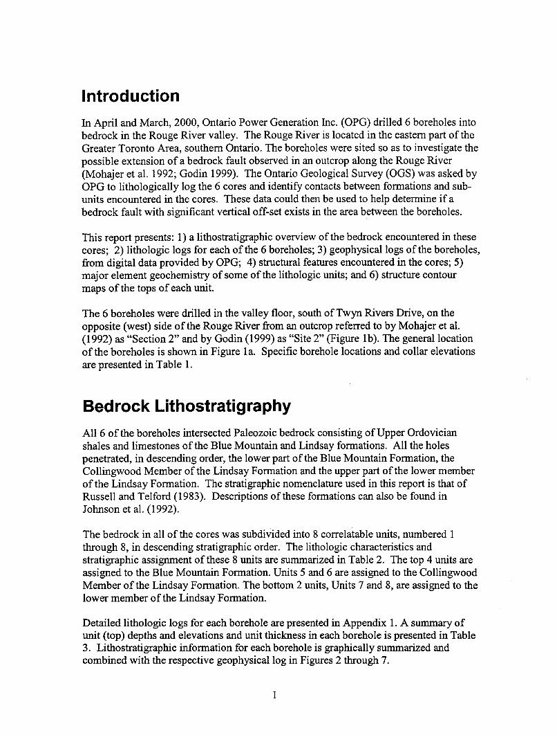
CONTENTSIntroduction..........................................................................................................................1
Bedrock Lithostratigraphy ...................................................................................................1
Lithologic Unit Descriptions..................................................................................11
Geochemistry .........................................................................................................12
Geophysical Logs...................................................................................................12
Structural Geology.............................................................................................................12
Features Observed in the Cores .............................................................................12
Structure Contour Maps.........................................................................................15
Conclusions and Recommendations ..................................................................................15
Acknowledgements............................................................................................................24
References..........................................................................................................................24
Appendix 1: Detailed Lithologic Logs ............................................................................25
Detailed lithologic log for borehole RR-1 .............................................................26
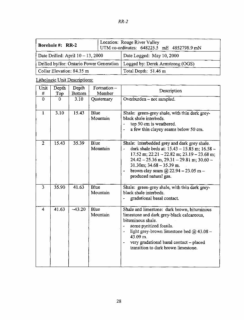
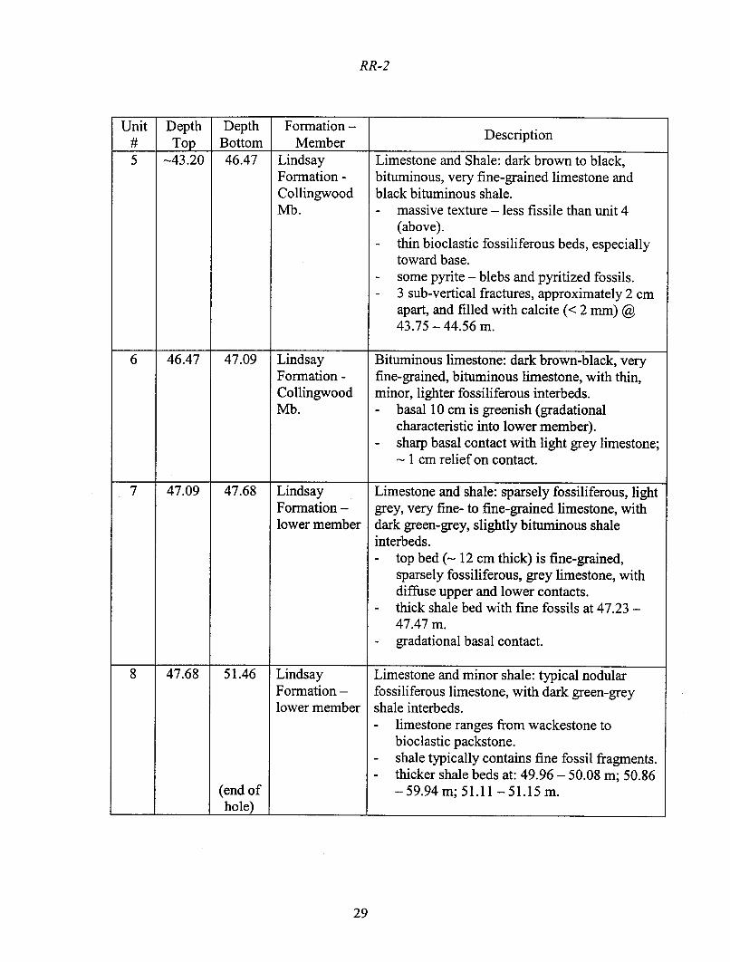
Detailed lithologic log for borehole RR-2 .............................................................28
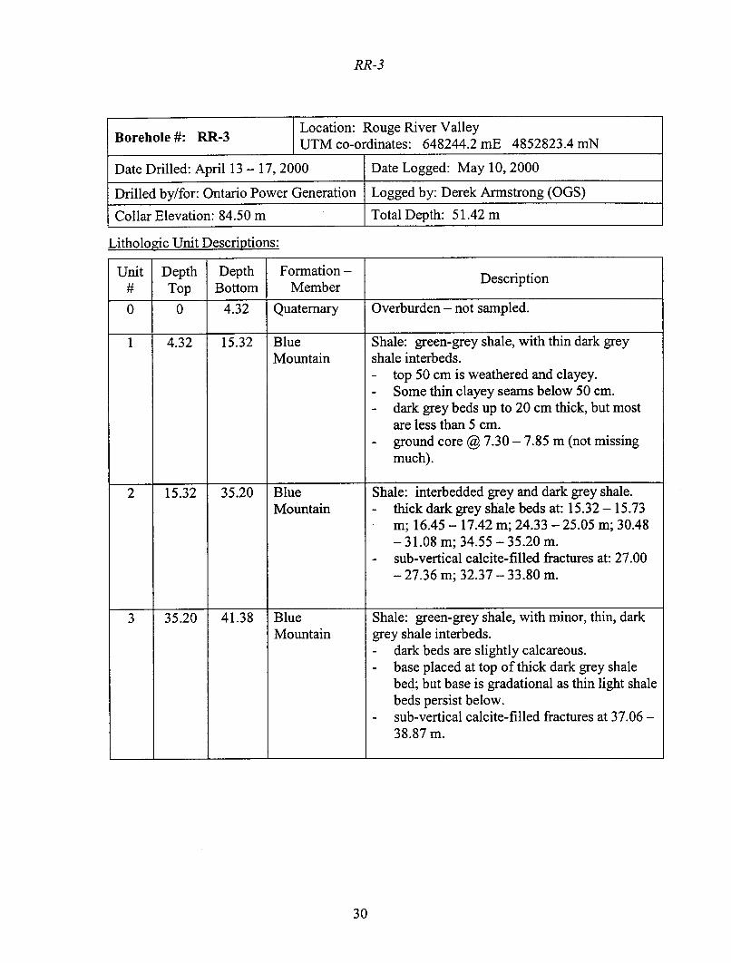
Detailed lithologic log for borehole RR-3. ............................................................30
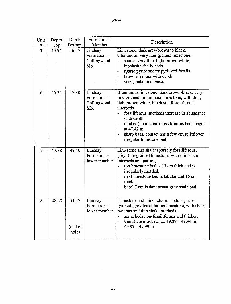
Detailed lithologic log for borehole RR-4 .............................................................32
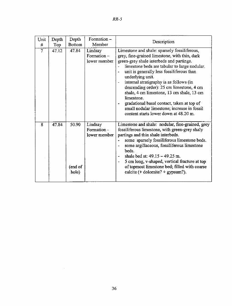
Detailed lithologic log for borehole RR-5 .............................................................34
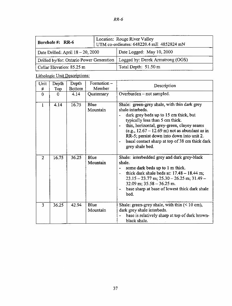
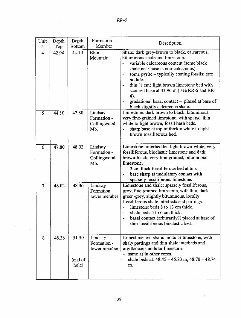
Detailed lithologic log for borehole RR-6. ............................................................37


vii
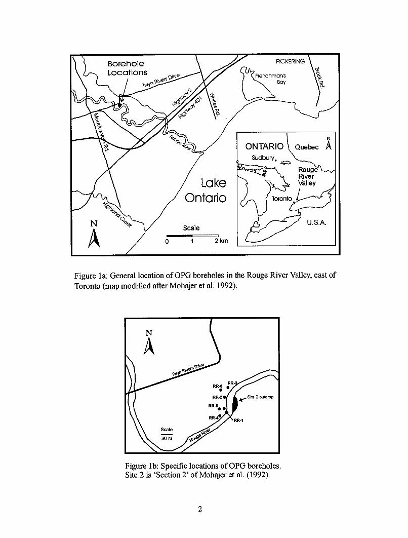
FIGURESFigure 1a: General location of OPG boreholes in the Rouge River Valley.........................2
Figure 1b: Specific locations of OPG boreholes..................................................................2
Figure 2: Geophysical, lithostratigraphic unit and clayey seam logs for borehole RR-1 ....5
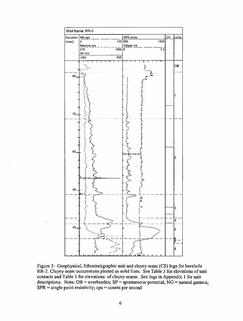
Figure 3: Geophysical, lithostratigraphic unit and clayey seam logs for borehole RR-2 ....6
Figure 4: Geophysical, lithostratigraphic unit and clayey seam logs for borehole RR-3 ....7
Figure 5: Geophysical, lithostratigraphic unit and clayey seam logs for borehole RR-4 ....8
Figure 6: Geophysical, lithostratigraphic unit and clayey seam logs for borehole RR-5 ....9
Figure 7: Geophysical, lithostratigraphic unit and clayey seam logs for borehole RR-6 ..10
Figure 8: Structure contour of top of Unit 1 ......................................................................16
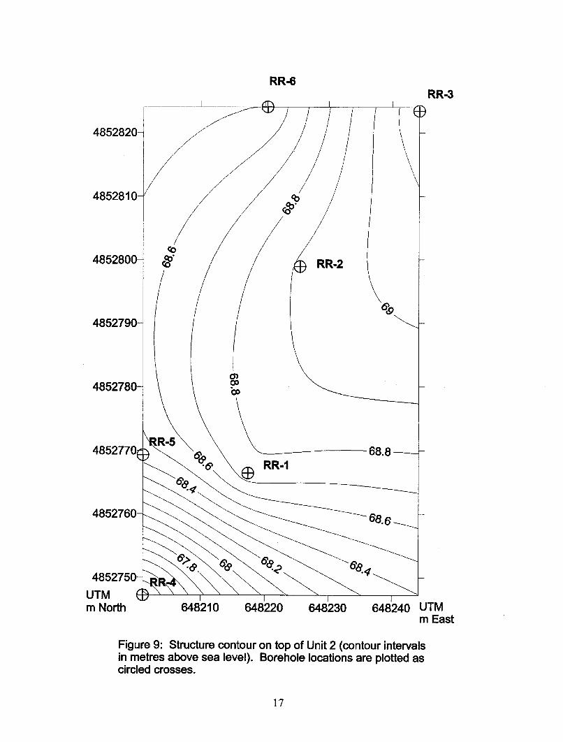
Figure 9: Structure contour of top of Unit 2 ......................................................................17
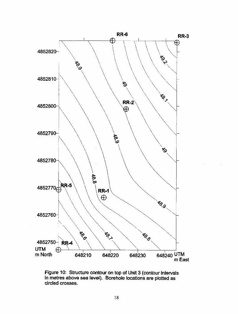
Figure 10: Structure contour of top of Unit 3 ....................................................................18
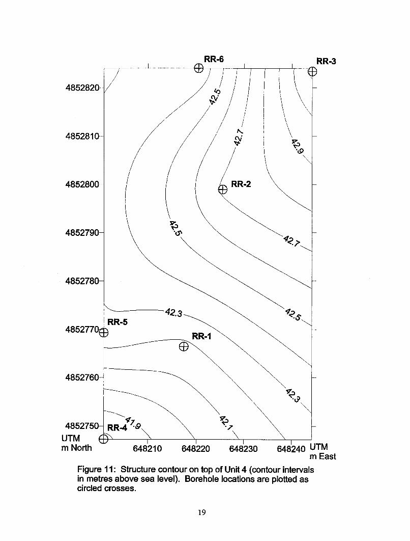
Figure 11: Structure contour of top of Unit 4 ....................................................................19
Figure 12: Structure contour of top of Unit 5 ....................................................................20
Figure 13: Structure contour of top of Unit 6 ....................................................................21
Figure 14: Structure contour of top of Unit 7 ....................................................................22
Figure 15: Structure contour of top of Unit 8 ....................................................................23


ix
TABLESTable 1: OPG borehole locations and collar elevations.......................................................3
Table 2: Lithostratigraphic summary of Rouge River valley boreholes..............................3
Table 3: Summary of lithostratigraphic contact depths and elevations ...............................4
Table 4: Geochemistry of samples representing lithologic units in OPG boreholeRR-2....................................................................................................................13
Table 5: Clayey seam occurrences in boreholes ................................................................14


4
Table 3: Summary of lithostratigraphic contact depths and elevations. Boreholes arepresented in order from southwest to northeast (see Figure 1b).
RR-4 RR-5 RR-1
Unit Depth(m)
Thick-ness (m)
Elev-ation
(masl)
Depth(m)
Thick-ness (m)
Elev-ation
(masl)
Depth(m)
Thick-ness (m)
Elev-ation
(masl)OB 0.00 2.60 84.64 0.00 2.74 83.97 0.00 3.88 84.731 2.60 14.78 82.04 2.74 12.78 81.23 3.88 12.09 80.852 17.38 18.81 67.26 15.52 19.83 68.45 15.97 19.93 68.763 36.19 6.68 48.45 35.35 6.34 48.62 35.90 6.66 48.834 42.87 1.07 41.77 41.69 2.24 42.28 42.56 1.44 42.175 43.94 2.41 40.70 43.93 2.73 40.04 44.00 2.90 40.736 46.35 1.53 38.29 46.66 0.46 37.31 46.90 0.69 37.837 47.88 0.52 36.76 47.12 0.72 36.85 47.59 0.73 37.148 48.40 3.07 36.24 47.84 3.06 36.13 48.32 3.25 36.41
EOH 51.47 33.17 50.90 33.07 51.57 33.16
RR-2 RR-6 RR-3
Unit Depth(m)
Thick-ness (m)
Elev-ation
(masl)
Depth(m)
Thick-ness (m)
Elev-ation
(masl)
Depth(m)
Thick-ness (m)
Elev-ation
(masl)OB 0.00 3.10 84.35 0.00 4.14 85.25 0.00 4.32 84.501 3.10 12.33 81.25 4.14 12.61 81.11 4.32 11.00 80.182 15.43 19.96 68.92 16.75 19.50 68.50 15.32 19.88 69.183 35.39 6.24 48.96 36.25 6.69 49.00 35.20 6.18 49.304 41.63 1.57 42.72 42.94 1.16 42.31 41.38 1.82 43.125 43.20 3.27 41.15 44.10 3.70 41.15 43.20 3.22 41.306 46.47 0.62 37.88 47.80 0.22 37.45 46.42 0.44 38.087 47.09 0.59 37.26 48.02 0.34 37.23 46.86 0.56 37.648 47.68 3.78 36.67 48.36 3.14 36.89 47.42 4.00 37.08
EOH 51.46 32.89 51.50 33.75 51.42 33.08
Note: OB = overburden; EOH = end of hole; masl = metres above sea level.

5
Well Name: RR-1
Elevation(masl)
SP mV70 150NG cps-10 100Neutron cps200 1800
SPR ohms250 400Caliper cm6 7.5
CS Units
80
70
60
50
40
OB
1
2
3
4
5
67
8
Figure 2: Geophysical, lithostratigraphic unit and clayey seam (CS) logs for boreholeRR-1. Clayey seam occurrences plotted as solid lines. See Table 3 for elevations of unitcontacts and Table 5 for elevations of clayey seams. See logs in Appendix 1 for unitdescriptions. Note: OB = overburden; SP = spontaneous potential; NG = natural gamma;SPR = single point resistivity; cps = counts per second


39
Metric Conversion Table
Conversion from SI to Imperial Conversion from Imperial to SI
SI Unit Multiplied by Gives Imperial Unit Multiplied by Gives
LENGTH1 mm 0.039 37 inches 1 inch 25.4 mm1 cm 0.393 70 inches 1 inch 2.54 cm1 m 3.280 84 feet 1 foot 0.304 8 m1 m 0.049 709 chains 1 chain 20.116 8 m1 km 0.621 371 miles (statute) 1 mile (statute) 1.609 344 km
AREA1 cm@ 0.155 0 square inches 1 square inch 6.451 6 cm@1 m@ 10.763 9 square feet 1 square foot 0.092 903 04 m@1 km@ 0.386 10 square miles 1 square mile 2.589 988 km@1 ha 2.471 054 acres 1 acre 0.404 685 6 ha
VOLUME1 cm# 0.061 023 cubic inches 1 cubic inch 16.387 064 cm#1 m# 35.314 7 cubic feet 1 cubic foot 0.028 316 85 m#1 m# 1.307 951 cubic yards 1 cubic yard 0.764 554 86 m#
CAPACITY1 L 1.759 755 pints 1 pint 0.568 261 L1 L 0.879 877 quarts 1 quart 1.136 522 L1 L 0.219 969 gallons 1 gallon 4.546 090 L
MASS1 g 0.035 273 962 ounces (avdp) 1 ounce (avdp) 28.349 523 g1 g 0.032 150 747 ounces (troy) 1 ounce (troy) 31.103 476 8 g1 kg 2.204 622 6 pounds (avdp) 1 pound (avdp) 0.453 592 37 kg1 kg 0.001 102 3 tons (short) 1 ton (short) 907.184 74 kg1 t 1.102 311 3 tons (short) 1 ton (short) 0.907 184 74 t1 kg 0.000 984 21 tons (long) 1 ton (long) 1016.046 908 8 kg1 t 0.984 206 5 tons (long) 1 ton (long) 1.016 046 90 t
CONCENTRATION1 g/t 0.029 166 6 ounce (troy)/ 1 ounce (troy)/ 34.285 714 2 g/t
ton (short) ton (short)1 g/t 0.583 333 33 pennyweights/ 1 pennyweight/ 1.714 285 7 g/t
ton (short) ton (short)
OTHER USEFUL CONVERSION FACTORS
Multiplied by1 ounce (troy) per ton (short) 31.103 477 grams per ton (short)1 gram per ton (short) 0.032 151 ounces (troy) per ton (short)1 ounce (troy) per ton (short) 20.0 pennyweights per ton (short)1 pennyweight per ton (short) 0.05 ounces (troy) per ton (short)
Note:Conversion factorswhich are in boldtype areexact. Theconversion factorshave been taken fromor havebeenderived from factors given in theMetric PracticeGuide for the CanadianMining andMetallurgical Industries, pub-lished by the Mining Association of Canada in co-operation with the Coal Association of Canada.


ISSN 0826--9580ISBN 0--7794--0402--5