ordinary meeting of council - banyule.vic.gov.au · ordinary meeting of council - 6 february 2012...
TRANSCRIPT

Ordinary Meeting of Council Council Chambers, Service Centre
275 Upper Heidelberg Road, Ivanhoe
6 February 2012 commencing at 7.45pm
Following the public forum commencing at approximately 7.30pm and may be extended to 8pm if necessary.
AGENDA
The Mayor’s Acknowledgement of the Wurundjeri People “Our Meeting is being held on the traditional lands (country) of the Wurundjeri people and I wish to acknowledge them as the traditional owners and pay my respects to their Elders.”
Apologies and Leave of Absence Cr Tom Melican has submitted a Leave of Absence request for the period 17 February to 21 February 2012 (inclusive).
Confirmation of Minutes Ordinary Meeting of Council held 12 December 2011 Special Meeting of Council held 13 December 2011
Disclosure of Interests
Presentation Ms Sarah Gillett, Community Safety Officer, and Ms Frances Gianinotti, Youth & Community Services Coordinator, are making a presentation on the Safer Banyule Plan 2012-2016.
1. Petitions 1.1 Vermont Parade, Greensborough - Traffic Concerns............................................... 3
REPORTS:
2. People – Community Strengthening and Support 2.1 McCrae Road, Rosanna - Road Safety Investigation............................................... 5 2.2 Broadlea Crescent, Viewbank - Options for Speed Reduction
Measures................................................................................................................ 13 2.3 Christmas Day Storm Event Update ...................................................................... 22 2.4 HACC Delivered Meals Consumer Satisfaction Report ......................................... 27

AGENDA (Cont’d)
Ordinary Meeting of Council - 6 February 2012 Page 2
3. Planet – Environmental Sustainability 3.1 Northern Alliance for Greenhouse Action Memorandum of
Understanding ........................................................................................................ 29 4. Place – Sustainable Amenity and Built Environment
4.1 269-279 Ryans Road, Eltham North - Vacant Land Subdivision............................ 33 4.2 140 Bonds Road, Lower Plenty - Vacant Land Subdivision and
road opening .......................................................................................................... 57 4.3 Greensborough Walk/Main Street Retail and Office Development ........................ 73 4.4 Enforcement of Railway Station Car Parks ............................................................ 90 4.5 Dougharty Road, Heidelberg West - Request for use by B-Double
vehicles .................................................................................................................. 95 4.6 Ivanhoe Public Golf Course - 1 Vasey Street, Ivanhoe - Proposed
Lease to Leisure Mangement Services Pty Ltd...................................................... 98 4.7 Yallambie Park Preschool - 309-311 Yallambie Road, Yallambie -
Request to increase leased area.......................................................................... 100 5. Prosperity – Prosperous and Sustainable Local Economy
5.1 Supplementary Valuation 4/2011 ......................................................................... 105 6. Participation – Community Involvement in Community Life
6.1 The Banyule Community Safety Plan 2012-2016 ................................................ 107 6.2 Ward Fund Allocations ......................................................................................... 111
7. Strategic Resource Plan - Use Our Resources Wisely 7.1 Review of Councillor Resource, Expense and Entitlements Policy...................... 113 7.2 Assembly of Councillors ....................................................................................... 115
8. Sealing of Documents 8.1 Sealing of Documents .......................................................................................... 119
9. Notices of Motion Nil
10. General Business
11. Urgent Business
Closure of Meeting to the Public
That in accordance with Section 89(2) of the Local Government Act 1989, Council close the Meeting to members of the public and adjourn for five minutes to allow the public to leave the Chamber prior to considering the following confidential matters.
12. Confidential Matters 12.1 Contractual Matter 12.2 Contractual Matter 12.3 Contractual Matter 12.4 Other Matter
Matters Discussed in Camera
That all confidential matters and reports related to the following items remain confidential unless otherwise specified.
Closure of Meeting

1.1
Petitions
Ordinary Meeting of Council - 6 February 2012 Page 3
1.1 VERMONT PARADE, GREENSBOROUGH - TRAFFIC CONCERNS
Author: Justin Dynan - Senior Transport Engineer, City Development
Ward: Bakewell
File: ST7590 A petition with 40 signatures has been received from residents of Vermont Parade, Greensborough. The petition prayer is as follows: “The following residents request that Banyule City Council carry out a road safety evaluation into the ongoing safety of all the occupants along the length of Vermont Pde, Greensborough. On many occasions young children and seniors citizens have been narrowly missed by speeding vehicles (cars/vans). As rate payers, we request that the Council’s Traffic Management Branch investigate and review this issue with a means to providing a deterrent to ongoing speeding in our residential street.” A copy of the petition covering letter is provided as Attachment 1.
OFFICER COMMENT
Vermont Parade is a local residential street that is about 550m in length. A roundabout exists at the intersection with McDowell Street which is approximately mid-block. A locality plan of Vermont Parade is shown below in Figure 1.
Figure 1 – Location Plan

1.1
Petitions VERMONT PARADE, GREENSBOROUGH - TRAFFIC CONCERNS cont’d
Ordinary Meeting of Council - 6 February 2012 Page 4
Residents have raised their concerns about the street being used as a short cut and that motorists are driving above the 50km/h speed limit. They have therefore requested that Vermont Parade be reviewed with regard to safety. To further investigate the issues raised it is considered that a traffic speed and volume survey be undertaken in each block of Vermont Parade following the return of school in February 2012 given there is no recent data available. RECOMMENDATION
1. That Council receives and notes the petition. 2. That the matter is investigated further by Council’s Transport Section and a
report be presented back to Council at the conclusion of the investigation. 3. That the primary petitioner be advised accordingly.
ATTACHMENTS No. Title Page 1 Covering letter 122

2.1
People – Community Strengthening and Support
Ordinary Meeting of Council - 6 February 2012 Page 5
2.1 MCCRAE ROAD, ROSANNA - ROAD SAFETY INVESTIGATION
Author: Sanjev Sivananthanayagam - Transport Engineer, City Development
Ward: Ibbott
File: ST4920 SUMMARY
To consider the possible implementation of speed reduction measures in McCrae Road, Rosanna. CITY PLAN
This report is in line with Council’s City Plan objective to "promote community safety".
BACKGROUND
In 2007/08 funding was set aside in the New Works and Services Budget for two road humps to be installed in McCrae Road, Rosanna. However, two petitions were received and considered by Council at its meeting on 7 May 2007 in relation to traffic concerns in the street and its surrounds. One petition requested that the installation of road humps in McCrae Road not proceed and the second petition requested a ‘left turn ban’ be installed from Lower Plenty Road into Cantala Avenue during the morning and afternoon traffic peaks. At the meeting of 7 May 2007 Council resolved: “1. That Council receives and notes the two petitions.
2. Council not proceed with the proposal to install road humps in McCrae Road
north off Lees Court and north of Homewood Court at this time.
3. The request for left turn ban from Lower Plenty Road into Cantala Avenue during the morning and afternoon traffic peaks be referred to Councils Traffic Engineers for investigation and to be reported back to Council.
4. The primary petitioner be advised of Council’s consideration of the requests.” A follow up report was considered by Council at its meeting on 25 August 2008 in regards to item 3 of the resolution. At the meeting Council resolved: “1. That the report be received.
2. A left turn ban be imposed from Lower Plenty Road into Cantala Avenue
effective from 7.00am to 9.00am, Mondays to Fridays.
3. Residents of the area bounded by the Banyule Creek, Banyule Road, Rosanna Road and Lower Plenty Road be advised in terms of part 2 of the resolution.”
All items of the above Council resolution were actioned at the time.

2.1
People – Community Strengthening and Support MCCRAE ROAD, ROSANNA - ROAD SAFETY INVESTIGATION cont’d
Ordinary Meeting of Council - 6 February 2012 Page 6
In the past 12 months Council has received three (3) separate residential concerns about the speed of vehicles in McCrae Road. Following these concerns further investigations have been undertaken. This report considers the need for traffic management treatments in the street.
EXISTING CONDITIONS
McCrae Road is classified under Council’s road hierarchy as a “Local Road” (residential street) with a default speed limit of 50km/h. The road width of McCrae Road is 7.2m measured between the face of kerbs. It is approximately 675m in length, and runs north to south. At the southern end of the street it connects in to Banyule Road and at the northern end it has a cul-de-sac. Four (4) courts (Mercedes Court, Homewood Court, Pilgrim Court and Lees Court) and four (4) other streets (McAuley Drive, Maleela Grove, Cantala Avenue and Leura Avenue) have access off McCrae Road. The McCrae Road / Cantala Avenue route connects Lower Plenty Road with Banyule Road and acts as a convenient through route or ‘rat run’. Due to the topography of the area, sections of the road are steep with longitudinal gradients in excess of 10% in some sections. There is a reserve with play area between Mercedes Court and Homewood Court. A locality plan of the area is provided in Figure 1.
Figure 1 – Locality Plan
Subject Location
N

2.1
People – Community Strengthening and Support MCCRAE ROAD, ROSANNA - ROAD SAFETY INVESTIGATION cont’d
Ordinary Meeting of Council - 6 February 2012 Page 7
The intersection with Banyule Road is controlled by a give way sign and linemarking on McCrae Road. The intersection of Cantala Ave is also controlled by a give way sign and linemarking on Cantala Avenue. There is dashed centre linemarking installed for most sections of the street.
INVESTIGATIONS
A road safety investigation of McCrae Road has been undertaken, including several site observations, a traffic speed and volume count and a community consultation survey. Traffic Speed and Volume Survey A traffic count was conducted over the period of a week, from 3 – 9 August 2011, with the counter installed in the vicinity of Homewood Court. The results of the traffic count are presented in Table 1, with a previous count conducted from 23 - 30 November 2006 at a similar location.
Table 1 – Traffic Speed and Volume Directions 3 - 9 Aug 2011 23 - 30 Nov 2006 Average Weekday Volume (vpd) Both 1,078 1,124 N 387 395 S 691 729 85th Percentile Speed* (km/h) Both 61.3 62.3 N 60.1 61.6 S 62.3 63.0 Morning Peak: 8am - 9am (vph) Both 114 179 N 46 36 S 75 146 Afternoon Peak: 3pm - 4pm (vph) Both 132 105 N 58 51 S 88 67
* The 85th percentile speed is the speed 85 percent of vehicles are travelling at or below. The speed and volume survey revealed that the average daily traffic volume was 1,078 vehicles, and the 85th percentile speed (the speed at which 85% of the vehicles are travelling at or below) was 61.3 km/h. Traffic Volume McCrae Road provides access through to Banyule Primary School which is located in Banyule Road, and St Martin of Tours located at Silk Street and Lower Plenty Road intersection via Cantala Avenue, and other nearby residential streets. As such, some additional traffic is to be expected on this road other than that directly generated by McCrae Road residents. Having noted this, the traffic count data indicates that the overall traffic volume is considered to be well within acceptable guideline limits for a local street.

2.1
People – Community Strengthening and Support MCCRAE ROAD, ROSANNA - ROAD SAFETY INVESTIGATION cont’d
Ordinary Meeting of Council - 6 February 2012 Page 8
When comparing this data to that of a previous traffic survey undertaken in the street in November 2006, it indicates that the overall volume has remained consistent. However in the morning peak period between 8am – 9am, there has been a reduction in traffic volumes of approximately 65 vehicles. This indicates that the morning left turn ban installed at Cantala Avenue from Lower Plenty Road has had a minor impact on restricting traffic volumes during this period. Traffic Speeds The 85th percentile speed at 61.3km/h was slightly lower than the 2006 survey however is still significantly high and of concern in a residential street. This is a particular concern given the adjacent public reserve at this location, which could be expected to attract reasonable pedestrian movements from the area. Whilst it is acknowledged that the survey location was at the bottom of a slope and some allowance would generally be factored into the speed result due to this, a difference of 11.3km/h to the speed limit is still a concern and motorists would generally be expected to moderate their speed much better than this. Community Consultation Survey Following ongoing residential concern and the high 85th percentile results of the traffic count a residential questionnaire was distributed to gauge current levels of concern in the community to the identified issue and seek response in regard to possible traffic management treatments. The residential questionnaire received an excellent 52% response rate, or 51 responses out of 99 questionnaires delivered. The final results of the survey are as follows: 1. Do you believe that installation of traffic management treatments is needed in
McCrae Road?
63% Agree 29% Disagree 6% Neutral 2% Not Stated
2. Would you be supportive of the installation of a traffic management treatment, similar to one of the treatments shown on the attached drawing, installed in front of your property?
57% Agree 35% Disagree 4% Neutral 4% Not Stated
If you support traffic management treatments for McCrae Road, which sort of treatment(s) would you prefer?
Road Hump 35% Agree 29% Disagree 10% Neutral 26% Not Stated
Raised Intersection 39% Agree 24% Disagree 12% Neutral 25% Not Stated
Two Lane Angled Slow Point 43% Agree 27% Disagree 12% Neutral 18% Not Stated
Modified T-intersection 31% Agree 22% Disagree 16% Neutral 31% Not Stated
2.1
People – Community Strengthening and Support MCCRAE ROAD, ROSANNA - ROAD SAFETY INVESTIGATION cont’d
Ordinary Meeting of Council - 6 February 2012 Page 9
Site Observations and Casualty Crash History During site visits vehicles were observed travelling at speeds more than 50km/h. The topography of the road lends it self to high speeds, given the significant grades. A check of the VicRoads casualty crash database indicates that there have been no reported casualty crashes in McCrae Road in the last five (5) years where data is available. However, residents have indicated instances where vehicles have lost control.
DISCUSSION
When considering the speed, volume and other factors in determining the warrants for the installation of road safety devices, McCrae Road ranks quite highly amongst the list of streets for future consideration of funding. With the installation of any road safety device, there will be advantages and disadvantages to the residents. It is appropriate for residents to be provided with an opportunity to consider the effects of road safety devices, including their impact on the amenity of the street, the potential loss of on-street parking and the impact on property access (i.e. being able to access private driveways safely). As such and as previously noted, a questionnaire was sent to the residents to ascertain their views. Comments received from the community indicated that the majority of respondents were in favour of the installation of traffic management treatments in McCrae Road.
- 63% agreed that McCrae Road needed traffic management treatments to be
installed and 29% disagreed - The most favoured traffic management treatment was ‘Two Lane Angled Slow
Point’ with 43% supporting the installation and ‘Raised Intersection’ was favoured next with 39% support.
- The least favoured treatment was ‘Road Humps’. As such, it is considered that the installation of road safety devices to reduce speed of vehicles along McCrae Road is warranted. For road safety devices to be effective at controlling the speed of traffic in a 50km/h zone, they should generally be spaced around 80 to 120 metres apart. At this spacing, motorists generally travel at a more uniform speed and are less inclined to speed up and brake suddenly between treatments. Installing an isolated treatment will generally result in only a localised speed reduction near the treatment with little benefit to the remainder of the street. According to the Australian Standards, it is not appropriate to install traffic treatments on roads where the longitudinal gradient (steepness) of the road is more than 10%, as they have the potential to become more of a traffic hazard than a slowing device. As mentioned, some sections of McCrae Road are very steep, which limits opportunities for the installation of traffic treatments. Considering the spacing, topography of the road, approach sightlines, preference from the residents and intersecting streets / driveways, the suitable location for traffic treatments are considered to be:
2.1
People – Community Strengthening and Support MCCRAE ROAD, ROSANNA - ROAD SAFETY INVESTIGATION cont’d
Ordinary Meeting of Council - 6 February 2012 Page 10
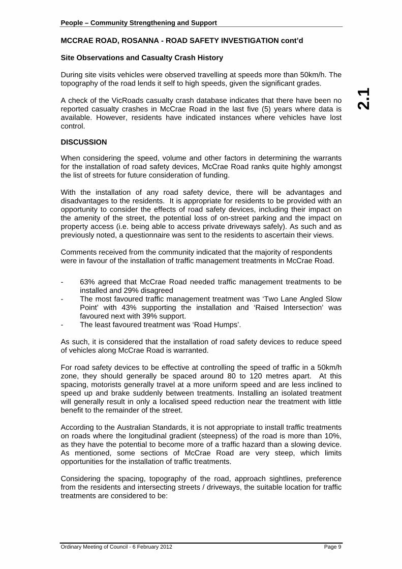
Location 1: Vicinity of Homewood Drive A suitable treatment here is considered to be a raised intersection. The majority of residents in this section indicated their preference for traffic management treatment to be installed, with the raised intersection being one of their preferred options. Location 1 is shown in Figure 2.
Figure 2 – Location 1: Vicinity of Homewood Drive
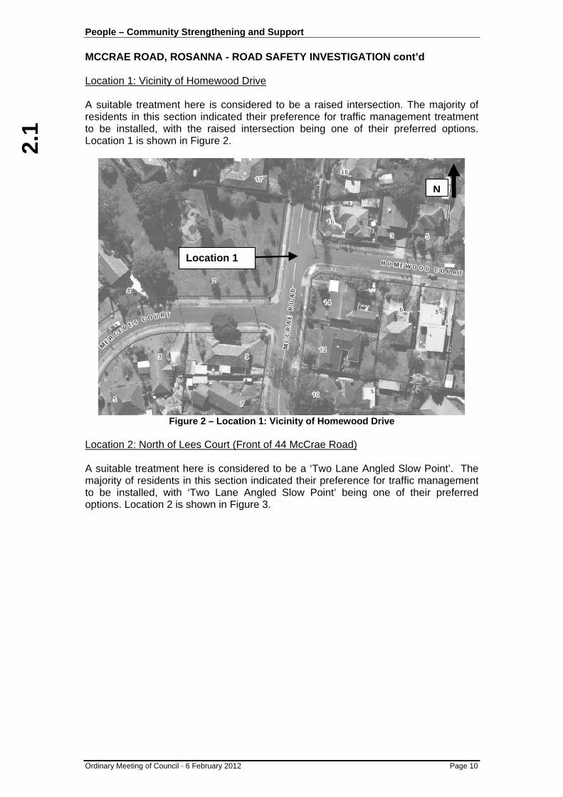
Location 2: North of Lees Court (Front of 44 McCrae Road) A suitable treatment here is considered to be a ‘Two Lane Angled Slow Point’. The majority of residents in this section indicated their preference for traffic management to be installed, with ‘Two Lane Angled Slow Point’ being one of their preferred options. Location 2 is shown in Figure 3.
Location 1
N

2.1
People – Community Strengthening and Support MCCRAE ROAD, ROSANNA - ROAD SAFETY INVESTIGATION cont’d
Ordinary Meeting of Council - 6 February 2012 Page 11
Figure 3 – Location 2: North of Lees Court
Both the locations are in a flat section of the road. A treatment between Pilgrim Court and Lees Court was not considered as a result of poor approach sightlines from both directions due to the topography of the road. It should be noted, the installation of any traffic treatments north of Lees Court (ie. Location 2) may encourage some motorists to avoid this section of McCrae Road and divert through Maleela Grove. To discourage motorist from driving through Maleela Grove, a raised threshold treatment would also be considered at the intersection of Cantala Avenue and Maleela Grove. Location 3 is also shown in Figure 3. A concept plan of the complete traffic management proposal is provided as Attachment 1.
Location 2
Location 3
N

2.1
People – Community Strengthening and Support MCCRAE ROAD, ROSANNA - ROAD SAFETY INVESTIGATION cont’d
Ordinary Meeting of Council - 6 February 2012 Page 12
Cost Estimate The cost estimate for the installation of one (1) raised intersection, one (1) two lane angled slow point and a raised threshold treatment is likely to be around $110,000, including upgrade of street lighting, traffic management and likely drainage works. - Location 1: Raised Intersection - $45, 000 - Location 2: Two Lane Angled Slow Point - $40, 000 - Location 3: Raised Threshold Treatment - $25, 000 CONCLUSION When considering the speed, volume and other factors in determining the warrants for the installation of road safety devices, McCrae Road ranks quite highly amongst the list of streets, for future consideration of funding. When also considering the traffic survey results it appears the impact of the turn ban at Cantala Avenue has not fully addressed the concerns on McCrae Road with regards to the speed of vehicle and it is considered that this could be addressed by installing road safety devices.
Two Lane Angled Slow Point and Raised Intersection treatment have been chosen by the residents as their most preferred traffic treatments. Two locations have been identified as the most suitable locations for installation of any traffic management along McCrae Road. A further, third location has been identified at the intersection of Maleela Grove and Cantala Avenue for possible treatment to prevent any further diversion by motorist, by the above proposal. RECOMMENDATION
That:
1. Residents of McCrae Road and Maleela Grove, Rosanna be further consulted on the proposed traffic management treatments, these being:
a) Installation of a “Raised Intersection” at Homewood Court;
b) Installation of a ‘Two Lane Angled Slow Point’, north of Lees Court in front of No.44;
c) Installation of a ‘Raised Threshold Treatment’ at Maleela Grove and Cantala Avenue intersection.
2. Given overall resident approval these traffic safety measures be listed in
Council’s ten year Capital Works Program for future funding consideration.
ATTACHMENTS No. Title Page 1 Concept Plan 123
2.2
People – Community Strengthening and Support
Ordinary Meeting of Council - 6 February 2012 Page 13
2.2 BROADLEA CRESCENT, VIEWBANK - OPTIONS FOR SPEED REDUCTION MEASURES
Author: Sanjev Sivananthanayagam - Transport Engineer, City Development
Ward: Hawdon
File: ST1065 SUMMARY
To consider options for speed reduction measures to be implemented in Broadlea Crescent, Viewbank. CITY PLAN
This report is in line with Council’s City Plan key direction to "promote community safety".
BACKGROUND
At its Meeting of 12 December 2011, Council considered an item of Urgent Business regarding Broadlea Crescent, Viewbank. At the Meeting, Council resolved: “1. That Council officers provide a report to Council outlining options for speed
reduction measures to be implemented in Broadlea Crescent, Viewbank.
2. That a report be submitted to Council no later than February 2012 in order for costs associated with speed reduction options to form part of the Council’s 2012/13 Budget.
3. That the report also include costs associated with erecting bollards to the Right
of Way/walkway located between Broadlea Crescent and Castleton Road, Viewbank.”
At its Meeting of 7 March 2011, Council previously considered a Motion regarding the road safety in Broadlea Crescent. At the Meeting, Council resolved: “That Council Officers undertake a road safety investigation of Broadlea Crescent, Viewbank and that a report come back to Council on the results of the investigation.” In response to this motion on 6 June 2011, Council considered a report in relation to the road safety in Broadlea Crescent. At the Meeting Council resolved: “1. That Council’s speed trailer be installed for a one week period, as part of the
Speed Awareness Program and the local police be notified and requested to patrol the street to enforce the speed limit at morning and afternoon peak times.
2. An advance warning sign ‘Bend’ be installed facing vehicles approaching from
Lower Plenty Road.”

2.2
People – Community Strengthening and Support BROADLEA CRESCENT, VIEWBANK - OPTIONS FOR SPEED REDUCTION MEASURES cont’d
Ordinary Meeting of Council - 6 February 2012 Page 14
Both resolutions were actioned at the time, with an advanced warning sign installed and the Speed Awareness Program undertaken. This report responds to the 12 December 2011 Council resolutions.
EXISTING CONDITIONS
Broadlea Crescent is classified under Council’s road hierarchy as a “Local Road” (residential street) with a default speed limit of 50km/h. The road width of Broadlea Crescent is 6.8m measured between the face of kerbs. It is approximately 300m in length, and connects Lower Plenty Road and Rockaway Drive. The first 200m from Rockaway Drive runs east to west and the following 100m runs north to south. As such there is a significant bend in the road. Rosemary Court has access only from Broadlea Crescent and intersects approximately 100m east of Rockaway Drive. A locality plan of the subject site is provided in Figure 1.
Figure 1 – Locality Plan
The intersection with Rockaway Drive is controlled by a Give Way sign and linemarking on Broadlea Crescent including a 20m continuous centre linemarking. The intersection of Lower Plenty Road is controlled by a stop sign and linemarking on Broadlea Crescent, including a 30m continuous centre linemarking. There is an additional single continuous centre linemarking installed around the bend, between number 16 and 26 for approximately 80m, delineating the centre of the road. There are also advance warning signs ‘Bend’ installed on Broadlea Crescent facing traffic travelling in both directions, approaching the bend.
Subject Location
1
2
3
N

2.2
People – Community Strengthening and Support BROADLEA CRESCENT, VIEWBANK - OPTIONS FOR SPEED REDUCTION MEASURES cont’d
Ordinary Meeting of Council - 6 February 2012 Page 15
PAST INVESTIGATIONS A road safety investigation of Broadlea Crescent has been undertaken in early-mid 2011, including several site observations and a traffic speed and volume count in Broadlea Crescent. The traffic count was conducted over a week, from 1 – 7 April 2011 with the counter installed in the vicinity of 12 Broadlea Crescent. The results of the traffic count are presented in Table 1.
Table 1 – Results of Traffic Speed and Volume Count
Period Direction Volume (vpd)
85th Percentile Speed* (km/h)
Eastbound 406 49
Westbound 260 44 Average Weekday
Both 666 47
Eastbound 35 59
Westbound 25 52 AM Peak
Both 60 54
Eastbound 51 58
Westbound 25 53 PM Peak
Both 76 56 * 85th percentile speed is the speed 85 percent of vehicles are travelling at or below
Broadlea Crescent intersects with Lower Plenty Road and provides access through to Viewbank Primary School, the local shops and other nearby residential properties. As such, some additional traffic is to be expected on this road other than that directly generated by Broadlea Crescent residents. The traffic count data indicates that the overall traffic volume is considered to be well within acceptable guideline limits for a local street. The speed and volume count also highlighted an overall 85th percentile speed of 47km/h, which is under the legal speed limit for the street. However further analysis of the traffic count data indicated that there did appear to be general speeding instances during the morning and afternoon peak periods. A check of the VicRoads crash data indicates that there have been no reported casualty crashes in Broadlea Crescent in the last five (5) years where data is available. Notwithstanding, Council is aware of a crash which occurred on the 17 February 2011 at the corner in Broadlea Crescent. Discussions with the Victoria Police Traffic Management Unit did not indicate any concerns with the existing road environment which might have contributed to this crash and highlighted that this crash was being attributed to excessive vehicle speed in the wet road conditions at the time. Past surveys of parking in the street in the past have indicated that parking on street is not in high demand, with not more than four (4) vehicles parked in the street during the times of observation. It was however previously observed that on occasions vehicles were parked next to the single continuous linemarking at the bend in the road, which is illegal and of some concern given road width and sight lines.

2.2
People – Community Strengthening and Support BROADLEA CRESCENT, VIEWBANK - OPTIONS FOR SPEED REDUCTION MEASURES cont’d
Ordinary Meeting of Council - 6 February 2012 Page 16
Council’s Local Laws department were advised of this concern in June 2011 and requested to monitor this location as needed. Recent observation indicated that illegal parking is still occurring occasionally, and this might be related to property works in the area. This is not considered a major issue. TRAFFIC MANAGEMENT DEVICE SELECTION AND LOCATION For road safety devices to be effective at controlling the speed of traffic in a 50km/h zone, they should generally be spaced 80 to 120 metres apart. At this spacing, motorists generally travel at a more uniform speed and are less inclined to speed up and brake suddenly between treatments. Installing an isolated treatment will generally result in only a localised speed reduction near the treatment with little benefit to the remainder of the street. However, in this instance, the first 200m of Broadlea Crescent from Rockaway Drive runs east to west and the following 100m runs north to south. As such, the significant bend on the road acts as a natural speed reduction measure. Considering the above and the approach sightlines from both directions, the appropriate locations for any installation of road safety devices in Broadlea Crescent are: - the intersection of Broadlea Crescent and Rockaway Drive is considered to be
a suitable location for installation of traffic management devices to slow down traffic before entering Broadlea Crescent, which is shown in Figure 2.
Figure 2 – Location 1
- in the first 200m of Broadlea Crescent (which runs east to west) the most
appropriate location is considered to be at the Rosemary Court intersection or in front of number 12 Broadlea Crescent, which is shown in Figure 3.
Location 1
N

2.2
People – Community Strengthening and Support BROADLEA CRESCENT, VIEWBANK - OPTIONS FOR SPEED REDUCTION MEASURES cont’d
Ordinary Meeting of Council - 6 February 2012 Page 17
Figure 3 – Location 2
- in the following 100m of Broadlea Crescent (which runs north to south) the
most suitable location is considered to be approximately 50m south of Lower Plenty Road in front of 28 Broadlea Crescent, which is shown in Figure 4.
Location 2
N

2.2
People – Community Strengthening and Support BROADLEA CRESCENT, VIEWBANK - OPTIONS FOR SPEED REDUCTION MEASURES cont’d
Ordinary Meeting of Council - 6 February 2012 Page 18
Figure 4 – Location 3
Four (4) types of road safety devices have been identified as the most suitable for the three (3) locations shown above, following the consideration of the most effective treatments for the space available and consistency with the local road network. These being: - Road Hump - Raised Intersection - Modified T – Intersection - Splitter Island At location 1, the first three types of road safety devices can be accommodated, as intersecting Rosemary Court enables the options of intersection treatments to be considered. However, location 2 enables only mid section treatments to be installed and as such only the road hump is considered suitable. At location 3, the three (3) intersection treatments can be considered.
Location 3
N
2.2
People – Community Strengthening and Support BROADLEA CRESCENT, VIEWBANK - OPTIONS FOR SPEED REDUCTION MEASURES cont’d
Ordinary Meeting of Council - 6 February 2012 Page 19
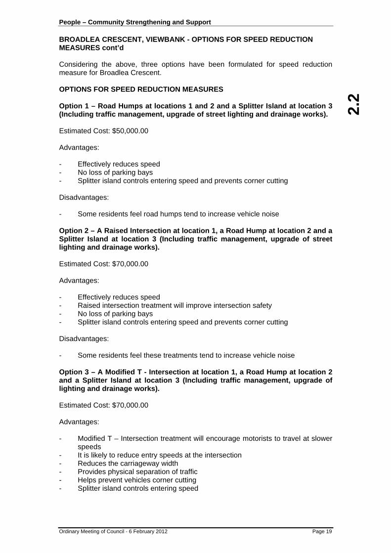
Considering the above, three options have been formulated for speed reduction measure for Broadlea Crescent. OPTIONS FOR SPEED REDUCTION MEASURES Option 1 – Road Humps at locations 1 and 2 and a Splitter Island at location 3 (Including traffic management, upgrade of street lighting and drainage works). Estimated Cost: $50,000.00 Advantages: - Effectively reduces speed - No loss of parking bays - Splitter island controls entering speed and prevents corner cutting Disadvantages: - Some residents feel road humps tend to increase vehicle noise Option 2 – A Raised Intersection at location 1, a Road Hump at location 2 and a Splitter Island at location 3 (Including traffic management, upgrade of street lighting and drainage works). Estimated Cost: $70,000.00 Advantages: - Effectively reduces speed - Raised intersection treatment will improve intersection safety - No loss of parking bays - Splitter island controls entering speed and prevents corner cutting Disadvantages: - Some residents feel these treatments tend to increase vehicle noise Option 3 – A Modified T - Intersection at location 1, a Road Hump at location 2 and a Splitter Island at location 3 (Including traffic management, upgrade of lighting and drainage works). Estimated Cost: $70,000.00 Advantages: - Modified T – Intersection treatment will encourage motorists to travel at slower
speeds - It is likely to reduce entry speeds at the intersection - Reduces the carriageway width - Provides physical separation of traffic - Helps prevent vehicles corner cutting - Splitter island controls entering speed

2.2
People – Community Strengthening and Support BROADLEA CRESCENT, VIEWBANK - OPTIONS FOR SPEED REDUCTION MEASURES cont’d
Ordinary Meeting of Council - 6 February 2012 Page 20
Disadvantages: - Potential loss of up to 6 to 8 on–street parking spaces - Modified T treatments can be seen as a “challenge” to some, minimising the
speed reduction impact. - Reduced carriageway widths can impact heavy vehicle access, making waste
collection more difficult. DISCUSSION The provision and need for traffic management devices in Broadlea Crescent is considered a very low priority given the speed, volume and crash record, and one normally outside of the intervention level for such treatments based on Council’s LATM strategy. Given Council’s limited annual budget to address LATM issues throughout the Municipality it is considered that the most appropriate response at this location is to continue to request Victoria Police enforcement activities during the morning and afternoon peak periods and continue to add the site to Council’s Speed Awareness Program on an ongoing basis for the next 12 months. Notwithstanding, three (3) locations have been identified as the most suitable locations for the possible installation of traffic management devices. Three options have been formulated in identifying the most effective treatments for these locations. In this instance the speeding which is occurring in Broadlea Crescent is primarily only in the traffic peak periods and is being carried out by a relatively low volume of vehicles (60 to 70). Should Council consider the installation of traffic management devices appropriate in the street, it is preferred that community consultation in Broadlea Crescent be undertaken to determine the preferred option by the residents. With the installation of any road safety devices, there will be advantages and disadvantages to the residents. It is appropriate for residents to be provided with an opportunity to consider the effects of road safety devices, including their impact on the amenity of the street, the potential loss of on-street parking and the impact on property access (i.e. being able to access private driveways safely). CASTLETON PARK WALKWAY CONCERNS Concern has been raised regarding illegal hoon type activity and vehicles occasionally driving through the walkway to Castleton Park between Broadlea Crescent and Castleton Road. Council’s Parks and Transport Departments have not previously been made aware of this issue, however bollards can be installed to help prevent this through access. As the Parks Department maintains and cuts the grass in the walkway, they have indicated that the installation of drop down bollards at the Broadlea Crescent end would be appropriate should bollards be considered. For the installation of three (3) drop down bollards the cost is estimated to be approximately $2000.

2.2
People – Community Strengthening and Support BROADLEA CRESCENT, VIEWBANK - OPTIONS FOR SPEED REDUCTION MEASURES cont’d
Ordinary Meeting of Council - 6 February 2012 Page 21
CONCLUSION
A small number of vehicles are speeding during the peak traffic periods on Broadlea Crescent, Viewbank. Three (3) locations have been identified as the most suitable locations for the possible installation of traffic management devices. Three options have been formulated in identifying the most effective treatments for these locations. The installation of such treatments at this location rates as a very low priority when assessed under Council’s LATM strategy. Greater benefit maybe available through the provision of treatments at higher priority sites as assessed through Council’s LATM strategy. Should Council consider the installation of traffic management devices appropriate in the street, community consultation be undertaken in Broadlea Crescent to determine the preferred option. Concerns in relation to vehicles driving through Castleton Park walkway have been raised. The provision of three (3) drop down bollards to help prevent this and still maintain through vehicle access for grass cutting and maintenance is estimated at around $2,000. RECOMMENDATION
That: 1. Council’s speed trailer be installed for a one week period on an ongoing basis
over the next 12 months, as part of the Speed Awareness Program and Victoria Police be notified and requested to patrol the street to enforce the speed limit at morning and afternoon peak times.
2. Given the low priority for traffic management treatments in Broadlea Crescent,
no treatments be considered at this time. 3. Three (3) drop down bollards be considered at the Broadlea Crescent end of
the walkway to Castleton Park, subject to funding being provided.
ATTACHMENTS Nil

2.3
People – Community Strengthening and Support
Ordinary Meeting of Council - 6 February 2012 Page 22
2.3 CHRISTMAS DAY STORM EVENT UPDATE Author: Russell Darling - Manager Operations, City Services
File: BS14/030/001 SUMMARY
To provide an update on Council’s response and recovery from the extensive flood and storm damage on Christmas Day 2011 in the City of Banyule. CITY PLAN
This report is in line with Council’s City Plan key direction of "protect and improve public health and wellbeing".
BACKGROUND
On Sunday December 25 December, severe thunderstorms cut across the north of Melbourne causing hail damage and flooding. These Christmas Day storm event impacted throughout Banyule with a particular focus on the north of the municipality. Greensborough rainfall data provided by Melbourne Water has confirmed the intensity of the storm was well above the 1 in 100 year storm event for a sustained period of over 6 hours. In other parts of Banyule, including Heidelberg and Ivanhoe the storm event was less than 1 in 100.
CURRENT STATUS
Council staff have been continuing to undertake the necessary clean up and repair work on Council assets and also respond to enquiries and requests for assistance. The following provides an outline on Council’s response: Customer Service Customer Service officers received more than 690 calls from residents following the Christmas Day storm event – they include:
• 305 calls to unblock storm water drains and pits. Some of these require investigation only.
• 189 requests to collect storm damaged materials. • 102 calls for emergency relief and recovery assistance (of which the majority
were referred to the Department of Human Services and other support agencies).
• 18 calls relating to parks maintenance such as fallen trees and repairs to playgrounds and paths.
2.3
People – Community Strengthening and Support CHRISTMAS DAY STORM EVENT UPDATE cont’d
Ordinary Meeting of Council - 6 February 2012 Page 23
Relief and Recovery • There have been 106 customer requests received regarding Relief and
Recovery. Out of these:
− 89 referred to DHS for grant support/assessment − 22 referred to Salvation Army for material aid − 41 residents displaced from home for a period of time − Currently we are following up periodically with 15 residents regarding
additional support Hard Waste • Over 160 requests were received for the special additional hard waste service
which was available until 3 January. • All additional pick ups have been completed with approximately 100 tonnes of
material collected as a result. • Any new requests after 3 January have been included in the resident’s annual
hard waste allocation. Due to the storm cleanup process there is currently about a five week wait however individual cases can be assessed based on urgency.
Cleansing (Streets and Drains) • The Cleansing Service Unit were very busy cleaning road reserves. Additional
labour was also hired to clear and inspect drains and replace pit lids. • Council continues to investigate all drainage requests and will inspect all drain
requests in the storm affected areas. Where design issues are identified, these are referred to Council engineers for further investigation.
Parks and Gardens • 70 out of 160 playgrounds in Banyule were affected by the floods, with 35
cordoned off due to flood water displacing the ‘soft fall’ beneath equipment to the extent that it does not meet the required Australian Standards. This material will need to be dug down to a depth of 200mm and replaced. Current estimates are that it will cost up to $120,000 to replace the soft fall.
• Urgent repairs to the two playgrounds at Macleod Park and Petrie Park are underway with works on other playgrounds to commence shortly.
• Extensive damage has occurred to fences, paths and other assets on Council land and within Council Reserves.
Council Buildings and Infrastructure Assets The following assets were damaged by the storm:
• Facilities
− Briar Hill Pre-School − Greensborough Pre-School − Delta Rd Pre-School − Binnak Park Pavilion − Greensborough War Memorial Pavilion − Warringal Park Pavilion

2.3
2.3
People – Community Strengthening and Support CHRISTMAS DAY STORM EVENT UPDATE cont’d
Ordinary Meeting of Council - 6 February 2012 Page 24
− Watsonia Pool − Greensborough Bowling Club − Jet Studios − Joyce Ave Child Care Centre − Tenancy 1 9-13 Flintoff St − Tenancy 4 9-13 Flintoff St − 66 Main St − 92 Albion Crescent − Nets Stadium − Meals kitchen − Bundoora Hall − Greensborough Hall − Montmorency Football Pavilion − Montmorency Tennis Pavilion
• Shared Trails
− Plenty River Trail − Darebin Creek Trail − Main Yarra Trail − Harry Pottage Reserve Basin Track − Rosanna Parklands Trail − Donaldson Creek Trail
• Infrastructure
− Station Road car parking bays − Petrie Park car park parking bays − Macleod Tennis Club court surfaces and fencing. − Spillway structure at the Watsonia Army barracks − Path at Fell Reserve − Chelsworth Park cleanup
INSURANCE & FINANCIAL IMPLICATIONS
• A significant proportion of Council costs and losses are not property related, such as footpath and car park infrastructure repairs, removal of debris from streets and its disposal, fleet damage and staff overtime/regular pay for response/clean-up activities.
• Based on the quotes/repair provided to date, Council’s claim will be approximately $150,000 for property damage. We will claim for debris removal from insured property locations and also some increased staff/contractor costs associated with the storm. Some sites are yet to have quotes provided for rectification (eg Macleod tennis club.)
• There is an estimated $120,000 for playground soft fall reinstatement that we will claim.
• Council’s property insurance also covers sports surfaces, and bridges and culverts.

2.3
People – Community Strengthening and Support CHRISTMAS DAY STORM EVENT UPDATE cont’d
Ordinary Meeting of Council - 6 February 2012 Page 25
• To date, 22 Council owned vehicles have been reported as being damaged by hail stones, to varying degrees. This damage is insured through Council’s motor vehicle policy, however, Council will be responsible for the insurance excess on each vehicle although this will be capped at $100,000 for this one event. Vehicle repair assessments are underway by the insurer, but it could be a couple of months before all vehicles are assessed and repaired or replaced.
• It is estimated that the overall cost to Council as a result of this single storm event will be $550,000 (as at 20 January 2012). Council will finalise the claim which will be presented to the insurers as part of due process.
• Data provided to the Insurance Council of Australia (ICA) by member companies shows they had received 77,174 claims by January 13, with insurance losses estimated at $550.7 million. The ICA declared the storms a catastrophe on December 29, 2011.
2011 Catastrophe Number of claims
lodged* Total reserved value of claims*
Queensland floods (two Catastrophes declared) Dec 2010-Jan 2011
58,463 $2.4 billion
Queensland Cyclone Yasi – Jan 2011 72,203 $1.33 billion Victorian floods – Jan 2011 7952 $122 million Perth bushfires – Feb 2011 410 $35 million Victorian severe storms – Feb 2011 49,396 $412.3 million Margaret River bushfires – Nov 2011 399 $52.2 million Christmas Day storms – Dec 2011 77,174 $550.7 million TOTAL 265,997 $4.903 billion
STATE GOVERNMENT FUNDING
The Federal and State Governments both declared the Christmas Day storms a natural disaster. This means that Council can make a claim for funding under the existing Natural Disaster Financial Assistance (NDFA) arrangements. Under the NDFA arrangements Councils can claim for:
• Emergency protection works – including works undertaken to protect community assets and to restore essential public services; and/or
• Restoration of municipal and other essential public assets – including repair of roads and bridges, reserves and associated community facilities, and destroyed public buildings.
Councils may also claim for extraordinary salaries, wages or other expenditure which would not have been incurred had the emergency not occurred. In addition to NDFA arrangements, councils can apply to the Victorian Grants Commission for the provision of special payments where there is a shortfall between the approved restoration costs and the Department of Treasury and Finance contribution.
CONCLUSION
An interim review of the 2011 Christmas Day storm event has shown it to be the worst emergency event in Banyule’s history, not only in severity, but also in its impact and timing. Costs are still being gathered and all avenues for recovering costs of repairing damaged assets will continue to be followed, although there will still be some out of pocket expenses that Council will incur for insurance excess payments and some staff costs particularly for resident support and advice recovery functions.

2.3
2.3
People – Community Strengthening and Support CHRISTMAS DAY STORM EVENT UPDATE cont’d
Ordinary Meeting of Council - 6 February 2012 Page 26
RECOMMENDATION
That Council officers: 1. Continue to repair all assets that have been damaged by the Christmas Day
storm and floods. 2. Continue to work closely with the insurance industry to obtain the maximum
amount possible on the damages claims. 3. Pursue funding for restoration costs from the State Government under existing
emergency management arrangements. 4. Report back to Council the outcomes of claims associated with the Christmas
Day storm event.
ATTACHMENTS Nil

2.4
People – Community Strengthening and Support
Ordinary Meeting of Council - 6 February 2012 Page 27
2.4 HACC DELIVERED MEALS CONSUMER SATISFACTION REPORT
Author: John Minchinton - HACC Team Leader Delivered Meals & Property Maintenance, Community Programs
File: 0 SUMMARY
To advise Councillors about the progress of the Home and Community Care Delivered Meals Service following the transition to Community Chef in March 2011 and recent consumer satisfaction survey results. CITY PLAN
This report is in line with Council’s City Plan key direction of "provide services and support to, and advocate for, people at important life stages".
BACKGROUND
In early 2004 Hobson’s Bay Council proposed a group of like Councils fund a pilot project to investigate a shared production facility. This was a direct result of increasing production costs for those councils who produced their own meals and a lack of suitable private providers that could provide a product that directly meets the particular needs of the clientele From this pilot project a report recommended it was a viable proposition for a number of Councils to pool their resources and to apply to Federal and State Government bodies for funding to complete the project As a result, a new modern, “State of the Art” facility was built in Altona; Community Chef. The co-operative business is jointly owned by 20 municipal Councils who share resources at substantially lower costs. The new model gives eligible consumers a far greater choice and more flexibility then the previous delivered meals service. The new service became operational in December 2012 and in early March 2011, Banyule’s HACC Delivered Meals Service started operating under the new service arrangements.
CURRENT SITUATION
Evaluation The Banyule HACC Delivered Meals and Home Care teams spent many hours assisting our consumers with the transition to this new service. Consumers had to endure many changes including administrative changes, as the old facility at 203 Henry St was upgraded in preparation for the new service. As part of ongoing quality management, we conducted a consumer satisfaction survey in November 2011 to assess the impact of the changes to consumers.

2.4
People – Community Strengthening and Support HACC DELIVERED MEALS CONSUMER SATISFACTION REPORT cont’d
Ordinary Meeting of Council - 6 February 2012 Page 28
The results of the survey show we have achieved our desired results which were to: • successfully move our service from the traditional hot lunchtime meal to the
new safer cook chill process • offer residents of Banyule 6 choices per day (an increase from 3 per day) • deliver meals from 9.00am – 3.30pm in two designated shifts • maintain our commitment to cater for the various health needs of our clientele • keeping consumers well informed of changes or alterations to our processes We sent surveys to all 453 Banyule delivered meals consumers and received more than 215 replies. This is a very high rate of reply resulting in a credible and accurate report. In previous years we have achieved an average overall satisfaction rating of between 90% – 92%. In our recent survey, consumer satisfaction with the new meals model achieved an improved rating of 99%. Survey Results This year’s results are as follows: Overall Satisfaction 99% Taste of food 90% Meals Choices 91% Friendliness / Helpfulness of delivery staff 100% Friendliness / Helpfulness of office staff 99% Better service than 2 years ago 86% Better food quality than 2 years ago 80% Meal Component Ratings Soup 89% Main 94% Dessert 84%
CONCLUSION
Overall this has been a fantastic result. We have identified a number of opportunities for improvement based on consumer comments. Examples include difficulties with opening packaging, improvements to desserts and changes to the variety of meal types e.g. less “casserole” type dishes, more baked dishes. Banyule City Council Aged and Disability Services are active members of the Community Chef Advisory Group and the Community Chef Operations Group. Through continuous discussion and adequate planning for improvement, Banyule’s consumer satisfaction results will continue to improve. RECOMMENDATION
That Council note the report. 1.
ATTACHMENTS Nil
3.1
Planet – Environmental Sustainability
Ordinary Meeting of Council - 6 February 2012 Page 29
3.1 NORTHERN ALLIANCE FOR GREENHOUSE ACTION MEMORANDUM OF UNDERSTANDING
Author: Clayton Simpson - Resource Conservation Officer, City Development
File: BS24/010/002
Previous Items Council on 4 April 2011 (Item 3.1 - Northern Alliance for Greenhouse Action Strategic
Plan 2011-15) SUMMARY
To consider Council’s ongoing membership of the Northern Alliance for Greenhouse Action (NAGA) by signing a new Memorandum of Understanding. CITY PLAN
This report is in line with Council’s City Plan key direction to ‘"deliver action on climate change" by reducing energy use and greenhouse gas emissions and work towards carbon neutrality’.
BACKGROUND
In the Greenhouse Action Strategy 2002 (GAS), Council committed itself to an emissions reduction target for its own operations of 30% below the 1996/97 level by 2010 and a 20% community reduction over the same time frame. NAGA membership helps work towards the City Plan and GAS key directions. At its 29 June 2009 meeting, Council resolved to sign a three year Memorandum of Understanding (MoU) to pay an annual fee of $10,000 (+3% annual increment) to become a member of NAGA. At its 15 March 2010 meeting, Council resolved to endorse the NAGA Towards Zero Net Emissions (TZNE) plan for Council to participate in. At its 4 April 2011 meeting, Council resolved to note the NAGA Strategic Plan 2011-2015. Energy prices have been rising over the long term. Currently, the cost of electricity network improvements is being incorporated into electricity price rises which will be significant when they pass through to Council. The incorporation of a carbon price from July 2012 will add a further cost pressure, although with a smaller impact than the network improvements. Within this context, ‘business-as-usual’ energy use will result in significantly rising costs. Even with its energy saving measures Council’s energy use is projected to continue to grow. One example of an upcoming additional energy use and cost for Council is the operation of Greensborough Regional Aquatic and Leisure Centre. In order to minimise energy cost imposts, Council needs to position itself for implementing a range of further energy saving measures including energy efficient streetlights. Ongoing membership of NAGA will continue to support energy saving measures in the City of Banyule.
3.1
3.1
Planet – Environmental Sustainability NORTHERN ALLIANCE FOR GREENHOUSE ACTION MEMORANDUM OF UNDERSTANDING cont’d
Ordinary Meeting of Council - 6 February 2012 Page 30
MEMBERSHIP
The current NAGA Membership MoU expires in June 2012. A new MoU is proposed for the next five years, two years of which – 2015/16 and 2016/17 – are further options. The proposed MoU incorporates an annual membership fee of $20,000 (plus a 3% annual increment). The proposed MoU is attached for Council’s consideration.
BENEFITS
NAGA develops energy saving and greenhouse gas emission reduction projects within the NAGA region. The NAGA region is comprised of the Cities of Banyule, Darebin, Hume, Manningham, Melbourne, Moreland, Whittlesea and Yarra and the Shire of Nillumbik in partnership with the Moreland Energy Foundation Limited (MEFL). MEFL hosts a NAGA Coordinator position. The annual membership fee funds the Coordinator position and NAGA’s operational costs. By combining member organisation resources, NAGA implements projects on a scale that is beyond a member’s individual capacity. It enables a Council to be more effective in developing energy saving and emissions reduction projects in its own operations and in the community. TZNE and energy efficient streetlight work are key examples that reflect this. TZNE sets the framework for energy saving and emissions reduction projects for the community. One TZNE project is Delivering Clean Energy Services (DCES). DCES facilitates Banyule and NAGA region residents getting solar hot water and photovoltaic panels installed on their homes and purchasing electric bikes. So far, 25 Banyule households have had solar panels installed and a further 72 households have registered with the program. Across NAGA, there have been a total of 985 registrations. With the 83 Banyule households that previously took up solar panels in a pilot version of this community bulk buy approach in 2009, about 108 households have benefitted from this regional approach to date. Council contributed about $17,000 over 2010/11 and 2011/12 on the TZNE projects plus the annual $10,000 (+3% annual increment) membership to fund the coordination and leadership NAGA provides. NAGA initiatives in the streetlight and other energy efficiency areas have included:
• Information sharing on energy efficient buildings and cogeneration solutions. • Support for streetlight technical approval processes that resulted in the
acceptance by electricity distributors of the energy efficient Twin 14 watt T5 Fluorescent as a direct replacement for the inefficient 80 watt Mercury Vapours;
• The development of a Victoria-wide Business Case for energy efficient streetlights, a project that was led by Council and part-funded by a Sustainability Victoria grant;
• Funding advocacy work including the Give Our Streets the Green Light (GOSTGL) for energy efficient streetlights.
The NAGA Strategic Plan for 2011-15 aims to continue the development of projects that save energy across the NAGA region and support member organisations with these projects. Strategic directions are set around climate change actions, regional collaboration, advocacy, capacity building of NAGA members and NAGA governance.

3.1
Planet – Environmental Sustainability NORTHERN ALLIANCE FOR GREENHOUSE ACTION MEMORANDUM OF UNDERSTANDING cont’d
Ordinary Meeting of Council - 6 February 2012 Page 31
FUNDING BENEFITS
Council represented NAGA on the working group that undertook the GOSTGL campaign. This brought influence to the GOSTGL table that would not have been as great if it had only been Banyule that was represented. In part, the GOSTGL campaign led to a $220 million pool of State and Federal funding promises towards streetlight and other energy efficiency initiatives. This demonstrates the ‘strength in numbers’ that Council membership of NAGA is capable of producing. The $220 million pool of funding opportunities will be made available sometime during 2012 to 2016. Council needs to be well-prepared for these opportunities to secure funding for the rollout of energy efficient streetlights. Continued membership of NAGA improves the chances of success with these funding opportunities. Funding guidelines sometimes call for projects that incorporate some form of co-operation or partnering between organisations and to demonstrate achievements to the community through partner organisations. Guidelines often ask for background on past project implementation capacity and membership of associations or groupings that lend credibility to applicant’s environmental sustainability claims. Council is well positioned for funding by being involved in a number of past and current NAGA projects. Historically, funding agencies view regional groupings such as NAGA or similar partnerships favourably when awarding grants. Examples of this that Banyule and other NAGA Councils have been involved in include:
• NAGA (including Banyule) – $243,000 of state funding for investigation of public lighting energy efficiency and a state-wide business case;
• Banyule, Moreland and Darebin – $50,000 of federal funding for investigating energy efficiency in Council’s own external lighting;
• NAGA (including Banyule) – $146,000 of state funding for DCES; • NAGA (including Banyule) – $180,000 of state funding to develop TZNE; • Darebin (and Banyule) – $210,000 of state funding for the Sustainable Homes
Program; • NAGA or sub-groups of NAGA – $650,000 across four grants for environmental
sustainability for buildings, statutory planning, multi-cultural environmental and energy use communications to the community;
• East Region Group of Councils (including Banyule) – $8 million of federal funding for stormwater harvesting projects.
Continued membership of NAGA is likely to improve the chances of securing state and federal funding for Council energy saving projects. This is likely to be the case whether the funding submissions are from the whole of NAGA, from some sub-group of NAGA Councils, or from individual Councils who are NAGA members.
CONCLUSION
Membership and participation in NAGA has benefitted Council by helping with energy saving projects and progressing towards emissions reduction commitments in Council’s City Plan and GAS. Among other benefits, Council’s annual NAGA contribution of about $10,000 and the $17,000 TZNE contribution over 2010/11 and 2011/12 have led to significant DCES residential solar panel installations and to GOSTGL campaign funding promises.
3.1
3.1
Planet – Environmental Sustainability NORTHERN ALLIANCE FOR GREENHOUSE ACTION MEMORANDUM OF UNDERSTANDING cont’d
Ordinary Meeting of Council - 6 February 2012 Page 32
With the onset of significantly rising energy costs due to electricity network improvements and the carbon price, Council needs to position itself for the implementation of energy efficient streetlights and other measures. The chances of securing state and federal funding for streetlights and other Council energy saving projects are likely to be improved by continued membership of NAGA. A new NAGA Membership MoU, incorporating an annual $20,000 (plus a 3% annual increment) contribution, is proposed for the next five years, two years of which – 2015/16 and 2016/17 – are further options. RECOMMENDATION
That Council sign the Northern Alliance for Greenhouse Action (NAGA) Memorandum of Understanding (MoU) for 2012/13, 2013/14, 2014/15 with the option of a further two years in 2015/16 and 2016/17.
ATTACHMENTS No. Title Page 1 Northern Alliance for Greenhouse Action Memorandum of Understanding
(NAGA MoU) 124

4.1
Place – Sustainable Amenity and Built Environment
Ordinary Meeting of Council - 6 February 2012 Page 33
4.1 269-279 RYANS ROAD, ELTHAM NORTH - VACANT LAND SUBDIVISION
Author: Julian Edwards - Development Planning Coordinator , City Development
Ward: Beale
File: P992/2011 SUMMARY
The proposal is for a six (6) lot subdivision and creation of two (2) municipal reserves, including associated vegetation and tree removal and removal of easements and reservation status on the land at 269-279 Ryans Road, Eltham North.
Planning Permit Application: P992/2011
Development Planner: Julian Edwards
Address: 269-279 Ryans Road ELTHAM NORTH
Proposal: Subdivision and associated works of the land including:
- Six (6) lot subdivision and creation of two (2) Reserves;
- Vegetation and tree removal;
- Removal of reserve status of reserve No.2 on PS328469R;
- Removal of reserve status of reserve No.1 on LP120808; and
- Removal of easement for way, drainage and sewerage created on LP120808.
Existing Use/Development: Detached residential dwelling
Applicant: Hansen Partnership Pty Ltd
Zoning: Residential 1
Overlays: Environmental Significance (Schedule 3)
Notification (Advertising): Sign on site and letters to adjoining and nearby properties
Objections Received: One (1)
Ward: Beale
Cultural Heritage Management Plan (CHMP) required:
No
4.1
Place – Sustainable Amenity and Built Environment 269-279 RYANS ROAD, ELTHAM NORTH - VACANT LAND SUBDIVISION cont’d
Ordinary Meeting of Council - 6 February 2012 Page 34
DETAILED PROPOSAL
The proposal is for a subdivision and associated works of the land including: • Six (6) lot subdivision and creation of two (2) reserves. The six lots comprise
five (5) conventional housing allotments and a residential ‘superlot’, while the two proposed reserves include a municipal reserve and a reconfigured tree reserve along the Ryans Road boundary;
• Vegetation and tree removal; • Removal of reserve status of reserve No.2 on PS328469R; • Removal of reserve status of reserve No.1 on LP120808; and • Removal of easement for way, drainage and sewerage created on LP120808 • Development exclusion zones’ provided to minimise vegetation losses,
particularly in relation to trees. Lots 1-5 are proposed to front Liddesdale Grove with individual separate vehicle access points, whilst Lot 6 (superlot) will be accessed via a separate vehicle access point to Liddesdale Grove. The proposed lot sizes are as follows:
Lot 1 – 800 m² Reserve No 1 (Lot 7) – 8829m² Lot 2 – 800m² Reserve No 2 (Plantation Reserve) - 511m² Lot 3 – 800m² Lot 4 – 800m² Lot 5 – 800m² Lot 6 – 6365m²
BACKGROUND/HISTORY
Council negotiated with the previous owner to purchase the site in 2010. Settlement took place in November 2010. The main reason behind these negotiations was that the Council saw an opportunity to provide direction for the future planning of this important site. The desired outcome was to protect a significant proportion of the site as a reserve while subdividing other parts consistent with the character of the area to sell to recover the costs of the property purchase and project funding, including management of the conservation area. The initial design which was discussed at an early public information/consultation session included a seven (7) lot subdivision with an additional lot fronting Liddesdale Grove, however following the consultation session and discussion with various referral authorities, the proposal was amended before lodgement of the planning application to delete a lot to provide a more consistent subdivision pattern with the area as well as protect additional important vegetation.
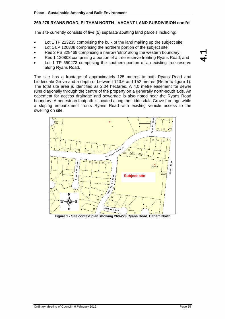
SUBJECT SITE AND SURROUNDING AREA
The subject site is a rectangular area of land located between Ryans Road and Liddesdale Grove near the intersection with Calendonia Drive, in the suburb of Eltham North. In this locale, Ryans Road forms the municipal boundary with Nillumbik Shire Council.
4.1
Place – Sustainable Amenity and Built Environment 269-279 RYANS ROAD, ELTHAM NORTH - VACANT LAND SUBDIVISION cont’d
Ordinary Meeting of Council - 6 February 2012 Page 35
The site currently consists of five (5) separate abutting land parcels including: • Lot 1 TP 213235 comprising the bulk of the land making up the subject site; • Lot 1 LP 120808 comprising the northern portion of the subject site; • Res 2 PS 328469 comprising a narrow ‘strip’ along the western boundary; • Res 1 120808 comprising a portion of a tree reserve fronting Ryans Road; and • Lot 1 TP 550273 comprising the southern portion of an existing tree reserve
along Ryans Road.
The site has a frontage of approximately 125 metres to both Ryans Road and Liddesdale Grove and a depth of between 143.6 and 152 metres (Refer to figure 1). The total site area is identified as 2.04 hectares. A 4.0 metre easement for sewer runs diagonally through the centre of the property on a generally north-south axis. An easement for access drainage and sewerage is also noted near the Ryans Road boundary. A pedestrian footpath is located along the Liddesdale Grove frontage while a sloping embankment fronts Ryans Road with existing vehicle access to the dwelling on site.
Figure 1 - Site context plan showing 269-279 Ryans Road, Eltham North
Subject site
4.1
Place – Sustainable Amenity and Built Environment 269-279 RYANS ROAD, ELTHAM NORTH - VACANT LAND SUBDIVISION cont’d
Ordinary Meeting of Council - 6 February 2012 Page 36
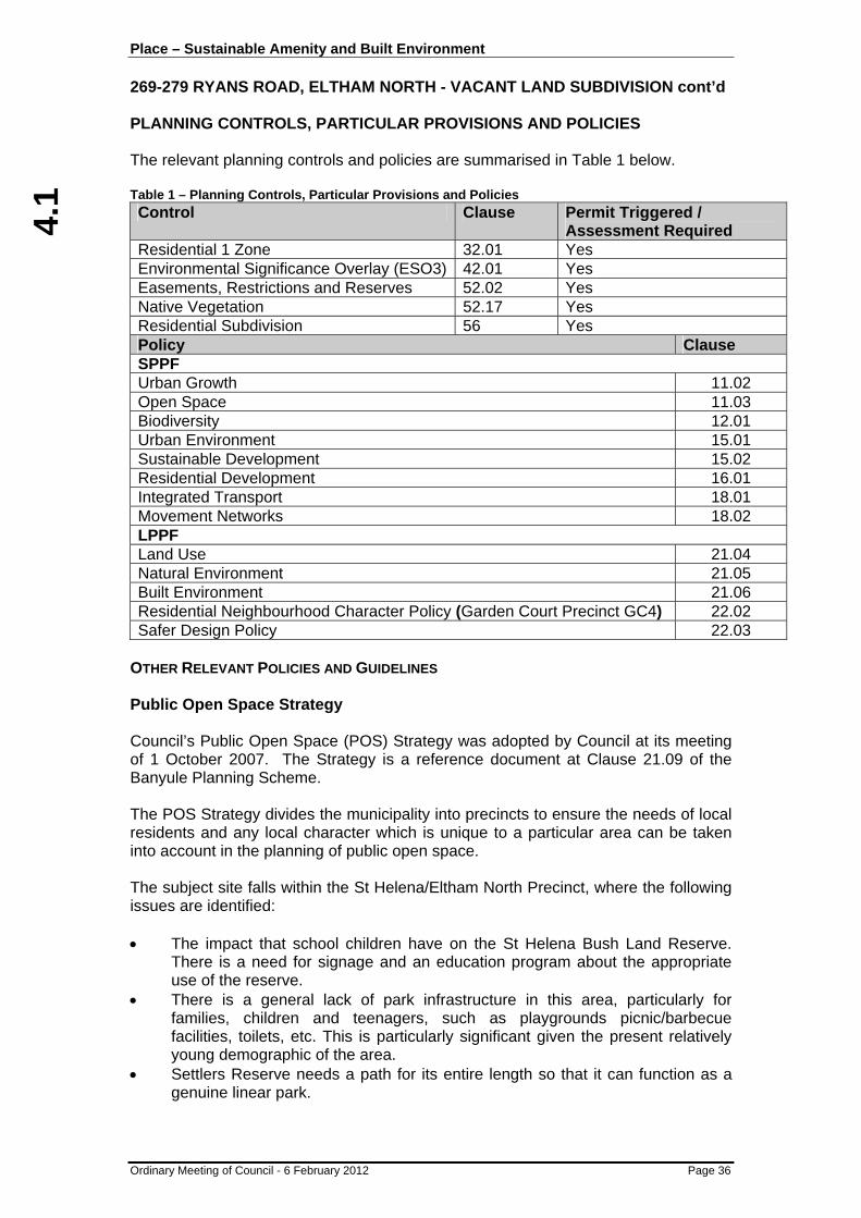
PLANNING CONTROLS, PARTICULAR PROVISIONS AND POLICIES The relevant planning controls and policies are summarised in Table 1 below. Table 1 – Planning Controls, Particular Provisions and Policies Control Clause Permit Triggered /
Assessment Required Residential 1 Zone 32.01 Yes Environmental Significance Overlay (ESO3) 42.01 Yes Easements, Restrictions and Reserves 52.02 Yes Native Vegetation 52.17 Yes Residential Subdivision 56 Yes Policy Clause SPPF Urban Growth 11.02 Open Space 11.03 Biodiversity 12.01 Urban Environment 15.01 Sustainable Development 15.02 Residential Development 16.01 Integrated Transport 18.01 Movement Networks 18.02 LPPF Land Use 21.04 Natural Environment 21.05 Built Environment 21.06 Residential Neighbourhood Character Policy (Garden Court Precinct GC4) 22.02 Safer Design Policy 22.03
OTHER RELEVANT POLICIES AND GUIDELINES Public Open Space Strategy Council’s Public Open Space (POS) Strategy was adopted by Council at its meeting of 1 October 2007. The Strategy is a reference document at Clause 21.09 of the Banyule Planning Scheme. The POS Strategy divides the municipality into precincts to ensure the needs of local residents and any local character which is unique to a particular area can be taken into account in the planning of public open space. The subject site falls within the St Helena/Eltham North Precinct, where the following issues are identified: • The impact that school children have on the St Helena Bush Land Reserve.
There is a need for signage and an education program about the appropriate use of the reserve.
• There is a general lack of park infrastructure in this area, particularly for families, children and teenagers, such as playgrounds picnic/barbecue facilities, toilets, etc. This is particularly significant given the present relatively young demographic of the area.
• Settlers Reserve needs a path for its entire length so that it can function as a genuine linear park.

4.1
Place – Sustainable Amenity and Built Environment 269-279 RYANS ROAD, ELTHAM NORTH - VACANT LAND SUBDIVISION cont’d
Ordinary Meeting of Council - 6 February 2012 Page 37
• There is lack of informal recreation facilities in Anthony Beale Reserve, e.g. picnic/barbeque facilities, play facilities for teenagers.
• The provision of facilities suitable for teenagers is of particular importance. There needs to be an assessment of the needs of young people in the area and appropriate facilities provided accordingly.
• There is a need for management strategies for bush land and nature reserves in this precinct.
• Interpretive signage required in small bush land reserves in this precinct. • The natural reserves in this area are of high conservation significance and
should be managed accordingly. • The indigenous vegetation at the eastern end of Anthony Beale Reserve
requires enhanced management. Residential Subdivision of Vacant Land Guidelines In February 2004 Council adopted the above guidelines which indicate that subdivision of residential land prior to development will be discouraged unless an applicant can demonstrate that a proposal can overcome site constraints and lead to similar development outcomes as would be achieved by subdividing after development approval. The guidelines state that Council will consider the following issues: • The future development of subdivided land; • A subsequent planning permit for development of lots less than 500m2 will be
required; • A subsequent planning permit for development may still be required for
subdivided lots covered by overlays; • The Banyule Planning Scheme sets a high standard for development in
keeping with the environmental, amenity and neighbourhood character expectations of the community and vacant lot subdivision proposals must demonstrate that such high quality outcomes will result.
PUBLIC NOTIFICATION AND CONSULTATION The project as a whole has undergone a robust community consultation prior to lodgement of the application. The applicant sent an information package (mailout) to the greater surrounding neighbourhood in early June 2011 (which numbered 80 properties, as well as the local primary school and Nillumbik Shire Council). This package contained a Frequently Asked Questions flyer and an information cover letter. The covering letter invited interested parties to attend a Community Information Session which took place on 15 June in Greensborough. The session was well attended. Community feedback and comments received were dispersed to the relevant project consultants for consideration and advice. At the meeting, the applicant committed to undertake a further Traffic and Transportation Review of the local traffic as well as investigate providing vehicular access to Lot 6 from Ryans Road instead of Liddesdale Grove.
4.1
Place – Sustainable Amenity and Built Environment 269-279 RYANS ROAD, ELTHAM NORTH - VACANT LAND SUBDIVISION cont’d
Ordinary Meeting of Council - 6 February 2012 Page 38
After the meeting on 21 June, a further mailout which included the concept plan presented at the Community Information Session was sent to all 80 properties, as well as the local primary school and Nillumbik Shire Council. The cover letter further invited comment and feedback. A project update letter was posted to the greater surrounding neighbourhood (107 properties, as well as the local primary school and Nillumbik Shire Council) early September 2011. The letter invited interested parties to attend a pre-application information meeting held on 13 September in Briar Hill. At this meeting, the applicants Traffic Engineer provided the findings of the Traffic and Transportation Review, whilst other matters were also discussed relating to the proposed subdivision. As well as these sessions, various feedback from local residents was also received verbally and in writing. All written and verbal feedback received was then responded to after obtaining feedback and advice from the relevant project consultants. The project also has a webpage which was updated as the project progressed. The webpage contained links to the various plans as they developed, as well as the various consultants’ reports. An updated Frequently Asked Questions flyer that was developed for the Planning Application Stage was posted out with the formal planning notification advertising letter in November 2011. Formal notification of the application was given by placing three (3) signs on site (two facing Liddesdale Grove and one facing Ryans Road) and Council mail to adjoining and nearby properties as well as the greater neighbourhood area (total 97). One objection was received. Grounds of the objection are summarised as follows: • There was no public consultation conducted prior to Council purchasing site; no
consideration of most of the objections raised by correspondence or at meetings; that Council has taken a “steam-roller approach” at public meetings; that neither Nillumbik Council or the Primary School were present at meetings and that there is no evidence that Nillumbik Council were consulted;
• Increased traffic, parking chaos and safety concerns in Liddesdale Grove, especially around school times;
• Lot sizes are inconsistent with surrounding properties; • No clear vision provided for Lot 6; • Future dwellings may have difficulty complying with ResCode; • Existing cehicle access is via Ryan’s Road so no issue with having new access
off Ryans Road; • Loss of on-street parking on Liddesdale Grove; • Rejection of Council’s findings and statements in relation to minimum design
requirements for intersections and roundabouts as it already exists; • Traffic counts used in reports were not adequate; • Vehicle access to the Superlot (lot 6) off Liddesdale Grove is unacceptable and
inappropriate; • Real reason for Council pursing the plan and access relates to the monetary
outlay and not the environmental or safety aspects put forward, again with no evidence of consultation with Nillumbik Shire Council.

4.1
Place – Sustainable Amenity and Built Environment 269-279 RYANS ROAD, ELTHAM NORTH - VACANT LAND SUBDIVISION cont’d
Ordinary Meeting of Council - 6 February 2012 Page 39
Given the issues raised in the objection, the response provided at early information/consultation sessions and within this report, further consultation was considered unlikely to result in resolution between the parties, and as such no further meeting was convened in this instance. REFERRAL COMMENTS A summary of the comments received from internal and external referral authorities is provided below in Table 2. Table 2 – Summary of Referral Comments Internal Conditions/Notes Comments Engineering Yes Minor concerns resolvable (Refer to
response on file) Environment Yes Concerns resolvable (Refer to response on
file) Arborist Yes Concerns resolvable (Refer to response on
file) Parks/Open Space Yes Comments indicated that a fire break would
be likely to be needed between the conservation reserve and future dwellings on lot 6 and that this could be addressed as part of the future permit for the superlot. Also, there is a need to ensure funding is available for management of the conservation reserve.
Property Yes No concerns, standard notes regarding access over Council land.
External Objection Conditions Yarra Valley Water No Yes (Refer to response on file) Melbourne Water No Yes (Refer to response on file) Telstra No No APA Group No No DSE No Yes (Refer to response on file) SP AusNet No Yes (Refer to response on file)
TECHNICAL CONSIDERATION
RESPONSE TO POLICY FRAMEWORK
A summary of the residential area type as described in Clause 21.06 of the Banyule Planning Scheme, along with distances to public transport and shops is provided in Table 3 below. Table 3 – Residential Area Type and distance to shops and public transport
Residential Area Type Limited Incremental Access to Public Transport
• Approx. 2.5km to Diamond Creek Train Station, 2.7km to Eltham Train Station and Approx. 3.4km to Greensborough Train Station (As the crow flies)
• Approx. 280m to Bus Routes 580 to the north on Ryans Road and access to 517 Route near the site and south along Rysan Road
Access to Shops Approx 900m to St Helena Neighbourhood Activity Centre

4.1
Place – Sustainable Amenity and Built Environment 269-279 RYANS ROAD, ELTHAM NORTH - VACANT LAND SUBDIVISION cont’d
Ordinary Meeting of Council - 6 February 2012 Page 40
The proposed subdivision is considered to be consistent with State and Local Planning Policies through well planned provision of additional residential lots that can accommodate future dwellings, protect and enhance trees and other native vegetation and maintain important characteristic of the neighbourhood through an appropriate subdivision pattern. The density proposed for the lots fronting Liddesdale Grove (800m2 lots) is reflective of the sites zoning and proximity to good public transport, shopping and other public and community facilities. Lots sizes have been formulated based on the existing subdivision pattern and existing lots found in the area and provide suitable space for future dwellings and provision of trees and other landscaping consistent with the establish and preferred character. It is envisaged that the super lot will be further developed in the future with an integrated housing development. This is likely to be more intensive than a density of 1:800m2, however given the important vegetation on site that will need to be retained, the density is unlikely to be unreasonable for the area and will create opportunities for housing diversity and smaller allotments to manage, which is also consistent with State and Local Policies. The provision of a large secured municipal reserve will ensure the most important native vegetation on site is protected and maintained, whilst also providing an opportunity to meet State Government Net Gain requirements (which is discussed in more detail below). Moreover and of equal importance are noteworthy trees, many of which will also be protected through exclusion zones proposed on the residential allotments fronting Liddesdale Grove. A detailed response to the relevant considerations of the Banyule Planning Scheme is provided below or in the attachments which deal with the subdivision layout, neighbourhood character and vegetation.
NEIGHBOURHOOD CHARACTER STRATEGY ASSESSMENT
The proposal meets the objectives of Council’s Neighbourhood Character Policy at Clause 22.02 of the Banyule Planning Scheme. Although a number of the specific design responses and objectives are not relevant at the subdivision stage as they relate more to built form outcomes, a detailed assessment against the relevant components is included as an attachment to this report. Conditions are required to ensure compliance is achieved, whilst a variation to the design response relating to tree retention contained within the Vegetation Cover objectives requires further discussion. The proposed subdivision layout has been designed to retain vegetation on site. Exclusion zones, which will exclude buildings and works from being carried out within those areas, have been provided to retain the important vegetation and whilst no front gardens are proposed, these areas will ensure the outcome is achieved. Additionally, a large municipal reserve is being provided which will result in the most important vegetation on site being retained and any future development of the super lot will need to factor in existing vegetation within the design.
4.1
Place – Sustainable Amenity and Built Environment 269-279 RYANS ROAD, ELTHAM NORTH - VACANT LAND SUBDIVISION cont’d
Ordinary Meeting of Council - 6 February 2012 Page 41
Not all trees are being retained on site, including some high retention value trees. In consideration of this it is noted that the site is zoned Residential 1 and therefore contemplates some form of subdivision or development. Moreover, there is scope to modify the exclusion zones to accommodate crossovers/driveways but more importantly, increase their size at both the front and rear of properties such that they become both exclusion zones and landscape zones to not only retain additional trees, but also accommodate replacement planting consistent with the character of the area. The revisions are shown on the modified plans marked revision B, dated 25 January 2012, titled ‘Concept Plan’ and ‘Tree retained/lost Plan’. These revisions will form a condition of any permit issued, so to restrictions for access into these areas for any buildings and works. Tree protection zones will also be required during construction, so to sensitive construction techniques for driveways, especially for lot 1 and the accessway in the future for lot 6 adjacent to the tree on lot 5. Finally, it is noted that trees 148 and 149, being high retention and medium retention value trees on lot 3 are currently proposed for removal. At this stage, it is considered more appropriate to require the trees to be retained, however not include them in an exclusion zone. This will enable consideration of their removal when designing a future dwelling for the lot, as there may be scope to construct decking or similar structure beneath these trees without actually having to remove them. Not placing an exclusion zone allows flexibility and two additional important trees are not automatically lost. As this is a subdivision permit, all of the above requirements, although required on some plans, will need to be incorporated into a S.173 Agreement so that all future owners are aware of their obligations and the restrictions on the individual sites.
CLAUSE 56 ASSESSMENT (RESCODE)
An assessment against the provisions of Clause 56 (Rescode) of the Banyule Planning Scheme has been undertaken and is included on file. The proposal complies with all objectives and standards of the Scheme subject to the inclusion of permit conditions as detailed within the attachment.
NATIVE VEGETATION AND TREES
The subject site is densely covered in trees and vegetation and is of a size that affords it two levels of protection under the Banyule Planning Scheme. The first level of protection is the state native vegetation controls at Clause 52.17 which applies to not only trees, but also understorey, ground covers and grasses. The second level of protection is the Environmental Significance Overlay (Schedule 3) which is of the highest order environmental overlay in Banyule away from waterways. This control applies more so to trees, but also contains the requirement for buildings and works to obtain a planning permit. It is important to note the difference between these two controls as, although containing some similar objectives and intentions, they operate quite differently.

4.1
Place – Sustainable Amenity and Built Environment 269-279 RYANS ROAD, ELTHAM NORTH - VACANT LAND SUBDIVISION cont’d
Ordinary Meeting of Council - 6 February 2012 Page 42
State Vegetation Controls Both the State Planning Policy Framework and Clause 52.17 of the Banyule Planning Scheme identify the need to adopt the principles of net gain (three step approach) where an application will either impact on or result in the removal of native vegetation. These steps are referred to as:
• To avoid adverse impact, particularly through vegetation clearance; • If impacts cannot be avoided, to minimise impacts through appropriate
consideration in planning processes and expert input to project design or management; and
• Identify appropriate offset options. The Department of Sustainability the Environment and Municipal Council’s across Victoria adopt the principles and findings of the Victorian Civil and Administrative Tribunal’s decision in Villawood v Greater Bendigo CC [2005] VCAT 2703 (20 December 2005), whereby it was established and has since been accepted that generally where lots created by a subdivision are less than 4000m2 or where areas cannot be fenced off and protected, then for the purposes of net gain, all vegetation is considered lost, even if some is being retained. This is an important point in context of the current proposal for a number of reasons relating to tree retention on the northern lots, usability of public open space and fencing, all of which are discussed below. Before discussing these points however, there is need to understand the vegetation on site, which has influenced the current subdivision layout. The starting point for this site was a flora and fauna assessment which was prepared by a local ecologist. The study found that the site had been subjected to a variety of disturbances since settlement, including timber harvesting and grazing, however the site had been for the most part, undisturbed for the past 8-10 years. The study also found that the site could effectively be split into two zones shown in Figure 2. In simple terms, zone 1 contains the better quality vegetation on site, although zone 2 does also contain some good quality vegetation also, just not at the same quantity or quality.
Figure 2 – Vegetation Zone Delineation (extracted from ecologist report)
4.1
Place – Sustainable Amenity and Built Environment 269-279 RYANS ROAD, ELTHAM NORTH - VACANT LAND SUBDIVISION cont’d
Ordinary Meeting of Council - 6 February 2012 Page 43
In response to the ecological findings, the proposed subdivision layout resembles the findings through setting aside effectively all of zone 1 as a municipal conservation reserve. Setting aside zone 1 in effect responds to all three principles of net gain through avoiding the removal or adverse impact of the most important native vegetation on site, minimises removal given the size of the reserve and also provides an option for the provision of offsets onsite and within the municipality. Provided zone 1 is appropriately fenced off to the public, then only the vegetation north of zone 1 is considered lost for the purposes of net gain as much of the area will be ultimately developed except for tree reserves. Compliance with other controls will still be required. This is a positive response to the site which could have been developed further with reduced retention and provision of offsets outside of the municipality or in regional areas. In relation to the provision of offsets, it is noted that effectively 100% weed eradication is proposed for the reserve, which is a very difficult and onerous task. Council’s Environment Department have indicated that it may be more appropriate and beneficial to the overall environment of the municipality to achieve a high level of weed eradication, however that level may not be 100%, rather 80% with the remainder of offsets occurring in nearby bush reserves such as the St Helena Bush Reserve or Browns Reserve. The final decision on how offsets will be provided does not need to be determined at this time given the number of options available that will result in an overall benefit and ‘net gain’ of native vegetation for the municipality. A condition of permit will require an offset plan which addresses these requirements which is standard practice for these types of applications. The conditions of permit will also require in relation to and in addition to an offset plan: • 100% offsets on site or where not achievable, generally within the municipality
or neighbouring municipalities; • Some species, namely Orchids (Corybas diemencius, Microtis sp, Pterostylis
sp. Thelymitra media,) Geranium sp 3 (pallidiflorum) and Billardiera (scandens subsp. Braceatha) from the ‘lost’ area will be required to be translocated into zone 1 from lots 1-5 before clearing occurs and from the super lot at a future stage before that site is developed;
• A zoologist will be required to relocate fauna before vegetation removal occurs; • Fencing along the reserve is to be permeable yet restrictive to pets/people. A
subsequent planning permit will be required for this fencing which is considered to be a procedural matter;
• Water Sensitive Urban Design (WSUD) to super lot (future requirement) to restrict water flows into the reserve (to avoid spreading weeds) or the use of possible kerbing.
Environmental Significance Overlay Controls As noted earlier, the second control affecting the site is the Environmental Significance Overlay (Schedule 3), which applies only to trees as opposed to understorey, ground covers or grasses, however the objectives and intentions relating to maintaining and enhancing conservation values is consistent with the State vegetation controls. The other difference is that where trees are proposed to be retained, they are not considered “lost” despite not being set aside in a reserve and therefore still contribute to the environmental, landscape and character of an area.

4.1
Place – Sustainable Amenity and Built Environment 269-279 RYANS ROAD, ELTHAM NORTH - VACANT LAND SUBDIVISION cont’d
Ordinary Meeting of Council - 6 February 2012 Page 44
It is only proposed to remove trees that are not shown for retention on lots 1 – 5 at this stage. These will primarily be in exclusion zones. There is no proposal at present to remove any trees on the super lot, which is inclusive of the indicative path location, however some trees have been shown for removal where a future accessway will be located. What this means is that although already factored into a net gain assessment, considered lost and some of which will be lost once accessways are constructed in the future, additional planning permission will be required for some of their removal under this control. As such, any future design for the super lot will need to be responsive to the vegetation and every effort will need to be made to retain high and medium retention value trees. Turning to lots 1 – 5, a careful review and assessment of the subdivision layout has been carried out to ascertain whether an appropriate balance has been struck between competing considerations relating to the zoning of the land, allowing some form of subdivision, consistency with neighbourhood character and subdivision patterns as well as tree retention. A review of the arborist report submitted with the application identifies that there are some 110 trees proposed for removal across the five lots of which six are high retention, 48 are medium retention and the remainder are low retention value. Conversely, there are approximately 47 trees being retained within exclusion zones, containing a mixture of high, medium and low retention species. Additionally, although not proposed for removal, there are some questions surrounding the impact on further trees within the road reserve to Liddesdale Grove, along the proposed future accessway to the super lot and within the exclusion zones of some sites primarily associated with crossovers, driveways and future fencing. Low retention value trees are generally considered suitable for removal, however, every effort should be made to retain medium retention trees and there has to be a good reason to allow the removal of high retention trees. The tree removal proposed has been assessed in this context and in context of the other competing considerations. Firstly, it is noted that some of the proposed exclusion zones are illogical as they envisage works through them for future driveways, fences and services rendering them accessible and not excluded from impacts to trees. This concern is resolvable however through minor changes to the exclusion zones as follows: • Deletion of part of the exclusion zones on lots 1, 2 and 3 at the frontage to
Liddesdale Grove to allow for a 3m wide driveway. This will not result in any additional tree removal subject to appropriate sensitive construction techniques for any driveway for lot 1;
• Increase the exclusion zones on lots 1, 3 and 5 to extend across the frontages to Liddesdale Grove (whilst maintaining a 3m driveway space) which results in increase overall exclusion area and additional tree protection and retention;
• Ensure any drainage and sewerage easement across the rear of lots 1-5 is located on the common boundary of lot 6 and located wholly within lot 6. Any services should be ‘bored’, however this will ensure minimal impact on existing trees within the exclusion zones across the rear of lots 1-5 and will avoid existing and proposed planting within the easement.

4.1
Place – Sustainable Amenity and Built Environment 269-279 RYANS ROAD, ELTHAM NORTH - VACANT LAND SUBDIVISION cont’d
Ordinary Meeting of Council - 6 February 2012 Page 45
In addition to the above, there is scope to extend the exclusion zones across the rear of lots 1,2 and 3 such that a minimum area of 5m is set aside for landscaping to offset the loss of the high retention trees and without impacting on the useable space on site for the construction of a dwelling. Tree 235 is a high retention tree located within an exclusion zone on lot 5 adjacent to the accessway for the super lot. Engineering advice has indicated that fill will be required to achieve appropriate grades for the future accessway for the first 6m into the site. This may have an impact on tree 235 and requirements around the need for retaining walls with well drained medium fill will be required as conditions of permit for the future owners/developers of lot 6. Investigations were carried with respect to changing lot boundaries to provide a mixture of lots in an attempt to retain two additional high retention trees (trees 217 and 222), however these investigation revealed that a substantial change would be required that was likely to make other lots undevelopable, too narrow or result in impacts on other high retention trees. Investigations were also carried out with respect to the centrally located stand of trees on lot 2 which is likely to result in creating an outcome where parking storage facilities will be located forward of any future dwelling. Council’s arborist reviewed these trees in addition to other nearby trees to establish whether the correct balance had been achieved. Advice provided is that the correct trees are of higher value than others nearby and the layout is appropriate as proposed. Finally, investigations were carried out in relation to trees 148 and 149 that are of high and medium retention value respectively. These trees were examined in more detail given the location towards the rear of lot 3 to establish whether there is scope to retain them. Including these trees within an exclusion zone would be overly restrictive for this lot, significantly reducing the developable area, however that is not to say that they may not be able to be retained. As such, at this stage it is considered more appropriate to require the trees to be retained, however not include them in an exclusion zone. This will enable consideration of their removal when considering the design of a future dwelling for the lot, as there may be scope to construct decking or similar structure beneath these trees without actually having to remove them. Not placing an exclusion zone allows flexibility and two additional important trees are not automatically lost. If a future design demonstrates that they can be removed with suitable justification, then their removal may be considered appropriate at that time. The above changes, for the most part, have been shown on modified plans marked revision B, dated 25 January 2012, titled ‘Concept Plan’ and ‘Tree retained/lost Plan’ and this will form a condition of permit, along with requirements for tree protection during any construction which will be linked through a S.173 Agreement on title ensuring future owners are aware of their obligations.
REMOVAL OF EASEMENTS AND RESERVES
Clause 52.02 of the Banyule Planning Scheme outlines that a permit is required before a person proceeds to remove an easement or remove reservation status under the Subdivision Act 1988.

4.1
Place – Sustainable Amenity and Built Environment 269-279 RYANS ROAD, ELTHAM NORTH - VACANT LAND SUBDIVISION cont’d
Ordinary Meeting of Council - 6 February 2012 Page 46
These components of the proposal are procedural more than anything to reflect the changes to the existing parcels of land. The easements being removed are located towards the Ryans Road frontage and were created to facilitate vehicle and pedestrian access to Ryans Road for the existing dwelling over the southern lot, with provision for services to also connect to Ryans Road. As vehicle access and access to services is no longer required to Ryans Road, these easements will become redundant if the subdivision proceeds and therefore are no longer required. The removal of the reservation status (Reserve No.1 on LP120808) relates to the north eastern tree reserve abutting Ryans Road. This reserve is larger in depth than the remaining tree reserves along Ryans Road and is effectively being reduced to align with the other tree reserve to the south. To compensate for the loss of the area, additional tree reserve is being proposed where the proposed easements are to be removed to provide a contiguous 10m wide tree reserve for the length of the Ryans Road frontage. Additionally, the southern portion of the site set aside for vegetation retention and offsets will also become a reserve. Reserve No.2 on PS328469R (40 Liddesdale Grove) is also being removed to enable the proposed lots along Liddesdale Grove to have frontage to Liddesdale Grove.
TRAFFIC AND PARKING IMPLICATIONS
Concerns were expressed at the consultation sessions and within the objection received regarding traffic and parking considerations associated with the proposal. A Traffic Engineering consultant was engaged to investigate all traffic and parking matters associated with the proposal. The report identifies that vehicle access from Liddesdale Grove is effectively the only option due to safety and sightline concerns from Ryans Road, all lots will be able to accommodate minimum parking requirements. It is noted that although approximately five on-street parking spaces will be lost on Liddesdale Grove, there is more than adequate on-street parking along the remainder for resident needs. Parking will continue to be an issue during school drop off and pick up times, however this is common across Metropolitan Melbourne within close proximity to a school that provides little to no parking. It is suggested that visitor parking be provided within the super lot which will be considered and required at that time in the future, once it is known what level of housing will be proposed. PUBLIC OPEN SPACE The requirement for public open space has been considered having regard to Council’s Public Open Space Strategy and Section 18 of the Subdivision Act 1988. The land is currently occupied by a single dwelling and the proposed subdivision will result in lots with an ability to accommodate a minimum of five dwellings in addition to multiple dwellings on the super lot. It is considered appropriate to require that this matter be resolved through permit conditions. This provides an opportunity for further investigations into the various options to achieve the best outcome for the community, whether it be a public path adjacent to the reserve, an area set aside on the super lot, paths through the reserve or monetary contributions (which might be in the form of bringing forward open space projects in the area).
4.1
Place – Sustainable Amenity and Built Environment 269-279 RYANS ROAD, ELTHAM NORTH - VACANT LAND SUBDIVISION cont’d
Ordinary Meeting of Council - 6 February 2012 Page 47
OBJECTORS’ CONCERNS
Although a majority of the objector’s concerns have been responded to within the body of this report or within the associated attachments, the concern surrounding consultation prior to purchase of the land requires a response. It is noted that Council could not have undertaken community consultation before purchasing the site without compromising a commercial negotiating position for the acquisition of the site. Additionally, this concern is a matter outside of the scope of consideration at the time of the Planning Permit application process and is matter that should be discussed separately with the relevant officers of Council. CONCLUSION It is considered that the proposed subdivision, subject to minor changes and permit conditions will result in an appropriate outcome for the site without unreasonably compromising the environment or the character of the area. The subdivision layout is reflective of the existing subdivision pattern and the retention of a municipal reserve will ensure a large patch of native vegetation is conserved, protected and maintained for years to come. The proposal achieves a balance between not only competing planning considerations and policy objectives, but also community aspirations through ensuring the site is not overdeveloped with the important vegetation being retained. RECOMMENDATION
That Council having complied with Section 52, 58, 60, 61 and 62 of the Planning and Environment Act 1987, resolves that a Notice of Decision to Grant a Planning Permit be issued in respect of Application No. P992/2011 for Subdivision and associated works of the land including:
- Six (6) lot subdivision and creation of two (2) reserves;
- Vegetation and tree removal;
- Removal of reserve status of reserve No.2 on PS328469R (40 Liddesdale Grove);
- Removal of reserve status of reserve No.1 on LP120808; and
- Removal of easement for way, drainage and sewerage created on LP120808
at 269-279 Ryans Road ELTHAM NORTH subject to the following conditions: Plans (1) Prior to Certification of the Plan of Subdivision, amended plans to the
satisfaction of the Responsible Authority must be submitted to and approved by the Responsible Authority. When approved the plans will be endorsed and will then form part of the permit. The plans must be drawn to scale with dimensions and three copies must be provided. The plans must be generally in accordance with the advertised plans submitted with the application but modified to show:
(a) Provision of a 3m wide drainage and sewerage easement on the eastern side of the rear boundaries of lots 1-5 in favour of Banyule City Council and Yarra Valley Water (if required);

4.1
Place – Sustainable Amenity and Built Environment 269-279 RYANS ROAD, ELTHAM NORTH - VACANT LAND SUBDIVISION cont’d
Ordinary Meeting of Council - 6 February 2012 Page 48
(b) Amended plans generally in accordance with the modified plans marked revision B, dated 25 January 2012, titled ‘Concept Plan’ and ‘Tree retained/lost Plan’ including:
(i) modified exclusion zones to all lots;
(ii) crossover locations including traffic engineering evidence that the location for lot 1 works;
(iii) Additional tree retention associated with the modified exclusion zones.
(c) Trees 148 and 149 on lot 3 to be indicated for retention as part of the current proposal;
(d) All exclusion/landscaping zones to be fully dimensioned;
(e) Indicative fencing (generally of post and wire style yet restrictive enough to prevent public access) to the offset area with a notation that further approval is required for the fence.
(2) Prior to Certification of the Plan of Subdivision, a satisfactory detailed drainage
plan with specifications must be submitted to and approved by the Responsible Authority. Such plan must include:
(a) The drainage works necessary to connect the subject land (including individual allotments) to the Council nominated point of discharge (which may entail a 225mm diameter drain for outfall drainage);
(b) Evidence that the existing drainage system south of the subject site has sufficient capacity to accept discharge from the development site;
(c) Where evidence in (b) above cannot be provided, details and design of any upgrade of the system must be provided and constructed.
Once approved, drainage must be constructed to the satisfaction of the Responsible Authority prior to the issue of a Statement of Compliance.
General (3) The subdivision as shown on the endorsed plan shall not be altered or modified
(whether or not in order to comply with any statute, Statutory Rule or By-Law or for any other reason) without the consent of the Responsible Authority.
Site Management Plan (4) Prior to the commencement of any subdivision works a site management plan
in accordance with Standard C26 of Clause 56.08 of the Banyule Planning Scheme must be prepared and submitted to the Responsible Authority for endorsement. Once endorsed, the plan must be adhered to at all times during subdivision works.
Native Vegetation Protection (5) Except with the further written consent of the Responsible Authority, no
vegetation (other than that indicated on the endorsed plan, or exempt from planning permission under the provisions of the Banyule Planning Scheme) shall be damaged, removed, destroyed or lopped.
4.1
Place – Sustainable Amenity and Built Environment 269-279 RYANS ROAD, ELTHAM NORTH - VACANT LAND SUBDIVISION cont’d
Ordinary Meeting of Council - 6 February 2012 Page 49
(6) All services where located within the Tree Protection Zone (TPZ) as calculated under Australian Standard AS4970-2009 of any tree being retained, must be bored without further approval from Council’s Development Planning Arborist or relevant project arboist.
(7) Unless otherwise agreed in writing by the Responsible Authority, prior to the
commencement of works (including demolition) on the site Tree Protection Zones must be established in accordance with the endorsed tree protection plan. You must contact Council’s Development Planning Arborist on 9457 9878 once the Tree Protection Fencing is erected so that an inspection of the fencing can be carried out. Please note a minimum of two (2) days prior notice is required. Once installed and inspected the Tree Protection Zones must not be moved or altered without approval of the Responsible Authority. (a) A tree protection plan must be prepared by the project arborist detailing
fencing material, fencing locations, signage, trunk and ground protection measures for all trees proposed to be retained where within 10m of any subdivision or demolition works proposed;
(b) Tree protection zones should be calculated using the methods detailed
within AS 4970-2009 Protection of trees on development sites. (c) The tree protection plan should be included in subsequent construction
documentation. The location of tree protection measures should also be shown on other documents such as demolition, bulk earth works, construction and landscape plans.
(d) An endorsed laminated A3 copy of this plan must be maintained and
displayed at the site entry for the construction period of the development.
(e) Activities generally excluded from the TPZ include but are not limited to— • machine excavation including trenching; • excavation for silt fencing; • cultivation; • storage; • preparation of chemicals, including preparation of cement products; • parking of vehicles and plant; • refuelling; • dumping of waste; • wash down and cleaning of equipment; • placement of fill; • lighting of fires; • soil level changes; • temporary or permanent installation of utilities and signs, and • physical damage to the tree.
(f) The area within the TPZ must be mulched. The mulch must be maintained
to a depth of 50–100 mm

4.1
Place – Sustainable Amenity and Built Environment 269-279 RYANS ROAD, ELTHAM NORTH - VACANT LAND SUBDIVISION cont’d
Ordinary Meeting of Council - 6 February 2012 Page 50
NOTE: Requests for consent of the Responsible Authority (City of Banyule) pursuant to this Condition should be directed to Council’s Arborist – Development Planning on 9457 9878. Consent for the conduct of works within the Tree Protection Zone, where granted, may be subject to conditions. Such conditions may include a requirement that: • Any underground service installations within the Tree Protection Zone be
bored to a minimum depth of 600mm to the top of the pipe; • All root excavation be carried out by hand digging or with the use of ‘Air-
Excavation’ techniques; • No roots greater than 30mm in diameter are to be cut or damaged without
the consent of Councils Arborist - Development Planning. Or other conditions, as relevant, to ensure the ongoing health and stability of the subject tree/s.
Section 173 Agreement (8) Unless otherwise agreed in writing by the Responsible Authority, prior to the
Certification of the Plan of Subdivision, the owner of the land at 269-279 Ryans Road, Eltham North must enter into an agreement with the Responsible Authority pursuant to Section 173 of the Planning and Environment Act 1987 to the satisfaction of the Responsible Authority and such agreement must provide for:
Exclusion and Landscape Zones/Tree Protection
(a) Unless otherwise agreed in writing by the Responsible Authority, no buildings or works (including structures, retaining walls or excavation) other than non-invasive landscaping and gardening normal to a dwelling can occur within exclusion/landscape zones provided for lots 1-5 on Plan of Subdivision PS 648526V.
(b) Unless otherwise approved in writing by the Responsible Authority, the trees indicated for retention within the exclusion zones or as shown for retention on the endorsed plan pursuant to Planning Permit P992/2011 must be retained and protected on the site.
Additional requirements lot specific
(c) In relation to Lot 1
(i) The driveway adjacent to tree 102 must be constructed utilising sensitive construction techniques, above grade where possible and of a suitable permeable surface to minimise the impact on the tree to the satisfaction of the Responsible Authority
(d) In relation to Lot 2
(i) Unless otherwise agreed in writing by the Responsible Authority, no detached garage may be located forward of the dwelling. Consideration may be given to a carport located forward of the dwelling subject to satisfactory justification being provided in relation to the carport’s height, form, appearance (including colours/materials) and screening vegetation.

4.1
Place – Sustainable Amenity and Built Environment 269-279 RYANS ROAD, ELTHAM NORTH - VACANT LAND SUBDIVISION cont’d
Ordinary Meeting of Council - 6 February 2012 Page 51
(e) In relation to lot 5
(i) The driveway adjacent to tree 229 must be constructed utilising sensitive construction techniques, above grade where possible and of a suitable permeable surface to minimise the impact on the tree to the satisfaction of the Responsible Authority
(f) In relation to lot 6
(i) The accessway from Liddesdale Grove must be constructed to Australian Standard AS 2890.1 (2004) such that a grade of 1 in 20 is achieved for the first 6m into the site and 1 in 5 (20%) for the remainder;
(ii) Any fill utilised to achieve (f) (i) above where adjacent to tree 235 on lot 5 must be retained through a retaining wall utilising well drained medium;
(iii) Provision of kerbing and Water Sensitive Urban Design (WSUD) measures to minimise the amount of run-off/sheet water entering the municipal conservation reserve;
(iv) Translocation of Orchids (Corybas diemencius, Microtis sp, Pterostylis sp. Thelymitra media,) Geranium sp 3 (pallidiflorum) and Billardiera scandens subsp. braceatha from lot 6 in the ‘lost’ area (zone 2) into zone 1 before any vegetation clearing occurs within that lot;
(v) Relocation of any fauna from zone 2 on lot 6 by an appropriately qualified person before vegetation removal on that lot occurs, unless otherwise agreed in writing by the Responsible Authority.
A memorandum of the Agreement is to be entered on title and the cost of the preparation and execution of the Agreement and entry of the memorandum on title is to be paid by the owner.
Public Open Space (9). Prior to the issue of a Statement of Compliance, a public open space
contribution must be made to the Responsible Authority in accordance with Section 18(1) of the Subdivision Act 1988. The contribution is to be to the satisfaction of the Responsible Authority and must be in one of the following ways:
(a) Monetary contribution of 5% of the value of the land; or
(b) Combined monetary and land contribution equating to 5% of the value/area of the land; or
(c) Land contribution in the form of publicly accessible paths adjacent to or through the conservation reserve with appropriate connections and or further approvals for any additional loss of native vegetation; or
(d) Other means of achieving an equivalent contribution to that above to the satisfaction of the Responsible Authority.

4.1
Place – Sustainable Amenity and Built Environment 269-279 RYANS ROAD, ELTHAM NORTH - VACANT LAND SUBDIVISION cont’d
Ordinary Meeting of Council - 6 February 2012 Page 52
Completion and standard of public works (10). Unless otherwise agreed in writing by the Responsible Authority, all drainage
works required to connect Lot 1 - 6 to the legal point of discharge as determined by Council must be carried out to the satisfaction of the Responsible Authority prior to the issue of a Statement of Compliance.
(11). Unless otherwise agreed in writing by the Responsible Authority, the proposed
vehicle crossing for Lots 1-6 must be carried out to the satisfaction of the Responsible Authority prior to the issue of a Statement of Compliance. All vehicle crossing works are to be carried out with Council Supervision under a Memorandum of Consent for Works which must be obtained prior to commencement of works.
(12). Vehicular access or egress to the subject land from any roadway or service
lane must be by way of a vehicle crossing constructed in accordance with Council’s Vehicle Crossing Specifications to suit the proposed driveway(s) and the vehicles that will use the crossing(s). The location, design and construction of the vehicle crossing(s) must be approved by the Responsible Authority. Any existing unused crossing(s) must be removed and replaced with concrete kerb, channel and naturestrip to the satisfaction of the Council prior to occupation of the building. All vehicle crossing works are to be carried out with Council Supervision under a Memorandum of Consent for Works which must be obtained prior to commencement of works.
Offset Requirements (13) In providing an offset plan as required by the Department of Sustainability and
Environment in conditions (14 – 19), the following requirements must be included within that plan, unless otherwise agreed in writing by the Responsible Authority:
(a) Seek to achieve 100% of offsets on site or where not achievable, a high proportion with the remainder generally within the municipality or neighbouring municipalities to the satisfaction of the Responsible Authority;
(b) Translocation of Orchids (Corybas diemencius, Microtis sp, Pterostylis sp. Thelymitra media,) Geranium sp 3 (pallidiflorum) and Billardiera scandens subsp. braceatha from the ‘lost’ area (zone 2) into zone 1 from lots 1-5 before any vegetation clearing occurs on those lots;
(c) Relocation of any fauna from zone 2 on lots 1-5 by an appropriately qualifies person before vegetation removal occurs;
(d) Provide nesting boxes in zone 1 to compensate for ‘removed’ hollow dependant mammals and birds;
(e) When approved, offset plans must be implemented within 12 months of the commencement of works associated with the subdivision unless otherwise specified in the offset plans. Maintenance and replanting of vegetation is to be undertaken if necessary until all the requisite numbers of plants are effectively established and have survived for at least 3 years.

4.1
Place – Sustainable Amenity and Built Environment 269-279 RYANS ROAD, ELTHAM NORTH - VACANT LAND SUBDIVISION cont’d
Ordinary Meeting of Council - 6 February 2012 Page 53
Department of Sustainability and Environment (14). Before the certification of the plan of subdivision, the owner must enter into a
registered on-title agreement to the satisfaction of the Responsible Authority which provides for the protection of vegetation in the Development Exclusion Zones on Lots 1-5. The applicant must pay the reasonable costs of the preparation, execution and registration of the on-title agreement.
(15). Prior to the certification of the plan of subdivision, an offset plan showing
appropriate offsets to compensate for the removal of 0.12 habitat hectares of vegetation must be prepared by a suitably qualified ecological consultant and be submitted to and approved by the DSE. The offset should be located in the on site conservation reserve that will be created through the subdivision. Once approved, the Offset Plan will be endorsed and will then form part of the permit. The offset plan must include the following:
a) Details of the proposed offsets which will achieve a net gain in quality and quantity of native vegetation. Offsets must equate to at 0.12 habitat hectares of Grassy Dry Forest, Ecological Vegetation Class (EVC 22), to the satisfaction of the Department of Sustainability and Environment.
b) Fully dimensioned plans (drawn to an appropriate scale), which clearly show the locations, boundaries and title details of all offset sites. The plans must also clearly show the boundaries of any different management zones and the location of any proposed fencing.
c) Type of offsets to be provided for each location. d) Details of revegetation including number of trees, shrubs and other
plants, species mix and density consistent with the characteristics Grassy Dry Forest (EVC 22).
e) Methods of managing and restoring the vegetation, such as fencing, weed control, enhancement planting and other habitat management actions.
f) Pest plant and animal control methods. g) A statement of the need to source local seed stock and options
available for sourcing of local seed, preferably from on site. h) A statement of the need for revegetation works to be carried out by a
suitably qualified ecological specialist. i) Methods of permanent protection for the offsets, such as the
registration on title of a covenant under section 3A of the Victorian Conservation Trust Act 1972, or an agreement under section 173 of the Planning and Environment Act 1987, or an agreement under section 69 of the Conservation Forests and Lands Act 1987, or (subject to agreement) transfer of the land to the Responsible Authority or the Crown.
j) Persons responsible for implementing and monitoring the offset plan. k) A schedule of management actions, which documents how the net
gain outcomes will be achieved within a 10 year timeframe. The schedule must clearly state: • That all initial works/actions (ie. any planting, fencing, signage,
initial pest plant and animal control works, and the registration of an appropriate on-title agreement to the satisfaction of the Responsible Authority will be completed by the developer prior to a statement of compliance being issued for the final plan of subdivision under the Subdivision Act 1988.

4.1
Place – Sustainable Amenity and Built Environment 269-279 RYANS ROAD, ELTHAM NORTH - VACANT LAND SUBDIVISION cont’d
Ordinary Meeting of Council - 6 February 2012 Page 54
• Who will be responsible for implementing and monitoring the net gain outcomes following the issue of a statement of compliance.
(16). Prior to the commencement of subdivision works, all persons undertaking the works must be properly briefed on all environmental requirements of the planning permit. A copy of the permit must be made available to all people working on the project.
(17). Prior to the commencement of subdivision works occurring Vegetation
Protection Fencing (VPF) must be erected to form an appropriate Vegetation Protection Zone (VPZ) around vegetation proposed for retention to the satisfaction of the Responsible Authority. This includes both the conservation reserve and the development exclusion zones on lots 1 to 5 that will be created through the subdivision. All VPZs must comply with the following: a) Each VPZ must be installed prior to the commencement of the subdivision
and associated works and shall not be removed until such works have been fully completed to the satisfaction of the Responsible Authority.
b) Each VPZ should be calculated by 12 x the Diameter at Breast Height (DBH) and be in general accordance with the Australian Standard – Protection of Trees of Development Sites (AS 4970-2009).
c) Each VPZ should be no less then 2m or greater than 15m. d) The following activities should be excluded from inside the VPZ:
i. machine excavation including trenching ii. directional drilling that is less than 600 mm deep iii. excavation for silt fencing iv. storage v. preparation of chemicals, including preparation of cement products vi. parking of vehicles and plant vii. refuelling viii. dumping of waste ix. wash down and cleaning of equipment x. placement of fill xi. temporary or permanent installation of utilities and signs
(18). Any clearing or construction activity associated with the subdivision and associated works must be carried out in accordance with Construction Techniques for Sediment Pollution Control, (Environment Protection Authority 1991), to the satisfaction of the Responsible Authority.
(19). Prior to removal of native vegetation, cuttings and/or seed of native species is
be taken and propagated for use in revegetation and landscaping on the subject land to the satisfaction of the Responsible Authority. The two threatened fauna species on site; Velvet Apple-berry (Billardiera scandens s.s.) and Pale- flowered Cransbill (Geranium sp.3 pallidiflorum) should be particularly well collected and propagated.
Melbourne Water (20). No polluted and/or sediment laden runoff is to be discharged directly or
indirectly into Melbourne Water’s drains or watercourses.
(21). Prior to Certification, the Plan of Subdivision must be referred to Melbourne Water, in accordance with Section 8 of the Subdivision Act 1988.

4.1
Place – Sustainable Amenity and Built Environment 269-279 RYANS ROAD, ELTHAM NORTH - VACANT LAND SUBDIVISION cont’d
Ordinary Meeting of Council - 6 February 2012 Page 55
Yarra Valley Water (22). The owner of the subject land must enter into an agreement with Yarra Valley
Water for the provision of water supply.
(23). The owner of the subject land must enter into an agreement with Yarra Valley Water for the provision of sewerage.
SP Ausnet (24). The applicant must -
(i) Enter in an agreement with SPI Electricity Pty Ltd for supply of electricity to each lot on the endorsed plan.
(ii) Enter into an agreement with SPI Electricity Pty Ltd for the rearrangement of the existing electricity supply system.
(iii) Enter into an agreement with SPI Electricity Pty Ltd for the rearrangement of the points of supply to any existing installations affected by any private electric power line which would cross a boundary created by the subdivision, or by such means may be agreed by SPI Electricity Pty Ltd.
(iv) Provide easement satisfactory to SPI Electricity Pty Ltd for the purpose of “Power Line” in the favour to “SPI Electricity Pty Ltd” pursuant to Section 88 of the Electric Industry Act 200, where easement have not been otherwise provided, for all existing SPI Electricity Pty Ltd electric power line and for any new power lines required to service the lots on the endorsed plan and/or abutting land.
(v) Obtain for the use of SPI Electricity Pty Ltd any other easement required to service the lots.
(vi) Adjust the position of any existing SPI Electricity Pty Ltd easement to accord with the position of the electricity line(s) as determined by survey
(vii) Provide survey plans for any electric substations required by SPI Electricity Pty Ltd and for associated power lines and cables and executes for a period of 30 years, at a nominal rental with a right to extend the lease for a further 30 years. SPI Electricity Pty Ltd requires that such leases are to be noted on he title by way on a caveat ot a notification under Section 88(2) of the Transfer of Land Act prior to the registration of the plan of subdivision.
(viii) Provide to SPI Electricity Pty Ltd a copy of the plan of subdivision submitted or certification that shows any amendments that we have required.
(ix) Agreement to provide alternative electricity supply to lot owners and.or each lot until such time as permanent supply is available to he development by SPI Electricity Pty Ltd. Individual generators must be provided at each supply point. The generator for temporary supply must be installed in such a manner as to comply with the Electric Safety Act 1998
(x) Ensure that all necessary auditing is completed to the satisfaction of SPI Electricity Pty Ltd to allow the new network assets to be safely connected to the distribution network.
4.1
Place – Sustainable Amenity and Built Environment 269-279 RYANS ROAD, ELTHAM NORTH - VACANT LAND SUBDIVISION cont’d
Ordinary Meeting of Council - 6 February 2012 Page 56
Time Limits (25). In accordance with section 68 of the Planning and Environment Act 1987, this
permit will expire if one of the following circumstances applies:
• The plan is not certified within two years of the date of this permit; or
• A Statement of Compliance is not issued within five (5) years of the date of certification.
In accordance with section 69 of the Planning and Environment Act 1987, the Responsible Authority may extend the periods referred to if a request is made in writing before the permit expires, or within three months afterwards.
Permit Notes A. Please note that property addresses are allocated by Council. This is usually
formalised at the time of the issue of a certified plan, however it is Council’s intention to number the proposed allotments as follows:
Lot 1 50 Liddesdale Grove Eltham North Lot 2 48 Liddesdale Grove Eltham North Lot 3 46 Liddesdale Grove Eltham North Lot 4 44 Liddesdale Grove Eltham North Lot 5 42 Liddesdale Grove Eltham North Lot 6 40 Liddesdale Grove Eltham North
B. If further information is required in relation to Melbourne Water's permit conditions shown above, please contact Melbourne Water on telephone 9235 2517, quoting Melbourne Water's reference 202358.
C. No structure (including but not limited to sheds, retaining walls, eaves, water
tanks, paving and landings) shall be built over any easement on the subject land except with the consent of the relevant Responsible Authority.
D. No permission can be granted either temporary or otherwise by Council and/or
its employees with respect to access to the adjacent Council owned land (including the road reserve) for any purposes relating to the proposal (eg. parking of surplus vehicles, delivery of materials etc.), without application being made for the requisite permit (ie. Local Law Permit).
E. Pursuant to Section 17(1) of the Subdivision Act 1988, works relating to the
subdivision must not be commenced prior to certification of the plan of subdivision, unless otherwise agreed in writing by the Responsible Authority.
ATTACHMENTS No. Title Page 1 Plans 1292 Neighbourhood Character Policy Assessment 1373 Clause 56 Assessment 141

4.2
Place – Sustainable Amenity and Built Environment
Ordinary Meeting of Council - 6 February 2012 Page 57
4.2 140 BONDS ROAD, LOWER PLENTY - VACANT LAND SUBDIVISION AND ROAD OPENING
Author: Julian Edwards - Development Planning Coordinator , City Development
Ward: Hawdon
File: P823/10 SUMMARY
The proposal is for a five (5) lot vacant land subdivision, associated works and reopening of the western end of Woodfull Road in Lower Plenty.
Planning Permit Application: P823/2010
Development Planner: Julian Edwards
Address: 140 Bonds Road LOWER PLENTY
Proposal: Five (5) lot vacant land subdivision and associated works
Existing Use/Development: Dwelling
Applicant: Bill Strong & Associates
Zoning: Low Density Residential
Overlays: Significant Landscape – Schedule 1
Vegetation Protection – Schedule 1
Particular Provisions: Clause 52.17 – Native Vegetation
Notification (Advertising): Sign on site and letters to adjoining and nearby properties
Objections Received: Two
Ward: Hawdon
Cultural Heritage Management Plan (CHMP) required:
No
It is proposed to subdivide a large parcel of land into five (5) allotments with lots 1 – 4 to contain vehicle access from Woodfull Road and lot 5, which contains the existing dwelling will be accessed from Bonds Road, Lower Plenty. All lots will be provided with an effluent envelope as sewer is presently not available to the site, whilst lots 1 – 4 will contain building envelopes ranging in area from 396m2 to 480m2. Lots 1 – 4 also show indicative future tennis court envelopes, however notes that these will be subject to future Council approval. The proposed lot sizes are as follows:
Lot 1 – 4786m² Lot 2 – 4002m² Lot 3 – 4018m²
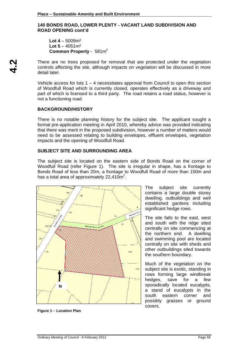
4.2
Place – Sustainable Amenity and Built Environment 140 BONDS ROAD, LOWER PLENTY - VACANT LAND SUBDIVISION AND ROAD OPENING cont’d
Ordinary Meeting of Council - 6 February 2012 Page 58
Lot 4 – 5009m² Lot 5 – 4051m² Common Property - 581m2
There are no trees proposed for removal that are protected under the vegetation controls affecting the site, although impacts on vegetation will be discussed in more detail later. Vehicle access for lots 1 – 4 necessitates approval from Council to open this section of Woodfull Road which is currently closed, operates effectively as a driveway and part of which is licensed to a third party. The road retains a road status, however is not a functioning road.
BACKGROUND/HISTORY
There is no notable planning history for the subject site. The applicant sought a formal pre-application meeting in April 2010, whereby advice was provided indicating that there was merit in the proposed subdivision, however a number of matters would need to be assessed relating to building envelopes, effluent envelopes, vegetation impacts and the opening of Woodfull Road.
SUBJECT SITE AND SURROUNDING AREA
The subject site is located on the eastern side of Bonds Road on the corner of Woodfull Road (refer Figure 1). The site is irregular in shape, has a frontage to Bonds Road of less than 20m, a frontage to Woodfull Road of more than 150m and has a total area of approximately 22,410m2.
The subject site currently contains a large double storey dwelling, outbuildings and well established gardens including significant hedge rows. The site falls to the east, west and south with the ridge sited centrally on site commencing at the northern end. A dwelling and swimming pool are located centrally on site with sheds and other outbuildings sited towards the southern boundary. Much of the vegetation on the subject site is exotic, standing in rows forming large windbreak hedges, save for a few sporadically located eucalypts, a stand of eucalypts in the south eastern corner and possibly grasses or ground covers.
Figure 1 – Location Plan
N
4.2
Place – Sustainable Amenity and Built Environment 140 BONDS ROAD, LOWER PLENTY - VACANT LAND SUBDIVISION AND ROAD OPENING cont’d
Ordinary Meeting of Council - 6 February 2012 Page 59
The surrounding area includes a number of large allotments that contain substantial houses and appurtenances including some tennis courts and swimming pools. There are substantial amounts of vegetation throughout the area. The western end of Woodfull Road which abuts the site is effectively a gravel driveway and for the most part, closed to traffic. The eastern end of Woodfull Road is open, paved, drained and utilised by dwellings that abut the road. The middle section between the two ends is a grassy verge with a scattering of trees and vegetation. The site is also bordered by Bonds Road on the western boundary. Bonds Road is a formed road with culvert drains and no footpaths. The nearest shops and services are those on Main Road in Lower Plenty, which is approximately 1.3km from the site. PLANNING CONTROLS, PARTICULAR PROVISIONS AND POLICIES Table 1 – Relevant Planning Controls, Particular Provisions and Policies Control Clause Permit Triggered /
Assessment required Low Density Residential Zone 32.03 Yes Vegetation Protection Overlay (VPO1) 42.02 No Significant Landscape Overlay (SLO1) 42.03 No Native Vegetation 52.17 No Policy Clause SPPF Urban Growth 11.02 Open Space 11.03 Biodiversity 12.01 Urban Environment 15.01 Sustainable Development 15.02 Residential Development 16.01 Integrated Transport 18.01 Movement Networks 18.02 LPPF Land Use 21.04 Natural Environment 21.05 Built Environment 21.06 Residential Neighbourhood Character Policy (Bush Woodland Precinct BW2)
22.02
Safer Design Policy 22.03 OTHER RELEVANT POLICIES AND GUIDELINES Public Open Space Strategy Council’s Public Open Space (POS) Strategy was adopted by Council at its meeting of 1 October 2007. The Strategy is a reference document at Clause 21.09 of the Banyule Planning Scheme.
4.2
Place – Sustainable Amenity and Built Environment 140 BONDS ROAD, LOWER PLENTY - VACANT LAND SUBDIVISION AND ROAD OPENING cont’d
Ordinary Meeting of Council - 6 February 2012 Page 60
The POS Strategy divides the municipality into precincts to ensure the needs of local residents and any local character which is unique to a particular area can be taken into account in the planning of public open space. The subject site falls within the Lower Plenty Precinct, where the following issues are identified:
• The need to control vermin in both private and public open space in cooperation with residents and Parks Victoria; i.e. in particular rabbits and foxes;
• The need to improve river corridor habitat and weed management; • The need to protect the river corridors from inappropriate development. Residential Subdivision of Vacant Land Guidelines In February 2004 Council adopted the above guidelines which indicate that subdivision of residential land prior to development will be discouraged unless an applicant can demonstrate that a proposal can overcome site constraints and lead to similar development outcomes as would be achieved by subdividing after development approval. The guidelines state that Council will consider the following issues:
• The future development of subdivided land; • A subsequent planning permit for development of lots less than 500m2 will be
required; • A subsequent planning permit for development may still be required for
subdivided lots covered by overlays; • The Banyule Planning Scheme sets a high standard for development in
keeping with the environmental, amenity and neighbourhood character expectations of the community and vacant lot subdivision proposals must demonstrate that such high quality outcomes will result.
PUBLIC NOTIFICATION Formal notification of the application was given by a sign on site and Council mail to adjoining and nearby properties. A total of two objections have been received, with the grounds of objection summarised as follows:
• Detrimental impact on the amenity of the neighbourhood; • Increase in housing density; • Lot 3 building envelope too close to the boundary – overlooking will occur; • Loss of vegetation; • Tennis court for lot 3 too close to the boundary; • Waste water envelope lot 3 too close to the boundary; • Objection to Woodfull Road being allowed to travel all the way through – it is
requested the barrier be installed; • Impact on vegetation within Woodfull Road; • The renaming of the road should be considered to ensure no confusion and
that you cannot travel through

4.2
Place – Sustainable Amenity and Built Environment 140 BONDS ROAD, LOWER PLENTY - VACANT LAND SUBDIVISION AND ROAD OPENING cont’d
Ordinary Meeting of Council - 6 February 2012 Page 61
CONSULTATION A meeting was held by request of the objectors to discuss their issues. The applicant was not present, however the matters were discussed and queries were answered. It was considered that a further formal consultation meeting was not required in this instance. REFERRAL COMMENTS A summary of the comments received from internal and external referral authorities is provided below in Table 2. Table 2 – Summary of Referral Comments Internal Conditions Comments Engineering Yes Minor concerns resolvable (Refer to response on
file) Environment No No concerns (Refer to response on file) Arborist Yes Minor concerns resolvable (Refer to response on
file) Health Yes Concerns resolvable (Refer to response on file) Property Yes Minor concerns resolvable (Refer to response on
file) External Objection Conditions Yarra Valley Water No Yes (Refer to response on file) Melbourne Water No Yes (Refer to response on file) Telstra No No APA Group No No SP AusNet No Yes (Refer to response on file)
TECHNICAL CONSIDERATION
RESPONSE TO POLICY FRAMEWORK
Given the size of the lots to be created and provision of appropriate building and effluent envelopes, the character of the area will be maintained and as such the proposal is consistent with State and Local Policy. The proposed subdivision and creation of an additional four (4) large sized allotments is consistent with the policy frameworks through providing additional housing opportunity reflective of both lot and house sizes within the area, whilst ensuring provision of services and protection of vegetation. Consideration has been given to the need to upgrade the road and effectively re-open the road to traffic in a limited capacity that will generally only service the subject site, although future requests may be made for further use from other adjacent properties should planning controls change in the future.

4.2
Place – Sustainable Amenity and Built Environment 140 BONDS ROAD, LOWER PLENTY - VACANT LAND SUBDIVISION AND ROAD OPENING cont’d
Ordinary Meeting of Council - 6 February 2012 Page 62
NEIGHBOURHOOD CHARACTER STRATEGY ASSESSMENT
The proposal meets the objectives of Council’s Neighbourhood Character Policy at Clause 22.02 of the Banyule Planning Scheme. Although a number of the specific design responses and objectives are not relevant at the subdivision stage as they relate more to built form outcomes, a detailed assessment against the relevant components is included as an attachment to this report. Some conditions are required to ensure compliance as noted within the attachment, however these are considered to be minor in nature. As this is a subdivision permit and although some requirements need to be made to the plans that will ultimately be endorsed, other requirements will need to be incorporated into a S.173 Agreement so that all future owners are aware of their obligations and the restrictions on the individual sites.
PROVISION OF SERVICES
Services such as potable water, electricity and gas are available to the site and each allotment will be required to be connected. The one service that is not readily available to the site is reticulated sewerage. The existing dwelling is currently serviced by an onsite septic system and effluent envelopes are proposed for all dwellings to ensure waste water can be treated on site. There was much discussion with Yarra Valley Water throughout the planning process, who initially required connection to sewer, however later altered that position as the sewer would not be accessible to the site until 2020-2025, unless the owner bore the cost. This was considered onerous where waste water could be treated on site and, subject to satisfying the Health Department of Council, Yarra Valley Water were comfortable. The Health Department noted concerns in relation to setbacks of effluent envelopes to boundaries and services, however these can be resolved as conditions of permit. Additionally, concern was raised with respect to the location of an indicative driveway through an envelope on Lot 3 and the size of the effluent envelopes to a number of lots do not correspond with the areas identified in the Land Capability Assessment. These items can also be addressed by conditions of permit. Finally and although not fundamental to the subdivision proposal, concern was raised with respect to access to the tennis court location near or over effluent areas if constructed later. This does not affect the subdivision and may only affect the ability of a future land owner to actually be able to physically construct a tennis court.
WASTE AND MAIL COLLECTION
If the subdivision is approved waste and mail collection can occur from the reopened Woodfull Road. The internal driveway is common land, the services would need to be provided at the start of that common land. The end of the reopened road would need to incorporate a turning area large enough for a waste truck to turn. Final detailed design and construction plans for Woodfull Road will be required as a condition of permit and construction of the road will be required prior to the issue of a Statement of Compliance for the subdivision, should approval be granted to reopen the road.

4.2
Place – Sustainable Amenity and Built Environment 140 BONDS ROAD, LOWER PLENTY - VACANT LAND SUBDIVISION AND ROAD OPENING cont’d
Ordinary Meeting of Council - 6 February 2012 Page 63
IMPACT ON VEGETATION
There are two overlay controls that affect the site and have objectives to protect and maintain vegetation within the area. As previously described there are some stands of vegetation on the site that are proposed to be removed. Some of the removal is to accommodate the new building envelopes and other to accommodate the Woodfull Road reopening to traffic and common property. A flora and fauna assessment was undertaken for the site and a supporting arborist report as well. The two documents reveal that vegetation being removed does not require a planning permit and there are no offsets required from a net gain perspective under the Victorian Native Vegetation Framework and State Vegetation clearing controls. Conditions of any permit issued will require appropriate tree protection measures and sensitive construction techniques for certain components of the subdivision works to ensure retention. It is also noted that, given each of the allotments to be created is greater than 4000m2, additional net gain considerations may be required in the future should individual land owners pursue vegetation removal in the future. PUBLIC OPEN SPACE The requirement for public open space has been considered having regard to Council’s Public Open Space Strategy and Section 18 of the Subdivision Act 1988. The land is currently occupied by a single dwelling and the proposed subdivision will result in lots with an ability to accommodate a minimum of five dwellings (inclusive of the existing dwelling). There will be an increase of four dwellings in the area as a result of the proposal, and therefore it is likely that existing open space within the area will be more intensively used. Council’s Public Open Space Strategy identifies the need to control vermin in both private and public open space in cooperation with residents and Parks Victoria (i.e. in particular rabbits and foxes), the need to improve river corridor habitat and weed management and the need to protect the river corridors from inappropriate development. Taking the above into consideration, it is appropriate to require a 4% cash contribution toward the provision and upgrading of public open space. ROAD OPENING OF WOODFULL ROAD The section of road, although not formally closed by way of Government Gazette, is effectively closed to traffic and does not operate as a through road, although there is an unsealed access path at present which two properties enjoy limited secondary access over. It is unclear how long it has been inactive for, however it is believed to have occurred under the Shire of Eltham, therefore more than 15 years ago. A review of Council records and archives could not substantiate any further the reasons for the existing condition of the road. Moreover, this section is currently licensed to a nearby property and up to 12 months notice of cessation of the licence is likely to be required.

4.2
Place – Sustainable Amenity and Built Environment 140 BONDS ROAD, LOWER PLENTY - VACANT LAND SUBDIVISION AND ROAD OPENING cont’d
Ordinary Meeting of Council - 6 February 2012 Page 64
It has been held at the Court of Appeal Bass Coast Shire Council -v- King (on appeal) (1996) that there is no obligation on Council to formally open or construct a road. In this case referring to this closed section of Woodfull Road and Section 204 (2) of the Local Government Act 1989 provides that,
“A Council may, by resolution, declare a road that is reasonably required for public use to be open to public traffic.”
Given the above, for the road to be open for traffic, whether a through road or not, must be by way of Council resolution. The applicant has been advised of this and further advised that any decision would need to be concurrent with a decision in relation to the proposed subdivision. There would be no need to open or have constructed this section if the subdivision fails from a merits perspective. In considering whether the road should be open to public traffic, not only does Council have to consider the merits of the application, but also to what level the road should be constructed. As it is recommended that should the proposal be supported, the construction of the road would need to be undertaken by the developer at their cost to Council’s satisfaction. Part of the assessment of whether the road should be open relates to its ability to be constructed to Council’s standards and also the impacts on existing vegetation and any removal required. Council’s Engineering Services Department have considered the opening of the road to public traffic from both a traffic and construction perspective, including reviewing the submitted draft plans, and advised that it is appropriate to construct and reopen the road to traffic to service the proposed subdivision. Conditions would require final detailed roadwork and construction plans and the road would need to be constructed to Council standards. Additionally, turning areas would need to be provided to accommodate a Council waste truck that would facilitate turning. On this basis and having regard to the merits of the proposed subdivision, it is considered appropriate to recommend that the road be opened to public traffic and constructed, however should not form a through road to the other section of Woodfull Road.
OBJECTORS’ CONCERNS
Although a majority of the objector’s concerns have been responded to within the body of this report or within the associated attachments, the concern surrounding renaming of Woodfull Road and the envelopes on Lot 3 requires further discussion. Any naming or renaming of roads is dealt with via a separate process and any decision on renaming is premature at this time until a decision is made on the current application. Should approval be granted and the subdivision eventuate, further consideration of renaming can be considered on its merits. In relation to Lot 3, the setbacks for the building envelope and any future tennis court have been increased. Although not a relevant consideration, this will assist in minimising future overlooking, although noted this will be addressed at the time of building permit for any future dwelling. The setback for the effluent envelope will meet with required setbacks and will not affect the adjoining property.

4.2
Place – Sustainable Amenity and Built Environment 140 BONDS ROAD, LOWER PLENTY - VACANT LAND SUBDIVISION AND ROAD OPENING cont’d
Ordinary Meeting of Council - 6 February 2012 Page 65
CONCLUSION It is considered that the proposed subdivision, subject to minor changes and permit conditions will result in an appropriate outcome for the site without unreasonably compromising the environment or the character of the area. The subdivision layout creates useable lots of a consistent size to those found within the area that will contribute to additional housing in accordance with State and Local Policies. The proposal ensures minimal impact on vegetation and necessitates the opening of the western end of Woodfull Road to public traffic, achieves a satisfactory planning outcome for the area. RECOMMENDATION
A. That Council, in accordance with Section 204 (2) of the Local Government Act 1989, resolve to re-open the western end of Woodfull Road, subject to the subdivision at 140 Bonds Road under Planning Permit P823/2010 eventuating and the road being constructed to Council standards and specifications at no cost to Council.
B. That Council having complied with Section 52, 58, 60, 61 and 62 of the
Planning and Environment Act 1987, resolves that a Notice of Decision to Grant a Planning Permit be issued in respect of Application No. P823/2010 for a five (5) lot subdivision and associated works of the land at 140 Bonds Road, Lower Plenty, subject to the following conditions:
Plans (1) Prior to Certification of the Plan of Subdivision, amended plans to the
satisfaction of the Responsible Authority must be submitted to and approved by the Responsible Authority. When approved the plans will be endorsed and will then form part of the permit. The plans must be drawn to scale with dimensions and three copies must be provided. The plans must be generally in accordance with the advertised plans submitted with the application but modified to show:
(a) All changes to the subdivision layout including modifications to envelopes in accordance with plan Ref No 13193B/01, Version 6, received by Council on 25/1/2012, including;
(i) Increase in the size of the waste water management envelopes to be consistent with the Land Capability Assessment prepared by EWS Environmental dated 14 December 2010;
(ii) Relocation of the driveway for Lot 3 such that it does not traverse over the effluent envelope;
(iii) Increase the setback of the building envelope from the southern boundary of Lot 3 to 6.6m;
(iv) Increase the setback of the future tennis court location from the southern boundary of Lot 3 to 4m;
4.2
Place – Sustainable Amenity and Built Environment 140 BONDS ROAD, LOWER PLENTY - VACANT LAND SUBDIVISION AND ROAD OPENING cont’d
Ordinary Meeting of Council - 6 February 2012 Page 66
(b) Confirmation that the waste water management envelopes, nominated for each of the respective lots, must satisfy the setback distances as specified within the EPA Code of Practice – Onsite Waste Management (Publication No 891.2);
(c) Creation of easements as follows:
(i) 2m wide drainage easement in favour of Council (or 3m wide drainage and sewerage easement if required) along the eastern boundaries of Lots 1 and 2;
(ii) 2m wide drainage easement in favour of Council (or 3m wide drainage and sewerage easement if required) along the southern boundaries of Lots 1, 2 and 3 to serve these lots and the common property driveway to the Legal Point of Discharge
(d) The common property driveway a minimum 3m wide pavement with opportunities for passing and must be a sealed surface with ramp grades to comply with AS/NZS 2890.1:2004;
(e) A notation indicating that all driveways where within 10m of a protected tree should be laid at or above grade.
(f) Roadworks and Drainage plan as required by Condition 2 of this permit;
(g) Landscape plan for Woodfull Road and Common Property as required by Condition 3 of this permit;
(2) Prior to Certification of the Plan of Subdivision, a satisfactory detailed
roadworks and drainage plan for Woodfull Road with specifications must be submitted to and approved by the Responsible Authority. Such plan must include:
(a) Fully sealed pavement with kerb and channel and vehicular crossings for each allotment where appropriate. Road pavements must be a minimum of 5.5 metres between kerb inverts. Minimum pavement depth is to be 260mm and must take into account subgrade conditions and may be subject to subgrade improvements;
(b) T-head courts and intersections are required to be designed to cater for Council’s 9.8 metre long garbage and recycling trucks;
(c) If deemed necessary, a footpath of 1.5 metres in width is to be provided on one side of the section of Woodfull Road that is to be constructed;
(d) Kerb and channel with the use of 600mm wide SM2 roll over kerb;
(e) Surface and underground drains;
(f) Underground conduits for water, gas, electricity and telephone;
(g) Appropriate intersection and traffic measures;
(h) Appropriate street lighting (with electrical supply plan and lighting layout plan);
(i) Street signs (if required);
(j) High stability permanent survey marks;
(k) Vehicle crossings;
(l) The location of street trees;

4.2
Place – Sustainable Amenity and Built Environment 140 BONDS ROAD, LOWER PLENTY - VACANT LAND SUBDIVISION AND ROAD OPENING cont’d
Ordinary Meeting of Council - 6 February 2012 Page 67
(m) Earthworks and fill with a compacted depth greater than 150mm.
The longitudinal grading of the new road must to be designed to Council’s minimum standards and smoothly transitioned into the existing Bonds Road pavement. Adequate sight distance must also be provided at the intersection with Bonds Road.
The details of the roadworks and drainage plan may be varied with the consent of the Responsible Authority.
Landscape Plan (Woodfull Road and Common Property) (3) Prior to Certification of the Plan of Subdivision, a satisfactory detailed
landscape plan for all streets, common property and open space reserves within the subdivision must be submitted to and approved by the Responsible Authority. Such plan must be prepared by a person suitably qualified or experienced in landscape design and shall include:
(a) The siting for all street tree planting having regard to issues such as service conduits, crossovers and street lighting location;
(b) A planting schedule including species selection, planting requirements and maintenance requirements;
(c) Measures for the protection of planted street trees (such as tree guards); (d) Tree protection measures for trees to be retained, in accordance with
Condition 9;
(e) Details of all permanent fences to be erected along all boundaries at the extent of the subdivision.
NOTE:
• The selection of species for the landscape plan must have regard to the Banyule City Council Street Tree Strategy.
• Tree planting material and installation requirements must meet the minimum standards and specifications of Council’s Parks and Buildings Department
General (4) The subdivision as shown on the endorsed plan shall not be altered or modified
(whether or not in order to comply with any statute, Statutory Rule or By-Law or for any other reason) without the consent of the Responsible Authority.
Common Property (5) Unless otherwise agreed by the Responsible Authority, prior to the issue of a
Statement of Compliance all works shown on the roadworks and drainage plan and landscape plan within the common property area must be completed to the satisfaction of the Responsible Authority.

4.2
Place – Sustainable Amenity and Built Environment 140 BONDS ROAD, LOWER PLENTY - VACANT LAND SUBDIVISION AND ROAD OPENING cont’d
Ordinary Meeting of Council - 6 February 2012 Page 68
Public Open Space (6) Prior to the issue of a Statement of Compliance, a public open space
contribution of 4% of the value of the land is required to be paid to Council, in accordance with Section 18(1) of the Subdivision Act 1988.
Tree Protection (7) Except with the further written consent of the Responsible Authority, no
vegetation (other than that indicated on the endorsed plan, or exempt from planning permission under the provisions of the Banyule Planning Scheme) shall be damaged, removed, destroyed or lopped.
(8) All services where located within the TPZ as calculated under Australian
Standard AS4970-2009 of any tree being retained, must be bored and any service pits must be located outside of the TPZ unless otherwise agreed in writing by Council’s Development Planning Arborist or relevant project arboist.
(9) Unless otherwise agreed in writing by the Responsible Authority, prior to the
commencement of works on the site Tree Protection Zones must be established in accordance with the endorsed tree protection plan. You must contact Council’s Development Planning Arborist on 9457 9878 once the Tree Protection Fencing is erected so that an inspection of the fencing can be carried out. Please note a minimum of 2 days prior notice is required. Once installed and inspected the Tree Preservation Zones must not be moved or altered without approval of the Responsible Authority. (a) A tree protection plan must be prepared by the project arborist detailing
fencing material, fencing locations, signage, trunk and ground protection measures for all trees proposed to be retained where within 10m of any subdivision works proposed;
(b) Tree protection zones should be calculated using the methods detailed
within AS 4970-2009 Protection of trees on development sites. (c) The tree protection plan should be included in subsequent construction
documentation. The location of tree protection measures should also be shown on other documents such as demolition, bulk earth works, construction and landscape plans.
(d) An endorsed laminated A3 copy of this plan must be maintained and
displayed at the site entry for the life of the development.
(e) Activities generally excluded from the Tree Protection Zone (TPZ) include but are not limited to— • machine excavation including trenching; • excavation for silt fencing; • cultivation; • storage; • preparation of chemicals, including preparation of cement products; • parking of vehicles and plant; • refuelling; • dumping of waste;

4.2
Place – Sustainable Amenity and Built Environment 140 BONDS ROAD, LOWER PLENTY - VACANT LAND SUBDIVISION AND ROAD OPENING cont’d
Ordinary Meeting of Council - 6 February 2012 Page 69
• wash down and cleaning of equipment; • placement of fill; • lighting of fires; • soil level changes; • temporary or permanent installation of utilities and signs; and • physical damage to the tree.
(f) The area within the TPZ must be mulched. The mulch must be maintained
to a depth of 50–100 mm
NOTE: Requests for consent of the Responsible Authority (City of Banyule) pursuant to this Condition should be directed to Council’s Arborist – Development Planning on 9457 9878. Consent for the conduct of works within the Tree Protection Zone, where granted, may be subject to conditions. Such conditions may include a requirement that: • Any underground service installations within the Tree Protection Zone be
bored to a minimum depth of 600mm to the top of the pipe; • All root excavation be carried out by hand digging or with the use of ‘Air-
Excavation’ techniques; • No roots greater than 30mm in diameter are to be cut or damaged without
the consent of Councils Arborist - Development Planning. Or other conditions, as relevant, to ensure the ongoing health and stability of the subject tree/s.
Section 173 Agreement (10) Unless otherwise agreed in writing by the Responsible Authority, prior to the
Certification of the Plan of Subdivision, the owner of the land at 140 Bonds Road, Lower Plenty must enter into an agreement with the Responsible Authority pursuant to Section 173 of the Planning and Environment Act 1987 to the satisfaction of the Responsible Authority and such agreement must provide for:
Building Requirements and Restrictions
(a) Any dwelling or other buildings to be constructed on Lots 1-4 must be contained within the building envelope (with the exception of a tennis court which must be contained within the tennis court envelope), unless otherwise agreed in writing by the Responsible Authority;
(b) No buildings or works of any kind including heavy machinery movements are to occur within the effluent envelopes unless associated with waste water treatment;
(c) All future tennis courts must be appropriately drained and connected to underground drainage to ensure no overland flows occur to effluent areas;

4.2
Place – Sustainable Amenity and Built Environment 140 BONDS ROAD, LOWER PLENTY - VACANT LAND SUBDIVISION AND ROAD OPENING cont’d
Ordinary Meeting of Council - 6 February 2012 Page 70
Tree Protection and Landscaping
(d) Unless otherwise approved in writing by the Responsible Authority, the trees indicated for retention on the building envelope plan endorsed pursuant to Planning Permit P823/10 must be retained and protected on the site.
Other Requirements (e) The owner acknowledge that all Council garbage collection from the land
will be from Woodfull Road and Bonds Road and not internally on site.
(f) The recommendations of the approved Land Capability Assessment must be implemented to the satisfaction of the Responsible Authority prior to occupation of the dwelling.
(g) Unless otherwise agreed in writing by the Responsible Authority, prior to the occupation of any dwelling the dwelling must be numbered in accordance with Council’s allocation of street numbers.
A memorandum of the Agreement is to be entered on title and the cost of the preparation and execution of the Agreement and entry of the memorandum on title is to be paid by the owner.
Completion and Standard of Public Works (11) Unless otherwise agreed in writing by the Responsible Authority, all drainage
works required to connect all lots to the legal point of discharge as determined by Council must be carried out to the satisfaction of the Responsible Authority prior to the issue of a Statement of Compliance.
(12) Unless otherwise agreed in writing by the Responsible Authority, any proposed
vehicle crossing must be carried out to the satisfaction of the Responsible Authority prior to the issue of a Statement of Compliance. All vehicle crossing works are to be carried out with Council Supervision under a Memorandum of Consent for Works which must be obtained prior to commencement of works.
(13) Vehicular access or egress to the subject land from any roadway or service
lane must be by way of a vehicle crossing constructed in accordance with Council’s Vehicle Crossing Specifications to suit the proposed driveway(s) and the vehicles that will use the crossing(s). The location, design and construction of the vehicle crossing(s) must be approved by the Responsible Authority. Any existing unused crossing(s) must be removed and replaced with concrete kerb, channel and naturestrip to the satisfaction of the Council prior to occupation of the building. All vehicle crossing works are to be carried out with Council Supervision under a Memorandum of Consent for Works which must be obtained prior to commencement of works.
Yarra Valley Water (14) The owner of the subject land must enter into an agreement with Yarra Valley
Water for the provision of water supply. (15) The owner of the subject land must enter into an agreement with Yarra Valley
Water for the provision of sewerage.
4.2
Place – Sustainable Amenity and Built Environment 140 BONDS ROAD, LOWER PLENTY - VACANT LAND SUBDIVISION AND ROAD OPENING cont’d
Ordinary Meeting of Council - 6 February 2012 Page 71
Yarra Valley Water will withdraw this condition when we receive a letter from Council stating that the lot/s are capable of adequately treating and retaining domestic wastewater within the boundaries of each lot. Please note that the provisions of State Environment Protection Policy (SEPP 40), Waters of Victoria apply.
Melbourne Water (16) No polluted and/or sediment laden runoff is to be discharged directly or
indirectly into Melbourne Water’s drains or watercourses.
(17) Prior to Certification, the Plan of Subdivision must be referred to Melbourne Water, in accordance with Section 8 of the Subdivision Act 1988.
SP Ausnet (18) The applicant must -
(i) Enter in an agreement with SPI Electricity Pty Ltd for the extension, upgrading or rearrangement of the electricity supply to lots on the plan of subdivision. A payment to cover the cost of such work will be required.
(ii) Provide electricity easements internal and external to the subdivision in favour of SPI Electricity Pty Ltd to service the lots on the plan of subdivision and/or abutting lands as required by SPI Electricity Pty Ltd. The provision of reserves for electricity substations may also be required.
Time Limits (19) In accordance with section 68 of the Planning and Environment Act 1987, this
permit will expire if one of the following circumstances applies:
• The plan is not certified within two years of the date of this permit; or
• A Statement of Compliance is not issued within five (5) years of the date of certification.
In accordance with section 69 of the Planning and Environment Act 1987, the Responsible Authority may extend the periods referred to if a request is made in writing before the permit expires, or within three months afterwards.
NOTES • In the event that this permit expires or the subject land is proposed to be used
or developed for purposes different from those for which this permit is granted, there is no guarantee that a new permit will be granted. If a permit is granted then the permit conditions may vary from those included on this permit having regard to changes that might occur to circumstances, planning scheme provisions or policy.
• Pursuant to Section 17(1) of the Subdivision Act 1988, works relating to the
subdivision must not be commenced prior to certification of the plan of subdivision, unless otherwise agreed in writing by the Responsible Authority.

4.2
Place – Sustainable Amenity and Built Environment 140 BONDS ROAD, LOWER PLENTY - VACANT LAND SUBDIVISION AND ROAD OPENING cont’d
Ordinary Meeting of Council - 6 February 2012 Page 72
• Prior to commencing tree removal works permitted by this permit, the applicant is advised to exercise caution when undertaking such works, including the operating of wheeled machinery, on properties where onsite waste treatment facilities are in place. Wheeled machinery should no be driven over the effluent disposal area. For information about the location of the onsite waste treatment facility on your property, please contact Council’s Health Unit on 9457 9965.
• Please note that property addresses are allocated by Council. This is usually
formalised at the time of the issue of a certified plan, however it is Council’s intention to number the proposed allotments as follows:
Lot 1 1/17 Woodfull Road, Lower Plenty Lot 2 2/17 Woodfull Road, Lower Plenty Lot 3 3/17 Woodfull Road, Lower Plenty Lot 4 4/17 Woodfull Road, Lower Plenty Lot 5 140 Bonds Road, Lower Plenty
Please note that this is subject to change and should be used as an indication only at this time. Final numbering will be provided when a Statement of Compliance is issued.
• Pursuant to Section 18(1) of the Subdivision Act 1988, a public open space
contribution of 4% of the value of the land is payable to the Responsible Authority prior to the issue of a Statement of Compliance. A valuation will be prepared and forwarded to the applicant. In accordance with Section 19(5) of the Subdivision Act, in the event that the contribution is not paid within 12 months of the date of this permit Council will request a revaluation of the site value at each anniversary, and will vary the amount of the payment required accordingly.
ATTACHMENTS No. Title Page 1 Subdivision Plans 1452 Neighbourhood Character Assessment 148

4.3
Place – Sustainable Amenity and Built Environment
Ordinary Meeting of Council - 6 February 2012 Page 73
4.3 GREENSBOROUGH WALK/MAIN STREET RETAIL AND OFFICE DEVELOPMENT
Author: Julian Edwards - Development Planning Coordinator , City Development
Ward: Bakewell
File: P1111/2011 SUMMARY
The proposal is for the activation and construction of retail and office floor space to Greensborough Walk and Main Street Greensborough with undercroft car parking.
Planning Permit Application: P1111/2011
Development Planning Coordinator:
Julian Edwards
Address: 66, 68-72, 74 and 78 (known as 3 Flintoff Street) Main Street GREENSBOROUGH
Proposal: Buildings and works for the purpose of constructing retail and office space and associated undercroft (semi-basement) car park.
Existing Use/Development: Existing shops, roadway & pedestrian walk under construction
Applicant: Banyule City Council
Zoning: Priority Development Zone (PDZ1)
Overlays: Design and Development (Schedule 4)
Public Acquisition Overlay (Schedule 6)
Notification (Advertising): Exemption from notification in accordance with the provisions of 37.06-6 (Part 8 of the Priority Development Zone 1 schedule) and Clause 43.02 (Part 2 of Design and Development Overlay Schedule 4).
Restrictive Covenant: There are no restrictive covenants on title that would prevent the issue of a permit for the proposal.
Planning Scheme Policy Considerations:
The following policies have been considered in the assessment of the proposal: SPPF – Cl. 17 Economic Development LPPF (MSS) Cl. 21.04 Land Use – Commercial Cl 21.06 Built Environment Cl21.08 Local Places LPPF – Cl. 22.05 Business Plan Policy LPPF – Cl. 22.03 Safer Design Policy
Cultural Heritage Management Plan (CHMP) required:
No

4.3
Place – Sustainable Amenity and Built Environment GREENSBOROUGH WALK/MAIN STREET RETAIL AND OFFICE DEVELOPMENT cont’d
Ordinary Meeting of Council - 6 February 2012 Page 74
PROPOSAL
It is proposed to construct a four level (including under-croft car park) mixed use development. The proposed development consists of two (2) separate buildings either side of Greensborough Walk that provide frontages to both the Walk and Main Street, Greensborough. Building 1 is located on the southwest side of Greensborough Walk. This building will be approximately 13.0m in width and 38.0m in length, each level will be approximately 494m2 with an overall height of approximately 12.85m from Main Street/Greensborough Walk to the parapet or 15.4m to the top of the roof plant. Building 2 is located on the northeast side of Greensborough Walk and this building will be approximately 15.5m in width and 38.0m in length with each level approximately 589m2 in area. Due to the fall on Main Street, this building will have an approximate overall height to the parapet of between 12.6m and 14.1m to the Walk and Main Street respectively, increasing by 2.5m to the top of roof plant. An under-croft car park accommodating 28 car spaces accessible via Grimshaw Lane is proposed. The area of this car park coincides with the footprint of the above proposed buildings inclusive of Greensborough Walk, approximately 1,114m2. Two (2) elevators, one (1) located in each building will provide employee access to the upper levels. The applicant has indicated that three (3) additional car spaces are proposed which appear to be located adjacent to Grimshaw Lane, however these do not appear to be within the title boundary of the development site and the development cannot rely on the sole use of these spaces. It is noted that they may contribute to available parking in the area, potentially bringing the total proposed parking to 31 spaces. Level 1 of both buildings will be utilised for retail premises, consisting of eight (8) shops. Shops 1 and 5 will have dual frontage to Main Street and Greensborough Walk. Shops 4 and 8 will also have dual frontage to Greensborough Walk and Grimshaw Lane, the remaining shops are single fronted to Greensborough Walk. All pedestrian access is via Greensborough Walk. Pedestrian Access to the upper levels is provided via Main Street. Levels 2 and 3 of both buildings will be utilised for offices and will be identical in layout and dimensions. A total of 12 offices are proposed, six (6) per level (or three per level per building). Toilet facilities will be provided on each floor. A plant room is located on the roof with larger setbacks from the lower levels of the proposed buildings. The facades consist of large floor to ceiling windows; however these will be partly obscured at the second and third levels via a transparent steel shell that will be constructed adjacent to the glazed façade. The retail component and the Main Street frontage will not have a secondary façade treatment. The following table identifies the total floor area of each component. Table 1 – Floor Area of Uses
Use Floor Area Retail (Shop) 943m2
Commercial (Office) 1696m2

4.3
Place – Sustainable Amenity and Built Environment GREENSBOROUGH WALK/MAIN STREET RETAIL AND OFFICE DEVELOPMENT cont’d
Ordinary Meeting of Council - 6 February 2012 Page 75
BACKGROUND HISTORY The current planning application before Council is effectively a follow on from both earlier planning applications and the Planning Scheme Amendment (C51) associated with the East Main Street precinct within the Greensborough Principal Activity Centre. A partnership process was entered into between Lend Lease and Council (Greensborough & Partners) whereby an application was lodged and consequently a Planning Permit P569/08 was issued on 6 October 2008 for buildings and works for the purpose of constructing a multi-level mixed use development (comprising commercial, leisure facilities and public spaces) and the alteration of access to a road in a Road Zone Category 1 over much of the entire East Main Street precinct on properties known as 3 - 19 Flintoff Street, 44 Grimshaw Street, 49 - 63, 66 - 74 and 106 - 126 Main Street, Greensborough. A report on the earlier proposal was considered by Council on 6 October 2008 (LOC.414). The earlier application included not only the Regional and Aquatic Leisure Centre (RALC), but also a collaborative workplace (COLAB Office), retail, commercial, restaurants/cafes, extensive car parking, a detailed Town Square, Walk and pedestrian connections, as well as modifications to the surrounding road network at key intersections. Council subsequently pursued the RALC, Town Square and Greensborough Walk separately and independently via Planning Permit P819/09 which was approved on 1 February 2010 and is currently under construction. The current planning application is one of a number of individual projects which aim to achieve the vision for Greensborough. Over time, these other projects will complement the current proposals in and around the activity centre, however they are not being considered as part of this application. SITE DESCRIPTION
The proposal is located at 66 - 78 Main Street, Greensborough. The sites are situated between Main Street and Grimshaw Lane and are separated by Greensborough Walk (Refer to Figure 1). Some of the site(s) are currently vacant as previous buildings have been demolished, whilst others remain standing until such time as this development is ready to proceed. The sites are generally rectangular in shape, the topography of the sites contains a 3.0m slope from east to west.
Development Area
Figure 1. Location Map
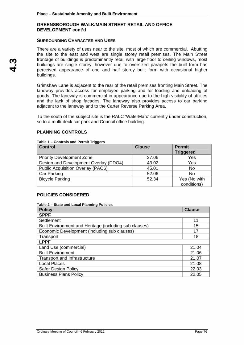
4.3
Place – Sustainable Amenity and Built Environment GREENSBOROUGH WALK/MAIN STREET RETAIL AND OFFICE DEVELOPMENT cont’d
Ordinary Meeting of Council - 6 February 2012 Page 76
SURROUNDING CHARACTER AND USES
There are a variety of uses near to the site, most of which are commercial. Abutting the site to the east and west are single storey retail premises. The Main Street frontage of buildings is predominantly retail with large floor to ceiling windows, most buildings are single storey, however due to oversized parapets the built form has perceived appearance of one and half storey built form with occasional higher buildings. Grimshaw Lane is adjacent to the rear of the retail premises fronting Main Street. The laneway provides access for employee parking and for loading and unloading of goods. The laneway is commercial in appearance due to the high visibility of utilities and the lack of shop facades. The laneway also provides access to car parking adjacent to the laneway and to the Carter Reverse Parking Area. To the south of the subject site is the RALC ‘WaterMarc’ currently under construction, so to a multi-deck car park and Council office building. PLANNING CONTROLS Table 1 – Controls and Permit Triggers Control Clause Permit
Triggered Priority Development Zone 37.06 Yes Design and Development Overlay (DDO4) 43.02 Yes Public Acquisition Overlay (PAO6) 45.01 No Car Parking 52.06 No Bicycle Parking 52.34 Yes (No with
conditions) POLICIES CONSIDERED Table 2 – State and Local Planning Policies Policy Clause SPPF Settlement 11 Built Environment and Heritage (including sub clauses) 15 Economic Development (including sub clauses) 17 Transport 18 LPPF Land Use (commercial) 21.04 Built Environment 21.06 Transport and Infrastructure 21.07 Local Places 21.08 Safer Design Policy 22.03 Business Plans Policy 22.05
4.3
Place – Sustainable Amenity and Built Environment GREENSBOROUGH WALK/MAIN STREET RETAIL AND OFFICE DEVELOPMENT cont’d
Ordinary Meeting of Council - 6 February 2012 Page 77
PUBLIC NOTIFICATION
The proposal is exempt from notification in accordance with the provisions of 37.06-6 (Part 8 of the Priority Development Zone 1 schedule) and Clause 43.02 (Part 2 of Design and Development Overlay Schedule 4). Additionally, Clause 52.34-2 in relation to bicycle parking, outlines that an application under that section is exempt from advertising, although noted that compliance will be required.
REFERRALS
Comments were sought from Council’s Engineering Department regarding vehicle access and parking layouts. Advice provided indicated that the levels did not appear to match at the access point at Grimshaw Lane, however this could be resolved through a condition of permit. Further, there would be a need for drainage plans to be provided. Comments were also sought from Council’s Property Services Section who advised that all built form should be contained within the boundaries of the site, save for weather protection/awnings along Greensborough Walk.
RESPONSE TO POLICY FRAMEWORK
The concept of this proposed development has been envisaged since the establishment of Planning Scheme Amendment C51, which created the overall planning framework and vision for the Greensborough Principal Activity Centre. The project forms the next stage in a number of projects for Greensborough, which brings the framework to life. The retail and commercial floor area promotes activation of the Walk, contributes to the economic viability of the centre, will create additional employment, improves the existing built form along Main Street and complements the RALC ‘WaterMarc’ both in appearance and form. The buildings contain extensive glazing and access to natural light, whilst the undercroft parking lends itself to natural ventilation ensuring an improved ESD outcome for the site. The use and development will improve safety along Greensborough Walk through activation and is consistent with original intention of acquiring the land publicly through Planning Scheme Amendment C51.
BUILT FORM
The proposed buildings need to be considered in context of the East Main Street Precinct Development Plan 2007, which is an incorporated document in the Banyule Planning Scheme, so to the design objectives and requirements of the Design and Development Overlay (Schedule 4).

4.3
Place – Sustainable Amenity and Built Environment GREENSBOROUGH WALK/MAIN STREET RETAIL AND OFFICE DEVELOPMENT cont’d
Ordinary Meeting of Council - 6 February 2012 Page 78
The East Main Street Precinct Development Plan 2007 was prepared as part of Planning Scheme Amendment C51 with a specific project in mind, being the original ‘Greensborough Project’ referred to earlier in the Background/History section of this report. Given this original all encompassing project did not eventuate, complete compliance with the document will not in all instances be achievable, however the principles and intentions of the document must be followed for a project to be considered generally in accordance with the document. The proposal currently before Council falls within Area 1 of the document which relates to the Town Square and Greensborough Walk. The proposal, in its limited relevance, is consistent with the objectives, use and built form vision identified for Area 1 through activating the Main Street end of the Walk, providing shelter along building facades through canopies for users of the Walk and improving safety as a consequence of the activation. What requires more discussion is the response to the indicative height identified for the podium level and above in the maps at the rear of the Incorporated Plan. This envisages activation and retail alongside the Walk, however provides a suggested maximum height of 76m AHD, between the Town square and Main Street. It is important to also note that the level of the Walk was indicated at 66m AHD. The proposed buildings either side of the Walk have building heights of up to 79.6m AHD and 79.85m AHD with further recessed roof plant contributing an additional 2.5m to this height, albeit this will not be seen at street or Walk level due to the recession proposed. The original indicative height of 76AHD was provided to ensure adequate sunlight could penetrate the walk and to ensure the amenity of users of the walk was not diminished through loss of sunlight or a sense of feeling enclosed due to heights adjoining the pedestrian scale environment. The proposed buildings are 3.6m – 3.85m higher than the indicative height identified in the Incorporated Plan, however as noted above, the Walk level is also a metre higher than envisaged, resulting in the buildings being 2.6m – 2.85m higher than envisaged. In ascertaining whether the increase in height above the envisaged heights is appropriate and generally consistent with the planning framework, the three key questions to consider are:
• Is the overall height consistent with and responsive to existing and envisaged heights of nearby development?
• Will the increase in height appear ‘over powering’ or dominant at the pedestrian scale for users of Greensborough Walk?
• Will the increase in height create unreasonable shadowing of the Walk? A response to these questions is provided inturn below.

4.3
Place – Sustainable Amenity and Built Environment GREENSBOROUGH WALK/MAIN STREET RETAIL AND OFFICE DEVELOPMENT cont’d
Ordinary Meeting of Council - 6 February 2012 Page 79
The heights as depicted in the Incorporated Plan are shown in Figure 2 below.
Figure 2: Indicative heights for the East Main Street Precinct The built form heights throughout the East Main Street Precinct are, save for a small section fronting Para Road, all higher than the proposed retail/office which will front the Walk. Although noted topography plays a key role in this area, the proposed buildings are still lower that other allowable built form in the precinct and the height is comparative to the RALC currently under construction. Moreover, where the development abuts existing buildings on Main Street, the Design and Development Overlay envisages three storeys to Main Street with recession above up to five storeys. As such, an appropriate response to the first question above is provided through a built form and height that is not out of context with the area or envisaged built form for Greensborough. In relation to the pedestrian scale, it is noted that Greensborough Walk is more than 11m in width between buildings and that canopies projecting over the space are proposed as glazed/transparent in material and appearance. This assists in providing an increased ‘open feel/sense’ to the air space above, yet providing weather protection along building edges. Whether a person feels ‘enclosed’ will vary, however through providing a visually interesting and attractive built form with high levels of glazing and an appearance of 11m clear access to daylight, it is considered that the additional increase of no more than 2.85m in height will not result in an overly dominant form along the Walk. Conditions of permit will require the buildings to be ‘pulled back’ within the boundaries of the site and where architectural features overhang Greensborough Walk. This will not apply to weather protection, but will necessitate modifications to the building to address future management and liability issues with the uncertainty of who will own the land.
4.3
Place – Sustainable Amenity and Built Environment GREENSBOROUGH WALK/MAIN STREET RETAIL AND OFFICE DEVELOPMENT cont’d
Ordinary Meeting of Council - 6 February 2012 Page 80
The final question relates to solar access to the Walk and shadowing caused by the buildings. In response to this, the architect has prepared shadow diagrams that were submitted with the application. Due to the orientation of the development site, shadowing will not occur to Main Street and therefore the assessment is limited to the Walk. The shadow diagrams indicate that during the summer months, good direct sunlight access to the Walk will be achieved generally between late morning through to 3pm, however direct sunlight is virtually non-existent during winter mornings, albeit some sunlight wil be available through the mid-afternoon. Given the orientation of the development area and shadows cast by heights, the additional 2.6 – 2.85m will not create any significant additional shadow in the winter months to that already cast by a building meeting the prescribed heights and as such, the increase in height is appropriate. Bringing back the architectural features which currently protrude outside the building envelope will result in recession of levels 2 and 3 by approximately 600mm which will further assist in reducing the shadow cast. It is finally of note that the objectives within the relevant section of the Incorporated Plan focus on maximising sunlight to the Town Square, rather than the Walk as some shadowing was always envisaged given the need for weather protection, which in this instance is clear. The proposed built form, for the reasons outlined above, is generally consistent with the Incorporated Plan for the East Main Street Precinct and the relevant design objectives and requirements of the Design and Development Overlay (Schedule 4). The development represents a key and necessary addition to the Greensborough retail precinct that will enhance a vital link between Main Street and the RALC ‘WaterMarc’. The development will create an active laneway experience due to the continuation of the retail component on Main Street and the connection between other uses to the southeast, whilst the removal of the existing vehicle laneway and associated removal of vehicles will create an intimate area that is distinct from Main Street, yet still connected and cohesive. Treatment to the blank walls at the rear of the buildings that abut Grimshaw Lane (including appropriate lighting), as well as the north-east and south-west walls will be required to improve the appearance and strike a balance between aesthetics of the walls, until such time as adjoining buildings are constructed. A mixture of colours and materials can often address this dilemma issue experienced in many activity centres across Victoria. Conditions will also require access for all for the ground level accessed from the Walk. The current plans indicate a level difference and a need for a step or ramp which will need to be clarified on the plans.
CAR PARKING PROVISION
The required car parking rates are specified at Clause 52.06 of the Banyule Planning Scheme. Amendment C51 to the Scheme introduced a schedule to Clause 52.06 that outlines the required car parking rates for particular types of land uses within the Activity Centre.

4.3
Place – Sustainable Amenity and Built Environment GREENSBOROUGH WALK/MAIN STREET RETAIL AND OFFICE DEVELOPMENT cont’d
Ordinary Meeting of Council - 6 February 2012 Page 81
A car parking precinct plan has been prepared for the Greensborough Principal Activity Centre (GPAC) and is incorporated into the Banyule Planning Scheme, which provides alternative rates of parking within the GPAC area. The plan also enables car parking for new uses to be provided on various sites throughout the precinct rather than being restricted to an individual development site. The proposed retail and office to Greensborough Walk is the second major application for the East Main Street Precinct, where the parking precinct plan is relevant. Parking can be considered on a precinct basis as opposed to site specific and therefore other existing and/or proposed parking in the area can be considered. The car parking rate established within the incorporated car parking precinct plan for the proposed retail and office is shown in the table below, inclusive of the proposed provision and any associated preliminary shortfall or surplus. Table 3 – Statutory Parking Requirements/Provision
Use Area / No. Parking Rate Parking Requirement
Retail (Shop) 943m² 4.6 spaces / 100 m² 43 Office 1696m² 3.5 spaces / 100m2 59 Total required 102 Total proposed
28 (on-site) 3 (off-site)
31 Surplus/Shortfall (+/-) - 71
Parking demand and supply was considered in detail under Planning Permit application P819/09 (RALC development) and the following tables are a useful starting point as they depict overall parking required versus parking supplied from a precinct basis. It is noted that an earlier error was observed in relation to the provision of parking, which has been corrected in the tables below, resulting in more parking being provided than first envisaged. This relates to only 21 spaces being built along Grimshaw Lane instead of 22 and 85 spaces being constructed beneath the RALC instead of 74 (net increase of 10 spaces). Table 4 – Previous Overall Parking Requirements for GPAC
LAND USE PARKING REQUIREMENT
COMMENT
RALC ‘WaterMarc’ 190 Spaces Parking Precinct Plan Requirement
Flintoff Street Office 79 Spaces Existing Permit Requirement
Replacement Parking 600 Spaces Parking Precinct Plan Requirement
TOTAL REQUIRED 869 Spaces

4.3
Place – Sustainable Amenity and Built Environment GREENSBOROUGH WALK/MAIN STREET RETAIL AND OFFICE DEVELOPMENT cont’d
Ordinary Meeting of Council - 6 February 2012 Page 82
Table 5 – Previous Overall Parking Provision for GPAC
CAR PARKING AREA
PARKING SUPPLY COMMENT
Henry Street Car Park
377 Spaces Yield increased by re-linemarking undertaken in 2010
Rear of the RALC (Grimshaw Lane)
21 Spaces
Under RALC ‘WaterMarc’
85 Spaces Currently under construction
Flintoff Street Multi-deck
273 Spaces Opportunity at the time for an additional deck to provide up to 63 spaces in the future
Existing East Precinct (Other)
122 Spaces
TOTAL PROVISION
878 Spaces
At the time of the last development (RALC), there was a surplus of nine car spaces and since that time, an additional level on the Flintoff Street multi-deck car park, as noted in Table 5 has been constructed, resulting in a further 63 spaces being provided towards the precinct. A revised table would therefore appear as follows. Table 6 – Revised Overall Parking Requirements for GPAC
Component PARKING REQUIREMENT COMMENT
Table 4 869 Spaces
New retail 43 Spaces
New office 59 Spaces
TOTAL REQUIRED
971 Spaces

4.3
Place – Sustainable Amenity and Built Environment GREENSBOROUGH WALK/MAIN STREET RETAIL AND OFFICE DEVELOPMENT cont’d
Ordinary Meeting of Council - 6 February 2012 Page 83
Table 7 – Revised Overall Parking Provision for GPAC
CAR PARKING AREA
PARKING SUPPLY COMMENT
Table 5 878 Spaces
Flintoff Street Multi-deck new level
63 Spaces
Undercroft below retail and office
31 Spaces Need to clarify exact location of 3 of these spaces
TOTAL PROVISION
972 Spaces
The tables above, and more specifically Tables 6 and 7 demonstrate that the proposed car parking complies with the planning scheme and the parking precinct plan for Greensborough. Although all parking is being provided for from a precinct basis, the allocation or proportioning to staff and customers has not yet been completed. The proposed development is providing more than 2600m2 of additional commercial and retail and floor space of which a proportion of parking will need to be set aside for all day parking for staff, whilst some of the customer parking can be shared within existing restricted parking in the immediate area. Anecdotally, office uses attract a substantially higher staff parking rate than retail and is likely to be in the order of 85% of all parking required. This would equate to approximately 50 of the 59 car spaces. By comparison, retail tenancies of the size proposed (85m2 – 142m2) would usually only attract 2-3 staff at most at any one time, although ultimately would be dependant on the end retail use. Conservatively, applying a requirement for two staff car spaces per tenancy as an average, 16 staff car parking spaces would be required, bringing the total to 66. Given that 28 car spaces are proposed within the basement (with potential for a further 3 externally), there may only be a need to allocate an additional 38-41 from a nearby car park such as the multi-deck car park or through providing additional car parking such as a new mezzanine level beneath the RALC or additional basement levels on site to cater for staff parking. Provision will also be required for the other 36 customer spaces. Alternatively, all spaces on site may become customer or public and specific allocated parking may eventuate in one or more of the options outlined. The three external spaces do not appear to be located on the actual site and therefore these would likely contribute to overall public parking for the area unless individual titles were created if they are in fact located off the site. It is finally of note that the 102 space requirement is likely to be reduced through conditions requiring a slight reduction in the building footprint as detailed in the built form section. All of the above requirements can be addressed as a condition of permit including compliance with the parking rates in the schedule to Clause 52.06 of the Banyule Planning Scheme.
4.3
Place – Sustainable Amenity and Built Environment GREENSBOROUGH WALK/MAIN STREET RETAIL AND OFFICE DEVELOPMENT cont’d
Ordinary Meeting of Council - 6 February 2012 Page 84
Car Park Design and Layout Council’s Transport Engineers have reviewed the layout and operation of the car park and advised that it is generally in accordance with Australia Standards and should operate appropriately, however there is some discrepancy between the approved levels of Grimshaw Lane under Planning Permit P819/09 and the entry levels shown on the current plans. This can be addressed by condition of permit to ensure access and egress works to Australian Standards. Bicycle Facilities Clause 52.34 of the Banyule Planning Scheme outlines bicycle parking requirements and identifies that six employee and two visitor spaces are required for the office component and no spaces are required for the shop component as the area does not exceed 1000m2. Moreover, as more than five employee spaces are required, shower facilities are required, so to change rooms. It is interesting to note that the office tenancies are split over 12 varying in size in two separate buildings and one communal change room and shower would be nonsensical and impractical in this instance. The plans provided show communal toilets and shower for each three tenancies therefore provision of four of each is made which is appropriate. It is unclear from the plans as to the location of bicycle parking, however there appears more than adequate provision within the basement to provide for six spaces. This will form a condition of permit. Waste Management No details of waste management have been provided, however it is envisaged that storage will occur in the basement service area and collection will be by way of private contractor. A waste management plan will form a requirement of permit which must demonstrate storage and collection information which will also be required to be shown on the plans.
CONCLUSION
The current proposal is the next vital project in bringing the vision for the Greensborough Principal Activity Centre and more specifically, the East Main Street precinct to fruition. The proposed development is of high quality architecture and design to activate and improve the appearance of not only Greensborough Walk, but also Main Street, through an interesting design that provides weather shelter to users of the Walk without significantly detracting from their amenity. The development has been designed generally in accordance with the planning framework established for both Greensborough and more specifically the Incorporated Plan relating to the East Main Street Precinct. Minor conditions will be required on the permit to address outstanding information relating to car park allocation and access, waste management and bicycle parking.

4.3
Place – Sustainable Amenity and Built Environment GREENSBOROUGH WALK/MAIN STREET RETAIL AND OFFICE DEVELOPMENT cont’d
Ordinary Meeting of Council - 6 February 2012 Page 85
RECOMMENDATION
That Council having complied with Section 52, 58, 60, 61 and 62 of the Planning and Environment Act 1987, resolves that a Planning Permit be issued in respect of Application No. P1111/11 buildings and works for the purpose of constructing an undercroft (semi-basement) car park and associated retail and office space, at 66, 68-72, 74 and 78 (known as 3 Flintoff Street) Main Street GREENSBOROUGH, subject to the following conditions: Architectural Plans (1) Before the development permitted by this permit starts, amended plans must
be submitted to and approved by the Responsible Authority. When approved, the plans will be endorsed and will then form part of the permit. The plans must be drawn to scale with dimensions and three copies must be provided. The plans must be generally in accordance with the plans submitted with the application but modified to show: (a) Details and levels of access ramps to the undercroft car park and
Grimshaw Lane demonstrating that they comply with Australian Standards;
(b) The buildings contained wholly within the property boundaries, especially at the rear with no overhang of Grimshaw Lane and the second and third floors slightly recessed such that the architectural screens are contained within the footprint of the building;
(c) Details of treatments to the rear elevation at Grimshaw Lane level and the external side walls to the east and west as shown on TP12 that provide a visually interesting appearance;
(d) Demonstrating that access for all is achieved to the ground floor retail tenancies in accordance with Australian Standards;
(e) Details of waste storage areas within the undercroft parking area; (f) Provision of six bicycle parking spaces within the undercroft parking area; (g) Accurate location including dimensions to Australian Standards for the
three (3) external car spaces on Grimshaw Lane; (h) Details of securing the undercroft parking area; (i) Nomination of car parking allocation in accordance with condition 4.
Drainage Plans (2) Unless otherwise agreed in writing by the Responsible Authority, the
development permitted by this permit must not be commenced (excluding site preparation works and demolition) until satisfactory detailed drainage plans are submitted to and approved by the Responsible Authority. Such plans must be prepared by a person suitably qualified or experienced in engineering and shall address matters such as: (a) The internal drainage and method of disposal of stormwater from all
roofed areas and sealed areas including the use of an on-site detention system where required;
(b) Any drainage works necessary to connect the subject land to the Council nominated point of discharge.

4.3
Place – Sustainable Amenity and Built Environment GREENSBOROUGH WALK/MAIN STREET RETAIL AND OFFICE DEVELOPMENT cont’d
Ordinary Meeting of Council - 6 February 2012 Page 86
Management Plans Construction Management Plan (3) Unless otherwise agreed in writing by the Responsible Authority, prior to
commencement of the development hereby approved, a Construction Management Plan must be prepared and approved to the satisfaction of the Responsible Authority.
Car Parking Management Plan (Retail/Office) (4) Unless otherwise agreed in writing by the Responsible Authority, prior to the
commencement of development permitted by this permit, a Car Park Management Plan associated with the retail/office must be prepared and approved to the satisfaction of the Responsible Authority. Such a plan must clearly identify, although is not limited to outlining: (a) Nomination of parking within the precinct associated with the retail/office
uses at a rate in accordance with the schedule to Clause 52.06 including permanent staff parking and customer parking whereby no less than 85% of all office floor space comprises staff parking and no less than an average of two staff parking spaces per retail tenancy are provided;
(b) Details of allocation of the car parking on site (including the three spaces within Grimshaw Lane);
(c) Where staff or customer parking is nominated in a yet to be constructed car park, details of the proposed location and parking provision proposed; and
(d) Details and evidence of how any car parking off-site is linked to the uses on site for the life of the buildings.
Waste Management Plan (5) Unless otherwise agreed in writing by the Responsible Authority, prior to the
occupation of the development, a Waste Management Plan must be prepared and approved to the satisfaction of the Responsible Authority. Such plan must detail: (a) That a private contractor will be engaged; (b) How waste and recycling materials are to be managed within and
collected from the subject site; (b) The waste storage area necessary for the likely demand of the building; (c) Anticipated frequency of collection(s) and hours of collection (s); and (d) How bin storage areas will be maintained to ensure there is no
unreasonable emission of odour or noise.
All management plans must be implemented and adhered to at all times unless otherwise agreed in writing by the Responsible Authority. General (6) The development as shown on the endorsed plans or described in the
endorsed documents must not be altered or modified except with the written consent of the Responsible Authority.
4.3
Place – Sustainable Amenity and Built Environment GREENSBOROUGH WALK/MAIN STREET RETAIL AND OFFICE DEVELOPMENT cont’d
Ordinary Meeting of Council - 6 February 2012 Page 87
(7) Unless otherwise agreed in writing by the Responsible Authority the development must not commence operations until:- (a) The parking area(s) shown on the endorsed plan(s) have been
constructed to the requirements and satisfaction of the Responsible Authority;
(b) The allocated staff parking for the retail/office has been constructed where off site, agreements entered into or arrangements made in association with ongoing access and use of parking off site to the satisfaction of the Responsible Authority;
(c) Drainage works have been undertaken and completed to the requirements and satisfaction of the Responsible Authority; and
(d) Submission and approval of Management Plans in accordance with conditions 3, 4 and 5.
Amenity (8) The development permitted by this permit must not, in the opinion of the
Responsible Authority, adversely affect the amenity of the locality by reason of the processes carried on; the transportation of materials, goods or commodities to or from the subject land; the appearance of any buildings, works or materials; the emission of noise, artificial light, vibration, smell, fumes, smoke, vapour, steam, soot, ash, dust, waste water, waste products, grit, or oil; the presence of vermin, or otherwise.
(9) Goods, equipment, packaging material or machinery must not be stored or left
exposed outside a building so as to be visible from any public road or thoroughfare.
Car Parking / Access (10) Areas set aside for the parking and movement of vehicles as shown on the
endorsed plan(s) must be made available for such use and must not be used for any other purpose.
(11) The boundaries of all car spaces, access and egress lanes and the direction in
which vehicles should proceed along the access lanes must at all times be clearly indicated on the ground to the satisfaction of the Responsible Authority.
(12) Advisory signage for motorists exiting the car park complex and providing
information in relation to relevant access from each level. (13) Lighting of the car park to comply with AS 2890.1:2004, Section 4.7. (14) Vehicular access or egress to the subject land from any roadway or service
lane must be by way of a vehicle crossing constructed in accordance with Council’s Vehicle Crossing Specifications to suit the proposed driveway(s) and the vehicles that will use the crossing(s). The location, design and construction of the vehicle crossing(s) must be approved by the Responsible Authority. Any existing unused crossing(s) must be removed and replaced with concrete kerb, channel and naturestrip to the satisfaction of the Council prior to occupation of the building. All vehicle crossing works are to be carried out with Council Supervision under a Memorandum of Consent for Works which must be obtained prior to commencement of works.

4.3
Place – Sustainable Amenity and Built Environment GREENSBOROUGH WALK/MAIN STREET RETAIL AND OFFICE DEVELOPMENT cont’d
Ordinary Meeting of Council - 6 February 2012 Page 88
Waste Collection / Loading (15) Unless otherwise agreed in writing by the Responsible Authority, no
receptacles for any form of rubbish or refuse (other than public waste bins) may be placed or allowed to remain in view from a public road or thoroughfare, save for collection days without the written consent of the Responsible Authority and odour must not be emitted from any such receptacle(s) so as to cause offence to any person(s) outside the subject land.
Time Limits (16) In accordance with section 68 of the Planning and Environment Act 1987, this
permit will expire if one of the following circumstances applies:
• The development is not commenced within two years of the date of this permit; or
• The development is not completed within four years of the date of this permit.
In accordance with section 69 of the Planning and Environment Act 1987, the Responsible Authority may extend the periods referred to if a request is made in writing along with payment of relevant fee before the permit expires, or within three months afterwards.
Permit Notes Expiry of Permit (A) In the event that this permit expires or the subject land is proposed to be used
or developed for purposes different from those for which this permit is granted, there is no guarantee that a new permit will be granted. If a permit is granted then the permit conditions may vary from those included on this permit having regard to changes that might occur to circumstances, planning scheme provisions or policy.
Additional approvals required Building Permit Required (B) A Building Permit must be obtained prior to the commencement of any works
associated with the proposed development. No Signs Without Consent (C) Except where no permit is required under the provisions of the Banyule
Planning Scheme, no advertising signs may be constructed or displayed without a permit.
Building over Easements (D) No structure shall be built over any easement on the subject land except with
the consent of the relevant Responsible Authority.

4.3
Place – Sustainable Amenity and Built Environment GREENSBOROUGH WALK/MAIN STREET RETAIL AND OFFICE DEVELOPMENT cont’d
Ordinary Meeting of Council - 6 February 2012 Page 89
Hoardings, Traffic Management & Protection of Assets during Construction (E) Prior to the commencement of any works traffic management (including
hoarding for pedestrian access) and shoring plans are to be submitted to and approved by Council. This relates to areas along the boundaries of the property where protection of Council assets and public safety are paramount.
Supervision of works undertaken on Council Assets (F) Council’s Construction Department must supervise all works undertaken on
Council assets within private property, Council Reserves, easements, drainage reserves and/or road reserves, including connection of the internal drainage system to the existing Council assets. Prior to the commencement of any works, an application must be made and a permit received for:
• A “Memorandum of Consent for Works” for any works within the road reserve; and/or
• A “Drainage Connection Permit” for any works other than within a road reserve.
ATTACHMENTS No. Title Page 1 Retail and Office Plans 151

4.4
Place – Sustainable Amenity and Built Environment
Ordinary Meeting of Council - 6 February 2012 Page 90
4.4 ENFORCEMENT OF RAILWAY STATION CAR PARKS
Author: Gina Burden - Manager Governance, Information & Laws, and Daniel Kollmorgen - Manager Development Services, City Development
File: BS30/010/004 SUMMARY
To advise of the enforcement program to be implemented at Railway station car parks within Banyule by Metro Trains, and to consider the possible flow on of parking in to surrounding local streets. CITY PLAN
This report is in line with Council’s City Plan key direction to "support sustainable transport".
BACKGROUND
The Department of Transport (DoT) wrote to Council in late December advising of the forthcoming program to enforce car parking restrictions at Darebin, Eaglemont, Greensborough, Ivanhoe, Macleod, Montmorency and Rosanna railway station car parks. Railway station car parks are private areas and not controlled by Councils. A declaration dated 1 December 2011 made pursuant to the Road Safety Act 1986 has enabled Metro Authorised Officers (AOs) to enforce Road Rules parking controls at designated park and ride facilities. DISCUSSION Enforcement Program The Department in their correspondence have advised that initially warning notices will be issued, however repeat offenders may be issued with an infringement notice. The explanation given for the enforcement program is that many station car parks are subject to high levels of usage, unfortunately however, they have increasingly been misused by commuters and non commuters with people now parking in restricted areas. The Metro Trains AOs have been trained to enforce parking controls and have the power to report parking offences to the DoT who will be responsible for issuing warning notices, infringement notices, processing appeals and, if necessary, prosecution. Given that Council is likely to receive complaints or queries in relation to the enforcement program, the DoT has reassured Council that its Public Affairs Branch is liaising with Metro Trains to ensure appropriate information regarding the new arrangements is provided to patrons using the car parks at Darebin, Eaglemont, Greensborough, Ivanhoe, Macleod, Montmorency and Rosanna railway stations.

4.4
Place – Sustainable Amenity and Built Environment ENFORCEMENT OF RAILWAY STATION CAR PARKS cont’d
Ordinary Meeting of Council - 6 February 2012 Page 91
It was noted that Watsonia Station car park and Heidelberg Stations have not been included in the list of Banyule railway stations in relation to the current enforcement program. Follow up discussions have revealed that enforcement and an audit of parking issues was previously undertaken at Watsonia and Heidelberg Stations in 2009 and the Department is aware of the issues and the staffing resources that will need to be allocated at those railway stations. The current enforcement program at the remaining stations is in part about auditing what the specific issues are at those stations. However, the advice received, is that all railway station car parks throughout the metropolitan area will be regularly patrolled, and parking restrictions enforced. The work of the new train inspectors/AOs recruited will include getting on to trains and inspecting and getting off at different stations which then includes patrolling car parks. The indication given is that each car park, including all Banyule stations, will be patrolled on a regular weekly basis by the team of AOs. Their focus will be on illegally parked cars, such as overstaying drop off zones, double parking, parking in no standing zones, or in disability parking zones without a permit. Access to Railway Stations and Impacts on Local Parking Commuter rail patronage has progressively increased over recent years. The most recent data provided by the DoT highlights a 27% increase in boarding’s from 2004 to 2010, representing an ongoing annual increase of around 4.6% over this period. Table 1 following highlights the growth in commuter patronage on the rail system in Banyule.
Table 1 – Railway Station Boardings – Derived from DoT Data
Station 2004-05 2009-10
Darebin 459 522 13.7% 2.3% 29.5% 19
Ivanhoe 2,865 3,285 14.7% 2.4% 37.2% 156
Eaglemont 614 689 12.2% 2.0% 35.5% 27
Heidelberg 2,477 3,401 37.3% 6.2% 18.0% 166
Rosanna 1,199 1,718 43.3% 7.2% 46.1% 239
Macleod 1,331 1,783 34.0% 5.7% 34.7% 157
Watsonia 1,688 2,143 27.0% 4.5% 57.0% 259
Greensborough 2,334 2,970 27.2% 4.5% 38.6% 245
Montmorency 845 1,164 37.8% 6.3% 45.7% 146
Banyule Totals 13,812 17,675 27.5% 4.6% 38.0% 1415
* - assuming constant 2009-2010 DoT Survey proportions
Extra Arrived by Car over
Period*
Normal Weekday Boardings Boarding Change % 2004 - 2010
Average Annual % Boarding Change
Proportion Arrived by Car
2009-10
As noted in Table 1 these patronage increases have generated significant additional vehicle trips to our railway stations of up to 1400 vehicles a day based on DoT passenger travel survey data from 2010. Whilst not all these vehicles will be parking at the stations and may represent a proportion of drop offs, observations highlight that many such trips to Banyule stations continue to be by single occupant vehicles requiring parking. This has represented a substantial increase in parking demand in and around our railway stations.

4.4
4.4
Place – Sustainable Amenity and Built Environment ENFORCEMENT OF RAILWAY STATION CAR PARKS cont’d
Ordinary Meeting of Council - 6 February 2012 Page 92
Given the limited increase in commuter parking being provided at our Stations over this same period, part of this additional parking is being accommodated on Council’s road network and parking areas. Parking issues and requests for new parking restrictions to protect residential and commercial parking around our railway stations have shown a considerable increase over this period. Bus service improvements in the period 2004 to 2010 have seen some significant service increases at Heidelberg and Greensborough Stations, with the frequent and well patronised SmartBus orbital routes of 901, 902 (Greensborough) and 903 (Heidelberg) being introduced over this period. DoT passenger travel surveys in 2010 highlight that 25% of rail commuters arrived by bus to the station in Greensborough with around 18% arriving this way in Heidelberg. This is significantly higher than our other stations and likely reflects the higher level of bus service to these Stations. Table 2 following highlights the 2010 survey data for all of Banyule’s Stations.
Table 2 – Rail Commuter Bus Arrivals
Station Arrived via Bus
Darebin 5.6%
Ivanhoe 4.1%
Eaglemont 0.0%
Heidelberg 17.6%
Rosanna 11.9%
Macleod 9.3%
Watsonia 4.1%
Greensborough 25.0%
Montmorency 0.9%
Banyule Totals 8.7% As noted the majority of Banyule’s Stations have quite poor bus transfer figures, perhaps as a result of the limited bus access, connectivity and frequency of service to most of these. This generally poor bus access leaves little alternative to many commuters than to drive to the station and park nearby.
OFFICER COMMENT
The decision to enforce railway station car parks, while necessary to ensure fair access to the limited parking spots, is likely to increase the pressure on parking in nearby residential and local streets which are already adversely impacted in relation to parking by their proximity to the stations. Council’s Local Laws Unit will endeavour to monitor the impact on surrounding local streets by assessing whether there are increased complaints of flow on parking issues in these streets. Enforcement patrols of surrounding streets by Council’s officers may also need to be escalated as a result.

4.4
Place – Sustainable Amenity and Built Environment ENFORCEMENT OF RAILWAY STATION CAR PARKS cont’d
Ordinary Meeting of Council - 6 February 2012 Page 93
Also, regardless of the Department’s attempts to advise patrons of the enforcement program, it is likely to create increased complaints to Council’s customer service centres as commuters may initially assume the parking infringements are being issued by Council, which has occurred in the past. Accordingly, advice has been sought from the Department about contact details for referring enquiries or complaints and these contact details have been communicated to the relevant Council staff. The provision of strategically located additional rail commuter parking facilities within Banyule, is considered a worthwhile objective to help alleviate the rail commuter parking issues around our stations. Watsonia Station with direct access to the Greensborough Highway and just south of the bypass and Metropolitan Ring Road offers a substantial opportunity for the provision of significant commuter parking facilities; above those currently provided at this location. Other smaller opportunities around Montmorency Station and others, may also be possible and worthwhile investigating. Bus services to Banyule railway stations could be significantly improved with higher frequencies and better interchange facilities and integration. This would help encourage sustainable travel options and remove some of the commuter parking pressures around our Stations as these forms of transport became more viable to many commuters through improved integration and access.
CONCLUSION
The Department has confirmed that they have commenced their surveillance audits at the relevant stations and that enforcement of all stations will commence shortly. They have also advised that there will be signs displayed at all railway stations regarding the pending enforcement program. Council acknowledges the necessity to enforce the appropriate utilisation of the railway station car parks in order to facilitate better and safer access for all rail users, however some shift in parking may eventuate into Council streets and parking areas. Council officers will monitor this impact and increase enforcement patrols where this might be appropriate. Given the continual growth of rail commuter levels at Banyule Stations, the lack of strategically placed additional commuter car parking and poor integration of bus services at the majority of our stations is exacerbating the commuter parking issues at all of our Stations. Consideration needs to be given to addressing these issues at a State level, so as more sustainable transport options are encouraged and developed. RECOMMENDATION
That: 1. Council note the advice received by the Department of Transport regarding
commencement of the enforcement program of Banyule train station car parks by Metro Trains.
2. The parking impact in local surrounding streets caused by flow on commuter
parking be monitored by Council’s parking enforcement officers and enforcement of restrictions in these streets be escalated where required.

4.4
4.4
Place – Sustainable Amenity and Built Environment ENFORCEMENT OF RAILWAY STATION CAR PARKS cont’d
Ordinary Meeting of Council - 6 February 2012 Page 94
3. Council write to the Minister for Transport to request additional strategically located commuter parking facilities and improved bus connection, frequency and integration at our Railway Stations to address the ongoing growth in rail commuter numbers.
ATTACHMENTS Nil

4.5
Place – Sustainable Amenity and Built Environment
Ordinary Meeting of Council - 6 February 2012 Page 95
4.5 DOUGHARTY ROAD, HEIDELBERG WEST - REQUEST FOR USE BY B-DOUBLE VEHICLES
Author: Justin Dynan - Senior Transport Engineer, City Development
Ward: Olympia
File: ST2210 SUMMARY
To consider a new request received from Stef’s Transport, to use B-Double vehicles in Dougharty Road, Heidelberg West. CITY PLAN
This report is in line with Council’s City Plan key direction to "protect and develop publicly used assets".
BACKGROUND
In 2007, Council received a letter from VicRoads “seeking Municipal assistance in expanding the available access for B-Doubles and Higher Mass Limits vehicles on the Victorian road network”. A report in relation to this request was considered by Council at its Meeting on 4 February 2008. Council resolved at this Meeting: “1. That Council receives the report. 2. The Municipal Association of Victoria (MAV) be advised that Council supports
its process for assessing and nominating those local roads that may be suitable and appropriate for use by B-Doubles and Heavy Mass Limits vehicles, as set out in its email to councils dated 20 December 2007. Such advice to be forwarded to the MAV before 15 February 2008.
3. Council advises VicRoads that there are no local roads within Banyule that are
suitable for B-Double or HML. If VicRoads insist on a study to confirm this opinion, that it not be at ratepayer expense.
4. Council advises VicRoads that in principle Council supports the push for a
more efficient freight transport system, but believes that our local network is already severely congested and does not have the capacity to accommodate larger and heavier vehicles.
5. Council writes to all local State and Federal members of Parliament and
advising them of our decision not to increase B-Double and HML network within Banyule and requests that they work to create long term solutions to our freight issues that do not impact on our residents.”
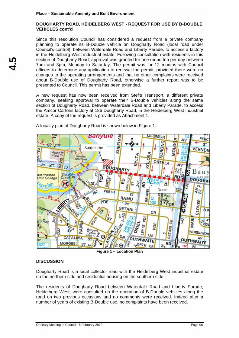
4.5
Place – Sustainable Amenity and Built Environment DOUGHARTY ROAD, HEIDELBERG WEST - REQUEST FOR USE BY B-DOUBLE VEHICLES cont’d
Ordinary Meeting of Council - 6 February 2012 Page 96
Since this resolution Council has considered a request from a private company planning to operate its B-Double vehicle on Dougharty Road (local road under Council’s control), between Waterdale Road and Liberty Parade, to access a factory in the Heidelberg West industrial estate. Following consultation with residents in this section of Dougharty Road, approval was granted for one round trip per day between 7am and 3pm, Monday to Saturday. The permit was for 12 months with Council officers to determine any application to renewal the permit, provided there were no changes to the operating arrangements and that no other complaints were received about B-Double use of Dougharty Road, otherwise a further report was to be presented to Council. This permit has been extended. A new request has now been received from Stef’s Transport, a different private company, seeking approval to operate their B-Double vehicles along the same section of Dougharty Road, between Waterdale Road and Liberty Parade, to access the Amcor Cartons factory at 186 Dougharty Road, in the Heidelberg West industrial estate. A copy of the request is provided as Attachment 1. A locality plan of Dougharty Road is shown below in Figure 1.
Figure 1 – Location Plan
DISCUSSION Dougharty Road is a local collector road with the Heidelberg West industrial estate on the northern side and residential housing on the southern side. The residents of Dougharty Road between Waterdale Road and Liberty Parade, Heidelberg West, were consulted on the operation of B-Double vehicles along the road on two previous occasions and no comments were received. Indeed after a number of years of existing B-Double use, no complaints have been received.
Subject site
Route

4.5
Place – Sustainable Amenity and Built Environment DOUGHARTY ROAD, HEIDELBERG WEST - REQUEST FOR USE BY B-DOUBLE VEHICLES cont’d
Ordinary Meeting of Council - 6 February 2012 Page 97
This new request from Stef’s Transport is also for one (1) round trip per day, however it would only be for three (3) days per week, from Monday to Friday. Freight to the Amcor Cartons factory would be more efficient if the private company was given permission to use B-Double vehicles as less heavy vehicle traffic movements would be required to the site. The proposed route has previously been assessed as being suitable for B-Double vehicles. All other possible routes to the site would require travelling along other local roads, which is not desirable. The company would also be required to make application to VicRoads in order to obtain a permit.
CONCLUSION
It is considered that an additional three (3) B-Double vehicle movements per week along Dougharty Road, between Waterdale Road and Liberty Parade, would be acceptable given that it is providing access to an industrial estate and that no issues or complaints have been received from residents. Given that this is likely to become an annual request, it is recommended that it be determined by Council officers under delegation, provided there are no changes to the agreed operating arrangements and no complaints are received about B-Double use of Dougharty Road. RECOMMENDATION
That: 1. Permission be granted to Stef’s Transport to operate their B-Double articulated
combination truck and trailer on Dougharty Road, between Waterdale Road and Liberty Parade, to access the Amcor Cartons factory at 186 Dougharty Road in the Heidelberg West industrial estate, for one (1) round trip per day, three (3) days a week, between the hours of 7am and 3pm, Monday to Friday, for a period of 12 months.
2. Council officers determine any application to renew the permit in 12 months
time, provided there are no changes to the operating arrangements and that no complaints are received about B-Double use of Dougharty Road, otherwise a further report is to be presented to Council.
3. Stef’s Transport be advised of the Council Resolution.
ATTACHMENTS No. Title Page 1 Stefs Transport - B Double Request Letter 160

4.6
Place – Sustainable Amenity and Built Environment
Ordinary Meeting of Council - 6 February 2012 Page 98
4.6 IVANHOE PUBLIC GOLF COURSE - 1 VASEY STREET, IVANHOE - PROPOSED LEASE TO LEISURE MANGEMENT SERVICES PTY LTD
Author: Jeanette Kringle - Property Co-ordinator, City Development
Ward: Griffin
File: BS28/015/068, BP7570/1 SUMMARY
To determine whether or not to enter into a short term lease with Leisure Management Services Pty Ltd for the management and operation of the Council owned land and improvements known as the Ivanhoe Public Golf Course at 1 Vasey Street, Ivanhoe. CITY PLAN
This report is in line with Council’s City Plan key direction to "protect and develop publicly used assets".
BACKGROUND
Council is the owner of the land and improvements known as Ivanhoe Public Golf Course (golf course) being part of the land shown shaded on the locality plan (at Figure 1) below at 1 Vasey Street, Ivanhoe.
Figure 1: Locality Plan

4.6
Place – Sustainable Amenity and Built Environment IVANHOE PUBLIC GOLF COURSE - 1 VASEY STREET, IVANHOE - PROPOSED LEASE TO LEISURE MANGEMENT SERVICES PTY LTD cont’d
Ordinary Meeting of Council - 6 February 2012 Page 99
A short term lease commencing on 1 April 2011 was entered into between Council and Leisure Management Services Pty Ltd (LMS). This lease is due to expire on 30 March 2012. When the short term lease was entered into it was anticipated that details of the proposed stormwater harvesting project and the financial operations of the golf course would be resolved well before the expiry date of the initial short term lease. Unfortunately this has not eventuated.
CURRENT SITUATION
It is now envisaged that, during the next 12 months, Council will gather sufficient details on the ongoing management of the golf course to make a decision on whether to proceed with a long term lease with LMS. Consequently it is considered appropriate that a further short term lease be granted to LMS for the term of one (1) year commencing on 31 March 2012.
LEGAL CONSIDERATION
Section 190(3) of the Local Government Act 1989 (the Act) provides that Council must given public notice of its intention to enter into a lease where the lease is for a period of one (1) year or more and the market rental is in excess of $50,000 per annum. Therefore public notice is required. Due to the nature of the business operations, and the desire of both Council and LMS to preserve business continuity of the golf course, public notice of Council’s intention to enter into the lease was given in December 2011 rather than in February 2012. Given the fast approaching expiry date, this was considered necessary to secure the ongoing management and operation of the golf course as an interim measure. Public notice was given in the “Heidelberg Leader” on Tuesday 13 December 2011 inviting the public to make written submissions by on 10 January 2012.
CONCLUSION
No submissions to the public notice were received. Preservation of business continuity of the management and operation of the golf course is seen as paramount. Accordingly, ratification of the further short term lease to LMS for the period of one (1) year commencing on 31 March 2012 should be supported by the affixing of Council’s seal. RECOMMENDATION
That the Common Seal of Banyule City Council be affixed to the lease between Banyule City Council and Leisure Management Services Pty Ltd for the management and operation of the Council owned land and improvements known as the Ivanhoe Public Golf Course at 1 Vasey Street, Ivanhoe, for the period of one (1) year commencing on 31 March 2012.
ATTACHMENTS Nil

4.7
Place – Sustainable Amenity and Built Environment
Ordinary Meeting of Council - 6 February 2012 Page 100
4.7 YALLAMBIE PARK PRESCHOOL - 309-311 YALLAMBIE ROAD, YALLAMBIE - REQUEST TO INCREASE LEASED AREA
Author: Jeanette Kringle - Property Co-ordinator, City Development
Ward: Bakewell
File: BS34/015/026 BS28/015/045 BP8120/311 SUMMARY
To consider the increase of the existing leased area of the Yallambie Park Preschool by 165m2 to incorporate the recently extended and refurbished former Yallambie Maternal and Child Health Centre and a request for an additional 85m2 of land to provide a fenced ‘child safe’ area for the preschool facility. CITY PLAN
This report is in line with Council’s City Plan key direction to "protect and develop publicly used assets".
BACKGROUND
A preschool service known as Yallambie Park Preschool operates from the land known as 309-311 Yallambie Road, Yallambie (Council owned land) shown on the locality plan at Figure 1 below.
Figure 1: Locality Plan

4.7
Place – Sustainable Amenity and Built Environment YALLAMBIE PARK PRESCHOOL - 309-311 YALLAMBIE ROAD, YALLAMBIE - REQUEST TO INCREASE LEASED AREA cont’d
Ordinary Meeting of Council - 6 February 2012 Page 101
The preschool service is managed jointly by Early Childhood Management Services and a volunteer kindergarten parent committee (the Committee). This preschool has for many years had strong enrolments and these numbers are expected to continue to increase in future years.
TECHNICAL COSIDERATIONS
The Council owned land is a stand alone parcel. The improvements on the land originally comprised one building with two distinct sections. One section contained a ‘one playroom’ preschool facility and the other section a Maternal Child Health Centre, which has been non-operational and vacant for a number of years (former MCHC). The Council owned land is included in a Residential 1 Zone (R1Z) and is affected by the Vegetation Protection Overlay (VPO5) control.
CURRENT SITUATION
Major reforms are to be introduced into the early childhood sector in the next five (5) years. The Australian Government, through Council of Australian Governments (COAG) has determined that all children should be able to access 15 hours kindergarten in the year before they start school. Currently children in Victoria can access only 11 hours of four (4) year old kindergarten. The increase in hours must be delivered by 2013. Additionally by 2016, the National Quality Framework for Early Childhood Education requires that the staff-child ratio for children over three (3) years of age should be reduced from 1:15 to 1:11. In most Banyule preschools this will mean that class sizes will be reduced from an average of 26 to 22. It has been identified that there will be additional staffing costs to meet the reduced staff-child ratios, particularly to cover leave periods, so preschools will have to factor these increased costs into their individual budgets. In October 2010 the Committee was successful in its application for $100,000 funding under the Department of Early Education Childhood Development (DEECD) Children’s Capital program – Renovation and Refurbishment Grant (Stage 2 Universal Access). The Committee also contributed $82,352 of its own funds. The extension and refurbishment of the former MCHC, to create an additional playroom at the preschool facility (the works), were completed in December 2011 in readiness for the commencement of the new kindergarten year in February 2012. The current lease expires on 30 April 2015. The existing leased area does not include the extended building, which now provides for a second playroom to enable the preschool to meet its legislative obligations, nor does it provide a fenced ‘child safe’ area to the preschool facility within the existing fence line. Consequently the Committee seeks Council’s consent to extend the existing leased area to include the area shown as the proposed increased leased area on Figure 2 below and to further extend the existing fence line to incorporate a ‘child safe’ area.

4.7
4.7
Place – Sustainable Amenity and Built Environment YALLAMBIE PARK PRESCHOOL - 309-311 YALLAMBIE ROAD, YALLAMBIE - REQUEST TO INCREASE LEASED AREA cont’d
Ordinary Meeting of Council - 6 February 2012 Page 102
Figure 2 below identifies the extent and location of:
• the existing leased area;
• the proposed increased leased area (being approximately 165m2); and
• the proposed ‘child safe’ area (being approximately 85m2).
Figure 2: Location and Extent of the Existing and Proposed Leased Areas
LEGAL CONSIDERATION
Council must give public notice of its intention to increase the existing leased area and invite submissions from members of the public in accordance with the section 223 of the Local Government Act 1989 (the Act).
POLICY IMPLICATIONS
PUBLIC NOTICE
Council’s Official Newspaper Policy provides as follows: “The Heidelberg Leader and/or Diamond Valley Leader and/or the Heidelberg and Valley Weekly, where appropriate be appointed as Council’s official newspapers for the purpose of providing public notice except where circumstances may be deemed appropriate to use The Age and/or the Herald sun for particular public notices.”
OFFICER COMMENT
Leader Community Newspapers advises that the “Heidelberg Leader” is the local newspaper distributed in the immediate area. However the distribution area of the “Diamond Valley Leader” commences nearby.

4.7
Place – Sustainable Amenity and Built Environment YALLAMBIE PARK PRESCHOOL - 309-311 YALLAMBIE ROAD, YALLAMBIE - REQUEST TO INCREASE LEASED AREA cont’d
Ordinary Meeting of Council - 6 February 2012 Page 103
Given the location of the Council owned land, and local newspaper distribution areas, it is considered prudent that, in this instance, public notice be given in both publications.
DISCUSSION
The proposed ‘child safe’ area is located immediately adjacent to the north/west corner of the existing leased area. It does not display any evidence of regular use by the public, save for the well worn informal path which appears to be used as access to the preschool facility. Consequently it is considered that the excision of the additional area of 65m2 will not compromise the function of the Council owned land or its surrounds.
CONCLUSION
External funding from the Federal Government and the Committee has allowed the extended and refurbished former MCHC to be incorporated as part of the preschool facility. The works have been completed in time for the commencement of the new kindergarten year in February 2012. The proposal to extend the existing fence line to incorporate a ‘child safe’ area will not compromise the function of Council owned land or its surrounds. Accordingly the proposal to increase the leased area by 250m2 could be documented by written agreement. In light of the above, Council should:
• support the proposal to increase the existing leased area of the Yallambie Park Preschool at 309-311 Yallambie Road Yallambie by approximately 250m2 to include the recently extended and refurbished building and a ‘child safe’ area for the preschool facility; and
• direct the commencement of the statutory procedures by giving public notice in accordance with Council’s Official Newspaper Policy.
In anticipation of there being no submissions received in response to the public notice, Council should ratify the proposal to increase the existing leased area by approximately 250m2 and resolve to affix its common seal to the agreement to document the increased leased additional area and ‘child safe’ area being included in the preschool facility fenceline. RECOMMENDATION
That: 1. Pursuant to sections 190(3) and 223 of the Local Government Act 1989 (the
Act), Council directs that public notice of its intention to increase the existing leased area of the Yallambie Park Preschool located at 309-311 Yallambie Road, Yallambie, by 250m2, to incorporate 165m2 the recently extended and refurbished former Yallambie Maternal and Child Health Centre and an additional area of 85m2 to provide a fenced ‘child safe’ area to the preschool facility, be given in the “Heidelberg Leader” and the “Diamond Valley Leader”.

4.7
4.7
Place – Sustainable Amenity and Built Environment YALLAMBIE PARK PRESCHOOL - 309-311 YALLAMBIE ROAD, YALLAMBIE - REQUEST TO INCREASE LEASED AREA cont’d
Ordinary Meeting of Council - 6 February 2012 Page 104
2. That, subject to:
a. the completion of the statutory procedures referred to in Item 1; and
b. there being no submissions received pursuant to section 223 of the Act;
Council resolves to increase the existing leased area by 250m2 and to affix Council’s common seal to the agreement documenting such increase.
3. In the event of submissions being received then, in accordance with section
223 of the Act, a report be presented to Council to hear those submissions.
ATTACHMENTS Nil

5.1
Prosperity – Prosperous and Sustainable Local Economy
Ordinary Meeting of Council - 6 February 2012 Page 105
5.1 SUPPLEMENTARY VALUATION 4/2011 Author: Peter Kemm - City Valuer, City Development
File: BS12/055/003 SUMMARY
Minuting the Valuer’s Statutory Declaration relating to the Supplementary Valuations effective from 1 February 2012.
BACKGROUND
The City Valuer has submitted the attached supplementary valuation statutory declaration as required under Section 13DH(2) of the Valuation Land Act 1960. The supplementary Valuation is to be effective from February 2012. RECOMMENDATION
That Council note the attached Supplementary Valuation Declaration dated 11 January, 2012.
ATTACHMENTS No. Title Page 1 Supplementary Valuation Declaration 161

6.1
Participation – Community Involvement in Community Life
Ordinary Meeting of Council - 6 February 2012 Page 107
6.1 THE BANYULE COMMUNITY SAFETY PLAN 2012-2016
Author: Frances Gianinotti - Youth & Community Services Co-Ordinator, Community Programs
File: 0 SUMMARY
To inform Council on the development of the Safer Banyule Plan 2012-2016 (attached). CITY PLAN
This report is in line with Council’s City Plan key direction of "develop a connected and involved community".
BACKGROUND
The Community Safety portfolio has been in place for more than 10 years and is well established within Council and the community. Its primary focus has been:
• Preventing crime before it occurs, with health promotion as the underliying principle
• Improvements in open spaces through good urban design to support positive interactions
• Reducing risk factors for crime by addressing social factors: family relationships, coping skills of parents and adolescents, improving sense of belonging and ensuring resources in areas of greatest need
Key highlights of the portfolio over the past 4 years include:
• Coordinated responses to emerging hot spot issues eg Rosanna shopping precinct; Watsonia train station;
• Facilitation of early intervention referrals for young people eg BACKUP initiative for young offenders;
• Increased responsible service of alcohol in sports clubs eg Good Sports Program supported by VicHealth;
• Increased awareness of Preventing Violence Against Women eg White Ribbon Action Team and Council/community campaigns;
• Increased education and implementation of best practice in graffiti management eg Adopt Your Space program, Taggart Trial, Traffic Graffix, Street Art program;
• Partnerships with Council and the community to improve safe design of public spaces eg CPTED training for Council officers.

6.1
6.1
Participation – Community Involvement in Community Life THE BANYULE COMMUNITY SAFETY PLAN 2012-2016 cont’d
Ordinary Meeting of Council - 6 February 2012 Page 108
STRATEGIC FRAMEWORK The Community Safety Plan 2012-2016 has been developed within the context of the key objectives of Council’s City Plan, primarily PEOPLE – to support and strengthen the health and safety of Banyule’s community and PARTICIPATION – to govern effectively by supporting civic participation, advocacy and efficient resource management. The Plan is also a key supporting plan for Banyule’s People: Health and Wellbeing Policy and Strategy 2009-2013. State and Federal Governments set an early intervention/harm minimisation framework. Their focus is crime prevention, early intervention, community participation and reducing disadvantage evident in policies such as the Neighbourhood Renewal Strategy, the Social Inclusion Agenda, Victoria Police: The Way Ahead Strategy, and the Vic Health Public model of Health, which guides Council to plan for primary prevention work in family violence. The Department of Justice’ Community Crime Prevention Program provides Council the opportunity to improve public safety infrastructure. KEY DIRECTIONS Council’s role in Community Safety has been defined by 4 key strategic focus areas: People, Places, Crime and Coordination. Evidence from current data, consultation findings and policy direction found that the Safer Banyule Plan should continue its work within these areas. These areas are aligned with the City Plan 2009-2013, the People: Health and Wellbeing Policy & Strategy, the Banyule Community Plan, and the Youth and Community Partnerships Service Objectives and Quality & Cost Standards. Key Area 1: Coordination “Ensure a partnership approach to crime prevention initiatives, and ensure effective service delivery which aims to prevent issues before they occur” Priorities are to develop and sustain partnerships to ensure outcomes that address safety impacts on community. Council has strong and effective partnerships with agencies in Banyule including Banyule Community Health Services, Berry Street, Neighbourhood Watch and Police. The Community Safety Plan recommends continuing a coordinated approach to address community safety issues. Key Area 2: People “Ensure there are measures of intervention for those more at risk of crime. recognising some people have greater fear of crime in Banyule than the real risk, and working to improve their sense of safety” Amenity issues such as graffiti, waste and trip hazards negatively affect people’s perceptions of safety and continue to be a priority for action for Council. Priorities include to improve people’s sense of safety in their surroundings.
6.1
Participation – Community Involvement in Community Life THE BANYULE COMMUNITY SAFETY PLAN 2012-2016 cont’d
Ordinary Meeting of Council - 6 February 2012 Page 109
Key Area 3: Places “Ensure space is well designed and maintained so that it is appealing for the community and lessens the chance of opportunistic crime” Priorities highlight a dedication to ensuring spaces incorporate safer design principles and that places are well used and maintained Key Area 4: Crime Ensure a crime prevention focus is maintained at Council level and in partnership. Ensure that focus is given to family violence, graffiti and vandalism, hoon driving and other crimes which have increased in the police statistics such as robbery and theft from motor vehicle” Priorities include to educate residents on ways to reduce the chance of crime occurring, to continue to raise awareness of family violence and to evaluate the existing Graffiti Management Strategy. PROFILE OF COMMUNITY SAFETY IN BANYULE Community safety covers broad areas such as crime, injuries and accidents, poor family relationships and lack of support, drug and alcohol use and related behaviours, poor physical environment, unstable housing and social exclusion. The community generally have a personal interest in maintaining or improving community safety at some level. While Banyule is generally a safe place, community concerns and local data highlight issues that need a strong community and Council focus. They include anti social behaviour, robbery, theft from motor vehicle and family violence. Council plays a significant role in partnership with Victoria Police, local services & agencies and the broader community Council’s primary role in responding to these issues is community strengthening and social inclusion. It is acknowledged that crime statistics and community concerns change over time, however are often common to many other municipalities in varying degrees. Intervention or behaviour change programs can have a positive effect on crimes such as property damage. Patterns of crime and community safety issues inform meaningful allocation of resources. Data shows that safety issues can be more likely in specific suburbs of Banyule and those living in areas of higher disadvantage are likely to feel more fearful. Where Banyule’s crime statistics increase, such as robbery and family violence, the same pattern of increase can be seen statewide. Family Violence has been a rising issue state wide in recent years. Statistics do not relate the gravity of the issue, since many incidents are not reported. The Australian Bureau of Statistics identified that from the age of 15, only 19 per cent of women who experience physical violence report the incident to the police. Through ongoing consultations with the youth services sector, there is evidence that young people are less likely to report physical, verbal or sexual assault.

6.1
6.1
Participation – Community Involvement in Community Life THE BANYULE COMMUNITY SAFETY PLAN 2012-2016 cont’d
Ordinary Meeting of Council - 6 February 2012 Page 110
The underlying strategies for Council are situational and social crime prevention. They look at safer design and reducing the opportunity for offending and, at a social level, addressing the underlying and often complex issues related to crime and victimisation. KEY CHALLENGES Family violence has increased in Banyule in recent years as evidenced by the
rise in police statistics. Council’s role has incrementally increased accordingly in response, including raising awareness and primary prevention initiatives. This is also in line with increased efforts across the Melbourne metropolitan northern region and the partnerships that Council has developed. While family violence is clearly a priority for the Banyule community, the challenge for Council is that there are limited staff resources which also have broader community safety responsibilities.
The current Graffiti Management Strategy incorporates diversionary, reactive
and enforcement measures to tackle graffiti in Banyule. A comprehensive review of this strategy will be undertaken in 2012 to ensure resources are best placed for effective outcomes. The review outcomes and subsequent revised Graffiti Management Strategy will be presented to Council in late 2012.
Hot spot areas and issues are regularly monitored and addressed in terms of
trying to ensure effective responses as appropriate. The Community Safety role has an important coordination and facilitation role in this process to ensure a whole-of-Council approach.
CONCLUSION
Implementation of the Safer Banyule Plan over the next four years will support Council to deliver its commitments in the City Plan 2009-2013 and the People: Health & Wellbeing Policy and Strategy 2009-2013. It will also inform future city plans and strategies. The Plan is an important framework to promote and support community safety and amenity and to coordinate effective responses to crime prevention and community safety issues in the municipality. RECOMMENDATION
That Council endorse the Banyule Community Safety Plan 2012 - 2016
ATTACHMENTS No. Title Page 1 Safer Banyule Plan (Draft 12 Jan12) 162
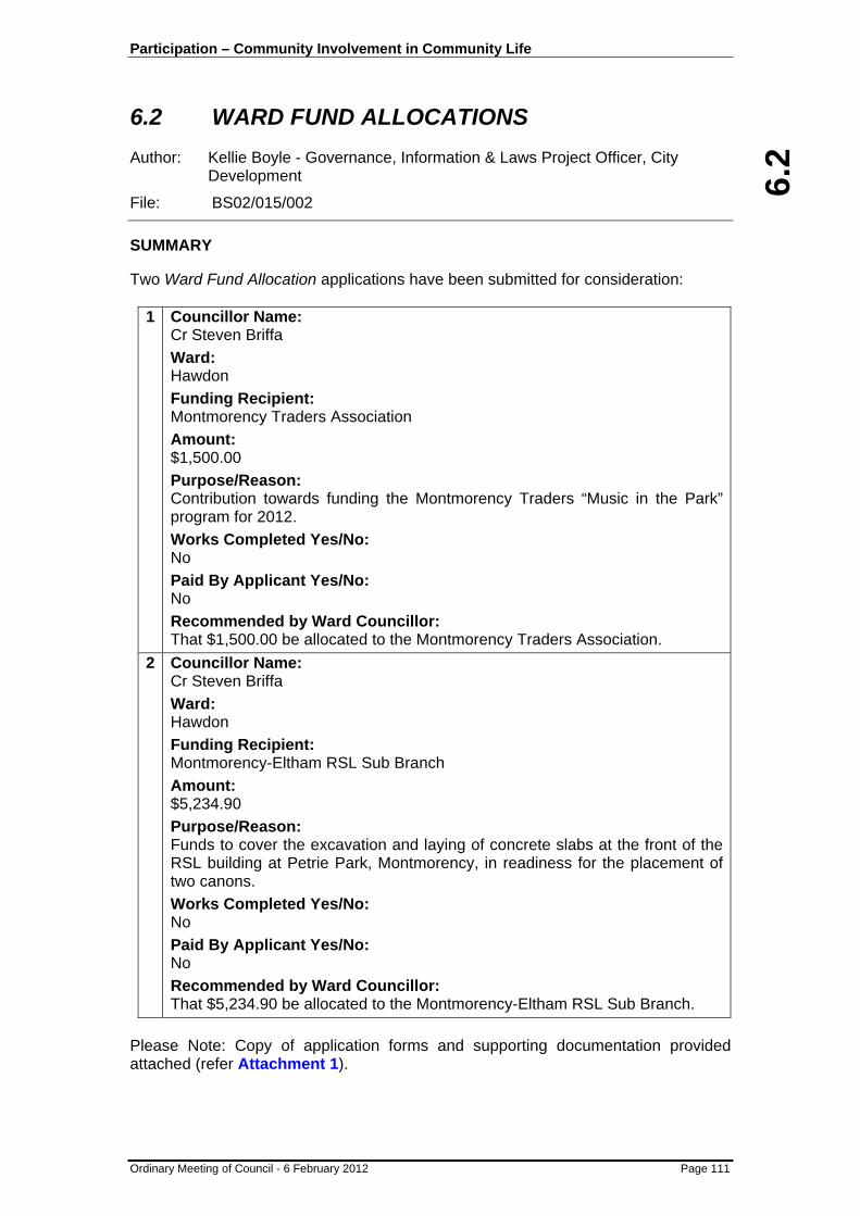
6.2
Participation – Community Involvement in Community Life
Ordinary Meeting of Council - 6 February 2012 Page 111
6.2 WARD FUND ALLOCATIONS Author: Kellie Boyle - Governance, Information & Laws Project Officer, City Development
File: BS02/015/002 SUMMARY
Two Ward Fund Allocation applications have been submitted for consideration:
1 Councillor Name: Cr Steven Briffa Ward: Hawdon Funding Recipient: Montmorency Traders Association Amount: $1,500.00 Purpose/Reason: Contribution towards funding the Montmorency Traders “Music in the Park” program for 2012. Works Completed Yes/No: No Paid By Applicant Yes/No: No Recommended by Ward Councillor: That $1,500.00 be allocated to the Montmorency Traders Association.
2 Councillor Name: Cr Steven Briffa Ward: Hawdon Funding Recipient: Montmorency-Eltham RSL Sub Branch Amount: $5,234.90 Purpose/Reason: Funds to cover the excavation and laying of concrete slabs at the front of the RSL building at Petrie Park, Montmorency, in readiness for the placement of two canons. Works Completed Yes/No: No Paid By Applicant Yes/No: No Recommended by Ward Councillor: That $5,234.90 be allocated to the Montmorency-Eltham RSL Sub Branch.
Please Note: Copy of application forms and supporting documentation provided attached (refer Attachment 1).

6.2
Participation – Community Involvement in Community Life WARD FUND ALLOCATIONS cont’d
Ordinary Meeting of Council - 6 February 2012 Page 112
RECOMMENDATION
That the Ward Fund Allocations for the Montmorency Traders Association and the Montmorency-Eltham RSL Sub Branch be approved for payment and the beneficiaries be notified of Council’s decision.
ATTACHMENTS No. Title Page 1 Ward Fund Application Forms and Supporting Documentation 216

7.1
Strategic Resource Plan - Use Our Resources Wisely
Ordinary Meeting of Council - 6 February 2012 Page 113
7.1 REVIEW OF COUNCILLOR RESOURCE, EXPENSE AND ENTITLEMENTS POLICY
Author: Gina Burden - Manager Governance, Information & Laws, City Development
File: BS02/015/004 SUMMARY
To seek Council endorsement of the reviewed Councillor Resource, Expense and Entitlements Policy (attached) which has been amended and updated in line with recommendations from a recent audit review. CITY PLAN
This report is in line with Council’s City Plan key direction to "provide effective support to enable good governance and accountable leadership".
BACKGROUND
Section 75B of the Local Government Act 1989 (the Act) requires that a Council must adopt and maintain a policy in relation to the reimbursement of out-of-pocket expenses for Councillors and members of Council committees. Section 75C of the Act requires Councils to provide for resources and facilities for Councillors as prescribed. In accordance with these requirements, Banyule Council has a policy titled “Councillor, Resource, Expense and Entitlement Policy” (Policy) which was last reviewed and adopted by Council on 19 October 2009. As part of a recent internal audit, Council’s auditors, Oakton, reviewed the existing Policy and have recommended that a number of minor amendments and updates be made to ensure it is current and to more clearly set out the procedure for Councillors’ reimbursements.
DISCUSSION
Banyule’s Policy complies with the requirements of section 75B of the Act. This was confirmed not only by the internal audit but also by the recent audit conducted by the Local Government Inspectorate into Banyule Council’s governance processes, which noted that the Councillor Reimbursement Policy was compliant and contained the prescribed procedures in relation to claiming out-of-pocket expenses in line with the regulatory requirements of the Act. Oakton, however, have recommended that there are a number of matters that would improve the Policy which includes: Councillors’ entitlement to claim workers compensation if injured while carrying out their Councillor duties, which became effective from 1 July 2010, and also the development of a reimbursement procedure. At present the Policy spells out what can be reimbursed but does not include the procedure. These two matters have now been included in the revised Policy.
7.1
Strategic Resource Plan - Use Our Resources Wisely REVIEW OF COUNCILLOR RESOURCE, EXPENSE AND ENTITLEMENTS POLICY cont’d
Ordinary Meeting of Council - 6 February 2012 Page 114
Revision of the Policy has also allowed opportunity for other minor updates to be made, these are: • Reference to the Councillor and Mayoral Allowance amount set in 2009 has
been removed as the amount is now reviewed and increased annually by the Minister;
• A definition for Councillor duties has been inserted to allow for better assessment of allowable expenses and reimbursements while undertaking Council duties. The definition is the same as that used for the purposes of workers compensation for Councillors; and
• The list of Communication Facilities and Equipment has been updated to include the latest version of technology and software which is now utilised and provided by Council.
CONCLUSION
In keeping with Council’s requirement to adopt and maintain a policy relating to the reimbursement of Councillor expenses and to provide appropriate resources and facilities for Councillors, it was timely to review the existing Council Policy relating to these matters. Accordingly, the recommendations made by Council’s internal auditors have been actioned and included in the revised Policy. RECOMMENDATION
That Council adopt the revised Councillor Resource, Expense and Entitlements Policy.
ATTACHMENTS No. Title Page 1 Councillors Resource, Expense and Entitlements Policy 2012 220

7.2
Strategic Resource Plan - Use Our Resources Wisely
Ordinary Meeting of Council - 6 February 2012 Page 115
7.2 ASSEMBLY OF COUNCILLORS Author: Kellie Boyle - Governance, Information & Laws Project Officer, City Development
File: BS02/015/002 SUMMARY
In accordance with Section 80A of the Local Government Act 1989 Council is required to report as soon as possible to an Ordinary Meeting of Council a record of any assemblies of Councillors held. Below is the latest listing of notified assemblies of Councillors held at Banyule City Council. RECORD OF ASSEMBLIES 1 Date of Assembly: 5 December 2011
Type of Meeting Councillor Briefing
Matters Considered: Items on the Council Agenda for the Ordinary Meeting of 5 December 2011 (excluding confidential items) as listed below: • 2.1 The Banyule Youth Strategic Plan 2011-2015 • 2.2 Restricted Breed Dog Legislation Update • 2.3 Price Park Master Plan • 2.4 Melbourne's Northern Region • 4.1 Ivanhoe Grammar School - Amendment to
Development Plan and Year7/8 Addition • 4.2 Ferguson Street, Macleod - Infrastructure
Condition • 4.3 Update on the Heritage Planning Scheme
Amendments • 4.4 Proposed Rezoning of Council's Turnham
Avenue Service Centre and Douglas Street Car Park in Rosanna
• 4.5 Rezoning land in the Greensborough Principal Activity Centre to the Activity Centre Zone
• 4.6 Montmorency Activity Centre Transport Issues • 4.7 Vehicle Crossovers (Driveways) • 4.8 School Regeneration Project - Current
Community Facilities
(Please Note: Time did not allow for all items listed on the Agenda to be discussed)
Councillors Present: Jessica Paul Steven Briffa Wayne Phillips Peter McKenna Tom Melican Craig Langdon
Staff Present Simon McMillan, CEO Ramesh Choudari, Director City Services Scott Walker, Director City Development Gina Burden, Manager Governance, Information & Laws

7.2
7.2
Strategic Resource Plan - Use Our Resources Wisely ASSEMBLY OF COUNCILLORS cont’d
Ordinary Meeting of Council - 6 February 2012 Page 116
Kellie Boyle, Governance, Information & Laws Project Officer Daniel Kollmorgen, Manager Development Services Frances Gianinotti, Coordinator Youth & Community Partnerships David Cox, Coordinator Strategic Planning Allison Beckwith, Manager Leisure, Recreation & Cultural Services Helen Lawless, Manager Workforce Development Peter Utri, Manager Organisation Performance Peter Benazic, Manager Parks & Gardens Cheryle Michael, Youth Planning & Policy Officer
Others Present Nil
Conflict of Interest: Nil
2 Date of Assembly: 9 December 2011
Type of Meeting Greensborough Project Steering Committee (GPSG)
Matters Considered: • RALC Design Team progress • Community Space progress • Communication/Community Consultation
Councillors Present: Steven Briffa Peter McKenna
Staff Present Simon McMillan, CEO Ramesh Choudari, Director City Services Scott Walker, Director City Development Arun Chopra, Manager Major Projects & Infrastructure Allison Beckwith, Manager Leisure Recreation & Cultural Services
Others Present Nil
Conflict of Interest: Nil
3 Date of Assembly: 12 December 2011
Type of Meeting Councillor Briefing
Matters Considered: Councillor Committee Representation for 2012
Councillors Present: Jessica Paul Steven Briffa Wayne Phillips Peter McKenna Tom Melican Jenny Mulholland Craig Langdon
Staff Present Simon McMillan, CEO
Others Present Nil
Conflict of Interest: Nil

7.2
Strategic Resource Plan - Use Our Resources Wisely ASSEMBLY OF COUNCILLORS cont’d
Ordinary Meeting of Council - 6 February 2012 Page 117
4 Date of Assembly: 13 December 2011
Type of Meeting Councillor Briefing
Matters Considered: Items on the Council Agenda for the Special Meeting of 13 December 2011 (excluding confidential items) as listed below: • 5.1 182 Hawdon Street, Heidelberg - Proposed Sale
of Land • 7.1 Proposed Lease to Bellfield Community Centre
Inc - 96 Oriel Road, Bellfield
Councillors Present: Jessica Paul Steven Briffa Wayne Phillips Peter McKenna Tom Melican Jenny Mulholland Craig Langdon
Staff Present Simon McMillan, CEO Keith Yeo, Director Corporate Services Daniel Kollmorgen, Manager Development Services Vivien Ferlaino, Coordinator Governance & Information
Others Present Nil
Conflict of Interest: Nil
RECOMMENDATION
That the Assembly of Councillors report be received.
ATTACHMENTS Nil


8.1
Sealing of Documents
Ordinary Meeting of Council - 6 February 2012 Page 119
8.1 SEALING OF DOCUMENTS Author: Kellie Boyle - Governance, Information & Laws Project Officer, City Development
File: BS04/010/002 The following documents require the affixing of the Common Seal of Council:
PARTY\PARTIES: Banyule City Council OFFICER: Kellie Boyle FILE NUMBER: BS04/010/002 DOCUMENT: Delegation
1
BRIEF EXPLANATION: To update the Planning Delegation to Council Staff. Delegations from Council to staff enable officers to make day-to-day decisions within their positions. Delegations need to be updated regularly due to changes in legislation or title changes to officers positions to ensure that staff are able to continue working within their authority and within the boundaries of the law. In this instance, the update is to reflect title changes.
PARTY\PARTIES: Banyule City Council OFFICER: Kellie Boyle FILE NUMBER: BS04/010/002 DOCUMENT: Instrument of Authorisation
2
BRIEF EXPLANATION: Pursuant to Section 224 of the Local Government Act 1989, a Council may appoint any person other than a Councillor to be an authorised officer for the purposes of the administration and enforcement of any Act, regulations or local laws which relate to the functions and powers of the Council. Officers who undertake the Statutory role of Planners require Authorisation.
An authorised officer has the power to: • Demand the name and address of a person who has committed, or who the authorised officer reasonably suspects has committed or is about to commit, an offence against any Act, regulation or local law in respect of which he or she is appointed. • To enter land at any reasonable time and to enforce the Planning and Environment Act.
The Instrument of Authorisation requires the Council Seal for Nick Helliwell to be a Major Developments Planner in the Planning Unit.

8.1
Sealing of Documents SEALING OF DOCUMENTS cont’d
Ordinary Meeting of Council - 6 February 2012 Page 120
RECOMMENDATION
That: 1. The Common Seal of the Banyule City Council be affixed to the Planning
Delegation. 2. That Nick Helliwell be appointed and authorised as set out in the Instrument of
Authorisation and the Common Seal of the Banyule City Council be affixed to the Instrument.
ATTACHMENTS Nil