oxford reconnaissance report - massachusetts
TRANSCRIPT

OXFORD RECONNAISSANCE REPORT
BLACKSTONE VALLEY / QUINEBAUG-SHETUCKETLANDSCAPE INVENTORY
MASSACHUSETTS HERITAGE LANDSCAPEINVENTORY PROGRAM
Massachusetts Department of Conservation and Recreation
John H. Chafee Blackstone River Valley National Heritage Corridor
Quinebaug and Shetucket Rivers Valley National Heritage Corridor

PROJECT TEAM
Massachusetts Department of Conservation and RecreationJessica Rowcroft, Preservation PlannerDivision of Planning and Engineering
Quinebaug and Shetucket Rivers Valley National Heritage CorridorRobert Levite, UMass Extension
Project ConsultantsElizabeth Vizza, Elizabeth Vizza ConsultingElecta Kane Tritsch, Oakfield ResearchDaniel Wells, Hyla Ecological Services Inc.
Local Project CoordinatorJean O’Reilly, Chair, Historical Commission
Local Heritage Landscape ParticipantsIrene AllainCarol ButlerAlan DabrowskiRichard EscolasChristine GrimandoElwood JohnsonAnn KulisaChet KulisaJean O’ReillyEllie OlesonKen ParkerAnn PotterJohn RecknerBill ScanlanPeter SmithJeff StaffordVirginia SuklisAlice WalkerJames Walker
June 2007
Cover Photographs: Eames Pond MillCasavant FarmOxford Center

CONTENTS
Introduction ........................................................................................................................1
Part I: Oxford’s Heritage Landscapes
Oxford’s Landscape Through Time............................................................................2
Community-Wide Heritage Landscape Issues ...........................................................4
Oxford Priority Landscapes ........................................................................................5Oxford Center5Eames Pond Mill SiteFrench GardensCasavant FarmBuffalo Hill FarmFrench River Corridor
Part II: Building a Heritage Landscape Toolkit
Eight Toolkit Basics ..................................................................................................20
Oxford’s Toolkit: Current Status and Future Additions...........................................21
Conclusion and Implementation .........................................................................................28
Appendix A: Oxford Heritage Landscapes .............................................................................. i
Appendix B: Guide to Preservation and Planning Tools for Heritage ....................................vLandscapes

INTRODUCTION
The 22 Massachusetts communities within the John H. Chafee Blackstone River ValleyNational Heritage Corridor (BRV) and the Quinebaug and Shetucket Rivers ValleyNational Heritage Corridor (Q-S) are linked by a common heritage of agriculture andindustry powered by the rivers and streams that dominate the landscape of south centralMassachusetts. River Corridor towns extend from Mendon on the east to Brimfield on thewest. While they range in size from the city of Worcester to the compact town ofHopedale, each is equally shaped by the interaction of nature and culture over time.
Heritage landscapes are special places created by human interaction with the naturalenvironment that help define the character of a community and reflect its past. They aredynamic and evolving; they reflect the history of a community and provide a sense ofplace; they show the natural ecology that influenced land use patterns; and they oftenhave scenic qualities. This wealth of landscapes is central to each community’s character,yet heritage landscapes are vulnerable and ever changing. For this reason it is importantto take the first step toward their preservation by identifying those landscapes that areparticularly valued by the community – a favorite local farm, a distinctive neighborhoodor mill village, a unique natural feature or an important river corridor.
To this end, the Massachusetts Department of Conservation and Recreation (DCR) andthe two National Heritage Corridors (BRV and Q-S) have collaborated to bring theHeritage Landscape Inventory program to communities in south central Massachusetts.The goals of the program are to help communities identify a wide range of landscaperesources, particularly those that are significant and unprotected, and to providecommunities with strategies for preserving heritage landscapes.
The methodology for the Heritage Landscape Inventory program was developed in a pilotproject conducted in southeast Massachusetts and refined in Essex County. It is outlinedin the DCR publication Reading the Land, which has provided guidance for the programsince its inception. In summary, each participating community appoints a Local ProjectCoordinator (LPC) to assist the DCR-BRV/Q-S consulting team. The LPC organizes aheritage landscape identification meeting during which residents and town officialsidentify and prioritize the landscapes that embody the community’s character and itshistory. This meeting is followed by a fieldwork session including the consulting teamand the LPC, accompanied by interested community members. This group visits thepriority landscapes identified in the meeting and gathers information about thecommunity.
The final product for each community is this Reconnaissance Report. It outlines thecommunity’s landscape history; discusses broader land planning issues identified by thecommunity; describes the priority heritage landscapes and issues associated with them;and concludes with preservation recommendations. Two appendices include a list of allof the heritage landscapes identified at the community meeting and a reference listing ofland protection tools and procedures.

PART I
OXFORD’S HERITAGE LANDSCAPES

Heritage Landscape Inventory 2 Oxford Reconnaissance Survey
OXFORD’S LANDSCAPE THROUGH TIME
Oxford lies on the French River which flows the entire length of the town and drains itseastern half. In the north, the river descends 200’ in two miles, making it a prime sourceof power for many mills. The center of Oxford is a large glacial outwash plain ofvaluable agricultural land. Oxford is bordered by Webster, Dudley, Charlton andAuburn on three sides, all towns that were part of Oxford’s original land grant; to the eastit borders Millbury, Sutton and Douglas.
During the precontact era, the French River provided an important transportation corridorfor the Nipmuc peoples who lived in and traveled through the area. Thenortheast/southwest “Bay Path” often used by early English colonists and missionaries,followed another Native American route from Massachusetts Bay to Connecticut that ranthrough the southern part of town. It is likely that short-term Native American campswere located in the alluvial plain and around a cluster of small ponds in the southeast. In1682, the Nipmuc transferred a large area that included Oxford to English investors, whoencouraged settlement of the area by, among others, a group of French Huguenots whoestablished a significant farming settlement in the eastern part of town. This frontiercommunity experienced two incidents in the following two decades, during thecontinuing unrest that followed King Philip’s War. The Huguenots left in 1696 followingthe so-called Johnson massacre, when three children and their father were killed. In 1704,the Huguenots left and did not return. Subsequent settlement was undertaken by Englishsettlers, who relocated the village to what is now called the Old Common, immediatelynorth of the present town center. The French, and later the English, built grist and sawmills along the river, while extensive cedar swamps provided raw material for fencing,clapboards and shingles.
By the beginning of the 19th century the institutional focus of the town had extendedsouthward along Main Street. Farms spread into the western highlands with an emphasisearly in the century on sheep and livestock, that by mid-century moved to dairying. Anearly cotton mill was built at Rockdale (now part of Webster) on the French River in1814; in 1816 the Oxford Central Cotton and Woolen Manufacturing Company built amill in North Oxford, followed by other textile mills at Buffumville, Hodges Village,North Oxford, and Texas. Another industry in town was metal working: scythes, nailsand cotton machinery were all manufactured. The forest provided wood for the charcoalneeded by forges and trip hammers, and for potash. There were at least six potash worksin Oxford. A manufacturing facility for boot and shoemaking was located in OxfordCenter.
In 1840 the Norwich and Worcester Railroad was laid out along the French RiverCorridor, with a depot in Oxford Center, encouraging industrial development along itspath. Consequently the textile industry in Oxford developed in a linear pattern down theriver from North Oxford to Buffumville and Hodges Village. By the mid-19th centuryevery mill in town but one had burned at least once, and most of them closed periodicallydue to financial reversals. While the Civil War resulted in increased textile contracts, italso interrupted the market for shoes and boots, which had been sold mainly in the south.The last shoe manufactory in Oxford, A.L. Joslin Co., was destroyed by fire at the end ofthe 19th century. Forest products were more stable commodities, both in the form oflumber and cordwood for fuel. As was true throughout Worcester County, marketfarming in the later 1800s shifted from butter and cheese to milk production.

Heritage Landscape Inventory 3 Oxford Reconnaissance Survey
Streetcars came to Oxford at the turn of the century, one line from Worcester to Webster(north/south), the other from Worcester to Southbridge (east/west). The early 20th centuryalso saw a surge in the town’s textile industry which continued through the World War,but then went into a steady decline from then through the Depression. Despite thedownturn of business during the Depression, Chaffee Brothers Co. continued to expandits lumber business, and the shoe industry was reintroduced by C.A. Grosvenor Co. ofWorcester, with a new factory. After World War I, automobile traffic effectively replacedstreetcars as the transport of choice; Route 12 from Worcester to Norwich, CT wasdeveloped and the new Route 20 was established through North Oxford. Oxford’s farmsspecialized in products that demanded less of the land and were in steady demand: dairyproducts, orchard products – especially apples – and poultry. Marginal farm land wasallowed to revert to woods, or developed for residential use by commuters.
Important recent impacts on Oxford’s landscape and its economy have included the 1960federal flood control project at Hodges Village, which forced all the village structureswithin the project area to be moved, but significantly increased recreational open spacealong the French River; and the development of Interstate Route 395 through town, withan interchange adjacent to the town center.

Heritage Landscape Inventory 4 Oxford Reconnaissance Survey
COMMUNITY-WIDE HERITAGE LANDSCAPE ISSUES
Concern for heritage landscapes is not new to Oxford. The town’s Open Space Plan,prepared in 2006, dedicated a great deal of space to identifying the town’s unique culturaland scenic resources and recommending actions to protect them. This included a long listof historical and cultural resources prepared by the Historical Commission.
Oxford's Heritage Landscape Identification meeting, attended by interested residentsincluding many representing town boards and local non-profit organizations, washeld on February 22, 2007. During the meeting, residents compiled a lengthy list ofthe town's heritage landscapes, which is included as Appendix A of this report. As thecomprehensive list was being created, attendees were asked to articulate the value ofeach landscape and identify issues relating to its preservation.
Residents emphasized broad issues related to heritage landscapes and communitycharacter. These issues are town-wide concerns that are linked to a range or category ofheritage landscapes, not just to a single place. In Oxford, three related issues stand out:
Historic BuildingsOxford has seen the loss of some important cultural resources through tearing down ofhistoric buildings and building of inappropriately designed ones, particularly in the TownCenter. Without a Demolition Delay Bylaw or Local Historic Districting, the town lacksany mechanism to slow down this trend and create the space for an exploration ofalternatives.
Agricultural LandsAs Oxford faces increasing demand for housing stock and the economics of farmingmake the lifestyle more challenging, the Town is witnessing development of its farmlandand loss of this important element of its rural character. Mechanisms that provideprotection for the land as well as for the activity of farming are essential to ensure thatOxford’s farms can be sustained for years to come.
Historic Resources and Traffic PressuresIncreased traffic from development within the town and adjacent towns has placedpressures on Oxford’s roads. This pressure poses threats to the scenic and historicresources along them as concerns about increased use have led to discussions about roadwidening. It is critical that careful assessment of the advantages of proposed roadtreatments be made, in terms of their impact on traffic, on the scenic quality of the roaditself, and on adjacent heritage landscapes.

Heritage Landscape Inventory 5 Oxford Reconnaissance Survey
PRIORITY HERITAGE LANDSCAPES
Based on information gathered at the community meeting, attendees identified a group ofpriority landscapes for the consulting team to focus on, through field survey,documentation and planning assessment. Each of the priority landscapes is highly valuedand contributes to community character. None of them has any permanent form ofprotection.
Oxford’s priority landscapes range from a hidden cliffside garden to the Town Center. Ahillside farm is indicative of the town’s ridge-top settlement and strong agrarian roots,while an old mill site and the French River Corridor echoes the Town’s historic relianceon water-powered industry.
The landscapes which were given priority status by Oxford’s community meetingrepresent a range of scales and types of resources. Each landscape is also representativeof other, similar properties in the town and each demonstrates the multiple layers ofsignificance that are common to most heritage landscapes.
Natural and cultural features, individual and civic histories, combine to present propertyowners and concerned citizens with a complex combination of present-day issues andopportunities. The descriptions and recommendations that follow are intended to be firststeps and constructive examples for what needs to be an ongoing process: to identifywhat is valued and irreplaceable in the community, and develop strategies that willpreserve and enhance Oxford’s landscape heritage.
Oxford Center
Description: Oxford Center is located at the intersection of Main Street (Route 12) andCharlton Street/Sutton Avenue. It is at this major crossroads that the east-west roadconnecting Oxford with Charlton to the west and with Sutton to the east changes name.The Center stretches along Main Street from Front Street in the north to Huguenot Roadin the south. Main Street is the major north-south road through Oxford, and roughlyparallels the French River to the west. Several side streets including Maple Road,Fremont Street, Barton Street, East Main Street, and properties west of the Center onCharlton Street and east of the Center on Sutton Avenue are also a part of Oxford Center.
Oxford’s Main Street is very wide, purportedly the second widest main street in NewEngland. In Duane Hurd’s 1889 History of Worcester County, the Center was describedas a village “built on an extensive plain surrounded here and there by hills, and its mainstreet is a mile long, nearly one hundred and fifty feet wide and lined by rows of thriftytrees.” Today, Main Street retains its impressive width, visually extended by verygenerous planting strips between the road and the sidewalks and deep setbacks allowingbroad lawns in front of many of the residences. Today, the tree planting in the plantingstrip is discontinuous and includes canopy trees as well as smaller understory species.Rows of mature canopy trees in the broad green spaces in front of adjacent propertiesstrengthen the verdant character of the street. This extensive green space combined withMain Street’s historic residential and civic buildings strongly characterize the Center.

Heritage Landscape Inventory 6 Oxford Reconnaissance Survey
A number of historically significant churches are located here, including the UniversalistChurch— which claims to be the oldest Universalist Church in the world—dating to1792-93, the Greek Revival Congregational Church, and the Gothic Revival GraceEpiscopal Church built in 1864. Other significant buildings include Oxford’s impressiveVictorian Gothic Town Hall, constructed in 1873 to honor Civil War dead, and theClassical Revival former High School, which is an anchor for Main Street. The owner isrenovating the building, preserving and replicating architectural elements of the structure.Along with civic and commercial buildings, there are also a number of large andimpressive historic houses along the length of Main Street, reflective of the developmentof the street as a high-income residential corridor by the middle of the 18th century.
There are many locally owned businesses in the Center, but in recent years chain storeshave come to Main Street. About eight years ago, CVS demolished a historic home andreplaced it with a new building. Cumberland Farms constructed a modern building on thenorthwest corner of Main St., Charlton St. and Sutton Ave. set back from the road inorder to develop parking in the front, breaking the rhythm and impacting the character ofthe street. At least four historic structures were taken down in order to construct the CVS.Currently, Walgreens has an interest in demolishing four buildings on the opposite cornerof the street from Cumberland Farms and across Main Street from Town Hall, in order toconstruct a modern store building. Three of these houses are historic.
Joslin Park is a green space that was a gift of Dr. Joslin to the town, purchased by him toprevent it from being developed. The land was the site of one of the first public schools inOxford. It contains memorials to the veterans of the Korean and Vietnam Wars, the 1872North Gore District 8 Schoolhouse, a Native American grinding stone, and a wateringtrough originally on the south corner of Main and Charlton Streets.
There is a significant amount of traffic on Main Street and particularly on SuttonAvenue/Charlton Road, where traffic from fast-developing Charlton to the west movesthrough Oxford on its way to Route 395. There is a serious traffic problem during peakhours of the day.
Background: Oxford Center was home to most of the 30 English families who came tothe town in 1713 to settle. It was easily accessible from the Sutton Avenue/Charlton Roadcorridor, an early Native American trail and major east-west route for western settlers.

Heritage Landscape Inventory 7 Oxford Reconnaissance Survey
Soon after their arrival, the settlers laid out Main Street as the major north-south corridorfor the town. According to Daniel’s History of Oxford, tradition holds that Main Streetwas laid out eight rods wide because the seat of Worcester County was intended to belocated here. According to Daniels, the offer was rejected by the town on the grounds thatthe presence of the government would corrupt the morals of the town’s youth.
Although the Center did not become the seat of the county government, it was the focusfor nearly all the early commercial, civic and religious activities of the town. A meetinghouse and a school were constructed in 1736 and at least two taverns were operating by1739. By the mid-18th century, the civic and religious focus of the town shifted awayfrom Oxford Center to the North Common, which at that time was the demographiccenter of the town and the site chosen for the second meeting house. A struggle in the1830s about location of the town’s first town hall reflected a division between theindustrial villages of North Oxford and the commercial focus of Oxford Center. The firsttown hall was constructed in North Common, mid-way between the two areas. Theconstruction of the current town hall in 1873 marked the return of the civic focus toOxford Center for the first time since the mid-18th century. By then, the Center wasexperiencing significant commercial activity and prosperity, spurred by bootmaking andshoemaking, the principal industry of the Center during the early decades of the 19th
century. Commercial development continued along Main Street in the mid-19th century,mostly around the Sutton/Main/Charlton crossroads. The prosperity of the time isreflected in the houses along Main Street, constructed during a tremendous buildingboom from the late 1830s through the 1850s, which created the general landscape ofMain Street today.
The end of the 19th century and early 20th century was a time of economic prosperity andpopulation increase in Oxford. Oxford Center saw continued commercial growth,particularly at the Sutton/Main/Charlton intersection. During the 1920s Main Streetbecame a major auto route, Route 12, from Worcester to Norwich, Connecticut.Construction of I-395 in the 1970s and the recent improvements to Route 146 broughtincreased traffic to town.
There are two studies currently underway for the Center. One is an engineering study,focused on the Main/Charlton/Sutton intersection, that has produced several alternativesto control traffic flow. Two primary alternatives being explored are a roundabout that wasproposed by Mass Highway, and a one-way loop system. The second study is a masterplan focusing on design guidelines that seek to preserve the historic character andarchitectural rhythm of Main Street. It incorporates the traffic alternatives into the plan.Proposed intersection improvements at Cudworth Rd. and Route 12 would relieve trafficpressures on Oxford Center.
Issues:
Development pressures and changes to historic fabric: modern structures and loss ofhistoric buildings have negatively impacted the character of the Center.
Traffic congestion: traffic itself has a negative impact on the experience and comfortof users of the Town Center. However, proposed traffic changes need to be assessedin light of their impact on the historic character of the Center.
Lack of Permanent Protections: the lack of permanent protection, and the fact thatmany historic resources are owned privately in the Center, poses threats to the

Heritage Landscape Inventory 8 Oxford Reconnaissance Survey
resources of the district. Demolition activity and commercial plans raise concernsabout the likelihood of further loss of resources.
Outdated and Inadequate Historic Survey: the existing historic resources survey wascompleted over 20 years ago, and does not provide adequate information from whichto make planning decisions.
Recommendations:
Share the findings of this report directly with property and business owners. It isimportant for them to understand the high value placed on this heritage landscape byOxford’s citizens.
Review and adopt master plan recommendations and design guidelines thatstrengthen the character-defining features of the Center.
Update the 1984 historic resources survey, define the boundaries of the Center, andcomplete any additional historic resources survey work as necessary.
Make every effort to designate Oxford Center as a Local Historic District. Thisdesignation provides a high level of protection for historic buildings and features.Local Historic Districts are further described in Part II and in Appendix B.
Once formed, the Historic District Commission should review the status of allbuildings and landscapes within the district, and develop a set of recommendations toguarantee permanent preservation of these irreplaceable features. It should make aneffort to inform private property owners of the values associated with PreservationRestrictions, and it should develop a priority list of buildings and landscapes thatshould be protected.
Prioritize this district for National Register listing and work with MHC to completethe nomination process.
Move to implement the intersection improvements proposed for Cudworth Rd. andRoute 12 in order to relieve some of the traffic pressure on Oxford Center.
Eames Pond Mill Site
Description: The Eames Pond mill site is located on Sutton Avenue opposite Fort HillRoad, about one mile from Oxford Center. The pond sits in the middle of a ten-acreparcel of land and occupies approximately half of the parcel. Pond wildlife includes fish,beaver and otter. The residence on the property is located along the southeastern parcelboundary. A grass path on the property near the road was the former alignment of SuttonAvenue before the current road was built.

Heritage Landscape Inventory 9 Oxford Reconnaissance Survey
The dam is about 20 feet from the edge of the road. No Trespassing signs are posted todiscourage inappropriate activity and accidents caused by climbing over the stonework.Trash has been dumped on the site at times.
The water spills down an approximately 12-foot drop, creating a dramatic scene duringtimes of high water. When leaves are off the trees, the dam and waterfall are visible fromthe street, but obscured during the summer and fall. The dam and its embankment areapproximately sixty feet long, including foundations of the former mill to the northwest.What is visible of the dam’s stonework is one hundred years old; the dam has been rebuiltapproximately once every century. The mill foundation walls extend northwest and thenturn southwest. A variety of stone work in the walls seems to indicate successive buildingor rebuilding over time. A stone area measuring 6’ x 10’ (about 75 feet northwest of thedam) is apparently a cow watering station, provided by easement to a former neighbor forwatering his cows.
A stone-lined spillway with very large capstones is located to the southeast. The spillwaydries up in summer, and the water flow over the dam itself becomes reduced during thesummer months. Water from the dam goes into a conduit under Sutton Avenue andmerges with a second stream from the pond about fifty feet downstream south of SuttonAvenue.
A huge sugar maple stands in front of the dam close to Sutton Avenue, and secondgrowth deciduous and evergreen trees are growing in front of the dam and on top of it.There is also some vegetation growing out of the foundation walls. The dam needs to berepaired, and the owner has filed for the work with the state’s Office of Dam Safety.Vegetation also needs to be removed to prevent damage to the stonework. The Office ofDam safety has rated the dam as Significant Hazard Damage. They are working on theirpriority dams, those that have been rated High Hazard. It is not clear at this time when thedam can be cleared for repair. The owner intends to ensure that the new work preservesthe stone character of the dam, and that any concrete used is not visible.
The site is located within the section of Sutton Avenue that was designated a Scenic Roadin 1975. It appears that the designation was sought in order to protect the mill site. Theroad has been experiencing increasing traffic over the years, exacerbated by Sutton

Heritage Landscape Inventory 10 Oxford Reconnaissance Survey
Avenue’s connections to Routes 395 and 146. Residential housing and a recent HomeDepot development have also contributed to the traffic increases.
Background: The group of French Huguenots who came to Oxford in the 1680sestablished a farming settlement in the eastern part of town near Eames Pond, where theyconstructed a sawmill in 1688. Although the exact location of that mill has not beenconfirmed, the opinion from an archaeological reconnaissance of the site in 1999 was thatthere might be stonework from the original 17th century dam under the present EamesPond dam. The History of Oxford by George F. Daniels (1892) notes that, according totradition, Thomas Davis, in 1747, built a grist-mill on his farm one mile east of MainStreet (which would describe this location). His heirs continued to operate the mill until itwas purchased in 1824 by Capt. Ebenezer Rich. After operating it for several years, itbecame dilapidated and after a time was removed, and the water-power unimproved formany years. In 1847, Capt. Rich deeded one-half the water-privilege and half an acre toIvers Davis, who in partnership with Rich erected a saw-mill. Rich’s son added a grist-mill after 1852, and in 1858 a second son rebuilt the mills and operated them successfullyuntil 1884, when the farm and mills were sold to Abel M. Chaffee, who made radicalimprovements, adding a cider-mill.
The book The Huguenots in the Nipmuck Country by George F. Daniels (1880), remarksof the site that it preserves the “most complete memento of the extinct colony” of theHuguenots in Oxford. It states that, at the dam site “the kindly hand of nature hasprotected and preserved the handiwork of the Huguenots, as it has been kept in no otherlocality in Oxford.” This is probably a reference to the subsequent rebuilding and use ofthe site for a variety of mill operations.
Issues:
Lack of Documentation: a 1999 archaeological survey was conducted for MHC(Form D), but it is only a cursory overview and the site needs further research anddocumentation.
Need for periodic dam repair and lack of permanent protection: the site lackspermanent protections against inappropriate development or alteration. The currentproperty owner is a good steward, but it is critical to ensure that over time the sitewill be preserved and treated appropriately.
Threats from Sutton Road: there are concerns about widening of Sutton Road, whichcould impact this sensitive site.
Recommendations:
Share the findings of this report with the property owner. It is important for him tounderstand the high value placed on this heritage landscape by Oxford’s citizens.
Document the landscape and its historic features according to MHC standards, filingforms with the local historical commission and MHC.
Any repairs to the dam need to be done sensitively to avoid impacting the historicintegrity of the resource, and avoid damage to nearby archaeological resources.
Explore options for permanent preservation with the owner, including putting aConservation Restriction (CR) or a Preservation Restriction (PR) in place.
Advocate for protection of this site in town discussions concerning improvements toSutton Avenue.

Heritage Landscape Inventory 11 Oxford Reconnaissance Survey
French Gardens
Description: French Gardens are located about one-third of a mile south of Fort Hill, offFort Hill Road (south of 94 Fort Hill Road). They consist of terraced gardens built intocliffs, and are located on private property. The cliffs and gardens overlook Webster Lake,but are not visible from the road. Ownership of the gardens is unclear.
Background: The Huguenots settled in the Fort Hill area and terraced the hillside forgardens in the early 1700s. In the later 19th century, the property was a farm owned by theMayo family. A description of the terraced garden site in the late 19th century is found inGeorge Daniels’ 1892 History of the Town of Oxford:
“…a site of much natural beauty exists on the Mayo farm in the woods about100 rods south of the fort. Here the ground suddenly falls off to thesouthward at a high ledge of rocks, which forms a covert for a sunny nook inwhich are the remains of an old garden. From the top is a fine view severalmiles in extent…the place was cultivated by the Mayo family in the lastcentury and was known as the “French Garden,” and the “Vineyard.” Itsprincipal shelter is a straight, even faced, almost perpendicular cliff of about30 feet in height and nearly 100 in length running northeast and southwest,under which is a plot of about 30 square rods, originally wild and rocky,which has been enclosed, subdued and cultivated. A large part of thesurrounding wall—from two to three feet high—is now standing. At the eastend, near the cliff, are two well preserved terraces of about a square rod each,made by filling between the larger rocks and walled at the outer side.Sequestration is here so complete that the work has been well preserved.Larger gardens…existed around the fort, but the exposed situation wasunfavorable for the growth of other than hardy plants, and among the exoticsimported here there must have been some which could exist and thrive onlyin a sheltered position. This place…was well adapted to the purpose, and wasdoubtless a cherished spot where were nursed the choicest mementos of thefar away homeland.”
Issues:
Lack of Clarity of Ownership: it is unclear who are the owners of the Gardens. Lack of Public Access: the public has no access to this special place. Lack of Permanent Protection: there is presumably no permanent protection for these
significant gardens, part of the legacy of the Huguenots in Oxford.
Recommendations:
Find and contact the owner, and share this report in order for him to understand thehigh value placed on this heritage landscape by Oxford’s citizens.
Research and document the Gardens, according to MHC standards, filing forms withthe local historical commission and MHC.
Discuss protection options with the owner, including putting a ConservationRestriction in place.

Heritage Landscape Inventory 12 Oxford Reconnaissance Survey
Discuss the possibility for public access, perhaps on specific days when the Gardensand their significance can be highlighted, or during a larger celebration of the town’sheritage landscapes and specifically of the Huguenot’s legacy in Town.
Casavant Farm
Description: Casavant Farm is a dairy farm located on Fort Hill Road about a quarter of amile south of its intersection with Sutton Avenue. The farm consists of two parcels to theeast and west of the road, totaling 62 acres, 19 of which is forested. The cluster of farmbuildings sits on the larger, western parcel, with the entry drive culminating in a yardformed by the south-facing farmhouse and nearby barns. Spilt rail fencing lines thewestern side of the road and creates fenced areas of the yard. The barn cluster includestwo silos, one that was built in 1937 and is no longer used and a second one that went upin 1970. The original silo has been kept up for its scenic effect.
Behind the barns, a high, panoramic vista spreads out to the northwest over the valley toOxford Center, where the spires of the First Congregational Church, St. Roch’s Churchand Grace Episcopal church can be seen. The scenic landscape is marred by the presenceof Lane’s Gravel on Clara Barton Road, developed 8-10 years ago.
The farm has 60 head of cattle. Milk is sold to Agri-Mark, a regional cooperative inMethuen, who then sells it to Garelick. Besides use of the farm’s fields to grow hay andcorn for the cattle, the farmer leases 45 acres of fields at Buffalo Hill Farm on Dana Road(see Buffalo Hill Farm, below). He leased cornfields on property on Sutton Avenuepreviously, but the land was developed.
The farm is under Chapter 61A. The farmer had considered having a farm stand, butdecided it would be too difficult to manage.

Heritage Landscape Inventory 13 Oxford Reconnaissance Survey
Background: Farming on Casavant Farm land began during the years of the Civil Warwith the Moores, after which it was owned and farmed by the Shortsleeves family. Thenext family to farm the land was the Johnsons, who lived there for 30 years. The parentsof the current farmer bought the farm in 1959.
The farm’s pastures were once divided by stone walls, which were removed when farmoperations changed and they were no longer needed. The stone from the walls was soldfor use in the Auburn Mall retaining wall.
Sixty years ago there were 14 dairy farms in Oxford, and today Casavant Farm is the lastremaining dairy farm.
Issues:
Difficulty of Sustaining Farm Operations: loss of leased fields, lack of help from anext generation, and the economics of farming all make continuing the operations ofthe farm a challenge.
Lack of Permanent Protections: like many farms in the region, Casavant Farm is notpermanently protected.
Recommendations:
Share the findings of this report with the property owner. It is important for him tounderstand the high value placed on this heritage landscape by Oxford’s citizens.
Work with the owner to explore protection options, including placing an APR or aCR on the property.
Document the farm using an MHC Area form. Establish an Agricultural Commission in Oxford, or explore the potential to have a
joint Commission with another community, to advocate for the needs of farmers. Utilize the Cluster Zoning provision recently adopted by Oxford, to protect the
important qualities and features of agricultural lands in the event they are developed.
Buffalo Hill Farm
Description: Buffalo Hill Farm, the former summer home of Dr. Elliot P. Joslin, islocated on Dana Road, with land both on the north and south of the road. The propertyconsists of approximately 300 acres, 45 of which are tillable and leased by CasavantFarm (see Casavant Farm, above). The house, barn and caretaker’s house are located onthe parcel south of Dana Road. Other than the open space around the buildings and the 45acres of field, the remainder of the property is wooded. There are wetlands along the edgeof the property south of Dana Road. Several valleys drain water into a large marshy areaof the property, which drains south toward Brown (Joslin) Road. Beavers have created apond several acres in size on the site. A recent development was located southeast of theproperty, accessed by Stone Creek Circle which is an extension of Brown Road.
Heritage Landscape Inventory 14 Oxford Reconnaissance Survey
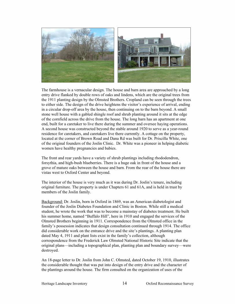
The farmhouse is a vernacular design. The house and barn area are approached by a longentry drive flanked by double rows of oaks and lindens, which are the original trees fromthe 1911 planting design by the Olmsted Brothers. Cropland can be seen through the treesto either side. The design of the drive heightens the visitor’s experience of arrival, endingin a circular drop-off area by the house, then continuing on to the barn beyond. A smallstone well house with a gabled shingle roof and shrub planting around it sits at the edgeof the cornfield across the drive from the house. The long barn has an apartment at oneend, built for a caretaker to live there during the summer and oversee haying operations.A second house was constructed beyond the stable around 1920 to serve as a year-roundresidence for caretakers, and caretakers live there currently. A cottage on the property,located at the corner of Brown Road and Dana Rd was built for Dr. Priscilla White, oneof the original founders of the Joslin Clinic. Dr. White was a pioneer in helping diabeticwomen have healthy pregnancies and babies.
The front and rear yards have a variety of shrub plantings including rhododendron,forsythia, and high-bush blueberries. There is a huge oak in front of the house and agrove of mature oaks between the house and barn. From the rear of the house there arevistas west to Oxford Center and beyond.
The interior of the house is very much as it was during Dr. Joslin’s tenure, includingoriginal furniture. The property is under Chapters 61 and 61A, and is held in trust bymembers of the Joslin family.
Background: Dr. Joslin, born in Oxford in 1869, was an American diabetologist andfounder of the Joslin Diabetes Foundation and Clinic in Boston. While still a medicalstudent, he wrote the work that was to become a mainstay of diabetes treatment. He builthis summer home, named “Buffalo Hill”, here in 1910 and engaged the services of theOlmsted Brothers beginning in 1911. Correspondence from the Olmsted office in thefamily’s possession indicates that design consultation continued through 1914. The officedid considerable work on the entrance drive and the site’s plantings. A planting plandated May 4, 1911 and plant lists exist in the family’s collection, althoughcorrespondence from the Frederick Law Olmsted National Historic Site indicate that theoriginal plans—including a topographical plan, planting plan and boundary survey—weredestroyed.
An 18-page letter to Dr. Joslin from John C. Olmsted, dated October 19, 1910, illustratesthe considerable thought that was put into design of the entry drive and the character ofthe plantings around the house. The firm consulted on the organization of uses of the

Heritage Landscape Inventory 15 Oxford Reconnaissance Survey
land, including the location of arable and pasture lands and their proximity to the barn.Olmsted urged Dr. Joslin to purchase a 10-acre tract of land, which would give him amuch better approach to the house, both topographically and in terms of views of thehouse. Joslin did purchase the land and implemented Olmsted’s recommendations.Olmsted wrote:
“Considering that it is your conception to treat the place primarilyas a farm and to reduce the landscape gardening treatment thatwould require expense for maintenance irksome to a farmer at aminimum, it seems best that the approach drive…should be on astraight line so as to be obviously convenient and farmlike….Itwill perhaps seem almost too utilitarian to have the drive withoutany shade trees so the hayfield would need to be sacrificedslightly in that regard.”
J.C. Olmsted thought carefully about the effects of “domesticity” or “wildness” aroundthe house, and the utilitarian functions of various parts of the yard, in his plantingrecommendations. The Planting Plan gives quantities of proposed species, with numbersthat are keyed to the accompanying plant list. Views of the hills to the west and to aproposed seating area south of the house are indicated. He wanted to manage vegetationso as not to lose the scenic views to the southwest, which today are constricted byvegetation growth on and off the property. The plan indicates an Ice House as well as aPoultry House and associated Chicken Run. The ice house is no longer extant, and thereare only remnants of the poultry house.
During the Joslin family’s tenure, the land has always been leased to local farmers.Originally there were cows and sheep to maintain the open space. The property has beenconsistently used by the family during summers and special occasions. A family memberlived on the property year-round from 1990 through 2004. The owners have been indisagreement about the disposition of the property, and it is currently in court.
Issues:
Significance of the Site: the association with Dr. Joslin, a noted figure in Oxford andmedical history, landscape design by the Olmsted Brothers and documentation of thatwork, and important surviving elements of that design work all make this anextremely significant property.
Uncertain Future: there is a lack of consensus (and as a result, currently a legalstruggle) among members of the extended family about development or preservationof the property.
Lack of Documentation: the property was not documented during the 1984 historicresources survey of the town.
Lack of Permanent Protection: the site lacks permanent protections for the historiclandscape and for agricultural use of the land.
Recommendations:
Share the findings of this report with the property owner. The owner needs to knowthat this heritage landscape is highly valued by Oxford’s citizens and of great historiclandscape significance.

Heritage Landscape Inventory 16 Oxford Reconnaissance Survey
Inform the owners about the benefits of Preservation Restrictions, ConservationRestrictions, and resources for technical and financial support for preservationmeasures.
Conduct a thorough inventory of the property in accordance with MHC standards. Prioritize the property for listing on the National Register. Discuss with the owner the importance of preparing a master plan for the property.
This would include a cultural landscape report and natural resources assessment thatarticulates the site’s significance, identifies character-defining features, and makesrecommendations for preservation, maintenance and appropriate use.
French River Corridor
Description: The French River lies in the Thames River Basin and originates at the outletof Rochdale Pond in Leicester just north of the Oxford town line. The river runs theentire length of Oxford, from its boundary with Leicester in the northwestern reach of thetown to the Webster town line, and served to power the textile industry in Oxford, thusinfluencing the development of the community. Over half of the watershed of the river inOxford is located within land designated as Priority Habitat by the state’s NaturalHeritage and Endangered Species Program. The river harbors two species of “specialconcern”, Creeper and Triangle Floater Mussels. In addition, the river corridor is home togreat blue herons, swans, Canada geese, and several varieties of ducks. Many varieties ofturtles, frogs, and snakes are common, as are bass and bluegill. Deer, foxes, mink, otters,and beavers are among the mammals seen.
The river passes through the Greenbriar Flood Control Area, over 1100 acres of landmanaged by the Army Corps of Engineers (ACE), which has to be maintained in itsundeveloped state. The ACE has 15 miles of trail throughout the flood control area thatare currently underutilized by the community.
In addition to its environmental values, the corridor has an abundance of scenic, historic,and recreational values. The Greenbriar Flood Control Area is located upgradient of theoriginal Hodges Mill and dam, remnants of which are still visible. Bartlett’s Bridge, thatcarries Clara Barton Road over the river, is listed as an individual property on theNational Register. It is located near Lane’s Gravel operation, and many trucks travel overthe dam coming to and from the quarry. Lane’s recently paid to reinforce the bridge, butsome of the historic elements were lost in the process. (This has not impacted its listingon the National Register.) An asphalt plant, sand quarry and transfer station for rubbishare also located along the river in North Oxford.
The French River Connection, a citizen group working to create a greenway along theriver and a blueway on the river, has done research on land ownership and identifiedopportunities for access, river use and connections to the regional network of trails. Afour-acre parcel of privately owned land on the river off Dudley Road has an unofficialdirt ramp into the river. It is a narrow triangle of land that may be undevelopable, and itborders an abandoned railroad bed owned by National Grid, which follows the riverabout 4-5 miles north to Clara Barton Road.

Heritage Landscape Inventory 17 Oxford Reconnaissance Survey
The Town’s Open Space Plan states that the river’s water quality is poor, and needs amulti-faceted strategy to achieve Class B designation. Water quality has been improvedgreatly over the years, and some portions of the river are cleaner than others. Water flowis affected by impoundments north in Leicester, which are used by that town forrecreational purposes. There are times during the summer months when water flow is toolow to maintain an adequate flushing rate for its fish population.
The ACE conducted a detailed study during the 1980s in association with a dredging andimpoundment project they were proposing. The study included assessment of wildlifehabitat, water quality and contamination, and the historic resources along the river.
Background: The stretch of river from near the Leicester town line to the GreenbriarFlood Control Area drops 200 feet in four miles. An 1891 perspective sketch of NorthOxford shows a succession of mills along the French River in this north area, drawn bythe availability of water power that made possible the development of an extensive textileindustry in the area. Mills were established in Hodges Village, North Oxford, Rochdaleand Texas. When the dams along the river broke during the flood of 1955, the flowreverted to its original river base, except in places where dam rubble allowed a smallimpoundment of river to remain. Hodges Dam was completed in 1960 to address floodcontrol, and the Greenbriar Flood Control Area as it is known today was created.
Hodges Dam has a put-in site for canoes and kayaks, which is currently the only legalusable point of access on the river in Oxford. In July of this year, the Board of Selectmenvoted to place an article on the fall Town Meeting to allow the Board to support thedevelopment of a canoe launch site and associated parking on a town-owned parcel southof Harwood Street on the west bank of the river. Assistance is being provided by thestate’s Public Access Board. This would allow a 2.75 mile canoe trip between HodgesDam and the new launch site. The project would implement a proposal made by aUniversity of Massachusetts study of recreational use of the river.
Oxford’s 2006 Open Space and Recreation Plan notes that the French River “is assigneda critical role in the Plan. As a long-range vision, the River should be designated as agreenway with land acquired or protected that has high potential for water-based

Heritage Landscape Inventory 18 Oxford Reconnaissance Survey
recreation, increases public access and enjoyment, and preserves valuable habitat forwildlife and rare plant species.” One of the Plan’s goals with four associated objectivesfocuses on the French River.
Issues:
Minimal Public Access to River: the proposed new canoe launch will provideadditional needed access to the river, for which there is currently only one publicaccess point to this major recreational resource.
Lack of Awareness of the Recreational and Historical Resources: the significantrecreational resources on ACE land is not well known by the community. Theinterpretive potential of dam/mill sites, and story of the river as it changed over time,is largely untapped
Need for Conservation of Wildlife Habitat: the river harbors important wildlifehabitat that needs to be protected.
Concern about Adequate River Flow: impoundment areas in Leicester with controlover flow in the French River at times not releasing enough CFS (cubic feet persecond) for standard flush rate for fisheries. The state is looking into legislation thatwould require maintenance of minimal summer flows.
Threat to historic resource—need for monitoring to prevent inappropriate alterationsto historic resources, in particular Bartlett’s Bridge.
Recommendations:
Build on the groundwork of the French River Connection and the Town to implementthe Open Space Plan’s recommendations for recreational and environmentalimprovements to the river.
Expand efforts to increase public awareness of the values and threats to the FrenchRiver corridor and build support for protection of the historic and ecologicalresources along its banks. Use a variety of means to peak interest and educate thepublic, including school curricula and tours.
Ensure that Bartlett’s Bridge is adequately reinforced, and that any work done in thefuture on the structure protects its historic character. Monitor its conditionperiodically.
Ensure that proper monitoring is conducted of operations along the river that couldnegatively impact water quality, and continue to monitor the river’s water quality.
Publicize the trail in the Greenbriar Flood Control Area, using signage, maps andtown publications to promote its recreational assets to the community.
Pursue possible purchase of the four-acre waterfront parcel for passive parkdevelopment and access to the river. Work with National Grid to create a rail trailalong the abandoned railroad line that can connect with other regional trails.
Work with Leicester and the state to ensure adequate water flow in the river duringthe summer months.
Take measures to protect the Hodges mill and dam remnants.

Heritage Landscape Inventory 19 Oxford Reconnaissance Survey
PART II
BUILDING A HERITAGE LANDSCAPE TOOLKIT

Heritage Landscape Inventory 20 Oxford Reconnaissance Survey
EIGHT TOOLKIT BASICS
As our communities undergo rapid land use changes, heritage landscapes are particularlythreatened because they are often taken for granted. There is a broad variety of resourcesthat communities can call upon to protect these irreplaceable resources. Below is achecklist of the basics. Each is discussed in the sections that follow and in Appendix B.
1. Know the resources: InventoryWe cannot advocate for something until we clearly identify it – in this case, the physicalcharacteristics and historical development of the town’s historic and archeologicalresources. The necessary first step is to record information about the resources at theMassachusetts Historical Commission.
2. Gain recognition for their significance: National Register ListingThe National Register of Historic Places is the nation’s official list of cultural resourcesworthy of preservation. Listing brings a number of benefits including recognition,consideration when federally-or state-funded projects may impact the resource, eligibilityfor tax credits, and qualification for certain grant programs.
3. Engage the public: Outreach, Education and InterpretationIn order to create a community of advocates, we need to raise public awareness andbroaden the base of support. This includes developing opportunities to learn about andcelebrate the places and history of the town, as well as to care for them.
4. Think in context: Comprehensive and Open Space PlanningIt is important that Open Space Plans and Comprehensive or Master Plans addressheritage landscapes as vital features of the community, contributing not only to uniquesense of place but also to environmental, recreational and economic health.
5. Develop partnerships: The Power of CollaborationProtecting community character, respecting history, and promoting smart growth areinterrelated concerns that impact heritage landscapes and require collaboration across abroad spectrum of the community. This includes communication among town boards anddepartments, as well as public-private partnerships.
6. Defend the resources: Zoning, Bylaw and Ordinance MechanismsEffective and innovative preservation tools exist in the legal and regulatory realm. Theserange from a wide array of zoning, bylaw and ordinance mechanisms, to incentiveprograms and owner-generated restrictions on land use.
7. Utilize the experts: Technical AssistanceRegulations and creative solutions for heritage landscapes are constantly changing andemerging. Public and private agencies offer technical assistance with the many issues tobe addressed, including DCR, MHC, the Heritage Corridor and the Central MassachusettsRegional Planning Commission.
8. Pay the bill: Funding PreservationFunding rarely comes from a single source, more often depending on collaborativeunderwriting by private, municipal, and regional sources. Each town also has a variety offunding sources that are locally-based and sometimes site-specific.

Heritage Landscape Inventory 21 Oxford Reconnaissance Survey
OXFORD’S TOOLKIT – Current Status and Future Additions
What follows is a review of the tools that Oxford already has in place, as well as anumber of additional tools that fall within some of the categories noted above (The toolsalready in place for Oxford provide a good foundation for heritage landscapepreservation, but their efficacy as protection for the town’s natural and cultural resourcescan be significantly improved by strengthening existing measures and putting others inplace. Appendix B includes extended descriptions of preservation measures; the specificapplications of those tools to Oxford’s resources are described below. In addition, theappendix contains a full description of additional avenues and creative approaches thatOxford can consider in developing a multi-pronged strategy for preservation.
A tool that has been proven to be one of the single most valuable resources in protectingheritage landscapes has been the Community Preservation Act (CPA). Towns that haveapproved the CPA have been able to leverage funding for such activities as historicresource surveys, acquisition of conservation restrictions and open space, adaptive reuseof historic structures, and signage programs. More information about the CPA can befound in Appendix B under 6. Defend the Resources: Laws, Bylaws and Regulations and8. Pay the Bill: Funding Preservation. Oxford’s Open Space Plan recommends thecommencement of an educational program to inform residents of the advantages ofadopting the CPA – this recommendation should be acted upon. The Quinebaug andShetucket Rivers Valley National Heritage Corridor is currently working with townboards to have the CPA considered on a town warrant article either this fall or the springof 2008
These tools should be considered in combination with those recommendations made inPart I for Oxford’s priority landscapes.
1. Know the resources: Inventory
Current: According to the Massachusetts Historical Commission, the town’sinventory (conducted in 1984) includes documentation for 272 buildings, structuresand sites. In addition, fourteen historic archaeological sites have been inventoried inOxford.
Additions Survey methodology has improved over time and the inventory workconducted in 1984, while extensive, should be revisited. Most important to heritagelandscape preservation, there has been an increased focus on landscapes; the surveywork of the 1980s focused heavily on architecture. In addition, significant sites likeBuffalo Hill Farm were not included. Survey work should prioritize heritagelandscapes and in particular those listed in this report.
It is recommended that a comprehensive archaeological survey be completed for thecommunity. Known and potential precontact Native American and historicarchaeological sites should be documented in the field for evidence of their culturalassociation and/or integrity. Funding assistance for this effort would also be availablefrom the MHC Survey and Planning grants, as well as CPA funding.
Heritage Landscape Inventory 22 Oxford Reconnaissance Survey
2. Gain recognition for their significance: State and National Register Listing
Current: Oxford has only five individual properties listed in the National Register,and no National Register Districts. The individual properties are: Huguenot Fort (1988), which also has a Preservation Restriction (1989) Clara Barton Homestead (1977) Bartlett’s Bridge (2000) Huguenot Monument (1988) Hudson Homestead (1977)
There are no local historic districts in Oxford.
Additions: According to the town’s Open Space and Recreation Plan, MHCidentified several villages and Oxford Center as worthy of consideration for inclusionin the National Register. They include: Wells Street and Watch Street; Learnedville;North Oxford; North Common; Oxford Center; Huguenot Square. This last is theintersection of Main Street and Sutton Avenue/Charlton Street, and wouldpresumably be included in Oxford Center.
It is recommended that the Oxford Historical Commission pursue designation planswith the MHC and revisit their prioritization of sites and areas for listing, whichmight first involve preparing updated MHC inventory forms. The Open Space Planhas included this in its Five-Year Action Plan. In light of the issues addressed in thisreport, Oxford Center and Buffalo Hill Farm should be given priority.
3. Engage the public: Outreach, Education and Interpretation
Current: The Oxford Historical Commission published an interpretive brochure in1984 giving brief descriptions of 20 sites of historical interest in Town, accompaniedby illustrations and a map. A new flyer has been prepared, as well as one about Joslinpark.
There have been school trips to the Huguenot Fort, and the Oxford HistoricalCommission has sponsored bus tours of Oxford. The Boy Scouts have worked at theFort site, including two scouts who were awarded Eagle Scout rank throughcoordinating b rush cutting at the Fort. Town-wide events and programs have beensponsored at the Fort by the Historical Commission and the Huguenot MemorialSociety of Oxford.
Additions: The Open Space Plan recommended that the community be engaged inpreparing outreach materials and creating a historic signage program, to continue thegood work already being conducted by the Historical Commission. The signageprogram was recommended to be a collaboration between the Historical Commissionand the Highway Department. These are excellent recommendations and ones thatother towns have found to be extremely valuable in raising awareness and creatingadvocates for community preservation.
Other excellent recommendations of the OSRP are to create an informational packetfor landowners encouraging them to pursue voluntary land preservation techniques,and to create a non-profit land trust that can accept land donations and assist in

Heritage Landscape Inventory 23 Oxford Reconnaissance Survey
purchasing key open space parcels. The town should talk to neighboring towns withlocal land trusts to learn about the benefits.
Preservation Mass, as the statewide preservation advocacy organization, is a sourceof support for advocacy. They have a program that annually identifies and publicizesthe 10 Most Endangered historic resources in the Commonwealth, which is a goodway to advocate for resources that are imminently threatened.
4. Think in context: Comprehensive and Open Space Planning
Current: Master Plan 1976. The Town’s Master Plan is decades old and needs to beupdated. Topics of concern have been addressed separately, such as a housing study,a transportation study and the downtown study, but looking at these issuescomprehensively and interdependently, with overarching town-wide goals, is animportant exercise that should follow.
Current: Open Space and Recreation Plan 2006. Oxford’s OSRP contains manygoals that directly relate to heritage landscape preservation and enhancement. Thecitizen survey conducted as part of the process showed clearly that residents want topreserve open space and the many significant historical assets of the Town, as well asimprove water-based recreation and access to the French River in particular.
A warning note was sounded in the Plan about Oxford being at a crossroads, withseveral historic sites at risk including Huguenot Square in Oxford Center. It statedthat “What is done with each historic property affects the entire community. It isimportant to recognize that with the disappearance of even one more piece ofOxford’s history, there is less history remaining to preserve.”
Several OSRP Goals specifically address issues related to priority heritagelandscapes. One deals solely with the French River. The objectives laid out for theseresources should be given priority. The objective to prepare design guidelines forOxford Center is currently underway.
Additions: The OSRP included an extensive listing of sites of historic significance,which along with this report can be used as the basis for prioritizing sites for anupdated historic resources survey, NR listing, and other protection mechanismsrecommended below to protect significant, sensitive and threatened resources.
The Plan recommended that the Town implement Open Space Residential Designconcepts and review the Zoning Bylaws for conformance to Smart Growth principles,two of a number of important tools that should be explored in the Master Plan updateprocess.
It is vital that there be strong links between community economic development, openspace, and recreation agendas in order to successfully address Oxford’senvironmental and development challenges. There should be regular joint meetingsof the town boards involved with all land-based and cultural resource issues. Thisscheduled interaction will help to maintain communication, coordinate planningpriorities, and advance programs that support and promote community character andheritage landscapes.

Heritage Landscape Inventory 24 Oxford Reconnaissance Survey
5. Develop Partnerships: the Power of Collaboration
Current Status: Oxford’s Historical Commission has had good relationships withthe Highway Department, who helped with the stone wall at Fort Hill, and with theBoard of Selectmen. Town boards work well together and share joint interests andobjectives.
Additional Efforts: It is essential that there continue to be good communication andcooperation between the town boards and commissions involved with land-based andcultural resource issues.
6. Defend the Resources: Zoning, Bylaw and Ordinance Mechanisms
Current Mechanisms
Rate of Development Bylaw: Town Meeting voted on and passed a Rate ofDevelopment Bylaw which restricts the number of homes that may be built on aparcel of land, until 2021. The OSRP recommended that the Town’s bylaw bereviewed to determine its impacts, and to revise as appropriate.
Cluster Zoning: Oxford has had cluster zoning for several decades, and made somechanges to its Bylaw in 2005 including allowing cluster by right rather than specialpermit.
Central Professional District: Oxford has a district that occurs along Main Streetimmediately to the north of the town center intended to allow limited commercialactivity in the many historic homes on the street while preserving historic character.
Additional Mechanisms
Three basic strategies have consistently proven effective as basic preservation toolsin communities throughout Massachusetts.
Demolition Delay Bylaws provide a time period in which towns can explorealternatives to demolition. The Oxford Historical Commission should work withMHC staff to develop a bylaw that could best suit Oxford’s needs. They should alsowork with other town groups to publicize the advantages of a demolition delay bylawto the community. The most valuable aspect of this bylaw is that it creates spacewithin which to have a conversation about how private and public needs can both bemet in the service of preservation. Many towns have found that a delay of one year isthe most effective time frame within which to negotiate alternatives to demolition. Amajority of the bylaws apply to all structures built over 50 years ago, in accordancewith federal standards.
Neighborhood Architectural Conservation Districts (NACD), further explained inAppendix B, are also local initiatives that recognize special areas within a communitywhere the distinctive characteristics of buildings and places are preserved andprotected. The Oxford Historic Commission should work with the MHC staff to

Heritage Landscape Inventory 25 Oxford Reconnaissance Survey
determine how an NACD can help to maintain the character of areas which havechanged through time, but which retain a valued neighborhood “feel” that may bethreatened by incompatible development.
Local Historic Districts (LHD), further explained in Appendix B, are also localinitiatives and the strongest form of protection to preserve special areas withdistinctive buildings and places. Unfortunately, National Register listing providesminimal protection for historic landscapes and structures. Local designation can betailored to specific community needs, and often protect private investment byenhancing property values. The key to tourism and, in part, to economicdevelopment, is the preservation of the rural and village center character of the Town.The recommendation made for LHD designation for Oxford Center should bepursued.
Additional mechanisms specific to Oxford’s landscapes
The following recommendations are organized by the types of resources thatMillbury has, and measures that should be considered to strengthen their protection.
Mill Villages and Industrial Structures
A defining characteristic of the Quinebaug and Shetucket Rivers Valley and Oxfordin particular are the mill villages that exhibit the vestiges of the transformative powerof the industrial revolution in mills, dams, mill worker housing and transportationelements such as the associated rivers, canals and railroads or rail traces. Oxfordexhibits that history in the villages of Learnedville and North Oxford.
Oxford should adopt an Adaptive Reuse Overlay Bylaw which would provideflexibility in considering adaptive reuse options for mill buildings.
Agricultural Lands
Preservation of agricultural landscapes means preservation of the farming activities;otherwise, it simply is the preservation of land as open space. There are instances inwhich changing technology requires modifications to existing farm structures, or theaddition of new ones. It is important to know what the features of an agriculturalsetting are and which features the community treasures in order to make a case forpreservation of these settings.
Appendix B has a full list of regulatory tools that should be considered to protectagricultural land; the following highlights important measures to meet the needs ofagricultural protection in Oxford.
1. Create an Agricultural Commission, a standing committee of town governmentcreated through vote at Town Meeting. This Commission would represent thefarming community, promote agricultural-based economic opportunities, andwork to protect and sustain agricultural businesses and farmland.
2. Prioritize parcels under Chapter 61A for future acquisition. Should the landownerchoose to sell land recently withdrawn from Ch 61, the town has only 120 days toact on its right of first refusal. The need to pay fair market value, combined with

Heritage Landscape Inventory 26 Oxford Reconnaissance Survey
lack of readily-available funding from a program such as the CommunityPreservation Act, makes it difficult for the town to effectively act on this right.
3. Strengthen public-private partnerships to preserve farmland through purchase ofAPRs or CRs
4. Develop partnerships to raise funds to purchase development rights on farms orto assist a farmer in the restoration of historic farm buildings for which the ownerwould be required to donate a preservation restriction (PR). This includesfollowing up on the Open Space Plan’s recommendation to create a land trust.
5. Make information about the Massachusetts Department of AgriculturalResources programs available to farmers, including the Farm ViabilityEnhancement Program (technical assistance, funding) and the AgriculturalEnvironmental Enhancement Program (supports best management practices foragricultural operations to mitigate impacts on natural resources).
6. Document farms that are considered critical to the character of Oxford’scommunity using MHC survey forms.
7. Adopt a right-to-farm bylaw which allows farmers to carry on farming activitiesthat may be considered a nuisance to neighbors. Refer to Smart Growth Toolkitat: http://www.mass.gov/envir/smart_growth_toolkit/bylaws/Right-to-Farm-Bylaw.pdf
8. Explore Community Supported Agriculture (CSA), a partnership between a farmand a community of supporters. Community members cover a farm’s yearlyoperating budget by purchasing a share of the season’s harvest. This relationshipguarantees farmers a reliable market, while assuring the members high qualityproduce, often below retail prices.
Scenic Roads
Scenic roads are an integral part of the historic fabric of the community. They arehighly valued by Oxford residents and visitors alike. Roads must also accommodatemodern transportation needs and decisions regarding roadways are often made withtravel and safety requirements as the only considerations. Oxford has not adopted theScenic Roads Act (MGL Chapter 40-15C), but it has designated 14 roads for whichthere would be review and approval for the removal of trees and stone walls withinthe right-of-way. The Town should discuss whether they would be better served byadopting the statute. In addition to roadway issues, much of what we value aboutscenic roads – the stone walls, views across open fields and the many scenic historicbuildings – is not within the public right-of-way. The preservation and protection ofscenic roads therefore requires more than one approach.1. Complete an inventory with descriptions and photo documentation of each of the
roads in Oxford considered to be or designated as scenic, including the character-defining features that should be retained.
2. Discuss the advantages of adopting a Scenic Road Bylaw and designate andadditional town roads protected by the bylaw beyond the roads alreadydesignated as Scenic. (The designation cannot be applied to state numberedroadways.) Add design criteria to be considered when approving removal of treesand stone walls.
3. Post attractive road signs that identify the scenic roads in town.4. Coordinate procedures between Highway Department, Planning Board and
Historical Commission.5. Consider a Scenic Overlay District which may provide a no-disturb buffer on
private property bordering on scenic roads or adopt flexible zoning standards to

Heritage Landscape Inventory 27 Oxford Reconnaissance Survey
protect certain views. Such bylaws would apply to the landscapes bordering statenumbered roadways, which would not be protected under the scenic roadsdesignation, as well as to landscapes bordering town roads.
6. Develop policies and implementation standards for road maintenance andreconstruction, including bridge reconstruction, which address the scenic andhistoric characteristics while also addressing safety. This is an important publicprocess in which the community may have to accept responsibility for certaincosts to implement standards higher than those funded by Mass HighwayDepartment. Such standards should have a section addressing the way in whichthe local Highway Department maintains roads; for example, requiring a publichearing if any new pavement width is to be added to a town road duringreconstruction or repair. Policies can be adopted by local boards havingjurisdiction over roads, or can be adopted at Town Meeting through a bylaw. Indeveloping policies consider factors such as road width, clearing of shoulders,walking paths and posted speeds. A delicate balance is required.
7. Utilize the experts: Technical assistance
A list indicating the full range of available governmental and non-profit sources oftechnical assistance can be found in Appendix B.
8. Pay the Bill: Funding Preservation
A list indicating the full range of available governmental and non-profit sources offunding can be found in Appendix B. As discussed above, the most effective way tocombine the limited financial resources of a community with those of the state isthrough the CPA.

Heritage Landscape Inventory 28 Oxford Reconnaissance Survey
CONCLUSION AND IMPLEMENTATION
Oxford’s residents have a strong sense of place, defined by the town’s varied naturalfeatures and the historic land use patterns that grew out of them. The town has alreadybegun to document and evaluate its most significant buildings and natural areas. It mustnow also look beyond these traditional resources to the landscapes, streetscapes, ruralroads, neighborhoods and other natural and cultural assets that define the community’scharacter. Like most municipalities, Oxford is facing multiple pressures for change thatwill have permanent impact on land-based uses and natural resources, especially itsremaining farming areas. Special places within the community that were once taken forgranted are now more vulnerable than ever to change.
The Oxford Reconnaissance Report is a critical tool in starting to identify the rich anddiverse heritage landscapes in Oxford and in developing creative preservation strategiesand partnerships. Oxford will have to determine the best ways and sequence in which toimplement the recommendations discussed above. The town would do well to form aHeritage Landscape Committee, as described in DCR’s publication, Reading the Land.
Landscapes identified in this report, especially the priority landscapes, will benefit fromfurther documentation in accordance with MHC guidelines. The documentation in turnwill provide an information base for the local publicity needed to build consensus andgather public support for landscape preservation. Implementing many of therecommendations in this report will require a concerted effort by and partnerships amongmunicipal boards and agencies, local non-profit organizations, and regional and stateagencies and commissions.
There are no quick fixes for the challenges of managing growth and funding preservation.Many of the recommended tasks and approaches will require cooperation andcoordination among a number of municipal, regional and state partners to be successful.They will require time and a good dose of patience, as volunteer schedules, legislativeprocedures, and funding cycles try to mesh.
Circulating this Reconnaissance Report is an essential first step. The recommendationsshould be presented to the Board of Selectmen, who represented Oxford in its applicationto the Heritage Landscape Inventory program. Copies of the report should be available onthe town’s web site and distributed to town departments and boards, particularly Oxford'sHistorical Commission, Planning Board, and Conservation Commission and will also beuseful for the Oxford Historical Society, neighborhood associations, local land trusts, andother preservation organizations. Finally, a reference copy belongs in the town library.All of these circulation efforts will broaden citizen awareness, and result in increasedinterest and support for Oxford's heritage landscapes.
Finally, the project team suggests that the following recommendations be the topthree priorities for Oxford as the town works to protect the character of itscommunity:
1. Consideration of a Local Historic District for Oxford Center2. Passage of a Demolition Delay Bylaw3. Passage of a Scenic Roads Bylaw

Heritage Landscape Inventory Oxford Reconnaissance Reporti
APPENDIX AOXFORD HERITAGE LANDSCAPES
This list was generated by local participants at the Heritage Landscape Identification meeting held inOxford on February 22, 2007 and follow-up fieldwork on April 27, 2007. There are undoubtedly otherheritage landscapes that were not identified at the HLI meeting noted above. The chart has twocolumns - the name and location of the resource are in the first; notes about the resource are in the second.Landscapes are grouped by land use category. Abbreviations used are listed below.
APR = Agricultural Preservation Restriction CR = Conservation RestrictionLHD = Local Historic District NRD = National Register DistrictPR = Preservation Restriction NRI = National Register Individual PropertyTTOR = The Trustees of Reservations Bold = Priority Landscape
Summary of Priority Landscapes:Casavant FarmEames Pond Mill SiteFrench GardensOxford CenterFrench River CorridorBuffalo Hill Farm
Agriculture
Casavant Farm Fort Hill Rd
active; overlooks Oxford Center; can see farm from Sutton Ave. and Route395
Thibeau’s Farm Old Webster Rd.
adjacent to river, hayed not farmed; beautiful pine grove behind; one of fewfarm areas in town; land up for sale
Federal Hill-Bigelow’sNurseryGoat Hill APR
Archaeology
Eames Pond Mill site Sutton Ave. at Fort Hill Rd.
dam and early mill site, original sawmill dated 1688
Saccarrappa Mill site Sacarrappa Rd.
known to make nails, etc. TriphammerSacarrappa Bridge and nearby raceway, part of mill; 3-4 businesses locatedhere
Old Pope cellar hole NE of Strack’s CornerGarrison House cellar hole; off Federal Hill Rd.chamois/washed leathermill site Just off Sutton Ave.
in a field along the brook leading southwest from Eames Pond
Huguenot Church andBurial Site
traditionally thought to be north of Huguenot Rd.

Heritage Landscape Inventory Oxford Reconnaissance Reportii
Huguenot Fort Fort Hill Rd.
On Mayo’s Hill, otherwise known as Fort Hill Rd.; site considered mosthistorically sensitive area of town; NRI 1988; PR 1989.
Burial Grounds and Cemeteries
South Cemetery also known as Old Burying Ground; behind Congregational ChurchGore Cemetery Pleasant St.
in that part of Oxford that is known as Merriam District
North Cemetery Main St.
Especially the old cemetery lots in NE corner closest to Main St.
St. Roch’s Cemetery Federal Hill Rd.Grace Episcopal ChurchCemetery Main St
Grace Episcopal Church
Clark Cemetery Prospect Hillfamily cemetery Whitin Rd.old Indian Burial Ground Thought to be in vicinity of Water St.
Civic / Institutional
Oxford Centerincludes Huguenot Square(crossroads of Sutton Ave.and Charlton St.)
Front St. (N) to Huguenot Rd. (S) on Main St., & beyond on W/E (exactboundary to be determined); lined with crabapple trees and double wide inthis area - had horse races, wanted to be county seat for Worcester County.Dr. Joslin paid Olmsted to do first master plan for Oxford, maderecommendations for that part of Main St.
Churches on Main St. Grace Episcopal Church; Universalist Church (presumed to be oldestUniversalist church in world; 1792-93; considerably changed from originalform); Congregational Church; First Baptist Church; St. Ann Church;
North Gore District 8Schoolhouse
Moved from Merriam District to Joslin Park
Oxford Town Hall also known as Memorial Hall, a memorial to Oxford veterans of the CivilWar
Old High School Main St.
built around 1913 (may have been earlier)
Charles Larned MemorialLibrary
common name now is Oxford Free Pubic Library
Commercial / Industrial
Krintzman Mill Route 12
in North Oxford on the French River, also known as Sibley Mill
water tower metalBlacksmith Shop and TollHouse Sutton Ave. at Joe Jenny Rd.
toll house for central Boston-Hartford Turnpike built 1826.
Heritage Landscape Inventory Oxford Reconnaissance Reportiii
Chaffee Bros. Co. MillComplex Rt. 12
c. 1900
Miscellaneous
Huguenot oak Huguenot Rd.Bartlett’s Bridge Clara Barton Rd.
stone arch bridge over the French RiverNRI 2000
keystone bridge Rt. 12 at George St.
railroad bridge over French River
Stagecoach Rd. milemarker
Stone marker; moved to Larned Rd., placed in wrong place and insun—deteriorating; other historic mile markers found throughout town
Maanexit ford Harwood St.
crosses French RiverMaanexit Dam may be located near the ford crossing
Markers and monumentsto individuals, events
Includes Hartland Monument, Johnson Monument (Main St. near JohnsonLane, in memory of what was known as the Johnson Massacre, KingPhilip’s War, 1676. Memorial erected 1929)
“Devil’s Den” off Clara Barton Rd.
Probably the cave referred to as Clara Barton Cave. Reached from road toLane Corp. using Stumpy Pond as a landmark
Lindbergh’s Landing Historic marker at S. end of town, on Marshall at turn of road
Open Space/ Recreation/ Parks
French River Corridor dams, gorges; trails in ACE land; waterfall, cave, hemlocks long west sideof river associated with Clara Barton (not near Birthplace); corridor is oneof most untapped town open space resources
French Gardens top of Fort Hill Rd.
Built into cliffs, very scenic (but not visible from road). Huguenots settledthere, terraced the hillside for gardens in early 1700s. Private ownership.
Mid-State Trail Rocky Hill Rd.
Trail has old rights of passage with no legal status; effort to secureeasements for trail’s passage
Greenbriar Flood Control Area
ACE-owned land; floodplain and hiking trails
Lowes Pond
Joslin Park Main St.
Includes memorials to veterans of Korean War and Vietnam War; 1872North Gore District 8 Schoolhouse, Native American grinding stone,watering trough originally on corner (south side) of Main and Charlton
Residential
Buffalo Hill Farm 90 Dana Rd.
summer home of Dr. Elliot Joslin, still in the family; Olmsted Bros. laid outdrive and planting plan, double rows of oaks and lindens; beautiful views
Clara Barton Homestead Clara Barton Rd.
House built 1818; over 100 acres including summer camp. NRI 1977.
Heritage Landscape Inventory Oxford Reconnaissance Reportiv
Clara Barton summerhouseBartlett Houses 146 & 148 N. Main St
2 houses built 1890.
Allen L. Joslin house 345 Main St.
built 1866
Whittaker MansionWilliam HudsonHomestead Hudson Rd.
c. 1720; considered oldest home remaining in Oxford; NRI 1977.
Davis-Lovett House 99 Lovett Rd.
c. 1784; thought to be one of the earliest homes remaining from the Englishsettlers
Davis-Bernon Farmhouse Lovett Rd. at Sutton Ave.
thought to be one of the earliest homes remaining from the English settlers;MHC inventory forms says it dates from 1857
19th century homes on Main St.
Capt. Abijah Davis House (243 Main St., built 1814); Benjamin PaineHouse (259 Main St., built 1815);
19th century homes on Charlton St.
residence (15 Charlton St., built 1835); residence (7 Charlton St., built1846)
Transportation
“corduroy” road stretch of log roadbed at end of leading to Bug Swampnamed Bug Swamp Rd. in Oxford, Eight Lots Rd. in Sutton
VillageNote – all of the villages listed below have MHC Area forms on file
Oxford Center see also Civic/Institutional for details on Center
Larnedville also known as Texas Village, Larned Village; Route 56 between Routes 20and 12.
North Oxford Along Route 12 from Leicester St. south to Depot St. including ClaraBarton Rd. and 1 Old Depot Rd. Area includes Hawes Village/WhiteVillage at southernmost end
Howarth Village West Oxford north of Charlton St.Buffumville West Oxford south of Charlton St.North Common area From Federal Hill Rd. south along Route 12 through Chaffee Bros. Mill
Complex including Holman St.RochdaleWells and WatchStreetscape

Heritage Landscape Inventory Oxford Reconnaissance Reportv
APPENDIX B
GUIDE TO PRESERVATION AND PLANNING TOOLS FOR HERITAGE LANDSCAPES
Preservation planning is a four-step process: identification, evaluation, education and protection.Within the realm of protection, there is a vast array of tools that communities can call upon and that aremost effective when used in combination with one another. Stewardship of these resources involveseducation and community support, planning with a clear set of goals, and regulatory mechanisms.
Three useful documents to consult when planning preservation strategies are:
♦ Department of Conservation and Recreation, Reading the Land
♦ Massachusetts Historical Commission, Survey Manual
♦ Massachusetts Historical Commission, Preservation through Bylaws and Ordinances
The following eight sections – based on the Toolkit Basics – detail the resources and strategies availablefor heritage landscape preservation—from documentation and evaluation, to public education, toregulating activities and finding the revenue necessary to fund the effort.
1. KNOW THE RESOURCES: INVENTORY
The vital first step in developing preservation strategies for heritage landscapes is to record informationabout the resources on MHC inventory forms. One cannot advocate for something unless one knowsprecisely what it is – the physical characteristics and the historical development.
Survey methodology has advanced since the early work of the 1980s. If a community had survey workdone during that time period, it is time for an inventory update, looking at resources in a morecomprehensive and connected way than may have been done at that time. Even if survey work is morerecent, there may be a need to document more resources throughout the community.
Using the Massachusetts Historical Commission survey methodology:
♦ Compile a list of resources that are under-represented or not thoroughly researched, beginningwith heritage landscapes.
♦ Document unprotected resources first, beginning with the most threatened resources.
♦ Make sure to document secondary features on rural and residential properties, such asoutbuildings, stone walls and landscape elements.
♦ Record a wide range of historic resources including landscape features and industrial resources.
♦ Conduct a community-wide archaeological reconnaissance survey to identify patterns ofprehistoric and historic occupation and to identify known and probable locations ofarchaeological resources associated with these patterns. Known and potential precontact andhistoric archaeological sites should be professionally field-checked to evaluate culturalassociations and integrity. A professional archaeologist is one who meets the professional

Heritage Landscape Inventory Oxford Reconnaissance Reportvi
qualifications (950 CMR 70.01) outlined in the State Archaeologist Permit Regulations (950CMR 70.00).
NOTE: The Inventory of Archaeological Assets of the Commonwealth contains sensitive informationabout archaeological sites. The inventory is confidential; it is not a public record (G.L. c. 9, ss. 26A(1)). Care should be taken to keep archaeological site information in a secure location with restrictedaccess. Refer to the MHC article "Community-Wide Archaeological Surveys" which appeared inPreservation Advocate, Fall 2005, and which can be found at the following MHC link:http://www.sec.state.ma.us/mhc/mhcpdf/pafall05.pdf.
2. GAIN RECOGNITION FOR THEIR SIGNIFICANCE: NATIONAL REGISTER LISTING
Survey work includes evaluation of whether resources meet the qualifications for National Registerlisting. This will provide new information about the eligibility of properties. Using the informationgenerated in the survey work and the accompanying National Register evaluations, expand your town’sNational Register program.
♦ Develop a National Register listing plan, taking into consideration a property’s or area’s integrityand vulnerability. Properties in need of recognition in order to advance preservation strategiesshould be given priority.
3. ENGAGE THE PUBLIC: OUTREACH, EDUCATION AND INTERPRETATION
The best stewards and advocates for heritage landscape protection are members of the community. Thereare many ways to communicate the importance of these special places to the public, and to connect theirpreservation with the shared values and goals that community members have already expressed in variousplanning documents and forums.
Think creatively about how to educate the community about the values and threats to heritage landscapes,and how each town resident benefits from these special places. Use a combination of strategies to get theword out about heritage landscapes and preservation of community character, including:
♦ Festivals and Tours – Tours are a great way to draw attention to the history around us, and toengage more people in caring for it. Consider hosting a Heritage Celebration Day including toursand family-friendly activities, or plan a celebration around a particular place or area on ameaningful date. Make sure events are well publicized.
♦ Signage and Banners – Signs are a very effective way to announce special historic sites anddistricts. Banners can also bring attention to the significance of an area and make a celebratorystatement about its contribution to the town.
♦ Written Materials – Clear, concise and engaging written material with engaging illustrations is areliable way to relay information about community character and heritage landscapes. Make useof fact sheets and flyers to get the word out on particular issues such as a town ordinance thatprotects heritage landscapes, a threat that needs to be addressed, or an upcoming event.
♦ School Curricula – Start teaching at a young age. Children are very receptive to engagingstories, and there are no better stories to excite childrens’ imaginations and build pride of placethan stories of their town’s past and present. Teachers have an opportunity to connect history

Heritage Landscape Inventory Oxford Reconnaissance Reportvii
with environmental issues through classroom study, hands-on history projects, and fieldexploration of a town’s heritage landscapes. Subsequently, students have an opportunity to teachtheir parents that preservation is everybody’s business.
♦ Lectures and Workshops – Use these forums to raise awareness, educate at a deeper level aboutthe community’s history and its resources, and broaden the base of interest.
♦ Website – Keep Historical Commission and local historical organizations’ entries on the town’swebsite current, and include information about issues, proposals for preservation strategies, andupcoming events.
♦ Press Releases – Use all avenues including press releases to keep the public informed when ameeting or event is about to occur. Work with local reporters to develop special interest articlesthat highlight landscape resources.
Remember that bringing an issue or a heritage landscape to people’s attention once will have only short-term effect. Outreach, education and interpretation must be ongoing concerns that involve preservationand conservation interests, teachers and community organizations in repeated projects to attract andengage the general public.
4. THINK IN CONTEXT: COMPREHENSIVE AND OPEN SPACE PLANNING
Communities use a variety of planning exercises and documents to define their goals and vision of thefuture, address community-wide issues, and recommend measures to respond to them. There are statemandates for towns to prepare Comprehensive or Master Plans and Open Space and Recreation Plans.
♦ Comprehensive or Master Plans provide an important frame of reference for land use decisions,and incorporate all of a community’s issues including economic development, housing andtransportation into an integrated plan. Heritage landscapes need to be seen through the lenses ofcommunity character, historic preservation, environmental health, and economic viability andgrowth. Their future and the values they contribute should be addressed within these multipleperspectives, not solely as historical assets of the community.
♦ Like Comprehensive Plans, Open Space Plans look holistically at the community—its history,demographics and growth patterns, and current conditions—to make recommendations thatprotect open space and natural resources for ecological health and public benefits. The HeritageLandscape Inventory Program provides a framework for looking at these important resources, andthis new understanding should be incorporated into Open Space Plans.
5. DEVELOP PARTNERSHIPS: THE POWER OF COLLABORATION
Because heritage landscapes encompass such a broad range of resources and issues—from preservation oftown centers, scenic roads and river corridors to promotion of smart growth and economic development –stewardship of these resources involves many interests in a community. It is essential that there be goodcommunication between the many departments and committees that address issues related to heritagelandscapes. Collaboration between public and private partners is also an essential element in a successfulpreservation strategy. National Heritage Corridor personnel are helpful guides to partnershipopportunities for projects you may have in mind.

Heritage Landscape Inventory Oxford Reconnaissance Reportviii
♦ Broaden the base. Preservation, particularly preservation of landscapes, is not just for theHistorical Commission. It is important that the cause not be marginalized by those who viewpreservation as opposed to progress, or to personal interests. A look at DCR’s Reading the Landshows the range of organizations and viewpoints that value heritage landscapes.
♦ Nurture public-private partnerships. Friends groups, neighborhood associations, and local landtrusts all have important roles to play to spread the word, and to expand the capacity of the publicsector to care for heritage landscapes.
♦ Take advantage of forums created to share issues and ideas. For instance, the MassachusettsDepartment of Agricultural Resources offers a “cluster” format for monthly discussion andinformation exchange meetings among area farmers.
♦ Share resources across communities. Towns that lack funding for a town planner position, forinstance, have found that “sharing” a planner with another community can be quite effective.
6. DEFEND THE RESOURCES; LAWS, BYLAWS AND REGULATIONS
A wide range of laws, bylaws and regulations is available to protect heritage landscapes. Following arebrief descriptions of some of the most widely used and/or most effective of these tools, arrangedalphabetically.
Adaptive Reuse Overlay DistrictAn Adaptive Reuse Overlay District is superimposed on one or more established zoning districts in orderto permit incentive-based reuses of existing built properties. These districts can be created to allow for theadaptive reuse of properties of a certain kind, or within a specified area within a community. As anoverlay zone, all regulations pertaining to the underlying zone apply, except to the extent that the overlayzone modifies or provides for alternatives to the underlying requirements.
Agricultural Preservation Restrictions (APR)This program, managed by the Department of Agricultural Resources, offers to pay farmers the differencebetween the "fair market value" and the "agricultural value" of farmland located on prime agriculturalsoils, in exchange for a permanent deed restriction which precludes any use of the property that will havea negative impact on its agricultural viability. This program is different from the Chapter 61 program,which provides tax incentives for short term restrictions.
Community Preservation ActThe Community Preservation Act is statewide enabling legislation that allows communities to assemblefunds for historic preservation, open space protection and affordable housing through a local property taxsurcharge (up to 3%, with some allowable exemptions) and state matching funds. These funds can supporta wide variety of activities, including inventory and documentation of historic resources, restoration andacquisition.
Conservation Restrictions (CR)A permanent deed restriction between a landowner and a holder - usually a public agency or a privateland trust; whereby the grantor agrees to limit the use of his/her property for the purpose of protectingcertain conservation values in exchange for tax benefits. EOEEA’s Division of Conservation Servicesprovides assistance to landowners, municipalities, and land trusts regarding conservation restrictions andhas produced The Massachusetts Conservation Restriction Handbook as a guide to drafting conservationrestrictions.

Heritage Landscape Inventory Oxford Reconnaissance Reportix
Corridor Protection Overlay DistrictA Corridor Protection Overlay District is intended to promote appropriate development within a givencorridor, serving to protect natural (and sometimes cultural) resources. As an overlay zone, all regulationspertaining to the underlying zone apply, except to the extent that the overlay zone modifies or providesfor alternatives to the underlying requirements. The Corridor Protection Overlay District can be usedcooperatively by adjoining communities to help maintain continuous protection across town lines.
Demolition Delay BylawWith a Demolition Delay Bylaw, requests for a permit to demolish a historic building must first bereviewed and approved by the local historical commission. Demolition Delay Bylaws are either list-based(applying only to a specific list of buildings that have been previously identified), age based (applying toall buildings that are older than a certain age – typically 50 years), or categorical (applying only toresources that meet a specific criteria, such as having been documented on Massachusetts HistoricalCommission forms). If the historical commission does not approve of the demolition and deems astructure significant, it can impose a delay period, during which time the property owner is encouraged toexplore alternatives to demolition. Delay periods of 6 months are common, although communities areincreasingly adopting delay periods of up to one year.
Design ReviewDesign Review is a non-regulatory process that is undertaken by a town appointed Design Review Board.The board reviews the design of new construction and additions – typically those taking place in alreadybuilt-up areas. Recommendations are made to the planning board to help preserve appropriate buildingpatterns and architectural styles, with the goal of maintaining the overall character of a given area.Design Review Boards often limit their review to exterior architectural features, site design and signage.
Downtown Revitalization ZoningDowntown Revitalization Zoning seeks to encourage businesses to locate in downtowns. Zoning of thisnature is typically written to be attractive to businesses of a certain kind that would work well within thegiven infrastructure and transportation needs, but can also incorporate some of the same elements asVillage Center Zoning (see below), such as encouraging mixed use development at a pedestrian-friendlyscale, with minimal setbacks and offsite parking.
Flexible Development ZoningFlexible Development Zoning allows for greater flexibility and creativity when subdividing land, toconform and work with the natural and cultural resources of a site and minimize alteration or damage tothese resources, rather than follow standard requirements of subdivision regulations. While this does notprevent land from being subdivided, it does allow for the protection of some features, serves to preservesome undeveloped land, and promotes better overall site planning.
Local Historic Districts (LHD)LHDs recognize special areas within a community where the distinctive characteristics of buildings andtheir settings are preserved. They offer the strongest form of protection available for historic resources.LHDs are administered by a Local Historic District Commission (distinct from the community’s LocalHistorical Commission), which reviews proposed exterior changes to buildings within the district. Thekinds of changes that are reviewed vary according to the terms of the local bylaw.

Heritage Landscape Inventory Oxford Reconnaissance Reportx
Neighborhood Architectural Conservation Districts (NCD)Neighborhood Architectural Conservation Districts (sometimes known as Neighborhood ConservationDistricts) are local initiatives that recognize special areas within a community where the distinctivecharacteristics of the neighborhood are important. They are less restrictive than Local Historic Districts inthat they focus on a few key architectural elements and massing, scale, and setback in an effort toembrace overall neighborhood character. As in Local Historic Districts, changes are reviewed by aNeighborhood Architectural Conservation District Commission.
Open Space ZoningOpen Space Zoning – also known as Cluster Development Bylaw, Open Space Communities Zoning,Open Space Development Overlay District, Open Space Preservation Subdivision, or Open SpaceResidential Development – allows greater density than would otherwise be permitted on a parcel, in aneffort to preserve open space. Typically, construction is limited to half of the parcel, while the remainingland is permanently protected under a conservation restriction.
Rate of Development BylawA town may slow the rate of its growth within reasonable time limits to allow the community to engage inplanning and preparation for growth. This measure must be used for the purpose of conducting studiesand planning for rational development, and not for restraining the rate of growth for a period of unlimitedduration.
Right to Farm BylawA Right to Farm Bylaw asserts the rights of farmers to pursue agricultural activities, provides communitysupport for farming activities and requires dispute resolution so that abutters cannot make nuisanceclaims. Agricultural landscapes are widely considered to be significant heritage landscapes for whichthere is constant concern of potential development. This bylaw serves to help active farmers remain justthat - active.
Scenic Overlay District ZoningScenic Overlay District Zoning protects scenic vistas by providing for a no-disturb buffer on privatelands, thereby helping to maintain specific viewpoints. This type of zoning is more far-reaching than aScenic Roads Bylaw (see below) and may be applied to numbered routes.
Scenic Roads BylawThe Scenic Roads Bylaw requires that a public hearing be held prior to the removal of any trees or stonewalls that fall within the public right of way on a designated scenic road. Depending on how it is written,the bylaw may apply to a predetermined list of roads or encompass all roads in a community (other thannumbered routes). The bylaw applies whenever there is any public or private impact to trees or stonewalls within the right of way, including activities such as road widening, utility company work or creatingprivate driveways.
Scenic Vista Protection BylawScenic Vista Protection Bylaws require additional design criteria for any proposals for new constructionin areas that are determined by the town to be a scenic vista. Vistas may encompass natural, cultural andhistoric features.
Shade Tree ActThe Shade Tree Act is a part of MGL Chapter 87, which defines all trees within the public way as publicshade trees. The municipal Tree Warden is responsible for the care, maintenance and protection of allpublic shade trees (except those along state highways). Trimming or removal of any public shade treesgreater than 1.5” in diameter requires a public hearing. Chapter 87 applies to all communities; however,

Heritage Landscape Inventory Oxford Reconnaissance Reportxi
some communities have adopted their own Shade Tree Act Bylaws that provide stricter regulations thanthose mandated in Chapter 87.
Site Plan ReviewSite Plan Review provides the planning board (and other boards and committees, depending how thebylaw is written) with an opportunity to consider a variety of community concerns – such as impacts tovehicular circulation, scenic vistas, topography and natural resources – during the permit process. Boardsmay comment on site plans and request changes to the design. Site Plan Review is typically limited tolarge scale projects and tied to the special permit process.
Smart Growth Zoning – Chapter 40RSmart Growth Zoning (Chapter 40R) provides financial rewards to communities that adopt specialoverlay zoning districts allowing as-of-right high density residential development in areas near transitstations, areas of concentrated development, or areas that are suitable for residential or mixed usedevelopment. Such zoning can help direct compact growth to areas that are already developed – such ashistoric village centers – thereby discouraging growth in less suitable areas.
Transfer of Development Rights (TDR)TDR is a regulatory technique that allows a landowner to separate building or development rights fromthe property and sell them, receiving compensation for preserving land and allowing for the developmentto occur in areas selected for higher density projects. In essence, development rights are "transferred"from one district (the "sending district") to another (the "receiving district"). As a result, developmentdensities are shifted within the community to achieve both open space preservation and economic goalswithout changing overall development potential.
Village Center ZoningThe goal of Village Center Zoning is to meet the needs of a small-scale, mixed-use, pedestrian-friendlyarea by encouraging compact development. New construction is required to be built at a scale that iscompatible with the neighborhood and to have a reduced (or no) setback from the street. Parking may bedirected to discourage large lots in front of buildings. Village Center Zoning shares many similaritieswith Traditional Neighborhood Development, and the terms are sometimes used interchangeably.
Wetlands Protection Act and BylawsThe Wetlands Protection Act (MGL Chapter 131, Section 40) protects wetlands by requiring a carefulreview by local conservation commissions of proposed work that may alter wetlands. The law alsoprotects floodplains, riverfront areas, land under water bodies, waterways, salt ponds, fish runs and theocean. Communities may also adopt their own Wetlands Protection Bylaw, providing stricter regulationsthan those mandated in Chapter 131.
7. UTILIZE THE EXPERTS: TECHNICAL ASSISTANCE
Beyond DCR and the Heritage Corridor, technical assistance is available from many governmental andnon-profit sources, most often free of charge to municipalities and non-profit organizations.
♦ American Farmland Trust: Clearinghouse of information supporting farmland protection andstewardship.
♦ Central Massachusetts Regional Planning Commission: The regional planning agencycharged with assisting communities with local planning efforts in this region.

Heritage Landscape Inventory Oxford Reconnaissance Reportxii
♦ Citizen Planner Training Collaborative: Provides local planning and zoning officials withtraining opportunities and online information; they also hold an annual conference to supportland use planning.
♦ Green Valley Institute: Provides technical assistance about land use planning to communitieswithin the Quinebaug-Shetucket Heritage Corridor. Web site and publications containinformation of use to communities throughout the region.
♦ Massachusetts Historical Commission: Provides technical assistance as well as grants tomunicipalities and nonprofits for preservation planning and restoration projects.
♦ New England Small Farm Institute: A non-profit dedicated to providing technical assistance,information and training to farmers.
♦ The Trustees of Reservations: Offers conservation and landscape protection workshops,publications and connections through the Putnam Conservation Institute. The Trustees alsomanages a unique Conservation Buyer Program that links interested sellers withconservation-minded buyers and assists with establishing permanent property protectionmechanisms.
♦ Massachusetts Department of Agricultural Resources is the state agency dedicated tosupporting the agricultural activities in the state through special initiatives, programs andtechnical assistance.
♦ The Trust for Public Land is a national non-profit that assists municipalities with landconservation efforts.
♦ DCR’s Lakes and Ponds Program works with local groups and municipalities to protect,manage and restore these valuable aquatic resources. They provide technical assistance tocommunities and citizen groups, help to monitor water quality at various public beaches toensure public safety, and provide educational materials to the public about a range of lakeissues.
♦ Massachusetts Agricultural Commissions has recently launched a new website that includeshelpful information both for communities with Agricultural Commissions and for thoselearning more about forming one.
♦ UMASS extension (NREC) – Natural Resources and Environmental Conservation) canprovide assistance on issues related to land and water resource protection, smartgrowth/sustainability measures and forestry and farming management.
8. PAY THE BILL: FUNDING PRESERVATION
Funding for preservation projects is an important aspect of implementing strategies to protect heritagelandscapes. There are local, state, regional, national and non-profit funding programs and resources thatcan assist communities in preservation and land conservation-related issues. The availability of suchassistance varies from year to year and private property is not always eligible for funding. Examplesinclude:
Local Funding Assistance
♦ Towns that have adopted the Community Preservation Act (CPA) find it to be anexcellent funding source for many heritage landscape projects. While tricky to pass inlean economic times, the number and types of projects that are benefiting across theCommonwealth makes the CPA worthy of consideration. Such projects include MHCinventory, National Register nominations, cemetery preservation, open space acquisitionand preservation and restoration of public buildings. The CPA (M.G.L. Chapter 44B)establishes a mechanism by which cities and towns can develop a fund dedicated tohistoric preservation, open space and affordable housing. Local funds are collected
Heritage Landscape Inventory Oxford Reconnaissance Reportxiii
through a 0.5% to 3% surcharge on each annual real estate tax bill. At the state level, theCommonwealth has established a dedicated fund which is used to match themunicipality’s collections under the CPA. The amount of the surcharge is determined byballot vote at a local election.
Adoption of the Community Preservation Act, by a majority vote on a ballot question, fosterspartnerships among historic preservationists, conservationists and affordable housing advocates.At least 10% of the funds must be used to preserve historic resources; at least 10% must be usedto protect open space; and at least 10% must be used to advance affordable housing. Theremaining 70% must be used for one of these three uses as well as recreational needs and can bedistributed in varying proportions depending upon the projects that the city or town believes areappropriate and beneficial to the municipality. Additional information about the CPA can befound at www.communitypreservation.org.
♦ Municipalities can establish land acquisition funds, increasing their revenue fromsources such as an annual fixed line item in the municipal budget; income from forestry,farming and leasing of town-owned land; gifts and bequests; grants and foundationfunding; and passage of the CPA, detailed above.
State Funding Assistance
Funding for a variety of preservation projects, primarily for municipalities and non-profit, isavailable through the Massachusetts Historical Commission (MHC), the EOEEA Division ofConservation Services (DCS), the Department of Conservation and Recreation (DCR) and otherstate agencies. Further information on these programs is available on the agency websites.
♦ MHC Survey and Planning Grants support survey, National Register and a widevariety of preservation planning projects.
♦ The Massachusetts Preservation Projects Fund (MPPF), administered through theMHC, funds restoration and rehabilitation projects.
♦ Towns that have a local historic district bylaw may apply for Certified LocalGovernment (CLG) status which is granted by the National Park Service (NPS) throughthe MHC. At least 10% of the MHC's yearly federal funding allocation is distributed toCLG communities through Survey and Planning matching grants. To become a CLG, thetown completes an application; after being accepted as a CLG, it files a report yearly onthe status of applications, meetings, and decisions; in return the town may apply for thematching grant funding that the MHC awards competitively to CLGs annually. Presently18 cities and towns in Massachusetts are CLGs. NOTE: CLG status is dependent in parton a municipality having at least one Local Historical District as evidence of thecommunity’s commitment to historic preservation.
Open Space Plans, with a requirement of updating the plan every five years, make a communityeligible for Executive Office of Energy and Environmental Affairs (EOEEA) grants andtechnical assistance programs through the Department of Conservation Services.
♦ The Massachusetts Self-Help Program of DCS assists local conservation commissionsin acquiring land for the purposes of natural and cultural resource protection and passiveoutdoor recreation.
Heritage Landscape Inventory Oxford Reconnaissance Reportxiv
♦ The Massachusetts Urban Self-Help Program, another DCS initiative, is geared towardassisting towns and cities in acquiring and developing land for park and outdoorrecreation purposes.
♦ DCS Conservation Partnership Grants assist non-profits in acquiring interests in landfor conservation or recreation, and have also been used in the past to help protect activeagricultural lands.
♦ The Federal Land and Water Conservation Fund, distributed through the DCS, cansupport heritage landscape protection by providing up to 50% of the total project cost forthe acquisition or renovation of park, recreation or conservation areas. Municipalities,special districts and state agencies are eligible to apply.
The Department of Conservation and Recreation (DCR) administers a variety of grantprograms that can help with heritage landscape preservation:
♦ Urban and Community Forestry grants fund projects which will result in sustainedimprovements in local capacity for excellent urban and community forestry management.
♦ The Recreational Trails Grant Program provides funding on a reimbursement basis fora variety of recreational trail protection, construction, and stewardship projects.
The Department of Agricultural Resources Farm Viability Enhancement Program workswith farmers to develop sound business plans and funding assistance to implement them.
Regional and Non-Profit Funding Assistance
♦ The John H. Chafee Blackstone River Valley National Heritage Corridor Commission’sHeritage Partnership Program supports projects in corridor towns that further the Corridorgoals of historic preservation, community revitalization, ecological restoration, land useplanning, riverway development and educating people about the Valley’s heritage.Communities and organizations located within the Corridor are eligible to receive funding,subject to availability.
♦ Quinebaug and Shetucket Rivers National Heritage Corridor provides mini-grants tomember towns, supporting preservation of heritage landscapes including projects involvingsustainable agriculture, river clean-ups, open space planning and natural resourceconservation.
♦ The Greater Worcester Community Foundation provides grants to non-profitorganizations for community enhancements.
♦ The Trust for Public Land (TPL) is a national, nonprofit, land conservation organizationthat conserves land for people to enjoy as parks, community gardens, historic sites, rurallands and other natural places. TPL helps communities identify and prioritize lands to beprotected; secure financing for conservation; and structure, negotiate and complete landtransactions. TPL’s New England Office recently launched the Worcester CountyConservation Initiative, to accelerate the pace of land conservation in central Massachusettsby helping communities plan and finance conservation projects.
Heritage Landscape Inventory Oxford Reconnaissance Reportxv
♦ The National Trust for Historic Preservation offers a variety of financial assistanceprograms. Based on the availability of funding, the National Trust awards more than $2million in grants and loans each year for preservation projects nationwide.
♦ The Central Massachusetts Regional Planning Commission (CMRPC) does notadminister grants, but can work with communities to write grants or help them find funding.
Federal Funding Assistance
♦ The Farmland and Ranchland Protection Program of the U.S. Department of Agriculturehas protected 85 farms to date in Massachusetts on 6,335 acres with matching funds. Eligibleorganizations are federally recognized Indian tribes, states, local government, and non-governmental organizations. They are required to provide 50-50 matching funds for purchaseof conservation easements in land with prime, productive soils that are subject to a pendingoffer, for the purpose of limiting conversion to non-agricultural uses of the land.
♦ All of the communities within the Blackstone Heritage Corridor have been designatedPreserve America communities, making them eligible to receive technical assistance andmatching grants related to heritage tourism. Eligible grant activities include research,documentation (e.g., historic resource surveys and National Register nominations),interpretation and education (e.g., signage, exhibits and itineraries), planning, marketing andtraining. (Communities within the Quinebaug and Shetucket Rivers Valley National HeritageCorridor may want to pursue Preserve America designation in order to take advantage ofthese funding opportunities.)
♦ The National Park Service’s Rivers & Trails Program provides technical assistance tocommunity groups and government agencies so they can conserve rivers, preserve openspace, and develop trails and greenways. The program does not offer grants, but can providestaff to help identify needs, assist partners in navigating the planning process, and help withorganizational development and capacity building. The program can serve as a catalyst forsuccessful trail development and conservation efforts.

Eddy Pond
Ramshorn Pond
Dark Brook Reservoir
Dark Brook Reservoir
Tinker Hill Pond
Pondville Pond
Stump Pond
Merrill Pond No. 4
Merrill Pond No. 3
Number 1 PondNumber 2 Pond
Thompson Pond
Town Farm Pond
Slaters Pond
Robinson Pond
Buffumville Lake
Buffumville Lake
Pierpont Meadow Pond
Hayden Pond
Texas Pond
Hudson Pond
Nipmuck Pond
Grassy Pond
Mckinstry Pond
Howarths Upper Pond
Stumpy Pond
Carbuncle Pond
Grassy Pond
New Pond
Thayers Pond
Borrow Pit Pond
Chimney Pond
Howarths Lower Pond
New Pond
Eames Pond
INTERSTA
TE 39
5
MAIN
STRE
ET
SOUTH STREET
DANA ROAD
OLD WEBSTER ROAD
MASSACHUSETTS TURNPIKE
SUTTON AVENUE
SUTT
ON ROAD
DUDL
EY RO
AD
LEICESTER ROAD
FEDE
RAL H
ILL R
OAD
EIGHT LOTS ROAD
ENNIS ROAD
CHARLTON STREET
PROSPECT STREET
OXFORD STREET
LOVETT ROAD
WEST SUTTON ROAD
DAVI
S ROA
D
WEST MAIN STREET
PIERPONT ROAD
WEST STREET
MARS
H RO
ADGA
LE R
OAD
CONLIN ROAD
JOE J
ENNY R
OAD
BROW
N RO
AD
SOUTH OXFORD ROAD
MILLBURY ROAD
DOUGLAS ROAD
DUDL
EY OXF
ORD RO
AD
FORT HILL ROAD
TOWN FARM ROADOXFORD ROAD
DOLAN ROAD
ELM STREETSO
UTHB
RIDGE
ROAD
MCINT
YRE R
OAD
MERRIAM ROADSTOWE ROAD
AUBURN ROAD
STAFFORD STREET
HOLBROOK ROAD
WASHINGTON STREET
KELLY STREET
HUDSON ROAD
CUDWORTH ROAD
CARLETON ROAD
OLD SOUTHBRIDGE STREET
LARNARD ROAD
WHITI
NG R
OAD
PLEASANT STREET
GRIGGS ROAD
HUGUENOT STREET
DEPOT ROAD
OLD WORCESTER ROAD
WALNUT STREET
A F PUTNAM ROAD
WEST MILLBURY ROAD
COUGHLIN ROAD
BOST
ON R
OAD
OX BOW ROAD
BAY PATH ROAD
SACARRAPPA ROAD
CENT
RAL S
TREE
T
UNNA
MED
ROAD
LOCUST STREET
CEDAR STREET
APPLETON ROAD
CENTRAL TURNPIKE
SULLIVAN ROAD
CHURCH STREET
CLARA BARTON ROAD
ROCH
DALE
STRE
ET
OXBOW ROAD
PARK
STR
EET
HENRY MARSH ROAD
HARWOOD STREET
HILL
STR
EET
WORCESTER ROAD
BARNES STREET
TURNER ROAD
QUOBAUG AVENUE
BUFFUM ROAD
STONE STREET
TINKER HILL ROAD
STURBRIDGE ROADTO
WN
FORE
ST R
OAD
OLD HOWARTH ROAD
PAIGE LANE
EDDY STREET
BROOK STREET
KLON
DIKE
ROA
D
COLICUM DRIVE
BAILEY ROAD
DAVIDSON ROADBEACH ROAD
ROCKY HILL ROAD
WATERMAN ROAD
MCGRATH ROAD
LELANDVILLE ROAD
BRYN MAWR AVENUE
ASHWORTH DRIVE
HOLLY STREET
LORING STREET
SUNSET AVENUE
MILL ROAD
DOLGE COURT
HERI
TAGE
ROA
D
PAUL STREET
WATER STREET
GOULDING DRIVE
PIONEER LANE
FOREST STREET
GILBERT WAY
BLAK
ER ST
REET
SCHOOL STREET
HOPE AVENUE
SOUTHBRIDGE STREET
ELBRIDGE ROAD
STATE STREET
BRIDGE STREET
FORT
HILL
ROA
D
SIANI ROAD
CRIS ROAD
COOLIDGE STREET
LINDA
AVEN
UE
MILL STREET
BARBARA AVENUE
PRISCILLA LANE
OLD DEPOT ROAD
DANA
DRI
VE
BAYB
ERRY
LANEGEORGE STREET
COTTAGE ROAD
HALL ROAD
OLD MILLBURY ROAD
DOUG
LAS D
RIVE
WELLS STREET
MAPL
E AVE
NUE
LIND
STRE
ET
SNEADE DRIVE
GARR
ISON
HEIG
HTS
CLOVER STREET
WALC
OTT S
TREE
T
PRINCE STREET
HOWE A
VENU
E
TOWER ROAD
CLIFF
STRE
ET
CLAR
ENCE
DRI
VE
BEVERLY STREET
PRATT AVENUE
HUGO
TERR
ACE
WALTERS DRIVE
MAY LANE
RAMSHORN ROAD
GROVE STREET
LEBLANC ROAD
SUZA
NNE
DRIV
EBU
RNS L
ANE
MALD
EN LA
NE
POTTLE DRIVE
POND LANE FOX RUN DRIVE
FAIRLAWN AVENUE
DAVIDSON ROAD
INTERSTATE 395
UNNAMED ROAD
MASSACHUSETTS TURNPIKE
WEST
STR
EET
§̈¦395
§̈¦290
§̈¦395
!(12
!(56
!(12
!(12
OXFORD
AUBURN
SUTTON
MILLBURY
CHARLTON
DOUGLASWEBSTER
DUDLEY
LEICESTER
OXFORDHERITAGE LANDSCAPE INVENTORY
0 0.90.45 Miles
¯Priority LandscapeLinear Priority Landscape
# State Register of Historic PlacesState Register of Historic DistrictsMajor RoadRoadAgricultural Preservation RestrictionCommonwealth of Massachusetts LandsNon-ProfitFederalMunicipalLand Trust
6
4
21
5
6
1. Oxford Center2. Eames Pond Mill Site3. French Gardens4. Casavant Farm5. Buffalo Hill Farm6. French River Corridor
P r i o r i t y L a n d s c a p e s
6
Map Created By:Hyla Ecologiocal Services, Inc.
(978) 371-1222www.hyla-ecological.com
NOTE RE BOUNDARIES: Priority Landscape outlinesare not legal parcel boundaries; they indicate local
focus of concern. All other GIS data were obtained fromMassGIS and may not include 2007 updates.
3